Assessment of Forest Stock and Encroachment on Forest Land in Sonbhadra Forest
Division
Division
1
P. Kunwar , Anil Kumar2
Paridhi Nagiyan3
1Acting Director & Head, Forestry Division, Remote Sensing Applications Centre, U.P., Lucknow 2Scientist “SE”, Forestry Division, Remote Sensing Applications Centre, U.P., Lucknow 3Project Scientist, Forestry Division, Remote Sensing Applications Centre, U.P., Lucknow ***

Abstract - In the state of Uttar Pradesh, tribals are inhabited in certain areas of forest lands since decades. As such, the Govt. of Uttar Pradesh desired to implement the provisions under “Scheduled Tribes & Other Traditional Forest Dwellers Act, 2006” for inhabitants on forest land. Hence, in this context, it was proposed to undertake this study in order to prepare baseline information on the habitations and cultivated area, existing currently on the notified forest land
The study area covers Sonbhadra Forest Division which falls in Sonbhadra district of Uttar Pradesh. The present study deals with the use of high resolution Resourcesat 2 LISS IV data of two seasons i.e. March April, 2012 & October, 2011 for detailed forest mapping and encroachment areas in forest land. Further IRS P6 LISS IV and Cartosat 1 of January February, 2010 merge data were also used for mapping of habitations in forest land. Erdas Imagine14 software was used for classification of different forest types and other landuse classes. ArcGIS 10.2 was used for mapping of forest density classes, habitations and base layers.
The forest/ vegetation and other landuse classes of the study area comprise of Sal Dominated, Tendu Dominated, Sidh Dominated, Arjun Dominated, Cassia Dominated, Salai Dominated, Mahua Dominated, Mahua, Miscellaneous, Bamboo Plantation, Forest Plantation, Scrub Forest, Forest Blank, Agriculture, Grassland, Rocky/ Barren, and Water Body, which are occupying 1319.29 ha, 678.80 ha, 369.03 ha, 97.86 ha, 40.04 ha 16.65 ha, 23.19 ha, 29607.98 ha, 452.89 ha, 1124.54 ha, 3694.06 ha, 10497.72 ha, 5163.28 ha, 399.22 ha, 1127.63 ha, and 307.03 ha areas respectively. Different forest types/ species with forest density classes viz. >70%, 40 70%, 10 40% and <10% were also classified and mapped, which occupied 5768.69 ha, 7972.65 ha, 8336.62 ha and 10075.90 ha areas respectively. The total timber volume in the Sonbhadra forest division has been estimated as 838526.66 m3 , based on the enumeration data of forest department. The enumeration data collected on the basis of stratified random sample points of each forest class
In Sonbhadra Forest Division, habitations on forest land were identified and further categorized into three categories viz. grouped, scattered and single hamlet. These are observed as 38, 106 and 71 in number respectively. The encroachment on forest land was estimated 5163.28 ha as agriculture land and 20.39 ha as grouped habitation. This study could be used as a baseline study for planning & management of forest and further monitoring of any type of encroachment on forest lands in future.
Keywords: Resolution, GIS, Cartosat 1, Forest Types, Crown Density, Volume
Forest is a unique gift of nature to mankind since time immemorial. Forest represents the largest, most complex and most viable self regenerating of all ecosystems. Forests have a direct and beneficial influence on all aspects of the biosphere,asaresultofwhichheatabsorptioncapacityandconductivity,aero dynamicroughnessandinfluenceonthe water cycle. Forest is a biological system having a vast organisation of living communities. It has a vital biological importanceintheformofgenereservesoffloraandfauna.Thesearemajorfactorsforenvironmentalconservationand control of extremes heat and cold, rendering the climate more equable Forests also tend to increase the relative humidity of the air and retard evaporation. However, with continuing pressures of population growth and the subsequent increasing needs of industries, food, fuel wood, fodder, small timber etc., depletion and degradation of forestsarecausingadversechangesinforestecosystem.Destructionofforestforagriculturalpurposesinrecentyears dominatesallothercausesofdeforestation Indiaisendowedwithanimmensevarietyofforestresources.
International Research Journal of Engineering and Technology (IRJET) e ISSN:2395 0056
ThetribalsinUttarPradeshareinhabitatedonforestlandsincedecades,assuchGovernmentofUttarPradeshdesired toimplementtheprovisions underScheduled Tribes& OtherTraditional ForestInhabitantsAct2006, forinhabitants on forest land. With this objective, it was proposed to undertake a study to prepare baseline information on the habitations and cultivated area existing currently on the forest land. Therefore it is necessary to monitor this renewableresourceonregularlybasis.Theconventionalmethodsofforestinventoryarecumbersome,timeconsuming andtheaccuracyoftheinformationisoftendisputable.Inthepresentscenarioofgeo spatial(RemoteSensing,GISand GPS)techniquesarewidelyappliedintheareasofforeststockmapping,forestmonitoring,assessmentofforestspecies distributionandencroachmentonforestlandbyanyhumanactivities.Assessmentandmonitoringofforestshavenow been easily facilitated with the advancement of these techniques. These spatial tools are helping to planners and decisionmakersinevolvingthesustainablestrategiesforpropermanagementandconservationofnaturalresources.
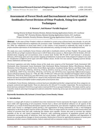
The study area covers Sonbhadra forest division which falls in Sonbhadra District of Uttar Pradesh. It has an area of 82067.86 ha and lies between 240 29'48" to 240 47'24"N latitude & 830 03'12" to 83032'43"E longitude. Sonbhadra forestdivisionliesbetweenVindhyanandKaimurhills.Itislocatedinthesouth easternpartoftheVindhyachalrange Thestudyareacoverspartsof63L/13,63P/01,63P/02,63P/05,63P/06and63P/10topographicalmapsofSurveyof Indiaon1:50,000scale.Thelocationmapofstudyareaisshowninfigure 1.
Fig.1 Location map of Study Area
Remote Sensing Satellite RESOURCESAT 2, LISS IV multispectral sensor data with 5.8m resolution of two seasons. March April2012,October,2011wereusedfordetailedforestmapping,encroachmentand themappingofhabitation in forest land, IRS P6 LISS IV and Cartosat 1 merged data (with resolution of 2.5m) of January, February 2010 were used ErdasImagine14software(animageprocessings/w)wasusedforgeometriccorrectionofrawimagesandimage processingfor classificationof differentforest/ vegetationtypes andotherlanduse classes. TheArcGIS10.2 was used formappingofdifferentforestdensityclasses,habitationsandpreparationof baselayersi.e.rail,road,canalandalso foranalysisofspatialandnon spatialofdata.SurveyofIndiatoposheetson1:50,000wereusedasancillarysourceof information
The recent LISS IV image was rectified with help of existing rectified image Cartosat 1 and ground control points (GCPS)usingErdasImagine14software.Therectifiedandenhancedsatellitedatahavebeeninterpretedoranalyzedto generate meaningful information. The present study adopted both types of classification methods, namely digital imageclassificationandvisual imageclassification. The forest boundariesviz. division, range,section, beat, block and compartmentweredigitized withthehelpofforestmaps,whichwereprovidedbyForestDepttofUttarPradesh.The base layers such as roads rail, canal, settlements, etc. were generated using satellite data and survey of India (SOI) topographicalmaps.Thedifferentthematicmapswereverified/validatedingroundalsoandfinalmapswereprepared afterincorporatingnecessarycorrections Thedifferentforesttypes/specieswithforestdensityclassesviz.>70%,40 70%,10 40%&<10%werealsointerpretedandmapped.
Volume: 09 Issue: 06 | June 2022 www.irjet.net p ISSN:2395 0072 © 2022, IRJET | Impact Factor value: 7.529 | ISO 9001:2008 Certified Journal | Page2760
International Research Journal of Engineering and Technology (IRJET) e ISSN:2395 0056
Volume: 09 Issue: 06 | June 2022 www.irjet.net p ISSN:2395 0072
Theestimationoftimbervolumewasbasedonsystematicgroundsamplingand collectionofenumerationdatawhich werecarriedoutbytheForestDepartment.Forthispurpose,anoptimumnumberofstratifiedrandomsamplepoints were generated aftertheanalysisofthesatellite data.Interritorial forest, samplingintensity was 0.04 %and sample plotsizewastakenas20x20m.EachsamplepointcoordinateswereidentifiedinthefieldwithhelpofGPSandwithin sampleplot,allthetreeswererecordedwiththeirCBH&height.Appropriatevolumeequations(FSI,1996)wereused for estimation of timber volume of each forest tree species, which were present in study area using Microsoft excel software.
The habitations were mapped through on screen digitization within forest boundary and habitations were further categorized into three categories viz. grouped, scattered and single hamlet. The encroachments on forest land were mappedasagriculturelandandgroupedhabitation.
Remote Sensing and GIS techniques had been used previously also by many researchers for mapping different forest types and species identification with reliable accuracy (Kachhwaha, 1985, 1993; Roy et al., 1991; Prasad et al., 1998; Xiuwan, 2002; Krishna et al., 2001; Chauhan et al., 2003; Singh and Moharir, 2003; Singh et al., 2003a, 2004, 2005a , 2005b;Chandrashekhar et al.,2005;Boydand Duana 2001;Jain et al., 2003;Gates, 1970;Aplin, 2003a ,Gould, (2000). Saxena (2002) and Singh et al. (2003b) had used PAN, LISS III merged and higher resolution satellite data for forest classification. Ghazanfari (1996) had applied Landsat TM data for forest type stratification in the Eastern Caspian range in Mazandaran Province. Abbasi (2001) had evaluated ETM+ data to identify the Fagus orientalis plant communityasoneofthemostvaluableforestcommunitiesinnorthernIranintermsofbiologicalandeconomicvalue. Landsat 3 MSS data had been used to draw spectral signatures of different vegetation classes in Allahabad and MirzapurdistrictsbyKachhwaha(1990).Kumar, et al. (2014)mappedforestencroachmentusingremotesensingand GIS techniques. L Tayeb, et al. (1991) adopted multistage sampling technique to map forest encroachment in Sudan. Watson, et al. (2015) used visual/ manual interpretation technique to detect encroachment on the multi temporal satellite images of protected area networks (PANs), Zambia. These studies are showing a worldwide variety of empirical approaches which had been followed to map forest cover types using digital remote sensing imagery on differentscales.
Thepresentstudyhasattemptedfortheidentificationofdifferentforesttypesandmappingoftheirdensityclassesand encroachmentareaonforestland.ThedigitalclassificationandvisualinterpretationofLISS IVimageshasresultedfor different forest/ vegetation types and density classes in Sonbhadra forest division. Various forest type with forest densityandotherlanduseclasseshavebeenclassifiedonthebasisof SatelliteremotesensingandGIStechniques,their detailsareasunder:
Sal (Shorea robusta) is a dominating species with other associated species viz. Asna, (Terminalia alata), Rohini (Mallotus phillipensis), Khair (Acacia catechu), Chironji (Buchnania lanzan), Arjun (Terminalia arjuna), Bahera (Terminalia belerica), Gurich (Mitragyna parviflora), Bargad (Ficus bengalensis), Gular (Ficus glomoreta), Haldu (Adina cordifolia), Mahua ( Madhca indica), Jamun (Syzygium cuminii) Saldominatedforestwithothertreespeciesoccupiesan area of 1319.29 ha and further classified on the basis of crown density i.e. >70%, 40 70%, 10 40% and <10%, occupying an area of 411.28 ha, 570.22 ha, 250.13 ha, and 87.66 ha respectively. Volume of Sal dominated forest has beenestimatedas131877.12m3instudyarea.
Tendu (Diospyros exculpta) isadominatingspeciesofthistypeofforestclass. Tendudominatedforestclassoccupies an area of 678.80 ha. The main associated species with Tendu are Buchnania lanzan, Palash (Butea Monosperma), Mahua (Madhca indica), Amaltas (Cassia fistula), Sidh (Hardwickia binata), Acacia catech, Awla (Embelica officinalis), Ficus glomoreta Tendu dominated forest has been further classified into different classes i.e. 40 70%, 10 40% and <10%, occupyingarea of282.22 ha,218.78 ha,and177.79 ha,respectively,basedoncrowndensity Thiscategory of forestishavingvolume5050.21m3
Volume: 09 Issue: 06 | June 2022 www.irjet.net p ISSN:2395 0072
Sidh (Hardwickia binata) is a dominating species mainly planted in mixed forest. Sidh dominated forest occupies an area of 369.03ha The main associated species with Sidh are Embelica officinalis, Diospyros exculpta, Terminalia belerica, Terminalia alata, Buchnania lanzan, Butea monosperma. Based on crown density, Sidh dominated forest has been further classified into different classes i.e. 40 70%, 10 40% and <10% occupying area of 50.84 ha, 111.01 ha, 207.18ha,respectivelyandvolumeofthiscategoryisestimatedas 4236.42m3
Arjun (Terminalia arjuna) isadominatingspecies,whichisplantedinmixedforest,occupiesanareaof97.86ha.The main associated species with Arjun are Syzygium cuminii, Butea monosperma Based on crown density, Arjun dominated forest has been further classified into different classes i.e. 40 70%, 10 40% and <10%, occupying area 26.16ha,66.91ha,and4.79harespectively.Volumeofthisclassofforestisestimatedas7468.67m3.
Cassiamixedforestoccupiesanareaof40.04ha.TheassociatedspecieswithCassiaspp.areBamboo(Dendrocalamus spp.), which are planted of some places Cassia dominated forest has been observed in two type of forest density classes i.e. 40 70% and 10 40%, occupying an area of 1.03 ha and 39.00 ha respectively, and this category of forest havingvolumeis55.29m3 .
Salai (Boswellia serrata) dominatedspeciesofforestareplantedinmixedforestanditoccupiesanareaof16.65ha.The mainassociatedspecieswithSalaiareJigna(Lannea coromandelica), Diospyros exculpta, Terminalia alata,Koriya.Salai dominatedforestishavingonly40 70%forestdensityclass,whichishavingtimbervolume412.21m3
Mahua (Madhca indica ) is planted at few places only and is identified as pure. Mahua forest is having low forest density,i.e.0 10%,whichisoccupyinganarea1.04haandvolumeisestimatedas11.11m3 .
Mahua (Madhca indica) dominated species of forest occupies an area of 23.19 ha The main associated species with Mahuaare Buchnania lanzan, Shorea robusta,Sidh, Acacia catechu, Terminalia alata,Cassia.Mahuahasbeenobserved andclassifiedonlyin10 40%densityclass,whichhas379.42m3,timbervolume
Miscellaneousforestsconstitutethemixedspeciesofforestviz. Acacia catechu, Adina codifolia, Albizia procera, Annona squamosa, Anogeissus latifolia, Azadirachta indica, Tectona grandis, Pongamia pinnata, Buchnania lanzan, Boswellia serrata, Bridelia retusa, Butea Monosperma, Cassia fistula, Cassia siamea, Cochlospermum religiousm, Dalbergia sisso, Diospyros exculpta, Embelica officinalis, Ficus bengalensis, Flacourtia indica, Gardenia latifolia, Haplophragma adenophyllum, Garuga pinnata, Hardwickia binata, Holopteia integrifolia, Ixora arborea, Lannea coromandelica, Madhca indica, Miliusa tomentosa, Mitragyna parviflora, Pongamia pinnata, Schleichera trijuga, Shorea robusta, Sterculia urens, Tectona grandis, Terminalia alata, Terminalia arjuna, Terminalia belerica, Terminalia chebula, Zizyphus mauritiana, Zizyphus zylopyra, Pongamia pinnata, Syzygium cuminii, Lagerstroemia parviflora, Eucalyptus spp., Bombax ceiba, Acacia spp Overall miscellaneous forests occupy an area of 29607.98 ha and it has been further classified into 04 density classes of >70%, 40 70%, 10 40% and <10%, having an area of 5357.41 ha, 7025.52 ha, 7627.59 ha and 9597.45 ha respectively. Miscellaneous forest timber volume is estimated as 689036.21 m3 , which has occupied 82.17%oftotalgeographicalareaofnotifiedforestland
Bamboo(Dendrocalamus spp.) isplantedatlimitedforestblocks/compartmentsofthestudyareaandotherspeciesof thisforestclasshasalsobeenobservedinscatteredform,i.e Diospyros exculpta, Butea monosperma. Thiscategoryis havinganareaof452.89ha,whichconstitutesonly0.82%oftotalgeographicalareaofnotifiedforestland.
International Research Journal of Engineering and Technology (IRJET) e ISSN:2395 0056
Volume: 09 Issue: 06 | June 2022 www.irjet.net p ISSN:2395 0072
Forestplantationsoccupiedanareaof1124.54ha,whichcomprises2.05%oftotalgeographicalareaofnotifiedforest land. These are relatively younger plantations. The main species observed in forest plantation are Cassia siamea, Madhca indica, Butea Monosperma, Tectona grandis.
Scrub forest consists of stunted growth of trees and bushy shrubs, which occupies an area of about 3694.06 ha. The main species observed in scrub forests are Holarrhena antidysentrica, Van tulsi, Bel, Sanhi, Koriya, Murerua, Lantana camara
Forestblanksarethoseareas,whicharehavingnovegetativecoverwithinthenotifiedforestland.Theseareasoccupy ground10497.72haareawhichis19.35%oftotalgeographicalareaofnotifiedforestland
Other landuse classes have also been mapped within the notified forest land viz. Agriculture, Grassland, Rocky/ Barren,andWaterBody,whichareoccupyinganareaof5163.28ha,399.22ha,1127.63haand307.03harespectively.
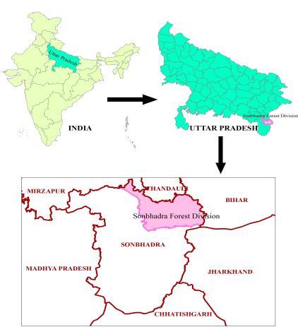
The Forest type withotherlanduseclasses ofSonbhadra Forest Division has been represented in figure 2and Forest Densityclasshasbeenrepresentedinfigure 3.Areastatisticsofforesttype&forestdensityclasses alongwithtimber volumeandotherlanduseclassesisgiventable 1
Fig. 2 Forest Type Map of Study Area
Fig. 3 Forest Density Map of Study Area
Volume: 09 Issue: 06 | June 2022 www.irjet.net p ISSN:2395 0072
Forest Type Forest Density Area (ha) Area % Volume (m3) Volume %
SalDominated <10% 8766 0.16 194276 0.23 10 40% 250.13 0.46 14094.42 1.68 40 70% 570.22 1.04 61123.77 7.29 70% 411.28 0.75 54716.16 6.53 Total 1319.29 2.40 131877.12 15.73
TenduDominated <10% 177.79 0.32 414.61 0.05 10 40% 218.78 0.40 802.50 0.10 40 70% 282.22 0.51 383310 0.46 Total 678 80 1 24 5050 21 0 60
SidhDominated <10% 207.18 0.38 3211 0.00 10 40% 111.01 0.20 219845 0.26 40 70% 5084 0.09 200586 0.24
Total 369.03 0.67 4236.42 0.51
ArjunDominated <10% 4.79 0.01 5106 0.01 10 40% 6691 0.12 431964 0.52 40 70% 2616 0.05 309797 0.37 Total 97 86 0 18 7468 67 0 89
CassiaDominated 10 40% 3900 0.07 1734 0.00 40 70% 1.03 0.00 3795 0.00 Total 40.04 0.07 55.29 0.01
Salaidominated 40 70% 1665 0.03 412.21 0.05 Total 16 65 0 03 412 21 0 05
Mahua <10% 1.04 0.00 1111 0.00 Total 1 04 0 00 11 11 0 00
MahuaDominated 10 40% 2319 0.04 379.42 0.05 Total 23.19 0.04 379.42 0.05
Miscellaneous <10% 959745 1748 10269487 1225 10 40% 762759 1389 12480389 1488 40 70% 702552 1279 17394433 2074 70% 535741 9.75 28759313 3430 Total 29607 98 53 91 689036 21 82 17
Other Classes
BambooPlantation 452.89 0.82 Total 452.89 0.82 Plantation 112454 2.05 Total 1124 54 2 05 Scrub 369406 6.73 Total 3694 06 6 73 ForestBlank 10497.72 1911 Total 10497 72 19 11 Grass 399.22 0.73 Total 399 22 0 73 Agriculture 516328 9.40 Total 5163.28 9.40 Rockey/Barren 112763 2.05 Total 1127.63 2.05 WaterBody 307.03 0.56 Total 307.03 0.56
Grand Total 54920 24 100 00 838526 66 100 00
Volume:
|
www.irjet.net
ISSN:
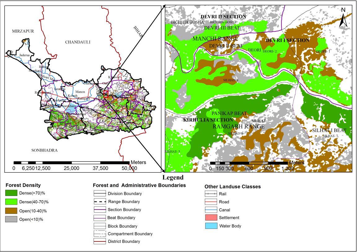
TheIRSP6LISSIVandCartosat 1mergedataofJanuary February,2010hasbeen usedformappingofhabitationsin notifiedforestland ForidentificationofhabitationsclassGoogleEarthimageshavealsobeenused Thecultivatedarea hasalsobeenmappedwithinnotifiedforestlandalongwithhabitations.Habitationshavebeencategorizedintothree sub categories viz. grouped, scattered and single hamlet which are of 38,106 and 71 in numbers respectively. The coordinatesof each habitationwereprovided toforest department,U.P.and these habitations wereverified by forest departmentinfieldwithhelpofGPS.EncroachmentmapofSonbhadraForestDivisionisshowninfigure 4
The present study demonstrated the vital use of geo spatial (Remote Sensing, GIS and GPS) techniques in accessible forestarea,whichiscosteffectivetoo.TheLISSIVdatahasbeenfoundveryusefulinidentificationandclassificationof major economically important species along with their density classes with high accuracy. The use of high resolution IRSP6LISSIVandCartosat 1mergedatawereverywelldemonstratedformappingofhabitationsonforestland.
Habitationsandagriculturewithinnotifiedforestlandshowstheencroachmentwhichneedstopayattentioninorder to avoid further encroachment in forest land Areas of other landuse classes like rocky/barren and grasslands should be used for afforestation, by those species which can survive on these areas in order to increase forest cover In Sonbhadra forest division, places having forest blank area and forest density class <10% require re plantation/ afforestation with proper management. The 10 40% density class is also required necessary action for further plantationandgapfilling.Theforestlandclassifiedasforestdenseclassviz.40 70%and>70%shouldbeprotectedfor regenerationandimprovementofdensity.
Thestudycouldbeusedasabaselineforforestmanagementplanningandfurthermonitoringofanyencroachmentin futureonforestlands.Itcouldalsobeusefulinimplementation ofdifferent programmesofGovernment,relatedwith forestmanagement.
International Research Journal of Engineering and Technology (IRJET) e ISSN:2395 0056
Volume: 09 Issue: 06 | June 2022 www.irjet.net p ISSN:2395 0072
Authors are thankful to Director, Remote Sensing Applications Centre, Uttar Pradesh, and Lucknow for providing necessary facilities and support in carrying out this study. Sincere thanks are also due to personnel of Forest Department,Govt.ofUttarPradeshforprovidingnecessaryenumerationdataofstratifiedsamplepointsandvaluable supportduringfieldwork
1) Abbasi, M. (2001) Investigating the possibility of Fagus orientalis stand type mapping using ETM+ data in Chalirdistrict Nowshahr.M.Scdissertation,FacultyofNaturalResources,UniversityofTehran Iran.
2) Aplin,P.(2003) RemoteSensing:basemapping.ProgressinPhysicalGeography,27,pp.275 283.pp.114.(In Persian).
3) Boyd, D.S. & Duane, W.J. (2001). Exploring spatial and temporal variation in Middle Infrared Reflectance(at 3.75µ)MeasuredfromtheTemporalForestWestAfrica,Int.J.RemoteSensing,22(10):1861 1879.
4) Chandrashekhar,M.B.,Sameer,S.,Raju,P.L.N.andRoy,P.S.,(2005).ForestCanopyDensityStratification:How RelevantinBiophysicalSpectralResponseModellingApproach.J.GeocartoInternational,20(1):15 21.
5) Chauhan, P.S., Porwal, M.C., Sharma, L.and Negi, J.D.S. (2003). Change Detection in Sal Forest in Dehradun Forest Division using Remote Sensing and Geographical Information System. J. Indian Soc. Remote Sensing, 31(3):211 218.
6) El Tayeb, I.,bishay, A & Dregney, H., (1991). A bioenergy project to reduce deforestation in Sudan, Second InternationalDesertDevelopmentConferenceCairo,Egypt,p.225 229.
7) FSI,(1996).VolumeEquationForestofIndia,NepalandBhutan,ForestSurveyofIndia,pp.249
8) Gates,D.M.(1970).Physicalandphysiologicalpropertiesofplants.InRemoteSensingwithSpecialReference toAgricultureandForestry.NationalAcademyofScienceWashingtonD.C.
9) Ghazanfari,H.(1996).Investigationoftheapplicationofsatellitedataforclassifyingforesttypesintheforests managed by mazandaran wood and paper company. M.Sc. dissertation, Faculty of Forestry, University of Gorgan,Iran,pp.124.(InPersian).
10) Gould, W. (2000). Remote Sensing of vegetation, plant species richness, and regional biodiversity hotspots. Ecol.Appl.10,1861 1870.
11) Jain,S.K.andChaudhary,A.(2003).SnowandforestcoverassessmentofUttaranchalstateusingIRS1CWIFS data,Photonirvachak,J.IndianSocietyRemoteSensing,31(2):91 99.
12) achhwaha, T.S. (1985). Temporal Monitoring of Forestland for Change Detection and Forest Cover Mapping Through Satellite Remote Sensing Technique. Proc. 6th Asian Conf. on Remote Sensing held at Hyderabad, IndiafromNov.21 26,1985,pp.276 281.
13) Kachhwaha,T.S.(1990). SupervisedclassificationapproachforassessmentofforestresourcesinpartofU.P. plains,IndiausingLandsat 3data.Photonirvachak,18(1&2):9 14.
14) Kachhwaha, T. S. (1993).Temporal and Multispectral approach in forest/vegetation mapping and corridor identification for Planning and management of Rajaji National Park, Uttar Pradesh, India. Int. J. of Remote Sensing,14(17):3105 3114.
15) Krishna, N.D.R., Maji, A.K., Krishna Murthy, Y.V.N., and Rao, B.S.P. (2001). Remote Sensing and Geographical InformationSystemforCanopyCoverMapping.J.IndianSoc.RemoteSensing,29(3):107 113.
16) Kumar,GR.P.Hemanjali,A.M.,Ravikumar,P.,Somasshekar,R.K.&Nagaraja,B.C.(2014).Assessmentofforest encroachment at Belgaum district of western Ghats of Karnatka using remote sensing and GIS, Journal of EnvironmentalBiology,vol.35,p.259-264.
International Research Journal of Engineering and Technology (IRJET) e ISSN:2395 0056
Volume: 09 Issue: 06 | June 2022 www.irjet.net p ISSN:2395 0072
17) Prasad,V.K., Rajagopal, R., Kant, Y, Srinivas, S. and Badarinath, K.V.S. (1998). Forest Canopy Characterisation usingIRS ICLISS IIISatelliteData.Proc.onRemoteSensingandGeograhpicalInformationSystemforNatural resources Management, A joint ISRS NNRMS Publication (Eds.: Ravindran, K.V., Prasad, J., Pande, L.M., Kushwaha,S.P.S.andSaha,S.K.),pp.247 254.
18) Roy, P.S., Ranganth, B.K. Diwakar, P.G., Vohra, T.P.S., Bhan, S.K., Singh, I.J. and Pandian V. C. (1991). The Tropical Forest Type Mapping and Monitoring using Remote Sensing, Int. J. Remote Sensing, 12(11): 2205 2225.
19) Saxena,A.K.(2002).ForesttypeStratificationwith EmphasisonSpeciesandDensity inTimliBadkalaForest Range using High Resolution Indian Remote Sensing Satellite Data. Proc. ISPRS Commission VII Symp. Resource and Environmental Monitoring held at NRSA, Hydrabad, India from Dec. 03 06, 2002. A NRSA Publication(Eds.:Navalgund,R.R.,Nayak,S.R.,Sudarshana,R.,Nagaraja,R.andRavindran,S.),pp.1036 1048.


20) Singh,I.J.andMoharir,S.(2003).ForestManagementusingRemoteSensingandGISinBarbatpurrange,Betul ForestDivision.J.IndianSoc.RemoteSensing,31(3):149 156.
21) Singh, T.P., Singh, S., and Roy, P.S. (2003a). Assessing Jhum Induced Forest Loss in Dibang Valley, Arunachal Himalayas ARemoteSensingPerspective.J.IndianSoc.RemoteSensing,31(1):03 09.
22) Singh,I.J.,Das,K.K.andKushwaha,S.P.S.(2003b).ForestStockAssessmentusingIRSLISS IIIandPanMerged DatainTimliForestRange,Dehradun.J.IndianSoc.RemoteSensing,31(1):49 56.
23) Singh,I.J.,Das,K.K.,Pant,D.N.andThee,N.(2004).QuantificationForestStockusingRemoteSensingandGIS. J.IndianSoc.RemoteSensing,32(1):113 118.
24) Singh,I.J.,Jugran,D.K.,Tharnruma,S.,and Reddy,S.R.(2005a).ForestResourceAssessmentinMohandForest RangeUttarPradeshusingRemoteSensingandGIS.J.IndianSoc.RemoteSensing,33(4):565 574.
25) Singh, S., Singh, T.P. and Srivastava, G. (2005b). Vegetation Cover Type Mapping in Mouling National Park in Arunachal Pradesh Eastern Himalayas An Integrated Geospatial Approach. J. Indian Soc. Remote Sensing, 33(4):547 563.
26) Watson,R.,Becker,M.Milanzi,J.&Nyirenda,M.(2015).Humanencroachmentintoprotectedareanetworksin Zambia: implications for large carnicore conservation, Regional Environmental Change, vol.15, no.2, p. 415 429.
27) Xiuwan,C.,(2002),UsingRemoteSensingandGIStoAnalyseLandCoverChangesandItsImpactsonRegional SuitableDevelopment.Int.J.RemoteSensing,23(1):107 124.
ActingDirector Scientist-SFHeadFRED M.sc.(Botany) Ph.D.(Botany)
Scientist-SEM.sc. (Ag) Soil Sciences Ph.D.(SoilSciences)