International Research Journal of Engineering and Technology (IRJET) e ISSN: 2395 0056

Volume: 09 Issue: 06 | June 2022 www.irjet.net p ISSN: 2395 0072
International Research Journal of Engineering and Technology (IRJET) e ISSN: 2395 0056
Volume: 09 Issue: 06 | June 2022 www.irjet.net p ISSN: 2395 0072
Priyanka Chawla1 , Kunal Pawar2
1 PG Student in Transportation Engineering and Planning, Department of Civil Engineering, SOET, Sandip University, Nashik, Maharashtra, India 2Assistant Professor in Transportation Engineering and Planning, Department of Civil Engineering, SOET, Sandip University, Nashik, Maharashtra, India ***
Abstract Mumbai Metropolitan Region is one of the biggest Metropolitan Areas of India which consist of Mumbai and its nearby Towns covering 9 Municipal Corporation and 15 small Municipal Councils. MMR is having presently vast network of Suburban Train System (Local train) as one of the Main Mode of Transport. Currently, in last decade lot of efforts have undergone to create new mode of public transport i.e. Metro (Mass Rapid Transit System) with stations at every 1.0 km. A plan of 337 km of Metro network is under various stages of Implementation in MMR Region. This research study deals with analyzing the impact of such a huge MRTS Network on Environmental and Social Parameters of the Region and also it is studied that whether such a huge investment will be helpful in creating a Environmental Friendly Public Transport. Further, a statistical analysis has been done to examine the quantum of shift of Mode of transport of Mumbai Residents from existing modes of Transport to Metro and its impact on Traffic Scenario of Entire MMR. This research project will create a standard platform and tool to identify the quantum of MRTS network to be required for each city based on existing infrastructure and probable growth scope of the city anywhere in India. It will help stakeholders to take decisions and plan for financials to develop the infrastructure in the City.
Key Words: MMR, MRTS, Four Stage TDM, Traffic Impact, Environmental Impact, SMNT
Inthelastfewdecades,Worldhasfacedtremendousgrowth intheUrbanizationfromMegacitiestoTier IIIcitiesdueto which there is a sharp increase in the registration of personal vehicles. The same has been observed in Indian Citiesandpeopleperspectivehavebeentoshifttopersonal modeoftransportfordailyworks.Thisisresultingintohuge impact on Environment and also Social Aspects. It is worldwide noted that rate of natural calamities have increasedandsimilarlyrateofaccidentaldeathshaveshown suddenrise.
Consideringthesamemanydevelopedcountriesinpastfew decadeshavealreadyapproachedtotakeeffortstoincrease theexistingpublictransportnetwork,developnewmodesof publictransportandimprovethetravelexperienceinpublic modeoftransport.Ithasresultedintoshift ofcommuters from private mode to public mode of transport. Similar approachwasadoptedinDelhi,Indiaandpresently350km ofMetroisunderoperation,65kmunderimplementation and64kmunderplanningstage.Inacitywithnorailmode ofpublictransporthasshownunexpectedshiftfrom road based mode to rail based mode. However, Mumbai MetropolitanRegionstandsdifferentascomparedtoDelhi oranyotherMetropolitancityinIndia.
MumbaiMetropolitanRegion(MMR)hadaHistoryofHuge Public Transport Network since 1853 which is known as MumbaiSuburbanRail(Local),it’slaidacross390kmand operates 2342 train services along 150 stations. It carries daily76lakhstripswithadensityof14 16persons/sq.mt.It is one of the main mode of public transport with 65% followedbyBusMode.However,itisfoundthatModeshare has reduced from 75 % to 65% in last 15 years and the reason behind it is inadequate capacity of system and increaseinCarsregistration.Thus,MMRisinneedofanew mode of Public Transport as Suburban System is at grade andcannotbeextendedfurtherconsideringfunnelshaped topography of City. Accordingly, MMRDA had prepared ComprehensiveTransportationStudyin2005 08inwhich Metro Rail System was recommended for entire MMR, following which first corridor i.e. Mumbai Metro Line 1 (Versova Andheri Ghatkopar) was implemented and operationswerecommencedfrom2014.Thesaidcorridoris 11.4kmlongandhasdailyridershipof4.5lakhsPre Covid scenario. Further, in successive years, city has seen implementation of multiple metro corridors across entire MMRanditisfoundthatthereisaplanof337kmofMetro NetworktobeimplementedinMMR.Considering330kmof SuburbanNetworkinexistenceandhugeroadnetwork,this planof337kmofMassRapidTransitSysteminMMR has createdaquestionofitsneed.
International Research Journal of Engineering and Technology (IRJET) e ISSN: 2395 0056
Volume: 09 Issue: 06 | June 2022 www.irjet.net p ISSN: 2395 0072
Inthisresearchwork,itwillbeanalyzedthatwhatwillbe theneedofsuchahugeMRTSnetwork,itsimpactonTraffic, Environmental and Social parameters. Transport Travel DemandModelwillbeusedfordifferenthorizonyearslike 2026,2031&2041toidentifythetravelpatternbasedon metroimplementedandshiftofmodeoftransportwill be workedouttoseereductioninroadtraffic.Further,being stationsatonekm,metrocommuterswillpreferwalkingand Non Motorizedtransportforfirst/lastmodeofcommuting tostationswhichwillfurtherreduceroadtraffic.Theresults of4StageModelingwillbeusedandcorrelatedtocurrent emissionsandnetreductioninemissionswillbeworkedout which will give Improvement in Environmental Aspect. However,thereisaprobabilityofmodelgivingresultswhich sayspeopledonotshifttopublictransportandMRTSmay not be required. The detailed study of this will give us a platform/toolwhichcanbeusedindifferentcitiestodefine needofMRTSineachcityrespectively.
Allthemetropolitancitiesarecongestedandroadsare insufficienttocaterthedemand.
Public Transport Share is reducing in the cities with existingPublicTransport.
Travel Experience, Comfort and safety is on risk in ExistingPublicTransport.
No Clearly defined tool is available to decide the quantumofPublicTransportrequiredforthecity.
Ongoing MRTS Projects impact on Travel Scenario, EnvironmentandSocialAspectsofCitiesisdifficultto beestimated.
NoFirmparametersaretheretodecideneedofpublic transportfortheparticularcity.
To do detailed study of the existing and upcoming PublicTransportInfrastructurefordevelopedcities.
TodefinetheneedofPublicTransportInfrastructure forIndianCities.
To analyze the Environmental Impact of Mass Rapid TransitSystemunderimplementationStageinMumbai MetropolitanRegion.
To analyze the Transport & Traffic Impact of Mass RapidTransit Systemunder implementationStagein MumbaiMetropolitanRegion.
To analyze the Social Impact of Mass Rapid Transit System under implementation Stage in Mumbai MetropolitanRegion.
To create a platform/tool to define the quantum of publictransportrequirementforeachcity.
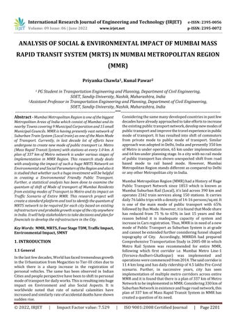
ThesaidresearchworkisacombinationofTransportation AspectandEnvironmentalAspectofaMetropolitanRegion andoutcomesofthesamecanbeusedtoanalyzetheneedof Transportation Infrastructure Developments in similar regionsacrossglobeandlevel 2citiesintheCountry.Further, this study will help toanswer the questions raised for the needofInvestmentsinPublicTransportandcanjustifyits serviceability in long term period. The Methodology is divided into two parts, a. Travel Demand Analysis and b. Socio EnvironmentalImpactAnalysis.
Travel Demand Models have the ability to estimate the futuretraveldemandandtransportationdeficienciesforthe horizon year and multiple intermediate years. The travel demand models are used for the estimation of passenger travel demand and assessment of transport network requirementforvarioushorizonyears.Aniterativeprocess is applied in the form of EMME macros by including trip generation,tripdistribution,mode choiceandassignment stages of the travel demand model. The Output of Travel DemandAnalysisinrespecttothesubjectstudyisexpected tobeasfollows:
International Research Journal of Engineering and Technology (IRJET) e ISSN: 2395 0056
Volume: 09 Issue: 06 | June 2022 www.irjet.net p ISSN: 2395 0072
a. Thespatialallocationoffuturetrips,especiallytheorigin andthedestination
b. The estimation of a future modal split among the competingtransportmeans
c. Estimatingthetrafficvolumesontheroadnetwork,and ofpassengertrafficonthepublictransportnetwork
d. Estimationoftraveltimes,speedoftransportmodesetc.
e.
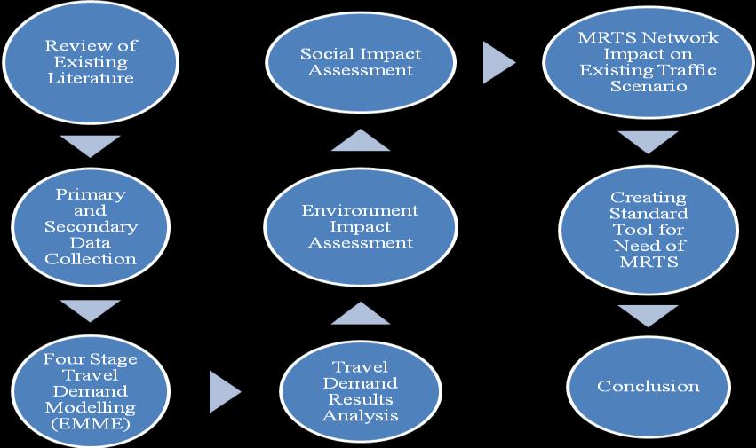
In the said study, with a special request to MMRDA, ComprehensiveTransportationStudyforMMRModelwas usedwhichwasdevelopedrecentlyforbaseyear2017with HorizonYears2021,2026,2031&2041.Thesaidmodelwas developed on EMME Software which is being used in the studypartiallyandtheoutputsofthemodelarebeingused toanalyzetheimpactofMRTS.ThedetailedTravelDemand AnalysisMethodologyisasfollows: Fig 2:MethodologyChartforTravelDemandAnalysis
TheOutputoftraveldemandanalysisistabulatedindetail modewiseandwhichisconvertedintoPCU(PassengerCar Unit) for with MRTS and without MRTS condition. The differenceinthesameisconsideredasreductioninvehicle trips in MMR which is considered for Social and EnvironmentalImpactAnalysis.TheEnvironmentalImpact AnalysisisdoneasreductioninemissionsofCo,CO2,NOx, SO2, Particulates etc. which is converted to savings in NumberofTreesinMMR.
Similarly, Social Impact Analysis is done based on the reductioninTravelTimeandCongestionwithandwithout MRTSCondition.Thesaidsavingsareconvertedtoincreased comfort, Economical benefits based on per hour Value of TimeofMMRresidentsandindirectlytotheEconomyofthe region.
Inadditiontotheabove,majorimpactsofMRTSNetworkon TrafficScenarioofMMRisalsobeingtabulatedinthisstudy. The details such as increase in MRTS Trips per day, reductioninroadbasedtrips,changeinAverageTripLength Mode wise, reduction in Travel Time, Running Speed and ultimatelytopercentageofcongestion.
ToanalyzetheSocial andEnvironmental ImpactofMRTS, there wasa needofmajordata collectioni.e.primaryand secondary. Considering the quantum of the work, majorly secondarydatahasbeenusedtogetmaximumcorrectness oftheimpactresults.However,someprimarydatacollection has been done for ground truthing of the secondary data. The data has been collected from various sources such as MMRDA website, CIDCO website, MRVC etc. The data collectedisusedforthefourstagetraveldemandmodeling and the results of the same are used to analyze socio and economicimpact.
Thelistofdatacollectedisasfollows:
1. MumbaiRapidTransitSysteminMMR:Proposedandin operation
2. NaviMumbaiMetro:CIDCO
3. Existing Suburban Rail Network: Proposed and in operation
4. PopulationandEmploymentofMMR:PresentandFuture
5. LandUseData:RegionalPlan
6. TrafficSurveyandHouseholdSurveys
7. RoadNetwork:ExistingandProposed
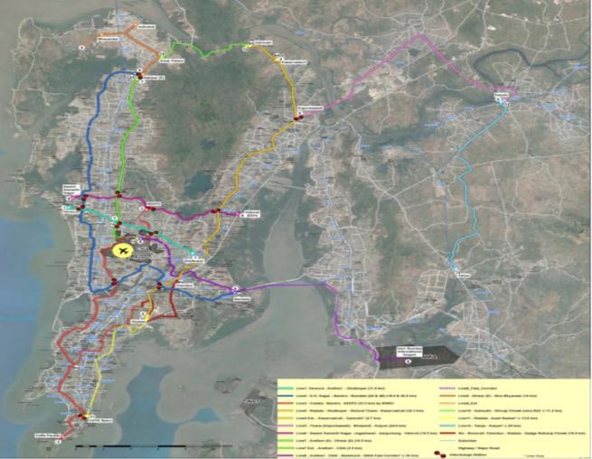
MMRDA is a planning & implementing agency for vital regional importance projects in Mumbai Metropolitan Region,Maharashtra.Theagencydealswiththepreparation of Regional Plan, Comprehensive Transport plan and is a SpecialplanningAuthorityforCommercialComplexeslike Bandra Kurla Complex and Wadala etc. MMRDA had preparedComprehensiveTransportationStudyforMMRin 2005inassistancewithWorldBank(1 CTS 2005).Basedon the recommendation in CTS study, MMRDA had taken up preparation of Mumbai Metro Master Plan through M/s. DMRC. TheMasterplanrecommended337kmsofMetrofor Mumbai City. As per this plan, MMRDA had taken up the implementationofMumbaiMetroLine 1(Versova Andheri Ghatkopar)inPPPmodein2008.
International Research Journal of Engineering and Technology (IRJET) e ISSN: 2395 0056
Volume: 09 Issue: 06 | June 2022 www.irjet.net p ISSN: 2395 0072
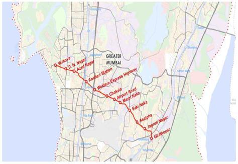
Fig 3:StationsofMetroLine 1
Further, based on experience of Metro Line 1, MMRDA emerged confidently to take up implementation of other metrocorridorsproposedinMumbaiMasterPlanandthe detailsofthesameareasfollows:
Table 1: DetailsofMumbaiMasterPlan
Line Corridor Length (Km)
Line2A Dahisar D.N.Nagar 18.6
Line2B D.N.Nagar Mandale 23.6
Line3 Colaba SEEPZ 33.5
Line4 Wadala Kasarwadavali 32.3
Line5 Thane Bhiwandi Kalyan 24.9
Line6 SwamiSamarthnagar Vikhroli 14.5
Line7 Dahisar(E) Andheri(E) 16.5
Line4A Extn. Kasarwadavali Gaimukh 2.67
Line7A. Andheri(E) Airport, 3.1
Line8 AirportMetro(CSIA NMIA) 35.0
Line9 Dahisar(E) Mira Bhayander 10.4
Line10 Gaimukh ShivajiChowk 11.2
Line11 Wadala CSTM 13.6
Line12 Taloja Kalyan 25.0
Line13 GhodbunderBridgeto Virar 25.0
Line14 Kanjurmarg Badlapur 45.0
Total 337.1
3.3
Fig- 4 MumbaiMRTSNetworkPlan
In addition to Metro taken up by MMRDA, CIDCO, the planning authority in Navi Mumbai, on the other end, has initiatedNaviMumbaiMetroNetworkasfollows:
Table 2: NaviMumbaiMetroNetwork
Phase Terminal Length
I Belapur Kharghar Taloja Pendhar 11.10km
II MIDC Taloja Kalamboli Khandeshwar (extensiontoAirport proposed)
10.30km
III InterlinkbetweenPendhar andMIDC 2km
Total 23.40 km
Mumbaisuburbanrailwayisamasstransitsystemcarrying morethan7.65millionpeopledaily(CentralRailway:4.18 million and Western Railway 3.47 million as per 2016 17 statistics)anditisconsideredasthelifelineofMMR.
MumbairegionisservedbytwoofIndia’szonalrailways,the Western Railway (WR) and the Central Railway (CR). The Western line runs northwards from Churchgate terminus station in Island City, which exclusively serves sub urban passengers,paralleltothewestcoast.TheCentralRailway runs from CSMT, Mumbai (Chhatrapati Shivaji Maharaj Terminus)stationsituatedveryclosetoChurchgateinIsland CityandserveslargepartofcentraltotheeastofMumbai.
International Research Journal of Engineering and Technology (IRJET) e ISSN: 2395 0056
Volume: 09 Issue: 06 | June 2022 www.irjet.net p ISSN: 2395 0072
CentralRailwayalsohasaharbourlinewhichnowbasically servesNaviMumbai.
agricultureareasliewithintheperi urbanareas,whilemost ofitisseenintheruralareas.Theexistingland usepattern of the MMR area during 2017 reflects that the available developed land area totals about 638.64 Sq km, which is approximately14.81%ofthetotalarea.LandAvailablefor future development totals about 573.27 Sq km i.e. approximately13.30%andthenon developablelandcomes outtobearound3099.85Sqkmi.e.approximately71.89%.
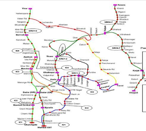
Fig 5 MumbaiSuburbanRailNetwork
To collect the planning parameters i.e. Population and Employment, various sources were available such as PopulationCensus 2011,EconomicCensus 2013,CTSStudy 2005,MCGMCMPPlan 2014,RegionalPlanforMMR 2017 19andCTSStudy2019.Tosimplifythework,RegionalPlan for MMR was used for the said study as it is based on populationcensus2011andtheMCGMCMPplanwasonly forMCGMarea.Further,duringdetailedstudyofCTSStudy 2019,itisfoundthattheyhaveusedEconomicCensus2013 forEmploymentdataandthecombinationofCTS2019and Regional Plan is used for Population and Employment of MMR.
Table 3: Population&EmploymentofMMR
Details 2017 2021 2026 2031 2041
Population 24.88 26.52 27.76 29.32 32.17
Employment 10.24 11.13 11.97 12.99 14.91
ItcanbeseenthatPopulationwillincreaseby7.29millionin MMRduringtheperiod2017to2041.Further,itcanbeseen thattheemploymentwillincreaseby3.67millioninMMR duringperiod2017to2041.
The Draft Regional Plan 2016 2036 reflected the existing land use, updated for the horizon year of 2016, at the regionallevelandalsoatmoredisaggregatelevelsaswell. MMRareacontainsamixofallland usecategoriesinvarying proportions.Thestudyareaspreadsaround4,311.75Sqkm area, which is dominated with the agricultural land in the regions outside the urban agglomerations. Some of the
AsapartofSecondaryData TrafficSurveyandHousehold SurveysofCTS2005study,CMP 2014andCTS 2017was collected.Tovalidatethesecondarydata,primarysurveys were planned for major links across Mumbai City. The surveys were carried out on EEH, WEH and Bandra Kurla LinkRoad.ItisfoundthatduetoCovid 19Pandemic,Public Transportusershavereducedduetosafetyconcernandthus public transport commuters have shifted to Road based transport. Further, major private companies have a Work fromHomePolicyduringpandemicresultingintonorealistic trafficcollection.Thus,recentmostdataoftrafficin2017is projectedto2021forthisresearchwork.
HouseholdSurveysareusedforFourStageTravelDemand Modeling and the collection of such data is a tedious task whichcanbedonebyappointingcertainagencieswhichtake residential properties society permission. It was thus decidedtouseexistingHouseholdsurveysfortheproject.
The Major Road Network Inventory is done from Google Earth Software in which the kmz of each road is being exported for travel demand modeling. The widths of each roadiscrossverifiedwithsecondarydatafromCTSStudy andthetypeofroadisverifiedfromGoogleMaps(Oneway ortwoway).Thesaiddataisupdatedwithproposedroad network inventory in MMR from Ongoing projects, DPR Studies,newsarticlesetc.Thesameissubjecttochangeas it’sacontinuousprocessandwillupdateeveryday.
Asperthemethodologyandwiththehelpoftraveldemand model,theanalysishavebeencompletedandtheresultsare presentedinthischapter.Furtherwiththehelpofoutcomes ofmodel,thesamehasbeenanalyzedintoestimatingSocial and Environmental Impact. In addition to this, it also includes Impact on Traffic Scenario of MMR. All these analysisareusedtocreateastandardtoolforNeedofMRTS.
International Research Journal of Engineering and Technology (IRJET) e ISSN: 2395 0056
Volume: 09 Issue: 06 | June 2022 www.irjet.net p ISSN: 2395 0072
Thedetailedanalysishasbeencarriedoutasfollows:
3. Changein Average TravelSpeedonUrban Roads
15% 25%for developingcities 25% 40%for metropolitancities
4. ChangeinTraveltimeon urbanroads 10% 20%
5. AverageCongestionon UrbanRoads Notgreaterthan 35%
4.4 Travel Demand Model Results:
The Four Stage Travel Demand Model Analysis was performedforfollowingscenarios:
1. Year 2021 with Existing Transport Network
2. Year 2026 with and without existing Transport Network
3. Year 2031 with and without existing Transport Network
4. Year 2041 with and without existing Transport Network
Fig
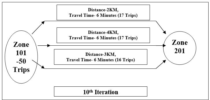
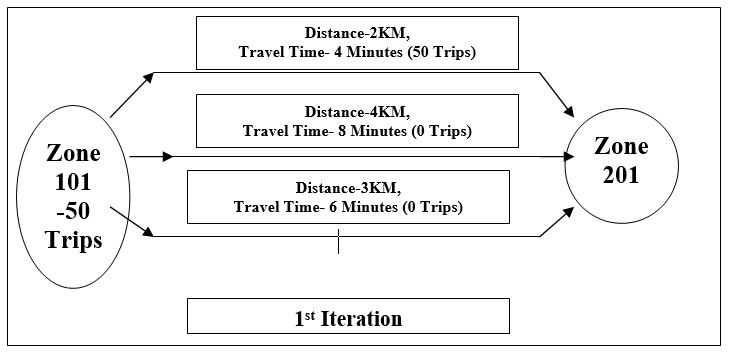
Itcanbeseenthatiterationsareperformedtillthepointall available routes are assigned equal trips based on travel time,traveldistanceandinsuchawaythatiffurthertrips areaddeditsre iteratedtoachievetheequilibrium.
Asapartofproject,anadditionalexercisehasbeendoneto developatoolwhichcanbeusedforothermetropolitanor developingcitiesacrossIndiatoexercisetheneedofMass Rapid Transit System and also the Quantum of it and to assess its environmental Impact. The Tool is for Study Purpose only, however the decision pertains to the concernedauthorityforitsutilizationornot.TheSMNTis developedbasedontheimpactofMRTSforMMR andthe samecanbeusedbasedonavailabilityoffollowingdata:
Table - 4: Parametersanditsrange
Sr. No Description of Parameters Range
1. MetroRidershipperKm 20,000 25,000per kmperday
2. ChangeinAverageTrip LengthModeWise 7.5% 10%
TheresultsoftheModelshows,ModewiseTripsperdayfor alltheanalysisyearsasfollows:
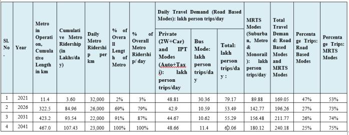
Table 5: ModewiseTripsperday
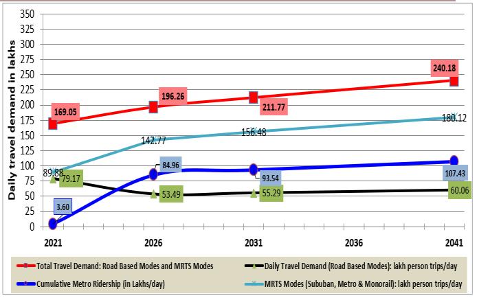
Chart 1:TotalTraveldemand:RoadbasedModesand MRTSModes
International Research Journal of Engineering and Technology (IRJET) e ISSN: 2395 0056
Volume: 09 Issue: 06 | June 2022 www.irjet.net p ISSN: 2395 0072
Table 6: AnalysisofVehicleFuelParameter
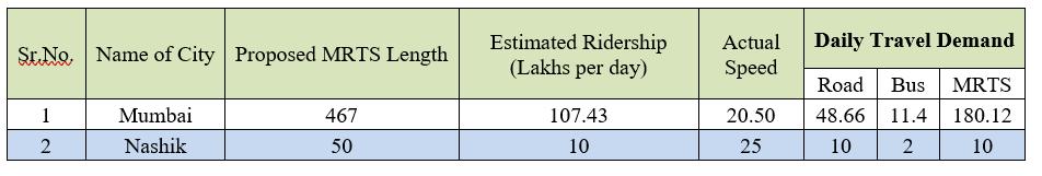
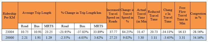
which will be cost effective. However the Nashik city exampleassumingdataisactual,theCongestionlevelis54% however Travel Time is not reducing considerable, thus MetronetworkLengthshallberevisedtomeetrangelevels. BasicallythisSMNTtoolcanbeasecondarychecktakingup MRTSprojectsforimplementation.
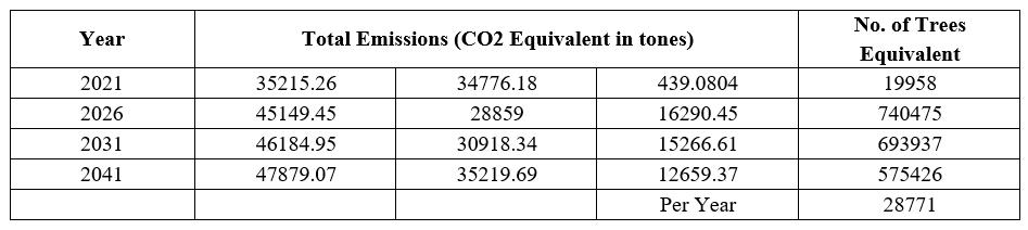
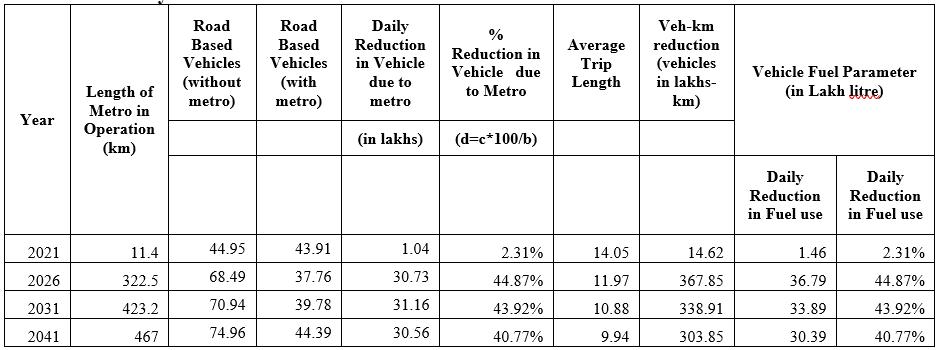
Table -7: TotalEmissionsSaving(CO2Equivalentintones)
Table 8: ReductioninTrafficCongestionLevel
An attempt has been made in this study with the help of technical approach to assess the need of MRTS in various cities of Developing Countries. To make this study more technicallyacceptable,veryminutedetailsandparameters are considered which has authenticated the output of the study.However,cityspecific parametersarekeptvariable basedonwhichtrueassessmentwillvaryfromcitytocity. Based on the Mumbai study, an Standard MRTS Necessity Tool have been developed which can be used for various developing cities to assess the need of MRTS and its Quantum and its impact based on input of city specific parameters. The detailed conclusions arrived at from this studyareasfollows:
1. Toassesstheneedof MRTS thereisa needofdetailed dataavailabilityofexistingvarioustransportmodes,its network,populationandemploymentofregionetc
2. ThesecondarydatasuchasTraffic,HouseholdSurveys and Preference surveys improves the Travel Demand Model.
TheOutcomeofSMNTToolisselfunderstoodandthesame canbeusedtoderiveataoptimizednumberofKmofMRTS required for a particular city based on Ranges as defined aboveinTableNo.10
Table -9: InputTableforSMNTTool
3. FourStageTravelDemandModelgivesoutputinvarious forms such as Average Trip Length, Zone to Zone Boarding/Alightingetcwhichmakesassessmentofsocial andeconomicimpacteasier.
4. ImplementationofProposedMRTSNetworkforMumbai MetropolitanRegionwillleadtoCongestionleveltobe reducingdrasticallyfrom95%to9%inonedecadetime periodandfurtherto8%inonedecade
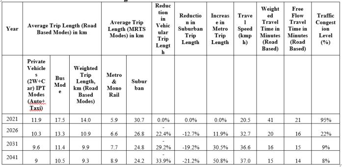
5. Thus,itcanbeconcludedthatformTrafficpointofview MRTSNetworkRecommendeduptoonedecadei.e.upto 2031shallbeprioritizedandfocused.
Table -10: OutputTableforSMNTTool
6. Reducingcongestionby1%byadding44kmofMetrois Notadvisable.HoweverNoadditionwillfurtherincrease congestion. Thus MMR shall be reassessed after one decade to examine the need of additional network for MMR.
7. Approximately40%reductioninfueluseisestimatedon commissioningofentireMetroNetworkforMMR.
ForExample,AverageTrafficCongestionshallbelessthan 35%,inMumbaiCityits28.56%subjectto467kmofMetro isimplemented,thusitcanbeseenthatthenetworkcanbe reduced upto a value wherein congestion is approx 35%
8. SavinginfuelandreductioninEmissionshasarrivedto equivalentof28,771TreesPlantedperYearby2041
International Research Journal of Engineering and Technology (IRJET) e ISSN: 2395 0056
Volume: 09 Issue: 06 | June 2022 www.irjet.net p ISSN: 2395 0072
9. IthasfurtherresultedintoreductioninTraveltimeby 1.8minutesperkmpervehicle,whichisaconsiderable reduction.
10.StandardMRTSNecessityTool(SMNT)isdependenton MRTSNetworkProposed,DailyTravelDemand,Average SpeedandMetroRidership.
11.StandardMRTSNecessityTool(SMNT)givesoutputin terms of Average Trip Length, Improved Travel Speed, TravelTimeandCongestionlevel.
TheStudyworkhasfurtherdetailedscopeavailablewhich canbetakenupforfutureresearchsuchasconvertingSMNT Tool into an Android Application or a Python Language Software.Further,thesametoolcanbedevelopedforother newmodesoftransportsuchasMetroNeoetc.TheImpact Assessmentcarriedoutinthisstudywillbehelpfultoassess thebudgetprovisionstobeallocatedforMRTSprojectscity wisewhichwilloptimizethefundallocationandwillserve thecounty/stateinIdealway.
[1] Chang, Liao, et al., “Life Cycle Assessment of Carbon FootprintinPublicTransportation ACaseStudyofBus Route No. 2 in Tainan City, Taiwan”, Procedia Manufacturing30(2019)388 395.
[2] Grote, Williams,et al.,“Includingcongestion effectsin urban road traffic CO2 emissions modelling: Do Local Government Authorities have the right options?” TransportationResearchPartD43(2016)95 106
[3] HyderabadMetropolitanDevelopmentAuthority,March 2013“ComprehensiveTransportationStudy(CTS)for HyderabadMetropolitanArea(HMA)”
[4] Mumbai Metropolitan Region Development Authority 2008,“ComprehensiveTransportationStudyforMMR 2005:08”
[5] Mumbai Metropolitan Region Development Authority 2021, “Updation of Comprehensive Transportation StudyforMMR 2017 19”
[6] Municipal CorporationofGreaterMumbaiApril 2016, “Comprehensive Mobility Plan (CMP) for Greater Mumbai”
[7] Samaras, Tsokolis et al, “Enhancing average speed emissionmodelsto account for congestionimpactsin trafficnetworklink basedsimulations”Transportation ResearchPartD75(2019)197 210
[8] ThawadiandGhamdi,“Evaluationofsustainableurban mobility using comparative environmental life cycle assessment: A case study of Qatar” Transportation Research Interdisciplinary Perspectives 1 (2019) 100003