International Research Journal of Engineering and Technology (IRJET) e ISSN: 2395 0056
Volume: 09 Issue: 06 | Jun 2022 www.irjet.net p ISSN: 2395 0072
International Research Journal of Engineering and Technology (IRJET) e ISSN: 2395 0056
Volume: 09 Issue: 06 | Jun 2022 www.irjet.net p ISSN: 2395 0072
1 M. Chaitanya Kumar,2T. Ankita,3 M. Jyothsna,4V. Chandini,5P. Vasudeva Rao,6 B. Amith
1 Assistant Professor, Dept. of ECE, Aditya Institute of Technology and Management, Tekkali. Andhra Pradesh, India 23456 Student, Dept. of ECE, Aditya Institute of Technology and Management(A), Tekkali. Andhra Pradesh, India ***
Abstract Coastal Ocean weather is highly dynamic in nature due to the rapid change in the wind patterns from time to time. Mostly wind generated waves are seen in the coastal region. Wind generated waves in the shallow water can pile up suddenly which is a threat to coastal fishing activity. Coastal fishing activities take place in the coastal region by small motorized fishing vessels and local country made FRP (Fibre Reinforced Plastic) boats. These local fishing vessel operations are unusual during high wind wave conditions, resulting in overtopping and capsizing of fishing vessels. These capsizing events end with injuries and even lead to deaths in fisherman communities. A dedicated real time fishing vessel motion monitoring unit has been designed to track the fishing vessel motion continuously through IMU sensor and gives the warning about vessels experiencing high wind waves and capsizing information with live location through GSM and GPS based technology to the shore based base station or coast guard for recovery and quick rescue operations. In particular, we are also focusing to control the navigation by placing the geofence so that the fishermen are directed to a safe region.
Key Words: GSM, GPS, IMU, Fishing boat, Capsizing, Geofence
Fishingisoneofthemostdangerousvocations,andmanyof the occurrences have been ascribed to a lack of stability awarenessandhavinglittletonoequipmentontheirboatto call for aid in an emergency. The coastline region is extremelyexposedtoshortperiodwaveswithlargerwave heights,hencesmallvesselfishingtakesplacethere.Oneof themostimportantoccurrencesinthemarineenvironment isthemovementofwindacrossthesea'ssurface.Thisflow causesthedevelopmentofwind generatedwavesthatcan travel long distances, as well as surface waves, which are causedbyinducedsurfacestressandfrictioncausedbyhigh winds. The creation of a wave is the result of interactions betweenindividualwaves.Individualwaveinteractionslead to the production of complex irregular wave movements. When deep sea waves travel into shallow water, their properties shift from a long wavelength to a short wavelength,andfromalowwaveheighttoagreaterwave height. These waves may be dangerous to anglers, and severalboatcapsizingincidentshavebeenreported.
Everyyear,hundredsoffishermenperishatsea duetoalackofasystemonboardthatcanconveydistress signals.Largeboats,suchascontainerships,employvessel stability monitoring systems, which typically include an accelerometer,agyroscope,andamagnetometer.However, these systems are designed for larger operators, making them prohibitively expensive for fishermen. A solution to thisproblemistoequipthemwithanaffordablesystemthat allows them to send distress warnings and track boat locationwhilealsosendingadistressmessagetotherescue partywithallrelevantlocationdetailsduringanemergency.
Fishingisoneofthemostdangerousjobsintheworld,with over24,000fatalitiesperyear;itisbelievedthatcapsizingof fishingvesselsaccountsformorethanhalfofallfatalitiesin somenations.Commercialfishingisadangerousprofession. Hundredsoffishermenarehurteveryday,andmorethan80 fishermen die while participating in fishing activities. Fishermen sometimes labour long hours in inclement weather,whichraisestheriskofaccidentsorinjury.Asthe numberandintensityofextremeweathereventsincreases, and natural catastrophes become more often and catastrophic,climatechangehasexacerbatedthedangerous circumstancesinwhichmostfishermenoperate.Mostofthe fishermeninIndiacame froma middleand poorfinancial backgroundinwhichthefamilymanwhoisthefisherman wastheonlybreadmakerofthefamily,ifanyunexpected incident takes place there will huge loss for the family members as well as the fisherman community. And there was much recent news’s on the boat capsizing events in India mainly from South India in which people are losing theirlivesandgettinginjuredso,itisimportanttohavea safety system for monitoring the fishing vessel for the fishermanandtheirfamily’swelfare.
TheDesignofaBoatSafetyandAccidentPreventionSystem, developed in Kuwait by A. Al Ramadhan, B. Al Sahen, M. Ayesh, and S. E. Esmaeili, includes a radar that acts as an obstacledetectorplacedinfrontoftheboat,whichwillhelp sailorsavoidanunderwaterobstacle,reducingcollisionand preventing boat accidents. Their technology is capable of triggering an SOS in addition to avoiding an undesired
2022, IRJET | Impact Factor value: 7.529 | ISO 9001:2008 Certified Journal

International Research Journal of Engineering and Technology (IRJET) e ISSN: 2395 0056
Volume: 09 Issue: 06 | Jun 2022 www.irjet.net p ISSN: 2395 0072
impediment.Intheeventofanemergency,sendamessage tothecoastguardwithyourGPSposition.Oneofthemost important features of this system is that if the obstacle sensordetectsanobstacle,itwillissueawarningtothesailor to change the boat's direction, and if the sailor does not changethedirectionwithinthreewarnings,thesystemwill automaticallychangetheboat'sdirection.Thisisexcellent work on boat safety, but it is too expensive for Indian fisherman. For example, a radar and obstacle detector systembuiltinKuwaitcostsover540dollars,whichisfar tooexpensiveforourfishermen.Furthermore,thissystem was designed for much bigger boats, not for Indian fishermen.Asaresult,wecanstatethatourgadgetisfarless expensiveforIndianfisherman.
LeighMcCue'sarticle"Puttingvesselmotionresearchinto the hands of operators" The Small Craft Motion Program (SCraMP)fortheiPhoneOperatingSystemwaspublishedin 2011.(iOS).Thissoftwareisdesignedtoprovidelow budget operators,particularlyfishermen,withessentialinformation about the condition of their fishing vessels. The accelerometer,gyroscope,locationcapabilities,andCPUof the iPhone are all used. This programme allows you to measure the motion of a ship. Despite the fact that the programmeisavailableforfreeinApple'sappstore,usingit needsthepurchaseofaniPhone,whichisfairlycostlyforan Indianfisherman.Measuringmovementsatmanylocations onthevesselatthesametimewouldnecessitatetheuseof multipleiPhones,aswellassomeefforttomaketheiPhone waterproof to prevent damage during operation, which wouldkeepthecostquitehigh.
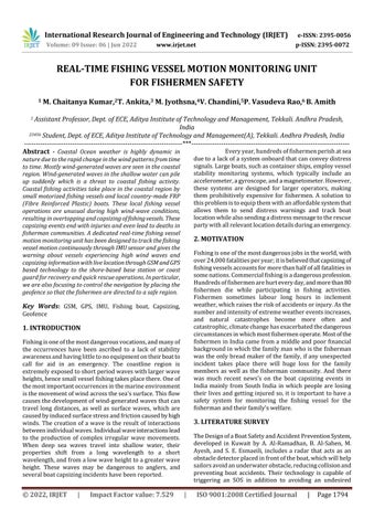
The Inertial Measurement Unit (IMU) is a device that produces motion data in a time series format. It's utilisedinavarietyofapplications,includingHumanActivity Recognition,TrackingandNavigation,andmanymore.The MPU9250 9 DOF (Degree of Freedom) module is a Micro Electro Mechanical System (MEMS) that combines an accelerometer,agyroscope,andamagnetometerintoatiny packageforthisproject.Asaresult,theMPU 9250isa9 axis motion tracking device with a 3 axis gyroscope, 3 axis accelerometer, 3 axismagnetometer, and a Digital Motion Processor. The MPU9250 module may interface with a microcontroller either through a serial port or a parallel port.TheSPIprotocolisknownasi2c.SPIispreferredfor faster speeds, whereasI2C hasfewerpins but operates at slowerspeeds.
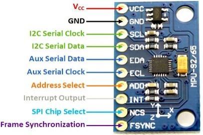
The ESP8266 is a low cost Wi Fi microprocessor with a microcontroller and integrated TCP/IP networking software.MicrocontrollerscanconnecttoaWi Finetwork andcreateprimitiveTCP/IPcommunicationsusingHayes styleinstructions.TCP/IPstandsforTransmissionControl Protocol/InternetProtocol,anditisasetofcommunication protocols that are used to link network devices on the internet as well as in private computer networks. The ESP8285 is a similar chip with 1 MiB of built in flash memory.Thissendsinstructionstotheperipheraldevices attachedtoit,whichactonthem.
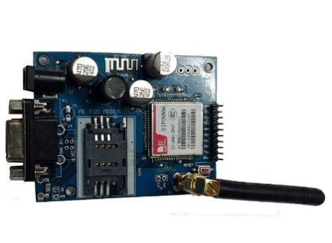
TheSIM900AGSMModuleisthetiniestandmost affordable GPRS/GSM module on the market. The module communicateswithamobilesimcardthroughGPRS/GSM technology. It can make and receive phone calls and SMS messagesandoperatesonthe900and1800MHzfrequency bands. The ESP module processes the IMU data, and if distressoccurs,itactivatestheGSMmodule,whichsendsthe datainURLformattotheSOScontact,alongwithamessage thatincludesthepositionandanalarmcall.
International Research Journal of Engineering and Technology (IRJET) e ISSN: 2395 0056
Volume: 09 Issue: 06 | Jun 2022 www.irjet.net p ISSN: 2395 0072
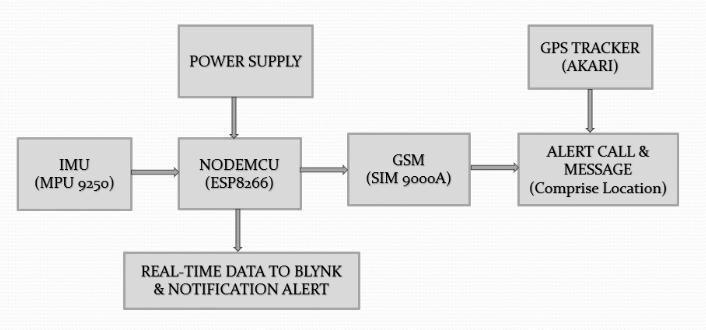
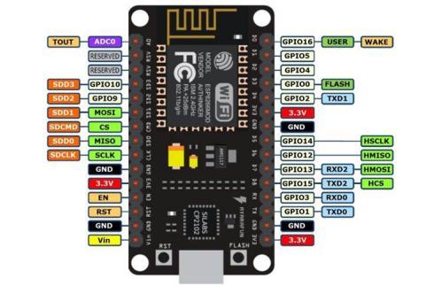
Fig.3:GSMModule(SIM900A)
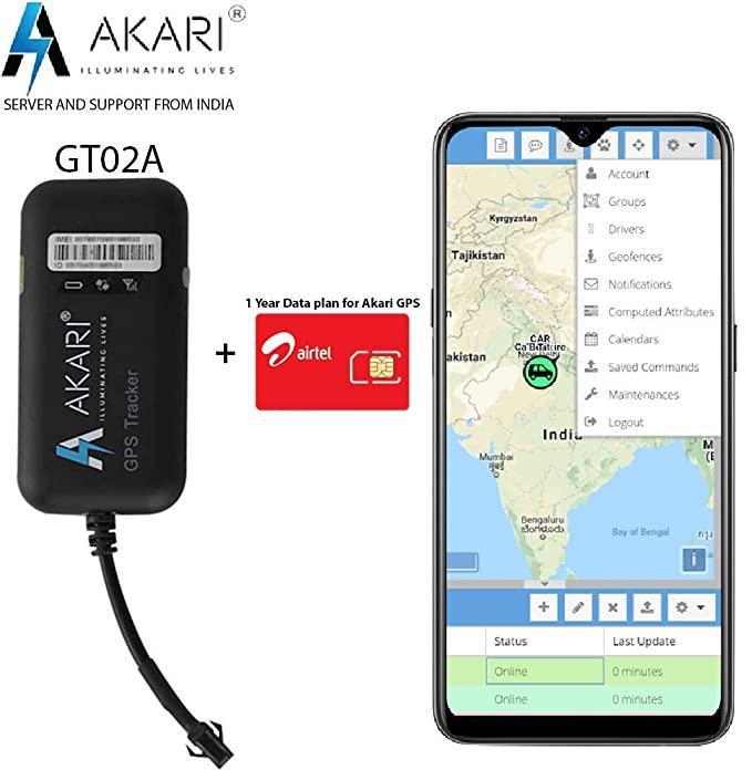
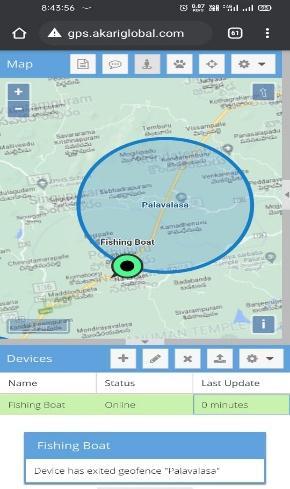
AGPStrackingunit,sometimescalledatracker, is a navigation device that utilises the Global Positioning System (GPS) to follow the movement and geographic position(latitudesandlongitudes)ofavehicle,asset,person, or animal. GPS tracking systems transmit special satellite signals, which are analysed by a receiver. The Akari GPS Trackerisatrackerthatusesthegsm/gprsnetworkandthe gps satellite positioning system to provide many security, location, monitoring, surveillance, emergency alerts, and trackingcapabilities.
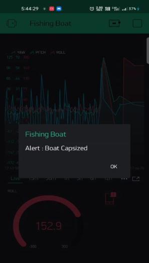
TheIMUunitwhichisMPU9250isembeddedwith the features of three individual units which are the Accelerometer,Gyroscope,andMagnetometer.Hereinthis projectwemainlyutilizetheAccelerometerandGyroscope forthecalculationofRoll,Pitch,andYawwhicharemotions ofthefishingvessel.Thatinformationisbeingevaluatedby the NodeMCU microcontroller whether there is any boat capsizing or not and if there is any boat capsizing it will enable the GSM module (SIM 900A) which alerts the respectivewithacallandmessage,themessagewillcontain alinkwhichdirecttotheAKARIGPSmapspagewhichshows thecurrentlocationofthefishingvesselwherethecapsizing incidenthasoccurred.
Themodelistestedinthedifferentwaterbodieswhichgives usthefollowingconclusions
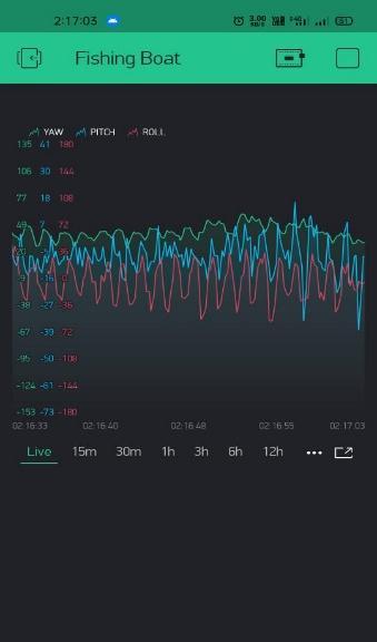
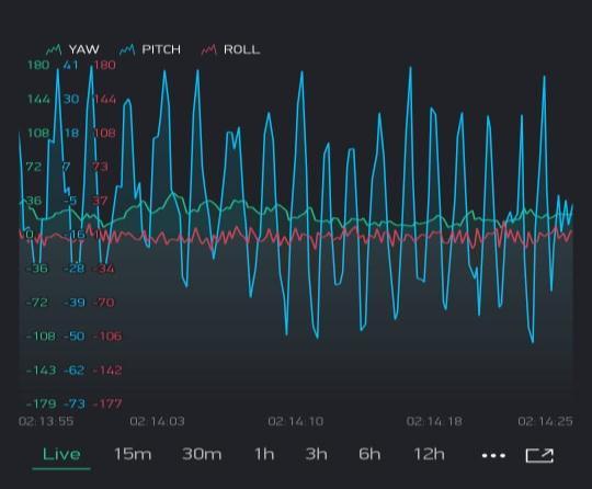
Mostlythepitchvalueisvaryingamongthethreevalues whenthesystemisinstalledintherespectivearenaas showninfig6.
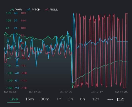
Wecreatedthecapsizingeventsothatwecanobserve the variation in the pitch, yaw, and roll values at the timeofdistress,weobservedthereisachangeinaxis whenthereisaturnoverofthefishingvesselandthere isalsoachangeinvaluesoffishingvesselmotion.When wecomparethechangeinthevaluesamongthethree motionspitch,yaw,androll,thereweobservedthereis awidevariationintherollmotionasshowninfig7So, wetookrollmotionasaprimaryvaluetodeterminethe capsizingeventofthefishingvessel.
International Research Journal of Engineering and Technology (IRJET) e ISSN: 2395 0056
Volume: 09 Issue: 06 | Jun 2022 www.irjet.net p ISSN: 2395 0072
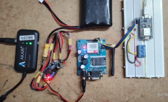
Fig.9showstheassemblyofallthecomponentsi.e.,thefinal prototype which is placed in a waterproof enclosure. In Blynkapplication,thereiscontinuousmonitoringofthedata andreal timedatacollectionasshowninfig10.
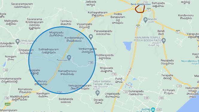
The main advantageof usingthe AKARI GPS Trackeris to createthegeo fences.Thegeofencescanbecreatedinany kindofshapecircular,rectangularwiththehelpoflinesand also with an area of coverage with respect to our requirementasshowninfig8.
Here the capsized event is intimated in two ways one is throughBLYNKandtheotheristhroughGSM.
1. In BLYNK, the intimation is given through the alert notification which is generated through the Blynkapplication and it also sends a notification if the device isdisconnectedfromtheserver
Fig.14:AlertNotificationforcrossinggeo fence
Fig.11:AlertNotificationthroughBlynkApplication
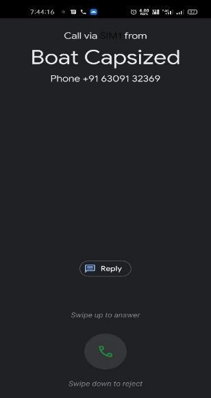
2.InGSM,theintimationisgiventhroughthealertcalland alertmessagewhichisembeddedwithweblocationlinkby clickingoverthelinkitwilldirecttotheakariwebsitesothat wecanobservethelivelocationtheboat.
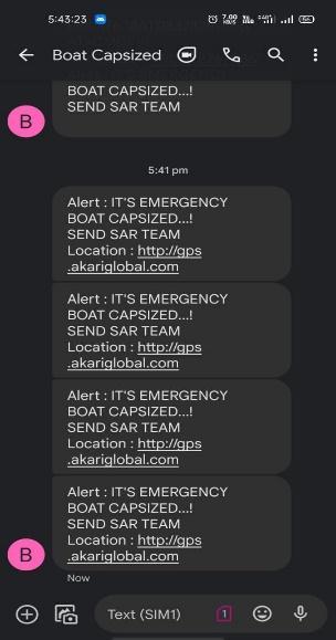
Fig.12:AlertCall Fig.13:AlertMessage
AKARI GPS Tracker tracks the movement of the fishing
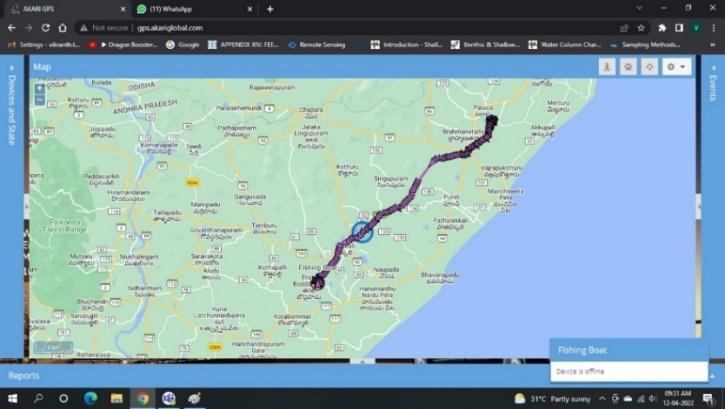
vesselandthereistheavailabilityoflivelocationanditalso hasafacilitythatstorestheprevioustracehistoryasshown in fig 15 and also helps to create the geo fences. The live location and tracking of the data can be accessed from a phoneorlaptop.Wegetthealertmessagewhenthereisin and out of the fishing vessel in the respective geofence as showninfig14.
Fig.15:LiveTrackingoftheSystem
The system with Satellite communication improves long rangefishingactivitiesand worksout ofcellularcoverage andwillgiveawiderangeofcoverage.
A further prediction of wave activity with two way voice communication which shares the voice message from the shoretothevesselandvesseltoshoremakesfasterrecuseof fishermanifanyincidenthappens
Thiswill helpinintroducingthelatesttechnologiestothe fishersandmakesafercoastalfishingactivitiesforthelocal fishermancommunitiesandimprovementinsurveillance.
VillagesinIndiacalledLankavillageswhicharecompletely surroundedbywaterhaveonlythewatertransportationfor evenchildrentogotoschool,sointhisscenario,thevessel motionmonitoringunitwouldplayavitalrole.
International Research Journal of Engineering and Technology (IRJET) e ISSN: 2395 0056
Volume: 09 Issue: 06 | Jun 2022 www.irjet.net p ISSN: 2395 0072
Local fishermen can afford to have the device installedintheirboats.Fishermenarethemostsusceptible duringacrisissincetheyhaveabsolutelynocommunication technologyonboardthatcanbringthemaidontheirlocation during an emergency. The suggested solution intends to protect fishermen's safety by employing GPS and GSM technologies in conjunction with the Internet of Things to keepaconstanteyeonthefishingvessel.Accordingtoour evaluation,oursystemidentifieslocationwithhighprecision andprovidesdatainamatterofseconds,sointheeventofa crisis,itwillbeabletorapidlysendadistresssignaltothe searchandrescueteamwiththeirposition.Thesuggested system would allow the turnover to be automatically detected,anditwillbeabletoconnectwiththecoastguard orSARteamintheeventofanemergency.Asaresult,the proposedsystemwillhelpsavethelivesofmanyfishermen inIndia.
[1] Al Ramadhan, B. Al Sahen, M. Ayesh, and S. Esmaeili, "TheDesignofaBoatSafetyandAccidentPrevention System", 2017 9th IEEE GCC Conference and Exhibition (GCCCE), 2017. Available: 10.1109/ieeegcc.2017.8447898 [Accessed 27 July 2019].
[2] L. McCue, “Putting vessel motion research into the hands of operators,” in Proc. 11th International ConferenceontheStabilityofShipsandOceanVehicles, Athens,Greece,September2012.
[3] A. Munshi, M. Mishu and K. Sayeed, "A low cost COSPAS SARSATalternativeforEPIRBtransponderfor local fishing boats in Bangladesh", 2014 10th International Conference on Communications (COMM), 2014. Available: 10.1109/iccomm.2014.6866704 [Accessed20July2019].
[4] MarineAccidentInvestigationBranch,“AnnualReport,” 2014. [Online]. Available: https://www.gov.uk/government/uploads/system/ uploads/attachment data/file/448430/MAIB AnnualReport2014.pdf
[5] Kemp and Young, Ship Stability notes and examples, 3rd ed. Butterworth Heinemann, 2001. Kemp and Young, Ship Stability notes and examples, 3rd ed. Butterworth Heinemann,2001.
[6] Mandal,S.,Hasan,I.,Hawlader,N.,Sultana,I.,Rahman, M. and Majumder, M., 2020. Occupational Health Hazard And Safety Assessment Of Fishermen Community In Coastal Zone Of Bangladesh. [online] Article.sciencepublishinggroup.com. Available at:
<http://article.sciencepublishinggroup.com/html/10.1 1648.j.hep.20170202.14.html?fbclid=IwAR3c_EweIniU HN3Zzgl3YFZL1Y7lsPBKa LwwyZJSL msnDvl8YU07u66GRs>[Accessed10August2019].
[7] N. Reddy, G. Ramakrishnan, and K. Rajeshwari, "Ensuring fishermen safety through a range based systembytrizonallocalizationusinglowpowerRSSI", 2017 Fourth International Conference on Signal Processing,CommunicationandNetworking(ICSCN), 2017. Available: 10.1109/icscn.2017.8085707 [Accessed27July2019].
[8] B.A.I.Nirmal,“GPSBasedTrackingSystemforFishing BoatsinSriLanka”ICT3016FeasibilityStudy[Online]. Available: https://www.academia.edu/17311783/GPS_Based_Tra cking_System_for_Fishing_Boats_in_Sri_Lanka. [Accessed:20July2019]
2022, IRJET | Impact Factor value: 7.529 | ISO 9001:2008 Certified Journal |