International Research Journal of Engineering and Technology (IRJET) e ISSN: 2395 0056

International Research Journal of Engineering and Technology (IRJET) e ISSN: 2395 0056
12345Department of Civil Engineering Sandip Institute of Technology and Research Center Mahiravani, Nashik, 422213.
67Prof. Assistant Professor, Department of Civil Engineering, Sandip Institute of Engineering and Management, Mahiravani, Nashik 422213. ***
Abstract Water is an essential element of economic development in any region. In recent years, Maharashtra Province (India) has been plagued by regional instability due to spatial and temporal variability in rainfall and lack of efficient use of the slope of the western part of the Sahyadri slope, which receives excess rainfall and adds to it. destructive in the Arabian Sea. Par River (2000 to 3000 mm Avg. Annual Rain) originates from the Kame hills in the Sahyadri species. The river flows west towards Gujarat State (India) and adds to the wastewater of the Arabian Sea. The Par river valley faces summer water shortages as opposed to overflowing rains during the rainy season. Endless Topography limits local irrigation. In contrast, the eastern part of the Sahyadri (river valley of Girna) is an area of low rainfall (1500 2000 mm Avg. Annual Rain). Therefore, this region is constantly experiencing water shortages. Water circulation is possible at two levels for sustainable development in any region. In the intrabasin cycle of flowing water, circulation can take place within the vessel itself (Punad Project). Though the water flows between the vessels; rotation is possible from one container to another. An effort has been made on paper to research and promote the efficient use of water in the study area which is possible by circulating water from Par to Girna.
planningensuredthatlocalcommunitiesplayedakeyrolein making the project a success. The local community has provided free staff to do this work. Several landowners sacrificed part of their property to start the project. The subdivisionofunproductivelandmakestheremainingplots oflandproductiveduetothewaterbeingmadeavailablefor irrigation.Theuniformityofpurposeresultedintheproject beingspentonrecordedtimeandwithlimitedfundingfrom Government. The success of the project has led the Maharashtra District Government to encourage District Managerstoconsiderwhetheritispossibletoreplicatethis model in their areas. The Department of Administrative Services,GovernmentofIndiahasidentifiedthisprojectasa good governance initiative. The project also received the Premier's Award for Excellence in Public Administration. ThisNoteProjectaimstodisseminateproject background andinformationtomakethisprojectasuccess.
Divertwaterfromresidualwatertodryanddesertareasin theregion.Increasingtheefficiencyofvariouswaterstorage facilities. Provide appropriate construction techniques for canalandtunnel.Andalsopar,nar,andgiranabasinwater transfertoGodavaribasin.
The Nashik River Linking Project is a new solution to the chronicproblemofunequalwatersupplyintheregion.The paradox of floods in some parts of the country and the droughtinpartsoftheregionwerethebeginningofaproject to connect the river. This work has provided a lasting solutiontotheproblemofwaterscarcityinseveralpartsof the region. This work has brought great benefits to all stakeholders in the urban and rural areas of the region, increasingtheavailabilityofdrinkingwaterespeciallyinthe summerandintheagriculturalcommunityandincreasing agricultural land. This work has brought in many governmentagencies/stakeholdersDistrictManagement, the Department of Irrigation, Municipal Structures and electedrepresentativesinoneplacetomaketheprojecta success.Inaddition,theparticipatoryapproachtopregnancy
A detailed field level survey (conducted by the irrigation department)toinvestigatewatershortagesandtoevaluate the effectiveness of the groundwater recharge structure. Identification and evaluation of existing infrastructure to minimizetheconstructionofnewcanals.Anunderstanding oftheregionalcirculationunderstandingthatcanbeusedto divertwater.
Thetunnelandthecanalconstructionmethoddependson the geographical specifications and geology accordingly, dependingonwhichconstructionmethodisused.providing groutingandlinetoprovidetunnel&trench.
Thisstudyisbasedonsecondarydata.Thedescriptionofthe Nashik region is attempted to mark the watershed of the river Par, Nar & Girana With the help of the following softwareprocessessuchasScanning,Georefrencing,Mosaic,
Volume: 09 Issue: 06 | Jun 2022 www.irjet.net p ISSN: 2395 0072 © 2022, IRJET | Impact Factor value: 7.529 | ISO 9001:2008 Certified Journal |
International Research Journal of Engineering and Technology (IRJET) e ISSN: 2395 0056
Volume: 09 Issue: 06 | Jun 2022 www.irjet.net p ISSN: 2395 0072
Reprojectionofthetoposheetandcreatingvariouslayers have been created. Aspect map editing, slope map, DEM (Digital Height Model) and various layers such as rivers, villagearea.
Tunnel system: Flowchart
Nashik is the third largest district in Maharashtra with a totalareaof15530sq.Km.km.Accordingtogeograpy,the regionincludespartoftheDeccanPlatau,oneoftheoldest blocksonthe
surface of the earth. A region can be broadly divided into three geographical regions, namely a) downghat konkan tract;b)theGirnapitandc)theGodavaribasin.
Girna MosamBasinisoneofthemostimportantriverbasins intheNashikregionofMaharashtraandisrichinagriculture and land use. The Girna River is the main tributary of the Tapti River, and the Mosam River is the tributary of the Girnas. Population growth is one of the key factors in changinglanduseandisamajorthreattothelowlands.The populationoftheGirna Mosamareamakesup37.54percent oftheNashikregion.Theaveragepopulationdensityis280 peoplepersquaremile.TheBasinhasatotalareaof5829.43 square km. Between 20 ° 15 '43 "to 20 ° 53'07" latitude north and 73 ° 40'12 "to 74 ° 56'22" east length. This containercanbewider dividedintofourtehsilsnamely,Malegaon,Nandgaon,Satan, KalwanandDeola.
Thisstudyisbasedonsecondarydata.Thedescriptionofthe Nashikregionisattemptedby
markingthewetlandsoftheParandGirnariverswhere46H /11,46H/15IndianweathermapspublishedbytheSurvey of India (S.O.I) were used. Digital insertion of paper sheet No.46H/11and46H/15(1:50,000)wasmade.Withthe help of the following software popular processes such as Scanner,Georefrencing,Mosaic,ToposheetOppositionand createvariouslayersarecreated.Aspectmapediting,slope map,DEM(DigitalHeightModel)andvariouslayerssuchas rivers,villagearea.
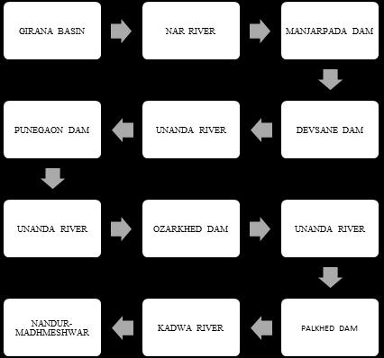
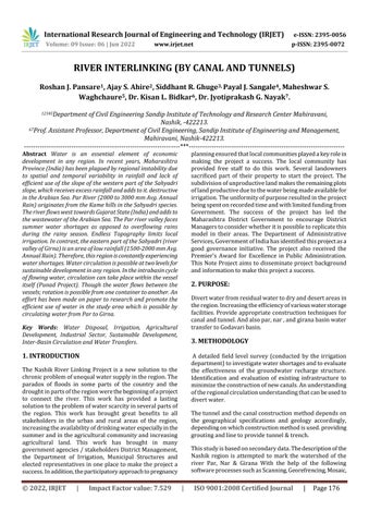
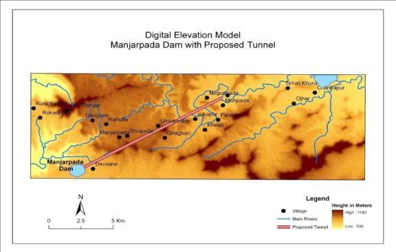
The Par rivers valley is experiencing a summer water shortage,incontrasttoheavyrainsduringtherainyseason. Consistent physiography limits local irrigation processes. Duringtherainyseasonduetogoodrains,Kharifplantsdo notneedwaterandduringRabbi&Non rain,duetolackof water storage, water is not made available. Using this wasteful tap water for irrigation and drinking water, the needtobuildadamnearManjarpada,Tal.Surgana(Nashik) has been made since ancient times. Participating in this project is a hilly plateau with a cover of 14.75 km2 (5.76 miles2).Thewaterholdingcapacityof50%isapproximately 845millioncubicmeters(MCM).Thelengthofthisclaydam is 2070 mt and a maximum of 56 mt. Its total volume of strorage is 570 mcft, of which 26 are C. Inter Basin Circulation
Inthisprojectriversflowingwest(Nar Par)willbediverted easttoGodavarivalley.
The planning commission has given the private sector authority over the project research; seven dams are proposed to be built under this project, which will be connected to each other by tunnels and pipelines. 89.12 millioncubicmeter.water(M.C.M)Itisproposedthatitbe raisedandstoredatGodavariBasin.
Inthisprojectwestflowingrivers(Nar Par)willbediverted totheeastintheGodavaribasin.
The planning commission has given authority to private sectorforthisprojectsurvey;sevendamsareproposedtobe constructedunderthisproject,whichwillbeconnectedto each other by tunnels and pipelines. 89.12 million cubic meter.water(M.C.M)isProposedtobeliftedandstoredin GodavariBasin.
Fromthe7proposeddamstobebuiltinParUpliftProject No.Thisextrawaterwillregeneratethepreviouslyirrigated
International Research Journal of Engineering and Technology (IRJET) e ISSN: 2395 0056
Volume: 09 Issue: 06 | Jun 2022 www.irjet.net p ISSN: 2395 0072
areathatwasunderwatercrisis.Therestoftheadditional arablelandcanbeplacedunderirrigationwiththerightand left canals of the Girna River.The rationale for the Manjarpadaproject:
InthisprojectthewateroftheParriverfromtheKamehills ofSahyadriwillbeboundatthebottomofthemountainat analtitudeof700metersabovesealevel(MSL).At690.50 mt the height from the MSL near the Haladbarda valley is divertedtotheGirnavalleybyatunnel.Aftermeetingthe Surgana and Dindori Tahsils irrigation requirements the remainingwatercanbedivertedtoa11.50kmtunnel.Girna.
Planningforfullutilizationofavailablewaterintheproject areaisunderway.Available845
WatereconomyMCM78MCMwaterwillbeavailableinPar basin.5weirswillbebuiltfromthebottomoftheriverand water will be distributed through private lift Irrigation systems.Oftheremaining291MCMwater,duringtherainy season the 11.50 km long tunnel, will be excavated in the upper part of the Chankapur dam on the river Girna. 114 MCM of the Right Canal of Chankapur included under the Punad project will irrigate the first 2445 ha kharif arable land.Theremaining57MCMwaterneartheLeftGirnacanal willberaisedby10to50mtandsmallirrigationcanalsin DundheandAjangwillbefilledwith50%oftheircapacity. These walls are always dry due to lack of rain. One small irrigation project for each Kalwan & Baglan tehsil is proposed.The120MillionCubicFeet(MCF)fortheKharif,
seasonwillbeextractedfromtheGiranaRiverandusedby Baglan&Kalwantehsil inaccordancewithenvironmental law.Ofthe544MCFlivingwaterstoredattheManjarpada dam,78mcftwaterwillbeavailablefromDindori&Surgana talukas, the remaining 454 mcft through a tunnel will be found at the Chankapur dam (Girna container). With this projectcoveredduringtheKharif&Rabbiperiodatotalof 9,233hawillbeirrigatedintheNashikregion.
ThewaterstoredattheMahjarpadadamwillbepumpedto theChankapurdambya11.50mtlengthoftunnel,theflow rate of the tunnel is considered to be the overflow and divertedwaterduringtheKharifseason.DuringtheKharif season291mcftwaterwillbedivertedwhichisconsidereda 40 dayflow.However,thevolumeofthetunnelisproposed tobe20days.Thefirstbasiclevelofthetunnelisproposed tobe702mtandthefinalbaseleveltobe690.50
An aqueduct ditch built to carry water to the fields for irrigation. Water is taken from a river, tank or reservoirs. Trenchescanbeconstructedusingconcrete,stone,brickor anyotherflexiblemembranethatsolvesrigidproblemssuch as water flow and erosion. The distribution system in the irrigationsystem,thearrangementofthetrenches,curves and specific aspects of the irrigation canal are briefly described in this article. Any irrigation scheme i.e. direct irrigationusingweirorbarrageandirrigationsystemsuch asdamsorpond,bothrequireanetworkofirrigationcanals ofvarioussizesandcapabilities.Thecanalsystemtherefore includes:
Tableno.1
1. Mainearthenware Length370m
2. TurndamsNo.1and2 Length120mand210m
3. Couples1and2 Length200mand220m
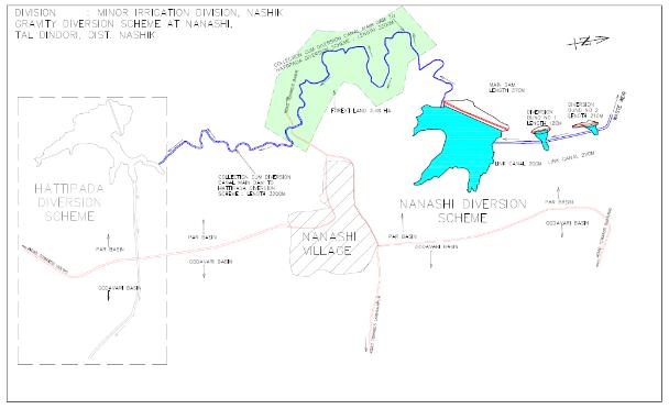
4. Canal diversion canal from main earthen dam to Hattipadadam Length3200m
35.39Mcft.
Figno.2layoutofnanashiproject
5.1 Program Canal Diversion Scheme, Nanashi, Tal. Dindori, Dist. The Nashik project is located on the west bank of the river.
According to a water supply certificate issued by the Hydrology Project, Nashik and the standard approved system, 370 meters. Area consumption of 19.61 liters of water on 54.99 liters of water is available on 1 sq. M. Drainage by a large 17 foot long [17 m] clay dam with a capacityof19.61gallonsandtwosmalldams.
in line with the general framework of the program, the programincludesthefollowingcomponents.
IntheNanashiregionwateriscollectedfromthenalasanda smallriveranddivertedtoaidinastrangearea,througha smallcanalthatcollectswaterandmeetsinalargecanaltoa waterreservoi
1.DivertedwateroftheParriverinthevalleyofGirnawill increaseitswaterlevel.Becauseofthiswatermostofland willbeirrigated.
2.TheirrigatedareaduetotheleftandrightGirnaCanals willbereplaced.Withmaincanal
3.ItwillsupplywatertothecanalsofGirnaRightandthe Rabbi season. Will revitalize small Dundhe and Ajang irrigationprojectinMalegaonTehsilalsodindoriandYeola.
4.DuringtheKharifseason,thefloodwatersfromtheGirna canal, at a height of 10 to 25 mt, can be restored. For irrigationindrysessionwillbereusing.
International Research Journal of Engineering and Technology (IRJET) e ISSN: 2395 0056
Volume: 09 Issue: 06 | Jun 2022 www.irjet.net p ISSN: 2395 0072
5. Implementing those small canal projects and Kolhapur (KTWeirs)projectsarenotpossibleduetowatershortages.
6. Under the Punad project, Chankapur Chankapur Right canalswatercanbesuppliedtoKharifplants.Alsopunegov damandozarkheddamcapacitywillbeincreasing.
Coordinating river projects is a major challenge and an opportunitytoaddresswater relatedproblemsthatcause droughts, floods, climate change and more. The long term strategyforwaterscarcityliesinmeetingthechallengesof rivers by building a network of dams, lakes, wetlands, hydroelectricpowerplantsandcanalsinallregionsofthe country.Linkingrivershasmanybenefits.Butthisshouldbe the last resort. India gets a lot of rain, but most of this rainwaterfallsintothewater.Ifwetakeallthisrainwater, Indiawillnotfacewatershortagesintheyearstocome.
However,riverconnectionisareallygoodsolutiontowater scarcity, but the connection should be done after careful researchanddetailedresearchsoasnottocreateproblems fortheenvironmentoraquaticlife.
So it may be a good idea to focus on local resources and considerotheroptionsavailable.Althoughtheprojectisan excellent opportunity for our nation to succeed and solve manyofourcurrentproblems,itissomehowaninvitationto manyothers.Therefore,evenifthisprojectisimportant,in thecurrentcontextandfinancialsituationofthenation,itis notappropriatetocontinuewithit.
IS 4756: Safety code for tunneling work : BureauofIndianStandards
IS: 7112 1973 TheBureauofIndianStandard code.
Ministry of Water Resources, Government of India, 1980. The National Perspective. New Delhi. http://wrmin.nic.in/ interbasin/perspective.htm.
Weekly,Vol38(29):3032 3033.
Roy, A. 1999. The Greater Common Good, Bombay: India Book. Shiva V, (2003), River Linking: False Assumptions. Flawed Recipes. New Delhi, Navdanya. http://www.navdanya.org/articles/false_ assumptions.htm
Ministry of Water Resources, Government of India,2002.ResolutionNo.2/21/2002 BM.13 (December).NewDelhi.
Ministry of Water Resources, Government of India. 1980. The national perspective. New Delhi.http://wrmin.nic.in/
http://www.wrmin.nic.in/writereaddata/link images/nwp20025617515534.