International Research Journal of Engineering and Technology (IRJET)
e-ISSN: 2395-0056
Volume: 09 Issue: 05 | May 2022
p-ISSN: 2395-0072
www.irjet.net
Route optimization of solid waste transportation in part of Lucknow- Capital city of Uttar Pradesh, India Reetu Rawat1, Dr. Virendra Kumar2, Dr. Sudhakar Shukla3 1M.Tech
Scholar, School of Geoinformatics, Remote Sensing Applications Centre, Uttar Pradesh, India 2 Scientist-SE, Remote Sensing Applications Centre, Uttar Pradesh, India 3Scientist-SE and Head of School of Geoinformatics, Remote Sensing Applications Centre, Uttar Pradesh, India ---------------------------------------------------------------------***---------------------------------------------------------------------
Abstract – The solid waste management system is a tedious
2. STUDY AREA
task facing developing and developing countries. Site validity analysis and improving a solid waste disposal route can make waste management cheaper and can be used for sustainable development. The result obtained shows the improvement of the route between the Shivari plant to the zone 4 place of Nagar Nigam Lucknow in two ways, each giving a very short effect and one of the fastest solid waste disposal routes. Time and distance are two factors that affect the outcome. In arc gis the distance to improve the route of the map and the time difference between the first collection point in the disposal of the time difference 0.2847 hour and the distance difference 0.2288 kilometer in large urban areas. Key Words: Municipal solid wastes, Route optimization, Waste collection points, Disposal sites, GIS, Remote Sensing, and ArcGIS.
1. INTRODUCTION The Municipal Solid Waste (MSW) Board from Urban Development has become a real concern for administrative offices, pollution control agencies, and administrative bodies and is open to most of the old urban areas. Lucknow is an important city and capital of Uttar Pradesh State 525 kilometers from Delhi and around 920 kilometers from Calcutta. Lucknow has long been known as a multicultural city and flourished as the social and artistic capital of North India for eighteen nineteen centuries and as a stronghold of the Nawabs. Lucknow is an important city and capital of Uttar Pradesh State. It is 525 kilometers from Delhi and about 920 kilometers from Calcutta. Lucknow has long been known as a multicultural city and flourished as the social and creative capital of North India in the eighteenth and nineteenth centuries and as the seat of the Nabsabs. Today it continues as an important center for teaching, commerce, aviation, accounting, drugs, innovation, programming, culture, the tourism industry, music and verse. Lucknow is still 123.45 meters above sea level and covers an area of 689.1 km. It is bordered on the east by the District Barabanki, on the west by the Unnao region, on the south by Raebareli and on the north by the districts of Sitapur and Hardoi. The town is located on the northwest shore of the Gomti waterway, which runs through it. Lucknow Municipal Corporation (LMC) is responsible for the management of the city-built MSW.
© 2022, IRJET
|
Impact Factor value: 7.529
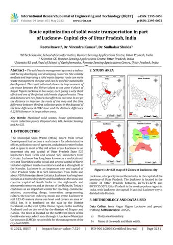
Figure1: ArcGIS map of 8 Zones of Lucknow city Lucknow, a large city in northern India, is the capital of the province of Uttar Pradesh. The Lucknow is located in the center of Uttar Pradesh between 26˚55’11.12”N and 80˚59'55.55"E. Uttar Pradesh is the most populous region in India, with Lucknow the capital. Municipal Lucknow city is divided into 8 zones.
3. METHODOLOGY AND DATA USED Data Collect from Nagar Nigam Lucknow and ground truthing. Software used- ArcGIS.
|
a)
Study area boundary.
b)
Name of the roads and their width.
ISO 9001:2008 Certified Journal
|
Page 3131