International Research Journal of Engineering and Technology (IRJET) e ISSN: 2395 0056

Volume: 09 Issue: 05 | May 2022 www.irjet.net p ISSN: 2395 0072
International Research Journal of Engineering and Technology (IRJET) e ISSN: 2395 0056
Volume: 09 Issue: 05 | May 2022 www.irjet.net p ISSN: 2395 0072
1
1,MIG 105, Board of Radiation and Isotope Technology, BRIT/BARC Vashi Complex, Sector 20, Vashi 400703, Navi Mumbai, Maharashtra, India ***
Abstract Since a long time India has pioneered in production, fabrication, supply and use of radioactive sealed sources with utmost safety and responsibility. Various types of irradiator sources for use in the country and abroad are fabricated as per the standards. Not only the irradiation facilities run by the Government but with several radiation processing plants commissioned in the private sector after signing up MoU, the requirement for industrial radioactive sources has rapidly increased. The irradiators and the related sources have diversified roles ranging from food processing, medical sterilization to research and medical uses. A major challenge with radioactive sources apart from safe handling and use is safe transportation across the country. It is not viable to send an escort person every time to accompany the vehicle and the freight. An equipment has to replace a man. So as a standard practice a GPS/GLONASS based Vehicle Tracking System has been designed in house as per own requirements.
AGPSandGLONASSaresatellitebasednavigationsystemandbeingacommontermknownbymostofus,ithasaimmense use in tracking, locating, guidance and navigation of people and assets. Starting from vehicle and traffic navigation, militaryuseinguidedmissilesandbombs,freightandassettracking,marineandseanavigation,airtransport,homing location beacon, use in smart phones and handheld devices etc. its uses are immense and too many possibilities of furtherdevelopments.InIndiaweneedthisextensivelyfortrackingandlocatingourCobalt 60basedradiationsource transportedbyheavymotorvehicle.ThoughGPSisUSbasedtechnologyyettherearemanycountriesthathavetheir ownversionsofGPSnamelyGLONASSofRussia,BeiDouofChina,IRNSSofIndia,GalileoofEuropeanUnion,QZSSof Japan. The GPS modules often use one or more technology like GLONASS or IRNSS etc. in a single chip to provide redundantcoverageeitherofoneormoresystems.HereisanimportantpointtonotethatIRNSSandQZSSareregional systemslimitedtothebordersofthecountryitself.HoweverGPSandGLONASSbeingavailableforlonginthemarket, mostoftheofftheshelfmodulessupportthemandareeasilyavailableinlocalmarket.GraduallyIndianIRNSSmodules arealsobecomingavailableasmanyofthedevicestartupsaretakingupfabricationofreceivermodules.
WeareusingastandardGLONASS/GPSmoduleforredundancyofreceptionandwhichisreadilyavailableinlocalmarket.A GPSreceivermoduleisalwaysalisteningdevice.ItalwaysreceivesdatafromGPSsatellitesinformofincidentradiowaves GPSmodulenevertransmitsdata,theyonlyreceive
GLONASS/GPSpositioningisbasedontrilateration,whichisthemethodofcalculatingexactpositionbymeasuringdistancesto pointsatknowncoordinates.Asabareminimum,trilaterationrequiresthreerangesto3knownlocations.GPS/GLONASS positioningrequiresfourpseudo rangestofoursatelliteswherefourthsatelliteisusedfortimingerrormitigationifwedig deeperintoitsworking.WewillseebasicsofGPSinthisarticleforbroadunderstandingofGLONASSaswellwhichworksin differentfrequencybandbutoverallconceptisverysimilar.AsGPSisgenericterm,itisveryeasyforbeginnerstounderstand thisconcept. [1]
AsignalistransmittedfromallsatellitestowardstheEarth.ThissignalcontainstheC/A(CoarseAcquisition)signal,Pcodeor PreciseCodeandNavigationMessage,whichisreceivedbyGLONASS/GPSreceivermodules.Theexacttimestampperfectly syncedwithatomicclockon boardsthesatellitethatthesignalistransmittedfromthesatelliteisencodedwithinthesignal incomingtothereceivermodule.Timeofsignalreceptionisrecordedbyreceiverusingon boardclockofthereceivermodule. Areceivermeasurestheerrorinformdifferenceinthesetwotimedata
International Research Journal of Engineering and Technology (IRJET) e ISSN: 2395 0056
Volume: 09 Issue: 05 | May 2022 www.irjet.net p ISSN: 2395 0072
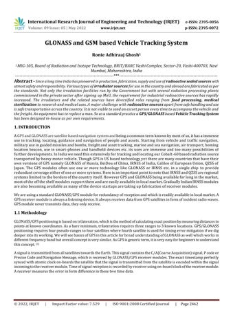
Fig.1 Arrangementoftrackingsatellitesinorbitofearth
NominalConstellationofaGPSorGLONASS
pseudorange=(timedifference) x(speedoflight)
Notethatpseudorangeisrangecontainingclockerrorsbecausethereceiverclocksarenotperfectasatomicclock.Thesatellite clockerrorisencodedinNavigationMessage,intheformofadigitalpolynomialstreamgeneratedbyonboardlogic.The receiverclockerrorcanbecalculatedbythereceiveralongwithunknowncoordinates.Thereare4variables thereforewe needaminimumof4pseudorangemeasurementstogettheexactresults. [3]
TherearebroadlyfourGPS/GLONASSsegmentstobeknownforbeginners[2]:
SpaceSegment,whichincludesthegroupofGPS/GLONASSsatellitesorbitingEarth,whichtransmitthesignalstothe receiver.
ControlSegment,whichisresponsibleforthehousekeepingoftheSpaceSegmentusingsatellitetrackingandcontrol.
User Segment, which includes user hardware modules and processing firmwares and softwares for trilateration, positioning, navigation,andguidanceapplications.
Ground Segment, which includes civilian/asset tracking systems that provide the User Segment with reference positions,preciseephemerides,andrealtimeservices.
ThetimingsignalsfromaGPSsatellitearegeneratedbyCesiumatomicclocks.Thebaselfrequencyis10.23Mhz.Twocarrier signalsgeneratedfromthissignalbyfrequencymultiplierofmagnitude154fortheL1channel(frequency=1575.42Mhz; wavelength=19.0cm),andfrequencymultiplierofmagnitude120fortheL2channelwithfrequencyof1227.6Mhzwhich turnstobewavelengthof24.4cm).Thebinarybitstreamsof0sand1sofhavePSKmodulationwhichleaveshasphaseintact forbit0orchangesitby180degreesforbit1.
International Research Journal of Engineering and Technology (IRJET)
e ISSN: 2395 0056
Volume: 09 Issue: 05 | May 2022 www.irjet.net p ISSN: 2395 0072
Therearethreetypesofcodeonthecarriersignals:
TheC/Acode
ThePcode
NavigationMessage
TheC/AcodecanbefoundontheL1channel.Thisisacodesequenceregeneratesevery1ms.Itisapseudo randomcode, whichinfactisgeneratedbyaknowncomplexalgorithm.ThecarrierfrequencyisresponsibleforthetransmissionoftheC/A codeatbitrateof1.023Mbps.TheinformationonC/Acodeisbasicallythetimeasperthesatelliteclockwhenthesignalwas transmitted.EachsatellitehasadifferentC/Acodeowingtouniquesetofgeneratorlogic,forindividualidentificationbythe receiver.
ThePcodeispresentandtransmittedonboththeL1andL2channel.WhereasC/Aisabroadertolerancecodesufficientfor initiallysyncingontothesignal,thePcodeisformoreprecisepositioning.Pcodecanbeprotectedandencryptedbyaprocess knownasanti spoofing/anti jammingandusedbyUSmilitaryandalliesandtheaccesstotheciviliansarenotprovided.
TheNavigationMessageisontheL1channelthatistransmittedataveryslowbitrateofonly50bps.Itisa1500bitlong sequencewhichtakes30secondstotransmit.TheNavigationMessageincludesinformationonthesatelliteorbitdataalso knownasbroadcastephemeris,satelliteclockcorrectionsdata,almanacdatathatisapproximatepositionofallothersatellites, ionosphereconditioninformation,andsatellitediagnosticstatus.AllsignalsreceivedbyaGPS/GLONASSreceivermodule calculatesthepositioninformofgeographicallatitudeandlongitudecoordinates.ForexamplelikeLatitude=19.077142˚Nand Longitude=73.013075˚E.Apartfromthegeographicalpositiondata,GPSalsomeasurealtitudeabovemeansealevel,speedof thevehicle,currentdate timestamp,systemhealth,batterychargestatusetc.OnsimilarbasisGLONASSalsoworkbutwith differentsatelliteconfigurationsanddifferentfrequencybandsofbroadcast.
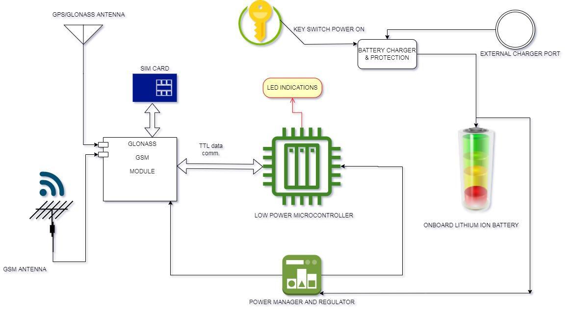
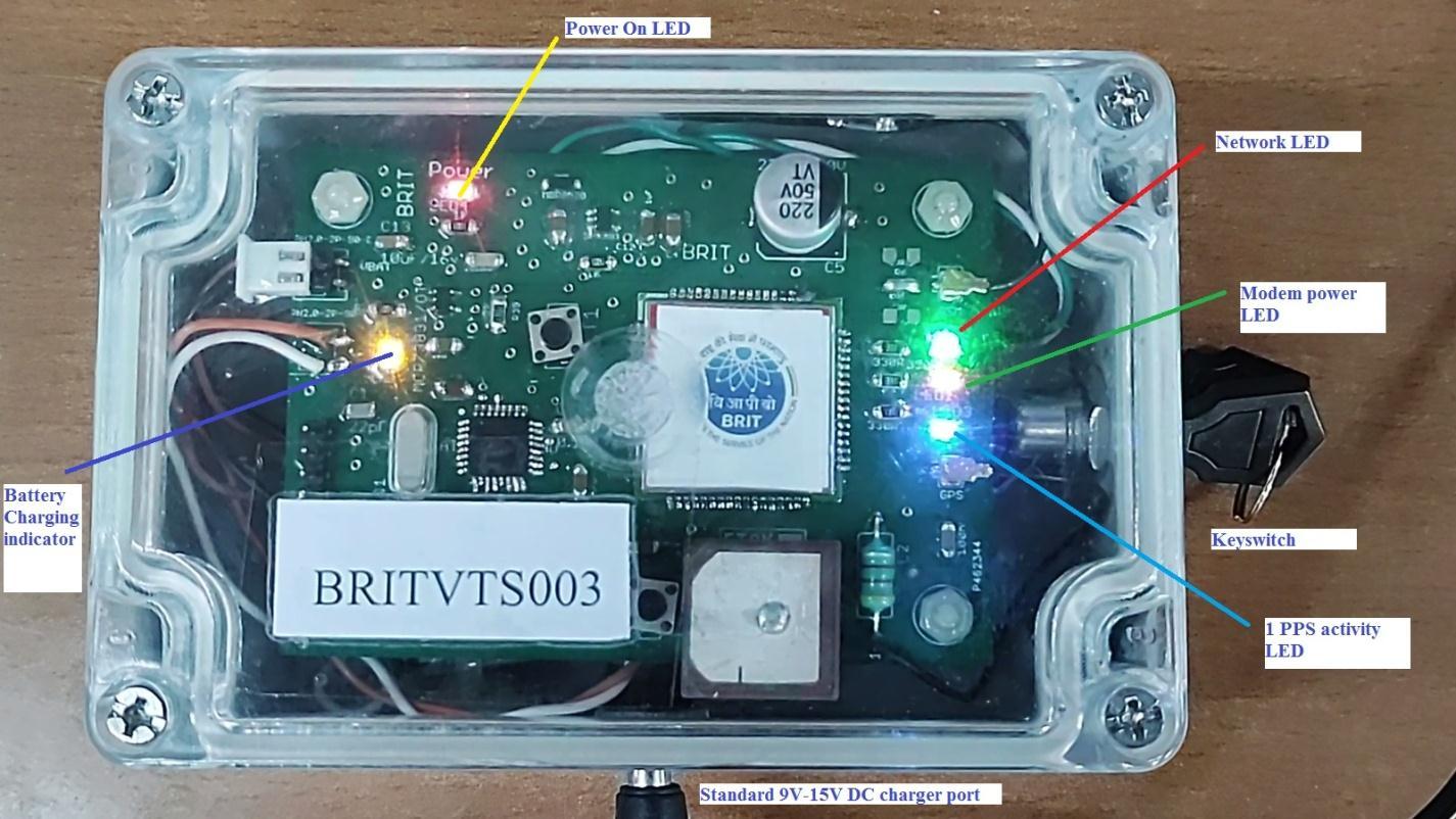
ThesystemalsousesGSM(GlobalSystemforMobilecommunications)withaSIMcardhousedinthesystem.Thedeviceuses SMS(ShortMessagingService)totransmitthedevice'slocationtoareceivingGSMmodemattachedtoaVehicleTracking Serverinuser'spremises.IntheactualsystemGPSsystemandGSMsystemarehousedinonesinglemodulethathasbeen assembledonasingleprintedcircuitboard.Thesystemisgovernedbyalowpowermicrocontrollerthatcommunicateswith GPS/GSM module to fetch the location after a certain amount of time elapsed and send the location via SMS. The system includeson boardpowerregulator,on boardLi Ionbatterycharger,batteryprotectionsystem.LEDindicationshavebeen providedforuserconvenience.TheGSMusesaflexiblepatchantennathathasbeenpastedontheinsidebodyoftheenclosure anditshasbeenconnectedtothesystemviaaUFLconnector(atypeofminiaturecoaxialRFconnector.TheGPSusesaceramic antennawithactivebiasingforhighersensitivity.IthasbeenattachedontopofthesystemboardwithUFLconnectiontothe system.Thebatterycableviaakey switchandchargingpowercablehasbeenconnectedthoughaDCbarreljacktotheboard. TheSIMcardishousedinaconnectoronbottomsideoftheboardforconcealment.
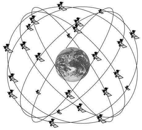
AsperFig.2therawpacketoftheGLONASSlocationdataisshownwherethe
the
systemis shownalongsidespeedandaltitudedata.
International Research Journal of Engineering and Technology (IRJET) e ISSN: 2395 0056
Volume: 09 Issue: 05 | May 2022 www.irjet.net p ISSN: 2395 0072
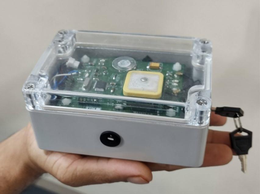
The unit measures only 12cm(L) x 7.5(B) cm x 5cm(H) that fits in the palm and weighs only 310 gms (including Li Ion 5000mAh battery) that makes it highly portable kind of device as per Fig 4. image.
AccordingtoFig.3andFig.4thesystemhasbeenfabricatedonacustomdesignedsingleprintedcircuitboard,whichhasbeen assembledonwithelectroniccomponentsin house.IthasbeenenclosedinaIP65gradeboxtopreventdustandmoisture ingress.TheLithiumIonbatteryof3.7V,5000mAhhasbeenplacejustunderthecircuitboard.Theunithasbeenprovidedwith aDCjackthatiscompatiblewith9 12VDC,1.5ADCadaptorforchargingofthebattery.Theunithasalsobeenprovidedwitha key switchinsteadofordinaryon/offswitchsothatunitshallnotbemaliciouslyturnedoffbyunauthorizedpersons.Only stationin chargeoftherespectiveunitsfromwheretheconsignmenthasbeendispatchedfromwouldbeholdingtheidentical keysforthesystem.
4
AccordingtoFig.4wherethefamiliaritytotheindicationLEDsareprovided,itcanbeseenthatRedLEDisforpoweron indication.TheorangeLEDistheBatterychargeindicatorwhentheunitisbeingchargedwithDCadaptor.Thebatterycharges attherateof500mA.Theoreticallyfora5000mAhbatteryitwouldtakeminimum10hrstocharge.Afterchargingiscompleted theOrangeLEDwouldshutoff.Orwhicheverisearlier.ThegreennetworkLEDblinkscontinuouslywhenevertheunitsearches forGSMnetworkinthevicinity.Onceitfetchesthenetworkthenitblinksonceinevery3seconds.TheYellowLEDindicates theGlonass/GPS/GSMmodulepowerandtheBlueLEDthatblinksevery1secondindicatesmodemactivity.
Fig 5 Reference of the device with respect to palm to indicate the compact nature.
The receiving station consists of a GSM modem attached to a Linux based server system that reads a device ID, location message,statusetc.andextractsthelocationandstatusdatafromthemessageandthenstoresthedatainadatabase.Every GPSunithasbeenassignedwithaspecificIDe.g.BRITVTS00xandeveryIDhasaSIMnumberassociatedwithit.SotheIDand SIMnumberoftheunitismatchedwiththedetailsstoredinserverdatabasethen onlythelocationdata isverifiedtobe original.ThereisalsoscopeofuniqueIMEIverificationofaGSMunitmoduleandmaybeimplementedinfuture.Fig.6shows datastorage.
International Research Journal of Engineering and Technology (IRJET) e ISSN: 2395 0056
Volume: 09 Issue: 05 | May 2022 www.irjet.net p ISSN: 2395 0072
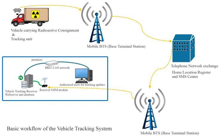
AbasiccommunicationflowhasbeenshowninFig.7.TheGPStrackermountedonvehicletravellinginremoteareasendsits locationafteracertaintimethatiscommunicatedbyGSMtelephonenetworkvialocalBTStoExchangeandthentohome locationBTSandfinallydeliveredtoReceivingstationGSMmodeminuser'spremises.Asshowntheserverreadsthedata, storesthelocationdatainlocaldatabaseandalsofetchesthelocationareanamefrompresavedpan Indialocationdatabaseto knowthenameoftheplacesthevehiclehastravelledthrough.Authorizedusersfromuser'spremiseshavebeenprovided accessviaexistingweb serverbasedportaltocheckthetrackingupdateswheneverrequired.
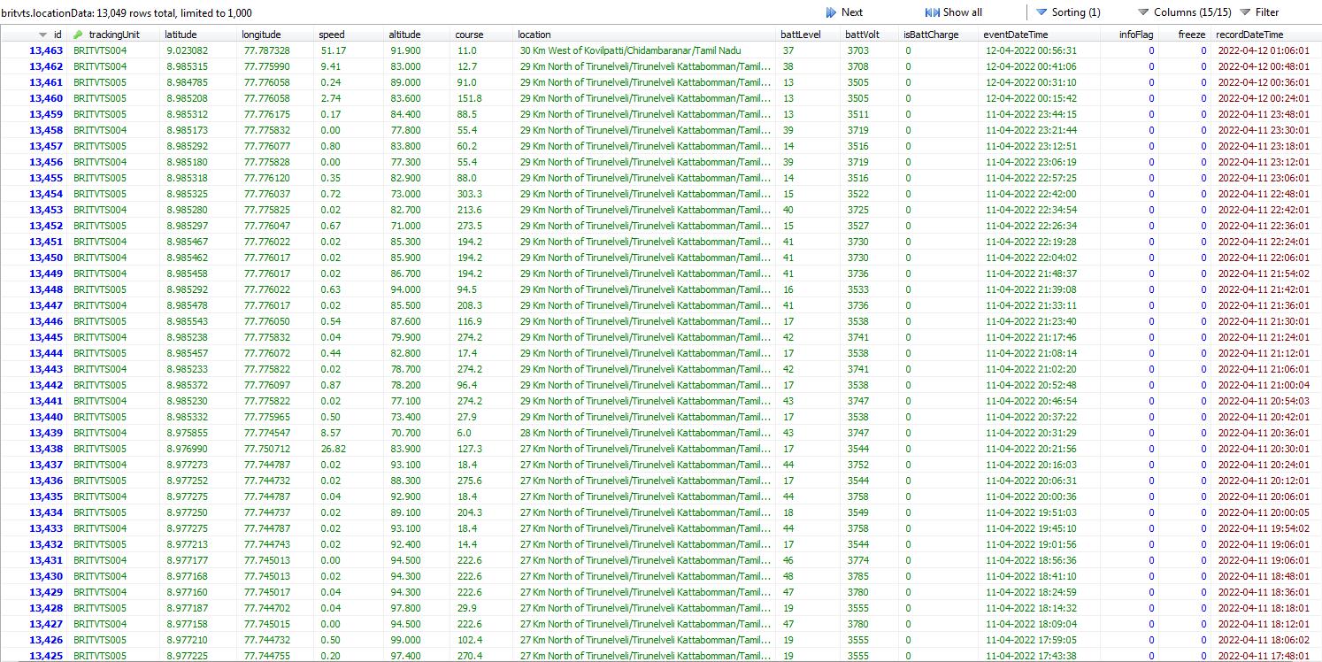
Fig. 6 MYSQLbasedbackendofweb serverforstorageandprocessingoflocationdata
Fig 7. CommunicationFlowofVehicleTrackingSystem.
International Research Journal of Engineering and Technology (IRJET) e ISSN: 2395 0056
Volume: 09 Issue: 05 | May 2022 www.irjet.net p ISSN: 2395 0072
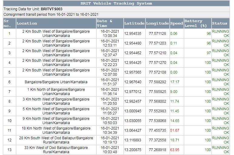
AtrackingpageisshowninFig.8wherethelatestlocationisatthetop.Thecolumnsofthepagetableareselfexplanatory.
Fig. 8 Trackingpageasshowntoauthorizedusers
ItisbeyonddoubtthatGLONASS/GPSandsimilartechnologybasedvehicletrackinghavebecomeaveryimportantpartfor freightandassettracking[4].AsthedemandofRadioactivematerialsformedical,industrialandresearchuseswillincrease,so willthenumberoftransportationeventswouldincreaseaswell.HavingtheseGPStrackershandywouldbebeneficial.In housedevelopmentofsuchdevicesgivesquicktroubleshooting,replacement,up gradationbenefits.Foracriticaltasksuseof in housedevicesreducesdependabilityof Indiaonothers.The future scope ofthisworkcanbeextendedwith
InclusionofMapfeaturesinserverforvisualatlaswithlocation.
InclusionofRadiationmonitoralongwiththeupgradedunittocheckforradiationleakagealongtheway.
Upgradingofdiagnosticfeaturesasperrequirement.
ImplementationofIndianIRNSSwhenreceivermodulesareavailableindomesticmarket.
[1] https://www.nasa.gov/ [2] https://www.gps.gov/systems/gps/
[3] Rifandi, Ronal & Assagaf, Said & Ningtyas, Yoga Dwi Windy Kusuma. (2013). An Insight About GPS. 10.13140/RG.2.2.34893.13285.
[4] Upreti,Swagata&Kumar,Manish.(2008).PerspectivesofGlobalPositioningSystem(GPS)Applications.