International Research Journal of Engineering and Technology (IRJET) e-ISSN: 2395-0056 Volume: 09 Issue: 05 | May 2022 www.irjet.net p-ISSN: 2395-0072
Morphometric Analysis of Warana Basin using GIS and Remote Sensing Techniques
Rushikesh S. Patil1, Omkar V. Vanjari2 Dr. D.Y.Patil College of Agricultural Engineering and Technology Talsande, Kolhapur***
Abstract: In the current era of climate change most of the natural resources are deteriorating with very fast rate, which is the alarming situation in front of all the researchers and policy makers at global, national as well as regional scale. Soil and water resources are most important resources for all the living being. Therefore its conservation is the big challenge in front of world. Conservation of natural resources starts from its proper and precise site specific planning. Watershed is the natural entity in which both soil and water resources are conserved to maintain the natural and economical balance of the region. In earlier days, hand delineation method was commonly used for water delineation may have chances of manual errors at planning stage it may multiply in the lateral stage. But Recently, Geographical Information system (GIS) and Remote Sensing (RS) techniques are mainly used for watershed delineation. Warana river basin, of Maharashtra, India is selected for the present study. The catchment area of the Warana basin is about 2081 km2 The Data used for study is SRTM 1 ARC 2nd DEM (Digital Elevation Model) with 30 m * 30 m resolution. Morphometric analysis of basin was calculated under linear, areal and relief aspects by using the geospatial technique. Survey of India (SOI) toposheet number E43N11, E43N12, E43N15, E43N16, E43O4, E43U1, E43T13, E43U5 and E43U9 having 1: 50,000 scale is used for the study. Watershed is the big geographical area which can is very difficult to manage conservation practices within a season or year therefore a watershed prioritization is one of the most important tool to prioritise Subwatersheds as per the erosion rate of the natural resources. The results were reveals that, the trunk order stream of the Warana basin was 8th with mean stream length ratio was 2.53 and mean bifurcation ratio of Warana basin was 4.22. Watershed prioritise was done by calculating 74 parameters and its intensity. Sub watershed 1, Sub watershed 8, Sub watershed 10, Sub watershed 12, and Sub watershed 13 were most affected and need urgent conservation. On the contrary Sub watershed 6, Sub watershed 7, Sub watershed 11, Sub watershed 14, Sub watershed 15 and Sub watershed 16 are least affected.
INTRODUCTION
Water plays a vital role in satisfying basic human needs. Water also plays important role in socio economic development.Watercoversabout71%oftheearthsurface.Worldhas2.5%freshwaterfromthatIndiahasjust4%ofthe world’sfreshwater.AsthemainsourceofwaterinMaharashtraisrainfall,soitbecomesnecessaryforustoconservethe water. Morphometryreferstothestudyofconfiguration,evolutionandcharacteristicsoflandforms. Themorphometricanalysisofawatershedplaysanimportantroleindecidingthehydrologicalbehavioursuchasrunoff and soil erosion. Morphometric analysis is also vital to find groundwater potential and management, environmental assessment. Morphometric analysis is helpful in knowing terrain features, hydrological characteristics and also its flow patterns. quantitative analysis of the watershed involves different components such as stream segments, stream order, basinperimeter&area,elevationdifference,slope andprofileoflandhashighly responsibleforthenaturaldevelopment of basin (Horton, 1945). Horton (1932, 1945) carried out first and highly important work on morphometric analysis of basin. After that some Geomorphologist and Geohydrologist, like Strahler (1953), Schumm (1956), Melton (1957),

© 2022, IRJET | Impact Factor value: 7.529 | ISO 9001:2008 Certified Journal | Page2289
International Research Journal of Engineering and Technology (IRJET) e-ISSN: 2395-0056
Volume: 09 Issue: 05 | May 2022 www.irjet.net p-ISSN: 2395-0072
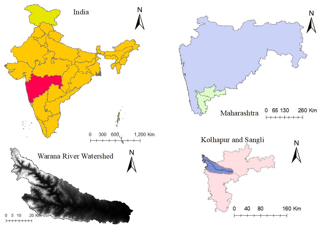
Morisawa(1957),Strahler(1957),GregoryandWalling(1973),Chorleyetal.(1984)modifiedanddevelopedtheHorton’s study. Morphometric analysis is helpful to know hydrological system of watershed which is useful for carrying out management strategies. In this study an attempt has made to prioritization of watersheds on the basis of morphometric characteristicsofWaranariverbasinwhichhelpstounderstandmanagementofnaturalresourcesandtoidentifyregions which have high erosion rate. Stream order found for Warana river watershed is 8 and stream length is 377.88 km. The regionswhichhavehigherosionratearesubwatershednumber1,8,10,12and13andTheregionswhichhavelowerosion ratearesubwatershednumber6,7,11,14,15and16.
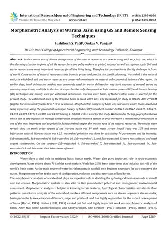
STUDY AREA
WaranariverswatershedisspreadacrosstheSangliandKolhapurdistrict.ItisanimportanttributaryofKrishna River Outletofthisstudyareaisconsideredasconfluence.Confluenceoccurswheretworiversjointoformsinglechannel. TheWaranaWatershedcoversanareaof2,081squareKilometersandisspreadovereighttalukasnamelyShirala,Valva, Miraj, Shahuwadi, Panhala, Hatkanangale and Shirol. The Warana Valley extends between Sangli and Kolhapur districts anditslatitudinalandlinearextentextendsbetweenN'16047’toN'17047’andE'730 30’15”toE'740 30’respectively.The studyareahasastheannualaveragerainfallrangeinbetween650 2500mm.
FigNo1Studyareamap

Data Used and Methodology
Remote sensing and GIS (Geographic Information System) technique was used in this study of morphometric analysisofWaranariverbasin.ByusingtheSurveyofIndia(SOI)topographicalmapsofabout1: 50,000remotelysensed dataisrectifiedandDataisanalysedbyusingArcGIS10.3SoftwarebyusingtoposheetandDEM(DigitalElevationModel) Topographical map: SOI (Scale 1: 50,000) Number E43I13; SRTM (DEM) with 30 m x 30 m spatial resolution. By using WGS 1984 datum, Universal Transverse Mercator (UTM) zone 43N projection SOI topographic map is georeferenced in ArcGIS10.3.InthisstudythestreamorderiscalculatedbyusingStrahlerorder. AccordingtoStrahler(1957),thesmallest
© 2022, IRJET | Impact Factor value: 7.529 | ISO 9001:2008 Certified Journal | Page2290
International Research Journal of Engineering and Technology (IRJET) e-ISSN: 2395-0056
Volume: 09 Issue: 05 | May 2022 www.irjet.net p-ISSN: 2395-0072
fingertip tributaries are designated as order 1. Where two first order channels join, a channel segment of order 2 is formed, where two of order 2 join, a segment of order 3 is formed and so forth. The trunk stream through which all dischargeofwaterandsedimentpassesisthereforethestreamsegmentofhighestorder(VinothM.).
RESULT AND DISCUSSION
FigNo2Streamordermap
Streamorder(Su)
AccordingtoStrahler(1957),thesmallestfingertiptributariesaredesignatedasorder1.Wheretwofirstorder channelsjoin,achannelsegmentoforder2isformed,wheretwooforder2join,asegmentoforder3isformedandso forth.Thetrunkstreamthroughwhichalldischargeofwaterandsedimentpassesisthereforethestreamsegmentof highestorder(VinothM.).ItwasfoundthattheWaranariverbasinisa8thordertrunkstream.
StreamNumber(Nu)
Streamnumberisdefinedastheorderwiseadditionofstreamsegments.Streamnumberisaninverseofstream order.Streamnumbersof1st,2nd,3rd,4th,5th,6thstreamsare5001,1098,204,42,10and1respectively.Highvalueof firstorderstreamsShowsthatthereispossibilityofsuddenflashfloodafterheavyrainfall(Horton1945).
Streamlength(Lu)
Streamlengthistheadditionoflengthallthestreamshavingorderu.Generally,thetotallengthofstream segmentsismaximuminfirstorderstreamsanddecreasesasthestreamorderincreases.Theextentofstreamlengthina watershedinformationaboutthecharacteristicssizeofvariouscomponentsofdrainagenetworkanditscontributing surfacearea.TotalstreamlengthofWaranaRiveris377.88km.(Strahler,1964).
Meanstreamlength(Lum)
© 2022, IRJET | Impact Factor value: 7.529 | ISO 9001:2008 Certified Journal | Page2291
International Research Journal of Engineering and Technology (IRJET) e-ISSN: 2395-0056
Volume: 09 Issue: 05 | May 2022 www.irjet.net p-ISSN: 2395-0072
Meanstreamlengthisacharacteristicpropertywhichrelatestothesizeofdrainagenetworkcomponentsandits contributingbasinsurfaces(Strahler,1964).Itiscomputedbydividingthetotalstreamlengthoforder“u”bythenumber ofstreamsofsegmentsintheorder.Therearevariationsinmeanstreamlengthvalues0.31to0.42.
Streamlengthratio(Lurm)
TheratioofthemeanlengthoftheoneordertothenextlowerorderofthestreamsegmentsisknownasStream lengthratio(Lurm).(Horton1945).Theamountofstreamlengthratiovariesfrom0.81to1.057duetothechangeinmean streamlengthofRadhanagariWatershed.
Bifurcationratio(Rb)
Bifurcationratioisdefinedastheratioofthenumberofstreamsofanygivenordertothenumberofstreamsin thenexthigherorder.Itisobservedthatthebifurcationratioisdifferentfromoneordertoitsnextorder.Abifurcation ratiovaluegreaterthan5isconsideredashighervalueanditindicatesthatstrongstructuralcontrolonthedrainage patternandthe bifurcationratiovaluelessthan5isconsideredaslowervaluesindicatesthatwatershedisnotaffected bystructuraldisturbance(Nag1998).
WeightedmeanBifurcationratio(Rbwm)
Weightedmeanbifurcationratioiscalculatedbymultiplyingthebifurcationratioofeachsuccessivepairoforders bytotalnumberofstreamsinthisratioandthencalculatedthemeanofsumofthesevaluesStrahler(1953).Thevalue foundforRbwmis4.71.
Lengthofmainchannel(Cl)
Thelengthalongthelongestwatercoursefromoutflowpointofwatershedtotheuppermostwatershedboundary isknownasLengthofmainchannel(Cl).TheArcGIS10.3softwareisusedtocomputethelengthofmainchannel(Cl).The valuefoundfor(Cl)is77.9km.
ChannelIndex(Ci)&ValleyIndex(Vi)
ChannelIndex(Ci)iscalculatedbydividingMainChannelLength(Cl)withAdmi.e.Ci=Cl/Adm.andValleyIndex (Vi)iscalculatedbydividingValleyLength(Vl)withAdmi.e.Vi=Vl/Adm ThecalculatedChannelIndex(Ci)&Valley Index(Vi)isfoundtobe1.42and1.35respectively.
RHOcoefficient
TheRatioofstreamlengthratiotothebifurcationratioisknownasRHOcoefficient.RHOcoefficientdetermines therelationbetweenthedrainagedensityandphysiographicdevelopmentofbasin(Horton,1945).Thefactorslike biologic,climatic,anthropogenicandgeomorphologicfactorsaffectstheRHOcoefficient.ThecalculatedvalueofRHO coefficientforthisstudyareais0.58
© 2022, IRJET | Impact Factor value: 7.529 | ISO 9001:2008 Certified Journal | Page2292
International Research Journal of Engineering and Technology (IRJET) e-ISSN: 2395-0056
Volume: 09 Issue: 05 | May 2022 www.irjet.net p-ISSN: 2395-0072
© 2022, IRJET | Impact Factor value: 7.529 | ISO 9001:2008 Certified Journal | Page2293
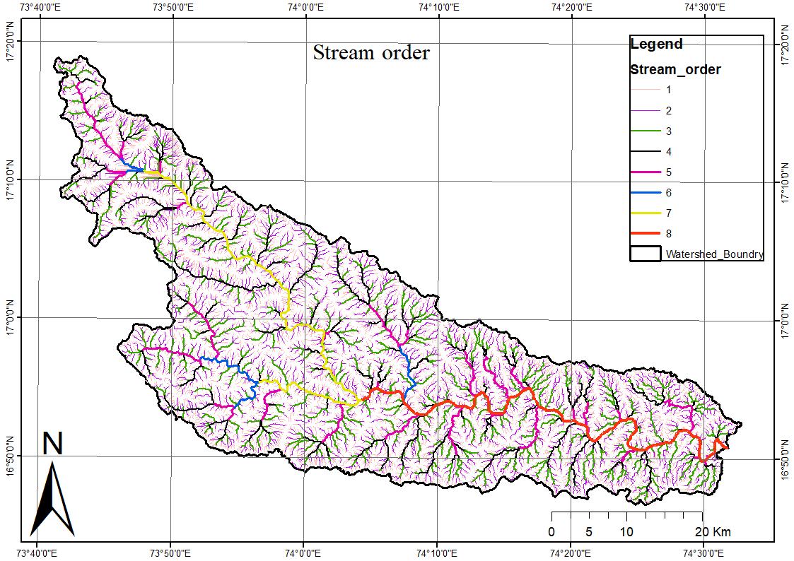
FigNo3Subwatershedsmap
STREAM NUMBE R(Nu)
International Research Journal of Engineering and Technology (IRJET) e-ISSN: 2395-0056 Volume: 09 Issue: 05 | May 2022 www.irjet.net p-ISSN: 2395-0072
Linear aspects SW1 SW2 SW3 SW 4 SW5 SW 6 SW 7 SW8 SW9 SW1 0 SW1 1 SW1 2 SW1 3 SW1 4 SW1 5 SW1 6 WholeBasin
1889 2253 2766 118 8 104 40 1 41 2 615 374 252 159 182 4 481 149 93 1501 14461 393 299 342 162 31 57 72 105 54 30 23 267 65 23 18 173 2114 86 62 107 38 8 16 17 27 15 7 9 68 19 3 5 58 535 25 11 21 9 1 2 5 8 2 1 1 20 4 2 2 14 128 6 1 7 2 1 1 3 1 0 3 1 1 1 6 26 2 0 2 1 1 0 0 5 1 1 1 2 2 1 1 1 1 TOTAL 2399 2626 3243 139 9 144 47 7 50 7 758 446 290 192 218 2 570 178 119 1752 17272
STREAM LENGTH (Lu)
560.9 468 623 254 7.42 88 10 0. 137. 38 77.5 8 46.8 36.1 100 94.1 32 23.4 307. 3 2959 289.8 278 328 149 19.7 40 48 74.5 4 42.1 8 22.4 17.1 48.5 64.4 14.4 12.4 181. 6 1633 113.4 98.4 167 67. 0 11.7 17 28 3.43 23.1 14.6 11.5 28.6 24.4 6.48 4.2 93.5 6 714.0 72.96 58.3 57.9 33. 5 9.36 10 14 13 8.86 9.17 6.76 14.5 11.8 8.66 4.7 24.9 8 360.0 26.78 1.88 40.0 11. 0 6.3 8.7 2.18 8.52 0 8.76 9.12 1.85 3.72 24.5 6 153.4 5.21 0 17.8 9.1 0.43 32.58 19.51 36.6 1 17.3 1.11 57.23 18.7 36.0 24.6 5 79.51
© 2022, IRJET | Impact Factor value: 7.529 | ISO 9001:2008 Certified Journal | Page2294
International Research Journal of Engineering and Technology (IRJET) e-ISSN: 2395-0056
Volume: 09 Issue: 05 | May 2022 www.irjet.net p-ISSN: 2395-0072
Total 1088. 704 943. 17 1253. 082 524 .25 48.2 67 16 3.2 20 0.8 8 250. 85 160. 24 93.1 5 71.6 6 236. 96 204. 06 63.4 1 48.4 6 656. 8 5989.702
0.29 0.20 0.22 0.2 1 0.07 0.2 0.2 0.22 0.20 0.18 0.22 0.05 0.19 0.21 0.25 0.20 4 0.204
0.737 0.93 0.96 0.9 2 0.63 0.7 0.6 0.70 0.78 0.74 0.74 0.18 0.99 0.62 0.69 1.05 0 0.772
Mean Stream Length
1.318 1.58 1.56 1.7 6 1.46 1.0 1.6 0.12 1.54 2.09 1.28 0.42 1.28 2.16 0.84 1.61 3 1.334
2.918 5.30 2.75 3.7 2 9.36 5.4 2.9 1.62 4.43 9.17 6.76 0.72 2.96 4.33 2.35 1.78 4 2.813 4.463 1.88 5.72 5.5 1 6.3 8.7 0.72 8.52 5.902 2.605 8.92 0.43 6.516 0.55 28.61
stream length ratio (Lur)
2.483 4.48 4.26 4.3 1 8.93 3.2 2.7 3.17 3.76 4.01 3.27 3.29 5.06 2.91 2.73 5.12 8 3.774 1.788 1.70 1.62 1.9 1 2.29 1.5 2.5 0.17 1.97 2.79 1.72 2.31 1.30 3.44 1.21 1.53 5 1.727 2.213 3.34 1.76 2.1 1 6.39 5.1 1.7 12.7 2.87 4.38 5.24 1.72 2.30 2.00 2.79 1.10 6 2.107 1.529 377 0.35 417 2.073 537 1.4 789 74
1.1 63 00 4
3.0 20 69
0.44 717 9
1.92 325 1 0 0 0 0 0 0 0 2.098132 0.583 645 0 1.559 441 0 0.59 174 3 1.103975 0 0 0 0 0 0 1.29 069 8 0 4.391498
© 2022, IRJET | Impact Factor value: 7.529 | ISO 9001:2008 Certified Journal | Page2295
International Research Journal of Engineering and Technology (IRJET) e-ISSN: 2395-0056
Volume: 09 Issue: 05 | May 2022 www.irjet.net p-ISSN: 2395-0072
Mean Stream Length Ratio
2.003 484 2.47 0255 2.431 666 2.4 537 14 5.87 5455
2.7 48 99 9
2.5 01 62 7
4.14 891 4
2.63 425 7
2.79 986 7 3.41 717 2.44 634 9
2.88 732 1
2.78 970 4
2.25 165 9 2.59 03 2.533956
4.806 616 7.53 5117 8.087 719 7.3 333 33 3.35 4839
7.0 35 08 8
5.7 22 22 2
5.85 714 3
6.92 592 6 8.4 6.91 304 3
6.83 146 1 7.4 6.47 826 1
Bifuegat ion Ratio (Rb)
5.16 666 7 8.67 6301 6.840587 4.569 767 4.82 2581 3.196 262 4.2 631 58 3.87 5 3.5 62 5
4.2 35 29 4
3.88 888 9 3.6 4.28 571 4
2.55 555 6
3.92 647 1
3.42 105 3
7.66 666 7 3.6 2.98 2759 3.951402 3.44 5.63 6364 5.095 238 4.2 222 22 8 8 3.4 3.37 5 7.5 7 9 3.4 4.75 1.5 2.5 4.14 2857 4.179688 4.166 667 11 3 4.5 2 5 2.66 666 7 2 4.923077 3 3.5 3 5.2 2 0.5 2.5 2 2 mean bifurgati onratio 4.245 7.24 4.84 5.0 7 5.07 5.1 4.5 3.94 5.00 6.56 6.15 4.71 5.19 5.21 3.75 5.26 7 4.227822
Lur-r
850.8 747 952 403 27.1 12 8 14 211 119 69.3 53.3 148 158 46.4 35.8 489. 0 4592.82 403.2 377. 33 496.2 216 .46 31.4 8 57. 4 77. 17 77.9 7 65.2 8 37.0 9 28.7 2 77.1 7 88.9 20.9 16.6 2 275. 25 2347.212 186.3 156. 82 225.4 6 100 .58 21.0 87 27. 98 43. 16 16.4 3 31.9 6 23.8 2 18.3 5 43.1 6 36.3 5 15.1 4 8.9 118. 54 1074.102
© 2022, IRJET | Impact Factor value: 7.529 | ISO 9001:2008 Certified Journal | Page2296
International Research Journal of Engineering and Technology (IRJET)
e-ISSN: 2395-0056
Volume: 09 Issue: 05 | May 2022 www.irjet.net p-ISSN: 2395-0072
99.74 60.2 7 97.97 44. 55 9.36 7 17. 27 23. 26 15.1 8 17.3 8 9.17 6.76 23.2 6 20.9 8 10.5 1 8.42 49.5 4 513.54 26.78 1.88 40.04 11. 02 0 6.3 5 8.7 6 20.9 6 8.52 0 0 44.8 4 9.12 1.85 3.72 49.2 1 232.97
total 1566 1344 1812 776 89.1 23 7 30 1.3 342. 46 242. 9 139. 41 107. 14 337. 39 313. 94 94.8 2 73.5 981. 59 8760.644
Lur*Lurr
2112. 993 3351 .375 4059. 278 173 9.8 24 242. 831 41 3.1 11
41 1.6 38 2
673. 478 3
450. 968 7
278. 703 9
174. 488 5
491. 433 3
802. 605 5
135. 512 3
98.2 003 8 2508 .254 17336.92 721.0 564 642. 2141 808.3 933 414 .12 19 72.3 5143
86. 47 88 5
19 3.0 97 6
13.9 526 9
128. 702 8
103. 775 5
49.6 587 6
179. 017 6 115. 637 72.0 049 9
20.2 330 4 422. 7705 4054.884 412.4 439 524. 3381 397.2 326 212 .36 72 134. 8273
14 3.2 78 6
74. 24 24 3
70. 26 12 4
210. 165 1
91.9 368 8 104. 369 96.3 256 3
74.2 424 3
83.6 168 7
30.3 500 9
24.8 988 1 131. 1194 2264.002 152.5 4 21.3 4584 203.1 444 65. 888 29 0 20. 08 50 7
66 2.9 53 5
74 9.2 39 6
6.78 818 5
904. 384 3
705. 034 5
486. 848 4
320. 472 9
744. 693 3
100 1.85 9
237. 867 4
143. 332 2 3062 .144 25756.37
33.4 260 9 0 0 0 0 0 0 0 1077.475 1023.087 total 3399. 033 4539 .273 5468. 048 243 2.2 02 450. 0097
Luwm 2.169 17 3.37 7033 3.017 533 3.1 336 5.04 982 2.7 87 2.4 86 2.64 084 2.90 257 3.49 220 2.99 116 2.20 721 3.19 124 2.50 862 1.95 009 3.11 9575 2.940009
© 2022, IRJET | Impact Factor value: 7.529 | ISO 9001:2008 Certified Journal | Page2297
International Research Journal of Engineering and Technology (IRJET) e-ISSN: 2395-0056 Volume: 09 Issue: 05 | May 2022 www.irjet.net p-ISSN: 2395-0072
35 04 1 60 7 7 1 6 8 5 1 8
2282 2552 3108 135 0 135 45 8 48 4 720 428 282 182 209 1 546 172 111 1674 16575 479 361 449 200 39 73 89 132 69 37 32 335 84 26 23 231 2649 111 73 128 47 9 18 22 35 17 8 10 88 23 5 7 72 663 31 12 28 11 1 3 6 11 3 1 1 23 5 3 3 20 154 8 3 27 TOTAL 2903 2998 3713 160 8 184 55 2 60 1 898 517 328 225 253 7 658 206 144 1997 20068
Nu-r
Rb*Nu-r
1096 8.7 1922 9.62 2513 6.63 990 0 452. 9032 32 22. 07
27 69. 55 6
421 7.14 3
296 4.29 6 236 8.8 125 8.17 4
142 84.5 8 404 0.4 111 4.26 1 573. 5 1452 4.13 113382.7 2188. 919 1740 .952 1435. 121 852 .63 16 151. 125
26 0.0 62 5
37 6.9 41 2
513. 333 3 248. 4 158. 571 4
81.7 777 8
131 5.36 8
287. 368 4
199. 333 3 82.8 689. 0172 10467.26 381.8 4 411. 4545 652.1 905 198 .44 44 72 14 4 74. 8 118. 125 127. 5 56 90 299. 2 109. 25 7.5 17.5 298. 2857 2771.133 129.1 667 132 84 49. 5 0 6 30 29.3 333 3 6 0 0 0 0 0 0 0 758.1538 54
© 2022, IRJET | Impact Factor value: 7.529 | ISO 9001:2008 Certified Journal | Page2298
International Research Journal of Engineering and Technology (IRJET) e-ISSN: 2395-0056
Volume: 09 Issue: 05 | May 2022 www.irjet.net p-ISSN: 2395-0072
32 51. 29 7
48 77. 93 5
TOTAL 1366 8.62 2151 4.02 2730 7.94 1100 0.58 676. 0282 363 2.13 3
334 6.19 6
258 3.37 1
142 9.95 2
158 99.1 5
443 7.01 8
132 1.09 4 673. 8 1551 1.43 1274 33.3 Rbwm 4.708 7.17 7.35 6.84 3.67 6.57 5.4 5.4 6.47 7.87 6.35 6.26 6.74 6.41 4.67 7.76 7 6.350
RhoCoefficient (Lur/Rb)
0.516 0.59 0.52 0.58 2.66 0.45 0.4 0.5 0.54 0.47 0.47 0.48 0.68 0.45 0.53 0.59 1 0.551 0.391 0.35 0.50 0.44 0.59 0.42 0.5 0.0 4 0.54 0.65 0.67 0.59 0.38 0.44 0.33 0.51 4 0.437 0.643 0.59 0.34 0.50 0.79 0.64 0.5 3.7 0.38 0.62 0.58 0.50 0.48 1.33 1.11 0.26 0.504 0.367 0.03 0.69 0.32 0.58 0.6 0.1 0.96 0.426 2.195 meanrho 0.479 0.39 0.51 0.46 1.35 0.52 0.5 1.1 0.60 0.58 0.57 0.52 0.51 0.74 0.66 0.45 7 0.823
MainChannel Length(Cl)km 39.53 45.4 5 38.5 8 27.4 11.1 13.9 12 22 17.3 12.7 10.0 39.3 6.15 9.55 11.3 33.8 149.2
VallyLength(Vl) Km 38.71 44.2 37.1 25.8 10.0 12.3 12 21 16.8 11.1 9.16 38.2 4.66 8.81 9.63 32.5 146.7 MaximumAreial Distance(Adm) 34.56 34.7 33.8 22.3 9.66 12 11 16 12.7 10.1 7.2 19.1 13.9 7.9 7.66 21.5 105.6
Channelindex(Ci) 1.143 1.30 1.14 1.22 1.15 1.1 1.0 1.3 1.35 1.24 1.4 2.05 0.44 1.20 1.47 1.57 2 1.412 Valleyindex(Vi) 1.120 1.27 1.09 1.15 1.03 0.9 1.0 1.2 1.31 1.09 1.27 1.99 0.33 1.11 1.25 1.51 1 1.388
© 2022, IRJET | Impact Factor value: 7.529 | ISO 9001:2008 Certified Journal | Page2299
International Research Journal of Engineering and Technology (IRJET) e-ISSN: 2395-0056
Volume: 09 Issue: 05 | May 2022 www.irjet.net p ISSN: 2395 0072
Areal aspect
Thearealaspectofthedrainagebasin(watershed)suchasDrainagedensity(Dd),Streamfrequency(Fs),Drainage Texture(Rt),FormFactor(RF),Constantofchannelmaintenance(C),Lemniscate(k),InfiltrationNumber(If),Basin perimeter(P),Elongationratio(Re),Circularityratio(Rc),Lengthofoverlandflow(Lg)Werecalculatedandresultshown inTable4.
Lengthofbasin(Lb)
Basinlengthiscomputedbymeasuringthelongestdimensionofbasinparalleltoprincipaldrainageline (Schumm,1956).ItiscalculatedaccordingtoSchumm(1956)asitisfoundtobe62.8km. Basinarea(A)
TheArcGIS10.3softwareisusedtocalculatetheBasinarea(A),thevaluefoundfor(A)is2081km2.
BasinPerimeter(P)
Theareaenclosedbytheoutermostboundaryofbasinthatareaisknownasthebasinperimeter.Thefactorslike sizeandshapeofwatershedisindicatedbybasinperimeter.TheArcGIS10.3softwareisusedtocalculatetheBasin Perimeter(P),thevaluefoundfor(P)222m.
Lengtharearelation(Lar)
Lengtharearelation(Lar)iscalculatedbyformulaLar=1.4*A0.6 Hack(1957)givestherelationbetweenthe streamlengthandbasinarea.
Lemniscate’s(k)
Lemniscate’svaluegivestheslopeofbasinChorely(1967).theformulaforLemniscate’svaluek=Lb2/4*Awhere LbisbasinlengthinkmandAistheareaofbasininkm2.thevaluefoundforkis2.66.
Formfactor(Ff)
DifferentbasinshapesarerepresentedbytheFormfactor(Horton,1932).BytheHorton,formfactorisdefined astheratioofthebasinareaandsquareofthebasinlength.ThevaluesforFormfactorVariesbetween0.1to0.8.Circular typebasinshapeisindicatedbyhighervalueofformfactorwhiletheenlongatedbasinisindicatedbysmallervalue.The valuefoundfor(Ff)is0.184whichindicatesbasinisFernshaped
Elongationratio(Re)
AsgivenbySchum,elongationratioisdefinedastheratioofdiameterofacirclehavingsameareaasofthebasin andmaximumbasinlength.AccordingtoStrahlerThevalue0.6to1.0istheactualrangeofelongationratiovalues Shapes ofbasinarebasedonelongationratio;smallerthan0.7itiselongated,0.8to0.7itislesselongated,0.9to0.8itisoval shapedandgreaterthan0.9itiscircularshape.(SinghandSinghin1997)Thevaluefoundfor(Re)is0.48,which representsthatthebasiniselongated.
Textureratio(Rt)
Ratiobetweenthefirstorderstreamsandperimeterofbasini.e.(Rt=NI/P)isTextureratio.Textureratio dependsonfactorslikereliefaspectsofterrain,lithologyandinfiltrationcapacity.Thevaluefoundfor(Rt)is42.59.
Circulatoryratio(Rc)
AsperlawofMiller,circulatoryratioisdefinedastheratiooftheareaofabasintotheareaofacirclepossessing thesamecircumferenceastheperimeterofthebasin.AccordingtoMiller(1953)rangeforthecirculatoryratioofbasin
© 2022, IRJET | Impact Factor value: 7.529 | ISO 9001:2008 Certified Journal | Page2300
International Research Journal of Engineering and Technology (IRJET) e-ISSN: 2395-0056
Volume: 09 Issue: 05 | May 2022 www.irjet.net p ISSN: 2395 0072
variesfrom0.4to0.6whichshowsthatthebasiniselongatedandhighlypermeablegeologicalmaterials.Thevaluefound for(Rc)is0.22whichindicatesthatthebasiniselongatedtype.
Drainagetexture(Dt)
TheratioofstreamsegmentsofallorderstotheperimeterofthatareaisknownasDrainagetexture(Horton, 1945).SmithcreatedthefivedrainagetextureclassificationSmith(1950)i.e.,veryfine(>8),fine(6to8),moderate(4to 6),coarse(2to4),verycoarse(<2).Thevaluefoundfor(Dt)is50.87whichindicatesthattextureisveryfine.
Compactnesscoefficient(Cc)
AccordingtoGraveliusCompactnesscoefficient(Cc)istheratioofperimeterofwatershedtocircumferenceof circulararea,whichisequaltotheareaofwatershed(Gravelius1994).Compactnesscoefficientdependsnotonthesizeof watershedbutontheslope.Thevaluefoundfor(Cc)is2.11
Fitnessratio(Rf)
Fitnessratioisdefinedasratioofthemainchannellengthtothelengthofwatershedperimeter.Topographic fitnessismeasuredbyFitnessratio(Melton1957).Thevaluefoundfor(Rf)is0.0041.
Wanderingratio(Rw)
Wanderingratio(Rw)isdefinedastheratioofmainstreamlengthtothevalleylength(Smart&Surkan1967). Thestraightlinedistancemeasuredbetweenoutletofbasinandremostpointontheridgeiscalledthevalleylength.The valuefoundfor(Rw)is1.40.
WatershedEccentricity(τ)
Thewatershedeccentricityformulais,τ=[(|Lcm2 Wcm2|)]0.5/WcmWhereτ=Watershedeccentricity,Wcm= WidthofthewatershedatthecentreofmassandperpendiculartoLcmandLcm=Straightlengthfromthewatershed mouthtothecentreofmassofthewatershed.Thevaluefoundfor(τ)is1.54.
© 2022, IRJET | Impact Factor value: 7.529 | ISO 9001:2008 Certified Journal | Page2301
LengthfromW’sCenter toMouthofW’s(Lcm) Kms
International Research Journal of Engineering and Technology (IRJET) e-ISSN: 2395-0056
Volume: 09 Issue: 05 | May 2022 www.irjet.net p-ISSN: 2395-0072
AREAL ASPECTS
SW1 SW2 SW3 SW4 SW5 SW6 SW7 SW8 SW9 SW10 SW11 SW12 SW13 SW14 SW15 SW16 Whole Basin
15.36 17.2 15.87 12.41 4.8 3.85 6.4 10.81 7.51 6.03 3.18 11.57 5.23 4.37 4.55 11.89 51.03
WidthofW’satthe CenterofMass (Wcm)Kms 14.81 12.5 14.39 8.97 2.86 2.84 7.19 5.12 4.27 3.14 3.21 11.7 4.88 2.3 1.88 23.38 27.74
BasinLength(Lb)
Kms 36.36 34.3 40.64 24.41 8.228 12.03 13.55 16.43 12.12 8.84 7.20 28.38 13.3 6.62 5.75 25.9 100.62
LbinMeters 3635 9.72 3437 4064 2.16 2441 4.99 8228. 032 1203 7.03 1355 8.24 1643 3.23 1212 9.29 8848.4 82 7201.3 14 28384. 67 13389. 67 6628.7 1 5753.9 15 25956. 39 10062 6.5
MeanBasinWidth(Wb) 9.54 9.14 10.37 765 7.043 213 3.079 716 4.113 14 4.502 797 5.212 4.137 094 3.2547 96 2.7828 26 7.8982 77 4.4601 55 2.6128 76 2.3462 29 7.3789 14 20.680 44 AREA 346.6 9 314 421.7 7 171.9 6 25.34 49.51 61.05 85.65 50.18 28.8 20.04 224.19 59.72 17.32 13.5 191.53 2081 PERIMETER 115.1 4 113.9 1 116.8 3 71.34 28.61 37.92 38.36 68.06 43.14 32.62 24.27 100.62 46 23.78 24.73 85.47 339.48
RelativePerimeter (Pr) 3.01 2.76 3.610 117 2.410 429 0.885 704 1.305 643 1.591 502 1.258 448 1.163 19 0.8828 94 0.8257 11 2.2280 86 1.2982 61 0.7283 43 0.5458 96 2.2409 03 6.1299 63
© 2022, IRJET | Impact Factor value: 7.529 | ISO 9001:2008 Certified Journal | Page2302
International Research Journal
of
Engineering and Technology (IRJET) e-ISSN: 2395-0056
Volume: 09 Issue: 05 | May 2022 www.irjet.net p-ISSN: 2395-0072
LengthAreaRelation (Lar) 46.78 44.08 52.62 274 30.71 74 9.736 705 14.55 271 16.50 211 20.21 922 14.67 055 10.513 89 8.4579 8 36.016 19 16.285 46 7.7491 98 6.6731 1 32.769 52 137.11 7
Lemniscate’s(k) 3.81 3.76 3.916 318 3.466 457 2.671 686 2.926 482 3.011 07 3.152 961 2.931 837 2.7185 98 2.5877 71 3.5937 8 3.0020 64 2.5369 4 2.4524 1 3.5176 44 4.8657 82
FormFactorRatio(Rf) 0.26 0.27 0.255 342 0.288 479 0.374 296 0.341 707 0.332 108 0.317 162 0.341 083 0.3678 37 0.3864 33 0.2782 59 0.3331 04 0.3941 76 0.4077 62 0.2842 81 0.2055 17
ShapeFactorRatio
(Rs) 3.81 3.76 3.916 318 3.466 457 2.671 686 2.926 482 3.011 07 3.152 961 2.931 837 2.7185 98 2.5877 71 3.5937 8 3.0020 64 2.5369 4 2.4524 1 3.5176 44 4.8657 82
ElongationRatio (Re) 0.58 0.58 0.570 33 0.606 209 0.690 514 0.659 769 0.650 436 0.635 632 0.659 167 0.6845 3 0.7016 21 0.5953 73 0.6514 11 0.7086 15 0.7207 23 0.6017 82 0.5116 69 ElipticityIndex(Ie) 3.39 4.88 2.565 3.038 3.122 2.414 1.863 4.049 4.420 3.3704 3.2867 5.1148 0.2854 3.5178 5.3924 4.3291 8.1181 TextureRatio(Rt) 16.41 19.7 23.67 16.65 3.635 10.57 10.74 9.036 8.669 7.725 6.5512 18.127 10.456 6.265 3.7606 17.561 42.59
CircularityRatio(Rc) 0.33 0.30 0.388 0.424 0.389 0.432 0.521 0.232 0.338 0.340 0.427 0.278 0.354 0.384 0.277 0.329 0.226
© 2022, IRJET | Impact Factor value: 7.529 | ISO 9001:2008 Certified Journal | Page2303
International Research Journal of Engineering and Technology (IRJET) e-ISSN: 2395-0056
Volume: 09 Issue: 05 | May 2022 www.irjet.net p-ISSN: 2395-0072
CircularityRation (Rcn) 3.01 2.76 3.610 2.410 0.88 1.30 1.59 1.25 1.16 0.882 0.825 2.2280 1.2982 0.7283 0.5458 2.2409 6.1299
DrainageTexture (Dt) 20.84 23.05 27.75 828 19.61 032 5.033 205 12.57 911 13.21 689 11.13 723 10.33 843 8.8902 51 7.9110 01 21.685 55 12.391 3 7.4852 82 4.8119 69 20.498 42 50.877 81
CompactnessCoefficient (Cc) 0.00 0.00 0.000 187 0.000 685 0.012 658 0.004 395 0.002 924 0.002 636 0.004 867 0.0111 73 0.0171 69 0.0005 69 0.0036 64 0.0225 21 0.0385 5 0.0006 62 2.23E 05 FitnessRatio(Rf) 0.34 0.40 0.330 223 0.384 076 0.390 772 0.366 825 0.336 809 0.324 86 0.401 715 0.3899 45 0.4153 28 0.3911 75 0.1336 96 0.4015 98 0.4581 48 0.3954 6 0.4395 55
WanderingRatio(Rw) 1.09 1.32 0.949 26 1.122 261 1.358 77 1.155 6 0.952 926 1.345 444 1.428 773 1.4375 35 1.3997 45 1.3866 64 0.4593 09 1.4407 03 1.9690 94 1.3021 84 1.4829 1
Watershed Eccentricity(τ) 0.28 0.95 0.465 055 0.956 072 1.347 874 0.915 283 #NU M! 1.859 491 #NU M! 1.6394 72 0.1376 84 0.1503 27 #NUM! #NUM! #NUM! 1.6930 93 1.5440 41
© 2022, IRJET | Impact Factor value: 7.529 | ISO 9001:2008 Certified Journal | Page2304
CentreofGravityOFthe Watershed(Gc) 73.51 E& 18.47 N
International Research Journal of Engineering and Technology (IRJET) e-ISSN: 2395-0056
Volume: 09 Issue: 05 | May 2022 www.irjet.net p-ISSN: 2395-0072
73.53 E& 18.43 N
73.51 E& 18.45 N
73.43 E& 18.50 N
73.47 E& 18.51 N
73.45 E& 18.51 N
73.43 E& 18.52 N
73.41 E& 18.54 N
73.37 E& 18.55 N
73.33E & 18.57N
73.34E & 18.58N
73.34E & 18.58N
73.34E & 18.58N
73.34E & 18.58N
73.34E & 18.58N
73.34E & 18.58N
73.34E & 18.58N
HydraulicSinuosity Index(Hsi)% 2.13 2.81 3.858 435 6.060 606 11.19 843 12.16 112 7.382 55 5.163 43 3.184 323 13.651 88 10.132 16 2.9718 46 28.932 04 8.6549 71 16.456 92 3.9634 15 1.7001 75
TopographicSinuosity Index(Tsi) % 97.87 97.19 96.14 156 93.93 939 88.80 157 87.83 888 92.61 745 94.83 657 96.81 568 86.348 12 89.867 84 97.028 15 71.067 96 91.345 03 83.543 08 96.036 59 98.299 82
StandardSinuosity Index(Ssi) 1.02 1.03 1.039 052 1.062 016 1.113 546 1.127 229 1.073 09 1.051 855 1.030 934 1.1438 85 1.1004 37 1.0298 27 1.3197 42 1.0839 95 1.1765 32 1.04 1.0171 78
LongestDimension ParalleltothePrincipal DrainageLine(Clp)Kms 38.71 44.20 37.13 25.8 10.04 12.34 12.04 21.02 16.81 11.12 9.16 38.22 4.66 8.81 9.63 32.5 146.7 StreamFrequency (Fs) 6.92 8.36 7.689 025 8.135 613 5.682 715 9.634 417 8.304 668 8.849 971 8.888 003 10.069 44 9.5808 38 9.7328 16 9.5445 41 10.277 14 8.8148 15 9.1473 92 8.2998 56
DrainageDensity (Dd)Km/Kms2 3.14 3.00 2.971 008 3.048 674 1.904 775 3.296 304 3.290 418 2.928 78 3.193 304 3.2343 75 3.5758 48 1.0569 61 3.4169 46 3.6610 85 3.5896 3 3.4292 28 2.8782 81
ConstantofChannel Maintenance(Kms2/ Km) 0.32 0.33 0.336 586 0.328 011 0.524 996 0.303 37 0.303 913 0.341 439 0.313 155 0.3091 79 0.2796 54 0.9461 09 0.2926 59 0.2731 43 0.2785 8 0.2916 11 0.3474 3
© 2022,
|
|
Certified
|
IRJET
Impact Factor value: 7.529
ISO 9001:2008
Journal
Page2305
International Research Journal of Engineering and Technology (IRJET) e-ISSN: 2395-0056
Volume: 09 Issue: 05 | May 2022 www.irjet.net p-ISSN: 2395-0072
DrainageIntensity(Di) 2.20 2.78 2.588 019 2.668 574 2.983 405 2.922 794 2.523 895 3.021 726 2.783 325 3.1132 58 2.6793 19 9.2083 05 2.7932 96 2.8071 28 2.4556 34 2.6674 79 2.8836 16
InfiltrationNumber
(If) 21.73 25.12 22.84 415 24.80 283 10.82 429 31.75 797 27.32 583 25.91 962 28.38 21 32.568 36 34.259 62 10.287 2 32.613 18 37.625 47 31.641 92 31.368 49 23.889 31
LengthofOverlandFlow (Lg)Kms 0.16 0.17 0.168 293 0.164 006 0.262 498 0.151 685 0.151 956 0.170 72 0.156 578 0.1545 89 0.1398 27 0.4730 55 0.1463 3 0.1365 72 0.1392 9 0.1458 05 0.1737 15
© 2022, IRJET | Impact Factor value: 7.529 | ISO 9001:2008 Certified Journal | Page2306
International Research Journal of Engineering and Technology (IRJET) e-ISSN: 2395-0056
Volume: 09 Issue: 05 | May 2022 www.irjet.net p ISSN: 2395 0072
Relief aspect
Reliefaspectsprovidesinformationrelatedwithelevation.ReliefaspectsareMaximumbasinrelief(H),Relief ratio(Rhl),Relativerelief(Rhp),Absoluterelief(Ra),Channelgradient(Cg),RuggednessNumber(Rn),MeltonRuggedness number(MRn),Gradientratio(Rg).
Maximumbasinrelief(H)
ThedifferencebetweentheelevationofhighestPointinthecatchmentandthecatchmentoutletisknownas Maximumbasinrelief(H) Thevaluefoundfor(H)is568manditrevealsthatbasinhasundulatingterrainhavinghigh kineticenergyofwaterresultsinseveresoilerosion.
Reliefratio(Rhl)
Reliefratio(Rhl)isdefinedastheratiobetweenthetotalreliefofbasin(H)andthelongestdimensionofbasin parallel(Lb)tomaindrainageline(Schumm,1956)i.e.Rhl=H/Lb.Thevaluefoundfor(Rhl)is5.33.
Relativerelief(Rhp)
TheformulausedtocalculateRelativerelief(Rhp)isRhp=H*100/PwhichisgivenbytheMelton(1957),whereP isperimeterinmeter&Histotalbasinrelief.Thevaluefoundfor(Rhp)is0.167.
Absoluterelief(Ra)
Theelevationdifferencebetweenthegivenlocationandthesealevel.ArcGIS 10.3softwareisusedtocalculate theabsolutereliefandthevaluefoundfor(Ra)is1109m.
Channelgradient(Cg)
ChannelGradient(Cg)iscalculatedbyformulaCg=H/{(π/2)*Clp}whichisgivenbytheBroscoe(1959)where ClpisthelongestdimensionparalleltothePrincipaldrainageline(Clp)Kmsand‘H’istotalbasinrelief..Thevaluefound for(Cg)is2.4661.
RuggednessNumber(Rn)
Ruggednessnumberiscalculatedbythemultiplicationofbasinreliefanddrainagedensity(Strahler,1968). Ruggednessnumber(Rn)measuresthesurfaceunevennessorroughness.Ruggednessnumberiscombinationoftheslope steepnessalongwiththelength.ForthisstudyareavalueforRuggednessNumber(Rn)foundis1.63.
MeltonRuggednessnumber(MRn)
MeltonRuggednessnumber(MRn)isdefinedastheslopeindexthatgivesspecialrepresentationoftherelief ruggednesswithinthewatershed.ForthisstudyareavalueforMeltonRuggednessnumber(MRn)foundis12.45.
© 2022, IRJET | Impact Factor value: 7.529 | ISO 9001:2008 Certified Journal | Page2307
International Research Journal of Engineering and Technology (IRJET) e-ISSN: 2395-0056
Volume: 09 Issue: 05 | May 2022 www.irjet.net p-ISSN: 2395-0072
RELIEF ASPECTS
SW1 SW2 SW3 SW4 SW5 SW6 SW7 SW8 SW9 SW1 0 SW1 1 SW1 2 SW1 3 SW1 4 SW1 5 SW1 6 Whol e Basin
HeightofBasin Mouth(z)m 559.0 0 566.0 0 576 599 603 624 642 650 647 682 681 681 681 681 681 681 559
MaximumHeight of theBasin(Z)m 777.0 0 680.0 0 711 1110 819 967 1164 1226 1272 1097 1134 1134 1134 1134 1134 1134 1272
TotalBasinRelief (H)m 218.0 0 114.0 0 135 511 216 343 522 576 625 415 453 453 453 453 453 453 713 Hinkilometer 0.22 0.11 0.135 0.511 0.216 0.343 0.522 0.576 0.625 0.415 0.453 0.453 0.453 0.453 0.453 0.453 0.713 ReliefRatio(Rhl) 0.01 0.00 0.003 636 0.019 806 0.021 514 0.027 796 0.043 355 0.027 402 0.037 18 0.037 32 0.049 454 0.011 852 0.097 21 0.051 419 0.047 04 0.013 938 0.004 86
AbsoluteRelief (Ra) m
777.0 0 680.0 0 711 1110 819 967 1164 1226 1272 1097 1134 1134 1134 1134 1134 1134 1272
© 2022, IRJET | Impact Factor value: 7.529 | ISO 9001:2008 Certified Journal | Page2308
RelativeRelief Ratio(Rhp)
DissectionIndex (Dis)
International Research Journal of Engineering and Technology (IRJET) e-ISSN: 2395-0056 Volume: 09 Issue: 05 | May 2022 www.irjet.net p-ISSN: 2395-0072
ChannelGradient (Cg)m/Kms
0.19 0.10 0.115 553 0.716 288 0.754 981 0.904 536 1.360 792 0.846 312 1.448 771 1.272 226 1.866 502 0.450 209 0.984 783 1.904 962 1.831 783 0.530 011 0.210 027
0.28 0.17 0.189 873 0.460 36 0.263 736 0.354 705 0.448 454 0.469 821 0.491 352 0.378 304 0.399 471 0.399 471 0.399 471 0.399 471 0.399 471 0.399 471 0.560 535
3.59 1.64 2.315 843 12.61 542 13.70 315 17.70 432 27.61 496 17.45 38 23.68 169 23.77 079 31.49 946 7.549 321 61.91 739 32.75 085 29.96 21 8.878 001 3.095 706
GradientRatio (Rg) 0.01 0.00 0.003 322 0.020 93 0.026 252 0.028 495 0.038 501 0.035 051 0.051 528 0.046 901 0.062 905 0.015 959 0.033 832 0.068 339 0.078 729 0.017 452 0.007 086
WatershedSlope (Sw)
0.01 0.00 0.003 322 0.020 93 0.026 252 0.028 495 0.038 501 0.035 051 0.051 528 0.046 901 0.062 905 0.015 959 0.033 832 0.068 339 0.078 729 0.017 452 0.007 086 Ruggedness Number (Rn) 0.68 0.34 0.401 086 1.557 872 0.411 431 1.130 632 1.717 598 1.686 977 1.995 815 1.342 266 1.619 859 0.478 803 1.547 876 1.658 472 1.626 102 1.553 44 2.052 214 Melton
©
|
|
2022, IRJET
Impact Factor value: 7.529
ISO 9001:2008 Certified Journal | Page2309
TotalContour Length(Ctl)Kms 688.4 1 187.4 6
ContourInterval (Cin)m 10M 10M 10M 10M 10M 10M 10M 10M 10M 10M 10M 10M 10M 10M 10M 10M
Ruggedness Number(MRn) 11.71 6.43 6.573 489 38.96 792 42.90 92 48.74 697 66.80 788 62.23 845 88.22 968 77.33 068 101.1 927 30.25 451 58.61 899 108.8 49 123.2 91 32.73 255 15.62 98
90.82 1184. 77 110.5 2 145.3 7 187.9 6 332.3 1264. 11 499.4 6 331.3 7 332.3 7 333.3 7 334.3 7 335.3 7 336.3 7
International Research Journal of Engineering and Technology (IRJET) e-ISSN: 2395-0056
Volume: 09 Issue: 05 | May 2022 www.irjet.net p-ISSN: 2395-0072
SlopeAnalysis (Sa) 0.01 0.00 0.001 134 0.014 966 0.016 537 0.008 278 0.006 865 0.008 258 0.051 27 0.045 842 0.041 393 0.003 711 0.013 974 0.048 327 0.062 188 0.004 396 0
AverageSlope(S) % 0.71 0.36 0.113 407 1.496 61 1.653 729 0.827 779 0.686 534 0.825 793 5.126 976 4.584 234 4.139 333 0.371 125 1.397 403 4.832 749 6.218 781 0.439 638 0
MeanSlopeof Overall Basin(Ѳs) 0.20 0.06 0.021 533 0.688 98 0.436 148 0.293 617 0.307 879 0.387 974 2.519 151 1.734 236 1.653 543 0.148 254 0.558 222 1.930 543 2.484 222 0.175 623 0
RelativeHeight (h/H)
IN Hyps omet ric table
IN Hyps omet ric table
IN Hyps omet ric table
IN Hyps omet ric table
IN Hyps omet ric table
IN Hyps omet ric table
IN Hyps omet ric table
IN Hyps omet ric table
IN Hyps omet ric table
IN Hyps omet ric table
IN Hyps omet ric table
IN Hyps omet ric table
IN Hyps omet ric table
IN Hyps omet ric table
IN Hyps omet ric table
IN Hyps omet ric table
IN Hyps omet ric table
RelativeArea (a/A)
IN Hyps omet ric table
IN Hyps omet ric table
IN Hyps omet ric table
IN Hyps omet ric table
IN Hyps omet ric table
IN Hyps omet ric table
IN Hyps omet ric table
IN Hyps omet ric table
IN Hyps omet ric table
IN Hyps omet ric table
IN Hyps omet ric table
IN Hyps omet ric table
IN Hyps omet ric table
IN Hyps omet ric table
IN Hyps omet ric table
IN Hyps omet ric table
IN Hyps omet ric table
SurfaceAreaof Relief (Rsa)SqKms 346.6 9 314.0 0 421.7 7 171.9 6 25.34 49.51 61.05 85.65 50.18 28.8 20.04 224.1 9 59.72 17.32 13.5 191.5 3 2081
Composite Profilearea(Acp) sq.km. 346.6 9 314.0 0 421.7 7 171.9 6 25.34 49.51 61.05 85.65 50.18 28.8 20.04 224.1 9 59.72 17.32 13.5 191.5 3 2081
© 2022, IRJET | Impact Factor value: 7.529 | ISO 9001:2008 Certified Journal | Page2310
International Research Journal of Engineering and Technology (IRJET) e-ISSN: 2395-0056
Volume: 09 Issue: 05 | May 2022 www.irjet.net p-ISSN: 2395-0072
1 Bifurgation Ratio(Rb) 3.9 7 5.8 2 4.6 5 6.8 1 3.1 1 3 37 2 1 0 26 7 1 5 30 4 1 4 40 1 6 39 4 8 37 0 1 1 47 6 4 39 1 9 35 3 1 2 26 5 1 6 48 3 3 2 stream fequency(Fs) 6.9 2 1 5 8.3 7 1 2 7.6 9 1 4 8.1 4 1 3 5.6 8 1 6 9.6 3 4 8.3 0 1 1 8.9 0 8 88 9 9 10. 07 2 95 8 5 97 4 3 95 4 6 10. 28 1 88 1 1 1 91 5 7
3 Drainage Texture(Dt) 20. 86 4 23. 06 2 27. 78 1 19. 46 6 5.0 3 1 5 12. 58 8 13. 22 7 11. 20 1 0 10. 33 1 1 8.8 9 1 2 7.9 1 1 3 21. 70 3 12. 39 9 7.4 9 1 4 4.8 1 1 6 20. 51 5 4 FormFactor (Rf) 0.2 6 4 0.2 4 2 0.4 0 1 3 0.3 0 7 2.6 9 1 6 0.3 2 9 0.4 1 1 4 0.2 5 3 0.2 8 6 0.3 5 1 0 0.3 5 1 2 0.5 9 1 5 0.3 1 8 0.2 7 5 0.1 8 1 0.3 5 1 1
5 Circularotory Ratio(Rc) 0.3 2 6 0.3 0 5 0.3 8 1 1 0.4 1 1 3 0.3 9 1 2 0.4 3 1 5 0.5 2 1 6 0.2 3 1 0.3 4 8 0.3 4 9 0.4 3 1 4 0.2 8 3 0.3 5 1 0 0.3 8 1 3 0.2 8 2 0.3 3 7
6 Elongation Ratio(Re) 05 7 6 05 6 2 07 1 1 4 06 2 8 05 8 4 06 4 1 0 07 2 1 5 05 6 3 06 0 7 06 7 1 1 06 7 1 3 08 6 1 6 06 2 9 05 9 5 04 8 1 06 7 1 2 7 Compactness Coefficient (Cc) 17 5 1 1 18 3 1 3 16 1 5 11 5 1 16 1 6 15 3 3 13 9 2 28 1 1 6 17 3 1 0 17 3 9 15 4 4 19 1 1 4 16 9 8 16 2 7 19 1 1 5 17 5 1 2 8 LengthOf OverlandFlow (Lg) 0.1 5 1 1 0.1 7 4 0.1 6 6 0.1 6 5 0.2 6 2 0.1 5 1 0 0.1 5 9 0.1 7 3 01 6 7 01 5 8 01 4 1 04 7 1 3 01 5 1 2 01 4 1 6 01 4 1 5 01 5 1 3 9 Drainage Density(Dd) 3.1 4 1 1 3.0 0 1 3 2.9 7 1 4 3.0 5 1 2 1.9 0 1 6 3.3 0 6 3.2 9 7 2.9 3 1 5 3.1 9 9 3.2 3 8 3.5 7 4 4.7 4 1 3.1 4 1 0 3.6 6 2 3.5 9 3 3.4 3 5 10 StreamLength Ratio(Lur) 1.7 1 1 5 2.4 7 1 0 2.2 5 1 2 3.2 9 5 3.5 3 3 3.2 8 6 2.3 3 1 1 7.4 7 1 2.6 3 9 3.7 3 2 3.4 2 4 1.0 6 1 6 2.9 3 8 2.2 0 1 3 2.0 8 1 4 3.2 2 7 11 Drainage Intensity(Di) 2.2 0 1 6 2.7 9 2 2.5 9 1 3 2.6 7 1 1 2.9 8 4 2.9 2 5 2.5 2 1 4 3.0 4 3 2.7 8 9 3.1 1 1 1 2.6 8 1 0 9.2 1 4 2.7 9 7 2.8 1 6 2.4 6 1 5 2.6 7 1 2 12 InfiltrationNo (If) 21. 75 1 4 25. 13 1 1 22. 86 1 3 24. 81 1 2 10. 82 1 5 31. 76 5 27. 33 9 26. 06 1 0 28. 38 8 32. 57 4 34. 22 2 10. 29 1 6 32. 61 3 37. 63 1 31. 64 6 31. 39 7
© 2022,
| Impact Factor value:
|
Certified Journal | Page
Sr N o Parameters SW1 SW2 SW3 SW4 SW5 S W 6 S W 7 S W 8 S W 9 SW 10 SW 11 S W 12 S W 13 S W 14 S W 15 S W 16 V P V P V P V P V P V P V P V P V P V P V P V P V P V P V P V P
IRJET
7.529
ISO 9001:2008
2311
13
RugdnessNo (Rl)
14 ReliefRatio (Rhl)
International Research Journal of Engineering and Technology (IRJET) e-ISSN: 2395-0056
Volume: 09 Issue: 05 | May 2022 www.irjet.net p-ISSN: 2395-0072
1.7 1 3 1.5 0 4 1.4 1 5 1.0 4 8 0.7 9 1 3 1.4 1 6 1.3 4 7 9.4 4 1 1.0 1 9 0.4 1 1 4 0.9 0 1 2 0.3 2 1 5 0.1 9 1 6 0.9 6 1 0 6.9 4 2 0.9 4 1 1
15. 01 9 13. 90 1 2 14. 80 1 0 14. 32 1 1 42. 95 1 34. 49 2 33. 25 4 0.2 6 1 6 23. 56 7 13. 86 1 3 33. 42 3 15. 38 8 3.9 3 1 5 32. 83 5 30. 24 6 11. 76 1 4
15 RelativeRelief Ratio(Rhp) 0.4 7 9 0.4 4 1 0 0.4 0 1 2 0.4 7 8 1.4 6 1 1.1 3 2 1.0 6 4 0.4 4 1 1 0.7 3 7 0.3 9 1 3 1.0 4 6 0.3 0 1 5 0.1 2 1 6 1.1 0 3 1.0 6 5 0.3 2 1 4
16 RHO Coefficient 0.4 3 1 5 0.4 3 1 6 0.4 9 1 4 0.5 1 1 3 1.1 6 2 0.8 8 6 0.8 7 7 2.4 6 1 0.6 6 1 1 0.9 5 4 0.9 3 5 1.0 0 3 0.7 5 9 0.6 2 1 2 0.7 9 8 0.6 7 1 0
17 Lamniscate(K) 3.8 1 1 3 4.1 0 1 5 2.4 6 2 3.2 9 9 3.7 2 1 2 3.1 0 7 2.4 7 3 4.0 1 1 4 3.5 6 1 0 2.8 7 6 2.8 4 4 1.7 1 1 3.2 7 8 3.6 8 1 1 5.5 2 1 6 2.8 5 5
18 Compound value 5.0 0 5.5 3 5.5 0 5.3 3 5.2 1 6.5 5 5.9 9 4.9 0 5.4 6 5.1 3 6.3 1 4.9 6 4.6 3 6.4 6 6.0 9 5.5 9
19 Ranking 4 10 9 7 6 16 12 2 8 5 14 3 1 15 13 11
20 Priority High Mediu m Mediu m Mediu m Mediu m Low Low high Mediu m high Low high high Low Low Low
PrioritizationTable
© 2022, IRJET | Impact Factor value: 7.529 | ISO 9001:2008 Certified Journal | Page2312
International Research Journal of Engineering and Technology (IRJET) e-ISSN: 2395-0056
Volume: 09 Issue: 05 | May 2022 www.irjet.net p ISSN: 2395 0072
Conclusion
Satellitedata wasalsousedforbetterunderstatingoflandformandtheirprocesses.Bothprocessesarehelpfulforwater managementplanning,naturalresourcemanagement,plantationandunderstandingphysiographyofbasin. Prioritizationofwatershedisdoneonbasisofthelinearaspect(La),Arealaspect(Aa),Reliefaspect(Ra).Higherfirst orderstreamresultsineasilydisposalofwaterhencegroundwaterrechargeisless.Lengthratio,bifurcationratioand streamorderofbasinindicatesthatthebasiniseightorderbasinwithdendritictypeofdrainagepatternFormfactor, ElongationratioandCirculatoryratioshowsthebasintypeiselongated.Drainagetextureshowsthatthebasintextureis veryfinethatimpliesithasmoreriskofsoilerosionandinfiltrationratioindicatesbasinhaslowerinfiltrationcapacity andhigherrunoff.Fromthemaximumbasinrelieftheterrainisundulatingtypehavingkineticenergyofwaterishigh resultshigherrunoff.
Acknowledgement
IthankfultoDr.V.P.MandaleTrainingCo ordinator,JDINFOTECH,Aurangabad,Maharashtraforproviding TechnicalAssistanceduringINPLANTTrainingprogram.
REFERENCES
Alexander,P.O(1979),"AgeandDurationofDeccanVolcanism:K.Ar.Evidence",DeccanVolcanismGeologicalSocietyof India,MemoirNo.3,Bangalore,pp244 257
Bhagwat,T.N.,Shetty,A.,andHegde,V.S.,2011.Spatialvariationindrainagecharacteristicsandgeomorphic instantaneousunithydrograph(GIUH);implicationsforwatershedmanagement AcasestudyoftheVaradaRiverbasin, NorthernKarnataka.Catena,87(1),52 59.DOI:10.1016/j.catena.2011.05.007
Broscoe,A.J(1959),“QuantitativeAnalysisofLongitudinalStreamProfilesofSmallWatersheds”,ProjectN.389 042,Tech. Bep.18,GeologyDepartment,ColumbianUniversity,ONR,GeographyBranch,NewYork
Calef,W.C(1950),“FormandProcess,CambridgeUniversityPress”,London,pp473.Catchment”,International AssociationofScientificHydrology Bulletin,13,pp61 68.
Chorley,R.J.,Schumm,S.A.andSugden,D.E.,1984.Geomorphology:London.MethuenandCo.London.Chorley,R.J (1972),“SpatialAnalysisinGeomorphology”,MathuenandCo.Ltd.,London Chorley,R.L(1967),“ModelsinGeomorphology”,inR.J.ChorleyandP.Haggett(eds.),ModelsinGeography,London,pp 59 96.
Dury,G.H(1952),“MethodsofCartographicalAnalysisinGeomorphologicalResearch”,SilverJubileeVolume,Indian GeographicalSociety,Madras,pp136 139.
EsperAngillieri,M.Y.,2008.MorphometricanalysisofColangüilriverbasinandflashfloodhazard,SanJuan,Argentina. EnvironmentalGeology,55(1),107 111.DOI:10.1007/s00254 007 0969 2
Faniran,A(1968),“TheIndexofDrainageIntensity AProvisionalNewDrainageFactor”,AustralianJournalofScience,31, pp328 330.
Gaikwad,R.andBhagat,V.,2017.Multi CriteriaWatershedPrioritizationofKasBasininMaharashtraIndia:AHPand InfluenceApproaches.HydrospatialAnalysis,1(1),41 61.DOI:10.21523/gcj3.17010105
Gold,D.P(1980),“StructuralGeology”,Chapter14inRemoteSensinginGeology,editbySiegal,B.S.andGillespie,A.R., JohnWiley,NewYork,pp410 483.
© 2022, IRJET | Impact Factor value: 7.529 | ISO 9001:2008 Certified Journal | Page2313
International Research Journal of Engineering and Technology (IRJET) e-ISSN: 2395-0056
Volume: 09 Issue: 05 | May 2022 www.irjet.net p ISSN: 2395 0072
Gregory,K.J.,andWalling,D.E.,1976.Drainagebasinformandprocess:Ageomorphologicalapproach.EdwardArnold, London
Gregory,K.J.&Walling,D.E(1968),“TheVariationofDrainageDensitywithinaHorton,R.E(1932),“DrainageBasin Characteristics”,Transactions,AmericanGeophysicalUnion,13,pp350 61.
Horton,R.E(1945),“ErosionalDevelopmentofStreamsandtheirDrainageBasins”,BulletinoftheGeologicalSocietyof America,56,pp 275 370.
King,C.A.M(1966),“TechniquesinGeomorphology”,EdwardArnold,(Publishers)Ltd.London,pp319 321. Magesh,N.S.,Chandrasekar,N.,andSoundranayagam,J.P.,2011.MorphometricevaluationofPapanasamandManimuthar watersheds,partsofWesternGhats,Tirunelvelidistrict,TamilNadu,India:aGISapproach.EnvironmentalEarthSciences, 64(2),373 381.DOI:10.1007/s12665 010 0860 4
Melton,M.A.,Ananalysisoftherelationsamongelementsofclimate,Surfacepropertiesandgeomorphology,ProjectNR 389042,Tech.Rep.11,ColumbiaUniversity,1957.
Pareta,K(2003),“MorphometricAnalysisofDhasanRiverBasin,India”,UttarBharatBhoogolPatrika,Gorakhpur,39,pp 15 35.
Pareta,K(2004),“Hydro GeomorphologyofSagarDistrict(M.P.):AStudythroughRemoteSensingTechnique”, ProceedinginXIXM.P.YoungScientistCongress,MadhyaPradeshCouncilofScience&Technology(MAPCOST),Bhopal. Pareta,K(2005),“Rainfall RunoffModelling,SoilErosionModelling,WaterBalanceCalculation,andMorphometric AnalysisofMolaliWatershed,Sagar,MadhyaPradeshusingGISandRemoteSensingTechniques”,proceedingin25th InternationalCartographicCongress,INCA.
Pareta,K.andKoshta,Upasana(2009),“SoilErosionModelingusingRemoteSensingandGIS:ACaseStudyofMohand Watershed,Haridwar”,MadhyaBhartiJournal,Dr.HariSinghGourUniversity,Sagar(M.P.),55,pp23 33.
Rai,P.K.,Mohan,K.,Mishra,S.,Ahmad,A.andMishra,V.N.,2017.AGIS basedapproachindrainagemorphometric analysisofKanharRiverBasin,India.AppliedWaterScience,7(1),217 232.DOI:10.1007/s13201 014 0238 y Richards,K.S.Arnett,R.R.andEllis,J(1985),“GeomorphologyandSoils”,GeorgeAllenandUnwin,London,pp441. Scheidegger,A.E(1965),“TheAlgebraofStreamOrderNumber”,U.S.GeologicalSurveyProfessionalPaper,525B,B1,pp 87 89.
Schumm,S.A(1954),“TherelationofDrainageBasinRelieftoSedimentLoss”,InternationalAssociationofScientific Hydrology,36,pp216 219.
Schumm,S.A(1956),“EvolutionofDrainageSystems&SlopesinBadlandsatPerthAnboy,NewJersey”,Bulletinofthe GeologicalSocietyofAmerica,67,pp597 646.
Schumm,S.A(1963),“SinuosityofAlluvialRiversontheGreatPlains”,BulletinoftheGeologicalSocietyofAmerica,74,pp 1089 1100.
Shreve,R.L(1966),“StatisticalLawofStreamNumbers”,JournalofGeology,74,pp17 37
Singh,P.,Gupta,A.,andSingh,M.,2014.Hydrologicalinferencesfromwatershedanalysisforwaterresourcemanagement usingremotesensingandGIStechniques.TheEgyptianJournalofRemoteSensingandSpaceScience,17(2),111 121.DOI: 10.1016/j.ejrs.2014.09.003
Smith,G.H(1939),“TheMorphometryofOhio:TheAverageSlopeoftheLand(abstract)”,AnnalsoftheAssociationof AmericanGeographers,29,pp94.
©
2022, IRJET | Impact Factor value: 7.529 | ISO 9001:2008 Certified Journal | Page2314
Strahler,A.N.,1957.Quantitativeanalysisofwatershedgeomorphology.Transactions,AmericanGeophysicalUnion, 38(6),913 920.DOI:10.1029/tr038i006p00913
Strahler,A.N(1952),“HypsometricAnalysisofErosionalTopography”,BulletinoftheGeologicalSocietyofAmerica,63,pp 1117 42.
Strahler,A.N(1956),“QuantitativeSlopeAnalysis”,BulletinoftheGeologicalSocietyofAmerica,67,pp571 596. Strahler,A.N(1964),“QuantitativeGeomorphologyofDrainageBasinandChannelNetwork”,HandbookofApplied Hydrology,pp39 76
Sujatha,E.R.,Selvakumar,R.andRajasimman,B.,2014.WatershedprioritizationofPalarsubwatershedbasedonthe morphometricandlanduseanalysis.JournalofMountainScience,11(4),906 916.DOI:10.1007/s11629 012 2628 7 Thornbury,W.D(1954),“PrinciplesofGeomorphology”,JohnWileyandSons,London.
Vinoth M. 2014 Characteristics of Drainage Morphological Studies Using GIS in Kolli Hills, Central of Tamil Nadu, India. InternationalJournalofRemoteSensing&Geoscience(IJRSG).2014;3(3):10 15.
International Research Journal of Engineering and Technology (IRJET) e-ISSN: 2395-0056 Volume: 09 Issue: 05 | May 2022 www.irjet.net p ISSN: 2395 0072 © 2022, IRJET | Impact Factor value: 7.529 | ISO 9001:2008 Certified Journal | Page2315