International Research Journal of Engineering and Technology (IRJET)
e-ISSN: 2395-0056
Volume: 09 Issue: 05 | May 2022
p-ISSN: 2395-0072
www.irjet.net
IOT BASED NAUTICAL TRACKING SYSTEM Ms. N. SAVITHAA1, P. SAVITHA2, S. TRISHA3, C. SUBHASHREE4 1 Assistant
professor, Department of ECE, Sri Ramakrishna Institute of Technology, India Student, Department of ECE, Sri Ramakrishna Institute of Technology, India ---------------------------------------------------------------------***--------------------------------------------------------------------Abstract – Monitoring is a necessary issue for outside 3. PROPOSED SYSTEM 234 UG
command and the security of business workplaces. The ocean edge between the countries isn't really well defined, which is the instruction exposition behind this crossperiphery hatefulness for fishers. The rule behind this research work is to give a simple to use and appropriate condition to avoid various tragedy and to alert the fishermen on the periphery place. An organized form using microcontroller unit warranty the fishermen by advising the boundary edges using Global Positioning System (GPS). GPS control is used to find the current region of the computing barge or vessel. Using GPS, the present supplement and longitude regards can be traced and can be addressed to the control unit. By then the control unit finds the present area by transforming the current degree andlongitudinal features with the preplanned regard. From the eventual development of the examination, the system alert bothered fishers that they will fulfil the nautical border.
The proposed framework utilizes a GPS recipient which obtains signal from the satellite and provides the current positionof the watercraft. The satellite innovation utilized is low earth circle, where the network is managed without holes. The microcontroller thinks about and demonstrates the angler that he has crossed the limit by a LCD show with a ringer. A report for climate can likewise be obtained using temperature and mugginess sensor. The goal is to decide the real area of the watercraft and to realize as far as possible with the climate projection.
Key Words: Temperature Sensor, Arduino, GPS, LCD etc.
1. INTRODUCTION In this framework, the remote innovation was utilized to send the message from the pontoon to the beach front watchmen with the situation of the watercraft in the ocean utilizing the IOT innovation. The framework is utilized to distinguish the limit of the nation as there is an open question between Sri Lanka and India still exists. This fundamentally happens while the angler crosses fringe of neighboring nation as they do not know about the breaking points in ocean.
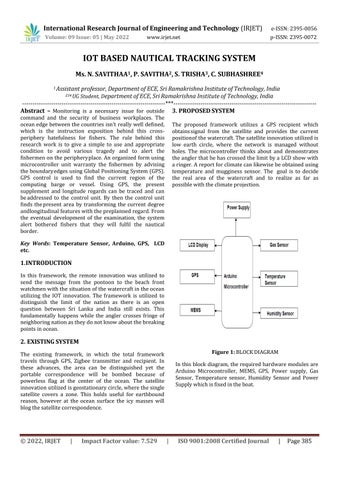
2. EXISTING SYSTEM Figure 1: BLOCK DIAGRAM
The existing framework, in which the total framework travels through GPS, Zigbee transmitter and recipient. In these advances, the area can be distinguished yet the portable correspondence will be bombed because of powerless flag at the center of the ocean. The satellite innovation utilized is geostationary circle, where the single satellite covers a zone. This holds useful for earthbound reason, however at the ocean surface the icy masses will blog the satellite correspondence.
© 2022, IRJET
|
Impact Factor value: 7.529
In this block diagram, the required hardware modules are Arduino Microcontroller, MEMS, GPS, Power supply, Gas Sensor, Temperature sensor, Humidity Sensor and Power Supply which is fixed in the boat.
|
ISO 9001:2008 Certified Journal
|
Page 385