International Research Journal of Engineering and Technology (IRJET) e-ISSN: 2395-0056

Volume: 09 Issue: 10 | Oct 2022 www.irjet.net p-ISSN: 2395-0072
International Research Journal of Engineering and Technology (IRJET) e-ISSN: 2395-0056
Volume: 09 Issue: 10 | Oct 2022 www.irjet.net p-ISSN: 2395-0072
1 Assistant Professor, Chitkara School of Planning and Architecture, Chitkara University, India
2 Associate Professor, Division of Architecture and Civil Engineering, Ashikaga University, Japan ***
Abstract - The purpose of this research paper is to present architecture features and present state of water structure in Narnaul through the field survey that has been conducted in Narnaul, India. Moreover, this paper shares the methodology of the field survey of water structures for specific area/district which has never been focused.
An assessment of the inventory forms helped to identify 5 sub-categories within Water Structures in Narnaul: 1) Johads; 2) Talabs/Sagars; 3) Kunds; 4) Wells; 5) Baolis / Stepwells. The typology of water structures was essentially based on the purpose for which the water was used, the method of collecting and accessing water as well as their physical form and architectural character. Through documented water structures which are scattered in Narnaul, the feature and present state of a variety of water structures can be recognized.
Key Words: Water Structure, Narnaul, Stepwell, Documentation, Historical Heritage, Conservation
Amongtheworld'smostimportantresources,waterplays an important role in all livelihoods, development, and environmental protection [1]. In Indian context water holds sacred values and defines purity [2]. It narrates the storyoflives,ritualsandmythsofitspeople.Astheresult of water capturing practices in the months of monsoon thesemagnificentstonestructurescameintoshapewhich wecallasStepwells(Indianname-Baoli)[3].
While these underground water monuments comprise one of India’s major building traditions, they are perhaps the most neglected of the world’s great bodies of architecture [4]. This paper tells the feature and its uniquenessofwaterstructuresofNarnaul,semi-aridzone, one that shares in India’s culture, especially its art, architectureandengineering.
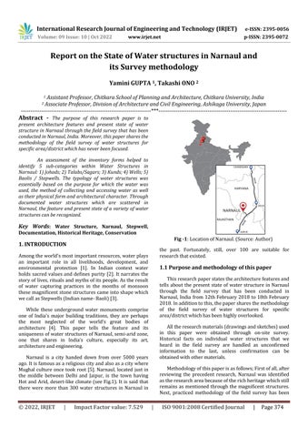
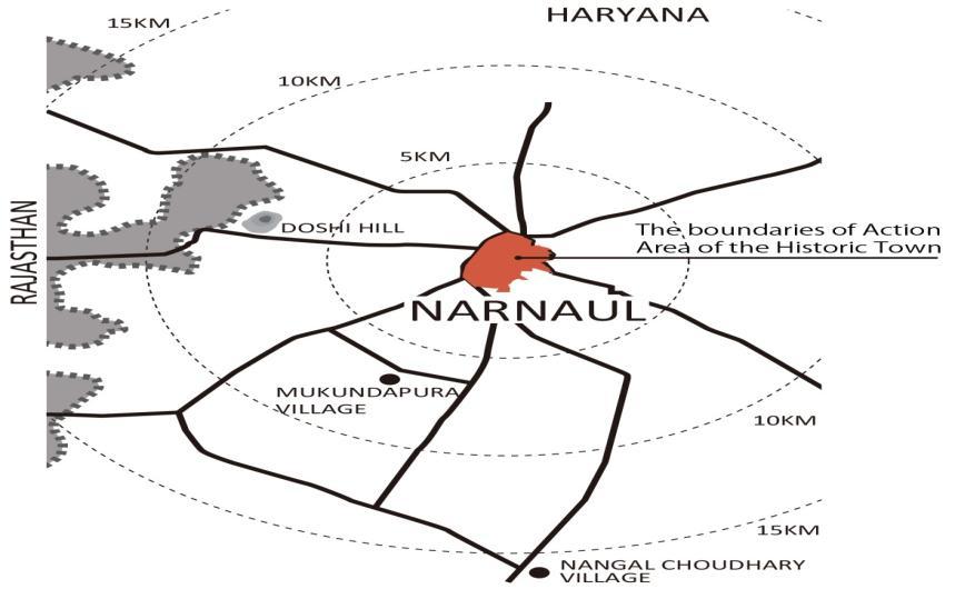
Narnaul is a city handed down from over 5000 years ago.Itisfamousasareligiouscityandalsoasacitywhere Mughal culture once took root [5].Narnaul,located justin the middle between Delhi and Jaipur, is the town having Hot and Arid, desert-like climate (see Fig.1). It is said that there were more than 300 water structures in Narnaul in
Fig -1:LocationofNarnaul.(Source:Author)
the past. Fortunately, still, over 100 are suitable for researchthatexisted.
Thisresearchpaperstatesthearchitecturefeaturesand tells about the present state of water structure in Narnaul through the field survey that has been conducted in Narnaul, India from 12thFebruary 2018 to18thFebruary 2018.Inadditiontothis,thepapersharesthemethodology of the field survey of water structures for specific area/districtwhichhasbeenhighlyoverlooked.
Alltheresearchmaterials(drawingsandsketches)used in this paper were obtained through on-site survey. Historical facts on individual water structures that we heard in the field survey are handled as unconfirmed information to the last, unless confirmation can be obtainedwithothermaterials.
Methodologyofthispaperisasfollows;Firstofall,after reviewing the precedent research, Narnaul was identified astheresearchareabecauseoftherichheritagewhichstill remains as mentioned through the magnificent structures. Next, practiced methodology of the field survey has been
International Research Journal of Engineering and Technology (IRJET) e-ISSN: 2395-0056
Volume: 09 Issue: 10 | Oct 2022 www.irjet.net p-ISSN: 2395-0072
followed in detail while discussing each process and its self-assessmentsinordertojustifytheprocessofthefield survey and share the experience. Finally, the features and present state of the water structures which were documentedinNarnaulwereanalyzed.
At first it was analyzed what has already been done in the area of water structures. Many researchers have already been involved in the study of water structures. Many of them are ‘Patan's Rani ki vav’ registered as a WorldHeritageSite[6]and‘ChandBaori’[7],whichisthe oldest stepwell, and limited to major cities such as Delhi andAhmedabad.
The following works are listed as recently published exertions.
For an instance the books ‘The Vanishing Stepwells of India’ by Victoria Lautman [8] and ‘Steps to water; the Ancient Stepwells of India’ by Morna Livingston [9], both thesebookscontainthepictorialdocumentationofexisting water structures right from 4th century to late 1990’s. So we looked what further can be done in this area. And, we observedthatalltheseresearchesdonotnarrateaboutthe waterstructuresindepth.
Originality of this paper is to understand not only limited unknown water structures located in Narnaul as a specific water structure but also architecture features and its diversity of the water structures scattered throughout thetown/districtcomprehensively.
There is no precedence research ofNarnaul focusedas acaseexampleofthispaper.RegardingwithNarnaul,there is a booklet compiled by INTACH. Although it is reliable content, it is only introducing some existing historic buildingspresentinNarnaul.
The water structures to be treated in this research are divided into five main parts. These technical terms were based on the term called by local people in Narnaul, so in caseofotherareaitmaybedifferent.
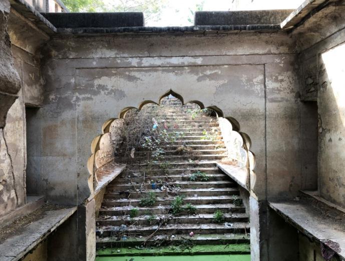
1)Stepwell- Stepwells, also called Baolis, are wells in which the water level is reached by descending a wide set of steps, often going down several stories. Built by the nobility for civic and strategic reasons, Stepwells were secular structures from which everyonecoulddrawwater[10].(SeeFig.2)
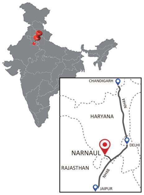
2)Talab and Sagar- Talabs and Sagarsare large reservoirs used to collect water during heavy rains, and to prevent excessive flooding in surrounding areas. Such structures are lined with masonry and often have other architectural embellishments such aspavilions[11].(SeeFig.3)
International Research Journal of Engineering and Technology (IRJET) e-ISSN: 2395-0056
Volume: 09 Issue: 10 | Oct 2022 www.irjet.net p-ISSN: 2395-0072
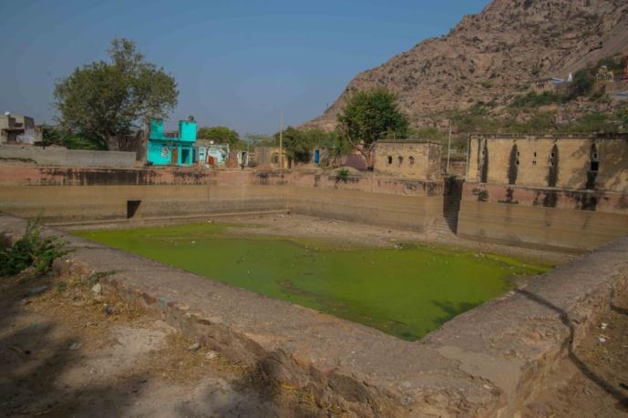
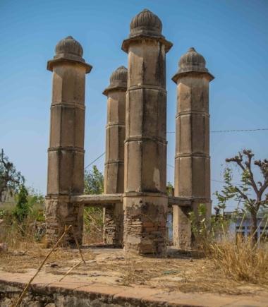
3)Kund-AKundisalsoawatercatchmenttool.Itsmain purpose is to harvest rainwater for drinking and other purposes. Many kunds are accompanied with temples and ascribed with sacred values [12] (See Fig.4)
4)Well- Wells are vertical structures dug in ground for the purpose of bringing ground water to the earth’s surface[13].(SeeFig.5)
Narnaul is a municipal corporation in the Indian state of Haryana. It is the headquarters of the Mahendragarh District.Aplacewitha richandvariedlegacy,Narnaul has created a deep impact on India’s historical, social and economic order and, has contributed significantly to its cultural and architectural heritage. Narnaul lies at the borderofHaryanaandRajasthan,at135kmfromDelhiand around 160 km from Jaipur, on the historically significant Delhi-Agra-Ajmeraxis.Thelocationonthismajorhighway has been a significant factor in shaping the history, economyandsocialstructureofthetown.
The proximity ofNarnaul toRajasthanalso meansthat thetownsharesitsclimaticcharacteristics.Thetownhasa Hot and Arid, desert-like climate. In summers, the highest temperature soars up to 55°C, while the winter temperaturescanlowerdownto-10°C.Thelandisdryand suffers from a scarcity of water. These harsh conditions werethemajortriggersfordevisingavarietyofinnovative structuresforwaterharvestingandmanagement[15].
The low-lying, barren hills of Aravalli range form the backdropofthetown,withtheDhosiHilllocatedat12Km fromthecity,becominganimportantlandmarkandsacred nodeforitspeople(seeFig.1&7).
ThedevelopmentofNarnaul,fromaforestregioninthe 17th century to a thriving urban nucleus, has also been aided by abundance of mineral and botanical resources in theregion.
In a country with history vaster than its diversity, and the opulence of its world-renowned archaeological marvels, the value of this small town has been largely overlooked. The history of Narnaul goes back to a period extendingasfarbackasaround5,000yearsago.According toalegend,thetowndatesbacktotheMahabharataas‘Nar Rashtra’,fromwhereitendedupinthehandsoftheAfghan rulerSherShahSuri,whowasbornonthisland.Thefamed Mughal king Akbar, while he ruled, hadestablisheda mint here,churningoutcoinsforthemasses.
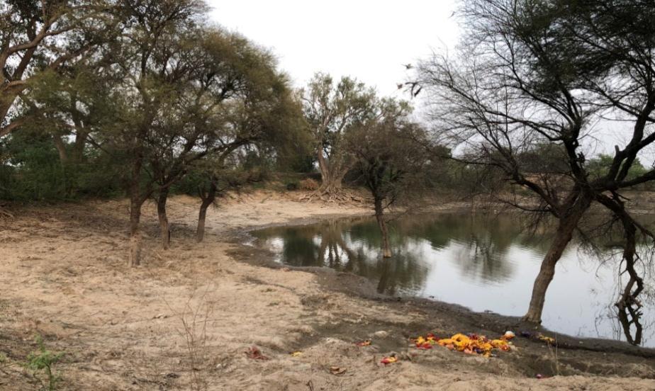
5)Johad- A Johad is a naturally formed pond that captures and conserves rainwater. It is one of the oldestsystemsusedtoconserveandrechargeground water.Johadsarecommunityowned,usuallyfoundin ruralsettings[14].(SeeFig.6)
Despite being largely ignored in the pages of Indian history, Narnaul has maintained its historical and cultural relevance through its rich and diverse built heritage, ranging from havelis to kunds to talabs and baolis to templesand mosques. All ofthese had a crucial impacton thesocialandphysicalstructuringofthetown.Inaddition tosubstantialnumbersofhavelisandwaterbodies,thecity of Narnaul also contains numerous gardens, tombs and
International Research Journal of Engineering and Technology (IRJET) e-ISSN: 2395-0056
Volume: 09 Issue: 10 | Oct 2022 www.irjet.net p-ISSN: 2395-0072
places of worship ranging from temples to mosques (see Fig.7).
Researchmethodologywhichwasadoptedisas:
Step1: Identification of Action Area (within historical boundariesofNarnaul)
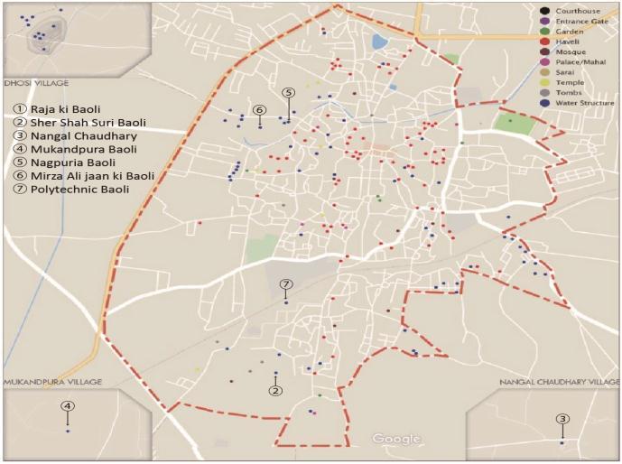
As already mentioned above, when conducting the survey, we set the historic district (about 2 km square) writteninthecityplanningdrawingofNarnaulasthearea
to be investigated (Action Area). The limited area is as showninthefollowingfigure8.
Step2: Identification of the resources holding the historicalheritage
For the survey, we divided the action area into 24 blocks, and picked up buildings, etc. that had been inside formorethan100years.Asa groupof5people,wemade records-(mappinginthemap,writingdownthecoordinate on the page and identifying exact location on google map, writinginformationtotheinventoryform,recordinginthe photographs, measurement of the sizes, brief history, period of construction and Description of architectural attribute). The reason for subdividing the action area was to record in detail the range that can be walked around. Even in mapping to a map, there is an advantage that errorsarereduced.
Fig -7:Diversebuiltheritagesinthehistoricdistrictof Narnaul(Source:Author)
In this investigation, in cooperation with GoogleMap, thelatesttechnologyofmappingthebuildingwasusedbut itturnedoutthattherearesomeerrorsduetoradiowaves and mobile phone capabilities. Even a small error on Web atlas will be very large in real city. Especially in the water structure most structures are located in the basement it becomes a big problem if the position shifts. In that sense aswell,thelocationtobesurveyedwaslimitedtoanarrow area so that the location could be determined. Another major problem was that several investigation teams conducted this survey, but to supervise them and to maintain the precision was little challenging at certain level. In this project, eight supervisors managed investigations one after another and were in charge of certain blocks. This further reduced the chances of discrepancies.
In this step every identified structure was marked on the map using separate Color-codes for each use of the building (see Fig 7). Mapping was done in reference to coordination of GoogleMap and handwritten map written onthepageandInventoryform.
As already mentioned, it is important to be aware that errors will occur in Google map's coordinate. By mapping together not only the original water structure but also other historical sources, it will lead to grasping the meaning from the urban, positional relationship of each waterstructure.
Fig -8:Actionareaofthehistorictownandsurroundings ofNarnaul(Source:Author)
Again, it is also to reduce the discrepancy of the positionalrelationshipinthemapping.
As the action area was investigated, some water structures were also identified outside the action area. Only for this, supplementary investigation was conducted
International Research Journal of Engineering and Technology (IRJET) e-ISSN: 2395-0056
Volume: 09 Issue: 10 | Oct 2022 www.irjet.net p-ISSN: 2395-0072
inadditiontothemappingcreatedinStep3,ratherthana planned survey, it was a spot-like survey. Historical resourceswerethoroughlylookedonthewaytothetarget stepwellbuthistoricalresourcescannotbecoveredoutside the actionarea (see Fig.7).The stepwell found outside the actionarea isabout15kmawayfromNarnaul.Ingeneral, the stepwells are often located in places where villages once existed, and even in places up to 15 km apart, historical resources such as agricultural land and water structure(Narnaulcitytoexistingvillage)arelesslikelyto be located. However, it was found that there are several Water structures including wells etc. in the existing settlements. A total of five categories of water structures wereidentifiedfromtheinventoryformsfordetailedstudy anddocumentation(seeFig.1-5).
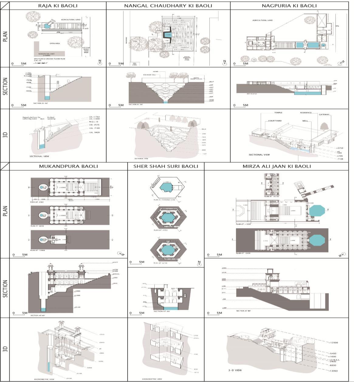
Plansofwaterstructuresweremeasuredwith thehelp oftriangulationmethodandthedepthsofthewaterbodies werenotedusingvariouslocaltechniquesusingthreadand stone. An observation made resulted to a conclusion that thestructureswerenotonlyrestrictedtothegroundlevel but also extended to the underground levels from where thewaterbodieswereeasilyaccessible.Theheightsofthe structures were measured using the measuring tapes and laserbeams.Someofthewaterstructureswerepresentin conditionofruinsandweredocumentedwithutmostcare.
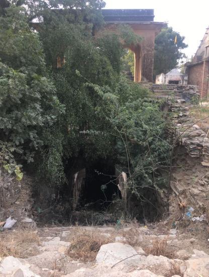
As a result of the survey conducted by the above methodology,itwasfoundthatinNarnaulwaterstructures is1)Johads;2)Talabs/Sagars;3)Kunds;4)Wells;5)Baolis / Stepwells. The breakdown is as follows: As per the data collected while listing, the survey area in this research contains 01 Johad, 07 Talabs/Sagars, 04 Kunds, 83 Wells, and07Baolis.Outofthese,allthe6Baolisweretakenupfor detailed research. Incidentally, the undocumented stepwell, Polytechnic Baoli, could not be accessed due to badstate(seeFig.9).
To explain these features easily, Johads and Kunds, being large storage tanks, were situated outside Narnaul’s historical urban boundaries, whereas the Wells, Talabs/Sagars and Baolis, supplying water for daily household needs were mainly located within it. The documented stepwells are discussed in next section further.
Figure10showsdrawingsofsixstepwellsdocumented inNarnaulandFigure7showsthelocationofdocumented stepwells Table 1 summarizes the outline of the documentedwaterstructures(seeTable1).
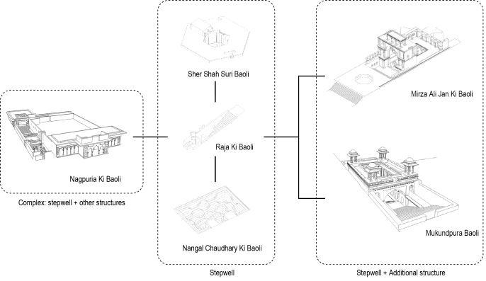
Focusing on stepwell, these are found in several forms/styles. For stepwell, it can be divided into three types. 1) stepwell, 2) stepwell + additional structure, 3) complex:stepwell+otherstructures(seeFig.11).
Fig -11: Stepwells categorized into three types (Source:Author)
International Research Journal of Engineering and Technology (IRJET) e-ISSN: 2395-0056
Volume: 09 Issue: 10 | Oct 2022 www.irjet.net p-ISSN: 2395-0072
Among Type one there is Raja Ki Baoli, Nangal Chaudhary Ki Baoli, Sher Shah Suri Baoli. They are comparativelysmallinsizeandusedonacommunity-base. RajikiBaoli,whichisrectangularwithstepsreachingwell from only one side in orderto draw water, is the simplest one. NangalChaudharyKiBaoliisalsorectangular,buthas stepsonthreesides.Thesetwoarelocatedontheoutskirts ofNarnaul.SherShahSuriBaoliisHexagonalanditssteps to access the well is narrow. Location of Sher Shah Suri Baoliislocatedon the garden within the historic area, but it has no relation with surroundings. Since the inside has twolayersofgalleries,thisstepwellisnotonlypeoplewho use gardens and to draw water but also a place for taking rest.
InTypetwothereisMirzaAliJanKiBaoli,Mukundpura Baoli which not only have steps leading to the basement but also have additional structure showing off the presence. It is believed that it is because kings used to come and take rest in the additional structure such as a flat-roofed pillared pavilion which is henceforth called ‘takht’. So, it is comparatively larger with wide steps. In particular,MirzaAliJanKiBaolilocatedinthecenterofthe city, has a symbolic appearance and is the largest. Even thoughMukundpuraBaoliislocatedattheoutskirtsofthe city,inthesurveyitwasrecognizedthatitwasusedbythe rulerandwasusedasagateofthevillage.
Fig -10:DrawingsdocumentedstepwellsinNarnaul(Source:Author)
International Research Journal of Engineering and Technology (IRJET) e-ISSN: 2395-0056
Volume: 09 Issue: 10 | Oct 2022 www.irjet.net p-ISSN: 2395-0072
Table -1:InformationdocumentedstepwellsinNarnaul(Source:Author)
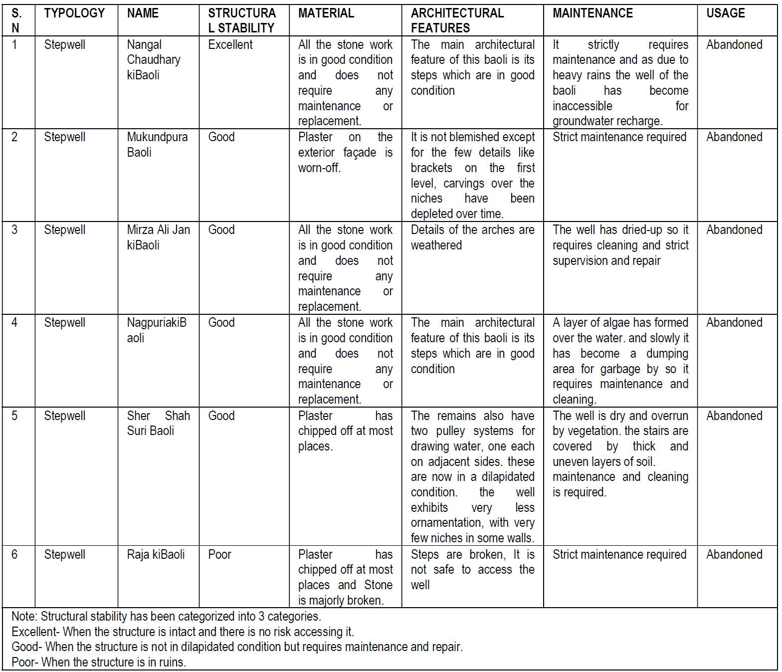
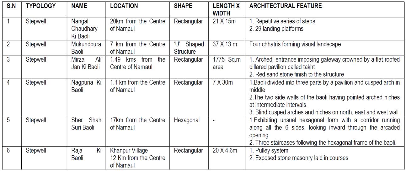
Table -2:CurrentstateandarchitecturalfeaturesstepwellsinNarnaul(Source:Author)
2022, IRJET | Impact Factor value: 7 529 | ISO 9001:2008 Certified Journal
International Research Journal of Engineering and Technology (IRJET) e-ISSN: 2395-0056
Volume: 09 Issue: 10 | Oct 2022 www.irjet.net p-ISSN: 2395-0072
Then in Type three there is Nagpuria Ki Baoli which composed not only stepwell but also temple and school (now residence) as a complex. This complex exists and servesthepurposefortheneighboringcommunitythanfor the kings, so the stepwell was used for the daily life for neighbors.Asdescribedabove,therearedifferencesinhow to use the stepwells, which shows that it appears as a differenceoftheshape.
Despite their historical importance, only a handful of stepwells are still relatively decently preserved by the early 21st century, particularly those in tourist-friendly areas. However, a number of factors contributed to the deplorable condition of most structures For instance, stepwells were considered unhygienic breeding grounds for disease and parasites by the British Raj, and consequently were barricaded, filled in, or otherwise destroyed. As well as eliminating the physical need for stepwells,"modern"substituteslikevillagetaps,plumbing, andwatertanksalsoeliminatedtheirspiritualsignificance. With time, stepwells became outdated, were abandoned, turned into garbage dumps and latrines, or were repurposedasstorageareas,minedfortheirstone,orwere justlefttodecay.
Thecurrentstateofdocumentedstepwellsisconcretely exemplified as below in Table 2 (see Table 2) As seen in table 2, the current state summarized from the view point of structural stability, material, architectural features, maintenanceandusage.
Every structure including the polytechnic stepwell is abandoned and requires maintenance. Both Polytechnic stepwellandRajakiBaolihavepoorstructurestability,and require restoration due to some deterioration. Though every structure would be stable for longer time since historic water structures are constructed by stone. The common cause of damage in both of two is vegetation growthandgarbage.
With respect to the other 6 structures excepting the above two structures, even though maintenance would be partially required, main structure has maintained good state of structure stability. Although it is not the same as the above two, the deterioration of the structure is surely proceeding due to abandonment. Since stepwell are no longernecessaryfordailylifeforgettingwater,thewillto remain within the community is crucial point. It is indeed truethatNangalChaudharykiBaoli,thatpossessexcellent structure stability was used until recently and remains close relation to the community. Looking back to PolytechnicBaoliandRajakiBaoli,Polytechnicstepwellis located in the urban area but within the campus of the college, so that closed toward the community. In case of RajakiBaoli,ithasnorelationshipwithacommunityfrom thebeginning.
Documented stepwells all demonstrate structural stabilitybuttheyneedrestoration.Restorationneedstobe done using traditional materials with skilled craftsmen, architectsandstructuralengineers.
This study focused on water structures of Narnaul which fortunately still remain even after tremendous historic recoursesduetohistoricalandclimaticinfluence.
Over 100 water structures could be recognized throughout Narnaul, out of which 6 stepwells were documented through appropriate methodology of the surveyandcomparativeanalysis was broughtout through drawings and photograph of documented structures. Thereby, this paper could share the feature of water structures, especiallystepwells, inNarnaul andits present state. Obviously, methodology of the survey conducted in Narnaulwouldbeusefulforfuturesurvey.
Regarding with methodology of the survey, it seems to be very effective. Inventory form were filled in detail at a certain quality under supervisor, supporting with advancedtoolssuchasGoogleMapincombinationinorder togetcoordinateofthestructure.Usingthewebatlaswas very worthwhile way to analyze not only the individual case but also distributed structure in the whole area in order to understand the interrelationship with not only waterstructuresbutalsootherhistoricalresources.
ThroughthissurveyinNarnaul,itwasrecognizedthata varietyofwaterstructuresstillremained.Moreover,seven stepwells (including polytechnic Baoli) have different shape. Focusing the shape of the Stepwell, these shapes correspond to how they are used, and it can be seen their lifewhenthewaterstructureswasused.
In discussion of the present state, historic water structuresconstructedbystonemaintainingoodcondition having structural stability. The difference is related with the location. It is thus, the water structures would be in a statethattheplantgrowslittlebylittle,thestepcollapses, and it became inaccessible in case of a closed place from communityoraplaceawayfromcommunity.
We would like to acknowledge the efforts of students of Batch 2015, Chitkara School of Planning Architecture, Chitkara UniversityPunjab whotookthesubjectasa part of their documentation studies and helped the research. This work was financially supported by Chitkara UniversityandJSPSKAKENHIGrantNumberJP20K04909.
International Research Journal of Engineering and Technology (IRJET) e-ISSN: 2395-0056
Volume: 09 Issue: 10 | Oct 2022 www.irjet.net p-ISSN: 2395-0072
Theauthorsconfirmthatthedatasupporting thefindings of this study are available within the article [and/or] its supplementarymaterials.
1. Hogeboom, R.J. The water footprint concept and Water’s grand environmental challenges. One Earth2020,2,218–222.
2. Singh, R. P. B. (1994). Water Symbolism and Sacred Landscape in Hinduism: A Study of Benares (Vārāṇasī) (Wassersymbolismus und heiligeLandschaftimHinduismus:EineStudieaus Benares (Vārāṇasi)).Erdkunde,48(3), 210–227. http://www.jstor.org/stable/25646594
3. Sharad Chandra. (2015). Steps to Water: StepwellsinIndia.ChitralekhaJournalonArtand Design,5.
4. Singh,R.(2015).StepwellsinBundilieinneglect, face extinction. Times of India. https://timesofindia.indiatimes.com/entertainme nt/events/jaipur/dj-harsh-injaipur/articleshow/47039709.cms
5. Arya, R. T. (2022). narnaul: of all-powerful medieval nobles and incredible wealth. https://ramaarya.blog/2022/09/26/haryananarnaul-travel-guide/
6. UNESCOWorldHeritageCentre1992-2022
7. ChandBaoriStepWellinRajasthan,India.(2014). https://timesofindia.indiatimes.com/travel/desti nations/chand-baori-step-well-in-rajasthanindia/articleshow/35997690.cms
8. Victoria Lautman, The Vanishing Stepwells of India,MerrellPublishers,2017
9. Morna Livingston, Steps to water; the Ancient Stepwells of India, Princeton Architectural Press, 2002
10. Lautman, V. (n.d.). stepwell. https://www.britannica.com/technology/stepwel l
11. Traditional Water Harvesting Systems. (n.d.). cseindia.org/traditional-water-harvestingsystems-683
12. Studio, R. (2021). Rainwater Harvesting In Rajasthan.
13. Todd, D.K. (1980) Groundwater Hydrology. 2nd Edition,JohnWiley&Sons,NewYork.
14. Sharad Chandra. (2015). Steps to Water: StepwellsinIndia.ChitralekhaJournalonArtand Design,5.
15. Mahendragarh. (n.d.). https://districts.ecourts.gov.in/mahendragarh