Traffic Circulation, Diversion, and Management Plan for AhmedabadMumbai High Speed Rail Corridor Package C-7 (Sanjivani Choughule)
ABSTRACT
PackageC-7ofMumbai-AhmadabadHighSpeedRailCorridorincludesstretchof18.133Kmandhastwoupcomingstations i.e.,AhmadabadandSabarmatiStation.ThisHigh-SpeedCorridorwillbeginfromMumbaiinMaharashtraandterminateat Sabarmati in Gujrat. The length of this High-Speed Rail (HSR) Corridor is 508.17 km of which Elevated: 468 km, underground: 27 km (2 km under sea at Thane Creek) At-Grade: 13 km and consists of 12 Stations. This AhmedabadMumbaiHighSpeedRail(AMHSR)lineenvisagesuseofpublictransportsystembetweenfinancialcapitalsofMaharashtra andGujaratandshallcaterthepresentandfuturetraveldemandofthecatchmentarea.Thislineshallalsoreduceloadfrom road-basedtransportsystemofthe corridor.DuringtheconstructionphaseofanyTransportationInfrastructurerunning alongtheRightofWay(ROW)ofexistingroadwaysystem,Trafficdiversionandmanagementplanimplementationbecomes absolute mandatory to reduce congestion, conflicts increase level of safety and ease construction process. Similarly, for package C-7 of High-Speed Rail Corridor, there is need of preparing an implementing Traffic Circulation, Diversion and Management plan to create a synergy amongst construction activities, traffic flow, safety of pedestrian and construction worker with minimal impact on surrounding catchment. This study shall provide Traffic circulation, diversion and management plan which will help to cater the existing traffic and stir them in a smooth and non-congested flow with the helpofsignage’s,roadmarkings,etc.
1. INTRODUCTION
Traffic management is a process of compiling and analyzing information on the impacts that a specific development proposalislikelytohaveontheoperationofroadsandtransportnetworks& alsocontrolofbothstationaryandmoving traffic, including pedestrians, bicyclists, and all types of vehicles. The management is not only including general impacts relatingtotransportmanagement(roadefficiencyandsafety)butshouldalsoconsiderspecificimpactsonallroadusers, including on-road public transport, pedestrians, cyclists, and heavy vehicles. Every land use generates home and nonhome-basedtripsovertheperiodofdaywhichplyontheaccessroadsandmainarterialroadsconnecting theproposed/ planned development. Also, as any infrastructure construction activity shall reduce the available capacity of transport network which will affect the level of service. These roads have specific capacity in terms of number of vehicle (PCU) handling in peak hour as per IRC 106-1990. To provide satisfactory riding quality on this rods, specific level of service shall bemaintained by maintaining volume and easeof flowwith properdiversion andmanagementplansforthetraffic plyingontheseroads.
It is necessary to maintain both quality and quantity of road infrastructure continuously to maintaining good Level of Serviceandsafetyonroads.MostimportantlywhenitcomestoTier1&2citieswhere,percentagetripgenerationevery year is increasing due to urban migration, transportation infrastructure facilities become the backbone of the city. However,duetolackofMassTransit/TransitOrientedDevelopmentsandimpropertransportationplanning,commuters mustfacemajortrafficissuesduringpeakhour.Foranyinfrastructureproject,apropertrafficdiversionandmanagement planisalsomandatorytocatertheneeds,easethemovementandmanagingagoodsafetylevelduringexecution.
2. OBJECTIVES OF STUDY
TheprimaryobjectiveofthisstudyistoprepareTrafficCirculation&Diversionplanforconstructionvehiclewiththehelp ofPrimaryandSecondarydatacollectedforthecorridor(C-7)andthecatchmentareasothatcongestion,conflictscanbe ignored to the maximum extent with increase in safety of pedestrians and workers along with improved workability at site.

International Research Journal of Engineering and Technology (IRJET) e-ISSN:2395-0056
Volume: 09 Issue: 10 | Oct 2022 www.irjet.net p-ISSN:2395-0072
Toachievetheaboveobjectives,followingscopeispreparedwhichincludes:
a) Reconnaissancesurveytounderstandtheexistingtrafficscenario,proposedconstructionplan(phasingifany)and bottlenecksinthetrafficflowofstudyarea.
b) Reconnaissancesurveywillbefollowedbycollectionprimarydatafromthesitewhichwillincludebutnotlimitedto:
i. Classified Traffic Volume Count at Mid-blocks (Between intersection)
ii. Turning Movement Survey at Intersections (All intersection in study area)
iii. Spot-Speed Survey (at midblock of study area)
iv. Origin-Destination Survey (Strategic location around study area)
c) Alongwithprimarysurveydatacollection,availabledatarequiredforthestudywillbecollectedfromtheclient.
d) Detailedtrafficanalysiswillbedonebasedonthedatacollected,rectified,andscrutinized.Thistrafficanalysiswill provideresultslikecurrentLOSofstudyarea,potentialroutesfortrafficdiversion,travelcharacteristicsofroadusers, bottlenecksontheroadnetwork,LOSofroadnetworkconsideringproposeddiversionplan.
e) TakinginaccounttherequiredspaceforconstructionofAMHSR corridor, traffic circulation plan for construction vehicleswillbepreparedwithdetailinglikeROWrequiredwithadequateturningradius,signageplanetc.
f) Conceptualtemporarysignageplanfordivertedrouteisprepared.
g) Trafficissuesinthestudycorridorwillbeidentifiedandtheirsolutionwillbeprovided
3. APPROACH & METHODOLOGY
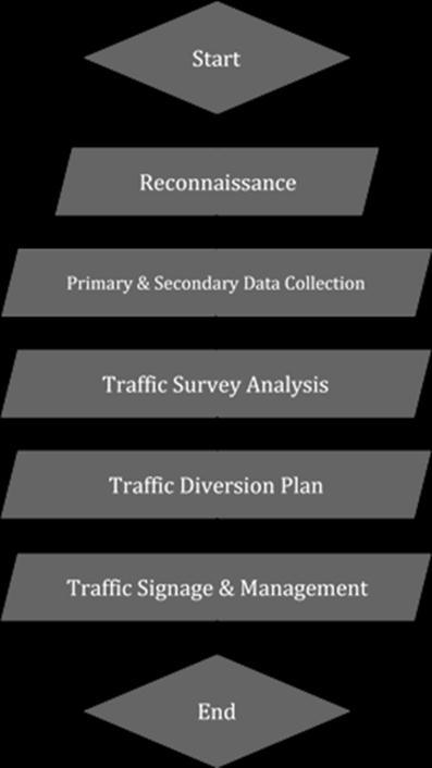
In line with the scope of work methodology for preparing diversion plan for package C- 7 has been prepared and approached accordingly. Reconnaissance survey was conducted to understand the existing traffic scenario, proposed construction plan (phasing if any) and bottlenecks in the traffic flow of study area followed by primary data collection fromsite through varioustrafficsurveys asmentionedinthe scope. Along with primarysurveydata collection, available datarequiredandavailableforthestudylikeTopographicalsurveyofthecorridorandGFCforstationsarecollectedfrom theclient. Trafficsurvey wasdonebasedontheprimarydata collectedand the resultsandobservationsareprovided in thesubsequentchapters.AfteracceptanceoftheTrafficsurveyanalysisreport,trafficdiversionplanforthejunctionwill bepreparedindetail.Signageplanfordivertedrouteshallalsobepreparedatthisstageofthestudy.Studyapproachand methodologyisshowninthefollowingflowcharttounderstandthechronologyofwork.
Volume: 09 Issue: 10 | Oct 2022 www.irjet.net p-ISSN:2395-0072
4. TRAFFIC SURVEYS ANALYSIS
In order to arrive at the present traffic scenario and appreciate the travel characteristics of the road users in this area, primarystudieswereorganizedandconducted.Theobservationsfromthefieldstudieshavebeenpresentedbelow.
A. Methodology adopted for the Traffic Study
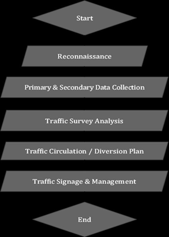
To measure the impact of C-7 Package construction work on road network, the current traffic characteristics need to be assessed. Package C-7 of Ahmedabad Mumbai High Speed Rial Corridor starts near Vatva and ends at Sabarmati where Sabarmati Rolling Stock Depotis beingconstructed. Sabarmati maintenance depot will bethe largest depot among three depotsplannedforMAHSRcorridor.OtherdepotswillbeatSurat(Gujarat)andThane(Maharashtra).Togetabetterand clearunderstandingoftheexistingtrafficconditions,theflowoftraffic,utilizationofroadROWandsomeothertechnical detailsoftheroadPrimarytrafficsurveywereplannedandconducted.
Thesesurveysinclude. 1 TrafficVolumecount–3Locations 2 TurningmovementSurvey–5Locations 3 OriginandDestinationsurvey–3Locations 4 SpotSpeedsurvey–3Locations
International Research Journal of Engineering and Technology (IRJET) e-ISSN:2395-0056
Volume: 09 Issue: 10 | Oct 2022 www.irjet.net p-ISSN:2395-0072
B. Traffic Volume Count (TVC)
Traffic Volume Count is counting of the number of vehicles passing through a road over a period. It is defined as the procedureto determine mainlyvolume oftrafficmoving onthe roadsata particularsection duringa particular time. TrafficvolumecountwasconductedTrafficVolumecountwasconductedon3locations:
1 ManiNagarBridge
2 CadillaRoad
3 SubhashBridge
As per the data collected at the location, it can be clearly seen that the road is dominated by the movement of Two Wheelersfollowedbyauto rickshawandthencars.Also,thepeak houroftheMid-block isfrom11.00to12.00 inthe Morning,18.00to19.00intheeveningand10.00to11.00inthemorning.
C. Turning Movement Count
Turning Movement Count or most popularly known asIntersection count is used to count vehicles which are moving inward and outward of an intersection in number of directions. The main purpose is to gather the vehicle data to determine the traffic flow in particular direction. Traffic Movement count was done at 5 Junctions to determine the directionalflowinpeakhourswhichwillbehelpfultodecidethedivertedrouterequiredforthestudyarea.Thesurvey wasconducted4hoursinthemorningpeakand4hoursintheeveningpeak.Turningmovementcountwasconducted atfollowinglocations:
i. Vatva Railway Crossing
TurningMovementcountconductedatVatvaRailwayCrossingagainshowsthatthe alignmentstretchisdominatedby twowheelersfollowedbyBicycles.Also,themorningpeaki.e.,9.00to10.00isat709PCUs/hr.andeveningpeakhour i.e.,19.00to00isaround861PCUs/hr.
International Research Journal of Engineering and Technology (IRJET)
e-ISSN:2395-0056
Volume: 09 Issue: 10 | Oct 2022 www.irjet.net p-ISSN:2395-0072
ii. Cadilla Railway Crossing
TheTurningMovementcountconductedatCadillaRailwayCrossingshowsthatthealignmentstretchisdominatedby two wheelers followed by auto rickshaw Also, the morning peak i.e., 10.00 to 11.00 is at 2496 PCUs/hr. and evening peakhouri.e.,18.00to19.00isaround2593PCUs/hr.
iii. Mani Nagar Railway Crossing
The Turning Movement count conducted at Mani Nagar Railway Crossing Junction again shows that the alignment stretchisdominatedbytwowheelersfollowedbyautorickshawAlsothemorningpeaki.e.,10.00to10.00isat2521 PCUs/hr.andeveningpeakhouri.e.,19.00to20.00isaround2788PCUs/hr.
iv. Bhairavnath Chowk
TurningMovementcountconductedatBhairavnathChowkagainshowsthatthealignmentstretchisdominatedbytwo wheelersfollowed byauto rickshawAlso,themorning peak i.e.,10.00to11.00isat3909PCUs/hr.and eveningpeak houri.e.,20.00to21.00isaround4400PCUs/hr.
v. Arham Circle
Turning Movement count conducted at Arham Chowk again shows that the alignment stretch is dominated by two wheelersfollowedbyautorickshaw.Also,themorning peaki.e.,09.00to10.00isat6346PCUs/hr.andeveningpeak houri.e.,19.00to20.00isaround8322PCUs/hr.
D. Origin and Destination Study
The Origin-Destination survey is carried out to study the travel pattern of passenger traffic along the study corridor. OriginandDestinationStudywasconductedatthreelocations:
1 VatvaRailwayCrossing
2 CadillaRailwayCrossing
3 ManiNagarRailwayCrossing
The Information about Origin and Destination of trips, trip length, trip purpose, frequency of trips, travel cost, travel timewascollectedduringtheinterviews.
a) MajorityofTripsaredominatedbyworkpurposeandfollowedbybusiness/educationpurpose.
b) Averagetriplengthforbusinessandeducationpurposevariesfrom2.0to8.0km.
c) AverageTraveltimeforthecommutersvariesfrom10minutes-20minutes.
d) AveragetravelcostvariesfromRs.10toRs.20dependinguponthemodeoftravel
E. Spot Speed Survey
Spot speed studies are used to determine the speed distribution of a traffic stream at a specific location. Spot speed surveyiscarriedoutatmid-blocklocationswithfree-flowingtraffictodeterminetheaveragespeedofvehiclemoving in peak hour. Spot speed survey data at these three (Mani Nagar Bridge, Cadilla Road, Subhash Bridge) locations suggeststhattheaveragespeedofanyvehicleisbetween20-40Km/Hr.SpeedofTwo-Wheelerislittlehigherthanthe othermodeswhichisunderstoodconsideringthedrivingconditionsinthestudyarea.
5. TRAFFIC CIRCULATION & DIVERSION PLAN
ItisimportanttoanalyzethetrafficcongestionbasedonthedatacollectedforthepackageC-7corridoralongwiththe divertedrouteasitwillprovidethepresentLevelofServiceofthecorridoralongwithLevelofServiceavailableafter traffic diversion on alternate routes. Level of Service is defined as a qualitative measure describing operational conditions within a traffic stream, and their perception by drivers/passengers. Level of Service definition generally describestheseconditionsintermsoffactorssuchasspeedandtraveltime,freedomtomaneuver,trafficinterruptions, comfort,convenience,andsafety.Sixlevelsofservicearerecognizedcommonly,designatedfromAtoF,withLevelof Service A representing the best operating condition (i.e., free flow) and Level of Service F the worst (i.e., forced or
International Research Journal of Engineering and Technology (IRJET)
e-ISSN:2395-0056
Volume: 09 Issue: 10 | Oct 2022 www.irjet.net p-ISSN:2395-0072
break-downflows.Onurbanroads,theLevelofServiceisaffectedduetoroadsidecommercialactivities,construction activities,divertedtraffic,pedestrianvolumesetc.
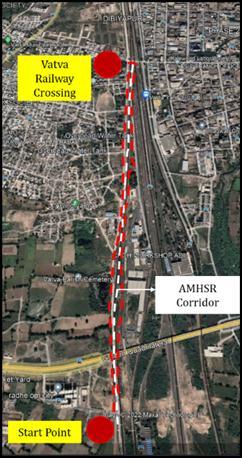
A. Vatva Railway Colony
Thisisthelocationof1strailwaycrossingonthestudycorridorandimportanttoanalyzeaslevelofserviceofthisroad not just depends upon the volume of traffic but queuing of vehicles due to railway crossing. As shown in the table below the peak hour traffic in morning on north south corridor (Dibiyapur – Vatva Railway Colony playground) is about146PCU.Consideringthisroadasacollectorstreetbecauseofroadconditionandpunctures,thecapacityofthe two-lane two-way road is about 1300 PCU (900 DSV). Therefore, the Volume / Capacity ratio of the road is 0.12. However, during railway crossing halt this scenario may change and there is a requirement of clear path for constructionvehicles.
Time Interval
Vatva Railway Crossing (PCU/ Hr.)
8:00to9:00 88
9:00to10:00 146
10:00to11:00 117
11:00to12:00 61
16:00to17:00 48
17:00to18:00 59
18:00to19:00 123
19:00to20:00 85
Asshowninfigurethissectionmostlyliesingreenfieldareaparalleltoexistingrailwayline.A6mwidecorridorwhich is 6 m away from the existing railway line and parallel to AMHSR proposed corridor is suggested for movement of construction vehicles. Vatva crossing is the first railway crossing on the proposed AMHSR corridor. One route for constructionpurposeisproposedparalleltotheAMHSRcorridorbutanadditionalUTurnisprovidedat railwaylevel crossing to provide access to the corridor where AMHSR & existing Railway corridor are their side from left to right andviceversa.
International Research Journal of Engineering and Technology (IRJET) e-ISSN:2395-0056
Volume: 09 Issue: 10 | Oct 2022 www.irjet.net p-ISSN:2395-0072
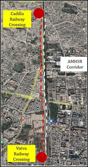
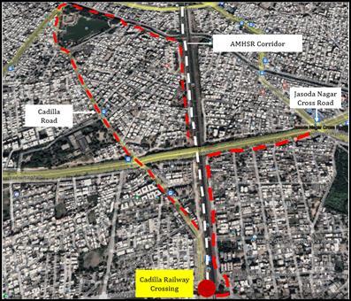
B. Cadilla Crossing
Thisisthelocationof2ndrailwaycrossingonthestudycorridorandimportanttoanalyzeaslevelofserviceofthisroad notjustdependsuponthevolumeoftrafficbutqueuingofvehiclesduetorailwaycrossing.Asshowninthetablebelow thepeak hourtrafficineveningonnorthsouthcorridor(ManiNagar - Dibiyapur)isabout1608PCU.Consideringthis road as sub arterial road, the capacity of the two-lane two-way road is about 1714 PCU (1200 DSV). Therefore, the Volume / Capacity ratio of the road is 0.93 and Level of Service is E. This indicates saturated traffic situation in peak hour.Thisshouldbeconsideredwhilepreparingtrafficcirculationplanforconstructionvehicles.
Time Interval
Cadilla Crossing (PCU/ Hr.)
8:00to9:00 1340
9:00to10:00 1478
10:00to11:00 1504
11:00to12:00 1327
16:00to17:00 1496
17:00to18:00 1482
18:00to19:00 1608
19:00to20:00 1466
Asshowninfigurethissectionmostlyliesingreenfieldareaparalleltoexistingrailwayline.A6mwidecorridorwhichis 6 m away from the existing railway line and parallel to AMHSR proposed corridor is suggested for movement of constructionvehicles.
International Research Journal of Engineering and Technology (IRJET) e-ISSN:2395-0056
Volume: 09 Issue: 10 | Oct 2022 www.irjet.net p-ISSN:2395-0072
Thenextsection,whichisstartsafterCadillaLevelCrossing,Similartothetrailingsectiona6mwidecorridoraway from the existing railway line and parallel to AMHSR proposed corridor is suggested for movement of construction vehiclestillCadillaBridge.DuetorestrictioninverticalclearanceafterCadillaBridgeduetotheflyover,wesuggestaleft turn at from Vatva Station Road towards Cadilla Roadwhich gives a detour to the other side of Cadilla Bridge. Similarly due to Pier placement at Cadilla crossing the traffic at RHS shall be diverted to a parallel road on the right- hand side towardsJasodaNagarCrossRoad.
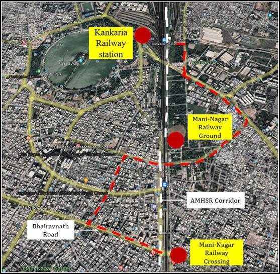
C. Mani Nagar Railway Crossing
Thisisthelocationof3rdrailwaycrossingonthestudycorridorandimportanttoanalyzeaslevelofserviceof thisroadnotjustdependsuponthevolumeoftrafficbutqueuingofvehiclesduetorailwaycrossing.Asshown in the table below the peak hour traffic in evening on north south corridor (Mani Nagar Railway StationDibiyapur)isabout1755PCU.Consideringthisroadassubarterialroad,thecapacityofthefour-lanetwo-way divided road is about 4100 PCU (2900 DSV). Therefore, the Volume / Capacity ratio of the road is 0.42 and LevelofServiceisB.Thisindicatestheoreticallyfreeflowtrafficsituationinpeakhour.However,duetolevel crossing, actual traffic situation is different and should be taken care while preparing construction vehicle trafficcirculationplan.
Time Interval
Mani Nagar Railway Crossing (PCU/ Hr.)
8:00to9:00 1436
9:00to10:00 1594
10:00to11:00 1701
11:00to12:00 1304
16:00to17:00 1613
17:00to18:00 1755
18:00to19:00 1771
19:00to20:00 1431
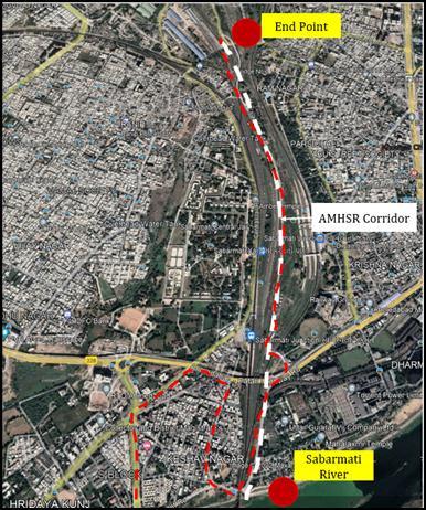
As shown in figure this section mostly parallel to AMHSR corridor. A 6m wide corridor which is 6m away from the existingrailwaylineandsuggestedformovementofconstructionvehicles.TheAlignmentshiftsfromLefttoRightside
International Research Journal of Engineering and Technology (IRJET) e-ISSN:2395-0056
Volume: 09 Issue: 10 | Oct 2022 www.irjet.net p-ISSN:2395-0072
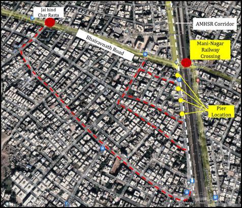
of the existing Railway Line at nearby Mani-Nagar Railway Ground and a portal is proposed at nearby Mani Nagar Railway Ground right side of the AMHSR corridor. To connect the ROW a left turn towards. Bhairavanth Road which connectstheManiNagarBridgeandeventuallyconnectstotheAMHSRcorridornearbytheKankariaRailwaystation, whichshallgiveaninternalaccesstillnearbyManiNagarRailwayGround.
InAdditiontotheabove-mentioneddiversion,duringPierPlacementitwasobservedthatthe4piersbeforetheMani Nagar Railway Crossing were obstructing the road movements. So, to overcome this reduction of the carriageway for thelengthof3.5mitwassuggestedthetrafficshallbedivertedtoaSubarterialroadconnectingJaiHindCharRastaon Bhairavnathroadalongwiththethree markedconnectingroadstodisplacethetrafficbeforethesepierobstructions. This shall increase travel distance of about 1 km, but as operating speed can be managed on this road it is suggested trafficshallbedivertedonthemarkedrouteratherthanplyingonexistingrouteduringconstructionphase.
Volume: 09 Issue: 10 | Oct 2022 www.irjet.net p-ISSN:2395-0072
D. Subhash Bridge
This bridge lies on the Sabarmati River and connecting north and south parts of the Ahmedabad and important as constructionvehiclesshallplyonthisroad.Asshowninthetablebelowthepeakhourtrafficineveningonnorthsouth corridor(Gandhinagar-Ahmedabad)isabout4193PCU.Consideringthisroadasarterialroad,thecapacityofthefourlanetwo-waydividedroadisabout5142PCU(3600DSV).Therefore,theVolume/Capacityratiooftheroadis0.8and Level of ServiceisE. Thisindicatestheoreticallysubsaturated trafficsituationinpeak hour.However, Subhash bridge relatestoarterial4laneroadfromeithersidewhichmakesdecongestionofSubhashbridgeeasier.
Time Interval
Subhash Bridge (PCU/ Hr.)
8:00to9:00 3138
9:00to10:00 2910
10:00to11:00 3206
11:00to12:00 2383
16:00to17:00 4125
17:00to18:00 4193
18:00to19:00 3108
19:00to20:00 2933
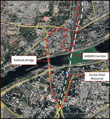
As shown in figure below this stretch is uniform and continuous till Sabarmati River front. The entire stretch will be connected tovariousopeningsinbetweenthem,onesuchpointissuggestedadjacenttotheSardarVallabhbhaiPatel National Memorial which can be used to connect the Subhash Bridge to cross Sabarmati River. A muddy path will be constructedinSabarmatiRiverontheROWtocreateaccessfortheconstructionvehicles.AlongwiththemuddyPath SubhashBridgecanalsobeusedtoaccessboththeendsoftheriver.
As shown in figure below the remaining existing parallel road is available parallel to the AMHSR including a tunnel nearby Ahmedabad-Patan Highway flyover which has the required vertical clearance. After the tunnel the adequate landisavailableparalleltotheROWtocreateaccesspointsinbetween.
International Research Journal of Engineering and Technology (IRJET)
e-ISSN:2395-0056
Volume: 09 Issue: 10 | Oct 2022 www.irjet.net p-ISSN:2395-0072
6. TRAFFIC MANAGEMENT IMPLEMENTATIONS
Constructionzoneisanintegralpartofanyroadconstructionsystem.Thesafetypracticesinconstructionwill,therefore, be oriented towards reducing conditions, which lead to such hazards, and consequent stress whereby risk of accident increases. Different measures are aimed at avoiding hazardous conditions for different zones and sections where major constructionactivitiesaregoingon.
Signagehas beenprovided insucha waythat the driverwill get completeinformationabout the roadsafetyregulations ahead. With the help of this signage, driver can understand the characteristics of road section. The signage plan is therefore prepared for complete corridor. All signage proposed will be clearly understood. Reflective or illuminated signage is suggested for proper visibility. Signage needs to be placed at appropriate locations suggested in the signage drawingsothatpeoplehavetimetoseeandunderstandthesignsandtakeappropriateaction.Itincludesthefollowing:
a) OngoingWorkSigns
b) SpeedLimit
c) Advance“TrafficDiversionAhead”Board
d) No-ParkingSign
Channelizingdevicesareusedtowarnvehiclesofunusualconditioncreatedbyconstructionsormaintenanceactivityinor nearthetravelledwayandtoguidevehiclessafelypasstheworkarea.Itincludesthefollowing:
a) TrafficCones
b) TubularMarkers
c) Delineators
d) ObjectHazardMarker
e) Drums
f) Barricades
Forsafetyofpeopleatwork,itisrequiredtoidentifyhazards,assessriskandconsidermeanstocontroltheriskexposure duringthework.Therefore,thepoliciesthatshouldbeconsideredareasfollow:
a) Toensurethattrafficisdelayedaslittleaspossiblebytheconstructionoperation.
b) Importance is given to traffic safety for pedestrians and to provide a safe working environment for the workmen.
c) Routineinspectionoftrafficcontrol elementsandtrafficoperationneedstobecarriedouttoensurethat roadsidesafetyisneverslackduringtheprogressoftheproject.
7. CONCLUSION
1. PackageC-7ofMumbaiAhmadabadHighSpeedRailCorridorinAhmadabadCityincludesastretchof18.133Km andhastwoupcomingstationsi.e.,AhmadabadandSabarmatiStation
2. There isneedof preparing an implementing TrafficDiversionandManagement planforthis packagetocreate a synergy amongst construction activities, traffic flow, safety of pedestrian and construction worker with minimal impact on surrounding catchment. This study shall provide Traffic diversion and management plan which will helptocatertheexistingtrafficandstirtheminasmoothandnon-congestedflowwiththehelpofsignage’s,road markings,etc.InlinewiththerequirementofTrafficdiversionandmanagementplanforstudycorridor.
3. InlinewiththescopeofworkmethodologyforpreparingdiversionplanforpackageC-7hasbeenpreparedand approachedaccordingly.
International Research Journal of Engineering and Technology (IRJET) e-ISSN:2395-0056
Volume: 09 Issue: 10 | Oct 2022 www.irjet.net p-ISSN:2395-0072
4. Reconnaissance survey was conducted to understand the existing traffic scenario, proposed construction plan (phasing if any) and bottlenecks in the traffic flow of study area followed by primary data collection from site throughvarioustrafficsurveysasmentionedinthescope.
5. Asperthedatacollectedatthelocation,itcanbeclearlyseenthattheroadisdominatedbythemovementofTwo Wheelersfollowedbycars.Also,thepeakhouroftheMid-blockisfrom10.00to11.00inthemorning.
6. While diverting the traffic for construction of the alignment, parking management and signage plan becomes mandatoryassomeportionoftheroadcapacityisnotutilizedbecauseofencroachmentandillegalparking.
7. REFERENCES
TheIndianRoadCongress,IRC:SP55-2014(FirstRevision)
IRC106–1990(GuidelinesforCapacityofUrbanroadsinplainarea)
TheIndianRoadCongress,IRC:67-2012(CodeofPracticeforRoadSigns)
IndianHighwayCapacityManual(Indo–HCM),sponsoredbyCSIRNewDelhi(2012-2017)
TrafficEngineeringandTransportPlanningbyDr.LRKandivali
OtherresearchpaperspublishedforTrafficImpactassessmentoflarge-scaleinfrastructuredevelopments