International Research Journal of Engineering and Technology (IRJET)
e-ISSN: 2395-0056
Volume: 11 Issue: 04 | Apr 2024
p-ISSN: 2395-0072
www.irjet.net
FLOOD ASSESSMENT OF WESTERN MAHARASHTRA REGION Rahul Kapase1, Mrunmai Panchwadkar2, Ajay Kawathe3, Suraj Landge4 ,Ajinkya Gore5 Aniket Malusare6 Assistant Professor Civil Engineering, RMD Sinhgad School of Engineering, Warje, Pune, Maharashtra, India 2 Student Civil Engineering, RMD Sinhgad School of Engineering, Warje, Pune, Maharashtra, India 3 Student Civil Engineering, RMD Sinhgad School of Engineering, Warje, Pune, Maharashtra, India 4 Student Civil Engineering, RMD Sinhgad School of Engineering, Warje, Pune, Maharashtra, India 5 Student Civil Engineering, RMD Sinhgad School of Engineering, Warje, Pune, Maharashtra, India 6 Student Civil Engineering, RMD Sinhgad School of Engineering, Warje, Pune, Maharashtra, India ---------------------------------------------------------------------***--------------------------------------------------------------------1
Abstract - Flooding is a recurring natural hazard that poses
Flooding in this region can damage infrastructure, crops, and livelihoods, and in extreme cases, lead to loss of life.
significant risks to human lives, infrastructure, and the environment. Western Maharashtra, a region in India, has witnessed a history of devastating floods, leading to substantial socioeconomic losses. This study aims to provide a comprehensive flood assessment of the Western Maharashtra region, incorporating various factors such as rainfall patterns, hydrological characteristics, land use changes, and existing flood mitigation measures. The research employs a multidisciplinary approach, integrating remote sensing and GIS techniques with hydrological modelling and statistical analysis. Historical rainfall data from meteorological stations and satellite-derived precipitation estimates are analysed to identify temporal and spatial patterns of extreme precipitation events. Hydrological characteristics, including river networks, catchment areas and flow rates are analysed using digital elevation models and hydrological modelling tools.
1.1 Flood A flood is a natural event where typically dry land suddenly becomes submerged. Some floods occur rapidly and recede quickly, while others build up over days or months before dissipating. Floodwaters in populated areas can carry away houses, bridges, vehicles, furniture, and even people, causing significant damage to farms, trees, and heavy objects. General reasons for flooding are varied and include both human-induced and natural causes. Poorly designed infrastructure is a common human factor contributing to flooding, while natural reasons such as heavy rainfall also play a significant role.
Key Words: flood assessment, Western Maharashtra, rainfall patterns, hydrological characteristics, land use changes, flood mitigation, remote sensing, GIS, hydrological modelling, risk management.
1.INTRODUCTION Floods occur when water overflows onto typically dry land, posing significant risks to agriculture, civil infrastructure, and public health. Human alterations to the environment, such as deforestation and changes in watercourses, often exacerbate flooding, along with larger issues like climate change and rising sea levels. Climate change intensifies rainfall and extreme weather events, heightening flood risks globally. Floods can cause widespread devastation, resulting in loss of life, property damage, and disruptions to critical infrastructure. Vulnerable populations living in floodplains or poorly constructed buildings without warning systems are particularly at risk. Floods historically leave long-term traumatic impacts on affected individuals. Climate change has increased the frequency and severity of floods worldwide. Western Maharashtra, known for its rich cultural heritage and varied terrain, faces flooding during the monsoon season due to heavy rainfall and low-lying areas.
© 2024, IRJET
|
Impact Factor value: 8.226
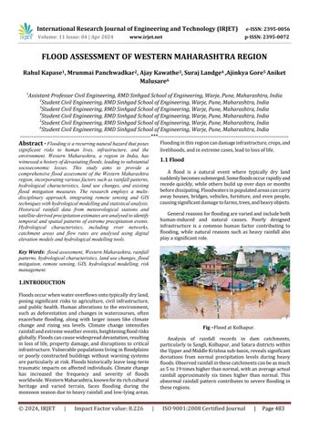
Fig –Flood at Kolhapur. Analysis of rainfall records in dam catchments, particularly in Sangli, Kolhapur, and Satara districts within the Upper and Middle Krishna sub-basin, reveals significant deviations from normal precipitation levels during heavy floods. Observed rainfall in these catchments can be as much as 5 to 19 times higher than normal, with an average actual rainfall approximately six times higher than normal. This abnormal rainfall pattern contributes to severe flooding in these regions.
|
ISO 9001:2008 Certified Journal
|
Page 483