International Research Journal of Engineering and Technology (IRJET)
e-ISSN: 2395-0056
Volume: 11 Issue: 04 | Apr 2024
p-ISSN: 2395-0072
www.irjet.net
Preliminary Proposal for Debris Management in the city of Guayaquil due to disaster situations Camacho Monar Mélida1, Bajaña Escobar Andrea2, Paredes Proaño Ariana3 1 Professor of the Faculty of Engineering, civil engineering career at the Catholic University of Santiago de
Guayaquil
2 Graduated from the Faculty of Engineering, at the Catholic University of Santiago de Guayaquil
3 Graduated from the Faculty of Engineering, at the Catholic University of Santiago de Guayaquil
---------------------------------------------------------------------***---------------------------------------------------------------------
Abstract - The Guayaquil canton, located on the southwest
infrastructures with more than 50 years of construction, there are medium-rise buildings, commercial and residential types, and in addition, it is limited to the north with Avenida 7 NE - Coronel Gregorio Escobedo y Rodríguez, To the south with Cjón. 11 S-E – Ayacucho, to the east with Av. Simón Bolívar Palacios and to the west with AV. 1N-O- Machala (See figure 2).
coast of Ecuador, currently has efficient management of the collection, transportation and final disposal of solid waste. The city of Guayaquil, being located in a region of high seismicity, faces the need for an emerging waste management plan as part of its preparation for possible natural disasters such as earthquakes. The importance of waste management after a natural disaster lies in several aspects such as the proper management of debris to minimize the risks of damage to public health and for the restoration of infrastructure and the reconstruction of the city. The present investigation addresses the quantification of the volume of debris in the central area of the city covering an area of 1396 Ha and an initial proposal for management and identification of areas for rubble dumps in the Guayaquil canton due to disaster situations is presented. Key Words: Debris Management, Disaster Situations, Solid Waste, risks, earthquakes.
1.INTRODUCTION The geographical areas in the city of Guayaquil that are most likely to be affected by earthquakes were determined, based on historical data of seismic activity and the tectonic characteristics of the region. For this research, data from the RADIUS project [1] were used to quantify the debris and an initial management of debris management location of waste dump sites was proposed.
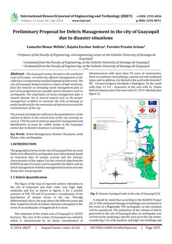
1.1 Debris Quantification The figure of the map of expected seismic intensities in the city of Guayaquil and their risks: very high, high, moderate and low as shown in figures 1 for a seismic scenario of VIII, VII and VI presents a visualization of the distribution of seismic forces in the city. Through differentiated colors, the map shows the different areas and their respective levels of seismic intensity anticipated in the event of an earthquake of magnitude 8 or more.
Fig -1: Seismic Zoning of soils in the city of Guayaquil [1] It should be noted that according to the RADIUS Project [1]; A 10% estimated damage to buildings was estimated in the event of a Magnitude VIII earthquake, so this situation will be considered. The estimation of the volume of debris generated in the city of Guayaquil after an earthquake was carried out by analyzing a specific area (a) in the city center, considering 1 ha with medium and high-rise buildings and
The extension of the urban area of Guayaquil is 33,825 hectares. The area of the center of Guayaquil was selected, which is characterized by its dense concentration of
© 2024, IRJET
|
Impact Factor value: 8.226
|
ISO 9001:2008 Certified Journal
|
Page 1875