
Hydrological Model for Estimating Volume of Inflow into the Peppara Dam Reservoir Using GIS and SWAT
Midhila M1, Fathima Sherin T2
1Assistant Professor, Dept.of Civil Engineering, Vidya Academy of Science and Technology Technical Campus, Kerala, India
2Assistant Professor, Dept.of Civil Engineering, Vidya Academy of Science and Technology Technical Campus, Kerala, India
Abstract - This article presents an application of SWAT model to simulate and predict the volume of inflow into Peppara dam reservoir. The model was calibrated and validated using SWAT CUP (SWAT-Calibration Uncertainty Programs). The calibration was done from 2004 to 2013 and validation was performed from 2014 to 2018. The coefficient of determination (R2) and Nash Sutcliffe Efficiency (NSE) obtained were 0.77 and 0.69 respectively during calibration stage and 0.79 and 0.74 respectively during validation stage. Model showed good performance during calibration and validationstage. This rainfall runoffcanbeusedforpredicting the volume of inflow into the reservoir for various rainfall events and it can help in planning the water distribution to TVM corporation
Key Words: Watershed model; GIS; SWAT: Peppara dam reservoir
1.INTRODUCTION
Hydrologicalmodelisasimplificationofreal-worldsystem, thathelpsinunderstanding,predictingandmanagingwater resources.SoilandWaterAssessmentTool (SWAT)isone type of tool used for developing a hydrological model. Hydrologicalprocessesoccurinwatershed.Theanalysisof watershedisafundamental step.Hydrologicalmodelsare usedtodeterminethestreamflowoveralongperiod. This modelwhichproduceshistoricalcurrentornaturalstream flow records and is used to generate the future yields. Objective of this research is to develop a model for predictingvolumeofinflowintothePepparadamreservoir. Thismodel will helpinplanning the waterdistribution as well as for electricity generation planning in TVM corporation. The SWAT-CUP tool is a program that interfaceswithArcSWATtoperformcalibration,validation andsensitivityanalysis.
2. STUDY AREA
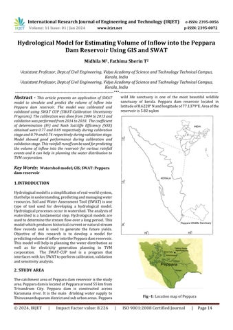
ThecatchmentareaofPepparadamreservoiristhestudy area.PepparadamislocatedatPepparaaround55kmfrom Trivandrum City. Peppara dam is constructed across Karamana river. It is the main drinking water supply to Thiruvananthapuramdistrictandsuburbanareas. Peppara
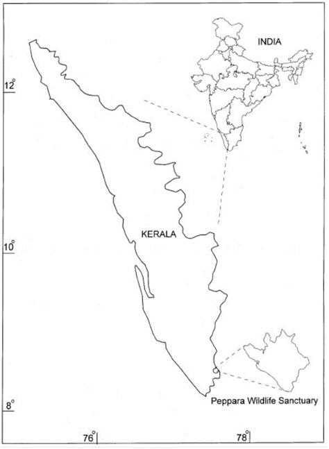
wild life sanctuary is one of the most beautiful wildlife sanctuary of kerala. Peppara dam reservoir located in latitudeof8.6228°Nandlongitudeof77.1379°E.Areaofthe reservoiris5.82sq.km

International Research Journal of Engineering and Technology (IRJET) e-ISSN: 2395-0056 Volume: 11 Issue: 01 | Jan 2024 www.irjet.net p-ISSN: 2395-0072 © 2024, IRJET | Impact Factor value: 8.226 | ISO 9001:2008 Certified Journal | Page14
***
Fig -1:LocationmapofPeppara
3. METHODOLOGY
SWATmodelwassimulatedbyusingArcSWATwithhelpof DEM,Landuselandcovermap,soilmapandmeterological datafromNedumangadustation.SWATsimulationwasdone from2004to2018. Thereservoirwaterlevelwascollected fromKWA(KeralaWaterAuthority)
4.MODEL EFFICIENCY
Theperformanceofthemodelwasdeterminedbystatistical co-efficients.Thecalibrationandthevalidationwerecarried out using the Coefficient of Determination (R^2), Nash–SutcliffeEfficiencyindex(NSE)
disallowing 5 % of the bad simulation. To evaluate the significance of the relative sensitivity t-stat and p- value were utilised. t- stat provides a measure of sensitivity. pvaluedeterminesthesignificanceofsensitivity.Thelarger absolutet-statsignifiesgreatersensitivity.Closertozerothe p-value,thehighersignificance.Validationistheprocessof comparingthemodelanditsbehaviourtotherealsystem anditsbehaviour.Thepurposeofvalidationistocheckthe accuracy and performance of the model basis on the past dataforwhichwealreadyhaveactuals.Validationwasdone from 2014 to 2018. Observed data is the Peppara dam reservoir inflow. The surface area of the reservoir was multiplied with reservoir water level difference to obtain volumeofinflowintoPepparadamreservoir.
Table- 2: CalibrationParameters

= (1)
Parameter code Parameter’s name

NSE=1-[ (2)
where, = observation
= simulatedvalue
Table-1 Generalperformancerating
Very good Good Satisfactory Un Satisfactory
R2
5. CALIBRATION AND VALIDATION
The SWAT-CUP tool is a program that interfaces with Arc SWAT to perform calibration, validation and sensitivity analysis.ThemethodSUFI-2(SequentialUncertainityFitting Version2)wasselected.SUFI2providesgoodaccuracyand has the ability to capture the observed data with small uncertainties Calibration was done for 10 years (20042013)alongwithsensitivity analysisthatissamedata set andparametersareusedforboth.Thesensitivityanalysisis so used to identify and rank the most responsive hydrological parameters that have significant impact on specific model output. Calibration and sensitivity analysis were carried out for 3 iterations each having 500 simulations. 18 parameters were used. In each of the simulationsthevaluesofparametersgetupdatedinsucha waythatmoredataarebracketedinthe95PPU.Itcalculated at the 2.5% and 97.5% level of the output variables
R_CN2.mgt InitialSCSCNIIvalue
V_ALPHA_BF Baseflowalphafactor
V_GW_DELAY.gw Groundwaterdelaytime(days)
V_GWQMN.gw Threshold water depth in Shallow aquiferforflow
R_ESCO.hru Soilevaporationcompensationfactor
R_EPCO.hru Plantuptakecompensationfactor
R_CH_N2.rte Manning’s“n”valueforthemain channel
R_CH_K2.rte Effectivehydraulicconductivityinmain channel(mm/hr)
R_OV_N.hru Manning’s “n’’valuefortheOverland flow
R_REVAPMN.gw ThresholddepthofwaterinShallow aquiferfor‘revap’
R_GW_REVAP.gw Ground“revap’’coefficient
R_SURLAG.bsn Surfacerunofflagtime
R_SOL_K.sol Saturatedhydraulicconductivity
R_SOL_BD Moistbulkdensity(Mg/m3)
R_SOL_AWC.sol AvailablewatercapacityoftheSoillayer
R_ALPHA_BNK.rteBaseflowalphafactorforbankstorage
R_RCHRG_DP.gw Deepaquiferpercolationfactor
R_SLSUBBSN.hru Averageslopelength
International Research Journal of Engineering and Technology (IRJET) e-ISSN: 2395-0056 Volume: 11 Issue: 01 | Jan 2024 www.irjet.net p-ISSN: 2395-0072 © 2024, IRJET | Impact Factor value: 8.226 | ISO 9001:2008 Certified Journal | Page15
>0.7 0.60< ≤ 0.70 0.50< ≤ 0.60 ≤0.50 NSE 0.75 <NSE <1.00 0.65 <NSE ≤0.75 0.5<NSE≤ 0.65 ≤0.50
6. RESULT AND DISCUSSION
Parameter name
R_CN2.mgt
V_ALPHA_BF.gw
V_GW_DELAY.gw
R_SOL_AWC.sol
R_GW_REVAP.gw
R_SLSUBBSN.hru 67.540001
R_SURLAG.bsn
R_ESCO.hru
R_REVAPMN.gw
R_CH_K2.rte
R_RCHRG_DP.gw
R_EPCO.hru
V_GWQMN.gw
R_ALPHA_BNK.rte
R_CH_N2.rte 0.297800


Table-
Calibration (2004 -2013)
Validation (20142018)
R2 0.77(Verygood) 0.79(Verygood)
NSE 0.69(Good) 0.74(good)
7. CONCLUSIONS
TheArc-SWATmodelwasdevelopedtoestimatereservoir volumeofinflowperformedeffectivelyforPepparareservoir catchment.DuringcalibrationofmodelthevalueofR2 and NSEobtainedwere0.77and0.69whichwerewithinthegood limitsandthevaluesforthesameobtainedduringvalidation were0.79and0.74whichshowsgoodperformanceofthe model. 18 Parameters were used in this study. Curve number,Base flow alpha factor,Ground waterdelaytime, Manning’s “n” value for the overland flow, Saturated hydraulicconductivity,Availablewatercapacityofthesoil layer and moist bulk density are the most sensitive parametersinthePeppara damreservoircatchment. This rainfallrunoffmodelcanbeusedforpredictingthevolume ofinflowintothereservoirforvariousrainfalleventsandit can help in planning the water distribution to TVM corporation.
8. REFERENCES
[1]Arnold.J.G, Moriasi. D.N, Gassman. P.W,Abbaspour.K.C, White.M.J, Srinivasan.R, Santhi.C, Harmel.R.D, Van Griensven.A, Van Liew.M.W, Kannan.N, Jha.M.K (2012), SWAT:Modeluse,Calibration,Validation,AmericanSociety AgricultureandBiologicalEngineers,55(4),pp1491-1508
[2]ShimaaM.Ghoraba(2015),Hydrologicalmodelingofthe Simly dam watershed (Pakistan) using GIS and SWAT model,Journalofhydrology,54,pp583-594.
[3]Bounhieng Vilaysanea, Kaoru Takaraa, Pingping Luob, Inthavy Akkharathc, Weili Duana (2015) Hydrological stream flow modelling for calibration and uncertainty analysisusingSWATmodelintheXedoneriverbasin,Lao PDR,Environmentalsciences,28,pp380-390
[4]Abbaspour.K.C,Rouholahnejad.E,Vaghefi.S, Srinivasan.R, Yang.H,Klove.B(2015),AContinentalscalehydrologyand water quality model for Europe: Calibration and UncertainitofahighresolutionlargescaleSWATmodel, JournalofHydrology,524,pp733-752
[5]Milad Jajarmizadeh, Lariyah Mohd Sidek, Sobri Harun, Mohsen Salarpour (2017), Optimal calibration and uncertainityanalysisofSWATforanAridClimate,AirSoil andwaterresearch,10,pp1-14
International Research Journal of Engineering and Technology (IRJET) e-ISSN: 2395-0056 Volume: 11 Issue: 01 | Jan 2024 www.irjet.net p-ISSN: 2395-0072 © 2024, IRJET | Impact Factor value: 8.226 | ISO 9001:2008 Certified Journal | Page16
Table-3: Parametervalueobtainedfromcalibration
Fitted
value
0.700500
0.459190
93.449997 R_OV_N.hru 0.121 R_SOL_K.sol 93.699974
0.76 R_SOL_BD.sol 1.580314
0.021320
1.302350
0.564086
55.000004
95.275002
0.745000
0.975500
0.767737
0.558250
Fig -2: Monthlyobservedandsimulatedflowincalibration
Fig -3: Monthlyobservedandsimulatedflowinvalidation
4: Summaryofthecalibrationandvalidationresult
[6]Tejaswini.V, Sathian.K.K (2018), Calibration and validation of SWAT model for Kunthipuzha Basin using SUFI 2 Algorithm, International Journal of Current MicrobiologyandAppliedSciences,7(1),pp2162-2172
[7]AndrianoAnsari,TasukuKato,AtiqotunFitriah(2019), Simulating stream flow through the SWAT model in the Keduang sub watershed Wonogiri ,Indonesia, Agritech, 39(1),pp60-69
[8]ThairSharifKhayyan,ImzahimAbdulkareemAlwan,Ali MohsenHayder (2019),HydrologicalmodelforHemren damreservoircatchmentarea atthemiddleriverDiyala reachinIraqusingArcSWATmodel,Appliedwaterscience, 9(5),pp1-15
[9]GianluigiBusico,NicoloColombani,DavideFronzi,Marco Pellegrini, Alberto Tazioli, Micol Mastrocicco (2020), EvaluationSWATmodelperformanceconsideringdifferent soil data input to quantify actual and future runoff susceptibility in a highly urbanized basin, Jounral of environmentalmanagement,266, 11062
[10]SharleneL.Beharry,DdonaldGabriels,DeyaniraLobo, DeaneshRamsewak,RichardM.Clarke(2020),Useofthe swatmodelforestimatingreservoirvolumeintheupper navetwatershedinTrinidad,SNAppliedscience,3(2),pp 1-13
[12]MdSharafatChowdhury(2023),Modellinghydrological factorsfromDEMusingGIS,MethodsX,Vol.10,102062
[11]http://www.2w2e.comaccessedon1.12.2022@3.30 pm
International Research Journal of Engineering and Technology (IRJET) e-ISSN: 2395-0056 Volume: 11 Issue: 01 | Jan 2024 www.irjet.net p-ISSN: 2395-0072 © 2024, IRJET | Impact Factor value: 8.226 | ISO 9001:2008 Certified Journal | Page17