International Research Journal of Engineering and Technology (IRJET)

Volume: 10 Issue: 07 | July 2023
International Research Journal of Engineering and Technology (IRJET)
Volume: 10 Issue: 07 | July 2023
1M.tech Scholar, Dept. Of Electronics Engineering, HBTU, Uttar Pradesh, India
2Assistant Professor, Dept. Of Electronics Engineering, HBTU, Uttar Pradesh, India ***
Abstract One of the significant challenges in path optimization is unpredictability of traffic patterns. Route Planningistheprocessoffindingthebestpossiblepathto reach the destination while considering various factors such as distance, traffic, road condition, and other constraints. Effective route planning is critical for optimizing travel time, reducing fuel consumption, and improving overall transportation efficiency.The existing algorithms mostly considers waiting time at particular node and distance between two node to find the route. They generally do not consider the demand or traffic congestion toward next node. The demand or traffic congestion value differs for both the incoming and outgoing road. To resolve this issue we have applied Reverse Labeling Dijkstra Algorithm, which find the optimum route between source destination pair consideringtrafficcongestionordemand.
Keywords RLDA, Arc Attribute, Edge Attribute, Route Planning
Route Planning in urban cities is a crucial aspect of modern transportation planning. With the growth of urbanization, there has been a significant increase in traffic volume, leading to traffic congestion, safety concerns, and environmental pollution. Route planning aims to address these challenges by providing most efficient and safe routes for vehicles and pedestrian to travel in urban areas. To improve the road's traffic conditions, it is important to perform research on the IntelligentTransportationSystem(ITS)
ITS refers to the comprehensive system designed to achieve greater traffic control, modern information integration, electronic technology for communication and other high-tech goods [1]. ITS uses real-time data and communication networks to collect, process, and disseminate information about traffic conditions, weather, road infrastructure, and other relevant factors that affect transportation. The application of contemporary communication technologies, management skills, and analytical abilities like big data, cloud computing, and artificial intelligence is the most crucial integration of the transportation industry to realise the real-time traffic condition. It improves the
current state of urban traffic for people, ensuring travel safetyforpeople. [2,3].
DRGS(Dynamic Route Guidance System), which utilizes the latest technologies such as GPS (Global Positioning System), computers, and telecommunications, to obtain more time and traffic information on the network and provide the driver with an optimal driving route, is an important component. This way of smart transportation is used to improve urban traffic conditions. The feature of this system is based on the road data and includes elementsallofwhicharetraffic,people,vehicle,roads.It leadstoincreaseintheprofitsofthedrivers,andproper distributionofcitytraffic.
In the current path optimization research, time spent in the arc is usually calculated and the time spent on the node is typically ascribed to or ignored for the related arc. There are numerous intersections and road segmentswithinthecity'sroadnetwork. Thetimetaken atthejunction will alsobelongerthan thetimetocross the street due to the effects of traffic lights and regulations, as well as the fact that vehicles travelling straight, sideways, turning right, turning left, or turning from a U-intersection have different driving patterns. Thereforewhenplanningroutesforcitytraffic,onemust takeintoaccountthetimetocrossroadandintersection atthesametime
The shortest path method and intelligent optimization algorithm are the two most commonly utilized optimization algorithms in DRGS. [4]. The shortest path algorithm: Dijkstra Algorithm [5,6], A* Algorithm[7], Flyod algorithm and other heuristic search algorithm. Intelligent Optimisation algorithm includes: Particle SwarmOptimisationAlgorithm,AntColonyOptimisation algorithm,GeneticAlgorithm, neural network algorithm, etc.Theshortestpathproblemwasinitiallyaddressedby Dijkstra'smethodin1959.Thisstrategyistypicallyused to resolve the single source shortest path problem The Dijkstra algorithm has a temporal complexity of O(n2) [8].
Liu et al. further enhanced the Dijkstra algorithm to address the issue of poor availability by carefully
Volume: 10 Issue: 07 | July 2023 www.irjet.net
examining the characteristics and limitations of the route and traffic capacity [9]. Raphael et al. first presented the A* method as one of the shortest path optimizations in 1968 [10]. The shortest path in the network of static roads can be found most effectively usingthedirectheuristicsearchalgorithm,A*Algorithm.
In order to solve combinatorial optimization issues like the travelling salesman problem (TSP), secondary allocation problem (QAP), job scheduling problem (JSP), and other combinatorial optimization issues, ant colony optimization (ACO) is frequently used. ACO has the advantages of parallelism, robustness, and positive feedback. The ant colony algorithm will enter the local optimum when solving the problem of route planning becauseoftheenormousnumberofcrossingsandroads inmetropolitan networks. It alsohasissueswith a large numberofiterationsandtemporalcomplexity.
An enhanced evolutionary method for the Capacitated Vehicle Routing Problem (CVRP) was proposed by Mohammedetal.,YangsuggestedcombiningtheParticle Swarm Optimisation (PSO) method with a genetic algorithm(GA).[11],Anapproachthatcombinesparticle swarm optimization (PSO) and ant colony optimization (ACO) was proposed by Chen et al. [12]. With regard to Vehicle Routing Problem with Time Window (VRPTW), Anenhancedparticleswarmoptimizationtechniquewas put forth by Yang et al. [13]. For the purpose of solving theVRPTWissue,Zhangetal.suggestedanoveldiscrete Particle Swarm Optimisation method. Based on the above study there have been various optimization techniquestosolvetheproblemofrouteplanning
Inthisarticle,weexaminehowtoplantrafficroutesina deterministic network while taking junction time consumption into account. Travel time along an arc and the amount of time between nodes with various next arcsarebothchangeableinthisnetwork.
Urbanbusroutingsystemfaceschallengesinoptimizing routes and ensuring efficient transportation. The existing bus routing system relies on predefined routes thatdonotconsiderreal-timetrafficcondition,resulting in suboptimal routes and increased travel time. Traditionalbusroutingalgorithmsoftenfailstoadaptto changing demand pattern, variation in passenger preference, or unforeseen disruption. This lack of flexibility results in flexible routes that do not cater to evolving transportation needs, leading to inefficiencies anddecreasedpassengersatisfaction.
By leveraging the Reverse Labeling Dijkstra Algorithm (RLDA), the urban bus routing system can overcome these challenges and improve efficiency, passenger
2395-0072
satisfaction, and overall urban transportation. Arc attributerepresentsthetrafficcongestionoftheroad.
To represent the road network, we take into consideration a directed weighted graph G = (V,E, Ω,Ф) withfourtuples:
E: Set of all segment between intersections in road network(arcinnetwork).
V:Setofallintersectioninthenetwork(nodes).
(i,j):iandjareconnectedbyanedge.
Ω :Set of the edge attribute value, L(i,j) is the attribute valueforthespecificedge,ortheamountoftimeittakes avehicletopassthatspecificedge.
Ф: Set of arc attribute value for the directed graph of particular node, The arc attribute value for the specific arc, i.e. traffic congestion in that specific arc, is given by Ʌ(i,j,k).
The mathematical model of the problem can bedescribedas:
Where, ( )denotesthe minimumtravelfromsource todestination.
A Dijkstra algorithm variant called the Reverse Labeling Dijkstra Algorithm is used to determine the shortest routebetweenasourceandadestination. Startingatthe destination node, the algorithm moves backwards towards the source node, updating the node labels as it goes
Step 1: Setthelabelofallthenodesinthegraph.
Step 2: Sortallthearconthebasisofitsattribute.
Step 3: Checkthesourcenodeinsortedlistofarcs.
Step 4: Ifsourcenodeisfoundaddarcinthepath JumptoStep6.
Step 5: Ifsourcenodeisnotfoundthenselectthearc withminimumtraveltimeandjumptoStep1.
Step 6: Calculatethetotalcostofthefinalpath.
In this part, the Reverse Labeling Dijkstra Algorithm (RLDA)issimulatedtofind the best routeina real-time road network. We perform RLDA algorithm in Python Language in AnacondaNavigator. The code is run on JupyterNotebookinAnacondaNavigatoronanIntel(R)
Core(TM) i5-7200U processor at 2.50GHz with 12GB RAMonaWindows1064-bitsoperatingsystem.
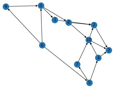
In this section we shall validate Reverse Labeling DijkstraAlgorithm(RLDA)usingadirectedgraph.Letus consideradirectedgraph(fig1)having11nodesand18 directedarcs.
Table

Timespentoneachedgeisgivenbyedgeattributevalue L(i,j)isshowninTable1.
Travel timeof eachroadsegmentisarc attribute Ʌ(i,j,k) isshowninTable2.
Thedestinationnodeis3,andthesourcenodeis6. The motivebehindthealgorithmistofindtheminimumtime pathfromsourcenode6todestinationnode3.
When considering only the edge attributes value the pathfollowedforsourcenodetodestinationnodeis 6 0 8 10 3,accordingDijkstraAlgorithm andthetraveltimeis15.
When arc attribute value is considered, using RLDA, the routefollowedwillbe 6 0 1 2 3andtraveltimewillbe23.
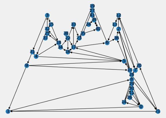
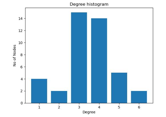
Tofurtherverifythealgorithmwehaveappliedthesame algorithmtoanetworkwith42nodesand72edges.The networkisshowninfig2.Thedegreeofthe
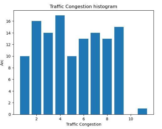
givennetworkisshowninfig3.Thetrafficcongestionfor thegivennetworkisshowninfig4.
The simulation method is all carried out for the same source destination pair In this condition, we will observe the various outcomes in the path obtained by both the algorithms : (1) RLDA; (2) Dijkstra Algorithm. For each source destination pair we shall calculate its edgeattributevalueandarcattributevalue.
After conducting the simulation following outcomes are beenobserved:
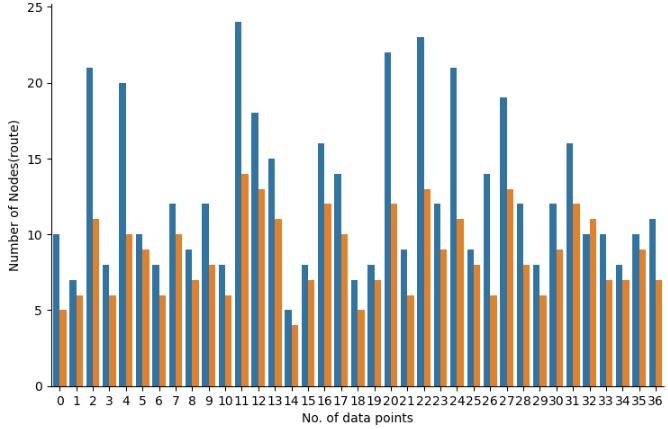
(1) Aftersimulationwehaveobservedthepathobtained inbothalgorithmsdiffers.
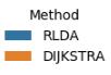
(2) The number of nodes found in path obtained via RLDA algorithm was more than that in Dijkstra Algorithm. This result can been seen when we plot the graph for different combination of source destinationpair.Theplotisshowninfig5.
International Research Journal of Engineering and Technology (IRJET) e-ISSN:2395-0056
Volume: 10 Issue: 07 | July 2023 www.irjet.net p-ISSN:2395-0072
In the above plot no. of data points represents the varioussourcedestinationpair.
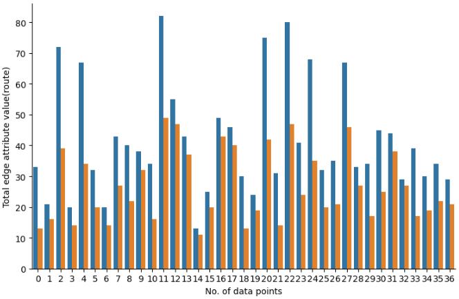
(3) ThetotaledgeattributevaluesofRLDAAlgorithmare much more as compared to Dijkstra Algorithm This result can been seen when we plot the graph for differentcombinationofsourcedestinationpair.The plotisshowninfig6.
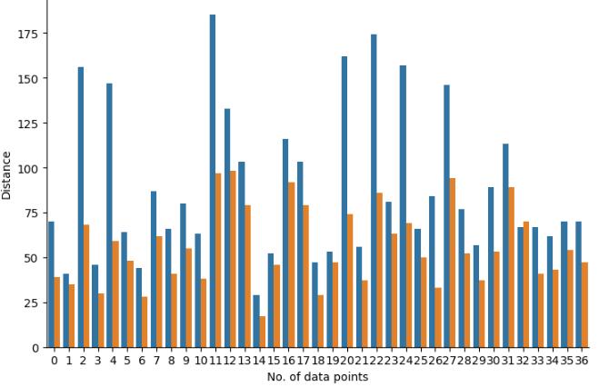
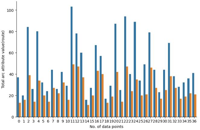
(4) The total arc attribute values of RLDA Algorithm are much more as compared to Dijkstra Algorithm. This result can been seen when we plot the graph for differentcombinationofsourcedestinationpair.The plotisshowninfig7.
number as compared to that of Dijkstra Algorithm. Thiscomparisonisshowninfig8.
(5) The distance obtained in RLDA covers much more nodes than that in Dijkstra, from this we can also conclude that the services provided to people in the path covered using RLDA Algorithm are more in
In urban bus route planning, the objective is to determine efficient routes for buses to serve a set of stops or station, taking into account factors such as passengerdemand,traveltime,distance,andoperational constraints. The results obtained shows that Reverse Labeling Dijkstra Algorithm proves beneficial in this context. The final route obtained by Reverse Labeling Dijkstra Algorithm at a particular instant of time covers maximumnodes,whichmeansitprovideservices tothe maximum number of people. The results show that it provide better results as compared to the Dijkstra Algorithm as number of nodes covered by Dijkstra Algorithm are less compared to the Reverse Labeling Dijkstra Algorithm. Passenger satisfaction is also prioritized through RLDA. By incorporating passenger preferences into the routing algorithm, it ensures that routes are designed to meet individual needs, minimize transfer time, and provide convenient transportation options. This personalized approach enhances the overall passenger experience and encourages more people to choose public transportation as a reliable and efficientmodeoftransport
[1] B. W. Yang, “Research status and development trend analysis of intelligent transportation system,” China PlantEngineering,vol.2,pp.121-122,2019.
[2] Q. T. Geng, Study on the Key Technology of Intelligent TransportationSystem Basedonthe Theory ofImageRecognition,JilinUniversity,Changchun,China, 2016.
[3] B. Wei, Modeling and Simulation Research on Vehicular Ad Hoc Networks of Intelligent Transportation System Based on Internet of Things, LanzhouJiaotongUniversity,Lanzhou,China,2017.
[4] P. Liu, “Research on modeling and optimization algorithm of dynamic route guidance system in intelligent transportation system,” Ph.D. dissertation, Dept.Auto.Eng.,JilinUniv., Changchun,China,2017.
[5] E. W. Dijkstra, “A note on two problems in connectionwithgraphs,''NumerischeMath.,vol.1, no.1, pp.171_269,1959.
[6] Y. L. Chen, L. Y. Zhuang, L. B. Zhu, X. J. Shao, and H. Wang, “Research n path planning of parking system based on the improved Dijkstra algorithm, ”Modern Manuf.Eng.,vol.6,no.7,pp.63_67,2017.
[7] Y. W. Liu and H. Q. Wu, “Path planning based on theoretical shortest distance variable weight A* algorithm,'' Comput. Meas. Control, vol. 26,no. 4, pp. 175_178,2018.
[8] Wang Shu-xi and Wu Zhengxue, “Improved Dijkstra ShortestPathAlgorithmanditsApplication,”vol. 39,no. 5,pp.223–228,Jan.2012
[9]Y.L.Liu,Y.Li,J.L.Wu,andX.Meng, “Routeplanning ofexpresswayemergencyevacuationbasedonimproved Dijkstraalgorithm,''Transp.Res., vol.2,no.6,pp.54_66, 2016.
[10] P. Hart, N. Nilsson, and B. Raphael, “A Formal Basis for the Heuristic Determination of Minimum Cost Paths,” IEEE Transactions on Systems Science and Cybernetics,vol.4,no.2,pp.100–107,1968.
[11] W. Y. Zhi, “Improved GA with particle swarm's evolutionary strategy for solving constrained optimizationproblems,''ControlDecis.,vol.16,no.4,pp. 135_147,2012.
[12] Y. Kao, M.-H. Chen, and Y.-T. Huang, “A Hybrid AlgorithmBasedonACOandPSOforCapacitatedVehicle RoutingProblems,”vol.2012,pp.1–17,Aug.2012
[13]Y.F.Ma,F.Yan,andK.Kang,“Animproved particle swarm optimization for simultaneous pickup and delivery vehicle routing problems with time wdows under a fuzzy random environment,” Oper Res. Manage. Sci.,vol.27,no.12,pp.73_83,2018.
[14]D.-D.ZhuandJ.-Q.Sun,“ANewAlgorithmBased on Dijkstra for Vehicle Path Planning Considering Intersection Attribute,” IEEE Access, vol. 9, pp. 19761–19775,2021