Volume: 10 Issue: 05 | May 2023 www.irjet.net

Volume: 10 Issue: 05 | May 2023 www.irjet.net
***
Abstract:
Landuseandlandcoveraresignificantfactorsformakinginformeddecisionsacrossglobal,regional,andurbancontexts. However, accurately assessing changes in land use and land cover over short periods of time presents significant challenges. The city of Nagpur has experienced rapid development, characterized by large-scale infrastructure projects thathavenegativelyimpactedvarioushydrologicalparameters.Thisresearchpaperinvestigatesthespatialandtemporal changes in land use within Nagpur District between 2002 and 2016. The findings indicate a notable increase in built-up areas and fallow lands, spanning approximately 10 to 47 km2 and 164 to 2063 km2, respectively. Conversely, there has been a reduction in crop lands, forest lands, and water bodies, ranging from 57 to 2372 km2, 112 km2, and 189 km2 , respectively. Water bodies have also witnessed a decline ranging from 19 to 74 km2. These findings underscore the necessityforeffectiveurbanwatershedmanagementpracticestosafeguardthehydrologicalparametersintheregion.
Key Words: LandUse/LandCover,RemoteSensingandGIS,Urbanisation,NagpurDistrict.
Introduction:
LanduseandLandcover(LU/LC)arecriticalcomponentsthatshapethedynamicsoftheenvironment.Theyrefer totheclassificationanddistributionofvariouslandtypesandtheirassociatedcharacteristics.Theprocessofurbanization, driven by factors such as population growth and economic development, has a profound impact on LU/LC patterns and, consequently, on hydrological parameters. LU/LC serves as an essential indicator of catchment area characteristics, influencingthehydrologicalresponseofaregion.Changesinlanduse,especiallyinurbanareas,cansignificantlyalterthe naturalhydrologicalcycle.Urbanizationtypicallyinvolvestheconversionofnaturallandscapes,suchasagriculturalfields, forests, and water bodies, into built-up areas, resulting in increased impervious surfaces and reduced infiltration capacities. This transformation leads to changes in surface runoff patterns, increased flood risks, altered streamflow regimes, and modifications in groundwater recharge rates. The scientific investigation of LU/LC changes and their hydrologicalimplicationsiscrucialforunderstandingtheimpactsofurbanizationonwaterresources.Severalstudieshave investigatedtherelationshipbetweenurbanizationandLU/LCchanges.Forexample, researchconductedbySamantetal. (1998)focusedonMumbaiandhighlightedthesignificantinfluenceofpopulationpressureonlandusechangeswithinthe city. Similarly, Praful et al. (2011) examined land use transformations in the semi-arid region of Madhya Pradesh state, sheddinglightontheimplicationsofchanginglandcoveronlocalhydrologicalconditions.AnotherstudybySundarKumar et al. (2012) investigated the drastic alterations in LU/LC that occurred in Vijayawada city between 1973 and 2009, providing valuable insights into the spatial and temporal dynamics of land use changes and their hydrological consequences.SreenivasuluG.etal.(2013)utilizedRSandGIStechniquestostudyLU/LCchangesintheVempalliareaof Kadapa district, Andhra Pradesh, India, contributing to a better understanding of land use patterns and their effects on localhydrologicalresources.InoneofthestudybyPramodM.etal.(2014),theauthorsemployedRSandGIStoexamine land use changes and drainage patterns in Andhra Pradesh, India, facilitating the identification of areas susceptible to hydrological risks and the development of appropriate management strategies. Furthermore, Surya and Sumant (2016) conducted a district-wise analysis of land use changes in the capital city of India, providing comprehensive insights into theurbanization-inducedLU/LCmodificationsandtheirimplicationsforhydrologicalprocesses.
In recent years, a growing number of scientists have embraced the use of remote sensing and geographical informationsystems(GIS)technologyforinvestigatinglanduseandlandcoverchanges.ResearcherssuchasPraveenetal. (2013),Santoshetal.(2015),Hassanetal.(2016),Gogoietal.(2019),Prabuddhetal.(2019),Premetal.(2019),Biswajit etal.(2020),andJosephetal.(2020)havecontributedtothisemergingfieldofstudy. Thedetectionandanalysisofland use and land cover changes are typically accomplished by comparing different time period images and utilizing diverse datasets that provide information on specific land use categories. These datasets may include information on built-up
areas, croplands, fallow lands, and water bodies, among others. By examining changes in these land use categories, researcherscangaininsightsintotheevolvinglandscapepatternsandassociatedenvironmentaldynamics.

The focus of this particular study is on the detection and analysis of land use and land cover changes within Nagpur District from 2002 to 2016. In the results section of the paper, the study present a detailed examination of the spatial and temporal changes that occurred within Nagpur District during the specified time period. These changes are describedand analyzed in terms of the observedmodificationsin landuseandland covercategories, providing valuable insightsintotheevolvinglandscapedynamicsoftheregion.
Study Area:
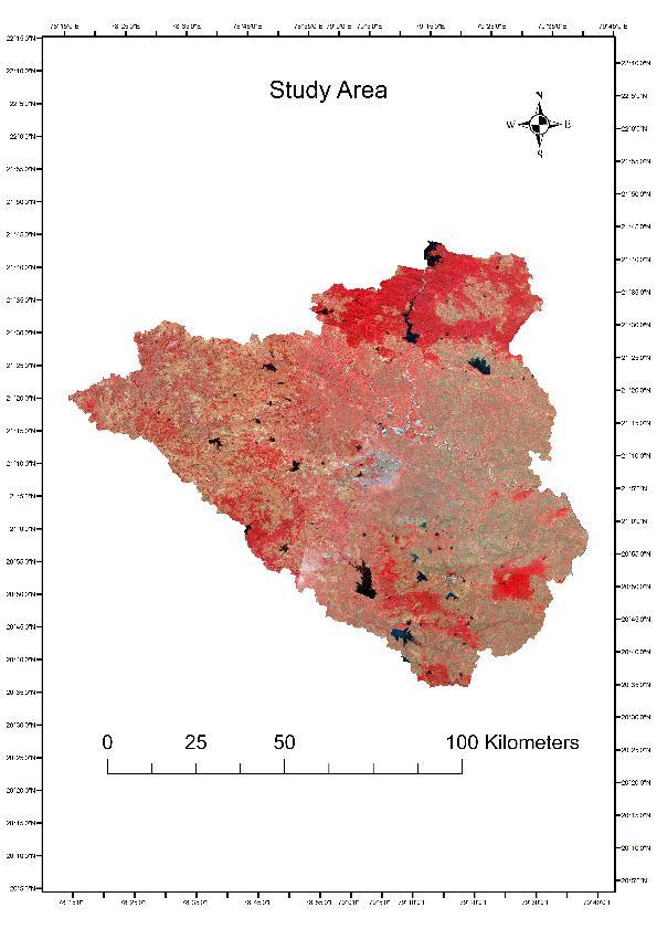
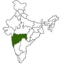
Nagpur District, situated in the central part of Maharashtra state, India, has been carefully selected as the study areaduetoitsuniquecharacteristicsandimportanceinthecontextoftheresearchobjectives.Spanninganexpansivetotal areaofapproximately9903.68km2,NagpurDistrictpresentsadiverselandscapeforin-depthanalysis.Atthecoreofthis district lies Nagpur city, a bustling urban center that serves as a hub of economic and cultural activities. As the administrative, commercial, and political capital of the region, Nagpur city showcases the complexities and dynamics of urbanization within the district. The hydrological features of Nagpur District are notably influenced by the presence of significantrivers.
ThePenchriver,Kanhanriver,Kolarriver,Nagriver,andPilirivertraversethroughvariouspartsofthedistrict, shaping the hydrological network and contributing to the overall water resource availability. Geographically, Nagpur District is positioned at the coordinates of 21° 8′ 40.95″N latitude and 79° 05′ 31.63″E longitude. These geographical coordinatespreciselylocatethedistrictwithintheEarth'scoordinatesystemandserveasareferenceforspatialanalysis and mapping. A visual representation of the study area, depicted in Figure 1, provides a comprehensive overview of the geographical extent and spatial distribution of Nagpur District. This visual aid enhances the understanding of the study area'sboundariesandspatialrelationships,facilitatingeffectivedatainterpretationandanalysis.
Aim and Objectives:
The central objective of this study is to comprehensively examine and detect the temporal changes that have takenplaceinthelanduseandlandcoverpatternswithinNagpurDistrict.Specifically,thestudyfocusesonanalysingthe variations occurring in different years, namely 2002, 2004, 2006, 2008, 2010, 2014, and 2016. To achieve this objective, highspatialresolutionsatellitedataisemployedasavaluableresourceforcapturingandassessingtheintricatedetailsof thelandsurface.
Methodology:
InthispaperremotesensingandGIStechnique hasbeenusedtoestimatethevarious LU/LCclasses occurredin thearea Thesatellitedataofyear2002,2004,2006,2008,2010,2014and2016hasbeenusedforthestudy.TheArcGIS softwarehasbeen usedfor digitisationprocess onthe satelliteimage. After digitisationof thevarious LU/LC,thearea of eachclasseswereestimatedandcompared TheoverallmethodologyhasbeengivenintheFigure2




Collection of Satellite images for year 2002, 2004, 2006, 2008, 2010, 2014 and 2016. Digitisation of data in Arc GIS software
Change detection in land use / land cover for the year 2002, 2004, 2006, 2008, 2010, 2014 and 2016.
Comparison of changes occurred in the land use from 2002 to 2016.
Results and Discussion:
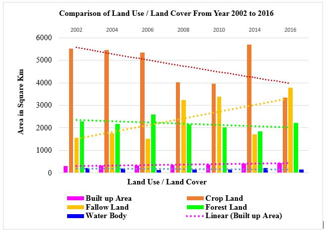
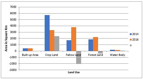
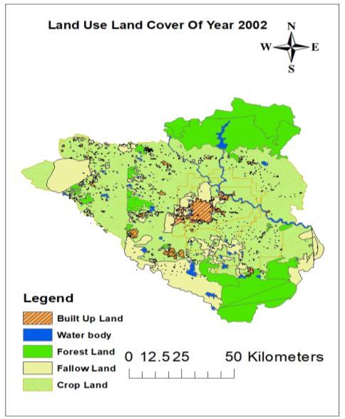
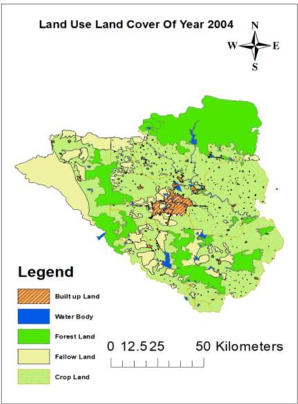
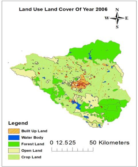
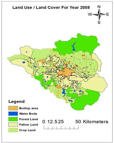
TheNagpurDistrictexperiencedsignificantdevelopmentalinitiativesfollowingtheyear2000aspartofthegovernmentof India'sfive-yeardevelopmentplan.Consequently,thistimeframewasselectedtomonitorandassesschangesintheland use patterns within the region. The findings of the study reveal a notable increase in built-up areas and fallow land, accompanied bya decrease incropland,forestland,andwaterbodiesfrom2002to2016.Thisobservedtransformation can be attributed to rapid urbanization, industrialization, and human activities, resulting in the conversion of crop land, forest land, and fallow land. Specifically, the built-up area expanded within a range of 10 to 47 km2, while fallow land
increasedbetween164and2063km2.Incontrast,cropland,forestland,andwaterbodiesexperiencedreductionsranging from57to2372km2,112km2,and189km2 respectively.Furthermore,theareacoveredbywaterbodiesdecreasedwithin therangeof19to74squarekm2,asoutlinedinTable1andTable2.
Table2presentsthechangesinlanduse/landcoverclasses,whereapositivesignsignifiesanincreaseandanegativesign indicatesadecrease.ThetrenddepictedinFigure3demonstratesanoverallincreaseinthebuilt-upandfallowlandarea between2002and2016.
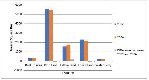
adecreaseincropland,forestland,and waterbodiesbetweentheyears2002and2004.
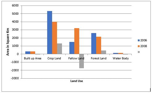
Likewise,Figure5demonstratestheexpansionofbuilt-upandfallowlandareas,alongsidethedeclineofcropland,forest land,andwaterbodiesobservedbetweentheyears2006and2008.
Figure
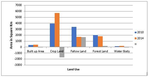
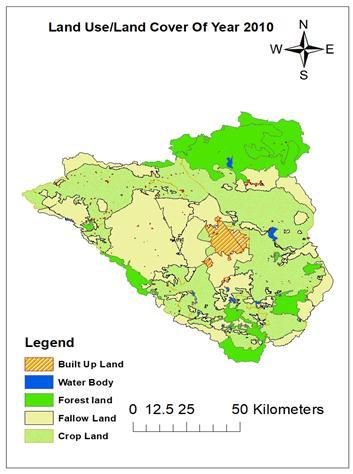
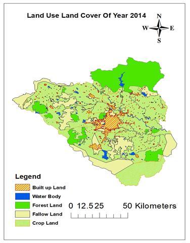
depictstheincreaseinbuilt-upareas,cropland,andwaterbodies,accompaniedbyadecreaseinfallowlandand forestareaobservedbetweentheyears2010and2014.
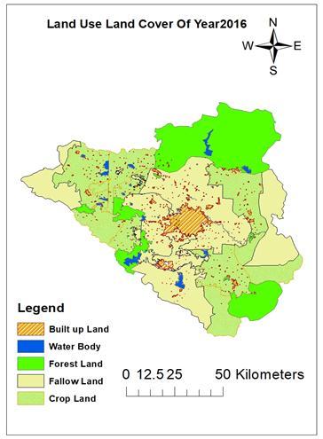
The study employs a detailed analysis of land use patterns, focusing on five key land use classes within the study area. These classes include built-up areas, water bodies, forest land, fallow land, and crop land. Each land use class is visually represented using distinct colors and patterns on the land use map. The use of green color to represent forest land is justifiedbyitsassociationwithnaturalvegetation.Thiscoloridentifiesanddistinguishareascoveredbydensevegetation. Similarly,therepresentationofcroplandusinggreencolorwithdotsisjustifiedbytheneedtodifferentiateitfromforest land. Water bodies are assigned a blue color, a common representation widely recognized for bodies of water such as rivers, lakes, and reservoirs. Blue color provides a clear visual distinction, allowing for the identification and analysis of water bodies within the study area. Fallow land, denoting agricultural land left uncultivated for a specific period, is represented in yellow color. This color choice differentiates fallow land from other land use classes and helps highlight areas where agricultural activities have been suspended or rotated. Lastly, built-up areas, representing urban or developedregions,aredepictedusingashadedorangecolor(Figure8)
Conclusions:
Thefollowingconclusionscanbederivedfromthestudy:
Land use and land cover play a crucial role in decision-making processes across global, regional, and urban contexts.
Assessingchangesinlanduseandlandcoverovershortperiodsoftimepresentssignificantchallenges.
The city of Nagpur has undergone rapid development, characterized by large-scale infrastructure projects that havenegativelyimpactedhydrologicalparameters.
Thestudyrevealedanincreaseinbuilt-upareasandfallowlands,spanningapproximately10to47km2 and164 to2063km2,respectively.
Conversely,therehasbeenareductionincroplands,forestlands,andwaterbodies,rangingfrom57to2372km2 , 112km2,and189km2,respectively.
Waterbodieshavealsowitnessedadeclinerangingfrom19to74km2 area
Effective urban watershed management practices are necessary to safeguard the hydrological parameters in the region.
Sustainable measures should be implemented to mitigate the adverse effects of rapid urbanization and industrializationoncroplands,forestlands,andwaterbodies.
MaintainingabalancebetweendevelopmentandtheconservationofecologicalresourcesisessentialforthelongtermsustainabilityandresilienceofNagpurDistrict'shydrologicalsystems.
References:
Biswajit Nath, Zhihua Wang, Yong Ge, Kamrul Islam, Ramesh P. Singh and Zheng Niu, (2020) “Land Use and Land Cover ChangeModelingandFuturePotentialLandscapeRiskAssessmentUsingMarkov-CAModelandAnalyticalHierarchy Process.”ISPRSInt.J.Geo-Inf.2020,9,134;doi:10.3390/ijgi9020134
Gogoi,P.P.,Vinoj,V.,Swain,D.etal.LanduseandlandcoverchangeeffectonsurfacetemperatureoverEasternIndia.Sci Rep9,8859(2019).https://doi.org/10.1038/s41598-019-45213-z.
Hassan, Z., Shabbir, R., Ahmad, S.S. et al., (2016), “Dynamics of land use and land cover change (LULCC) using geospatial techniques:acasestudyofIslamabadPakistan.”SpringerPlus5,812.https://doi.org/10.1186/s40064-016-2414-z
JosephSpruce,JohnBolten,IbrahimN.Mohammed,RaghavanSrinivasanandVenkatLakshmi.,(2020),“MappingLandUse Land Cover Change in the Lower Mekong Basin From 1997 to 2010.” ORIGINAL RESEARCH, doi: 10.3389/fenvs.2020.00021.
PrabuddhKumarMishra AmanRai,SureshChandRa (2019)“Landuseandlandcoverchangedetectionusing geospatial techniques in the Sikkim Himalaya, India.” The Egyptian Journal of Remote Sensing and Space Science, https://doi.org/10.1016/j.ejrs.2019.02.001
Praful Singh, Jay Krishna Thakur, Suyash Kumar, U. C. Singh, (2011), “Assessment of Land Use/Land Cover Using Geospatial Techniques in a Semi-arid Region of Madhya Pradesh, India.” Geospatial Techniques for Managing EnvironmentalResources,2011,ISBN:978-94-007-1857-9,
Pramod M. Kumar, K. Nagalakshmi, T. Lakshmi Prasad, N.Jayaraju ,B.Lakshmanna, (2019), “Land use and Land Cover Analysis using Remote Sensing and GIS: A Case Study in and around Bramhamgarimatam, Kadapa District, Andhra Pradesh,India”SSRGInternationalJournalofGeoinformaticsandGeologicalScience( SSRG-IJGGS)-Volume6Issue 1–JantoApr2019.
Praveen Kumar Mallupattu, and Jayarama Reddy Sreenivasula Reddy (2013), “Analysis of Land Use/Land Cover Changes Using Remote Sensing Data and GIS at an Urban Area, Tirupati, India.” Volume 2013 |Article ID 268623, https://doi.org/10.1155/2013/268623
Prem Chandra Pandey, Nikos Koutsias, George P. Petropoulos, Prashant K. Srivastava, Eyal Ben Dor, (2019), “Land use/landcoverinviewofearthobservation:datasources,inputdimensions,andclassifiers areviewofthestateof theart.”GeocartoInternational,https://doi.org/10.1080/10106049.2019.1629647.
Samant, H., Subramanyan, V., (1998), “Landuse/land cover change in Mumbai-Navi Mumbai cities and its effects on the drainage basins and channels. A study using GIS.” J Indian Soc Remote Sens 26, 1–6. https://doi.org/10.1007/BF03007333.
Santosh,BabarandH.Ramesh,(2015),“StreamflowResponsetoLandUse–LandCoverChangeovertheNethravathiRiver Basin,India.”JournalofHydrologicEngineering,©ASCE,ISSN1084-0699/05015002(11)/$25.00.
Sreenivasulu G., N. Jayaraju, M. Pramod Kumar, T. Lakshmi Prasad (2013), “An Analysis on Land Use/Land Cover Using RemoteSensingandGIS–ACaseStudyInandAroundVempalli,KadapaDistrict,AndhraPradesh,India.”International JournalofScientificandResearchPublications,Volume3,Issue5,May20131ISSN2250-3153.
Sundarakumar K., M. Harika, Sk. Aspiya Begum, S. Yamini, K. Balakrishna, (2012). “Land Use and Land Cover Change DetectionandUrbanSprawlAnalysisofVijayawadaCityUsingMultitemporalLandsatData.”InternationalJournalof EngineeringScienceandTechnology(IJEST).
SuryaPrakashPattanayakandSumantKumarDiwakar,(2016),“District-WiseChangeAnalysisofLandUse-LandCoverIn DelhiTerritoryUsingRemoteSensing&GIS”Journal ofUrbanandEnvironmental Engineering,v.10, n.2, p.201-213, ISSN1982-3932doi:10.4090/juee2016.v10n2.201213.