Implementing Portable Tourist Captain
Jyotsna A Nanajkar1, Niketan Gulekar2, Suyash Bibave3, Krishna Gadhave4, Ronald Anthony5Department of Information Technology, Zeal College of Engineering and Research, Pune-41, Maharashtra, India

***
Abstract - Tourism is travel for pleasure and for business as well. The tourism industry has become the largest and fastest growing industry in the world. These days, more and more people travel on vacation for the purpose of recreation, accommodation, and entertainment. The main goal of this project is to help tourists understand all of the information about specific tourist spots and glorious places. This will enable them to make full use of their visit without omitting critical information. There are lots of apps out there to guide tourists towards the places they should visit. They're paper-based and mobile-based, but they lack interactive features. Considering the limitations of existing applications, this system application provides a portable tour guide mobile application replacing the old tour guide booklet. The application was produced based on the Android platform with augmented reality technology, and delivered as a mobile application.
Key Words: Tourism; Technology; Mobile; Guide; Landmark;
1. Introduction
According to The World Tourism Organization, approximately 448 million tourists were visiting various places for entertainment and recreational purposes. This numberisonlyincreasingafterCOVIDhasreduced.Every year, there are more and more tourists coming from different regions of the world. For these 448 million tourists, there are only 400 Thousand tourist guides currently registered who are working at various tourist sites. They are the main and only source of knowledge about the place in most cases. Because of this, not every tourist has easy access to the information. The costs associatedwiththeguidesarealsohighinsomecases.The tourists are English speakingin most places,however, for tourists coming from different language speaking regions, there is a language barrier. The second solution a lot of tourist places have is paper-based navigation and guide systems. These are simple banners and info graphics which are used to convey the information. Despite being available in most places, they are often outdated or inaccurate. The language barrier problem is also faced by such systems. The maintenance and installation of such systems in all of the tourist sites will be very cost intensive.
Becauseofalltheseissues,alotoftouristscomingtovisit a site often remain unaware about the history and importanceoftheplacetheyarevisiting.Thisincludesthe historicalaswellasculturalvalue.Forplacesliketemples andancientlandmarks,knowingthehistoryisverycrucial totrulyunderstandthevalueofthemonument.
With the growing use of smartphones and advances in smartphonecameras,along withtheimprovementsinthe Machine Learning models, an interactive solution can be quite helpful. [5.2.1] will not only make the information freelyavailableatfingertips,butitwillalsoactasawayto promote tourism across various regions by suggesting placesofsimilarvalueandhistory.Theinteractivityof[5] will keep the tourist engaged while reducing the need of traditionalguidesystems.
1.1 Problem Statement
ThisMobileApplication“VIRTUALTOURISTGUIDE”,aims to help the tourist to know more about the place to be visited.
Paper based tour guide system presents static photo copied images with limited information, so they have limitations of intelligent representation and precise navigation and it is a traditional one. With a mobile application, we aim to solve the problem by allowing the user to identify and access information about tourist placesjustbycapturinganimage.
1.2 Need
➢ Increasing number of tourists coming from various partsoftheworldwhospeakdifferentlanguages
➢ Lack of interactive system for providing information abouttouristplaces
➢ Loss of history & importance of landmarks because of unawarenessregardingtheplace
➢ Issues and limitations of traditional, paper-based guidingsystems
2. Literature Survey
In the previous publication, related to the considered topic,theauthorsprovidedthedescriptionofrelatedwork
in the area of tourist guides.There are many state-of-theartpapersthatevaluatedifferentmobiletouristguides.At the present the following developed systems have been considered:
VirtualTouristGuide HariniB,AshmithaK, DeepanRajKR, JananiSR
PublishedDate-
March2021
Informationabout landmarksisdisplayed usingAugmented RealityVideosand voiceovers.
- AnAugmentedReality tourthatmakesuseof location-aware technology.
ItScansthetouristplace imagesandconveysthe informationandhistory byvoiceoverandhow theplaceisinthevideo formatusingAR.
AndroidMobileBased TourGuideSystem usingAugmented Reality
Akil.H.Sayyad, Santosh.A.Shinde
PublishedDate-
July2016
UsingSymmetricand combinatorialmatching Algorithm,keypointsin QueryImageare computed.
Animagewithhighest matchingscoreis considered and Landmark informationisretrieved fromthelabeled dataset.
BRISK&FREAK
BinaryRobustInvariant ScalableKey-points (BRISK)andFastRetina Key-points(FREAK),two stateoftheartbinary featuredescriptors,are connectedfor recognizing/tracking targetimageswithlow computationalforceand highlevelofaccuracy.
SmartBooklet:Tour GuideSystemwith MobileAugmented Reality
HeeseungChoi,Gyu ChulHan,andIg-Jae Kim
PublishedDate-
January2014
Symmetricand combinatorialmatching isappliedtofind nearestneighbors basedonkeypoints. Imagewiththehighest scoreisretrieved.
For3Dvideotracking, tracking-by-detection approachisusedona perframebasis.
BRISK&FREAK
Amobiletourguide systembasedonARfor touristsusableanywhere iftheypossessanoff-line tourbooklet.
3Dvirtualmodelsare renderedontheimages intheoff-linebooklet.
AMobileApplication basedonGlobal PositioningSystem andObject RecognitionTowards aDIgitalTourist Guide
WadiiBoulila,Anmar Abuhamdah,Maha Driss,SlimKammoun, SlimKammoun
PublishedDate-April 2014
3. Features of the project
➢ User-friendlyandroidapplication.
Theimageisprocessed inondeviceDLmodel providedbyFirebase Vision.Theresultwill beanarraythat containsplacenames andconfidenceofeach place.
➢ Multiplemodulesarecombinedintooneapplication.
➢ Portable,asitwillbeavailableinandroidphones.
➢ Providesreusabilityandscalability.
➢ Multiplelanguagesupport
➢ Lightweight,worksonallsmartphones
➢ Searchfeatureforfindinglandmarksofchoice
➢ LandmarkInformationcanbedownloadedforlateruse, incaseofnonetworkconnectivity
➢ Crowdsourcedfeedbackforreportingfalseorincorrect informationaboutalandmark
4. Methodology
The application uses technologies like Machine Learning(ML) and Image Processing algorithm to get the placedetailslikenameandlocation.
-Google’s Places [13] and Vision APIs [12] are used to further identify the place based on geo-coordinates and provideappropriatedetails.
-Based on the location[13], a list of related tourist places aroundthevicinitywillbeshowntotheuser.
-Ablog-likesystemforallowingtheuserstoadd/editnew touristplacesnotidentifiedbythesystem,aswellasshare their opinions regarding the same will also be implemented.
A middleware cache will also be implemented. Landmark information retrieved from Google Vision API will be stored in a server database. Subsequent requests from nearbycoordinatescanbeansweredwiththisinformation withouthavingtocallGoogleVisionAPI.Thiswillfurther
FirebaseMLkit SDK, GPS-Haversine Formula
Anapplicationthat provides3waysof identifyingandretrieving landmarks:Imagebased, GPSLocationBasedand Manualsearchfor retrievinglistof monumentsforpilgrims.
reducetheresponsetimesaswellasthecostsrequiredfor operation.
5. System Implementation
5.1 System Architecture
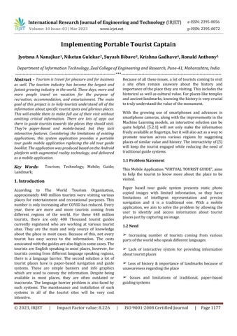
There are currently 4.78 billion mobile phone users worldwide, of which 3.5 billion use smartphones. Users can now easily purchase a smartphone with a built-in digital camera and internet connectivity for a low price. Based on this, the suggested approach will enable end users to utilize their phones as equipment to identify landmarksandgetinformationaboutthem.Theconsumer can photograph a tourist place, in order to discover relevant information. These images will be processed and verified by the server after being included in a request. Afterthat,theend-userwillreceivetheresultsalongwith alistofnearbyplacesthatmightbeofinteresttotheuser.
An overall architecture of this solution is shown in figure below.
Web.UsingReactNative,wecancodeonceanddevelopan applicationforbothiOSandAndroidoperatingsystems.
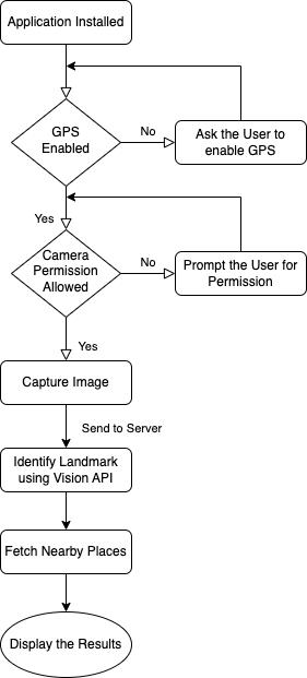
5.2.2 Server
Theserverwillhandleallthecomplexprocessinganddata storagerequiredforthesystem.Requestsfromthemobile application will be first handled by the server. These requests will include images of the landmark along with GPS Coordinates. The server will forward the data to GoogleVisionAPI&GooglePlacesAPI.Theresultswillbe stored in a database for faster access in consecutive requests. Reviews and suggestions about landmark informationwillalsobestoredinthedatabasethroughthe server.
The server will be connected to the mobile application over a REST API. The technologies used for development willconsistofJavascript,Express.js,Node.js.
5.2.3 Identification
TheGoogleVisionAPItakesanImageasaninputandcan identify objects[12] in it based on provided criteria. Landmarks and monuments can be identified using that, whichwillbereturnedtotheserver,whichwillstorethem first in the database. It will also retrieve any reviews for the tourist place and then in turn send the information backtotheclientapplication.
5.2 Modules
5.2.1 Mobile Application:
The mobile application will be the user facing part of the system. It will include a screen for the user to capture an imageofalandmark.Afterclickingapicture,itwillbesent totheserver.Themobileapplicationwillalsomakeuseof GPSlocationtofurther providealistoftouristattractions around the user’s location. The user can then browse through the list and get any information about them. Navigationalfunctionalitywillalsobeapartofthesystem sothatuser’scanidentifythedistanceandpotentialroads, routestothedestinationplace.
React Native, which is a framework for developing cross platform mobile applications, is used on the client side application.Theframeworkisrobustdespitebeingeasyto develop in. It is based on the React.js framework for the
The results from popular tourist places will be cached to sendthedatafastertotheuserswithouthavingtorunthe Google Vision identification pipeline again. For eg. For multiple user requests that are coming from very specific GPS coordinates around a small region, we can safely assume they all are at a single tourist location. Thus we can identify the tourist place for the first request and cache it in our database. For any consecutive requests comingfromthatregion,wecansendthecacheddatavery quickly.
5.2.4 Suggestions:
The Google Places API provides features like Geocoding, Reverse[10] location search, Search related functionality. It will provide the ability to search any tourist place and return its GPS Location, along with the navigational data. This data will be parsed by the mobile application and displayedappropriately.TheGooglePlacesAPIalsoallows retrieving a list of items based on a given filter around a specific coordinate. We will provide the user's location as theoriginandretrievealistoftouristplacesaroundit.
Using the Reverse Geocoding functionality, more accurate identification of a landmark can be done. We can use the
user’s current location to pinpoint the exact place along with using the Landmark identification from the image. Thiswillprovidemoreaccurateidentificationtotheuser.
6. Results
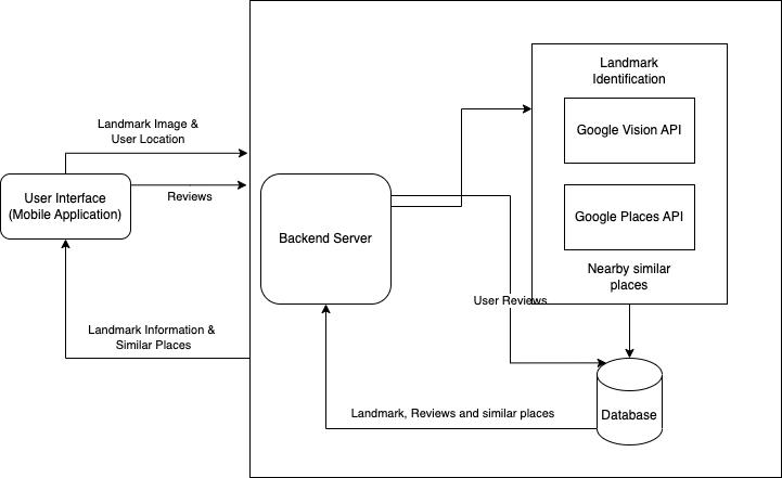
Fig 6.1:Landmarkcapturescreen
The above is a representation of the landmark capturing screenintheapplication.Oncetheusercapturesanimage, the image along with the user’s GPS coordinates will be sent to the server for landmark identification. After the identification process is completed, the user will get a response withthe details.This responsewill bedisplayed on a separate screen which will include details like Landmarkname,informationsuchasmonuments,historic data,Feesandotherchargesrelatedtothelandmark.The location of the landmark will also be available to the user alongwithabuttontogetdirectionsfornavigation.
Lastly, the user will have a list of related landmarks or tourist attractions that are nearby the user's current location. The user can scroll through these and plan their tripaccordingly.
7. Conclusion
The major issue with traditional tourist-based guide systems is that they present static photo-copied images with limited information, so they have limitations in intelligent representation and precise navigation. Secondly,theinformationthatispresentisavailableinthe regionallanguageofthatparticulararea whichcannot be understoodbythetouristsvisitingthelandmark,andmost of the time the in-person guide is also not available at everylandmarktoguideandinformabouttheplacetothe visitingtourists.
This Mobile Application “VIRTUAL TOURIST GUIDE”, overcomes these challenges by allowing the user to identifyandaccessinformationabouttouristplacesinthe language they understand, just by capturing an image. Withthisapp, onegetstoknowthehistoryofa place,the intricacies involved in the art or monument, and provide anyadditionalinformationandopinionsaboutit.Also,the app provides a list of tourist places in the vicinity of the user's current location. Henceforth enhancing the overall travelingexperienceofthetourist.
REFERENCES
[1] Harini B, Ashmitha K, Deepan Raj K R, Janani S R “VIRTUAL TOURIST GUIDE", International Research Journal of Engineering and Technology (IRJET), March 2021
[2] Akil. H. Sayyad , Santosh. A. Shinde “Android Mobile Based Tour Guide System using Augmented Reality”, International Journal of Science and Research (IJSR), July 2016
[3] Heeseung Choi, Gyu Chul Han, and Ig-Jae Kim, “Smart Booklet: Tour Guide System with Mobile Augmented Reality”, Imaging Media Research Center, Korea Institute of Science and Technology, Seoul, Korea, IEEE International Conference on Consumer Electronics · January2014
[4] M.U.E.Wijesuriya, S.U.Mendis, B.E.S.Bandara, K.P.Mahawattage, N.Walgampaya , D. De Silva, “INTERACTIVE MOBILE BASED TOUR GUIDE", IEEE, January2013
[5] Eman Ahmed Ali Mohamed, Dr. Safaa Hussein, “A Proposed Mobile Application for the Tourism Sector in Egypt”,December2018
[6] Alexander Smirnov, Alexey Kashevnik, Andrew Ponomarev, Nikolay Shilov, Maksim Shchekotov, Nikolay Teslya “Smart Space-Based Intelligent Mobile Tourist Guide:Service-BasedImplementation”,15thConferenceof FRUCTAssociation,April2014
[7] Wadii Boulila, Anmar Abuhamdah, Maha Driss, Slim Kammoun, Slim Kammoun “GuideMe: A Mobile ApplicationbasedonGlobalPositioningSystemandObject Recognition Towards a Smart Tourist Guide”, 2021 International Congress of Advanced Technology and Engineering(ICOTEN)
[8]KeshavSoni,AmanAgrawal,JahanviSolanki,ArshJain, Krati Mahajan, Prof. Akshita Mishra “VIRTUAL TRAVEL GUIDE”, International Research Journal of Modernization inEngineeringTechnologyandScience2021
[9] “VR For Tourism: The Future Of The Travel Industry.” Immersion VR, 19 Nov. 2019 immersionvr.co.uk/about360vr/vr-for-tourism/#:~:text=VRintourismiscurrently, industryinthenearfuture.
[10] Rob S. February, and Tomas July 15. “How Virtual Reality (VR) Is Transforming the Travel Industry.” Revfine.com, 22 Dec. 2020, www.revfine.com/virtualreality-travel-industry/
[11] Google Geocoding API documentation https://developers.google.com/maps/documentation/geo coding/requests-reverse-geocoding
[12] Google Vision API documentation https://cloud.google.com/vision/docs/detectinglandmarks
[13] Google Places API Documentation for identifying places based on user’s coordinates https://developers.google.com/maps/documentation/pla ces/web-service/overview