International Research Journal of Engineering and Technology (IRJET) e-ISSN:2395-0056

Volume: 10 Issue: 01 | Jan 2023 www.irjet.net p-ISSN:2395-0072
International Research Journal of Engineering and Technology (IRJET) e-ISSN:2395-0056
Volume: 10 Issue: 01 | Jan 2023 www.irjet.net p-ISSN:2395-0072
1Computer Science and Engineering, GuruNanak Institution of Engineering & Technology, Kalmeshwar Road,Nagpur, India.
2Assistant Professor, GuruNanak Institution & Technology,Kalmeshwar Road, Nagpur, India.
3Assistant Professor, GuruNanak Institute of Engineering & Technology, Kalmeshwar Road, Nagpur, India. ***
Abstract - Geoportals is a modest way to share online open Geo-spatial data and to develop Geo-InformationManagement System. The role of Geoportals is to provide possible advancements in Digitizing Agricultural or any other spatial data. This paper presents a review of the literatureconcerning Geoportals and serves many primary and secondary purposes. The paper will mainly focus on developing a hybrid-based Geoportal model. The strength of this Geoportals will lead toa full-fledged online Geoportal Interoperable Platform that could provide better data sharing and disseminationsolutions to the challenges. The main focus of this project will be on sharing the data in the form of service but not actual data. Actual sharing of data might cause tampering withthedataso it might affect the confidentiality of the data of a specific organization. So this project will fully be concentrated on service-oriented architecture. The proposed system will be able to view, analyze, and read data in the form of a map. Users will also get the facility to view data diagrammatically with the help of charts. This data will include vector data such as points, lines, polygons, and also raster data. All thedatawill be uploaded on GeoServer present in the specific organization. This data will be shared by developing a user-friendly User Interface and will be hosted on a special Server within the organization. An end user will be able to provide feedbackand give any suggestions. It will be helpful to strengthen the Geoportal.
Key Words: GeoServer, Geoportal, Geo-spatial data, GeoInformation, Agriculture, Data Analysis, GIS.
Spatial data analysis has become increasingly popular in mostdisciplines includingpublichealth,economics,crime, population,socialscience,agriculture,etc.Geoportalsarethe standardizedwaytofindandaccessgeospatialinformation and associated geographic services for researchers and users. Typically, these Geoportals also provide various functions for users to explore and analyze the data online. Geoportalsareaconsolidatedweb-basedsolutiontoprovide open spatial data sharing and online geo-information
management.TheGeoportalsshareinformationintheform of maps. A Map is an important and major source of geographicinformation. It is a symbolic representation of selected characteristics of a place, usually drawn on a flat surface.The mappresentsinformationabouttheworldina symbolic, simple, visualizing way depicting important geographicfactsforacertainplacewhichisusedextensively, for planning, analysis for decision-making by scientists, planners, administrators, policymakers, engineers, natural resourcesmapping, and monitoring institutes or agencies, academicians,ministries,socialgroupsand,etc.
Geoportalsaresuccessfulinlinkingmulti-sourcedata,butit is unrealistic to integrate the growing list of open-source tools in one place. A Geoportal has to be flexible in integratinguser'sdataandthird-partyanalyticalfunctionsto becomeaworkbench,whereuserscouldprocessandmodel the data simultaneously. Compared with desktop GIS softwarewhichisoftenpreparedforprofessionalGISusers, Geoportalsthatlinkswithopen-sourcetoolscouldprovidea very useful and lightweight workspace for researchers that don'thaveadequateknowledgein GIS,especiallyinthearea of spatialsocialscience.Theintegrationof open-sourcetools allows easier integration of big data sources. Geoportals normallyincludebaselinedatasuchascensusesandsurveys. Thepurposeofthispaperistoelaborateontheconcepts of Geoportalsinawiderandmoreinformativeway.Thispaper will show how Geoportal is developed and integratedusing different open-source tools. This Geoportal will be ableto visualize vector and raster data. This Geoportal will be interlinked with GeoServer. Along with sharing and visualizingdata,thisportal willshowhowtodoa queryon vector files. This portal will also be able to show data diagrammaticallyi.e.,piechart,linechart,barchart,etc.This GeoportalwillbeabletointegratewithdifferentGeoServers from different locations, which means this portal will work onanInteroperableplatform.Thisproposedscenariowillbe verymuchusefultomanyusersandresearcherstogooutin one place i.e. Geoportal and collects different information such as horticulture, animal, fishery, soils, crop, etc accordingtotheirrequirement.
International Research Journal of Engineering and Technology (IRJET)
e-ISSN:2395-0056
Volume: 10 Issue: 01 | Jan 2023 www.irjet.net p-ISSN:2395-0072
To provide a gateway to web-based geospatial resources, enabling a user to discover, view, and access geospatial information and services made availablebytheorganizations.
Likewise,dataproviderscanuseGeoportaltomake their geospatial resources discoverable, viewable, andaccessibletoothers.
Instead of storing surveys in isolated, individual files,Geoportalsallowssurveyorstostoreallsurvey datainonedatabase,providingeasyaccesstopast work that can be efficiently reused and overlaid withnewdata.
To enables to visualization of various point, line, and polygon thematic layers on soil and land resources.
To provide an interoperable platform to integrate different Geoportals on a single platform, so that usersshouldnotvisitdifferentGeoportalstocollect information.
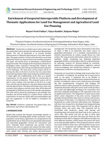
The proposed system will integrate many factors from collecting the data from the field and doing the needful modificationusingGIStoolsandpublishingitonGeoServer. GeoServerisanopen-sourceplatformtopublishandshare GeospatialdataintheformofWebMapServices(WMS)or WebFeatureServices(WFS).Thisdatawouldbecollectedby thesurveyor,analyst,soilscientist, student,orintern.This data might be within the organization or outside the organization. The collected data has been modified using ArcGISandQGISorotherGIStoolsandsoftwareaccordingto therequirement.Thisdatamightbethepoint,polygon,line, etc.Datamightbevectororraster.Thismodifieddatawillbe uploaded on GeoServer. GeoServer will be responsible for publishing this data on portals. To view this data portal wouldbedevelopedusingdifferentprogramminglanguages likeHTML, CSS,JavaScript,PHP,jQuery,ReactJS,Angular,etc. ADatabasesuchasMySQL,PostgreSQL,Oracle,etc.wouldbe used.AserverlikeWampServer,XAMPP,andApacheTomcat will be responsible to publish this developed system and userinterface.
The following procedure will be followed throughout the implementationofthewholeproject.
Data such as soil, crop, weather, etc. will be collectedfromdifferentlocationsbythesurveyor.
Somedatamaybecollectedbyresearchersusinga satellite with the help of Google Earth Engine or someothersource.
ThiscollectionwillbemodifiedbyusingArcGIS,and QGIS.
Thisstandardizedvectordatawillbeconvertedto ". shapefile" and raster data will be converted to ". geotiff".
Later'StyledLayerDescriptor'ispreparedbyusing QGISorbyusingXMLcode.
This data will be imported into the PostgreSQL database.
ThisdatawillbeuploadedonGeoServerwhichisan open-sourceplatform.
User interface for Geoportal will be developed by using different programming languages like HTML, CSS,JavaScript,PHP,jQuery,ReactJS,Angular,etc.
Different REST APIs will be developed to fetch servicesfromdifferentportals.
Some required data will be imported into the MySQLdatabase.
Finally, all these components will be integrated within a singleframetodevelopaGeoportal.Also,datacanbefetched frommultipleGeoServerwiththehelpofAPIstodevelopan "Interoperable Geoportal Platform". Different GeoServer wouldbelocatedindifferentlocationsordifferentinstitutes. EachinstitutewillhavecontroloveritsdataandGeoServer. Onlydatawillbesharedintheformofservice.Thisserviceoriented architecture will lead to the development of a big platformthatwillbeabletosharemultipleinformationfrom differentinstitutesonasingleportal.
International Research Journal of Engineering and Technology (IRJET) e-ISSN:2395-0056
Volume: 10 Issue: 01 | Jan 2023 www.irjet.net p-ISSN:2395-0072
Strength of Geoportals could lead to a full-fledged online Digital Earthsystemthatcouldprovide better solutions for spatial data sharing, geo-information management, and Earth science knowledge generation. This article also presentstherecommendations,intermsofthearchitectures, services, and techniques proposed for future Geoportal projects. Basic functionalities of Geoportals are identified andshouldbekept,suchasmetadatacatalog,datadiscovery, datavisualization,datasharing,anddatadownloads.Besides that, these Geoportals would be capable of connecting multiple distributed systems under hybrid system architecture. The other benefits of this Geoportal are its impressivedisplayanddesignstyle,itisfortheaspirantsor prospective candidates who want to make their career in webdesigningsuchaswebsites,webpages,andothers.Also, thisGeoportal ismuchmorehelpful to farmerswhodo not have much more knowledge about their soil, crop, animals, weather,etc.Thisproposedsystemwillalsoleadtheconcept of an Interoperable Geoportal Platform which will interconnectdifferentGeoportals.
Following are some future scopes to enhance and improve theexistingsystem.Itwillprovideamuchmoreeasywayto collectandshareinformation.
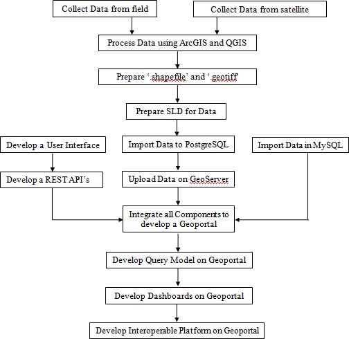
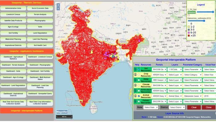
Fig - 1 shows a flow diagram to build the proposed Geoportal.Thiswillillustratehowthedatawillbecollected andprocessed,publishedandGeoportalisdeveloped.Fig-2 shows the homepage for the proposed Geoportal. This homepage shows User Interface for Geoportal which has differentservicesandapplications.FinallyFig-3showshow Interoperable Platform Concept works. This platform can collect different layers from different Geoportals such as BHOOMI Geoportal, KRISHI Geoportal, and IIRR Geoportal locatedatdifferentinstitutes.Theseallinstituteshavetheir Geoserverswhicharelocatedintheirorganizationsandhave their controls. With the help of APIs, data is fetched from theseGeoportalsintheformofWMSorWFSServicesandis shownonasingleplatform.Thedataisshownintheformof amap.Thisdataisforviewingandanalyzingpurposes.Data might be shared or allowed to download by providing authenticationsdependingonthepoliciesofthedataowner or institutes. Data security concepts would also be implemented to secure the data from hackers or other threats.
The Geoportal is a resource for analyzing, collecting, and retrievinginformationonasingledomain.Thisreviewwill hopefullyfacilitateresearchattemptstoaddressonlinedatasharing issues through Geoportals.In the long run, the
In the existing system data is collected by a surveyor,scientist, oranalystbutinthefuturedata mightbecollectedbyusingArtificialIntelligence.
The use of Drones might produce much enhancementinthecurrentsystem.
Agriculture Robots could provide immense improvementinthefieldofGeoportalsinthefuture.
Crop Yield Prediction and Data collection might be doneusingArtificialIntelligence,andcollecteddata mightbesharedthroughGeoportals.
In recent times many institutes are developing separateportals.Theymightthinkaboutdevelopinga singlehybridplatformsothatendusersdon't have torefertoindividualportals.SingleGeoportalwillbe abletoprovidecompleteinformationforfarmers.
Recentportalshavemuchinformationanddatabutit is somewhat complicated. This data and information should be simple and understandable tofarmersinthevillagearea.
[1]HaoJiang, Hyeongmo Koo, John Lodewijk vanGenderen "Currentstatusandfuturedirectionsofgeoportal".
[2] Dr. Vaishali Malode (Wadnerkar) "Major Geo-portals of India:AStudy"
International Research Journal of Engineering and Technology (IRJET) e-ISSN:2395-0056 Volume: 10 Issue: 01 | Jan 2023 www.irjet.net p-ISSN:2395-0072
[3]Yewati V. Meshram, Prajakta V. Nagrare, Rasika V. Kale, G.P. Obi Reddy, T. Satish and Praveen Sen "Prototype Android Based Real Time Crop Information Collection System"
[4]Fabian Schmidt, Arne Droge, Rothaar , and Andreas Rienow Development of a Web GIS for small scale detection and analysis of COVID 19 (SARS CoV 2) cases based onvolunteered geographic information for thecityofCologne,Germany,inJuly/August2020"
[5] Karolina Golicz, Stephen Hallett, Ruben Sakrabania, JoyGhosh “Adapting smartphone app used in water testing,for soil nutrient analysis”
[6] Sabrina Marx, RevatiPhalkey, Clara B Aranda-Jan, Jörn Profe1, Rainer Sauerborn,and Bernhard Höfle1 “Geographic information analysis and webbasedgeoportals to explore malnutrition in SubSaharanAfrica:asystematicreview of approaches”.
[7] Frank W. Davis,Dale A. Quattrochi, Merrill K. Ridd, NinaS-NLam,StephenJ.Walsh,JoelC.Michaelsen, Janet Franklin,Douglas A. Stow,Chris 1. Johannsen,Carol A. Johnston“ Environmental Analysis Using l ntegrated GIsand Remotely Sensed Data: Some ResearchNeeds andPriorities”.
[8] Hao Jianga, John van Genderen, Paolo Mazzetti , Hyeongmo Kooand Min Chene “Current status and futuredirections of geoportals”
Mayuri Vivek Padhye M-Tech final year in Computer Science & Engineering from GuruNanak Institute of Engineering & Technology,Nagpur
Prof Vijaya Kamble is assistance professor in GuruNanak Institute of Engineering&Technology
Prof Kalpana Malpe is assistance professor in GuruNanak Institute of Engineering&Technology,Nagpur