
International Research Journal of Engineering and Technology (IRJET) e-ISSN:2395-0056
Volume: 12 Issue: 03 | Mar 2025 www.irjet.net p-ISSN:2395-0072
INTEGRATED GEOELECTRICAL AND SEISMIC APPROACH FOR LANDSLIDE ASSESSMENT:A CASE STUDY IN THUNGSONG SITE,THAILAND.
ANANNYA SURESH.M
SIMI.K.RAVEENDRAN
1B. TECH UG Student, Department of Civil Engineering at Toms College of Engineering, Kottayam, India. 2Head of Department of Civil Engineering at Toms college of Engineering, Kottayam, India.
Abstract -This research assesses the possibility of landslide risks in Thungsong Thailand using an integrated geoelectrical and seismic approach. Integrating Electrical Resistivity Tomography (ERT) and Seismic Refraction methods permits the research to map subsurface structures, determine possible slip surfaces, and evaluate soil and bedrock properties. Such results illustrate the effectiveness of these geophysical techniques in scanning regions prone to landslides, thus helping in risk managementandland-useplanning.This methodprovides an effective means of evaluating landslide risks in other areasofthissort.
Key Words: ERT, SRT, P-wave, Tomography, Seismic waves.
1. INTRODUCTION
1.1. Background: It is a critical threat to human habitations and infrastructure, particularly for the areas with steep slopes and heterogeneous geological formations. Natural landslides can have a catastrophic impact, and understanding the causes and predicting future landslides is therefore vital to reduce their destructive impact. This limitation has made the integrated use of geophysical methods a prominent approachastraditionalinvestigationmethodsfrequently do not provide enough subsurface knowledge. Here we makeuseofbothgeoelectricalandseismictechniquesto investigate the subsurface at the Thungsong site in Thailand, an area prone to landslide activity because of the geologic patchwork underneath its surface to provideaholisticimageofthesubsurface.
Detection and prediction of landslides are still verified difficult because of the complicated conditions of subsurface. The traditional single-method approaches mightmisscrucialelements.Theintegratedgeoelectrical and seismic methods enhance the reliability of analysis, identifying potential slip surfaces and unstable areas Thiswastheproblemstatement.ObjectivesoftheStudy are assessing subsurface conditions with integrated geoelectrical and seismic methods. Then they trace and locate possible landslide hazard regions and to validate each methods findings against the other for increased accuracy.
2. STUDY AREA
2.1. Geographical Setting: The chosen study site in Thungsong,Nakhon SiThammaratProvince,Thailand,is an area prone to complex topography and landslides. ThungsongisinthesouthofThailandandhasa tropical monsoon climate. The region has high seasonal rainfall, particularlyduringthesouthwest monsoon season from MaytoOctober,withaverageannualprecipitationhigher than 2,000 mm. Steep slopes and heavy rainfall combinedresultinhighslopeinstabilityinthearea.
The study area is encircled by rolling hills and low mountains whose elevations range from 50 to 300 meters abovesea level. Heavy rainfall,inadditiontothe slopes, has resulted ina high number of pastlandslides. Main transport corridor and settlements are within the susceptible areas, making accurate landslide risk assessmentmorenecessary.
2.2 Geological Features
TheThungsongregioniscomposedofmetamorphicand sedimentary units, predominantly shale, sandstone, and decomposed granite. The surface is covered with loamy colluvial soil which is highly permeable but tends to get waterlogged.Theweak top layermakeslandslidesmore probable,especiallyduringperiodsofprolongedrainfall. Someimportantfeaturesare:
Soil Composition: Upper layers comprises colluvial depositsofsilt,sand,andclay.
Bedrock: Siltstone and sandstone together with other sedimentary rocks that have low to moderate resistivity and seismic velocity makes the upper portions of the ground.
Fault Lines: Minor brittle faults and fissures which facilitateentryofwateranddecreaseslopestabilitymay befoundtheregion.
Hydrogeological Conditions: The region is characterized by rapid oscillations of ground water having a considerable impact on slopes stability. During rain, water seeps in and increases the pore water pressure within the soil which results in lower shear
International Research Journal of Engineering and Technology (IRJET) e-ISSN:2395-0056
Volume: 12 Issue: 03 | Mar 2025 www.irjet.net p-ISSN:2395-0072
strength,makingtheslopespronetofailure.Ontheother hand, lower water levels in the dry season enhances slope stability temporarily. Preliminary investigations showed some surfaces of seepage and ground water movement. These zones, delineated by geoelectrical and seismic surveys, tend to significantly destabilize the slopestructure and amplify the risk of landslides,which makes them extremely decisive for reason of landslide hugsusceptibility.
2.3. Landslide History
The Thungsong area has historically experienced recurrent slides particularly on the road networks as well as the settlement areas. In the monsoon seasons of 2011 and 2017, landslides occurred and infrastructure was damaged along with loss of agricultural land.Primary Factors are anthropogenic and technological modification, the intensity of rainfall, and seismic activity. All slopes that possess a high degree of soil moisture as well as those that have a low cover of colluvium are the most susceptible to landslides. The negative impacts include obstructions of roads, destruction of houses, and degradation of soil which endangersthecommunities.
3.LITERATURE REVIEW
Existing Research Overview: Various geophysical methods have been used in previous landslide assessment studies. Using Electrical Resistivity Imaging (ERI)canhelpindetecting moisturezonesanddetecting slip surface. This gives us insight into the elastic properties of the material below the surface (subsurface), helping us to identify weak spots. Integratedmethodshavehigheraccuracythanindividual techniques[Sujitapan2022].BasicStructureinprevious research. It’s excellent that a number of the sources concentrate on studying subsurface abnormalities using seismic andgeoelectrical techniques.Accordingtostudy by Jongmans and Garambois (2007), combined techniques in landslide-prone areas offer a thorough assessmentofhazards.However,onlyasmallnumberof studiesprovideathoroughcross-comparativeevaluation of seismic and geoelectrical measures. This study closes thisgapbyofferingacomprehensivestrategyandcrossreferencingresultsformorepreciseoutcomes.
4. METHODOLOGY
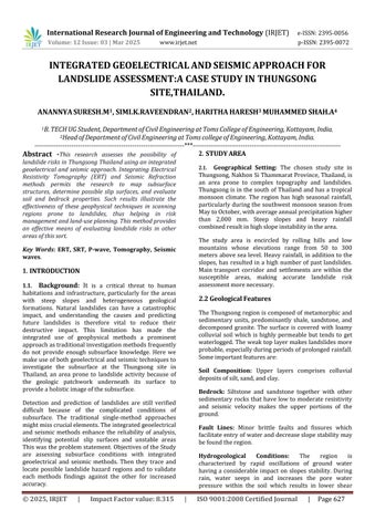
The study area was located in Thungsong, Thailand, where the geology is complicated and landslides frequentlyoccur.Heavyrainfallalsooccursintheregion, increasing the likelihood of slope failure. The Electrical Resistivity Tomography (ERT) approximately and Pwave Seismic Refraction Tomography (SRT) surveys were undertaken alongfourlongitudinal profiles(line1, line 2, line 3 and line 4) in a northeast-southwest
direction across the study site. Line 1 and Line 4 skirt across the slopes of known historical landslide features andarenearlyparalleltoLine2andLine
3. A second survey line (Line BH) is situated close to borehole at UTM 47P 586600E 900613N, about 600 m away from the main survey profiles (Fig. 1). Having a calibration reference is line BH, Line BH is used as a survey calibration with lithological borehole data. Consequently, the purpose of this study is to reveal the use of SRT and ERT with the 2D crossplot model to investigate internal structure and mechanisms of landslide in a remote and challenging-to-reach location. The2DCross-PlotAnalysisisaimed to identify sliding plane in landslide areas by analysing two key parameters: P-wave velocity and resistivity. Integration of these methods conjunction with borehole data is a pioneering effort in this geological setting of landslides, particularly in areas affected by monsoonal rainfall and characterized by mountainous terrain. for the reconciliation of geophysical information with the lithological information from boreholes. This research intends to provethat combining SRT and ERT data with the 2D cross-plot model is useful in the analysis of the internal structure and processes of landslides in remote regions.Inthe2DCross-PlotAnalysis,themainobjective istodetermineslidingplaneswithinthelandslidezones by associating the P-wave velocities with the resistivity values. The adaptation of this integrated methodology along with borehole calibration is new for the investigationoflandslidesinthemonsoonalregionswith hightopographyanddeeplyerodedlandforms.
3.1. Geoelectrical Method: TheWenner-Schlumberger array was applied to resistivity imaging to provide characterizationofthesubsurfaceonhighdetailprofiles.
3.2. Seismic Method: Seismic refraction surveys were done to evaluate the elastic characteristics of the subsurfaceandto differentiatethelooseandcompacted zones.
3.2.3.Data Collection: Resistivity data was stored with thehelpofamulti-electrodesystemalong3surveylines.
International Research Journal of Engineering and Technology (IRJET) e-ISSN:2395-0056
Volume: 12 Issue: 03 | Mar 2025 www.irjet.net p-ISSN:2395-0072
5.RESULT AND DISCUSSION
The subsurfaces structures along with their relation to the landslide phenomena were defined with the help of integrated geo-electrical and seismic surveys in combinationwithtraditionalgeologicalmapping.
Geoelectrical Findings: In combination with water restivity measurements, ERT results reflect changes in resistivity that are characteristic to various geological layers. The deep resistivity measured in the high positions range, >1000 \Omega m, suggests that there are compact bedrock located below. At the same time low resistivity which is also measured near the surface <100\Omegam,suggeststhattherearewatersaturated soilstogetherwithslipsurfaces.Considerableregionsof low resistivity for Line 1 and Line 4 at the depths of1020m suggest that there are saturated layers of clay causinginstabilityduetopreviouslandslides.
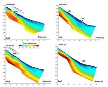
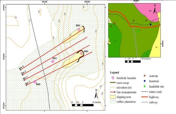
Fig 2: SRTresultscorrelatedwithboreholedatainthis landslidearea.
Seismic Findings: The results of SRT reflect the geographical distribution of velocity of the P-wave and show variations of the low-velocity zone. The lowvelocity zones <1500m/s were noticed close to the bed surface out of the rock material, clay, while those situated deeper are filled with other unconsolidated materials. The greater activities >3000m/s mark the bedrock compartment. The notice of well-defined lowvelocityzonesplacedunderneaththelow-velocitylayers along the line together with higher velocity layers is characteristic for the slip surface positions. Integrated Analysis: By the cross-plot analysis of resistivity results ofERT.
6. CONCLUSION
ResultfromtheElectricalResistivityTomography(ERT) surveying show very different resistivity values that clearlycorrespond todifferentsubsurface material.Low resistivity (1000 Ωm) at deeper levels suggest compactedbedrockwhichwillofferstability.Nearbythe scarp zones, anomalous resistivity patterns suggest possibledeformationand moistureingress, alignedwith pastlandslideoccurrences.Allthisis realizedbytheSRT resultsinterpreting.TheP-wavevelocitiesobtainedfrom Seismic Refraction Tomography (SRT) results were well correlated with the resistivity values of ERT. Lowvelocity zones (3000 m/s) are stiff, consolidated soil layers[9].
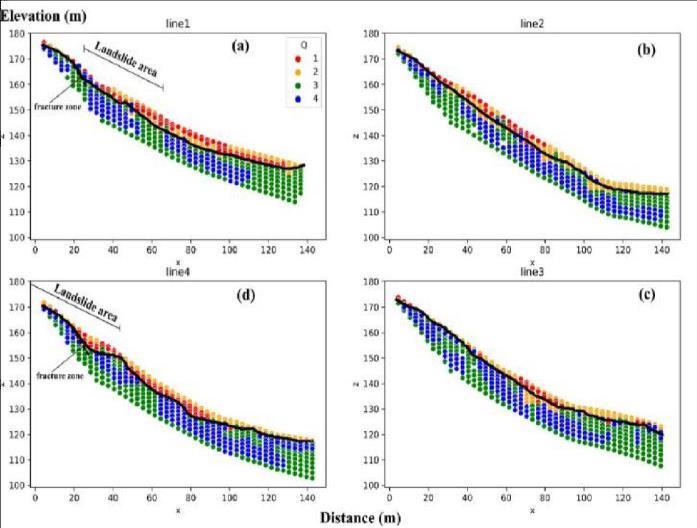
Fig3: 2DcrossplotmodelofPwavevelocity
P-wave velocities from the Seismic Refraction Tomography (SRT) insights were correlated well with the findings of ERT. Low-velocity zones (3000 m/s) correspond to competent bedrock. In particular, Line 1 and Line 4 showed different low-velocity layers with respect to their high- velocity zones, indicating the slip surfaces. The subsurface discontinuities were further taken up to derive potential shear zones that are likely to initiate landslide movements in the seismic profiles.
International Research Journal of Engineering and Technology (IRJET) e-ISSN:2395-0056
Volume: 12 Issue: 03 | Mar 2025 www.irjet.net p-ISSN:2395-0072
The merged output of ERT and SRT results reveals a holistic understanding ofthelandslidemechanisms.The sliding planes were accurately demarcated by the crossplot of resistivity and P wave velocities, highlighting its correlationwithboreholedatafromLineBH.Integrating these two models improved identification of unstable zones and proved the efficacy of the combined geophysicalapproachesinterrain.
REFERENCES
[1] Z. Ma, G. Mei, F. Piccialli, "Machine learning for landslides prevention: A survey," Neural Computing and Applications,vol.33,pp.10881–10907,2021.
[2] M. J. Froude, D. N. Petley, "Global fatal landslide occurrence from 2004 to 2016," Natural Hazards and EarthSystemSciences,vol.18,pp.2161–2181,2018.
[3] T.Dijkstra,N.Dixon,C.Crosby,M.Frost,D.Gunn,P. Fleming, J. Wilks, and C. Uk, "Forecasting infrastructure resilience to climate change," Proceedings of the Institution of Civil Engineers - Civil Engineering, vol. 167, no.6,pp.269–280,2014.
[4] S. Morelli, S. Utili, V. Pazzi, R. Castellanza, and X. Fan, "Landslides and geophysical investigations: advantages and limitations," International Journal of Geophysics,vol.2019,pp.1–16,2019.
[5] S. Glendinning, P. Hughes, P. Helm, J. Chambers, J. Mendes, D. Gunn, P. Wilkinson, and S. Uhlemann, "Construction, management, and maintenance of embankments used for road and rail infrastructure: Implications of weather-induced pore water pressures," ActaGeotechnica,vol.9,pp.799–816,2014.
[6] G. Colangelo, V. Lapenna, A. Perrone, S. Piscitelli, and L. Telesca, "2D Self-potential tomography for studyinggroundwaterflowsintheVarcod’Izzolandslide (Basilicata,southernItaly)," Engineering Geology,vol.88, no.3–4,pp.274– 286,2006.
[7] P. D. Jackson and K. J. Northmore, "Non-invasive moisture monitoring within an earth embankment a precursor to failure," NDT & E International, vol. 35, no. 2,pp.107–115,2002.
[8] S. Friedel, A. Thielen, and S. M. Springman, "Investigation of a slope endangered by rainfall-induced landslides using 3D resistivity tomography and geotechnical testing," Journal of Applied Geophysics, vol. 60,no.2,pp.100–114,2006.
[9] C. Sujitapan and J. M. Kendall, "Landslide assessmentthroughintegratedgeoelectricalandseismic methods: A case study in Thungsong site, southern Thailand," Heliyon,vol.10,2024.
BIOGRAPHIES

ANANNYASURESHM
Student
TOMSCollegeofEngineering
APJAbdulKalamTechnological University



SIMIKRAVEENDRAN
AssistantProfessor
TOMSCollegeofEngineering
APJAbdulKalamTechnological University
HARITHAHARESH Student
TOMSCollegeofEngineering APJAbdulKalamTechnological University


MUHAMMEDSHAA Student
TOMSCollegeofEngineering
APJAbdulKalamTechnological University