
International Research Journal of Engineering and Technology (IRJET) e-ISSN: 2395-0056
Volume: 13 Issue: 04 | Apr 2026 www.irjet.net p-ISSN: 2395-0072

International Research Journal of Engineering and Technology (IRJET) e-ISSN: 2395-0056
Volume: 13 Issue: 04 | Apr 2026 www.irjet.net p-ISSN: 2395-0072
B Kavya1, B Arun Kumar2 , A Harshitha Reddy3 , DVSR Sesidhar4
¹²³´Dept. of Electronics and Communication Engineering, MVSR Engineering College, Hyderabad, India ***
Abstract - Natural disasters such as floods, cyclones, and earthquakes often disrupt communication systems andcreate panic among affectedpopulations. This paperproposesaGPSenabled disaster alert and awareness system that provides real-time alerts, offline access to critical information, and AIbased chatbot assistance.
The system integrates a mobile application and web platform to deliver disaster-related information, safety guidelines, helpline numbers, and location-based rescue services. It utilizes geofencing and real-time location tracking to notify users when they enter disaster-prone areas. The offline functionality ensures accessibility even during network failures, while multilingual support enhances usability across diverse populations.
By combining real-time alerts, geolocation tracking, and intelligent assistance, the system aims to improve disaster preparedness, reduce response time, and minimize theimpact on human lives and property.
Key Words Disaster Management, GPS, Geofencing, Mobile Application, AI Chatbot, Emergency Alerts.
Naturaldisasterssuchasfloods,earthquakes,cyclones,and landslides pose significant threats to human life, infrastructure, and the environment. In recent years, the frequencyandintensityofsuchdisastershaveincreaseddue to climate change and urbanization. One of the major challengesduringdisastersisthelackoftimelyandaccurate information,whichleadstodelayedresponseandincreased casualties.
Existing disaster management systems primarily rely on masscommunicationmethodssuchastelevision,radio,and SMSalerts.Whilethesemethodsareeffectivetosomeextent, theyoftenfailtoproviderealtime,location-specificwarnings toindividuals.Moreover,networkfailuresduringdisasters furtherlimittheaccessibilityofcriticalinformation.
Withtherapidadvancementofmobiletechnologyandthe widespread availability of GPS-enabled smartphones, it is possibletodevelopintelligentsystemsthatcanproviderealtime, personalized alerts based on the user's location. Geofencing, a technique that creates virtual boundaries aroundspecificgeographicareas,canbeusedtodetectwhen a user enters a disasterprone zone and trigger immediate alerts.
This paper presents a GPS-enabled disaster alert and awareness system that leverages geolocation tracking, geofencing, and mobile notifications to enhance disaster preparednessandresponse.Thesystemprovidesreal-time alerts, offline access to safety information, navigation to nearbyrescuecenters,andAI-basedchatbotassistancefor userguidance.
Theprimaryobjectiveoftheproposedsystemistoimprove situationalawareness,ensuretimelyalerts,andassistusers in taking appropriate actions during emergencies. By integratingmoderntechnologieswithuser-friendlydesign, the system aims to reduce disaster impact and enhance publicsafety.
Disastermanagementsystemshavebeenwidelyresearched to improve early warning mechanisms and emergency response efficiency. Several studies have focused on communication systems, geofencing techniques, and intelligentassistancetools.
ThestudybyXinyanZhaoetal.[1]highlightstheimportance of AI-based chatbots in disaster communication. The research demonstrates that chatbot systems can provide real-time, adaptive responses and improve user preparedness.Fromthiswork,theproposedsystemadopts theconceptof AI-based chatbot assistance toguideusers duringemergencies.
Another study by SK McBride et al. [2] evaluates the effectivenessofgeofencingindeliveringtimelyalerts.The study shows that location-based alerts can be delivered withina fewsecondsandarehighlyreliableinreal-world scenarios.Inspiredbythis,theproposedsystemimplements GPS-based geofencing alerts to notify users when they moveintounsafezones.
In addition, Swapnil Sonawane et al. [3] proposed a geofencing-based disaster management system where virtualboundariesarecreatedarounddisaster-proneareas, andalertsaretriggeredwhenusersentertheseregions.This research confirms the feasibility of geofencing in disaster applications.Basedonthisapproach,theproposedsystem enhancesgeofencingbyintegrating real-time tracking and alert triggering using mobile GPS
ExistingdisasteralertsystemssuchasSMS-basedalertsand weatherapplicationsprovidelarge-scalecommunicationbut
International Research Journal of Engineering and Technology (IRJET) e-ISSN: 2395-0056
Volume: 13 Issue: 04 | Apr 2026 www.irjet.net p-ISSN: 2395-0072
lackpersonalizationandofflinefunctionality.Manysystems alsodependheavilyoninternetconnectivity,makingthem unreliableduringnetworkfailures.
Fromtheanalysisofthesestudies,itisobservedthat:
A. Chatbotsimproveuserinteractionbutarenotintegrated withreal-timealerts
B. Geofencing systems provide location-based alerts but lacknavigationandofflinesupport
C. Traditional systems provide alerts but lack personalizationandintelligence
Therefore,theproposedsystemcombinesthestrengthsof theseapproachesbyintegrating:
GPS-basedgeofencingalerts
Offlineaccessibilityforcriticalinformation
Navigationtonearestrescuecenters
AI-basedchatbotforemergencyguidance
Thisintegratedapproachaimstoprovideacomprehensive andreliabledisastermanagementsolution
The proposed system is a GPS-enabled disaster alert and awarenessapplicationdesignedtoprovidereal-timealerts, safety information, and emergency assistance to users duringdisastersituations.Thesystemintegratesgeolocation tracking, geofencing techniques, and mobile notification servicestoenhanceusersafetyandpreparedness.
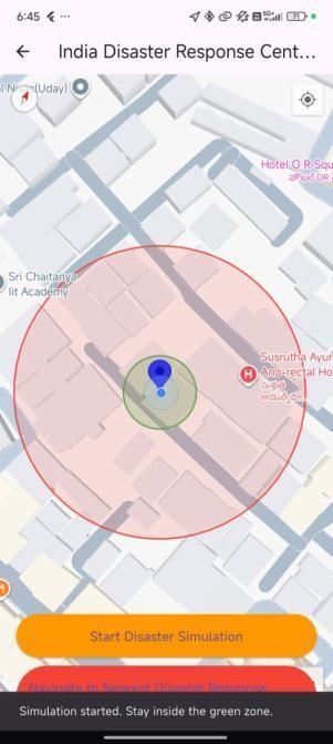
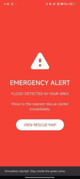
Thesystemcontinuouslytrackstheuser’slocationusingGPS services.Avirtualboundary,knownasageofence,iscreated aroundapredefinedsafezone.Whentheusermovesbeyond thissafezoneandentersapotentialdangerzone,thesystem automatically triggers an alert. This alert includes a notification message, an alarm sound, and an emergency alertscreentoimmediatelycapturetheuser'sattention.
The application also provides navigation to the nearest disaster response centers using Google Maps integration. Thisfeaturehelpsusers quicklyfindsafelocations during emergencies.Additionally,thesystemincludesanAI-based chatbot that assists users by providing disaster-related information,safetyguidelines,andquickresponsestouser queries.
Toensurereliabilityduringnetworkdisruptions,thesystem supportsofflineaccesstoessentialdisasterinformationsuch assafetytipsandemergencycontacts.Theapplicationalso includesmultilingualsupporttomakeitaccessibletousers fromdifferentlinguisticbackgrounds.
Theoverallworkflowofthesystemisasfollows:theuser’s location is continuously monitored, the system checks whether the user crosses the defined safe zone boundary, andifathresholddistanceisexceeded,analertistriggered alongwithnavigationassistance.
This integrated approach combines real-time monitoring, intelligent alerting, and user assistance into a single platform,makingitmoreeffectivethantraditionaldisaster managementsystems.
System Workflow: User → GPS Location Tracking → Geofence Detection → Danger Zone Entry → Alert Notification+Alarm→EmergencyScreen→Navigationto RescueCenter.
Thesystemarchitectureoftheproposeddisasteralertand awareness system is designed to provide real-time monitoring, alert generation, and emergency assistance using mobile and web technologies. The architecture consistsofmultipleinterconnectedcomponentsthatwork togethertoensureefficientdisasterdetectionandresponse.
International Research
Volume: 13 Issue: 04 | Apr 2026 www.irjet.net
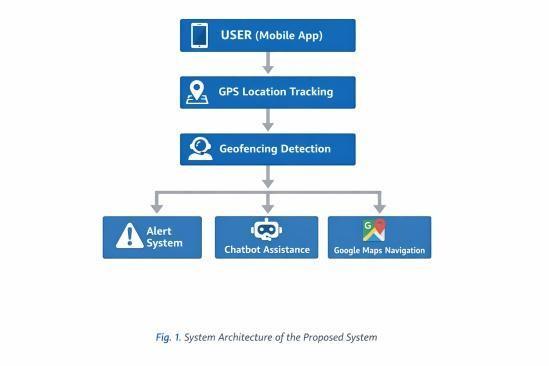
Theprimarycomponentistheuserdevice,whichrunsthe mobileapplicationdevelopedusingFlutter.Theapplication continuouslycollectstheuser’slocationusingGPSservices through the Geolocator module. The location data is then processedwithintheapplicationtodeterminewhetherthe useriswithinasafezoneorhasenteredapredefineddanger zone.
Thegeofencingmoduleplaysacrucialroleindefiningvirtual boundaries around safe and risk-prone areas. When the system detects that the user has crossed the defined boundary, it triggers the alert system. The alert system includespushnotifications,alarmsoundgeneration,andan emergencyalertinterfacetonotifytheuserinstantly.
The application is integrated with Google Maps API to display the user’s current location and nearby disaster response centers. It also provides navigation support to guideuserstothenearestsafelocation.
Additionally, the system includes a chatbot module that provides disaster-related guidance and answers user queries. A web platform is also integrated to provide informationalsupportandmultilingualdisasterawareness content.
Thearchitectureensuresseamlessinteractionbetweenall components,enablingreal-timealerting,userassistance,and improveddisasterresponseefficiency.
The proposed disaster alert and awareness system is implemented as a mobile application using the Flutter framework.Theapplicationintegratesmultipletechnologies suchasGPS-basedlocationtracking,geofencinglogic,realtimenotifications,andmapservicestoprovideaneffective disastermanagementsolution.
The system uses the Geolocator package to continuously tracktheuser’sreal-timelocationwithhighaccuracy.Asafe zone is dynamically created based on the user’s initial position when the simulation or monitoring starts. A geofencing mechanism is implemented by calculating the distancebetweentheuser’scurrentlocationandthedefined safe zone center. If the user moves beyond a predefined threshold distance, the system identifies it as entry into a dangerzone.
Upon entering the danger zone, the application triggers multiplealertmechanisms.Theseincludeapushnotification usinglocalnotificationservices,anaudiblealarmusingthe audioplayers package, and an emergency alert screen to captureuserattentionimmediately.Thismulti-layeredalert systemensuresthattheuserisinformedeve nifonealert methodfails.
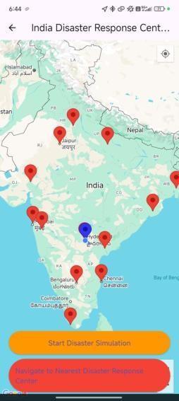
TheapplicationalsointegratesGoogleMapsAPItodisplay the user’s current location and nearby disaster response centers.Markersareusedtorepresentrescuecenters,and navigation functionality is provided using external map servicestoguideuserstothenearestsafelocation.
International Research Journal of Engineering and Technology (IRJET) e-ISSN: 2395-0056
Volume: 13 Issue: 04 | Apr 2026 www.irjet.net p-ISSN: 2395-0072

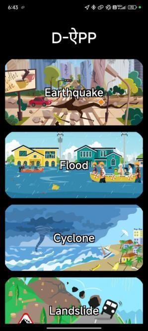
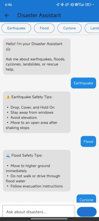
Additionally, a chatbot module is implemented to provide disaster-related information and safety guidelines. The chatbot responds to user queries based on predefined disasterscenariossuchasearthquakes,floods,cyclones,and landslides.
To improve reliability, the application includes offline support for essential safety instructions and emergency contacts. This ensures that users can access critical informationevenwheninternetconnectivityisunavailable.
Theimplementationdemonstratesthatthesystemiscapable ofprovidingreal-timealerts,location-basedassistance,and userguidanceeffectivelyduringdisastersituations.
The proposed GPS-enabled disaster alert and awareness systemwassuccessfullyimplementedandtestedinarealtime environment. The system demonstrated effective performance in detecting user movement and triggering alertswhentheuserenteredapredefineddangerzone.
Duringtesting,theapplicationaccuratelytrackedtheuser’s location using GPS services and continuously monitored movementwithminimaldelay.Thegeofencingmechanism effectively identified when the user crossed the safe zone boundary. Upon entering the danger zone, the system triggeredamulti-levelalert,includinganotificationmessage, alarmsound,andanemergencyalertscreen.Thisensured thattheuserwasimmediatelyinformedaboutthepotential risk.
The integration of Google Maps allowed users to visualize theircurrentlocationalongwithnearbydisasterresponse centers.Thenavigationfeaturesuccessfullyguidedusersto the nearest safelocation, improving responsetimeduring emergencysituations.
Thechatbotmoduleprovidedquickandrelevantresponses to user queries related to disaster safety, enhancing user interactionandawareness.Theofflinefunctionalityensured thatessentialsafetyinformationremainedaccessibleevenin theabsenceofinternetconnectivity.
International Research Journal of Engineering and Technology (IRJET) e-ISSN: 2395-0056
Volume: 13 Issue: 04 | Apr 2026 www.irjet.net p-ISSN: 2395-0072
Overall,thesystemachieveditsobjectiveofprovidingrealtime, location-based alerts and improving disaster preparedness.Thecombination of geofencing, alert mechanisms, navigation support, and intelligent assistancemakesthesystemmoreeffectivethantraditional disasteralertsystems.
However,certainlimitationswereobserved.Theaccuracyof locationtrackingdependsonGPSsignalstrength,andminor delays may occur in alert triggering due to device or environmentalfactors.Despitetheselimitations,thesystem providesareliableand practical solution for disaster management.
This paper presented a GPS-enabled disaster alert and awareness system designed to improve real-time disaster preparedness and response. The system integrates geolocationtracking,geofencing,mobilenotifications,alarm mechanisms,andnavigationservicestoprovidetimelyalerts andguidancetousersduringdisastersituations. Theimplementationresultsdemonstratethatthesystemcan effectively detect user movement, identify entry into disaster-proneareas,andtriggerimmediatealertsthrough notificationsandaudiblealarms.TheintegrationofGoogle Mapsenablesuserstolocateandnavigatetonearbydisaster responsecenters,whilethechatbotmoduleprovidesquick accesstosafetyguidelinesandessentialinformation.
The proposed system offers several advantages over traditional disaster management systems, including realtime personalized alerts, offline accessibility, and a userfriendly interface. These features contribute to improved situational awareness and faster response during emergencies.
However,certainlimitationsexist,suchasdependency on GPSaccuracyanddevicecapabilities.Futureenhancements can focus on integrating real-time disaster data from government agencies, implementing AIbased prediction models for early warning, and improving offline functionality. Additionally, the system can be extended to support wearable devices and IoT-based sensors for enhancedmonitoringandautomation.
Inconclusion,theproposedsystemprovidesapracticaland efficientsolutionfordisasteralertingandawareness,with thepotentialtosignificantlyreducerisksandimprovepublic safety.
[1] X. Zhao, Y. Sun, W. Liu, and C.-W. Wong, “Tailoring GenerativeAIChatbotsforMultiethnicCommunitiesin DisasterPreparednessCommunication:Extendingthe CASAParadigm,”2025.
[2] S. K. McBride et al., “Latency and Geofence Testing of Wireless Emergency Alerts (WEA),” U.S. Geological Survey(USGS),2023.
[3] S.Sonawaneetal.,“GeofencingforDisasterManagement System,” Journal of Emerging Technologies and InnovativeResearch(JETIR),vol.6,no.5,pp.123–126, 2019.
[4] A. K. Sharma and R. Gupta, “A Mobile-Based Disaster ManagementSystemUsingGPSandGISTechnologies,” InternationalJournalofComputerApplications,vol.174, no.12,pp.1–5,2021.
[5] M.RahmanandS.Islam,“DesignandImplementationof GPS-Based Emergency Alert System,” International JournalofAdvancedComputerScienceandApplications, vol.11,no.4,pp.234–239,2020.
[6] Google, “Google Maps Platform Documentation,” [Online]. Available: https://developers.google.com/maps
[7] Firebase, “Firebase Cloud Messaging Documentation,” [Online].Available:https://firebase.google.com/docs
[8] Flutter, “Flutter Documentation,” [Online]. Available: https://flutter.dev/docs
[9] P. K. Verma and A. S. Bansal, “Disaster Management UsingInternetofThings(IoT):AReview,”International
International Research Journal of Engineering and Technology (IRJET) e-ISSN: 2395-0056
JournalofEngineeringResearch&Technology(IJERT), vol.9,no.6,pp.120–125,2020.
[10]L.PalenandS.B.Liu,“CitizenCommunicationsinCrisis: Anticipating a Future of ICT-Supported Public Participation,”ProceedingsoftheSIGCHIConferenceon Human Factors in Computing Systems, pp. 727–736, 2007.
[11]A. Tapia, K. Moore, and N. Johnson, “Beyond the Trustworthy Tweet: A Deeper Understanding of Microblogged Data Use by Disaster Response and HumanitarianReliefOrganizations,”Proceedingsofthe InternationalISCRAMConference,2013.
[12]S.Poslad,F.Tao,Z.Ma,andZ.Wang,“SmartCityInternet ofThingsApplicationsforDisasterManagement,”IEEE TransactionsonIndustrialInformatics,vol.13,no.2,pp. 1–10,2017.
Volume: 13 Issue: 04 | Apr 2026 www.irjet.net p-ISSN: 2395-0072 © 2026, IRJET | Impact Factor value: 8.315 | ISO 9001:2008