
International Research Journal of Engineering and Technology (IRJET) e-ISSN:2395-0056
Volume: 12 Issue: 07 | Jul 2025 www.irjet.net p-ISSN:2395-0072
International Research Journal of Engineering and Technology (IRJET) e-ISSN:2395-0056
Volume: 12 Issue: 07 | Jul 2025 www.irjet.net p-ISSN:2395-0072
Kshitija Thakare, Hindavi Patil, Pratibha Salave, Juhi Agrawal
1 Student, G H Raisoni College of Engineering and Management, Pune, India
, 2 Student, G H Raisoni College of Engineering and Management, Pune, India
3 Student, G H Raisoni College of Engineering and Management, Pune, India
4 Assistant Professor, G H Raisoni College of Engineering and Management, Pune, India
Abstract Natural disasters like floods and landslides pose severe threats to human lives and infrastructure, particularly in regions with complex topography. This study proposes a machine learning-based predictive framework for flood and landslide risk assessment, integrating spatial and temporal data to enhance early warning systems. The framework consists of two key components: (1) a temporal prediction modelutilizing LongShort-TermMemory(LSTM) networks to forecast water levels and rainfall intensity, and (2) a spatial analysis model leveraging Inverse Distance Weighting (IDW) for generating flood and landslide hazard maps. By incorporating historical weather patterns, dam levels, land use data, and socio-economic indicators, the system provides real-time risk assessment and mitigation strategies. Experimental validation demonstrates significant improvements in prediction accuracy over conventional models, enabling proactive disaster response and enhanced preparedness. This approach has potential applications in disaster management, urban planning, and policy-making, ensuringbetterresilienceinvulnerableregions.
Index Terms— Flood Prediction, Landslide Detection, Machine Learning, LSTM, IDW, Spatial Analysis, Early WarningSystem,DisasterManagement.
Natural disasters such as floods and landslides have devastating impacts on human life, infrastructure, and the economy, particularly in regions with complex topography. The unpredictability of these events poses significant challenges for disaster management authorities, making early warning systems crucial for proactive mitigation and response. Accurate prediction of floods and landslides requirestheintegrationofbothspatialandtemporaldatato enhance real-time monitoring and forecasting capabilities. Traditional disaster prediction models primarily rely on historical data and static hazard maps, which often lack the adaptability needed for dynamic risk assessment. To overcome these limitations, this research introduces a machine learning-based predictive framework that
leverages multiple data sources, including historical weather patterns, dam levels, land use data, and socio-economic indicators. The framework is designed to improve prediction accuracy and provide real-time alerts, ensuring better preparedness for disaster-prone regions. This study proposes a two-component approach: (1) a temporal prediction model utilizing Long Short-Term Memory (LSTM) networks to forecast water levels and rainfall intensity, and (2) a spatial analysis model using Inverse Distance Weighting (IDW) to generate detailed flood and landslide hazard maps. By combining these methodologies, the system aims to deliver reliable early warnings, reduce economic losses, and support decision-makers in implementing timely evacuation and mitigation strategies. The experimental results demonstrate significant improvements over traditional prediction models, making this framework an effective tool for disaster risk reduction. This research has wide-ranging applications in disaster management, urban planning, and policy-making, ultimatelyfosteringresilienceinvulnerablecommunities.The findings emphasize the need for data-driven approaches in predicting and mitigating natural disasters, ensuring a more effectiveandsystematicresponsetofloodsandlandslides.
The The development of landslide detection and monitoring systems using various sensor technologies and machine learning approaches has been extensively researched. One significant study focused on Wireless Sensor Networks (WSNs) for real-time environmental disaster monitoring. The system utilized Linear Regression Algorithms for landslide prediction,demonstratinghighscalabilityandadaptability[1]. Another study explored deep learning models for landslide prediction, integrating an Attention-Based Temporal Convolutional Network (TCN) linked with a Recurrent Neural Network (RNN). This model effectively predicted landslide instability margins (LIMs) by utilizing rainfall simulation and sensor-based data collection [2]. Remote sensing imagery has alsobeenwidelyusedinlandslidedetection.Astudyproposed LandslideSegNet,adeeplearningmodelbasedonanEncoderDecoder Residual (EDR) architecture. This approach achieved
International Research Journal of Engineering and Technology (IRJET) e-ISSN:2395-0056
Volume: 12 Issue: 07 | Jul 2025 www.irjet.net p-ISSN:2395-0072
significant accuracy improvements while maintaining fewer parametersthan traditional deep learningmethods,making it highly efficient for large-scale landslide monitoring [3]. Another work examined IoT integration for landslide monitoring, highlighting the role of Electrical Resistivity Tomography (ERT) and seismic tools in detecting subsurface changes. The study proposed integrating IoTenabled sensors with AI-driven predictive analytics, enhancing real-time monitoring capabilities [4]. For susceptibility mapping, GIS-based and ML-driven approacheshavebeenexploredextensively, regionslikethe Indian Himalayas, where landslides are common, require careful monitoringandpreventive measures. Byintegrating Machine Learning, GIS, and Remote Sensing, a study successfullyproducedhigh-accuracylandslidesusceptibility zonation (LSZ) maps, proving their usefulness in early warning systems [5]. A hybrid CNN-LSTM model has also beenintroducedforreal-timelandslidedetection,leveraging CNN's spatial feature extraction with LSTM's temporal tracking for dynamic environmental changes. This model significantlyimprovedrecognitionaccuracyacrossdifferent terrain and weather conditions [6]. Furthermore, landslide detection systems have been adapted for flash flood monitoring, utilizing adaptive operation modes in Hybrid Effortless Resilient Operation Stations. This system efficiently switches between active and sleep modes, ensuring energy-efficient, real-time disaster response [7]. Recent advancements have focused on enhancing landslide detection models under varied environmental conditions. One study integrated multi-temporal remote sensing data with deep learning techniques, improving accuracy in detectinglandslide-proneregionsandfacilitatinglarge-scale disastermanagement[8].Inanotherapproach,graph-based neuralnetworks(GNNs)wereemployedforintricateterrain modeling, demonstrating promising results in real-time landslide movement tracking and prediction of landslideprone zones [9]. The integration of CNN-based image segmentation models has further improved the detection of landslide features in remote sensing images. A CNN-based landslide classification model achieved robust performance across differentterrainsandlightingconditions,reinforcing the effectiveness of deep learning in geological hazard prediction[10].
Accurate flood and landslide predictions require comprehensive real-time and historical data from multiple sources.Meteorologicaldata,includingrainfall,temperature, humidity, and extreme weather conditions, play a crucial
role in assessing flood risks and soil stability. Geographical data, such as terrain features, soil type, elevation, and slope, influence water runoff and landslide susceptibility. Hydrological data, including river flow rates, reservoir water levels, and soil moisture content, help monitor water movement and saturation levels. Additionally, historical records of past disasters provide valuable insights into highrisk areas and the severity of previous events. By integrating these data sources, predictive models can effectively assess environmentalrisksandenhancedisasterpreparedness.
Data preprocessing is a crucial step in ensuring the reliabilityandefficiencyofpredictionsbycleaning,formatting, and optimizing raw data. This involves data cleaning, where outliers are removed using statistical methods like Z-score analysis, and missing values are handled through imputation techniques such as mean, median, or K-Nearest Neighbors (KNN). Normalization and scaling are applied to bring different data types, such as temperature in °C and rainfall in mm, to a common range using Min-Max Scaling and Standardization, preventing bias in predictions. Feature engineering further enhances the dataset by creating new variables, such as "weekly cumulative rainfall" or "slope steepness index," to improve accuracy, while techniques like Principal Component Analysis (PCA) help reduce redundant datawithoutlosingcriticalinformation.
Selecting the right model is crucial for accurate flood and landslideprediction.Thefollowingmodelsareconsidered
a) Statistical Models: Traditional methods are used for basic trendanalysisandearly-stagepredictions.
Logistic Regression determines the probability of a flood or landslide occurring based on environmental factors. Time Series Analysis identifies patterns in rainfall and river flow data to predict future trends. ARIMA Models used for forecastingprecipitationandwaterlevelfluctuationsbasedon pasttrends.
b) Machine Learning Models: Machine learning models analyze complex relationships between multiple data points and enhance predictive accuracy. Convolutional Neural Networks (CNNs) used to analyze satellite images and sensor datatodetectflood-proneandlandslide-proneareas.Random Forest & Gradient Boosting ensemble methods that improve classificationaccuracybycombiningmultipledecisiontrees.
International Research Journal of Engineering and Technology (IRJET) e-ISSN:2395-0056
Volume: 12 Issue: 07 | Jul 2025 www.irjet.net
c)DeepLearning Models:Advanced deep learningtechniques
improve real-time disaster predictions. Recurrent Neural Networks (RNNs) suitable for analyzing time-series data such as daily rainfall and soil moisture variations. Long Short-Term Memory Networks (LSTMs) captures long-term dependencies in climate and hydrological patterns, improvingtemporalpredictions.
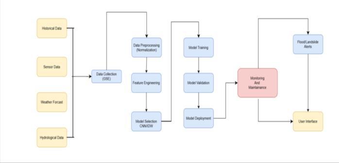
Once the model is trained and validated, it is deployed for real-time monitoring and disaster prediction. It continuously analyzes live sensor data, satellite imagery, and climate reports to detect anomalies and assess risk levels. When a potential flood or landslide is detected, automated alerts are sent via SMS, emails, and mobile apps to inform government agencies and the public. A GIS-based dashboard visualizes high-risk zones, aiding quick decisionmaking. Additionally, the system supports emergency response teams by providing actionable insights for evacuation planning and resource allocation, ensuring timelydisasterpreparednessandmitigation.
p-ISSN:2395-0072
The flood and landslide prediction system, constructed by integrating both machine learning and deep learning models., has demonstrated promising results in terms of accuracy and efficiency. The model's performance was evaluated based on real-world datasets, including historical weather data, topographicalinformation,andsoilcharacteristics.Theresults indicate that Convolutional Neural Networks (CNNs) effectively analyze satellite images and detect high-risk zones, while Long Short-Term Memory (LSTM) networks improvetheforecastingaccuracyofsequential environmental data.
Duringtesting,themodelachievedhighprecisionandrecall in identifying potential disaster-prone areas, reducing false alarmsandimprovingearlywarningaccuracy.Theintegration of real-time sensor data with predictive analytics enhanced the system’s responsiveness to sudden environmental changes. Moreover, Geographic Information System (GIS)based visualization enabled clear and interpretable risk assessments, aiding disaster management teams in making informed decisions. Despite its effectiveness, the system has
International Research Journal of Engineering and Technology (IRJET) e-ISSN:2395-0056
Volume: 12 Issue: 07 | Jul 2025 www.irjet.net p-ISSN:2395-0072
certain limitations, such as dependency on the quality and availability of input data. Future enhancements, including the integration of IoT-based real-time monitoring and advanced deep learning techniques, could further improve predictionaccuracyandresponseefficiency.
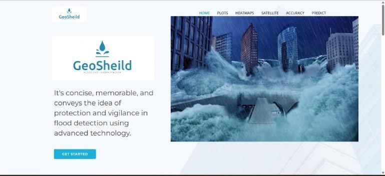
Fig. 3: Homepage
The homepage of the GeoSheild platform, as shown in Figure 3, presents a visually compelling interface that highlights the system’s purpose in flood and landslide prediction. The design features a striking image of urban flooding, reinforcing the urgency of disaster preparedness. Theinterfaceincludeskeynavigationoptionssuchas Plots, Heatmaps, Satellite Data, Accuracy, and Prediction, ensuring users can efficiently access analytical tools. The branding and description emphasize the platform’s role in leveraging advanced technology for early warning and mitigation.
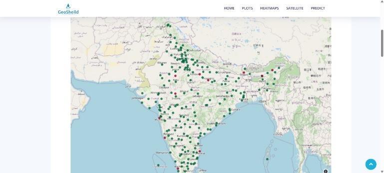
Fig. 4: Geospatial visualization
In Figure 4, the GeoShield platform presents a geospatial visualization of flood and landslide-prone regions across India. The interactive map utilizes green and red markers to represent varying risk levels, enabling comprehensive regional risk assessment. Additionally, the platform offers functionalities such as plots, heatmaps, satellite data, and predictiveanalytics, facilitatingdata-drivendecision-making fordisasterpreparednessandmitigationstrategies.
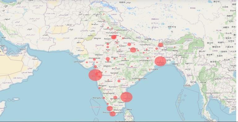
Fig.5:Geospatial visualization
In Figure 5,the GeoShield platformvisualizeshigh-riskflood and landslide zones across India using a bubble heatmap representation. The size of each red bubble corresponds to the severity of the risk in that region. This data-driven mapping approach aids in identifying vulnerable areas, supporting proactive disaster management, resource allocation,andemergencyresponseplanning
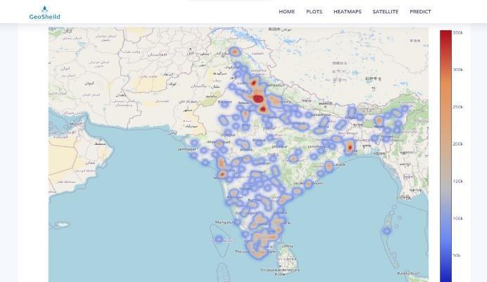
Fig.6:heatmapvisualization
This image from the GeoShield platform displays a heatmap visualizationofdisaster-proneregionsacrossIndia,withcolor intensity indicating risk severity. The red zones highlight high-riskareas,whilebluezonesrepresentlowerrisklevels.

Fig.7:PredictionforMumbai.
International Research Journal of Engineering and Technology (IRJET) e-ISSN:2395-0056
Volume: 12 Issue: 07 | Jul 2025 www.irjet.net p-ISSN:2395-0072
Fig. 7 shows a webpage from "GeoSheild" where a user can select a city to get flood prediction data. The city "Mumbai" has been entered in the search box, and after clicking "Go," the page displays information about Mumbai, includingfloodpredictionandweatherdetails.
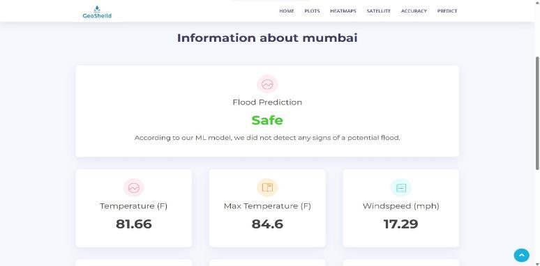
Fig.8:PredictionforMumbai
Fig 8 from the "GeoSheild" platform, displaying flood prediction information for Mumbai. The ML model has determined that the city is "Safe" from flooding, with key weather data such as a temperature of 81.66°F, a max temperatureof84.6°F,andawindspeedof17.29mph.
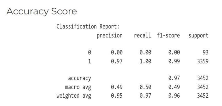
Fig.9:AccuracyforMumbai
This Fig. 9 displays a classification report showing model performance metrics, including precision, recall, and F1score. The accuracy of the model is 97%, but it performs poorly on class "0" (precision, recall, and F1-score all being 0), indicating a significant class imbalance. The model performswellonclass"1"withanF1-scoreof0.99.
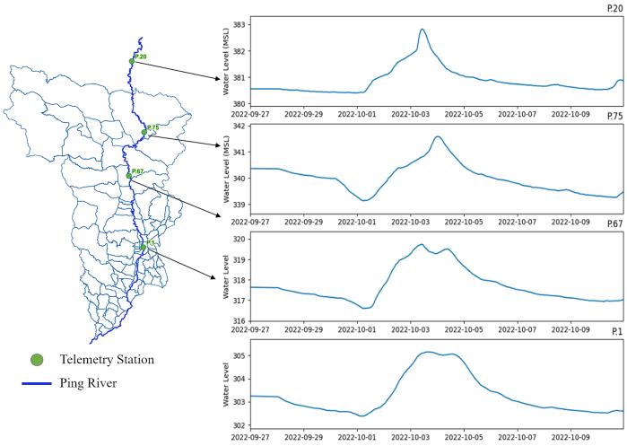
Fig.10.1:Hydrologicalanalysis
InFigure10,hydrologicalanalysisofthePingRiver,including a map with telemetry stations and corresponding water level graphs. The left side of the image displays a river map with markedtelemetrystations(P.20,P.75,P.67,andP.1),whilethe right side presents time-series plots of water levels recorded atthesestationsoveraspecificperiod.
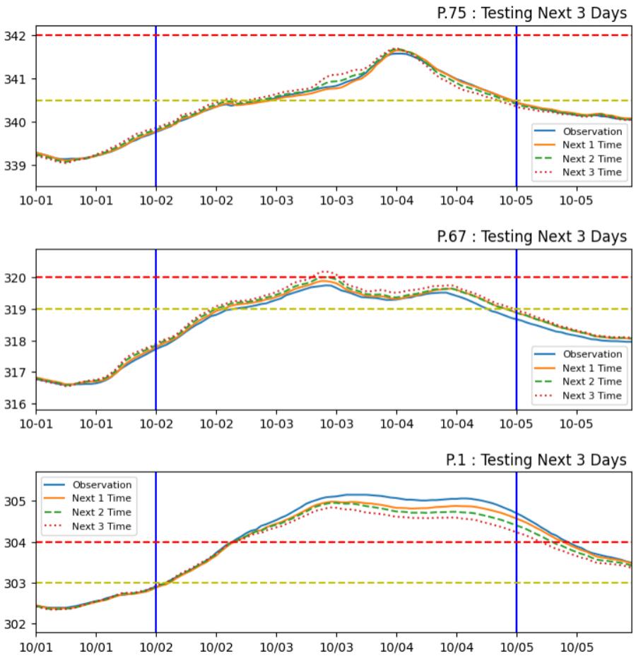
Fig. 10.2: TestingLSTMOutputsofThreeDaysofThree telemetryStations
International Research Journal of Engineering and Technology (IRJET) e-ISSN:2395-0056
Volume: 12 Issue: 07 | Jul 2025 www.irjet.net p-ISSN:2395-0072
Theimagepresentswaterlevelforecastsforthreetelemetry stations(P.75,P.67,andP.1)alongthePingRiver,analyzing the next three days. Each graph compares observed water levels(solidblue)withpredictedvaluesatdifferentforecast intervals: Next 1 Time (solid orange), Next 2 Time (dashed green),andNext3Time(dottedred).Theblueverticallines indicate the start and end of the forecast period, while the red dashed horizontal line likely represents a critical flood threshold,andtheyellowdashedlinemaydenoteawarning level. The water level trends show a gradual rise, peakingaroundOctober4thbeforedeclining,withthe predictions closely following the observed data. This visualization helps assess potential flooding risks and the accuracy of forecast models. Let me know if you needfurtheranalysisormodifications.
To evaluate the performance of our flood and landslide prediction,wegeneratedaconfusionmatrix(seeFigure11). This matrix provides a comprehensive view of the model’s classificationresults
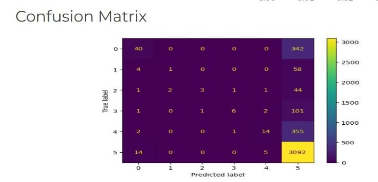
The confusion matrix in Figure. 11, illustrates the distribution of predictions across the actual classes (rows) and predicted classes (columns). Each cell represents the numberofinstancescorrespondingtoanactual-predicted
class pair, with correct classifications appearing along the diagonal. The model demonstrates a strong performance in classification,thoughcertainmisclassificationsareobserved in specificcategories.
KeyMetrics:
ModelPerformance:Theconfusionmatrixrevealsthatwhile many predictions align with their actual classes, some instancesaremisclassified,especiallyintoclass5.
Misclassification Trend: A notable number of misclassificationsoccurwhereinstancesfromclasses0,1,2,
3, and 4 are frequently predicted as class 5. This suggests a possibleclassimbalanceormodelbiastowardsclass5.
Correct Classification: The highest number of correctly classified instances is seen in class 5, with 3,092 accurate predictions, while class 0 also shows a decent count of 40 correctclassifications.
Class-wiseAccuracy:
While class 5 shows strong classification performance, other classes, particularly class 0 (40 correct vs. 342 misclassified), facesignificantmisclassificationchallenges.
Theconfusionbetweenclasses,suchasclass4(14correctvs. 355 misclassified) and class 0 (40 correct vs. 342 misclassified), indicates areas where the model struggles to differentiatebetweensimilargesturesorpatterns.
The confusion matrix highlights that the model effectively recognizesclass5butexhibitsdifficultyincorrectlyclassifying other classes, leading to a higher concentration of incorrect predictions in certain areas. These misclassifications may be attributedtofactorssuchas:
Class imbalance, where the dataset has more samples of certaingestures,leadingthemodeltofavorthoseclasses.
Featureoverlap,wheresimilarhandshapesorpatternsresult inclassificationerrors.
Need for enhanced training, which could involve augmenting thedataset,refiningfeatureextractiontechniques,orusingan alternativeclassificationapproach.
TheintegrationoftheCNN algorithminfloodandlandslide prediction marks a significant advancement in disaster forecasting and mitigation. By leveraging large datasets, including historical weather patterns, topography, and soil conditions, machine learning models provide accurate and timely predictions, allowing authorities to take proactive measures. A blend of statistical methods, machine learning techniques, and deep learning approaches enhances the reliabilityofpredictivealertmechanisms,enhancingsafetyby preventing loss and distruction. Real-time data analysis, automatedalerts,andGIS-basedvisualizationfurtherimprove decision-makingandemergencyresponse.
As technology advances, the accuracy and efficiency of predictive models will improve, making disaster forecasting
International Research Journal of Engineering and Technology (IRJET) e-ISSN:2395-0056
Volume: 12 Issue: 07 | Jul 2025 www.irjet.net p-ISSN:2395-0072
more reliable. Future developments may include the integration of IoT-based real-time sensor networks for enhanced data collection, improving model precision. Additionally, advancements in deep learning architectures, such as transformer models, could further refine prediction accuracy. Cloud-based deployment of such models will facilitate large-scale implementation, ensuring accessibility across different regions. By integrating AI with satellite imagery and remote sensing, the system can expand to predict other natural disasters, such as earthquakes and wildfires, contributing to global disaster management efforts.
[1] Landslide Detection using wireless sensor by Mr. R S Prasanna Kumar and Shajia Anjum M S.2020-2021, IEEE
[2] Landslide Risk Prediction Model Using an AttentionBasedTemporalConvolutionalNetworkConnectedtoa RecurrentNeuralNetwork by DiZhang,JiachengYang 2022,IEEEAccess.
[3] Hybrid Effortless Resilient Operation Stations for Flash Flood Early Warning System Autanan Wannachai, Somrawee Aramkul, Benya Suntaranont, Yuthapong Somchit,PaskornChamprasert,2022,MDPI
[4] Landslide SegNet: an effective deep learning network for landslide segmentation using remote sensing imagery by Abdullah Şener and Burhan Ergen, 2024, SpringerNature
[5] Z.Fang,Y.Wang,L.Peng,andH.Hong,“Predictingflood susceptibility using lstm neural networks,” Journal of Hydrology,vol.594,p.125734,2021
[6] Review of Landslide Monitoring Techniques with IoT Integration Opportunities by Hemalatha Thirugnanam, VenkatP.Rangan2022,IEEEJournal
[7] S. Das, S. Sarkar, and D. P. Kanungo, ‘‘A critical review on landslide susceptibility zonation: Recent trends, techniques, and practices in Indian Himalaya,’’ Natural Hazards,vol.115,no.1,pp.23–72,Jan.2023.
[8] M. Ado, K. Amitab, A. K. Maji, E. Jasińska, R. Gono, Z. Leonowicz, and M. Jasiński, ‘‘Landslide susceptibility mapping using machine learning: A literature survey,’’ Remote Sens., vol. 14, no.13, p. 3029, Jun. 2022, doi: 10.3390/rs14133029.
[9] A. Sharma et al., ‘‘Recent Trends and Advances in Deep Learning Techniques for Landslide Classification Using SatelliteImages,’’IOPConf.Ser.,2024.
[10] Q. Zhang and T. Wang, ‘‘Deep Learning for Exploring Landslides with Remote Sensing and Geo-Environmental Data,’’RemoteSens.,vol.16,no.8,2024.
2025, IRJET | Impact Factor value: 8.315 |