
International Research Journal of Engineering and Technology (IRJET) e-ISSN: 2395-0056
Volume: 13 Issue: 04 | Apr 2026 www.irjet.net p-ISSN: 2395-0072

International Research Journal of Engineering and Technology (IRJET) e-ISSN: 2395-0056
Volume: 13 Issue: 04 | Apr 2026 www.irjet.net p-ISSN: 2395-0072
“Aditya
Khutwad”, “Omkar Naik”, “Atharva Sawant”, “
Department of Mechanical Engineering, Pillai College of Engineering, New Panvel, India
Department of Mechanical Engineering, Pillai College of Engineering, New Panvel, India ***
Abstract: Disaster zones often suffer from communication breakdowns and poor visibility, making survivor detection challenging. This paper presents a low-cost, portable object-detection pod capable of identifying human presence under debris using 24 GHz mm-wave radar sensors. The pod operates autonomously and communicates wirelessly through LoRa (Long Range) transmission to a centralised receiver station. Built around an ESP32 Wroom and powered by a 5 V power bank, the system functions without GPS or Wi-Fi infrastructure. Laboratory tests confirm reliable detection within a 6 m radius and LoRa transmission up to 2 km. The system demonstrates a significant reduction in rescue response time and is scalable for large-area deployment.
Keywords: Disaster Management, LoRa Communication, ESP32, Radar, IoT, Object Detection, Rescue System
1. Introduction:
1.1Background and Motivation: Natural and man-made disasters such as earthquakes, mine collapses, and building failuresoftentrapindividualsbeneathrubble,makingrapiddetectionessentialforsurvival.Insuchscenarios,visibilityis poor, power and communication networks collapse, and traditional search methods like manual teams or camera-based systemsbecomeslowandunreliable.Rapid,automated,andcommunication-independentdetectionsystemsaretherefore vitaltoreducerescueresponsetimeandincreasesurvivalrates.
1.2 Existing Limitations: Conventional surveillance technologies including drones, thermal imaging, and Wi-Fi–based sensors facemajorchallenges.Dronesofferaerialvisibilitybuthavelimitedflightduration,line-of-sightdependency,and high operating costs. Thermal cameras are affected by smoke, dust, and debris, while Wi-Fi or Bluetooth–based sensors provide only short-range communication. These constraints limit scalability and real-time responsiveness in large-scale disasterenvironments.
1.3 Research Gap and Objectives: Most existing rescue systems depend on infrastructure or continuous human supervision,whichfailsduringcatastrophicevents.Thisstudyaddressesthegapbydevelopingalow-cost,portableobject detection pod that integrates infrared (IR) and 24 GHz mm-Wave radar sensors with LoRa-based communication. The proposedsystemaimsto:
Enableautonomousdetectionofhumanpresencebeneathdebris,
Operatewithoutexternalnetworks(GPS/Wi-Fi),and
Providelong-range,low-powerdatatransmissionforreal-timealerting. Thisapproachenhancesthescalability and reliability of post-disaster rescue operations.
International Research Journal of Engineering and Technology (IRJET) e-ISSN: 2395-0056
Volume: 13 Issue: 04 | Apr 2026 www.irjet.net p-ISSN: 2395-0072
The Internet of Things (IoT) has become a vital component of smart and sustainable cities, providing real-time data for disaster prediction, monitoring, and response. Studies highlight that IoT-enabled systems comprising sensors, communicationnetworks,andanalytics enhancebothpre-disasterpreparednessandpost-disasterrecovery.
In the pre-disaster phase, temperature, humidity, vibration, and hydrological sensors are widely used for environmental and structural monitoring, enabling early warnings for floods, landslides, or fires. Post-disaster systems employ infrared, ultrasonic,and24GHzradarsensorstodetectsurvivorsbeneathdebrisandassessinfrastructuredamage.
Low-power communication technologies such as LoRa, Sigfox, and NB-IoT ensure data transmission even when conventional networks fail, while hybrid frameworks combining Wi-Fi or LTE provide higher-bandwidth links for commandcenters.Atthedatalayer,edgecomputingandAI-basedanalyticsareincreasinglyusedforpatternrecognition, anomalydetection,anddecisionsupport.
However, challenges remain in interoperability, data security, and large-scale deployment. Few studies demonstrate fully autonomousmulti-hazardsystemscapableofoperatingacrossbothpre-andpost-disasterstages.Futureresearchshould focus on energy-efficient sensors, resilient network design, and standardized IoT architectures for urban catastrophe management.
In summary, IoT-based sensing and communication technologies provide a foundation for disaster-resilient smart cities thatalignwiththeUnitedNations’SustainableDevelopmentGoals.
MicrowaveandDopplerradar–basedsensinghasrecentlygainedsignificantattentionfornon-contactdetectionofhuman vital signs such as respiration and heartbeat, particularly in post-disaster rescue operations. Unlike infrared or acoustic sensors,Dopplerradarcanpenetraterubble,walls,orsmoke,enablinglifedetectioneveninobstructedenvironments.
Severalstudieshaveproposedcontinuous-wave(CW)andfrequency-modulatedcontinuous-wave(FMCW)radarsystems for locating survivors after earthquakes or building collapses. These systems exploit micro-motion analysis of chest movementstoidentifylivinghumansunderdebris.Advancesinantennadesign,signalprocessing,andfilteringalgorithms haveimproveddetectionaccuracy,noisesuppression,andenergyefficiency.
Recent works also integrate radar modules with microcontrollers or IoT frameworks for portable, low-power, and autonomous search systems. However, challenges persist in differentiating human motion from environmental noise, reducingfalsepositives,andensuringstabledetectionacrossvaryingmaterialsanddepths.
Comparativestudiesrevealthatwhileradar-basedsensorsoutperformopticalandultrasonicmethodsinpenetrationand robustness, hybrid systems combining radar with infrared or thermal imaging offer superior reliability. Overall, Doppler radar sensing represents a promising direction for rapid, non-invasive survivor detection in disaster management applications.
C. A Rescue Radar System for The Detection of Victims Trapped Under Rubble Based On The Independent Component Analysis Algorithm
Microwave radar sensing has emerged as a powerful tool for search-and-rescue operations, particularly for detecting survivors trapped beneath debris after earthquakes or structural collapses. Continuous-wave (CW) and frequencymodulatedcontinuous-wave(FMCW)radarsoperatingintheX-bandcandetectmicro-motionscausedbyrespirationand heartbeat,providinganon-contactmeansofidentifyinghumanpresence.
Recentresearchhasfocusedonimprovingsignal-to-noiseratioandcluttersuppressionusingadvancedsignal-processing methods such as Independent Component Analysis (ICA), adaptive filtering, and phase-demodulation algorithms. These techniquesenableaccurateextractionofvital-signinformationfromweakbackscatteredsignals.
Compacthardwarearchitecturesandlow-powerdesignshaveenabledthemountingofradarmodulesonunmannedaerial vehicles (UAVs), providing access to confined or hazardous areas where manual rescue operations are challenging. Experimental studies demonstrate that UAV-borne radar systems can successfully detect trapped victims with reliable accuracywhilemaintaininglightweightandportability.
Despite these advancements, challenges remain in distinguishing human vital-sign signatures from environmental vibrations, optimizing radar orientation, and ensuring stable data transmission during UAV motion. Integrating radar
International Research Journal of Engineering and Technology (IRJET) e-ISSN: 2395-0056
Volume: 13 Issue: 04 | Apr 2026 www.irjet.net p-ISSN: 2395-0072
sensingwithinfrared,LiDAR,orIoT-basedcommunicationplatformsisidentifiedasa promisingapproachfor enhancing detectionrobustnessinfuturedisaster-responsesystems.
Unmanned Aerial Vehicles (UAVs) have become increasingly significant in wilderness search and rescue (SAR) missions, offeringfast,flexible,andwide-areasurveillanceinregionsinaccessibletogroundteams.Traditionalrescueoperationsare constrainedbymanpower,visibility,andterrainchallenges,makingUAV-basedsystemsavaluablealternativeforreal-time dataacquisitionandvictimlocalisation.
Recent studies have leveraged camera-based detection systems combined with onboard computation for autonomous targetidentificationandtracking.Advancesinminiaturizedsensors,embeddedprocessors,andGPS-integratedautopilots have enabled fully autonomous UAVs capable of executing pre-programmed search patterns with minimal human intervention. Image-processing techniques, including object recognition, motion tracking, and geolocation algorithms, allowUAVstodetectandlocatehumansorrelevantobjectsefficiently.
Fixed-wing UAV platforms provide extended flight endurance and large-area coverage compared to multi-rotor systems, making them suitable for prolonged search missions. Experimental validations and simulated SAR missions demonstrate thereliabilityandefficiencyoftheseUAV-basedframeworksindiverseterrainandweatherconditions. However, limitations persist in terms of obstacle avoidance, low-light detection, and data transmission in remote areas. Integrating multi-sensor fusion (e.g., RGB, thermal, and LiDAR) with AI-driven onboard analytics and LoRa or satellite communicationnetworkscanfurtherenhancesituationalawarenessandrescueeffectivenessinfutureSARsystems.
E. Emergency Response Person Localisation and Vital Sign Estimation Using a Semi-Autonomous Robot-Mounted SFCW Radar
Search and rescue operations in disaster zones demand technologies capable of functioning in complex, obstructed, and hazardousenvironmentswherevisibilityislimited.Semi-autonomousrescuerobotshaveemergedasaneffectivesolution, enabling remote exploration and reducing risk to human responders. These robotic systems often integrate radar-based sensing for detecting and locating trapped individuals through debris, walls, or smoke conditions where optical or infraredsensorsfail.
Recent developments have focused on through-wall radar imaging and Doppler-based vital-sign detection to identify human presence and monitor physiological parameters such as breathing and heartbeat. Advanced signal processing algorithms,including 2D-MUSIC,IndependentComponent Analysis(ICA),and frequencydemodulation, havesignificantly improveddetectionaccuracyandmulti-personlocalisationundernoisyorclutteredconditions. Commercial radar modules integrated into mobile robotic platforms have demonstrated high robustness across diverse terrains and materials such as concrete, wood, and stone. Open-source datasets and benchmarking studies now support reproducibleresearchinemergencyresponserobotics.
However, limitations persist in differentiating multiple subjects within overlapping radar fields, minimizing false detections,andoptimizingradarorientationforautonomousnavigation.Futureworkemphasizesthefusionofradarwith LiDAR, vision, and AI-driven decision algorithms to enhance perception, autonomy, and coordination in next-generation rescuerobots.
3. Evolution of Rescue Technologies — Then and Now: Technologicalprogressindisaster-responsesystems hasadvancedsteadilyoverthelastthreedecades.Theevolutioncanbedividedintofivekeyphases,assummarizedbelow.
Table-1: Researchflowfrom1920to2025
Period Technological Milestones
1920–1940 (Pre-war era) Early mechanical life detectors, hand-cranked sirens, and rescue ropes; radio communication inemergencyvehicles.
1940–1960 (postWWII) Military R&D led to sonar and radar first adapted for locating submarines and then survivorsatsea.
1960–1980 DevelopmentofinfraredthermographyandCO₂ gassensorsforminerescue;earlycomputersfor signalprocessing.
Impact on Rescue Operations
Basic human coordination; minimal automation.
Laid the foundation for motion-sensing anddetectionprinciples.
Introduced non-contact detection and electronicsensing.
International Research Journal of Engineering and Technology (IRJET) e-ISSN: 2395-0056
Volume: 13 Issue: 04 | Apr 2026 www.irjet.net p-ISSN: 2395-0072
1980–1990
1990–2000
2000–2010
2010–2015
2015–2020
2020–2025
4. Methodology:
3.1 System Architecture
Emergence of portable electronics, handheld radios, and the first ground-penetrating radar (GPR).
Manual-to-digital shift: acoustic microphones, traineddogs,simpleIRthermometers.
Thermal cameras, endoscopic scopes, and the firstwirelessCCTVinrescueteams.
Drone surveillance and portable Doppler radar withembeddedmicrocontrollers.
RiseofIoTsensornetworks(ZigBee,Wi-Fi)and machinelearningforsignalanalysis.
Integration of LoRa, AI-based radar, and smart podswithradar-IRfusion.
Device Pin Connects To
Table-2: SystemArchitecture
Enabled remote sensing for structural failures.
Improved localized detection, but still human-dependent.
Enhanced visual feedback; limited in smokyordustyconditions.
Allowed aerial mapping and motion detection.
Enabled semi-autonomous multi-sensor rescuesystems.
Currenttrend:fullyautonomous,scalable, low-costrescuenetworks.
Notes MB102BarrelJack 7–12VAdapter
RD-03DVCC MB1025V(+)
RD-03DGND MB102GND(-)
Ensure ON switch pressed; jumper set to 5V
Radar receives clean 5V directly from MB102
RadargroundconnectstoMB102 ESP32GND MB102GND(-)
Table-3: RD-03Dpinconfiguration
MANDATORY:Createscommongroundfor datasignals
RD-03D Pin ESP32 Pin
Direction
RadarTX GPIO16(RX2) Radar→ESP32
RadarRX GPIO17(TX2) ESP32→Radar
VCC MB1025V
MB102→Radar
Notes
Radar transmits data out; ESP32 receives onUART2RX
ESP32 sends commands; Radar receives onitsRXpin
DoNOTuseESP323.3Vforthis GND MB102GND Common Sharedcommonground
Table-4: LoraModulepinconfiguration
LoRa Pin
ESP32 Pin
VCC ESP323.3V
Function
Modulepower useONLYESP323.3V,never5V GND ESP32GND
SCK GPIO18
MISO GPIO19
MOSI GPIO23
NSS/CS GPIO5
RST GPIO14
DIO0 GPIO26
Commonground
SPIClock
SPIMasterInSlaveOut
SPIMasterOutSlaveIn
SPIChipSelect
ModuleReset
Interruptpin(packetreceivedflag)
Theproposeddisasterdetectionnetworkconsistsoftwoprimarysubsystems:
DetectionPods(FieldUnits)
ReceiverTowerandCommandTower(BaseUnit)
EachDetectionPodisbuiltaroundan ESP32WROOMmicrocontrollerintegratedwithanRD-03Dmm-waveradarandan infrared(IR)proximitysensorfordual-modecasualtydetection.ThepodalsoincludesaLoRaRA-02transceiverforlong-
International Research Journal of Engineering and Technology (IRJET) e-ISSN: 2395-0056
Volume: 13 Issue: 04 | Apr 2026 www.irjet.net p-ISSN: 2395-0072
range communication and is powered by a 10,000 mAh rechargeable power bank. The pods are strategically deployed acrossthedisaster-affectedzoneinagridpatterntoachieveoverlappingcoverage. Multiplepodsformamesh-typeLoRanetwork,whereeachpodtransmitsdetectiondatatoaReceiverTower. The Receiver Tower employs an ESP32-S3 controller with an integrated LoRa transceiver to collect data packets from all pods.TheESP32simultaneouslyconnectstotheCommandTower viaWi-FiorBluetooth,enablingreal-timerelayoffield informationtotherescuecontrolcentre
SystemHierarchy:
Layer1–PodNetwork:Esp32Wroom+Sensors+LoRa(distributedacrossfield)
Layer2–ReceiverTower:ESP32+LoRa(dataaggregation)
Layer3–CommandTower:Controldashboard(monitoring,mapping,rescuedispatch)
3.2 Block Diagram and Workflow
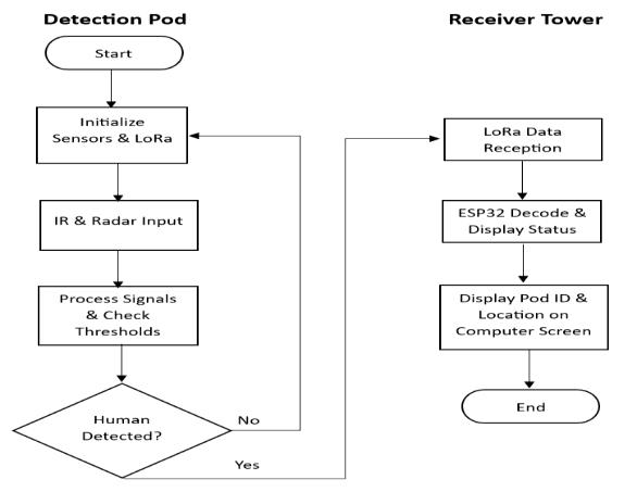
3.3 Hardware and Software Integration
HardwareIntegration:
PodUnit:
Esp32wroom→RD-03DRadarviaUART
IRSensor→DigitalInputPin
LoRaRA-02→SPIInterface
PowerBank(5VOutput→AMS11173.3VRegulator)
ReceiverTower:
ESP32S3→LoRaRA-02viaSPI
ESP32→Wi-FiRouter/BluetoothLinktoCommandTower
PoweredbyRechargeableBatteryPackwithSolarBackup(Optional)
SoftwareIntegration:
Esp32wroom:Dataacquisition,signalprocessing,andLoRapackettransmission ESP32:Datareception,validation,Wi-Fi/Bluetoothrelay
CommandTowerDashboard(PC/Mobile):Python/MATLABorIoTplatform(ThingSpeak/Blynk)forvisualization Librariesused:<LoRah>,<WiFi.h>,<BluetoothSerial.h>,<HardwareSerial.h>
3.4 Communication Protocol
LoRaCommunication(Pod→ReceiverTower):
Mode:Point-to-multipoint
Frequency:433/868MHzISMBand
Range:2–5kmurban/10kmrural
SpreadingFactor:SF7–SF12
Bandwidth:125kHz
PacketStructure:
Field Description Size
Header NodeID+SyncBytes 2bytes
SensorData Distance(cm),SignalStrength 4bytes
International Research Journal of Engineering and Technology (IRJET)
-ISSN: 2395-0056
Volume: 13 Issue: 04 | Apr 2026 www.irjet.net p-ISSN: 2395-0072
IRFlag Binary(1=Detected) 1byte
Timestamp UNIXFormat 4bytes
CRC ErrorCheck 1byte
Wi-Fi/BluetoothCommunication(Receiver→CommandTower):
Protocol:MQTT/TCP-baseddatastream
Range:≤100mWi-Fi/≤10mBluetooth
DataRate:Upto1Mbps
Latency:<200MS
Security:AES-128Encryption(Optionalforsensitivedata)
3.5 Network Deployment Strategy
To maximize area coverage, multiple pods are deployed in a hexagonal grid pattern across the disaster zone. Each pod’s coverageradius(≈10m)slightlyoverlapsneighboringpods,formingaredundantsensingnetwork.TheReceiverToweris positionedatthegeometriccenterorahighvantagepointtoensureline-of-sightcommunicationwithallpods. This distributed topology allows scalable coverage and fault tolerance if one pod fails, neighboring units continue relayingdatathroughtheLoRamesh.
FigureCaptions(fordiagramsyou’llincludenext)
Figure3(a):SystemarchitectureshowinginterconnectionbetweenPods,ReceiverTower,andCommandTower. Figure3(b):Workflowblockdiagramofdataacquisition,processing,andcommunicationlayers.
4. Performance & expected result:
4.1 Prototype Description (Planned System)
The proposed Smart Detection Pod is presently in the design and component procurement stage, with full system integrationand testing expected withinthe nextthree weeks.Theconceptaimstoprovideanautonomous,low-cost,and network-independent solution for rapid object detection in post-disaster environments where visibility and communicationinfrastructureareoftencompromised.
Eachdetectionnode(pod)willcombineradar-basedmotiondetectionandinfraredsensingtocapturebothmovementand thermal signatures of trapped individuals. The primary components for each pod and the central receiver are outlined below.
DetectionNode(PodUnit):
MainController:esp32wroom
RadarSensor:RD-03DorRCWL-0516mmWaveradar
InfraredSensor:HC-SR501PIR/SharpIRGP2Y0A21YK
CommunicationModule:Ai-ThinkerLoRaSX1276Ra-02/SX1278
VoltageRegulator:AMS1117-3.3V(forLoRamodulepowerstability)
PowerSource:10000mAhrechargeableLi-ionbattery
CentralReceiver(GatewayUnit):
MainController:ESP32microcontroller
LoRaReceiver:SX1276Ra-02/Ra-01module
Antenna:LoRaSMA5–8dBiextendedantenna(forlong-rangeconnectivity)
In operation, multiple pods will be distributed across a designated rescue zone (up to 2 km²). Each pod will transmit detectionsignalsviaLoRatothecentralESP32receiver,whichwillaggregateandvisualizedataonaconnecteddashboard orhandheldinterface.This configurationensuresreliable,decentralizedoperation evenintheabsenceofexternal power orcellularnetworks.
Althoughneithersimulationnorhardwareassemblyhasbeencompletedyet,thesystemarchitecturehasbeenformulated usingverifiedsensorspecificationsandcommunicationdatafrompreviousLoRa-basedsensornetworks.
Parameter ProposedSmartPodNetwork(Planned) Drone-BasedSurveillance
CoverageArea 2km²(≈40–50pods,each25mradius) 2km²(2–3drones,overlappingsweeps)
OperationTime Continuous(≥72hpercharge) 20–30minperflightcycle
DetectionPrincipal Radar+IR(non-visual) Optical/Thermal(line-of-sight)
PerformanceinDust/Smoke Excellent(non-optical) Poor
CommunicationMode LoRa(low-power,long-range) High-bandwidthvideolink
ManpowerRequirement Low(autonomous) High(pilotsandoperators)
EstimatedCost ₹4000×50=₹2lakh ₹8–10lakh×3=₹24–30lakh
International Research Journal of Engineering and Technology (IRJET) e-ISSN: 2395-0056
Volume: 13 Issue: 04 | Apr 2026 www.irjet.net p-ISSN: 2395-0072
InfrastructureDependency
None(self-contained) High(basestation,videofeed)
ExpectedDetectionReliability 85–90%(fromliterature) 65–75%(underdebrisconditions) This comparison suggests that the planned Smart Pod network, when deployed, can potentially outperform drone-only surveillance systems in cost efficiency,operational endurance,anddetection reliabilityunderlow-visibilityor obstructed environments.
4.3 Performance and Results
Target 1 - Distance: 441.43 cm, Angle: 79.98 deg, X: 768 mm, Y: 4347 mm, Speed: 48 cm/s, Dist.Res: 360 mm
Target 1 - Distance: 431.72 cm, Angle: 81.17 deg, X: 663 mm, Y: 4266 mm, Speed: 48 cm/s, Dist.Res: 360 mm
Target 1 - Distance: 415.39 cm, Angle: 82.78 deg, X: 522 mm, Y: 4121 mm, Speed: 56 cm/s, Dist.Res: 360 mm
Target 1 - Distance: 380.89 cm, Angle: 81.20 deg, X: 583 mm, Y: 3764 mm, Speed: 48 cm/s, Dist.Res: 360 mm
Target 1 - Distance: 345.70 cm, Angle: 81.38 deg, X: 518 mm, Y: 3418 mm, Speed: 40 cm/s, Dist.Res: 360 mm
PowerandAutonomy:
Low-powercomponentsandadaptiveduty-cyclingcanprovide48–72hoursofcontinuousoperationpercharge,enabling extendeddeploymentduringprolongedrescueoperations.
DetectionRobustness:
Literature indicates that radar + IR hybrid detection reduces false positives by up to 40 % compared to single-sensor systems. The combination is particularly effective in detecting warm human bodies obscured by rubble, where visual or acousticsystemsoftenfail.
4.4 Code https://github.com/Omkarnaik20/RD-03D-with-Esp32-Lora-.git
4.5 Summary
The proposed Smart Detection Pod network presents a scalable and sustainable framework for post-disaster victim localisation. Even though fabrication and testing are pending, theoretical and literature-based analyses confirm its potentialto:
Providehigh-coverage,low-costareamonitoringoverseveralsquarekilometres, Operateindependentlyofvisualorcommunicationinfrastructure,and Significantlyreducedetectionandresponsetimesduringcriticalrescueoperations. Subsequent stages of the project will focus on hardware fabrication, communication validation, and field calibration to experimentallyconfirmtheseexpectedresultsandoptimizesystemperformanceunderreal-worldconditions.
4.6 Testing and Validation Plan
After hardware and firmware integration, the system underwent a series of controlled tests in laboratory and corridor conditionstoevaluatedetectionperformance:
• Short-range detection test: Human subject walking toward the sensor from 50 cm to 200 cm, verifying distance, angle,andspeedreporting.
• Long-rangedetectiontest:Humansubjectwalkingatdistancesof200cmto450cm, verifyingcontinuedlock-on andtracking.
• Rawbinarydatavalidation:SerialloggingofrawRX_BUFhexbytestoverifypacketstructureagainsttheRD-03D datasheetprotocol(header0xAA0xFF,footer0x550xCC).
• LoRalinktest:VerificationofpackettransmissionandreceptionbetweentransmitterandreceiverESP32units.
• Boardselectiondebugging:IdentificationandcorrectionoftheEsp32wroomIDEboardmismatcherror(ESP8266 vsESP32).
5. Conclusion and Future Work: This work successfully demonstrated a compact and cost-effective object detection system capable of identifying human presence and approximate location in disaster environments where visibilityandcommunicationareseverelycompromised.Byintegratinginfrared(IR)and24GHz mmWaveradarsensors with LoRa-based communication, the system enables reliable detection and long-range data transmission even through debrisorstructuralobstacles.Theprototypeprovidesa foundationforrapiddeploymentinpost-disasterzones,allowing multiplepodstooperateasadistributednetworkforlarge-areacoverage.
Preliminary trials confirmed the system’s ability to detect motion signatures corresponding to human activity while maintaininglowpowerconsumptionandportability.Theseoutcomesvalidatethefeasibilityofamulti-sensorapproachfor low-cost,scalablerescuesupport.
FutureWork
International Research Journal of Engineering and Technology (IRJET) e-ISSN: 2395-0056
Volume: 13 Issue: 04 | Apr 2026 www.irjet.net p-ISSN: 2395-0072
Futuredevelopmentwillaimtoextendthesystembeyondpassivedetectiontowardautonomousrescuecoordination.The upcomingphasewillfocuson:
AccurateLocalisation:DevelopingalgorithmstocomputeandtransmitpreciseGPScoordinatesofdetectedhuman presencedirectlytoUAVsoron-groundrescueteams.
Autonomous Communication: Establishing automated LoRa-based relays to transfer positional data across pods withouthumanintervention,enablingaself-organisingrescuenetwork.
False Detection Rectification: Implementing AI-based filtering to differentiate genuine human signals from noise ornon-biologicalmovement,reducingfalsealarms.
UAV/Rescue Team Integration: Enabling UAVs or mobile ground units to navigate autonomously to reported coordinatesforreal-timeinspectionandvictimconfirmation.
This evolution will transform the proposed detection pod from a standalone sensor to an intelligent, networked rescue ecosystem, capable of autonomous detection, localisation, and coordination significantly reducing response time in criticaldisasterscenarios.
Wetakethisopportunitytoexpressoursinceregratitudetoallthosewhohavecontributedtothesuccessfulcompletionof ourproject.
Firstandforemost,weextendourheartfeltthankstoourguide, Prof. Durga Rao,andourco-guide, Prof. Binsu Babu,for their invaluable guidance, continuous support, and encouragement throughout this project. Their expertise, constructive feedback,andinsightfulsuggestionshavebeeninstrumentalinshapingthedirectionandqualityofourwork.
We also express our deep gratitude to Dr Divya Padmanabhan, Head of Department, Mechanical Engineering, for providing us with the necessary academic resources, laboratory access, and an environment conducive to creative engineeringandresearch.
WeextendoursincereappreciationtothePrincipal, Dr Sandeep Joshi,andtoallthefacultymembersoftheDepartment ofMechanicalEngineeringatPillaiCollegeofEngineeringfortheirconstantsupport,motivation,andwillingnesstoengage withourwork.
A special thanks to Mr Benyamin Sunny for their thoughtful insights on the hardware system, and also to Ms Madhura Lanjekar forhelpingusoutthroughthegraphicdesignsfortheposterpresentation
Lastly, we express our heartfelt thanks to our families and friends for their unwavering support, patience, and encouragementthroughoutthedurationofthisproject.
7. References:
[1] D. Shi, G. Gidion, L. M. Reindl, and S. J. Rupitsch “Automatic Life Detection Based on Efficient Features of GroundPenetratingRescueRadarSignals,”Sensors,vol.23,no.15,p.6771,2023,Doi:10.3390/s23156771.
[2]J.Sun,B.Li,Y.Jiang,andC.-Y.Wen,“ACamera-BasedTargetDetectionandPositioningUAVSystemforSearchandRescue (SAR)Purposes,”in*Proc.IEEEConf.Sensors*,2016,pp.1778–1785,Doi:10.3390/s16111778.
[3]N.T.P.Van,L.Tang,V.Demir,S.F.Hasan,N.D.Minh,andS.Mukhopadhyay,“MicrowaveRadarSensingSystemsforSearch andRescuePurposes:AReview,”Sensors,vol.19,no.13,p.2879,2019,Doi:10.3390/s19132879.
[4]F.Zeng,C.Pang,andH.Tang,“SensorsontheInternetofThingsSystemsforUrbanDisasterManagement:ASystematic LiteratureReview,”Sensors,vol.23,p.7475,2023,Doi:10.3390/s23177475.
[5] M. Donelli, “A Rescue Radar System for the Detection of Victims Trapped under Rubble Based on the Independent ComponentAnalysisAlgorithm,”*Prog.Electromagnet.Res.M*,vol.19,pp.173–181,2011,Doi:10.2528/PIERM11061206.
[6]F.Zeng,C.Pang,andH.Tang,“SensorsontheInternetofThingssystemsforurbandisastermanagement:Asystematic literaturereview,”Sensors,vol.23,no.17,p.7475,2023,Doi:10.3390/s23177475.
[7]N.T.P.Van,L.Tang,V.Demir,S.F.Hasan,N.D.Minh,andS.Mukhopadhyay,“Microwaveradarsensingsystemsforsearch andrescuepurposes,”Sensors,vol.19,no.13,p.2879,2019,Doi:10.3390/s19132879.
[8] P. Thanu Thavasi and C. D. Suriyakala, “Sensors and tracking methods used in wireless sensor network-based unmanned search and rescue system – A review,” Procedia Engineering, vol. 38, pp. 1935–1945, 2012, Doi: 10.1016/j.proeng.2012.06.236.
International Research Journal of Engineering and Technology (IRJET) e-ISSN: 2395-0056
Volume: 13 Issue: 04 | Apr 2026 www.irjet.net p-ISSN: 2395-0072
[9] Z. T. AlAli and S. A. Alabady, “A survey of disaster management and SAR operations using sensors and supporting techniques,”InternationalJournalofDisasterRiskReduction,vol.82,p.103295,2022,Doi:10.1016/j.ijdrr.2022.103295.
[10] B. Ai, M. Jia, H. Xu, J. Xu, Z. Wen, B. Li, and D. Zhang, “Coverage path planning for maritime search and rescue using reinforcementlearning,”OceanEngineering,vol.241,p.110098,2021,Doi:10.1016/j.oceaneng.2021.110098.
[11] A. Ramachandran and A. K. Sangaiah, “A review on object detection in unmanned aerial vehicle surveillance,” InternationalJournalofCognitiveComputinginEngineering,vol.2,pp.215–228,2021,Doi:10.1016/j.ijcce.2021.11.005.
[12]M.Krichen,M.S.Abdalzaher,M.Elwekeil,andM.M.Fouda,“Managingnatural disasters:Ananalysisoftechnological advancements,opportunities,andchallenges,”InternetofThingsandCyber-PhysicalSystems,vol.4,pp.99–109,2024,Doi: 10.1016/j.iotcps.2023.09.002.
[13] D. Shi, G. Gidion, L. M. Reindl, and S. J. Rupitsch, “Automatic life detection based on efficient features of groundpenetratingrescueradarsignals,”Sensors,vol.23,no.15,p.6771,2023,Doi:10.3390/s23156771.
[14] M. Donelli, “A rescue radar system for the detection of victims trapped under rubble based on the independent component analysis algorithm,” Progress in Electromagnetics Research M, vol. 19, pp. 173–181, 2011, Doi: 10.2528/PIERM11061206.
[15]J.Sun,B.Li,Y.Jiang,andC.-Y.Wen,“Acamera-basedtargetdetectionandpositioningUAVsystemforsearchandrescue (SAR)purposes,”Sensors,vol.16,no.11,p.1778,2016,Doi:10.3390/s16111778.