
International Research Journal of Engineering and Technology (IRJET) e-ISSN: 2395-0056
Volume: 13 Issue: 04 | Apr 2026 www.irjet.net p-ISSN: 2395-0072

International Research Journal of Engineering and Technology (IRJET) e-ISSN: 2395-0056
Volume: 13 Issue: 04 | Apr 2026 www.irjet.net p-ISSN: 2395-0072
Nikhil Mahankali1 , B.Vamshi2 , N.Amulya3 , B.Mamatha4
1Student, Department of Computer Science and Engineering, Geethanjali College of Engineering and Technology, Telangana, India
2Student, Department of Computer Science and Engineering, Geethanjali College of Engineering and Technology, Telangana, India
3Student, Department of Computer Science and Engineering, Geethanjali College of Engineering and Technology, Telangana, India
4Assistant Professor, Department of Computer Science and Engineering, Geethanjali College of Engineering and Technology, Telangana, India
Abstract - The crime monitoring of the city is an important aspect of the smart city infrastructure. Nonetheless, the majority of available crime visualization systems offer only comparatively inert mapping, but lack dynamically forceful analysis, predictive intelligence, or even risk-conscious decision-support. In this paper, the author introduces CrimeScope, a framework of event-driven geospatial crime analytics to improve safety in cities by broadcasting real-time alerts, developing hybrid risk models, and usingoptimalroutingstrategies. Thesuggested system incorporates RESTful APIs, event streaming via WebSockets, spatial density estimation, time-based trend analysis, and hotspots detection by sentiment in a modular full-stack system. A composite risk formulation of crime based on spatial density, temporal frequency ratios and sentiment polarity weighting is introduced. Low-latency alert propagation ( Less than 850 ms), effective API response time ( Less than 120 ms) and predictable shortterm risk trend evaluation have been experimentally evaluatedonsimulateddatasetsofurbanenvironments.The findings show that event-driven architectures with hybrid modeling is much better at situational awareness than the conventional solid crime systems. The framework facilitates its extension to intelligent urban governance and datadrivensafetyplanning.
Key Words: Crime Analytics, Event-based Systems, Geospatial Intelligence, Risk Modelling, Predictive Analytics, Smart Cities.
The fast urbanization and population growth has posed greatchallengesinthepreservationofthecommonsafety inthecontemporarycities. Crime eventsaredynamicand tend to be concentrated in space and time, and hence, proactive crime prevention cannot be done through the existing traditional statistical reporting. Traditional crime surveillancetoolsaremainlybasedonanalyzingpastdata and providing fixed reports restricting the possibilities of real-time decision-making and predicting. Effective crime
analysis has new possibilities due to recent progress in Machine Learning (ML) and geospatial analytics. The ML algorithmshavethecapabilitytoextractconcealedtrends on vast crime datasets and anticipate the possible risks amounts depending on the historical trends. These methods can be used to monitor proactively and handle urban safety better in combination with real-time communication systems and interactive dashboards, as some studies have investigated the classification models, including Random Forest, Decision Trees, and Support Vector Machines, as the models to predict crime. Nevertheless, most of the current systems are mainly concerned with offline analysis and do not have real-time alerting, interactivity at visualization and risk-aware features like the safe route planning. Thus, we have the need to come up with an integrated platform, a platform that can bring together predictive intelligence, geospatial visualization, and live monitoring in an integrated platform. The proposed paper is a City Safety Intelligence Platform, a real time crime analysis and prediction framework that is being developed using FastAPI framework at the backend and a React based frontend. The system combines a prediction model based on the Random Forest algorithm and geospatial heatmap to identify hotspots and a notification system based on a WebSocket to send real-time alerts. Moreover, the riskconscious route planning module proposes safer travel routes by circumventing high-crime areas; experimental analysis reveals that the proposed model is effective to predict the high-risk areas, and the system as a whole is scalable and viable in solving crime monitoring and proactivesafetymanagementinsmartcities.
Machine learning, deep learning, and spatio-temporal modeling methods have thrown a lot of light on crime prediction. There are different studies that have been carriedouttoinvestigatepredictivemodelstounderstand crimepatternsandpredictthefuturetrends.
International Research Journal of Engineering and Technology (IRJET) e-ISSN: 2395-0056
Volume: 13 Issue: 04 | Apr 2026 www.irjet.net p-ISSN: 2395-0072
The researchers of Safat et al. [1] implementednumerousmachinelearninganddeepneural network, such as Random Forest, SVM, XGBoost, LSTM, and ARIMA on large-scale crimes data. Their findings showedthatXGBoostperformedwellinclassification,and LSTMcanwellmodelthetemporalrelationship.Equally,Li et al. [5] suggested a CNN-LSTM hybrid model to predict trends in spatio-temporal crime forecasting, and they showed better results, when crime-related data were divided into convenient intervals. Their BiLSTM-CNN model was able to extract crime-related events in the textualdataandtheyenhancedtheprecisionofprediction whenjoinedwiththesocio-economicfactors.Asystematic review of crime prediction methods also showed the efficiency of the ensemble learning and deep learning methodsasemphasizedbyMandalapuetal.[9].
The time-series forecasting techniques have also been extensively studied. The effectiveness of the ARIMA model in predicting trends of crime was proved by Lu [10], and Box et al. [8] have defined ARIMA as the basis of time-series prediction. Geospatial and routing-based techniques are also improved in order to improvethesafetyoftheusers[11].Thehybridtechniques that are used to predict the route are based on a combination of statistical and machine learning techniques. Pindarwati and Wijayanto [3] suggested a safety conscious route recommendation module that avoidscrimehotspotswiththehelpofgeospatialdata.On the same note, spatial-temporal models focus on the significance of spatial-temporal characteristics in predicting crime effectively [13].Big data analytics and visualization techniques have also been utilised in the recent studies. Feng et al. [12] were able to visualize and predict crime on large scale crime data. Also, there is literature [15] that ensemble approaches like Random Forest [6] have solid and trustworthy performance.Even though these developments are in place, the majority of currentsystemsconcentrateonprediction,forecasting,or visualization as isolated entities. Given that, machine learning, real-time alerts, geospatial visualization, and safety-aware routing are limitedly combined within the same system. It is the gap that the proposed framework addresses.
1.1
The suggested City Safety Intelligence Platform is a multilayeredintelligentsystemtoanalyze,predict,andvisualize the crime patterns in real time. The system consists of machine learning models, time-series forecasting, natural language processing, geospatial analytics, and real-time communication mechanisms to deliver proactive crime monitoring and decision support. Layered architectural design is employed so as to ensure that it is modular, scalable, and data flow in between the components is
smoother.Thestructurecomprisesofthefivelargelayers: User Layer, Presentation Layer, Application Layer, AnalyticsandIntelligenceLayerandDataLayer.
The architecture is designed using a structured layered design to isolate responsibilities and improve maintainabilityofthesystem.
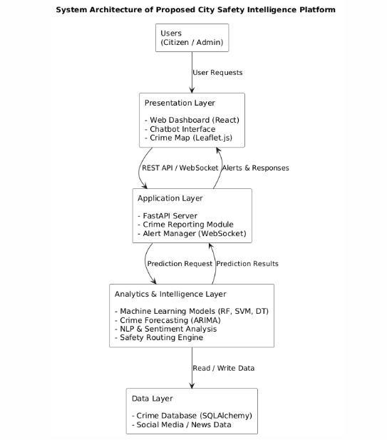
Fig.1.SystemarchitectureoftheproposedCitySafety IntelligencePlatformshowinglayereddesignanddata flow.
The User Layer comprises citizens/general users and the administrative users. Users are able to watch crime maps, report crimes, design safer paths and get real-time notifications about high-risk areas via the web-based interface.
The Presentation Layer consists of a React-based Web Dashboard, a chatbot interface and a crime visualization module deployed through Leaflet.js. This layer offers interactivevisualizationofcrimehotspots,crimepast,and futureoutputsmadebytheanalyticsengine.
Data Layer handles structured and unstructured sources of data. A relational database based on SQL Alchemy ORM is used to store historical crime records as well as crime incidents reported by users. Besides, social mediaand newsdataintheformoftextaregatheredand processedintermsofsentimentandeventanalysis.
International Research Journal of Engineering and Technology (IRJET) e-ISSN: 2395-0056
Volume: 13 Issue: 04 | Apr 2026 www.irjet.net p-ISSN: 2395-0072
4) Analytics & Intelligence Layer.
This layer is the intelligence of the system. It has machinelearning-basedpredictionmodel(RandomForest) to classify crime risk and ARIMA model to provide timeseriesforecasting,eventextractionandsentimentanalysis based on NLP and a safety routing module. The analytics engine will accept the input of historical and real-time data expecting to predict the level of risk, high-crime zones,andthefuturecrimepatterns.
5) Application Layer
Application Layer is applied with FastAPI backend server. It responds to API requests, processes userreported data, spawns predictive models, and handles real-time notifications over WebSocket communication There is a community alert module that alerts in case the high-riskconditionsareidentified.
Theproposedsystemapproachiscomprisedofaseries of steps that consist of data collection, preprocessing, feature extraction, model training, prediction and visualization.Theindividualsenlistedforthestudywillbe contactedviaemailsandinterviews.
1) Data Collection and Preprocessing
The people who will be enlisted to participate in the study will be approached through emails and interviews. Available crime statistics are obtained by use of publicly accessible crime data, self-reported crime cases, and external written materials like social media and news outlets. Preprocessing phase involves the processing of missing data, duplication of data, coding of categorical data and normalizing of numerical data. To objectively determine the performance of the models, the dataset is separatedintotwosets,trainingandtestingsets,in80:20 split. The extracted relevant features are crime type, geographic coordinates (latitude and longitude), date and time,frequencycountandsentimentscoresbasedontexts.
2) Crime Prediction Model
A machine learning model that is based on a Random Forest is used to categorize the levels of crime risks Random Forest was found to have better performance since it has the capability of ensemble learning and it is alsoresistanttooverfitting.RandomForestpredictioncan berepresentedwiththefollowingformula:
��^=majority_vote(��1(��),��2(��),...,����(��)) where����(��)rpresentsindividualdecisiontreesandthe finalpredictionisdeterminedbymajorityvoting. Standard measurements are used to measure model performance.Accuracyiscalculatedas:

Accuracy= whereTP,TN,FP,FN mean true positives, true negatives, false positives and falsenegativesrespectively.
3) ARIMA based crime forecasting.
The AutoRegressive Integrated Moving Average ARIMA(p,d,q)isusedtopredictthefuturetrendsofcrime. This model represents time-dependent relationships in series of crime counts and how they are likely to happen again.
TheoverallARIMAmodelisgivenas:
= where����isthepredictedvalueattimet, cisaconstantterm, ϕ_irepresentsautoregressivecoefficients,and θ_i representsmovingaveragecoefficients.
4) NLP-Based Event Extraction and Sentiment Analysis
The textual data of the news, social sites are analyzed with Natural Language Processing to improve the prediction of intelligence. The preprocessing pipeline consists of the text cleaning, tokenization, removing stopwords, and the vectorization. Sentiment analysis gives polarityvaluestoeventsextractedincasesthatarerelated tocrime,whichareincludedintheclassificationmodel as extrapredictivevariables.
5) Safety Routing Mechanism
This system combines crime hotspots analysis and route planning in order to suggest safe travel routes. Crime ratesare represented in the form of heatmaps,and every area is rated on the levels of risk according to historicaloccurrencesandforecastingpotential.
Theroutingcostoperationisadjustedto:
Cost=Distance+λ(CrimeRiskScore) where λ is a weighting parameter that balances travel efficiency and safety preference. This makes sure that routes going through the high-risk areas are more expensiveandavoidedwhencalculatingthepaths.
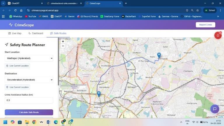
Fig. 2. Safety-aware route planning module suggesting optimalpathsavoidinghigh-crimeareas.
6) Real-Time Alert System
WebSocket communication between the backend and the frontend is used to implement a real time alert mechanism. The threshold is an established value when theforecastedriskofcrimeismorethanthethreshold.
τ,i.e., Risk>τ
Volume: 13 Issue: 04 | Apr 2026 www.irjet.net
The system automatically sends notifications to the users. The alerts are also shown on the dashboard and indicatedonthecrimemaptomakesurethatoneisaware todosoimmediately.
This systematic approach is a guarantee of the unified framework that integrates predictive modeling, forecasting, visualization, and proactive alerting on improvedurbansafetymanagement..
A. Experimental Setup
The system was evaluated using historical crime data along with user-reported incidents. After preprocessing (handling missing values, duplicates, and feature extraction), the dataset was split into training and testing setsinan80:20ratio.Thebackendwasimplementedusing FastAPI, and the frontend dashboard was used for visualization and real-time interaction. Experiments were conductedinasimulatedurbanenvironment.
B. Model Performance
A Random Forest model was used for crime risk classification and achieved an accuracy of approximately 90%. The ensemble approach improved prediction stability and reduced overfitting, making it effective for identifyinghigh-riskareas.
C. Forecasting Analysis
The ARIMA model was applied to analyze temporal crime patterns. It effectively captured short-term trends andseasonalvariations.Theforecastedcrimetrendsalong withupperandlowerconfidenceboundsareshowninFig. 5.
D. System Visualization and Outputs
The system provides interactive visualizations for betterunderstandingofcrimepatterns.
The live crime map (Fig. 3) shows real-time incidents and hotspot distribution. The dashboard (Fig. 4) presents summarized analytics such as crime counts and distribution. The ARIMA forecast (Fig. 5) presents predicted crime trends along with upper and lower confidenceintervals,providinguncertaintyestimation.
Additionally, the safety-aware route planning module suggestsoptimalpathsavoidinghigh-riskareas,asshown earlierinFig.2.
Overall, the system integrates real-time visualization, prediction, and routing to support proactive safety management.
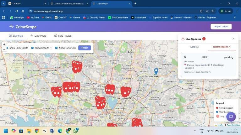
Fig.3.Livecrimemapdisplayingreal-timecrime incidentsandgeospatialdistributionofhotspots.

Fig.4.Crimeanalyticsdashboardshowingsummary statistics,crimecounts,andsysteminsights.
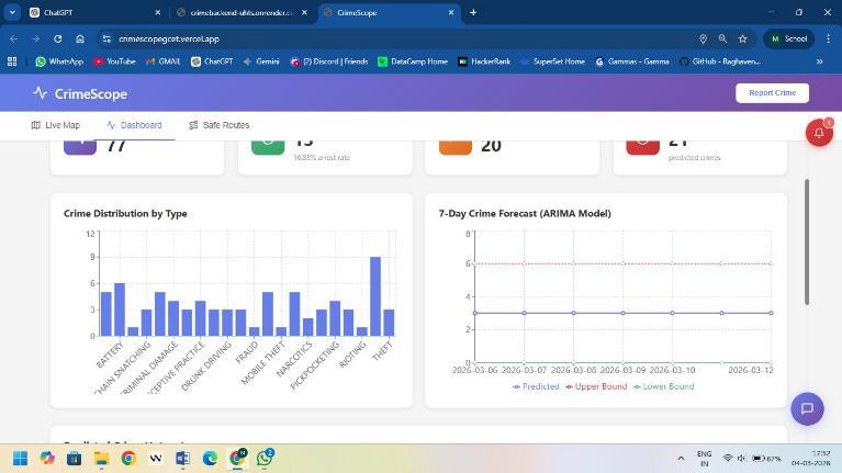
Fig.5.Crimedistributionbytypeand7-daycrime forecastusingARIMAmodel.
The elements of visualization enhance interpretability, whereas the alert system helps the user to be aware of high-riskconditionsinstantly.
5. CONCLUSION
The paper introduced a City Safety Intelligence Platform whichisananalysis,predictionandvisualsystemofcrime patterns based on machine learning and time-series predictionandgeospatialanalytics.Theproposedsolution incorporates crime information processing, prediction
International Research Journal of Engineering and Technology (IRJET) e-ISSN: 2395-0056
Volume: 13 Issue: 04 | Apr 2026 www.irjet.net p-ISSN: 2395-0072
model based on the Random Forest, ARIMA-based prediction,NLP-basedsentimentanalysis,safetyconscious routes of traffic as well as real time message alerts into a layeredframework.
The outcome of the experiment proves that the adopted predictionmodelcanbeusedtodeterminehigh-riskareas withhighaccuracyaccuracy.TheARIMAmodeliseffective atmodelingseasonaltrendsincrimeandassuchitallows crime patterns to be expected over a short term. The use of crime heatmaps and risk-based routing makes the system more usable as it assists in safer decision-making. Moreover,thealertsystem,whichisbasedonWebSockets, allows updating users with the real-time notification, makingthemmoreawareofthepossiblerisks. Theframeworksuggestedisapracticalandscalablemodel towards monitoring the safety in the urban areas. The system aids in proactive decision-making of both citizens and the administration by applying predictive analytics withvisualizationandreal-worldcommunication. To enhance the accuracy of prediction in further work, more machine learning and deep learning models like SupportVectorMachinesandLSTMnetworkscanbetried to use in the future. System responsiveness can be improvedwiththeintegrationofreal-timesourcesofdata, including live police feeds and monitoring systems based onIoT.Moreover,thesystemcanbescaledandadaptedby introducing better graph-based routing algorithms and deploymenttothemulti-city.
[1]W.Safat,S.Asghar,andS.A.Gillani,“Empiricalanalysis for crime prediction and forecasting using machine learning and deep learning techniques,” IEEE Access, vol. 9,pp.70080–70094,2021.ReadPaper
[2] S. Han, H. Huang, J. Liu, and S. Xiao, “American hate crime trends prediction with event extraction,” arXiv:2111.04951,2021.
[3] A. Pindarwati and A. W. Wijayanto, “Personalized safety route recommender application using integrated urbancrimehotspotdata,”Proc.SPIE,2019.
[4] H. M. P. Morales et al., “COVID-19 in Brazil Preliminary analysis of response supported by artificial intelligence,”FrontiersinDigitalHealth,2021.
[5] M. Li et al., “Crime forecasting: A spatio-temporal analysis with deep learning models,” arXiv:2502.07465, 2024.
[6] L. Breiman, “Random forests,” Machine Learning, vol. 45,no.1,pp.5–32,2001.
[7] C. Cortes and V. Vapnik, “Support-vector networks,” MachineLearning,vol.20,no.3,pp.273–297,1995.
[8] G. Box et al., Time Series Analysis: Forecasting and Control,5thed.,Wiley,2015.
[9] V. Mandalapu et al., “Crime prediction using machine learning and deep learning: A systematic review,” IEEE Access,2023.
[10]Y.Lu, “Crime predictionutilizingARIMAmodel,”BCP Business&Management,2023.
[11] M. Boni and M. Gerber, “Area-specific crime predictionmodels,”IEEEICMLA,2016.
[12]M.Fengetal.,“Bigdataanalyticsforvisualizationand forecastingofcrimedata,”IEEEAccess,2019.
[13] U. M. Butt et al., “Spatio-temporal crime prediction usingAI,”IEEEAccess,2021.
[14] A. Singh and S. Goswami, “Crime rate prediction frameworkusingmachinelearning,”IJARMT,2025.
[15] “Artificial intelligence & crime prediction: A systematicliteraturereview,”ScienceDirect,2022.