
International Research Journal of Engineering and Technology (IRJET) e-ISSN: 2395-0056
Volume: 13 Issue: 04 | Apr 2026 www.irjet.net
p-ISSN: 2395-0072

International Research Journal of Engineering and Technology (IRJET) e-ISSN: 2395-0056
Volume: 13 Issue: 04 | Apr 2026 www.irjet.net
p-ISSN: 2395-0072
1Student, Dept. Civil Engineering, Maharaja institute technology Thandavapura, Karnataka, India
2 Student, Dept. Civil Engineering, Maharaja institute technology Thandavapura, Karnataka, India
3 Student, Dept. Civil Engineering, Maharaja institute technology Thandavapura, Karnataka, India
4 Assistant Professor, Dept. Civil Engineering, Maharaja institute technology Thandavapura, Karnataka, India
Abstract - Stormwater drainage systems play a crucial role in preventing urban flooding and maintaining environmental sustainability. Rapid urbanization in Mysuru city has led to increased surface runoff and frequent waterlogging, especially in low-lying areas. This study presents a condition assessment and GIS-based mapping of the stormwater drainage network using field survey, QGIS, and SWMM modelling.
A total of 96 drainage sections were surveyed and classified based on physical condition and hydraulic performance. The results indicate that approximately 25% of drains are in good condition, 23% are moderate, and 52% are in poor condition, highlighting significant deterioration in the drainage network.
GIS-based thematic maps were developed to spatially represent the condition of drains and identify critical zones. Further, SWMM simulations were carried out using average rainfall data of Mysuru to evaluate hydraulic performance. The results indicate overflow and surcharging in several low-lying areas, confirming inadequate drainage capacity.
The study demonstrates that integration of GIS and SWMM provides an effective and low-cost approach for urban drainage assessment and flood mitigation planning. The findings can assist municipal authorities in prioritizing maintenance and improving stormwater management strategies.
Key Words: Stormwater Drainage, GIS Mapping, SWMM, Urban Flooding, Mysuru, Drainage Assessment.
Urban stormwater drainage systems are essential for managing surface runoff and preventing flooding in rapidly developing cities. With increasing urbanization, natural infiltration has significantly reduced due to the expansion of impervious surfaces such as roads, pavements, and buildings. This results in higher runoff volumes and peak flows, putting pressure on existing drainage infrastructure. Mysuru city has been experiencing frequent waterlogging and localized flooding, particularly in low-lying areas during monsoon seasons. These issues are primarily caused by inadequatedrainagecapacity,siltation,solidwastedumping, and lackofproper maintenance. Inaddition, theabsence of updated spatial data and systematic documentation ofdrainagenetworksmakesitdifficultforauthoritiestoassess and managethesystemeffectively.
Traditional methods of drainage assessment are time-consuming and lack spatial accuracy. The integration of Geographic Information System (GIS) provides an efficient solution by enabling the collection, analysis, and visualization of drainage data in a spatial environment. GIS helps in identifying critical areas, understanding drainage patterns,andsupportingdecision-making.
Further,hydraulicmodellingusingtheStormWaterManagementModel(SWMM)allowsevaluationofdrainagesystem performanceunderdifferentrainfallconditions.Ithelpsinidentifyingoverflowpoints,surchargingconduits,andfloodpronezones.
In this study, a combined approach of field survey, GIS mapping, and SWMM modelling is used to assess the condition andperformanceofstormwaterdrainsinselected low-lyingareasofMysurucity.Atotalof96drainsweresurveyedand
International Research Journal of Engineering and Technology (IRJET) e-ISSN: 2395-0056
Volume: 13 Issue: 04 | Apr 2026 www.irjet.net p-ISSN: 2395-0072
classified based on their physical condition and hydraulic performance. The study aims to identify critical drainage issuesandprovideinsightsforimprovingurbanstormwatermanagement.
The methodology adopted in this study consists of field survey, GIS-based mapping, and hydraulic modelling using SWMM.
Initially, selected low-lying areas of Mysuru city were identifiedfordetailedanalysis.Afieldsurveywasconducted using GPS-enableddevicestocollectdataondraindimensions,condition,andflowcharacteristics.
The collected data were processed using QGIS to create a spatial database and thematic maps. Drains were classified intoGood,Moderate,andPoorcategoriesbasedonphysicalcondition,blockagelevel,andhydraulicperformance. Further, the Storm Water Management Model (SWMM) was used to simulate the hydraulic behavior of the drainage network. Averagerainfall dataof Mysuru wasused asinput for the model. Sub-catchments, nodes, and conduits were defined,andsimulationswerecarriedouttoidentifyoverflowandfloodingconditions.
A total of 96 stormwater drains were surveyed and analysed for physical condition and hydraulic performance. Based on fieldobservations,thedrainagesystemwasclassifiedintothreecategories:Good,Moderate,andPoor.
Theanalysisshowsthat:
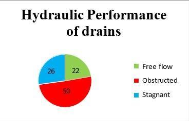
24drains(25%)areingoodcondition
22drains(23%)areinmoderatecondition
50drains(52%)areinpoorcondition
The high percentage of poorly maintained drains indicates severe issues such as siltation, blockage, structural damage, andimproperconnectivity.
GIS-based thematic mapping using QGIS helped in visualizing the spatial distribution of drainage conditions. It was observed that most of the poorly performing drains are concentrated in low-lying areas, making them highly vulnerabletowaterloggingduringrainfallevents.
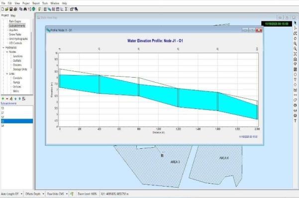
SWMM simulation was carried out using average rainfall conditions of Mysuru. The results revealed overflow and surcharginginseveralsectionsofthedrainagenetwork,confirmingthattheexistingsystemishydraulicallyinadequate inhandlingrunoff.
The combined analysis of field data, GIS mapping, and SWMM outputs clearly indicates the need for immediate maintenanceandupgradationofthedrainagesystem,particularlyincriticalzones.
International Research Journal of Engineering and Technology (IRJET) e-ISSN: 2395-0056
Volume: 13 Issue: 04 | Apr 2026 www.irjet.net p-ISSN: 2395-0072
The study highlights the critical condition of the stormwater drainage system in selected areas of Mysuru city. More than halfofthesurveyeddrainswerefoundtobeinpoorcondition,indicatingseveremaintenanceandstructural issues. GIS-basedmappingprovedtobeaneffectivetoolfor visualizingdrainageconditionsandidentifyingcriticalzones.SWMM simulations further confirmed that the existing drainage system is inadequate to handle current runoff conditions, resultinginoverflowinlow-lyingareas. The integration of field survey, GIS, and SWMM provides a reliable framework for urban drainage assessment. The results of this study can support municipal authorities in prioritizing maintenance, improving drainage design, and reducingurbanfloodingrisks.
[1]L. A. Rossman, “Storm Water Management Model User’s Manual Version 5.1,” U.S. Environmental Protection Agency (EPA),2015.
[2]J.MarsalekandB.Jimenez-Cisneros,“Urbanwatercycleprocessesandinteractions,”UNESCO,2014.
[3] S. Kumar and R. Singh, “GIS-based urban drainage analysis and mapping,” International Journal of Engineering Research&Technology,vol.6,no.5,pp.120–125,2017.
[4]A. Gupta and R. Agarwal, “Assessment of urban drainage systems using GIS techniques,” International Journal of Civil EngineeringResearch,vol.6,no.3,pp.233–240,2015.
[5]P.K.SwameeandA.K.Sharma,“Designofstormwaterdrainagesystems,”JournalofHydraulicEngineering, vol.134, no.2,pp.197–205,2008.
[6]QGISDevelopmentTeam,“QGISGeographicInformationSystem,”Open-SourceGeospatialFoundation,2023.
[7]S.T.SuribabuandT.V.V.S.S.Murthy,“StormwatermanagementusingSWMMmodel,”InternationalJournalofCivil EngineeringandTechnology,vol.8,no.4,pp.456–463,2017.
[8]Central Public Health and Environmental Engineering Organization (CPHEEO), “Manual on Storm Water Drainage Systems,”MinistryofUrbanDevelopment,GovernmentofIndia,2019.
2026, IRJET | Impact Factor value: 8.315 |
International Research Journal of Engineering and Technology (IRJET) e-ISSN: 2395-0056
Volume: 13 Issue: 04 | Apr 2026 www.irjet.net p-ISSN: 2395-0072
BIOGRAPHIES




NithinTSStudentCivilEngineeringDepartment MIT,ThandavapuraMysuru
YashwanthCSStudent
CivilEngineeringDepartment MIT,ThandavapuraMysuru
Manjunathaswamy Student
CivilEngineeringDepartment MIT,ThandavapuraMysuru
ManjunathGSAssistantprofessor
CivilEngineeringDepartmentMIT, ThandavapuraMysuru