
International Research Journal of Engineering and Technology (IRJET) e-ISSN: 2395-0056
Volume: 13 Issue: 03 | Mar 2026 www.irjet.net p-ISSN: 2395-0072

International Research Journal of Engineering and Technology (IRJET) e-ISSN: 2395-0056
Volume: 13 Issue: 03 | Mar 2026 www.irjet.net p-ISSN: 2395-0072
,
,
5, Yugandhar Deshmukh6
1IT Officer, Dept Of Information Technology, Nagpur Municipal Corporation , Maharashtra, India 23456UG student, Dept of Electronics and Telecommunication, KDK College of Engineering, Maharashtra, India
Abstract - Urban infrastructure management is a major challenge for growing cities, especially when it comes to maintaining underground drainage systems. Manual inspection of manholes is not only time-consuming but also risky and inefficient. This paper presents a smart solution for improvingthemonitoringandmaintenanceofmanholesusing modern technology for the Nagpur Municipal Corporation. The proposedsystem uses geo-tagging andInternet of Things (IoT) sensors to track the location and condition of manholes in real time. Each manhole is assigned a unique identity and mapped using GPS, making it easier for authorities to locate and manage them. Sensors installed inside the manholes continuously monitor important parameters such as water levels and harmful gases. When any abnormal condition is detected, the system automatically sends alerts to the concernedauthorities.Thisapproachhelpsreducetheneedfor manual inspections, improves response time during emergencies, and enhances worker safety. In addition, the collected data can be used for better planning and preventive maintenance.Overall,thesystemprovidesareliable,efficient, and scalable solution for smart urban infrastructure management.
Key Words: : Geo-tagging, Manhole Maintenance, GPS, Sewer System, Urban Infrastructure, Monitoring System, Smart City.
Manholes are small but incredibly important parts of any city’sseweranddrainagesystem.Theyallowmaintenance workers to access underground pipelines for cleaning, inspection, and repairs, keeping our cities safe, clean, and functioning smoothly. But as cities grow bigger and more crowded, the number of manholes increases, spreading acrossroads,footpaths,residentialareas,commercialzones, andindustrialsites.Managingallofthemusingtraditional, manual methods has become a huge challenge. Often,
records of manhole locations, conditions, and past maintenanceareincomplete,outdated,ormissingentirely. Becauseofthis,authoritiescanstruggletolocatemanholes during inspections or emergencies, leading to serious problemslike sewer blockages,wastewater overflow,foul smells, road damage, and even health hazards. In many cases, issues are noticed only after damage has already occurred,whichisnotonlycostlybutalsodisruptivetodaily life.Manual inspection of manholes is also risky. Workers often face dangerous gases, low oxygen levels, and unsafe conditionswhileenteringtheseundergroundspaces,which canresultinseriousinjuriesorevenfatalities.Additionally, relying on paper records or word-of-mouth knowledge makes it hard to keep track of maintenance schedules or prioritizerepairs.Thewholeprocessisslow,inefficient,and prone to errors.This is where modern solutions like geotagginganddigital maintenancemonitoringcomein.GeotaggingusesGPStechnologytorecordtheexactlocationof everymanhole,creatinganaccurate,easy-to-accessdigital map.Digitalmaintenancesystemsstoredetailedinformation abouteachmanhole,includingitscondition,cleaninghistory, inspectiondates,andanyrepairsperformed.Thesesystems allow authorities to monitor manholes in real-time, plan preventive maintenance, respond quickly to emergencies, andmanageresourcesmoreeffectively.Withgeo-taggingand digital monitoring, cities can move from a reactive approach fixing problems only after they occur to a proactivesystem,wherepotentialissuesaredetectedearly and addressed before they cause damage. This not only keepsthesewersystemrunningsmoothlybutalsoprotects public health, prevents environmental pollution, reduces repaircosts,andmakeslifesaferformaintenanceworkers. In addition, these technologies support better urban planning,transparency,andaccountability,makingiteasier formunicipalitiestomanagetheirinfrastructureefficiently and sustainably.In short, geo-tagging and maintenance
International Research Journal of Engineering and Technology (IRJET) e-ISSN: 2395-0056
Volume: 13 Issue: 03 | Mar 2026 www.irjet.net p-ISSN: 2395-0072
monitoringofmanholesisapractical,modernsolutionfor cities struggling to manage their underground sewer networks. By combining accurate location data with realtime monitoring, cities can ensure cleaner streets, safer livingconditions,healthierresidents,andamoreorganized andefficientapproachtourbanmaintenance.
In many cities, including those managed by the Nagpur Municipal Corporation, manhole covers are essential for publicsafetyandproperdrainage.However,theyoftensuffer from damage, theft, or displacement, which can cause accidents for pedestrians and vehicles. Traditionally, municipalauthoritiesrelyonmanualinspectiontocheckthe conditionandlocationofthesecovers.Thisprocessisslow, labor-intensive,andsometimesriskyforworkers.
Toovercomethesechallenges,researchersandcityplanners haveexploredwaystoimprovemonitoringandmaintenance of manhole covers. Some studies focused on mapping manholelocationsusingGPSordigitaltools.Byrecordingthe exact positions of manholes, authorities can easily locate covers that need maintenance, rather than searching manuallyacrossthecity.Thisalsoallowsbetterplanningfor repairteams,savingbothtimeandresources.
Other studies concentrated on checking the condition of manholecovers.Brokenormissingcoversposeserioussafety hazards,soearlydetectionisimportant.Severalapproaches recommend periodic surveys and using simple reporting systems where field workers can mark damaged covers, helpingmunicipalteamsactquickly.
Someworksalsoexploredrecord-keepingandmaintenance tracking. By maintaining a database of all manhole covers, includingrepairhistoryandinspectiondates,municipalities canplanpreventivemaintenance.Thisreducesemergency repairsandensuresthatcoversaresafeforthepublic.
Althoughtheseapproachesarehelpful,theyoftenfocuson onepartoftheproblem,likelocationtrackingorcondition monitoring, but rarely combine both. Furthermore, most systemsarenotfullyintegratedintomunicipalmanagement, makingithardertoplanandprioritizemaintenanceacross thecityefficiently.
The Manhole Maintenance System will use Geo-Tagging TechnologyforAutomationandImprovement. Thefirststepintheprocesswillinvolvecollectingimagesof themanholesatthetimeofinspection.Theseimagesshallbe collectedwithacamera(fixedorhandheld)andwillbeGeo-
TaggedwithaPointofReference(GPSCoordinates)aswell astheDate/Timecollected.
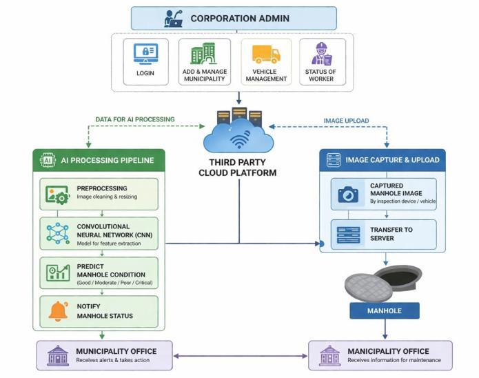
Fig-1: Architecturediagram
This will provide an accurate way of identifying each manhole's unique position and will allow easy tracking of where images were taken. When images and GPS coordinatesarecollected,theywillbeuploadedtoasecure 3rdPartyInternet-BasedStorage(Cloud)andaccessibleby allstatutorymunicipalitiesforsecuredatamanagementand storage (scalable). Once the images and coordinates are uploadedtothecloud,theywillbepre-processedbyusing ImagePreprocessingTechniquesincludingbutnotlimitedto Noise Reduction, Resize, Contrast Enhancement, and Normalization,toimprovetheclarityandconsistencyofthe imagepriortoitbeinganalyzedbytheConvolutionalNeural Network(CNN).
TheCNNwillbetrainedtoextractimportantvisualfeatures fromthepre-processedimagesandclassifytheConditionof the manhole into Safe, Damaged, Open, Blocked, and Hazardousconditions.TheoutputfromtheCNNModelwill allowtheAutomatedSystemtoaccuratelyandautomatically predict the Condition of the manholes and eliminate the needforcontinuousmanualinspections.
ThesystemshallgenerateReal-TimeAlertswiththePriority AssignmentofHigh,Medium,Lowaccordingtothecondition ofthemanhole.
1. Geo-tagging
Geo-taggingistheprocessofassigningauniquelocationto each manhole on a digital map. In this project, every manhole is tagged with its precise GPS coordinates. This
International Research Journal of Engineering and Technology (IRJET) e-ISSN: 2395-0056
Volume: 13 Issue: 03 | Mar 2026 www.irjet.net p-ISSN: 2395-0072
allowsmunicipalauthoritiestoquicklylocateeachmanhole and track which ones need repair or maintenance. Geotaggingmakestheentiresewersystemorganizedandeasy tomanage.
Manhole maintenance involves checking, repairing, and replacingmanholecoverstokeepthesewersystemsafeand functional.Thisprojectkeepsrecordsofallmanholecovers, notes which ones are damaged or missing, and helps authorities plan maintenance efficiently. Proper maintenance reduces accidents and ensures the sewer systemworksreliably.
3. GPS
GPS(GlobalPositioningSystem)isusedtorecordtheexact location of each manhole. By capturing latitude and longitude,theprojectcreatesadigitalmapshowingwhere all manholes are in the city. GPS makes it easier for maintenance teams to find manholes quickly without wastingtimesearchingmanually.
4. Sewer System
The sewer system is the underground network of manholes,pipes,anddrainsthatmanageswastewaterina city.Well-maintainedmanholesarecriticalforthesmooth functioningofthissystem.Thisprojectensuresthatmanhole coversaresafeandmaintainedsothesewersystemremains efficientandfreeofblockages.
5. Urban Infrastructure
Urban infrastructure includes roads, drains, sewers, and otherpublicfacilities.Manholesareanimportantpartofthis infrastructure. Proper management of manhole covers contributes to safer streets, better sanitation, and more reliablecityservices.
A monitoring system is used to keep track of manhole locations, conditions, and maintenance activities. This project uses a digital platform where authorities can see which manholes are damaged, which have been repaired, andwhichneedattention.Ithelpsinplanning,prioritizing, andorganizingmaintenancetasks.
A smart city uses technology and data to manage urban services efficiently. By combining geo-tagging, GPS, and a digitalmonitoringsystem,thisprojectsupportstheideaofa smartcity.Itmakesmanholemaintenancefaster,safer,and moreorganized,improvingoverallurbanmanagementand publicsafety.

Fig-2:
ThisimageshowshowasmartsystembyChitraguptahelps inmanagingmanholesinacityinaneasyandefficientway. First,vehicleswithsensorsandAImovearoundthecityand automaticallydetectmanholes.Theyalsorecordtheexact location and check the condition of each manhole. After collectingthedata,thesystemdecideswhichproblemsare serious and which are minor. Dangerous or damaged manholes are given higher priority so they can be fixed quickly.
Then,thesystemkeepsmonitoringthecontractorstomake sure they complete the work on time and properly. If any repaired manhole gets damaged again, it is also tracked. Once the work is done, a photo is taken as proof, and the issueismarkedassolvedonlyafterproperverification.This way,thereisnochanceoffakereports,andeverythingstays transparent.Overall,thissystemmakesthewholeprocess faster,smarter,andmorereliable
ThesystembyChitraguptamanagesmanholesinasimple andsmartway.First,AIandsensorsscanthecityandcollect dataaboutallmanholes.Thenthesystemdividestheminto two types: maintained (no action needed) and not maintained. The not maintained ones are further checked andsplitintotwogroupsseriousissueslikeopenorbroken manholesthatneedimmediaterepair,andminorissueslike smallcracksthatcanbefixedlater.
Overall,allpartsofthesystemworktogethersmoothlyfrom detecting problems to deciding priority so that important issues are solved quickly and maintenance work becomes fasterandmoreefficient.
International Research Journal of Engineering and Technology (IRJET) e-ISSN: 2395-0056
Volume: 13 Issue: 03 | Mar 2026 www.irjet.net p-ISSN: 2395-0072
ThesystembyChitraguptausingrealcitydata.Thesystem scansalargearea(around600kmofroads)andidentifiesall manholes, marking them as maintained (green) and not maintained (red) on the map. Out of 18,654 manholes surveyed,mostareingood condition, whilearound1,971 need attention. It also highlights which ones are severely damagedandrequireimmediateaction. Insimplewords,testingmeanscheckingwhetherthesystem is correctly detecting and classifying manholes, and validation means confirming that the results are accurate anduseful.Byshowingclearnumbersandvisualmapping, thesystemprovesthatitis workingproperlyandhelping authoritiestaketherightdecisionsquickly.
TheexpectedresultofthissystembyChitraguptaistogivea completeandclearpictureofallmanholesinthecityafter propertestingandvalidation.Thesystemshouldaccurately detecteverymanhole,markitsexactlocation,andcorrectly classify it as maintained or not maintained. It should also clearly highlight dangerous cases like open or badly damagedmanholessothattheycanbefixedimmediately.
Alongwiththis,thesystemisexpectedtoprovidereliable dataandnumbers,soauthoritiescantrusttheresultsand takedecisionswithoutconfusion.Itshouldreducemanual checking, save time, and avoid human errors. Another important resultis betterplanning officialscanfocuson high-priorityareasfirstandmanageresourcesproperly.In thelongrun,thisleadstosaferroads,feweraccidents,faster maintenance work, and full transparency, because every repairistrackedandverifiedwithproof.
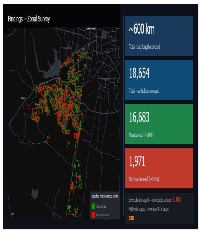
TheprimarytestingresultsofthesystembyChitraguptaina simple and clear way. During testing, the system covered around 600 km of roads and detected a total of 18,654 manholes.Outofthese,about16,683areingoodcondition (shown in green), which means most of the city infrastructure is properly maintained. However, around 1,971manholesarenotmaintained(showninred),which clearlyshowstheareasthatneedattention.
Amongthesedamagedmanholes,someareverydangerous and require immediate repair, while others have smaller issuesthatcanbehandledlater.Themapmakesiteasyto understand where most of the problems are located, so authoritiescanfocusonthoseareasfirstinsteadofchecking thewholecitymanually.Thissavesalotoftimeandeffort.
Another important point is that this result helps in better planninganddecision-making.Officialscanusethisdatato assignworktocontractors,trackprogress,andensurethat repairs are done properly. It also reduces human errors because everything is recorded automatically. In simple words, this testing proves that the system is reliable, accurate, and very helpful for making city maintenance faster,safer,andmoreorganized.
International Research Journal of Engineering and Technology (IRJET) e-ISSN: 2395-0056
Volume: 13 Issue: 03 | Mar 2026 www.irjet.net p-ISSN: 2395-0072
The system by Chitragupta proves to be a smart and practical solutionforcitymaintenance. Itnotonlydetects and locates manholes accurately but also helps in understandingtheirconditioninaveryclearway.Withthe help of this system, authorities can easily identify which problemsareseriousandneedimmediateaction,andwhich onescanbehandledlater,makingthewholeprocessmore organized.
Anotherimportantbenefitisthatitimprovestransparency and accountability. Since all data is recorded and verified, there is less chance of mistakes or false reporting. It also helpsinbetterplanning,properuseofresources,andfaster completionofwork.Inthelongrun,thissystemcanreduce accidents,improveroadsafety,andmakecityinfrastructure morereliable.
Overall,thissolutionmakesmaintenanceworkeasier,faster, and more efficient, which is very helpful for developing smartandsafecities.
[1] Y.Ding,B.Han,H.Jiang,H.Hu,L.Xue,J.Weng,Z.Tang, and Y.Liu.Applicationofimprovedyolov8imagemodel in urban manhole cover defect management and detection:Casestudy.Sensors,25(13):4144,2025.
[2] Varsha S, Sindhu P D, Vikram, “Manhole Visual InspectionSystemUsingDeepLearning”IJCRT,Volume 12,Issue4April2024
[3] Horsfall,O.M,Essenowo,I.E,“ManholeCoverSecurity And Monitoring System”,March 2024,Vol:11, Issue:1 pp:(31-48)
[4] Dr. T. Amalraj Victorie, M. Vasuki, Suriya.P, “ A Novel Approach For An Efficient Manhole Visual Inspection System Using Deep Learning Techniques”, May 2024, Vol:11,Issue:05
[5] D.Pang,Z.Guan,T.Luo, W.Su,andR.Dou.Real- time detectionofroadmanholecoverswithadeeplearning model.ScientificReports,13(1):16479,2023
[6] Dr. V. M. Karthikeyan, Balaganesh. R. Jayaseelan. S, “ManholeMonitoringSystem”,InternationalJournalof Engineering Research & Technology (IJERT), 2022, ISSN:2278-0181.
[7] M.A. Ganpat, A. O.G. Bansoe, S. Shivaji, IJEAST, March 2022,Vol:6,Issue:11
[8] Dr.T. Menakadevi, Akash.M, Dilip kumar.B, Kannan.M, Chandra Mohan.S,”IoT Based Automated Manhole Detection”,(IRJET),Apr2021,Vol:08
[9] Sahu,S,&Sahu,N,(2021).DetectionofManholeDefects Using Deep Learning. In International Conference on
Intelligent Communication and Computational Techniques(pp.609-616).Springer,Singapore.
[10] Muralidharan,V.,&Balasubramanian,R.(2020).Smart ManholeCoversmonitoringsystemusingIoT.In2020 IEEEInternationalConferenceonInnovationResearch andDevelopment(ICIRD)(pp.104-107).IEEE.