12
P-400
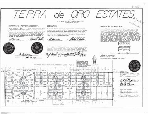
TERRA
de N1/2
CORPORATE
ACKNOWLEDGEMENT:
MAY On this 28 =day of L. Harrison and Michael P. Hollern,
F
I
R. IOE., Deschutes County, Cregon SEC. 16,
T. 21 S.,
W.
M.
plat and
Resources Corporation all to me personally known, who being say that they hold the aforesaid offices in the corhereunto mentioned. and thot the instnimentithe to uthority of the Boor sealed in behalf of said corporation, in behalf of said corporation, by the authority of the Board of sealed Directors, and further acknowledge said instrument to be the free act and deed of said corporation.
reunto attached, hereby
dedicate
on
the Brooks
Certific
poration
and easements shown
more
simple
particularly described in
public ferever
TERRA
de
set at the initial point
County to be a correct plat as located in Section 16, T. 21 S, R. IO E., W.M., Deschutes County, Oregon. ORO
Halles
By
Brooks Resources Corporation Secretar
ESTATES
to Deschutes
PPHarrian
L
2"x
and that the property platted the propert
golvanized
is describe describedd as as follows: follows
Beginning at the initial point which is the 1/4 corner common to sections 16 and 17, T.21S, schutes County, Oregon; thence N 89° 59 56 E
sections
common to
16 ond
2585.09
corner
07'09" W 1317. 32 feet to the S I/16 and 15, thence 89° 51' 44"
15; thence S00
W 2596.91 feet to the CS 1/16 corner of section 16; thence N 89° 54 39" W 2596.94 feet to the S1/16 mon to sections 16 and 17; thence N 01° Of 03" E 1309, 1 the initial point of this subdivision. corner common
Brooks Resources Corporatio
O.C
sworn, depose and say that I have correctly surveyed and marked with le monuments the land represented on the annexed plat of TERRA de ORO ESTATES.a subdivision to Deschutes Co. Oregon: that a 36"
parks, streets,
all
such plat and that we declare the annexed plat of
on
РАСE
registered surveyor for the State of Oregon, being first duly
1, James E. Bussard,
Surveyors
the
E
Y, C
CERTIFICATE:
SURVEYORS the annexed
of the land shown
L
H
.
We, the Brooks Resources Corporation, an Oregon corporation,
before me appeared Robert and secretary respectively of
duly sworn, do
Harrison ay Brooks Resources Corperatior
ORO ESTATES
The
DEDICATION:
1970,
president
SI/2
In
Brooks Resources Corporation Secretary
to sections
16
N
REGISTERED
OREGON LAND SURVEYOR
ONR
RES
and
of Deschute
respectively
James E. Bussard
F C. Sholes, duly elected, acting and qualified
Oregon.
hereby
certify that w
ULY 12, 1963
County Oregon, hereby certify that we have examined TERR respectively annexed plat of TERRA de ORO ESTATES, a subdivision to Deschutes County, due thereon have been fully paid asrequvalorem taxes and other special assessments
7f heel /6/10
Notary Public for the
My commission expires
ARIL 12, 1974
BUSSARD JAMES E. E. BUSSARD
Subscribed and
before me this
15
day of
11,
1974
MAY
1970.
James E Morrison
-70
Deschutes Ooully
sworn
My commission expires
MARCH
NOTE:
All individп
(Deschutes Riv
c.
N
Brnol N8g° 5o
Homesite Plat Brno
89° 59
56"E
2585.09
520.00'
294.0
295.9
355.00
566.
Iw
10
33834
58955 57€473
$8955'57"E 473.58
2
330.00
13
4
5
4750
283.59
306.42
330.00
24750
247.5
13.60
336.42
226.Og
226.08 589
12
352.2
13
2032
882
BLK 8
291.78
12
13
330.00
15
22 21
AAre
276.3
$89
10
276.33
276.33'
319.25
BLK
$283449
707
64.09
CS 1/16
323.72'
5
330.00 25
330.00
24
PARKWAY ACRES
218.56
294.28 BLK 296.89
271.64
218.00
271.64
4
35
271.64'
271.6
271.64
$89°55 57 E 8°3449
$284255
44" W N89° 5
Cann
271.64
31 34
00" w)
2596.91
D.&anhollon
28.0
330.
33
APPROVAL: The annexed plat of TERRA de ORO ESTATES was examined and approved this 1970. h day of July
209.04
13
271.64
Sec. 16
$89°55 57E
296.34
330.00-
19.25
Parkway Acres Phat Brng
2:8.00
286.47
29L66
30
27
East
1/4 Cor
296.96
330.00
255.96
N 89° 51'
301.5
293.7:
32
26
$89°5557E
9°55 57 E
19
312
BLK
55 57
38
330.00 410330.00 5
23 20
29118
293.72
330.0
17
64.09
2596.94'
304.13 0
28425
2834
ARAGA
AVE
330.00
R40.00
52425
354.85
N 89° 54' 39"W (Porkway Acrles Plat Brng. N 89° 51' 45 W)
330.od
14
$89°55 57
/16
460
330.00 4.00 4-62° 20 0" 16
247.50
10
296.8 15
283.63
300
2588.24
14
303.78
24750
10
8 286.2
34709
349.68
895557
55.98
$13.18
NO1° 01'03" E
PIS
HOAD
340.93 8 343
2
299.34
W2842 35E 6 $8955 57E
$8905
298.49
56.53 15
S89°55 57"E
148.09
206.9
2
SCALE:
Dept, approval prior
Deschures River Rec, Homesite Pat Brng. N 89 S 89° 57' 24E
C 1/4 8
$89°55 57
PART H!
UNIT 8
1317. 32
Initial
HOMESITES
528.66
1/4 Cor
RECREATION
1.08
S 00° 07' 09" W
West
RIVER
சு
DESCHUTES
domestic water systems an any sewage disposal system must have Tri-County Healt
Deschutes County
Commissioner
Deschutes County Surveyor
Jenin DMorgan 7-7-70