

The IWMP is a management framework for the multiple interdependent and interacting ecosystem services provided by Yangtze River Delta Demonstration Zone Watershed. It is envisioned to be a sustainable and robust ecosystem with excellent water quality and quantity, brilliant environment with friendly relationship among local communities and all relevant stakeholders with sustainable economies that respect the social and cultural contributions.
The plan can offer recommendations to integrate different administrative, regulatory and planning systems with different interests on the watershed. The matrix institutional framework is proposed, and Yangtze River Delta Demonstration Zone Watershed Management Committee is proposed to solve the institutional fragmentation and solve cross-border water issues. The plan focuses on establishing guidelines and making recommendations for management of water quality and flooding. The plan will be used to guide and develop the coming programs of all the processes that concern with water management. The monitoring and evaluation procedures are also included in the plan.
NB: This is an academic coursework
Course Code: Urban Planning and Design 303
Course Title Environment and Planning
Institution: Xi' an Jiaotong-Liverpool University
Submitted by: Hanyu Zeng
Student ID: 1928840
December, 2022
Yangtze River Delta (YRD) is one of the regions with the fastest growing economy and the highest urban density in China. Its integratedregional governancehas a long history (Hu and Sun, 2020).
During Qin Dynasty, Guji County was established in the lower reaches of the Yangtze River, and the government vigorously developed "Jiangnan" Area [Yangtze River Delta], which made the culture and economy of this area highly integrated and developed. Since then, "Jiangnan" Area has become the national center of economic gravity (Guangming Daily, 2022).
Yangtze River Delta is an important intersection with theBeltandRoad Initiativeand theYangtzeRiverEconomicBelt. It plays a pivotal role in China's overall modernization drive and a new pattern of all-round opening-up (Xu et al., 2019).
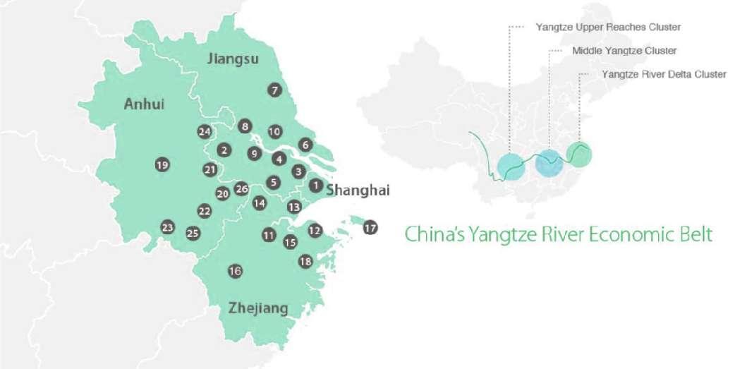
According to the map, Yangtze River Delta is the third urban cluster along the Yangtze River Economic Belt, together with the upstream cluster with Chongqing as the focus and the middle stream cluster with Wuhan as the focus. They serve as the main development pivots along the Yangtze River. This strategy can openupChina's central and western regions to the eastern coastal region and the rest of the world and narrowthegapbetween the
coastal areas and the relatively undeveloped interior areas.
Demonstration Zone of Green and Integrated Ecological Development of the Yangtze River Delta (DZ) 2
Size: 2,413 km
Boudary: including Qingpu District in suburban Shanghai (676 km2), Wujiang District in Suzhou City, Jiangsu Province (1092km2), and Jiashan County in Zhejiang Province (506km2)
Pilot Area: 660 km2, with administrative areas including Jinze, Zhujiajiao, Lili, Xitang and Yaozhuang
Main purpose: eco-friendly integrated development
We should corporate the idea of integrated development into innovative, coordinated, green, open and shared development, to achieve joint governance and shared win-win outcomes, to break administrative barriers, to focus on institutional innovation, and to establish effective new mechanisms for integrated development. (Yangtze delta demonstration zone marks third anniversary, 2022)
Development Focus: water conservation ecological environment comprehensive transportation municipal infrastructure industrial development
cultural tourism development

'Watershed' is often used as a synonym for catchment area and drainage basin. A watershed refers to a natural hydrologic draning that flows to particular streams or rivers beneath the ground surface (Pande, 2020)

The definition of watershed is varying. In addition to the element of hydrologic factors, watershed is a social-political and environmental subject that is critical in determining social and economic safety and supplying basic life facilities (Wani et al. 2008)
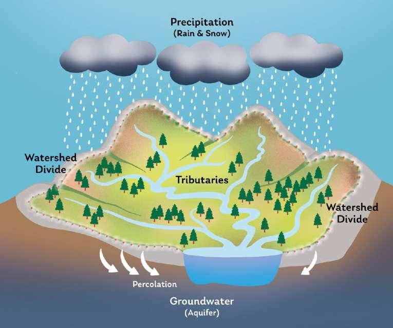
Diagram: What is watershed
Available at: https://hudsonwatershed.org/what-is-a-watershed/
Watershed management is the appropriate utilization and distribution of the total ecosystem resources and the process of creating and implementing plans or programs to ideally determine and realize the needs of plant, animal, and human communities and mitigate ecosystem degradation (Pande, 2020; California Department of Conservation, 2015).
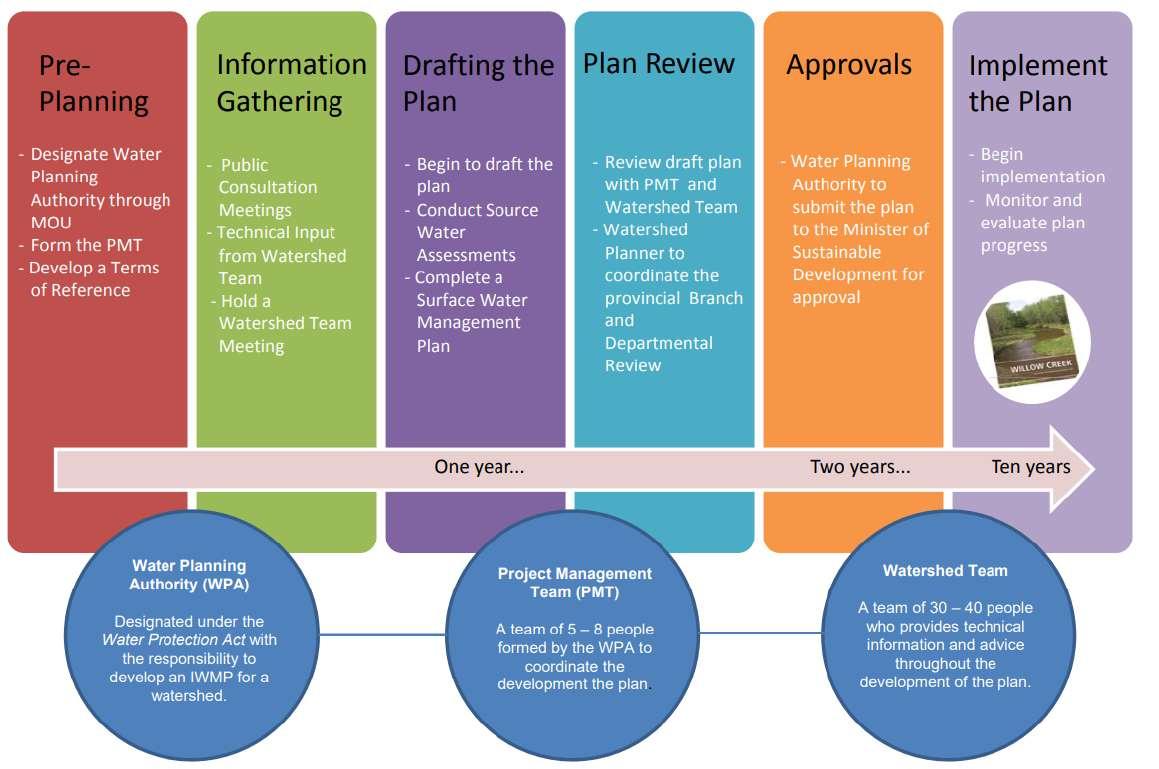
An Integrated Watershed Management Plan (IWMP) is a guiding document for multistakeholders, such as governments, landowners, planners, in a watershed. It sets out common goals and objectives for the short term and long term management of land and water resources in the basin. It is developed cooperatively by stakeholders from across the watershed including local industry, resident, interest groups and others. It states shared goals for the watershed and outlines action plans to achieve the goals to manage land, water and other related resources in the watershed. IWMP should be managed with multidisciplinary appraches with natural and socio-political considerations (Babur and Kara, 2017).
Therefore, IWMP is an effective tool to incorporate the fragmented issues of the watershed, and systematically solve the hydrological and socio-political problems. It is the combination of socio-economoc, environmental incentives, regulations and their sanctions (Simonovic, 2009). SDC (2005) defines IWMP as a process that facilitates the coordinated development of water and related resources so as to improve the resultant social and economic welfare in a sustainable manner without compromising the quality and quantity of the environment. The diagram below has illustrated the programme of the IWMP.

Schematic diagram of the the demonstration zone (adapted from Territorial Spatial Master Plan of the demonstration zone for integrated ecological and green development in the Yangtze River Delta region (2019-2035), 2020) (Group 6, 2022)
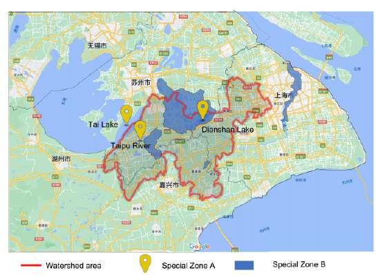
Special zones in the demonstration zone (made by author, 2022)
The objectives of the Territorial Spatial Master Plan of the Demonstration Zone for Integrated Ecological and Green Development in the Yangtze River Delta Region(2019-2035) are to construct one ecological heart, two green corridors along the Demonstration Zone, three blue chains that link to the main lakes, and four types of rural and water bases (Group 6, 2022). However, based on the evaluation of the current conditions in the Demonstration Zone, the definition of the watershed of is adjusted according to specified issues.
Given the water quality and flooding issues within the boundary of the Yangtze River Delta Ecology and Greenery Integration Demonstration Zone, there are special zones that should be emphasized to bring out the best of IWMP. Zone A would be cricial points to improve the water quality;Zone B would be regions that are exposed to higher flooding risks or more vulnerable to suffer from flood with greater losses, suggesting corresponding measures to be applied.
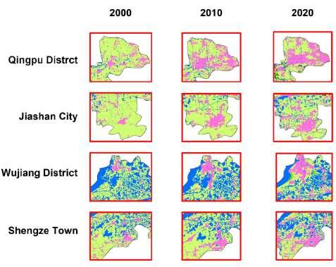
Natural resources in the basin are strained. The Yangtze River Delta region accounts for 3.7% of the country's land area, carrying 16% of the country's population and 24% of the total economy. Natural resources are under great pressure: the intensity of land development is nearly 17%, and the intensity of land development in some cities has exceeded 30% (Land Cover Change Figure). There is severe water resource scarcity. Per capita available water resources are less than 1/2 of the national level and 15% of the world level. The imbalance between the supply and demand of water resources in Shanghai and Jiangsu Province is extremely prominent (Zhang, Jin and Li, 2022).
The coordination of spatial development is unbalanced. According to the Yangtze River Delta City Collaborative Development Ability Index (2018), cities in northern Jiangsu and southwestern Zhejiang are weak in their ability to drive the coordinated development of their surrounding areas, and they have not yet formed a positive
interaction between ecological and economic development.
This is an eco-environmental fragile area. Rapid economic development has led to significant changes in the natural environment and rapid deterioration of environmental quality. The land subsidence in the YRD is serious, the air pollution caused by industrial areas is serious, the pollution of rivers, lakes and seas and other water systems, the soil pollution is obvious, and the water shortage is serious.
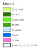
All these problems have trans-regional and trans-watershed characteristics. The mapping of water flow analysis demonstrates that Taipu river, Dianshan lake, and Yuandang lake are the primary flood drainage channels of eastern Taihu Lake and the main water supply channels of Shanghai. Therefore, this indicates that any pollution that occurs in the upper section of Taipu river, Dianshan lake, and other water areas
will lead to the water deterioration in Shanghai and Tai lake (Group 4, 2022).
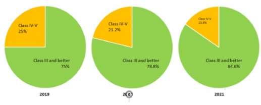
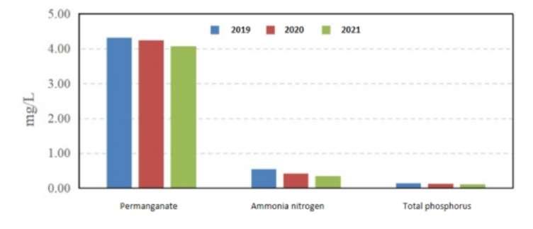
According to the pie charts illustrating the water quality of the Demonstration Zone, the water quality has been improving in recent years. By 2021, 84.6% of the water area reached Class III and no water area was inferior than Class V. However, compared to the water quality of the Yangtze River Basin, there is still much progress to be made (Group 4, 2022). The bar chart has presented the major water pollutants in the Demonstration Zone.

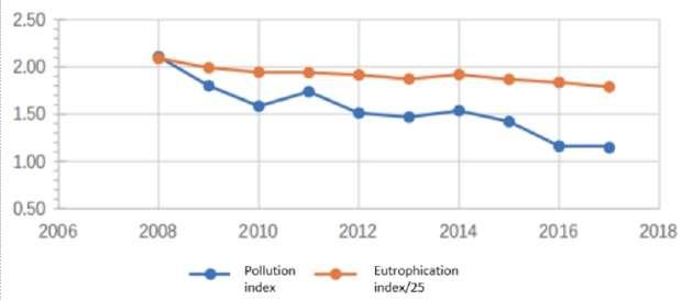
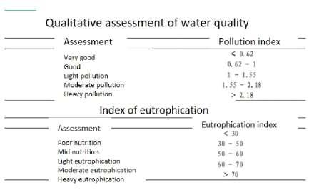
Dianshan Lake, as the largest lake in the Demonstration Zone, is confronting with pollution and eutrophication. From 2019 to 2020, the water quality of Dianshan lake has improved (Jiangsu Environment 2022). However, eutrophication remains as the primary problem because the main pollutants are nitrogen and phosphorus (Jiangsu Environment,2022).
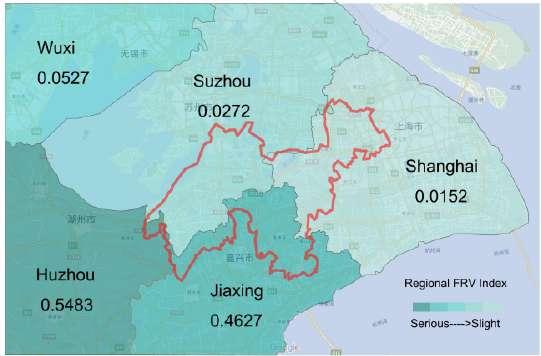
FRV in the watershed (made by author, data from Zhang and She, 2020)
The index of flood risk is determined by
Flood season's precipitation (positively correlated)
Topography (negatively correlated)
Vegetation coverage (negatively correlated)
Land cover type (correlated according to the types of vegetation)
River network density (postively correlated)
River distance (positively correlated)
Flood risk vulnerability (FRV) refers to the extent to which urban property may suffer from flood disaster (Zhang and She, 2020). It is the nature of an urban area that is vulnerable to floods and severely impacted by floods. Percipitation is positively correlated with FRV, while green coverage, per capita GDP and the number of hospitals are negatively correlated with FRV (Zhang and She, 2020). The greater the intensity and duration of precipitation in the watershed, the greater is the FRV. Since the average annual rainfall of Anhui and Zhejiang province is higher than that of Jiangsu and Shanghai province, most cities in these two provinces suffer greater flood losses. Therefore, the average FRV of the two provinces is much higher than that of
Jiangsu and Shanghai (Zhang and She, 2020).
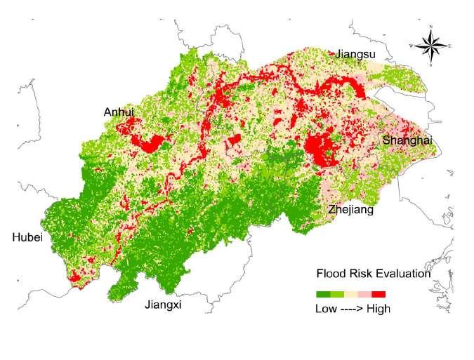
The GIS mapping synthesizes the above indicators to identify the areas that are at risk of flood attacks (Thefloodingdisaster assessmentinofYangtzeRiverBasin, 2022).
Flood risk evaluation in the watershed (adapted by author from FlooddisasterassessmentinofYangtzeRiverBasin, 2022)
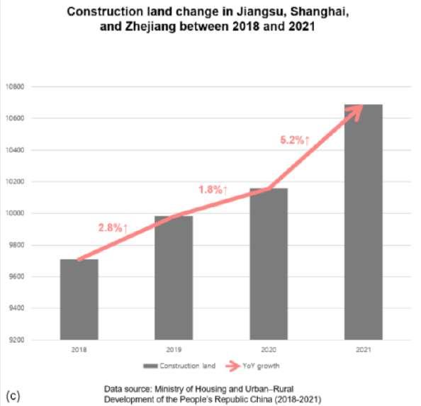
Construction land change in Jiangsu, Zhejiang, and
The bar chart shows the significant urban expansion of Jiangsu, Shanghai, and Zhejiang from 2018 to 2021, with year-onyear growth of 2.8%, 1.8% and 5.2% in the consecutive years.
According to the land use map, Wujiang District is the most industrial oriented among the three districts. The construction land is agglomerated in Shengze Town and Songling Town. Qingpu District has the most well-developed living environment because it has the highest proportion of residential are (25%), park and greening (9.3%), and fitness and culture (3.8%). Jiashan District's land use pattern is similar to that in Wujiang District. What stands out from the pie chart is that the percentage of education and science land is relatively high. The residential areas are agglomerated in the south, while the industrial land is expanding to the north (Group 7, 2022).
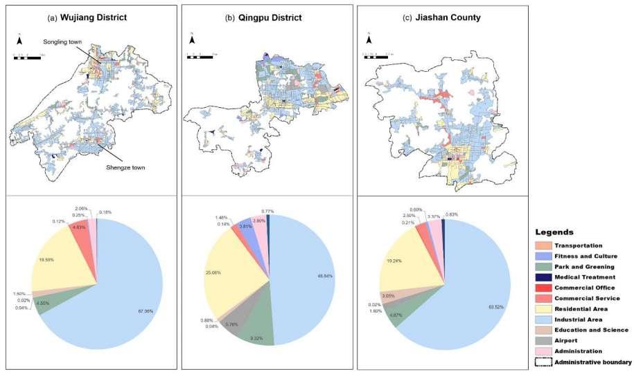
Land use map (Group 7, 2022) Shanghai (2018-2021) (Group 7, 2022)
The Sustainable Development Goals consist multiple references to water, management and stakeholder involvement via the specific water goal (No. 6), local participation target, and some governance-related goals regarding multi-stakeholder partnerships, inclusiveness, accountability, monitoring and evaluation. Under this context, the OECD principles on watershed governance emphasize partnership and engagement, which promotes stakeholder engagement for informed, win-win and result-oriented contribution to watershed planning design, implementation, and monitoring (Akhmouch and Delphine, 2016; Figure of OECD principles on water governance). 12
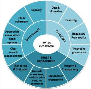
OECD Principles on Water Governance, Akhmouch and Delphine (2016)
The seven types of stakeholders, including residents, enterprises, sewage treatment plants, government departments, social organizations, media, and academic institutions, in the DZ are divided into three types: core stakeholders, sub-core stakeholders, and marginal stakeholders (Table of stakeholder analysis). They differ greatly according to the relative importance regarding the compensation policy, self-importance, and power(Group 10, 2022). The core takeholders are mostly grassroots marginalized groups. They have strong interests to the watershed, but they have limiteddecision making authority. The sub-core stakeholders and marginal core stakeholders are not strongly impacted by the environment and policies in the basin. However, they are critical actors to participate in policy decisions.Therefore, the opinions of inhabitants and enterprises, whose interests are greatly influenced by the basin management, should be considered by the government agencies. They should
establish grassroots associations for the watershed management planning and improve the operation of multilevel feedback and interaction mechanism.
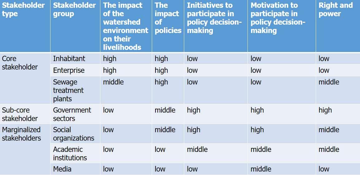
Table of stakeholder analysis from social, public, and private perspectives (Group 10, 2022)
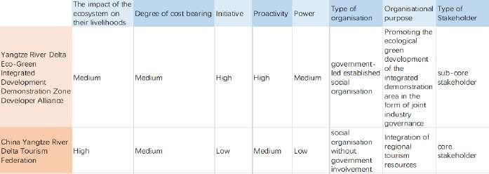
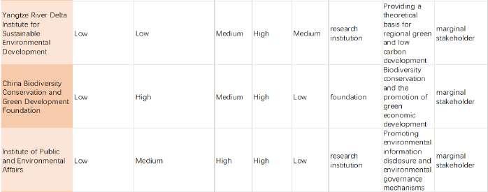
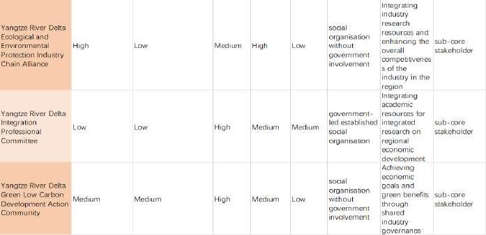
Table of stakeholder analysis for social organizations (Group 10
For social organizations (shown in Table of stakeholder analysis for social organizations), those without government involvement are the primary stakeholders because they are highly impacted by the policies and the environment. Government-led social organisations are considered as secondary stakeholders since they are less impacted and are entitled with more power. The research institutions are marginalized for limited interests impacted and a lack of power in the policy decision-making. , 2022)
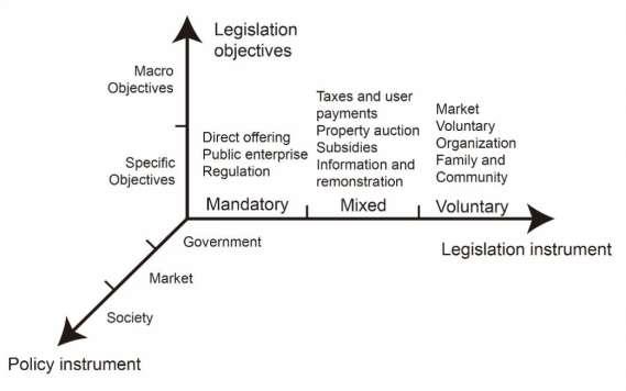
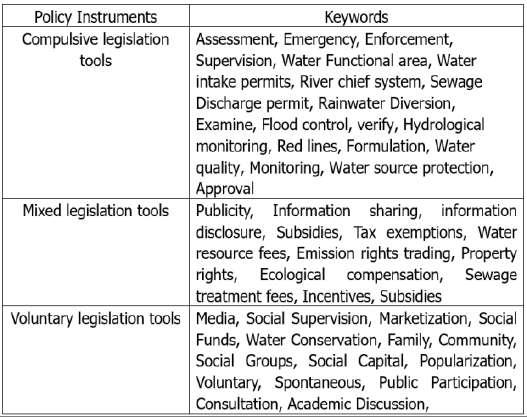
The content analysis method is applied to quantitatively analyze 167 water legislation in Shanghai, Zhejiang, and Jiangsu Province from 2010 to 2022 by calculating the word frequency that occurred in the legislation. Policy instruments are used to classify legislation into three types (below Figures), and to identify the characteristics in regional legislation (Table in the next page).
(Group 3, 2022)
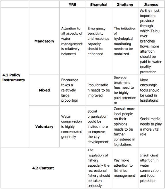
Summary of main characteristics and issues defined by word frequency according to legislation instruments: mandatory/mixed/voluntary (Group 3, 2022)
3, 2022)
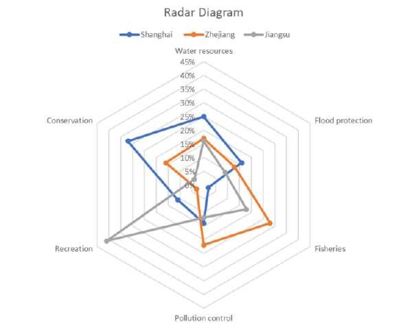
Through content analysis, the radar map shows that different priorities have been given to the six water-related aspects in Shanghai, Zhejiang, and Jiangsu Province (Group 3, 2022). Such varying priorities caused by regional fragmentation could hinder the integrated development of the watershed.
The most important and most urgent issues in the Demonstration Zone of Green and Integrated Ecological Development of the Yangtze River Delta (DZ) are water quality and flood control. These issues can be classified into three categories: ecological environment
(a),development pressure (b), and social engagement (c).
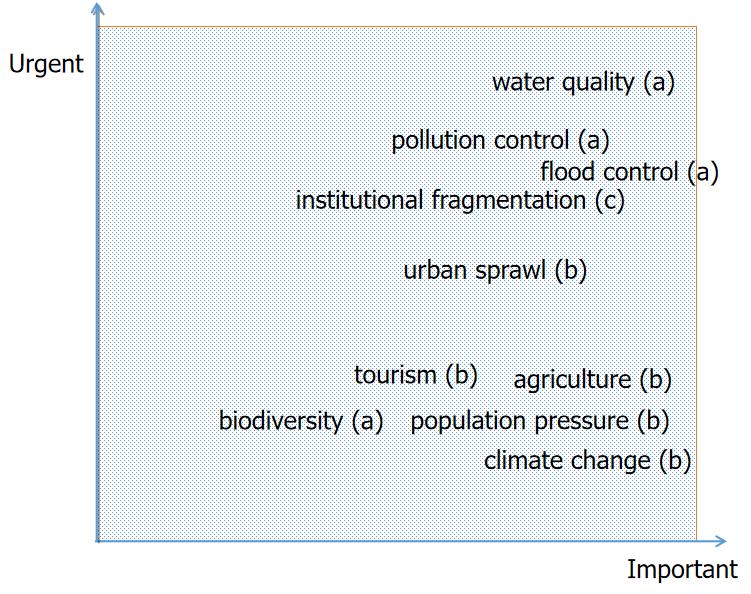
Issues identification (by author, 2022)
In terms of water quality problems in the ecological environment, the river networks of the demonstration zone is generally polluted to varying degrees, the drinking water quality in some areas is poor, the water quality of the water source is at risk, and the eutrophication in regional lakes and reservoirs are obvious, especially in Tai lake. The lack of effective regional cooperation mechanism makes the control of transregional pollution extremely difficult. The demonstration zone is highly intensive in infrastructure, and the risk of flood increases sharply, which seriously affects the production and life of the residents and regional development.
Structure of the campaign, adapted from Joon (2022) by author
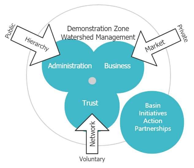
Institutional arrangements includes the networks of organizations and entities involved in planning, supporting, and implementing process. It incorporates the relationships between and among these entities at the district, provincial, and national levels, and between governmental and nongovernmental organizations, including local communities and
Matrix structure made by author (2022) enterprises (Snyder, 2017).
Saleth and Dinar (1999) reported that institutional arrangement for watershed management combines policies, laws, regulations, organisational values, implementation procedures, accountability mechanisms, reward and punishment mechanisms, norms and traditions, customs that are constructed to preserve and restore the watershed.

The successful implementation of the IWMP will require the reinforcement of the institutional framework that hinges on the commitment of several actors coming from different sectors and regions to work together. The administration support involves relevant government of each provincial level government, city level government, and district level government. The business support involves tourism developers, enterprises, and sewage treatment plants. The social groups involve resident representatives, NGOs of local, regional, national levels (with and without governmenr involvement), research institutions and expert groups, media, and other grassroot voluntary groups. Yangtze River Delta Demonstration Zone Watershed Management Committee (YRDMC) will be set up to manage all issues in the watershed.
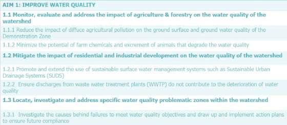
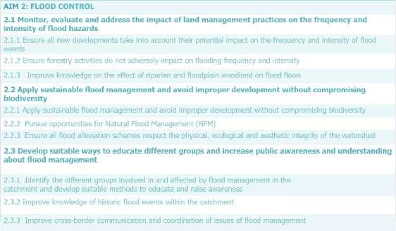
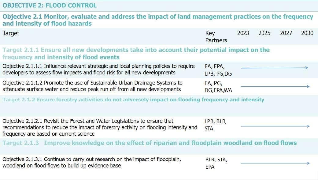
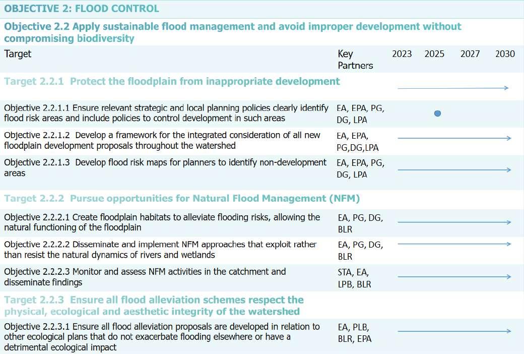
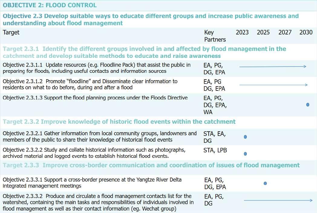
Monitor, evaluate and address the impact of land management practices
According to the situation analysis of water quality, the overall water quality of the watershed is not satisfactory, with serious water quality problems occurring in some water areas. Therefore the first aim is to improve the water quality. Given the fact that flooding is affecting some regions in the watershed more severe than other parts, the second aim is about flood control.
summary of action plans (author, 2022)
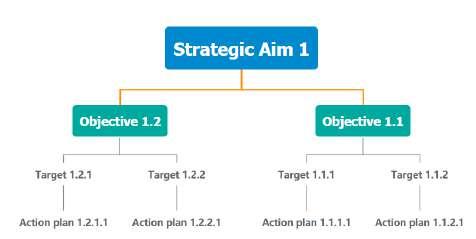
The flow chart shows the structure of IWMP action framework. And the tables illustrate the action plans to be made.
In order to keep the management motivated, the funding can come from water supply authorities that enjoy water resources for free from the watershed, beneficiaries, and polluters.
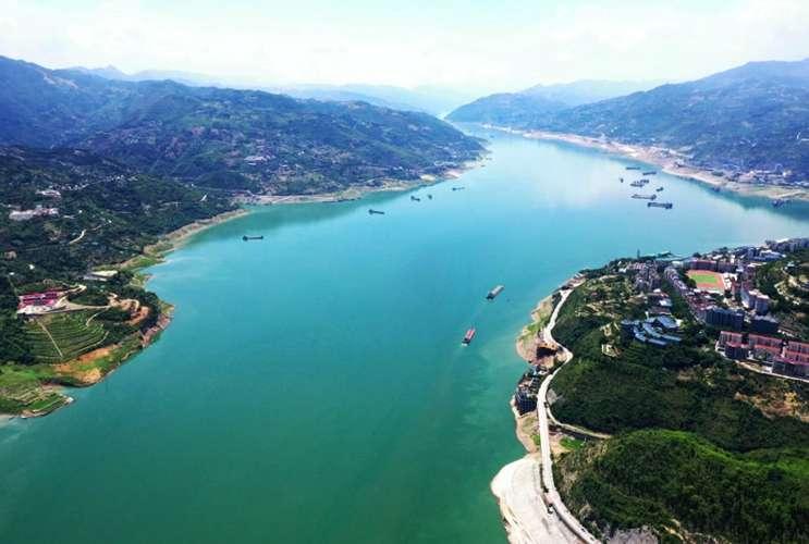
https://www.cqcb.com/dyh/live/dyh3691/2021-01-27/3642889_pc.html
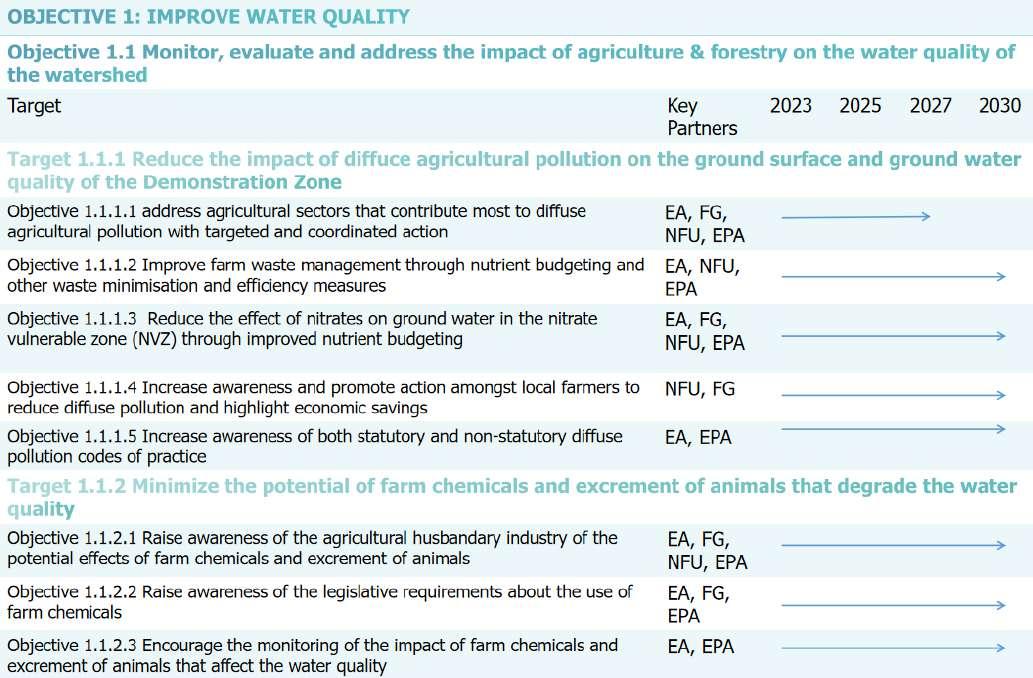
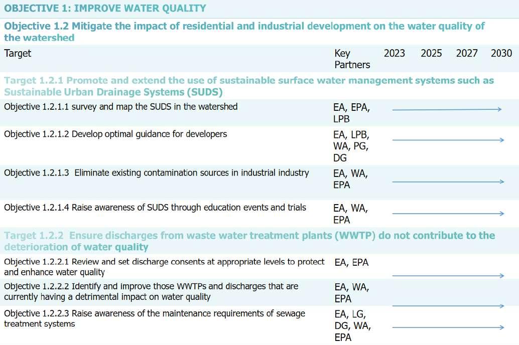
Action cards (author, 2022), refering to Tweed Forum (2010)
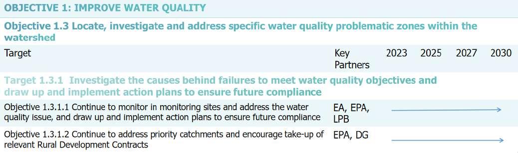
Action cards (author, 2022)
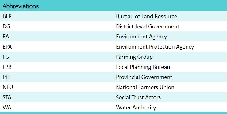
Abbreviation of stakeholders (author, 2022)
Monitoring and evaluation will continue to assist IWMP with conservation and management strategies, supervise committee functions, and predict future scenarios. Monitoring goals and objectives serve the cycles of planning and implementation/execution. The first circle indicates the design process of the monitoring campaign, the second circle means execution of the planned program, and the final circle illustrates how to use monitoring information to manage the demonstration zone watershed.
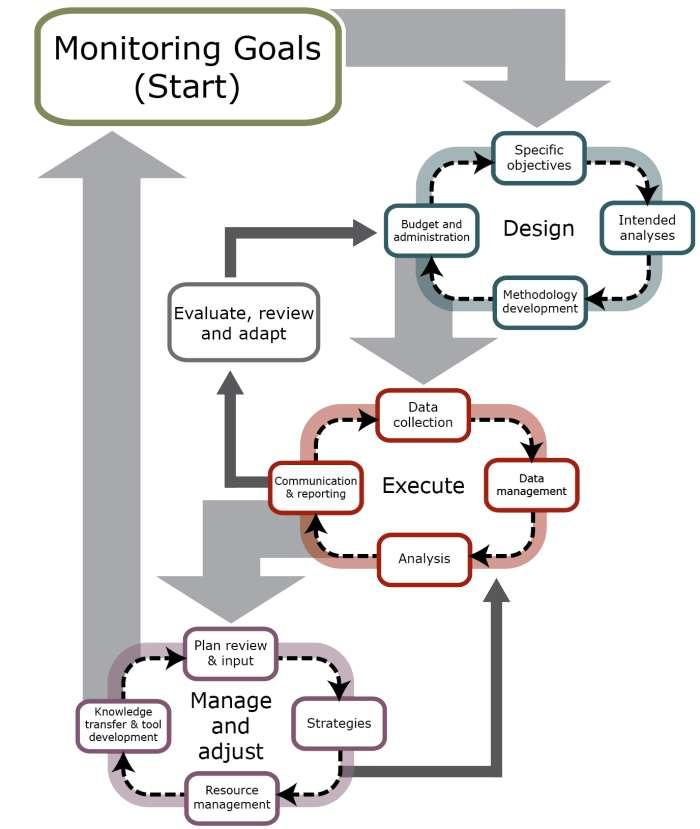
Steps in designing, implementing and applying the information collected in a long-term monitoring program, modified from Reynolds (2012)

Implementation of IWMP is overseen by the Management Committee and specialist sub-groups (from STA). Progress towards actions will be monitored, priorities for actions can be then adjusted, and additional actions will be raised when needed, and funding requirements will be further identified.
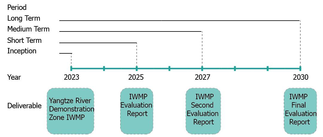
The table shows the objectives and measures to be employed to monitor the ground water, stream, water quality, flooding, and public awareness (Monitoring objectives and methods, 2022). The evaluation reports will be carried out in short term (2025), medium term (2027), and long term (2030) basises (The
Evaluation Timeline, 2022).
Monitoring objectives and methods (summarized by author, 2022) Source (Credit Valley Conservation,2018)(Flood disaster assessment in of Yangtze River Basin, 2022) (Lenel, 2009)
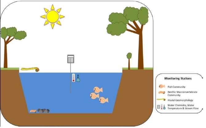
A monitoring site is the sum of the monitoring stations. Monitoring stations are the exact locations at which monitoring data are collected for specific attributes (Lenel et al., 2009). The monitoring data collected from stations in close proximity can be gathered together to carry out integrative analysis to describe the overall conditions of a particular ecosystem. A stream monitoring site monitors stream flows, geomorphology, chemitry in the water, animals and vegetation (according to the diagram). Some groundwater monitoring
sites collect data from different aquifers.
Akhmouch, A. and Delphine, C. (2016) "Stakeholder Engagement for Inclusive Water Governance: "Practicing What We Preach" , OECDWaterGovernanceInitiative, 8(5), pp.204 (Accessed: 10 December 2022).
Babur, Emre & Kara, Ömer. (2017) Importanceofintegratedwatershedmanagementonwaterquality.2, pp.150-157 (Accessed: 14 December 2022).
California Department of Conservation (2015) WatershedProgram. Available at: http://www.conservation.ca.gov/dlrp/wp/ Pages/Index.aspx. Accessed 23 Feb 2016 (Accessed: 14 December 2022).
Credit Valley Conservation (2018) IntegratedWatershedManagementMonitoringProgramReferenceSeriesVolume1: ProgramOverviewandMonitoringPlan. Available at:https://cvc.ca/wp-content/uploads/1970/01/IWMP-Volume-1_201801. pdf (Accessed: 31 December 2022).
Dezan Shira and Associates (2018) TheYangtzeRiverDeltaIntegrationPlan. Available at: https://www.china-briefing.com/news/yangtze-river-delta-integration-plan/ (Accessed: 14 December 2022).
Fang, Z. et al. (2021) 'Analysis on water quality variation trend of main rivers and lakes in integrated demonstration area on ecologically friendly development in Yangtze River Delta', ExpressWaterResources&HydropowerInformation, 42(4), pp. 68 -74. doi:10.15974/j.cnki.slsdkb.2021.04.012 (Accesses: 14 December 2022).
Flood disaster assessment in of Yangtze River Basin[长江流域河口三角洲洪涝灾害评估] (2022) Available at: https://zhuanlan .zhihu.com/p/585817574 (Accessed: 10 December 2022).
Government of Jiangsu(2022) TheannualecologicalandenvironmentalqualityassessmentoftheYangtzeRiverDelta DemonstrationZonein2021releasedarateofexcellentandgoodairqualityindexof87.4percent[长三角示范区2021年生态 环境质量年度评价发布空气质量指数优良率达87.4%].
Available at: http://www.jiangsu.gov.cn/art/2022/6/6/art_60096_10471574.html (Accessed:11/11/2022).
Group 3 (2022) 'Local water legislation', Unpublished Group Report Assessment, UPD303 Environment and Planning, Xi' anJiaotong-Liverpool University, Suzhou, China.
Group 4 (2022) 'Water Resource', Unpublished Group Report Assessment, UPD303 Environment and Planning, Xi'anJiaotongLiverpool University, Suzhou, China.
Group 6 (2022) 'Land Cover', Unpublished Group Report Assessment, UPD303 Environment and Planning, Xi'anJiaotongLiverpool University, Suzhou, China.
Group 6 (2022) 'Land Use', Unpublished Group Report Assessment, UPD303 Environment and Planning, Xi'anJiaotongLiverpool University, Suzhou, China.
Group 10 (2022) 'Stakeholders Analysis', Unpublished Group Report Assessment, UPD303 Environment and Planning, Xi' anJiaotong-Liverpool University, Suzhou, China.
Guangming Daily [光明日报] Available at: https://m.gmw.cn/baijia/2022-02/14/35514668.html (Accessed: 14 December 2022).
Hu, J. S. and Sun, J. W. (2020) 'A new framework of regional governance in the Yangtze River Delta from the perspective of state-regional scale reorganization[国家一区域尺度重组视角下的长三角区域治理新框架探析]', UrbanPlanningForum[城市规 划学刊], 5, pp. 55-61. Doi:10.16361/j.upf.202005007 (Accessed: 14 December 2022).
Huang, J. and She, J. W. (2020) 'Vulnerability Assessment and Influencing Factors Analysis of Urban Flood Disaster in Yangtze River Delta City Cluster [长江三角洲城市群洪涝灾害脆弱性评估及影响因素分析]', JournalofHohaiUniversity[河海大 学学报],22(6), pp.39-45 (Accessed: 10 December 2022).
Lenel, D., Bleakley, N., Tasmania. Department of Primary Industries, Parks, Water and Environment, Tasmania. Water and Marine Resources Division, Tasmania. Department of Primary Industries and Water, Tasmania. Water Resources Division, Tasmania. Water Policy and Planning Branch (2009) Tomahawk River Catchment Water Management Plan Department of Primary Industries and Water ; Department of Primary Industries, Parks, Water and Environment, [Hobart, Tas.]: [Hobart,
Tas.] viewed 4 Jan 2023. Available at: http://nla.gov.au/nla.obj-1863262078 (Accessed: 31 December 2022).
Manitoba Agriculture and Resource Development (2022) Integratedwatershedmanagementplanning. Available at: https://www.gov.mb.ca/agriculture/environment/water-management/integrated-watershed-management-planning.html (Accessed: 14 December 2022).
Ministry of Ecology and Environment of the People's Republic of China(2022) TheMinistryofEcologyandEnvironment announcedthenationalsurfacewaterandambientairqualityin12.2021and2021.1-12[生态环境部通报2021年12月和1-12月 全国地表水、环境空气质量状况]. Available at: https://www.mee.gov.cn/ywdt/xwfb/202201/t20220131_968703.shtml (Accessed: 11 December 2022).
Mugoro, T. (2013) 'Assessment of integrated watershed management practices in misirak badawacho woreda in the burkito and lakole sub-watersheds, snnprs', EnvironmentalEngineering(Accessed: 14 December 2022).
Pande, C. B. (2020) SustainableWatershedDevelopment.[electronicresource]:ACaseStudyofSemi-aridRegionin MaharashtraStateofIndia(1sted.2020.). Springer International Publishing (Accessed: 14 December 2022).
Reynolds, J.H. (2012) 'An overview of statistical considerations in long-term monitoring', DesignandAnalysisofLong-term EcologicalMonitoringStudies. Cambridge: Cambridge University Press, pp 23-53 (Accessed: 2 January 2023).
Saleth, M. R., & Dinar A. (1999) Waterchallengeandinstitutionalresponse. Tacoma, WA: World Bank (Accessed: 10 December 2022).
Snyder, N. (2017) Purposesofinstitutionalarrangements. Available at: https://unstats.un.org/wiki/display/I2CG/A.+++Purposes+of+institutional+arrangements (Accessed: 10 December 2022).
SDC (2005) Water. Policy Principles and Strategic Guidelines for Integrated Water Resource Management-IWRM (Accessed: 14 December 2022).
Simonovic, S. (2009) ManagingWaterResources:MethodsandToolsforaSystemsApproach. 54 (Accessed: 14 December 2022).
Wang, Y. W. (2017) StudyontheruleoflawapproachofintegratedmanagementofwaterpollutioninYangtzeRiverDelta[
三角流域水污染统筹治理法治路径研究]. MA thesis. .Zhejiang A & F University. Available at: http://hdl.handle.net/1721.1/ 97995 (Accessed: 14 November 2022).
Wani, S. P. et al. (2008) 'Community watershed as a growth engine for development of dryland areas. A comprehensive assessment of watershed programs in India', GlobalThemeonAgroecosystemsReportNo.47. Patancheru: International Crops Research Institute for the Semi-Arid Tropics (Accessed: 14 December 2022).
Xu, et al. (2019) 'Ecological City Evaluation under high Quality development: A case study of Yangtze River Delta Urban Agglomeration[高质量发展下的生态城市评价——以长江三角洲城市群为例]', GeographicalScience[地理科学], 39(8) pp.12281237 (Accessed: 14 December 2022).
Yangtze River Delta Demonstration Zone Marks The Third Anniversary (2022) Available at: https://www.thepaper.cn/newsDetail_forward_20771366 (Accessed: 14 December 2022).
Yangtze River Delta City Collaborative Development Ability Index (2018) Available at: https://baijiahao.baidu.com/s?id= 1612128036750720334&wfr=spider&for=pc (Accessed: 10 December 2022).
Zhang, X. L., Jin, Z. F. and LI, W. L. (2022) 'Suggestions for sharing science and innovation in the field of regional natural resources under the background of Yangtze River Delta integration [长三角一体化背景下区域自然资源领域科创共享路径与建议 ]', Shanghairealestate[上海房地产], pp. 8-11 (Accessed: 14 November 2022).