V isions
ydro
HISSN 2837-5696
HYDROVISIONS is the official publication of the Groundwater Resources Association of California (GRA). GRA’s mailing address is 808 R Street. Suite 209, Sacramento, CA 95811. Any questions or comments concerning this publication should be directed to the newsletter editor at hydrovisions@grac.org
The Groundwater Resources Association of California is dedicated to resource management that protects and improves groundwater supply and quality through education and technical leadership.
EDITOR
Rodney Fricke hydrovisions@grac.org
EDITORIAL LAYOUT
Smith Moore & Associates
EXECUTIVE OFFICERS
PRESIDENT
Erik Cadaret
Yolo County Flood Control & Water Conservation District
VICE PRESIDENT
Abhishek Singh INTERA
SECRETARY
Clayton Sorensen
West Yost Associates
TREASURER
Marina Deligiannis
Sacramento Area Sewer District
DIVERSITY, EQUITY AND INCLUSION OFFICER
Annalisa Kihara
State Water Resources Control Board
IMMEDIATE PAST PRESIDENT
Christy Kennedy
Woodard & Curran
ADMINISTRATIVE DIRECTOR
Amanda Rae Smith
Groundwater Resources Association of California
To contact any GRA Officer or Director by email, go to www.grac.org/board-of-directors
DIRECTORS
Jena Acos
Brownstein Hyatt Farber Schreck
Christopher Baker CA DWR
Matthew Becker
California State University Long Beach
Trelawney Bullis
AC Foods, Central Valley
Dave Ceppos
Public Policy Mediation and Facilitaion
Elie Haddad
Haley & Aldrich
Dr. Hiroko Hort
GSI Environmental, Inc
Len Mason
Geosyntec Consultants, Inc.
Melissa Turner
MLJ Environmental
Savannah Tjaden
Environmental Science Associates
Roohi Toosi
APEX Environmental & Water Resources
R.T. Van Valer
Retired
The statements and opinions expressed in GRA’s HydroVisions and other publications are those of the authors and/or contributors, and are not necessarily those of the GRA, its Board of Directors, or its members. Further, GRA makes no claims, promises, or guarantees about the absolute accuracy, completeness, or adequacy of the contents of this publication and expressly disclaims liability for errors and omissions in the contents. No warranty of any kind, implied or expressed, or statutory, is given with respect to the contents of this publication or its references to other resources. Reference in this publication to any specific commercial products, processes, or services, or the use of any trade, firm, or corporation name is for the information and convenience of the public, and does not constitute endorsement, recommendation, or favoring by the GRA, its Board of Directors, or its members.
President’s MessaGe
are you feelinG enerGized?!
Dear GRA Members and Groundwater Super Fans!
It’s spring and I don’t know about you, but I am thankful for Punxsutawney Phil seeing his shadow which led to another six weeks of winter! We saw another big storm shortly after adding to the sparse snowpack in the Sierra’s. Although the snowpack is still below the seasonal average (my ski addiction is not pleased with the lagging snowpack, but I’ll recover), surface water supplies are relatively full which is a good thing for groundwater!
Our first GRA Board meeting in February was an important one. The Board approved the contract with Marketing General Inc., to start work on developing a marketing plan for GRA. This marketing plan will help GRA forge a path to growth while also increasing GRA’s visibility within the water industry. The marketing plan is being guided by Dave Ceppos (Board member) and Amanda Smith (GRA Administrative Director) with support from the GRA Executive Committee. We anticipate the marketing plan to be completed within the next 3 to 6 months and, upon completion, we’ll have items ready to start implementing shortly after. We are also gearing up to embark on developing the next strategic plan (2026-2028), which will set the vision and direction for GRA for the next three years to continue building on success. Our primary focus on this strategic plan will be to improve internal GRA functions, clarify volunteer expectations, and overall GRA member satisfaction and experience. Growth is challenging, especially without these items being tuned up to setup a stronger foundation for future success!
We also have exciting conferences, branch meetings, and GRACasts coming up in the Spring and early Summer that should pique our interest. On March 31st through April 2nd, we had the 2026 Biennial Symposium on Managed Aquifer Recharge which was led by Adam Hutchinson and Garrett Rapp. This conference was co-hosted with the Arizona Hydrological Society and took place at the Double Tree Hotel in Sacramento. We had two full days of valuable technical content from an amazing lineup of speakers followed by a field trip to Yolo County on the third day to see recharge projects up close! In addition, the Herman Bouwer Award, a prestigious honor bestowed upon a globally respected pioneer in managed aquifer recharge, was given to Adam Hutchinson. The GRA Awards Task Force summed up why Adam was selected for this award better than I could state myself “…Adam’s highly effective accomplishments in advancing the science and practice of MAR over 30 years are coupled with his generosity of spirit in guiding and encouraging others, and leadership in running BSMARS and ISMARS. He is such a selfless, humble man, friendly, endearing, always focused on serving others. These are a rare combination [which] makes this award so special and to be celebrated. I can think of no more distinguished and truly deserving nominee.” I agree! Congratulations Adam and thank you for your service to advance sustainable groundwater for all during your career!
Are you located in SoCal? If so, you might not want to miss out on the opportunity to network with local GRA members at Angels Stadium on April 21st for a night at the ballpark to see the Angels take on the Blue Jays! There’s no better way to connect with others in groundwater than with peanuts, cracker jacks, and Mike Trout!
We hear about PFAS often, but we don’t usually get the chance to learn more about how PFAS in public water system drinking water may lead to exposure within the public population and what the data says on what exposure has occurred within the SoCal adult population. In May, Toki Fillman (CA Department of Public Health) will present her findings virtually at one of our GRACasts.
In June, GRA will be having its first SGMA Summit in the heart of where SGMA implementation is being felt the most: the San Joaquin Valley. The 2026 SGMA Summit is being led by Trelawney Bullis (Board Member) who pitched a vision for this conference to be a little different from what we’ve done in the past. The primary focus for this conference is to focus on the boots-on-the-ground realities of SGMA implementation and the people experiencing its impacts firsthand: rural domestic well owners and agricultural entities. A full day of panels will explore implementation successes, challenges, and ripple effects across operations, communities, and local economies. The second day will provide an opportunity for attendees to actively participate in a “SGMA Scenario Lab” where you get a fixed amount of water and money and get to dictate what happens on your property in certain scenarios and see the outcome! Who will cause water levels to plummet (feeling like a troublemaker?! — I’ll have a pie ready to throw at you, don’t worry)? Who will do the most recharge (Divert! Divert! Divert!)? Only one way to find out!
I’m energized by what we’ll learn together at these upcoming conferences, branch meetings, and GRACasts. What about you? Are you feeling energized?! We would love to see you get involved in GRA. How can you contribute? Share your ideas and feedback—let’s co-create GRA’s future. Together, we’ll guide the groundwater community toward a more innovative, resilient era that delivers lasting value to our diverse communities!

Erik Cadaret President, Groundwater Resources Association

Hydro Visions
arrested disPlaceMent: PreVentinG land subsidence froM Groundwater oVerdraft
by Pete Dennehy, Montgomery & Associates; and John Ellis, INTERA
Land subsidence due to groundwater overdraft must be addressed in California’s Central Valley to prevent costly damages that could undermine the Valley’s agricultural future. Subsidence costs have ballooned in recent years with major repairs to water conveyance infrastructure, levees, and wells. Aggregated costs to repair subsidence damage to only three structures: the Friant-Kern Canal, Delta Mendota Canal, and Corcoran Ring Levee (Figure 1), exceed a billion dollars (GRA Hydrovisions - Winter 2024). Other costly local fixes are being absorbed by local water providers and well owners, such as bolstering local flood control levees, repairing sagging conveyance canals and pipelines, and replacing damaged supply wells (DWR, 2025). The repair costs and risks associated with subsidence damage in recent years is unsustainable.
Advancing water resource management plans is critical for preventing subsidence. The California Department of Water Resources (DWR) released two new documents recently to help manage subsidence:
1) 2026 Best Management Practices of the Sustainable Management of Groundwater – Land Subsidence, or the “Subsidence BMP” (DWR, 2026);
2) Draft California’s Groundwater Bulletin 118 – Update 2025, or “Bulletin 118” (DWR, 2025), including Appendix I: Update on Land Subsidence in California. These DWR documents steer groundwater sustainability agencies towards the aggressive actions needed to address subsidence and achieve groundwater sustainability. This article summarizes a proven approach for preventing subsidence in the Santa Clara Valley and summarizes examples of effective subsidence management and new information from DWR that can be used to manage areas currently subsiding in the Central Valley.
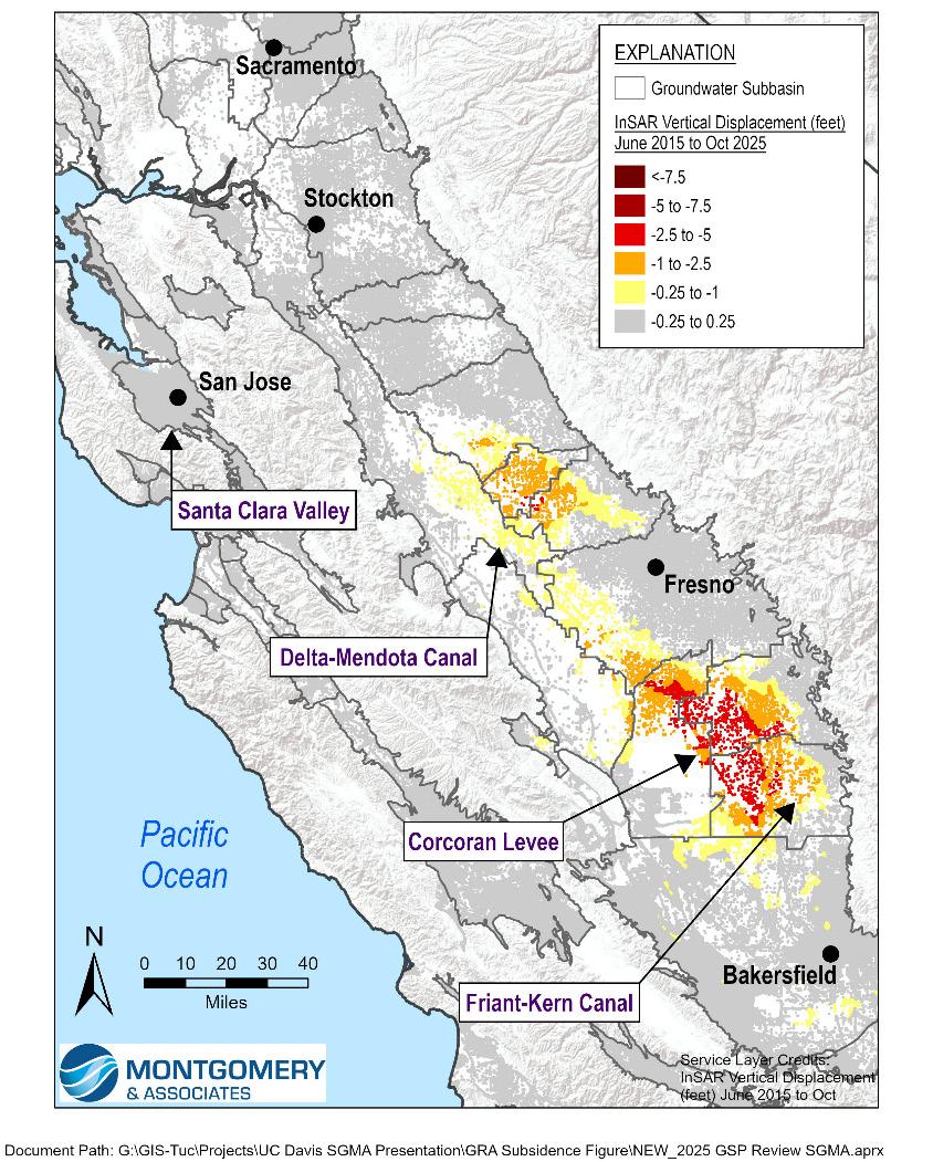
Figure 1: Article Case Study Locations and Subsidence Measured by InSAR 2015-2025
isions
This article is the fifth in the HydroVisions series on subsidence, including:
• California’s Sinking Feeling: An Introduction to Subsidence (Fall 2023)
• Models: Tools for Estimating and Predicting Subsidence (Spring 2024)
• Damage Done: Causes and Impacts of Land Subsidence in the San Joaquin Valley (Fall 2024)
• Subsidence Data: Techniques, Availability, and Interpretation (Winter 2024)
Lessons Learned
The only way to slow and eventually stop subsidence is to stabilize, and ideally raise, groundwater levels in subsidenceprone aquifer systems. Addressing overdraft is a proven strategy to prevent subsidence. Water managers in the Santa Clara Valley effectively stopped subsidence by importing new water sources to reduce groundwater pumping. The strategies employed in the Santa Clara Valley can be scaled to address the subsidence issues impacting sustainability in the Central Valley.
Santa Clara Valley
Subsidence in the Santa Clara Valley in the mid-1900s caused infrastructure damage, increased flooding, and allowed saltwater to intrude, degrading the local water supply. Between about 1915 and 1969, the northern portion of Santa Clara County experienced as much as 13 feet of subsidence due to groundwater overdraft (Valley Water, 2021; Figure 2). The subsided area spanned approximately 100 square miles from San Jose to the southern San Francisco Bay.
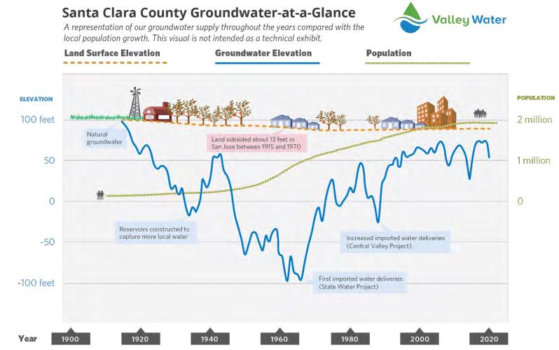
Valley Water and local stakeholders recognized that groundwater overdraft and subsidence had to stop to provide a viable path forward for the region and implemented a plan to decrease reliance on groundwater. By about 1970, subsidence was essentially halted because of Valley Water’s investments in reservoirs, diverse water supplies, and groundwater recharge. Currently, more than 50% of the Valley’s groundwater recharge is derived from imported sources. Recycled water has also been added to their portfolio to further diversify their resources. Finally, water conservation efforts continue to reduce demand even with growing population. By decreasing article continues on next page
Figure 2: History of Water Use and Subsidence in Santa Clara Valley (Valley Water, 2021)
reliance on groundwater pumping, groundwater levels have risen hundreds of feet and subsidence is no longer occurring (Valley Water, 2021).
Blueprint for Preventing Subsidence in the Central Valley Land subsidence in the Central Valley is not an unpredictable phenomenon. This subsidence is the result of groundwater levels declining below critical thresholds in fine-grained aquifer sediments. When groundwater levels decline too low, pore pressure declines, effective stress increases, and clay layers compact—manifested as subsidence at the land surface. Once compaction exceeds the historical stress—known as the critical head—that compaction becomes permanent. The land surface sinks, infrastructure is damaged, and aquifer storage capacity is irreversibly reduced.
The key to addressing subsidence is stabilizing and raising groundwater levels. The longer groundwater levels remain depressed, the more compaction occurs—not only during active pumping but also through delayed (residual) compaction in fine-grained sediments. Rapid and sustained groundwater recovery is therefore essential to stopping long-term subsidence, as shown on Figure 3. This figure from the Subsidence BMP (DWR, 2026) shows a long-term record of water levels and subsidence in the Tule Subbasin, and how subsidence was quickly arrested in the 1950s after water levels recovered rapidly due to Friant-Kern Canal water deliveries. Due to successful demand management, subsidence continued to be minimal for more than 50 years. Since 2000, however, groundwater levels have declined again, and subsidence is starting to increase.
Given the amount of overdraft and subsidence that has occurred in the last few decades, stabilizing or raising groundwater levels will require an extensive coordinated effort across groundwater basins, counties, and water districts. New information from DWR in Bulletin 118 and the Subsidence BMP provides blueprints for minimizing and eliminating subsidence through swift and decisive groundwater management actions. Promising strategies to avoid overdraft in subsidence prone areas include optimizing groundwater pumping, decreasing groundwater demand, and increasing managed aquifer recharge.
Groundwater pumping from deep, high-capacity wells located in the center of the valley tends to have a large impact on subsidence, whereas pumping from shallower aquifers closer to the valley margins can have a lesser impact. Much of the costly damage to conveyance and flood control infrastructure is found in the center of the valley where subsidence-prone aquifers, typically beneath thick clay interbeds or confining units, are being overdrafted. Some properties of lower risk areas include shallower aquifers, aquifers with less fine-grained sediment, areas that are conducive to natural or managed aquifer recharge, and areas that have less critical infrastructure susceptible to subsidence damage. A targeted management approach can therefore reduce risk by shifting pumping away from the most vulnerable zones, reducing extraction from deeper compressible units, and prioritizing groundwater level stabilization in areas where subsidence threatens major infrastructure. Managing subsidence effectively requires the alignment of pumping strategies with geologic and infrastructure vulnerability.
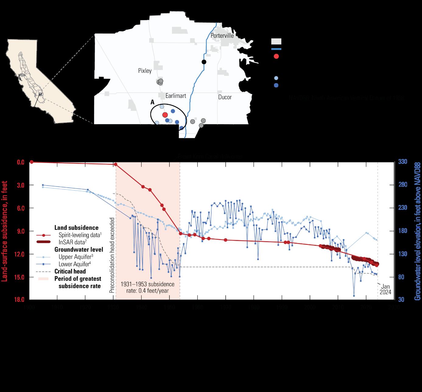
Figure 3: Subsidence BMP Figure Showing Subsidence in the Tule Subbasin (DWR, 2026)
Demand management by land fallowing, conservation, and/ or providing alternative water supplies is another effective way to reduce pumping and groundwater overdraft. Given the constraints on available surface water in most years, groundwater demands will need to decrease to bring the Central Valley’s water use into balance. The region must find ways to take sub-prime land out of production, grow less water intensive crops, use fewer crop rotations, and continue to improve agricultural and urban water use efficiency. Funding programs (e.g., DWR’s Multi-Benefit Land Repurposing Program) are designed to help landowners afford to fallow land. Some basins are exploring water allocation programs to implement demand management in subsided areas. Allocation programs can be used to incentivize the movement of pumping from deeper, subsidence-prone aquifers to shallower, less subsidence-prone aquifers through pumping limits in unsustainable areas.
Managed aquifer recharge (MAR) can offset groundwater pumping and provide an essential complement to pumping reductions to prevent subsidence in overdrafted areas. Wet years present opportunities to rebuild groundwater storage and create a buffer for future droughts. Recharge efforts are most effective when strategically targeting subsidence-prone areas where groundwater levels are below critical thresholds. Therefore, MAR that directly recharges the deep overdrafted aquifers in the Central Valley is the most effective approach for minimizing subsidence. Aquifer storage and recovery (ASR) has been used for recharging deep confined aquifers for municipal supply for decades. Agricultural ASR wells are a newer approach being advanced to directly address subsidence in agricultural areas in the Central Valley.
Many MAR approaches are designed to percolate water from the surface to recharge shallow aquifers. Consequently, surface recharge methods are less effective in the near-term at actively addressing deeper overdrafted aquifers that are causing subsidence but still do provide long-term basin management benefits. MAR approaches being used in the Central Valley that utilize surface recharge include dedicated recharge basins, onfarm flooding of dormant fields (Flood-MAR), and stream and river restoration to reconnect floodplains with aquifers.
Available water supply is a common limitation for MAR projects. Central Valley stream systems are fully allocated so for many areas water is only available for recharge in wet years. Conversely, treated wastewater can be used for beneficial reuse year-round to increase. Water availability can be increased in some cases by reservoir reoperation to release flood storage and water rights permitting. Finally, expanding conveyance systems and capacity can help increase surface water availability for recharge and provide water for conjunctive use of surface water and groundwater.
Conclusions
Slowing and stopping subsidence in the Central Valley is going to take a monumental and coordinated effort. However, the only path forward for the region is to take these necessary and sometimes painful steps to prevent groundwater overdraft and minimize subsidence. Ongoing subsidence mitigation efforts in these critical areas will be highlighted in the final article of this series in Summer 2026 edition of HydroVisions. Groundwater overdraft and subsidence in these critical areas cannot continue at the present rates and simply cannot be afforded by future generations and agricultural community in the Central Valley.
References
Valley Water, 2021. Groundwater Management Plan for the Santa Clara and Llagas Subbasins. https://s3.us-west-1. amazonaws.com/valleywater.org.us-west-1/s3fspublic/2021_GWMP.pdf
DWR, 2025. DRAFT California’s Groundwater: Bulletin 118 — Update 2025. https://water.ca.gov/programs/ groundwater-management/bulletin-118
DWR, 2026. Best Management Practices of the Sustainable Management of Groundwater – Land Subsidence. https://water.ca.gov/-/media/DWR-Website/WebPages/Programs/Groundwater-Management/ Sustainable-Groundwater-Management/BestManagement-Practices-and-Guidance-Documents/ Files/Land_Subsidence_BMP.pdf
Celebrating 46 Years!
▪ Modeling Software Development
▪ Hydrogeological Modeling
▪ Geochemical Investigation & Modeling
▪ Contaminant Fate & Transport
▪ Water Supply Evaluations
▪ Aquifer Storage & Recovery
▪ Managed Aquifer Recharge
▪ Monitoring Well and Pump Performance Optimization
▪ Remediation Engineering for Soil, Groundwater, and Surface Water
▪ Sampling and Field Services
▪ Expert Testimony & Litigation Support


Environmental Consulting and Engineering
At LWA, we understand that groundwater is vital for California’s water future. We’re here to help communities manage this precious resource wisely and in line with state regulations.
Home Office Davis, CA | 530.753.6400 with regional offices in Berkeley, San Diego, San Luis Obispo, Santa Monica, Seattle, Ventura, and Yreka
GROUNDWATER EXPERTS
PROVIDING INNOVATIVE SOLUTIONS FOR MANAGING OUR CRITICAL WATER RESOURCES
Related Services
Water Resources Modeling
Managed Aquifer Recharge
Interconnected Surface Water Analysis
Groundwater Dependent Ecosystems
Subsidence Analysis
Stormwater Management
PFAS
Sustainable Groundwater Management
Groundwater Quality
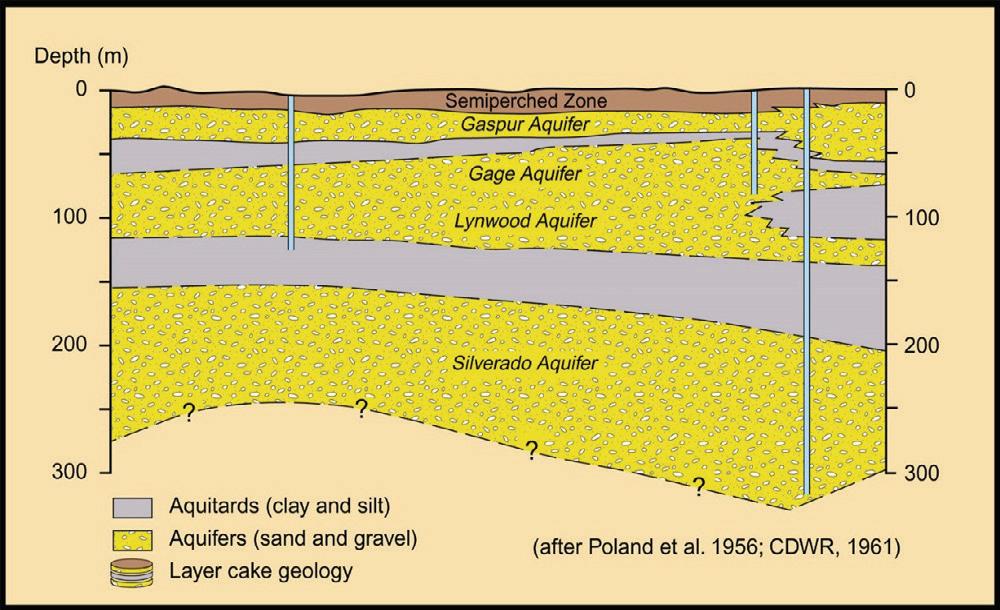
ENVIRONMENTAL SEQUENCE STRATIGRAPHY
Groundwater Geology to Optimize Sustainable Groundwater Management
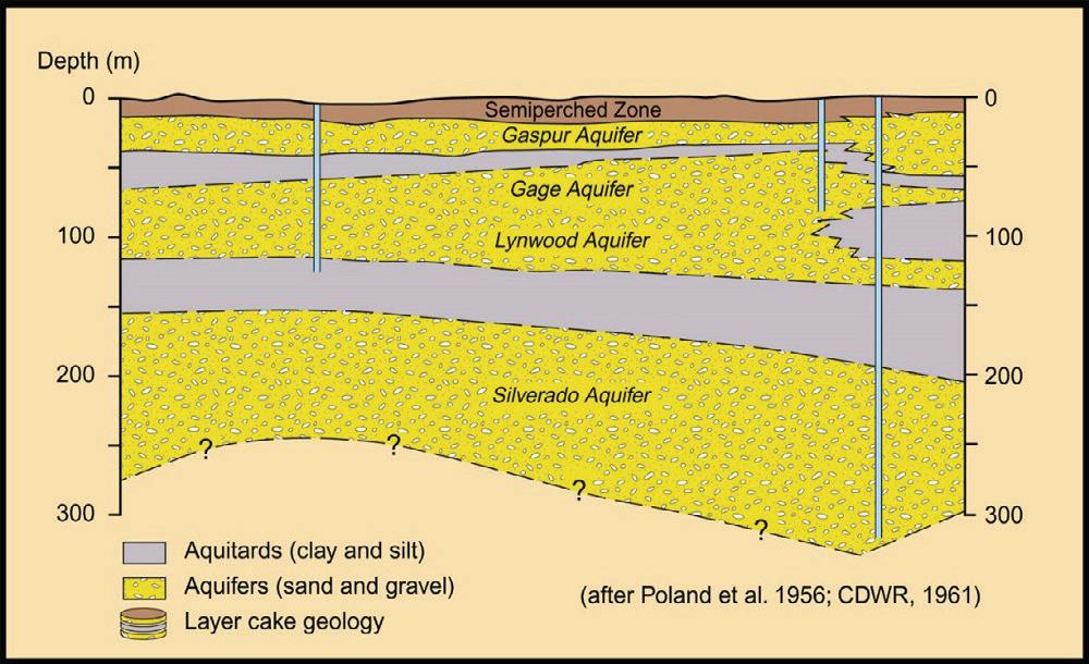
Environmental Sequence Stratigraphy (ESS) is a Geosyntec Best Practice for Groundwater Basin Characterization which is the foundation for all things related to sustainable groundwater management, including:
• Hydrogeological conceptual models
• Groundwater modeling
• Interconnected surface water-groundwater
• Subsidence analysis
• Managed Aquifer Recharge (MAR)
• Aquifer Storage and Recovery (ASR)
• Groundwater monitoring networks
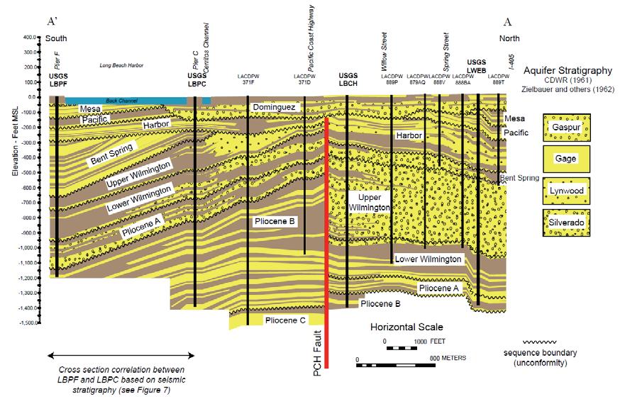
Coast Basin, LA County
ESS and PFAS
and PFAS
Because this approach creates a nuanced geological understanding of
to supporting remedial investigation programs involving per- and
approach is is a critical step in defining contaminant source and
groundwater monitoring programs.
Both the United States Air Force and Navy consider ESS to be a best because standard step-out “plume chasing” is not practical given the mobility, and stringent drinking water standards of these substances. ESS PFAS are likely connected to a source under investigation, or whether they
For more information, please contact our
Technical Truth: Geology is the primary control on groundwater flow
Because this approach creates a nuanced geological understanding of permeability and groundwater flow, it is uniquely suited to supporting remedial investigation programs involving per- and polyfluoroalkyl substances (PFAS). This geology-focused approach is is a critical step in defining contaminant source and pathways to effectively target sampling locations and groundwater monitoring programs.
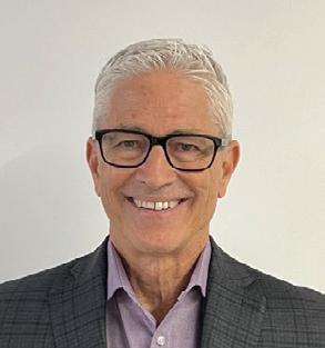
Rick Cramer, PG rick.cramer@geosyntec.com
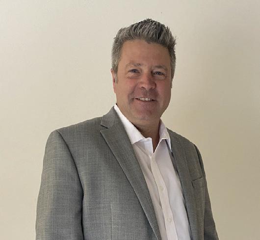
James Gonzales, PG, CHG james.gonzales@geosyntec.com
Both the United States Air Force and Navy consider ESS to be a best practice for PFAS investigations and remediation because standard step-out “plume chasing” is not practical given the ubiquitous occurrence, low detection limits, high mobility, and stringent drinking water standards of these substances. ESS also helps clients understand whether detected



Hydro Visions

flowinG tHrouGH tHe cracks: non-basin Groundwater in california
by Gus Tolley, Geo-Logic Associates; Trey Driscoll, INTERA; Marcus Trotta, Sonoma Water; Chad Taylor, Todd Groundwater; and Jim Blanke, Woodard & Curran
When most conversations about groundwater in California arise, attention quickly turns to the state’s well-defined alluvial groundwater basins—especially those basins governed under the Sustainable Groundwater Management Act (SGMA) 1 . However, beneath the radar lies a vast and often overlooked component of California’s groundwater portfolio: non-basin groundwater. Found primarily in hilly and mountainous terrain, this water source exists outside of sedimentary basins and supports rural communities, ecosystems, and agriculture. Unlike alluvial basins regulated under SGMA, non-basin aquifers are not subject to comprehensive groundwater sustainability requirements. Monitoring and characterization of these systems are generally limited, which creates challenges for long-term planning and drought resilience.
As California grapples with long-term water sustainability and climate variability, understanding the role, challenges, and policy gaps surrounding non-basin groundwater is more important than ever. This article is the first in a series and will provide a broad overview of non-basin groundwater in California and why it matters. Subsequent planned articles include:
• Aquifer On the Rocks: Importance and Challenges of Fractured Rock Aquifers
• Liquid Labyrinths: Regulatory Challenges for California’s Fractured Rock Wells
Groundwater moves through interconnected pore spaces or fractures within an aquifer. In sedimentary aquifers, groundwater flows through pore spaces between grains (primary porosity) such as sands, gravels, and silts. In contrast, non-basin aquifers rely on fractures and faults (secondary porosity) formed by various geologic and chemical processes, making water availability far more variable and difficult to predict. In general, secondary porosity is much lower than primary porosity in bedrock aquifers which results in much lower storage capacity and transmissivity compared to sedimentary aquifers. For example, aquifer tests performed in Lee Valley near San Diego showed the hydraulic conductivity of the fractured bedrock aquifer was about 140 times lower than the overlying weathered regolith (Kaehler & Hsieh, 1994).
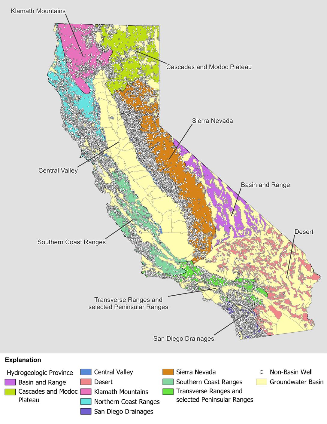
Non-basin aquifers account for about 40% of the state by area and are present in each of California’s 10 hydrogeologic provinces (Figure 1). About 36% of water supply wells in California are completed in non-basin aquifers according to the Department of Water Resources (DWR) Online System for Well Completion Reports (OSWCR). The distribution of non-basin wells generally follows population patterns, with the Peninsular Ranges, Sierra Nevada, and Northern Coast Ranges having the greatest density of non-basin supply wells at 6.2, 4.3, and 2.4 wells per square mile, respectively. The more sparsely populated Klamath Mountains, Desert, and Basin and Range hydrogeologic provinces show non-basin supply well densities of 0.56, 0.05, and 0.04 wells per square mile, respectively. Hydraulic properties of non-basin aquifers can vary significantly due to the rock type and degree of fracturing.
1 Alluvial groundwater basins in California are defined by DWR Bulletin 118. For more information, visit https://water.ca.gov/programs/groundwater-management/bulletin-118. An interactive map of groundwater basins and their SGMA prioritization can be found on the SGMA Basin Prioritization Dashboard: https://gis.water.ca.gov/app/bp-dashboard/final/
isions

Basalt units found in the Cascades and Modoc Plateau hydrogeologic province can be incredibly permeable due to the presence of cooling fractures and lava tubes, which results in the lack of surface runoff from Mt. Shasta and the numerous springs that feed the Shasta and Pit Rivers. On the other hand, many wells drilled into the granite of the Sierra Nevada end up yielding no water at all. This condition can be especially frustrating for private homeowners when drilling new or replacement wells as offsets on the order of tens of feet may miss primary producing fracture(s) and result in a dry hole. As a result, well success in these settings can be highly uncertain,
as two wells drilled seemingly right next to each other may have dramatically different yields.
Beyond quantity challenges, water quality in non-basin aquifers presents an additional layer of complexity reflecting both natural geochemical conditions and human influences. Granitic rocks naturally contain elevated concentrations of uranium and radon which can be dissolved in groundwater. Although most commonly associated with the Sierra Nevada, granites are not generally prevalent in the Central Valley, Northern Coast Ranges, and the Cascades and Modoc Plateau hydrogeologic provinces. Domestic wells with elevated radon concentrations are of particular concern for human health as radon is considered to be the leading cause of lung cancer among nonsmokers with inhalation during showering being a primary exposure pathway. While different methods are available for radon testing and mitigation, testing of domestic wells is only required for rental properties within certain areas of the state. The California Geological Survey has published an interactive map of indoor radon potential, but coverage is somewhat limited.
In addition to radionuclides, non-basin aquifers can also have naturally elevated concentrations of total dissolved solids (TDS), manganese and/or iron, and other trace elements. These concentrations can be the result of groundwater flowing through host rocks that are relatively easy to weather (e.g., basalts found in the Cascades and Modoc Plateau), and/ or from long flow paths and residence times. Water quality impacts are mostly aesthetic due to elevated TDS, hardness (high calcium and magnesium), iron, and/or manganese. Some areas, especially those with geothermal activity (e.g., North Coast Ranges and Basin and Range hydrogeologic provinces) can have locally elevated concentrations of trace elements (e.g., arsenic) which have human health concerns.
Human activities can also result in non-basin water quality impairments. Sawmills and mines are the two most common industries that historically overlap with non-basin aquifers in California. Chemical compounds such as chromated copper arsenate (CCA), creosote, alkaline copper quaternary (ACQ),
article continues on next page
Figure 1
copper azole (CA), and borates have been used as wood preservatives. Acid mine drainage, particularly in the Klamath Mountains and Gold County region of the Sierra Nevada, results from the oxidation and dissolution of sulfide minerals, which produces very low pH that can more easily leach other metals from bedrock. More recently, illegal marijuana grows can be sources of contamination due to improper use and/ or storage of high-strength pesticides and fertilizers, fuels, and trash. The time required for a release to impact a nearby supply well that intersects the same fracture network can be significantly shorter in a non-basin aquifer due to the decreased aquifer storativity (less water to dilute) and lower porosity (groundwater velocity generally increases as porosity decreases).
As California advances into an era defined by tighter water budgets, climate uncertainty, and increasing reliance on distributed water supplies, non-basin groundwater can no longer remain an afterthought. These fractured and heterogeneous systems, while inherently difficult to characterize, support a substantial portion of the state’s rural population and ecological resources yet lack the coordinated management, monitoring, and policy framework applied to alluvial basins under SGMA. Bridging this gap will require targeted data collection, improved understanding of fractured rock hydrogeology, and thoughtful consideration of how existing regulatory structures can evolve to address these unique conditions. Recognizing the importance of non-basin aquifers is the first step; developing the tools and policies to sustainably manage them will be essential to ensuring California’s long-term water resilience.
References
Burton, C. A., & Belitz, K. (2013). Groundwater Quality in the South Coast Range Coastal Groundwater Basins, California (No. 2013-3015). US Geological Survey.
Fram, M. S. (2014a). Groundwater Quality in the Klamath Mountains, California (No. 2014-3031). US Geological Survey.
Fram, M. S., & Belitz, K. (2014b). Groundwater Quality in the Sierra Nevada, California (No. 2014-3096). US Geological Survey.
Fram, M. S., & Shelton, J. L. (2015). Groundwater Quality in the Cascade Range and Modoc Plateau, California (No. 2014-3123). US Geological Survey.
Johnson, T. D., & Belitz, K. (2003). Hydrogeologic Provinces for California based upon established groundwater basins and watershed polygons (No. 2003-470).
Kaehler, C. A., & Hsieh, P. A. (1994). Hydraulic properties of a fracturedrock aquifer, Lee Valley, San Diego County, California (Vol. 2394). US Government Printing Office.
Mathany, T. M., & Belitz, K. (2015). Groundwater quality in the Northern Coast Ranges Basins, California (No. 2014-3114). US Geological Survey.
Wright, M. T., & Belitz, K. (2011). Groundwater quality in the San Diego Drainages Hydrogeologic Province, California. USGS Report, 8.

Hydro Visions
ModelinG Pfas leacHinG to Groundwater for reGulatory coMPliance – Part 1
John Stults, CDM Smith; Jenny Lagerquist, INTERA, Inc.; Kyle Young, Todd Groundwater; Hiroko Hort, GSI Environmental; Hannah Fitzpatrick, GSI Environmental
Per- and polyfluoroalkyl substances (PFAS) are commonly introduced into the environment through surface spills, with migration from soil to groundwater as the primary source of risk to drinking water sources. Directly simulating PFAS movement through the vadose zone is complex, highly specialized, and labor-intensive exercise. Empirical modeling techniques have been developed to estimate how PFAS may reach groundwater for regulatory evaluations. This article is the first in a two-part series on the leaching to groundwater exposure pathway for PFAS. Part 1 focuses on PFAS fate and transport and the Dilution Attenuation Factor (DAF) model. Part 2 will discuss the fundamental basis for simulating water and solute flux in the vadose zone and current options for numerical simulation of PFAS transport.
Empirical Assessments of Contaminant Leaching to Groundwater Using the DAF Model
The EPA Dilution Attenuation Factor (DAF)1 was developed in 1996 to assess the leaching to groundwater pathway and is intended as a conservative screening tool for calculating soil screening levels (SSLs) for groundwater protection based on regional climatic conditions, site specific groundwater and soil conditions, and contaminant-specific partitioning behavior. DAF estimates protective soil concentrations that will not cause groundwater contamination above regulatory limits (e.g., MCLs). The model incorporates dilution (mixing with clean water) and attenuation (sorption) and assumes that the contaminant is uniformly distributed throughout the vadose zone. The model is defined by four equations:

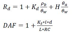
where, C pw is the porewater concentration, C gw is the target groundwater concentration (typically the regulatory threshold for groundwater), SSL is the soil screening level, Rd is the contaminant retardation factor, Kd is the Soil-water partitioning coefficient, DAF is the dilution attenuation factor, d is the mixing depth determined by Equation 45 of EPA 1996,1 and all other terms are defined in Table 1.
Regional screening levels (RSL)2 were developed by the EPA and can be used to develop inputs for water content and net recharge on an annually averaged basis. Default RSL values are typically used unless the site stakeholders opt to determine site-specific input values for the model. Default values for chemical specific solid phase and air-volatilization parameters are available in RSL tables.2
Modification of the EPA DAF Model for PFAS
The PFAS listed on the standard EPA 1633A analyte list typically have low vapor pressures and negligible Henry partitioning coefficients under environmentally relevant conditions. However, long chain PFAS are hydrophobic and act as surfactants, and therefore partition to the airwater interface. This additional retention mechanism is not considered in the traditional EPA DAF model and has been shown to be important for a wide range of PFAS of concern.3
isions
Brusseau and Guo 20234 proposed a revised EPA DAF model which considers air-water interfacial partitioning. The resultant model replaces Equation 3 with Equation 5.
q. 5

Where, K aw is the air-water interfacial partitioning coefficient, which is largely a function of PFAS properties and can be estimated using multiple empirical methodologies.5,6 The volume-normalized air-water interfacial area (A aw) can be estimated using the median grain diameter (d50) of the soil and the volumetric water content (θw) of the soil7 as in Equation 6.

Determination of Site-Specific Solid Partitioning for the EPA DAF Model
While EPA RSL tables can provide estimates of soil partitioning for various regions, soil-water partitioning coefficients can vary greatly and often require site specific determination. Equations 3 and 5 require the solid phase partitioning coefficient (Kd). The Kd for organic contaminants like PFAS is typically estimated using a relationship between the organic carbon partitioning coefficient (Koc) and the fraction of organic carbon (foc) for the site of concern. The K oc is typically estimated using EPA RSL tables2 or COMPTOX8, while foc is directly measured in the contaminated soil or estimated using RSL values. The estimated Kd is proportional to the K oc multiplied by the foc (Kd = K oc * foc).
The Kd term presented in Equations 3 and 5 can also be determined empirically if a site manager opts to develop alternative remediation criteria. The standard precipitation leaching procedure (SPLP) EPA Method 1312 is the most commonly used test in leaching evaluations. SPLP is intended to be a “worst-case-scenario” leaching evaluation for obtaining a conservative estimate of Kd. 9 Currently, some state agencies include the SPLP test as part of their PFAS assessment guidance.
An alternative to using SPLP is the EPA’s Leaching Evaluation Assessment Framework (LEAF), (alternative series of tests) which is intended for general leaching studies. Utilizing EPA Methods 1313, 1314, and 1316, and LEAF has been proposed as a more robust approach for assessing site-specific Kd values. Recent validation studies have suggested that minimal modification of EPA LEAF methods is required for application to PFAS and semi-volatiles organic compounds (SVOCs).10 EPA Method 1314 and 1316 can be used to develop Kd estimates under appropriate conditions. However, both methods require significantly more labor and sample processing than SPLP. Several other standard and nonstandard methods exist for leaching evaluations, which are summarized in Navarro et al. (2024).9
Porewater Suction Lysimeters for Direct Measurement of PFAS Concentrations
Porewater lysimeters in the vadose zone are analogous to groundwater wells. Suction lysimeters are typically constructed with a metal or PVC body attached to a ceramic or metallic mesh suction cup. Porewater lysimeters are typically installed directly above the maximum groundwater level in the capillary fringe to measure PFAS porewater concentrations (C pw) that might be leaching directly into the groundwater. While porewater lysimeters provide direct measurements of localized PFAS porewater concentrations that can be used for conceptual site model development, their use for quantitative evaluations of leaching requires significant additional considerations as outlined in an EPA “points-toconsider” document from 2024.11
Table 1: A review of important parameters for modeling PFAS transport in the vadose zone using the EPA DAF model.
Parameter Definition
Soil-water partitioning coefficient
Air-water interfacial partitioning coefficient
Air-water interfacial area
Soil bulk density
Use
Determine percentage of mass adsorbed to soil
Determine percentage of mass adsorbed to the airwater interface
Determine the available interfacial area available for adsorption
Mass of soil available for adsorption
Volumetric water content determine the void saturation of water in the pore space for mass balance calculations
Volumetric air content
Volumetric porosity
Median grain diameter
Organic carbon partitioning coefficient
Fraction of organic carbon
Saturated hydraulic conductivity of the underlying aquifer
Net annual recharge
Hydraulic gradient of the underlying aquifer
Length of the groundwater plume
Henry partitioning coefficient
Determine void space associated with air
Calculation of air-water interfacial area and the air phase content.
Used to estimate the air water interfacial area:
Estimate using the -relationship
Estimate using the -relationship
Determine the dilution factor
Determine the dilution factor
Determine the dilution factor
Determine the dilution factor
Determine mass volatilized in the air-phase
Method(s) of Determination
EPA Method 1312 (SPLP), LEAF 1313, LEAF 1314, LEAF 1316, Koc-foc correlation
Literature correlations - Stults et al. 2023,5 Brusseau et al. 20216
Correlation using the median grain diameter (d50) – Equation 6
ASTM D7263, ASTM F1815
Soil moisture sensors, ASTM D2974 for organic soils, ASTM D2216 for mineral soils
ASTM D4404
ASTM D6913, ASTM D7928
EPA COMPTOX Database
ASTM D2974 for peat and organic soils, Llyod-Kahn for general soils, EPA RSL tables
ASTM D5084-16a
EPA RSL tables, Groundwater table fluctuation, Computational models, environmental tracers12
Synoptic groundwater level measurements
Site specific investigation of vadose zone source area extent.
EPA COMPTOX Database - Not relevant for most PFAS
Conclusions
Part 1 summarized the primary risk assessment tool, the EPA DAF, model for assessing leaching to groundwater risk for PFAS. Methods for determining key input parameters for the EPA DAF model and more complex numerical models were also reviewed. Part 2 will review historical and recently developed numerical modeling options for comprehensive simulation of leaching to groundwater for PFAS. Key model parameters and parameter determination methods are provided in Table 111 and conclusions of this article are summarized in bullet form.
• The EPA DAF model is intended as a conservative approach for assessing whether soil contaminant concentrations pose an actionable risk to the underlying groundwater.
• When soils concentrations exceed generic conservative SSLs developed for a region, site-specific criteria may be utilized for a more appropriate criteria. Development of these alternative criteria typically requires more comprehensive numerical modeling, in addition to the EPA DAF model, to demonstrate that long-term risk to groundwater is adequately addressed.
• Some states, including California, have largely adopted the framework laid out in EPA 1996 with minimal modifications to the underlying modeling approach, although state-level considerations and applicable leaching terms vary.
• The EPA RSL tables are commonly referenced as inputs for state-level guidance. Parameterization of the DAF model may be performed using default values from EPA RSL tables2 and CompTox8 dashboard or using empirically derived data, depending on site-specific remediation requirements.
• The use of porewater lysimeters to aid in model parameterization and validation is an area of ongoing development.
• While Brusseau and Guo (2023) have developed a modified version of the EPA DAF model for PFAS, this model is not currently incorporated into statelevel guidance.
This article presents a summary of the necessary parameters required to develop models of PFAS leaching from soils to groundwater, and guidance on how to determine these parameters. The revised EPA DAF model is presented to demonstrate how parameters are used to determine SSLs. In the next article, we will review more complex numerical models for simulated PFAS leaching from vadose zone soils.
References
(1) EPA, U. Soil Screening Guidance: Technical Background Document| Superfund| US EPA. Washington, DC: US Environmental Protection Agency.[Accessed 7 March 2018] 1996.
(2) U.S. Environmental Protection Agency. Regional Screening Levels (RSLs) - Generic Tables, 2023. https://www.epa.gov/risk/regionalscreening-levels-rsls-generic-tables
(3) Schaefer, C. E.; Nguyen, D.; Fang, Y.; Gonda, N.; Zhang, C.; Shea, S.; Higgins, C. P. PFAS Porewater Concentrations in Unsaturated Soil: Field and Laboratory Comparisons Inform on PFAS Accumulation at Air-Water Interfaces. Journal of Contaminant Hydrology 2024, 264, 104359. https://doi.org/10.1016/j. jconhyd.2024.104359
(4) Brusseau, M. L.; Guo, B. Revising the EPA Dilution-Attenuation Soil Screening Model for PFAS. Journal of Hazardous Materials Letters 2023, 4, 100077. https://doi.org/10.1016/j.hazl.2023.100077
(5) Stults, J. F.; Choi, Y. J.; Rockwell, C.; Schaefer, C. E.; Nguyen, D. D.; Knappe, D. R. U.; Illangasekare, T. H.; Higgins, C. P. Predicting Concentration- and Ionic-Strength-Dependent Air–Water Interfacial Partitioning Parameters of PFASs Using Quantitative Structure–Property Relationships (QSPRs). Environ. Sci. Technol. 2023, 57 (13), 5203–5215. https://doi.org/10.1021/acs.est.2c07316
(6) Brusseau, M. L. Examining the Robustness and Concentration Dependency of PFAS Air-Water and NAPL-Water Interfacial Adsorption Coefficients. Water Research 2021, 190, 116778. https:// doi.org/10.1016/j.watres.2020.116778.
(7) Brusseau, M. L.; Yan, N.; Van Glubt, S.; Wang, Y.; Chen, W.; Lyu, Y.; Dungan, B.; Carroll, K. C.; Holguin, F. O. Comprehensive Retention Model for PFAS Transport in Subsurface Systems. Water Research 2019, 148, 41–50. https://doi.org/10.1016/j. watres.2018.10.035.
(8) Williams, A. J.; Grulke, C. M.; Edwards, J.; McEachran, A. D.; Mansouri, K.; Baker, N. C.; Patlewicz, G.; Shah, I.; Wambaugh, J. F.; Judson, R. S.; Richard, A. M. The CompTox Chemistry Dashboard: A Community Data Resource for Environmental Chemistry. J Cheminform 2017, 9 (1), 61. https://doi.org/10.1186/s13321-0170247-6.
(9) Navarro, D. A.; Kabiri, S. S.; Bowles, K.; Knight, E. R.; Braeunig, J.; Srivastava, P.; Boxall, N. J.; Douglas, G.; Mueller, J.; McLaughlin, M. J.; Williams, M.; Kookana, R. S. Review on Methods for Assessing and Predicting Leaching of PFAS from Solid Matrices. Curr Pollution Rep 2024, 10 (4), 628–647. https://doi.org/10.1007/ s40726-024-00326-6
(10) EPA. Development of Leaching Tests for Materials Containing SVOCs and PFAS; EPA 600/R-23/382; 2024. https://cfpub.epa.gov/ si/si_public_record_report.cfm?dirEntryId=364384&Lab=CESER (accessed 2025-10-01)
(11) EPA. Using Lysimeters to Determine the Potential of PFAS to Leach from Soil to Groundwater; 2023. https://www.epa.gov/system/ files/documents/2025-01/points-to-consider-for-lysimeters-andleaching_final.pdf
(12) Newell, C. J.; Stockwell, E. B.; Alanis, J.; Adamson, D. T.; Walker, K. L.; Anderson, R. H. Determining Groundwater Recharge for Quantifying PFAS Mass Discharge from Unsaturated Source Zones. Vadose Zone Journal 2023, 22 (4), e20262. https://doi. org/10.1002/vzj2.20262
Hydro Visions
buildinG Groundwater resilience: How collaboratiVe aPProacHes eMPower Vulnerable coMMunities
by Jane Gray and Matt Naftaly, PG, PH; Dudek1
Securing Water for California’s Most Vulnerable Communities
California’s groundwater resources are under increasing pressure. Climate variability, prolonged droughts, and regulatory requirements such as the Sustainable Groundwater Management Act (SGMA) have created complex challenges for communities that rely heavily on groundwater. For underrepresented communities, California Tribes, and small farmers, these challenges are compounded by limited technical capacity and financial resources.
How do we ensure these vulnerable water users are not left behind in the pursuit of groundwater sustainability? Addressing this challenge requires intentional strategies, including collaborative, interdisciplinary approaches; inclusive, language-appropriate community engagement; and tailored technical assistance that is free of charge and delivered statewide. In this article, Dudek Principal Geologist/Hydrologist Matt Naftaly and Watershed Sciences Project Director Jane Gray examine how these strategies are applied in practice, drawing on lessons learned through their work with the California Department of Water Resources (DWR) on the Underrepresented Communities, California Tribes, and Small Farmers Groundwater Technical Assistance (URCTA) Program2.
“Underserved communities, California Tribes, and small farmers often face the same or heightened groundwater challenges as other California communities, but with fewer resources. The URCTA Program helps level the playing field by bringing technical support directly to them,” notes Dudek Hydrogeologist Matt Naftaly, who works on the program. “Examples of such challenges include inadequate water supply, degraded water quality, aging infrastructure, and the ability to comply with regulatory requirements.”
Why Collaboration Matters
Groundwater management is inherently complex, and requires understanding aquifer dynamics, water quality, infrastructure limitations, and socio-economic realities. Vulnerable communities often lack the resources to navigate these challenges alone. That’s why collaboration across disciplines, agencies, and communities is essential. These services often include customized communication and outreach, comprehensive water system data collection, groundwater quality assessment, well performance evaluation, and the preparation of hydrogeologic studies and preliminary engineering reports to evaluate feasible alternatives, fundable and “shovel-ready” project solutions, and support to connect people with funding opportunities. This assistance is essential for communities in SGMA-regulated medium- and high-priority basins, including critically overdrafted areas.
1 Dudek is a U.S.-based environmental, planning, and engineering consulting firm founded in 1980. Dudek’s experts help clients to advance projects that address today’s most complex issues, including evolving our energy systems, reinforcing critical infrastructure, safeguarding the environment, and strengthening community resilience. www.dudek.com
isions
Effective support strategies include:
• Effective and Customized Communication and Engagement: Communicating in languages spoken by the communities served to educate and design community-supported solutions
• Technical Assistance: Providing multidisciplinary support, including hydrogeologic and engineering expertise, to assess system vulnerabilities and design practical solutions
• Capacity Building: Partnering with communities for knowledge exchange and project development opportunities
• Funding Pathways: Connecting communities to grants and programs that make improvements feasible for implementation or construction
• Inclusive Planning: Ensuring Tribal voices, small farmers, and underserved communities are part of groundwater governance conversations
“DWR’s URCTA Program directly responds to water supply, reliability and water quality needs that underrepresented communities, California Tribes, and small farmers have in accessing engineering, hydrogeological, and water quality solutions. As a URCTA partner, Dudek’s team is nimble and responds promptly to work with communities in addressing each of the unique needs they have and designing scalable solutions with them for the best outcomes,” says Jane Gray, Watershed Sciences Project Director at Dudek.
Case Study: URCTA Program in Action
The URCTA Program, led by DWR, was designed to help underrepresented communities, California Tribes, and small farmers address groundwater challenges through hands-on technical assistance and planning support.
“Every assessment tells a different story, from the aquifer conditions to the community’s history. The URCTA Program helps translate that story into a technical path forward,” Matt notes.
What URCTA Does
• Identifies and prioritizes vulnerable water systems in medium- and high-priority basins
• Conducts on-site assessments of wells, water quality, and infrastructure
• Prepares preliminary engineering reports with actionable recommendations—whether drilling a new well, adding treatment or water storage, or improving distribution systems
• Builds local capacity by explaining groundwater risks and connecting communities to funding opportunities
Collaboration in Action: Integrating Hydrogeology, Engineering, and Watershed Science
The success of the URCTA Program hinges on interdisciplinary teamwork. The outreach and engagement team offers extensive, customized, and statewide outreach and engagement. They conduct water supply and water quality need and risk assessment for underrepresented communities, California Tribes, and small farmers. Once these are assessed, the team can work with hydrogeologists and engineers to come up with scalable and sustainable solutions for these entities and dialogues with the communities, California Tribes, and small farmers to ensure that proposed solutions are workable and desired. Projects are then designed to 100% constructability.
2 The URCTA Program strives to determine the needs, risks, and vulnerabilities of communities impacted by the implementation of the Sustainable Groundwater Management Act (SGMA). The program identifies eligible communities throughout California with water supply challenges such as dry groundwater wells, water shortages, or poor water quality. https://water.ca.gov/urctaprogram
article continues on next page
“When we combine our disciplines, the solutions become clearer and more holistic. It’s not just about a well. It’s the whole watershed, the distribution system, and the community we are partnering with,” says Jane.
This integrated approach prioritizes communication, adaptability, and asset-based framing to build trust and ensure recommendations reflect both technical and community realities.
Lessons Learned for Broader Application
The URCTA Program offers valuable insights for anyone working to support vulnerable groundwater users, namely:
• Start with Listening: Understand community priorities before prescribing solutions
• Integrate Disciplines: Combine hydrogeology, engineering, and watershed science for comprehensive strategies
• Simplify Complexity: Translate technical findings into clear, actionable steps
• Plan for the Future: Align local efforts with statewide strategies like SGMA and the California Water Plan
These methods can guide similar initiatives across California and beyond, ensuring that groundwater sustainability is equitable and inclusive.
Results and Benefits for Underrepresented Communities, California Tribes, and Small Farmers
The URCTA Program has already supported water systems across California. Key benefits include:
• Clear identification of groundwater needs, risks, vulnerabilities, and water quality concerns
• Improved understanding of the role of small farmers in SGMA
• Options for system improvements that are practical, fundable, and scalable
• Enhanced community capacity to plan enhanced water reliability and system resilience
This work strengthens not only groundwater reliability but also economic resilience, especially for small farmers who rely heavily on groundwater resources for their livelihoods. Program documentation highlights ongoing outreach, connection-building, and tailored technical guidance that empower communities and farmers alike.
“One of the biggest successes is building relationships and supporting communities and farmers making more informed decisions and delivering solutions that allow them to function better,” notes Jane.
Groundwater Resilience Through Collaboration
Groundwater sustainability cannot be achieved without addressing the needs of those most vulnerable to water insecurity. By embracing collaboration, capacity building, and inclusive planning, we can create solutions that work for everyone. The URCTA Program is just one example of what’s possible and a reminder that technical expertise and community engagement together are the keys to resilience.
Hydro Visions

HiGHliGHts froM tHe 2025 conteMPorary
Groundwater issues council worksHoP
by Abhishek Singh, INTERA; Erik Cadaret, Yolo County Flood Control & Water Conservation District; Thomas Harter, UC Davis; Vicki Kretsinger Grabert, Luhdorff & Scalmanini; Tim Parker, Parker Groundwater; Dave Ceppos, DMC Public Policy Mediation and Facilitation
Since 2011, the Contemporary Groundwater Issues Council (CGIC) workshop, organized by the Groundwater Resources Association (GRA), has convened California’s top groundwater experts to tackle key policy, technical, and regulatory challenges facing the State’s groundwater community. The 15th CGIC workshop, held October 27, 2025, at the Buehler Alumni Center at UC Davis, explored the growing interconnections between groundwater management and surface water, recharge, land use, water rights, and economic realities under the theme “Above the Surface and Beyond SGMA: When Groundwater Management is more than Groundwater.” The full-day workshop included a moderated panel and roundtable discussion in the morning, and two facilitated breakout sessions — “Surface Water and Recharge” and “Land Use”.
Over 40 leaders from State regulatory agencies, public water agencies, water districts, groundwater sustainability agencies (GSAs), counties, non-profit organizations (NGOs), agricultural interests, academic and research institutions, and consulting firms participated, along with several GRA Board and Executive Members. The morning panel, moderated by GRA Board Director Dave Ceppos (DMC Public Policy Mediation and Facilitation), included Mr. Keith Wallace (California Department of Water Resources), Ms. Natalie Stork (State Water Resources Control Board), Ms. Alex Biering (California Farm Bureau Federation), Mr. James Peifer (Sacramento Regional Water Authority), and Mr. Mike Myatt (Environmental Defense Fund).
The panel opened with a frank assessment: California’s groundwater community does not adequately understand depletions of interconnected surface water (ISW), and this knowledge gap complicates managing groundwater and surface water resources holistically to minimize ISW depletions. ISW sits at the convergence of surface water and groundwater permitting frameworks developed independently for over a century — technically complex, loaded with uncertainty, and locally variable. Additionally, substantial gaps in monitoring and data persist statewide, making ISW management even more difficult. Panelists agreed that ISW is difficult to monitor and model — with the added challenge that State-agency guidance must balance statewide policy consistency with local spatial and temporal conditions that are central to defining stream depletion effects on beneficial uses and users. DWR confirmed that formal ISW guidance is near release, and the State is looking to provide both technical and funding assistance to address ISW challenges. The panel emphasized that defining and managing to “locally determined undesirable results” at the basin level is the crux of ISW management, and that local action cannot wait for complete information. GSAs will need to move forward with incomplete information and use an adaptive management approach as more data are collected to narrow the knowledge gap. The discussion then shifted to the financial headwinds confronting GSAs statewide. Inflation has driven implementation costs well beyond what most GSPs anticipated; in Sacramento, the cost of providing water has climbed from roughly $300 per acre-foot a decade ago to over $1,100 today. Prop 4’s $386 million for Managed Aquifer Recharge was welcomed but acknowledged as a beginning, not a solution. However, permitting recharge projects still remains complex. By some estimates, recharge permitting constraints resulted in an estimated loss of 300,000 to 400,000 acre-feet of potential recharge in a single month in 2025.
isions

Some panelists called for greater flexibility when permitting recharge projects, with more adaptive temporary permits and a regulatory culture needing to ensure laws and public trust are protected while also being willing to tolerate permissible imperfections in exchange for action. This goal was captured in the phrase “flexi-certainty.”
The roundtable discussion that followed explored several themes that cut across the panel’s structured discussion. Financial pressure and resource constraints emerged as the dominant concern: Prop 218 campaigns are failing, GSA budgets are tightening, and the cost of implementation has far outpaced what most GSPs anticipated. Participants flagged a compounding squeeze on small family farms — SGMA’s financial demands may push smaller operators to exit before the program can demonstrate results, accelerating consolidation toward corporate operations that can more easily absorb losses while they capitalize on water rights associated with land ownership, and diverse operations in which they can more flexibly move commodities around the state and elsewhere. No broadly acceptable mechanism has emerged to ease that burden, and proposed solutions have proven politically untenable. Participants noted the escalation in the threats of adjudication in several groundwater basins, a signal that some basin pumpers may find SGMA financially or politically intractable and could be looking for alternative management approaches. It is important to note, that California courts have affirmed that adjudications do not provide an “exit from SGMA”, and need to work in tandem with SGMA instead of replacing it. Participants also emphasized the practitioner’s responsibility to engage elected officials directly. State agencies cannot lobby the legislature, so it falls to practitioners and stakeholders to make the case for adaptive implementation and more State funding to support groundwater sustainability. The group also touched on shrinking hydrogeology graduate programs (creating technical and resource constraints) and the potential for AI to help close the resulting capacity gaps.
The afternoon breakout sessions produced substantive findings. The Surface Water and Recharge group identified the core ISW challenges — generating legally defensible depletion
estimates, navigating the intersection of pumping and surface water rights, and the inadequacy of monitoring tools in many basins — and called for permitting reform centered on “flexi-certainty”: the ability to act flexibly and adaptively on recharge opportunities and ensure regulatory compliance. The Land Use group addressed the disparate timelines between General Plan cycles (20 years) and GSP cycles (5 years), the risk of double-counting water supplies in Environmental Impact Reports, and the need for a regionally coordinated approach to land repurposing through the Multi-benefit Land Repurposing Program (MLRP).
The workshop ended with appreciation to the panelists, the moderator, and all participants for their candid and thoughtful engagement. Key strategic recommendations for GRA included:
• Evolving from a technical convener into a statewide integrator engaging counties, planners, and elected officials;
• Diversifying membership to include land-use planners, surface water agencies, and economic development leaders;
• Hosting a dedicated recharge and permitting summit;
• Developing a set of practical methods to estimate ISW depletions; and
• Building groundwater literacy through public-facing education that connects communities with regulators and legislators making decisions on their behalf.
As CGIC continues its role as a think tank for groundwater in California, the 2025 workshop reinforced that achieving and maintaining groundwater sustainability is not only a technical challenge but also includes economic, governance, and land use challenges. Groundwater sustainability demands broader coalitions, deeper public understanding, and GRA’s engagement well beyond its traditional audience.


Groundwater Sustainability Planning and Implementation
Groundwater Monitoring and Remediation
Groundwater Treatment
Infrastructure Design Planning, and Operation Well Design and Construction
Hydro Visions

GeoH2oMysteryPix
by Chris Bonds, GRA, Sacramento Branch Member at Large
GeoH2OMysteryPix is a fun addition to HydroVisions that started in Fall 2022, so going on 3 years now. The idea is simple; I provide one or more photograph(s) and two questions, along with a hint, and HydroVisions’ readers email in their guesses.
In a future issue of HydroVisions, I will share the answer(s) along with some brief background/historical information about the photos and acknowledge the first person(s) to email me the correct answer(s).
GRA looks forward to your continued participation in GeoH2OMysteryPix WINTER 2026 ANSWERS
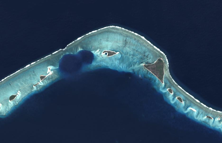
What is this? Where is it Located?
Hint: The first of its kind US testing took place in this region of the Pacific Ocean during the mid-20th Century.
Congratulations to Trevor Pontifex, PG, Hydrogeologist, Montgomery & Associates for providing the following partially correct response to the Winter 2026 GeoH2OMysteryPix
Questions:
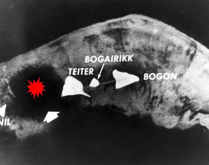
TP: “The clue and the image of an atoll immediately made me think of Bikini Atoll. That wasn’t it. It took several minutes of cruising around the Marshall Islands on Google Maps, but I finally found it: Enewetak Atoll!”
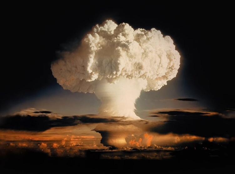
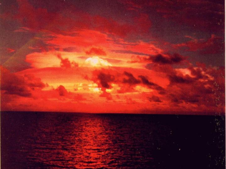
Background/History: The above cropped photo is a 2020 Landsat 8 image from National Geographic of the northern portion of Enewetak Atoll near Bogon Islet and the former Elugelab Islet within the Marshall Islands and Pacific Proving Grounds. The dark blue, circular features in the photo are craters from two nuclear test explosion during the early 1950s. The larger crater was created by detonation of the atmospheric Ivy-Mike Test device (aka “Sausage) on November 1, 1952. This first test of a 10.4-Megaton (Mt) thermonuclear (fusion) hydrogen bomb-device was historic and carved a crater that was 6,240 feet in diameter and 164 feet in depth. This explosion created a fireball about 4 miles wide and a mushroom cloud that reached an altitude of well above 100,000 feet. The islet of Elugelab was totally vaporized and destroyed by this test. The Ivy-Mike Test proved that a high-yield fusion bomb-device was feasible, significantly advancing the nuclear arms race. The second, smaller, overlapping crater was created on April 5, 1954, by the atmospheric Castle-Nectar Test of the Zombie bomb-device. The 1.8 Mt fission-fusion device was mounted on a barge in the Ivy-Mike Explosion Crater, and its detonation created a mushroom cloud that rose to an altitude of over 70,000 feet.
References:
https://en.wikipedia.org/wiki/Ivy_Mike#:~:text=Ivy%20Mike%20was%20the%20codename,yield%20comes%20from%20nuclear%20fusion https://en.wikipedia.org/wiki/Operation_Castle

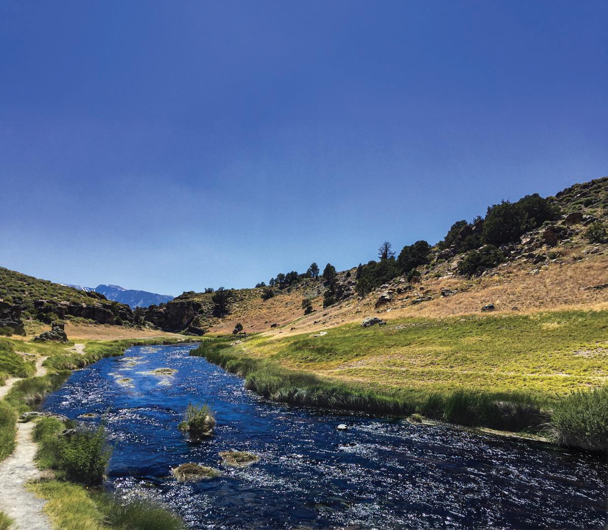
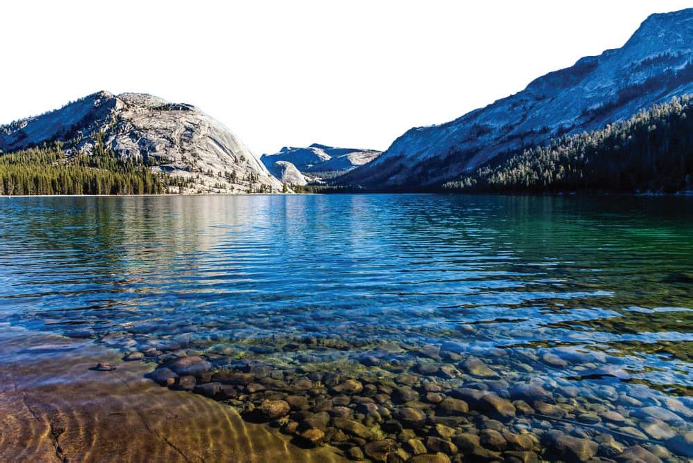
What is this? Where is it Located?
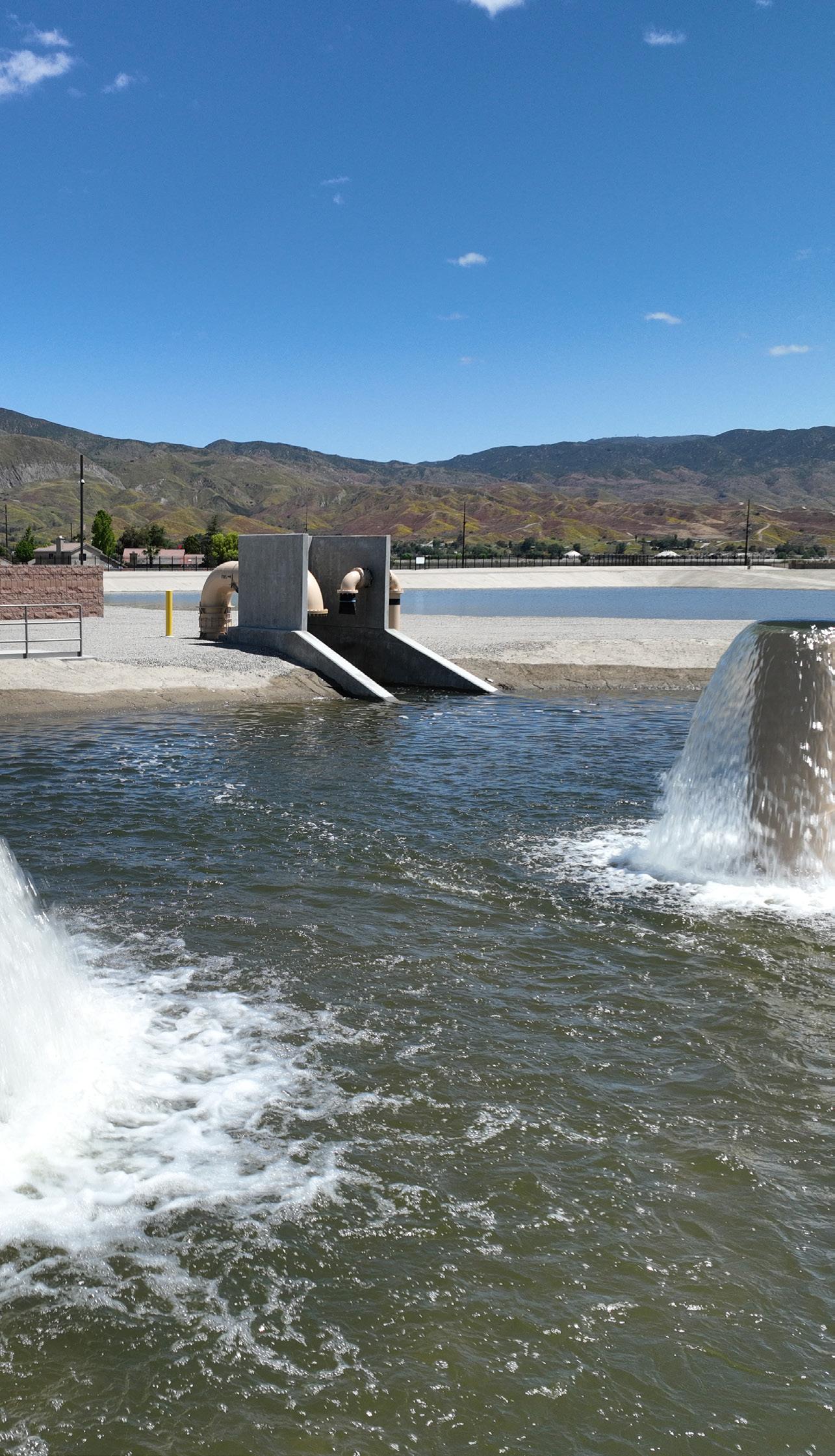
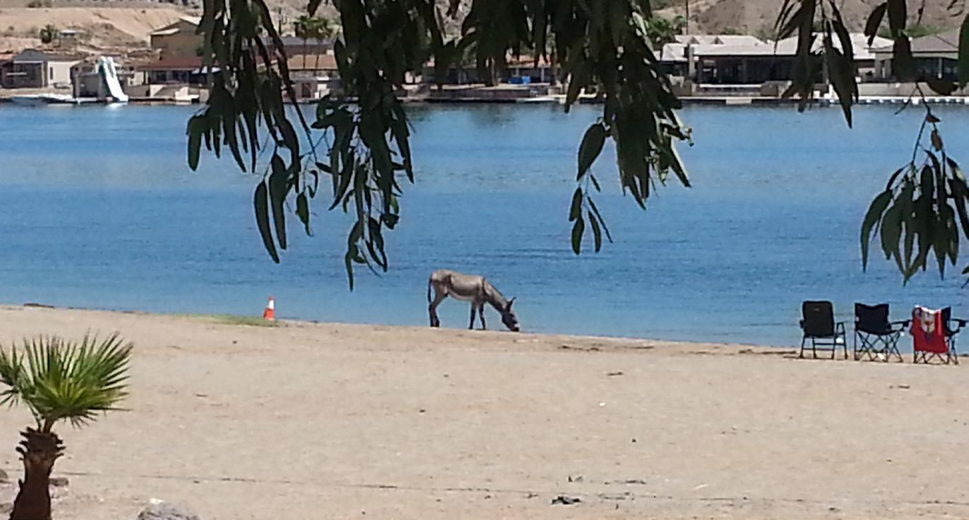
Hint: In the general vicinity of this cool water pix lies a historically significant piece of CA water infrastructure.
Think you know What this is and Where it is Located? Email your guesses to Chris Bonds at goldbondwater@gmail.com
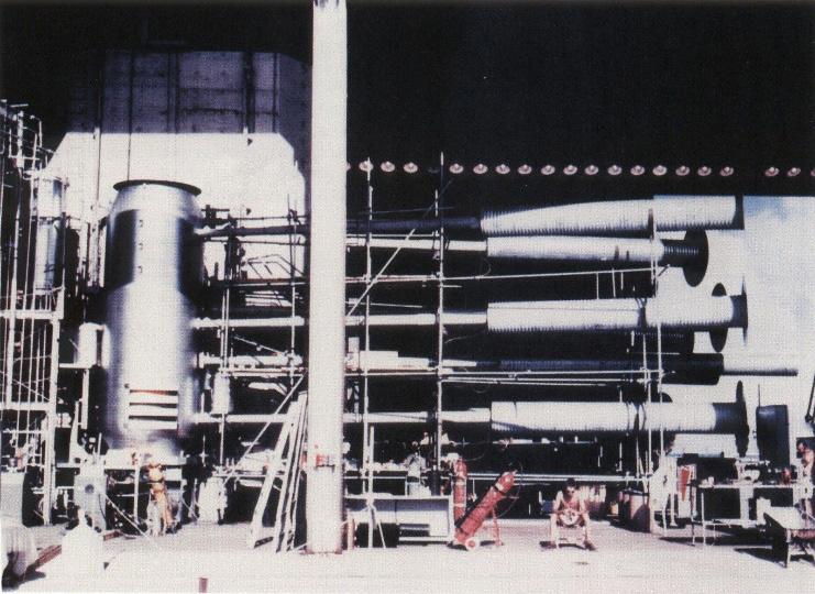
The Ivy-Mike Test Bomb-Device aka “Sausage”.
The Ivy-Mike Test Mushroom Cloud.
The Ivy-Mike Test Explosion Fireball.
Elugelab is gone following the Ivy-Mike Test.
Hydro Visions

PartinG sHot
by John Karachewski, PhD, DTSC PG & CHg - retired
isions

The St. Francis Dam Disaster occurred on March 12-13, 1928, and was one of the worst civil engineering failures in American history. This disaster occurred just two years after the dam’s completion and was one of the deadliest in California history, second only to the 1906 San Francisco earthquake. The practice of American engineering geology arose after the St. Francis disaster.
The dam’s failure released more than 12.4-billion gallons (38,000-acre feet) of water and sent a 70-foot wall of water, concrete, boulders, mud, and trees roaring down San Francisquito Canyon into the Santa Clara River Valley, and out to the Pacific Ocean near Oxnard. A swath of land up to 2-mile-wide and 70-mile-long was denuded of vegetation. The flood also devastated the towns of Santa Paula, Fillmore, and parts of Ventura. During the five and a half hours the floodwater took to reach the ocean, more than 450 people were killed, hundreds became homeless, over 900 houses and many bridges and roads were destroyed, and 24,000 acres of farmland were damaged or eroded away.
The St. Francis Dam was a concrete gravity-arch dam built to create a reservoir in San Francisquito Canyon, about 40-miles northwest of downtown Los Angeles. William Mulholland served as chief engineer for the Los Angeles water department. Water from the Owens River Aqueduct filled the 3-mile-long reservoir, which reached its capacity shortly before the dam failed. William Mulholland accepted blame for the defects and failure of the dam. Contrary to widespread belief, Dr. J. David Rogers suggested that it was Mulholland’s actual appreciation of geology which led him to build the St. Francis Dam to provide a year’s supply of water to Los Angeles in case the San Andreas fault ruptured the Owens River aqueduct.
Dr. J. David Rogers’ research found that the dam failure was due to multiple factors, including construction on a paleo-landslide, lack of engineering oversight, and improper design. Rogers recognized that the failure resulted from the eastern dam wall being built on a prehistoric (“paleo”) landslide, which was not recognized at the time. The dam
was also raised in height without strengthening the base following a prolonged drought. Rogers also noted that neither a site-specific structural design nor stability calculations were performed for the dam. Dr. Rogers (1992) publication on “Reassessment of the St. Francis Dam Failure” earned him the E.B. Burwell Award from the Geological Society of America.
The failure of the St. Francis Dam prompted the State Legislature to create the California Dam Safety Program on August 14, 1929. The primary purpose was to safeguard life and property through examination of dams constructed prior to 1929, approval of plans and specifications for new and existing dams, supervision of construction, and oversight of maintenance.
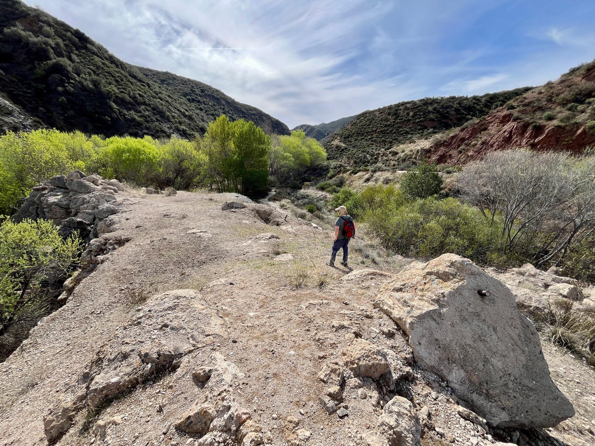
Photograph of concrete rubble pile with pipe (right foreground) by John A. Karachewski, PhD, on March 16, 2025. The approximate GPS coordinates of the photograph are 34.547009° and -118.512501°. Vignette 21 in Geology Underfoot in Southern California, Second Edition (2020) by Arthur G. Sylvester provides background and information for visiting the unmarked site. PBS produced a historical documentary by Lost LA - When the St. Francis Dam Collapsed.
Æ Managed Aquifer Recharge
Æ Aquifer Storage & Recovery
Æ Advance Modeling & Data Processing
Æ Stormwater Capture & Use
Æ Groundwater Infrastructure
Rehabilitation, Design & Operations
Æ Advanced Water Treatment Experts from Planning through Operations
Delivering Data Driven Sustainable Groundwater Solutions woodardcurran.com
Groundwater Modeling
Managed Aquifer Recharge
Hydrogeologic Investigations
Subsidence Evaluation and Mitigation
Seawater Intrusion Analysis
Municipal Well Design
Regulatory Compliance
Water Accounting Frameworks
Principal Water Resources Engineer
California Water Strategy Lead




and Surface Water Modeling to evaluate:
- Saltwater Intrusion and Barriers
- Interconnected Surface Water
-Recycled Water Recharge
- Safe Yield
-Aquifer Storage and Recovery
• Risk and Uncer tainty Analysis
•Aquifer Characterization
•Well Design and Construction Oversight
• Title-22 Permitting and Regulatory Support
• Air Quality Permitting, Modeling, Greenhouse
Gas Quantification and Reduction Contact one of our California water resource
Abhishek Singh, PhD, PE asingh@intera.com 424.275.4055
Trey Driscoll, PG, CHG tdriscoll@intera.com 760.415.1425
t H ank y ou to o ur c ontributors
Jim Blanke is a professional engineer, professional geologist, and certified hydrogeologist with over two decades of extensive experience in groundwater management in California. He has authored groundwater sustainability plans, developed technical guidance for various groundwater efforts, developed and implemented groundwater ordinances, expanded monitoring networks, and provided technical assistance for water transfers, recharge, and banking.
Chris Bonds is a Senior Engineering Geologist (Specialist) with the California Department of Water Resources (DWR) in Sacramento. Since 2001, he has been involved in a variety of statewide projects including groundwater exploration, management, monitoring, modeling, policy, research, and water transfers. Chris has over 31 years of professional work experience in the private and public sectors in California, Hawaii, and Alaska and is a Professional Geologist and Certified Hydrogeologist. Chris has been a member of GRAC since 2010, a Sacramento Branch Officer since 2017, and has presented at numerous GRAC events since 2004.
Erik Cadaret is an Associate Geologist with West Yost Associates and joined the GRA Board of Directors in 2021. Erik’s role with West Yost is to support various groundwater technical projects for clients within the state of California, management of a GSA in northern California, and support business development efforts to engage new clients. Erik loves being a part of GRA because it provides an outlet to collaborate with some of the greatest minds in groundwater.
Dave Ceppos is an Associate Director and Managing Senior Mediator with the Center for Collaborative Policy (CCP), a program of California State University Sacramento. Dave has a comprehensive background developing consensus based, stakeholder-driven, resource management processes, particularly on water policy. He has additional considerable management and field experience in watershed and natural resource planning, ecological assessment, hydrology, flood risk reduction planning, hazardous waste management, and habitat restoration.
Pete Dennehy, PG, CHG, specializes in hydrogeologic investigations and water resource planning primarily for California groundwater basins. He has over a decade of experience complying with the Sustainable Groundwater Management Act (SGMA) by developing and implementing Groundwater Sustainability Plans (GSPs). His technical work touches on all aspects of GSP implementation.
Trey Driscoll, PG, CHG, is the Managing California Director of Water Resources & Supply for INTERA. We provide stewardship and innovation to state and local water agencies for a sustainable tomorrow focused on water planning, supply development, recharge (ASR and MAR) and decision-support. Trey enjoys collaborating with fellow GRA members to help shape the future of water resources in California.
John Ellis is a Principal Hydrogeologist with 16 years of experience specializing in groundwater modeling, land subsidence, and water resources planning and management. His project work is focused in California, Texas, and Oklahoma, where he leads the development of local to regional scale groundwater flow and subsidence models and supports Sustainable Groundwater Management Act (SGMA) implementation.
Hannah Fitzpatrick is a Department of Energy Research Fellow working on Geophysics for Environmental Management. She specializes in distributed fiber optic sensing (DFOS) technologies, aquifer characterization, hydrostratigraphic analysis, poroelastic theory applications, and signal processing for geophysical data. Her research focuses on applying Distributed Temperature Sensing (DTS) and Distributed Acoustic Sensing (DAS) to diverse subsurface characterization problems.
Jane Gray is a Watershed Sciences Project Director specializing in collaborative groundwater planning and inclusive community engagement. She leverages nearly 30 years of experience to help underrepresented communities, California Tribes, and small farmers develop practical, sustainable water solutions.
Thomas Harter, Ph.D. is Cooperative Extension faculty and the Robert M. Hagan Endowed Chair in Water Management and Policy at the Department of Land, Air, and Water Resources; University of California, Davis. Dr. Harter's research group has done extensive modeling, laboratory, and field work to evaluate the impacts of agriculture and human activity on groundwater flow and contaminant transport in complex aquifer and soil systems. Dr. Harter is frequently speaking to public, technical, and scientific audiences, and is an active advisor for local, state, and federal organizations.
Hiroko Hort, PhD, PE is an engineer with GSI Environmental Inc. Her area of expertise includes environmental data analysis, computational groundwater/ surface water modeling, infectious disease modeling, and soil/hydraulic property characterization. Many of her recent studies focus on PFAS data analytics to understand the retardation scheme as well as support the modeling the fate and transport of PFAS in the groundwater and vadose zone.
John Karachewski, PhD, retired recently from the California-EPA in Berkeley after serving as geologist for many years in the Geological Support Branch of the Permitting & Corrective Action Division for Hazardous Waste Management. He leads numerous geology field trips for the Field Institute and also enjoys teaching at Diablo Valley College. John enjoys photographing landscapes during the magic light of sunrise and sunset. Since 2009, John has written quarterly photo essays for Hydrovisions.
Vicki Kretsinger Grabert, President at Luhdorff & Scalmanini. Vicki has more than 30 years of experience in regional groundwater resource management and quality assessments, including groundwater supply sufficiency and availability assessments, design of monitoring networks and programs, long-term groundwater quality monitoring and protection programs for twelve agricultural coalitions in the Central Valley, and groundwater technical assistance to the Central Valley Salinity Coalition since 2009.
Jenny Lagerquist, PE, brings nearly two decades of experience serving in environmental consulting and governmental roles, including more than a decade as a PFAS subject matter expert supporting complex site investigations and response actions across multiple Department of Defense installations.
Matt Naftaly, PG, PH, is a Professional Geologist and a Professional Hydrologist with more than three decades of experience in groundwater management and SGMA implementation. He supports communities, California Tribes, and small farmers statewide by translating complex hydrogeologic challenges into clear, actionable pathways for water resilience.
Tim Parker, PG, CEG, CHG is Ramboll’s groundwater sustainability expert with more than 40 years of experience in California groundwater. He has worked extensively in both public and private sectors and currently supports DWR’s airborne geophysical surveys. Tim is a leader in the groundwater community, including serving as President of the IAH-US National Chapter.
Dr. Abhishek Singh is a Principal Engineer with more than 20 years of experience and is President of INTERA’s Water Resources & Supply Line of Business, where he leads and manages operations, business development, strategic planning for the lob across the United States. Dr. Singh is also the chair of the GRA technical committee and serves on the GRA board of directors.
John Stults, PhD is an Environmental Engineer with CDM Smith located in Bellevue Research & Testing Laboratory. He completed his PhD research at Colorado School of Mines, studying the transport mechanisms of PFAS in the vadose zone. He specializes in PFAS transport and treatment assessments, numerical modelling, and scalable data analytics.
Chad Taylor is the Vice President and Principal Hydrogeologist at Todd Groundwater specializing in groundwater supply development, management, and monitoring on all scales from individual property to basin wide.
Gus Tolley, Ph.D., specializes in groundwater hydrology, numerical modeling, groundwater–surface water interactions, contaminant transport, GIS mapping, and workflow automation, with deep experience in developing, calibrating, and analyzing integrated hydrologic models for agricultural basins.
Marcus Trotta is a Principal Hydrogeologist with Sonoma Water and serves as plan manager for the Santa Rosa Plain, Petaluma Valley and Sonoma Valley Groundwater Sustainability Agencies. In these roles he leads technical studies and monitoring of riverbank filtration facilities and basin-scale groundwater resource studies and management programs.
Kyle Young, PhD, is a coastal hydrogeologist with academic experience in groundwater physics, hydrologic processes, and geophysics consulting. His expertise in groundwater physics and coastal hydrogeology derives from extensive training and research quantifying submarine groundwater discharge. Dr. Young has significant experience utilizing hydrologic modeling software and Geographic Information Systems (GIS) to characterize surface water flows for Managed Aquifer Recharge (MAR) decision-making.
CORPORATE SPONSORS


EVENT SPONSORS




COMMUNICATIONS SPONSORS

Roscoe Moss Company
Stults
Stefanie Shea
Assadi
Meeta Pannu Anaheim, CA
Rivers
Community Water Center working on drought, nitrate, and climate change related drinking water issues. Originally from San Diego, Kjia attended the University of California, Santa Barbara to obtain Bachelor of Arts in Environmental Studies and Political Science. During her time at UCSB, Kjia was to learn about environmental justice issues and vulnerable communities are often left out of the policy making process.
Hydro Visions