
Teaching Construction DX Through Heritage: From Laser Survey to Mixed Reality

Page 1


From Laser Survey to MR Experience

High School Students’ Digital Archiving of the Saijō Kofun Cluster

ProjectSupervisingTeacher:HironoriOhtoshi

Project Overview

This project is a collaborative effort with the KakogawaCityCulturalHeritage ResearchCentre and local construction companies to digitally archive the Saijō Kofun Cluster (Yamate, Kakogawa City) using advanced digital constructiontechnologies.Thefollowingactivities werecarriedout:

1. Mastering 3D Laser Surveying Techniques – Practical Training with Terrestrial Laser Scanners (TLS), UAVs, andLiDAR-EquippedTablets.

2. DataAnalysis – Volume Calculation and ContourGenerationwithPointCloudData.

3. Digital Model Production – Creating Reconstruction Models with CNC Routers and3DPrinters.

4. Utilisation of MR Technology –Developing Interactive Exhibitions Using DigitalArchiveData.

Through this project, studentscontribute to the documentation and preservation of cultural heritageusingconstructionDXtechnologieswhile fostering an awareness of cultural heritage conservationwithinthecommunity.

1. Mastering 3D Laser Surveying Techniques

Six third-year students from the Architecture Department’s FabLab Studio (3D Laser Surveying Technology Utilisation Team) conducted a 3D lasersurveyingexercise attheAmatsukaKofunin the Saijō Kofun Cluster as part of an event

celebrating the 50th anniversary of the Saijō KofunCluster’sdesignationasaNationalHistoric Site.Theeventwascarriedoutwiththesupportof the Kakogawa City Cultural Heritage Research Centre. With the assistance of four local construction companies, the students received instruction in the latest surveying technologies (Figures1–4)

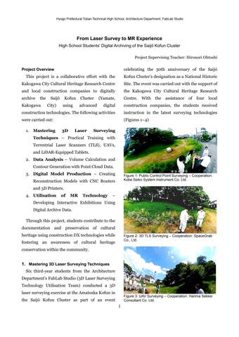
Figure 1: Public Control Point Surveying – Cooperation: Kobe Seiko System Instrument Co. Ltd.
Figure 2: 3D TLS Surveying – Cooperation: SpaceGrab Co., Ltd.
Figure 3: UAV Surveying – Cooperation: Harima Sekkei Consultant Co. Ltd.

2. Data Analysis

The data obtained through the use of 3D laser surveying techniques (Figures 5–11) were evaluated as archaeologically significant by the Institute of Historical Studies at Otemae University. Additionally, thanks to the generosity of Tatsuro Chiba from Asia Air Survey Co., Ltd., whoconceived themethod forcreating Red Relief Image Maps, a topographic map highlighting the terrain variations of Amatsuka Kofun, based on DEM (Digital Elevation Model) data surveyed by thestudentswascreated(Figure12).

Figure 4: LiDAR-Equipped Tablet Surveying –Cooperation: Maekawa Construction Co., Ltd.
Figure 5: Point Cloud Data from TLS around the Summit Area of Amatsuka Kofun
Figures 6 and 7: UAV Surveying – Provided by Harima Sekkei Consultant Co. Ltd.
Figure 8: Multi-source Point Cloud Data
Figure 9: Surface Extraction after Removal of Obstructions

 Visit to Construction ICT Worksite

To learn how to utilise point cloud data, a visit to a Construction ICT site was organised. During the visit, students had the opportunity to explore real-world examples of construction work using advanced technologies, including machine control (MC) machinery (Figures 13, 14).

Figure 10: Creation of Estimated Surface (Land-xml) and Calculation of Kofun Volume
Figure 11: Creation of Arbitrary Linear and Cross-Section Extraction (Measurement Interval: 10.0m) – Surface: Red Line, Figures 8–11 Provided by Maekawa Construction Co. Ltd.
Figure 12: Red Relief Image Map of Amatsuka Kofun –Provided by Asia Air Survey Co., Ltd.

 Visit to an Archaeological Excavation Site

Additionally, the students visited the archaeological excavation site of the Minami-Otsuka Kofun, located within the redevelopment project at Hioka Park (Ono, Kakogawa City), which further deepened their interestinarchaeology(Figures15,16).

 Participation in Events and Media Outreach Efforts (1)

At the Open High School event, we had the opportunity to introduce this project through a panel display to middle school students and their parents. Additionally, during a children’s workshop and the Architecture Department’s exhibition held at a local commercial facility, theprojectwasalsopresentedtolocalresidents (Figures 17, 18). Furthermore, the project was covered bymajormediaoutlets(Figures19–21), raising widespread awareness of the importance of cultural heritage preservation anddigitalconstructiontechnologieswithinthe community. In particular, the efforts of young generations using advanced technologies to preserve local history and cultural heritage werehighlypraisedbythelocalcommunityand stakeholders.

Figures 13 and 14: ICT Site Visit – In Collaboration with Maekawa Construction Co., Ltd.
Figures 15 and 16: Excavation Site Visit – In Collaboration with Anzai Corporation
Figure 17: Panel Display at the Children's Workshop
Figure 18: Panel Display at the Architecture Department's Exhibition

Figure 19: BAN-BAN TV News Meets, Broadcast on June 14, 2024 (Friday)

https://www.kobe-np.co.jp/news/touban/202406/0017719153.shtml

Figure 20: Kobe Shimbun, June 1, 2024 (Saturday), Page 23

Figure 21: The Daily Engineering & Construction News, June 13, 2024 (Thursday), Page 8

 Evaluation of Learning in 3D Laser Surveying and Data Analysis

Figure 22: Overall Satisfaction with the 3D Laser Surveying Practice

The satisfaction survey on the overall 3D laser surveying practice (Figure 22) indicated very high levels of satisfaction, with most participating students considering the project a success. This suggests that the planning and execution were effective and that the students gainedameaningfullearningexperience.

The satisfaction survey for each activity (Figure 23) also indicated generally high ratings, with particularly strong praise for the TLS and UAV surveying. These technologies were perceived as innovative and engaging by the students. Additionally, both the ICT construction site visit and the archaeological excavation site visit receivedhighratings,underscoringthesignificant impact of hands-on experiences on students' learning.

Intheself-assessmentsurveyontheacquisition of advanced technologies (Figure 24), students rated their proficiency in TLS and UAV surveying particularly highly. As these technologies were central to the project, the results indicate that students significantly enhanced their understandingandskillsinthesefields.

The survey on technologies and tasks that sparked interest (Figure 25) highlights UAV surveying and tablet-based surveying as areas of particular interest. However, interest in construction ICT site practices and archaeological excavationsurveyswassomewhatlower.

Figure 23: Satisfaction with Each Activity
Figure 24: Self-Assessment Results on the Mastery of Advanced Technologies
Figure 25: Technologies and Tasks That Sparked Interest

 Knowledge and Experience Gained Through 3D Laser Surveying

Student A: "There are various types of 3D laser surveying equipment, including ground laser scanners, drones, and tablets with LiDAR scanners,and Ilearned how to choose and use the right equipment depending on the location and thepurpose."

Student B: "Thanks to the collaboration with local companies, I was able to deepen my understanding of the latest construction technologies through the various surveying techniques used at Amatsuka Kofun and visits to constructionsitesusingICTmachinery."

Student C: "I was surprised to learn that our region is home to the Saijō Kofun Cluster and the Hiokayama Kofun Cluster. It made me want to learnmoreaboutourlocalculturalheritage."

Student D: "I understood that in modern construction sites, the increasing use of autonomous machinery is helping to address labourshortagesandimproveworkefficiency."

Student E: "I noticed the differences between the total station (TS) we used at school and the one used on-site, which helped deepen my understandingofsurveyingequipment."

Student F: "Learning how to collect and process point cloud data using TLS and UAV surveying, while also engaging with the local culture, was an invaluableexperience."

 Survey Results and Analysis of Free Responses on the Laser Surveying Practice

The survey results clearly demonstrate that the project was highly successful, providing students with an exceptionally effective and enriching learning experience. In particular, the TLS and UAV surveying were highly regarded, fostering a deeper appreciation for local cultural heritage amongthestudents.

Looking ahead, it is recommended to provide additional opportunities that allow students to take a more proactive role in their learning, thereby further developing their technical expertise. Furthermore, initiatives to cultivate

greater interest in construction ICT and archaeological excavation surveys would be valuable, encouraging students to engage with these fields in a more immersive, hands-on manner.

3. Digital Model Creation

Building on the digital data collected from AmatsukaKofuninthefirsthalfoftheproject,the 3D Laser Surveying Technology Utilisation Group created a comprehensive digital model of the entire Saijō Kofun Cluster in the latter half. The processisoutlinedasfollows

(1) Creation of a Kofun Shape Model Using a CNC Router

Using point cloud data from the Amatsuka Kofun, a CNC router was used to machine a urethane board model of its current shape. The estimated original shape at the time of construction was also reconstructed for comparisonandanalysis(Figures26–28).

Creation of the Current Shape Recreation of the Estimated Shape of Amatsuka Kofun at the Time of Construction
Figure 26: CNC Machining Simulation
Creation of the Current Shape Recreation of the Estimated Shape of Amatsuka Kofun at the Time of Construction
Figure 27: Carving the Shape of Amiizuka Kofun Using a CNC Router

(2) Creation of Kofun Cluster Shape Models Using a 3D Printer

In addition to the Amatsuka Kofun, 3D data wasgeneratedtoreconstructtheestimatedshapes of two other tumuli in the Saijō Kofun Cluster. These models, including the Amatsuka Kofun, were 3D-printed with the cooperation of the Institute of Historical Studies at Otemae University, based on historical research perspectives(Figures29–31).

Figure 29: 3D Printing Simulation

Furthermore, these models were also exhibited attheKakogawaGeneralCulturalCenterMuseum (Figure32).

4. Utilisation of MR Technology

Five first-year students joined the FabLab Studio in the Architecture Department and worked on acquiring MR (Mixed Reality) technology skills as part of the MR Technology Utilisation Team. They used MR technology to create exhibition spaces and tested its effectiveness through interactive activities (Figure 33).Additionally,usingthisdigitaldata,theyheld experience sessions at the school cultural festival (Figure 34), the Hyogo Prefecture High School Research Activity Conference at the Kobe City MikagePublicHall(Figure35),andtheKakogawa GeneralCulturalCenterMuseum(Figures36,37).

Figure 28: Comparison Model of the Current and Reconstructed Shapes of Amiizuka Kofun
Amatsuka Kofun Hitostuka Kofun
Gyojyatsuka Kofun
Gyojyatsuka Kofun _front part rear part
Amatsuka Kofun Hitozuka Kofun
Gyojyatsuka Kofun
Gyojyatsuka Kofun _front part rear part
Figure 30: 3D Printed Restoration Models of the Mounds in the Saijō Kofun Cluster
Figure 31: Comparison Model of the Mound Shapes and Sizes in the Saijō Kofun Cluster
Figure 32: Model exhibition at the Kakogawa General Cultural Center Museum

Through these efforts, they promoted the documentation and public display of archaeological sites using digital technologies, with the aim of preserving the region’s cultural heritage.

Media Outreach Efforts (2)

A digital model was created based on the 3D laser scanner surveying results of the Amatsuka Kofun, and an interactive exhibition space was developed within avirtualenvironmentusingMR technology. Visitors were able to intuitively understand the value of cultural heritage through hands-on experiences with the reconstructed burial mound and haniwa This initiative was featured in local media and received recognition as an innovative approach to cultural heritage preservation using cutting-edge technology. It was highly praised by local residents and cultural heritageexperts(Figures38,39).

Figure 33: Construction of MR Space Using a Game Engine
Figure 34: Saijō Kofun Cluster MR Experience Event at the School Cultural Festival
Figure 35: Hyogo Prefecture High School Inquiry Activity Research Association MR Experience
Figure 36: MR Experience at the Kakogawa General Cultural Centre Museum
Figure 37: MR Experience Mirrored on a PC Screen
Figure 38: Kobe Shimbun, 17 December 2024 (Friday), Page 21

 Survey Results on Digital Model Creation and the Use of MR Technology

In the satisfaction survey on the digital archiving of the kofun (Figure 40), all students who participated in the project rated it as 'satisfied' or higher, reflecting the project's high social significance. In particular, theuse of digital records of the Saijō Kofun Cluster and MR technology for the preservation and utilisation of cultural heritage was highly praised. Additionally, by visualising the kofun restoration through MR, the studentslikelygained a deeperunderstanding of its historical value and the importance of preserving cultural heritage. Furthermore, the project made a significant educational impact, contributing totheenhancementof ICTskillsand supportingcareerdevelopment.

In the survey on the understanding of the 3D data acquisition and processing process (Figure 41), all participants demonstrated a basic understanding of digital fabrication equipment. However, the high number of responses indicating "somewhat understood" suggests that factors such as insufficient practice time, lack of support systems, and task variability contributed to different levels of understanding. Time constraints, particularly in CNC router operation anddataediting,hadasignificantimpact.Moving forward, it will be important to ensure a more

Figure 39: The Daily Engineering & Construction News, 13 December 2024 (Friday), Page 16
Figure 40: Overall Satisfaction with the Digital Archiving of the Kofun
Figure 41: Understanding of the 3D Data Acquisition and Processing Process

Turn static files into dynamic content formats.

Create a flipbook
Teaching Construction DX Through Heritage: From Laser Survey to Mixed Reality by Hironori Ohtoshi - Issuu