3D Laser Scanner Surveying and VR Production Using Point Cloud Data
results was held at the city hall. The VR video produced has been made available on the website of the City Cultural Property Research Centre.
Regional Contribution through the Digital Archiving of a Hyogo Prefecture Designated Tangible Cultural Property Author: Hironori Ohtoshi (Hyogo Prefectural Toban Technical High School) To respond to the digital transformation (DX) of the construction industry, our school introduced a 3D laser scanner system and advanced the acquisition of cutting-edge technology. This system integrates surveying technology with information and communication technology (ICT), capturing distances and positions in all directions as 3D data, and reproducing them with colour information. Based on the school's vision of "Manufacturing, Human Development, and City Building," we conducted a research project to survey the Motookake House, a cultural property designated by Hyogo Prefecture, using 3D laser scanning and converting it into virtual reality (VR). The house,
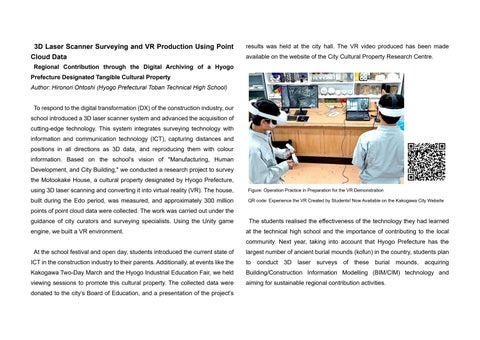
Figure: Operation Practice in Preparation for the VR Demonstration
built during the Edo period, was measured, and approximately 300 million
QR code: Experience the VR Created by Students! Now Available on the Kakogawa City Website
points of point cloud data were collected. The work was carried out under the guidance of city curators and surveying specialists. Using the Unity game
The students realised the effectiveness of the technology they had learned
engine, we built a VR environment.
at the technical high school and the importance of contributing to the local community. Next year, taking into account that Hyogo Prefecture has the
At the school festival and open day, students introduced the current state of
largest number of ancient burial mounds (kofun) in the country, students plan
ICT in the construction industry to their parents. Additionally, at events like the
to
Kakogawa Two-Day March and the Hyogo Industrial Education Fair, we held
Building/Construction Information Modelling (BIM/CIM) technology and
viewing sessions to promote this cultural property. The collected data were
aiming for sustainable regional contribution activities.
donated to the city’s Board of Education, and a presentation of the project’s
conduct 3D
laser surveys of these
burial
mounds, acquiring