SPECIAL TOPIC: LAND SEISMIC
Redefining transition-zone 3D seismic acquisition: Flexible land-nodal methods applied to the Kalundborg-Gassum CCS site, Denmark Piotr Potepa1*, Karim Souissi2, Manuel Beitz 2, Ewa Zubrzycka1 and Jerzy Trela1 describe how the challenges specific to the transition zone (TZ) in 3D seismic surveys can be overcome in a cost-effective manner by adapting land seismic equipment for use in marine conditions. Abstract Equinor and its partners Ørsted and Nordsøfonden recently conducted the Kalundborg carbon capture and storage (CCS) 3D seismic survey, acquired by Geofizyka Toruń S.A. (GT), to evaluate the suitability of subsurface sites for CO2 storage in Denmark’s coastal transition zone. This paper describes how challenges specific to transition zone (TZ) in 3D seismic surveys can be overcome in a cost-effective manner, by adapting land seismic equipment to marine conditions. With a strong focus on compliance with environmental regulations, the project successfully delivered high-quality 3D seismic data by integrating land-nodal technology across both onshore and offshore settings. The innovative application of buoy-mounted nodes, combined with an adaptive acquisition design, enabled seamless data acquisition and processing while minimising operational complexity. This approach sets a new benchmark for transition-zone seismic surveys. Introduction Seismic operations in transition zones and shallow water present unique challenges (Clark et al. 2025). The dual nature
of transition zones, which straddle both marine and terrestrial conditions, requires equipment and methodologies from both domains. In many cases, this is neither economically nor operationally efficient. Traditional marine methods, such as streamer vessels and ocean-bottom nodes (OBNs), are designed for use in deeper waters, whereas conventional land seismic systems cannot be used directly in shallow water. The lack of suitable technology has led to transition zones being overlooked in many projects, resulting in data gaps and compromised subsurface models. For the Kalundborg CCS 3D seismic survey here presented, having both features of transition zone and shallow water (Figure 1), we developed an innovative solution by adapting wireless land seismic node technology for use in shallow water. These self-contained recording units are mounted on buoyancy systems with integrated hydrophones. The nodes operate independently, storing data locally and being powered by internal batteries. By bridging the gap between land- and marine-based methods, this solution transforms one of the most challenging survey environments into a manageable and predictable part of seismic exploration.
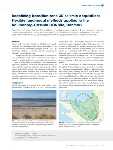
Figure 1 Acquisition of seismic data by source vessel Hydrocat Tapper in typical transition zone conditions off Vesterlyng beach, west of Havnsø. Note the white floats approx. 20 m behind the vessel (red arrow) supporting the source arrays. Photo credit: Wolfgang Kessler.
Figure 2 Location of the seismic survey area. The blue polygon delineates the receiver layout, the red polygon delineates the source layout, and the green polygon denotes licence block C2024/03.
1
Geofizyka Torun’ SA | 2 Equinor
*
Corresponding author, E-mail: piotr.potepa@GTservices.pl
DOI: 10.3997/1365-2397.fb2026005
FIRST
BREAK
I
VOLUME
44
I
JANUARY
2026
67