PERTH BASIN - NORTH
1. DALKEITH
The site of the Dalkeith (Sunset Home) artesian bore is at the base of the cliff. The bore was drilled in 1908 to a depth of 699m, and later flowed out of control for some years forming a pool of warm water. This became a favourite bathing place and passed into local folklore as the ‘hot spring’.
Salt water interface monitoring bores have been drilled around the foreshore. The superficial aquifer is 25-35m thick, and the interface is 10-20m below the water table.
From 1829 to 1890 water was supplied to Perth from springs and shallow wells which became increasingly insanitary. In 1891 the Queen Victoria Reservoir in the Darling Range was completed, but there were problems with the water quality from activities in the catchment area. The Sunset Home bore was one of about forty artesian bores drilled in Perth between 1895 and 1905 and the success of these led to the drilling of 21 artesian bores for public supply between 1897and 1932. These provided 60 to 70% of the city’s water supply until the completion of Canning Dam in 1940. The names of the geological formations Leederville, Claremont (now Yarragadee), Kings Park, Osborne, and South Perth were defined from intersections in these bores, and two important aquifers, the Leederville and the Yarragadee Formations, were recognised.
2. LAKE CLAREMONT
Formerly known as Butler’s Swamp, the land was once used for growing vegetables. After the surrounding area was cleared, the water table rose and formed a permanent lake, drowning the eucalypts. Like many other swamps in Perth, the area around it was used as a rubbish tip, and this is now concealed by the golf course.
About one in four houses in Perth now has its own bore or well for garden watering During the 1977 drought and consequent water restrictions it is estimated that one in ten houses had a bore installed. The total quantity of groundwater pumped for public and private supplies from the unconfined aquifer is about 220M m3/a, representing 60% of all water use in Perth. Water consumption from the public supply system has only just recovered to pre-1977 levels. Bore licensing has recently been extended to the Metropolitan area for bores drawing over 1500 m3/a.
3. SUBIACO WASTEWATER TREATMENT PLANT
Subiaco waste water treatment plant is one of two treatment plants discharging secondary effluent to the ocean. Waste water from here is discharged into 10m of water one kilometre offshore.
Solid waste was formerly put in lagoons behind the electricity sub-station, and used as garden fertilizer. As a result of leakage from the lagoons there is a plume of contaminated groundwater extending westwards.
Perth is part sewered and part reliant on septic tanks (mainly houses built between 1950 and 1970). Sewage is treated at three main plants, and secondary treated effluent disposed through ocean outfalls from the Subiaco and Beenyup plants. Secondary treatment removes between 35% and 55% of nitrogen, and the effluent contains 10-15 mg/L BOD, 20-25 mg/L suspended solids, 30-40 mg/L Nitrogen and 12 mg/L Phosphorus, meeting current EPA standards for ocean disposal. These standards are becoming more stringent and higher quality effluent may be necessary in the future.
4. BROCKWAY TIP
Brockway tip is operated by a consortium of local councils but is overdue for closure. It is likely to be replaced by the Mindarie site 30km to the north. The area in the foreground has been rehabilitated as open space.
Waste in the Perth area has been disposed of in about 150 former and existing landfill sites, but urban development has encroached around them and in the future waste will go to a limited number of large sites on the outer fringes of the metropolitan area, thus increasing the cost. Virtually all sites are on sand, resulting in a plume of contaminated groundwater, and emission of methane and other gases. Most sites have been rehabilitated as public open space, and development for building is not allowed. Hydrogeological criteria are important in the selection of new sites.
5. CSIRO
Headquarters of the Commonwealth Scientific and Industrial Research Organisation’s Division of Water Resources.
The major areas of research carried out by CSIRO Division of Water Resources (Perth) are in soil and stream salinisation, groundwater contamination, groundwater modelling, and resources management.
6. BOLD PARK No2 BORE
Bold Park No2 bore is one of eight ‘artesian’ bores drilled between 1954 and 1973 at reservoirs and treatment plants to cater for peak demand. The bore was drilled in 1973 to 780m. It produces at 5000 m3/d with a salinity of 880 mg/L TDS. Bold Park Nol, 1.3km to the north, also feeds into the reservoir.
Artesian bores have been drilled close to many of the reservoirs in the Metropolitan area in order to augment the supply from surface sources at times of peak demand. The water is untreated, and because the salinity of some of the artesian bores (especially south of the Swan River) is as high as 1800 mg/L TDS, the water has to be mixed to lower the salinity.
7. BOLD PARK RESERVOIR
The reservoir is situated on one of the highest points on the Pleistocene dunes (Spearwood Dune System) of the Tamala Limestone. It receives water from the Hills reservoirs and in peak periods from the artesian bores. The reservoir is roofed to prevent contamination.
Rottnest Island can be seen on the horizon 20km offshore. It represents the peak of a more westerly line of submerged Pleistocene dunes.
Rottnest is a popular holiday resort and the water supply is obtained from a thin, fresh water lens in the limestone aquifer on the island. Holiday cottages are supplied with brackish water for toilets and showers, and fresh water is supplied only to a limited number of taps. An artesian bore was drilled in 1911 and was reported to have encountered saline water in the Leederville Formation. The chances of obtaining fresh water in the underlying Yarragadee Formation have recently been reassessed on the basis of the potentiometric head, here at the coast (about 20m AHD), and indications from oil exploration wells that fresh water could extend as far as the island. The proposal to drill a 1500m bore to supply brackish water for desalination is now under consideration.
8. COASTLINE
Groundwater from the unconfined aquifer passes beneath the Pleistocene coastal dunes an discharges along the coast. The bores watering the reserve here are 15m deep and obtain yields of 2 000 m3/d from 10m of screen above the seawater interface which is at about 20m below sea level. To the south towards Fremantle the freshwater layer is substantially thinner.
The fore dunes (Quindalup Dunes) are of Holocene age and in places along the coast are mobile and unvegetated. North of Scarborough the Tamala Limestone crops out in low cliffs
To the north of Floreat Beach, drainage water from Herdsman Lake is discharged on the beach through a large diameter pipe.
9. HERTHA ROAD
The route crosses the former Hertha Road landfill site which has been filled to a depth of about 5m. The site lies over a peat swamp, and investigations have been carried out to determine the movement of leachate
Here the Mitchell Freeway has been built over a swamp, and loading to consolidate the peat is in progress. Alteration of the hydraulic characteristics by loading appeared to have caused a rise in water table, causing flooding of septic tanks at the retirement homes in Hertha Road (to the left).
Other land subdivisions in Perth have suffered from flooding In a recent case removal of a pine plantation caused the water table to rise and form a lake, where previously it was dry. Flooding after heavy rain has also occurred in a closed depression due to breakdown of an automatic pumping system. These occurrences indicate the pressure for development of unsuitable land, and the need for correct groundwater information.
10. GWELUP BOREFIELD
The Gwelup borefield (commissioned in 1974) is the only one of the Metropolitan area’s borefields in the unconfined aquifer to be entirely within the urban area. There are twelve bores ranging in depth from 32 to 66m. Some water is also drawn from the Leederville Formation. Design yields range up to 7000 m3/d. As a result of urban and agricultural development several of the bores have nitrate concentrations up to 29 mg/L.
Dissolved iron is a troublesome constituent of much of the groundwater in the Perth Basin, and can cause unsightly staining in parks and gardens. Treatment is necessary for public water supply. This involves aeration, clarification by the flocculation of iron oxide precipitates (using sodium alginate) and finally filtration through sand.
11. GWELUP TREATMENT PLANT
The treatment plant treats water from all the Gwelup bores before reticulation to the service reservoirs.
The borefields in the unconfined superficial formations supply 20% of Perth’s public water supply. Groundwater from the unconfined aquifer requires treatment for dissolved iron and colour caused by colloidal organic matter. All of the Authority’s borefields have strict pollution control regulations to protect groundwater quality.
12. BEENYUP WASTEWATER TREATMENT PLANT
Waste water is conducted through a 5km tunnel and an outfall 1.65km offshore. This outfall and the Cape Peron outfall (to the south of Perth) are the longest ocean outfalls in Australia.
13. PROPOSED NORTH COASTAL GROUNDWATER SCHEME
Investigations to define groundwater resources for supply to the fast expanding northwestern suburbs has been carried out to the north of the urban fringe, about 2km from the coast. Bores have investigated yields and water quality from the superficial aquifer. Production rates greater than 5000 m3/d have been obtained from the Tamala Limestone. It is planned to construct production bores screened in the top part of the aquifer which is iron free, and which will therefore not require treatment
14. LAKE JOONDALUP
Lake Joondalup is the largest of a chain of wetlands lying between two major ridges of the Tamala Limestone. The water table has a steep hydraulic gradient on the west side of the lake. Farther north at Yanchep there are extensive karst features in this zone of steep gradient.
Nutrient input and eutrophication is an important problem due to market gardening and urbanisation upgradient of the lakes.
15. WANNEROO GROUNDWATER AREA
Groundwater use in this area is controlled in order to allocate the groundwater resources equitably, and to ensure maintenance of water levels in the wetlands.
The soils developed on the Tamala Limestone are preferred for market gardening. A wide range of vegetables, vines and citrus are grown in the Wanneroo area. Groundwater is readily available, and proximity to markets is an important economic factor. Urban development is, however, pushing agriculture farther out. The groundwater resources in parts of this area are now fully allocated.
16. WANNEROO RESERVOIR
From this vantage point can be seen Lake Jandabup in the foreground, the Gnangara Pine Plantation in the middle distance and the Darling Scarp on the skyline. Lake Jandabup is at the boundary between the calcarenite of the Tamala Limestone and the leached quartz sands of the Bassendean Sand and Guildford Formation.
Chlorination and fluoridation of the water is carried out in the building near the reservoir entrance.
17. LAKE JANDABUP
The lake is an expression of the water table of the Gnangara groundwater mound. An investigation of the lake showed that a plume of higher salinity groundwater resulting from evapotranspiration extended downgradient from the lake. The need to maintain these wetlands for ecological reasons is a major constraint on the utilisation of the groundwater resources of the Gnangara Mound.
18. WANNEROO BOREFIELD & GROUNDWATER TREATMENT PLANT
Bores obtain groundwater from the superficial formations, and the shallow Leederville Formation and deep Yarragadee Formation artesian aquifers. The plant has a capacity of 145 ML/d. The groundwater contains dissolved gases, turbidity, dissolved iron and colour. These are treated by aeration, iron oxidation, coagulation and flocculation, clarification, and filtration
Wanneroo 257 is the deepest water supply bore in Perth, 1150m deep, and produces water of less than 300 mg/L from the Yarragadee formation. The bore has 100m of screen and is pumped at 10 000 m3/d. The water is likely to be greater than 40, 000 years old.
19. GNANGARA MOUND
The mounded water table in the superficial formations in this area is referred to as the Gnangara Mound. The aquifer has a saturated thickness of up to 70m and contains water with an average salinity of 250 mg/L TDS. The mound is Perth’s major groundwater resource. Fortunately the corridor plan and the location of State Forests have limited urban and agricultural development. However, there is increasing pressure for urbanisation on the fringes of the mound.
Exploration of the Gnangara Mound was commenced in 1962 by the Geological Survey and resulted in the commissioning of the Mirrabooka borefield in 1970. The shallow and deep artesian aquifers are fed by recharge of fresh water, from the unconfined Gnangara Mound, mixing with higher salinity water, derived from farther north. The hydrodynamics and age of the groundwater are discussed in the conference paper by Thorpe and Davidson.
Recharge on the Gnangara Mound has been quantified by the Geological Survey using tritium as a tracer, and by CSIRO using natural chloride and applied bromide tracers, soil moisture measurement and modelling These studies indicate that recharge below the natural banksia woodland is 20-30% of rainfall, whereas under pines recharge is much reduced, and under pasture the recharge is as high as 50%.
20. MELALEUCA PARK
At a site 2km to the south, the Geological Survey has determined recharge rates using tritium as a tracer. The interface between tritiated and non-tritiated groundwater was defined by drilling and sampling bores at various depths below the water table. The position of the interface indicated a recharge rate of 21% through the banksia woodland. Cores were also taken from the unsaturated zone to investigate seasonal changes, but these results were inconclusive.
21. BULLSBROOK TOWN WATER SUPPLY
This is one of the few non-Water Authority town water supply borefields and is operated by the RAAF. The water is piped to Bullsbrook, which is east of the Darling Fault.
The Water Authority is responsible for the supply of water to most towns in Western Australia. The few exceptions are Bunbury and Busselton, and single company, mining towns, which have local water boards, and use artesian water. The Water Authority is progressively assuming responsibility for the borefields in those mining towns which are undergoing normalisation.
22. DANDARAGAN PLATEAU
The route passes up the Gingin Scarp, a Tertiary shoreline formed in Cretaceous sedimentary rocks. Cropping out in these quarries are highly weathered siltstones of the late Cretaceous Osborne Formation.
23. CHITTERING VALLEY AND DARLING SCARP
The route crosses the Darling Fault at a point where there is no surface expression and descends into the Chittering Valley. The Brockman River which occupies the valley is an underfit stream draining into the Swan River. It is likely that the valley was made by a river, now diverted through the Moore River, which extended 200km to the north along the line of the Darling Fault .
The route runs back down the Darling Scarp into Bullsbrook and travels south with the Darling Scarp on the left and the Darling Fault to the right, concealed by the coastal plain sediments.
Dams in the Darling Range account for about 60% of Perth’s public water supply. However, dam storage has been only about a third of capacity during the last decade due to years of lower than average rainfall. Predictions of a lower rainfall due to the greenhouse effect give greater importance to the groundwater resources of the Perth Basin.
24. SWAN VALLEY
The Swan Valley is intensively developed for irrigation of vines with groundwater from the Leederville Formation. Falling potentiometric levels and fears of increasing salinity resulted in proclamation of the area in 1975 as a groundwater area.
A Groundwater Advisory Committee was constituted to advise the Water Authority of WA on allocation, the issue of licences and the conditions that should attach to them. The committee serves as a useful and effective means of providing public input to the management of an important groundwater resource. By 1980, 75% of the estimated renewable resource was being used such that only moderate scope for increased abstraction remained. The consequence of over abstraction would be the lowering of head and upward migration of the underlying brackish water. Commercial irrigation is licensed according to viability, order of application and suitability to existing development. A low priority is given to pasture and hobby farms.
Groundwater abstraction in Western Australia is controlled by the Rights in Water and Irrigation Act 1914 and amendments, which is administered by the Water Authority. Groundwater resources are vested in the Crown, and the government has wide discretionary powers in the administration, allocation and control of groundwater use.
I & 2. BUCKLAND HILL LOOKOUT
The reservoir is situated on top of the Pleistocene Spearwood Dune System which forms the Tamala Limestone. It receives water from the Hills reservoirs and in peak periods from the artesian bores. The reservoir is roofed to prevent contamination.
Artesian bores have been drilled close to many of the reservoirs in the Metropolitan area in order to augment the supply from the surface sources at times of peak demand. The water is untreated, and because the salinity of some of the artesian bores (especially south of the Swan River) is as high as 1800 mg/L TDS, the water has to be mixed to lower the salinity.
Sea water extends beneath the peninsula to the south and the interface is monitored with multiport bores drilled for the Perth Urban Water Balance Study. Industrial activity in North Fremantle has resulted in a number of groundwater pollution plumes. Rottnest Island can be seen on the horizon 20 km offshore. It represents the peak of a more westerly line of submerged Pleistocene dunes.
Rottnest is a popular holiday resort and the water supply is obtained from a thin fresh water lens in the limestone aquifer on the island. Holiday cottages are supplied with brackish water for toilets and showers, and fresh water is supplied only to a limited number of taps. An artesian bore was drilled in 1911 and was reported to have encountered saline water in the Leederville Formation. The chances of obtaining fresh water in the underlying Yarragadee Formation have recently been reassessed on the basis of the potentiometric head here at the coast (about 20m AHD) and indications from oil exploration wells that fresh water could extend as far as the island. The proposal to drill a 1500m bore to supply brack7sh water for desalination is now under consideration.
3. FREMANTLE
The original water supply for the city was drawn from wells and horizontal shafts excavated through the Tamala Limestone. It was recently discovered that there was a pool of oil floating in the shafts beneath the Fremantle Prison, suspected to be from a ruptured oil pipeline. Recovery of the oil is now underway.
4. FREMANTLE LANDFILL SITE
The landfill was used for the disposal of industrial, liquid and domestic waste, and the groundwater is contaminated as a result. The council controlled caravan village is located over the levelled landfill area.
Waste in the Perth area has been disposed of in about 150 former and existing landfill sites, but urban development has encroached around them and in the future waste will go to a limited number of large sites on the outer fringes of the metropolitan area, thus increasing the cost.
Virtually all sites are on sand and result in a plume of contaminated groundwater, and emission of methane and other gases. Most sites have been rehabilitated as public open space, and development for building is not allowed. Hydrogeological criteria are important in the selection of new sites.
5. COOGEE INDUSTRIES
The Coogee area has a concentration of animal based industries centred on the Robb Jetty abattoir. Thirty-five point sources of groundwater contamination have been identified in the area. Wastes from these activities have been disposed of into sinkholes and consequently the groundwater is highly contaminated and likely to discharge into Cockburn Sound. All these industries are to be relocated.
6. LAKE YANGEBUP
This is a degraded lake affected by clearing which has raised the water level and killed the fringing trees. Disposal of waste from Jandakot Wool scourers has contaminated the groundwater with high nutrient and heavy metal levels which have entered the lake.
7. URBANISATION
Increasing demand for housing land is causing conflict between urban development and protection of wetlands and water resources in the region. Rezoning of rural land to urban to permit development of about 10 000 houses is currently being considered in the South Jandakot area. If the proposal proceeds, a drainage scheme costing in the order of $7 million will be required to ensure adequate drainage of the area, and to protect wetlands and water resources from contamination.
8. JANDAKOT MOUND
The water table in this area is referred to as the Jandakot Mound. The superficial formations have a saturated thickness of up to 30m and contain water with a salinity less than 200 mg/L TDS. The mound is the major groundwater resource in the southern Perth area
Special rural zoning is allowed in the water supply area with strict controls on lot density, clearing and water use .
The Water Authority is responsible for the supply of water to most towns in Western Australia. The few exceptions are Bunbury and Busselton, and single company mining towns, which have local water boards and use artesian water. The Water Authority is progressively assuming responsibility for the borefields in those mining towns which are undergoing normalisation.
The borefields in the unconfined superficial formations supply 20% of Perth’s public water supply. Groundwater from the unconfined aquifer requires treatment for dissolved iron and colour caused by colloidal organic matter. All of the Authority’s borefields have strict pollution control regulations to protect groundwater quality.
9. JANDAKOT GROUNDWATER TREATMENT PLANT
The plant treats groundwater from the Jandakot Mound. The groundwater contains dissolved gases, turbidity, dissolved iron and colour. These are treated by aeration, iron oxidation, coagulation and flocculation, clarification, and filtration.
Dissolved iron is a troublesome constituent of much of the groundwater in the Perth Basin, and can cause unsightly staining in parks and gardens. Treatment is necessary for public water supply. This involves aeration, clarification by the flocculation of iron oxide precipitates (using sodium alginate) and filtration through sand.
10. THOMPSONS LAKE
Thompsons Lake is a relatively pristine lake, with little development nearby, and is an expression of the water table on the Jandakot Mound. There is a plume of higher salinity groundwater downgradient from the lake. The need to maintain these wetlands for ecological reasons is a major constraint on the utilisation of the groundwater resource; management is also complicated by their use as compensating basins for drainage.
11. LAKE COOGEE
Bores and shallow wells are used for market gardens in the area. The salinity has risen due to upcoming of the saltwater interface, evaporation and recirculation of salts, including fertilizers. The lake has a salinity range of 8000 to 48 000 mg/L TDS. Multiport bores have been installed around the lake to monitor the saltwater interface.
The soils developed on the Tamala Limestone are preferred for market gardening. A wide range of vegetables, vines and flowers are grown in the area. Groundwater is readily available, and proximity to markets is an important economic factor. Urban development is however pushing agriculture farther out. The groundwater resource in parts of this area are now fully allocated.
12. WOODMAN POINT WASTEWATER TREATMENT PLANT
All sewage from south of the Swan River passes through the Woodman Point Waste Water Treatment Plant. Unlike the plants to the north of the Swan River, the effluent receives only primary treatment before discharge through an outfall 4km offshore at Cape Peron (the longest ocean outfall in Australia). The effluent contains about 150 mg/L BOD, 110 mg/L suspended solids, 45 mg/L nitrogen and 12 mg/L phosphorus.
Perth is part sewered and part reliant on septic tanks (mainly houses built 1950-70). Sewage is treated at three main plants and secondary treated effluent disposed through ocean outfalls from the Subiaco and Beenyup plants. Secondary treatment removes between 35% and 55% of nitrogen and the effluent contains 10-15 mg/L BOD, 20-25 mg/L suspended solids, 30-40 mg/L Nitrogen and 12 mg/L Phosphorus, meeting current EPA standards for ocean disposal. These standards are becoming more stringent and higher quality effluent may be necessary in future.
13. WOODMAN POINT ARTESIAN BORE
Groundwater is obtained from an artesian bore in the Yarragadee Formation at Woodman Point for washing lime sands dredged from Cockburn Sound, and for piping the slurry inland to the cement works. Groundwater is also obtained from the Yarragadee Formation offshore on Garden Island.
14. ALUMINA REFINERY RESIDUE AREAS
Red mud residues from alumina refining have been placed in large clay lined ponds. Recovery of the caustic soda liquor from within the residues is being carried out with a grid of windpumps. Leaks in the clay seal are identified by a combination of air photography and piezometer grids, and are sealed with an intense network of grout holes. Leakage into the superficial aquifer has resulted in plumes of a concentration up-to 20 000 mg/L at the base of the aquifer extending beneath the refinery site. Recovery of this is recycled within the plant.
15. DEEP WELL DISPOSAL
Small quantities of toxic waste from the agricultural chemical plant is now disposed through a deep bore into the saline formation waters of the Cockleshell Gully Formation at a depth of about 1 300-1400m.
The waste was formerly disposed in a soakage pit and the resultant groundwater contamination is the worst case in the Perth area. The shallow groundwater is contaminated with 2-4-D and 2-4-5 T. The plume extends westwards below the adjacent construction site and has caused problems with excavations and dewatering.
16. OIL REFINERY
Leaks from oil storage tanks have created a large pool of oil floating on the water table. Recovery is now in progress using various skimming well techniques, and the amount of oil recovered pays the recovery cost.
17. COASTAL LAKES COOLOONGUP/WALYUNGUP
The lakes are hypersaline and are evaporative sinks. They lie at the boundary of Holocene beach ridges with the Pleistocene Tamala Limestone.
18. NICKEL REFINERY RESIDUE AREA
Ammonium sulphate residues (from the nickel refinery at Kwinana) have leaked from the disposal pond into the groundwater, and possible discharge to Lake Cooloongup is causing concern. Recovery has been underway since 1979, and the distribution and movement of the effluent is being monitored. A hydraulic barrier formed by injection of fresh water is under consideration to prevent seepage into the lake.
19. SERPENTINE RIVER FLATS
The clay flats and floodplain of the Serpentine river are a groundwater discharge area, and groundwater salinity in the superficial formations generally exceeds 1000 mg/L. Drainage is the responsibility of the Water Authority.
20. DARLING SCARP
The route runs along the foot of the Darling Scarp from Armadale to Midland with the Darling Fault to the west.
Dams in the Darling Range account for about 60% of Perth’s public water supply. However dam storage has been only about a third of capacity during the last decade due to years of lower than average rainfall. Predictions of a lower rainfall due to the greenhouse effect give greater importance to the groundwater resources of the Perth Basin.
21. SWAN VALLEY
The Swan Valley is intensively developed for irrigation of vines with groundwater from the Leederville Formation. Falling potentiometric levels and fears of increasing salinity resulted in proclamation of the area in 1975 as a groundwater area.
A Groundwater Advisory Committee was constituted to advise the Water Authority of WA on allocation, the issue of licences and the conditions that should attach to them. The committee serves as a useful and effective means of providing public input to the management of an important groundwater resource. By 1980, 75% of the estimated renewable resource was being used such that only moderate scope for increased abstraction remained. The consequence of over abstraction would be the lowering of head and upward migration of the underlying brackish water. Commercial irrigation is licensed according to viability, order of application and suitability to existing development. A low priority is given to pasture and hobby farms.
Groundwater abstraction in Western Australia is controlled by the Rights in Water and Irrigation Act 1914 and amendments, which is administered by the Water Authority. Groundwater resources are vested in the Crown and the government has wide discretionary powers in the administration, allocation and control of groundwater use.
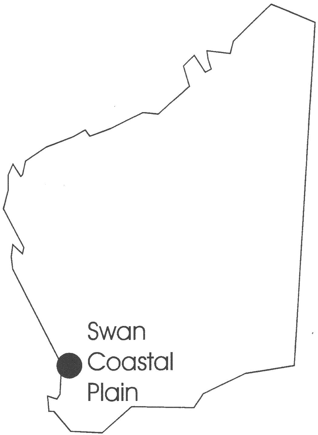
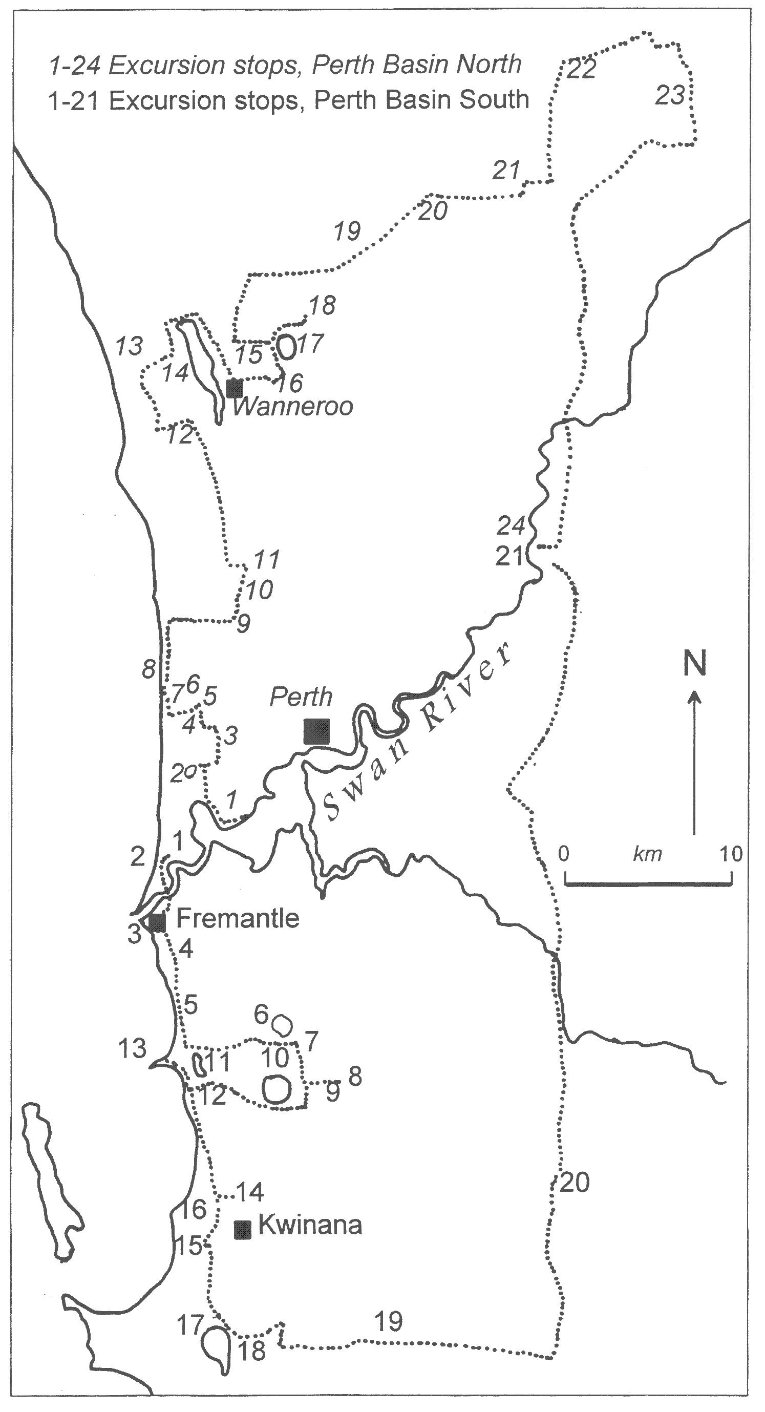
Figure 1Location diagram of the Swan Plain near Perth showing the excursion route.
ACKNOWLEDGEMENT
Published with the permission of the Director, Geological Survey of Western Australia.
APPENDIX
Selected figures taken from:
Allen, A. D. 1981. Groundwater resources of the Swan Coastal Plain, near Perth, Western Australia. In B. R. Whelan (ed.), Proceedings of Symposium on the Groundwater Resources of the Swan Coastal Plain. CSIRO Division of Land Resource Management. p29-74.
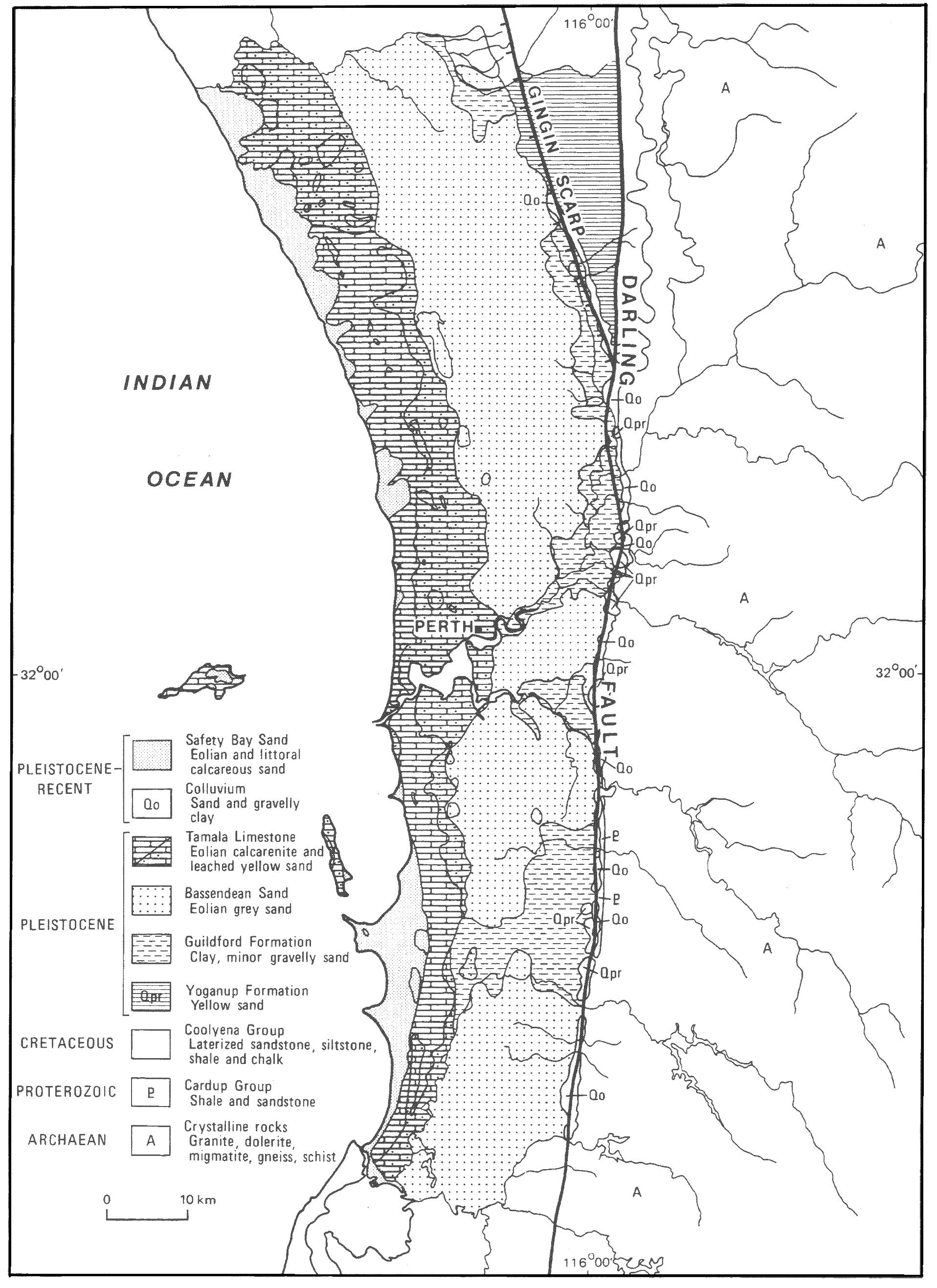
Figure 4Generalized geological map.
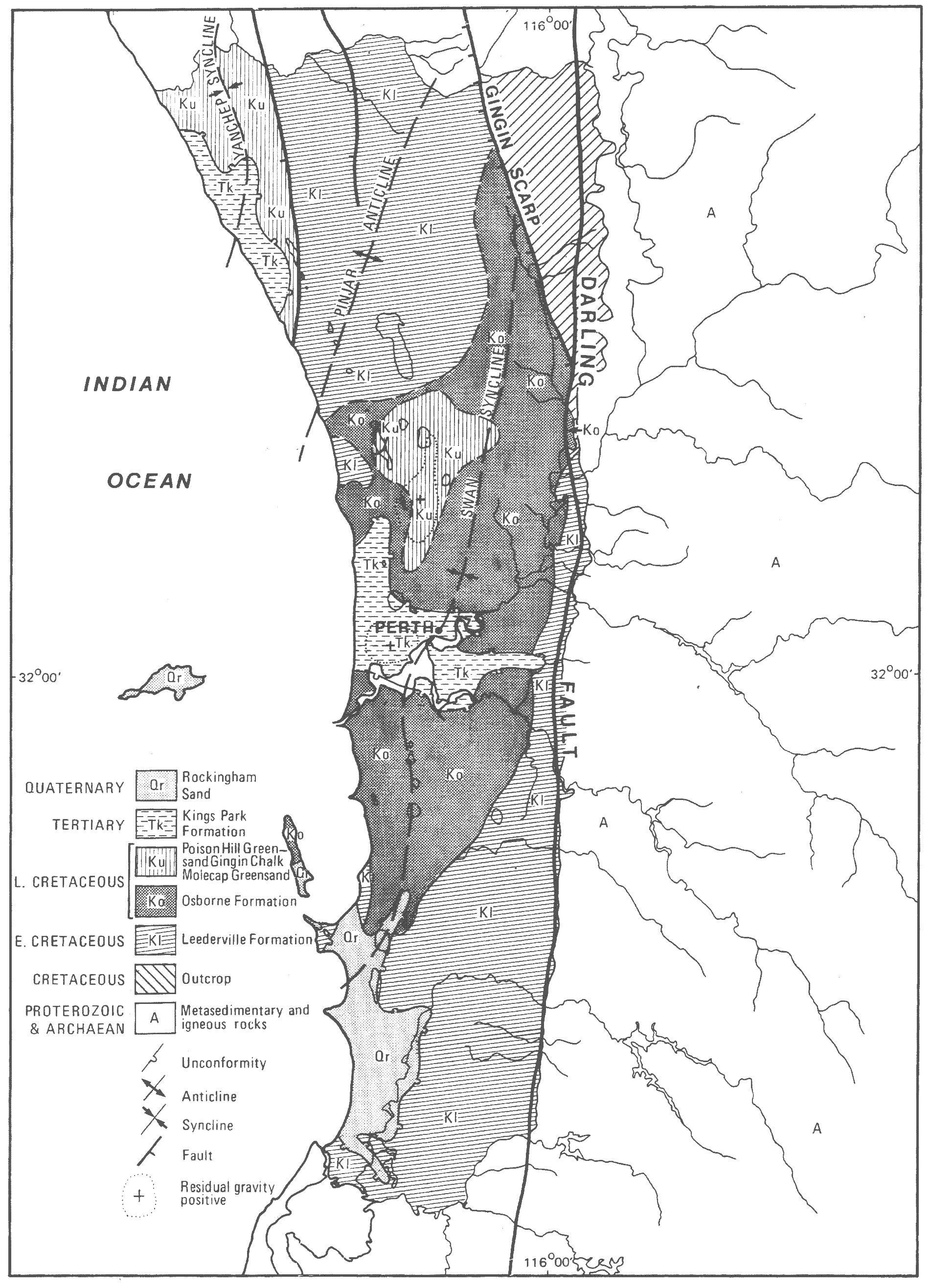
6Subcrop map
Figure
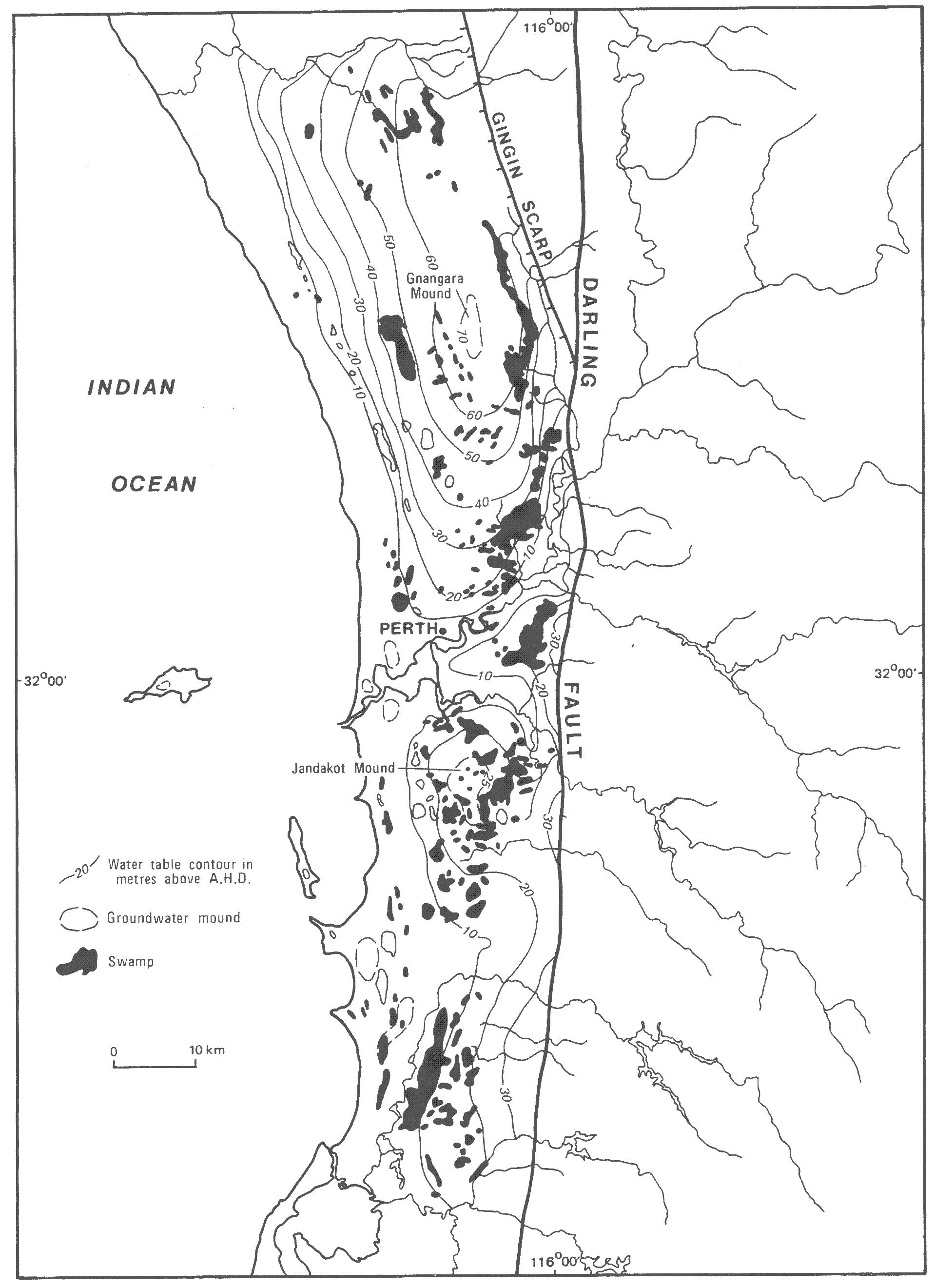
Figure 9Water table contours and relationships to wetlands
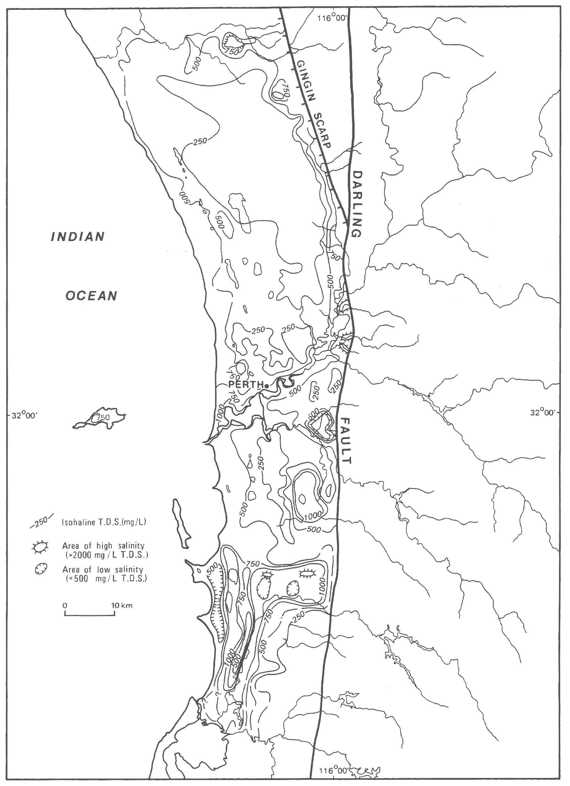
10Groundwater salinity (TDS) in superficial formations. (Note the map is very generalized
Figure
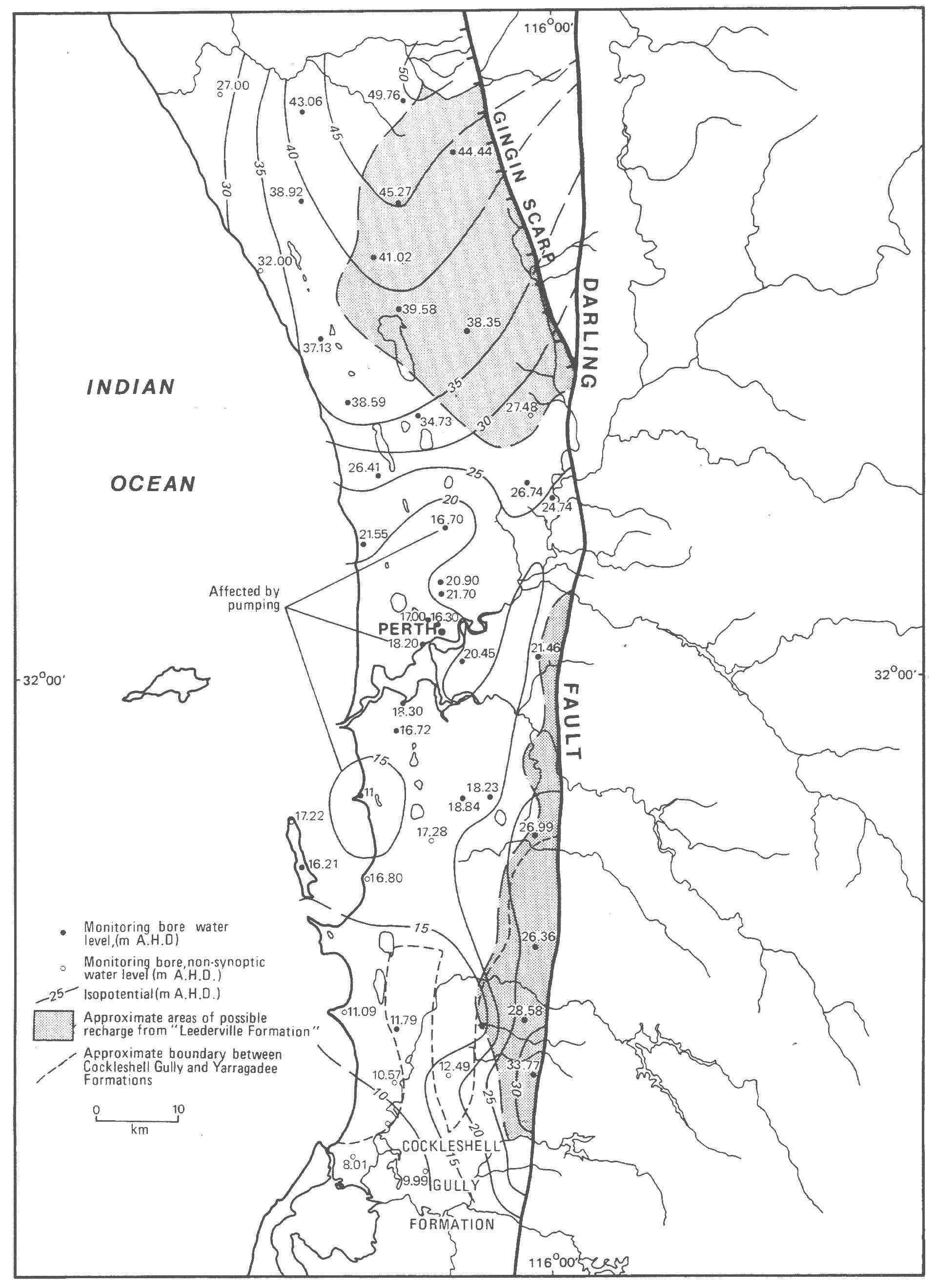
11Leederville Formation water levels, March-April, 1980.
Figure
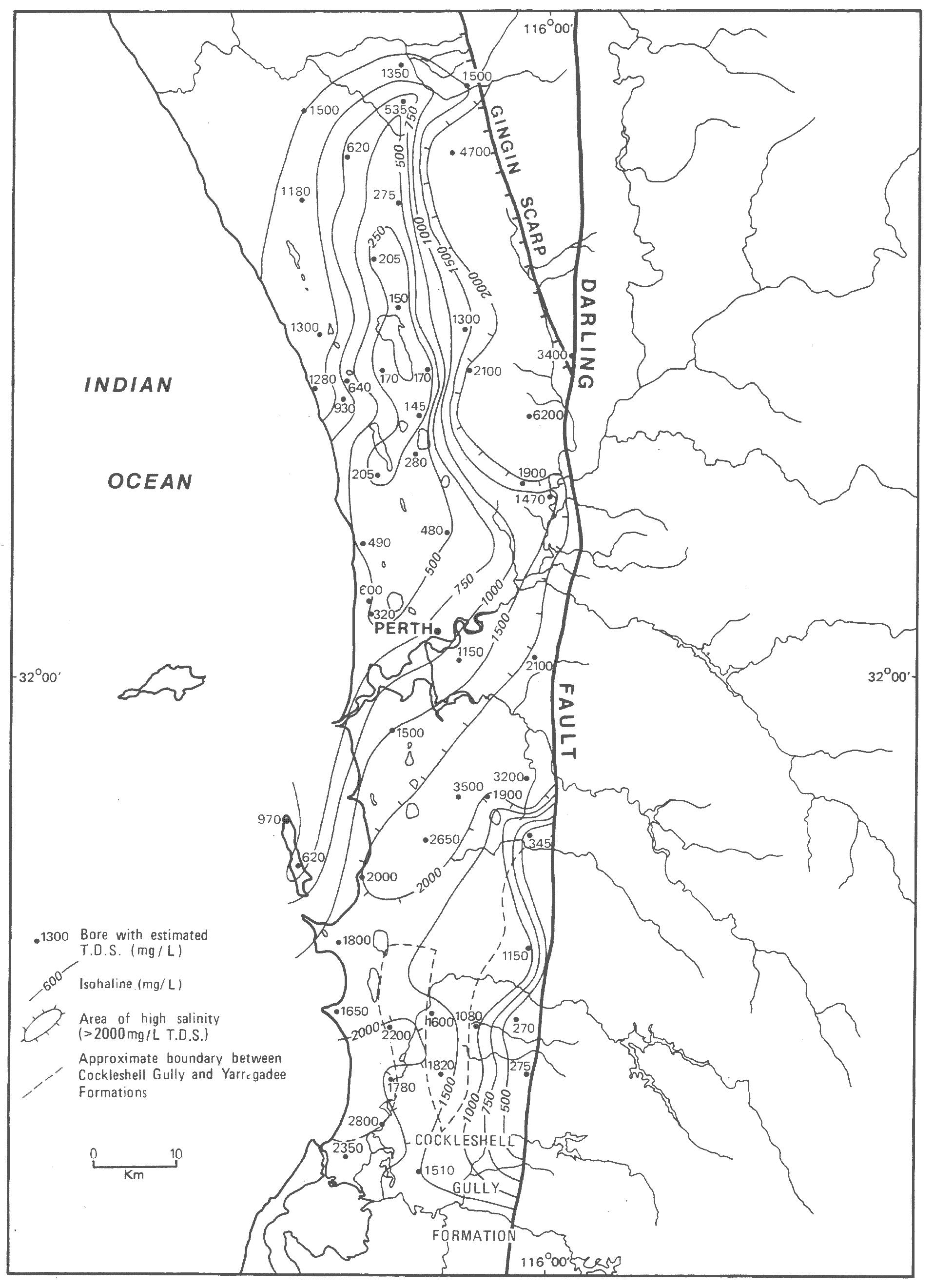
Figure 13Lowest salinity (TDS) groundwater in the Leederville Formation as estimated from resistivity logs.
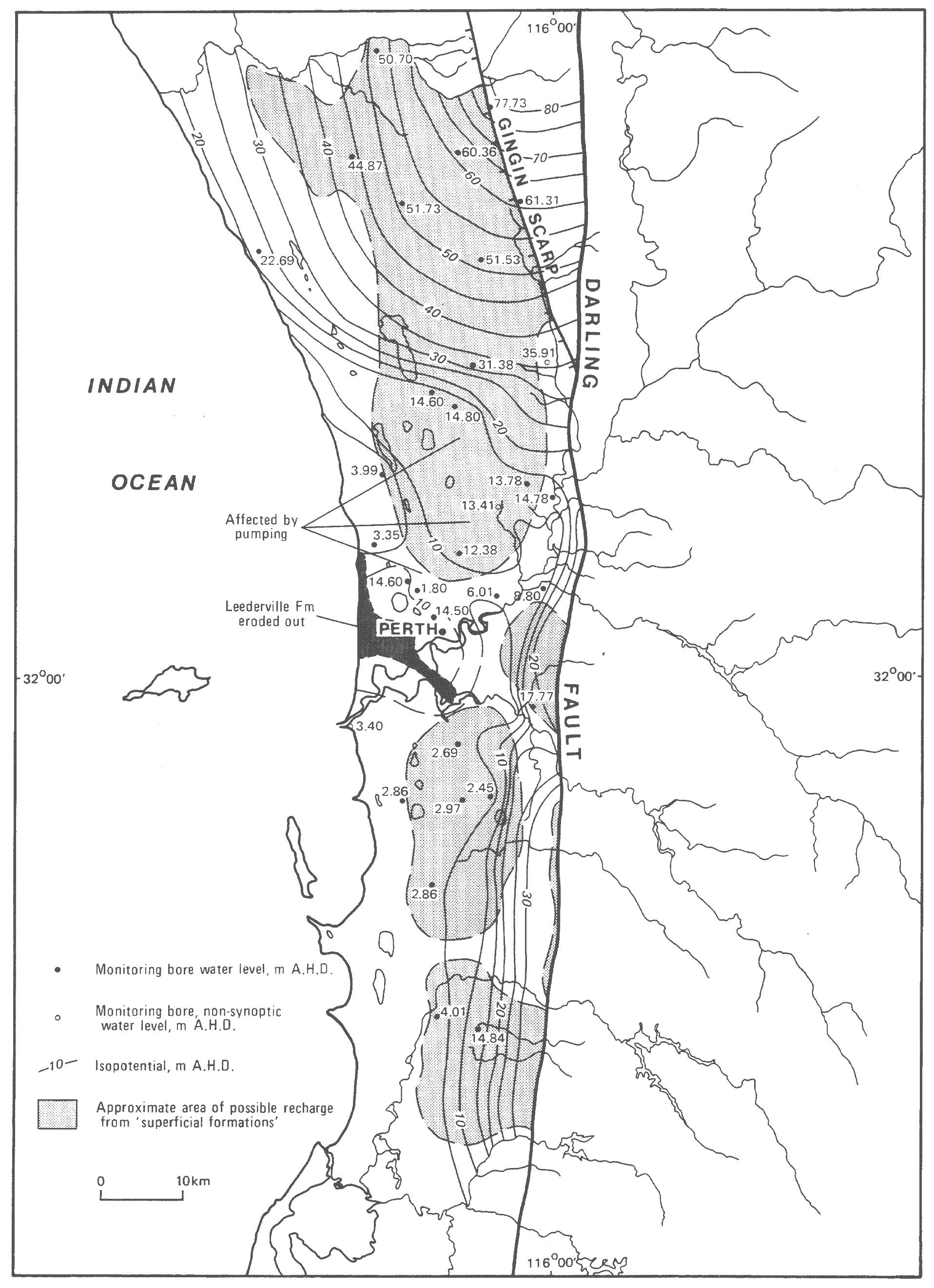
14Yarragadee Formation water levels, March-April, 1980.
Figure
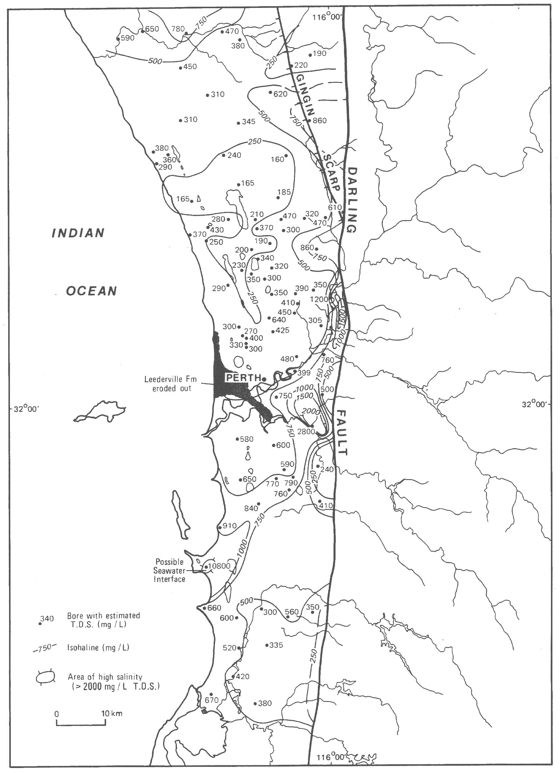
15Lowest salinity (TDS) groundwater in the Yaragadee and
Formations as estimated from resistivity logs.
Figure
Cockleshell Gully