Geological Society of Australia (WA Division), Excursiyn Guidebook 8 -d , --1
Geological Society of Australia (WA Division)
EXCURSION GUIDEBOOK No. 8
edited by .I. Groves2and S. E. Wo3
Geological Survey of Western Australia, 100 Plain Street, East Perth, Western Australia 6004
Key Centre for Strategic Mineral Deposits, Department of Geology and Geophysics, The University of Western Australia, Nedlands, Western Australia 6009
Orebusters Pty Ltd, 4 Handley Close, Leeming, Western Australia 6 149
12th Australian Geological Convention September 1994
Guidebook for the post-convention excursion E 10
12th Australian Geological Convention, Perth, September I994
Preferred reference for this volume:
Witt, W. K., Groves, D.I. and Ho, S. E. (Editors). 1994. Ore deposits of the Eastern Goldfields, Western Australia. Geological Society of Australia (WA Division) Excursion Guidebook, 8, 82p.
0 12th AGC and Geological Society of Australia (WA Division), all rights reserved 1994
ISSN 0819-6613
ISBN 0 909869 94 4
Available for purchase+om:
Geological Society of Australia (W. A. Division)
P 0 BQX6014
East Perth Australia 6004
Printed by: Optima Press, 32 Kensington Street, East Perth, WA 6004
Ore Deposits of the Eastern Goldfields, Western Australia i
PREFACE
Some parts of this excursion guidebook contain extracts from, or are based on, the following references, and the authors acknowledge permission to reproduce or use the published material.
Part I11 GROVES D.I., 1990. No. 3 Eastern Goldfields Mineral Deposits. Part 11: Overview of komatiite-associated nickel-sulphide deposits in the Norseman-Wiluna Belt. In Ho S.E., Glover J.E., Myers J.S. & Muhling J.R. (eds), Third International Archaean Symposium, Perth, 1990. Excursion Guidebook. The Geology Department & University Extensiorz, The University of Western Australia, Publication No. 21. 318-328.
Part IV LLOYD P., 1993. Golden Pig Mine Case Study In Narrow Vein Mining Seminar, Bendigo, Victoria, 17-18 June 1993, pp. 99-105. Australasian Institute of Mining and Metallurgy, Parkville.
RIDLEY J.R. & GROVES D.I. (compilers), 1993. Excursion 4. Gold mineralisation at various regional metamorphic grades. In Williams P.R. & Haldane J.A. (compilers), An International Conference on Crustal Evolution, Metallogeny and Exploration of the Eastern Goldfields. Excursion Guidebook. Australian Geological Survey Organisation, Record 1993153, 101-134.
SAUTER P., 1993. Excursion 5. A workshop to explore the controversial aspects of the Kalgoorlie geology. Iiz Williams P.R. & Haldane J.A. (compilers), An International Conference on Crustal Evolution, Metallogeny and Exploration of the Eastern Goldfields. Excursion Guidebook. Australian Geological Survey Organisation, Record 1993153, 135-144.
WATCHORN R., 1993. Kambalda gold geology (updated). In International Mining Geology Conference, Kalgoorlie-Bouldel; WA, 5-8 July 1993, Handbook, pp. 28-42. Kalgoorlie Branch, Australasian Institute of Mining and Metallurgy, Kalgoorlie.
WYCHE S. (compiler), 1990. No. 6 Kalgoorlie granite-greenstone terrain. Part 111: Excursion localities. In Ho S.E., Glover J.E., Myers J.S. & Muhling J.R. (eds), Third International Archaean Symposium, Perth, 1990. Excursion Guidebook. The Geology Department & University Extension, The University of Western Australia, Publication No. 21, 237-303.
The following individuals are also acknowledged for providing material for this excursion guidebook.
Part IV B.J. Mayers & S. Warriner, Burmine Operations Ltd
N. Taylor, Fraser Mine Management Pty Ltd
The following companies are acknowledged for supporting this excursion by providing access to their mines and drillcore. The excursion would not be possible without the time and effort contributed by mine staff.
Kanowna area
Mount Pleasant area
Kambalda area
Coolgardie area
Kalgoorlie-Boulder
Southern Cross area
Kanowna Belle Gold Mines
National Mine Management on behalf of Golden Kilometre Mines Joint Venture St Ives Gold Mines and Kambalda Nickel Operations (Western MIning Corporation Ltd)
Coolgardie Gold N.L.
Kalgoorlie Consolidated Gold Mines Pty Ltd
Goldfan Ltd (Herald Resources Group)
New Celebration Burmine Operations Ltd
Kambalda Nickel Operations provided safety boots, overalls, safety glasses and hard hats for the duration of the excursion. Kalgoorlie Consolidated Gold Mines Pty Ltd provided lamps, belts and self-rescuers for the visit to Southern Cross.

PART I: OVERVIEW OF THE KALGOORLIE TERRANE
INTRODUCTION
EXTENT OF THE KALGOORLIE TERRANE ROCK TYPES AND STRATIGRAPHY DEFORMATION
INTRUSIVE ROCKS
INTRODUCTION
STRUCTURAL SE'ITING, STRUCTURAL CONTROLS AND MINERALIZED STRUCTURES ALTERATION
TIMING RELATIONSHIPS, ALERATION ISOGRADS AND BALI SUITE GRANITOIDS
INTRODUCTION
CLASSIFICATION
INTRODUCTION
LOCALITY
Introduction
Regional setting Gold deposits
Introduction
Regional setting
Mt Pleasant Sill
Liberty Granodiorite
Overview of gold deposits
Introduction
Exploration and mining history
Structure
Hydrothermal alteration
Gold mineralization
St Ives Goldfield
LOCALITY 4 LODE GOLD DEPOSITS OF THE COOLGARDIE DISTRICT
Introduction Bayleys
Lindsays
Three Mile Hill
LOCALITY 5: LODE GOLD DEPOSITS OF KALGOORLIE-BOULDER
Introduction
Regional geology
Structure
Structural controls on gold mineralization
Alteration and mineralization
Source of fluids, deposition of gold and geological setting
LOCALITY 6: LODE GOLD DEPOSITS OF NEW CELEBRATION
Introduction Gold mineralization
LOCALITY 7: LONDONDERRY PEGMATITE
LOCALITY 8: LODE GOLD DEPOSITS OF THE SOUTHERN CROSS GREENSTONE BELT
Introduction
Regional structural and metamorphic geology
mineralization
PART I: OVERVIEW OF THE KALGOORLIE TERRANE
W.K. Witt’ & D.I. GrovesZ
1. Geological Survey of Western Australia, 100 Plain Street, East Perth, WA., Australia 6004
2. Key Centrefor Teaching and Research in Strategic Mineral Deposits, Department of Geology and Geophysics, The University of WesternAustralia, Nedlands, WA., Australia 6009
INTRODUCTION
The Archaean Yilgarn Craton, Western Australia, with an area of 657,000 km2, has produced 3,000 t of gold, 1.22 Mt of nickel, 155 000 t copper, 345 000 t zinc and 79 000 t lead. It has also produced 17,000 t of Li,O, 1,800 t Ta,O, (from pegmatitic sources) and 167,000 t V,O, (from layered mafic intrusions). The Western Australian mineral sands industry has produced ilmenite, rutile, zircon and monazite from sediments derived from the Yilgarn Craton (Fig. I.1A). ’
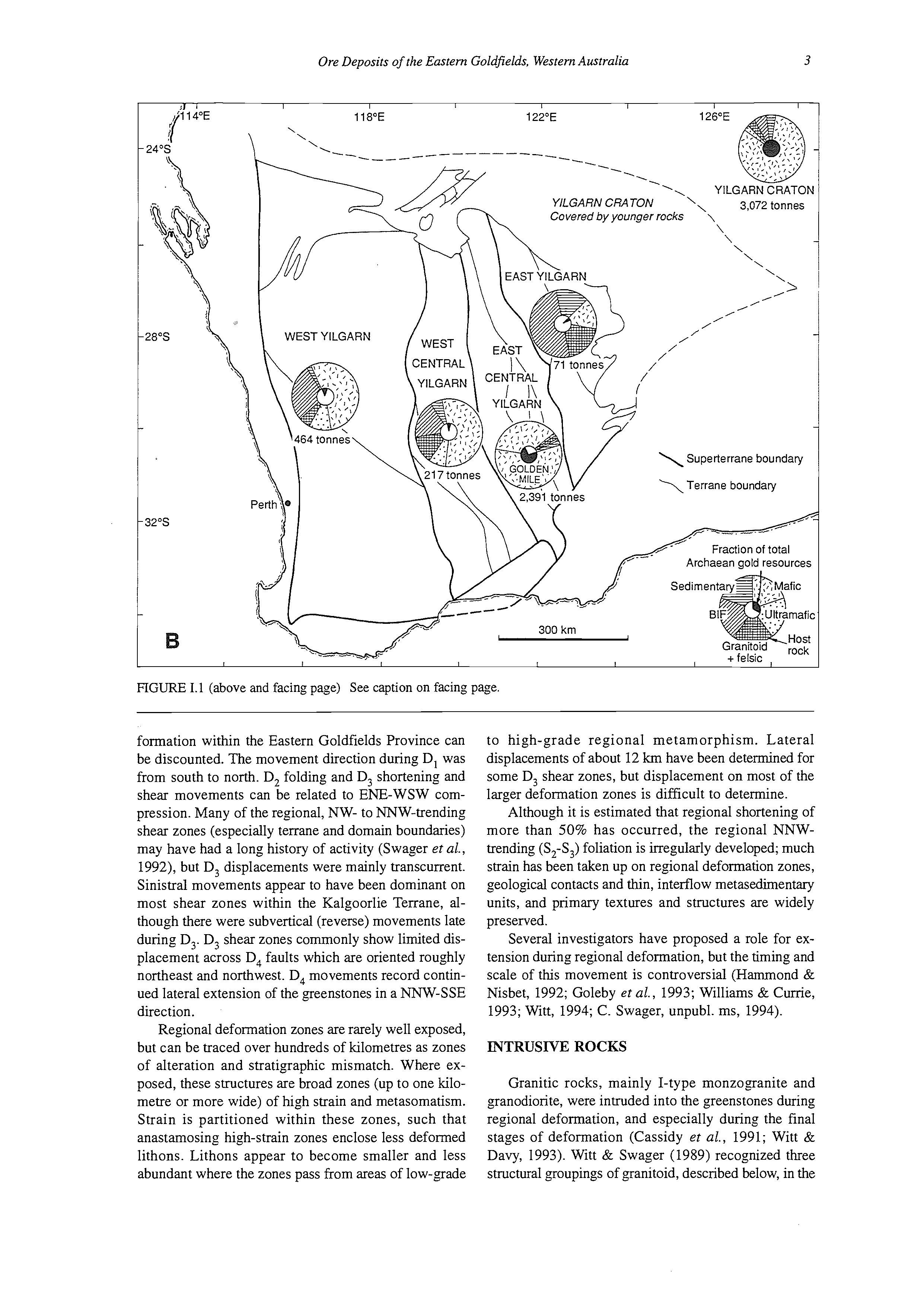
The Yilgarn Craton has traditionally been subdivided into four main subprovinces (Gee et al., 1981) but Myers (1993) has redefined the Craton as a number of geologically distinct superterranes. Figure I.1B shows the relative gold production of each of these superterranes.
Gold is the major mining commodity produced from the Yilgarn Craton, and gold mineralization is emphasized on this excursion. Nickel deposits at Kambalda and a lithium-rich, rare-metal pegmatite at Londondeny (near Coolgardie) are also visited.
In recent years, it has become evident that gold mineralization occurs in a wide range of metamorphic settings, up to and including granulite-facies rocks. Although there is a systematic variation in alteration mineralogy and (less systematically) structural style with metamoqhic grade of the host rocks, most deposits in the Yilgarn Craton display a large number of features in common. This has led to the concept of a continuum of deposit styles reflecting a single genetic process acting throughout a thick crustal section (Groves et al., 1992). This variation in alteration assemblages and structural style with metamorphic grade is a major focus of the excursion. Although the excursion is centred around the main fields of gold production in Western Australia (the Kalgoorlie Terrane of Swager et al., 1992; see Fig. 1.2), it is necessary to examine the high-temperature end of the continuum in the Southern Cross area (the West Central Superterrane: Myers, 1993).
EXTENT OF THE KALGOORLIE TERRANE
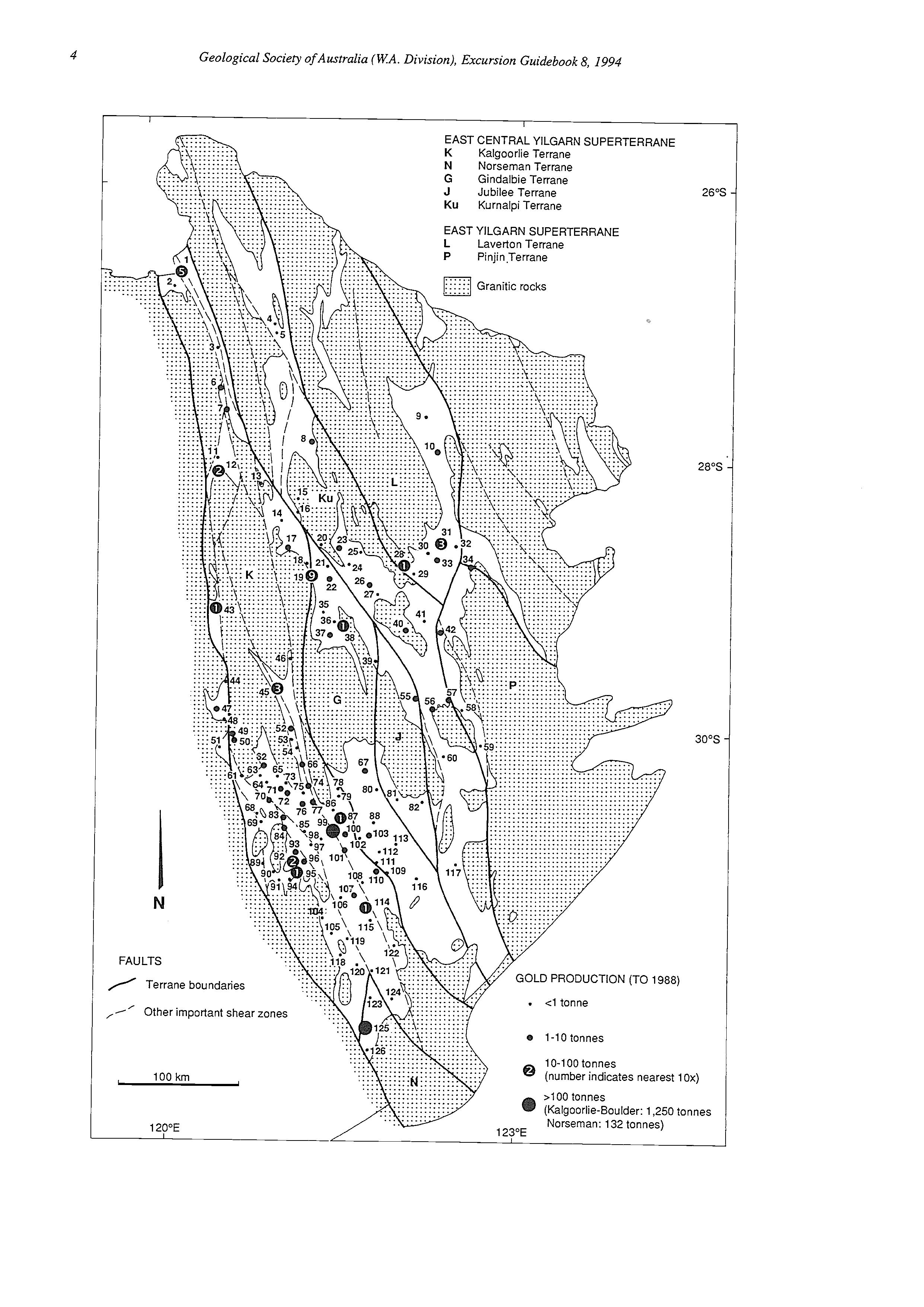
The Kalgoorlie Terrane is an elongate, fault-bounded granite-greenstone terrane which includes the worldclass, “giant” gold deposits at Kalgoorlie, as well as major mining districts at Kambalda, Coolgardie, Mount Pleasant, Ora Banda, Paddington-Broad Arrow and Menzies (Fig. 1.2). It has yielded almost 2,000 t of gold since mining began in the early 1890s (figures to, and including, 1993). An east-west seismic traverse across
the southern part of the Kalgoorlie Terrane, at about the latitude of Mount Pleasant (Figs 1.3,1.4), suggests that the greenstones bottom out against felsic crust along a flat-lying surface at around 7 km depth (Goleby et al., 1993). The Boorara-Menzies Shear (Bardoc Tectonic Zone) dips moderately to the west and may penetrate the basal dicollement. The Ida Fault, which forms the western boundary of the Kalgoorlie Terrane, dips eastwards and penetrates the crust-mantle interface. Much of the description of the geology of the Kalgoorlie Terrane which follows summarizes that of Swager et al. (1990, 1992).
ROCK TYPES AND STRATIGRAPHY
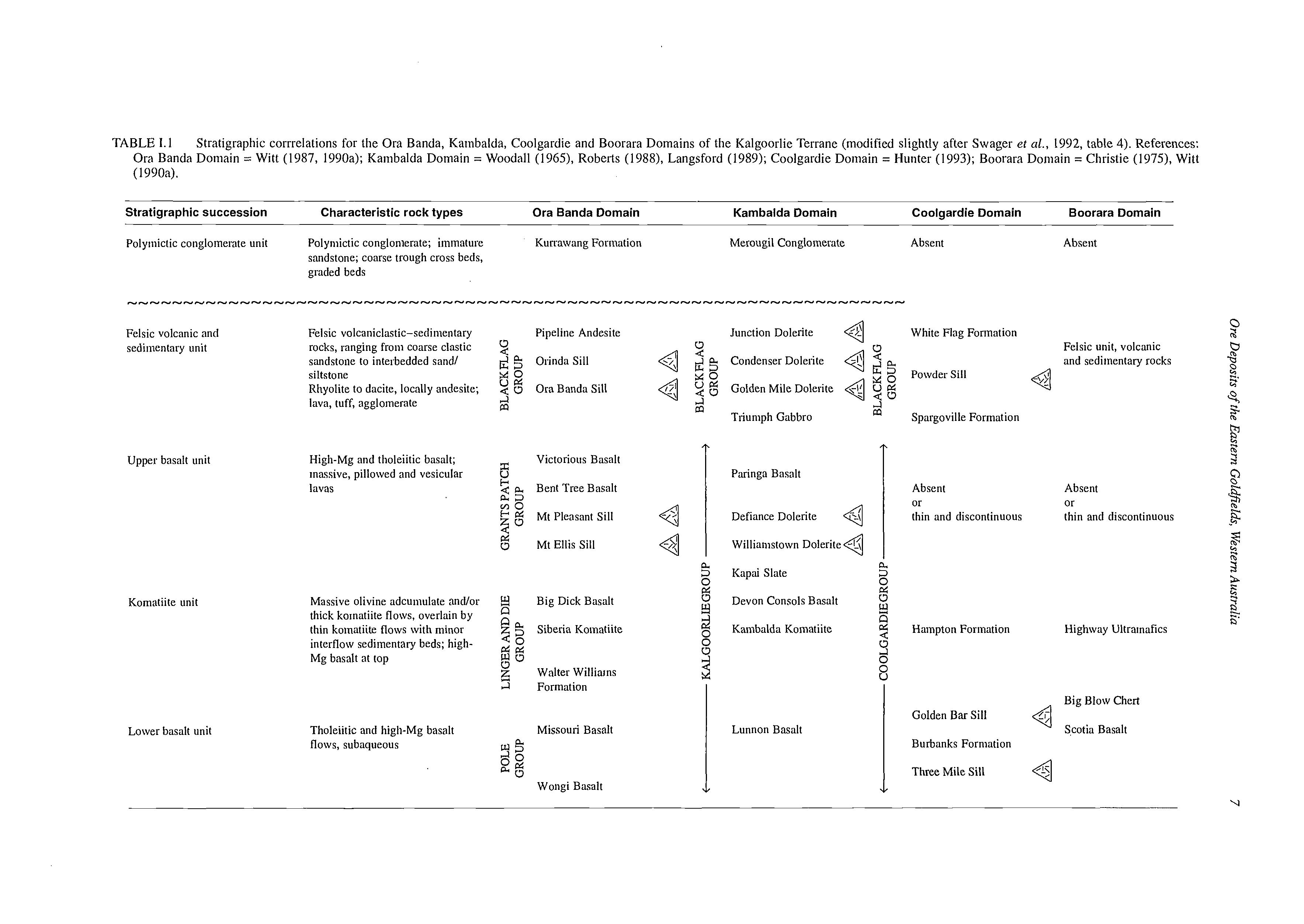
The Kalgoorlie Terrane is distinguished from most other terranes in the Yilgarn Craton by the absence of banded iron-formation (BIF). It contains a similar package of rock types to terranes to the east (but in different proportions) and has a distinct stratigraphy (Table I. 1). Single-zircon geochsonology indicates deposition of the Kambalda Komatiite at around 2700 Ma (ClaouiLong et al., 1988). Black Flag Group dacite from the Parker Domain has been similarly dated at 268 1 rt 5 Ma (D. Nelson, pers. comm., 1994). The upper basalt unit is only fully developed in central domains (Ora Banda, Kambalda) of the Kalgoorlie Terrane.
Layered and differentiated mafic sills were emplaced at various stratigraphic levels, and have a similar compositional range to the volcanic rocks. Some of the sills have Fe-rich fractionated zones which are important host rocks for gold mineralization (Travis et al., 1971; Witt et al., 1991a). Although zones enriched in platinum group elements have been identified in some sills (Witt et al., 1991b), no economic concentrations have been discovered.
Granitic gneiss crops out at several localities in the Eastern Goldfields Province, including west of the Kalgoorlie Terrane, but unequivocal identification of basement to the greenstones has not been possible.
DEFORMATION
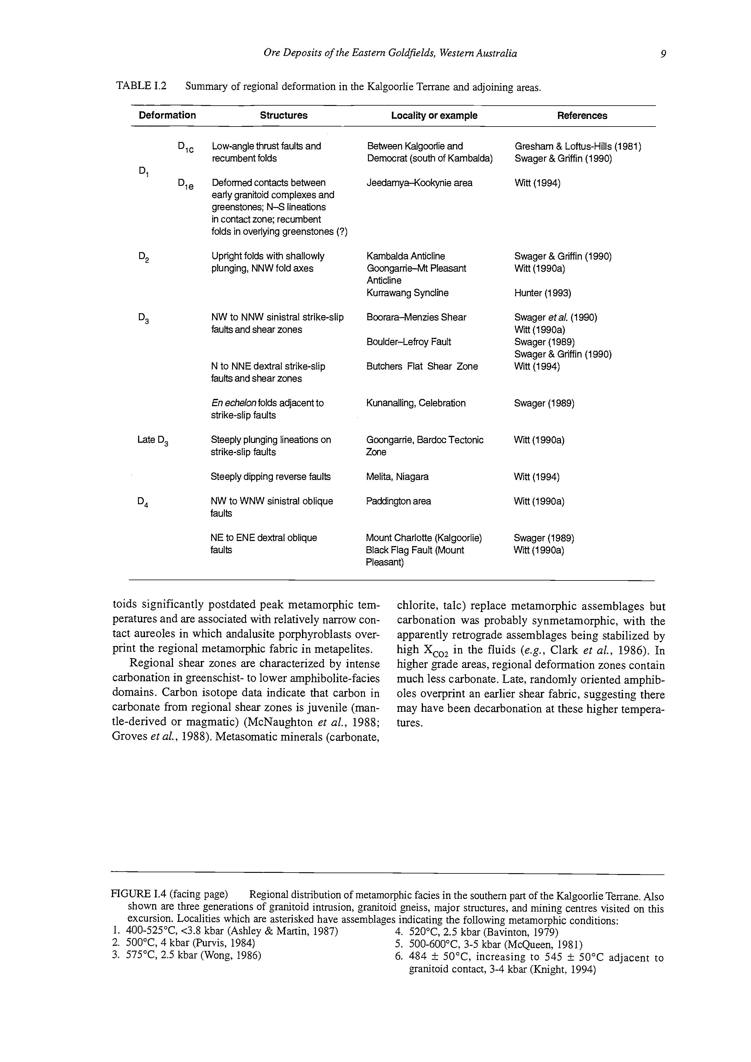
The regional deformation history of the Kalgoorlie Terrane and adjacent areas is summarized in Table 1.2. Studies in adjacent terranes (Platt et al., 1978; Spray, 1985; Hammond & Nisbet, 1992; Williams & Currie, 1993; Witt, 1994) have determined a similar deformation history. Although it is generally presumed that deformation was synchronous in these terranes, more geochronological data are required before diachronous de-
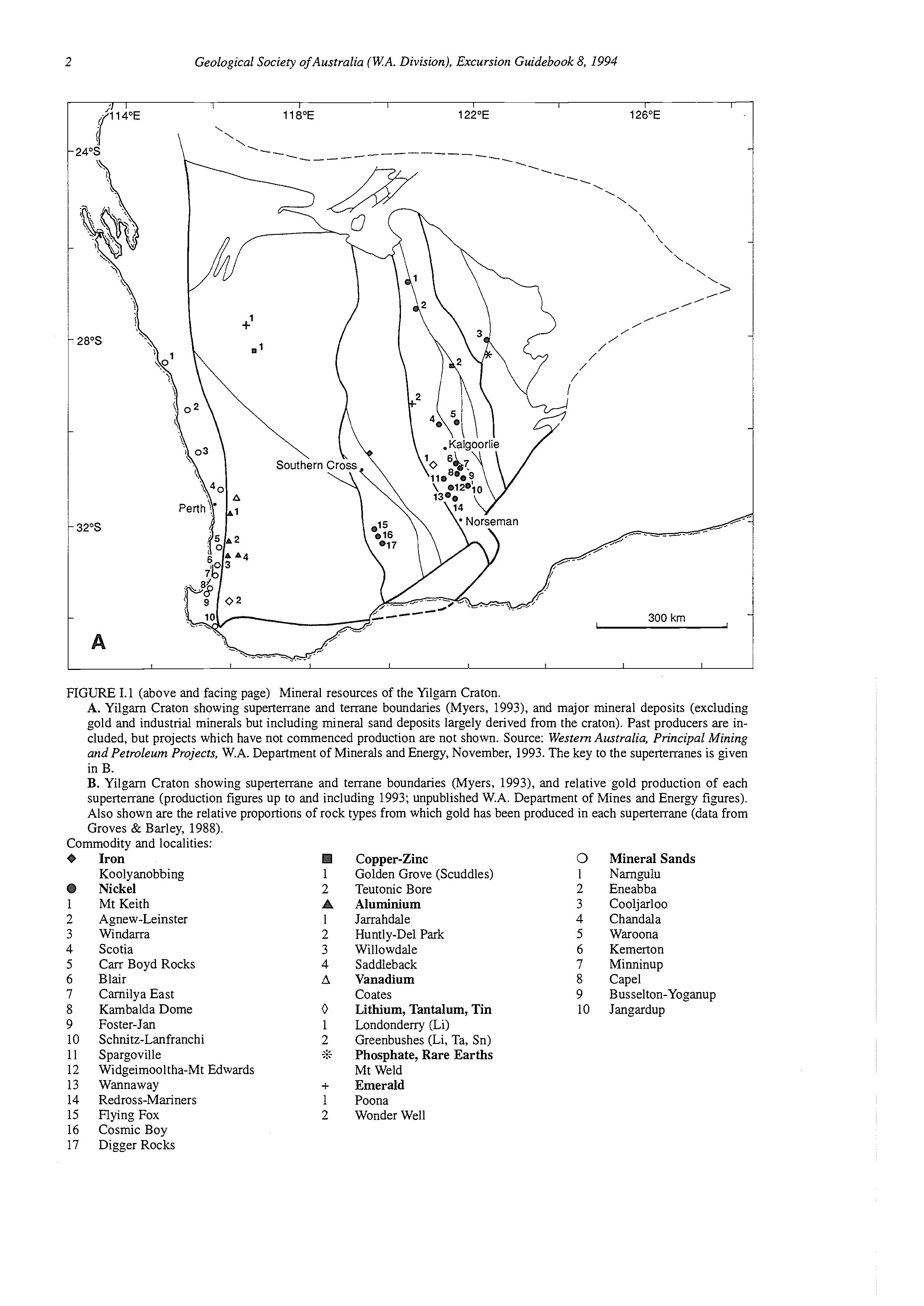
FIGURE 1.1 (above and facing page) Mineral resources of the Yilgarn Craton.
A. Yilgarn Craton showing superterrane and terrane boundaries (Myers, 1993), and major mineral deposits (excluding gold and industrial minerals but including mineral sand deposits largely derived from the craton). Past producers are included, but projects which have not commenced production are not shown. Source: Western Australia, Principal Mining and Petroleum Projects, W.A. Department of Minerals and Energy, November, 1993. The key to the superterranes is given in B.
B. Yilgarn Craton showing superterrane and terrane boundaries (Myers, 1993), and relative gold production of each superterrane (production figures up to and including 1993; unpublished W.A. Department of Mines and Energy figures). Also shown are the relative proportions of rock types from which gold has been produced in each superterrane (data from Groves & Barley, 1988).
Commodity and localities:
FIGURE 1.1 (above and facing page) See caption on facing page.
formation within the Eastern Goldfields Province can be discounted. The movement direction during D, was from south to north. D, folding and D, shortening and shear movements can be related to ENE-WSW compression. Many of the regional, NW- to NNW-trending shear zones (especially terrane and domain boundaries) may have had a long history of activity (Swager et al., 1992), but D, displacements were mainly transcurrent. Sinistral movements appear to have been dominant on most shear zones within the Kalgoorlie Terrane, although there were subvertical (reverse) movements late during D,. D, shear zones commonly show limited displacement across D, faults which are oriented roughly northeast and northwest. D, movements record continued lateral extension of the greenstones in a hW-SSE direction.
Regional deformation zones are rarely well exposed, but can be traced over hundreds of kilometres as zones of alteration and stratigraphic mismatch. Where exposed, these structures are broad zones (up to one kilometre or more wide) of high strain and metasomatism. Strain is partitioned within these zones, such that anastamosing high-strain zones enclose less deformed lithons. Lithons appear to become smaller and less abundant where the zones pass from areas of low-grade
to high-grade regional metamorphism. Lateral displacements of about 12 km have been determined for some D, shear zones, but displacement on most of the larger deformation zones is difficult to determine.
Although it is estimated that regional shortening of more than 50% has occurred, the regional NNWtrending (S2-S3) foliation is irregularly developed; much strain has been taken up on regional deformation zones, geological contacts and thin, interflow metasedimentary units, and primary textures and structures are widely preserved.
Several investigators have proposed a role for extension during regional deformation, but the timing and scale of this movement is controversial (Hammond & Nisbet, 1992; Goleby et al., 1993; Williams & Currie, 1993; Witt, 1994; C. Swager, unpubl. ms, 1994).
INTRUSIVE ROCKS
Granitic rocks, mainly I-type monzogranite and granodiorite, were intruded into the greenstones during regional deformation, and especially during the final stages of deformation (Cassidy et al., 1991; Witt & Davy, 1993). Witt & Swager (1989) recognized three structural groupings of granitoid, described below, in the
Kalgoorlie Terrane.
1. Pre- to syn-D, granitoids were emplaced as broadly conformable sheet-like bodies at the base of, or within, the greenstone succession, probably during
D,.
2. Post-D, to syn-D, granitoids were diapirically emplaced, and are concentrated in a zone along the western side of the Kalgoorlie Terrane.
3. Late-tectonic to post-tectonic granitoids were emplaced late in the history of the Terrane.
Limited geochronological data suggest the granitoids were emplaced at 2690-2680 Ma (group I), 2665-2660 Ma (group 2) and 2650-2600 Ma (group 3) (Hill ef al., 1992).
Small porphyry intrusions, including lamprophyres (Rock et aL, 1989), are widespread and petrologically diverse; they may be genetically related to some of the I-type granitoid suites (Witt, 1992). They are common in and near regional deformation zones, and are associated with many gold deposits (Perring et al., 1988, 1989).
METAMORPHISM AND REGIONAL CARBONATION
Regional metamorphism probably commenced with sea-floor metamorphism (Barley & Groves, 1987) and evolved through dynamothermal and “contact” metamorphic stages. The present distribution of metamor-
phic grade is shown in Figure 1.4. Low-pressure metamorphism is indicated by widespread andalusite stability. Metamorphic grade varies from prehnitepumpellyite facies and lower greenschist facies in the central, low-strain parts of the Kalgoorlie Terrane (the “static” domains of Binns et aL, 1976) to upper amphibolite facies in pervasively foliated zones near the margins of the greenstone belts (the “dynamic” domains of Binns et aL, 1976). High-grade metamorphic rocks are spatially related to post-D, to syn-D, plutons (Fig. 1.4). This spatial relationship and the D,-D, metamorphic fabric in “dynamic domains” indicate peak regional metamorphism occurred during D,. The age of the postD, to syn-D, plutons should therefore closely approximate the age of peak regional metamorphism. Only one of these plutons has been dated by the U-Pb in zircon method. The Theatre Rocks Monzogranite, near Norseman, gives an age of around 2660 Ma (Hill et aL, 1992). Thermal aureoles around post-D, to syn-D, plutons are not classical contact metamorphic features since they do not overprint regional metamorphic fabrics. Diapiric emplacement of the plutons, during regional deformation and metamorphism, uplifted deeper, hotter levels of the greenstone sequence and contributed additional heat which raised ambient metamorphic temperatures in the surrounding aureole (Bickle & Archibald, 1984). Intrusion broadly coincident with peak regional metamorphic temperatures produced very wide thermal aureoles. In contrast, late-tectonic grani-
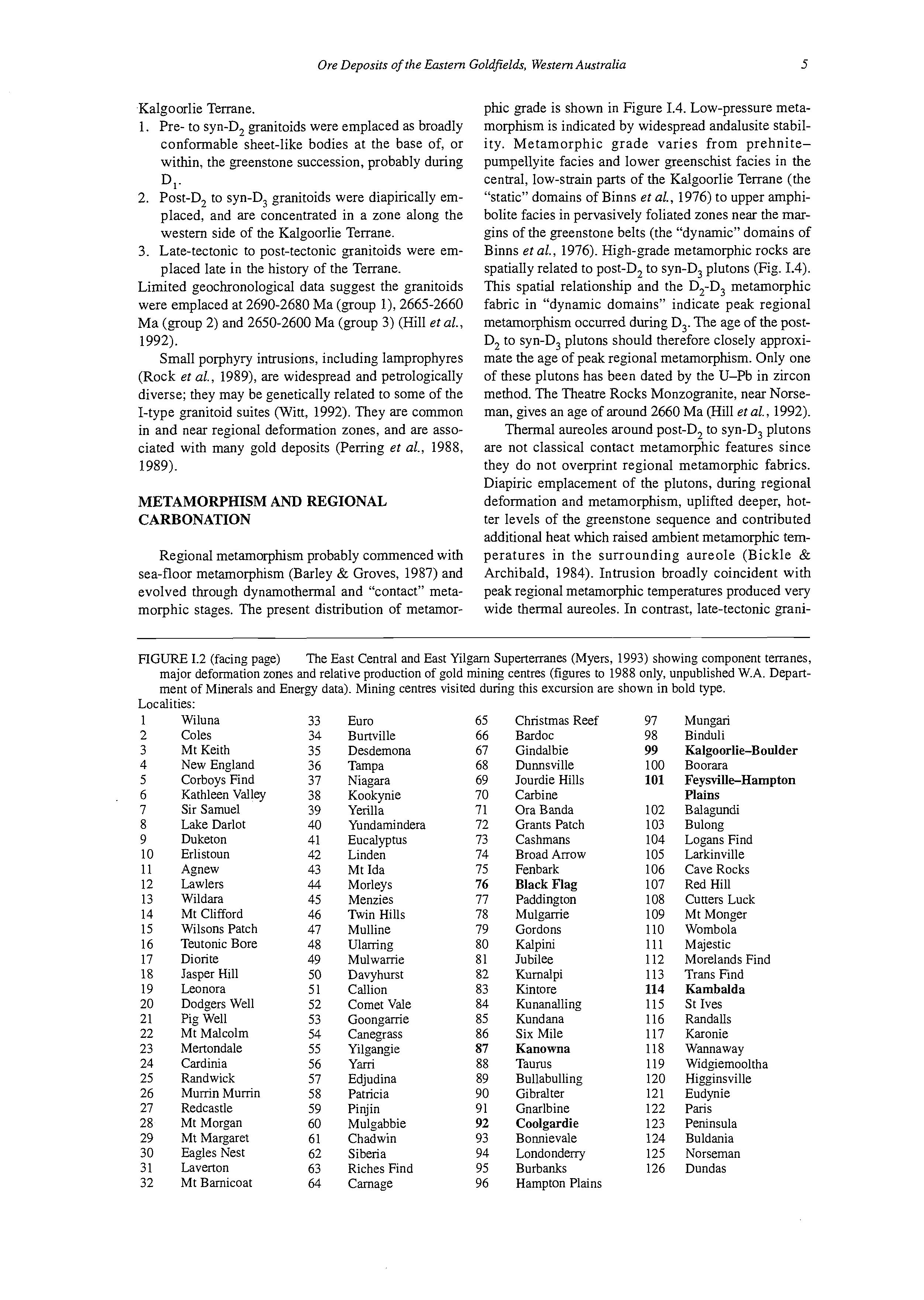
FIGURE 1.2 (facing page) The East Central and East Yilgam Superterranes (Myers, 1993) showing component terranes, major deformation zones and relative production of gold mining centres (figures to 1988 only, unpublished W.A. Department of Minerals and Energy data). Mining centres visited during this excursion are shown in bold type.
Coles Mt
Corboys
Sir
Duketon
Erlistoun
Agnew
Lawlers
Wildara
Mt Clifford
Wilsons Patch
Teutonic Bore
Diorite
Jasper Hill
Leonora
Dodgers Well
Pig Well
Mt Malcolm
Mertondale
Cardinia
Randwick
Mumn Murrin
Redcastle
Mt Morgan
Mt Margaret
Eagles
Desdemona
Kookynie
Yerilla
Yundamindera
Eucalyptus
Linden
Mt Ida
Morleys
Menzies
Twin Hills
Mulline
Ulaning
Mulwanie
Davyhurst
Callion
Comet Vale
Goongame
Canegrass
Yilgangie
Yani
Edjudina Patricia
Pinjin
Gindalbie Dunnsville
Jourdie Hills
Carbine
Ora Banda
Grants Patch
Cashmans
Broad Arrow
Fenbark
Black Flag
Paddington
Mulganie
Gordons
Kalpini
Jubilee
Kumalpi
Kintore
Kunanalling
Kundana
Six Mile
Kanowna
Taurus
Bullabuliing
Gibralter
Mungari
Binduli
Kalgoorlie-Boulder
Boorara
Feysville-Hampton
Plains
Balagundi
Bulong
Logans Find
Larkinville
Cave Rocks
Red Hill
Cutters Luck
Mt Monger
Wombola
Majestic
Morelands Find
Trans Find
Kambalda
St Ives
Randalls
Karonie
Wannaway
Widgiemooltha
Higginsville
Eudynie
Paris
Peninsula
Buldania
Norseman
Dundas
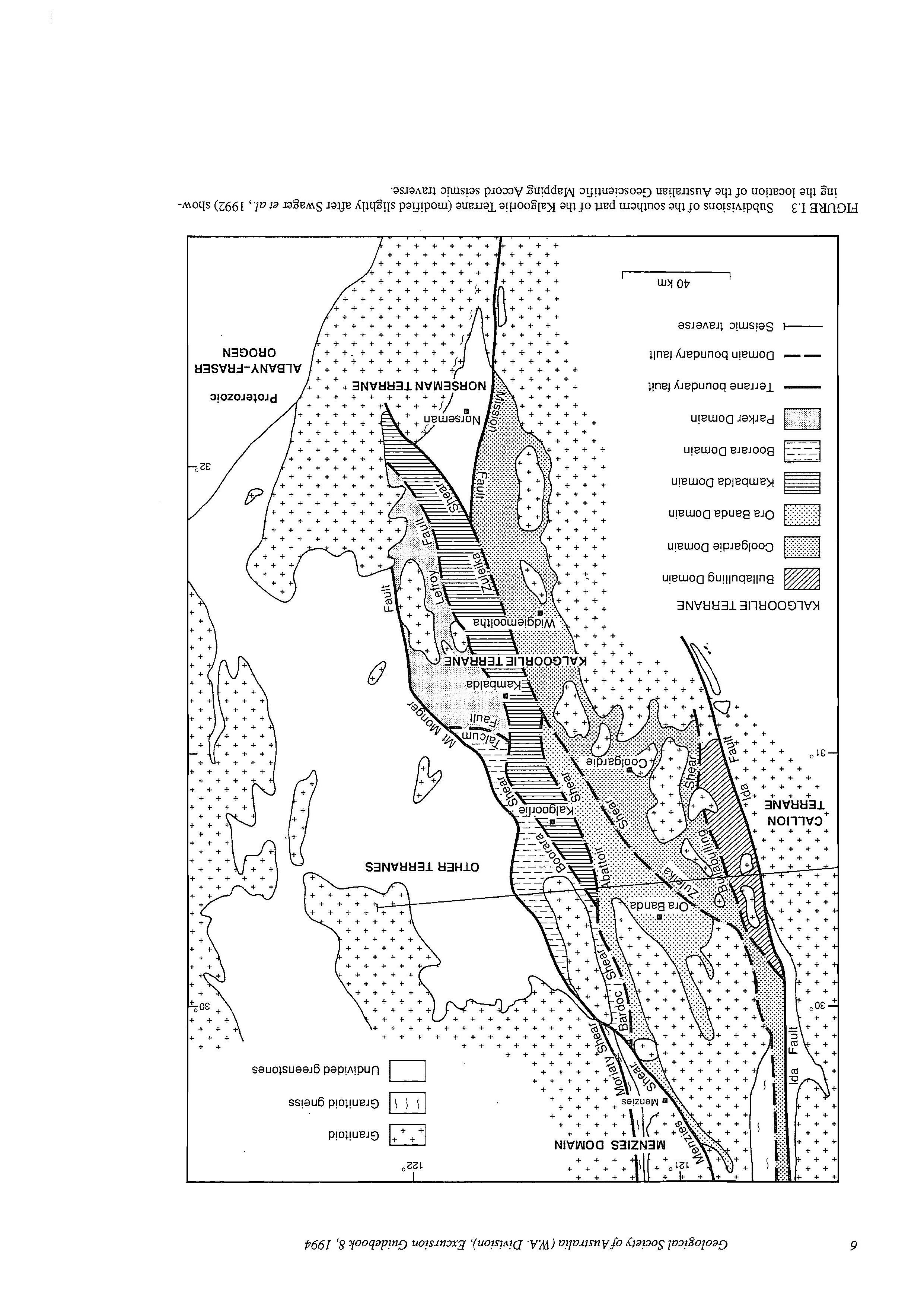
TABLE 1.1 Stratigraphic corrrelalions for the Ora Banda, Katnbalda, Coolgardie and Boorara Domains of the Kalgoorlie Terrane (modified slightly after Swager et al., 1992, table 4).References: Ora Banda Domain = Witt (1987, 1990a); Kambalda Domain = Woodall (1963, Roberts (19881, Langsford (1989); Coolgardie Domain = Hunter (1993); Boorara Domain = Christie (1975), Witt (19904.
Stratigraphic succession
Polyinictic conglomerate unit Pol ymictic conglomerate; immature sandstone; coarse trough cross beds, graded beds
Kumawang Formation Merougil Conglomerate Absent Absent
Felsic volcanic and Felsic volcaniclastic-sedimentary Pipeline Andesite sedinientary unit rocks, ranging from coarse clastic 2 sandstone to interbedded sand/ 5 Orinda Sill siltstone
Rhyolite to dacite, locally andesite; Q 0 Ora Banda Sill lava, tuff, agglomerate
High-Mg and tholeiitic basalt; Victorious Basalt massive, pillowed and vesicular a Bent Tree Basalt laves a3 roo 2 % Mt Pleasant Sill Q % Mt Ellis Sill
Junction Dolerite
Condenser Dolerite
p: Golden Mile Dolerite m 5°
Triumph Gabbro White Flag Formation Felsic unit, volcanic and sedimentary rocks Powder Sill
Spargoville Formation
Paringa Basalt
Defiance Dolerite
4 Williainstown Dolerite -s a 5 Kapai Slate 0 lx 0 Devon Consols Basalt
Walter Williruns
Massive olivine adcumulate and/or 9 Big Dick Basalt thick kornatiite flows, overlain by thin kornatiite flows with minor 5 Siberia Komatiite interflow sedimentary beds; highMg basalt at top a 2 8 ,-l Formation
Tholeiitic and high-Mg basalt flows, subaqueous Missouri Basalt
Wongi Basalt
8 Kambalda Komatiite 8 Absent Absent or or thin and discontinuous thin and discontinuous
Hampton Formation Highway Ultrarnafics
Golden Bar Sill
Burbanks Formation
Three Mile Sill
Big Blow Chert S,cotia Basalt
4
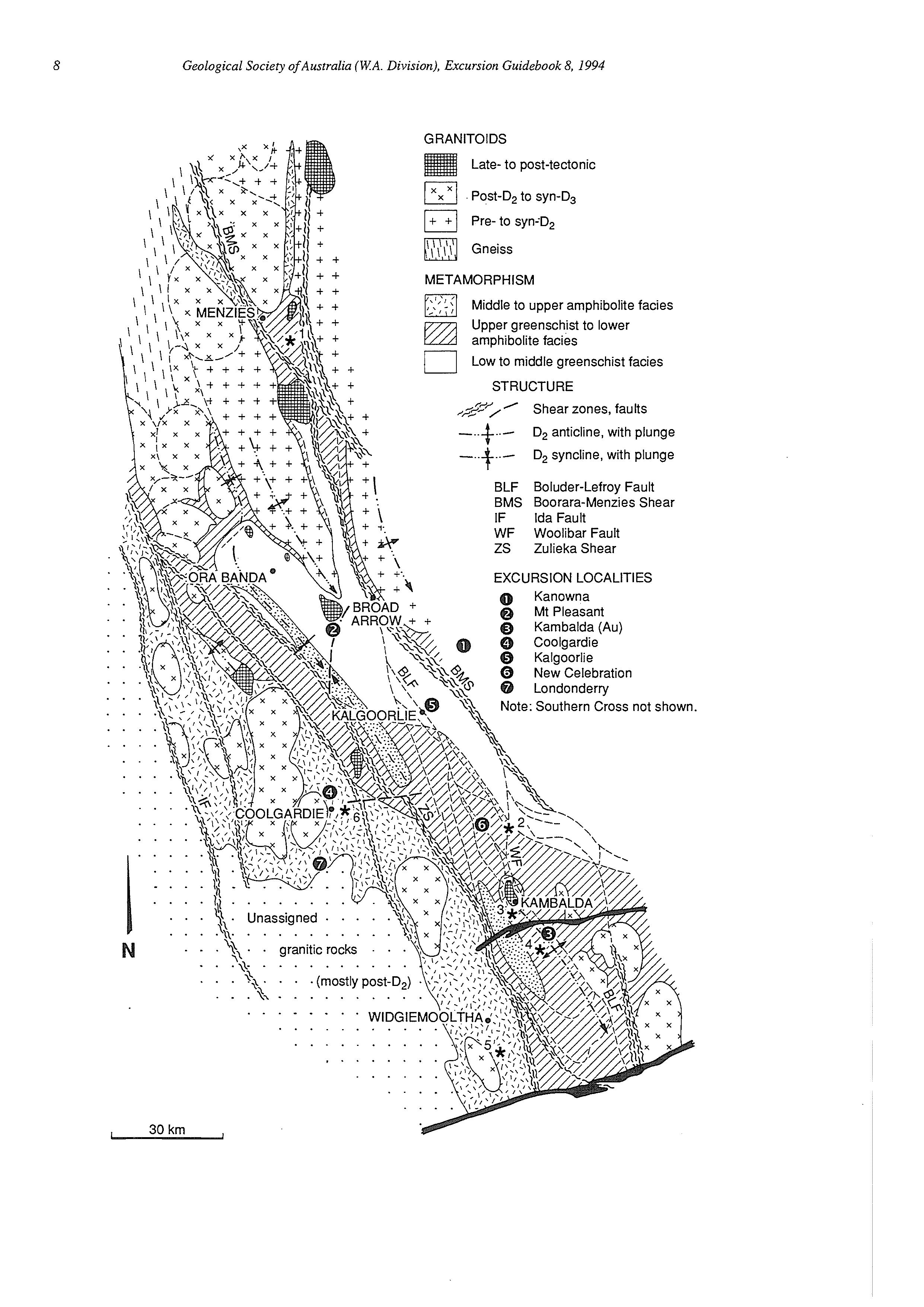
TABLE 1.2 Summary of regional deformation in the Kalgoorlie Terrane and adjoining areas.
Deformation
D2
Structures
D,, Low-anglethtust faults and recumbent folds
D,e
Deformedcontacts between early granitoid complexesand greenstones; N-S lineations in contact zone; recumbent folds in overlying greenstones (?)
Upright folds with shallowly plunging, NNW fold axes
NW to NNW sinistral strike-slip faults and shear zones
N to NNE dextral strike-slip faults and shear zones
En echelon folds adjacent to strike-slip faults
late D3 Steeply plunging lineations on strike-slip faults
Steeply dipping reversefaults
D4
NW to WNW sinistral oblique faults
NE to ENE dextral oblique faults
Locality or example
Between Kalgoorlie and Democrat (south of Kambalda)
Jeedamya-Kookyniearea
References
Gresham & Loftus-Hills (1981)
Swager & Griffin (1990)
Witt (1994)
Kambalda Anticline
Goonganie-Mt Pleasant Anticline
Kurrawang Syncline
Boorara-Menzies Shear
Boulder-Lefroy Fault
Butchers Flat Shear Zone
Kunanalling, Celebration
Goongarrie, BardccTectonic Zone
Melita, Niagara
Paddingtonarea
Mount Charlotte (Kalgoorlie) Black Flag Fault (Mount Pleasant)
toids significantly postdated peak metamorphic temperatures and are associated with relatively narrow contact aureoles in which andalusite porphyroblasts overprint the regional metamorphic fabric in metapelites.
Regional shear zones are characterized by intense carbonation in greenschist- to lower amphibolite-facies domains. Carbon isotope data indicate that carbon in carbonate from regional shear zones is juvenile (mantle-derived or magmatic) (McNaughton ef al., 1988; Groves et al., 1988). Metasomatic minerals (carbonate,
Swager & Griffin (1990)
Wtt (1990a)
Hunter (1993)
Swager eta/.(1990)
Witt (1990a)
Swager (1989)
Swager & Griffin (1990)
Witt(1994)
Swager (1989)
Witt(1990a)
Witt (1994)
Witt (1990a)
Swager (1989)
Witt (1990a)
chlorite, talc) replace metamorphic assemblages but carbonation was probably synmetamorphic, with the apparently retrograde assemblages being stabilized by high Xco2 in the fluids (e.g., Clark et al., 1986). In higher grade areas, regional deformation zones contain much less carbonate. Late, randomly oriented amphiboles overprint an earlier shear fabric, suggesting there may have been decarbonation at these higher temperatures.
FIGURE 1.4 (facing page) Regional distribution of metamorphic facies in the southern part of the Kalgoorlie Tenane. Also shown are three generations of granitoid intrusion, granitoid gneiss, major structures, and mining centres visited on this excursion. Localities which are asterisked have assemblages indicating the following metamorphic conditions:
1. 400-525"C, <3.8 kbar (Ashley & Martin, 1987)
2. 5OO0C,4 kbar (Purvis, 1984)
3. 575"C, 2.5 kbar (Wong, 1986)
4. 520"C, 2.5 kbar (Bavinton, 1979)
5. 500-60O0C,3-5 kbar (McQueen, 1981)
6. 484 I. 50"C, increasing to 545 k 50°C adjacent to granitoid contact, 3-4 kbar (Knight, 1994)

PART 11: GOLD MINERALIZATION IN THE KALGOORLIE TERRANE
W.K. Witt' & D.I. Groves2
1. Geological Survey of Western Australia, 100 Plain Street, East Perth, WA., Australia 6004
2. Key Centre for Teaching and Research in Strategic Mineral Deposits, Department of Geology and Geophysics, The University of Western Australia, Nedlands, WA., Australia 6009
INTRODUCTION
Much of the information which follows refers to the Menzies-Kambalda area (Witt, 1993a), which corresponds roughly to the Kalgoorlie Terrane, excluding the Coolgardie Domain. Observations from the Coolgardie area (Knight et al., 1993; Knight, 1994) are mostly consistent with those from the Menzies-Kambalda area.
HOST ROCKS
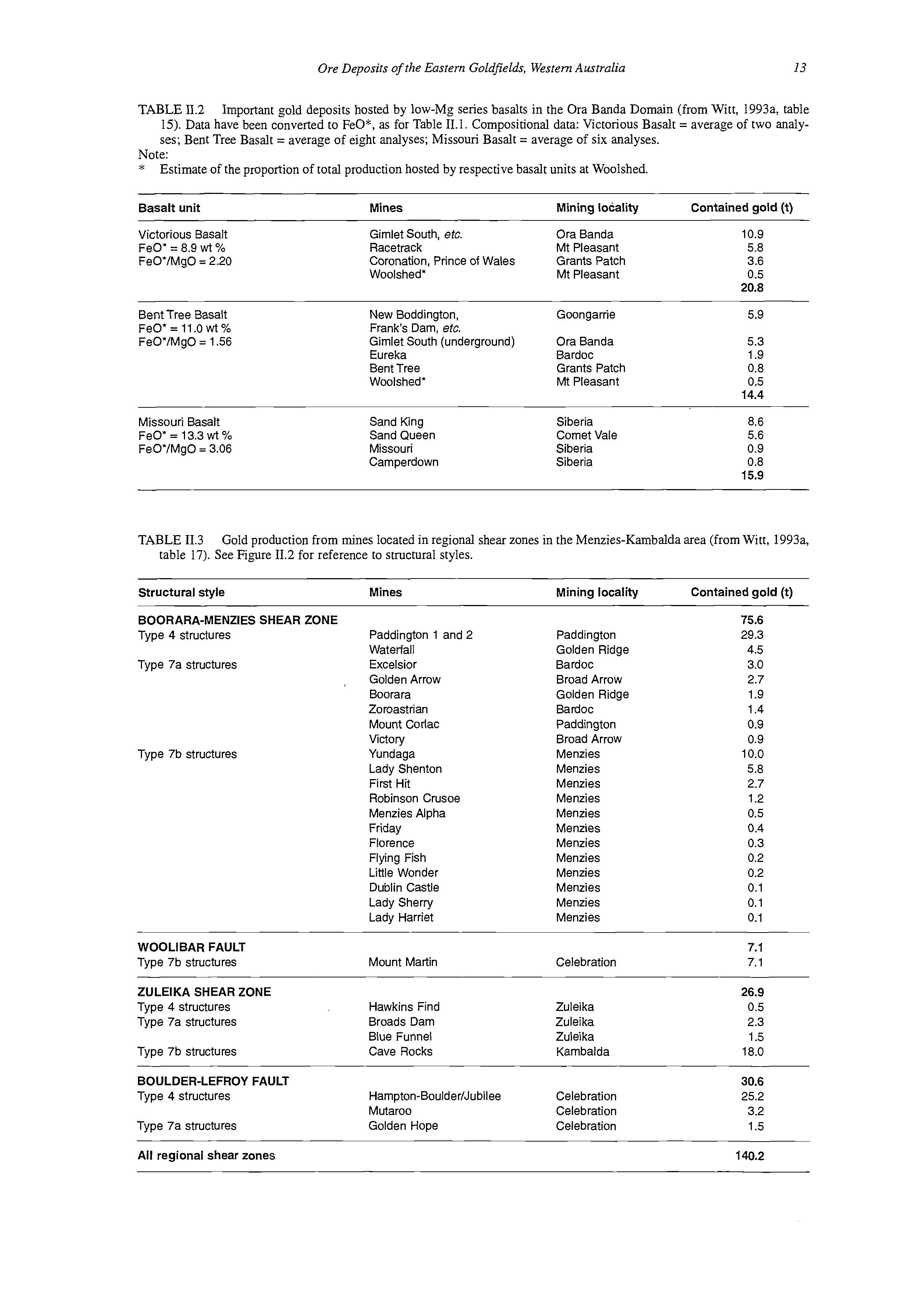
All rock types in the Kalgoorlie Terrane host gold mineralization, but most production has come from fractionated quartz-dolerite zones of mafic-ultramafic sills and from tholeiitic basalt (Fig. 11.1). The dominance of quartz-dolerite and tholeiitic basalt remains even if bias introduced by the "giant" Kalgoorlie deposits (Golden Mile, Mount Charlotte) is eliminated. A similar picture
GRANITOID-HOSTED
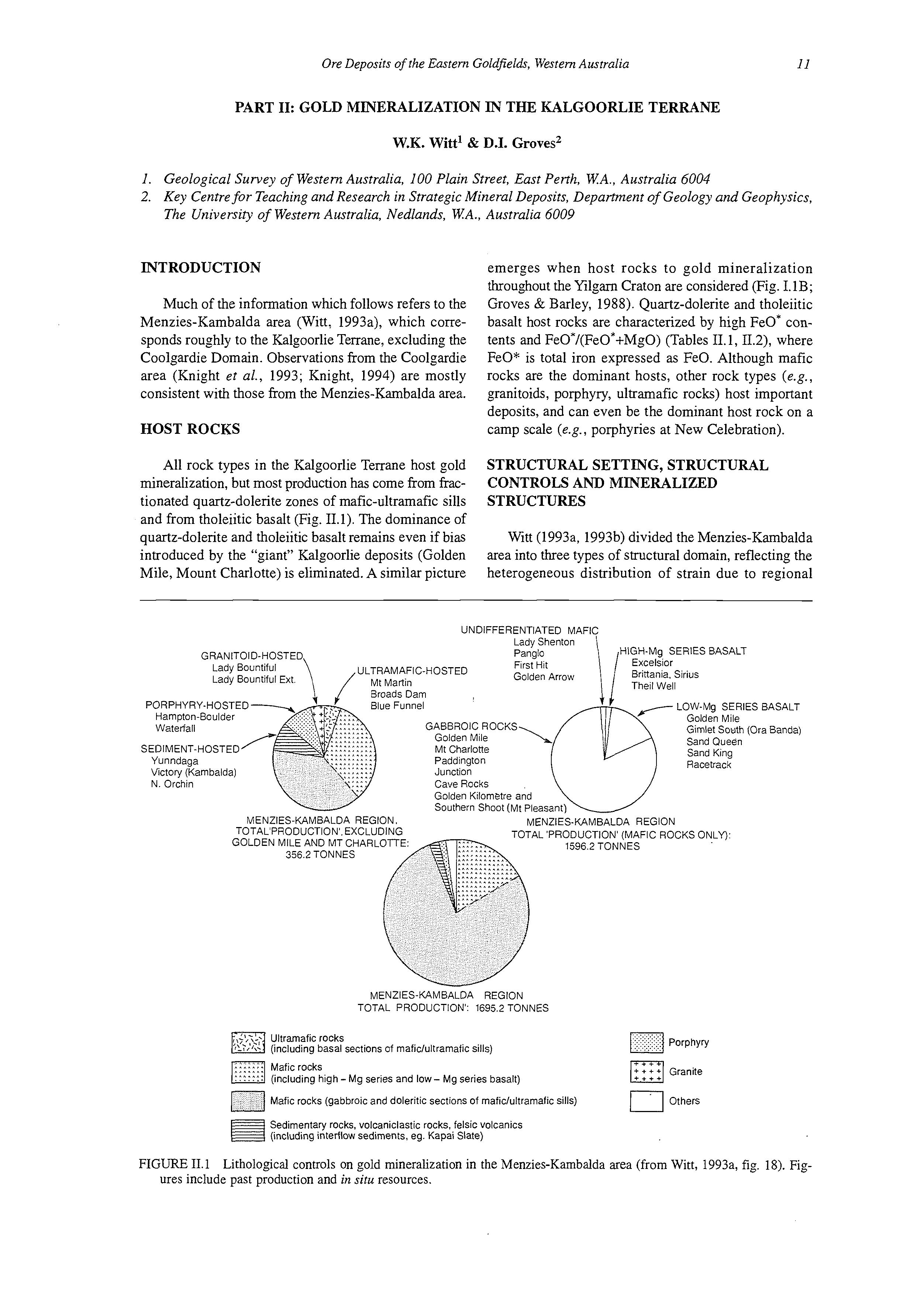
emerges when host rocks to gold mineralization throughout the Yilgarn Craton are considered (Fig. I.1B; Groves & Barley, 1988). Quartz-dolerite and tholeiitic basalt host rocks are characterized by high FeO* contents and FeO*/(FeO*+MgO) (Tables II.1,11.2), where FeO* is total iron expressed as FeO. Although mafic rocks are the dominant hosts, other rock types (e.g., granitoids, porphyry, ultramafic rocks) host important deposits, and can even be the dominant host rock on a camp scale (e.g., porphyries at New Celebration).
STRUCTURAL SETTING, STRUCTURAL CONTROLS AND MINERALIZED STRUCTURES
Witt (1993a, 1993'0) divided the Menzies-Kambalda area into three types of structural domain, reflecting the heterogeneous distribution of strain due to regional
UNDIFFERENTIATED MAFIC
ULTRAMAFIC-HOSTED
Lady BountifulExt Golden Arrow
PORPHYRY-HOSTED
GABBROIC ROCKS Golden Mile
SEDIMENT-HOSTED Mt Charlotte Yunndaga Paddington Victory (Karnbalda) Junction N Orchin Cave Rocks
Golden Kilornetre and Harnpton-Boulder Waterfall
VENZIES-KAMBALDA REGION.
HIGH-Mg SERIES BASALT Excelsior Brittania.Sirius Theil Well
LOW-Mg SERIES BASALT Golden Mile Gimlet South (Ora Banda) Sand Queen Sand King Racetrack
MENZIES-KAMBALDA REGION TOTAL PRODUCTION' EXCLUDING GOLDEN MILE AND MT CHARLOTTE 356 2 TONNES
TOTAL 'PRODUCTION' (MAFIC ROCKS ONLY) 1596 2 TONNES
MENZIES-KAMBALDA REGION TOTAL PRODUCTION': 1695.2 TONNES
Ultramaficrocks (including basal sections of maficlultramafic sills)
Mafic rocks (including high - Mg series and low- Mg series basalt)
Mafic rocks (gabbroic and dolerittc sections of maficlultramafic sills)
Sedimentary rocks, volcaniclastic rocks, felsic volcantcs (including interflow sediments, eg Kapai Slate)
Porphyry aGranite
Others
FIGURE 11.1 Lithological controls on gold mineralization in the Menzies-Kambalda area (from Witt, 1993a, fig. 18). Figures include past production and in situ resources.
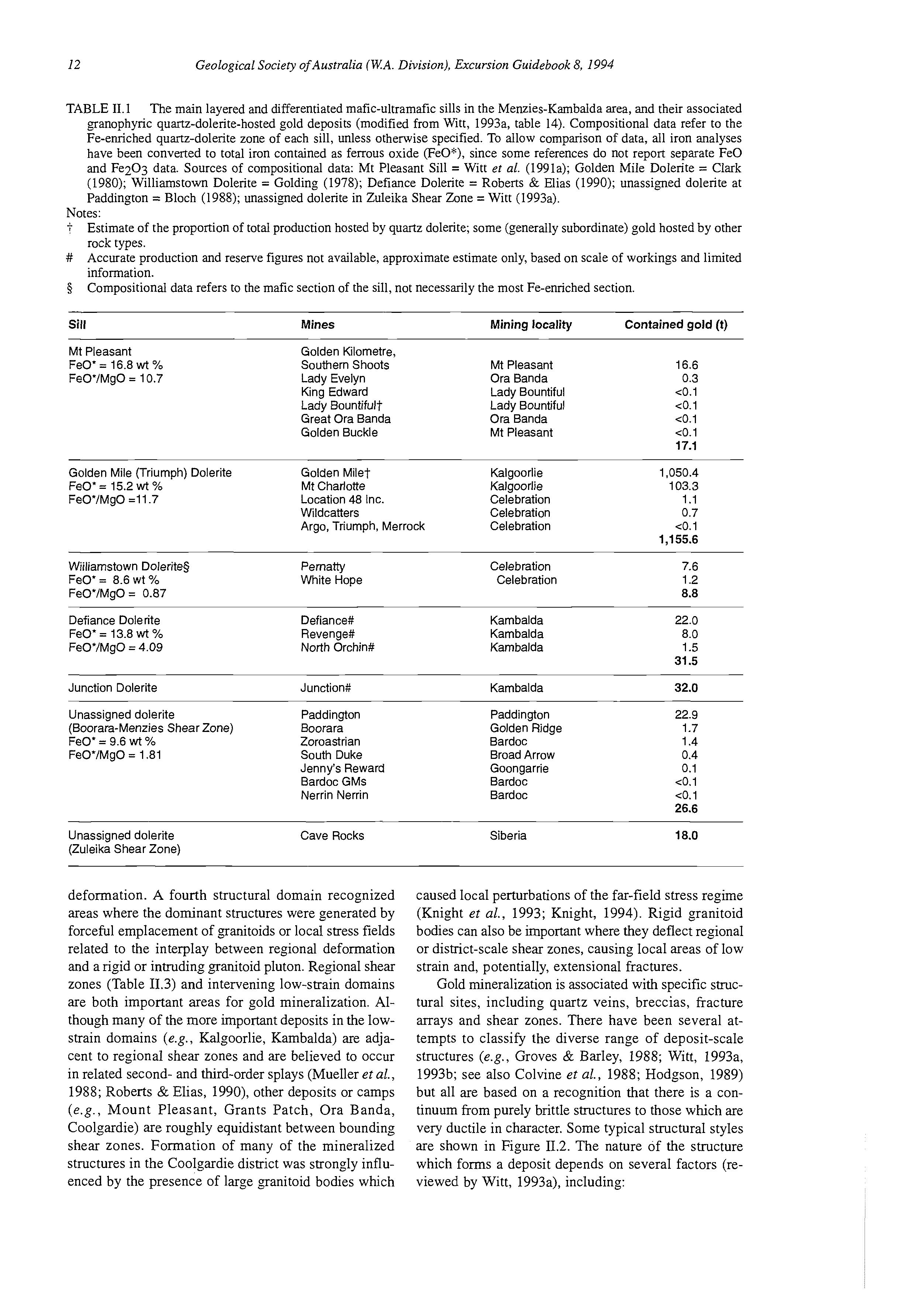
TABLE 11.1 The main layered and differentiated mafic-ultramafic sills in the Menzies-Kambalda area, and their associated granophyric quartz-dolerite-hosted gold deposits (modified from Witt, 1993a, table 14). Compositional data refer to the Fe-enriched quartz-dolerite zone of each sill, unless otherwise specified. To allow comparison of data, all iron analyses have been converted to total iron contained as ferrous oxide (FeO*), since some references do not report separate FeO and Fe2O3 data. Sources of compositional data: Mt Pleasant Sill = Witt et al. (199Ia); Golden Mile Dolerite = Clark (1980); Williamstown Dolerite = Golding (1978); Defiance Dolerite = Roberts & Elias (1990); unassigned dolerite at Paddington = Bloch (1988); unassigned dolerite in Zuleika Shear Zone = Witt (1993a).
Notes: i # 3
Estimate of the proportion of total production hosted by quartz dolerite; some (generally subordinate) gold hosted by other rock types.
Accurate production and reserve figures not available, approximate estimate only, based on scale of workings and limited information.
Compositional data refers to the mafic section of the sill, not necessarily the most Fe-enriched section.
Sill
Mt Pleasant
FeO' = 16.8 wt %
FeO'IMgO = 10.7
Golden Kilometre,
Southern Shoots
Lady Evelyn
King Edward
Lady Bountiful?
Great Ora Banda
Golden Buckle
Golden Mile (Triumph) Dolerite
Few = 15.2 wt %
FeVlMgO =11.7
Wiiliarnstown Dolerites
FeO' = 8.6 wt %
FeOYMgO = 0.87
Defiance Dolerite
Few = 13.8 wt Yo
= 4.09
Mt Pleasant
Ora Banda
Lady Bountiful
Lady Bountiful
Ora Banda
Mt Pleasant
Golden Milet Kalgoorlie
Mt Charlotte Kalgoorlie
Location 48 Inc. Celebration
Wildcatters Celebration
Argo, Triumph, Merrock Celebration
Unassigned dolerite Paddington (Boorara-Menzies Shear Zone) Boorara
FeO' = 9.6 wt Yo Zoroastrian
FeO'IMgO = 1.81 South Duke Jenny's Reward Bardoc GMs Nerrin Nerrin Paddington Golden Ridge Bardoc
Unassigned dolerite (Zuleika Shear Zone)
deformation. A fourth structural domain recognized areas where the dominant structures were generated by forceful emplacement of granitoids or local stress fields related to the interplay between regional deformation and a rigid or intruding granitoid pluton. Regional shear zones (Table 11.3) and intervening low-strain domains are both important areas for gold mineralization. Although many of the more important deposits in the lowstrain domains (e.g., Kalgoorlie, Kambalda) are adjacent to regional shear zones and are believed to occur in related second- and third-order splays (Mueller et al., 1988; Roberts & Elias, 1990), other deposits or camps (e.g.. Mount Pleasant, Grants Patch, Ora Banda, Coolgardie) are roughly equidistant between bounding shear zones. Formation of many of the mineralized structures in the Coolgardie district was strongly influenced by the presence of large granitoid bodies which
caused local perturbations of the far-field stress regime (Knight et al., 1993; Knight, 1994). Rigid granitoid bodies can also be important where they deflect regional or district-scale shear zones, causing local areas of low strain and, potentially, extensional fractures.
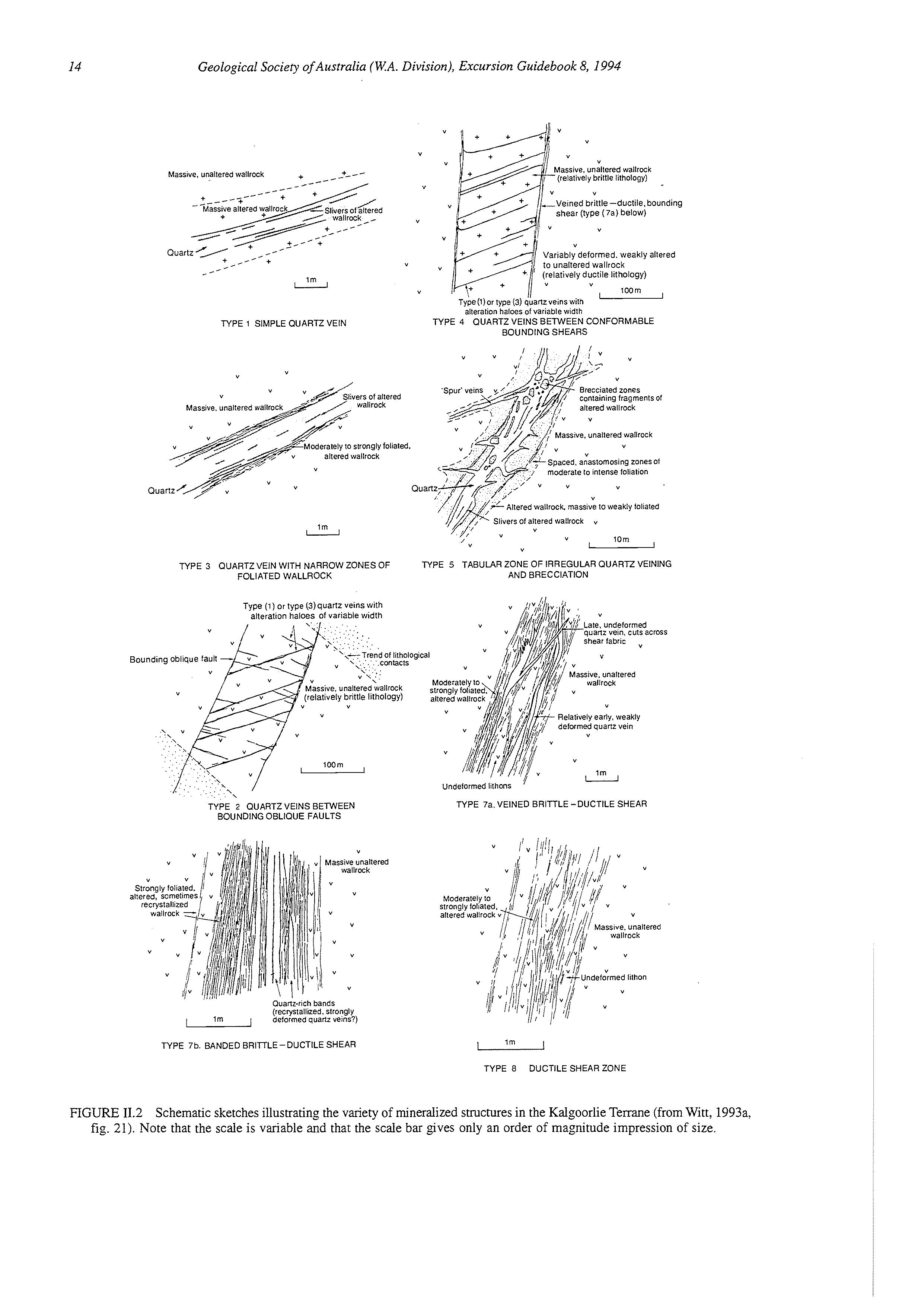
Gold mineralization is associated with specific structural sites, including quartz veins, breccias, fracture arrays and shear zones. There have been several attempts to classify the diverse range of deposit-scale structures (e.g., Groves & Barley, 1988; Witt, 1993a, 1993b; see also Colvine et al., 1988; Hodgson, 1989) but all are based on a recognition that there is a continuum from purely brittle structures to those which are very ductile in character. Some typical structural styles are shown in Figure 11.2. The nature of the structure which forms a deposit depends on several factors (reviewed by Witt, 1993a), including:
TABLE 11.2 Important gold deposits hosted by low-Mg series basalts in the Ora Banda Domain (from Witt, 1993a, table 15).Data have been converted to FeO*, as for Table 11.1. Compositional data: Victorious Basalt = average of two analyses; Bent Tree Basalt = average of eight analyses; Missouri Basalt = average of six analyses.
Note: *
Estimate of the proportion of total production hosted by respective basalt units at Woolshed.
Bent Tree Basalt
FeO'=ll.Owt%
FeO'IMgO = 1.56
New Boddington, Goongarrie Frank's Dam, etc.
Gimlet South (underground)
Missouri Basalt
TABLE 11.3 Gold production from mines located in regional shear zones in the Menzies-Kambalda area (from Witt, 1993a, table 17). See Figure 11.2 for reference to structural styles.
BOORARA-MENZIES SHEAR ZONE
Type 4 structures
Type 7a structures
Type 7b
WOOLIBAR FAULT
Type
ZULEIKA SHEAR ZONE
Masswe. unalleredwallrock + __ + -- -<* lm
TYPE 1 SIMPLEQUARTZ VEIN "
(relalivelybrillle lithology)
shear (type (7al below)
(relatively ductile lithology)
BOUNDING SHEARS
Massive.unalteredwallrock
moderale 10 intense IollaIiOn
Altered wallrock. massiveto weakly folialed lm lorn u "
TYPE 3 QUARTZVEIN WITH NARROWZONES OF TYPE 5 TABULAR ZONE OF IRREGULARQUARTZ VEINING FOLIATEDWALLROCK AND BRECCIATION
Type (1 1or type (3)quartz veins with alteration haloes of variable width
Late. undeformed quartz vein. cuis across shear fabric "
assive. unallered wallrock
Relativelyearly, weakly deformedquartzvein
Undeformedlilhons
TYPE 7a. VEINED BRITTLE -DUCTILE SHEAR
TYPE 2 OUARTZVEINS BETWEEN BOUNDINGOBLIQUE FAULTS
Ouarlz-richbands (recrystallized.strongly ,.. I Im , deformedquartz veins?)
TYPE 7b. BANDED BRITTLE-DUCTILE SHEAR I 1m I
TYPE 8 DUCTILE SHEAR ZONE
FIGURE 11.2 Schematic sketches illustrating the variety of mineralized structures in the KalgoorlieTerrane (from Witt, 1993a, fig. 21). Note that the scale is variable and that the scale bar gives only an order of magnitude impression of size.
SCHEMATIC CRUSTAL PROFILE AT TIME OF GOLD MINERALIZATION
SUB-GREENSCHIST
L. GREENSCHIST
WELL-DOCUMENTED GOLD DEPOSITS
Greenstone-hosted
Wiluna deposits
Racetrack
Mt Charlotte Golden Mile Lancefield Sons of Gwalia Harbour Lights HuntNictory-Defiance
Norseman deposits
Frasers/Hopes Hill Marvel LochlNevoria (OK, Mararoa, Crown)
Griffins Find
Granitoid-hosted
Lady Bountiful
Granny Smith Great Eastern (Stage I)
Westonia
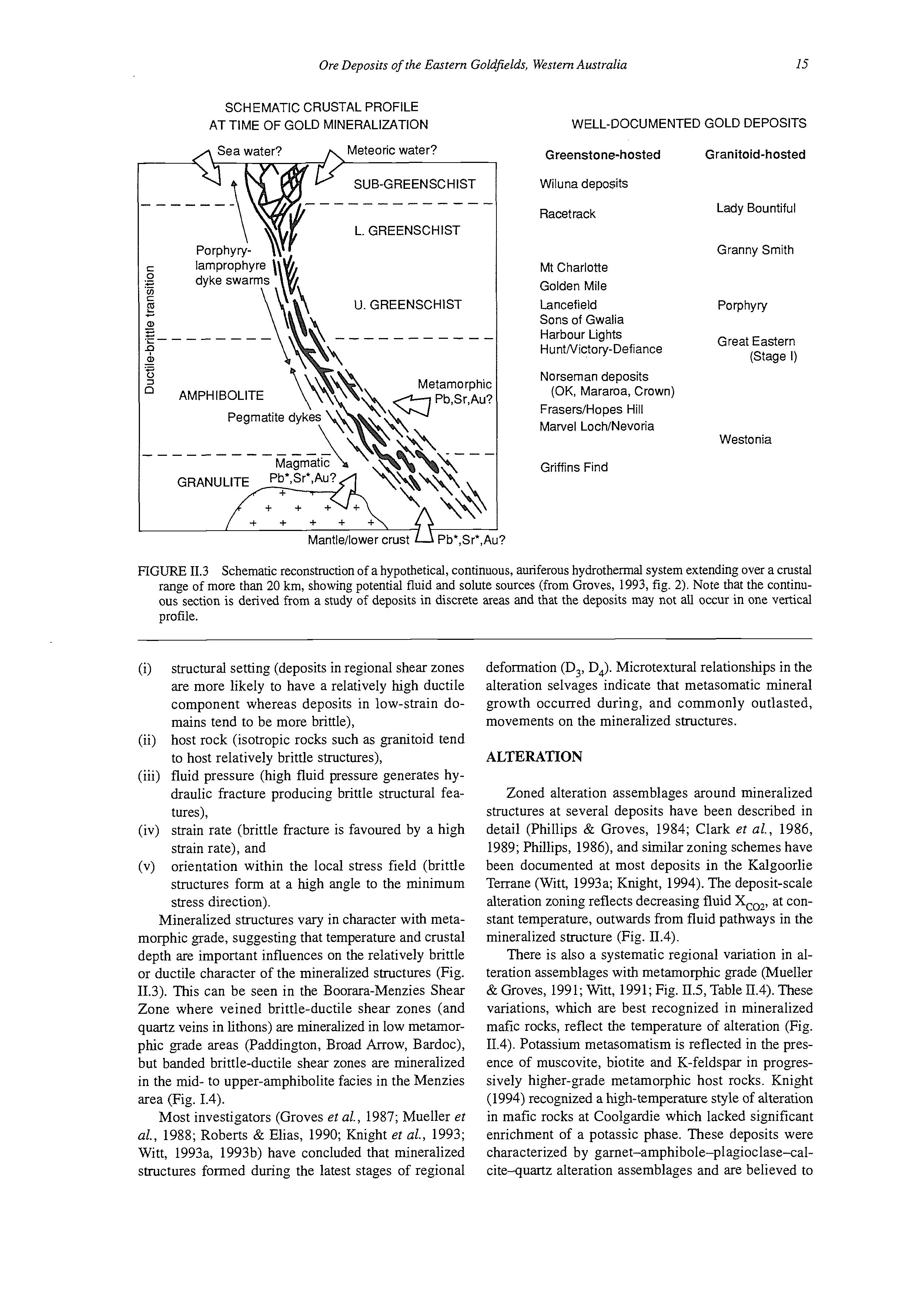
FIGURE 11.3 Schematic reconstruction of a hypothetical, continuous, auriferous hydrothermal system extending over a crustal range of more than 20 km, showing potential fluid and solute sources (from Groves, 1993, fig. 2). Note that the continuous section is derived from a study of deposits in discrete areas and that the deposits may not all occur in one vertical profile.
(i) structural setting (deposits in regional shear zones are more likely to have a relatively high ductile component whereas deposits in low-strain domains tend to be more brittle),
(ii) host rock (isotropic rocks such as granitoid tend to host relatively brittle structures),
(iii) fluid pressure (high fluid pressure generates hydraulic fracture producing brittle structural features),
(iv) strain rate (brittle fracture is favoured by a high strain rate), and
(v) orientation within the local stress field (brittle structures form at a high angle to the minimum stress direction).
Mineralized structures vary in character with metamorphic grade, suggesting that temperature and crustal depth are important influences on the relatively brittle or ductile character of the mineralized structures (Fig. 11.3). This can be seen in the Boorara-Menzies Shear Zone where veined brittle-ductile shear zones (and quartz veins in lithons) are mineralized in low metamorphic grade areas (Paddington, Broad Arrow, Bardoc), but banded brittle-ductile shear zones are mineralized in the mid- to upper-amphibolite facies in the Menzies area (Fig. 1.4).
Most investigators (Groves et al., 1987; Mueller et al., 1988; Roberts & Elias, 1990; Knight et al., 1993; Witt, 1993a, 1993b) have concluded that mineralized structures formed during the latest stages of regional
deformation (D3, D4). Microtextural relationships in the alteration selvages indicate that metasomatic mineral growth occurred during, and commonly outlasted, movements on the mineralized structures.
ALTERATION
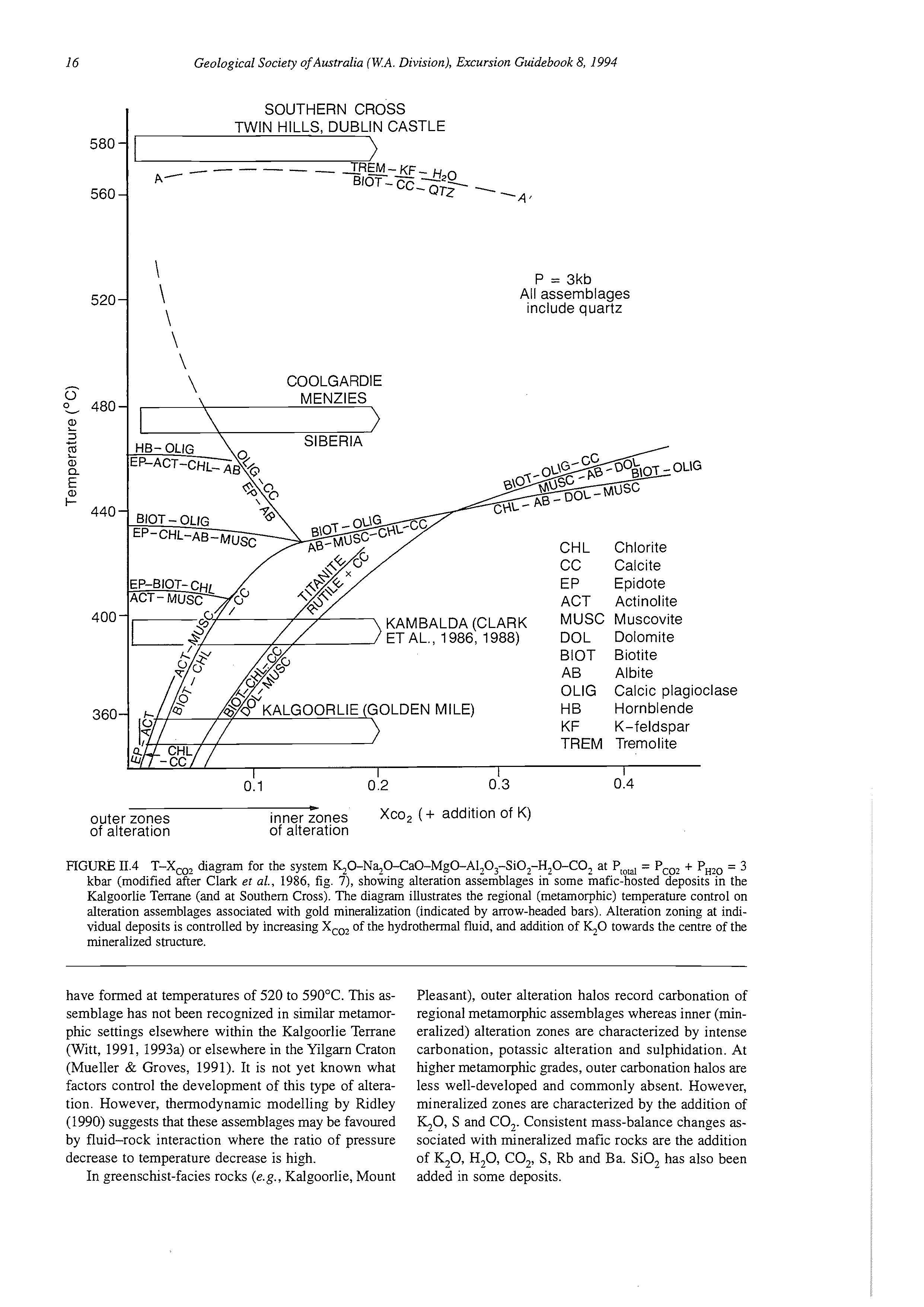
Zoned alteration assemblages around mineralized structures at several deposits have been described in detail (Phillips & Groves, 1984; Clark et al., 1986, 1989; Phillips, 1986), and similar zoning schemes have been documented at most deposits in the Kalgoorlie Terrane (Witt, 1993a; Knight, 1994). The deposit-scale alteration zoning reflects decreasing fluid Xco2, at constant temperature, outwards from fluid pathways in the mineralized structure (Fig. 11.4).
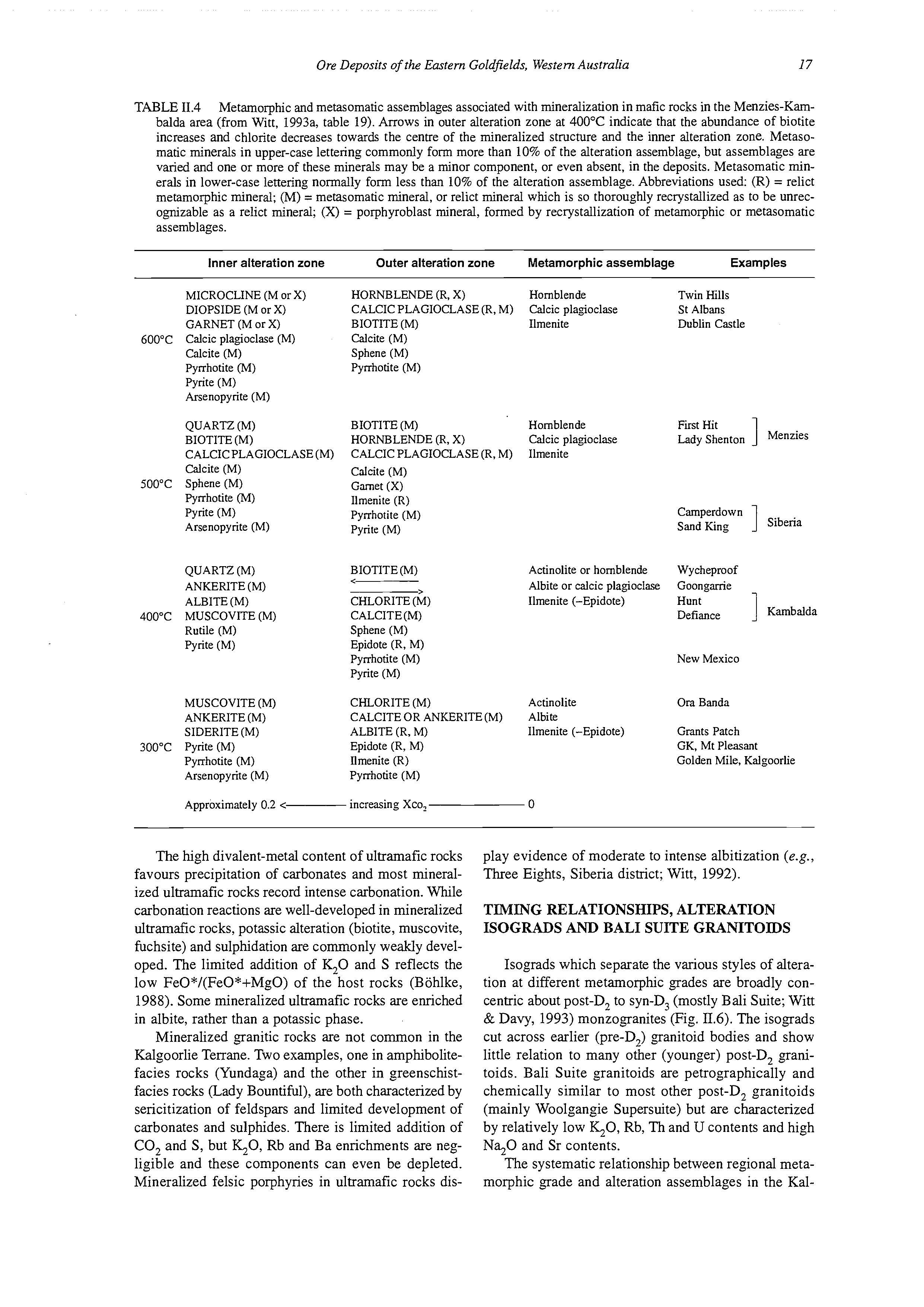
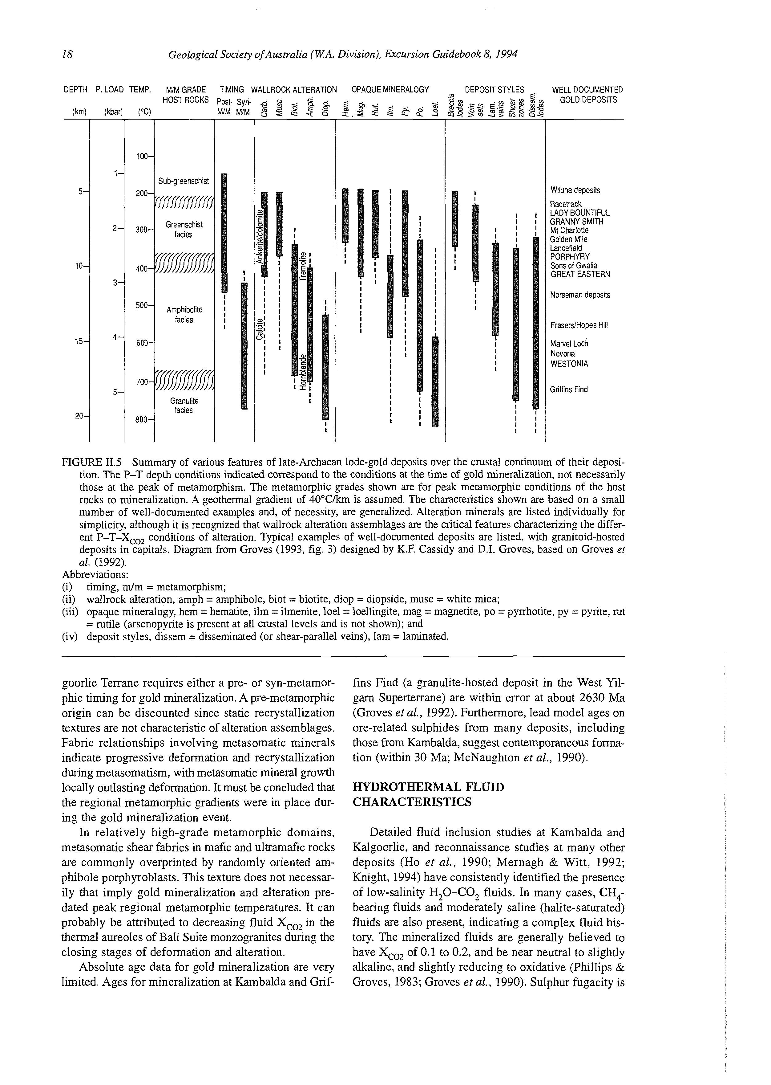
There is also a systematic regional variation in alteration assemblages with metamorphic grade (Mueller & Groves, 1991; Witt, 1991; Fig. 11.5, Table IT.4).These variations, which are best recognized in mineralized mafic rocks, reflect the temperature of alteration (Fig. 11.4). Potassium metasomatism is reflected in the presence of muscovite, biotite and K-feldspar in progressively higher-grade metamorphic host rocks. Knight (1994) recognized a high-temperature style of alteration in mafic rocks at Coolgardie which lacked significant enrichment of a potassic phase. These deposits were characterized by garnet-amphibole-plagioclase-calcite-quartz alteration assemblages and are believed to
SOUTHERN CROSS TWIN HILLS, DUBLIN CASTLE
P = 3kb
All assemblages include quartz
KAMBALDA (CLARK
ETAL., 1986, 1988)
CHL Chlorite
CC Calcite
EP Epidote
ACT Actinolite
OLIG
MUSC Muscovite
DOL Dolomite
BlOT Biotite
AB Albite
OLlG Calcic plagioclase
HB Hornblende
KF K-feldspar
TREM Tremolite
y!
outer zones inner Tones Xco, (+ addition of K) of alteration of alteration
FIGURE 11.4 T-Xco2 diagram for the system ~O-N~0-Ca0-Mg0-A1,O3-Si0,-H,O-CO2 at Protal= Pco2 + PHZp= 3 kbar (modified after Clark ef al., 1986, fig. 7), showing alteration assemblages in some mafic-hosted deposits in the Kalgoorlie Terrane (and at Southem Cross). The diagram illustrates the regional (metamorphic) temperature control on alteration assemblages associated with gold mineralization (indicated by arrow-headed bars). Alteration zoning at individual deposits is controlled by increasing Xco2 of the hydrothermal fluid, and addition of h0 towards the centre of the mineralized structure.
have formed at temperatures of 520 to 590OC. This assemblage has not been recognized in similar metamorphic settings elsewhere within the Kalgoorlie Terrane (Witt, 1991, 1993a) or elsewhere in the Yilgarn Craton (Mueller & Groves, 1991). It is not yet known what factors control the development of this type of alteration. However, thermodynamic modelling by Ridley (1990) suggests that these assemblages may be favoured by fluid-rock interaction where the ratio of pressure decrease to temperature decrease is high.
In greenschist-facies rocks (e.g., Kalgoorlie, Mount
Pleasant), outer alteration halos record carbonation of regional metamorphic assemblages whereas inner (mineralized) alteration zones are characterized by intense carbonation, potassic alteration and sulphidation. At higher metamorphic grades, outer carbonation halos are less well-developed and commonly absent. However, mineralized zones are characterized by the addition of &-0, S and CO,. Consistent mass-balance changes associated with mineralized mafic rocks are the addition of K,O, H,O, CO,, S, Rb and Ba. SiO, has also been added in some deposits.
TABLE 11.4 Metamorphic and metasomatic assemblages associated with mineralization in mafic rocks in the Menzies-Kambalda area (from Witt, 1993a, table 19). Arrows in outer alteration zone at 400°C indicate that the abundance of biotite increases and chlorite decreases towards the centre of the mineralized structure and the inner alteration zone. Metasomatic minerals in upper-case lettering commonly form more than 10% of the alteration assemblage, but assemblages are varied and one or more of these minerals may be a minor component, or even absent, in the deposits. Metasomatic minerals in lower-case lettering normally form less than 10% of the alteration assemblage. Abbreviations used: (R) = relict metamorphic mineral; (M) = metasomatic mineral, or relict mineral which is so thoroughly recrystallized as to be unrecognizable as a relict mineral; (X) = porphyroblast mineral, formed by recrystallization of metamorphic or metasomatic assemblages.
Inner alteration zone
MICROCLINE (M or X)
DIOPSIDE (M or X)
GARNET (M or X)
600°C Calcic plagioclase (M)
Calcite (M)
Pyrrhotite (M)
Pyrite (M)
Arsenopyrite (M)
QUARTZ (M)
Outer alteration zone
Metamorphic assemblage Examples
HORNBLENDE (R, X) Hornblende Twin Hills
CALCIC PLAGIOCLASE (R, M) Calcic plagioclase St Albans
BIOTITE (M) Ilmenite Dublin Castle
Calcite (M)
Sphene (M)
Pyrrhotite (M)
BIOTITE (M) Hornblende First Hit BIOTITE(M) HORNBLENDE (R, X) Calcic plagioclase
Lady Shenton Menzies 1
CALCIC PLAGIOCLASE (M) CALCIC PLAGIOCLASE (R, M) Ilmenite
Calcite (M)
500°C Sphene (M)
Pyrrhotite (M)
Pyrite (M)
Arsenopyrite (M)
Calcite (M)
Garnet (X)
llmenite (R)
Pyrrhotite (M) Camperdown
Pyrite (M)
BIOTITE(M)
QUARTZ (M) ANKERITE (M) ALBITE(M) CHLORITE (M)
400°C MUSCOVITE (M)
Rutile (M)
Pyrite (M)
MUSCOVITE (M)
ANKERITE (M)
Actinolite or hornblende Wycheproof < > Albite or calcic plagioclase Goonganie
Ilmenite (-Epidote)
CALCITE(M) Defiance
Hunt ] Kambalda
Sphene (M)
Epidote (R, M)
Pyrrhotite (M)
New Mexico Pyrite (M)
CHLORITE (M)
Actinolite
CALCITE OR ANKERITE (M) Albite SIDERITE (M) ALBITE (R, M)
300°C Pyrite (M)
Pyrrhotite (M)
Epidote (R, M)
Ilmenite (R)
Om Banda
Ilmenite (-Epidote) Grants Patch
GK, Mt Pleasant
Golden Mile, Kalgoorlie Arsenopyrite (M)
Pyrrhotite (M)
Approximately 0.2 < increasing Xco, 0
The high divalent-metal content of ultramafic rocks favours precipitation of carbonates and most mineralized ultramafic rocks record intense carbonation. While carbonation reactions are well-developed in mineralized ultramafc rocks, potassic alteration (biotite, muscovite, fuchsite) and sulphidation are commonly weakly developed. The limited addition of K,O and S reflects the low FeO*/(FeO*+MgO) of the host rocks (Bohlke, 1988). Some mineralized ultramafic rocks are enriched in albite, rather than a potassic phase.
Mineralized granitic rocks are not common in the Kalgoorlie Terrane. Two examples, one in amphibolitefacies rocks (Yundaga) and the other in greenschistfacies rocks (Lady Bountiful), are both characterized by sericitization of feldspars and limited development of carbonates and sulphides. There is limited addition of CO, and S, but QO, Rb and Ba enrichments are negligible and these components can even be depleted. Mineralized felsic porphyries in ultramafic rocks dis-
play evidence of moderate to intense albitization (e.g., Three Eights, Siberia district; Witt, 1992).
TIMING RELATIONSHIPS, ALTERATION ISOGRADS AND BALI SUITE GRANITOIDS
Isograds which separate the various styles of alteration at different metamorphic grades are broadly concentric about post-D, to syn-D, (mostly Bali Suite; Witt & Davy, 1993) monzogranites (Fig. 11.6).The isograds cut across earlier (pre-D,) granitoid bodies and show little relation to many other (younger) post-D, granitoids. Bali Suite granitoids are petrographically and chemically similar to most other post-D, granitoids (mainly Woolgangie Supersuite) but are characterized by relatively low q0, Rb, Th and U contents and high N30 and Sr contents.
The systematic relationship between regional metamorphic grade and alteration assemblages in the Kal-
FIGURE 11.5 Summary of various features of late-Archaean lode-gold deposits over the crustal continuum of their deposition. The P-T depth conditions indicated correspond to the conditions at the time of gold mineralization, not necessarily those at the peak of metamorphism. The metamorphic grades shown are for peak metamorphic conditions of the host rocks to mineralization. A geothermal gradient of 4O"Clkm is assumed. The characteristics shown are based on a small number of well-documented examples and, of necessity, are generalized. Alteration minerals are listed individually for simplicity, although it is recognized that wallrock alteration assemblages are the critical features characterizing the different P-T-Xco2 conditions of alteration. Typical examples of well-documented deposits are listed, with granitoid-hosted deposits in capitals. Diagram from Groves (1993, fig. 3) designed by K.F. Cassidy and D.I. Groves, based on Groves et al. (1992).
Abbreviations:
(i) timing, m/m = metamorphism;
(ii) wallrock alteration, amph = amphibole, biot = biotite, diop = diopside, musc = white mica;
(iii) opaque mineralogy, hem =hematite, ilm = ilmenite, loel = loellingite, mag = magnetite, PO = pyrrhotite, py = pyrite, rut = rutile (arsenopyrite is present at all crustal levels and is not shown); and (iv) deposit styles, dissem = disseminated (or shear-parallel veins), lam = laminated.
goorlie Terrane requires either a pre- or syn-metamorphic timing for gold mineralization. A pre-metamorphic origin can be discounted since static recrystallization textures are not characteristic of alteration assemblages. Fabric relationships involving metasomatic minerals indicate progressive deformation and recrystallization during metasomatism, with metasomatic mineral growth locally outlasting deformation. It must be concluded that the regional metamorphic gradients were in place during the gold mineralization event.
In relatively high-grade metamorphic domains, metasomatic shear fabrics in mafic and ultramafic rocks are commonly overprinted by randomly oriented amphibole porphyroblasts. This texture does not necessarily that imply gold mineralization and alteration predated peak regional metamorphic temperatures. It can probably be attributed to decreasing fluid X,,, in the thermal aureoles of Bali Suite monzogranites dunng the closing stages of deformation and alteration.
Absolute age data for gold mineralization are very limited. Ages for mineralization at Kambalda and Grif-
fins Find (a granulite-hosted deposit in the West Yilgarn Superterrane) are within error at about 2630 Ma (Groves et al., 1992). Furthermore, lead model ages on ore-related sulphides from many deposits, including those from Kambalda, suggest contemporaneous formation (within 30 Ma; McNaughton et al., 1990).
HYDROTHERMAL FLUID CHARACTERISTICS
Detailed fluid inclusion studies at Kambalda and Kalgoorlie, and reconnaissance studies at many other deposits (Ho et al., 1990; Mernagh & Witt, 1992; Knight, 1994) have consistently identified the presence of low-salinity H,O-CO, fluids. In many cases, CH4bearing fluids and moderately saline (halite-saturated) fluids are also present, indicating a complex fluid history. The mineralized fluids are generally believed to have Xco2 of 0.1 to 0.2, and be near neutral to slightly alkaline, and slightly reducing to oxidative (Phillips & Groves, 1983; Groves et al., 1990). Sulphur fugacity is
ALTERATION ISOGRADS
Muscovite + ankerite + quartz + fluid -- biotite + calcite +fluid approx. 350°C 2
Ankerite +chlorite + fluid anorthite +quartz + fluid approx. 45OoC
Biotite + calcite + quartz d rnicrocline + diopside + fluid approx. 550°C
GRANlTOlDS
Late- to post-tectonic /y*xI Post-D, to syn-D, Pre- to syn-D,
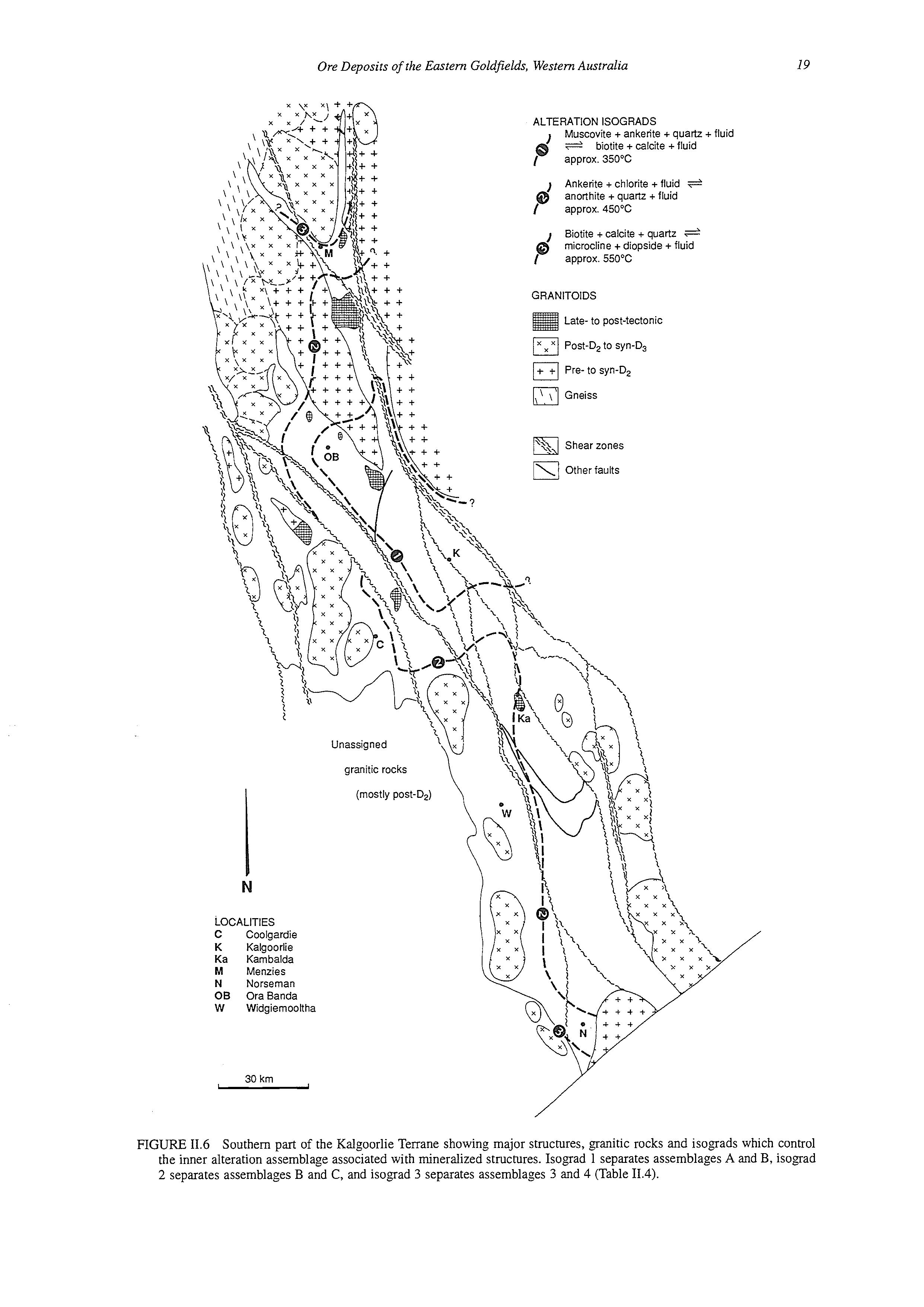
LOCALITIES
C Coolgardie
K Kalgoorlie
Ka Karnbalda
M Menzies
N Norseman
OB OraBanda
W Widgiernooltha
30 krn -
FTGUFE 11.6 Southern part of the Kalgoorlie Terrane showing major structures, granitic rocks and isograds which the inner alteration assemblage associated with mineralized structures. Isograd 1 separates assemblages A and B, 2 separates assemblages B and C, and isograd 3 separates assemblages 3 and 4 (Table 11.4).
control isograd
Granitoid pluton
Porphyry intrusion
Lamprophyre intrusion
Sediment-dominated sequence
Volcanic-dominated sequence
Granitic basement
Mantle
Crustal-scale fault
Subsidiary fault
Ore-fluid flow
Dilational structure
Gold deposit
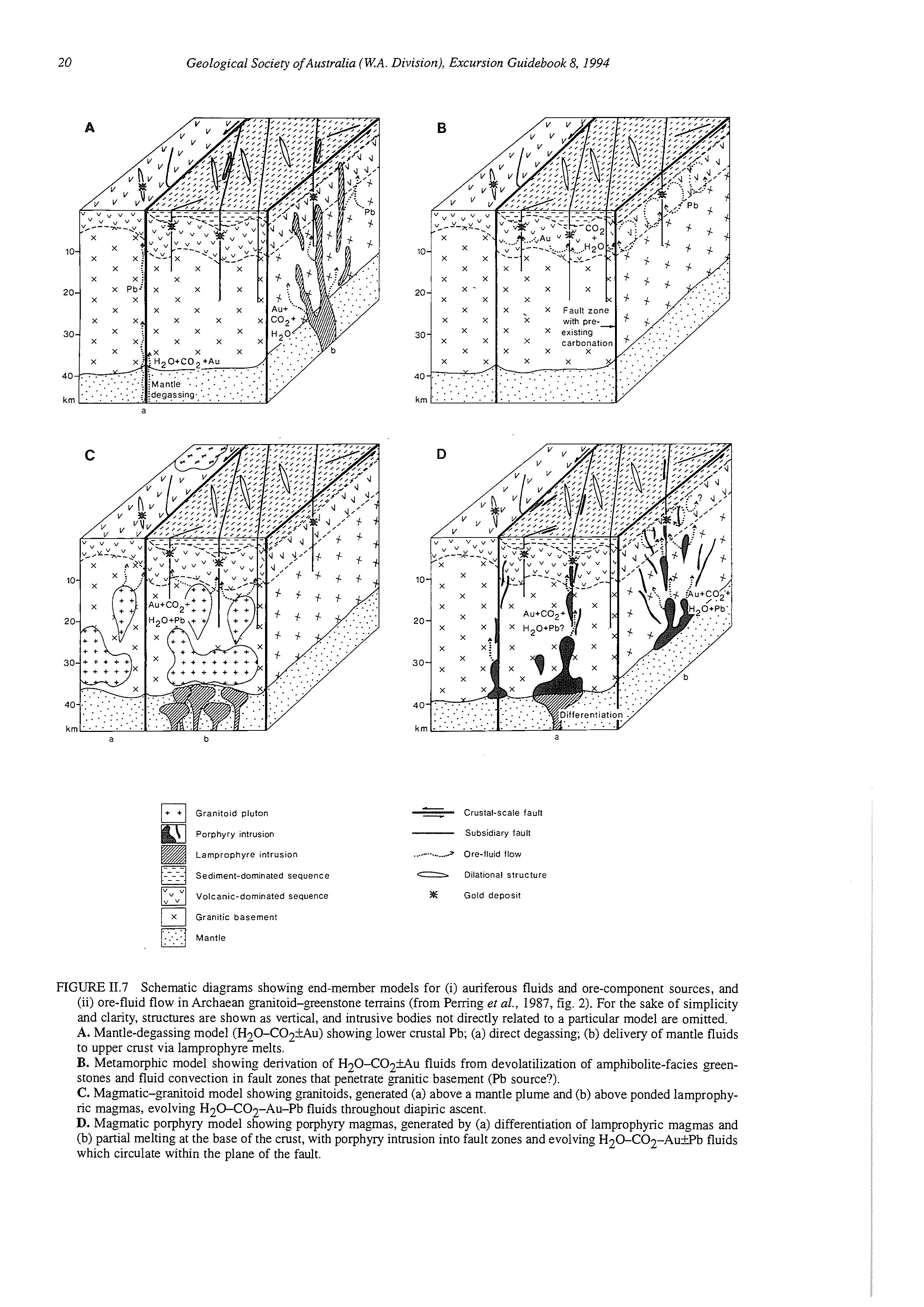
FIGURE 11.7 Schematic diagrams showing end-member models for (i) auriferous fluids and ore-component sources, and (ii) ore-fluid flow in Archaean granitoid-greenstone terrains (from Pemng et al., 1987, fig. 2). For the sake of simplicity and clarity, structures are shown as vertical, and intrusive bodies not directly related to a particular model are omitted.
A. Mantle-degassing model (H~O-CO~FAU)showing lower crustal Pb; (a) direct degassing; (b) delivery of mantle fluids to upper crust via lamprophyre melts.
B. Metamorphic model showing derivation of H2O-CO2iAu fluids from devolatilization of amphibolite-facies greenstones and fluid convection in fault zones that penetrate granitic basement (Pb source?).
C. Magmatic-granitoid model showing granitoids, generated (a) above a mantle plume and (b) above ponded lamprophyric magmaas,evolving H20-CO2-Au-Pb fluids throughout diapiric ascent.
D. Magmatic porphyry model showing porphyry magmas, generated by (a) differentiation of lamprophyric magmas and (b) partial melting at the base of the crust, with porphyry intrusion into fault zones and evolving H20-CO2-AuFPb fluids which circulate within the plane of the fault.
moderately high (log as = -2.5 to -0.5), and gold was probably transported as reduced-sulphur complexes such as Au(HS); (Mikucki & Groves, 1990).
Ridley (1990) has argued that wallrock alteration assemblages are consistent with a fluid source that has equilibrated with a rock of broadly granitic composition. Thus mineralized granitic rocks generally display little enrichment of K,O, Rb and Ba. Stable isotope studies (C, H, 0) have-generally given ambiguous results but have identified some variation (“provinciality”) in 6CI3 (carbonate) among different gold-mining districts (see McNaughton et al., 1990, for a review). Recent stable-isotope data from some very low metamorphic-grade deposits (e.g., Racetrack at Mount Pleasant: Gebre-Mariam et al., 1993) provide evidence that meteoric or sea water may have been involved in mineralization, and these deposits are viewed as the uppermost part of the crustal continuum of gold deposits (Groves et al., 1992).
Radiogenic isotopes, on the other hand, provide evidence for derivation of Pb and Sr in the hydrothermal fluids from granitoids or unexposed felsic crust (McNaughton et al., 1990; Mueller et al., 1991). Many of the deposits investigated contain initial Pb and Sr isotopic ratios that were more radiogenic than those of greenstones at the age of gold mineralization (2.63 Ga). Knight (1994) found that initial Pb and Sr isotopic ratios in deposits at Coolgardie become more radiogenic with proximity to the contact with the (Bali Suite) Calooli Monzogranite. Similarly, in a Yilgarn-wide study, Mueller et al. (1991) showed that Sr in scheelite from gold lodes is relatively radiogenic in deposits which are close to granitoid batholiths. McNaughton et al. (1993) noted that deposits in regional shear zones (e.g., the Boorara-Menzies Shear) contained lead that was significantly more radiogenic than Pb in deposits from adjacent low-strain domains.
DEPOSITIONAL MECHANISMS
Phillips & Groves (1983) explained the preferential mineralization of Fe-rich host rocks by suggesting that iron in the host rocks reacted with gold-sulphur complexes in the hydrothermal fluid to form iron sulphides. Gold released from the hydrothermal sulphur complexes was deposited in quartz veins and the adjacent altered wallrocks, commonly in close association with pyrite and arsenopyrite. Other mechanisms (e.g., changes in f02,phase separation) must account for the deposition of gold and sulphides in low-FeO* rocks such as ultramafic rocks and granitoids.
HYDROTHERMAL FLUID SOURCES
mineralizing hydrothermal fluids, including: (i)
Evidence is accumulating for a deep source for the the presence of gold deposits in amphibolite- and granulite-facies rocks (Groves et al., 1992; Witt, 1993a);
(ii) the spatial association of gold deposits and C02rich fluids with regional shear zones which penetrate the base of the greenstones (Groves et al., 1987; Witt, 1993a);
(iii) juvenile 6C13 for carbonates in regional deformation zones (Groves et al., 1988);
(iv) the association of porphyry and lamprophyre dykes with many deposits, especially those in regional shear zones (Pening et al., 1989); and
(v) the complementary variation in Pb isotopic signatures of ore-related sulphides with the initial Pb isotopic ratios of proximal granitoids and porphyries, suggesting derivation of both from underlying felsic crust (McNaughton et al., 1990).
Four end-membermodels which recognize deep sources for mineralizing fluids are shown in Figure 11.7.

PART 111: OVERVIEW OF KOMATIITE-ASSOCIATEDNICKEL-SULPHIDE DEPOSITS IN THE NORSEMAN-WILUNA BELT
D.I. Groves’ & W.K. Witt2
1. Key Centre for Teaching and Research in Strategic Mineral Deposits, Department of Geology and Geophysics, The University of Western Australia, Nedlands, WA., Australia 6009
2. Geological Survey of Western Australia, 100 Plain Street, East Perth, WA., Australia 6004
INTRODUCTION
Since the discovery of Kambalda in 1966, Western Australia has been a major producer of nickel from sulphide nickel deposits, largely from the Kambalda-St Ives group of deposits but also from Mt Keith, Agnew, Windarra and South Windarra, Scotia, Nepean, Widgiemooltha and Forrestania (Fig. I.1A). These deposits are hosted by komatiitic rocks, and represent the only signifi_cantresources of sulphide nickel (as against lateritic nickel) in Australia. Currently, they contain about 11 percent of the world’s identified nickel resources in deposits with more than 0.8 wt % Ni, with subsidiary amounts of Cu and platinum-group elements (PGE). Production in 1993 amounted to 55,000 t nickel.
This overview is based on Groves (1990) which draws heavily on previous summaries of the deposits by Groves & Hudson (1981), Marston et al. (1981), Naldrett (1981), Gresham & Loftus-Hills (1981), Ross & Travis (198 I), and Lesher (1989). Hill et al. (1987) provided an excellent summary of the nature of komatiites in the Eastern Goldfields Province of the Yilgarn Block. Aspects of the volcanology of the host komatiite sequence are provided by Hill et al. (1990).
Many of the deposits have undergone supergene enrichment as a result of the deep weathering of the Western Australian Shield, but only the primary (hypogene) features of the nickel deposits are discussed here.
CLASSIFICATION OF DEPOSITS
It is important to discuss a classification of the komatiite-associated nickel deposits, as concepts on the grouping of the deposits have evolved with increasing
degrees of documentation. Until recently, the subdivision of deposits into “Volcanic-peridotite associated (VPA)” and “Intrusive-dunite associated (IDA)”, proposed by Marston et al. (1981), and Ross & Travis (1981), had been generally accepted. However, studies by Donaldson et al. (1986), Hill et al. (1987), and Barnes et al. (1988a, 1988b, 1988c) confirm that the two groups are end members of a continuum of deposits associated with thick komatiitic lava flow sequences which may have both peridotitic and dunitic cumulate zones
In view of this, the descriptive classification developed by Lesher (1989) is adopted here. In this classification (see Table 111.l), komatiite-associated nickel deposits are divided into four classes, comprising two lithological groups and two subdivisions based on ore type. The Agnew deposit is now classified as a combination of a IA deposit in a komatiitic peridotite flow and a IIB deposit in a subsequent transgressive komatiitic dunite flow (Barnes et al., 1988a).
The distribution of the major nickel deposits in terms of the classification of Lesher (1989) is shown in Figure 111.1, the major references to the deposits in the Norseman-Wiluna Belt are given in Table 111.2, and the host-rock characteristics are given in Table ILI.3. As all deposits at Kambalda are of class I, only this class is discussed below.
REGIONAL SETTING
As for other mineral deposit types in the Western Australian Shield, the komatiite-associated nickel deposits have a heterogeneous distribution and are confined to the eastern half of the craton (Figs I. lA, III. 1).
TABLE 111.1 Classification of komatiite-associated nickel deposits (after Lesher, 1989).
Classification
I. KOMATllTlC PERIDOTITE-HOSTED
A. Stratiform
B. Stratabound
II. KOMATllTlC DUNITE-HOSTED
A. Stratiform
B. Stratabound
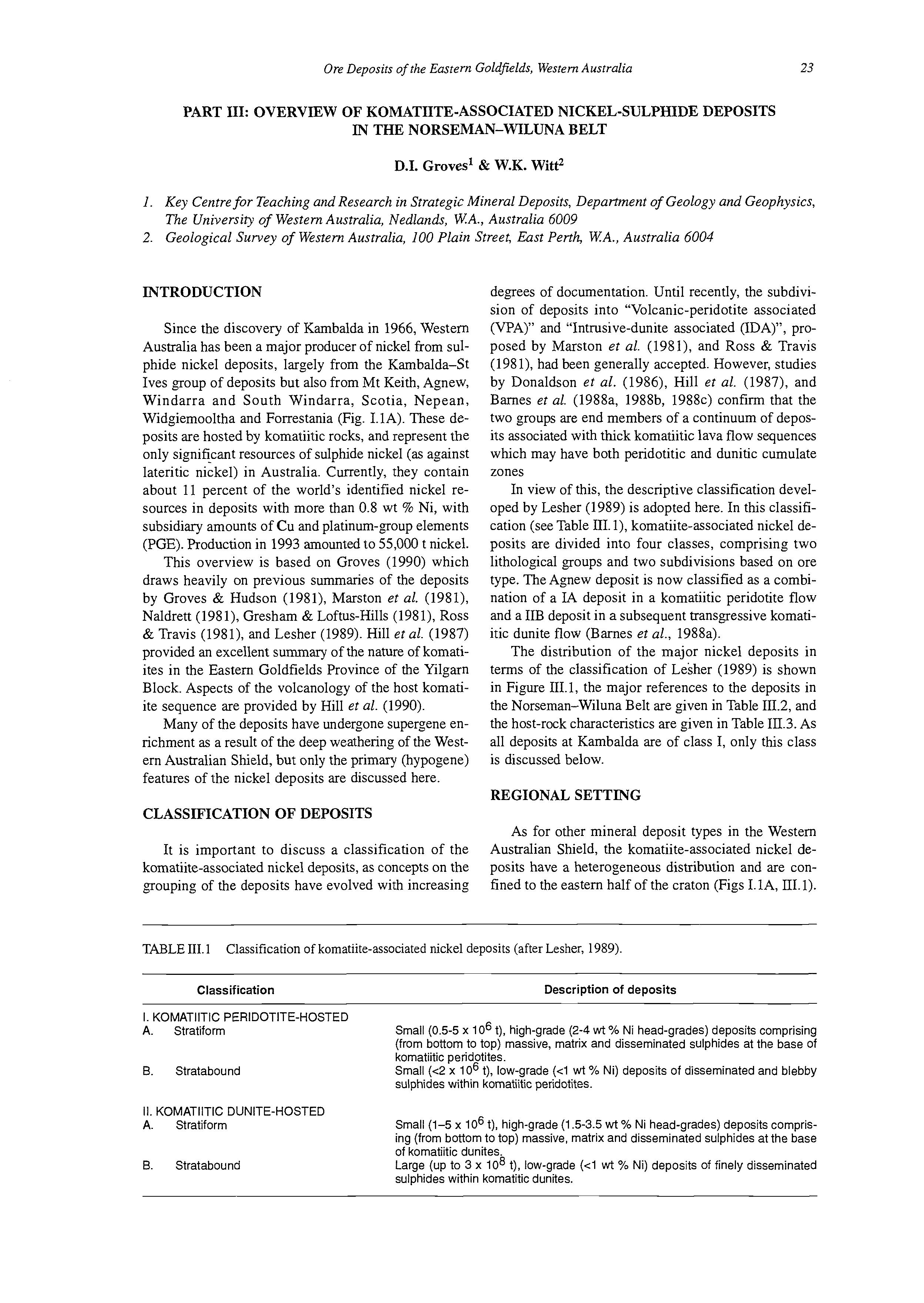
Description of deposits
Small (0.5-5 x lo6 t), high-grade (2-4 wt % Ni head-grades) deposits comprising (from bottom to top) massive, matrix and disseminated sulphides at the base of komatiitic peridotites.
Small (c2x lo6 t), low-grade (c1 wt % Ni) deposits of disseminated and blebby sulphides within komatiitic peridotites.
Small (1-5 x lo6 t), high-grade (1.5-3.5 wt % Ni head-grades) deposits comprising (from bottom to top) massive, matrix and disseminated sulphides at the base of komatiitic dunites.
Large (up to 3 x lo8 t), low-grade (c1 wt % Ni) deposits of finely disseminated sulphides within komatitic dunites.
PHANEROZOIC
SEQUENCE
100 km
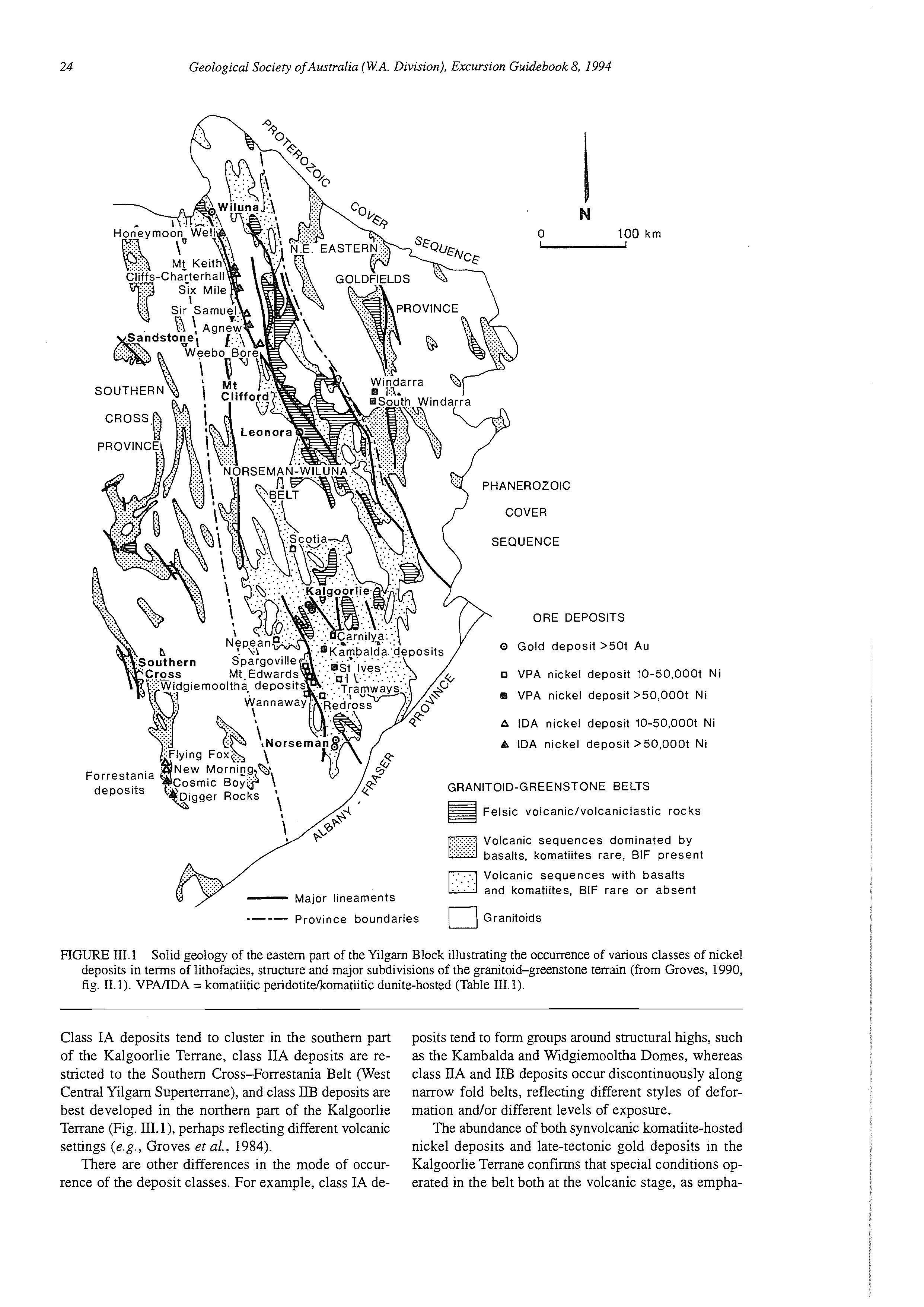
ORE DEPOSITS
0 Gold deposit >50t Au
o VPA nickel deposit 10-50,000t Ni
VPA nickel deposit >50,000t Ni
ickel deposit 10-50,000t Ni
IDA nickel deposit >50,00Ot Ni
G R A N IT01D - G R E E NST 0 N E BELTS
Felsic volcanic/volcaniclastic rocks
Volcanic sequences dominated by basalts, komatiites rare, BIF present Volcanic sequences with basalts and komatiites, BIF rare or absent -Major lineaments
*--- Province boundaries Granitoids
SURE 111.1 Solid geology of the eastern part of the Yilgarn Block illustrating the occurrence of various classes of nickel deposits in terms of lithofacies, structure and major subdivisions of the granitoid-greenstone terrain (from Groves, 1990, fig. 11.1). VPMDA = komatiitic peridotitekomatiitic dunite-hosted (Table 111.1).
Class IA deposits tend to cluster in the southern part of the Kalgoorlie Terrane, class IIA deposits are restricted to the Southern Cross-Forrestania Belt (West Central Yilgarn Supertenane), and class IIB deposits are best developed in the northern part of the Kalgoorlie Terrane (Fig. 111.I), perhaps reflecting different volcanic settings (e.g., Groves ef al., 1984).
There are other differences in the mode of occurrence of the deposit classes. For example, class IA de-
posits tend to form groups around structural highs, such as the Kambalda and Widgiemooltha Domes, whereas class IIA and IIB deposits occur discontinuously along narrow fold belts, reflecting different styles of deformation and/or different levels of exposure.
The abundance of both synvolcanic komatiite-hosted nickel deposits and late-tectonic gold deposits in the Kalgoorlie Terrane confirms that special conditions operated in the belt both at the volcanic stage, as empha-
TABLE III.2 Classification of major komatiite-associated nickel deposits from the Norseman-Wiluna Belt with the most important references to the deposits (modified from Groves, 1990, table 11.2).
Deposit Class Important geological references
Honeymoon Well
Betheno
Mt Keith
Six Mile-Goliath
Black Swan
Agnew
Scotia
Nepean
Kambalda district
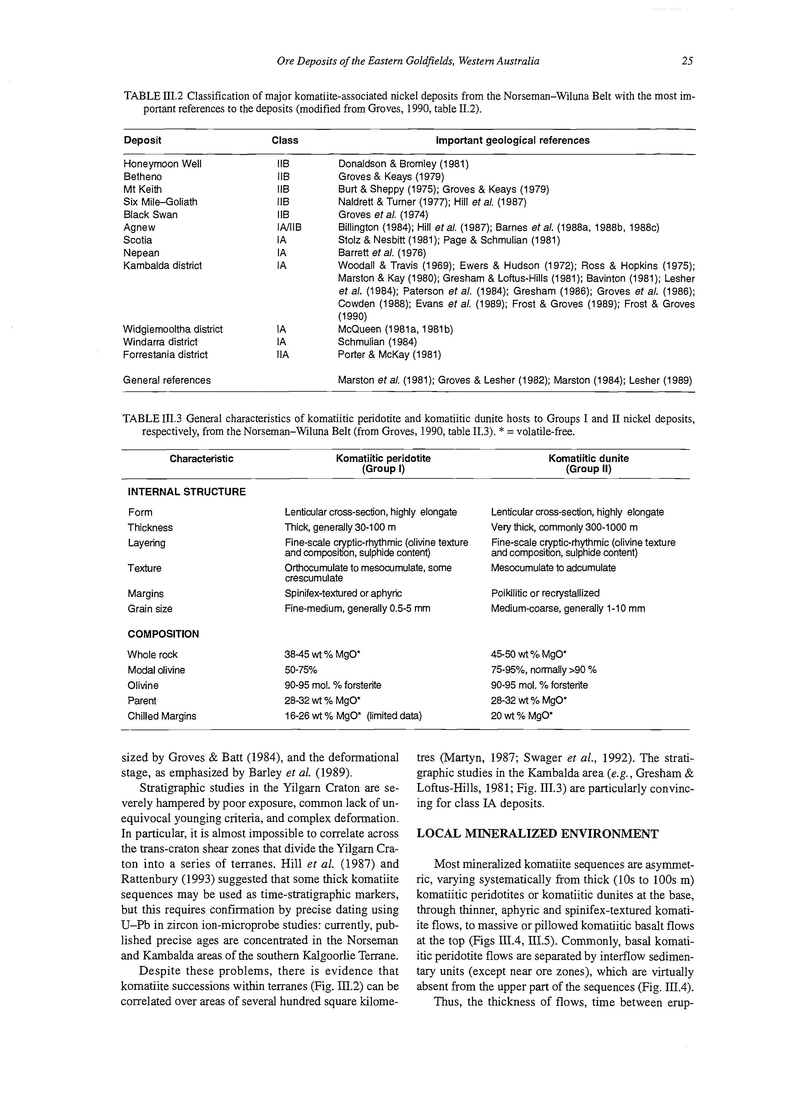
Widgiemoolthadistrict
Windarra district
Forrestania district
General references
Donaldson & Brornley (1981)
Groves & Keays (1979)
Burt & Sheppy (1975); Groves & Keays (1979)
Naldrett & Turner (1977); Hill et a/. (1987)
Groves et a/. (1974)
Billington (1984); Hill eta/. (1987); Barnes eta/. (1988a, 1988b, 1988c)
Stolz & Nesbitt (1981); Page & Schmulian (1981)
Barrett ef a/. (1976)
Woodall & Travis (1969); Ewers & Hudson (1972); Ross & Hopkins (1975); Marston & Kay (1980); Gresham & Loftus-Hills (1981); Bavinton (1981); Lesher et a/. (1984); Paterson et a/. (1984); Gresham (1986); Groves et a/. (1986); Cowden (1988); Evans eta/. (1989); Frost & Groves (1989); Frost & Groves
McQueen (1981a, 1981b)
Schmulian (1984)
Porter & McKay (1981)
Marston et a/. (1981); Groves & Lesher (1982); Marston (1984); Lesher (1989) (1990)
TABLE 111.3 General characteristics of komatiitic peridotite and komatiitic dunite hosts to Groups I and II nickel deposits, respectively, from the Norseman-Wiluna Belt (from Groves, 1990, table 11.3). * = volatile-free.
Characteristic
INTERNAL STRUCTURE
Form
Thickness
Layering
Texture
Margins
Grain size
Komatiitic peridotite (Group I)
Lenticularcross-sed'on, highly elongate
Thick, generally 30-100 in
Fine-scale cryptic-rhythmic (olivine texture
Komatiitic dunite (Group 11)
Lenticular cross-section, highly elongate
Very thick, commonly 300-1000 m
Fine-scalecryptic-rhythmic (olivine texture and composition, sulphide content)
Orthocurnulate to mesocumulate, some Mesocumulate to adcumulate
crescumulate
Spinifex-texturedor aphyric
COMPOSITION and composition, sulphide content)
Whole rock
Modal olivine
Olivine
Parent
Chilled Margins
Fine-medium, generally 0.5-5 rnm
3845 wt Yo MgO'
50-75%
90-95 mol. Yoforsterite
28-32 wt Yo MgO*
Poikilitic or recrystallized
Medium-coarse, generally 1-10 mm
45-50 wt Yo MgO*
75-95%. normally >90 Yo
90-95 mol. % forsterite
28-32 wt % MgO*
16-26 wt Yo MgO* (limiteddata) 20 wt Yo MgO'
sized by Groves & Batt (1984), and the deformational stage, as emphasized by Barley et al. (1989).
Stratigraphic studies in the Yilgarn Craton are severely hampered by poor exposure, common lack of unequivocal younging criteria, and complex deformation. In particular, it is almost impossible to correlate across the trans-craton shear zones that divide the Yilgarn Craton into a series of terranes. Hill et al. (1987) and Rattenbury (1993) suggested that some thick komatiite sequences may be used as time-stratigraphic markers, but this requires confiiation by precise dating using U-Pb in zircon ion-microprobe studies: currently, published precise ages are concentrated in the Norseman and Kambalda areas of the southern Kalgoorlie Tenane. Despite these problems, there is evidence that komatiite successions within terranes (Fig. III.2) can be correlated over areas of several hundred square kilome-
tres (Martyn, 1987; Swager et al., 1992). The stratigraphic studies in the Kambalda area (e.g., Gresham & Loftus-Hills, 1981; Fig. 111.3) are particularly convincing for class IA deposits.
LOCAL MINERALIZED ENVIRONMENT
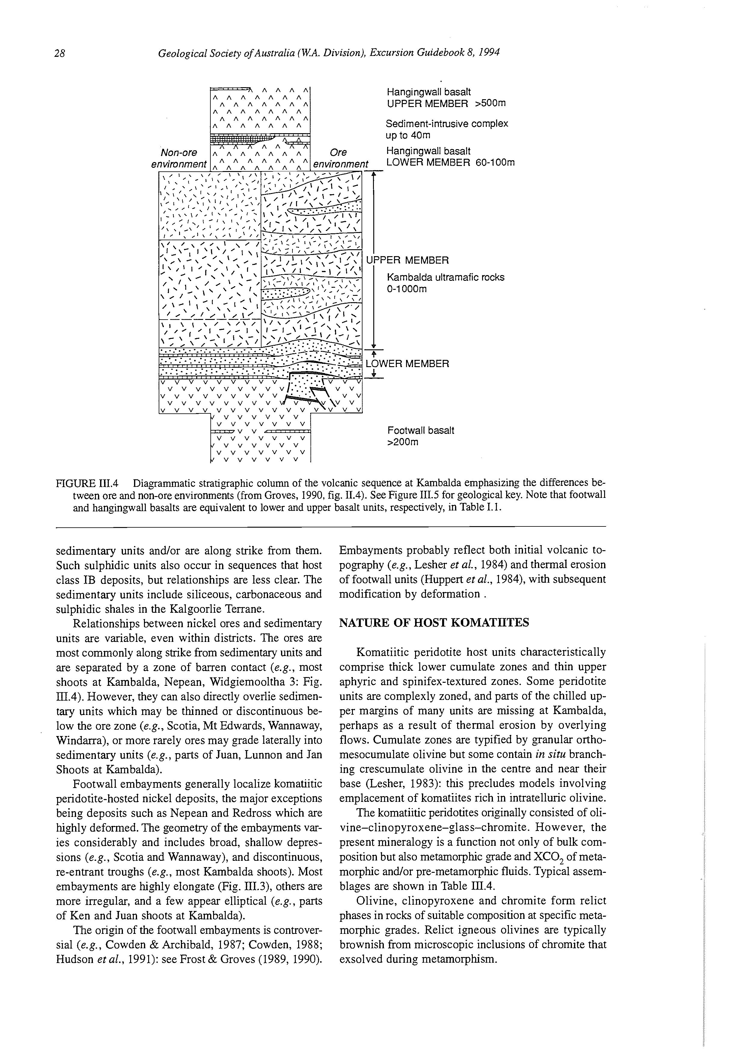
Most mineralized komatiite sequences are asymmetric, varying systematically from thick (10s to 100s m) komatiitic peridotites or komatiitic dunites at the base, through thinner, aphyric and spinifex-textured komatiite flows, to massive or pillowed komatiitic basalt flows at the top (Figs 111.4, 111.5). Commonly, basal komatiitic peridotite flows are separated by interflow sedimentary units (except near ore zones), which are virtually absent from the upper part of the sequences (Fig. III.4). Thus, the thickness of flows, time between erup-
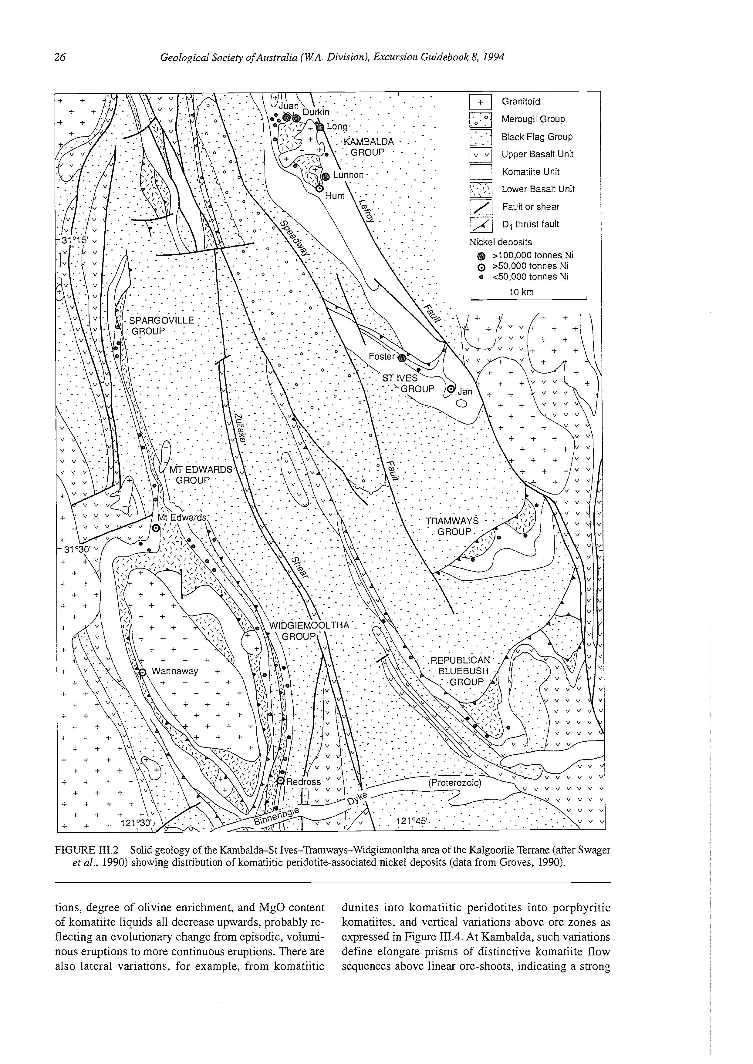
FIGURE 111.2 Solid geology of the Kambalda-St Ives-Tramways-Widgiemooltha area of the Kalgoorlie Terrane (after Swager el al., 1990) showing distribution of komatiitic peridotite-associated nickel deposits (data from Groves, 1990).
tions, degree of olivine enrichment, and MgO content of komatiite liquids all decrease upwards, probably reflecting an evolutionary change from episodic, voluminous eruptions to more continuous eruptions. There are also lateral variations, for example, from komatiitic
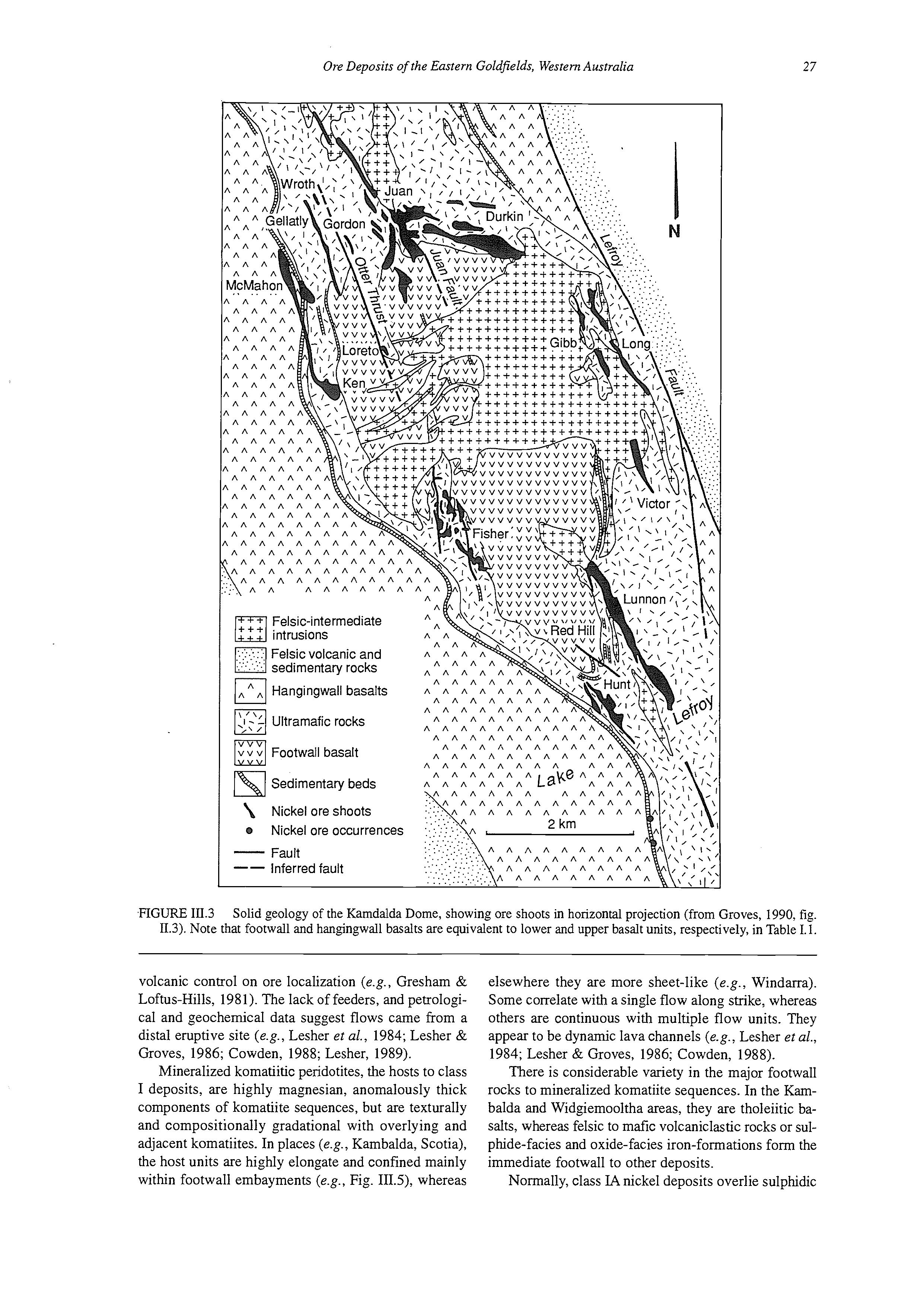
dunites into komatiitic peridotites into porphyritic komatiites, and vertical variations above ore zones as expressed in Figure III.4. At Kambalda, such variations define elongate prisms of distinctive komatiite flow sequences above linear ore-shoots, indicating a strong
Inferred fault --
.FIGURE 111.3 Solid geology of the Kamdalda Dome, showing ore shoots in horizontal projection (from Groves, 1990, fig. 11.3). Note that footwall and hangingwall basalts are equivalent to lower and upper basalt units, respectively, in Table 1.1.
volcanic control on ore localization (e.g., Gresham & Loftus-Hills, 1981). The lack of feeders, and petrological and geochemical data suggest flows came from a distal eruptive site (e.g., Lesher et al., 1984; Lesher & Groves, 1986; Cowden, 1988; Lesher, 1989).
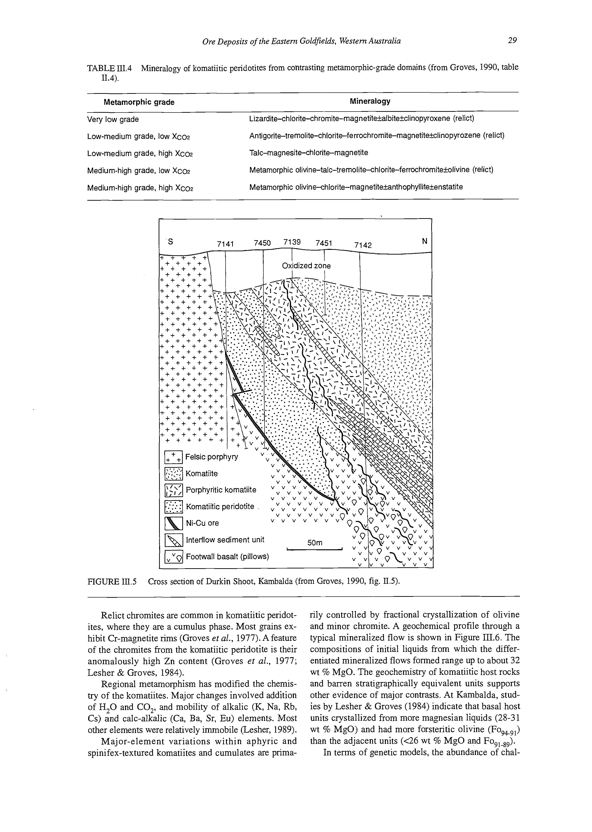
Mineralized komatiitic peridotites, the hosts to class I deposits, are highly magnesian, anomalously thick components of komatiite sequences, but are texturally and compositionally gradational with overlying and adjacent komatiites. In places (e.g., Kambalda, Scotia), the host units are highly elongate and confined mainly within footwall embayments (e.g., Fig. IIIS), whereas
elsewhere they are more sheet-like (e.g., Windma). Some correlate with a single flow along strike, whereas others are continuous with multiple flow units. They appear to be dynamic lava channels (e.g., Lesher et al., 1984; Lesher & Groves, 1986; Cowden, 1988).
There is considerable variety in the major footwall rocks to mineralized komatiite sequences. In the Kambalda and Widgiemooltha areas, they are tholeiitic basalts, whereas felsic to mafk volcaniclastic rocks or sulphide-facies and oxide-facies iron-formations form the immediate footwall to other deposits.
Normally, class IA nickel deposits overlie sulphidic
Hangingwall basalt UPPER MEMBER >500m
Sediment-intrusive complex up to 40m Hangingwall basalt e LOWER MEMBER 60-100m
Kambalda ultramafic rocks
Footwall basalt >200m
FIGURE 111.4 Diagrammatic stratigraphic column of the volcanic sequence at Kambalda emphasizing the differences between ore and non-ore environments (from Groves, 1990, fig. 11.4). See Figure 111.5 for geological key. Note that footwall and hangingwall basalts are equivalent to lower and upper basalt units, respectively, in Table 1.1.
sedimentary units and/or are along strike from them. Such sulphidic units also occur in sequences that host class IB deposits, but relationships are less clear. The sedimentary units include siliceous, carbonaceous and sulphidic shales in the Kalgoorlie Terrane.
Relationships between nickel ores and sedimentary units are variable, even within districts. The ores are most commonly along strike from sedimentary units and are separated by a zone of barren contact (e.g., most shoots at Kambalda, Nepean, Widgiemooltha 3: Fig. III.4). However, they can also directly overlie sedimentary units which may be thinned or discontinuous below the ore zone (e.g., Scotia, Mt Edwards, Wannaway, Windarra), or more rarely ores may grade laterally into sedimentary units (e.g., parts of Juan, Lunnon and Jan Shoots at Kambalda).
Footwall embayments generally localize komatiitic peridotite-hosted nickel deposits, the major exceptions being deposits such as Nepean and Redross which are highly deformed. The geometry of the embayments varies considerably and includes broad, shallow depressions (e.g., Scotia and Wannaway), and discontinuous, re-entrant troughs (e.g., most Kambalda shoots). Most embayments are highly elongate (Fig. 111.3), others are more irregular, and a few appear elliptical (e.g., parts of Ken and Juan shoots at Kambalda).
The origin of the footwall embayments is controversial (e.g., Cowden & Archibald, 1987; Cowden, 1988; Hudson et al., 1991): see Frost & Groves (1989,1990).
Embayments probably reflect both initial volcanic topography (e.g., Lesher et al., 1984) and thermal erosion of footwall units (Huppert et al., 1984), with subsequent modification by deformation .
NATURE OF HOST KOMATIITES
Komatiitic peridotite host units characteristically comprise thick lower cumulate zones and thin upper aphyric and spinifex-textured zones. Some peridotite units are complexly zoned, and parts of the chilled upper margins of many units are missing at Kambalda, perhaps as a result of thermal erosion by overlying flows. Cumulate zones are typified by granular orthomesocumulate olivine but some contain in sitir branching crescumulate olivine in the centre and near their base (Lesher, 1983): this precludes models involving emplacement of komatiites rich in intratelluric olivine.
The komatiitic peridotites originally consisted of olivine-clinopyroxene-glass-chromite. However, the present mineralogy is a function not only of bulk composition but also metamorphic grade and XCO, of metamorphic and/or pre-metamorphic fluids. Typical assemblages are shown in Table m.4.
Olivine, clinopyroxene and chromite form relict phases in rocks of suitable composition at specific metamorphic grades. Relict igneous olivines are typically brownish from microscopic inclusions of chromite that exsolved during metamorphism.
TABLE III.4 11.4).
Mineralogy of komatiitic peridotites from contrasting metamorphic-grade domains (from Groves, 1990, table
Metamorphic grade
Very low grade
Low-medium grade, low XCOZ
Low-medium grade, high XCOZ
Medium-high grade, low XCOZ
Medium-high grade, high XCOZ
Mineralogy
Lizardite-chlorite-chromite-magnetitefalbitekclinopyroxene(relict)
Antigorite-tremolitehlorite-ferrochromite-magnetitefclinopyrozene (relict)
Talc-magnesite-chlorite-magnetite
Metamorphic olivine-talc-tremolite-chlorite-ferrochromite+olivine (relict)
Metamorphic olivinehlorite-magnetitekanthophyllitefenstatite
FiGURE 111.5 Cross section of Durkin Shoot, Kambalda (from Groves, 1990, fig. 11.5).
Relict chromites are common in komatiitic peridotites, where they are a cumulus phase. Most grains exhibit Cr-magnetite rims (Groves et al., 1977). A feature of the chromites from the komatiitic peridotite is their anomalously high Zn content (Groves et al., 1977; Lesher & Groves, 1984).
Regional metamorphism has modified the chemistry of the komatiites. Major changes involved addition of H,O and CO,, and mobility of alkalic (K, Na, Rb, Cs) and calc-alkalic (Ca, Ba, Sr, Eu) elements. Most other elements were relatively immobile (Lesher, 1989).
Major-element variations within aphyric and spinifex-textured komatiites and cumulates are prima-
rily controlled by fractional crystallization of olivine and minor chromite. A geochemical profile through a typical mineralized flow is shown in Figure 111.6. The compositions of initial liquids from which the differentiated mineralized flows formed range up to about 32 wt % MgO. The geochemistry of komatiitic host rocks and barren stratigraphically equivalent units supports other evidence of major contrasts. At Kambalda, studies by Lesher & Groves (1984) indicate that basal host units crystallized from more magnesian liquids (28-31 wt % MgO) and had more forstentic olivine (Fo,,,) than the adjacent units (<26 wt % MgO and In terms of genetic models, the abundance of chal-
IC+fl Felsic porphyry
Komatiite I.
Pyroxene-rich komatiite
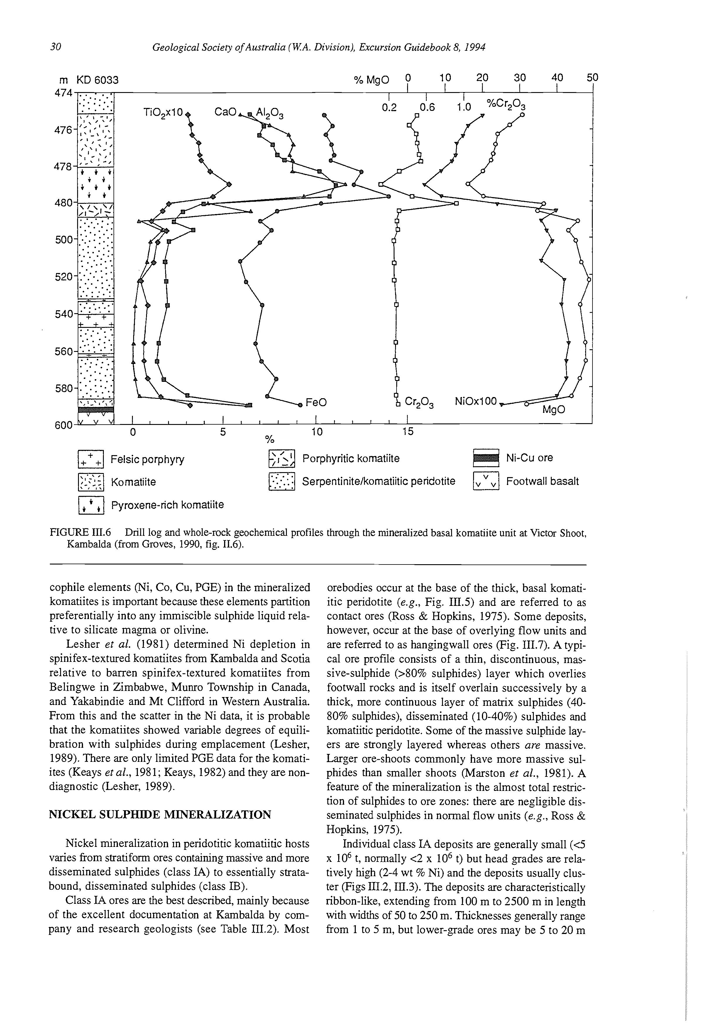
Porphyritic kornatiite
Ni-Cu ore
Serpentinite/komatiitic peridotite a Footwall basalt
FIGURE 111.6 Drill log and whole-rock geochemical profiles through the mineralized basal komatiite unit at Victor Shoot, Kambalda (from Groves, 1990, fig. 11.6).
cophile elements (Ni, Co, Cu, PGE) in the mineralized komatiites is important because these elements partition preferentially into any immiscible sulphide liquid relative to silicate ma,ma or olivine.
Lesher er al. (1981) determined Ni depletion in spinifex-textured komatiites from Kambalda and Scotia relative to barren spinifex-textured komatiites from Belingwe in Zimbabwe, Munro Township in Canada, and Yakabindie and Mt Clifford in Western Australia. From this and the scatter in the Ni data, it is probable that the komatiites showed variable degrees of equilibration with sulphides during emplacement (Lesher, 1989). There are only limited PGE data for the komatiites (Keays er al., 1981; Keays, 1982) and they are nondiagnostic (Lesher, 1989).
NICKEL SULPHIDE MINERALIZATION
Nickel mineralization in peridotitic komatiitic hosts varies from stratiform ores containing massive and more disseminated sulphides (class IA) to essentially stratabound, disseminated sulphides (class IB).
Class IA ores are the best described, mainly because of the excellent documentation at Kambalda by company and research geologists (see Table 111.2). Most
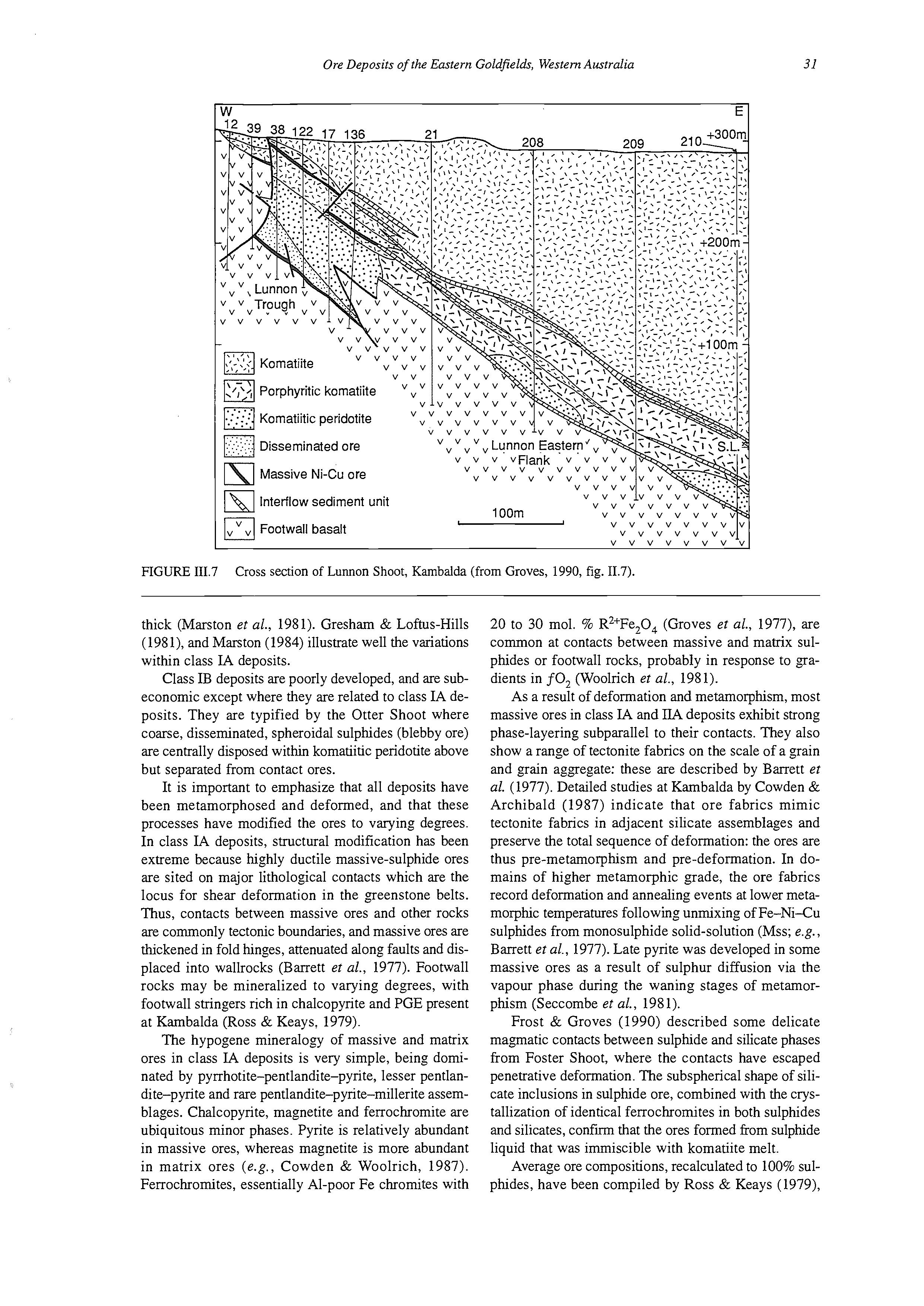
orebodies occur at the base of the thick, basal komatiitic peridotite (e.g., Fig. 111.5) and are referred to as contact ores (Ross & Hopkins, 1975). Some deposits, however, occur at the base of overlying flow units and are referred to as hangingwall ores (Fig. 111.7). A typical ore profile consists of a thin, discontinuous, massive-sulphide (SO% sulphides) layer which overlies footwall rocks and is itself overlain successively by a thick, more continuous layer of matrix sulphides (4080% sulphides), disseminated (10-40%) sulphides and komatiitic peridotite. Some of the massive sulphide layers are strongly layered whereas others are massive. Larger ore-shoots commonly have more massive sulphides than smaller shoots (Marston et al., 1981). A feature of the mineralization is the almost total restriction of sulphides to ore zones: there are negligible disseminated sulphides in normal flow units (e.g., Ross & Hopkins, 1975).
Individual class IA deposits are generally small (4 x lo6 t, normally <2 x lo6 t) but head grades are relatively high (2-4 wt % Ni) and the deposits usually cluster (Figs III.2,111.3). The deposits are characteristically ribbon-like, extending from 100 m to 2500 m in length with widths of 50 to 250 m. Thicknesses generally range from 1 to 5 m, but lower-grade ores may be 5 to 20 m
thick (Marston et al., 1981). Gresham & Loftus-Hills (198 I), and Marston (1984) illustrate well the variations within class IA deposits.
Class IB deposits are poorly developed, and are subeconomic except where they are related to class IA deposits. They are typified by the Otter Shoot where coarse, disseminated, spheroidal sulphides (blebby ore) are centrally disposed within komatiitic peridotite above but separated from contact ores.
It is important to emphasize that all deposits have been metamorphosed and deformed, and that these processes have modified the ores to varying degrees. In class IA deposits, structural modification has been extreme because highly ductile massive-sulphide ores are sited on major lithological contacts which are the locus for shear deformation in the greenstone belts. Thus, contacts between massive ores and other rocks are commonly tectonic boundaries, and massive ores are thickened in fold hinges, attenuated along faults and displaced into wallrocks (Barrett et al., 1977). Footwall rocks may be mineralized to varying degrees, with footwall stringers rich in chalcopyrite and PGE present at Kambalda (Ross & Keays, 1979).
The hypogene mineralogy of massive and matrix ores in class IA deposits is very simple, being dominated by pyrrhotite-pentlandite-pyrite, lesser pentlandite-pyrite and rare pentlandite-pyrite-millerite assemblages. Chalcopyrite, magnetite and ferrochromite are ubiquitous minor phases. Pyrite is relatively abundant in massive ores, whereas magnetite is more abundant in matrix ores (e.g., Cowden & Woolrich, 1987). Ferrochromites, essentially Al-poor Fe chromites with
20 to 30 mol. % R2+Fe,0, (Groves et al., 1977), are common at contacts between massive and mamx sulphides or footwall rocks, probably in response to gradients in f0, (Woolrich et al., 1981).
As a result of deformation and metamorphism, most massive ores in class IA and IIA deposits exhibit strong phase-layering subparallel to their contacts. They also show a range of tectonite fabrics on the scale of a grain and grain aggregate: these are described by Barrett et al. (1977). Detailed studies at Kambalda by Cowden & Archibald (1987) indicate that ore fabrics mimic tectonite fabrics in adjacent silicate assemblages and preserve the total sequence of deformation: the ores are thus pre-metamorphism and pre-deformation. In domains of higher metamorphic grade, the ore fabrics record deformation and annealing events at lower metamorphic temperatures following unmixing of Fe-Ni-Cu sulphides from monosulphide solid-solution (Mss; e.g., Barrett et al., 1977). Late pyrite was developed in some massive ores as a result of sulphur diffusion via the vapour phase during the waning stages of metamorphism (Seccombe ef al., 1981).
Frost & Groves (1990) described some delicate magmatic contacts between sulphide and silicate phases from Foster Shoot, where the contacts have escaped penetrative deformation. The subspherical shape of silicate inclusions in sulphide ore, combined with the crystallization of identical ferrochromites in both sulphides and silicates, confirm that the ores formed from sulphide liquid that was immiscible with komatiite melt.
Average ore compositions, recalculated to 100% sulphides, have been compiled by Ross & Keays (1979),
Marston et al. (1981), and Naldrett (1981). In terms of the system Fe-Ni-S, most ores plot within the field of Mss at 600"C, consistent with a magmatic origin for the sulphide ores. Individual ore samples exhibit scatter, probably due to metamorphism which also explains those deposits with more S-rich compositions than Mss. Komatiite-hosted ores are characterized by high NU Cu and low Pd/Ir ratios which distinguish them from other magmatic sulphide ores (Naldrett, 1981; Barnes et al., 1988b). Kambalda sulphides have near-chondritic abundances of PGE and slightly fractionated chondritenormalized PGE distribution patterns (Pd/Ir = 10). Metal ratios are relatively constant within individual ore horizons, but vary between ore shoots in a single deposit and between deposits. Available sulphur-isotope data (Seccombe et al., 1978, 1981) and S/Se ratios (Groves et al., 1979) suggest strongly a link between sulphur sources for the sulphidic sedimentary units and the nickel ores.
GENETIC MODELS
Most authors have proposed magmatic models involving segregation of immiscible sulphide-oxide liquids from komatiite magmas: other non-ma,matic models are shown to be invalid by Groves et al. (1976, 1979), Naldrett (1979), and Naldrett & Campbell (1982). The major evidence for a magmatic model includes the following features.
(i) There is a specific association between ores and the lowermost, most magnesian units in komatiite piles.
(ii) Both massive and disseminated sulphide ores predate deformation, metamorphism and alteration of surrounding rocks.
(iii) The relatively consistent profile of massive ore overlain by matrix ore then disseminated ore indicates gravitational settling or flow segregation.
(iv) Distinctive chalcophile ferrochromites are like those crystallized experimentally from sulphideoxide liquids.
(v) The high Ni and PGE contents, high NUCu and Pd/Ir ratios and low Zn contents of the ores are consistent with known ore-element partitioning between sulphide and basic-ultrabasic liquids.
Based on a variety of evidence (summarized by Lesher, 1989), the most viable genetic model involves voluminous rapid eruption of turbulently convecting komatiites in extensional basins forming large channelized flows that assimilated variable amounts of sulphidic footwall rocks during eruption. The lava channels were probably localized along pre-existing topographic lows in the substrate, but these were deepened
and modified by thermal erosion fiom continuous or periodic flow-through of very hot, turbulently convecting komatiite lava.
Some flows either assimilated large proportions of footwall rocks or selectively assimilated sulphide-rich sediments, and thereby achieved sulphur saturation early in their crystallization history. Sulphide-oxide droplets scavenged chalcophile elements from the komatiite liquid and settled to the base of the flow to form stratiform ores. The observed profile of massivematrix-disseminated ores in class IA deposits probably resulted from a combination of dynamic flow segregation (Hudson, 1972) and static buoyancy (Naldrett, 1973). Variations in ore tenor between stratifom ore shoots in one ore district (e.g., Kambalda) can be broadly explained by variations in silicate/sulphide ratios (R factor of Campbell & Naldrett, 1979), caused by variable degrees of assimilation and turbulent mixing of sulphidic sediments with host komatiites: this is consistent with the commonly lower tenor of thicker ore shoots (Lesher & Groves, 1986). Variations in f0, due to assimilation may also have affected ore tenor (Cowden & Woolrich, 1987).
Distal parts of flows were better mineralized than proximal zones, probably because assimilation could have initially occurred adjacent to the eruption site, but the fast-flowing komatiite lava did not reach sulphur saturation until some intermediate point along the length of the channel. Furthermore, the dense sulphide liquid would have been preferentially ponded in topographic irregularities within the channel, and, owing to its low viscosity, may even have been mobilized down-channel subsequent to segregation because it would have been above its liquidus (1120-1160°C) at the komatiite solidus (about 1200°C). Subsequent sulphide accumulations (hangingwall ores) were concentrated down the same volcanic pitchline as the early-formed ores.
This preferred genetic model is essentially a distal volcanic-assimilation model (e.g., Lesher & Groves, 1986; Evans et al., 1989; Frost & Groves, 1989; Lesher, 1989). It not only satisfies most of the constraints imposed by parameters of mineralized environments, but also explains the absence of nickel deposits in areas that did not have lava channels and sulphidic sediments at the volcanic stage.
All deposits were subsequently modified by regional deformation and metamorphism. Strain was localised in mechanically weak massive-sulphide lenses, and most ore structures and textures reflect deformation and annealing processes: the present ore mineralogy represents crystallization from metamorphic Mss and intermediate solid-solution (Iss), relict magnatic phases and secondary pyrite.
PART IV: EXCURSION LOCALITIES
W.K. Witt', S.E. Ho2 & D.I. Groves3
1. Geological Survey of Western Australia, 100 Plain Street, East Perth, WA., Australia 6004
2. Orebusters Pty Ltd, 4 Handley Close, Leeming, WA., Australia 6149
3. Key Centre for Teaching and Research in Strategic Mineral Deposits, Department of Geology and Geophysics, The University of Western Australia, Nedlands,
KA.. Australia 6009.
INTRODUCTION
Locality descriptions are provided for Kanowna, Mount Pleasant, Kambalda (gold), Coolgardie, Kalgoorlie-Boulder, New Celebration, Londonderry and Southern Cross. Logistical restrictions mean that some of these localities may be excluded from the itinerary, but they are included here for completeness.
LOCALITY 1: LODE GOLD DEPOSITS OF THE KANOWNA DISTRICT
[based on Ross, 19931
Introduction
The ghost town of Kanowna is 20 km northeast of Kalgoorlie. Gold was discovered in the Kanowna district in 1893, less than a year after its discovery at Kalgoorlie. By 1918, the Kanowna district had produced over 500,000 oz of gold from both alluvial and bedrock sources (Maitland, 1919). Today, just a few kilometres southwest of the old Kanowna townsite, the recently discovered Kanowna Belle deposit boasts measured and indicated resources of 1.9 million oz of gold and is open at depth. The following summarizes the geology, alteration and gold mineralization in the district, followed by examples of historical mines and the Kanowna Belle deposit.
Regional setting
The gold deposits of the Kanowna district are 10cated in Archaean greenschist-facies rocks of the Boorara Domain in the Kalgoorlie Terrane, within the Norseman-Wiluna Belt. The stratigraphic succession of the Boorara Domain is a lower basalt unit (Scotia Basalt), Big Blow Chert, a komatiitic unit (Highway Ultramafics), a discontinuous upper basalt unit, and a felsic volcanic and sedimentary package (Witt, 1990a). The upper felsic succession is the Gindalbie Formation as defined by Williams (1970), and is correlated with the Black Flag Group of the Ora Banda, Kambalda and Coolgardie Domains. It is also the formation which hosts gold mineralization in the Kanowna district. Stratigraphic subdivision of the Gindalbie Formation in the Kanowna district was attempted by Taylor (1984), but structural complexities precluded stratigraphic correlation over significant areas.
The 1: 100,000 structural interpretation map of Kanowna (Ahmat & Swager, 1992) shows the Kanowna district is a structural sub-domain bounded by the Kanowna Shear to the west and the Mt Monger Fault to the east. The sub-domain is dominated by the south-
east-plunging Scotia-Kanowna Anticline, which is cored by monzogranite. The Kanowna gold deposits are located on the eastern limb of the anticline or on smaller parasitic folds (Grigson, 1981). Earlier thrust faults are folded by the anticline and the rocks are overprinted by an upright foliation striking between 120" and 180". The structural framework of the Kalgoorlie Terrane erected by Swager (1989) recognized four deformation events. At Kanowna, the early faults formed during D, deformation and resulted in repetition of basalt and ultramafic units in the region. The Scotia-Kanowna Anticline is a large, upright, regional D, fold (Witt, 1990a), and the D, event was responsible for the ubiquitous steeply dipping to upright foliation. D, has not been recognized in the Kanowna district. North-south structural features have been noted, but poor exposure limits further interpretation.
Metamorphic grade in the Boorara Domain is lower greenschist facies in the south, but increases to amphibolite facies to the north (Binns et al., 1976). Around Kanowna, lower greenschist-facies metamorphism is indicated by the mineral assemblage of albite-chloriteactinolite-clinozoisite in metabasalts (Taylor, 1984), and the mineralogy of metabasalts about 6 km north of the Kanowna townsite indicates prehnite-pumpellyite to greenschist facies metamorphism (Hack, 1972).
Gold deposits
Lode-gold deposits in the Kanowna district are hosted by a variety of rock types (Table IV.l), including komatiite, high-Mg basalt, polymict conglomerate, felsic conglomerate, finer-grained epiclastic rocks and intrusive porphyry. No rock type is preferentially mineralized and a rock type which bounds mineralization at one mine may host mineralization at another. The control on mineralization is an interplay of structure and rheology.
Ho (1984) divided the Kanowna deposits into three distinct styles using the major mineralized structure and rock type. The structural styles are: (i) laminated quartz veins, (ii) quartz stockworks and vein arrays, and (iii) mineralized alteration haloes in shear zones with subordinate quartz.
In addition to quartz stockworks and vein arrays, hydrothermal breccias occur (Kanowna Belle, Bonnie Charlie).
Low-temperature alteration minerals in the Kanowna gold deposits include Cr-rich mica, white mica, ankerite, calcite, albite and quartz. The variation in proximal alteration minerals between deposits can be
TABLE IV.l Production and geological characteristics of selective bedrock mines in the Kanowna district (modified from Ross, 1993, table 11.3). References: [l] = Peachey (1993); [23 = Grigson (1981), Ho (1984); 131 = Mees (1991); [4]= Maitland (1919), [5] = Ho et al. (1990).
Deposit Production Host rocks
Kanowna Belle (measuredand indicated resourceof 1.9 M 0.7, inferred resource of 2.1 M oz)
Robinsons [l]
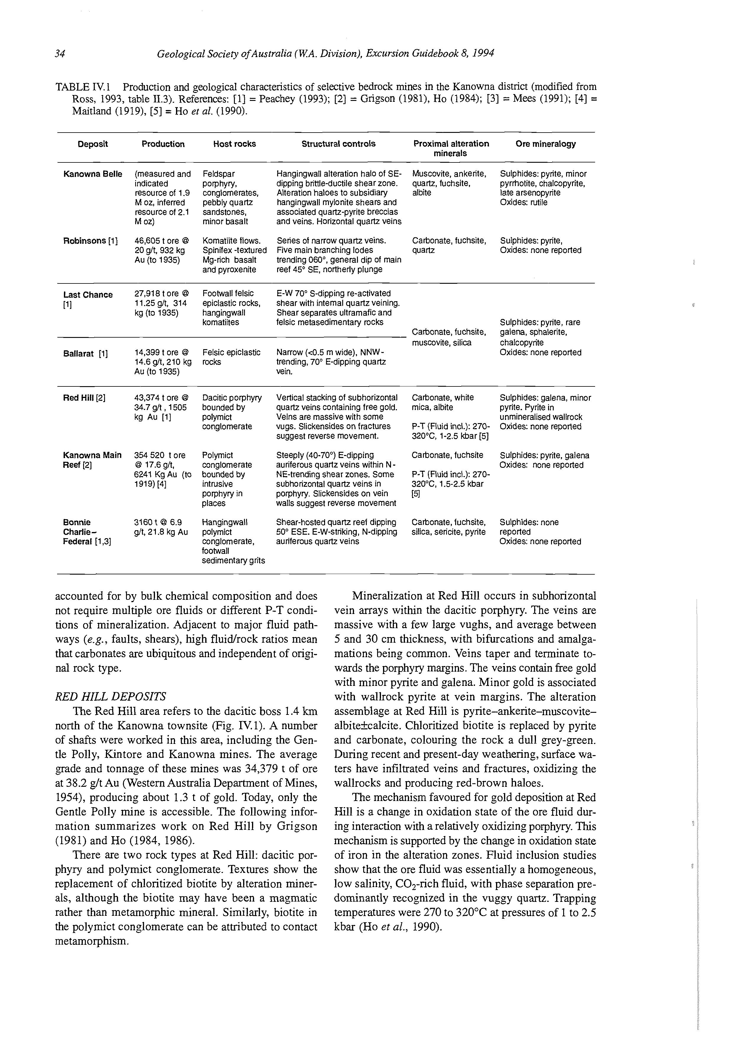
46,605tore @ Feldspar Porphyry, conglomerates, pebbly quartz sandstones, minor basalt
20 g/t, 932 kg Au (to 1935)
Komatiiie flows. Spinifex -textured Mgrich basalt and pyroxenite
Hangingwall alteration halo of SE- Muscovite, ankerite, Sulphides: pyrite, minor dipping brittle-ductileshear zone. quartz, fuchsite, pyrthotite, chalcopyrite, Alteration haloes to subsidiary albite late arsenopyrite hangingwall mylonite shears and associated quartz-pyrite breccias and veins. Horizontalquartz veins
Oxides: rutile
Series of narrow quartz veins. Carbonate, fuchsite, Sulphides: pyrite, Five main branching lodes quartz
Oxides: none reported trending 060", general dip of main reef 45O SE, northerly plunge
Last Chance 27,918tore @ Footwall felsic E-W 70° S-dipping re-activated 11.25gh, 314 epiclastic rocks, shear with internal quartz veining. kg (to 1935) hangingwall Shear separates ultramafic and
PI komatiites felsic metasedimentaryrocks
Batlarat [l] 14,399tore @ Felsic epiclastic Narrow (c0.5 m wide), NNW-
Sulphides: pyrite, rare
Catbonate,fuchsite, galena, sphalerite, muscovite, silica chalcopyrite
Oxides: none reported 14.6s/t, 210 kg rocks trending, 70" E-dippingquartz Au (to 1935) vein.
RedHill [2] 43,374 t ore @ Dacitic porphyty 34.7 g/t , 1505 kg Au [TI polymict bounded by conglomerate
Kanowna Main 354520 tore Polymict Reef [2] @ 17.6 g/t, conglomerate 6241 Kg Au (to bounded by I 919)141 intrusive
Vertical stacking of subhorizontal quartz veins containingfree gold. Veins are massive with some vugs. Slickensides on fractures suggest reverse movement.
Steeply (40-70') E-dipping auriferous quartz veins within NNE-trending shear zones. Some subhorizontal quartz veins in
Carbonate, white Sulphides: galena, minor mica, albite pyrite. Pyrite in unmineralised wallrock P-T (Fluid incl.): 270- Oxides: none reported 320°C,1-2.5kbar [5]
Oxides: none reported
Carbonate, fuchsite Sulphides: pyrite, galena P-T (Fluid incl.): 270320°C1.5-2.5kbar
Porphyry in porphyry. Slickensideson vein [5l places walls suggest reverse movement
Bonnie 3160 t @ 6.9 Hangingwall Shear-hosted quartz reef dipping Ca&onate, fuchsite, Sulphides: none Charlie- g/t, 21.8 kg Au polymict 50' ESE. E-W-striking,N-dipping silica, sericite. pyrite reported Federal [1,3] conglomerate, auriferous quartz veins
Oxides: none reported footwall sedimentarygrits
accounted for by bulk chemical composition and does not require multiple ore fluids or different P-T conditions of mineralization. Adjacent to major fluid pathways (e.g., faults, shears), high fluidrock ratios mean that carbonates are ubiquitous and independent of original rock type.
RED HILL DEPOSITS
The Red Hill area refers to the dacitic boss 1.4 km north of the Kanowna townsite (Fig. W.1). A number of shafts were worked in this area, including the Gentle Polly, Kintore and Kanowna mines. The average grade and tonnage of these mines was 34,379 t of ore at 38.2 g/t Au (Western Australia Department of Mines, 1954), producing about 1.3 t of gold. Today, only the Gentle Polly mine is accessible. The following information summarizes work on Red Hill by Grigson (1981) and Ho (1984, 1986).
There are two rock types at Red Hill: dacitic porphyry and polymict conglomerate. Textures show the replacement of chloritized biotite by alteration minerals, although the biotite may have been a magmatic rather than metamorphic mineral. Similarly, biotite in the polymict conglomerate can be attributed to contact metamorphism.
Mineralization at Red Hill occurs in subhorizontal vein arrays within the dacitic porphyry. The veins are massive with a few large vughs, and average between 5 and 30 cm thickness, with bifurcations and amalgamations being common. Veins taper and terminate towards the porphyry margins. The veins contain free gold with minor pyrite and galena. Minor gold is associated with wallrock pyrite at vein margins. The alteration assemblage at Red Hill is pyrite-ankerite-muscovitealbitekcalcite. Chloritized biotite is replaced by pyrite and carbonate, colouring the rock a dull grey-green. During recent and present-day weathering, surface waters have infiltrated veins and fractures, oxidizing the wallrocks and producing red-brown haloes.
The mechanism favoured for gold deposition at Red Hill is a change in oxidation state of the ore fluid during interaction with a relatively oxidizing porphyry. This mechanism is supported by the change in oxidation state of iron in the alteration zones. Fluid inclusion studies show that the ore fluid was essentially a homogeneous, low salinity, CO,-rich fluid, with phase separation predominantly recognized in the vuggy quartz. Trapping temperatures were 270 to 320°C at pressures of 1 to 2.5 kbar (Ho et al., 1990).
>.- Watercourse, ephemeral Mine / Road
0 Pit ,/’Track
FIGURE 1V.I fig. 11.9).
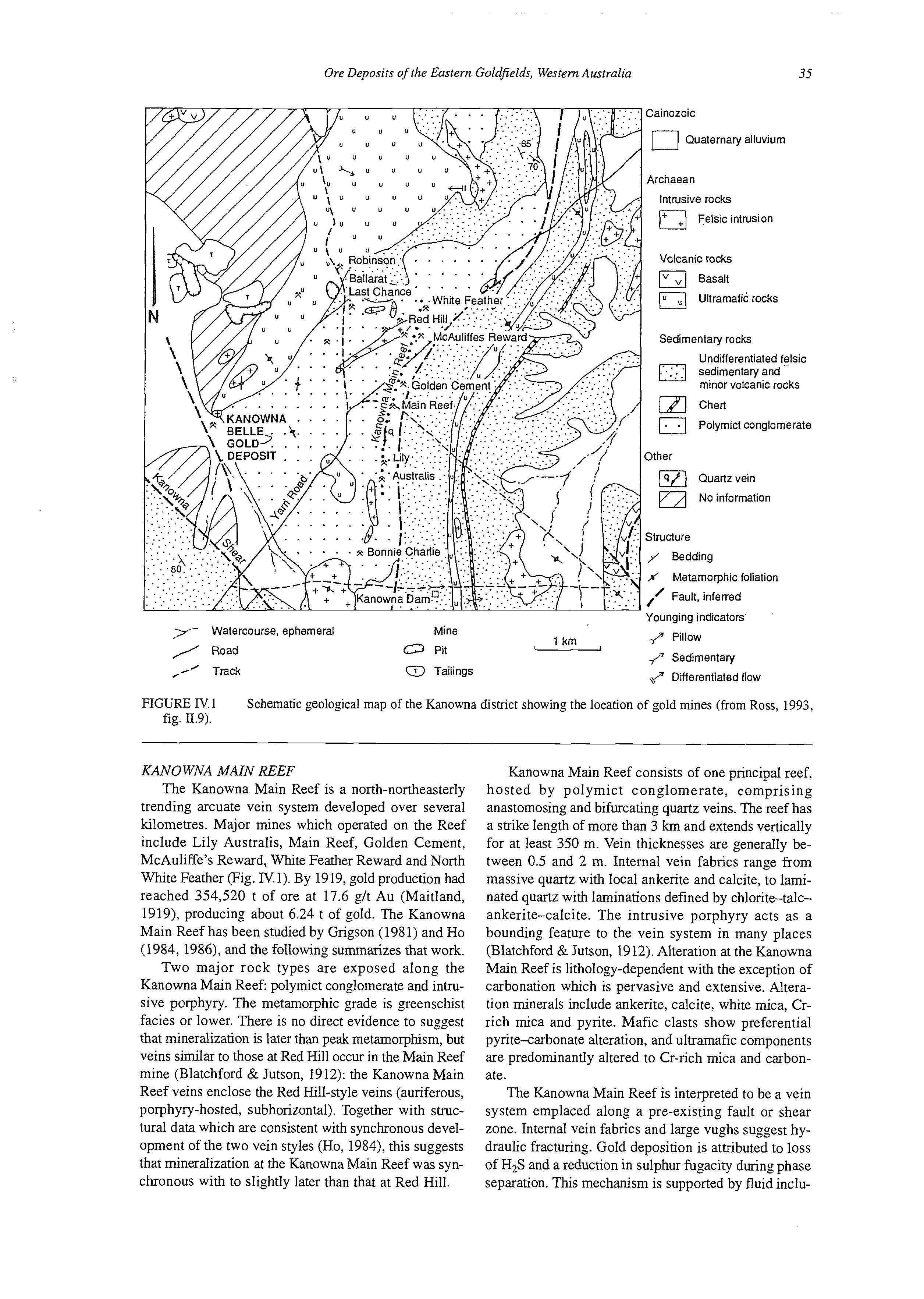
1 km -
0 Tailings
p Pillow /‘ Sedimentary ,? Differentiatedflow
Schematic geological map of the Kanowna district showing the location of gold mines (from Ross, 1993,
KANO WNA MAIN REEF
The Kanowna Main Reef is a north-northeasterly trending arcuate vein system developed over several kilometres. Major mines which operated on the Reef include Lily Australis, Main Reef, Golden Cement, McAuliffe’s Reward, White Feather Reward and North White Feather (Fig. IV.l). By 1919, gold production had reached 354,520 t of ore at 17.6 glt Au (Maitland, 1919), producing about 6.24 t of gold. The Kanowna Main Reef has been studied by Grigson (198 1) and Ho (1984, 1986), and the following summarizes that work.
Two major rock types are exposed along the Kanowna Main Reef: polymict conglomerate and intrusive porphyry. The metamorphic grade is greenschist facies or lower. There is no direct evidence to suggest that mineralization is later than peak metamorphism, but veins similar to those at Red Hill occur in the Main Reef mine (Blatchford & Jutson, 1912): the Kanowna Main Reef veins enclose the Red Hill-style veins (auriferous, porphyry-hosted, subhorizontal). Together with structural data which are consistent with synchronous development of the two vein styles (Ho, 1984), this suggests that mineralization at the Kanowna Main Reef was synchronous with to slightly later than that at Red Hill.
Kanowna Main Reef consists of one principal reef, hosted by polymict conglomerate, comprising anastomosing and bifurcating quartz veins. The reef has a strike length of more than 3 km and extends vertically for at least 350 m. Vein thicknesses are generally between 0.5 and 2 m. Internal vein fabrics range from massive quartz with local ankerite and calcite, to laminated quartz with laminations defined by chlorite-talcankerite-calcite. The intrusive porphyry acts as a bounding feature to the vein system in many places (Blatchford & Jutson, 1912). Alteration at the Kanowna Main Reef is lithology-dependent with the exception of carbonation which is pervasive and extensive. Alteration minerals include ankerite, calcite, white mica, Crrich mica and pyrite. Mafic clasts show preferential pyrite-carbonate alteration, and ultramafic components are predominantly altered to Cr-rich mica and carbonate.
The Kanowna Main Reef is interpreted to be a vein system emplaced along a pre-existing fault or shear zone. Internal vein fabrics and large vughs suggest hydraulic fracturing. Gold deposition is attributed to loss of H,S and a reduction in sulphur fugacity during phase separation. This mechanism is supported by fluid inclu-
Structure
Graves Dam Grits Aphyric intrusion I wall , shear
High-Mg basalts
Lowes Sandstone
QED Rudite
Cemetery Conglomerate
0 0 ' Golden Valley Conglomerate
IFeldspar phyric porphyry
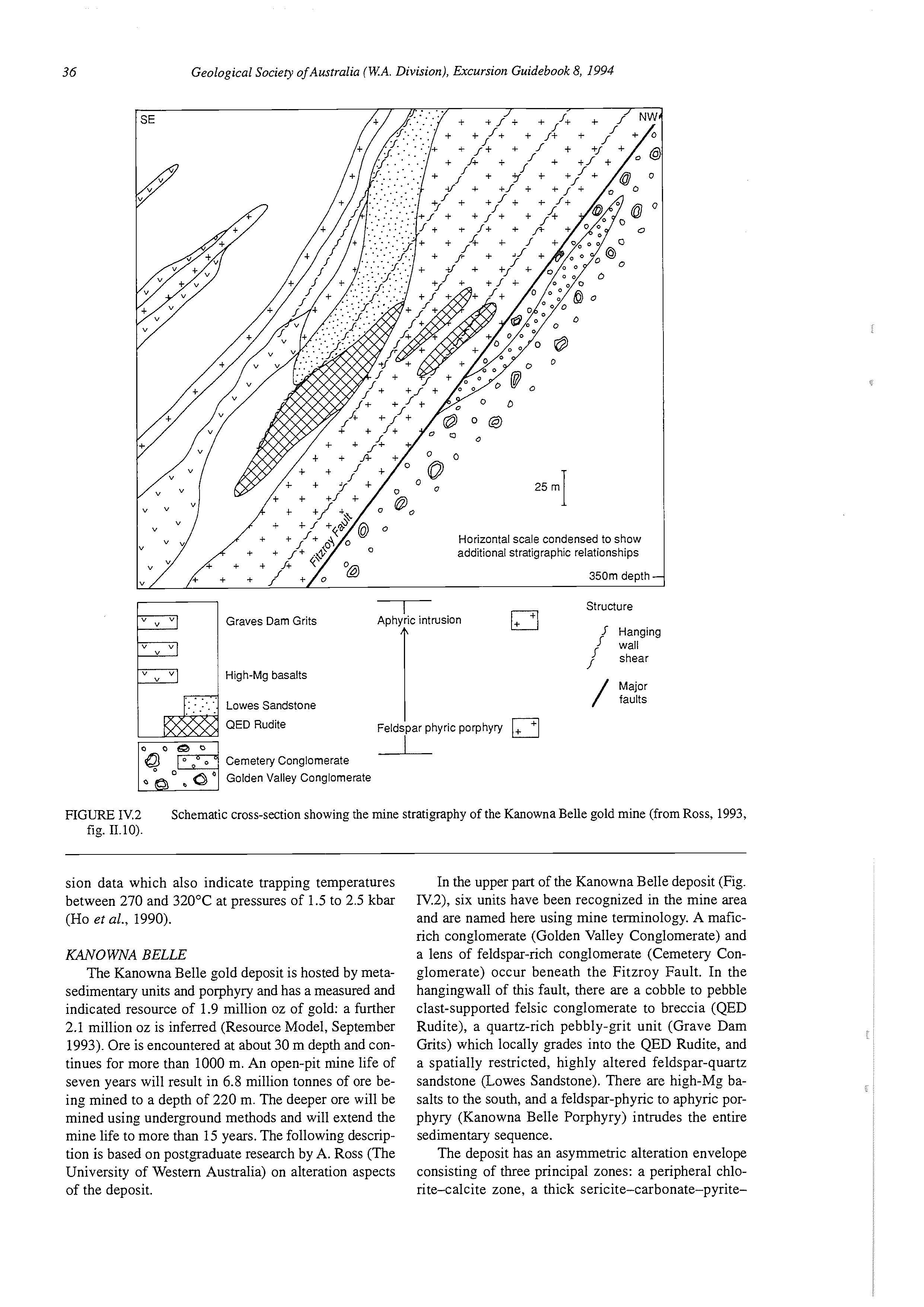
,== Hanging
Major / faults
FIGURE IV.2 Schematic cross-section showing the mine stratigraphy of the Kanowna Belle gold mine (from Ross, 1993, fig. 11.10).
sion data which also indicate trapping temperatures between 270 and 32OOC at pressures of 1.5 to 2.5 kbar (Ho et al., 1990).
KANOWNA BELLE
The Kanowna Belle gold deposit is hosted by metasedimentary units and porphyry and has a measured and indicated resource of 1.9 million oz of gold: a further 2.1 million oz is inferred (Resource Model, September 1993). Ore is encountered at about 30 m depth and continues for more than 1000 m. An open-pit mine life of seven years will result in 6.8 million tonnes of ore being mined to a depth of 220 m. The deeper ore will be mined using underground methods and will extend the mine life to more than 15 years. The following description is based on postgraduate research by A. Ross (The University of Western Australia) on alteration aspects of the deposit.
In the upper part of the Kanowna Belle deposit (Fig. IV.2), six units have been recognized in the mine area and are named here using mine terminology. A maficrich conglomerate (Golden Valley Conglomerate) and a lens of feldspar-rich conglomerate (Cemetery Conglomerate) occur beneath the Fitzroy Fault. In the hangingwall of this fault, there are a cobble to pebble clast-supported felsic conglomerate to breccia (QED Rudite), a quartz-rich pebbly-grit unit (Grave Dam Grits) which locally grades into the QED Rudite, and a spatially restricted, highly altered feldspar-quartz sandstone (Lowes Sandstone). There are high-Mg basalts to the south, and a feldspar-phyric to aphyric porphyry (Kanowna Belle Porphyry) intrudes the entire sedimentary sequence.
The deposit has an asymmetric alteration envelope consisting of three principal zones: a peripheral chlorite-calcite zone, a thick sericite-carbonate-pyrite-
fuchsite zone, and a spatially restricted quartz-albitepyrite zone. Alteration assemblages are overprinted locally by hydrothermal fracturing and carbonates. Above 350 m depth, the inner two zones are generally restricted to the hangingwall of the Fitzroy Fault.
There is a strong structural control on mineralization. The most prominent feature is the Fitzroy Fault zone, or Fitzroy Fault gouge. The fault zone is a mineralized brittle-ductile shear with zones of schistosity and brecciation. Within this fault zone is a narrow but continuous fault gouge, commonly referred to as the Fitzroy Fault or simply the "pug zone". This fault gouge strikes northeast and dips 60" southeast. In the upper part of the deposit, most of the mineralization is above this gouge. There are smaller shears in the hangingwall of the deposit which appear to be responsible for hangingwall oreshoots above the pervasive blanket of Fitzroy mineralization.
Gold is associated with pyrite in alteration haloes around the Fitzroy Fault zone and hangingwall shears. It also occurs in hydrothermal quartz breccias, sericitepyrite veinlets, and pyritic quartz stockworks. In places, there is free gold in late horizontal quartz veins.
The Kanowna Belle deposit formed either synchronous with peak metamorphism of shortly afterwards. Mineralized veins both exploit the D, regional foliation and crosscut it. There is a late chlorite overprint on the margins of the deposit, but this chlorite may be related to late shears, peripheral alteration, or regional metamorphism. Biotite occurs locally in both the footwall and hangingwall of the deposit, but its origin may be primary magmatic, contact metamorphic, or regional metamorphic. No fluid inclusion studies have been completed on Kanowna Belle, but structural and alteration styles are similar to those for Red Hill and Kanowna Main Reef. It is likely that the pressure and temperature constraints on mineralization were similar, as were the mechanisms for gold deposition.
LOCALITY 2: LODE GOLD DEPOSITS OF THE MT PLEASANT DISTRICT
[based on Gebre-Mariam, 1993; Witt, 1990bI
Introduction
The Mt Pleasant district is about 35 km northwest of Kalgoorlie, in the Kalgoorlie Terrane, within the Norseman-Wiluna Belt. The lode-gold deposits of the district have produced about 30 t of gold to date (Witt, 1993a). In the Mt Pleasant district, gold deposits are hosted by a variety of rock types, including mafic layered sills (Mt Pleasant Sill), tholeiitic basalt and granitoid (Liberty Granodiorite).
Regional setting
The Mt Pleasant district forms the southern portion of the Ora Banda Domain (Swager et al., 1990). The supracrustal succession of the Domain is broadly comparable with the sequences at Kalgoorlie (Travis et al., 1971) and Kambalda (Roberts, 1988), and is dated at 2704 i:8 Ma (Pidgeon, 1986), essentially the same age
as the Kambalda greenstones (2702 i: 4 Ma; Claou6Long et al., 1988). It is dominated by mafic to ultramafic rocks and high-level intrusive equivalents of the mafic lavas. The sequence is about 10 km thick (Witt, 1990a). This is much thicker than the greenstone succession at Kalgoorlie or Kambalda, a difference partly attributed to a larger proportion of intrusions, and partly to a lesser structural attenuation than in the Kalgoorlie or Kambalda areas.
In the Mt Pleasant district, the upper part of the Ora Banda Sequence (Fig. IV.3) includes the Bent Tree Basalt (flow basalt), Victorious Basalt (porphyritic basalt) and Black Flag Group (felsic to intermediate volcanic and epiclastic sedimentary rocks). Intruding the sequence are the Mt Ellis (layered pyroxenite to quartzgabbro) and Mt Pleasant (layered peridotite to quartzgabbro) Sills, the Liberty Granodiorite, and felsic porphyries.
Upright D, folding and D, transcurrent faulting are the dominant regional-scale deformation features in the district (Witt, 1990a). Late "E-trending D, faults have disrupted the greenstone sequence. In general, the rocks are unstrained and there is no pervasive or spaced fabric except in discrete planar zones of high strain, which are characterized by pervasive foliation and destruction of primary textures. Massive undeformed mafic to ultramafic rocks wj th well-preserved igneous structures and textures, including cumulate textures in layered intrusions, and pillows and varioles in basalts, occur over a wide area. Metamorphism is characterized by a high degree of primary textural preservation, and ranges from low to mid-greenschist facies.
Mt Pleasant Sill
The Mount Pleasant Sill (Fig. IV.4)is a layered and differentiated mafic-ultramafic intrusion which generally occurs towards the bottom of the Grants Patch Group. It has a high-Mg bulk composition (about 11 wt % MgO), and ranges from a peridotite at the base to a granophyric quartz gabbro about 50 m below the top (Witt et al., 1991a). The quartz-gabbro zone is an ironrich rock (Table 11.1) which is a preferred host rock to gold mineralization at several mining localities in the Ora Banda Domain, including Mount Pleasant (Golden Kilometre, Southern Shoot).
Most of the recognized zones within the Mount Pleasant Sill are described below. Zone 1 is a melanocratic microgabbro and Zone 11 is a thin, poorly defined unit.
ZONE 2, PERIDOTITE
The second zone is an olivine orthocumulate in which rounded serpentine pseudomorphs after olivine (<1 mm) occur within coarser (3-4 mm) chloritic domains which probably represent clinopyroxene oikocrysts. Cumulus olivine is rarely recognizable in hand specimen, but titanium-rich hornblende (up to 10 wt % TiO,) oikocrysts are visible in the core as brown cleavage surfaces up to 2 or 3 mm across. The hornblende, which appears to be a primary phase, is only
Kalgoorlie i
FIGURE IV.3 Regional geology map of the Mt Pleasant district, showing the location of gold deposits (slightly modified from Cassidy & Bennett, 1990, fig. 111.18). The aeroinagnetic data are 2 overlaid to show the location of exposed and inferred granitic bodies. 1.5 kni I
Royal Slandard Fault Zone
Eastwind
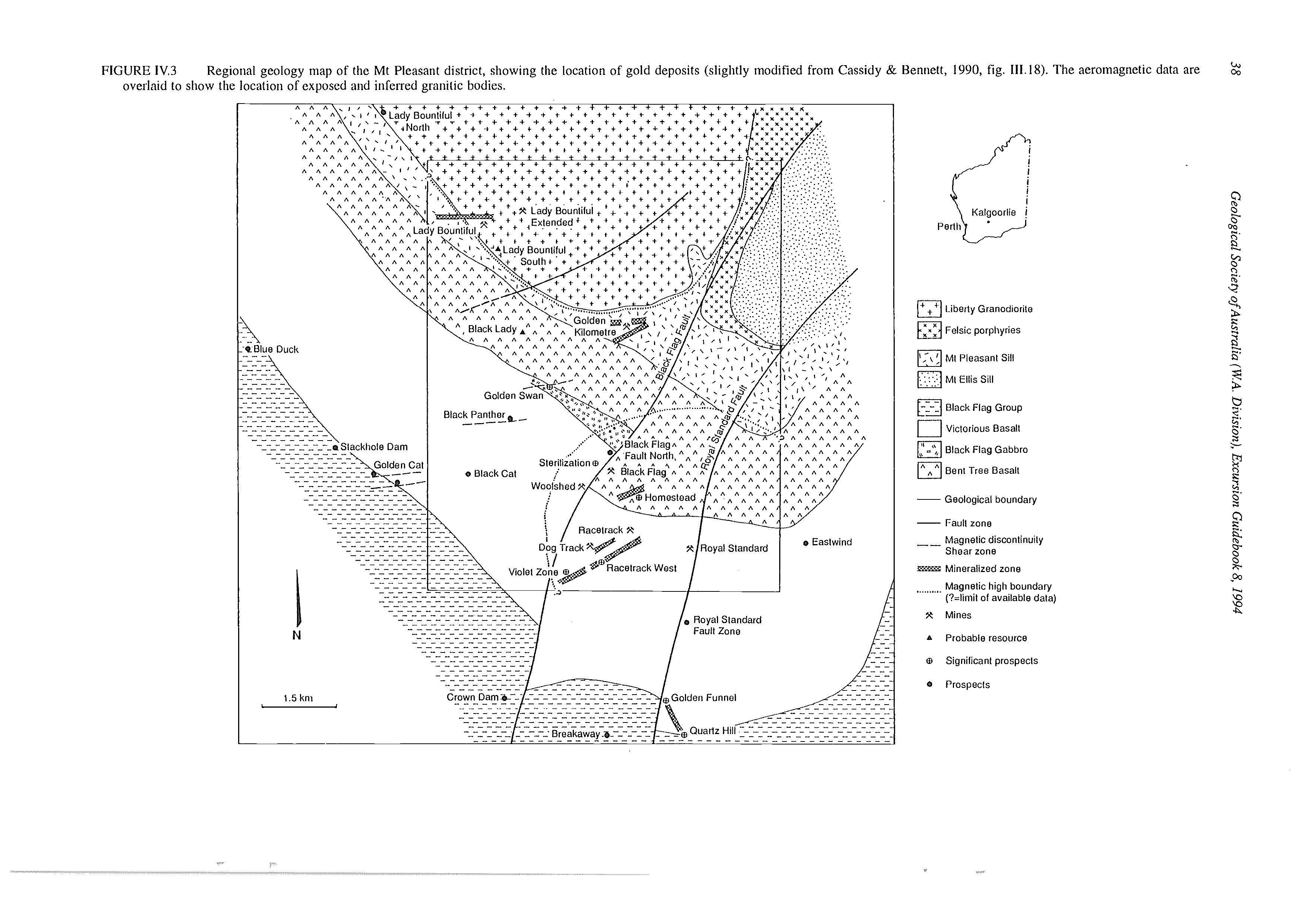
Granodiorite
Feisic porpliyrias
, \ ' MI Pleasant Sill
MI Ellis Sill
aBlack Flag Group
Viclorious Basalt
Black Flag Gabbro
Bent Tree Basal!
-Geological boundary
-Fault zone
-_ Magnetic discontinuily
Shear zone
IZEPEZE Mineralized zone
...I I..... Magnetic high boundary
(?=limit of available data)
X Mines
A Probable resource
61 Signilicant prospects
* Prospects
FIGURE IV.4
Abbreviations:
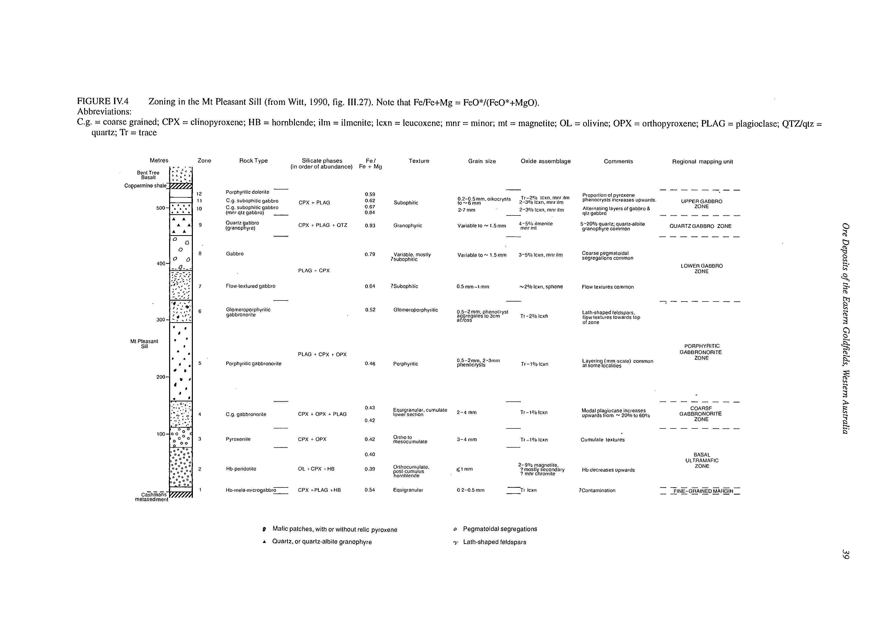
Zoning in the Mt Pleasant Sill (from Witt, 1990, fig. 111.27). Note that Fe/Fe+Mg = FeO*/(FeO*+MgO).
C.g. = coarse grained; CPX = clinopyroxene; HB = hornblcnde; ilm = ilmenite; lcxn = leucoxene; mnr = minor; mt = magnetite; OL = olivine; OPX = orthopyroxene; PLAG = plagioclase; QTZ/qtz =
quartz; Tr = trace
(mnr qlz qabbio)
Ouarlr gabbro
(granophyrc)
Gabbro 0 79
Vaitable. moslly ?subophiltc
Praporllo" 01 pyroxene phenocrysls inciea~e~upwards UPPERGABBRO Alteinaltng layersol gabbro 8 qtz qabbro
5-20% quartz; quarlralbilc OUARTZGABBRO ZONE granophyre common ZONE
Coarse peqmaloidal segreqations common
LOWERGABBRO ZONE PLAG - CPX
Flowexlured gabbro 0 64 0 52
Glomeroporphynlic qabbronorile
1Subophilic
Glomoroporphyrilic
Pcrphyrtlic
tHQ
Equigranujar. Cumulate lower SeCIlOn
0.5-Zmm. aggregalesphenocryst lo 3cm
PORPHYRITIC GABBRONORITE ZONE
Layerin (mm scale) common at some7ocalities
Pegmatoidal segregations '5- Lath-shaped feldspars
Modal plaglocasc increases upwards lrom - 20% 10 60%
GABBRONORITE COARSF ZONE
BASAL ULTRAMAFIC ZONE Hb decreases upwards
TABLE IV.2 Average whole-rock analyses (major and minor elements as wt %, trace elements as ppm), Liberty Granodiorite and enclaves. LO1 = loss on i,gition, including H,O+, H,S and “others” (from Witt, 1990b, table III.3).
Samples:
1. Average of seven Liberty Granodiorite samples
2. Average of three “high-SO,” microgranitoid enclaves 3. Average of three “low-SO,” microgranitoid enclaves 1 2 3
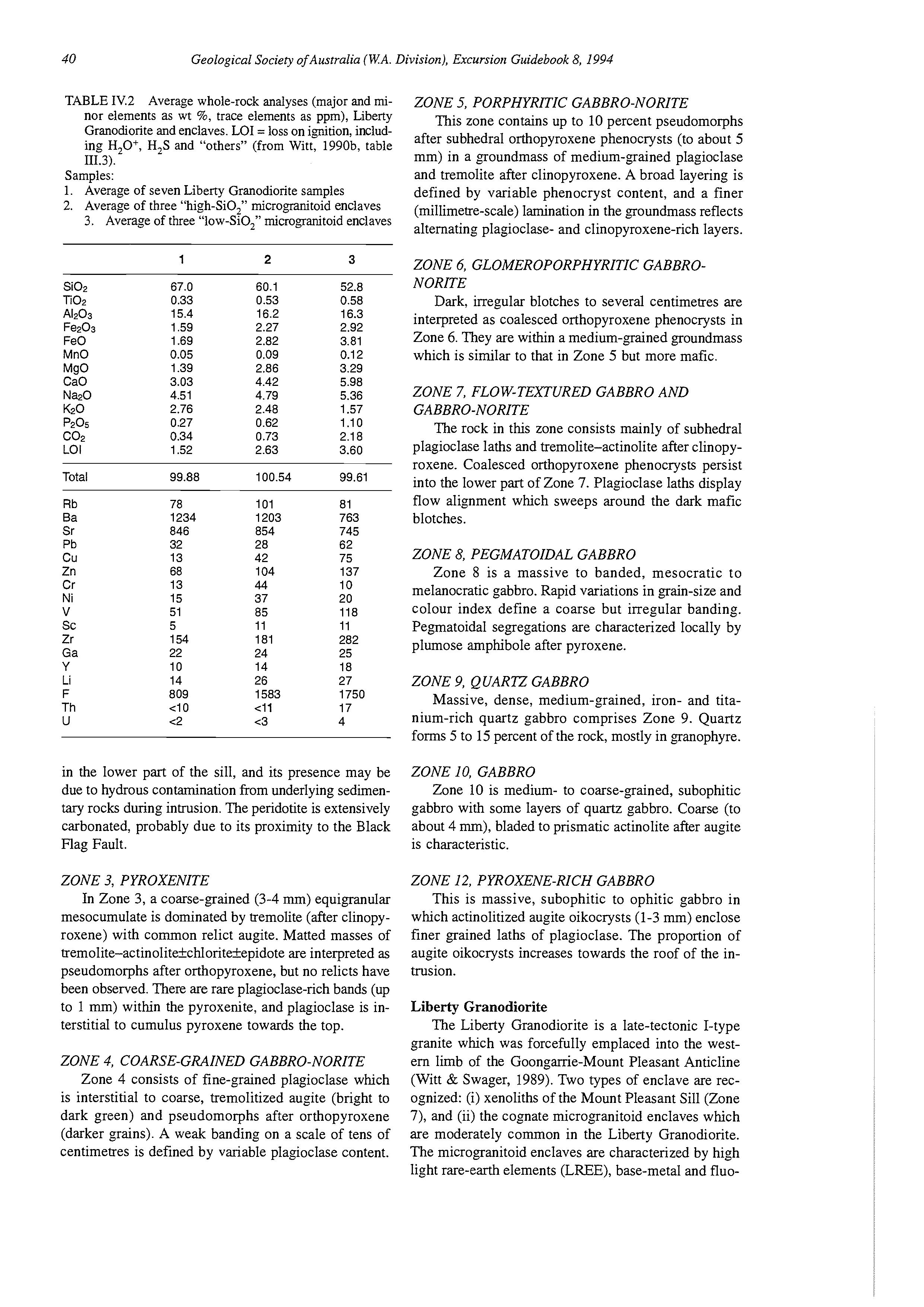
in the lower part of the sill, and its presence may be due to hydrous contamination from underlying sedimentary rocks during intrusion. The peridotite is extensively carbonated, probably due to its proximity to the Black Flag Fault.
ZONE 3, PYROXENITE
In Zone 3, a coarse-grained (3-4 mm) equigranular mesocumulate is dominated by tremolite (after clinopyroxene) with common relict augite. Matted masses of tremolite-actinolitekchloritekepidoteare interpreted as pseudomorphs after orthopyroxene, but no relicts have been observed. There are rare plagioclase-rich bands (up to 1 mm) within the pyroxenite, and plagioclase is interstitial to cumulus pyroxene towards the top.
ZONE 4, COARSE-GRAINED GABBRO-NORITE
Zone 4 consists of fine-grained plagioclase which is interstitial to coarse, tremolitized augite (bright to dark green) and pseudomorphs after orthopyroxene (darker grains). A weak banding on a scale of tens of centimetres is defined by variable plagioclase content.
ZONE 5, PORPHYRITIC GABBRO-NORITE
This zone contains up to 10 percent pseudomorphs after subhedral orthopyroxene phenocrysts (to about 5 mm) in a groundmass of medium-grained plagioclase and tremolite after clinopyroxene. A broad layering is defined by variable phenocryst content, and a finer (millimetre-scale) lamination in the groundmass reflects alternating plagioclase- and clinopyroxene-rich layers.
ZONE 6, GLOMEROPORPHYRITIC GABBRONORITE
Dark, irregular blotches to several centimetres are interpreted as coalesced orthopyroxene phenocrysts in Zone 6. They are within a medium-grained groundmass which is similar to that in Zone 5 but more mafic.
ZONE 7, FLOW-TEXTURED GABBRO AND GABBRO-NORITE
The rock in this zone consists mainly of subhedral plagioclase laths and tremolite-actinolite after clinopyroxene. Coalesced orthopyroxene phenocrysts persist into the lower part of Zone 7. Plagioclase laths display flow alignment which sweeps around the dark mafic blotches.
ZONE 8, PEGMATOIDAL GABBRO
Zone 8 is a massive to banded, mesocratic to melanocratic gabbro. Rapid variations in grain-size and colour index define a coarse but irregular banding. Pegmatoidal segregations are characterized locally by plumose amphibole after pyroxene.
ZONE 9, QUARTZ GABBRO
Massive, dense, medium-grained, iron- and titanium-rich quartz gabbro comprises Zone 9. Quartz forms 5 to 15 percent of the rock, mostly in granophyre.
ZONE 10, GABBRO
Zone 10 is medium- to coarse-grained, subophitic gabbro with some layers of quartz gabbro. Coarse (to about 4 mm), bladed to prismatic actinolite after augite is characteristic.
ZONE 12, PYROXENE-RICH GABBRO
This is massive, subophitic to ophitic gabbro in which actinolitized augite oikocrysts (1-3 mm) enclose finer grained laths of plagioclase. The proportion of augite oikocrysts increases towards the roof of the intrusion.
Liberty Granodiorite
The Liberty Granodiorite is a late-tectonic I-type granite which was forcefully emplaced into the westem limb of the Goonganie-Mount Pleasant Anticline (Witt & Swager, 1989). Two types of enclave are recognized: (i) xenoliths of the Mount Pleasant Sill (Zone 7), and (ii) the cognate microgranitoid enclaves which are moderately common in the Liberty Granodiorite. The microgranitoid enclaves are characterized by high light rare-earth elements (LREE), base-metal and fluo-
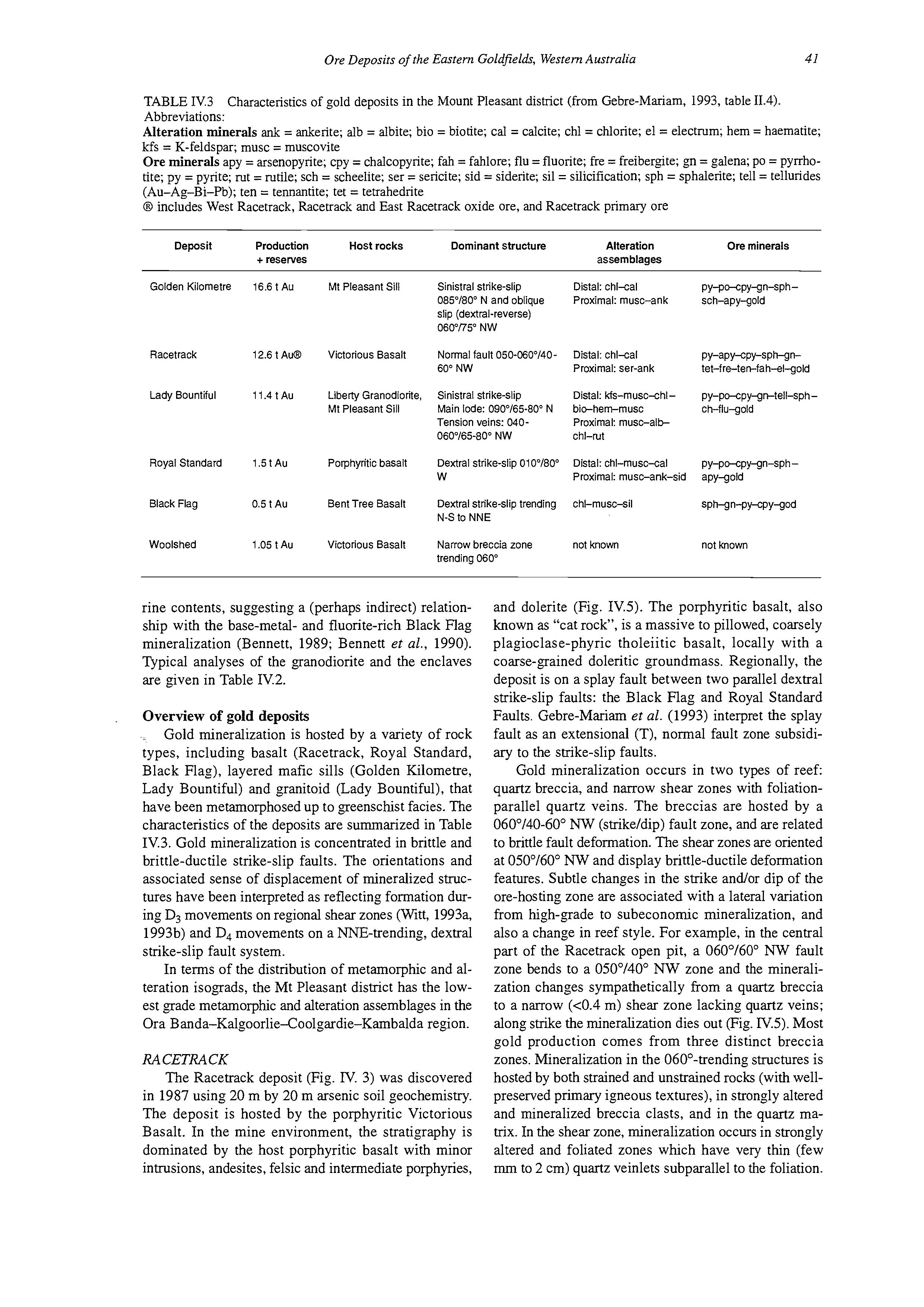
TABLE IV.3
Abbreviations:
Alteration minerals ank = ankerite; alb = albite; bio = biotite; cal = calcite; chl = chlorite; el = electrum; hem = haematite; kfs = K-feldspar; musc = muscovite
Ore minerals apy = arsenopyrite; cpy = chalcopyrite; fah = fahlore; flu = fluorite; fre = freibergite; gn = galena; PO = pyrrhotite; py = pyrite; rut = rutile; sch = scheelite; ser = sericite; sid = siderite; sil = silicification; sph = sphalerite;tell = tellurides (Au-Ag-Bi-Pb); ten = tennantite; tet = tetrahedrite
@ includes West Racetrack, Racetrack and East Racetrack oxide ore, and Racetrack primary ore
Characteristics of gold deposits in the Mount Pleasant district (from Gebre-Mariam, 1993, table 11.4). Deposit
Golden Kilornetre 16.6 t Au Mt Pleasant Sill
Racetrack 12.6 t A& Victorious Basalt
Lady Bountiful 11.4 t Au Liberty Granodiorite, Mt Pleasant Sill
Royal Standard 1.5 t Au Porphyritic basalt
Black Flag 0.5 t Au Bent Tree Basalt
Woolshed 1.05 t Au Victorious Basalt
Sinistral strike-slip 085"/80" N and oblique slip (dextral-reverse) 060"/75" NW
Normalfault 050-060°/4060' NW
Sinistral strike-slip Main lode: 090V65-80" N Tension veins: 040060"/65-80" NW
Dextral strike-slip 010°/800 w
Dextral strike-slip trending N-S to NNE
Narrow breccia zone trending 060'
rine contents, suggesting a (perhaps indirect) relationship with the base-metal- and fluorite-rich Black Rag mineralization (Bennett, 1989; Bennett et al., 1990). Typical analyses of the granodiorite and the enclaves are given in Table IV.2.
Overview of gold deposits
Gold mineralization is hosted by a variety of rock types, including basalt (Racetrack, Royal Standard, Black Flag), layered mafic sills (Golden Kilometre, Lady Bountiful) and granitoid (Lady Bountiful), that have been metamorphosed up to greenschist facies. The characteristics of the deposits are summarized in Table IV.3. Gold mineralization is concentrated in brittle and brittle-ductile strike-slip faults. The orientations and associated sense of displacement of mineralized structures have been interpreted as reflecting formation during D3 movements on regional shear zones (Wid, 1993a, 1993b) and D4movements on a WE-trending, dextral strike-slip fault system.
In terms of the distribution of metamorphic and alteration isograds, the Mt Pleasant district has the lowest grade metamorphic and alteration assemblages in the Ora Banda-Kalgoorlie-Coolgardie-Kambalda region.
RACETRACK
Distal: chl-cal PY-Po-cPY-gn-SPhProximal: rnusc-ank sch-apy-gold
Distal: chl-cal PY-aPY-cPFsPh-gnProximal: ser-ank tet-fre-ten-fah-el-gold
Distal: Ms-rnusc-chl- py-po-cpy-gn-tell-sph-
Proximal: rnusc-albbic-hemrnusc ch-flU-gold
Chi-Nt
Distal: chl-musc-cal py-pc-cpy-gn-sph -
Proximal: rnusc-ank-sid apy-gold
chl-rnusc-sil sPMn-py-cPy-god
not known not known
The Racetrack deposit (Fig. N. 3) was discovered in 1987 using 20 m by 20 m arsenic soil geochemistry. The deposit is hosted by the porphyritic Victorious Basalt. In the mine environment, the stratigraphy is dominated by the host porphyritic basalt with minor intrusions, andesites, felsic and intermediate porphyries, and dolerite (Fig. IV.5). The porphyritic basalt, also known as "cat rock", is a massive to pillowed, coarsely plagioclase-phyric tholeiitic basalt, locally with a coarse-grained doleritic groundmass. Regionally, the deposit is on a splay fault between two parallel dextral strike-slip faults: the Black Flag and Royal Standard Faults. Gebre-Mariam et al. (1993) interpret the splay fault as an extensional (T), normal fault zone subsidiary to the strike-slip faults.
Gold mineralization occurs in two types of reef quartz breccia, and narrow shear zones with foliationparallel quartz veins. The breccias are hosted by a 060"/40-60" NW (strike/dip) fault zone, and are related to brittle fault deformation. The shear zones are oriented at 050°/60" NW and display brittle-ductile deformation features. Subtle changes in the strike and/or dip of the ore-hosting zone are associated with a lateral variation from high-grade to subeconomic mineralization, and also a change in reef style. For example, in the central part of the Racetrack open pit, a 060°/60" NW fault zone bends to a 050"/40" NW zone and the mineralization changes sympathetically from a quartz breccia to a narrow (<0.4 m) shear zone lacking quartz veins; along strike the mineralization dies out (Fig. N.5).Most gold production comes from three distinct breccia zones. Mineralization in the 060°-trending structures is hosted by both strained and unstrained rocks (with wellpreserved primary igneous textures), in strongly altered and mineralized breccia clasts, and in the quartz matrix. In the shear zone, mineralization occurs in strongly altered and foliated zones which have very thin (few mm to 2 cm) quartz veinlets subparallel to the foliation.
u Greenstones
\ Fault
50 km -
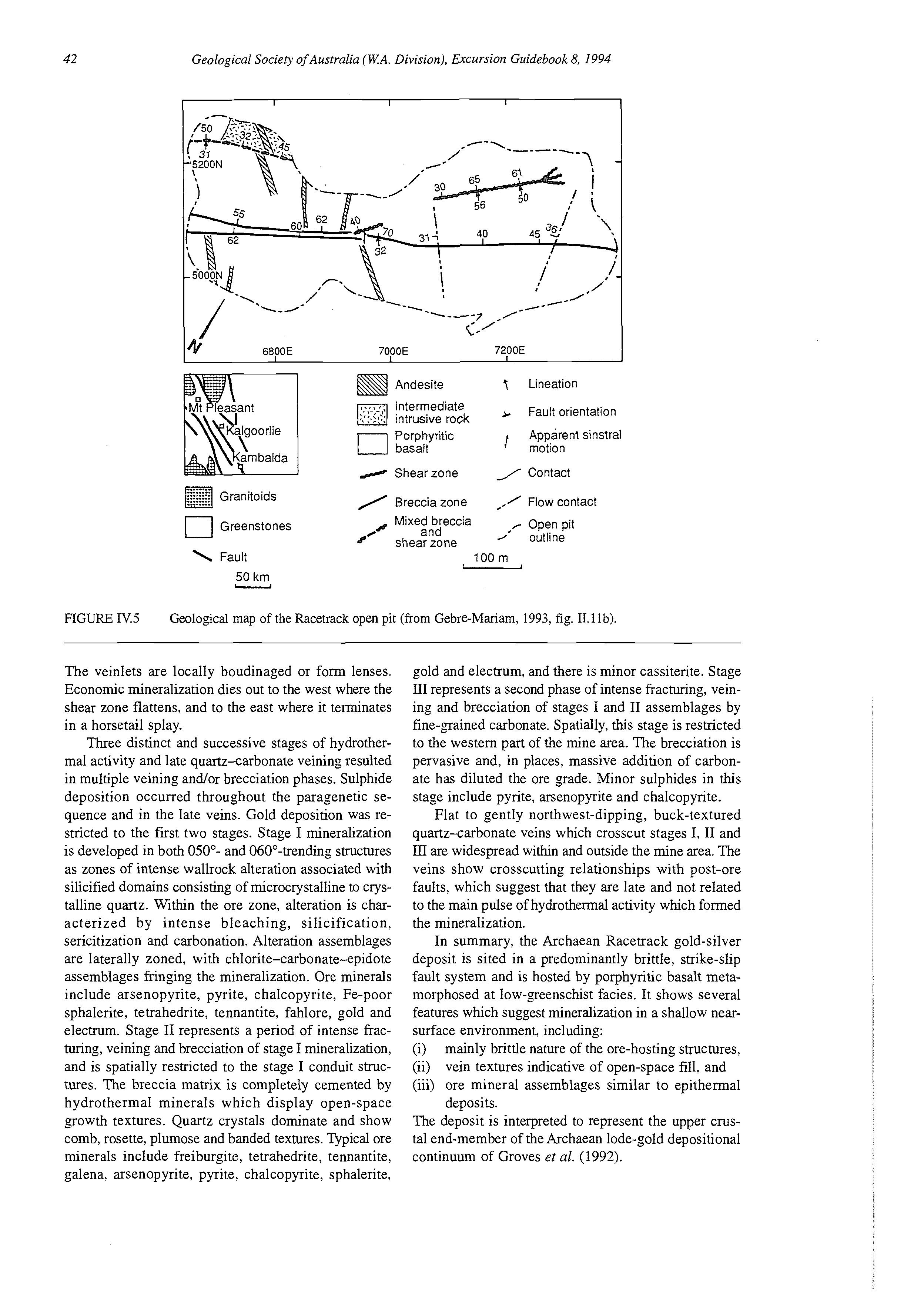
&$@Andesite
,;(-\-,\ IntermediaterJintrusive rock Porphyritic basalt
/ Shearzone 7 Lineation
Fault orientation Apparent sinstral motion
1Contact
/ Breccia zone / Flow contact
Mixed breccia Open pit shearzone / and /' outline
100 rn -
The veinlets are locally boudinaged or form lenses. Economic mineralization dies out to the west where the shear zone flattens, and to the east where it terminates in a horsetail splay.
Three distinct and successive stages of hydrothermal activity and late quartz-carbonate veining resulted in multiple veining and/or brecciation phases. Sulphide deposition occurred throughout the paragenetic sequence and in the late veins. Gold deposition was restricted to the first two stages. Stage I mineralization is developed in both 050"- and 060"-trending structures as zones of intense wallrock alteration associated with silicified domains consisting of microcrystalline to crystalline quartz. Within the ore zone, alteration is characterized by intense bleaching, silicification, sericitization and carbonation. Alteration assemblages are laterally zoned, with chlorite-carbonate-epidote assemblages fringing the mineralization. Ore minerals include arsenopyrite, pyrite, chalcopyrite, Fe-poor sphalerite, tetrahedrite, tennantite, fahlore, gold and electrum. Stage I1 represents a period of intense fracturing, veining and brecciation of stage I mineralization, and is spatially restricted to the stage I conduit structures. The breccia matrix is completely cemented by hydrothermal minerals which display open-space growth textures. Quartz crystals dominate and show comb, rosette, plumose and banded textures. Typical ore minerals include freiburgite, tetrahedrite, tennantite, galena, arsenopyrite, pyrite, chalcopyrite, sphalerite,
gold and electrum, and there is minor cassiterite. Stage 111represents a second phase of intense fracturing, veining and brecciation of stages I and I1 assemblages by fine-grained carbonate. Spatially, this stage is restricted to the western part of the mine area. The brecciation is pervasive and, in places, massive addition of carbonate has diluted the ore grade. Minor sulphides in this stage include pyrite, arsenopyrite and chalcopyrite.
Flat to gently northwest-dipping, buck-textured quartz-carbonate veins which crosscut stages I, I1 and ID are widespread within and outside the mine area. The veins show crosscutting relationships with post-ore faults, which suggest that they are late and not related to the main pulse of hydrothermal activity which formed the mineralization.
In summary, the Archaean Racetrack gold-silver deposit is sited in a predominantly brittle, strike-slip fault system and is hosted by porphyritic basalt metamorphosed at low-greenschist facies. It shows several features which suggest mineralization in a shallow nearsurface environment, including: (i) mainly brittle nature of the ore-hosting structures, (ii) vein textures indicative of open-space fill, and (iii) ore mineral assemblages similar to epithermal deposits.
The deposit is interpreted to represent the upper CNStal end-member of the Archaean lode-gold depositional continuum of Groves et al. (1992).
Subophitic gabbro + Flow basalt
minor quartz gabbro
Shale
Porphyritic dolerite
Subophitic gabbro
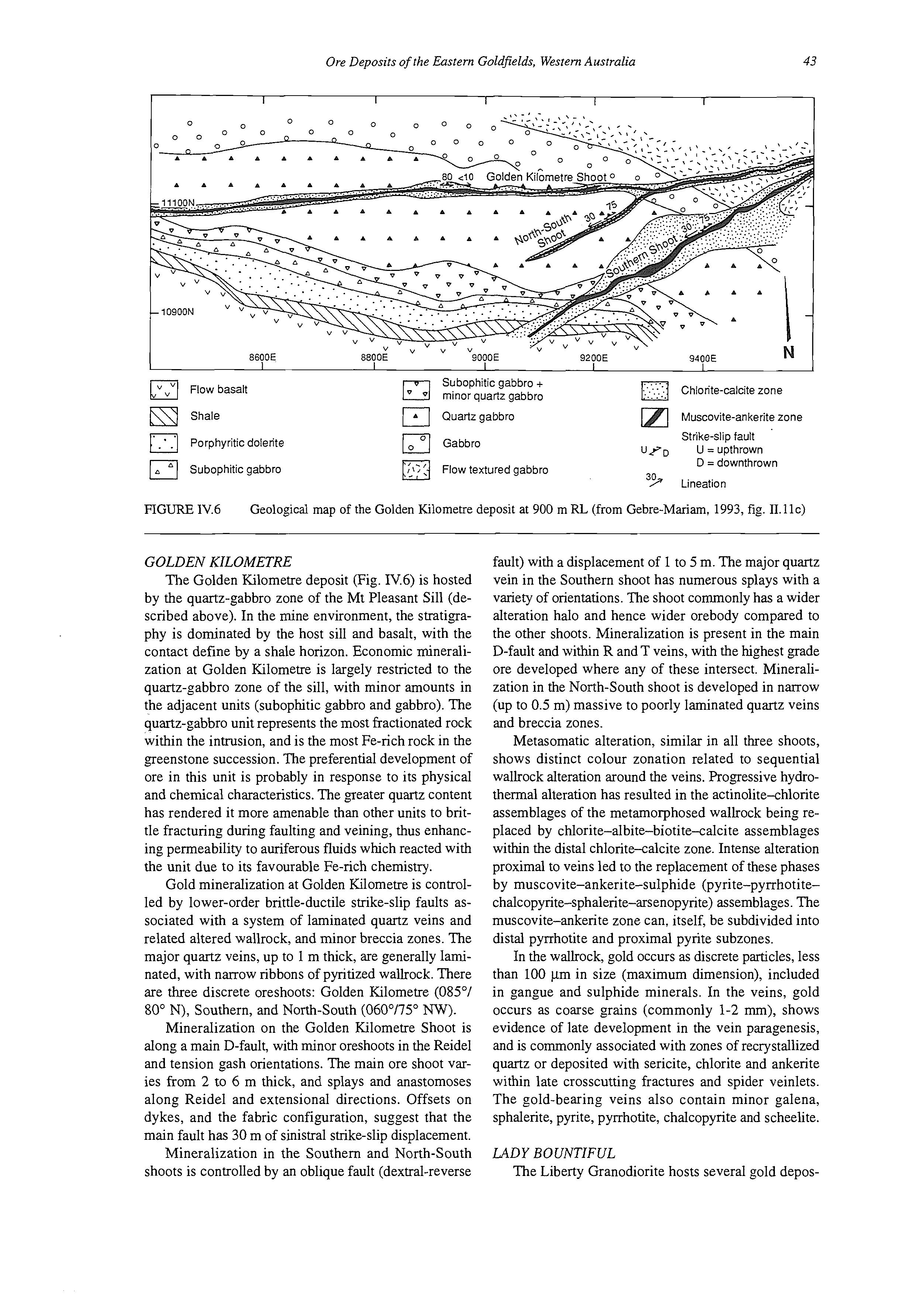
1.Chlorite-calcitezone
Quartz gabbro Muscovite-ankeritezone
Gabbro
Strike-slip fault U = upthrown
D = downthrown
Flow textured gabbro 39+ Lineation
FIGURE lV.6 Geological map of the Golden Kilometre deposit at 900 m RL (from Gebre-Mariam, 1993, fig. 11.11~)
GOLDEN KILOMETRE
The Golden Kilometre deposit (Fig. IV.6) is hosted by the quartz-gabbro zone of the Mt Pleasant Sill (described above). In the mine environment, the stratigraphy is dominated by the host sill and basalt, with the contact define by a shale horizon. Economic mineralization at Golden Kilometre is largely restricted to the quartz-gabbro zone of the sill, with minor amounts in the adjacent units (subophitic gabbro and gabbro). The quartz-gabbro unit represents the most fractionated rock within the intrusion, and is the most Fe-rich rock in the greenstone succession. The preferential development of ore in this unit is probably in response to its physical and chemical characteristics. The greater quartz content has rendered it more amenable than other units to brittle fracturing during faulting and veining, thus enhancing permeability to auriferous fluids which reacted with the unit due to its favourable Fe-rich chemistry.
Gold mineralization at Golden Kilometre is controlled by lower-order brittle-ductile strike-slip faults associated with a system of laminated quartz veins and related altered wallrock, and minor breccia zones. The major quartz veins, up to 1 m thick, are generally laminated, with narrow ribbons of pyritized wallrock. There are three discrete oreshoots: Golden Kilometre (085"/ 80" N), Southern, and North-South (060"/75" NW).
Mineralization on the Golden Kilometre Shoot is along a main D-fault, with minor oreshoots in the Reidel and tension gash orientations. The main ore shoot varies from 2 to 6 m thick, and splays and anastomoses along Reidel and extensional directions. Offsets on dykes, and the fabric configuration, suggest that the main fault has 30 m of sinistral strike-slip displacement.
Mineralization in the Southern and North-South shoots is controlled by an oblique fault (dextral-reverse
fault) with a displacement of 1 to 5 m. The major quartz vein in the Southern shoot has numerous splays with a variety of orientations. The shoot commonly has a wider alteration halo and hence wider orebody compared to the other shoots. Mineralization is present in the main D-fault and within R and T veins, with the highest grade ore developed where any of these intersect. Mineralization in the North-South shoot is developed in narrow (up to 0.5 m) massive to poorly laminated quartz veins and breccia zones.
Metasomatic alteration, similar in all three shoots, shows distinct colour zonation related to sequential wallrock alteration around the veins. Progressive hydrothermal alteration has resulted in the actinolite-chlorite assemblages of the metamorphosed wallrock being replaced by chlorite-albite-biotite-calcite assemblages within the distal chlorite-calcite zone. Intense alteration proximal to veins led to the replacement of these phases by muscovite-ankerite-sulphide (pyrite-pynhotitechalcopyrite-sphalerite-arsenopyrite) assemblages. The muscovite-ankerite zone can, itself, be subdivided into distal pyrrhotite and proximal pyrite subzones.
In the wallrock, gold occurs as discrete particles, less than 100 pm in size (maximum dimension), included in gangue and sulphide minerals. In the veins, gold occurs as coarse grains (commonly 1-2 mm), shows evidence of late development in the vein paragenesis, and is commonly associated with zones of recrystallized quartz or deposited with sericite, chlorite and ankerite within late crosscutting fractures and spider veinlets. The gold-bearing veins also contain minor galena, sphalerite, pyrite, pyrrhotite, chalcopyrite and scheelite.
LADY BOUNTIFUL
The Liberty Granodiorite hosts several gold depos-
FIGURE IV.7 Regional geological map showing gold mines and camps in the St Ives area (from Ho et al., 1994, fig. 1).
its, the most significant of which is the Lady Bountiful mine (1,697,000 t at 4.1 g/t). Mineralization at Lady Bountiful (Fig. IV.3) is in east-west quartz veins. The granodiorite adjacent to the mineralized veins is altered to a sericite-pyrite assemblage. Iron expelled from the
alteration zone is deposited as haematite in an outer selvage between the sencite-pyrite assemblage and the unaltered granodiorite.
LOCALITY 3: LODE GOLD DEPOSITS OF THE KAMBALDA DISTRICT
[based on Watchorn, 1993; update of Spiers et al., 19901
Introduction
The Kambalda district contains a significant number of gold deposits, many of which are concentrated within the Kambalda-St Ives area. Operating gold mines include the Victory, Revenge and Junction underground mines, and the North Orchin, Lifeboat and Delta South open pits.
Exploration and mining history
Gold was discovered in the Kambalda district at Red Hill in 1897. Exploration interest in the district was rekindled with the discovery of the Ives Reward deposit in 1919. The Ives Reward mine produced 10,000 oz of gold before closing in the late 1930s. Subsequently, little work was undertaken until 1974 when the area was reassessed by Western Mining Corporation Ltd following an increase in the gold price. However, it was concluded that sporadic high gold values encountered in drilling, outcrop and old gold workings were confined to near-surface oxidized rocks. This was despite good high-grade patches being found associated with the nickel ore at Silver Lake and Fisher in the early 1970s.
TABLE IV.4 Characteristics of gold deposits in the Kambalda area (after Spiers et al., 1993, table 3).
Abbreviations:
ac = actinolite; ab = albite; ank = ankerite; bt = biotite; cl = chlorite; dl = dolomite; hb = hornblende; mt = magnetite; ms = muscovite; pi = plagioclase; py = pyrite; PO = pyrrhotite; q = quartz; sp = serpentine; tc = talc; tm = tremolite
Deposit
Hunt be's Reward
Red Hill
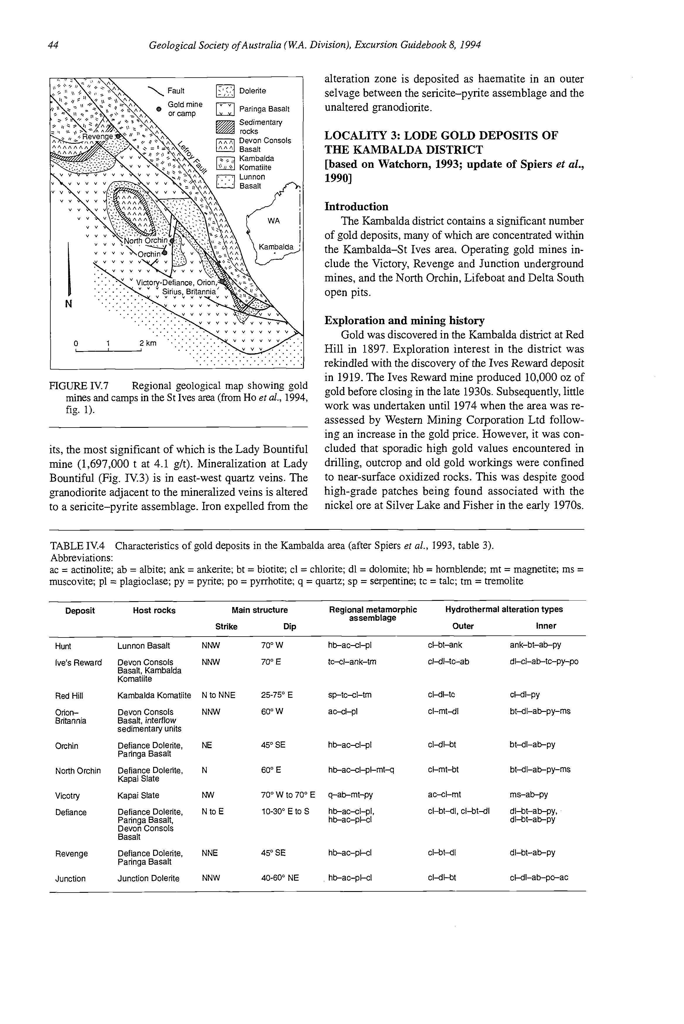
Lunnon Basalt
Devon Consols Basalt, Karnbalda Kornatiite
Karnbalda Komatiite
OrionBritannia N to NNE NNW
Devon Consols Basalt. interflow sedimentary units
Orchin
W
E
E sp-tc-cl-tn
W ac-cl-pl
Defiance Dolerite, Paringa Basalt
North Orchin N
Vicotry Defiance
Revenge Junction
Defiance Dolerite. Kapai Slate Kapai Slate
Defiance Dolerite. Paringa Basalt, Devon Consols Basalt
Defiance Dolerite, Paringa Basalt
Junction Dolerite
Ore zones
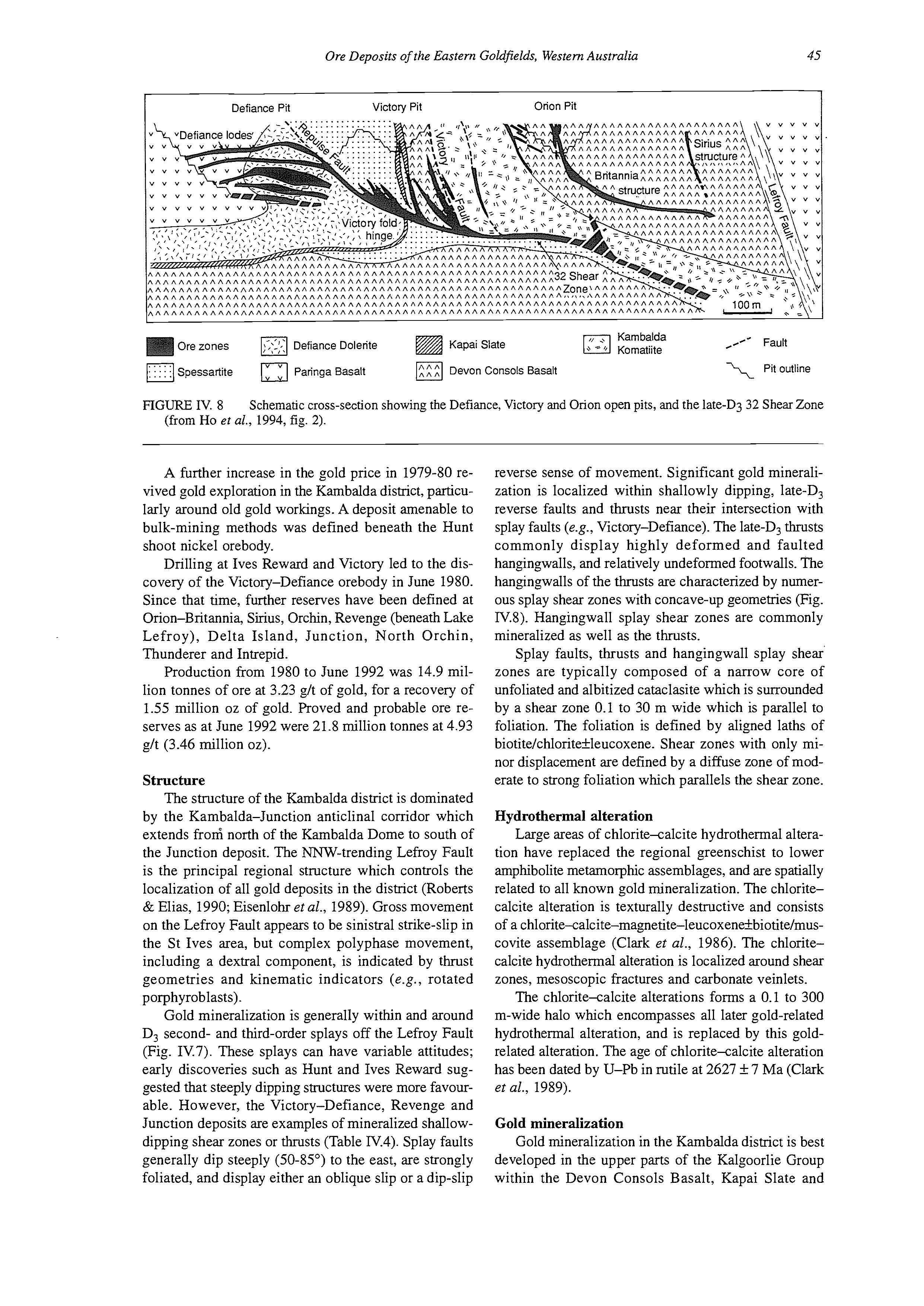
Defiance Dolerite Kapai Slate
Spessartite Paringa Basalt Devon Consols Basalt \ Pitoutline
FIGURE IV. 8 Schematic cross-section showing the Defiance, Victory and Orion open pits, and the late-D3 32 Shear Zone (from Ho et al., 1994, fig. 2).
A further increase in the gold price in 1979-80 revived gold exploration in the Kambalda district, particularly around old gold workings. A deposit amenable to bulk-mining methods was defined beneath the Hunt shoot nickel orebody.
Drilling at Ives Reward and Victory led to the discovery of the Victory-Defiance orebody in June 1980. Since that time, further reserves have been defined at Orion-Britannia, Sirius, Orchin, Revenge (beneath Lake Lefroy), Delta Island, Junction, North Orchin, Thunderer and Intrepid.
Production from 1980 to June 1992 was 14.9 million tonnes of ore at 3.23 git of gold, for a recovery of 1.55 million oz of gold. Proved and probable ore reserves as at June 1992 were 21.8 million tonnes at 4.93 git (3.46 million oz).
Structure
The structure of the Kambalda district is dominated by the Kambalda-Junction anticlinal corridor which extends from north of the Kambalda Dome to south of the Junction deposit. The NNW-trending Lefroy Fault is the principal regional structure which controls the localization of all gold deposits in the district (Roberts & Elias, 1990; Eisenlohr et al., 1989). Gross movement on the Lefroy Fault appears to be sinistral strike-slip in the St Ives area, but complex polyphase movement, including a dextral component, is indicated by thrust geometries and kinematic indicators (e.g., rotated porphyroblasts).
Gold mineralization is generally within and around D, second- and third-order splays off the Lefroy Fault (Fig. IV.7). These splays can have variable attitudes; early discoveries such as Hunt and Ives Reward suggested that steeply dipping structures were more favourable. However, the Victory-Defiance, Revenge and Junction deposits are examples of mineralized shallowdipping shear zones or thrusts (Table IV.4). Splay faults generally dip steeply (50-85") to the east, are strongly foliated, and display either an oblique slip or a dip-slip
reverse sense of movement. Significant gold mineralization is localized within shallowly dipping, late-D, reverse faults and thrusts near their intersection with splay faults (e.g., Victory-Defiance). The late-D, thrusts commonly display highly deformed and faulted hangingwalls, and relatively undeformed footwalls. The hangingwalls of the thrusts are characterized by numerous splay shear zones with concave-up geometries (Fig. N.8). Hangingwall splay shear zones are commonly mineralized as well as the thrusts.
Splay faults, thrusts and hangingwall splay shear zones are typically composed of a narrow core of unfoliated and albitized cataclasite which is surrounded by a shear zone 0.1 to 30 m wide which is parallel to foliation. The foliation is defined by aligned laths of biotiteichloritekleucoxene. Shear zones with only minor displacement are defined by a diffuse zone of moderate to strong foliation which parallels the shear zone.
Hydrothermal alteration
Large areas of chlorite-calcite hydrothermal alteration have replaced the regional greenschist to lower amphibolite metamoIphic assemblages, and are spatially related to all known gold mineralization. The chloritecalcite alteration is texturally destructive and consists of a chlorite-calcite-magnetite-leucoxenekbiotiteimuscovite assemblage (Clark et al., 1986). The chloritecalcite hydrothermal alteration is localized around shear zones, mesoscopic fractures and carbonate veinlets.
The chlorite-calcite alterations forms a 0.1 to 300 m-wide halo which encompasses all later gold-related hydrothermal alteration, and is replaced by this goldrelated alteration. The age of chlorite-calcite alteration has been dated by U-Pb in rutile at 2627 f 7 Ma (Clark et al., 1989).
Gold mineralization
Gold mineralization in the Kambalda district is best developed in the upper parts of the Kalgoorlie Group within the Devon Consols Basalt, Kapai Slate and
Paringa Basalt. However, gold mineralization has been recorded in all parts of the Kalgoorlie Group succession (Table IV.4). Preferred host rocks are generally more massive, rheologically strong, and Fe-rich. In contrast, Fe-poor felsic intrusions show excellent development of vein and breccia structures, but auriferous pyrite alteration is more weakly developed, with a lower gold grade but more massive orebodies.
GOLD MINERALIZATION STYLES
Gold mineralization can be divided into the following three main structural styles.
1. Lode, where the term “lode” is defined as the auriferous and pyritickpyrrhotitic hydrothermal alteration developed within and flanking selective parts of more extensive shear zones. The lode shear zone is typically composed of a thin (0.5-50 cm) core of cataclasite surrounded by an inner zone of foliated cataclasite 0.1 to 3 m wide, and an outer broad zone of shear-zone-parallel foliation. At least 40% of the lode shear zone can be dilationally brecciated.
2. Quartz vein stockworks, defined as irregular bodies of closely spaced and regularly oriented quartz veins with variably developed auriferous and pyritic hydrothermal alteration envelopes, which are commonly best developed in the brittle felsic intrusions and Kapai Slate.
3. A composite style, comprising variably developed quartz-vein stockwork mineralization localized within and around lode shear zones, particularly foliated shear zones.
HYDROTHERMAL ALTERATION TYPES
Gold-related hydrothermal alteration has produced a mineral zonation around lodes and stockwork veins which varies locally depending on the initial host-rock composition and fluid chemistry (Table IV.4).
Mafic rocks generally progress from an outer weakly foliated chlorite-calcite zone to a strongly foliated biotite-dominated zone, and an inner pyrite-albitedolomite zone adjacent to the quartz vein or dilational breccia. Detailed descriptions of this type of alteration are given by Phillips & Groves (1984) and Clark et al. (1986, 1989). Gold is generally absent from quartz veins and restricted to the sulphidic albite-dolomite zone of the altered wallrock.
The two typical hydrothermal alteration types are described below. However, the zonation types are not always all present in any one alteration envelope.
The stable assemblage of the biotite zone (outer) is albite-biotite-quartz-calcite/dolomite-magnetite~ pyrite-muscovite. Biotite is interpreted to have replaced chlorite as the dominant mafk mineral. This zone marks a change in bulk rock chemistry with increased K,O contents and decreased MgO, CaO and FeO abundance (Clark et ul., 1986).
The albite zone (inner) is generally a pale tan colour and contains an albite-ankerite/quartz-pyrite assemblage with minor chlorite, biotite, muscovite and calcite (Clark et ul., 1986). SO2, CaO, K20 and A1,0, contents are low and Na20 and Au contents high com-
pared to the outer alteration zones. Gold is invariably associated with well-formed pyrite euhedra or, as at Junction, granular pyrrhotite.
St Ives Goldfield
STRUCTURE OF VICTORY AREA
In the Victory area, the earliest recognizable macroscopic structure in the area is the Victory Fold (Fig. IV.8). This is an open recumbent fold with a northsouth-trending fold axis. The western limb is upward facing with shallow west dips, whereas the eastern limb is upright to overturned. Stratigraphy on the western limb generally youngs to the west despite extensive faulting. The lowermost unit exposed is the Kambalda Komatiite and the uppermost is the Paringa Basalt.
The Victory Fold is cut by a suite of upright NNWtrending felsic to intermediate intrusions (Fig. IV.9) dated at 2680 +21/-12 Ma (Clark et al., 1989). The sequence is further disrupted by a NNW-trending fault system which includes the Victory, Repulse and Paringa Faults (Figs IV.8, IV.9). The three faults are characterized by the development of an intense schistose fabric. The Repulse and Paringa Faults contain macroscopic boudins of quartz-albite intrusive rocks, or quartz keratophyre (Clark et al., 1989).
The late-D, Defiance shear zone controls much of the gold mineralization geometry in the immediate Victory-Defiance area, and is interpreted to be crosscut by the Lefroy Fault (Fig. N.8). Hangingwall splays from this shear zone have concave-up geometries, dip to the east, and are generally well mineralized. Hangingwall splays include the Repulse, Victory, Orion-Britannia and Sirius shear zones (Fig. IV.8).
MINERALIZATION
Gold mineralization in the Victory area occurs as:
(i) quartz-vein stockwork arrays, (ii) quartz-vein stockwork arrays hosted by shear zones, and (iii) a composite of (i) and (ii). The composite style accounts for the bulk of current and past reserves.
Quartz-vein stockwork arrays are commonly developed within the steeply dipping Kapai Slate and porphyritic intrusions. The stockworks consist of regularly oriented quartz veins which are 2 to 6 cm wide and spaced at intervals of 5 to 30 cm. The dominant vein set has a shallow westerly dip and locally shows a sigmoidal form across some strongly foliated shear zones. Gold is associated with pyritic alteration enveloped around veins. Mineralization is particularly well developed within magnetite-rich metasedimentary horizons and Fe-rich rocks adjacent to porphyry contacts.
Mineralization hosted by shear zones shows greater morphological variation than the stockwork-style mineralization. Shear zones are typically defined by a broad (5-40 m) foliation which imparts a spaced to slaty cleavage on host rocks. The orientation of the foliation is variable, but the dominant fabric is parallel to the boundaries of the shear zones. Mineralization within shear zones is generally restricted to a narrower (5-10 m)
I Devon Consols Basalt / Fault
Kambalda Kornatiite / Pit outline
FIGURE IV.9 Geological map of the Victory open-pit area (after Spiers et al., 1990, fig. 24).
asymmetrical lode horizon composed of an inner cataclasite k overprinting dilational breccia stockwork vein array, enveloped by auriferous pyritic alteration. Hydrothermal wallrock alteration and stockwork veining are normally more extensively developed in the hangingwall of the 32 Shear Zone (Fig. IV.8). Although dilational breccias and stockwork vein arrays display broadly synchronous timing relationships, late planar stockwork veins crosscut the dilational breccias and foliated shear zones.
ORE FLUID AND AGE OF MINEUALIZATION
Clark et al. (1989) used fluid inclusion, mineral equilibria, amphibole geobarometry and calcite-dolomite geothermometry to estimate P-T conditions of 390 4OoC and 1.7 to 2.0 kbar for the Victory gold mineralization. The ore fluid is interpreted to be HzO-C02rich, with 19 to 36 wt % COz and 8 to 9 wt % NaCl equiv. (Clark et al., 1989). The temperature estimate
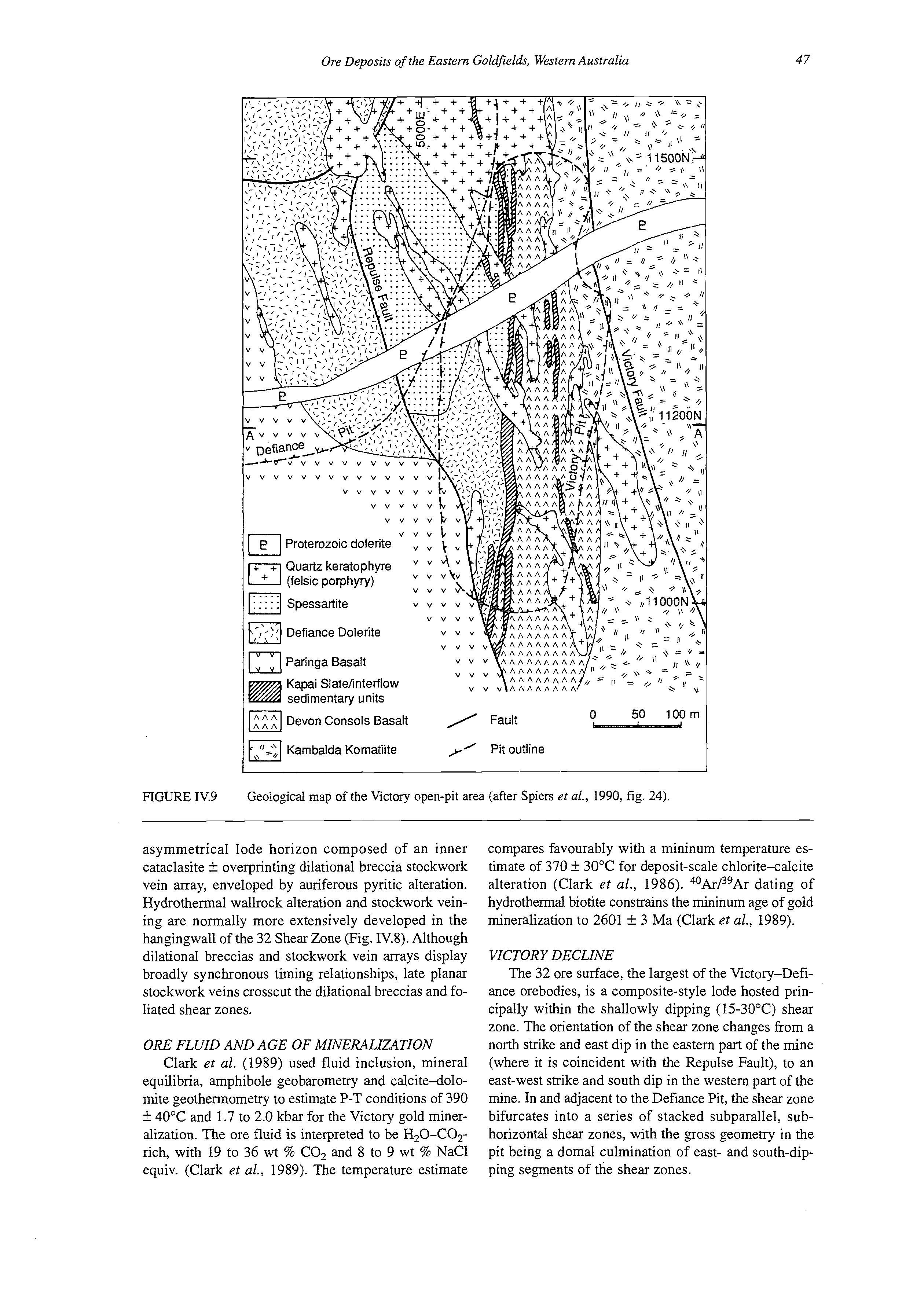
compares favourably with a mininum temperature estimate of 370 k 30°C for deposit-scale chlorite-calcite alteration (Clark et al., 1986). 40Ar/39Ardating of hydrothermal biotite constrains the mininum age of gold mineralization to 2601 k 3 Ma (Clark et al., 1989).
VICTORY DECLINE
The 32 ore surface, the largest of the Victory-Defiance orebodies, is a composite-style lode hosted principally within the shallowly dipping (15-30°C) shear zone. The orientation of the shear zone changes from a north strike and east dip in the eastern part of the mine (where it is coincident with the Repulse Fault), to an east-west strike and south dip in the western part of the mine. In and adjacent to the Defiance Pit, the shear zone bifurcates into a series of stacked subparallel, subhorizontal shear zones, with the gross geometry in the pit being a domal culmination of east- and south-dipping segments of the shear zones.
180/32 Red Ore Drive
The 180/32 Red Ore Drive accesses the main 32 ore surface about 30 m into the footwall of the Repulse Fault. At this locality, the ore zone is a composite-style lode consisting of both dilational breccia and stockwork vein-style mineralization. The dominant host rock is Paringa Basalt, but minor cherty interflow sedimentary units are present. There is typically an association of high gold values with pyritic alteration assemblages. The quartz-carbonate breccia and vein-infill material are typically barren or low grade.
100/32 Yellow Ore Drive
Exposures in the 100/32 Yellow Ore Drive are typical of the north-striking, east-dipping sections of the 32 ore surface where lode is coincident with the Repulse Fault. In contrast to the 180/32 Red locality, no significant overprinting dilational breccias are formed, although the shallowly west-dipping stockwork vein-set is present, particularly in the felsic porphyries. At this locality, the Repulse Fault is marked by development of a well-defined foliated cataclasite. The host rocks consist of hangingwall Paringa Basalt and a footwall lamprophyre (an intermediate intrusion locally termed xenolithic diorite). Felsic porphyry dykes are also abundant in this area.
DEFIANCE OPEN CUT
The Defiance lodes are confined largely to low-angle shear zone splays which branch from the footwall of the 32 Shear Zone and the Repulse Fault. The Repulse Fault is also mineralized and the entire zone defines a low-angle shear zone complex (Fig. IV.8).
All three styles of mineralization are recorded within the pit. Host rocks exert a strong control on the style of lode structure developed, with four rock types forming the main hosts to gold mineralization. The Paringa Basalt and quartz-rich Defiance Dolerite zones are typically dilationally brecciated with quartz*carbonate/albite matrices. In the amphibolechlorite-rich zones, lodes are narrower, strongly foliated and rarely brecciated. Mineralization associated with the quartz-feldspar porphyries occurs as crosscutting, tensional, stockwork vein arrays. Isolated high-grade patches of gold were recorded in the diopsidealmandine contact metamorphic aureole to the Proterozoic dolerite dyke.
East Wall
Three rock types are exposed in the east wall of the Defiance pit: lamprophyre (“xenolithic diorite”), Defiance Dolerite and felsic porphyry dykes (“quartz keratophyres”). The major structural features are the NNW-striking east-dipping (40-50”)Repulse Fault, and the various Defiance lode structures.
The lamprophyre is restricted within the pit to the hangingwall of the Repulse Fault, and is characterized by a set of vertical close-spaced (50-100 cm) quartzcarbonate veins. It is generally poorly mineralized.
The Defiance Dolerite is present within the footwall
of the Repulse Fault and hosts most of the shallow-dipping lode structures. The east wall shows the irregular nature of the quartz veining and dilational brecciation.
All rock types are intruded by a suite of subvertical, NNW-striking felsic dykes. The felsic dykes host a set of strongly developed horizontal stockwork veins. At least one phase of intrusion predates movement on the Repulse Fault. The more Fe-rich mafic rocks (zone 4, Defiance Dolerite; Paringa Basalt) are commonly mineralized adjacent to dyke margins.
South Wall
The south wall of the Defiance pit exposes two major rock types. The Paringa Basalt is exposed on the upper benches and, from the 270 to 290 m level, includes cherty interflow sedimentary units which indicate a shallow westerly dip. An east-west-trending Proterozoic quartz-dolerite dyke, 25 to 35 m wide, is exposed on the lower benches. The dyke has a 3 m-wide chilled margin and a coarse-grained gabbroic centre. The wallrock alteration halo varies from 5 to 8 m in width and contains a distinctive almandine-diopside mineralogy.
The major structural element exposed in the southern pit face is the Paringa Thrust. This is a moderately westerly dipping structure which defines the limit of the Defiance Dolerite and mineralized structures to the west.
The two quartz-breccia lodes exposed in the southern pit wall, south of the Proterozoic dyke, form part of the multiple lode systems typical of those mined in the pit. The lode structures converge to the west and form a thick (20 m) quartz-breccia ore zone (see below).
Composite quartz breccia and stoclwork vein lodes, West Wall
A classic composite ore zone of quartz breccia and stockwork vein arrays is exposed in the lower western wall of the Defiance pit. It consists of a series of subhorizontal shear zones, 0.1 to 1 m wide, with dilational quartz-breccias in places. The breccias overprint and sigmoidally deform the 1 to 5 cm-thick, shallowly west-dipping stockwork veins.
Adjacent to lode structures there is a pale albitebiotite-pyrite alteration assemblage which grades outwards into a darker more biotite-rich assemblage, and then into a pale green chlorite-calcite assemblage.
LOCALITY 4: LODE GOLD DEPOSITS OF THE COOLGARDIE DISTRICT
[based on Knight & Batten, 19931
Introduction
Archaean lode-gold deposits in the Coolgardie Goldfield (Fig. IV.10) occur as laminated quartz reefs (Bayleys, Kings Cross), narrow brittle-ductile shear zones sited along porphyry-ultramafic rock contacts (Tindals), fault-bounded quartz-vein sets (Lindsays), and gabbro-hosted quartz-vein sets (Three Mile Hill).
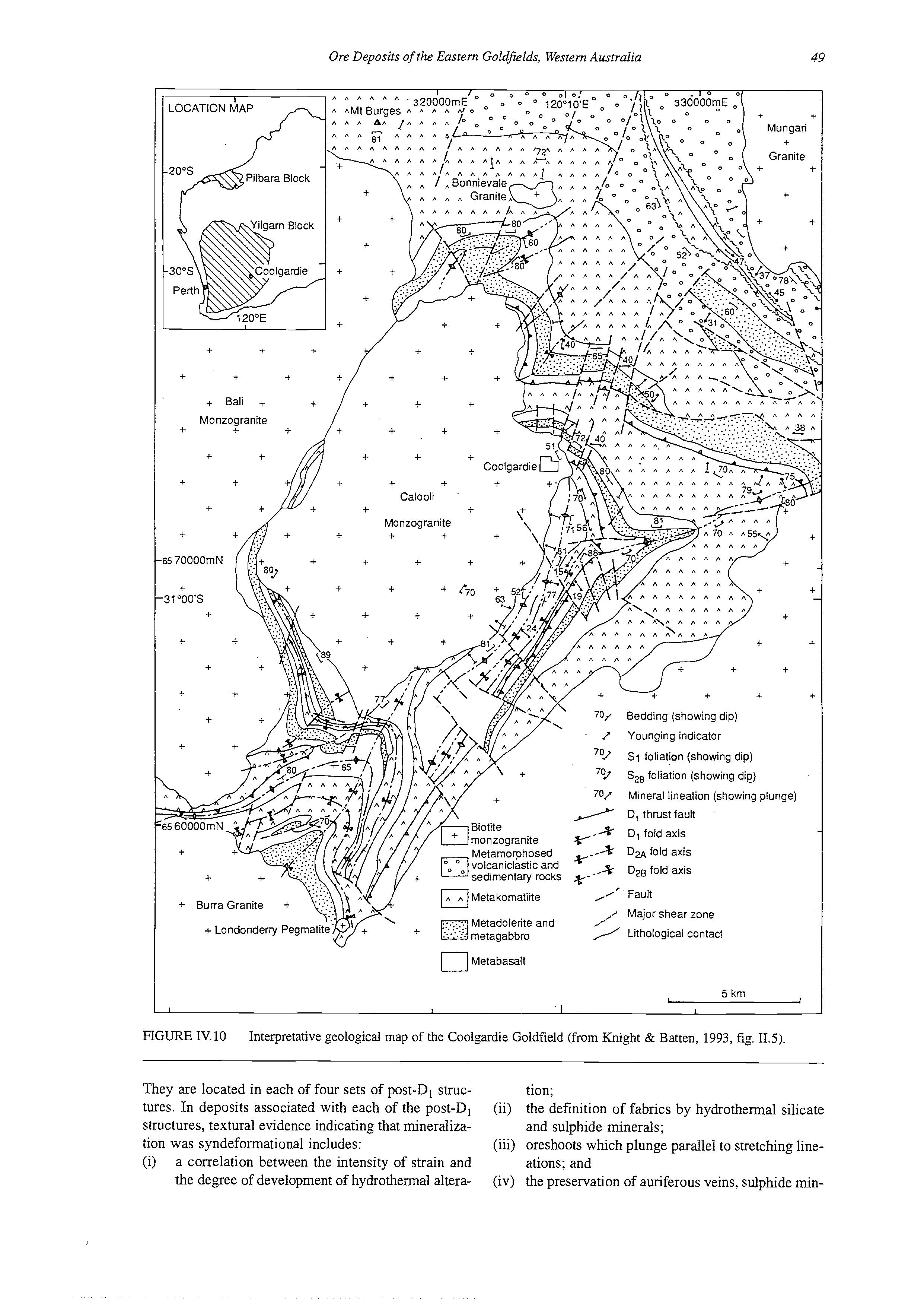
krn I I L I
FIGURE IV.10 Interpretative geological map of the Coolgardie Goldfield (from Knight & Batten, 1993, fig. 11.5).
They are located in each of four sets of post-D, structures. In deposits associated with each of the post-D, structures, textural evidence indicating that mineralization was syndefomational includes:
(i) a correlation between the intensity of strain and the degree of development of hydrothermal alteration;
(ii) the definition of fabrics by hydrothermal silicate and sulphide minerals;
(iii) oreshoots which plunge parallel to stretching lineations; and
(iv) the preservation of auriferous veins, sulphide min-
50 Geological Society of Australia (WA. Division), Excursion Guidebook 8, 1994
LOCATIONMAP 1
200s
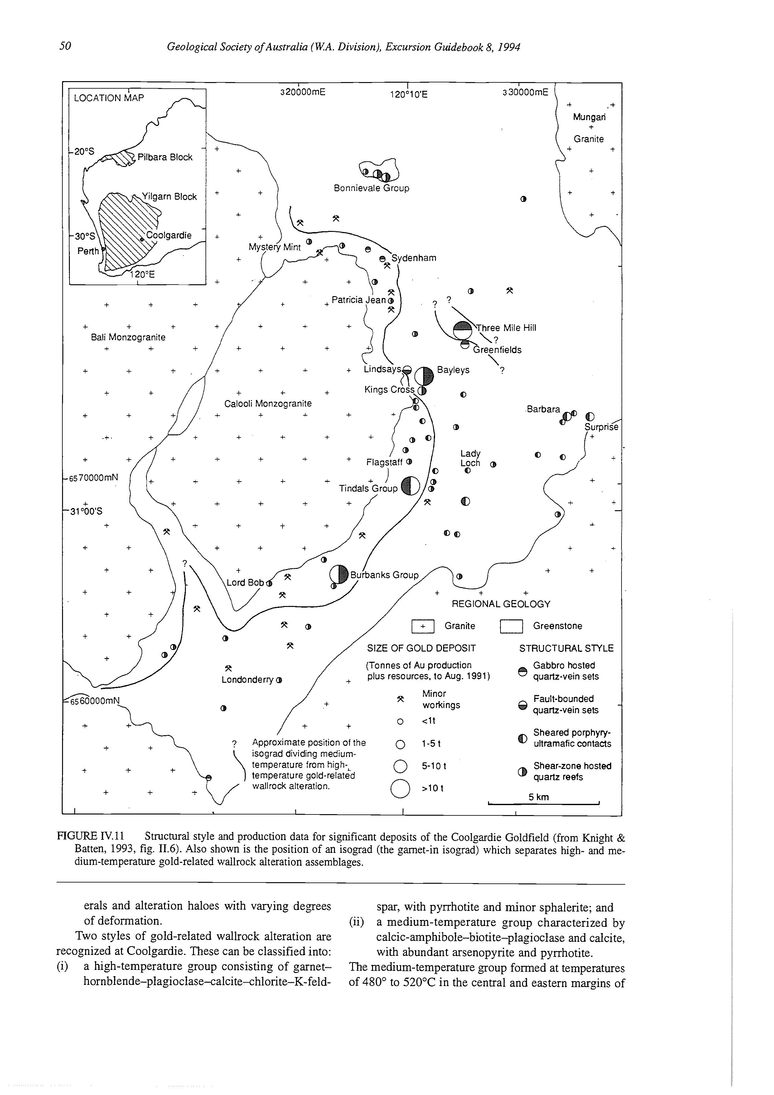
Pilbara Block
320000mE 120"lO'E 330000mE \ I
Bonnievale Group @ c Mungari Granite
REGIONALGEOLOGY /+I Granite 0 Greenstone
SIZE OF GOLD DEPOSIT
(Tonnes of Au production plus resources, to Aug. 1991)
STRUCTURAL STYLE
Fault-bounded
Sheared porphyry-
Approximate position of !he 0 1-5 t ultramafic cOntaCts isograd dividing mediumtemperature from high-&
Shear-zone hosted temperature gold-related wallrock alteration.
FIGURE IV. 11 Structural style and production data for significant deposits of the Coolgardie Goldfield (from Knight & Batten, 1993, fig. 11.6). Also shown is the position of an isograd (the garnet-in isograd) which separates high- and medium-temperature gold-related wallrock alteration assemblages.
erals and alteration haloes with varying degrees spar, with pyrrhotite and minor sphalerite; and of deformation.
(ii) a medium-temperature group characterized by Two styles of gold-related wallrock alteration are calcic-amphibole-biotite-plagioclase and calcite, recognized at Coolgardie. These can be classified into: with abundant arsenopyrite and pyrrhotite.
(i) a high-temperature group consisting of garnet- The medium-temperature group formed at temperatures hornblende-plagioclase-calcite-chlorite-K-feld- of 480" to 520°C in the central and eastern margins of
TABLE IV.5 Production and geological characteristics of sipificant mines in the Coolgardie Goldfield (modified from Knight & Batten, 1993, table 11.2). The standard error on temperature calculations quoted in the text and this table is 50°C and 1 kbar for pressure estimates.
Deposit Production Host rocks Structural
Bayleys
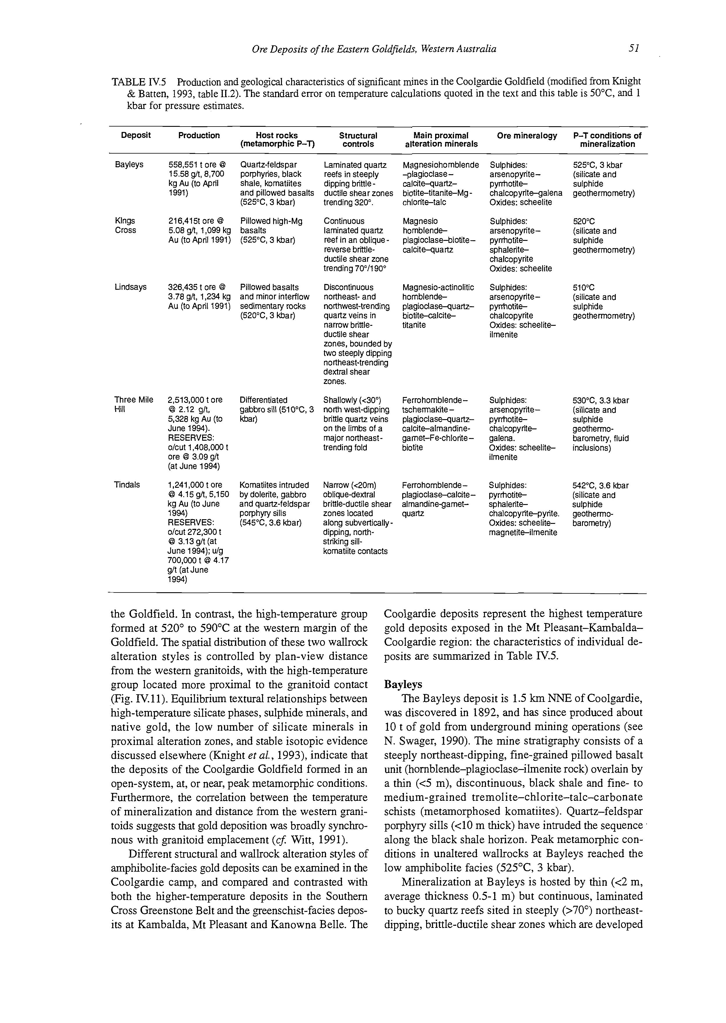
Klngs Cross
Lindsays
558.551 tore @ 15.58 g/t, 8,700 kg Au (to April 1991)
216.415t ore @ 5.08 g/t, 1,099 kg Au (to April 1991)
(metamorphic P-T) controls alteration minerals mineralization
Quartz-feldspar porphyries, black shale, komatiites and pillowed basalts (525"C, 3 kbar)
Pillowedhigh-Mg basalts (525"C, 3 kbar)
326,435tore @ 3.78 g/t, 1,234 kg Au (to April 1991)
Pillowedbasalts and minor interflow sedimentary rocks (520°C, 3 kbar)
Laminated quartz reefs in steeply dipping brittleductile shear zones trending 320'.
Continuous laminated quartz reef in an obliquereverse brittleductile shear zone trending 70°/1900
Discontinuous northeast-and northwest-trending quartz veins in narrow brittleductile shear zones, bounded by two steeply dipping northeast-trending dextral shear zones.
Magnesiohomblende -plagioclasecalcite-quartzbiotite-titanite-Mgchlorite-talc
Magnesio hornblendeplagioclase-biotitecalcite-quartz
Magnesio-actinolitic homblendeplagioclase-quartzbiotite-calcitetitanit e
Sulphides: arsenopyritepyrrhotitechalcopyritegalena
Oxides: scheelite
Sulphides: arsenopyritepyrrhotitesphaleritechalcopyrite
Oxides: scheelite
Sulphides: arsenopyritepyrrhotitechalcopyrite
Oxides: scheeliteilmenite
525"C, 3 kbar (silicateand sulphide geothermometry)
520°C (silicate and sulphide geothermometry)
510°C (silicate and sulphide geothermometry)
Three Mile Hill Tindals
2,513,000 tore @ 2.12 gn, 5,328 kg AU (to June 1994).
RESERVES: o/cut 1,408,000 t ore @ 3.09 g/t (at June 1994)
1,241,000 t ore @ 4.15 g/t, 5,150 kg Au (to June
RESERVES: o/cut 272,300 t @ 3.13 g/t (at June 1994); u/g 700,000 t @ 4.17 g/t (at June 1994) 1994)
Differentiated gabbro sill (510°C, 3 br)
Shallowly (<30") northwest-dipping brittle quartz veins on the limbs of a major northeasttrending fold
Komatiites intruded by dolerite, gabbro and quartz-feldspar porphyry sills (545"C, 3.6 kbar)
Narrow (<20rn) obliquedextral brittle-ductileshear zones located along subverticallydipping, northstrikingsillkornatiite contacts
Ferrohornblendetschermakiteplagioclase-quartzcalcite-alrnandinegarnet-fe-chloritebiotite
Ferrohornblendeplagioclase-calcitealmandine-gametquartz
Sulphides: arsenopyritepyrrhotitechalcopyritegalena.
Oxides: scheeliteilmenite
Sulphides: pyrrhotitesphaleritechalcopyrite-pyrite
Oxides: scheeiitemagnetite-ilmenite
53OoC,3.3 kbar (silicateand sulphide geothermobarometry, fluid inclusions)
542"C, 3.6 kbar (silicate and sulphide geothermobarometry)
the Goldfield. In contrast, the high-temperature group formed at 520" to 590°C at the western margin of the Goldfield. The spatial distribution of these two wallrock alteration styles is controlled by plan-view distance from the western granitoids, with the high-temperature group located more proximal to the granitoid contact (Fig. IV. 11). Equilibrium textural relationships between high-temperature silicate phases, sulphide minerals, and native gold, the low number of silicate minerals in proximal alteration zones, and stable isotopic evidence discussed elsewhere (Knight ef al., 1993), indicate that the deposits of the Coolgardie Goldfield formed in an open-system, at, or near, peak metamorphic conditions. Furthermore, the correlation between the temperature of mineralization and distance from the western granitoids suggests that gold deposition was broadly synchronous with granitoid emplacement (cf: Witt, 1991).
Different structural and wallrock alteration styles of amphibolite-facies gold deposits can be examined in the Coolgardie camp, and compared and contrasted with both the higher-temperature deposits in the Southern Cross Greenstone Belt and the greenschist-faciesdeposits at Kambalda, Mt Pleasant and Kanowna Belle. The
Coolgardie deposits represent the highest temperature gold deposits exposed in the Mt Pleasant-KambaldaCoolgardie region: the characteristics of individual deposits are summarized in Table IV.5.
Bayleys
The Bayleys deposit is 1.5 km "Eiof Coolgardie, was discovered in 1892, and has since produced about 10 t of gold from underground mining operations (see N. Swager, 1990). The mine stratigraphy consists of a steeply northeast-dipping, fine-grained pillowed basalt unit (hornblende-plagioclase-ilmenite rock) overlain by a thin (<5 m), discontinuous, black shale and fine- to medium-grained tremolite-chlorite-talc-carbonate schists (metamorphosed komatiites). Quartz-feldspar porphyry sills (<lo m thick) have intruded the sequence along the black shale horizon. Peak metamorphic conditions in unaltered wallrocks at Bayleys reached the low amphibolite facies (525"C, 3 kbar).
Mineralization at Bayleys is hosted by thin (<2 m, average thickness 0.5-1 m) but continuous, laminated to bucky quartz reefs sited in steeply (>70°) northeastdipping, brittle-ductile shear zones which are developed
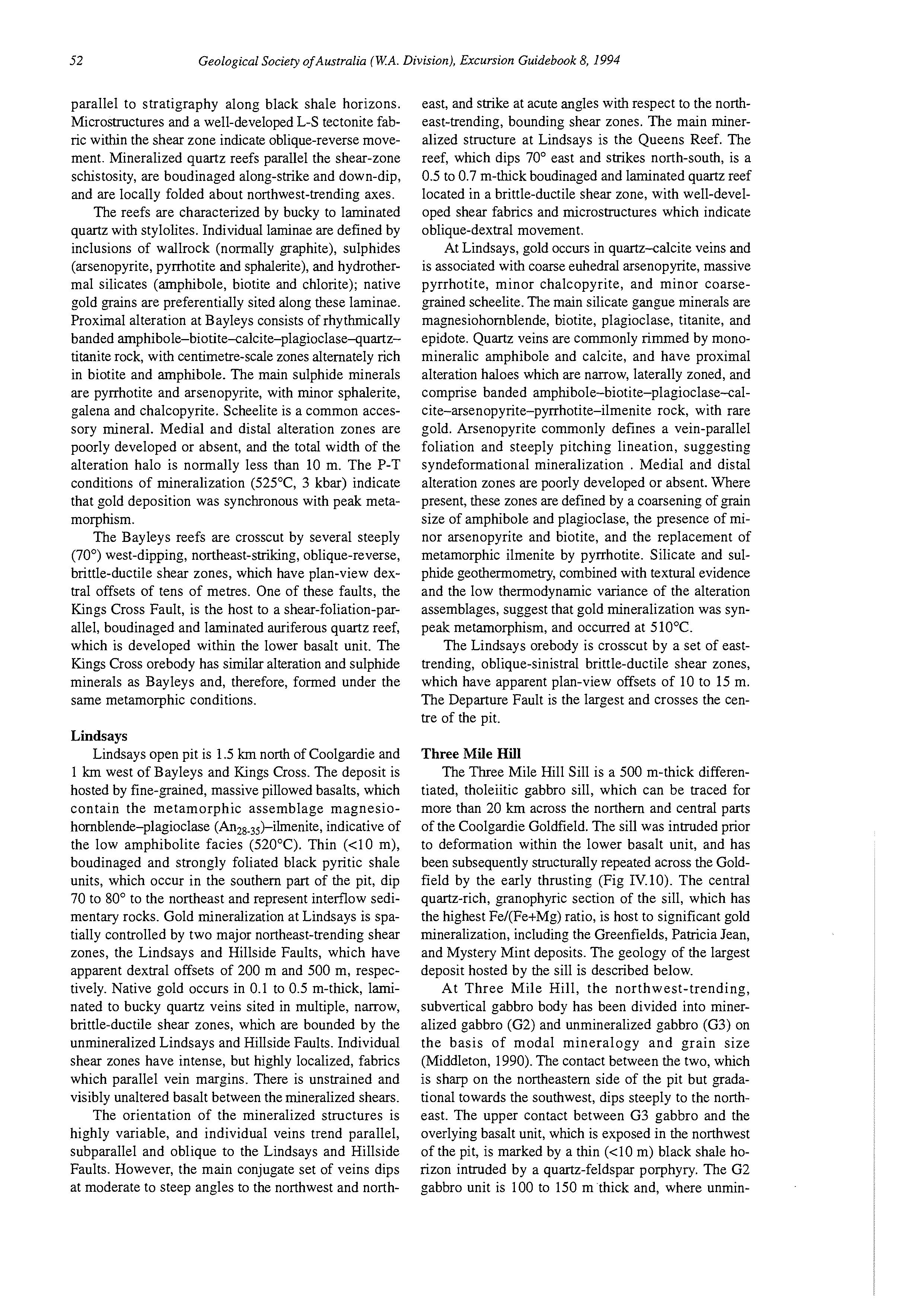
parallel to stratigraphy along black shale horizons. Microstructures and a well-developed L-S tectonite fabric within the shear zone indicate oblique-reverse movement. Mineralized quartz reefs parallel the shear-zone schistosity, are boudinaged along-strike and down-dip, and are locally folded about northwest-trending axes.
The reefs are characterized by bucky to laminated quartz with stylolites. Individual laminae are defined by inclusions of wallrock (normally graphite), sulphides (arsenopyrite, pyrrhotite and sphalerite), and hydrothermal silicates (amphibole, biotite and chlorite); native gold grains are preferentially sited along these laminae. Proximal alteration at Bayleys consists of rhythmically banded amphibole-biotite-calcite-plagioclase-quartztitanite rock, with centimetre-scale zones alternately rich in biotite and amphibole. The main sulphide minerals are pyrrhotite and arsenopyrite, with minor sphalerite, galena and chalcopyrite. Scheelite is a common accessory mineral. Medial and distal alteration zones are poorly developed or absent, and the total width of the alteration halo is normally less than 10 m. The P-T conditions of mineralization (525OC, 3 kbar) indicate that gold deposition was synchronous with peak metamorphism.
The Bayleys reefs are crosscut by several steeply (70') west-dipping, northeast-striking, oblique-reverse, brittle-ductile shear zones, which have plan-view dextral offsets of tens of metres. One of these faults, the Kings Cross Fault, is the host to a shear-foliation-parallel, boudinaged and laminated auriferous quartz reef, which is developed within the lower basalt unit. The Kings Cross orebody has similar alteration and sulphide minerals as Bayleys and, therefore, formed under the same metamorphic conditions.
Lindsays
Lindsays open pit is 1.5 km north of Coolgardie and 1 km west of Bayleys and Kings Cross. The deposit is hosted by fine-grained, massive pillowed basalts, which contain the metamorphic assemblage magnesiohornblende-plagioclae (An,,,,)-ilmenite, indicative of the low amphibolite facies (520°C). Thin (<lo m), boudinaged and strongly foliated black pyritic shale units, which occur in the southern part of the pit, dip 70 to 80' to the northeast and represent interflow sedimentary rocks. Gold mineralization at Lindsays is spatially controlled by two major northeast-trending shear zones, the Lindsays and Hillside Faults, which have apparent dextral offsets of 200 m and 500 m, respectively. Native gold occurs in 0.1 to 0.5 m-thick, laminated to bucky quartz veins sited in multiple, narrow, brittle-ductile shear zones, which are bounded by the unmineralized Lindsays and Hillside Faults. Individual shear zones have intense, but highly localized, fabrics which parallel vein margins. There is unstrained and visibly unaltered basalt between the mineralized shears. The orientation of the mineralized structures is highly variable, and individual veins trend parallel, subparallel and oblique to the Lindsays and Hillside Faults. However, the main conjugate set of veins dips at moderate to steep angles to the northwest and north-
east, and strike at acute angles with respect to the northeast-trending, bounding shear zones. The main mineralized structure at Lindsays is the Queens Reef. The reef, which dips 70" east and strikes north-south, is a 0.5 to 0.7 m-thick boudinaged and laminated quartz reef located in a brittle-ductile shear zone, with well-developed shear fabrics and microstructures which indicate oblique-dextral movement.
At Lindsays, gold occurs in quartz-calcite veins and is associated with coarse euhedral arsenopyrite, massive pyrrhotite, minor chalcopyrite, and minor coarsegrained scheelite. The main silicate gangue minerals are magnesiohornblende, biotite, plagioclase, titanite, and epidote. Quartz veins are commonly rimmed by monomineralic amphibole and calcite, and have proximal alteration haloes which are narrow, laterally zoned, and comprise banded amphibole-biotite-plagioclase-calcite-arsenopyrite-pyrrhotite-ilmenite rock, with rare gold. Arsenopyrite commonly defines a vein-parallel foliation and steeply pitching lineation, suggesting syndeformational mineralization . Medial and distal alteration zones are poorly developed or absent. Where present, these zones are defined by a coarsening of grain size of amphibole and plagioclase, the presence of minor arsenopyrite and biotite, and the replacement of metamorphic ilmenite by pyrrhotite. Silicate and sulphide geothermometry, combined with textural evidence and the low thermodynamic variance of the alteration assemblages, suggest that gold mineralization was synpeak metamorphism, and occurred at 5 IO'C.
The Lindsays orebody is crosscut by a set of easttrending, oblique-sinistral brittle-ductile shear zones, which have apparent plan-view offsets of 10 to 15 m. The Departure Fault is the largest and crosses the centre of the pit.
Three Mile Hill
The Three Mile Hill Sill is a 500 m-thick differentiated, tholeiitic gabbro sill, which can be traced for more than 20 km across the northern and central parts of the Coolgardie Goldfield. The sill was intruded prior to deformation within the lower basalt unit, and has been subsequently structurally repeated across the Goldfield by the early thrusting (Fig IV.10). The central quartz-rich, granophyric section of the sill, which has the highest Fe/(Fe+Mg) ratio, is host to significant gold mineralization, including the Greenfields, Patricia Jean, and Mystery Mint deposits. The geology of the largest deposit hosted by the sill is described below.
At Three Mile Hill, the northwest-trending, subvertical gabbro body has been divided into mineralized gabbro (G2) and unmineralized gabbro (G3) on the basis of modal mineralogy and grain size (Middleton, 1990). The contact between the two, which is sharp on the northeastern side of the pit but gradational towards the southwest, dips steeply to the northeast. The upper contact between G3 gabbro and the overlying basalt unit, which is exposed in the northwest of the pit, is marked by a thin (<lo m) black shale horizon intruded by a quartz-feldspar porphyry. The G2 gabbro unit is 100 to 150 m thick and, where unmin-
eralized, is generally massive, homogeneous, and consists of the equilibrium assemblage ferrohornblendeplagioclase(An18_30)-ilmenite-quartzwith minor garnet. Peak metamorphic temperatures reached the low amphibolite facies (510-530°C).
Three Mile Hill mine is located on the eastern limb of a major northeast-trending, steeply southwest-plunging open anticline. Mineralization is confined to the G2 gabbro (and can therefore be classified as stratabound), and sited in narrow (<0.5 m), strike-continuous (50-100 m), brittle bucky quartz-calcite-amphibole-arsenopyrite-pyrrhotite veins and their associated alteration haloes, which dip shallowly (<30") to the northwest. Arsenopyrite, the dominant sulphide, is commonly coarsegrained, euhedral and associated with native gold; pyrrhotite is typically coarse grained and massive. Accessory ore minerals include scheelite, chalcopyrite and galena. Silicate vein minerals include plagioclase-amphibole-titanite and minor biotite. Mineralized veins in the G2 gabbro are mainly undeformed, except they are crosscut by a set of steeply dipping (60-80"), northeasttrending, brittle-ductile shear zones.
Wallrock alteration can be divided into three zones, described below.
Proximal alteration, characterized by intense bleaching, consists of plagioclase(Ano-3)-homblende-calcite-quartz-arsenopyrite-pyrrhotite, with minor almandine garnet, titanite, biotite and rare native gold. Auriferous quartz veins are commonly rimmed by monomineralic calcite andor arsenopyrite and pyrrhotite
Medial alteration is characterised by moderate bleaching and a similar assemblage to that which occurs in the proximal alteration zone, except that sulphides are less abundant and hornblende is the main silicate phase.
Distal alteration appears weakly bleached, contains trace calcite, biotite, arsenopyrite and pyrrhotite, but mainly consists of minerals characteristic of unaltered G2 gabbro.
The transition from unaltered G2 gabbro to a gold-bearing quartz vein can occur on the scale of 10 cm; distal and proximal alteration haloes are commonly weakly developed or absent.
Geothermobaromeby and analysis of fluid inclusions in gold-related quartz indicates that gold mineralization was peak-metamorphicand occurred at about 530°C and 3.3 kbar. Gold mineralization at Three Mile Hill is structurally similar to deposits located in other differentiated mafic sills in the Kalgoorlie district (cj Witt, 1993). However, it has the highest temperature mineralization of the known deposits hosted by these sills.
LOCALITY 5: LODE GOLD DEPOSITS OF
KALGOORLIE-BOULDER
[based on Sauter, 19931
Introduction
Since their discovery in 1893, the Kalgoorlie gold deposits have produced a total of about 1300 tonnes (43 million oz) of gold from 150 million tonnes of ore. This equates to about 1% of the total world gold production. Most of this production has come from the lodes of the Golden Mile, historically mined by underground methods, and currently the site of a large-scale open-pit operation. Other significant production has come from the Mt Charlotte and Hannans North underground mines, and the Mt Percy open pit. Current resources are in excess of 18 million oz of gold.
Regional geology
At Kalgoorlie, the stratigraphic sequence has been well established since the mid-1960s (Woodall, 1965; Fig. IV.12). It consists of a series of komatiitic to highMg to tholeiitic volcanic units (Hannans Lake Serpentinite, Devon Consols Basalt and Paringa Basalt), intercalated with thin sedimentary horizons, including the sulphidic black shales and cherts of the Kapai Slate. This sequence is overlain by the volcanic-sedimentary series of the Black Flag Beds.
Several differentiated doleritic sills are concordant within or between the stratigraphic units. The economically most important of these is the Golden Mile Dolerite. It has been subdivided into ten units (Travis et al., 1971) showing a tholeiitic differentiation trend. Clark (1980) showed that the sequence resulted from in situ differentiation in a gabbroic sill.
Recent work (Clout et al., 1990) has resulted in a re-interpretation of the Gold Mile Dolerite geology immediately to the south and east of the Golden Mile. Dolerites previously thought to be extensions of the Golden Mile Dolerite were identified as separate intrusions, the Aberdare and Eureka Dolerites (Fig. IV.12). This interpretation has important implications for the structural geology of the Golden Mile area.
The metamorphic grade in the Kalgoorlie area is lower to mid-greenschist facies.
Structure
Structure in the Kalgoorlie Goldfield is dominated by tight, northwest-trending, upright folds; strike-parallel faults; and late, north-trending, oblique faults (Fig. IV.12).
The Kalgoorlie Syncline and Anticline are the earliest D, structures recognized (Swager, 1989). The Kalgoorlie Syncline is an asymmetrical structure, with a very steeply dipping westerly limb and a moderately dipping easterly limb (Fig. IV.13). A core of Black Flag Group rocks is bound on the eastern side by the Golden
FIGURE IV.12 (page 54)
FIGURE IV.13 (page 55)
Interpreted geology of the Kalgoorlie area (from Sauter, 1993, fig. 1).
Cross-section A-B (see Fig. IV.14) through the Golden Mile (from Sauter, 1993, fig. 2)
ABERDAHE DOLERITE
FEDEWL DOLERITE EUREKA DOLERITE
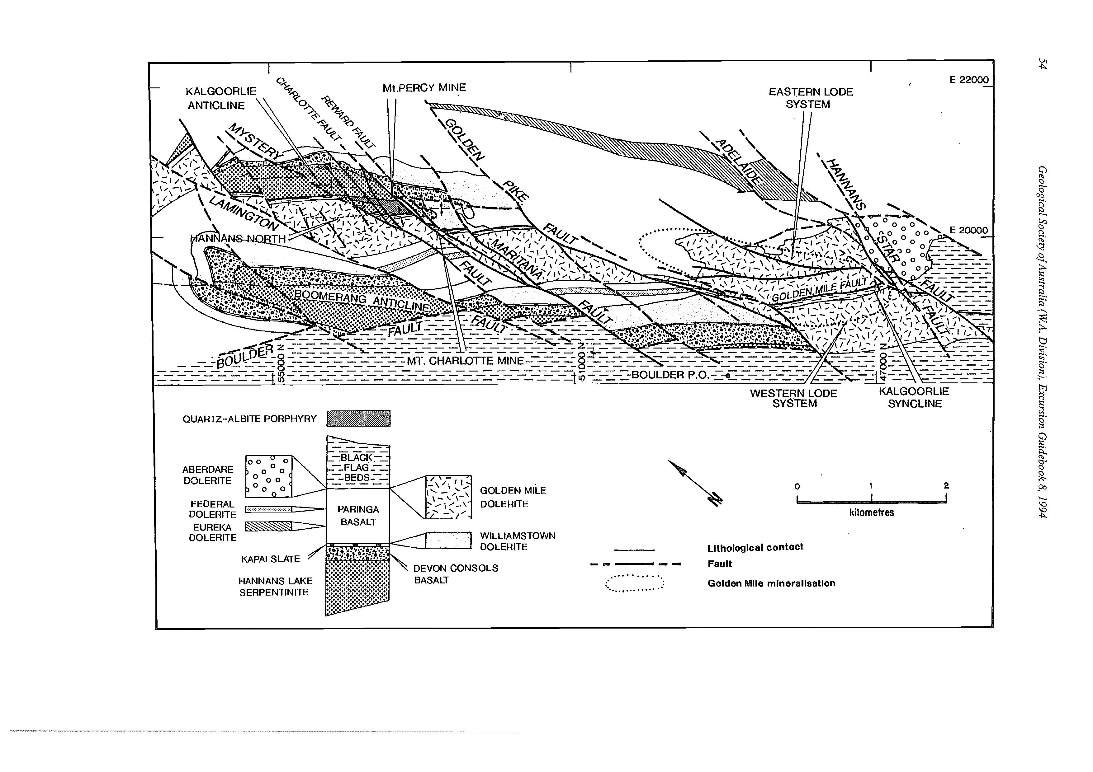
Llthologlcalcontact
KAPAl SLATE SERPENTINITE 0 I 2 kilometres
Golden Mile mlnerallsatlon
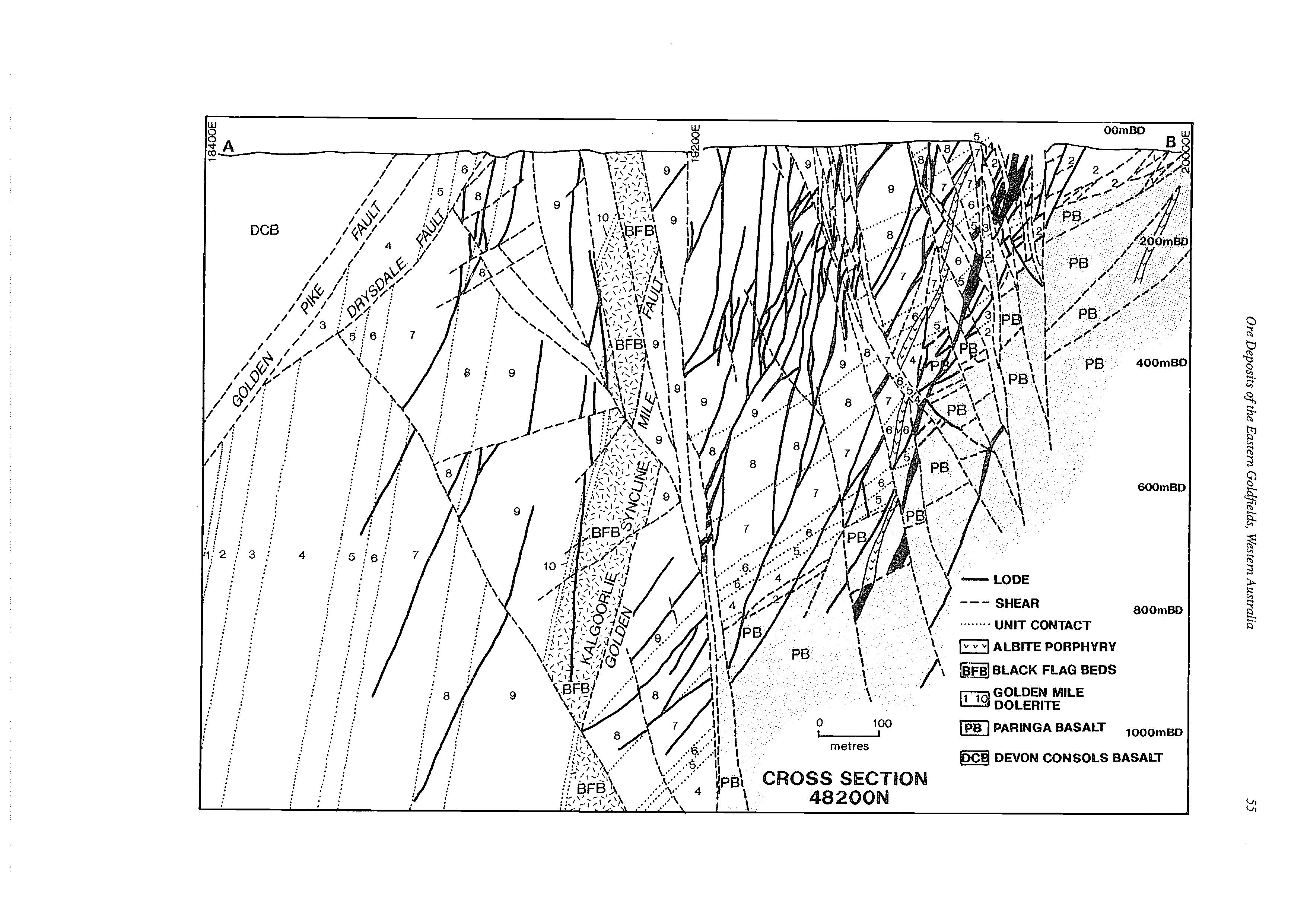
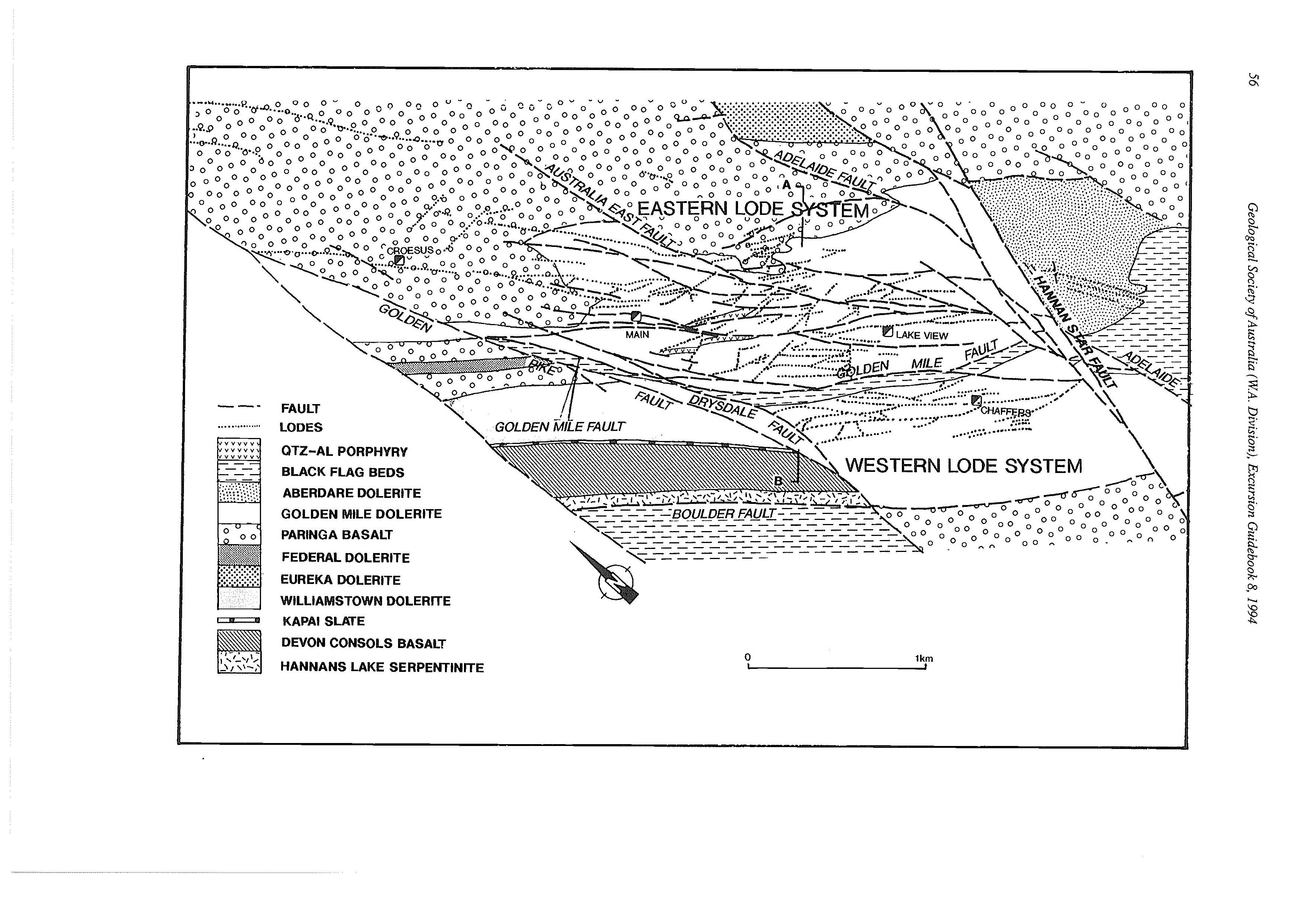
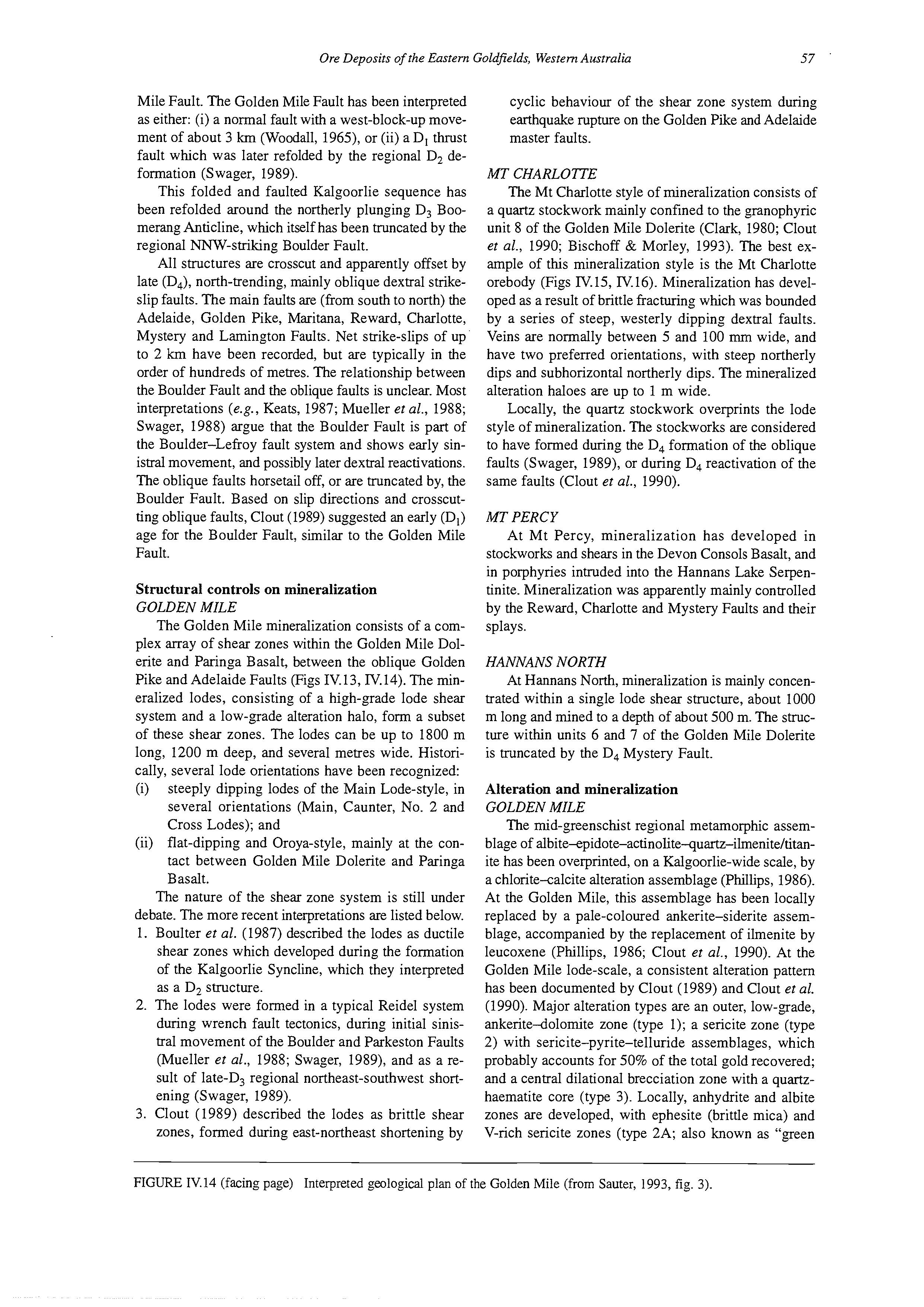
Mile Fault. The Golden Mile Fault has been interpreted as either: (i) a normal fault with a west-block-up movement of about 3 km (Woodall, 1965), or (ii) a D, thrust fault which was later refolded by the regional D, deformation (Swager, 1989).
This folded and faulted Kalgoorlie sequence has been refolded around the northerly plunging D, Boomerang Anticline, which itself has been truncated by the regional "W-striking Boulder Fault.
All structures are crosscut and apparently offset by late (D4),north-trending, mainly oblique dextral strikeslip faults. The main faults are (from south to north) the Adelaide, Golden Pike, Maritana, Reward, Charlotte, Mystery and Lamington Faults. Net strike-slips of up to 2 h have been recorded, but are typically in the order of hundreds of metres. The relationship between the Boulder Fault and the oblique faults is unclear. Most interpretations (e.g., Keats, 1987; Mueller et al., 1988; Swager, 1988) argue that the Boulder Fault is part of the Boulder-Lefroy fault system and shows early sinistral movement, and possibly later dextral reactivations. The oblique faults horsetail off, or are truncated by, the Boulder Fault. Based on slip directions and crosscutting oblique faults, Clout (1989) suggested an early (D,) age for the Boulder Fault, similar to the Golden Mile Fault.
Structural controls on mineralization GOLDEN MILE
The Golden Mile mineralization consists of a complex array of shear zones within the Golden Mile Dolerite and Paringa Basalt, between the oblique Golden Pike and Adelaide Faults (Figs IV.13, IV.14). The mineralized lodes, consisting of a high-grade lode shear system and a low-grade alteration halo, form a subset of these shear zones. The lodes can be up to 1800 m long, 1200 m deep, and several metres wide. Historically, several lode orientations have been recognized:
(i) steeply dipping lodes of the Main Lode-style, in several orientations (Main, Caunter, No. 2 and Cross Lodes); and (ii) flat-dipping and Oroya-style, mainly at the contact between Golden Mile Dolerite and Paringa Basalt.
The nature of the shear zone system is still under debate. The more recent interpretations are listed below.
1. Boulter et al. (1987) described the lodes as ductile shear zones which developed during the formation of the Kalgoorlie Syncline, which they interpreted as a D, structure.
2. The lodes were formed in a typical Reidel system during wrench fault tectonics, during initial sinistral movement of the Boulder and Parkeston Faults (Mueller et al., 1988; Swager, 1989), and as a result of late-D, regional northeast-southwest shortening (Swager, 1989).
3. Clout (1989) described the lodes as brittle shear zones, formed during east-northeast shortening by
cyclic behaviour of the shear zone system during earthquake rupture on the Golden Pike and Adelaide master faults.
MT CHARLOTTE
The Mt Charlotte style of mineralization consists of a quartz stockwork mainly confined to the granophyric unit 8 of the Golden Mile Dolerite (Clark, 1980; Clout et al., 1990; Bischoff & Morley, 1993). The best example of this mineralization style is the Mt Charlotte orebody (Figs IV. 15, IV.16). Mineralization has developed as a result of brittle fracturing which was bounded by a series of steep, westerly dipping dextral faults. Veins are normally between 5 and 100 mm wide, and have two preferred orientations, with steep northerly dips and subhorizontal northerly dips. The mineralized alteration haloes are up to 1 m wide.
Locally, the quartz stockwork overprints the lode style of mineralization. The stockworks are considered to have formed during the D, formation of the oblique faults (Swager, 1989), or during D, reactivation of the same faults (Clout et al., 1990).
MT PERCY
At Mt Percy, mineralization has developed in stockworks and shears in the Devon Consols Basalt, and in porphyries intruded into the Hannans Lake Serpentinite. Mineralization was apparently mainly controlled by the Reward, Charlotte and Mystery Faults and their splays.
HANNANS NORTH
At Hannans North, mineralization is mainly concentrated within a single lode shear structure, about 1000 m long and mined to a depth of about 500 m. The structure within units 6 and 7 of the Golden Mile Dolerite is truncated by the D4 Mystery Fault.
Alteration and mineralization
GOLDEN MILE
The mid-greenschist regional metamorphic assemblage of albite-epidote-actinolite-quaxtz-ilmenite/titanite has been overprinted, on a Kalgoorlie-wide scale, by a chlorite-calcite alteration assemblage (Phillips, 1986). At the Golden Mile, this assemblage has been locally replaced by a pale-coloured ankerite-siderite assemblage, accompanied by the replacement of ilmenite by leucoxene (Phillips, 1986; Clout et al., 1990). At the Golden Mile lode-scale, a consistent alteration pattern has been documented by Clout (1989) and Clout et al. (1990). Major alteration types are an outer, low-grade, ankerite-dolomite zone (type 1); a sericite zone (type 2) with sericite-pyrite-telluride assemblages, which probably accounts for 50% of the total gold recovered; and a central dilational brecciation zone with a quartzhaematite core (type 3). Locally, anhydrite and albite zones are developed, with ephesite (brittle mica) and V-rich sericite zones (type 2A; also known as "green
FIGURE IV.14 (facing page) Interpreted geological plan of the Golden Mile (from Sauter, 1993, fig. 3).
FIGURE IV.15 Surface plan of the Mt Charlotte area showing locations of the Maritana, Reward, Charlotte, Pharlap and Reservoir stockworks in relation to unit 8 of the Golden Mile Dolerite and oblique faults (from Bischoff & Morley, 1993, fig. 6).
leader”) at the top of the lodes. The V-bearing minerals and tellurides indicate very high gold tenors. Gold at the Golden Mile occurs in the native state or as gold and silver tellurides, commonly intimately associated with pyrite. The ore is refractory.
The proposed position of some of the alteration zones (Fig. IV.17) would indicate, for the first time, a vertical zonation of the lodes (Clout, 1989). The interpretation that green leader ores are part of the alteration zonation contrasts with findings from other workers who argue that green leader, including the highgrade Oroya shoot, is a separate, possibly later, ore type, mainly formed close to the contact between Golden Mile Dolerite and Paringa Basalt, in association with sedimentary units (cf. Phillips, 1986; Swager, 1989).
MT CHARLOTTE
At Mt Charlotte, the semi-regional chlorite-calcite alteration is replaced by chlorite-ankerite(-sulphide) and ankerite-sericite-sulphide in alteration haloes around the quartz veins (Clark, 1980; Neall, 1985; Clout et al., 1990). Pyrite and pyrrhotite are the dominant sulphide species, with pyrrhotite increasing in abundance with depth. Gold is present as 5 to 15 pm grains in fractures of pyrite or as blebs at pyrite grain boundaries, and there are minor tellurides. The ore is free milling.
MT PERCY
At Mt Percy, porphyries and basalts exhibit wide-
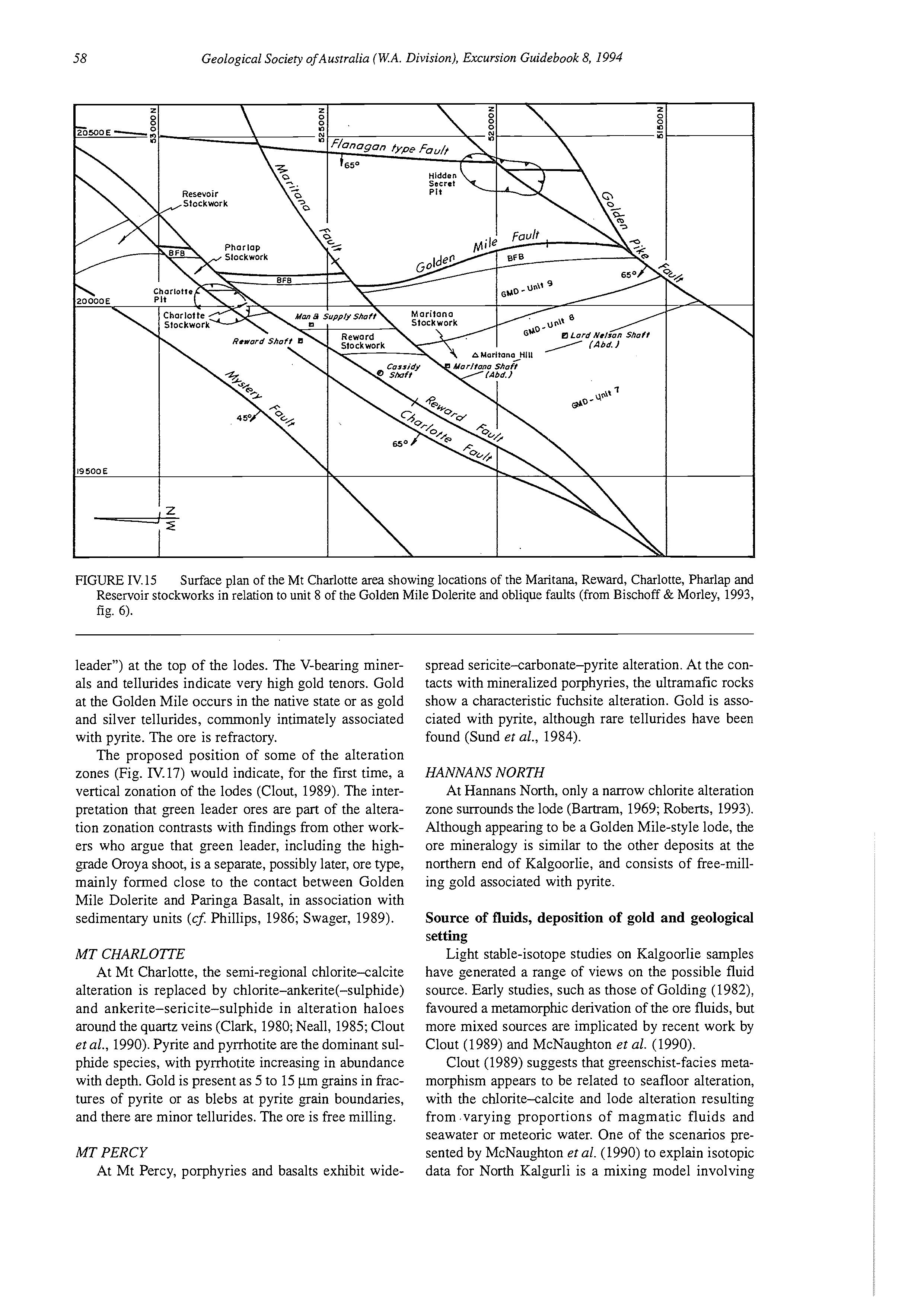
spread sericite-carbonate-pyrite alteration. At the contacts with mineralized porphyries, the ultramafic rocks show a characteristic fuchsite alteration. Gold is associated with pyrite, although rare tellurides have been found (Sund et al., 1984).
HANNANS NORTH
At Hannans North, only a narrow chlorite alteration zone surrounds the lode (Bartram, 1969; Roberts, 1993). Although appearing to be a Golden Mile-style lode, the ore mineralogy is similar to the other deposits at the northern end of Kalgoorlie, and consists of free-milling gold associated with pyrite.
Source of fluids, deposition of gold and geological setting
Light stable-isotope studies on Kalgoorlie samples have generated a range of views on the possible fluid source. Early studies, such as those of Golding (1982): favoured a metamorphic derivation of the ore fluids, but more mixed sources are implicated by recent work by Clout (1989) and McNaughton et al. (1990).
Clout (1989) suggests that greenschist-facies metamorphism appears to be related to seafloor alteration, with the chlorite-calcite and lode alteration resulting from ,varying proportions of magmatic fluids and seawater or meteoric water. One of the scenarios presented by McNaughton et al. (1990) to explain isotopic data for North Kalgurli is a mixing model involving
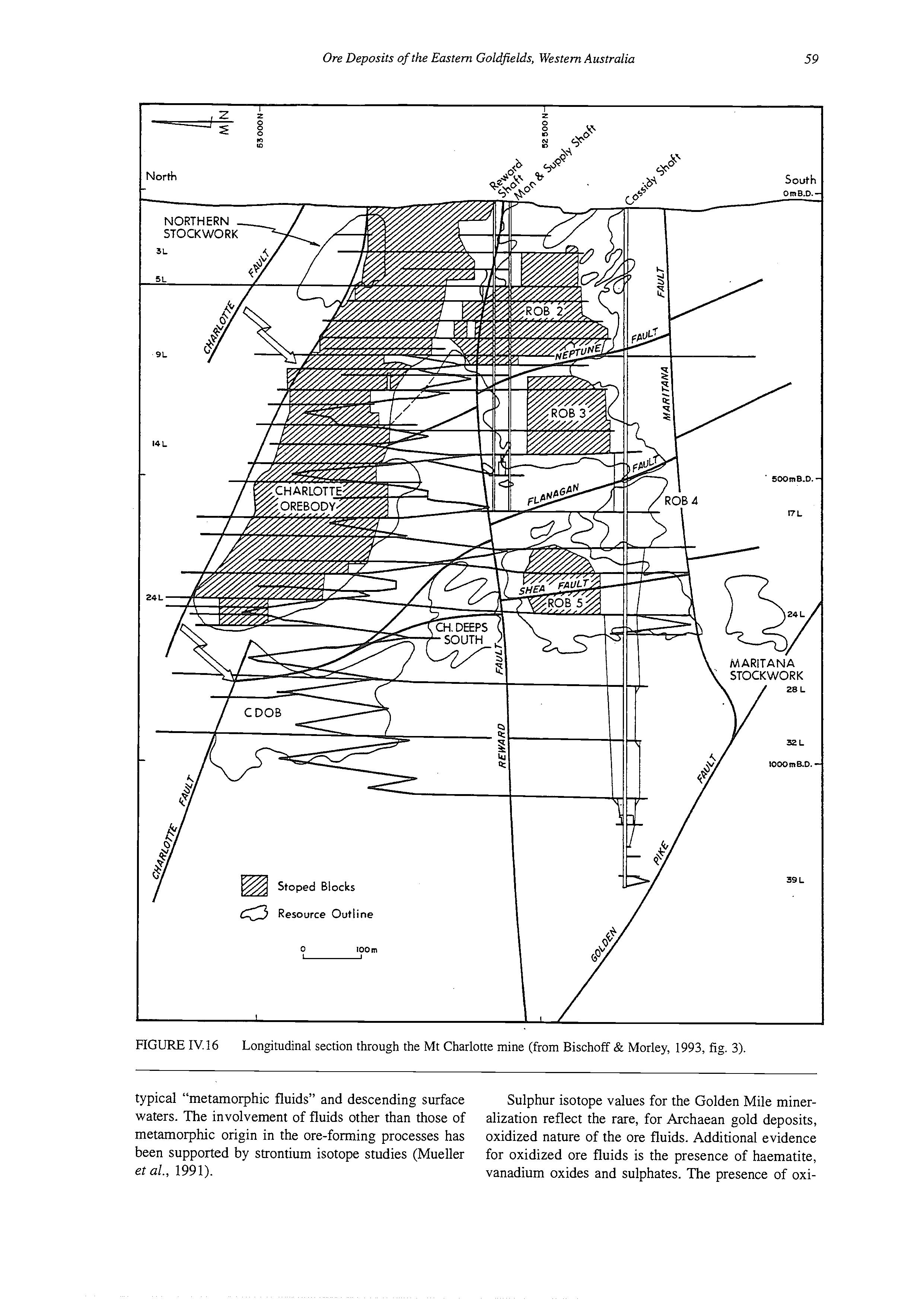
FIGURE IV.16 Longitudinal section through the Mt Charlotte mine (from Bischoff & Morley, 1993, fig. 3).
typical “metamorphic fluids” and descending surface waters. The involvement of fluids other than those of metamorphic origin in the ore-forming processes has been supported by strontium isotope studies (Mueller et al., 1991).
Sulphur isotope values for the Golden Mile mineralization reflect the rare, for Archaean gold deposits, oxidized nature of the ore fluids. Additional evidence for oxidized ore fluids is the presence of haematite, vanadium oxides and sulphates. The presence of oxi-
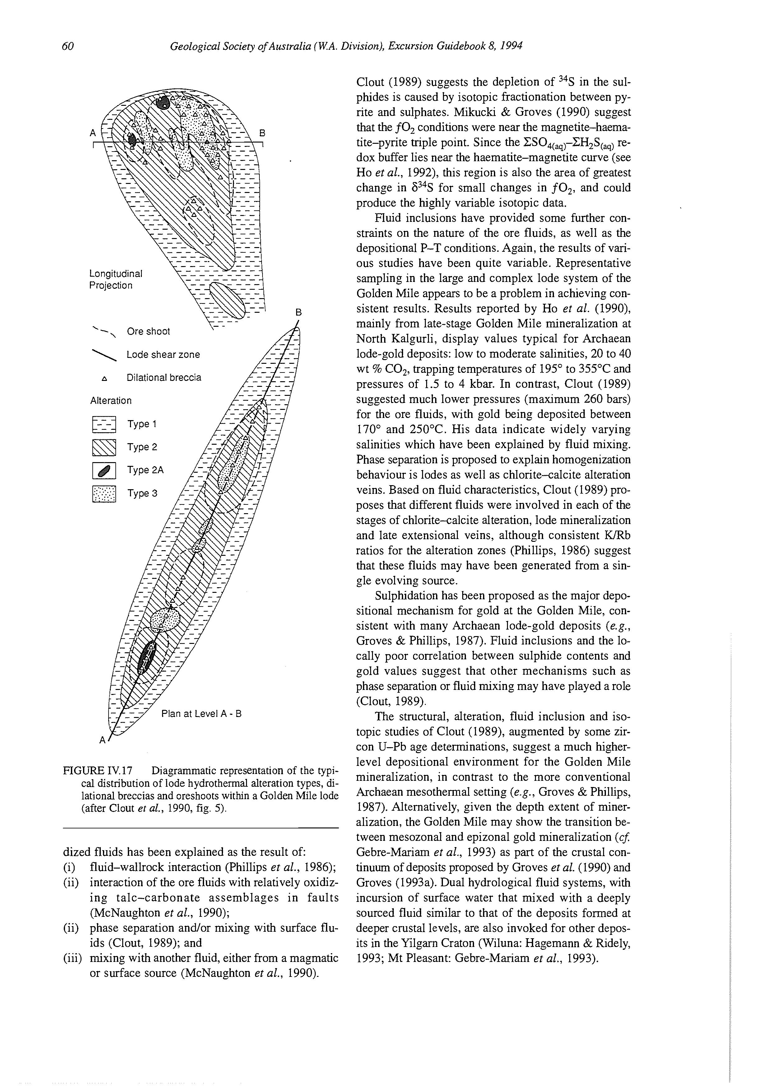
FIGURE IV. 17 Diagrammatic representation of the typical distribution of lode hydrothermal alteration types, dilational breccias and oreshoots within a Golden Mile lode (after Clout er aL, 1990, fig. 5).
dized fluids has been explained as the result of
(i) fluid-wallrock interaction (Phillips et al., 1986); (ii) interaction of the ore fluids with relatively oxidizing talc-carbonate assemblages in faults (McNaughton et al., 1990);
(ii) phase separation andor mixing with surface fluids (Clout, 1989); and
(iii) mixing with another fluid, either from a magmatic or surface source (McNaughton et al., 1990).
Clout (1989) suggests the depletion of 34S in the sulphides is caused by isotopic fractionation between pyrite and sulphates. Mikucki & Groves (1990) suggest that the f0, conditions were near the magnetite-haematite-pyrite triple point. Since the CSO,(,)-CH,S~,,) redox buffer lies near the haematite-magnetite curve (see Ho et al., 1992), this region is also the area of greatest change in 634S for small changes in fO,, and could produce the highly variable isotopic data.
Fluid inclusions have provided some further constraints on the nature of the ore fluids, as well as the depositional P-T conditions. Again, the results of various studies have been quite variable. Representative sampling in the large and complex lode system of the Golden Mile appears to be a problem in achieving consistent results. Results reported by Ho et al. (1990), mainly from late-stage Golden Mile mineralization at North Kalgurli, display values typical for Archaean lode-gold deposits: low to moderate salinities, 20 to 40 wt % CO,, trapping temperatures of 195" to 355°C and pressures of 1.5 to 4 kbar. In contrast, Clout (1989) suggested much lower pressures (maximum 260 bars) for the ore fluids, with gold being deposited between 170" and 250°C. His data indicate widely varying salinities which have been explained by fluid mixing. Phase separation is proposed to explain homogenization behaviour is lodes as well as chlorite-calcite alteration veins. Based on fluid characteristics, Clout (1989) proposes that different fluids were involved in each of the stages of chlorite-calcite alteration, lode mineralization and late extensional veins, although consistent WRb ratios for the alteration zones (Phillips, 1986) suggest that these fluids may have been generated from a single evolving source.
Sulphidation has been proposed as the major depositional mechanism for gold at the Golden Mile, consistent with many Archaean lode-gold deposits (e.g., Groves & Phillips, 1987). Fluid inclusions and the locally poor correlation between sulphide contents and gold values suggest that other mechanisms such as phase separation or fluid mixing may have played a role (Clout, 1989).
The structural, alteration, fluid inclusion and isotopic studies of Clout (1989), augmented by some zircon U-Pb age determinations, suggest a much higherlevel depositional environment for the Golden Mile mineralization, in contrast to the more conventional Archaean mesothermal setting (e.g., Groves & Phillips, 1987). Alternatively, given the depth extent of mineralization, the Golden Mile may show the transition between mesozonal and epizonal gold mineralization (c$ Gebre-Mariam et al., 1993) as part of the crustal continuum of deposits proposed by Groves et al. (1990) and Groves (1993a). Dual hydrological fluid systems, with incursion of surface water that mixed with a deeply sourced fluid similar to that of the deposits formed at deeper crustal levels, are also invoked for other deposits in the Yilgarn Craton (Wiluna: Hagemann & Ridely, 1993; Mt Pleasant: Gebre-Mariam et al., 1993).
LOCALITY 6: LODE GOLD DEPOSITS OF NEW CELEBRATION
[based on Groves, 1993bl
Introduction
New Celebration gold mine is 35 km southeast of Kalgoorlie, in the Archaean Kalgoorlie-St Ives Greenstone Belt (Fig. 1.4). The leases comprise 550 h2and are part of a joint venture between Newcrest Mining Ltd (80%) and Mt Martin Gold Mines NL (20%). Open-pit mining commenced in August 1986, and combined open-pit and underground operations currently produce over 150,000 oz of gold annually. The total gold production to the end of 1992 was more than 500,000 oz.
Gold mineralization
The Hampton-Boulder and Celebration gold deposits occur in, or immediately adjacent to, the BoulderLefroy Fault (Fig. N.18), in an upper greenschist-facies metamorphic domain. In the open-pit areas, the zone of intense shearing and high-strain fabrics is subvertical and over 100 m wide. The shear zone truncates a tight, steeply north-plunging anticline, the Celebration Anticline, with stratigraphic sequences to the east being equivalent to the Kalgoorlie sequence. The sequences to the west are poorly exposed.
In the Hampton-Boulder ore zones, the mineralization (>20 t contained gold) is controlled by the distribution of a quartz-feldspar porphyry body (Fig. Tv. 19), which is 600 m long by up to 80 m thick, and is known locally at the Hampton-Boulder Porphyry. This porphyry, which contains corroded phenocrysts of quartz and albite, dips steeply west and divides a mainly mafic hangingwall sequence from an ultramafic sequence containing thinner felsic-porphyry bodies in the footwall. Lamprophyres are also present. Major mineralization is related to stockworks of quartz-carbonatepyrite veinlets along the hangingwall and footwall contacts of the brittle felsic-porphyry bodies, particularly the Hampton-Boulder Porphyry, producing a series of tabular, steeply west-dipping ore zones in which there are steeply plunging higher-grade oreshoots. There is pervasive alteration of the porphyry, mainly sericitization and silicification, with free gold present as microscopic (50 pm diameter) grains within and along the grain boundaries of pyrite. Calcite alteration of the volcanic wallrock is widespread, but economic gold mineralization is only associated with localized intense quartz-ankerite-pyrite alteration of footwall ultramafic rocks.
LOCALITY 7: LONDONDERRY PEGMATITE
The Londonderry pegmatite, located 19 km SSW of Coolgardie, has produced 74,3 13 t of microcline feldspar, more than 100 t of lepidolite, 75 t of beryl and 5 t of amblygonite. Reserves of petalite are estimated to be in the order of thousands of tonnes (Hill, 1976).It is a well-exposed example of the Li-rich granitic pegmatites which occur widely throughout the Yilgarn Craton and
host commercial concentrations of Li20 and T%Os (e.g., Greenbushes, Binneringie). The Londonderry pe,matite has a maximum thickness of 25 m, and strikes northwest for over 370 m. The lensoid to sheet-like body dips at about 30” NE and cuts upright, isoclinally folded and metamorphosed gabbro, basalt and komatiite.
The pegmatite consists of quartz, microcline, albite, petalite, lepidolite, beryl, garnet, biotite, apatite, tantalite-columbite and ixiolite. Minor native bismuth and cassiterite have also been recorded. It is zoned from an outer feldspathic unit to inner petalite- and lepidolitebearing units. Petalite is pseudomorphed by the following assemblages: albite-quartz, quartz-cookeite, prehnite-quartz and, less commonly, eucryptite-quartz or spodumene-quartz.
Witt (1992) identified the spatially associated Bali Suite monzogranites as probable parent or “fertile” granitoids which generated Li-rich pe,matites in the Coolgardie area. These granitoids contain numerous pegmatitic segregations, have minor garnet, and display similar petrographic and chemical characteristics to “fertile” granitoids in Canada described by Cerny & Meintzer (1988).
LOCALITY 8: LODE GOLD DEPOSITS OF THE SOUTHERN CROSS GREENSTONE BELT [based on Bloem et al., 19931
Introduction
The Southern Cross Greenstone Belt between Marvel Loch and Bullfinch (Fig. Tv.20) is a narrow, highly deformed greenstone band. To the east is the Ghooli Dome, a granitic diapiric intrusion, deformed along its eastern and western margins. The Rankin Dome is to the west. The greenstone belt comprises dominantly tholeiitic and high-Mg basalts and komatiites together with BIF overlain by younger sequences of temgenous sedimentary rocks. Quartz-rich sandstones, possibly unconformable on adjacent granitoid, locally occupy the base of the succession (Gee, 1982).
Regional structural and metamorphic geology
The Southern Cross Greenstone Belt has been affected by overlapping metamorphic, deformational, and granitoid emplacement events. Although the structures in the area can be explained by a progressive deformation event (Bloem et al., in press), the event can be divided into three phases:
(i) D,, which was upright folding;
(ii) D,, which comprises an early dominantly eastwest flattening stage and a late dominantly shearing stage; and
(iii) D,, which was ongoing dextral shearing, oblique (reverse/thrust-dextral) shearing and brittle faulting and kinking, during retrograde metamorphism. A regional-scale D2 shear zone, the Fraser’sCorinthia shear zone, follows the eastern contact of the greenstone belt north and south of Southern Cross. Rocks within this shear zone, which is 0.5 to 1 km wide, are strongly foliated and partly mylonitic. A strong flat-
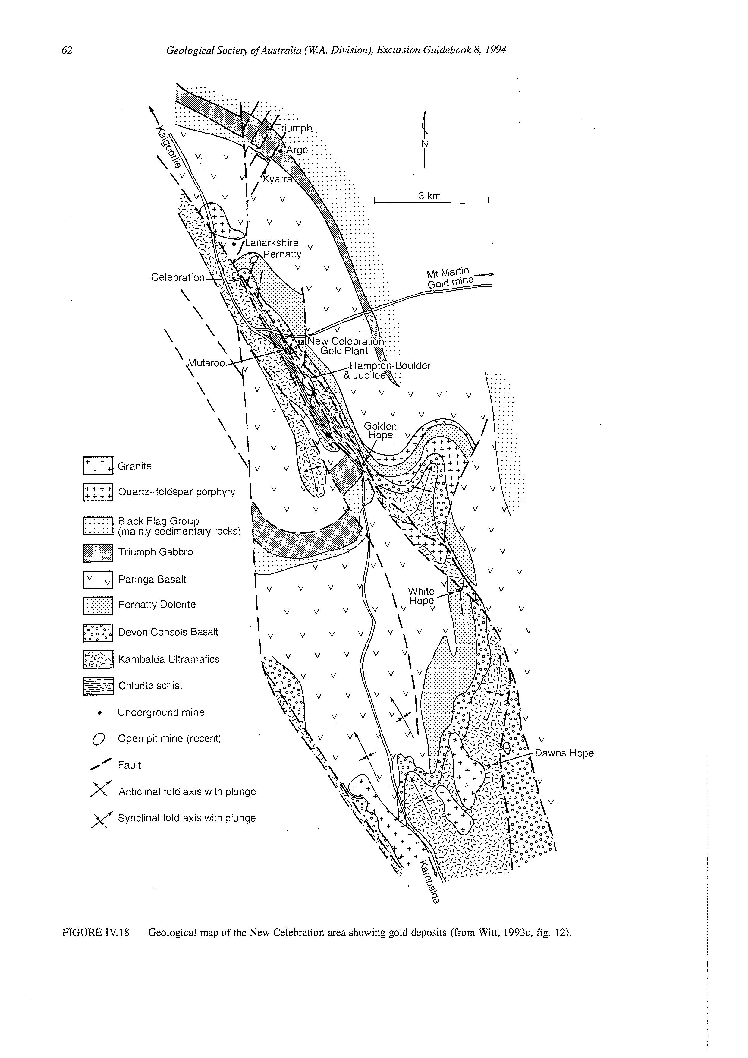
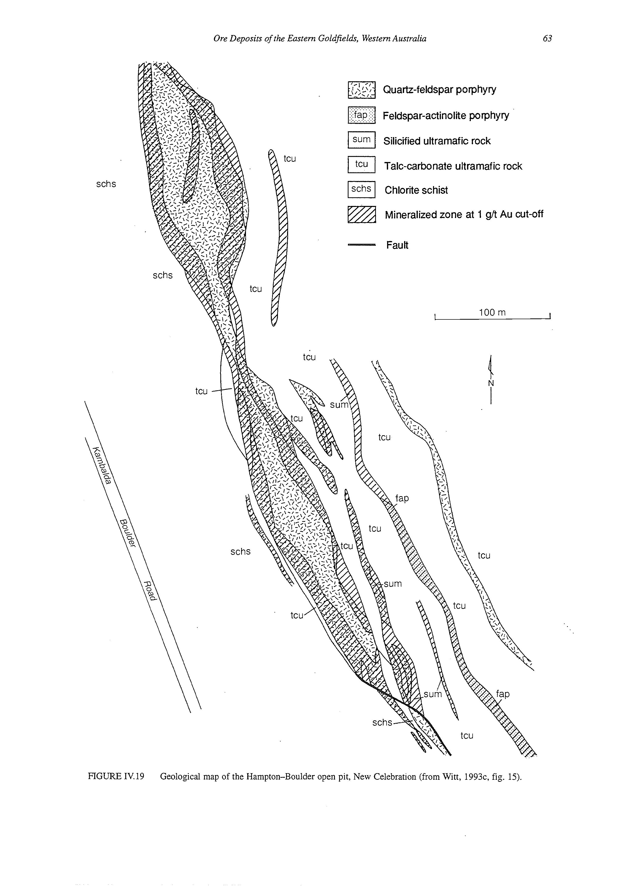
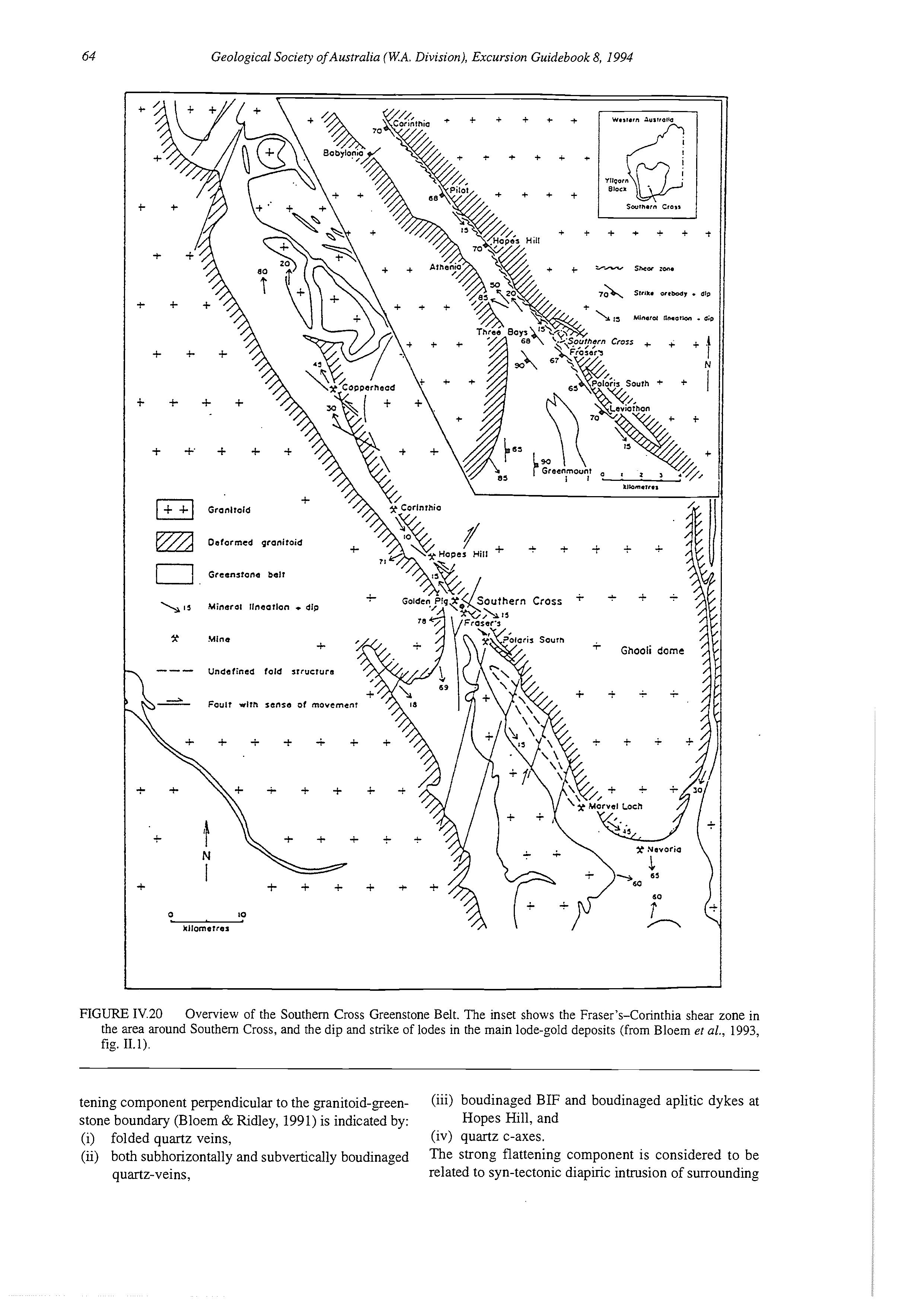
FTGURE IV.20 Overview of the Southern Cross Greenstone Belt. The inset shows the Fraser’s-Corinthia shear zone in the area around Southern Cross, and the dip and strike of lodes in the main lode-gold deposits (from Bloem et al., 1993, fig. 11.1).
tening component perpendicular to the ganitoid-geenstone boundary (Bloem & Ridley, 1991) is indicated by:
(iii) boudinaged BIF and boudinaged aplitic dykes at Hopes Hill, and
(i) folded quartz veins, (iv) quartz c-axes.
(G) both subhorizontally and subvertically boudinaged quartz-veins,
The strong flattening Component is considered to be related to syn-tectonic diapiric intrusion of surrounding
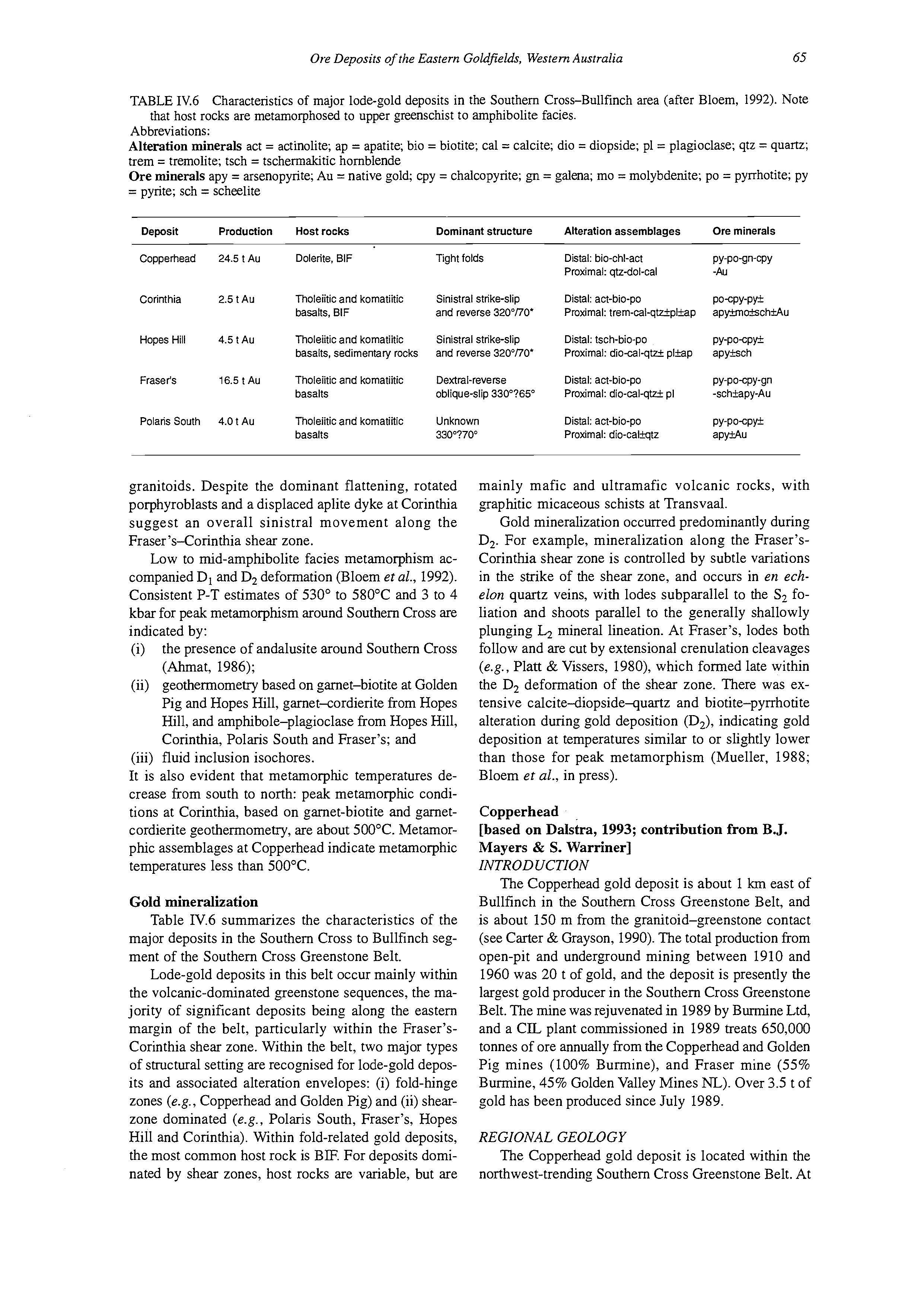
TABLE IV.6 Characteristics of major lode-gold deposits in the Southem Cross-Bullfinch area (after Bloem, 1992). Note
Abbreviations:
Alteration minerals act = actinolite; ap = apatite; bio = biotite; cal = calcite; dio = diopside; pl = plagioclase; qtz = quartz; trem = tremolite; tsch = tschermakitic hornblende
Ore minerals apy = arsenopyrite; Au = native gold; cpy = chalcopyrite; gn = galena; mo = molybdenite; PO = pyrrhotite; py = pyrite; sch = scheelite that host rocks are metamorphosed to upper greenschist to amphibolite facies.
Deposit Production Host rocks Dominant
Copperhead 24.5 t Au Dolerite, BIF
Corinthia 2.5 t Au
Hopes Hill 4.5 t Au
Fraser's 16.5 t Au
Polaris South 4.0 t Au
Tholeiitic and komatiitic basalts, BIF
Tholeiitic and komatiitic basalts, sedirnentaly rocks
Tholeiitic and komatiitic basalts
Thoieiitic and komatiitic basalts
Tight folds
Sinistral strike-slip and reverse 320"UO'
Sinistral strike-slip and reverse 32O0UO'
Dextral-reverse oblique-slip 330°?65"
Unknown 33Oo?7O0
granitoids. Despite the dominant flattening, rotated porphyroblasts and a displaced aplite dyke at Corinthia suggest an overall sinistral movement along the Fraser 's-Corinthia shear zone.
Low to mid-amphibolite facies metamorphism accompanied D1 and D, deformation (Bloem er al., 1992).
Consistent P-T estimates of 530" to 580°C and 3 to 4 kbar for peak metamorphism around Southern Cross are indicated by:
(i) the presence of andalusite around Southern Cross (Ahmat, 1986);
(ii) geothermometry based on garnet-biotite at Golden Pig and Hopes Hill, garnet-cordierite from Hopes Hill, and amphibole-plagioclase from Hopes Hill, Corinthia, Polaris South and Fraser's; and (iii) fluid inclusion isochores.
It is also evident that metamorphic temperatures decrease from south to north: peak metamorphic conditions at Corinthia, based on garnet-biotite and garnetcordierite geothermometry, are about 500°C. Metamorphic assemblages at Copperhead indicate metamorphic temperatures less than 500°C.
Gold mineralization
Table IV.6 summarizes the characteristics of the major deposits in the Southem Cross to Bullfinch segment of the Southern Cross Greenstone Belt.
Lode-gold deposits in this belt occur mainly within the volcanic-dominated greenstone sequences, the majority of significant deposits being along the eastern margin of the belt, particularly within the Fraser'sCorinthia shear zone. Within the belt, two major types of structural setting are recognised for lode-gold deposits and associated alteration envelopes: (i) fold-hinge zones (e.g., Copperhead and Golden Pig) and (ii) shearzone dominated (e.g., Polaris South, Fraser's, Hopes Hill and Corinthia). Within fold-related gold deposits, the most common host rock is BE For deposits dominated by shear zones, host rocks are variable, but are
Distal: bio-chi-act
Proximal: qtz-dol-cal
Distal: act-bio-po
Proximal: trem-cal-qtrq&ap
Distal: tsch-bio-po
Proximal: dio-calqtzi pl3sp
Distal: act-bio-po Proximal: dio-cal-qtzi pl
Distal: act-bio-po Proximal: dio-caliqtz
PY-Po-Qn-cPY -Au
PO-cPY-P* apylmoSchMu
PY-Po-cP* apysch
PY-PocpY-g" -schiapy-Au
PY-Po-cP* apWu
mainly mafic and ultramafic volcanic rocks, with graphitic micaceous schists at Transvaal.
Gold mineralization occurred predominantly during D,. For example, mineralization along the Fraser'sCorinthia shear zone is controlled by subtle variations in the strike of the shear zone, and occurs in en echelon quartz veins, with lodes subparallel to the S, foliation and shoots parallel to the generally shallowly plunging L2 mineral lineation. At Fraser's, lodes both follow and are cut by extensional crenulation cleavages (e.g., Plan & Vissers, 1980), which formed late within the D, deformation of the shear zone. There was extensive calcite-diopside-quartz and biotite-pyrrhotite alteration during gold deposition (D,), indicating gold deposition at temperatures similar to or slightly lower than those for peak metamorphism (Mueller, 1988; Bloem et al., in press).
Copperhead
[based on Dalstra, 1993; contribution from B.J. Mayers & S. Warriner]
INTRODUCTION
The Copperhead gold deposit is about 1 km east of Bullfinch in the Southern Cross Greenstone Belt, and is about 150 m from the granitoid-greenstone contact (see Carter & Grayson, 1990).The total production from open-pit and underground mining between 1910 and 1960 was 20 t of gold, and the deposit is presently the largest gold producer in the Southern Cross Greenstone Belt. The mine was rejuvenated in 1989 by Burmine Ltd, and a CIL plant commissioned in 1989 treats 650,000 tonnes of ore annually from the Copperhead and Golden Pig mines (100% Burmine), and Fraser mine (55% Burmine, 45% Golden Valley Mines NL). Over 3.5 t of gold has been produced since July 1989.
REGIONAL GEOLOGY
The Copperhead gold deposit is located within the northwest-trending Southern Cross Greenstone Belt. At
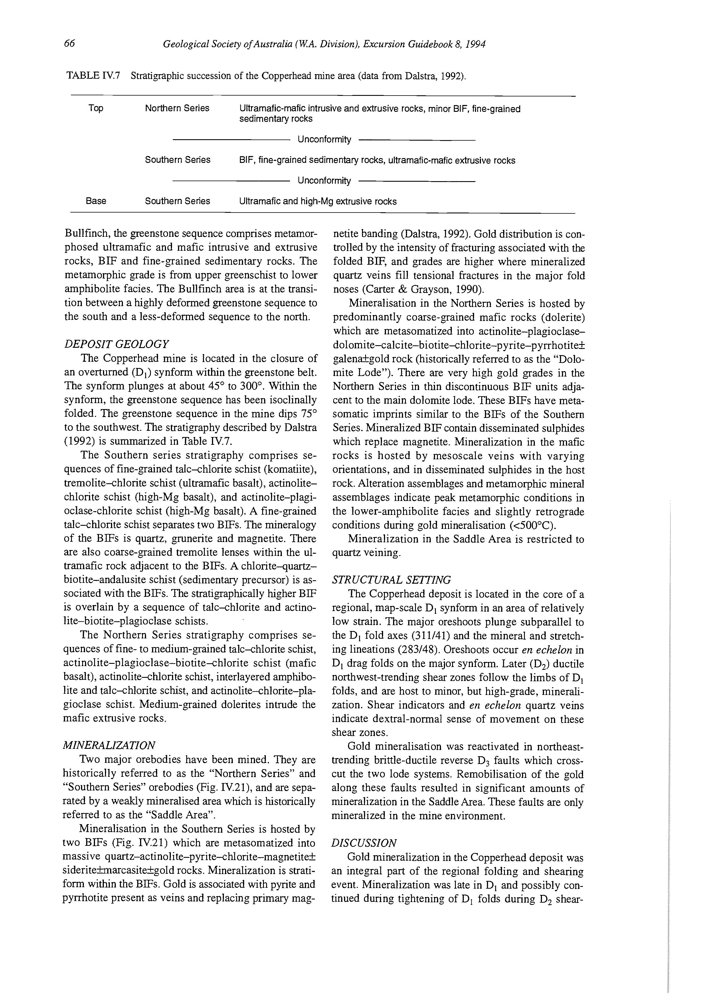
TABLE IV.7 Stratigraphic succession of the Copperhead mine area (data from Dalstra, 1992).
Top Northern Series Ultramafic-maficintrusive and extrusive rocks, minor BIF, fine-grained Sedimentary rocks
Unconformity
Southern Series BIF, fine-grained sedimentary rocks, ultramafic-maficextrusive rocks
Unconformity
Base Southern Series Ultramafic and high-Mg extrusive rocks
Bullfinch, the greenstone sequence comprises metamorphosed ultramafic and mafic intrusive and extrusive rocks, BIF and fine-grained sedimentary rocks. The metamorphic grade is from upper greenschist to lower amphibolite facies. The Bullfinch area is at the transition between a highly deformed greenstone sequence to the south and a less-deformed sequence to the north.
DEPOSIT GEOLOGY
The Copperhead mine is located in the closure of an overturned (DJ synform within the greenstone belt. The synform plunges at about 45” to 300’. Within the synform, the greenstone sequence has been isoclinally folded. The greenstone sequence in the mine dips 75” to the southwest. The stratigraphy described by Dalstra (1992) is summarized in Table R.7.
The Southern series stratigraphy comprises sequences of fine-grained talc-chlorite schist (komatiite), tremolite-chlorite schist (ultramafk basalt), actinolitechlorite schist (high-Mg basalt), and actinolite-plagioclase-chlorite schist (high-Mg basalt). A fine-grained talc-chlorite schist separates two BIFs. The mineralogy of the BIFs is quartz, grunerite and magnetite. There are also coarse-grained tremolite lenses within the ultramafic rock adjacent to the BIFs. A chlorite-quartzbiotite-andalusite schist (sedimentary precursor) is associated with the BIFs. The stratigraphically higher BIF is overlain by a sequence of talc-chlorite and actinolite-biotite-plagioclase schists.
The Northern Series stratigraphy comprises sequences of fine- to medium-grained talc-chlorite schist, actinolite-plagioclase-biotite-chlorite schist (mafic basalt), actinolite-chlorite schist, interlayered amphibolite and talc-chlorite schist, and actinolite-chlorite-plagioclase schist. Medium-grained dolerites intrude the mafic extrusive rocks.
MINERALIZATION
Two major orebodies have been mined. They are historically referred to as the “Northern Series” and “Southern Series” orebodies (Fig. IV.21), and are separated by a weakly mineralised area which is historically referred to as the “Saddle Area”.
Mineralisation in the Southern Series is hosted by two BIFs (Fig. IV.21) which are metasomatized into massive quartz-actinolite-pyrite-chlorite-magnetite* sideriteimarcasitekgold rocks. Mineralization is stratiform within the BIFs. Gold is associated with pyrite and pyrrhotite present as veins and replacing primary mag-
netite banding (Dalstra, 1992). Gold distribution is controlled by the intensity of fracturing associated with the folded BIF, and grades are higher where mineralized quartz veins fill tensional fractures in the major fold noses (Carter & Grayson, 1990).
Mineralisation in the Northern Series is hosted by predominantly coarse-grained mafic rocks (dolerite) which are metasomatized into actinolite-plagioclasedolomite-calcite-biotite-chlorite-pyrite-pyrrhotite~ galenakgold rock (historically referred to as the “Dolomite Lode”). There are very high gold grades in the Northern Series in thin discontinuous BIF units adjacent to the main dolomite lode. These BIFs have metasomatic imprints similar to the BIFs of the Southern Series. Mineralized BIF contain disseminated sulphides which replace magnetite. Mineralization in the mafic rocks is hosted by mesoscale veins with varying orientations, and in disseminated sulphides in the host rock. Alteration assemblages and metamorphic mineral assemblages indicate peak metamorphic conditions in the lower-amphibolite facies and slightly retrograde conditions during gold mineralisation (<500”C).
Mineralization in the Saddle Area is restricted to quartz veining.
STRUCTURAL SETTING
The Copperhead deposit is located in the core of a regional, map-scale D, synform in an area of relatively low strain. The major oreshoots plunge subparallel to the D, fold axes (311/41) and the mineral and stretching lineations (283/48). Oreshoots occur en echelon in D, drag folds on the major synform. Later (D2) ductile northwest-trending shear zones follow the limbs of D, folds, and are host to minor, but high-grade, mineralization. Shear indicators and en echelon quartz veins indicate dextral-normal sense of movement on these shear zones.
Gold mineralisation was reactivated in northeasttrending brittle-ductile reverse D3 faults which crosscut the two lode systems. Remobilisation of the gold along these faults resulted in significant amounts of mineralization in the Saddle Area. These faults are only mineralized in the mine environment.
DISCUSSION
Gold mineralization in the Copperhead deposit was an integral part of the regional folding and shearing event. Mineralization was late in D, and possibly continued during tightening of D, folds during D, shear-