RUSTAL EV
Geological Society of Australia (WA Division)
EXCURSION GUIDEBOOK No. 7
S. A. Wilde
Curtin University of Technology, G P 0 Box U 1987, Perth, Western Australia 600 1
12th Australian Geological Convention September 1994
Guidebook for the pre-convention excursion E8
12th Australian Geological Convention, Perth, September 1994
Preferred referencefor this volume:
Wilde, S. A. 1994. Crustal evolution of the southwestern Yilgam Craton. Geological Society ofAustralia (WA Division) Excursion Guidebook, 7,20p.
0 12th AGC and Geological Society of Australia (WA Division), all rights reserved 1994
ISSN 0819-6613
ISBN 0 909869 93 6
Available for purchase porn:
Geological Society of Australia (W. A. Division) P 0 Box 6014 East Perth Australia 6004
Printed by: Optima Press, 32 Kensington Street, East Perth, WA 6004
CONTENTS
INTRODUCTION
TRADITIONAL VIEW OF THE YILGARN CRATON
MAIN GEOLOGICAL COMPONENTS OF THE SOUTHWESTYILGARN CRATON
Metamorphic Belts
Greenstone Belts
Migmatite
Granitoids
REVIEW OF RECENT KNOWLEDGE
Previous Geochronology
New GeochronologicalEvidence
Geophysical Evidence
TElZRANE ACCRETION MODEL
Balingup Terrane
Boddington Terrane
Lake Grace Terrane
Murchison Terrane
TIMING OF TERRANE ASSEMBLY
EXCURSION LOCALITIES
BALINGUP TERRANE
Chittering Metamorphic Belt
BODDINGTON TEmm
Jimperding Metamorphic Belt ACKNOWLEDGMENTS

INTRODUCTION
Although it is only four years since the last excursion guide was prepared by the author for this particular region (Wilde, 1990), there have been a number of major advances which require considerable re-appraisal of our views on the geological evolution of the area. Two aspects in particular have led to this position: an increase in our knowledge of the age of key rock units and the evaluation of a deep seismic traverse line which crossed all major crustal components in the vicinity of New Norcia, leading to the establishment of a terrane accretion model (Wilde et al, in press).
The Chittering-Toodyay Excursion aims to examine a number of key outcrops which provide important information relevant to understanding the geological evolution of the southwestern portion of the Archaean Yilgarn Craton.
TRADITIONAL VIEW OF THE YILGARN CRATON
The Yilgarn Craton was formerly subdivided by Gee et al. (1981) into four distinct regions. An older polymetamorphic domain along the western margin (the Western Gneiss Terrain) is terminated to the west by the Darling Fault. To the east are three younger granite-greenstone terranes (the Murchison, Southern Cross and Eastern Goldfields Provinces) which are of lower metamorphic grade and were considered to have developed, at least in part, on an older gneissic basement. In contrast to the earlier view of Glikson (1971) and Glikson and Lambert (1976), Gee and co-workers argued that the greenstone sequences were deposited within en-sialic basins and were not segments of oceanic crust. The Western Gneiss Terrain was thus believed to extend beneath the granite-greenstone provinces and this interpretation became widely accepted (eg Groves and Batt, 1984; Hallberg, 1986; Blake and Groves, 1987; Campbell and Hill,1988). Implicit in the model of Gee et al. (1981) was the idea that the Yilgarn Craton had been in existence from at least 3.0 Ga, becoming cratonized by the emplacement of voluminous granitoids at ca 2,660 Ma.
MAIN GEOLOGICAL COMPONENTS OF THE SOUTHWEST YILGARN CRATON
The area is characterized by discrete, linear metamorphic belts enveloped by diffiise areas of migmatite, containing isolated rafts of the earlier gneissic sequences (Wilde, 1990). The present distribution of gneiss and migmatite is largely controlled by the emplacement of Late Archaean granitoids which typically post-date metamorphism and regional tectonism. The high-grade gneisses and supracrustal rocks have been grouped within the Jimperding, Chittering and Balingup Metamorphic Belts (Wilde, 1980 and 1990). Migmatite is locally developed at the margins of these belts and also forms more extensive areas in the eastern part of the region. There are also a number of small greenstone belts, ranging in metamorphic grade from greenschist to granulite facies, widely distributed across the region (Fig. 1). All these sequences are intruded by a variety of granitoids, including charnockites in the east.
Metamorphic Belts
The chief rock-type in the Jimperding, Chittering and Balingup Metamorphic Belts is layered quartz-feldsparbiotite gneiss. Some units are paragneiss and show gradations to arkosic quartzite and quartz-mica schist and are interleaved with orthoquartzite, banded iron formation and rare calc-silicate rocks. This association is a characteristic feature of the Jimperding Metamorphic Belt east and southeast of Toodyay and of the southeastern part of the Balingup belt. It has been interpreted as indicating stable shelf sedimentation on a pre-existing sialic basement (Gee et al., 1981; Wilde, 1990). In contrast, the Chittering and western portion of the Balingup Metamorphic Belt consist mainly of pelite, semi-pelite and greywacke. Banded iron formation and quartzite are absent and this association has been interpreted to be the result of rapid, trough-style sedimentation along a continental margin (Gee et al.,1981; Wilde, 1990).
The Jimperding Metamorphic Belt shows a progressive eastward increase in metamorphic grade fiom lower amphibolite to granulite facies, with the presence of andalusite, sillimanite and cordierite indicating low pressure. In contrast, the Chittering and Balingup Metamorphic Belts are chiefly at amphibolite facies, with the presence of kyanite, sillimanite and staurolite indicating moderate pressure, Barrovian-type metamorphism (Wilde, 1990). This contrast in grade between the metamorphic belts appears to be in part related to their location, with the higher pressure assemblages occurring at the western margin of the craton, associated with ductile shear zones related to
LOCALITY PLAN
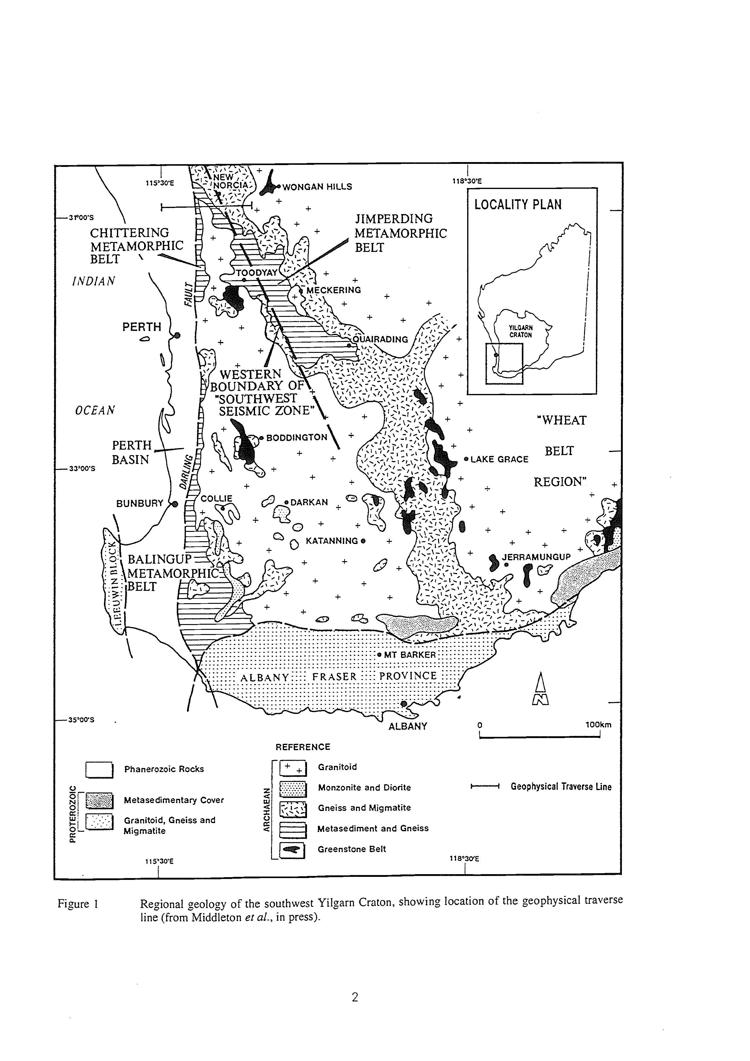
:igure 1 Regional geology of the southwest Yilgarn Craton, showing location of the geophysical traverse line (from Middleton et al., in press).
early movement along the Darling Fault Zone (Blight et aZ., 1981; Bretan, 1985). This zone has been reactivated at several later periods, resulting in local retrogression to greenschist facies assemblages.
Greenstone Belts
There are a number of small greenstone belts present in the Western Gneiss Terrain. In the southeastern portion (Fig. l), areas of mafic and felsic granulite are interleaved with a variety of metasedimentary rocks. These were interpreted as 'keels' of original greenstone belts by Wilson (1969) and this interpretation is supported by more recent work on the mafk granulites (Wilde and Pidgeon, 1987; Nemchin et aZ.,in press). The mineralogical features indicate that this area underwent low to moderate pressure granulite facies metamorphism and the enclosing granitoids commonly include hypersthene-bearing charnockites (Wilde, 1990).
Three lower grade greenstone belts are present near the western margin of the Yilgam Craton (Fig. 1); the Saddleback, Morangup and Wongan Hills Greenstone Belts. The Saddleback Greenstone Belt (Wilde, 1976 and 1990) near Boddington (Fig. 1) is poorly-exposed due to an extensive cover of Tertiary laterite. It is composed of mafic and felsic volcanic rocks, with minor sedimentary units, metamorphosed to greenschist facies and generally in faulted contact with orthogneiss, migmatite and granite. However, in the extreme southwest, granite intrudes metasediments and felsic pyroclastic rocks (Wilde, 1976). The Morangup Greenstone Belt near Toodyay (Wilde and Pidgeon, 1990) consists predominantly of metabasalt with a greenschist facies assemblage of tremolite-actinolite, albite and clinozoisite. Porphyritic andesite and fine grained metasedimentary rocks are also present. The sequence is also poorly exposed and the full extent of the belt is unknown. The Wongan Hills Greenstone Belt consists predominantly of basalt, dacite, chert, banded iron formation and mica schist, interleaved with paragneiss and intruded by small ultramafic units, all metamorphosed to upper amphibolite facies (Carter and Lipple, 1982). The presence of cordierite indicates low pressure conditions, similar to those in the nearby Jimperding Metamorphic Belt (Pidgeon et aZ.,1990).
Migmatite
Mi,smatites form extensive areas in the southwestern part of the Yilgarn Craton (Fig. 1). They are composed of earlier gneissic rocks invaded by younger, less-deformed, unmetamorphosed granitoid components. They are developed at the margins of the metamorphic belts, with much of the gneissic palaeosome derived from reworking of the metamorphic rocks. Some granitic neosomes appear to have been formed by in situ partial melting of the gneisses (Wilde, 1990). The most extensive zone of gneiss and migmatite extends southeastward from the Jimperding Metamorphic Belt to the southern edge of the Yilgarn Craton (Fig. 1).
Granitoids
Granitoids occur as two large batholiths that occupy a considerable portion of the southwest Yilgarn Craton (Fig. 1). The granitoids east of Meckering and Quairading and around Lake Grace were informally referred to as the "Wheat Belt" granites by Wilson (1958), whereas the western area has been termed the Darling Range Batholith (Wilde and Low, 1978). The zone of mignatite referred to above separates the two batholithic areas (Fig. 1).
Around Katanning (Fig. l), many porphyritic granites are hypersthene-bearing and petrographically and geochemically identical to those developed further east within the zone of migmatite and gneiss south of Quairading and in the "Wheat Belt" batholith. Wilde and Pidgeon (1987) describe reaction textures from near Lake Grace which indicate that hypersthene and subsequent mafic minerals followed a ma,matic crystallisation sequence and that these charnockites are of igneous origin.
The ,mnitoids of the Darling Range Batholith are quite diverse and show considerable textural variation. They range in composition from granodiorite to granite; the compositional variations being commonly independent of textural changes. Where cross-cutting relations can be identified, granodiorite is invariably the earliest phase. Most granitoids are undeformed, although plutons of porphyritic granite that occur close to the eastern boundaries of the Chittering and Balingup Metamorphic Belts show evidence of intense ductile shearing. There is a westward increase in deformation, resulting in a progressive change from porphyritic granite to augen gneiss, mylonite and ultramylonite (Blight et aL, 1981). This deformation is related to early movement along the Darling Fault Zone, accompanied by medium pressure, amphibolite facies metamorphism (Wilde, 1990).
There are also a number of small bodies of quartz-poor granitoids of dioritic, monzonitic and syenitic affinity within the granite batholiths. More extensive areas of quartz monzonite occur south of Darkan (Fig. 1) and these are rich in amphibolite xenoliths. A distinctive, tectonised quartz monzonite (the Gibralter Quartz Monzonite) forms a narrow, discontinuous zone along the eastern boundary of the Balingup Metamorphic Belt (Wilde and Walker, 1982 and 1984) in association with migmatite (Fig. 1).
Previous Geochronology
The antiquity of the Western Gneiss Terrain was first established by Arriens (1971), who obtained a number of ages in excess of 3.0 Ga from gneisses using Rb-Sr techniques. A Rb-Sr study by de Laeter et al. (1981) identified gneissic rocks at least 3.3 Ga old in the northwestern part of the Western Gneiss Terrain near Mt. Narryer. This led to extensive investigations within the Narryer Gneiss Complex (Myers, 1988), using Rb-Sr, Sm-Nd and Pb-Pb (de Laeter et al., 1985; Fletcher et al., 1988) and U-Pb zircon (%MY et al.,1988 and 1990) techniques. The oldest rocks so far identified in the area are 3,730 Ma old gneisses (Kinny et al., 1988), based on U-Pb-Th ion microprobe data. Detrital zircons as old as 4.18 Ga (Froude et al., 1983) and 4,27 Ga (Compston and Pidgeon, 1986) have been identified at Mount Narryer and Jack Hills, respectively. The mature clastic sedimentary rocks that contain the ancient zircons also contain considerably younger detrital zircons and, based on an evaluation of these, the age of deposition at both Jack Hills and Mt. Narryer is considered to be ca 3.1 Ga (Compston and Pidgeon, 1986; Kinny et al., 1990).
Nieuwland and Compston (1981) also obtained ca 3.3 Ga detrital multigrain zircon ages from mature orthoquartzites in the Toodyay area of the southwest Yilgarn Craton, which were believed to be invaded by granite ca 3.25 Ga ago. These rocks of the Jimperding Metamorphic Belt (Fig. 1) near Toodyay are the oldest known crustal components in the southwest Yilgarn. Indeed, Kinny (in Wilde, 1990) has identified by ion microprobe techniques, a spectrum of zircon ages up to 3,735 Ma from the Windmill Hill quartzite.
Ion microprobe studies in the Eastern Goldfields Province have led to the identification of older inherited zircons within the greenstone sequences in the eastern part of the Yilgam Craton (Compston et al., 1985; Campbell and Hill, 1988), thus apparently substantiating the presence of an older granitic basement to the greeenstones.
Whilst these data appear to support the 'fixist' model of Gee et al. (198 I), other factors need to be considered. These include new U-Pb zircon data, evidence from a major deep crustal geophysical investigation and the growing application of Phanerozoic-style plate tectonics models to the Archaean. Myers (1993) has presented evidence for terrane accretion throughout the Precambrian areas of Western Australia, including the Yilgarn Craton. He has identified a number of discrete terranes within the northern and eastern portions of the craton and these have recently been extended into the southwest portion (Middleton et al., in press: Wilde et al., in press).
New Geochronological Evidence
A comprehensive review of the available geological and geochronological data for the southwest Yilgarn was undertaken by Wilde (1990) and used to constrain an evolutionary model, based on the parameters defined by Gee et al. (1981). Recent geochronological work has resulted in a modification to this scheme.
The main changes from those presented by Wilde (1990) relate to further work undertaken in the Toodyay and Wheat Belt areas. Firstly, a re-examination of quartzite-orthogneiss relations in the Jimperding Metamorphic Belt by P.D. Kinny and A.P. Nutman (P.D. Kinny, personal communication, 1993) suggests modification to the conclusions of Nieuwland and Compston (1981). Nieuwland and Compston, on the basis of a U-Pb multigrain zircon study, proposed that the quartzites were deposited between 3,340 and 3,250 Ma, intruded by granite sheets at 3,250 Ma and the whole sequence metamorphosed to granulite facies at 3180 Ma. A study of the Windmill Hill quartzite based on U-Pb-Th determinations of single zircons on the SHRIMP ion-microprobe (P.D. Kinny in Wilde, 1990) gave a spectrum of ages from 3,735 to 3,177 Ma. Unpublished work on the intrusive granitic sheets (orthogneisses) indicates that the age of intrusion was ca 2.6 Ga and that the 3,250 Ma age obtained by Nieuwland and Compston (198 1) was the result of incorporation of significant amounts of detrital zircon from digestion of older quartzite xenoliths (P.D. Kinny, personal communication, 1993). Whilst the depositional age of the quartzites still appears to be >3.0 Ga, there is now no evidence for an early, pre-3 Ga granite-forming event in the region.
The second piece of new evidence comes from a conventional, single-grain zircon U-Pb study of mafic granulites (high-grade greenstones) in the Wheat Belt region southeast of Toodyay (Nemchin et al., in press). This study more precisely defines the timing of granulite facies metamorphism at between 2,649 and 2,640 Ma, which is significantly younger than the age of 2,671 to 2,654 Ma (Wilde and Pidgeon, 1986), recorded from the greenschist facies Saddleback Greenstone Belt to the west near Boddington (Fig. 1). As suggested by Wilde (1990), this implies a separate evolution for these adjoining regions.
Geophysical Evidence
A deep seismic reflection survey was carried out approximately 110 km north of Perth, near New Norcia (Middleton et al. 1993) and recorded to 12 secs two-way time. The seismic data reveal a multitude of shallow east-dipping reflectors which, on further enhancement lead to the identification of seven major zones (Fig. 2), based on reflection character and supplemented by modelling of ground magnetics. Within the Yilgarn Craton, one of the most significant features is the three-layered nature of the crust, substantiating the results of an earlier survey by Mathur 4
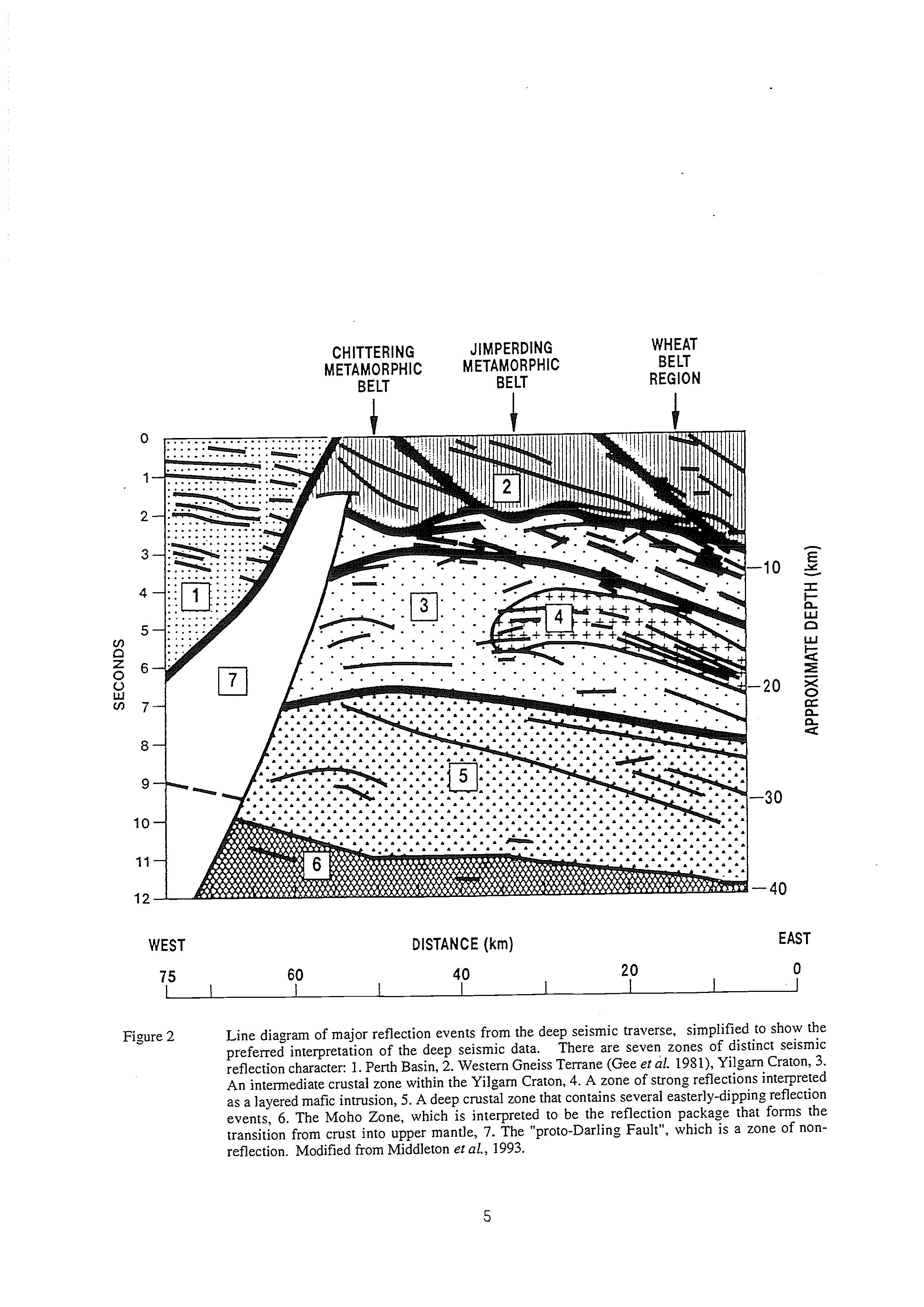
Figure 2 Line diagram of major reflection events from the deep seismic traverse, simplified to show the preferred interpretation of the deep seismic data. There are seven zones of distinct seismic reflection character: 1. Perth Basin, 2. Western Gneiss Terrane (Gee et al. 1981), Yilgarn Craton, 3. An intermediate crustal zone within the Yilgarn Craton, 4.A zone of strong reflections interpreted as a layered mafic intrusion, 5. A deep crustal zone that contains several easterly-dipping reflection events, 6. The Moho Zone, which is interpreted to be the reflection package that forms the transition from crust into upper mantle, 7. The "proto-Darling Fault", which is a zone of nonreflection. Modified from Middleton et al., 1993.
(1974). The transition to the upper mantle occurs between 30 and 40km depth and shows a marked easterly dip (Fig. 2). This passes upward into the lower crustal component, which has previously been considered to be intermediate granulite in character (Mathur, 1974; Gee et al., 1981). It also contains some easterly-dipping reflectors, which may represent ductile shear zones. However, reflections are weak and its nature is largely unknown.
The overlying intermediate crustal layer is believed to consist chiefly of granitic rocks and is separated from the upper and lower crustal layers by major decollements. There is also a lens-like unit within this zone which is characterised by strong reflectors. The eastern part is coincident with two distinct magnetic bodies identified by the ground magnetics and these have been interpreted as part of a large, layered mafk intrusion (Middleton et al., 1993).
Close to the Darling Fault, there is a distinctive segment that has virtually no seismic response. It may lie in the "shadow zone" of the Phanerozoic Darling Fault, where no seismic energy can penetrate (Middleton et al., 1993) or alternatively, it may be the result of extreme deformation associated with the ArchaeanProterozoic proto-Darling Fault Zone (Blight et al., 1981; Wilde, 1990) which outcrops in this area and is characterised by sub-vertical ductile structures.
Detailed geological mapping along the seismic traverse line (Fig. 1) by Morawa (1992) has shown that a number of reflection events, that are interpreted as thrust faults, have surface expression (Fig. 2), including major faults that appear to define the junction between the Chittering and Jimperding Metamorphic Belts and between the Jimperding belt and the Wheat Belt region. They dip steeply at the surface and then "bottom-out'' onto a basal detachment in the vicinity of 2 to 3 seconds (about 7 to 9 km deep). The continuity of this detachment surface suggests that this zone was formed by "thin-skinned" compressional tectonics, with the major crustal components (the Chittering, Jimperding and Wheat Belt regions) transported to their present positions as thrust slices (Fig. 2). Significantly, the boundary between the Jimperding and Wheat Belt regions also corresponds with a marked fall in gravity values (see also Fraser and Pettifer, 1980). In addition, the decollement surface appears to have been locally displaced by normal faulting (Fig. 2), suggesting reactivation under an extensional regime. This may have accompanied mafic dyke emplacement during the Proterozoic or else be associated with Phanerozoic tectonism that resulted in the development of the Perth Basin and/or its subsequent dismemberment during the Cretaceous plate tectonic episode.
TERRANE ACCRETION MODEL
The recognition that shear zones at the surface can be correlated with major, shallow east-dipping, seismic reflectors in the sub-surface is of major.significance. The reflectors occur throughout the total thickness of continental crust in the southwest Yilgarn Craton and imply a uniformity in crustal construction in this region.
The coincidence of shear zones and seismic reflectors with the boundary between the Chittering and Jimperding Metamorphic Belts and between the latter and the Wheat Belt region, implies that these areas are separate crustal segments, brought into their present position by transport along major east-dipping thrusts. The Jimperding Metamorphic Belt/Wheat Belt boundary is also marked by a fall in the gravity values (Middleton et al., 1993), the position of which also corresponds with a regional change in the Bouguer anomalies recognised by Fraser and Pettifer (1980). The Avon Gravity High in the west gives way sharply to a region of intermediate gravity referred to as the Narambeen Gravity Shelf (Fraser and Pettifer, 1980). Similarly, Everingham (1968) postulated that this change in gravity is centred along the currently-active Southwest Seismic Zone and is related to a major change in the deep crustal structure.
When the events are considered in the light of the recently-acquired geophysical and geochronological data, it is possible to apply an alternative evolutionary model for the southwest Yilgarn Craton to that of Gee etal. (1981).
If evidence obtained along the geophysical traverse line is extended southward and constrained by the regional geological, geochronological and geophysical data presented above, it is then possible to delimit the main crustal components in the southwest Yilgarn Craton. This leads to the recognition of at least three separate terranes, which, from west to east, are referred to as the Balingup, Boddington and Lake Grace Terranes (Wilde et al., in press : Fig. 3). In addition, a small portion of the Murchison Terrane (Myers, 1993) is present in the north around Wongan Hills. The characteristics of the newly-defined terranes are summarised in Table 1 and discussed below, based on information presented in Wilde et al. (in press).
Balingup Terrane
The Balingup Terrane (Fig. 3) is a narrow, north-trending belt delimited to the west by the Darling Fault and less precisely defined in the east by later intrusive granitoids. The terrane consists of the Balingup and Chittering Metamorphic Belts, characterised by turbiditic sediments and intensely-deformed orthogneisses. The age of sedimentation is not precisely constrained, with Sm-Nd model ages (Fletcher et al., 1985) suggesting that the Balingup belt were deposited between 3.07 and 2.83 Ga and the Chittering belt after 2.89 Ga (Wilde, 1990).
Table 1. Characteristic features of the Balingup, Boddington and Lake Grace Terranes (from Wilde et al., in press).
Balingup
Trough sediments
Medium pressure metamorphism
No greenstone belts
Ductile deformation extensive
2,612-2,527 Ma granitoids
Granitoids; greenschist facies
Boddington
Shelf sediments
Low pressure metamorphism
Low grade greenstones
Nappes and brittle faults
2,677-2,640 Ma granitoids
Granitoids; greenschist facies
Lake Grace
Shelf sediments
Low pressure metamorphism
High ,mde greenstones
Upright folds; steep plunges
2,640 and 2,587 Ma granitoids
Granitoids (2,640 Ma): granulite facies
The sequences were metamorphosed under medium pressure, amphibolite facies conditions, with the development of kyanite, sillimanite and staurolite in metapelites. Metamorphism in the Balingup Metamorphic Belt has been dated at ca 2,838 Ma near Bridgetown by D.A. Nieuwland (quoted in Wilde, 1980) using Rb-Sr techniques: there are no comparable data for the Chittering Metamorphic Belt.
Strong ductile deformation is prominent along the western boundary of this terrane and is associated with periodic movement along the Darling Fault Zone, commencing about 2,577 Ma ago (Blight et al., 1981). The eastern boundary is defined in the extreme southeast by the Gibralter Quartz Monzonite (Wilde and Walker, 1982 and 1984). This is a metamorphic tectonite, believed to have been emplaced during the peak of regional metamorphism. The Sm-Nd model age of 2.74 M.09 Ga (Fletcher et al., 1983) and Rb-Sr model age of ca 2,828 Ma (Rosman et al., 1980), although not precise, are within error of Nieuwlands Rb-Sr isochron age.
Granitoids associated with the Balingup Terrane are younger than in most other parts of the Yilgarn Craton. An ion microprobe, U-Pb-Th zircon study of the Logue Brook Granite, located east of Bunbury (Fig. l), by Compston et al. (1986) established a crystallization age of 2,612 rt5 Ma. In the Greenbushes area, south of Balingup (Fig. I), ca 2,577 Ma ages were recorded for the Cowan Brook Dam and Millstream Dam granitoids, whilst the Greenbushes Pegnatite has an age of 2,527 Ma (Partington el al., 1986). All these rocks have undergone ductile deformation, with portions of the Logue Brook Granite infolded with paragneisses of the Balingup belt (Wilde and Walker, 1982). The Greenbushes Pegmatite is a late-stage granitoid, emplaced syn-kinematically into a major sinistral shear zone under medium pressure, amphibolite facies conditions (Partington et al., 1986).
Boddington Terrane
The Boddington Terrane (Fig. 3) is separated in the north from the Balingup Terrane by a 2 km-wide shear zone characterised by phyllonite and quartz boudins, marking the junction of the Chittering and Jimperding Metamorphic Belts (Middleton et al., in press). Further south, the original line of contact appears to have been obliterated by later granite intrusion, which includes three porphyritic granite plutons (Wilde, 1990), the most southerly being the 2,612 Ma Logue Brook Granite, implying that the two terranes were in contact at this time. The Boddington Terrane is only about 10 km wide in the north, but widens to around 120 km in the south (Fig. 3).
The Boddington Terrane includes the northern part of the Jimperding Metamorphic Belt, although further south the major gravity change occurs within the belt and the Boddington Terrane is defined to include only the western, flatlying portion near Toodyay (Figs. 1 and 3). The Jimperding sediments form part of a major nappe that has been strongly refolded (Wilde and Low, 1978), with metamorphic grade increasing eastward from lower amphibolite to amphibolite-granulite transition facies, with andalusite and iron-rich cordierite indicating low pressure conditions. It appears from the detrital zircon suite that the orthoquartzites were deposited between 3.0 and 3.1 Ga (P.D. Kinny, in Wilde, 1990). However, the oldest zircons are ca 3,735 Ma and were interpreted by Kinny as being derived from a granite-gneiss terrane. Although there is no other evidence of crust of this age in the southwest Yilgarn Craton, it has been identified in the Nanyer Gneiss Complex, some 800 km to the north (Kinny et al., 1990).
The Saddleback and Morangup Greenstone Belts form part of the Boddington Terrane and consist of mafic and felsic lavas and pyroclastic rocks, with minor amounts of sediment, metamorphosed to low pressure greenschist facies and largely down-faulted against adjacent gneiss and granitoid. The Saddleback belt formed between 2,671 and 2,654 Ma (Wilde and Pidgeon, 1986) and the Morangup sequence near Toodyay (Fig. 1) is considered to be of similar age (Wilde and Pidgeon, 1990). The geochemical nature of both sequences is consistent with either a mature island arc or a continental, Andean-type magmatic arc setting (Wilde, 1990).
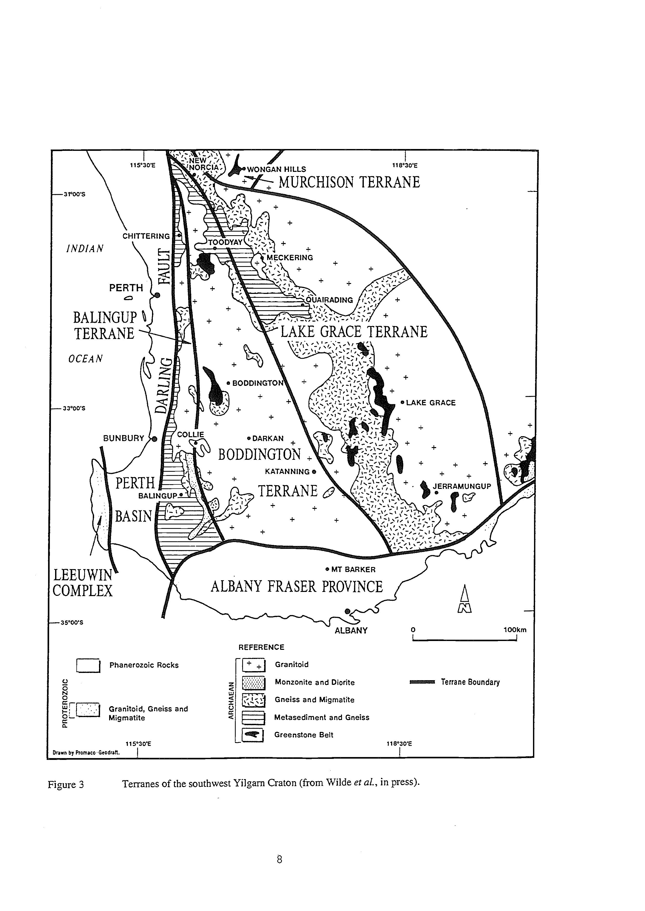
The eastern boundary of the Boddington Terrane is clearly defined by gravity data (Fig. 3) and coincides with the Yandanooka-Cape Riche Lineament of Everingham (1968) and the boundary between the Avon Regional Gravity High in the west and the Narembeen Regional Gravity Shelf to the east, as defined by Fraser and Pettifer (1980). Significantly, this zone is also the focus of present-day seismic activity and has been referred to as the "Southwest Seismic Zone" (Doyle, 1971).
Granitoids in the Boddington Terrane appear to have developed within a short time span between 2,677 and 2640 Ma (Wilde, 1990). Conventional multigrain U-Pb dating of zircons give ages from 2,677 to 2,642 Ma for granitoids intruding the Jimperding Metamorphic Belt at Toodyay (Nieuwland and Compston, 1981). Further south near Boddington (Fig. l), adamellite intruding the Saddleback Greenstone Belt gives a conventional multigrain isochron age of 2,640 +26/-24 Ma (Wilde and Pidgeon, 1986).
Lake Grace Terrane
The Lake Grace Terrane (Fig. 3) extends east from the major change in gravity for almost 200 km and corresponds closely with the area originally referred to as the "Wheat Belt" region by Wilson (1958). It narrows markedly in the north, where it comes into contact with the Murchison Terrane (Fig. 3). Its eastern boundary is not precisely defined, owing to a lack of detailed geological mapping, and that shown on Figure 3 is based on an estimate of the eastern extent of charnockitic granitoids obtained from the geological literature and unpublished fieldwork by the author. The terrane is characterised by sediments, greenstones and granitoids, all at granulite facies.
Included within the terrane are the eastern portion of the Jimperding Metamorphic Belt and isolated outcrops of metamorphic rocks incorporated in the mi,matite zone that extends south from near Meckering to the southern limit of the Yilgarn Craton (Fig. 3). They consist of thin units of orthoquartzite, arkosic paragneiss and banded iron formation, interleaved with a variety of garnetiferous orthogneiss, ultramafic units and mi,matite. All rocks are metamorphosed to granulite facies, with the local development of cordierite indicating low pressure conditions. The boundary within the Jimperding Metamorphic Belt is marked by the easterly change from amphibolite-granulite transition facies to granulite facies metamorphism and the structural change from flat-lying nappes in the west to north-plunging upright folds in the east (Wilde and Low, 1978). This was long considered to be a major tectonic boundary (Wilde, 1974), but it is only now that its true significance has been realised.
A number of greenstone remnants are present within the Lake Grace Terrane (Fig. 3), with ages up to ca 2,790 Ma (Wilde and Pidgeon, 1987; Nemchin et aL, in press). A two-pyroxene mafic granulite from Badgebup, 33 km northeast of Katanning (Fig. l), is interpreted as an original tholeiitic basalt (Wilde and Pidgeon, 1987) and has a concordant, conventional multigrain zircon, U-Pb isochron age of 2,798 +16 Ma. Felsic gneisses associated with the mafic granulite give a comparable, though less precise, age of 2,750 +I30 Ma. A felsic granulite from near Lake Grace (Fig. 1) has a poorly constrained, discordant isochron age of ca. 2,780 Ma (Wilde and Pidgeon, 1987) and a TCHURSm-Nd model age of 2.77 H.04 Ga (I.R.Fletcher, written communication, 1987). The consistency of these ages across the Lake Grace Terrane and their similarity to the 2,795 +38 Ma age for the lower succession Kathleen Valley greenstones of the Eastern Goldfields Province (Cooper and Dong, 1983), supports the view of Wilson (1969) that these granulites represent uplifted portions of the lower 'root' zones of greenstone belts. Nemchin et ul. (in press) also identified zircon components in the mafic granulites with ages of 2,640 to 2,649 Ma. These are ascribed to later zircon growth during the regional granulite facies metamorphism.
The earliest granitoids within the Lake Grace Terrane are hypersthene-bearing charnockites (Wilde and Pidgeon, 1987). Conventional multigrain, U-Pb zircon ages of 2,652 k24 Ma were obtained near Lake Grace and ages of 2,639 +19 and 2,634 CIS Ma were recorded from Badgebup, 33 km east of Katanning (Fig. 3). These results, when combined with a more intensely deformed variant, give a pooled isochron age of 2,627 +I2 Ma. More precise, single zircon data from some of the same samples give a consistent age of 2,640 Ma (Nemchin, personal communication, 1994), considered to reflect zircon growth during peak regional metamorphism which, for these rocks is believed to be coincident with their emplacement (Wilde and Pidgeon, 1987). These high grade charnockitic rocks formed at the same time as 'normal' adamellites were intruding the Saddleback Greenstone Belt in the Boddington Terrane to the west, again indicating the fundamental nature of the boundary between these two terranes. Younger granitoids are also present in the Lake Grace Terrane, with medium to coarse-grained granodiorite and adamellite cutting the charnockites and post-dating granulite facies metamorphism. These give a pooled multigrain zircon U-Pb isochron age of 2,587 E25 Ma (Wilde and Pidgeon, 1987).
Granulite facies metamorphism in the Lake Grace Terrane was of regional extent and took place at relatively low pressure, with the local development of sapphirine and cordierite, the appreciable iron content of the latter suggesting pressures below 6kb (Wilde and Pidgeon, 1987). Estimates of peak metamorphic temperatures also indicate a uniformity across the area. Wilde and Pidgeon (1987) calculated a temperature of cu 70O0C at Lake Grace, based on limited two-pyroxene geothermometry. Lindsley (1983) calculated mean temperatures of 740° + 45OC (clinopyroxene) and 693O t2S°C (orthopyroxene) for rocks at Quairading (Fig. 3), using the pyroxene analyses of Davidson (1968). Similarly, temperature estimates by Wilson and Green (1971), based on the fractionation of O*s/O*6in coexisting mineral pairs from South Quairading, give a maximum temperature of 695O C15OC. All these data support the idea that a portion of intermediate crust was transported to the surface along a thrust zone, 9
marked by the major change in gravity signature. The timing of this event is unknown but, since there is no evidence of the ca. 2,640 Ma granulite facies metamorphic event in the Boddington Terrane to the west, it must have occurred after 2,640 Ma.
Murchison Terrane
A small portion of the Murchison Terrane (Myers, 1993) lies within the southwest Yilgarn Craton and is represented by the 3,008 Ma Wongan Hills Greenstone Belt (Pidgeon et al., 1990). The age of most greenstones in the Murchison terrane is 3.0 Ga and they are distinctly older than similar lithologies to the south and east (Pidgeon and Wilde, 1990). Closely associated with the greenstone volcanics are granitoids with an age of 2,800 59 Ma, identified by zircon xenocrysts in a migmatite south of Wongan Hills (Pidgeon et al., 1990; Wilde, 1990).
TIMING OF TERRANE ASSEMBLY
The above data have been integrated with the terrane model of Myers (1993), and the results are presented in Figure 4 (Wilde et al., in press). The Lake Grace Terrane is unique, being the only region characterised by charnockitic granitoids. Its relation to the Murchison Terrane is unclear, since it appears to cut across this at a high angle close to the Wongan Hills Greenstone Belt (Figs. 3 and 4). However, it may be significant that both these terranes show evidence of mi,matisation, regional metamorphism and possibly granitic intrusion at ca 2.8 Ga (Wilde, 1990). The major difference is that the greenstone sequences in the Lake Grace Terrane formed in the interval 2.8 to 2.7 Ga, whereas those in the Murchison chiefly formed at 3.0 Ga (Pidgeon and Wilde, 1990) and are the oldest in the craton.
The Lake Grace Terrane has close similarities with the Yellowdine and Barlee Terranes to the east (Fig. 4), in what was originally the Southern Cross Province of Gee et al. (1981). The youngest greenstones in the Yilgarn Craton (2.7 to 2.65 Ga) occur both in the Boddington Terrane in the southwest and further east within the Kalgoorlie, Kurnalpi and Gindalbie Terranes (Fig. 4) (the Norseman-Wiluna Belt of Gee et al., 1981). There is thus a repetition of greenstone ages across the craton, contradicting the earlier view of Gee et al. (1981), which implied eastward younging of events away from the western margin.
There are insufficient precise dates available on granitoids throughout the Yilgarn Craton to make meaningful comparisons regarding the nature and timing of granite mamomatismin the different terranes. However, it is'pertinent to note that the youngest Archaean granitoids in the Yilgarn Craton crystallised about 2,580 Ma and have so far been identified in the Balingup Terrane (Partington et al., 1990) and in the Lake Grace Terrane (Wilde and Pidgeon, 1987). In the Balingup Terrane, there are also large plutons of porphyritic granite, including the Logue Brook Granite with a U-Pb zircon age of 2,612 & 5 Ma (Compston et al., 1986), considerably younger than dates so far obtained from the bulk of the granitoids elsewhere in the craton. The view was originally put forward by Gee et al. (1981) that there was a widespread granite emplacement event at about 2,660 Ma that led to cratonisation of the Yilgarn Craton. This must now be questioned, since not only have significantly younger granites been identified but there is a marked contrast between granites of the same age: 2,640 Ma high-grade charnockitic granitoids in the Lake Grace Terrane compared to ca 2,640 Ma 'low-grade', unmetamorphosed granites in the Boddington Terrane.
The existence of major terrane boundaries in the southwest Yilgarn Craton can also be used to explain the apparent paradox regarding the timing of high grade metamorphism in the region. Upper amphibolite to granulite facies metamorphism has been identified as occurring at 3,180 Ma in the Jimperding Metamorphic Belt near Toodyay (Nieuwland and Compston, 1981); at ca 2,800 Ma at Wongan Hills (Pidgeon et al., 1990): and at 2,640 Ma near Lake Grace (Wilde and Pidgeon, 1987; Nemchin et al., in press). It has long been an enigma as to why regional metamorphism at such high grades was apparently localised and had no effect on adjacent areas. Evidence presented here indicates that these events took place within separate terranes (the Boddington, Murchison and Lake Grace Terranes, respectively) which had independent histories prior to collision and accretion during the Late Archaean.
The exact timing of terrane accretion is not precisely constrained at present. The simplest interpretation of the geophysical data presented in Figure 2 is that the terranes were successively thrust from east to west over an earlier granitic basement (Middleton et al., in press). The marked contrast between the Lake Grace and Boddington Terranes indicates they did not attain their present relative configuration until after the 2,640 Ma granulite facies event. The boundary between the Boddington and Balingup Terranes is more difficult to define, since the relations are obscured by Tertiary laterite. However, it is defined in the extreme south by a linear belt of quartz monzonite (Fig. 3), which is over 100 km long and less than 10 km in width (Wilde, 1990). The boundary shown in Figure 3 corresponds closely with a line separating Rb-Sr biotite ages of 430 to 500 Ma in the west from 2,300 to 2,600 Ma ages to the east, as determined by Libby and de Laeter (1979) and de Laeter and Libby (1993). The mineral ages are not reflected in the Rb-Sr whole-rock ages, which are consistently greater than 2,300 Ma even at the western edge of the craton. De Laeter and Libby (1993) interpret this change in mineral age as being the result of cooling during uplift in the Early Palaeozoic. However, they do recopise that it could result from the presence of a major crustal boundary.
Crustal assembly of the eastern Yilgarn Craton was completed prior to 2,411 Ma, since this is the age of the major east-west Widgemooltha Dyke Suite (Fletcher et al., 1987). Mafic dykes in this suite traverse the Gindalbie, Kalgoorlie, Barlee and Yellowdine Terranes (Myers, 1993). One of these dykes, the Binneringee Dyke (see Wilde 10
Charnockitic Granite 2640Ma Layered Intrusions 2800Ma
Granite, mainly 2800-2600Ma Greenstones 2700-2650Ma
Gneiss <3000Ma Greenstones 2800-2700Ma
Gneiss >3000Ma
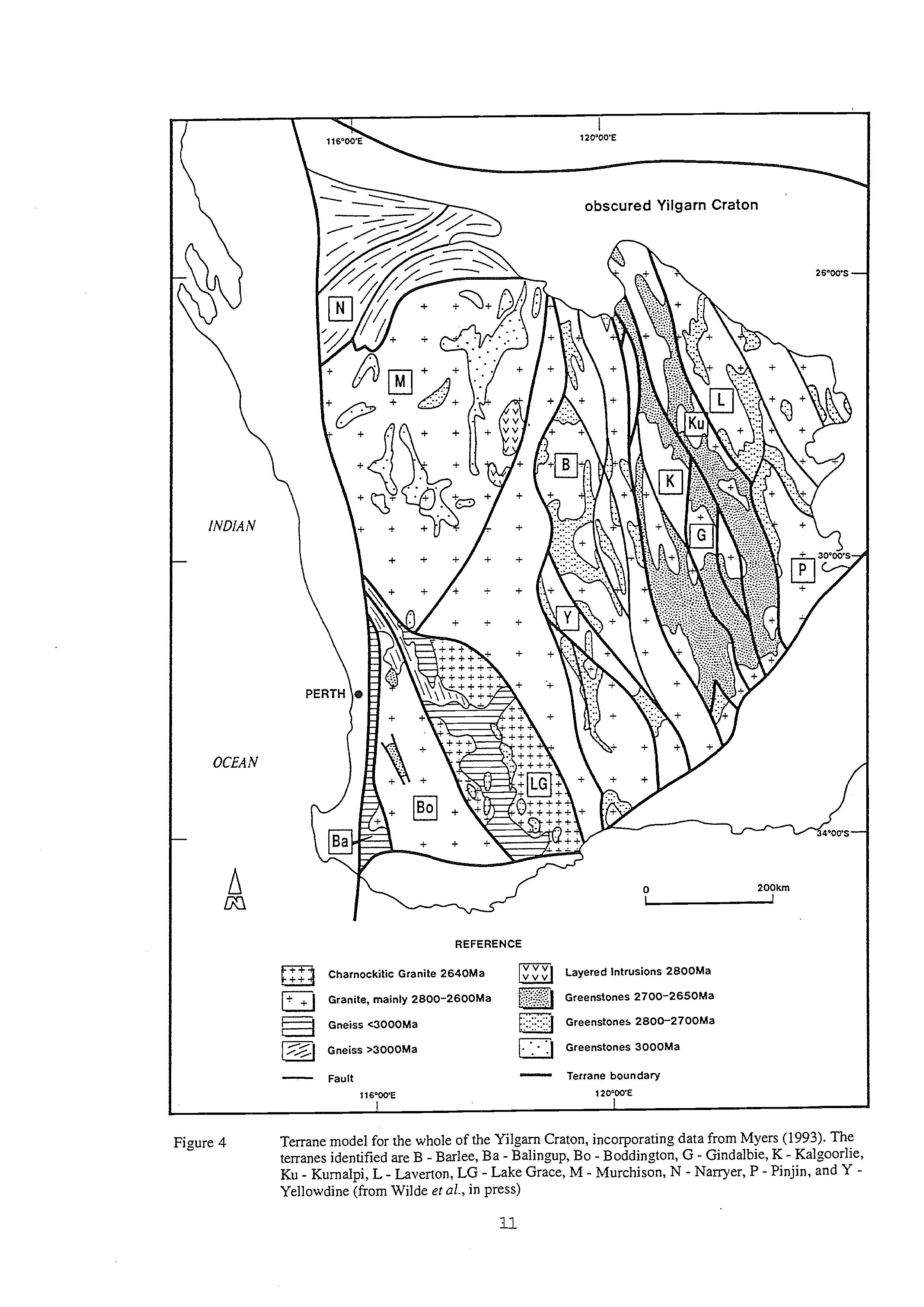
Greenstones 3000Ma
Fault116'WE - Terrane boundary
Figure 4 Terrane model for the whole of the Yilgarn Craton, incorporating data from Myers (1993). The terranes identified are B - Barlee, Ba - Balingup, Bo - Boddington, G - Gindalbie, K - Ralgoorlie, Ku - Kurnalpi, L - Laverton, LG - Lake Grace, M - Murchison, N - Narryer, P - Pinjin, and YYellowdine (from Wilde et ~l.,in press)
and Walker, 1982), extends through into the Lake Grace and Boddington terranes but appears to terminate abruptly to the southeast of Collie. It could be terminated by later Proterozoic strike-slip faulting or, alternatively, it could terminate at the boundary between the Boddington and Balingup terranes. A summary of the timing of major events in the various terranes is presented in Table 2.
Table 2. Timing of major Archaean events in the southwest Yilgarn Craton within the Balingup, Boddington, Lake Grace and Murchison Terranes. Modified from Wilde et al. (in press).
AGE (Ma) EVENT
BALINGUP TERRANE
2527
2577
2612
2740
2838
2830 - 3070
BODDINGTON TEFSUNE
2530 - 2560
- 2677 2654 - 2671
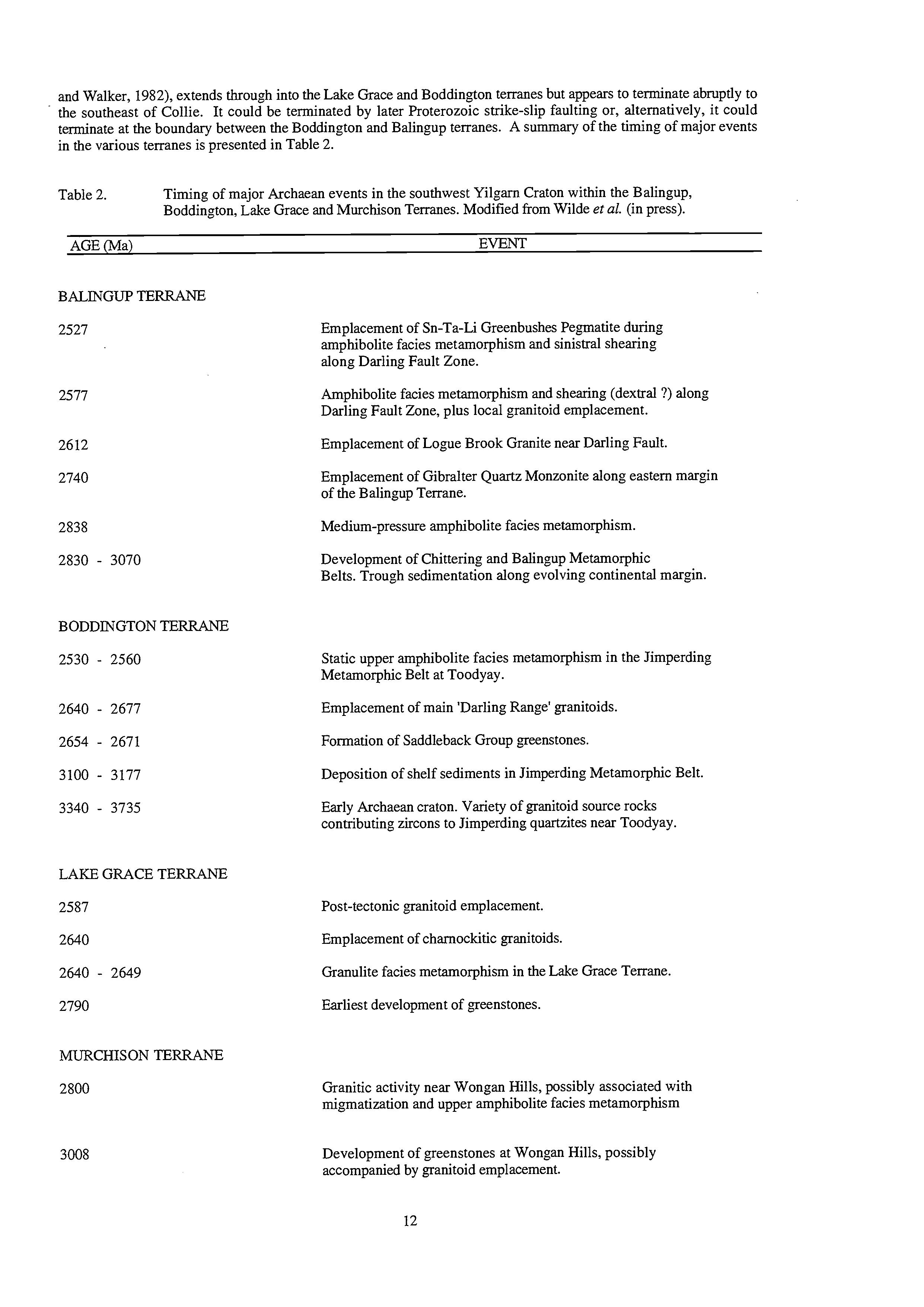
3008
Emplacement of Sn-Ta-Li Greenbushes Pegmatite during amphibolite facies metamorphism and sinistral shearing along Darling Fault Zone.
Amphibolite facies metamorphism and shearing (dextral ?) along Darling Fault Zone, plus local granitoid emplacement.
Emplacement of Logue Brook Granite near Darling Fault.
Emplacement of Gibralter Quartz Monzonite along eastern margin of the Balingup Terrane.
Medium-pressure amphibolite facies metamorphism.
Development of Chittering and Balingup Metamorphic Belts. Trough sedimentation along evolving continental margin.
Static upper amphibolite facies metamorphism in the Jimperding Metamorphic Belt at Toodyay.
Emplacement of main 'Darling Range' granitoids.
Formation of Saddleback Group greenstones.
Deposition of shelf sediments in Jimperding Metamorphic Belt.
Early Archaean craton. Variety of granitoid source rocks contributing zircons to Jimperding quartzites near Toodyay.
Post-tectonic granitoid emplacement.
Emplacement of charnockitic granitoids.
Granulite facies metamorphism in the Lake Grace Terrane.
Earliest development of greenstones.
Granitic activity near Wongan Hills, possibly associated with migmatization and upper amphibolite facies metamorphism
Development of greenstones at Wongan Hills, possibly accompanied by granitoid emplacement.
EXCURSION LOCALITIES
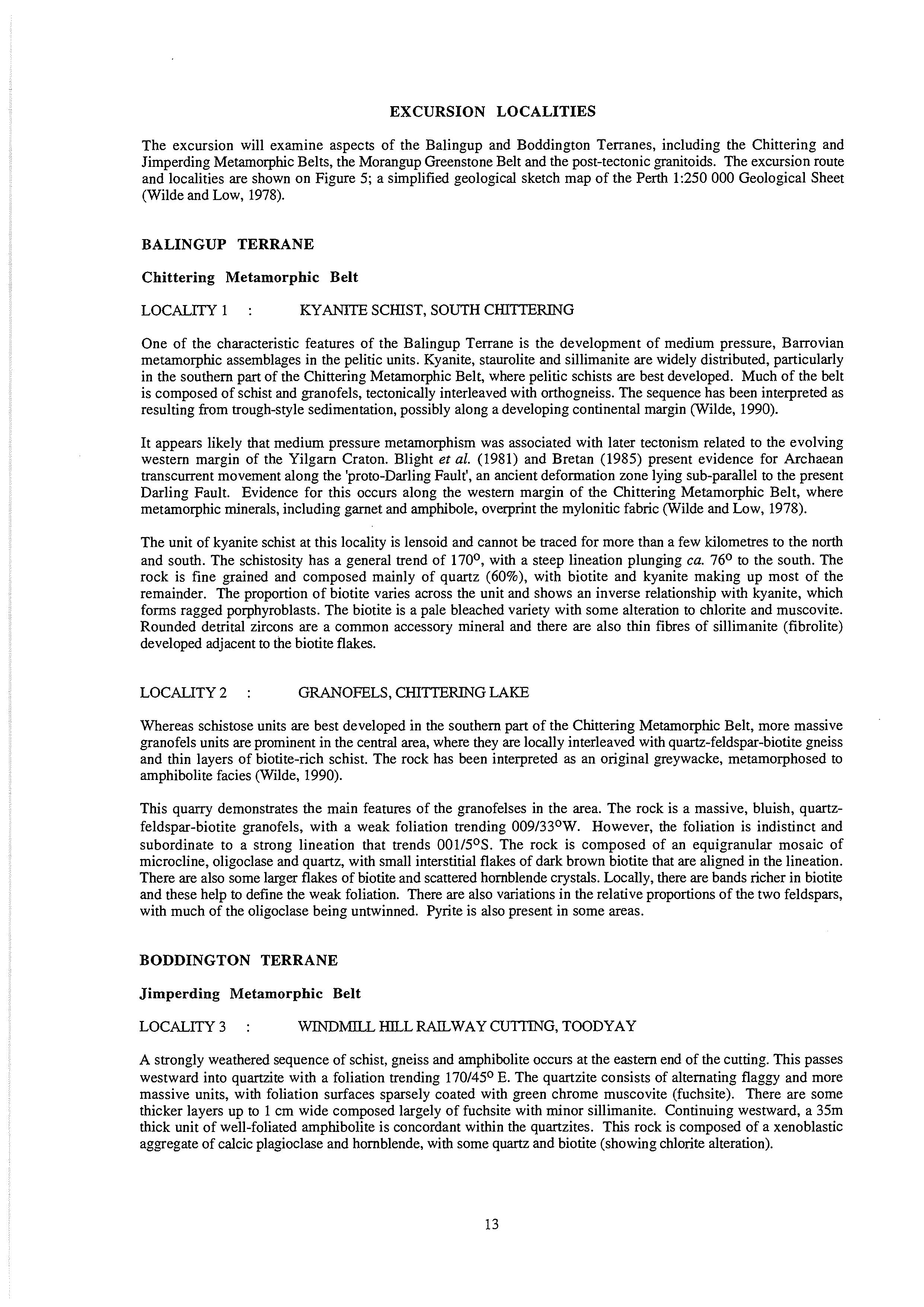
The excursion will examine aspects of the Balingup and Boddington Terranes, including the Chittering and Jimperding Metamorphic Belts, the Morangup GreenstoneBelt and the post-tectonic granitoids. The excursion route and localities are shown on Figure 5; a simplified geological sketch map of the Perth 1:250 000 Geological Sheet (Wilde and Low, 1978).
BALINGUP TERRANE
Chittering Metamorphic Belt
LOCALITY1 : KYANITE SCHIST, SOUTH
CHITTERING
One of the characteristic features of the Balingup Terrane is the development of medium pressure, Barrovian metamorphic assemblages in the pelitic units. Kyanite, staurolite and sillimanite are widely distributed, particularly in the southern part of the Chittering Metamorphic Belt, where pelitic schists are best developed. Much of the belt is composed of schist and granofels, tectonically interleaved with orthogneiss. The sequence has been interpreted as resulting from trough-style sedimentation,possibly along a developing continental margin (Wilde, 1990).
It appears likely that medium pressure metamorphism was associated with later tectonism related to the evolving western margin of the Yilgarn Craton. Blight et al. (1981) and Bretan (1985) present evidence for Archaean transcurrent movement along the 'proto-Darling Fault', an ancient deformation zone lying sub-parallel to the present Darling Fault. Evidence for this occurs along the western margin of the Chittering Metamorphic Belt, where metamorphic minerals, including garnet and amphibole, overprint the mylonitic fabric (Wilde and Low, 1978).
The unit of kyanite schist at this locality is lensoid and cannot be traced for more than a few kilometres to the north and south. The schistosity has a general trend of 170°, with a steep lineation plunging ca. 76O to the south. The rock is fine grained and composed mainly of quartz (60%), with biotite and kyanite making up most of the remainder. The proportion of biotite varies across the unit and shows an inverse relationship with kyanite, which forms ragged porphyroblasts. The biotite is a pale bleached variety with some alteration to chlorite and muscovite. Rounded detrital zircons are a common accessory mineral and there are also thin fibres of sillimanite (fibrolite) developed adjacent to the biotite flakes.
LOCALITY2 : GRANOFELS, CHITIERING LAKE
Whereas schistose units are best developed in the southern part of the Chittering Metamorphic Belt, more massive granofels units are prominent in the central area, where they are locally interleaved with quartz-feldspar-biotite gneiss and thin layers of biotite-rich schist. The rock has been interpreted as an original greywacke, metamorphosed to amphibolite facies (Wilde, 1990).
This quarry demonstrates the main features of the granofelses in the area. The rock is a massive, bluish, quartzfeldspar-biotite granofels, with a weak foliation trending O09/33°W. However, the foliation is indistinct and subordinate to a strong lineation that trends O01/5°S. The rock is composed of an equigranular mosaic of microcline, oligoclase and quartz, with small interstitial flakes of dark brown biotite that are aligned in the lineation. There are also some larger flakes of biotite and scattered hornblende crystals. Locally, there are bands richer in biotite and these help to define the weak foliation. There are also variations in the relative proportions of the two feldspars, with much of the oligoclase being untwinned. Pyrite is also present in some areas.
BODDINGTON TERRANE
Jimperding Metamorphic Belt
LOCALITY3 : WINDMILL HILL RAILWAY CU?TING,TOODYAY
A strongly weathered sequence of schist, gneiss and amphibolite occurs at the eastern end of the cutting. This passes westward into quartzite with a foliation trending 170/45O E. The quartzite consists of alternating flaggy and more massive units, with foliation surfaces sparsely coated with green chrome muscovite (fuchsite). There are some thicker layers up to 1 cm wide composed largely of fuchsite with minor sillimanite. Continuing westward, a 35m thick unit of well-foliated amphibolite is concordant within the quartzites. This rock is composed of a xenoblastic aggregate of calcic plagioclase and hornblende, with some quartz and biotite (showing chlorite alteration).
TOODYAY-CHITTERING EXCURSION
Solid Geology Interpretation Map of the Perth 1:250 000 Sheet
SCALE
5 0 I 10 IS I0 bm
r=Lt%l3-r----r-r=1
REFERENCE
Granitic Rocks
Migmatlte
E]Moranyp Greenstone Belt a .. Chittering Melamorphic Belt
L7.1Jirnperding Mctnmomliic Belt
SY MDOLS
- Geological boundary
-1-
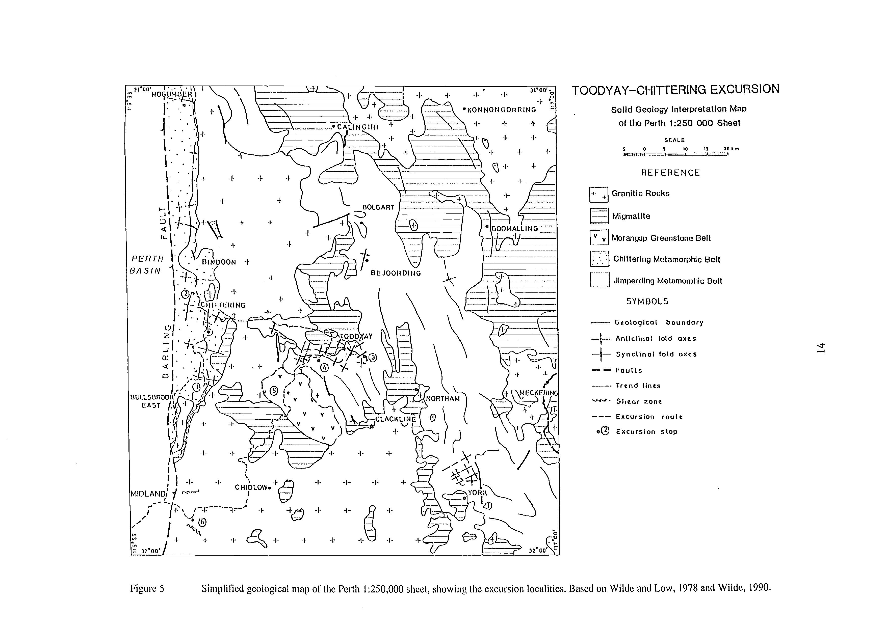
Antlcllnal lold axes
Syiiclinal ~o~daxes
- - Faulls
- Trend lines
-' Shear zone
Excursion roult ---
e@ Excursion slop

Further west, the quartzite is more flaggy and has a prominent lineation. There are some transgressive quartz and pegmatite veins, many of which are sub-horizontal. Some good examples of herringbone cross-bedding are preserved in the quartzite close to where the cutting is widest and these indicate that the sequence is the correct way up. PLEASE NOTE: this area is classified as a Geological Monument Site and samples MUST NOT BE REMOVED.
An extensively weathered ultramafic intrusion, approximately 15m wide, occurs to the west. This rock is particularly unstable and collapsed during construction of the cutting. A sub-vertical dolerite dyke cuts the quartzites to the west and is unmetamorphosed. At the extreme western end, ,mitic gneiss is faulted against the quartzite.
Fifty individual zircon grains were analysed using the SHRMP ion microprobe from a sample of fuchsitic quartzite collected from the northern side of the railway cutting (Kinny, in Wilde, 1990). Zircons from this unit had previously been studied by Nieuwland and Compston (1981) using multigrain techniques. From analyses of four grain-size fractions, Nieuwland and Compston obtained a discordance line with an upper intercept age of 3,341 +133/-73 Ma. They interpreted the good alignment of the analyses on the concordia diagram as indicating that the range in ages of rocks in the source area was rather small. However, it is clear from the ion microprobe analyses that the provenance ages span at least 550 million years.
A heterogeneous provenance for the quartzite is indicated. Two thirds of the detrital zircon populations have 207Pb/206Pbages in the range 3,200 Ma to 3,350 Ma (median 3,270 Ma), whereas the remaining one third are older, having 207Pb/206Pbages up to 3,500 Ma. Additionally, one grain yielded an age of 3,735 +lo Ma (20). Using these results, the positions of the four multigrain analyses of Nieuwland and Compston can be explained readily in terms of the admixture of all the above components identified by the ion probe, allowing for higher relative proportions of radiogenic Pb in the multigrain analyses to have been derived from discordant, high-U zircon (Kinny in Wilde, 1990).
The youngest concordant analysis of low-U zircon provides an upper limit to the time of deposition of the quartzite at 3,177 lt15 Ma (20). This is consistent with the ca 3,100 Ma upper limit for the deposition of the Mount Narryer quartzite, Jack Hills meta-conglomerate and related metasedimentary rocks from the northern part of the Western Gneiss Terrain (Compston and Pidgeon, 1986; Kinny et al., 1990) and suggests that the quartzites of the Jimperding Metamorphic Belt may be contemporaneous.
LOCALITY4 : POISON CREEK, TOODYAY
The area was first mapped and described by Prider (1934). Later work (Prider, 1944) extended the mapping to include most of the Toodyay region, including the previous locality of Windmill Hill. Rocks from the Poison Creek section were also sampled by Nieuwland (1980) and are critical to Nieuwland and Compston's (1981) interpretation of their U-Pb zircon data.
Poison Creek is partially controlled by a fault-line and is also sub-parallel to the metamorphic foliation in the area. The exposed rocks consist of a sequence of quartzites and orthogneisses. Within the quartzites are thin schistose units, some of which contain abundant sillimanite. There are also thin layers of banded amphibolite in which amphibole is far in excess of plagioclase.
The quartzites are fine to medium-grained with a xenoblastic granular texture. Accessory amounts of muscovite (locally fuchsite) and feldspar (both microcline and oligoclase) are present. The orthogneisses are medium to coarsegrained with variations in the intensity of the gneissic foliation. Most have an augen texture, with porphyroclasts of microcline strongly aligned in the fabric. The original rock was a porphyritic granite, as microcline is in excess of plagioclase. Biotite is the mafic mineral phase and is commonly altered to chlorite.
One of the most important features of the Poison Creek section is the exposed contact between orthogneiss and quartzite. The orthogneiss is intrusive, being discordant to the bedding and extending as veins into the quartzite. In addition, xenoliths of quartzite occur within the orthogneiss close to the contact. Later deformation has lessened the discordance and the contact is now sub-parallel to bedding in the quartzite. The granite appears to have been intruded as sheets (Prider, 1944).
Using conventional multigrain zircon U-Pb isotopic data, Nieuwland and Compston (1981) defined an age of ca 3,250 Ma for the igneous precursor of the orthogneiss This would constrain the minimum depositional age of the supracrustal succession. However, Kinny (personal communication, 1993) indicates that this age is the result of contamination by older quartzite xenoliths and the true age of intrusion is ca. 2.6 Ga.
LOCALITY5 : MORANGUP GREENSTONE BELT, MORANGUP HILL
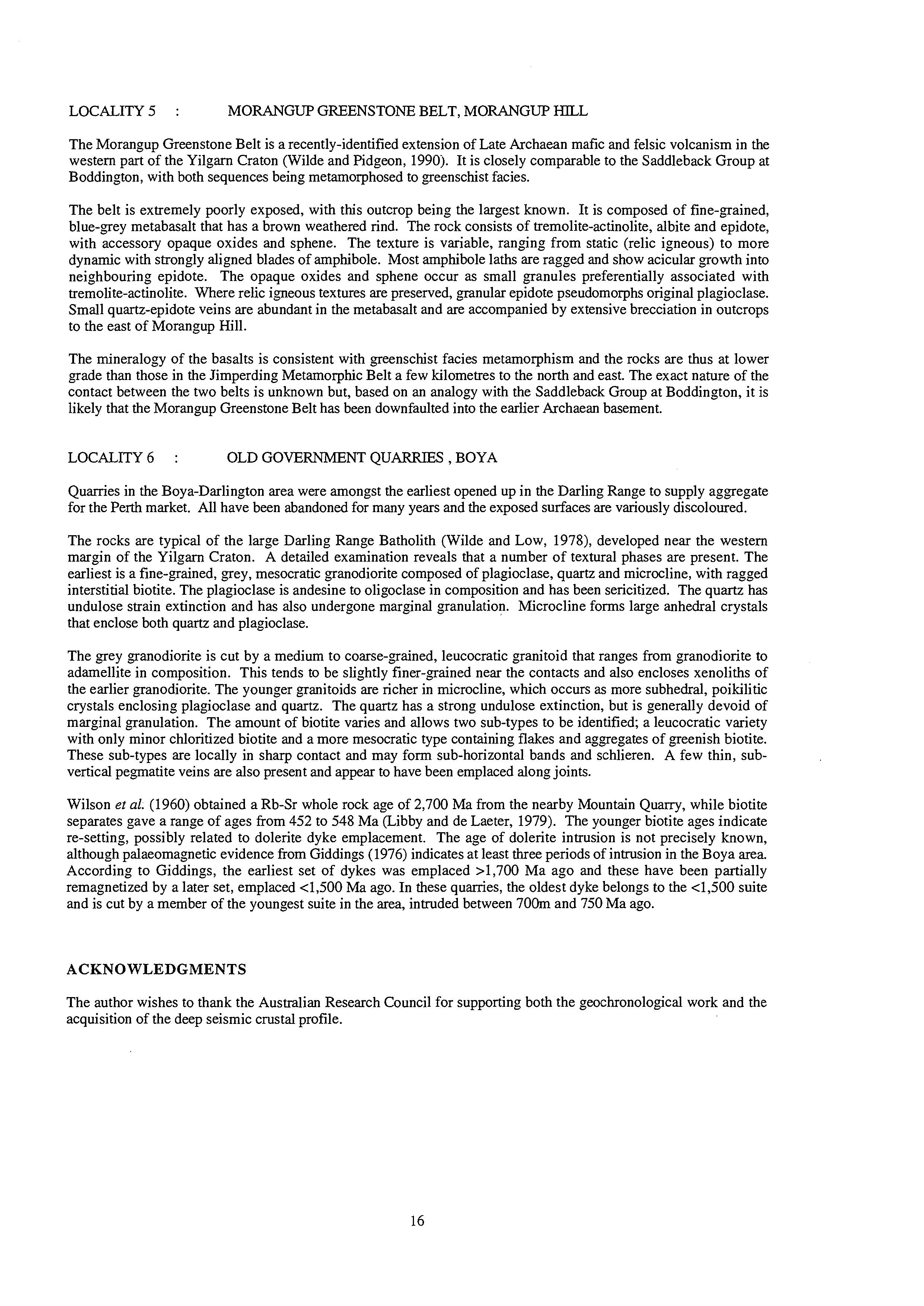
The Morangup Greenstone Belt is a recently-identified extension of Late Archaean mafk and felsic volcanism in the western part of the Yilgarn Craton (Wilde and Pidgeon, 1990). It is closely comparable to the Saddleback Group at Boddington, with both sequences being metamorphosed to greenschist facies.
The belt is extremely poorly exposed, with this outcrop being the largest known. It is composed of fine-grained, blue-grey metabasalt that has a brown weathered rind. The rock consists of tremolite-actinolite, albite and epidote, with accessory opaque oxides and sphene. The texture is variable, ranging from static (relic igneous) to more dynamic with strongly aligned blades of amphibole. Most amphibole laths are ragged and show acicular growth into neighbouring epidote. The opaque oxides and sphene occur as small granules preferentially associated with tremolite-actinolite. Where relic igneous textures are preserved, granular epidote pseudomorphs original plagioclase. Small quartz-epidote veins are abundant in the metabasalt and are accompanied by extensive brecciation in outcrops to the east of Morangup Hill.
The mineralogy of the basalts is consistent with greenschist facies metamorphism and the rocks are thus at lower grade than those in the Jimperding Metamorphic Belt a few kilometres to the north and east. The exact nature of the contact between the two belts is unknown but, based on an analogy with the Saddleback Group at Boddington, it is likely that the Morangup Greenstone Belt has been downfaulted into the earlier Archaean basement.
LOCALITY6 : OLD GOVERNMENT QUARRIES, BOYA
Quarries in the Boya-Darlington area were amongst the earliest opened up in the Darling Range to supply aggregate for the Perth market. All have been abandoned for many years and the exposed surfaces are variously discoloured.
The rocks are typical of the large Darling Range Batholith (Wilde and Low, 1978), developed near the western margin of the Yilgarn Craton. A detailed examination reveals that a number of textural phases are present. The earliest is a fine-grained, grey, mesocratic granodiorite composed of plagioclase, quartz and microcline, with ragged interstitial biotite. The plagioclase is andesine to oligoclase in composition and has been sericitized. The quartz has undulose strain extinction and has also undergone marginal granulation. Microcline forms large anhedral crystals that enclose both quartz and plagioclase.
The grey granodiorite is cut by a medium to coarse-grained, leucocratic granitoid that ranges from granodiorite to adamellite in composition. This tends to be slightly finer-grained near the contacts and also encloses xenoliths of the earlier granodiorite. The younger granitoids are richer in microcline, which occurs as more subhedral, poikilitic crystals enclosing plagioclase and quartz. The quartz has a strong undulose extinction, but is generally devoid of marginal granulation. The amount of biotite varies and allows two sub-types to be identified; a leucocratic variety with only minor chloritized biotite and a more mesocratic type containing flakes and aggregates of greenish biotite. These sub-types are locally in sharp contact and may form sub-horizontal bands and schlieren. A few thin, subvertical pe-gnatite veins are also present and appear to have been emplaced along joints.
Wilson et al. (1960) obtained a Rb-Sr whole rock age of 2,700 Ma from the nearby Mountain Quarry, while biotite separates gave a range of ages from 452 to 548 Ma (Libby and de Laeter, 1979). The younger biotite ages indicate re-setting, possibly related to dolerite dyke emplacement. The age of dolerite intrusion is not precisely known, although palaeomagnetic evidence from Giddings (1976) indicates at least three periods of intrusion in the Boya area. According to Giddings, the earliest set of dykes was emplaced >1,700 Ma ago and these have been partially remagnetized by a later set, emplaced ~1,500Ma ago. In these quarries, the oldest dyke belongs to the 4,500 suite and is cut by a member of the youngest suite in the area, intruded between 70Om and 750 Ma ago.
ACKNOWLEDGMENTS
The author wishes to thank the Australian Research Council for supporting both the geochronological work and the acquisition of the deep seismic crustal profile.
REFERENCES
Arriens P.A., 1971. The Archaean Geochronology of Australia. Geological Society of Australia, Special Publication No. 3, 11-23.
Blake T.S. and Groves D.I., 1987. Continental rifting and the Archaean-Proterozoic transition. Geology, 15, 229232.
Blight D.F., Compston W. and Wilde S.A., 1981. The Logue Brook Granite: age and significance of deformation zones along the Darling Scarp. Western Australian Geological Survey,Annual Report for 1980, 72-80.
Bretan P.G., 1985. Deformation processes within mylonite zones associated with some fundamental faults. University of London, PhD Thesis (unpublished).
Campbell I.H. and Hill R.I., 1988. A two-stage model for the formation of the granite-greenstone terrains of the Kalgoorlie-Norseman area, Western Australia. Earth and Planetary Science Letters, 90, 11-25.
Carter J.D. & Lipple S.L. 1982. Moora, Western Australia. 1:250 000 Geological Series Explanatory Notes. Geological Survey of Western Australia, 25p.
Compston W. and Pidgeon R.T., 1986. Jack Hills, a further occurrence of very old detrital zircons in Western Australia. Nature, 321, 766-769.
Compston W., Williams I.S. and McCulloch M.T., 1986. Contrasting zircon U-Pb and model Sm-Nd ages from the Archaean Lope Brook Granite. Australian Journal of Earth Sciences, 33, 193-200.
Compston W., Williams I.S., Campbell I.H. and Gresham J.J., 1985. Zircon xenocrysts from the Kambalda volcanics: age constraints and direct evidence for older continental crust below the Kambalda-Norseman greenstones. Earth and Planetary Science Letters, 76,299-31 1.
Cooper J.A. and Dong Y.B., 1983. Zircon age data from a greenstone of the Archaean Yilgarn Block, Australia. Contributions to Mineralogy and Petrology, 82, 397-402.
Davidson L.R., 1968. Variations in ferrous iron-magnesium distribution coefficients of metamorphic pyroxenes from Quairading, Western Australia. Contributions to Mineralogy and Petrology, 19, 239-259.
de Laeter J,R and Libby W.G., 1993. Early Palaeozoic biotite Rb-Sr dates in the Yilgarn Craton near Harvey, Western Australia. Australian Journal of Earth Sciences, 40,445-453.
de Laeter J.R., Fletcher, I.R., Bickle M.J., Myers J.S., Libby W.G. and Williams I.R., 1985. Rb-Sr, Sm-Nd and Pb-Pb geochronology of ancient gneisses from Mt Narryer, Western Australia. Australian Journal of Earth Sciences, 32, 349-358.
de Laeter J.R., Fletcher I.R., Rosman K.J.R., Williams I.R., Gee R.D. and Libby W.G., 1981. Early Archaean gneisses from the Yilgarn Block, Western Australia. Nature, 292, 322-324.
Doyle H.A., 1971. Seismicity and structure in Australia. Royal Society of New Zealand, Bulletin 9, 149-152. Everingham I.B., 1968. Seismicity of Western Australia. Bureau of Mineral Resources Report 1968/132, 21p.
Fletcher I.R., Rosman K.J.R. and Libby W.G., 1988. Sm-Nd, Pb-Pb and Rb-Sr geochronology of the Manfred Complex, Mount Narryer, Western Australia. Precambrian Research, 38,343-354.
Fletcher I.R., Libby W.G. and Rosman K.J.R., 1987. Geological Note: Sm-Nd dating of the 2411 Ma Jimberlana dyke, Yilgarn Block, Western Australia. Australian Journal of Earth Sciences, 34,523-525.
Fletcher I.R., Wilde S.A. and Rosman K.J.R., 1985. Sm-Nd ages across the margins of the Archaean Yilgarn Block, Western Australia - III; the Western margin. Australian Journal of Earth Sciences, 32,73-82.
Fletcher, I.R., Wilde S.A., Libby W.G. and Rosman K.J.R., 1983. Sm-Nd model ages across the margins of the Archaean Yilgarn Block, Western Australia - 11; Southwest transect into the Proterozoic Albany-Fraser Province. Geological Society of Australia, Journal 30, 333-340.
Fraser A.R. and Petiffer G.R.,1980. Reconnaissance gravity surveys in WA and SA, 1969-1972. Bureau of Mineral Resources, Bulletin 196, 60p.
Froude D.O., Ireland T.E., Kinny P.D., Williams IS., Compston W., Williams I.R. and Myers J.S., 1983. Ion microprobe identification of 4,1004,200 Myr-old terrestrial zircons. Nature, 304, 616-618.
Gee R.D., Baxter J.L., Wilde S.A. and Williams I.R., 1981. Crustal development in the Archaean Yilgarn Block, Western Australia. Geological Society of Australia, Special Publication No. 7,43-56.
Giddings J.W., 1976. Precambrian palaeomagnetism in Australia 1: Basic dykes and volcanics from the Yilgarn Block. Tectonophysics, 30, 91-108.
Glickson A.Y., 1971. Archaean geosynclinal sedimentation near Kalgoorlie, Western Australia. Geological Society of Australia, Special Publication No. 3, 443-460.
Glickson A.Y. and Lambert I.B., 1976. Vertical zonation and petrogenesis of the early Precambrian crust in Western Australia. Tectonophysics, 30,55-89.
Groves D.I. and Batt W.D., 1984. Spatial and temporal variations of Archaean metallogenic associations in terms of evolution of granitoid-greenstone terrains with particular emphasis on the Western Australian Shield. in Kroner, A.,Hanson, G.N. and Goodwin, A.M (editors)Archaean Geochemistry, Springer-Verlag, Berlin, 73-98. Hallberg J.A., 1986. Archaean basin development and crustal extension in the northeastern Yilgarn Block, Western Australia. Precambrian Research, 31, 133-156.
Kinny P.D., Wijbrans J.R., Froude D.O., Williams I.S. and Compston W., 1990. Age constraints on the geological evolution of the Narryer Gneiss Complex, Western Australia. Australian Journal of Earth Sciences,
orthogneisses and anorthosites at Mount Narryer, Western Australia. Precambrian Research, 38,325-34 1.
Kinny P.D., Williams I.S., Froude D.O., Ireland T.R. and Compston W., 1988. Early Archaean zircon ages from Libby W. G. and de Laeter J.R. 1979. Biotite dates and cooling history at the Western margin of the Yilgarn Block. Lindsley D.H., 1983. Pyroxene Thermometry. American Mineralogist, 68,477-493. 37, 51-69.
Geological Survey of Westem Australia Annual Report for 1978, 79-87.
Mathur S.P., 1974. Crustal structure in southwestern Australia from seismic and gravity data. Tectonophysics, 24,
151-182.
Middleton M. F., Wilde S.A., Evans B.J., Long A. and Dentith M., 1993. A preliminary interpretation of deep seismic reflection and other geophysical data from the Darling Fault Zone, Western Australia. Exploration Geophysics, 24, 71 1-718.
Middleton M. F., Wilde S.A., Evans B.J., Long A., Dentith M. and Morawa M.A., (in press). Implications of a geoscientific traverse over the Darling Fault Zone, Western Australia. Australian Journal of Earth Sciences, 42. Morawa M.A., 1992. Explanatory notes for the ARC Darling Fault seismic traverse. Postgraduate Diploma Thesis, Curtin University of Technology (unpublished), 23p.
Myers, J.S., 1993. Precambrian history of the West Australian craton and adjacent orogens. Annual Review of Earth and Planetary Science, 21,453-485.
Myers J.S., 1988. Early Archaean Narryer Gneiss Complex, Yilgarn Craton, Western Australia. Precambrian Research, 38, 297-307.
Nemchin A.A., Pidgeon R.T. and Wilde S.A. (in press). Timing of Late Archaean granulite facies metamorphism in the southwestern Yilgarn Craton of Western Australia: evidence from U-Pb ages of zircons from mafic granulites. Precambrian Research.
Nieuwland D.A., 1980. Structural geology and geochronology of the Toodyay district, Western Australia. Australian National University, PhD Thesis (unpublished).
Nieuwland D.A. and Compston W., 1981. Crustal evolution in the Yilgarn Block near Perth, Western Australia. Geological Society of Australia, Special Publication No. 7, 159-171.
Partington G.A., McNaughton N.J., Kepert D.A., Compston W. and Williams I.S., 1986. Geochronology of the Balingup Metamorphic Belt: constraints on the temporal evolution of the Greenbushes Pe-gnatite District. Bureau of Mineral Resources Record 1986110, 55-56.
Pidgeon R.T. and Wilde S.A., 1990. The distribution of 3.0 Ga and 2.7 Ga volcanic episodes in the Yilgarn Craton of Western Australia. Precambrian Research, 48: 309-325.
Pidgeon R.T., Wilde S.A., Compston W. and Shield M.W., 1990. Archaean evolution of the Wongan Hills Greenstone Belt, Yilgarn Craton, Western Australia. Australian Journal of Earth Sciences, 37, 279-292.
Prider R.T., 1934. The geology and physiography of the Jimperding area. Royal Society of Western Australia, Journal 20, 1-16.
Prider R.T., 1944. The geology and petrology of part of the Toodyay district, Western Australia. Royal Society of Western Australia, Journal 28, 83-137.
Rosman K.J.R., Wilde S.A., Libby W.G. and de Laeter, J.R., 1980. Rb-Sr dating of granitic rocks in the Pemberton area. Western Australian Geological Survey, Annual Report for 1979, 97- 100.
Wilde S.A., 1974. Explanatory Notes on the Archaean rocks of the Perth 1:250 000 Geological Sheet, Western Australia. Western Australian Geological Survey, Record 1974115, 43p.
Wilde S.A., 1976. The Saddleback Group - a newly-discovered Archaean greenstone belt in the southwestern Yilgarn Block. Western Australian Geological Survey, Annual Report for 1975, 92-95.
Wilde S.A., 1980. The Jimperding Metamorphic Belt in the Toodyay area and the Balingup Metamorphic Belt and associated granitic rocks of the Southwestern Yilgarn Block. International Archaean Symposium, 2nd, Perth 1980, Geological Society of Australia, Excursion Guide, 41p.
Wilde S.A., 1990. Geology and crustal evolution of the southwestern Yilgarn Craton. in S.E. Ho, J.E. Glover, J.S. Myers and J.R. MuhIing (editors), Third International Archaean Symposium, Perth, 1990, Excursion Guidebook, Geology Department and University Extension Publication, 21,97- 122.
Wilde S.A. and Low G.H., 1978. Perth, Western Australia. 1:250 000 Geological Series Explanatory Notes, Western Australian Geological Survey, 36 p.
Wilde S.A. and Pidgeon R.T., 1986. Geology and geochronology of the Saddleback Greenstone Belt in the Archaean Yilgarn Block, southwestern Australia. Australian Journal of Earth Sciences, 33,49 1-501.
Wilde S.A. and Pidgeon R.T., 1987. U-Pb geochronology, geothermometry and petrology of the main areas of gold mineralization in the "Wheat Belt" region of Western Australia. Western Australian Minerals and Petroleum Research Institute, Project 30, Final Report, 171 p.
Wilde S.A. and Pidgeon R.T., 1990. The Morangup Greenstone Belt: a further discovery of Late Archaean volcanic rocks in the southwest Yilgarn Craton, Western Australia. International Archaean Symposium, 3rd Perth 1990, Abstracts, Geoconferences,205-206.
Wilde S.A. and Walker I.W., 1982. Collie, Western Australia. 1:250 000 Geological Series Explanatory Notes WesternAustralian Geological Survey , 39 p.
Wilde S.A. and Walker I.W., 1984. Pemberton-Irwin Inlet, Western Australia. 1:250 000 Geological Series Explanatory Notes Western Australian Geological Survey, 37 p.
Wilde S.A., Middleton M.F. and Evans B.J., in press. Terrane accretion in the southwest Yilgarn Craton: evidence from a deep seismic crustal profile. Precambrian Research, IGCP 280 Special Volume.
Wilson A.F., 1958. Advances in the knowledge of the structure and petrology of the Precambrian rocks of southwestern Australia. Royal Society of Western Australia, Journal 41, 57-83.
Wilson A.F., 1969. Granulite terrains and their tectonic setting and relationship to associated metamorphic rocks in Australia. Geological Society of Australia, Special Publication No. 2, 243-258.
Wilson A.F. and Green D.C., 1971. The use of oxygen isotopes for geothermometry of Proterozoic and Archaean granulites. Geological Society of Australia, Special Publication No. 3, 389-400.
Wilson A.F., Compston W., Jeffrey P.M. and Riley G.H., 1960. Radioactive ages from the Precambrian rocks of Australia. Geological Society of Australia, Journal 6, 179-195.