Geological Society of Australia (WA Division)
EXCURSION GUIDEBOOK No. 6 LA
J. S. Myers
Geological Survey of Western Australia, 100 Plain Street, East Perth, Western Australia 6004
12th Australian Geological Convention September 1994
Guidebook for the pre-convention excursion E6
12th Australian Geological Convention, Perth, September 1994
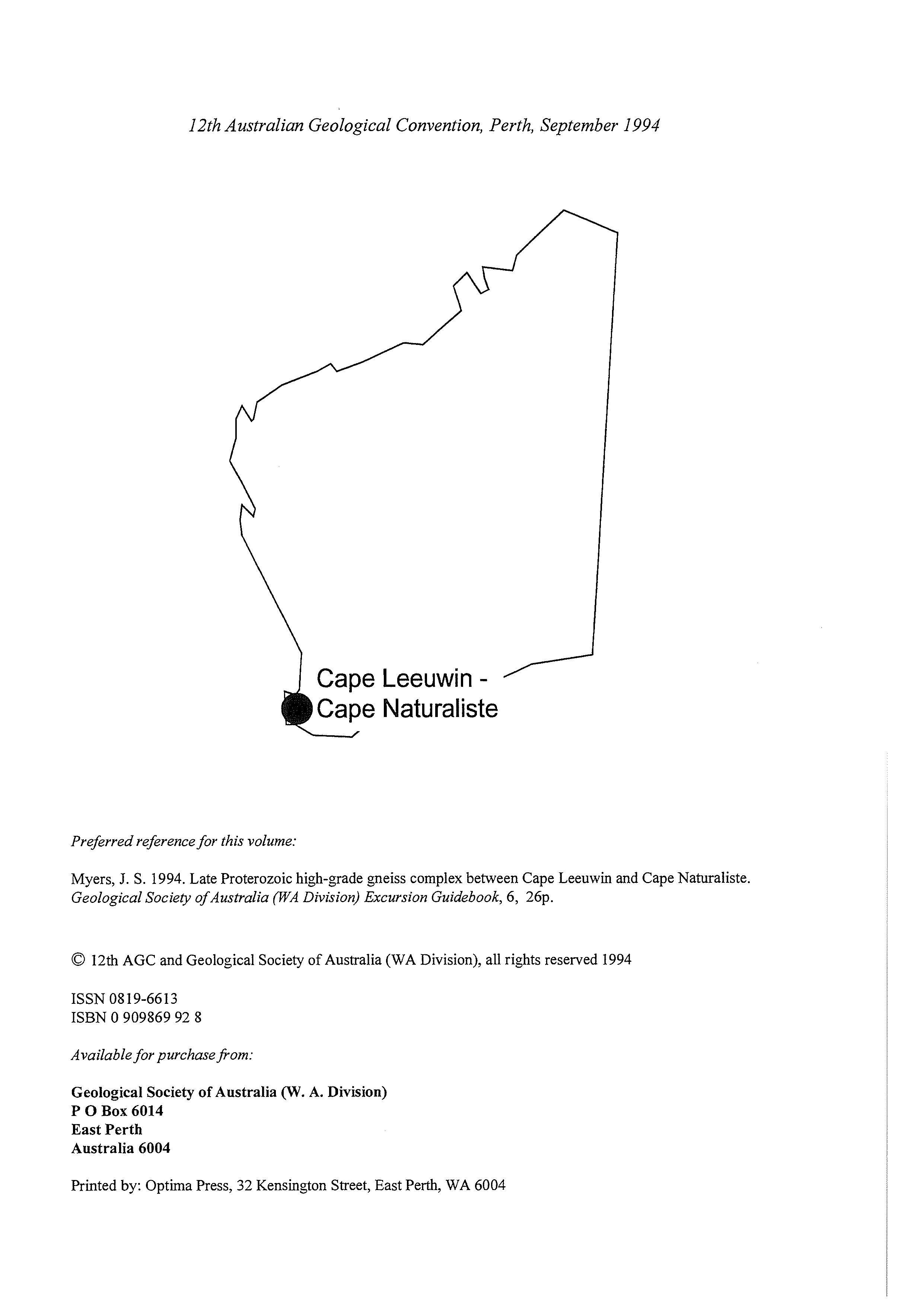
1 Cape Leeuwin - / Cape Naturaliste
Preferred referencefor this volume:
Myers, J. S. 1994. Late Proterozoic high-grade gneiss complex between Cape Leeuwin and Cape Naturaliste. Geological Society of Australia (WA Division) Excursion Guidebook, 6, 26p.
0 12th AGC and Geological Society of Australia (WA Division), all rights reserved 1994
ISSN 0819-6613
ISBN 0 909869 92 8
Available for purchase porn:
Geological Society of Australia (W. A. Division)
P 0 Box 6014
East Perth
Australia 6004
Printed by: Optima Press, 32 Kensington Street, East Perth, WA 6004
BUNBUR LEEUWIN COMPLEX
Cape Naturaliste
LOC. 1
7
Lac. 4
SOUTHERN OCEAN
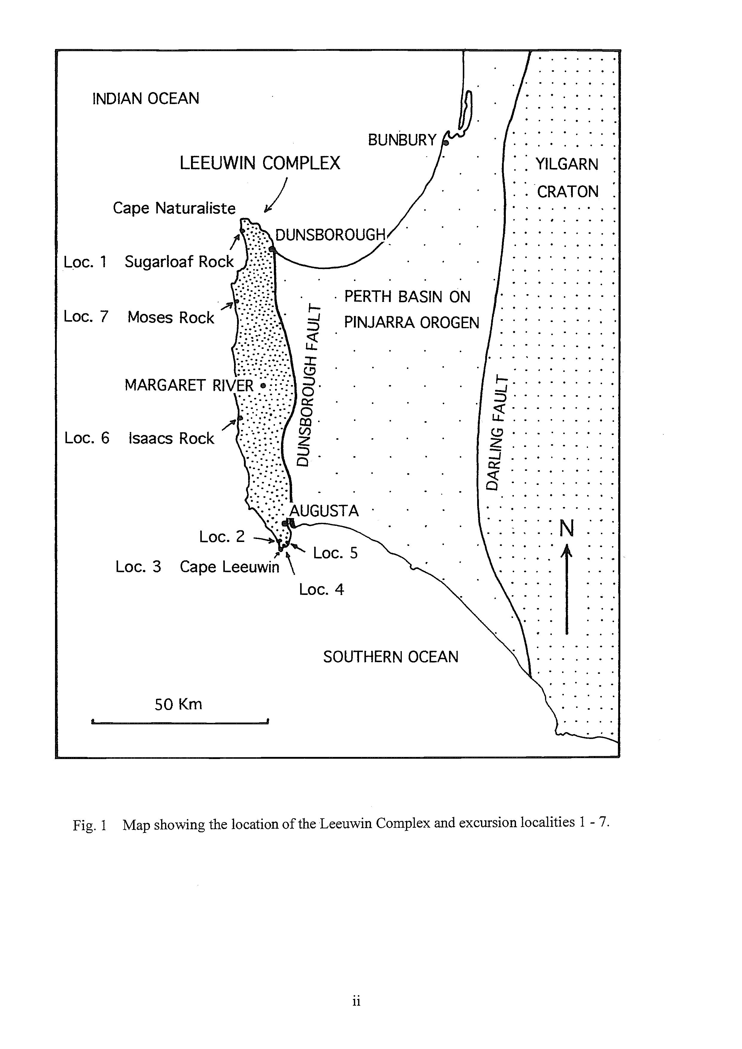
1 Map showing the location of the Leeuwin Complex and excursion localities 1 - 7.
REGIONAL GEOLOGY OF THE LEEUWIN COMPLEX
The Leeuwin Complex consists of granitic and anorthositic gneisses that have been strongly deformed and recrystallized at granulite grade of metamorphism. It forms the southwest corner of Australia and is well exposed along the coast between Dunsborough and Augusta (Fig. 1) (for more detailed regional map see Myers 1989).
The crystalline rocks of the Leeuwin Complex form a north-trending ridge 15 km wide and 100 km long. The same rocks can be traced fiom aeromagnetic data offshore to the edge of the continental shelf both to the south and to the northwest. The complex is bounded to the east by the Dunsborough Fault (Fig. l), part of a rift system that was active during the separation of Australia from greater India in the Mesozoic. A crystalline basement of early and middle Proterozoic rocks was downfaulted between the Dunsborough and Darling Faults and buried by about 5 km of Permian to Cretaceous shallow marine sedimentary rocks in the Perth Basin (Fig. 1). To the east of the Darling Fault, the Archaean Yilgarn Craton forms an elevated plateau of granite and gneiss with metavolcanic and metasedimentary rocks.
The Leeuwin Complex and the basement beneath the Perth Basin to the east form part of the Pinjarra Orogen (Myers 1990a). This orogen consists of a collage of terranes that were accreted to the western margin of the Yilgarn Craton during the Proterozoic. Most of the orogen is buried by Phanerozoic rocks deposited in the Perth Basin, a Phanerozoic rift system that developed on the older orogen. Other exposures of the Pinjarra Orogen form the Northampton Block and Mullingarra inliers (see inset map on Fig. 4).
The age of the Leeuwin Complex is unknown in detail. A U-Pb zircon age of 550 - 570 Ma from a granitic gneiss northwest of Dunsborough is thought to date the igneous precursor of the gneiss (Wilde and Murphy 1990). The gneiss is deformed and metamorphosed in granulite facies, and the zircon age suggests that this deformation and metamorphism occurred in latest Precambrian or early Phanerozoic time. Two samples from the Leeuwin Complex have given Sm-Nd model ages of 1130 and 1160 Ma (McCulloch 1987). These model ages are distinctly younger than Sm-Nd model ages of 2280 - 2032 Ma obtained from boreholes into basement of the Perth Basin to the east (recalculated by Fletcher, personal communication 1988, from Fletcher and others 1985).
The Leeuwin Complex consists of intensely deformed plutonic igneous rocks, mainly granite and a smaller amount of anorthosite (Myers 1990a, b). All the main components have been metamorphosed to granulite facies, but in many places the rocks were subsequently recrystallized to retrograde amphibolite facies. Although most rocks are strongly deformed, the deformation was heterogeneous and relict primary textures are widely preserved. Most granitic gneisses can be subdivided on the basis of inferred primary grain size into even grained and porphyritic varieties. The anorthositic gneisses contain relict igneous layering and range in composition from anorthosite through leucogabbro to gabbro (Myers 1990b).
The Leuwin Complex is dominated by subvertical, north-trending layering and foliation. The contacts between most rock units and abundant pegmatite veins are strongly deformed and are sub-parallel. The banding is attenuated and boudinage is widespread. The main foliation is parallel to the axial surfaces of mesoscopic isoclinal folds. This foliation and associated lineations are refolded by tight to open, upright, northwest-trending, north-plunging folds.
Large-scale folds of banding are suggested by alternating belts of S- and 2-profile minor folds. These folds are typically asymmetric. Long limbs are attenuated and some contain pegmatite veins associated with granulite facies metamorphism.
Most rocks are either in granulite facies and contain greenish greasy-looking quartz and feldspar with minor orthopyroxene, clinopyroxene and garnet, or in amphibolite facies and are brown or white quartz-feldspar-biotite rocks with textures indicating retrogression from granulite facies. Prograde granulite facies mineral assemblages and textures, and partial melt patches, are also seen locally enclosed by rocks in prograde amphibolite facies. These suggest that conditions were close to the amphibolite-granulite facies transiion.
Deformed and recrystallized mafic dykes are widespread. Some cut across pegmatite melt patches and minor folds of the pegmatite-banded gneiss, and are themselves recrystallized in granulite or amphibolite facies. Granitic pegmatite veins rich in K-feldspar and magnetite are widespread. They cut the main fold structures and caused retrogression where they cut greenish, greasy looking granulite facies rocks. Thin tonalite dykes are also widespread. They cut pegmatite melt patches and veins and so appear to post-date the peak of metamorphism. They are generally undeformed or slightly deformed but are recrystallized in amphibolite facies.
The Leeuwin Complex is partly overlain by Tertiary laterite and sand, but the most prominent Cainozoic rock unit is Tamala Limestone (see maps by Myers 1989 and Leonhard 1991). The limestone is derived from calcareous sand that was blown fiom the west during low stands of sea level associated with times of maximum glaciation during the Pleistocene. The sand accumulated on the western flank of the partly laterite covered erosion surfaces of the Leeuwin-Naturaliste ridge, and was lithified by groundwater. Recent erosion of the limestone has led to the formatioin of numerous cave systems.
SEQUENCE OF MAJOR EVENTS
A sequence of events can be determined by observations of the superposition of intrusions, deformation and metamorphism. The rocks of the Leeuwin Complex can also be subdivided on the basis of these observations into two major groups: older Cowaramup gneiss and younger Hamelin granite (Table 1).
The oldest component of the Cowaramup gneiss is the Augusta anorthosite complex which crystallized as one or a number of layered intrusions ranging from anorthosite through leucogabbro to gabbro. The anorthosite complex was intruded by sheets of granite and veins of pegmatite. These rocks were subjected to intense deformation (Dl) accompanied by highgrade metamorphism. The pegmatite vein networks were flattened, folded, and attenuated, and the granite became a pegmatite-banded gneiss. At the same time the interleaved layers of anorthosite, leucogabbro and gabbro were isoclinally folded. Continued flattening led to boudinage of the more competent anorthositic layers within the less competent granitic gneiss.
Table 1 Outline of main events
Igneous emplacement
granite, pegmatite and dolerite
D3 dykes granulite facies D2 high-grade
Hamelin granite and dolerite dykes
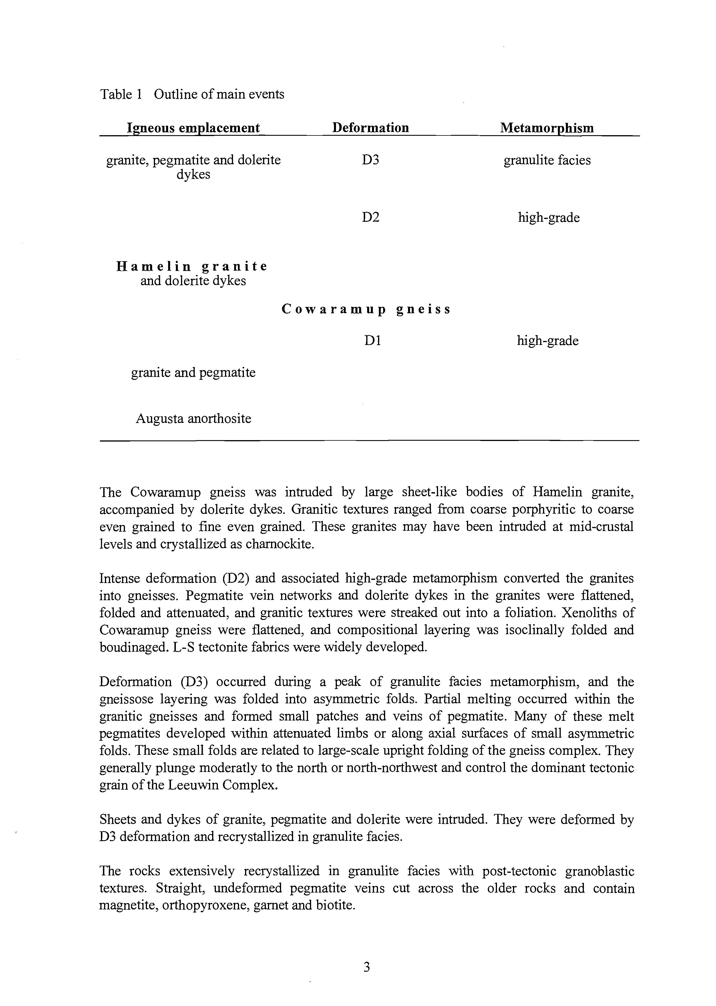
granite and pegmatite
Cowaramup gneiss
Augusta anorthosite high-grade
The Cowaramup gneiss was intruded by large sheet-like bodies of Hamelin granite, accompanied by dolerite dykes. Granitic textures ranged fiom coarse porphyritic to coarse even grained to fine even grained. These granites may have been intruded at mid-crustal levels and crystallized as charnockite.
Intense deformation (D2) and associated high-grade metamorphism converted the granites into gneisses. Pegmatite vein networks and dolerite dykes in the granites were flattened, folded and attenuated, and granitic textures were streaked out into a foliation. Xenoliths of Cowaramup gneiss were flattened, and compositional layering was isoclinally folded and boudinaged. L-S tectonite fabrics were widely developed.
Deformation (D3) occurred during a peak of granulite facies metamorphism, and the gneissose layering was folded into asymmetric folds. Partial melting occurred within the granitic gneisses and formed small patches and veins of pegmatite. Many of these melt pegmatites developed within attenuated limbs or along axial surfaces of small asymmetric folds. These small folds are related to large-scale upright folding of the gneiss complex. They generally plunge moderatly to the north or north-northwest and control the dominant tectonic grain of the Leeuwin Complex.
Sheets and dykes of granite, pegmatite and dolerite were intruded. They were deformed by D3 deformation and recrystallized in granulite facies.
The rocks extensively recrystallized in granulite facies with post-tectonic granoblastic textures. Straight, undeformed pegmatite veins cut across the older rocks and contain magnetite, orthopyroxene, garnet and biotite.
Thin tonalitic dykes were intruded after the peak of granulite facies metamorphism. They were slightly deformed and recrystallized in amphibolite facies.
Partial retrogression to amphibolite facies occurred during uplift and cooling.
TECTONIC SETTING
The Proterozoic tectonic setting of the Leeuwin Complex is unknown. The complex is in fault contact with rocks of the Perth Basin that overlie a crystalline basement that has given much older Sm-Nd model ages than rocks of the Leeuwin Complex. The basement of the Perth Basin is in turn in fault contact to the east with the older, Archaean Yilgarn Craton.
This situation could be interpreted as reflecting successive accretion of younger sialic crust against the Yilgarn Craton. However there is no evidence of the timing of such accretion, nor that these crystalline rocks formed alongside the Yilgarn Craton. Alternatively it is possible that both the Leeuwin Complex and the basement beneath the Perth Basin formed elsewhere, either independently or together, and were not assembled in their present relative positions until a later time, up to latest Precambrian time.
Both D1 and D2 episodes of deformation reflect substantial crustal compression at midcrustal depths, accompanied by recrystallization in amphibolite and granulite facies. Metamorphic recrystallization in granulite facies outlasted D2 deformation suggesting that the rocks remained at a deep crustal level, and that the immediately preceeding tectonic environment had led to crustal thickening. This suggests an environment of crustal collision.
Remnants of a layered anorthosite body (or bodies) occur intimately interleaved with granitic gneiss throughout the Leeuwin Complex, suggesting that this older part of the complex (Cowaramup gneiss) represents a single slice of sialic crust. After an episode of substantial deformation and metamorphism (Dl), these rocks were intruded by a large amount of granite (Hamelin granite) probably in a number of sheet-like bodies. The granites were accompanied by the intrusion of mafic dykes, significant deformation and granulite facies recrystallization. The time that may have elapsed between the D1 and D2 episodes is unknown. Unless this time can be demonstrated to have been short, then it cannot be assumed that the large volume of Hamelin granite that postdates D1 is in any way related to the tectonic environment that gave rise to the anorthosite. The relative age of the anorthosite and associated pre-D1 granite is likewise unknown.
The anorthosite does not contain evidence of equant calcic plagioclase megacrysts that are a characteristic feature of Archaean anorthosites, and so it may be Proterozoic in age. Most Proterozoic anorthosites formed between 1300 and 950 Ma and typically comprise large plutons dominated by sodic plagioclase (Ashwal, 1993). The surviving remnants of fresh igneous plagioclase in the Augusta anorthosite are predominantly calcic (bytownitelabradorite). Thus the Augusta anorthosite also differs from typical ("massif-type") midProterozoic anorthosites.
Some of the mid-Proterozoic anorthosites, such as in the Adirondacks and in southern Norway, are intimately associated with, and thought by some to be genetically related to, chamockites and mangerites The Hamelin granites (chamockites) of the Leeuwin Complex that post-date D 1 are tectonically, and probably temporally, distinct from the anorthosites, although the anorthosites could broadly be contemporaneous with the older granites that predate D 1.
The Cowaramup gneiss is probably of mid-Proterozoic or late Proterozoic age. The Hamelin granites are probably of late Proterozoic age and may be part of a widespread episode of granite emplacement associated with deformation and high-grade metamorphism that occurred in older orogenic belts during the disintegration of the supercontinent of Rodinia between about 750 and 500 Ma.
DESCRIPTION OF LOCALITIES
The excursion visits some of the most easily accessible localities that provide examples of the main rock types, structures and sequence of events in the geological history of the Leeuwin Complex. They provide an opportunity of observe geological processes that occurred at midcrustal depths, and led to the formation of a heterogeneous high-grade gneiss complex.
Note that much of the coastline between Dunsborough and Augusta is part of the Leeuwin Naturaliste National Park. Hammering of rocks should be avoided and permission should be sought for the collection of any rock samples. Localities 1,2, 6 and 7 are part of the National Park.
Most of this coastline faces the open ocean and the prevailing easterly drift of both the wind systems and the predominant current of the Southern Ocean. It is therefore vulnerable to freak waves and unexpected heavy swell, and so vigilance and caution should always be exercised on these coastal outcrops.
Locality 1 Sugarloaf Rock
There is easy access to a variety of components of the Leeuwin Complex from the car park at Sugarloaf Rock (Fig. 2). Intrusive relations between some of the main rock units can also be seen more clearly than elsewhere.
Between the car park and the neck of the rocky promentary adjacent to the south of Sugarloaf Rock the most abundant rock is pegmatite-banded granitic gneiss. The banding is a result of intense deformation of pegmatite veins in relatively uniform granite (Hamelin granite). The veins have been folded, rotated into parallelism, attenuated and streaked out. This granitic gneiss contains thin discontinuous layers of amphibolite and metamorphosed leucogabbro and anorthosite that have been boudinaged during the deformation of the gneiss. Some layers of amphibolite may have been derived from gabbro associated with the leucogabbro ad anorthosite, but some may have been derived from dolerite dykes. There are also deformed inclusions of heterogeneous Cowaramup gneiss.
The largest outcrop of Cowaramup gneiss occurs on the eastern part of the headland south of Sugarloaf Rock (Fig. 2). It comprises heterogeneous granitic gneiss with disrupted layers of amphibolite and anorthosite, and is part of a north-plunging fold core. The paler, grey Cowaramup gneiss is veined by pinker granite and pegmatite, and contains diffuse pegmatite melt patches and veins. The granite and pegmatite veins cut older gneissic layering and fold structures in the Cowaramup gneiss.
Above and to the west of this fold core of Cowaramup gneiss, the relatively uniform granitic gneiss contains amphibolite layers that are probably derived from dolerite dykes. The dykes were strongly deformed, boudinaged and then folded by D3. Profile sections of large-scale D3 folds can be seen on the south-facing cliff of Sugarloaf Rock, and small folds of the same gereration can be seen on the rocky headland. The predominant folds are open or tight and have Z-shaped profiles. Axial surfaces dip steeply east, parallel to the regional strike of the gneissose layering of the Leeuwin Complex. The folds developed an axial planar foliation.
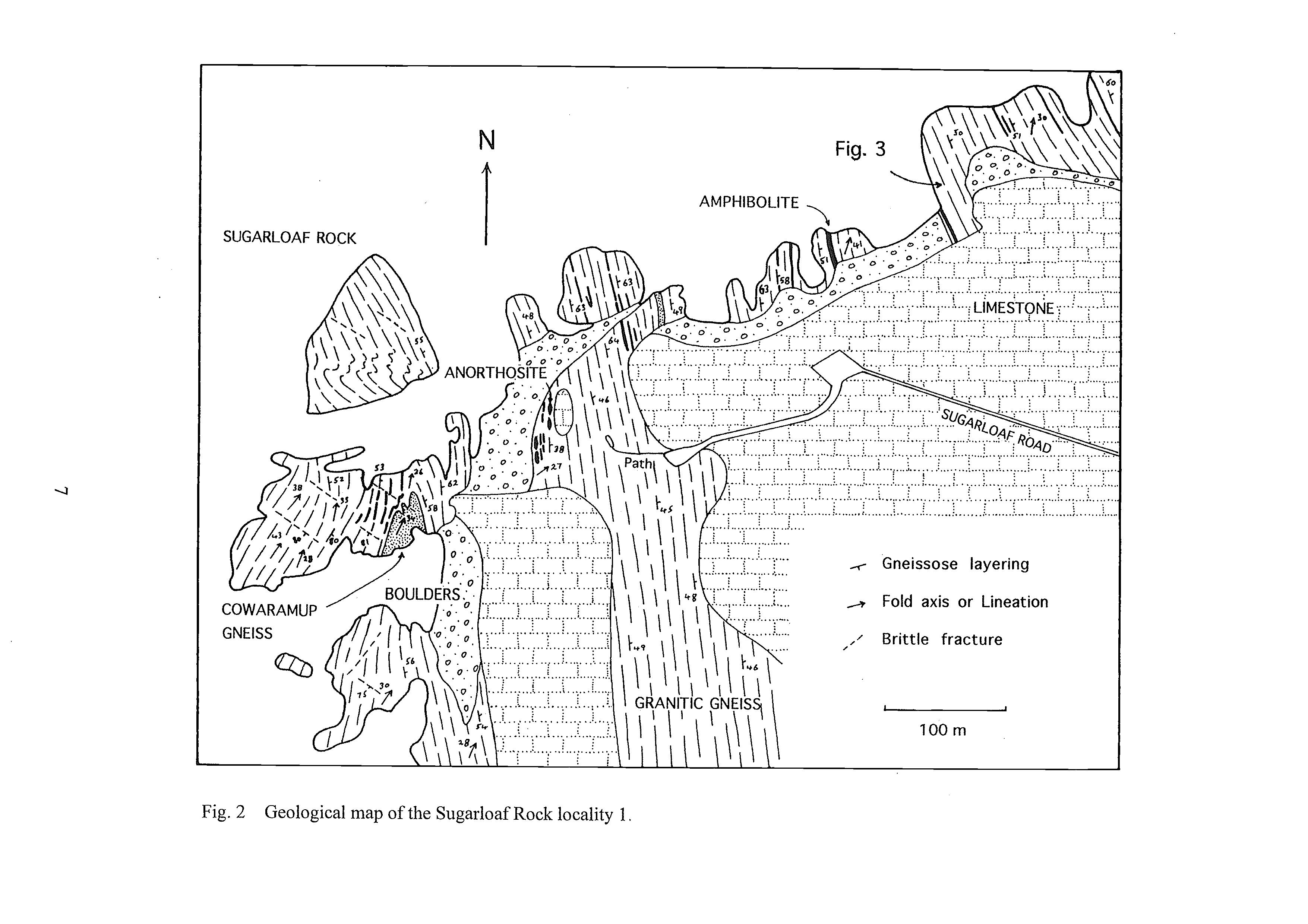
Gneissose layering
Fold axis or Lineation
Layering/foliation intersection lineations are parallel to fold axes and plunge at moderate angles northwards.
The folds are most clearly defined by the pegmatite banding of the granitic gneiss and thin amphibolite dykes. Both the pegmatite banding and the amphibolite dykes were previously strongly deformed. Prior to the D3 folding, pegmatite veins in the gneiss were folded and rotated into parallelism and attenuated, and the dykes were boudinaged (D2). The D3 folds appear to be contemporaneous with the last episode of granulite facies metamorphism as some contain irregular, diffuse-margined pegmatite melt patches and veins along their axial surfaces and attenuated limbs.
Recrystallization generally outlasted deformation and most rocks have coarse grained granoblastic textures. Straight undeformed pegmatite dykes containing orthopyroxene are widespread. They cut the D3 folds. Most rocks were partly retrogressed from granulite to amphibolite facies. The retrogression was heterogeneous and a range of stages of retrogression can be seen on the rocky headland adjacent to Sugarloaf Rock.
Granulite facies rocks are generally dark and weathered surfaces are brown. The rocks appear relatively massive because the colour contrast between granitic and mafic rocks is slight. Relatively fiesh rocks are dark green because both quartz and feldspars are dark green and greasy in appearance. They generally contain orthopyroxene and clinopyroxene, and some rocks contain garnet. When the rocks were retrogressed to amphibolite facies, pyroxenes and garnets were replaced by green hornblende and biotite. The granitic rocks are white or pink and contrast with black amphibolites. Retrogression was locally concentrated along the margins of some amphibolite dykes. In some parts of this locality where retrogression has been almost complete, lenses of dark green granulite facies granitic rocks occur as remnants within paler, pink amphibolite facies granitic rocks.
Figure 3 illustrates some of the geological history of the high-grade metamorphic and tectonic activity that affected the granitic gneiss. It is a map of a small part of the smooth west-facing surface of a short rocky promentary east of Sugatloaf Rock. It is located just above the normal splash zone. The pegmatite-banded gneiss in Figure 3 appears to have been derived by intense deformation fiom uniform porphyritic granite and a network of pegmatite veins. The vein network and igneous texture of the granite were flattened, attenuated and streaked out to form the gneissose banding. Traces of the former porphyritic texture are preserved as relict augen.
Irregular pegmatite, in situ melt patches developed during a subsequent metamorphic episode accompanied by milder deformation. The melt patches cut across the banding of the granitic gneiss, including isoclinally folded pegmatite veins. However most pegmatite melt patches appear to be derived from the older pegmatite veins that form the main banding of the gneiss, as many are concentrated along these older veins or stem fiom them. The pegmatite melt patches and veins were deformed and partly flattened parallel with the main, older banding.
The pegmatite melt patches and veins are cut by thin amphibolite dykes, subparallel with the main banding of the older gneiss. They may have been subject to the same deformation that modified the shape of the pegmatite melt patches. The arnphibolite dykes are cut by an undeformed pegmatite dyke containing biotite, magnetite and orthopyroxene. Many of the orthopyroxenes form hopper crystals. The amphibolite dykes are also cut by a small shear zone.
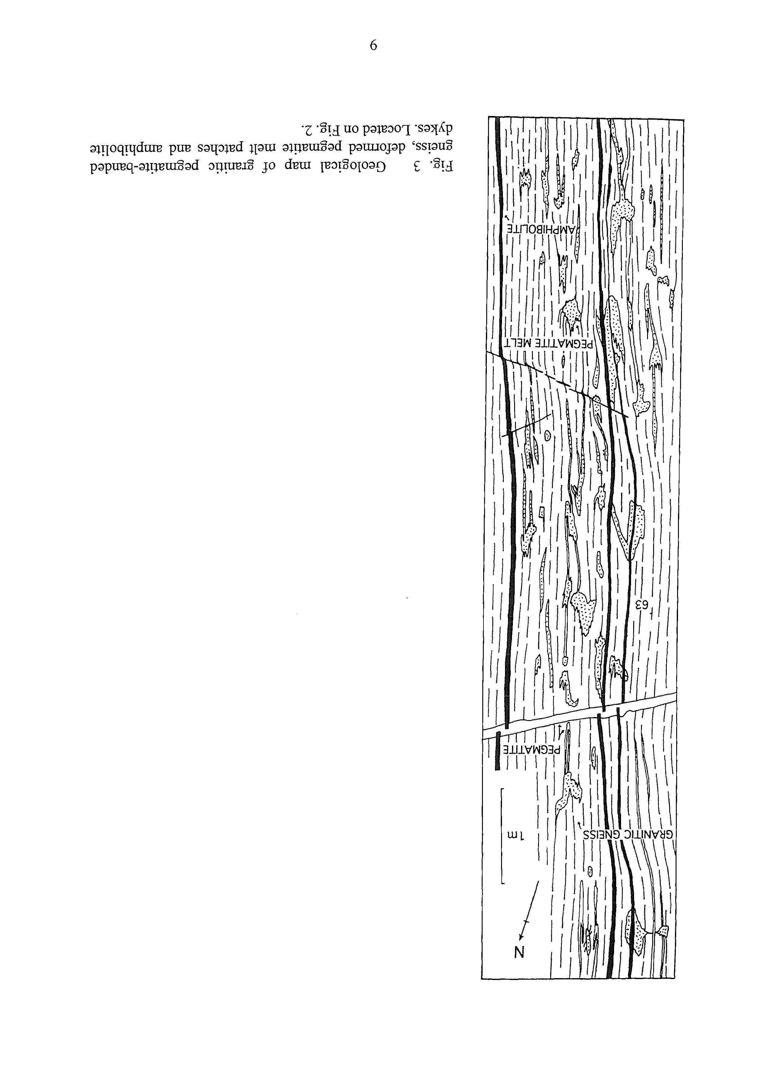
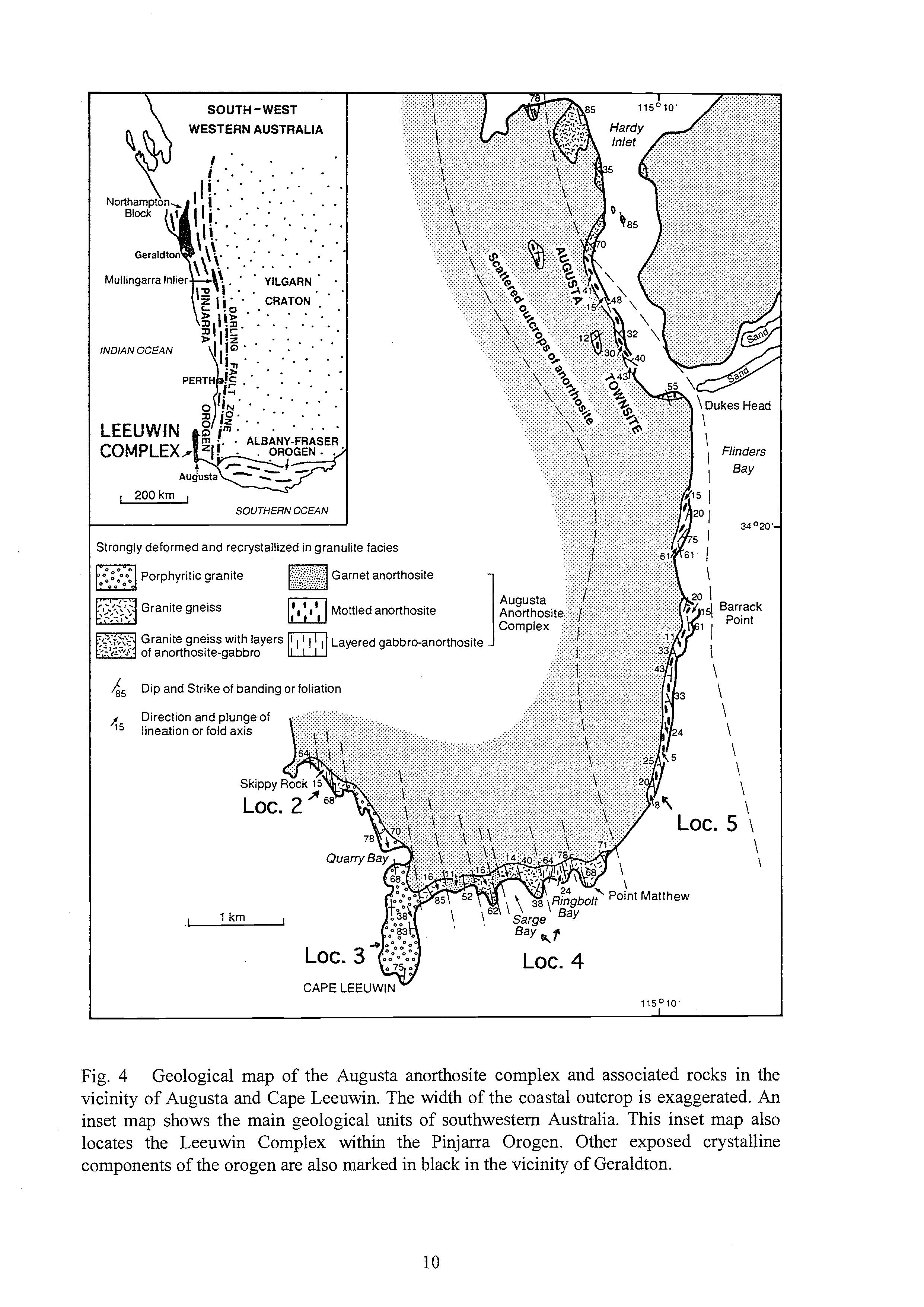
Fig. 4 Geological map of the Augusta anorthosite complex and associated rocks in the vicinity of Augusta and Cape Leeuwin. The width of the coastal outcrop is exaggerated. An inset map shows the main geological units of southwestern Australia. This inset map also locates the Leeuwin Complex within the Pinjarra Orogen. Other exposed crystalline components of the orogen are also marked in black in the vicinity of Geraldton.
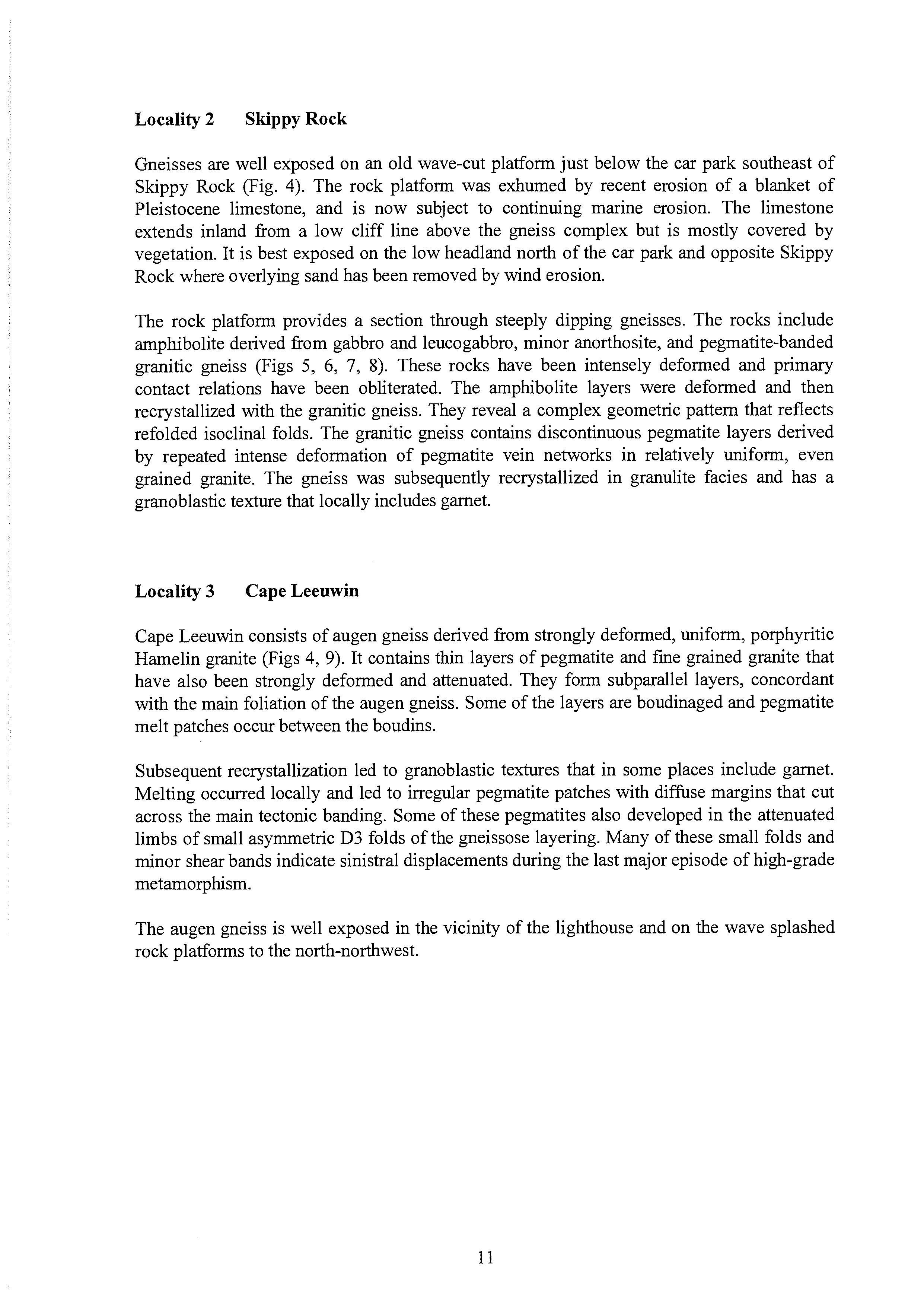
Locality 2 Skippy Rock
Gneisses are well exposed on an old wave-cut platform just below the car park southeast of Skippy Rock (Fig. 4). The rock platform was exhumed by recent erosion of a blanket of Pleistocene limestone, and is now subject to continuing marine erosion. The limestone extends inland from a low cliff line above the gneiss complex but is mostly covered by vegetation. It is best exposed on the low headland north of the car park and opposite Skippy Rock where overlying sand has been removed by wind erosion.
The rock platform provides a section through steeply dipping gneisses. The rocks include amphibolite derived from gabbro and leucogabbro, minor anorthosite, and pegmatite-banded granitic gneiss (Figs 5, 6, 7, 8). These rocks have been intensely deformed and primary contact relations have been obliterated. The amphibolite layers were deformed and then recrystallized with the granitic gneiss. They reveal a complex geometric pattern that reflects refolded isoclinal folds. The granitic gneiss contains discontinuous pegmatite layers derived by repeated intense deformation of pegmatite vein networks in relatively uniform, even grained granite. The gneiss was subsequently recrystallized in granulite facies and has a granoblastic texture that locally includes garnet.
Locality 3 Cape Leeuwin
Cape Leeuwin consists of augen gneiss derived from strongly deformed, uniform, porphyritic Hamelin granite (Figs 4, 9). It contains thin layers of pegmatite and fine grained granite that have also been strongly deformed and attenuated. They form subparallel layers, concordant with the main foliation of the augen gneiss. Some of the layers are boudinaged and pegmatite melt patches occur between the boudins.
Subsequent recrystallization led to granoblastic textures that in some places include garnet. Melting occurred locally and led to irregular pegmatite patches with diffuse margins that cut across the main tectonic banding. Some of these pegmatites also developed in the attenuated limbs of small asymmetric D3 folds of the gneissose layering. Many of these small folds and minor shear bands indicate sinistral displacements during the last major episode of high-grade metamorphism.
The augen gneiss is well exposed in the vicinity of the lighthouse and on the wave splashed rock platforms to the north-northwest.
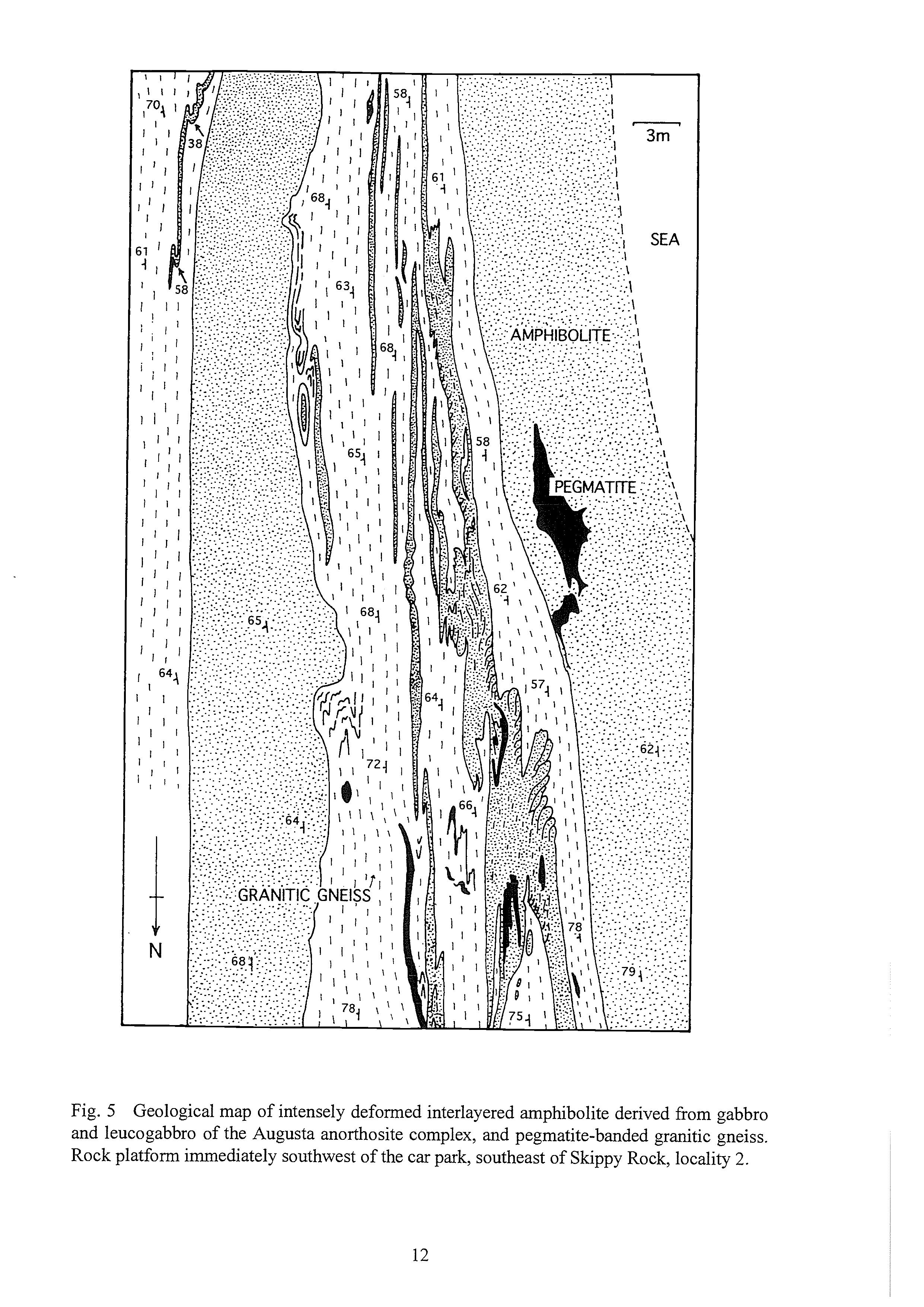
Fig. 5 Geological map of intensely deformed interlayered amphibolite derived fiom gabbro and leucogabbro of the Augusta anorthosite complex, and pegmatite-banded granitic gneiss. Rock platform immediately southwest of the car park, southeast of Skippy Rock, locality 2.
Fig. 6 Folded layers of amphibolite derived from metagabbro (black) and pegmatite-banded granitic gneiss. Locality 2, southeast of Skippy Rock. View south to Cape Leeuwin lighthouse.
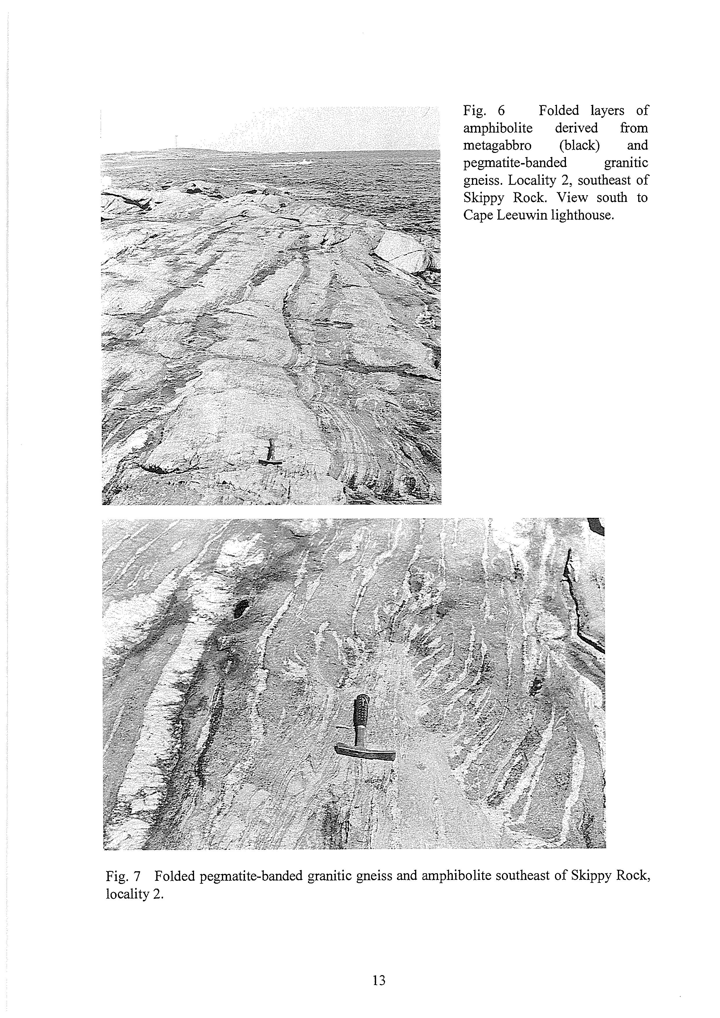
Fig. 7 Folded pegmatite-banded granitic gneiss and amphibolite southeast of Skippy Rock, locality 2.
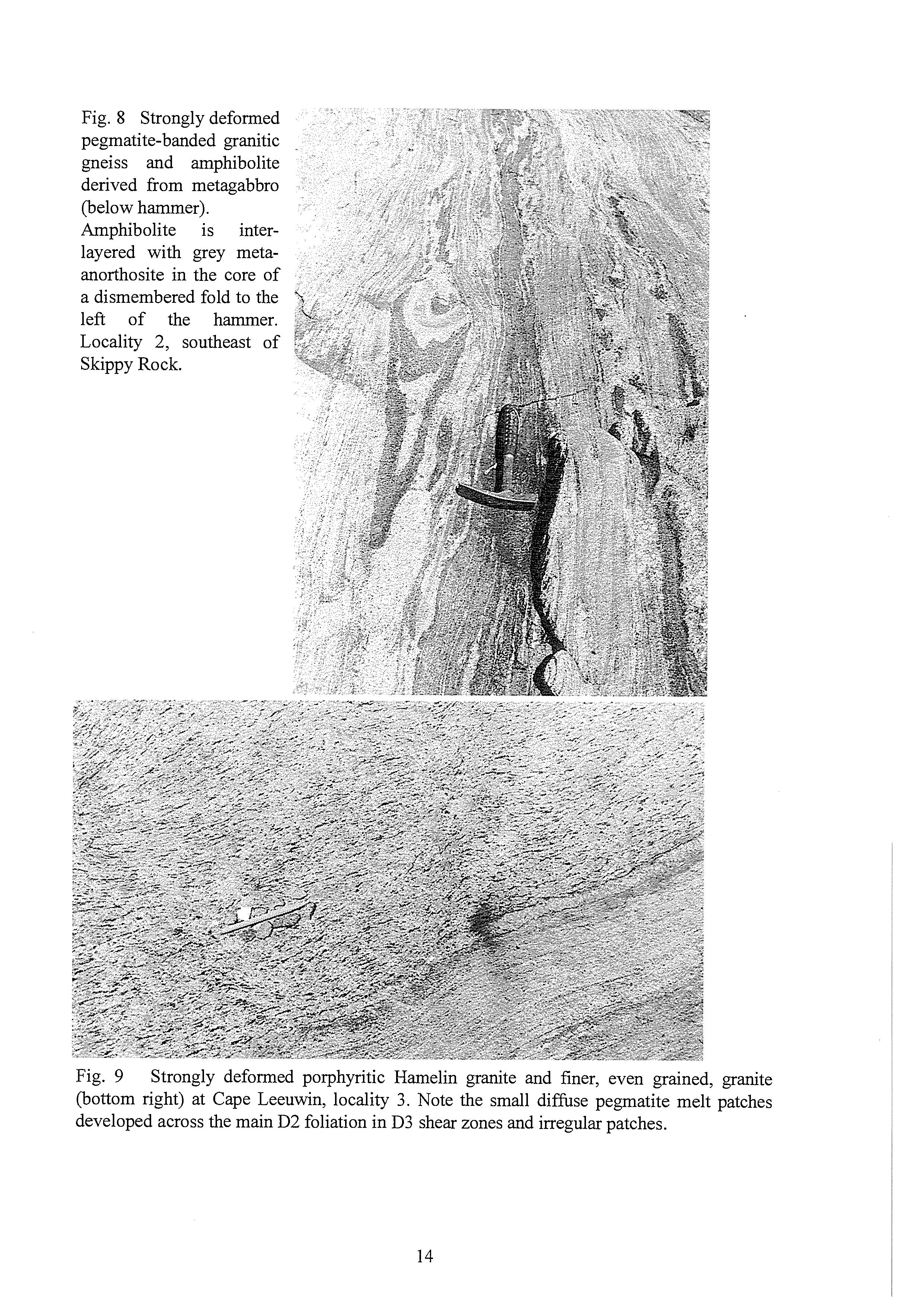
Fig. 9 Strongly deformed porphyritic Hamelin granite and finer, even grained, granite (bottom right) at Cape Leeuwin, locality 3. Note the small diffuse pegmatite melt patches developed across the main D2 foliation in D3 shear zones and irregular patches.
Locality 4 Sarge and Ringbolt bays
This coast section across the strike of the Augusta anorthosite complex and interleaved granitic gneiss contains a variety of rock types and structures. The headlands reflect the strike of the gneisses (Fig. 4).
The headland that forms the west side of Sarge Bay consists of even grained pegmatitebanded granitic gneiss derived by intense deformation of a pegmatite vein network in even grained granite. The pegmatite veins were isoclinally folded, attenuated and rotated into parallelism. In places a linear fabric parallels the fold axes of the isoclinal folds which plunge gently south. The rocks were subsequently recrystallized with granoblastic textures and locally contain garnet.
Garnets are prominent in anorthosite in a fold core to the east. Here an L-tectonite fabric is more pronounced than planar fabrics and plunges gently to the south. To the east the anorthosite is followed by granitic gneiss similar to that of the adjacent headland, and then by the beach of Sarge Bay.
The headland to the east, between Sarge Bay and Ringbold Bay, consists of relatively uniform pegmatite-banded granitic gneiss. The gneiss was derived by intense deformation of a pegmatite vein network in uniform even grained granite. It was subsequently recrystallized in granulite facies and developed a granoblastic texture.
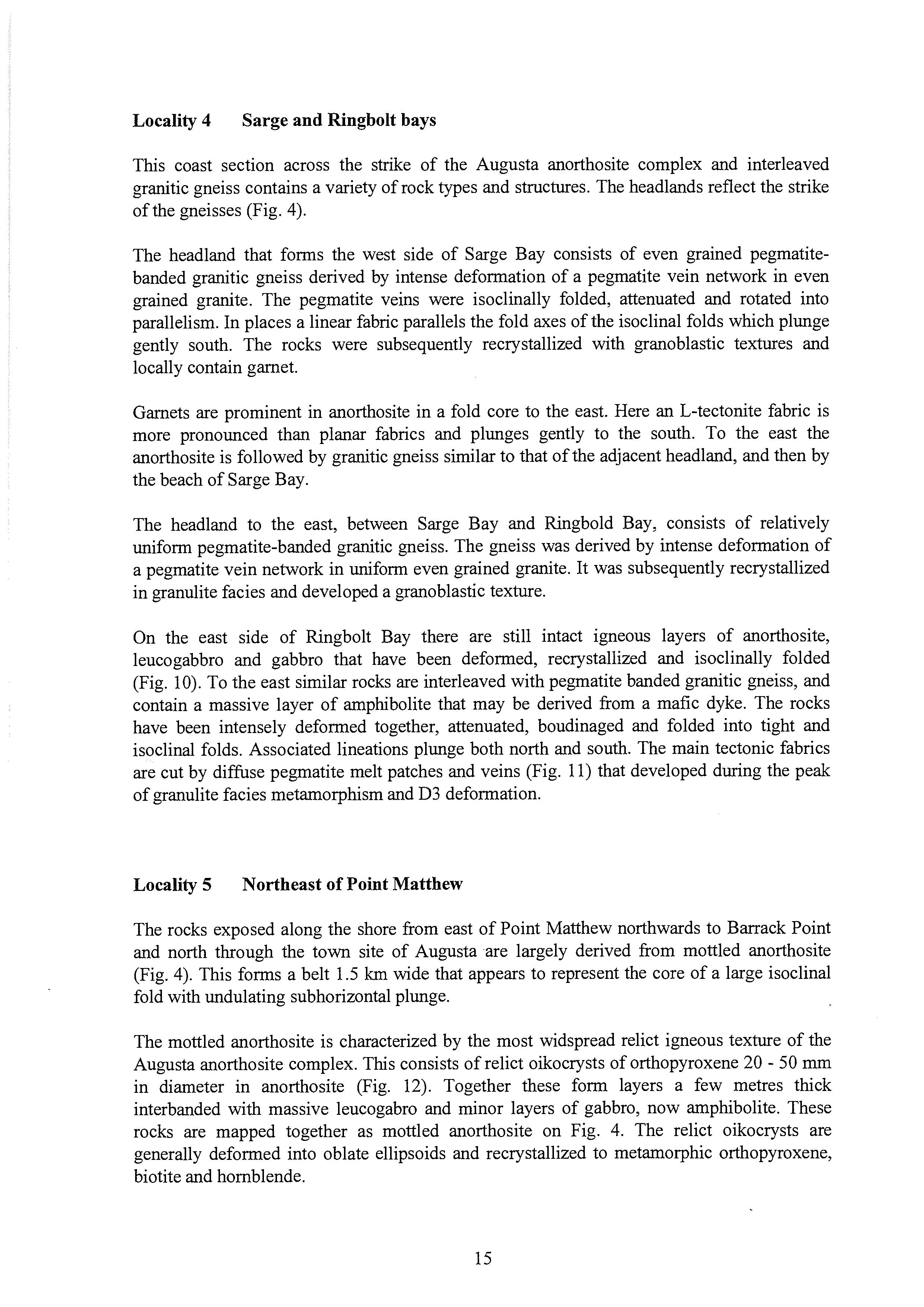
On the east side of Ringbolt Bay there are still intact igneous layers of anorthosite, leucogabbro and gabbro that have been deformed, recrystallized and isoclinally folded (Fig. 10). To the east similar rocks are interleaved with pegmatite banded granitic gneiss, and contain a massive layer of amphibolite that may be derived from a mafic dyke. The rocks have been intensely deformed together, attenuated, boudinaged and folded into tight and isoclinal folds. Associated lineations plunge both north and south. The main tectonic fabrics are cut by diffuse pegmatite melt patches and veins (Fig. 11) that developed during the peak of granulite facies metamorphism and D3 deformation.
Locality 5 Northeast of Point Matthew
The rocks exposed along the shore from east of Point Matthew northwards to Barrack Point and north through the town site of Augusta are largely derived from mottled anorthosite (Fig. 4). This forms a belt 1.5 km wide that appears to represent the core of a large isoclinal fold with undulating subhorizontal plunge.
The mottled anorthosite is characterized by the most widspread relict igneous texture of the Augusta anorthosite complex. This consists of relict oikocrysts of orthopyroxene 20 - 50 mm in diameter in anorthosite (Fig. 12). Together these form layers a few metres thick interbanded with massive leucogabro and minor layers of gabbro, now amphibolite. These rocks are mapped together as mottled anorthosite on Fig. 4. The relict oikocrysts are generally deformed into oblate ellipsoids and recrystallized to metamorphic orthopyroxene, biotite and hornblende.
Fig. 10 anorthosite in pegmatite-banded granitic gneiss (right) at Ringbolt Bay, locality 4.
Folded layers of black amphibolite, derived from metagabbro, and grey rneta-
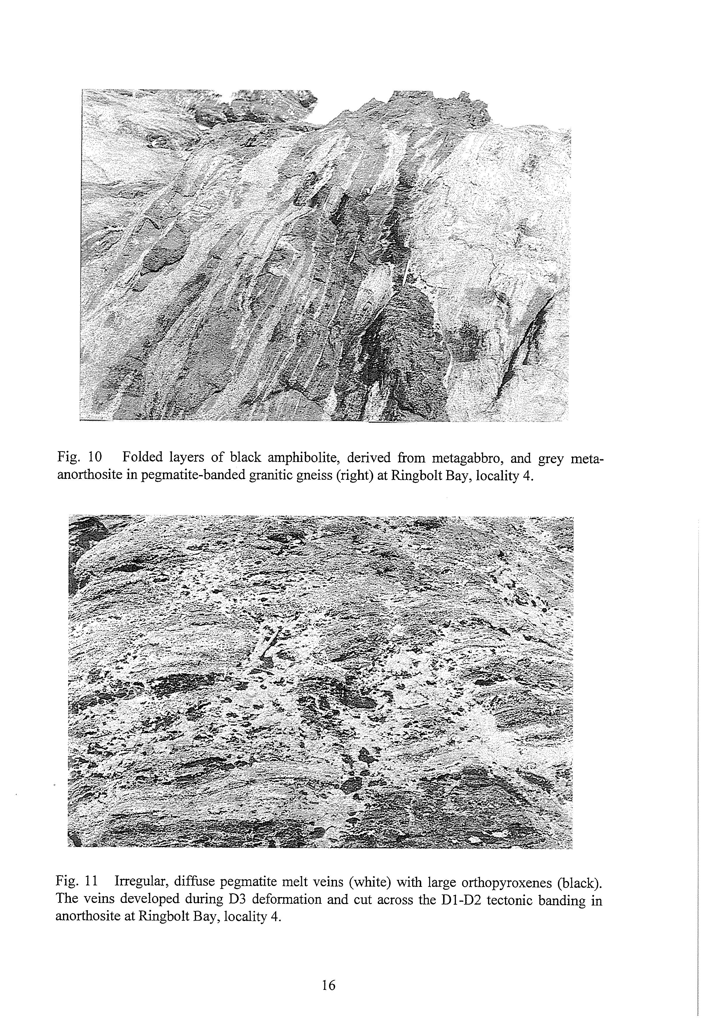
Fig. 11 Irregular, diffuse pegmatite melt veins (white) with large orthopyroxenes (black). The veins developed during D3 deformation and cut across the D1-D2 tectonic banding in anorthosite at Ringbolt Bay, locality 4.
The mottled anorthosite appears to have been relatively uniform except for layering marked by different sizes of relict orthopyroxene oikocrysts. Deformation was heterogeneous and ranges from weak to intense (Fig. 12). Tectonic fabrics range from L-tectonite through L-S to S-tectonite, and mainly appear to relate to the formation and attenuation of the large-scale isoclinal fold of which the mottled anorthosite forms the core.
The main tectonic layering is boudinaged and locally cut by small asymmetric folds. Pegmatites containing orthopyroxene developed between boudins and in attenuated fold limbs.
The mottled anorthosite is well exposed in a relatively low state of deformation at the northeastern end of the beach northeast of Point Matthew. All stages can be seen in the streaking out of the relict igneous oikocrysts into a tectonic layering (Fig. 12). Linear fabrics are also prominent and plunge gently north. They are all stretching lineations; elongations of minerals or mineral clusters and developed parallel to the fold axis of the major isoclinal folds.
The main tectonic fabrics were overprinted by granoblastic recrystallization in granulite facies. This was associated with the development of pegmatites containing orthopyroxene in the attenuated limbs of small asymmetric folds, and between boudins of the older tectonic layering.
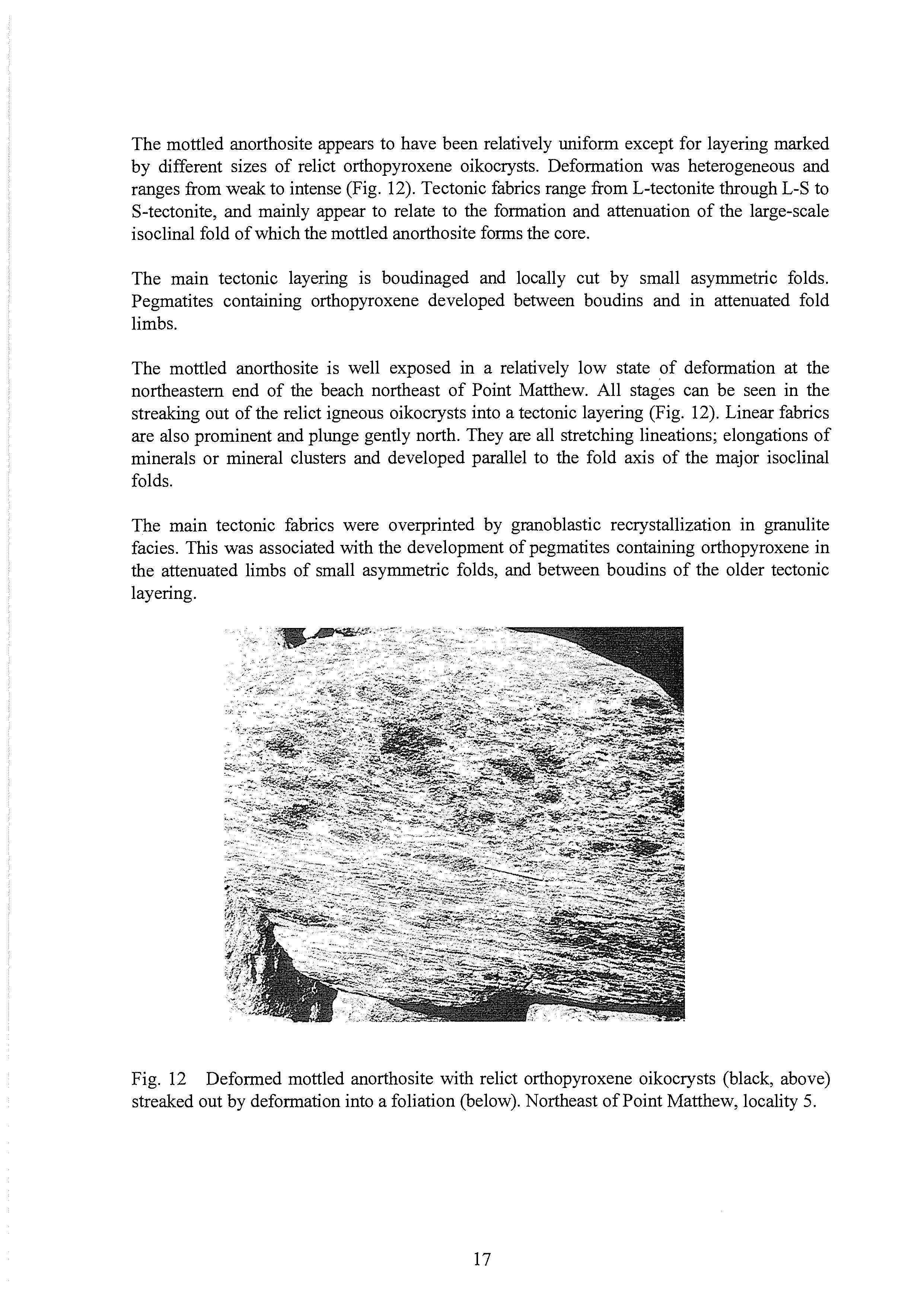
Fig. 12 streaked out by deformation into a foliation (below). Northeast of Point Matthew, locality 5.
Deformed mottled anorthosite with relict orthopyroxene oikocrysts (black, above)
Locality 6 Isaacs Rock
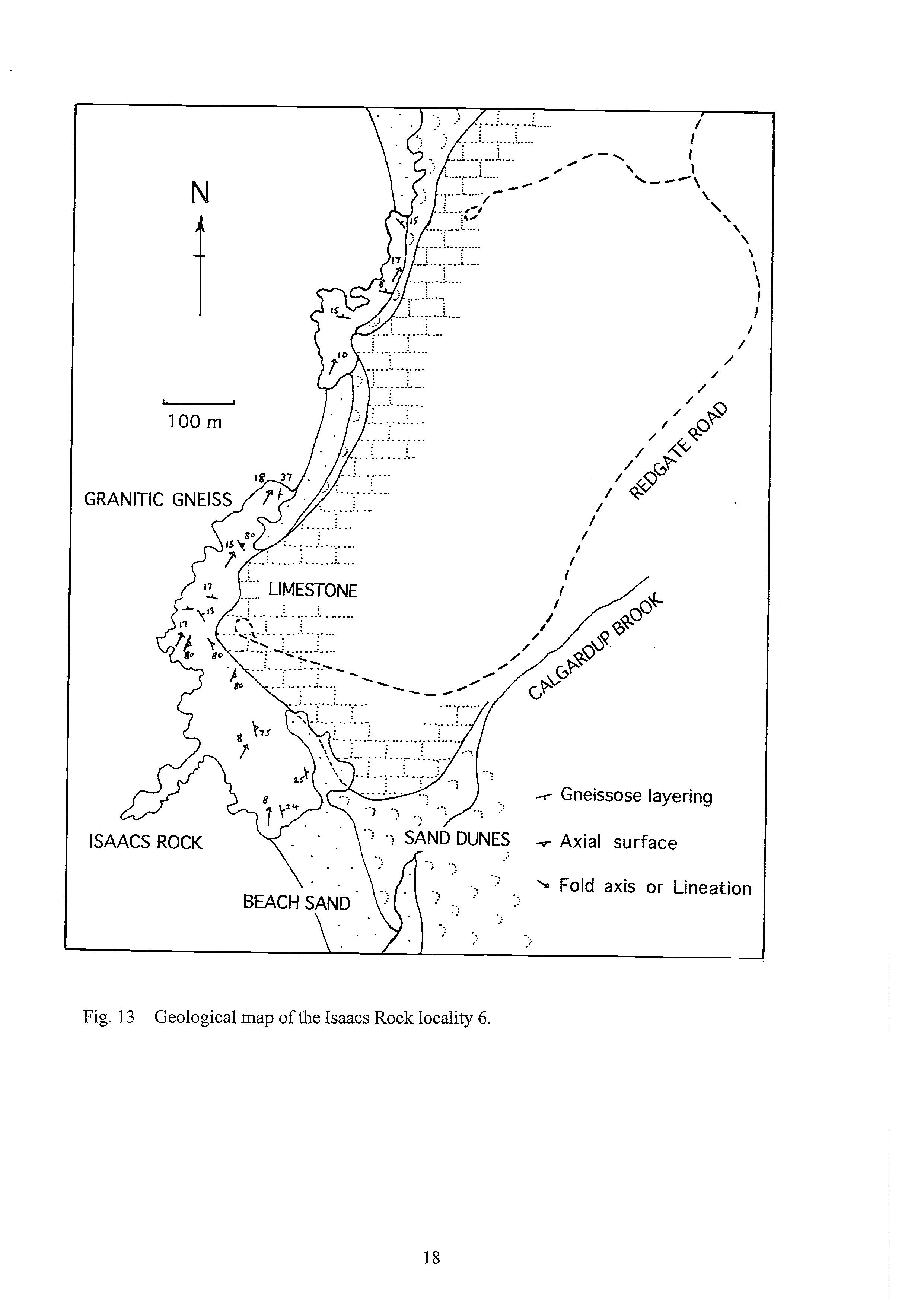
Rocks of the Leeuwin Complex are exposed along the shore where recent marine erosion has stripped off a former cover of Pleistocene limestone (Fig. 13). The main rock type is a granitic gneiss with relict augen of K feldspar, and a granoblastic texture containing garnet. The gneiss appears to have been derived from a relatively uniform porphyritic granite that was heterogeneously deformed (Hamelin granite). The deformation was strong but not intense. The large igneous feldspars were recrystallized and streaked out into lenses and thin discontinuous layers. This tectonic fabric forms the main banding of the gneiss and dips gently eastwards.
Thin discontinuous amphibolite layers in the granite gneiss may have been derived from dolerite dykes that were strongly deformed and streaked out with the relict igneous texture of the porphyritic granite.
The gneissose layering was folded into small asymmetric D3 folds with axial surfaces dipping steeply eastwards (Fig. 14). Fold axes and parallel lineations plunge gently northeast. Most folds have Z-shaped profiles and step the gneissose layering down towards the east. These folds formed during the peak of metamorphism in granulite facies because many of them contain diffuse pegmatite melts along attenuated limbs. Some of these pegmatites contain garnet and orthopyroxene. Metamorphic recrystallisation outlasted the deformation, and most rocks have granoblastic textures.
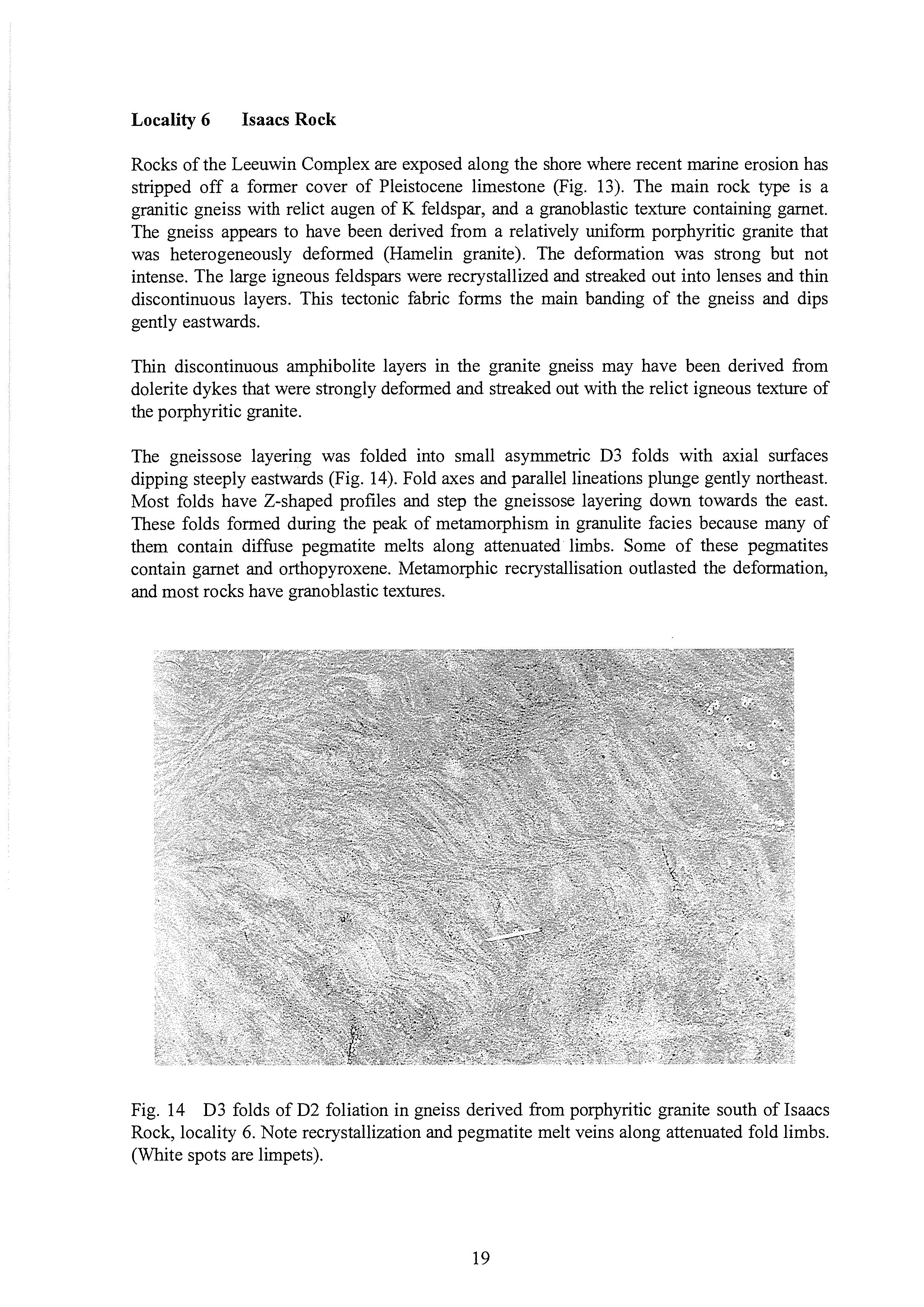
Fig. 14 D3 folds of D2 foliation in gneiss derived from porphyritic granite south of Isaacs Rock, locality 6. Note recrystallization and pegmatite melt veins along attenuated fold limbs. (White spots are limpets).
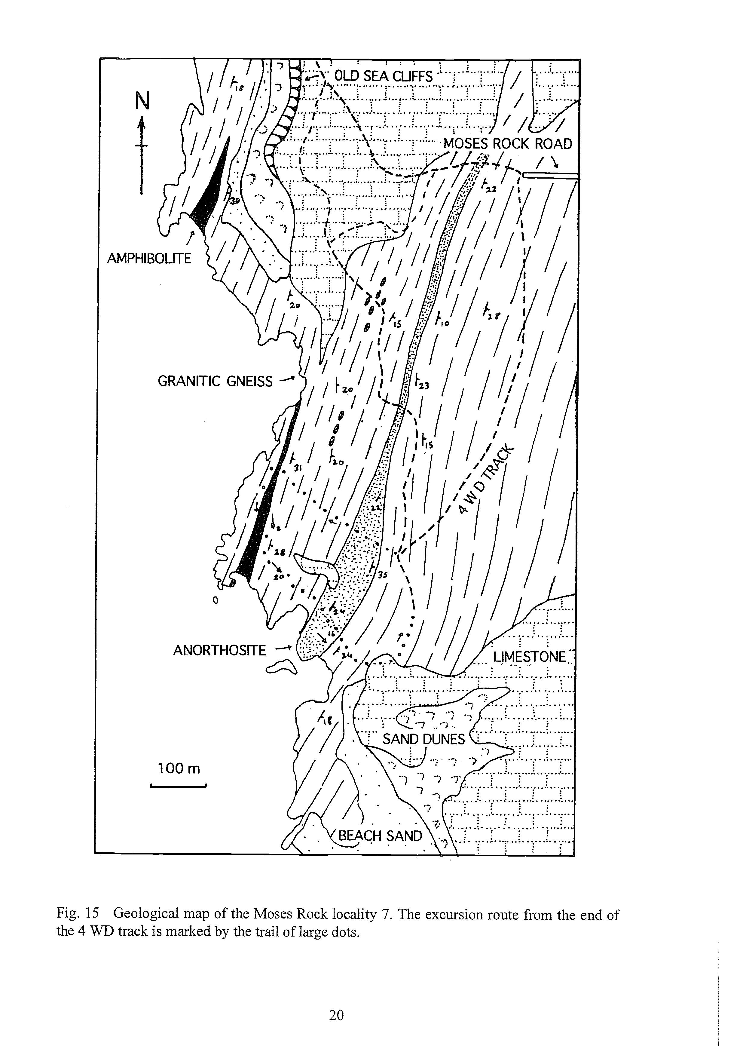
Fig. 15 Geological map of the Moses Rock locality 7. The excursion route from the end of the 4 WD track is marked by the trail of large dots.
Locality 7 Moses Rock
Gneisses of the Leeuwin Complex are extensively exposed in the vicinity of Moses Rock, where they have been exhumed by erosion of a former blanket of Pleistocene limestone (Fig. 15). The limestone developed from calcareous sand that was blown from the west during low stands of sea level related to peaks of Pleistocene glaciation. The sand covered an older marine erosion surface, formed during a period of higher sea level. This erosion surface can be seen as the relatively smooth cliff top between the limestone in the central part of Figure 15. Another, more recent episode of high sea level is marked by the old sea cliffs cut into the limestone west of Moses Rock road.
The shape of the coastline reflects the north-northeast strike of the gneissose layering and abundant vertical brittle fractures and joints that strike southeast.
The most abundant type of gneiss was derived from uniform coarse, even grained Hamelin granite and pegmatite veins. The vein network was intensely deformed and streaked out into discontinuous subparallel layers that form the most prominent banding of the gneiss.
In some places the granite gneiss also contains abundant thin discontinuous layers of amphibolite that may have been derived by similar intense deformation of dolerite dykes. Some of these amphibolite layers could also represent fragments of larger bodies of metagabbro, such as the two large lenses of amphibolite that are exposed near the sea (Fig. 15). These large amphibolite bodies are net-veined by pegmatites and strongly deformed. They may be related to metamorphosed leucogabbro and anorthosite that occurs nearby as trains of inclusions in the granitic gneiss, and also forms a continuous belt to the east (Fig. 15).
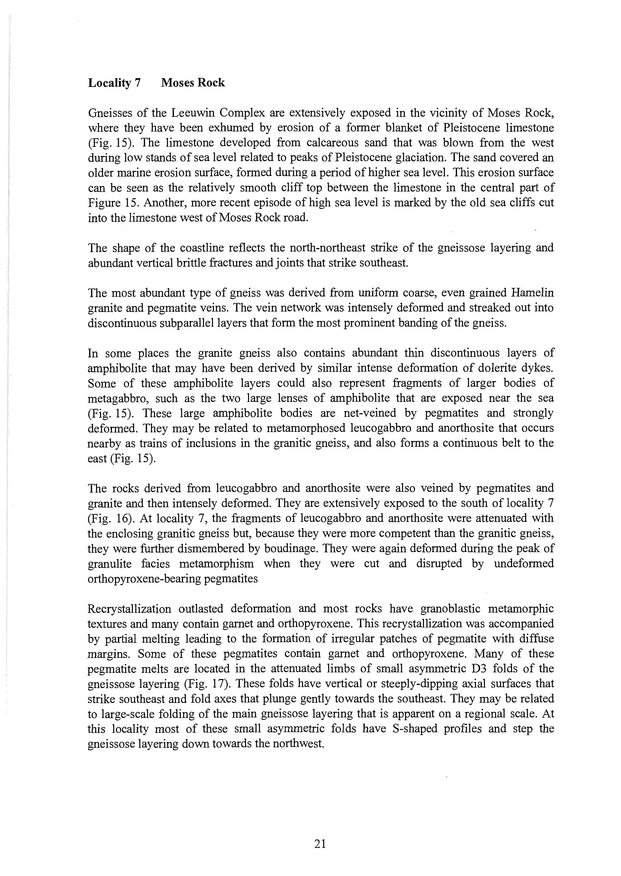
The rocks derived from leucogabbro and anorthosite were also veined by pegmatites and granite and then intensely deformed. They are extensively exposed to the south of locality 7 (Fig. 16). At locality 7, the fragments of leucogabbro and anorthosite were attenuated with the enclosing granitic gneiss but, because they were more competent than the granitic gneiss, they were further dismembered by boudinage. They were again deformed during the peak of granulite facies metamorphism when they were cut and disrupted by undeformed orthopyroxene-bearing pegmatites
Recrystallization outlasted deformation and most rocks have granoblastic metamorphic textures and many contain garnet and orthopyroxene. This recrystallization was accompanied by partial melting leading to the formation of irregular patches of pe,gnatite with diffuse margins. Some of these pegmatites contain garnet and orthopyroxene. Many of these pegmatite melts are located in the attenuated limbs of small asymmetric D3 folds of the gneissose layering (Fig. 17). These folds have vertical or steeply-dipping axial surfaces that strike southeast and fold axes that plunge gently towards the southeast. They may be related to large-scale folding of the main gneissose layering that is apparent on a regional scale. At this locality most of these small asymmetric folds have S-shaped profiles and step the gneissose layering down towards the northwest.
Fig. 16 East-dipping pegmatite-banded anorthositic gneiss (Cowaramup gneiss), south of Moses Rock locality 7. View south to the headland of Cowaramup Point on the horizon on the far right.
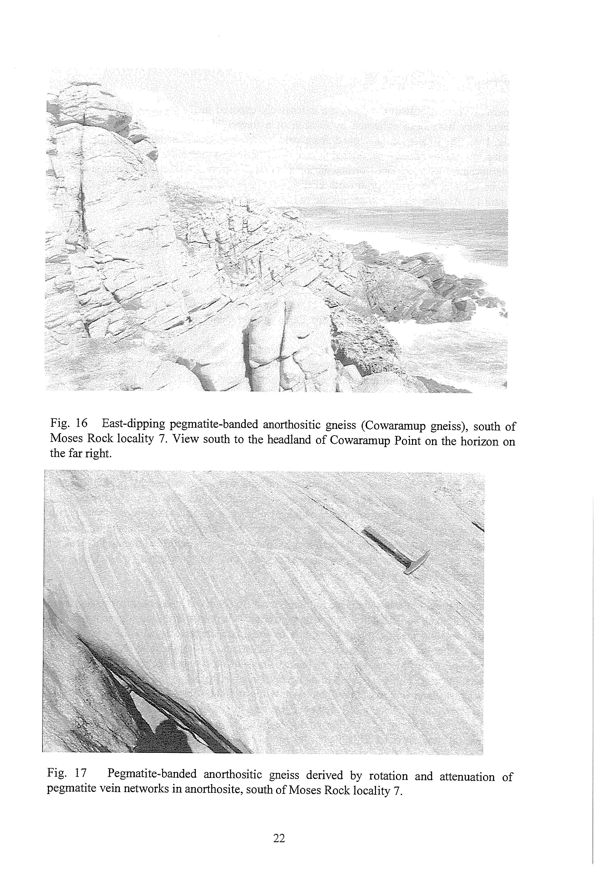
Fig. 17 pegmatite vein networks in anorthosite, south of Moses Rock locality 7. Pegmatite-banded anorthositic gneiss derived by rotation and attenuation of
Pegmatite melt patches and related small asymmetric folds are well exposed in both plan and section view on wave washed rocks adjacent to the northwest of the main anorthosite layer.
Relatively fresh granulite facies rocks can be seen west and northwest of the end of Moses Rock road. They are superficially massive and dark grey-green in colour because both quartz and feldspar are dark green and of waxy appearance. To the south the rocks are extensively retrogressed to amphibolite facies, quartz and feldspars are white or pink and amphibolite layers are more distinct as dark layers containing abundant hornblende which contrasts with the paler granite gneiss.
REFERENCES
Ashwal, L.D. 1993. Anorthosites. Springer-Verlag, Berlin, 430 pp.
Fletcher, I.R., Wilde, S.A. & Rosman, K.J.R. 1985. Sm-Nd model ages across the margins of the Archaean Yilgarn Block, Western Australia - 111. The western margin. Australian Journal of Earth Sciences 32,73-82.
Leonhard, E.L. 1991. Yallingup sheet 1930 IV and part sheet 1830 I, Geological Survey of Western Australia, 1: 50 000 environmental geology series.
McCulloch, M.T. 1987. Sm-Nd isotopic constraints on the evolution of Precambrian crust in the Australian continent. In: Proterozoic Lithosphere Evolution (Geodynamics series 17). International Lithospheric Program Publication 01 30, 115-130.
Myers, J.S. 1989. Australia 1:l 000 000 geological series, sheet SI 50, Albany. Geological Survey of Western Australia.
Myers, J.S. 1990a. Pinjarra Orogen. In: Geology and Mineral Resources of Western
Myers, J.S. 1990b. Anorthosite in the Leeuwin Complex of the Pinjarra Orogen, Western Australia. Geological Survey of Western Australia, Memoir 3,265-272. Australia. Australian Journal of Earth Sciences 37,241-245.
Wilde, S.A. & Murphy, D.M.K. 1990. The nature and origin of Late Proterozoic high-grade gneisses of the Leeuwin Block, Western Australia. Precambrian Research 47,25 1-270.
ACKNOWLEDGEMENT
Published with permission of the Director of the Geological Survey of Western Australia.