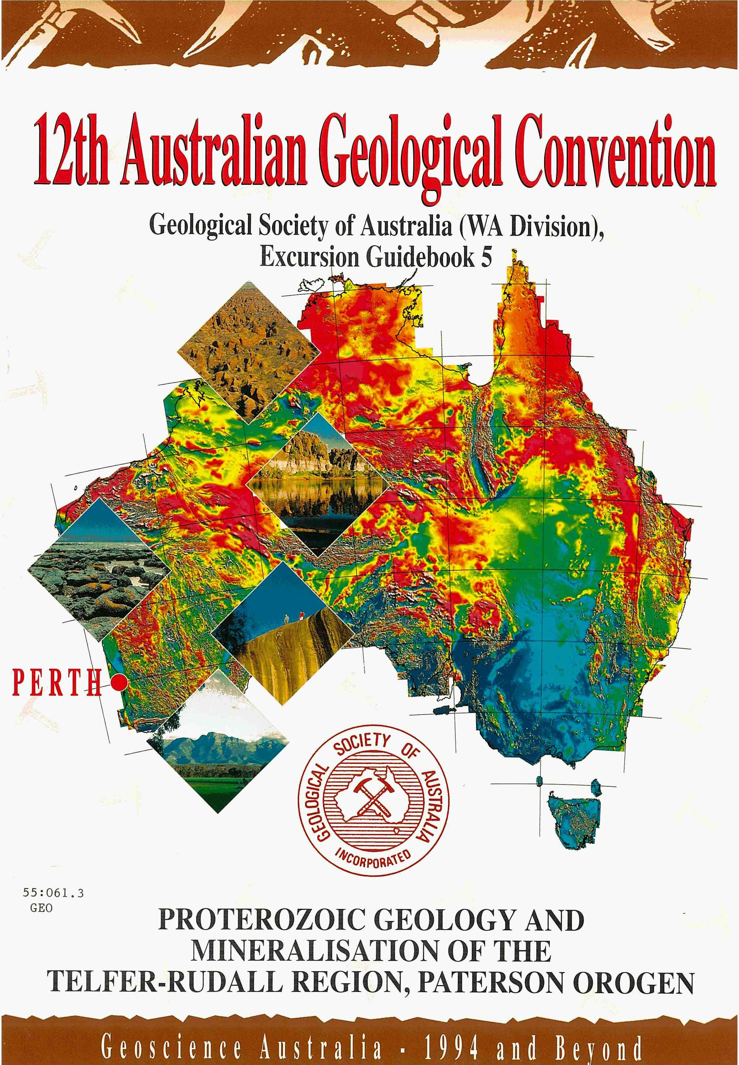
Geological Society of Australia (WA Division), Excurs@ Guidebook 5 J .s d- -
Geological Society of Australia (WA Division)

A. H. Hickman, I. R. Williams and L. Bagas (with contributions fiom A. Richards and P. Dare)
Geological Survey of Western Australia, 100 Plain Street, East Perth, Western Australia 6004
12th Australian Geological Convention September 1994
Guidebook for the pre-convention excursion E4
12th Australian Geological Convention, Perth, September 1994
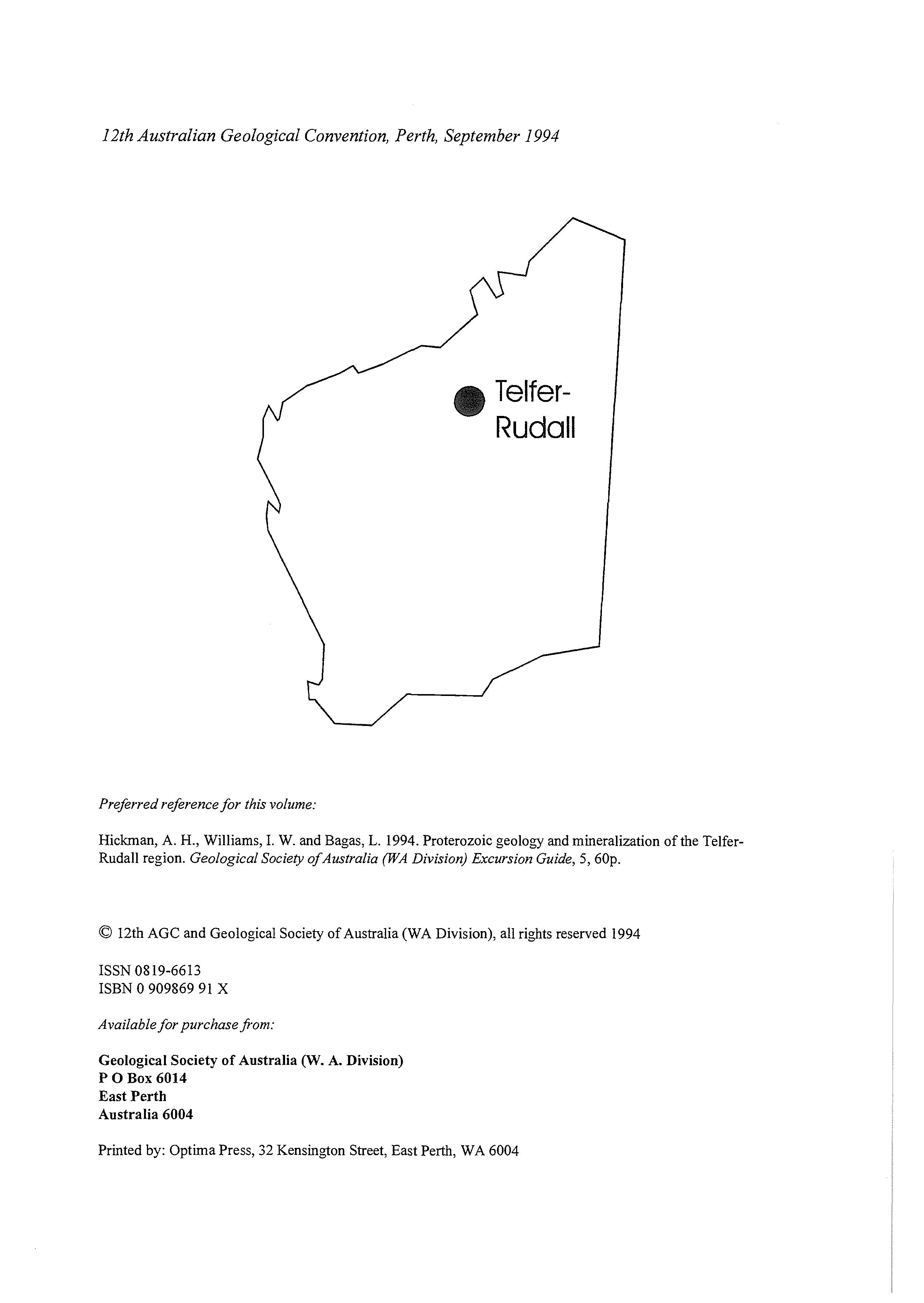
Preferred reference for this volume:
Hickman, A. H., Williams, I. W. and Bagas, L. 1994. Proterozoic geology and mineralization of the TelferRudall region. Geological Society of Australia (WA Division) Excursion Guide, 5,60p.
0 12th AGC and Geological Society of Australia (WA Division), all rights reserved 1994
ISSN 0819-6613
ISBN 0 909869 91 X
Available for purchase from:
Geological Society of Australia (W. A. Division)
P 0 Box 6014
East Perth
Australia 6004
Printed by: Optima Press, 32 Kensington Street, East Perth, WA 6004
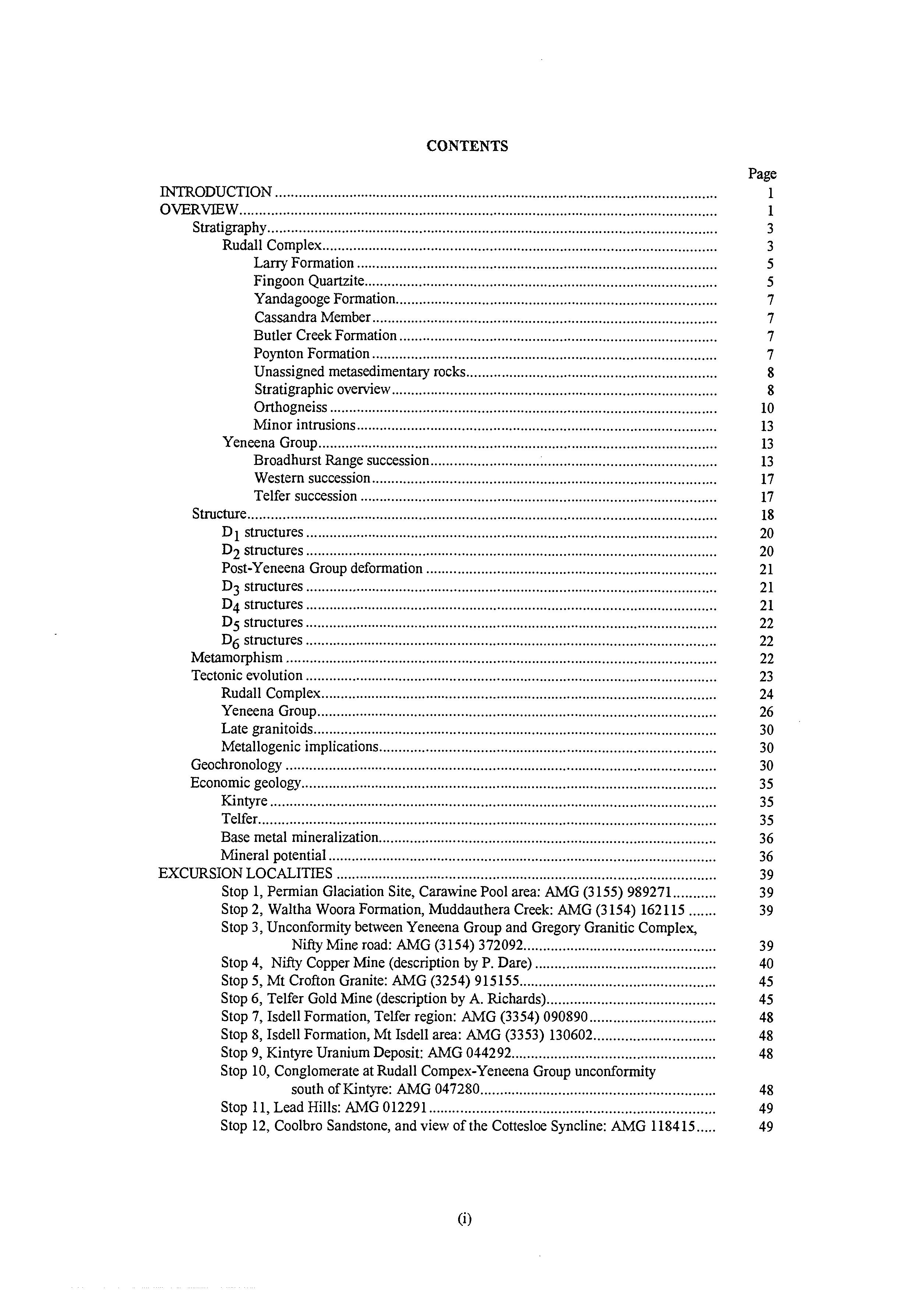
CONTENTS
INTRODUCTION .................................................................................................................
OVERVIEW
Stratigraphy...................................................................................................................
Rudall Complex
Larry Formation
Fingoon Quartzite..........................................................................................
Yandagooge Formation..................................................................................
Cassandra Member
Butler Creek Formation
Poynton Formation ........................................................................................
Unassigned metasedimentary rocks ................................................................
Stratigraphic overview
Orthogneiss
Minor intrusions ............................................................................................
Yeneena Group
Broadhurst Range succession .........................................................................
Western succession
Telfer succession
Structure........................................................................................................................
D 1 structures
D2 structures .........................................................................................................
Post-Yeneena Group deformation
D3 structures .........................................................................................................
D4 structures .........................................................................................................
D5 structures
D6 structures
Metamorphism ..............................................................................................................
Tectonic evolution
Rudall Complex
Yeneena Group......................................................................................................
Late granitoids
Metallogenic implications
Geochronology
Economic geology
Kintyre
Telfer.....................................................................................................................
Base metal mineralization
Mineral potential ...................................................................................................
EXCURSION LOCALITIES
Stop 1, Permian Glaciation Site, Carawine Pool area: AMG (3 155) 989271...........
Stop 2, Waltha Woora Formation, Muddauthera Creek: AMG (3154) 162115 .......
Stop 3, Unconformity between Yeneena Group and Gregory Granitic Complex,
Nifty Mine road: AMG (3154) 372092
Stop 4, Nifty Copper Mine (description by P. Dare) ..............................................
Stop 5, Mt Crofton Granite: AMG (3254) 915155
Stop 6, Telfer Gold Mine (description by A Richards)
Stop 7, Isdell Formation, Telfer region: AMG (3354) 090890
Stop 8,Isdell Formation, Mt Isdell area: AMG (3353) 130602...............................
Stop 9, Kintyre Uranium Deposit: AMG 044292
Stop 10, Conglomerate at Rudall Compex-Yeneena Group unconformity
south of Kintyre: AMG 047280............................................................
Stop 11, Lead Hills: AMG 012291 .........................................................................
Stop 12, Coolbro Sandstone, and view of the Cottesloe Syncline: AMG 118415
Contents (continued)
Stop 13. Core Display. MIM Camp. Sunday Creek
Stop 14. F3 Fold. Broadhurst Formation: AMG 214380.........................................
Stop 15. F4 and F5 Folds. Broadhurst Formation: AMG 204386............................
Stop 16, Cottesloe Gossan: AMG 202367 ..............................................................
Stop 17, Coolbro Sandstone-Broadhurst Formation Transition Zone: AMG 205350
Stop 18. Carbonate Rock and Pb Gossan: AMG 155401 ........................................
Stop 19, Turbidite Deposits, Broadhurst Formation: AMG 137426........................
Stop 20, D4 Linpi Thrust. Rudall River Area: AMG (3352) 134080
Stop 21, Shear Zone at Rudall Crossing: AMG 119066
Stop 22, Post-D4 dolerite dyke: AMG 180024
Stops 23-25, Traverse from the Butler Creek Formation to the Fingoon Quartzite .
Stop 26, F4 folding of S2 in K-feldspar augen orthogneiss: AMG 197031
Stop 27, D2 Shear Zone, Gap Creek: AMG 150042
Stop 28, Pyroxenite Lens and Post-D2 Aplite: AMG 150048 .................................
Stop 29, Synclinal Slice of Yeneena Group in Clayton Domain: AMG 070007 ......
Stops 30-3 1, Lithologically layered orthogneiss ....................................................
Stops 32-33. Southwestern Thrust and Coolbro Sandstone ....................................
Stop 34, Coolbro Sandstone basal conglomerate. Mt Doom Area:
AMG (3252) 937080
Stop 35, Broadhurst Formation, Mt Doom area: AMG (3252) 937082 ...................
Stop 36, Choorun Formation Unconformity: AMG (3252) 927057.........................
Stop 37, Choorun Formation Traverse, Curran Curran Rock Hole:
AMG (3252) 910085 ...........................................................................
Stop 38. Unnamed clastic-carbonate succession overlying Choorun Formation:
AMG (3253) 885120
Stop 39, Coolbro Sandstone, Broadhurst Formation Traverse, Three Sisters
Hills area: AMG (3253) 925130 ..........................................................
Stop 40. Coolbro Sandstone - transition units. East Throssell Range:
AMG (3253) 445681 ...........................................................................
Stop 41, Googhenama Formation, Balfour Downs - Moses Chair track:
AMG (3154) 445681 ...........................................................................
Stop 42. Cracker Mn Pit, Woodie Woodie area: AMG (3 154) 155088....................
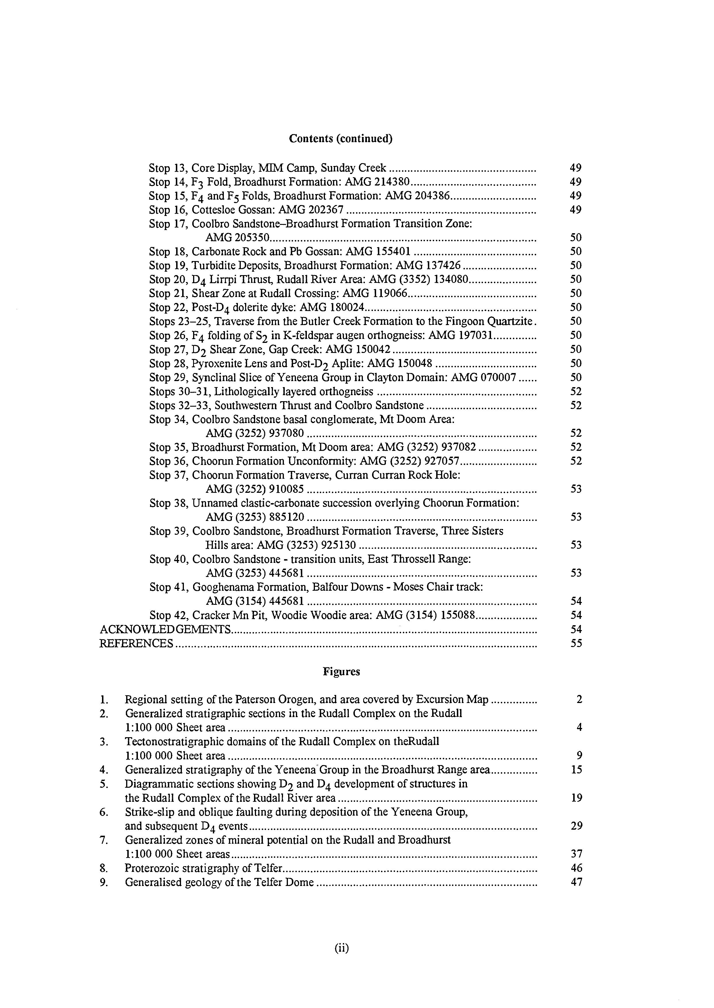
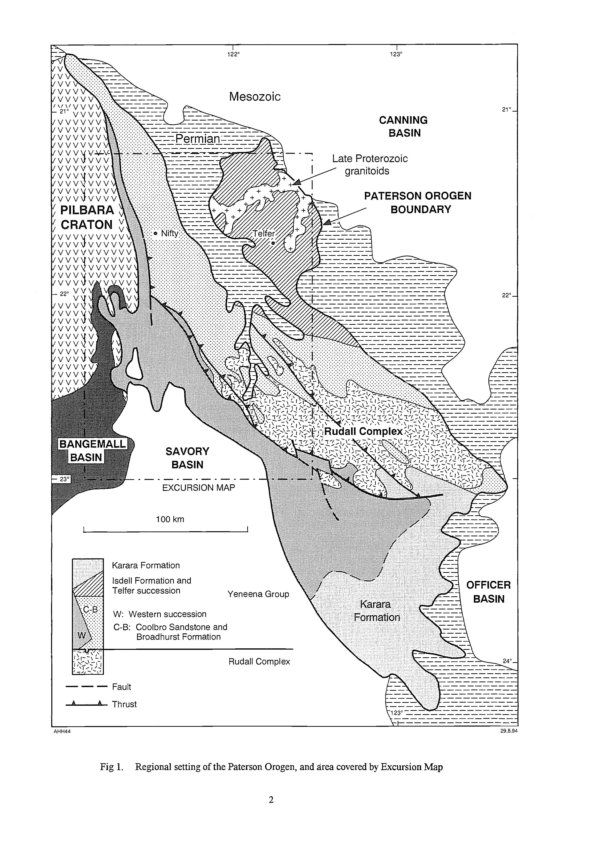
Regional setting of the Paterson Orogen. and area covered by Excursion Map
Generalized stratigraphic sections in the Rudall Complex on the Rudall
1:lOO 000 Sheet area
Tectonostratigraphic domains of the Rudall Complex on theRudal1
1:lOO 000 Sheet area
Generalized stratigraphy of the Yeneena-Group in the Broadhurst Range area
Diagrammatic sections showing D2 and D4 development of structures in the Rudall Complex of the Rudall River area
Strike-slip and oblique faulting during deposition of the Yeneena Group, and subsequent D4 events ..............................................................................................
Generalized zones of mineral potential on the Rudall and Broadhurst
1:lOO 000 Sheet areas ....................................................................................................
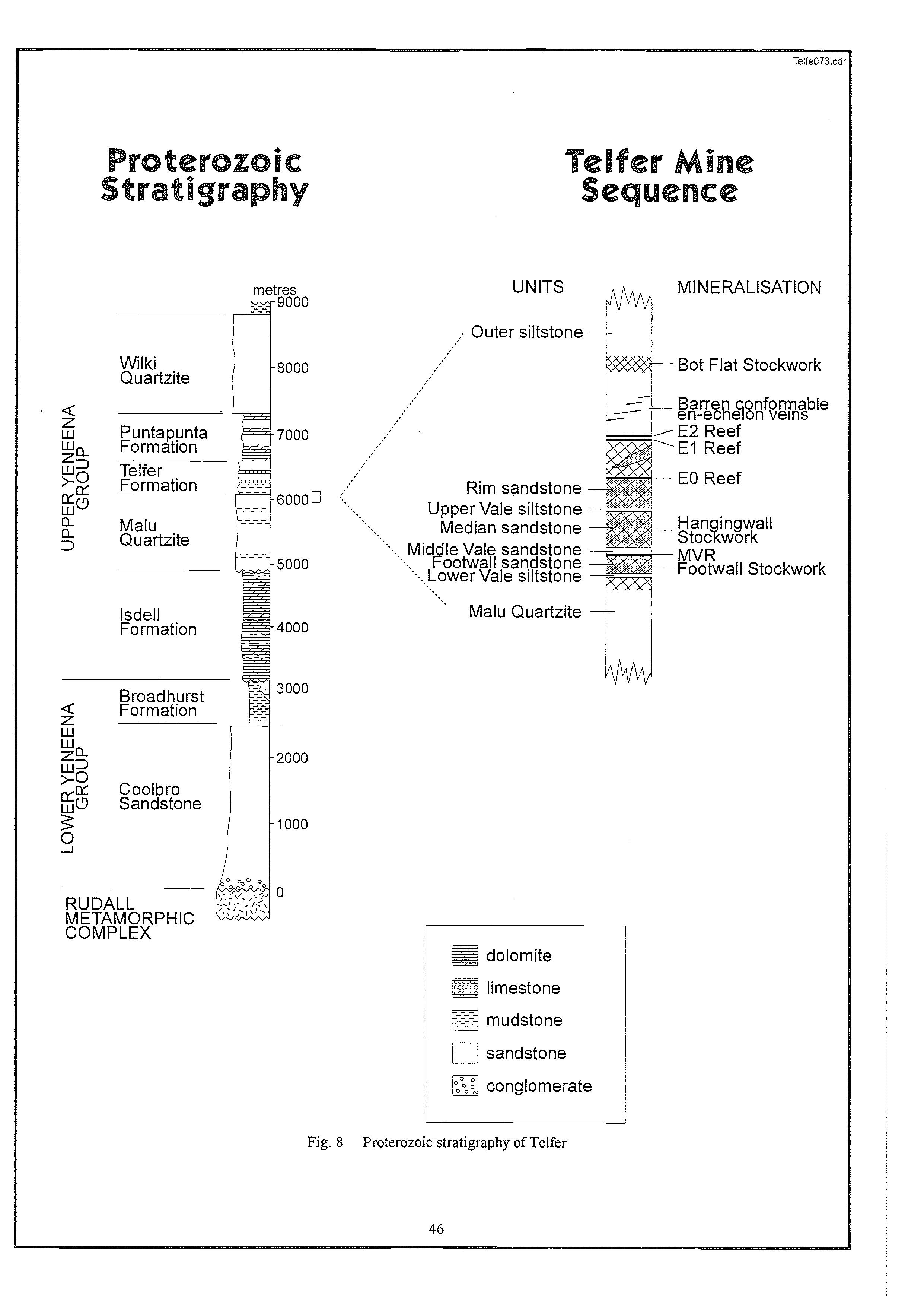
Proterozoic stratigraphy of Telfer...................................................................................
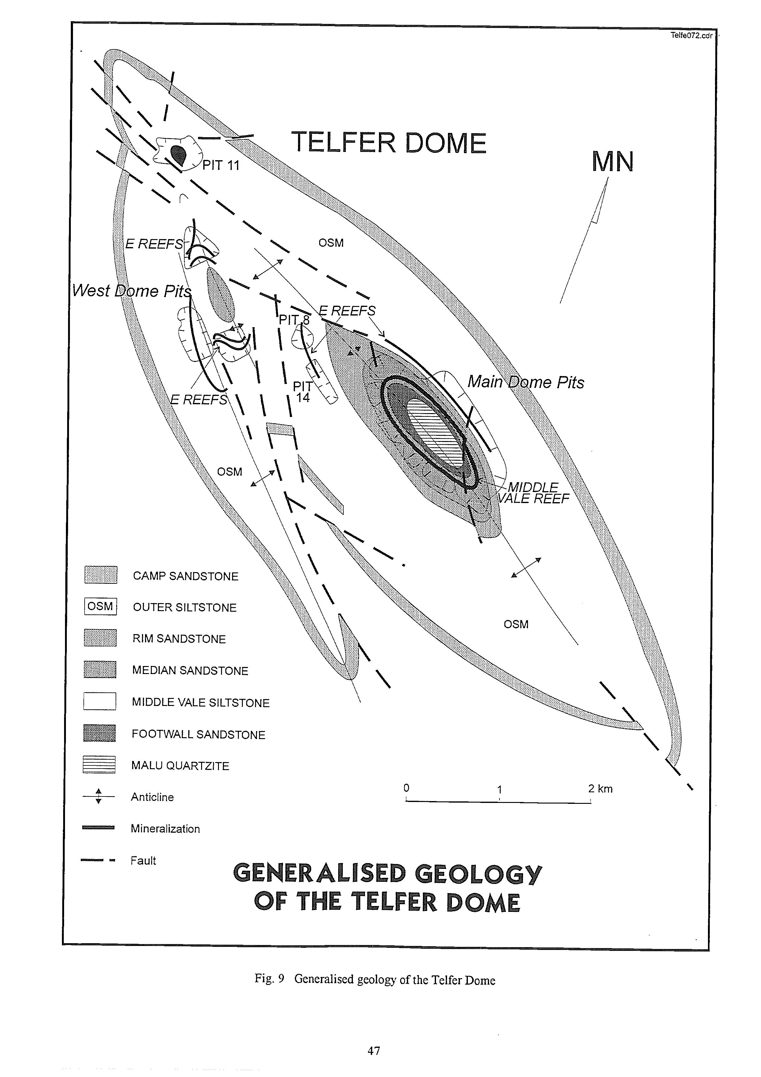
Generalised geology of the Telfer Dome
Generalized stratigraphy of the Paterson Orogen
Stratigraphyof the sedimentary succession of the Rudall Complex
Summary of tectonostratigraphic domains in the Rudall Complex, Rudall 1:lOO 000 Sheet area (from Hickman and Bagas, in press) .................................
Stratigraphy of the Telfer succession (From Williams and Myers, 1990)
Summary of deformation episodes .................................................................................
Summary of the Proterozoic tectonic evolution of the Paterson Orogen, with theoretical metallogenic implications (from Hickman and Bagas, in press) Geochronological
for intrusive rocks, Paterson

MINERALIZATION OF THE TELFER-RUDALL REGION,
GUIDEBOOK TO THE PROTEROZOIC GEOLOGY AND PATERSON OROGEN, WESTERN AUSTRALIA
INTRODUCTION
This guidebook firstly reviews currently available information on the regional geology and mineralization of the northern and central parts of the Paterson Orogen and, in a second section, describes localities visited during the excursion. The aims of the excursion are to outline recent major advances in understanding the tectonic evolution of the orogen, and to examine how mineralization relates to this tectonic history.
OVERVIEW
As discussed by Blockley and de la Hunty (1975), geological knowledge of the Paterson Orogen (referred to as a 'province' until 1990) was extremely limited prior to 1:250 000-scale reconnaissance mapping by the Geological Survey of Western Australia during 1974 and 1975 (Chin et al., 1980; 1982). The conclusions reached from that work were first reported by Williams et al. (1976), and later expanded, using additional information, by Williams and Myers (1990). The main conclusions were:
(i) the Paterson Orogen consists of the Rudall Complex (igneous and sedimentary rocks metamorphosed to amphibolite facies) unconformably overlain by the Yeneena Group (clastic and carbonate rocks), which in turn is unconformably overlain by the Karara Formation (clastic and carbonate rocks);
(ii) the Rudall Complex has a long and complex history of multiple deformation and metamorphism, but contains two distinguishable units: older banded orthogneiss and paragneiss, and younger quartzite and schist;
(iii) the Yeneena Group's stratigraphic succession is regionally variable due to deposition in three zones of differing palaeogeographic, tectonic, metamorphic, and igneous history.
Mineral exploration of the Paterson Orogen commenced about 1970, and a sequence of discoveries in 1971 at Telfer (gold), Rudall River (platinum), Lead Hills (base metals), Mt Cotton (base metals in 1971, uranium in 1981-82) resulted in widespread exploration during the 1970's and 1980's. Subsequent important mineral deposits were found at Nifty (copper) in 1981, and at Kintyre (uranium) in 1985. However, only very limited information has so far been published on the area's mineralization.
In 1989 the Geological Survey of Western Australia commenced a program of detailed 1:lOO 000scale geological mapping, and by mid-1994 four key sheets (Broadhurst, Rudall, Connaughton, and Throssell) had been completed. The new information has necessitated a major re-interpretation of the orogen, which has implications not only for local tectonic evolution and controls of mineralization, but also for continental-scale processes in northwestern Australia during the period 2000Ma to 600 Ma.
On geophysical evidence the Paterson Orogen occupies a 1500 km long arcuate zone extending from the east Pilbara to central Australia (Myers and Hocking, 1988; Clarke, 1991; Myers, 1993). However, the shape and edent of the Paterson Orogen are primarily due to the Neoproterozoic Paterson Orogeny, and therefore not directly related to earlier orogenic events (mainly c. 1750-1250 Ma) responsible for the Rudall Complex
STRATIGRAPHY
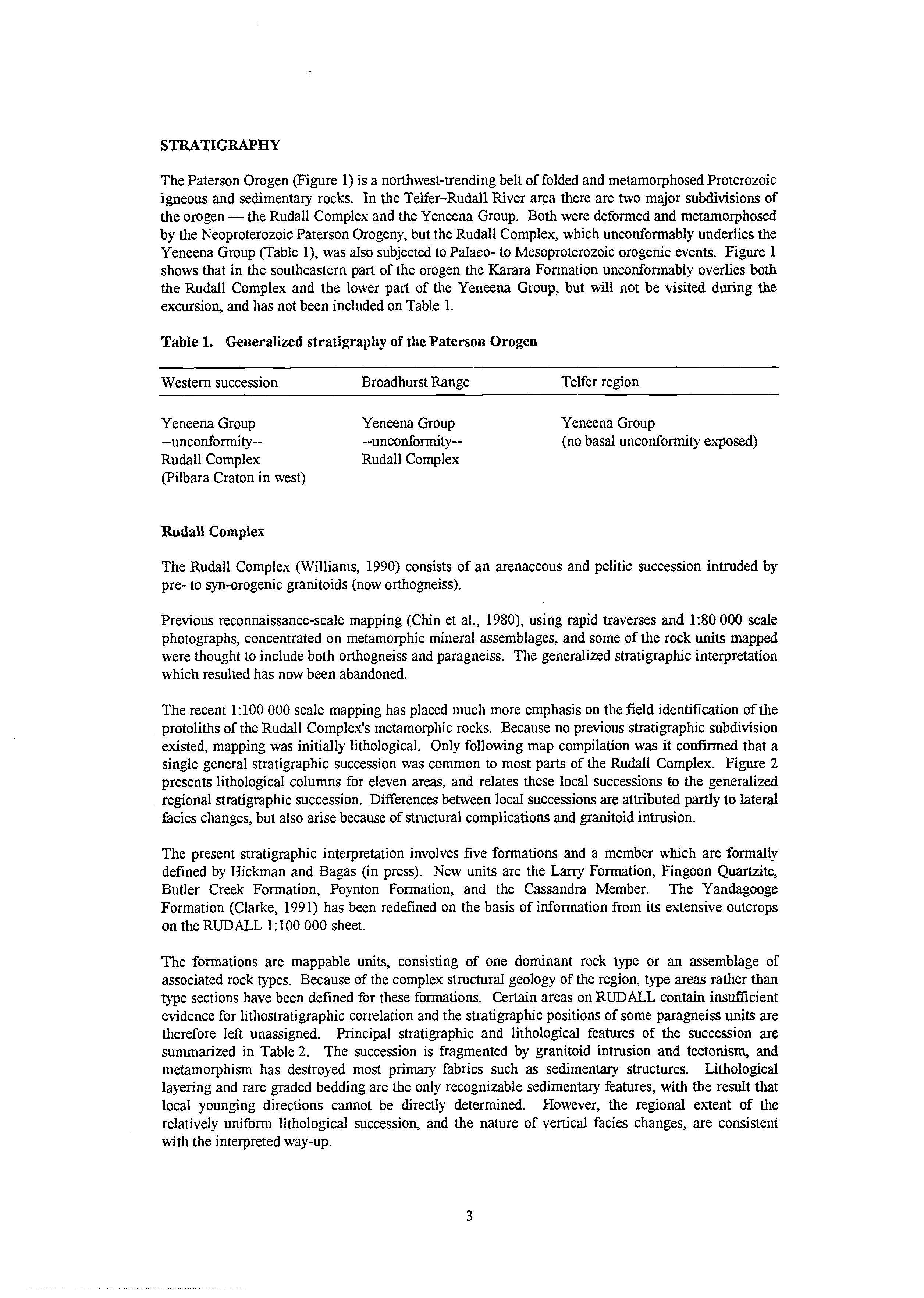
The Paterson Orogen (Figure 1) is a northwest-trendingbelt of folded and metamorphosedProterozoic igneous and sedimentary rocks. In the Telfer-Rudall River area there are two major subdivisions of the orogen -the Rudall Complex and the Yeneena Group. Both were deformed and metamorphosed by the Neoproterozoic Paterson Orogeny, but the Rudall Complex, which unconformably underlies the Yeneena Group (Table l), was also subjected to Palaeo- to Mesoproterozoic orogenic events. Figure 1 shows that in the southeastern part of the orogen the Karara Formation unconformably overlies both the Rudall Complex and the lower part of the Yeneena Group, but will not be visited during the excursion, and has not been included on Table 1.
Table 1. Generalized stratigraphy of the Paterson Orogen
Western succession
Yeneena Group
Broadhurst Range Telfer region
Yeneena Group --unconformity-- --unconformity-Rudall Complex Rudall Complex (Pilbara Craton in west)
Rudall Complex
Yeneena Group (no basal unconformity exposed)
The Rudall Complex (Williams, 1990) consists of an arenaceous and pelitic succession intruded by pre- to syn-orogenicgranitoids (now orthogneiss).
Previous reconnaissance-scale mapping (Chin et al., 1980), using rapid traverses and 130 000 scale photographs, concentrated on metamorphic mineral assemblages, and some of the rock units mapped were thought to include both orthogneiss and paragneiss. The generalized stratigraphic interpretation which resulted has now been abandoned.
The recent 1:lOO 000 scale mapping has placed much more emphasis on the field identification of the protoliths of the Rudall Complex's metamorphic rocks. Because no previous stratigraphic subdivision existed, mapping was initially lithological. Only following map compilation was it confirmed that a single general stratigraphic succession was common to most parts of the Rudall Complex. Figure 2 presents lithological columns for eleven areas, and relates these local successions to the generalized regional stratigraphic succession. Differences between local successionsare attributed partly to lateral facies changes, but also arise because of structural complications and granitoid intrusion.
The present stratigraphic interpretation involves five formations and a member which are formally defined by Hickman and Bagas (in press). New units are the Larry Formation, Fingoon Quartzite, Butler Creek Formation, Poynton Formation, and the Cassandra Member. The Yandagooge Formation (Clarke, 1991) has been redefined on the basis of information from its extensive outcrops on the RUDALL 1: 100 000 sheet.
The formations are mappable units, consisting of one dominant rock type or an assemblage of associated rock types. Because of the complex structural geology of the regon, type areas rather than type sections have been defined for these formations. Certain areas on RUDALL contain insufficient evidence for lithostratigraphic correlation and the stratigraphic positions of some paragneiss units are therefore left unassigned. Principal stratigraphic and lithological features of the succession are summarized in Table 2. The succession is fragmented by granitoid intrusion and tectonism, and metamorphism has destroyed most primary fabrics such as sedimentary structures. Lithological layering and rare graded bedding are the only recognizable sedimentary features, with the result that local younging directions cannot be directly determined. However, the regional extent of the relatively uniform lithological succession, and the nature of vertical facies changes, are consistent with the interpreted way-up.
Iron-rich pelite and graphitic schist
Banded iron-formation
Pelitic schist
Psammitic paragneiss
Quartz-muscovite schist, minor quartzite
Muscovitic quartzite, minor quartz-muscovite schist
Quartzite
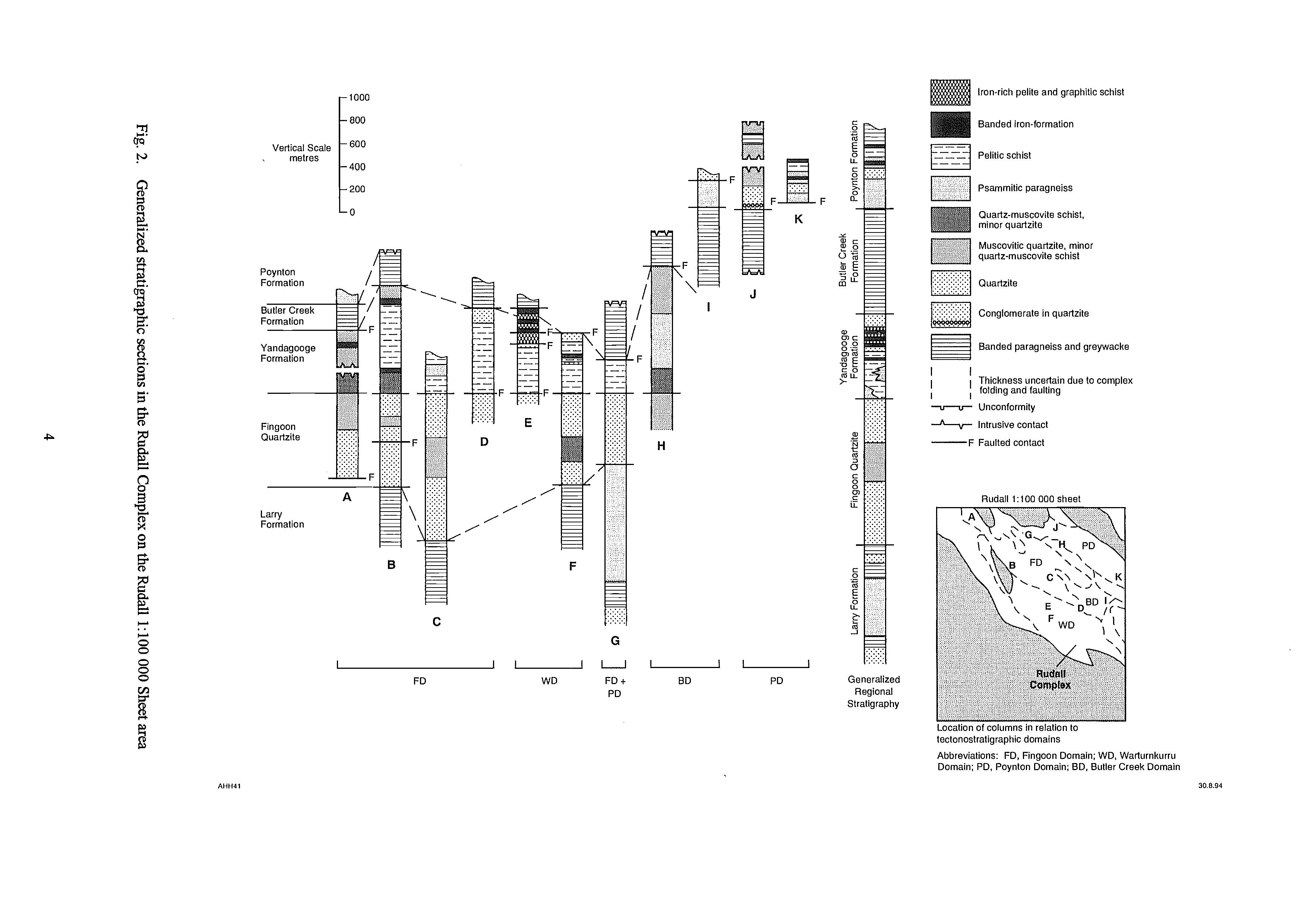
Banded paragneiss and greywacke
I I Thickness uncertain due to complex I 1 folding and faulting
-v--v- Unconformity
,-A-v- Intrusive contact -F Faulted contact
Rudall 1:lOO 000 sheet
tectonostratigraphicdomains
Abbreviations: FD, Fingoon Domain; WD, Warturnkurru Domain; PD. Poynton Domain: BD, Butler Creek Domain
Lary
Formation
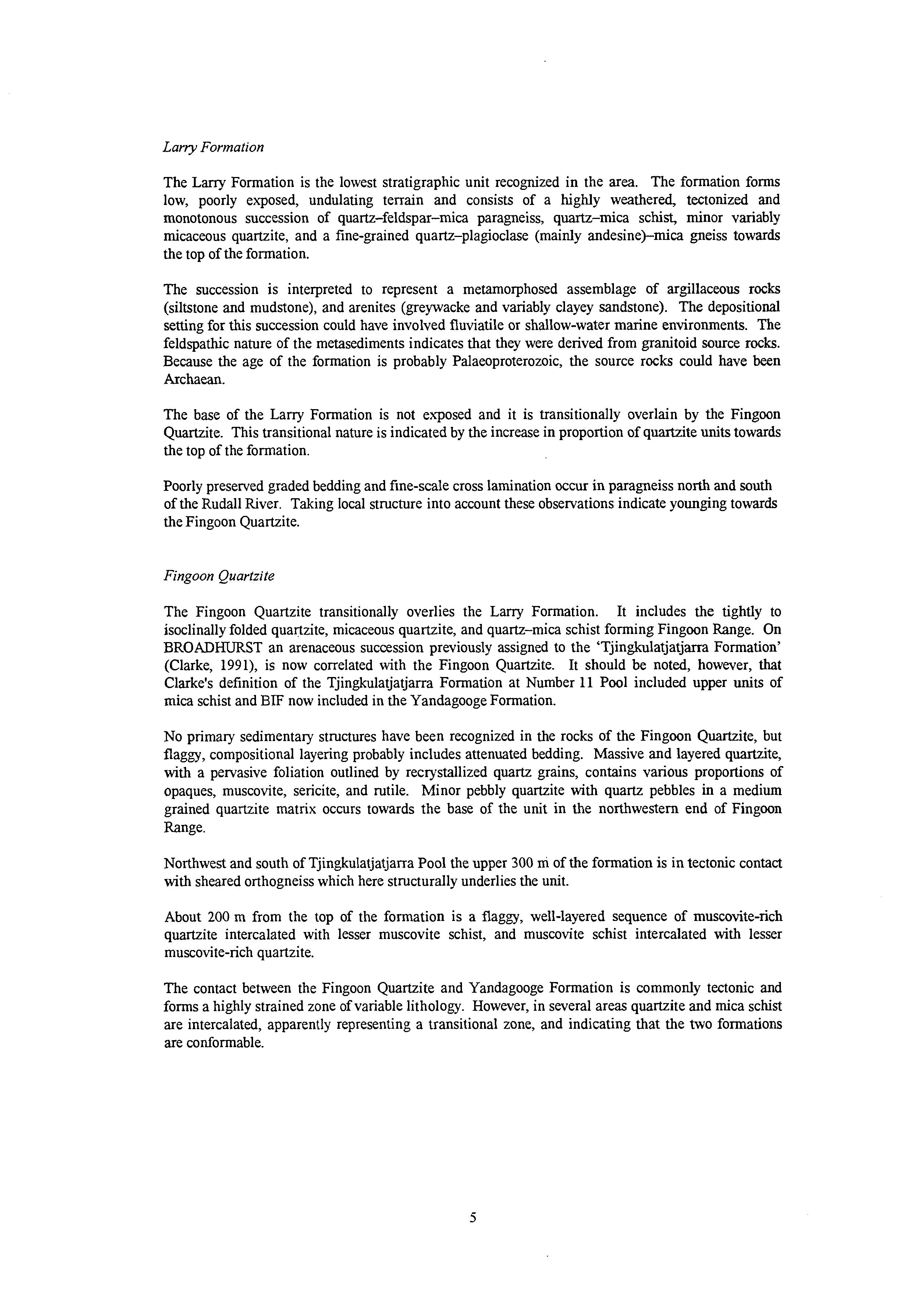
The Larry Formation is the lowest stratigraphic unit recognized in the area. The formation forms low, poorly exposed, undulating terrain and consists of a highly weathered, tectonized and monotonous succession of quartz-feldspar-mica paragneiss, quartz-mica schist, minor variably micaceous quartzite, and a fine-grained quartz-plagioclase (mainly andesine)--mica gneiss towards the top of the formation.
The succession is interpreted to represent a metamorphosed assemblage of argillaceous rocks (siltstone and mudstone), and arenites (greywacke and variably clayey sandstone). The depositional setting for this succession could have involved fluviatile or shallow-water marine environments. The feldspathic nature of the metasediments indicates that they were derived from granitoid source rocks. Because the age of the formation is probably Palaeoproterozoic, the source rocks could have been Archaean.
The base of the Larry Formation is not exposed and it is transitionally overlain by the Fingoon Quartzite. This transitional nature is indicated by the increase in proportion of quartzite units towards the top of the formation.
Poorly preserved graded bedding and fine-scale cross lamination OCCUI in paragneiss north and south of the Rudall River. Taking local structure into account these observations indicate younging towards the Fingoon Quartzite.
Fingoon Quartzite
The Fingoon Quartzite transitionally overlies the Larry Formation. It includes the tightly to isoclinally folded quartzite, micaceous quartzite, and quartz-mica schist forming Fingoon Range. On BROADKURST an arenaceous succession previously assigned to the ‘Tjingkulatjatjarra Formation’ (Clarke, 1991), is now correlated with the Fingoon Quartzite. It should be noted, however, that Clarke’s definition of the Tjingkulatjatjarra Formation at Number 11 Pool included upper units of mica schist and BIF now included in the Yandagooge Formation.
No primary sedimentary structures have been recognized in the rocks of the Fingoon Quartzite, but flaggy, compositional layering probably includes attenuated bedding. Massive and layered quartzite, with a pervasive foliation outlined by recrystallized quartz grains, contains various proportions of opaques, muscovite, sericite, and rutile. Minor pebbly quartzite with quartz pebbles in a medium grained quartzite matrix occurs towards the base of the unit in the northwestern end of Fingoon Range.
Northwest and south of Tjingkulatjatjarra Pool the upper 300 m of the formation is in tectonic contact with sheared orthogneiss which here structurally underlies the unit.
About 200 rn from the top of the formation is a flaggy, well-layered sequence of muscovite-rich quartzite intercalated with lesser muscovite schist, and muscovite schist intercalated with lesser muscovite-rich quartzite.
The contact between the Fingoon Quartzite and Yandagooge Formation is commonly tectonic and forms a highly strained zone of variable lithology. However, in several areas quartzite and mica schist are intercalated, apparently representing a transitional zone, and indicating that the two formations are conformable.
Table 2. Stratigraphy of the sedimentary succession of the Rudall Complex
Unit,
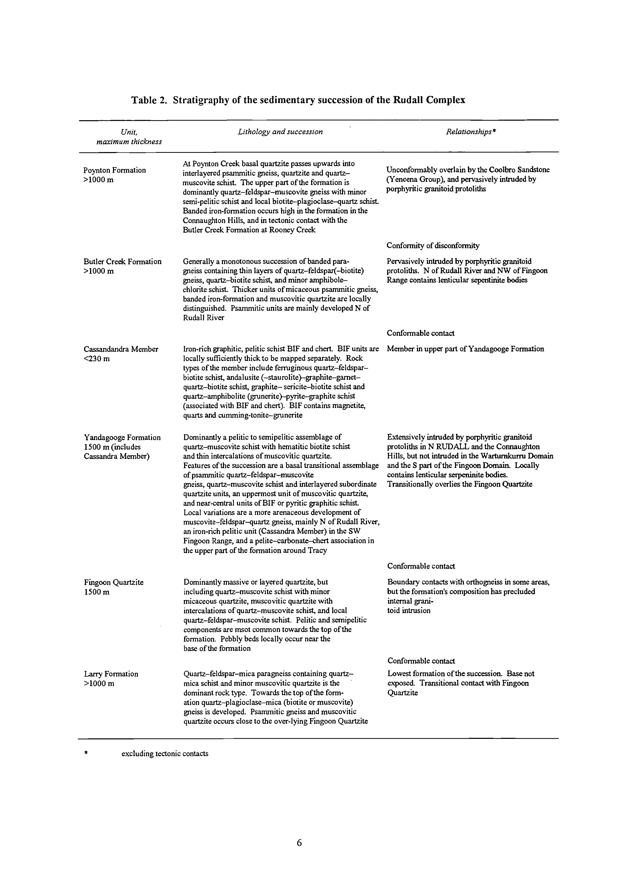
Lithologyandsuccession
Relationships * maximumrhickness
Poynton Formation
>lo00 m
At Poynton Creek basal quartzite passes upwards into interlayered psammitic gneiss, quartzite and quartzmuscovite schist. The upper part of the formation is dominantly quartz-feldspar-muxite gneiss with minor semi-pelitic schist and local biotite-plagioclase-quartz schist Banded iron-formation occurs high in the formation in the Connaughton Hills, and in tectonic contact with the Butler Creek Formation at Rwney Creek
Unconformably overlain by the Coolbro Sandstone (Yeneena Croup), and pervasively intruded by porphyritic granitoid protoliths
Butler Creek Formation
>lo00 m
Cassandandra Member
<230 m
Yandagooge Formation
1500 m (includes Cassandra Member)
Generally a monotonous succession of banded paragneiss containing thin layers of quartz-feldspar(-biotite) gneiss, quartz-biotite schist, and minor amphibolechlorite schist. Thicker units of micaceous psammitic gneiss, banded iron-formation and muscovitic quartzite are locally distinguished. Psammitic units are mainly developed N of Rudall River
Iron-rich graphitic, pelitic schist BIF and chert BIF units are locally sufficiently thick to be mapped separately. Rock types ofthe member include fermginous quartz-feldsparbiotite schist, andalusite (-staurolite jgraphite-gametquartz-biotite schist, graphite- sericite-biotite schist and quartz-amphibolite (grunerite)-pyrite-graphite schist (associated with BIF and chert). BIF contains magnetite, quarts and cumming-tonite-gruna-ite
Dominantly a pelitic to semipelitic assemblageof quartz-muscovite schist with hematitic biotite schist and thin intercalations of muscovitic quartzite. Features of the succession are a basal transitional assemblage of psammitic quartz-feldspar-muscovite gneiss, quartz-muscovite schist and interlayered subordinate quartzite units, an uppermost unit of muscovitic quartzite, and nearcentral units of BIF or pyritic graphitic schist
Local variations are a more arenaceous development of muscovite-feldspar-quartz gneiss, mainly N of Rudall River, an iron-rich pelitic unit (CassandraMember) in the SW Fingoon Range, and a pelite-carbonate-chert association in the upper part ofthe formation around Tracy
conformity of discanf.rmity
Pervasively intruded by porphyritic granitoid protoliths. N of Rudall River and NW of Fingoon Range contains lenticular sepentinite bodies
Conformablecontact
Member in upper part of Yandagwge Formation
Extensively intruded by porphyritic granitoid protoliths in N RUDALL and the Connaughton Hills, but not intruded in the Warturnkum Domain and the S part of the Fingoon Domain Locally contains lenticular serpeninitebodies. Transitionally overlies the Fingoon
Fingoon Quartzite
1500 m
Larry Formation
>lo00 m
Dominantly massive or layered quartzite, but including quartz-muscovite schist with minor micaceous quartzite, muscovitic quartzite with intercalations of quartz-muscovite schist, and local quartz-feldspar-muscovite schist. Pelitic and semipelitic components are msot common towards the top of the formation. Pebbly beds locally occur near the base of the formation
Quartz-feldspar-mica paragneiss containing quartzmica schist and minor muscovitic quartzite is the dominant rock type. Towards the top of the formation quartz-plagioclase-mica (biotite or muscovite) gneiss is developed. Psammitic gneiss and muscovitic quartzite occurs close to the over-lying Fingmn Quartzite
* excluding tectonic contacts
Conformablecontact
Boundary contacts with orthogneiss in some arm, but the formation's composition has precluded internal granitoid intrusion
Conformable contact
Lowest formation of the succession Base not exposed. Transitional contact with Fingoon Quartzite
Yandagooge Formation
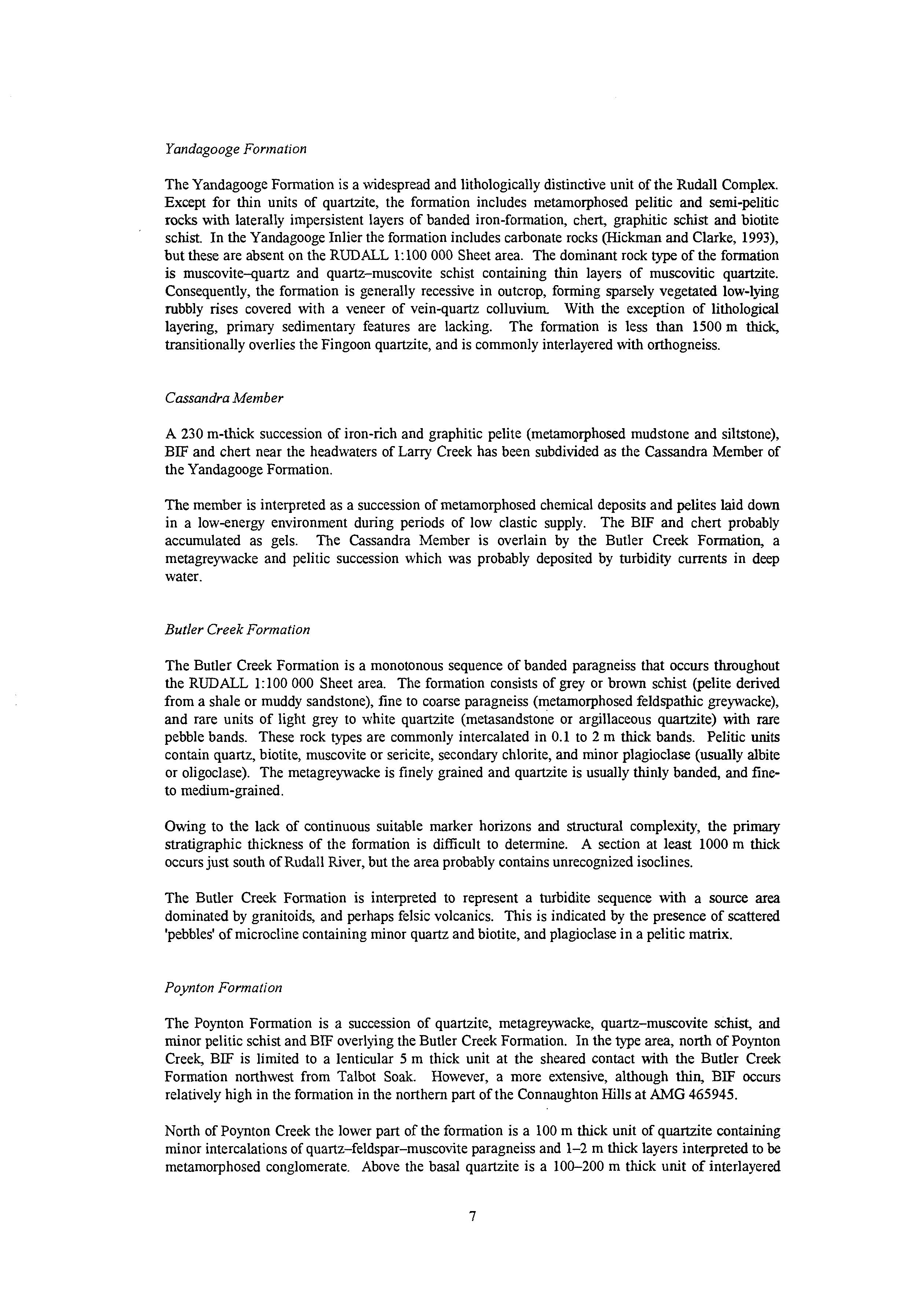
The Yandagooge Formation is a widespread and lithologically distinctive unit of the Rudall Complex. Except for thin units of quartzite, the formation includes metamorphosed pelitic and semi-pelitic rocks with laterally impersistent layers of banded iron-formation, chert, graphitic schist and biotite schist. In the Yandagooge Inlier the formation includes carbonate rocks (Hickman and Clarke, 1993), but these are absent on the RUDALL 1:100 000 Sheet area. The dominant rock type of the formation is muscovite-quartz and quartz-muscovite schist containing thin layers of muscovitic quartzite. Consequently, the formation is generally recessive in outcrop, forming sparsely vegetated low-lying rubbly rises covered with a veneer of vein-quartz colluvium With the exception of lithological layering, primary sedimentary features are lacking. The formation is less than 1500 m thick, transitionally overlies the Fingoon quartzite, and is commonly interlayered with orthogneiss.
Cassandra Member
A 230 rn-thick succession of iron-rich and graphitic pelite (metamorphosed mudstone and siltstone), BIF and chert near the headwaters of Larry Creek has been subdivided as the Cassandra Member of the Yandagooge Formation.
The member is interpreted as a succession of metamorphosed chemical deposits and pelites laid down in a low-energy environment during periods of low clastic supply. The BIF and chert probably accumulated as gels. The Cassandra Member is overlain by the Butler Creek Formation, a metagreywacke and pelitic succession which was probably deposited by turbidity currents in deep water.
Butler Creek Formation
The Butler Creek Formation is a monotonous sequence of banded paragneiss that occurs throughout the RUDALL 1:lOO 000 Sheet area. The formation consists of grey or brown schist @elite derived from a shale or muddy sandstone), fine to coarse paragneiss (metamorphosed feldspathic greywacke), and rare units of light grey to white quartzite (metasandstone or argillaceous quartzite) with rare pebble bands. These rock types are commonly intercalated in 0.1 to 2 m thick bands. Pelitic units contain quartz, biotite, muscovite or sericite, secondary chlorite, and minor plagioclase (usually albite or oligoclase). The metagreywacke is finely grained and quartzite is usually thinly banded, and fineto medium-grained.
Owing to the lack of continuous suitable marker horizons and structural complexity, the primary stratigraphic thickness of the formation is difficult to determine. A section at least 1000 m thick occurs just south of Rudall River, but the area probably contains unrecognized isoclines.
The Butler Creek Formation is interpreted to represent a turbidite sequence with a source area dominated by granitoids, and perhaps felsic volcanics. This is indicated by the presence of scattered 'pebbles' of microcline containing minor quartz and biotite, and plagioclase in a pelitic matrix.
Poynton Formation
The Poynton Formation is a succession of quartzite, metagreywacke, quartz-muscovite schist, and minor pelitic schist and BIF overlling the Butler Creek Formation. In the type area, north of Poynton Creek, BIF is limited to a lenticular 5 m thick unit at the sheared contact with the Butler Creek Formation northwest from Talbot Soak. However, a more extensive, although thin, BE occurs relatively high in the fomiation in the northern part of the Connaughton Hills at AMG 465945.
North of Poynton Creek the lower part of the formation is a 100 m hck unit of quartzite containing minor intercalations of quartz-feldspar-muscovite paragneiss and 1-2 m thick layers interpreted to be metamorphosed conglomerate. Above the basal quartzite is a 100-200 m thick unit of interlayered
quartzite and quartz-feldspar-muscovite paragneiss and schist. The feldspathic arenite is interpreted as a metamorphosed arkosic sandstone, but it could be a felsic volcanogenic sediment. A 100-200 m thick sheet of orthogneiss separates the arkosic unit from the upper part of the formation, which is best exposed in a tributary of Poynton Creek. The upper unit is at least 400 m thick and consists of compositionally layered quartz-feldspar-biotite paragneiss with numerous thin units of quartzite and quartz-biotite schist. Some creeks in the upper part of this section of the formation expose 0.5 to 1.0 m compositionally layered rhythmic units, lower feldspathic quartzite layers grading upwards into plagioclase-quartz-muscovite-biotite gneiss overlain by 50-100 mm layers of biotite+pidote-quartz microgneiss. These rhythmic units are interpreted to be metamorphosed sandstone-greywacke-shale graded beds of a turbidite succession.
Unassigned metasedimentary rocks
Large metasedimentary enclaves in the orthogneiss of the northwestern part of the RUDALL, 1:lOO OOO Sheet area are not correlated with the main succession. In this area, the Clayton Domain (see below), stratigraphic correlationwould be speculativebecause evidence other than rock type is absent.
Stratigraphic overview
The stratigraphic subdivision of the Rudall Complex is lithostratigraphic, and based on regional continuity of successions. No unconformities are recognized within the succession, and contacts with orthogneiss are either tectonic or intrusive. The stratigraphic succession has been extensively fragmented by thrust faults of D, and D, generation (see below), and the various tectonostratigraphic domains contain distinct stratigraphic packages (Table 3, Figure 3). Correlation across domain boundaries is partly tentative, and no correlation has been made into the complexly disrupted stratigraphy of the Clayton Domain. Generalized stratigraphic sections, from the Warturnkurm, Fingoon, Butler and Poynton domains are shown in Figure 2.
The depositional environments responsible for the succession are discussed under ‘Tectonic Evolution’, but some preliminary observations are appropriate at this stage. The lithostratigraphic succession of the Rudall Complex appears to broadly define an orogenic cycle represented by a mixed sandstone-mudstone (Larry Formation) to quartzite (Fingoon Quartzite) assemblage in the lowest part of the succession and pelites, rare carbonates and turbidites (Yandagooge Formation and Butler Creek Formation), and a thick quartzite (Poynton Formation) in the upper part. The type of depositional system responsible for this succession cannot be directly determined owing to non-preservation of its eastern section, and because of destruction of important sedimentological criteria (eg. facies relationships and sedimentay structures). However, by analogy with modem environments the lithological character of the sedimentary assemblage indicates either intracratonic or continental margin deposition. Later in this guidebook (‘Tectonic Evolution’) additional geological evidence is used to favour deltaic-shelf to moderately deep-water deposition on a rifted continental margin. The continental landmass lay to the southwest and west of the RUDALL 1:lOO 000 Sheet area, and was the southeastern part of the PiIbara Craton.
The Lany Formation, Fingoon Quartzite and Yandagooge Formation are chiefly confined to the Fingoon and Warturnkurm domains, although the Yandagooge Formation extends into the Butler Domain. Within the Fingoon Domain the Fingoon Quartzite becomes thinner to the northeast and the Yandagooge Formation becomes thicker to the southeast, although present thickness variations are probably partly tectonic. Way-up evidence is restricted to the upper part of the Larry Formation where fine-scale cross bedding and graded bedding indicate younging towards the overlying Fingoon Quartzite.
The Larry Formation is transitionally overlain by the Fingoon Quartzite in the Fingoon and Warturnkurru domains, where at the top of the Larry Formation thin quartzite bands are intercalated with an assemblage of pelitic schist and argillaceous arenites. This transition could be interpreted either as a change from comparative deep to shallow environments, or as a transition between two types of shallow-water facies (eg estuarine or delta plain to shelf sands); insufficient diagnostic data are preserved.
Savory
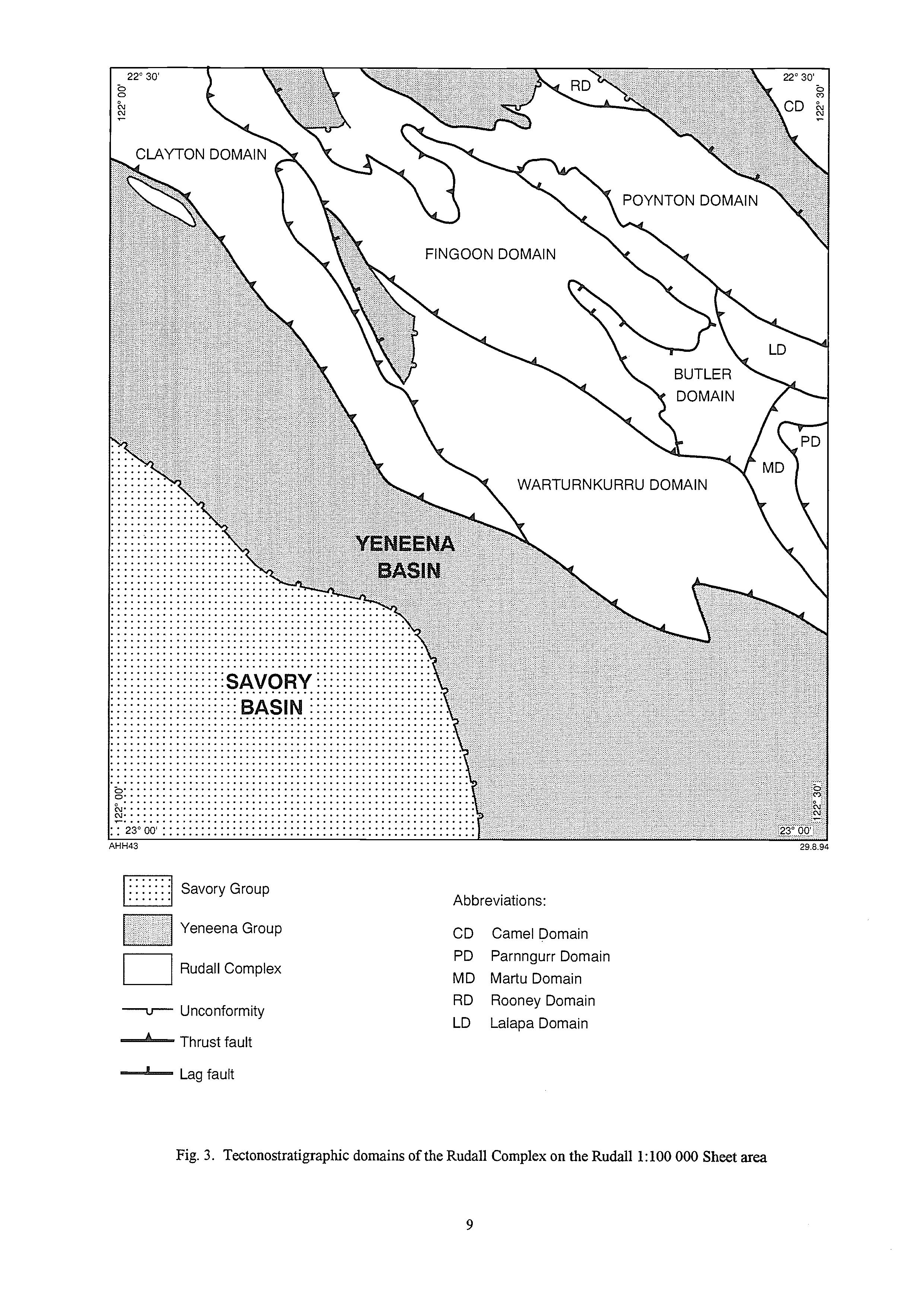
Abbreviations:
CD Camel Domain
PD Parnngurr Domain
MD Martu Domain
RD Rooney Domain
LD Lalapa Domain
One of the least tectonized contacts between the Fingoon Quartzite and Yandagooge Formation is preserved in the Wartumkurm Domain where quartzite and quartz-mica schist are intercalated at the base of the Yandagooge Formation. Quartzite forms thin layers throughout the Yandagooge Formation but towards the northern part of the Fingoon Domain feldspathic and argillaceous (poorly sorted) psammitic paragneiss forms much of the formation. In the same direction units of BE and graphitic schist become less common and much thinner. These changes indicate a source detritus to the northeast.
The Butler Creek Formation, a thick, monotonous succession of metamorphosed turbidite sediments and argillaceous units, sharply overlies quartzite and pelitic schist in the Yandagooge Formation. The contact between the two formations is variably tectonized, although a conformable relationship appears to be preserved at the northwestern end of the Fingoon Range.
The Poynton Formation, ‘an upward fining succession of quartzite, metagreywacke, and minor pelite and BIF, is almost entirely confined to the Poynton Domain, where it is underlain by banded paragneiss of the Butler Creek Formation (see ‘PoyntonFormation’).
Because the southwestern boundary of the Poynton Domain is a major thrust (Connaughton Thrust), the interpretation that the Poynton Formation is the youngest sedimentary formation of the Rudall Complex depends on its relationship to the Butler Creek Formation. An alternative interpretation would equate the Poynton Formation with the Fingoon Quartzite, and would require correlating the Butler Creek Formation of the Poynton Domain with the Lam Formation of the Fingoon and Wartumkurm domains. These correlations are less probable, because they would require fortuitous juxtaposition of lithologically similar paragneiss units of different ages in the vicinity of the Connaughton Thrust. Moreover, the Poynton Formation appears to overlie the Butler Creek Formation in the Butler Domain.
Metasedimentary units of the Clayton Domain may belong to the Fingoon Quartnte and Yandagooge Formation, but stratigraphicrelations are obscured by sheets of orthogneissand tectonic slicing of the area.
Orthogneiss
About 50% of the outcrop area of the Rudall Complex is composed of orthogneiss derived from granitoid protoliths. About 80% of the orthogneiss is a microcline-quartz-plagioclase-biotite gneiss (mapped as PRga)containing numerous augen (deformed megacrysts) of K-feldspar. A further 10% of the orthogneiss is a lithologically layered gneiss (mapped as PRgx) with inclusions (mainly xenoliths) of amphibolite, serpentinite, banded iron-formation, and various types of paragneiss. This relatively complex orthogneiss is intruded by sheets of PRga, suggesting that the granitoid protoliths of these two varieties of gneiss crystallized during separate intrusive events.
The PRga protoliths intruded almost all levels of the paragneiss succession. PRgx contacts with the stratigraphic succession of the Rudall Complex are far more limited, but intrusive relationships to adjacent units are indicated. At no localities do units of the paragneiss succession unconfonnably overlie any of types of orthogneiss, and no conglomerates containing orthogneiss clasts have been identified. In summary, field evidence indicates that PRga (and probably ERgx) protoliths were younger than the entire paragneiss succession.
Microcline-quartz-plagioclase-biotite gneiss @Rga) containing numerous augen of K-feldspar is generally well exposed, and forms low rocky hills with only sparse vegetation. The rock is variably foliated by S2 (Structure) mica alignment, and ranges from a poorly foliated porphyritic granite or monzogranite to a quartz-feldspar-muscovite schist. The mica foliation is generally folded by F4 folds or crenulated by S4 (Structure). Microscopic examination generally reveals a strongly foliated, granoblastic mosaic of microcline, plagioclase and quartz with variable biotite and muscovite. Where rock composition is granodiorite, the feldspar augen are chiefly composed of oligoclase.
Table 3. Summary of tectonostratigraphic domains in the Rudall Complex, RUDALL 1:lOO 000 Sheet area (from Hickman and Bagas, in press)
Domain Rock units
Camel Rooney
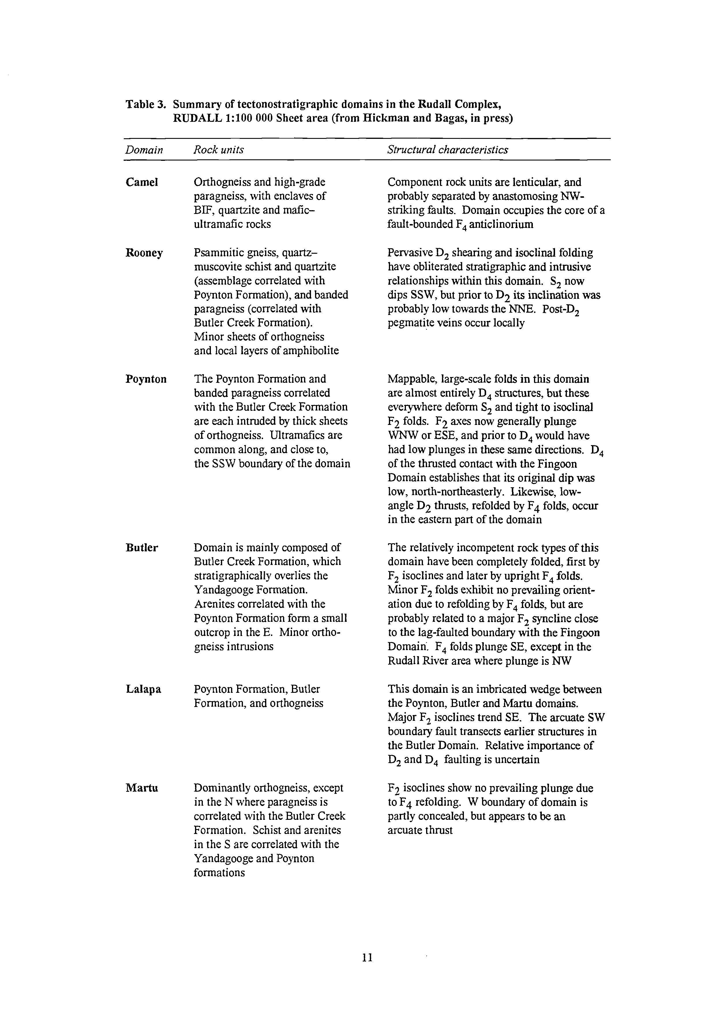
Orthogneiss and high-grade paragneiss, with enclaves of BIF, quartzite and maficultramafic rocks
Psammitic gneiss, quartzmuscovite schist and quartzite (assemblage correlated with Poynton Formation), and banded paragneiss (correlated with Butler Creek Formation). Minor sheets of orthogneiss and local layers of amphibolite
Poynton
Butler
The Poynton Formation and banded paragneiss correlated with the Butler Creek Formation are each intruded by thick sheets of orthogneiss. Ultramafks are common along, and close to, the SSW boundary of the domain Domain is mainly composed of Butler Creek Formation, which stratigraphically overlies the Yandagooge Formation. Arenites correlated with the Poynton Formation form a small outcrop in the E. Minor orthogneiss intrusions
Lalapa
Poynton Formation, Butler Formation, and orthogneiss
Martu
Dominantly orthogneiss, except in the N where paragneiss is correlated with the Butler Creek Formation. Schist and arenites in the S are correlated with the Yandagooge and Poynton formations
Structural characteristics
Component rock units are lenticular, and probably separated by anastornosing Wstriking faults. Domain occupies the core of a fault-bounded F4anticlinorium
Pervasive D, shearing and isoclinal folding have obliterated stratigraphic and intrusive relationshipswithin this domain. S, now dips SSW, but prior to D2 its inclination was probably low towards the "E. Post-D, pegmatite veins occur locally
Mappable, large-scale folds in this domain are almost entirely D, structures,but these everywhere deform S, and tight to isoclinal F2 folds. F2 axes now generally plunge WNW or ESE, and prior to D, would have had low plunges in these same directions. D, of the thrusted contact with the Fingoon Domain establishes that its original dip was low, north-northeasterly. Likewise, lowangle D2 thrusts, refolded by F4 folds, occur in the eastern part of the domain
The relatively incompetent rock types of this domain have been completely folded, first by F, isoclines and later by upright F4 folds. Minor F, folds exhibit no prevailing orientation due to refolding by F, folds, but are probably related to a major F2 syncline close to the lag-faulted boundary with the Fingoon Domain', F4 folds plunge SE, except in the Rudall River area where plunge is NW
This domain is an imbricated wedge between the Poynton, Butler and Martu domains. Major F2 isoclines trend SE. The arcuate SW boundary fault transects earlier structures in the Butler Domain. Relative importance of D, and D, faulting is uncertain
F2 isoclines show no prevailing plunge due to F4 refolding. W boundary of domain is partly concealed, but appears to be an arcuate thrust
Table 3. (continued)
Domain Rock units
Parnngurr Butler Creek and Poynton formations with minor orthogneiss
Fingoon Fingoon Quartzite, Larry Formation and orthogneiss, with Yandagooge and Butler Creek formations in the NW
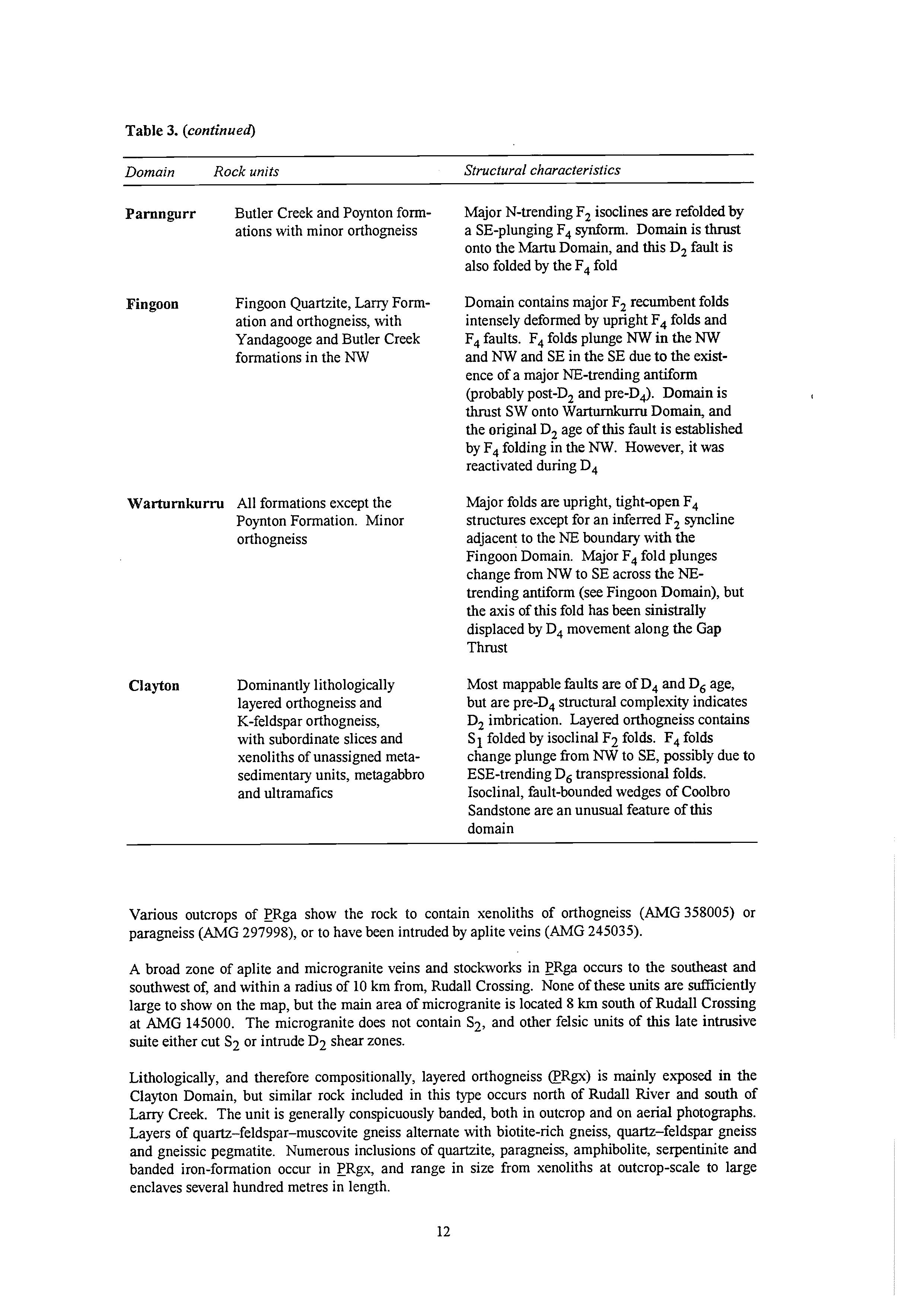
Warturnkurru All formations except the
Poynton Formation. Minor orthogneiss
Clayton Dominantly lithologically
layered orthogneiss and K-feldspar orthogneiss, with subordinate slices and xenoliths of unassigned metasedimentary units, metagabbro and ultramafics
Structural characteristics
Major N-trending F, isoclines are refolded by a SE-plunging F4 synforrn. Domain is thrust onto the Martu Domain, and this D, fault is also folded by the F4 fold
Domain contains major F2 recumbent folds intensely deformed by upright F4 folds and F, faults. F, folds plunge NW in the NW and NW and SE in the SE due to the existence of a major NE-trending antiform (probably post-D2 and pre-Dk). Domain is thrust SW onto Warturnkurm Domain, and the original D, age of this fault is established by F, folding in the NW. However, it was reactivated during D,
Major folds are upright, tight-open F, structures except for an inferred F, syncline adjacent to the NE boundary with the Fingoon Domain. Major F, fold plunges change from NW to SE across the NEtrending antiforrn (see Fingoon Domain), but the axis of this fold has been sinistrally displaced by D, movement along the Gap Thrust
Most mappable faults are of D, and D, age, but are pre-D, structural complexity indicates D, imbrication. Layered orthogneiss contains S1 folded by isoclinal Fa folds. F, folds change plunge from NW to SE, possibly due to ESE-trending D, transpressional folds. Isoclinal, fault-bounded wedges of Coolbro Sandstone are an unusual feature of this domain
Various outcrops of PRga show the rock to contain xenoliths of orthogneiss (AMG358005) or paragneiss (AMG297998), or to have been intruded by aplite veins (AMG 245035).
A broad zone of aplite and microgranite veins and stockworks in ERga occurs to the southeast and southwest of, and within a radius of 10 km from, Rudall Crossing. None of these units are diciently large to show on the map, but the main area of microgranite is located 8 km south of Rudall Crossing at AMG 145000. The microgranite does not contain S2, and other felsic units of this late intrusive suite either cut S2 or intrude D2 shear zones.
Lithologically, and therefore compositionally, layered orthogneiss @R@) is mainly exposed in the Clayton Domain, but similar rock included in this type occurs north of Rudall River and south of Larry Creek. The unit is generally conspicuously banded, both in outcrop and on aerial photographs. Layers of quartz-feldspar-muscovite gneiss alternate with biotite-rich gneiss, quartz-feldspar gneiss and gneissic pegmatite. Numerous inclusions of quartzite, paragneiss, amphibolite, serpentinite and banded iron-formation occur in ERgx, and range in size from xenoliths at outcrop-scale to large enclaves several hundred metres in length.
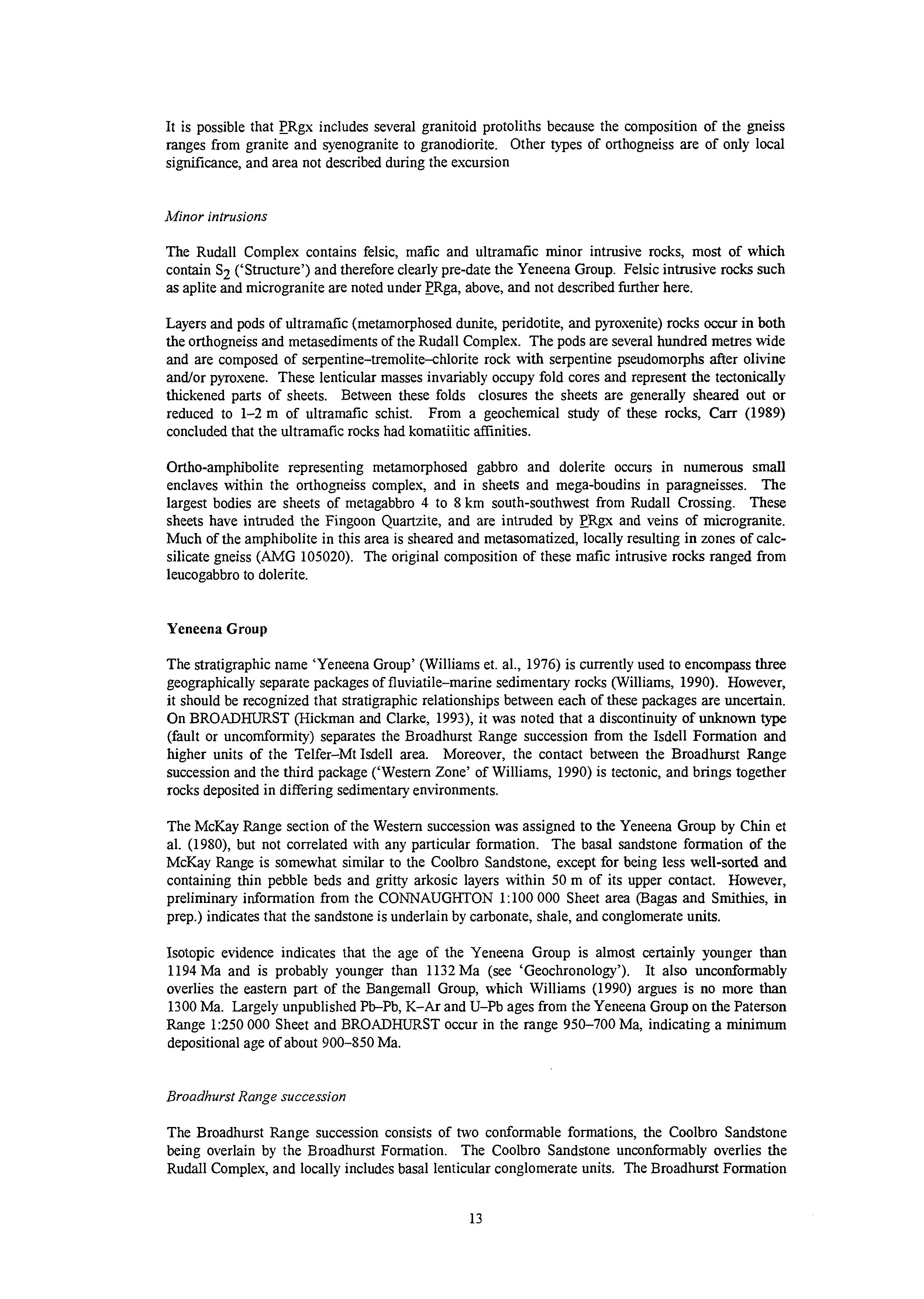
It is possible that PRgx includes several granitoid protoliths because the composition of the gneiss ranges from granite and syenogranite to granodiorite. Other types of orthogneiss are of only local sigmfkance, and area not described during the excursion
Minor intrusions
The Rudall Complex contains felsic, mafc and ultramafc minor intrusive rocks, most of which contain S2 (‘Structure’) and therefore clearly pre-date the Yeneena Group. Felsic intrusive rocks such as aplite and microgranite are noted under ERga, above, and not described further here.
Layers and pods of ultramafic (metamorphosed dunite, peridotite, and pyroxenite) rocks occur in both the orthogneiss and metasediments of the Rudall Complex. The pods are several hundred metres wide and are composed of serpentine-tremolite-chlorite rock with serpentine pseudomorphs after olivine and/or pyroxene. These lenticular masses invariably occupy fold cores and represent the tectonically thickened parts of sheets. Between these folds closures the sheets are generally sheared out or reduced to 1-2m of ultramafc schist. From a geochemical study of these rocks, Carr (1989) concluded that the ultramafk rocks had komatiitic amities.
Ortho-amphibolite representing metamorphosed gabbro and dolerite occurs in numerous small enclaves within the orthogneiss complex, and in sheets and mega-boudins in paragneisses. The largest bodies are sheets of metagabbro 4 to 8 km south-southwest from Rudall Crossing. These sheets have intruded the Fingoon Quartzite, and are intruded by ERgx and veins of microgranite. Much of the amphibolite in this area is sheared and metasomatized, locally resulting in zones of calcsilicate gneiss (AMG 105020). The original composition of these mafc intrusive rocks ranged from leucogabbro to dolerite.
Yeneena Group
The stratigraphic name ‘Yeneena Group’ (Williams et. al., 1976) is currently used to encompass three geographically separate packages of fluviatile-marine sedimentary rocks (Williams, 1990). However, it should be recognized that stratigraphic relationships between each of these packages are uncertain. On BROADHURST (Hickman and Clarke, 1993), it was noted that a discontinuity of unknown type (fault or uncomformity) separates the Broadhurst Range succession from the Isdell Formation and higher units of the Telfer-Mt Isdell area. Moreover, the contact between the Broadhurst Range succession and the third package (‘Western Zone’ of Williams, 1990) is tectonic, and brings together rocks deposited in differing sedimentaryenvironments.
The McKay Range section of the Western succession was assigned to the Yeneena Group by Chin et al. (1980), but not correlated with any particular formation. The basal sandstone formation of the McKay Range is somewhat similar to the Coolbro Sandstone, except for being less well-sorted and containing thin pebble beds and gritty arkosic layers within 50 m of its upper contact. However, preliminary information from the CONNAUGHTON 1:lOO 000 Sheet area (Bagas and Smithies, in prep.) indicates that the sandstone is underlain by carbonate, shale, and conglomerate units.
Isotopic evidence indicates that the age of the Yeneena Group is almost certainly younger than 1194 Ma and is probably younger than 1132 Ma (see ‘Geochronology’). It also unconformably overlies the eastern part of the Bangemall Group, which Williams (1990) argues is no more than 1300 Ma. Largely unpublished Pb-Pb, K-Ar and U-Pb ages from the Yeneena Group on the Paterson Range 1:250 000 Sheet and BROADHURST occur in the range 950-700 Ma, indicating a minimum depositional age of about 900-850 Ma.
Broadhurst Range succession
The Broadhurst Range succession consists of two conformable formations, the Coolbro Sandstone being overlain by the Broadhurst Formation. The Coolbro Sandstone unconformably overlies the Rudall Complex, and locally includes basal lenticular conglomerate units. The Broadhurst Formation
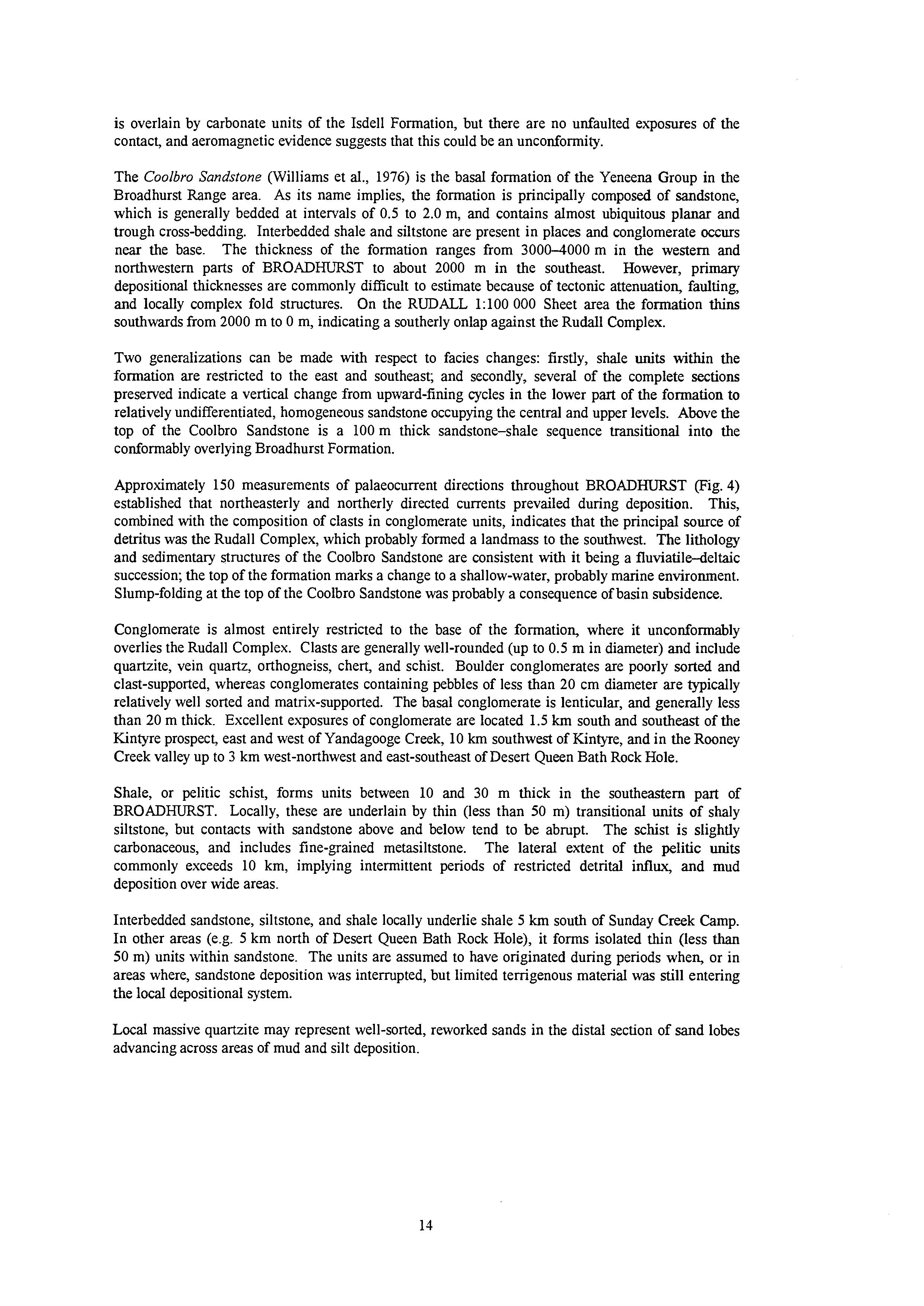
is overlain by carbonate units of the Isdell Formation, but there are no unfaulted exposures of the contact, and aeromagnetic evidence suggests that this could be an unconformity.
The Coolbro Sandstone (Williams et al., 1976) is the basal formation of the Yeneena Group in the Broadhurst Range area. As its name implies, the formation is principally composed of sandstone, which is generally bedded at intervals of 0.5 to 2.0 m, and contains almost ubiquitous planar and trough cross-bedding. Interbedded shale and siltstone are present in places and conglomerate occurs near the base. The thickness of the formation ranges from 3000-4000 m in the western and northwestern parts of BROADHURST to about 2000 m in the southeast. However, primary depositional thicknesses are commonly difficult to estimate because of tectonic attenuation, faulting, and locally complex fold structures. On the RUDALL 1:lOO 000 Sheet area the formation thins southwards from 2000 m to 0 m, indicating a southerly onlap against the Rudall Complex.
Two generalizations can be made with respect to facies changes: firstly, shale units within the formation are restricted to the east and southeast; and secondly, several of the complete sections preserved indicate a vertical change from upward-fining cycles in the lower part of the formation to relatively undifferentiated, homogeneous sandstone occupying the central and upper levels. Above the top of the Coolbro Sandstone is a 100 m thick sandstone-shale sequence transitional into the conformably overlying Broadhurst Formation.
Approximately 150 measurements of palaeocurrent directions throughout BROADHURST (Fig. 4) established that northeasterly and northerly directed currents prevailed during deposition. This, combined with the composition of clasts in conglomerate units, indicates that the principal source of detritus was the Rudall Complex, which probably formed a landmass to the southwest. The lithology and sedimentary structures of the Coolbro Sandstone are consistent with it being a fluviatile-deltaic succession; the top of the formation marks a change to a shallow-water, probably marine environment. Slump-folding at the top of the Coolbro Sandstone was probably a consequence of basin subsidence.
Conglomerate is almost entirely restricted to the base of the formation, where it unconformably overlies the Rudall Complex. Clasts are generally well-rounded (up to 0.5 m in diameter) and include quartzite, vein quartz, orthogneiss, chert, and schist. Boulder conglomerates are poorly sorted and clast-supported, whereas conglomerates containing pebbles of less than 20 cm diameter are typically relatively well sorted and matrix-supported. The basal conglomerate is lenticular, and generally less than 20 m thick. Excellent exposures of conglomerate are located 1.5 km south and southeast of the Kintyre prospect, east and west of Yandagooge Creek, 10 km southwest of Kintyre, and in the Rooney Creek valley up to 3 km west-northwest and east-southeast of Desert Queen Bath Rock Hole.
Shale, or pelitic schist, forms units between 10 and 30 m thick in the southeastern part of BROADHURST. Locally, these are underlain by thin (less than 50 m) transitional units of shaly siltstone, but contacts with sandstone above and below tend to be abrupt. The schist is slightly carbonaceous, and includes fine-grained metasiltstone. The lateral extent of the pelitic units commonly exceeds 10 km, implying intermittent periods of restricted detrital influx, and mud deposition over wide areas.
Interbedded sandstone, siltstone, and shale locally underlie shale 5 km south of Sunday Creek Camp. In other areas (e.g. 5 km north of Desert Queen Bath Rock Hole), it forms isolated thin (less than 50 m) units within sandstone. The units are assumed to have originated during periods when, or in areas where, sandstone deposition was interrupted, but limited temgenous material was still entering the local depositional system.
Local massive quartzite may represent well-sorted, reworked sands in the distal section of sand lobes advancing across areas of mud and silt deposition.
ISDELL FORMATION
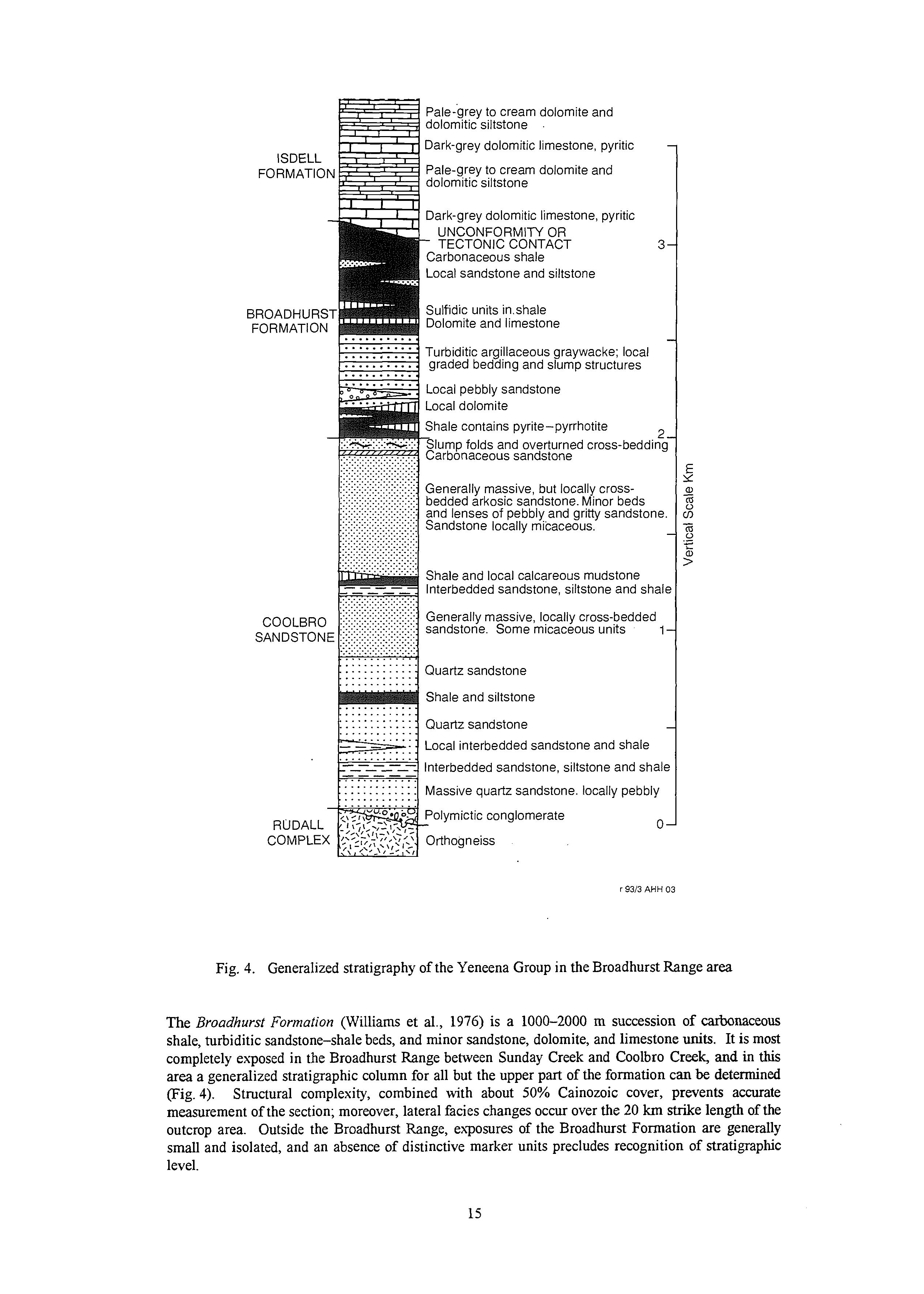
BROADHURST
Pale-grey to cream dolomite and dolomitic siltstone
Dark-grey dolomitic limestone, pyritic
Pale-grey to cream dolomite and dolomitic siltstone
Dark-grey dolomitic limestone, pyritic UNCONFORMITY OR - TECTONIC CONTACT 3
Carbonaceous shale
Local sandstone and siltstone
Sulfidic units inshale Dolomite and limestone
Turbiditic argillaceous graywacke; local graded bedding and slump structures
Local pebbly sandstone
Local dolomite
Shale contains pyrite-pyrrhotite
2
Slump folds and overturned cross-beddin!
Carbonaceous sandstone -
Generally massive, but locally crossbedded arkosic sandstone. Minor beds and lenses of pebbly and gritty sandstone Sandstone locally micaceous.
Shale and local calcareous mudstone lnterbedded sandstone. siltstone and shal
Generally massive, locally cross-bedded sandstone. Some micaceous units 1 1 : : : : 4 Quartz sandstone
Shale and siltstone
Local interbedded sandstone and shale siltstone and shal
Massive quartz sandstone. locally pebbly RUDALL ~~olymictic ?;!:,?.;>I-, - conglomerate COMPLEX /b~~;$~~,,’~~~Orthogneiss 0
Fig. 4. Generalized stratigraphy of the Yeneena Group in the Broadhurst Range area
The Broadhurst Formation (Williams et al., 1976) is a 1000-2000 m succession of carbonaceous shale, turbiditic sandstone-shale beds, and minor sandstone, dolomite, and limestone units. It is most completely exposed in the Broadhurst Range behveen Sunday Creek and Coolbro Creek, and in this area a generalized stratigraphic column for all but the upper part of the formation can be determined (Fig. 4). Structural complexity, combined with about 50% Cainozoic cover, prevents accurate measurement of the section; moreover, lateral facies changes occur over the 20 km strike length of the outcrop area. Outside the Broadhurst Range, exposures of the Broadhurst Formation are generally small and isolated, and an absence of distinctive marker units precludes recognition of stratigraphic level.
The Broadhurst Formation contains stratifom-stratabound Pb-Zn, Cu, and U-Cu mineralization. Exploration is still at a relatively early stage in most areas, but at N@, Western Mining Corporation (WMC) have demonstrated an economic deposit of supergene copper mineralization. The regional mineral potential of the Broadhurst Formation is considered to be very high.
Shale, or pelitic schist, is the dominant rock type in the central and upper levels of the Broadhurst Formation, but also occurs intercalated with sandstone within the basal transition succession from the conformably underlying Coolbro Sandstone. The shale is dark grey, carbonaceous, contains thin siltstone units and includes sulfidic zones up to 10 m in thickness. Pyrrhotite and pyrite constitute about 10% of carbonaceous shale near the base of the Broadhurst Formation, the high pyrrhotite content of this unit gives a distinctive aeromagnetic signature.
Graded sandstone-shale beds and interbedded sandstone and shale occurs at levels between about 200 m and 500 m above the base of the formation. The dominant rock type is lithic and argillaceous sandstone (greywacke), bedded at intervals of 0.3 to 1.0 m, and containing welldeveloped slaty cleavage. Individual beds have pelitic upper layers, but grading is only poorly developed in most exposures. Shale units are intercalated with graded units in some areas, and appear to become more prominent towards the southeast. The greywacke is considered to have been deposited from turbidity currents, possibly produced by basin subsidence.
Sandstone, intercalated with minor shale occurs low in the Broadhurst Formation, principally between Coolbro Creek and the Cottesloe prospect (22'17'S, 122'13'E). The sandstone is similar to that of the Coolbro Sandstone, but is separated from that formation by 50-100 m of shale and carbonate rock.
Shale interbedded within limestone and dolomite occupies the central and upper parts of the Broadhurst Formation.
Carbonate rock, locally containing minor shale occurs at all levels of the Broadhurst Formation, but the units are generally less than 100 m thick. The carbonate is grey, carbonaceous and sulfidic, includes both limestone and dolomite (established by chemical analysis), and is generally bedded at intervals of 1-30 cm. Surface exposures reveal sulfide-rich zones (oxidized) carrying disseminated pyrite and elongate nodules of massive pyrite up to 0.5 m thick. Chemical analysis of the sullidic carbonates have revealed low Cu, Pb, and Zn contents.
Basalt occurs at one locality 12 km west of Mount Isdell. The rock contains acicular pyroxene, indicative of quenching, but a volcanic (as opposed to intrusive) origin has not been established.
The Isdell Formation (Williams et al., 1976) is composed of carbonate rocks intercalated with relatively thin units of calcareous siltstone and shale. Exposures permit examination of stratigraphic sections over vertical intervals of up to 500 m, but Cainozoic and Permian cover prevent measurement of a complete column. The total thickness of the Isdell Formation exceeds 1000 m and, as noted by Williams (1990), it appears to be the most widespread formation of the Yeneena Group in the Paterson Orogen.
Aeromagnetic evidence (unpublished) indicates that the Isdell Formation underlies the northeastern 20% of the BROADHURST 1:lOO 000 Sheet area, but exposure is limited to the area around Mount Isdell. Stratigraphic contacts between the Isdell Formation and the underlying Broadhurst Formation have not been recognized in this area. The aeromagnetic evidence indicates a low-angle discontinuity along sections of the northwesterly trending contact, but it is unknown if this represents an unconformity or merely local tectonic contacts.
Dark-grey carbonate containing minor shale is well exposed.to the south of Mount Isdell, and at another locality 5 km east of Moses Chair. The rock is chiefly dolomitic limestone and dolomite, carbonaceous and locally sulfidic. Clastic texTures are common, and both graded bedding and finescale cross-bedding are locally preserved.
Pale-grey and cream carbonate intercalated with calcareous siltstone and shale are well exposed in the vicinity of Mount Isdell.
Mafk and ultramafic intrusive rocks form sills and small stocks in the Yeneena Group in the northern part of the Broadhurst Range area. Such rocks are poorly exposed and their origins and ages remain uncertain. Williams (1990) records that some dolerite sills of the Yeneena Group have returned Rb-Sr ages of between 700 and 750 Ma.
Gabbro and dolerite are the most common types of intrusive rock and are restricted mainly to the area south of Mount Isdell, and between Mount Isdell and Moses Chair. Except at a locality 5 km east of Moses Chair, where drilling has revealed a lenticular stock-like intrusion of gabbro and pyroxenite, the intrusions are sills and are generally about 50 to 100 m thick.
Variably silicified ultramafic rock outcrops immediately to the southwest of the lenticular gabbro described above, and structurally underlies that unit. The rock is ex-emely altered at the surface, but talc, antigorite and patchy opaline silica cap rock confirm its ultramafic nature.
Western succession
The stratigraphy of the Western succession is currently being reviewed in light of evidence from recent mapping. The excursion map reference panel shows the general succession, which is principally of shallowwater origin. Correlations with the Broadhurst Range succession are difficult due to faulted contacts and poor exposure, but it is clear that the Broadhurst Formation was deposited in deeper water than were units of the Western succession.
Te(fer succession
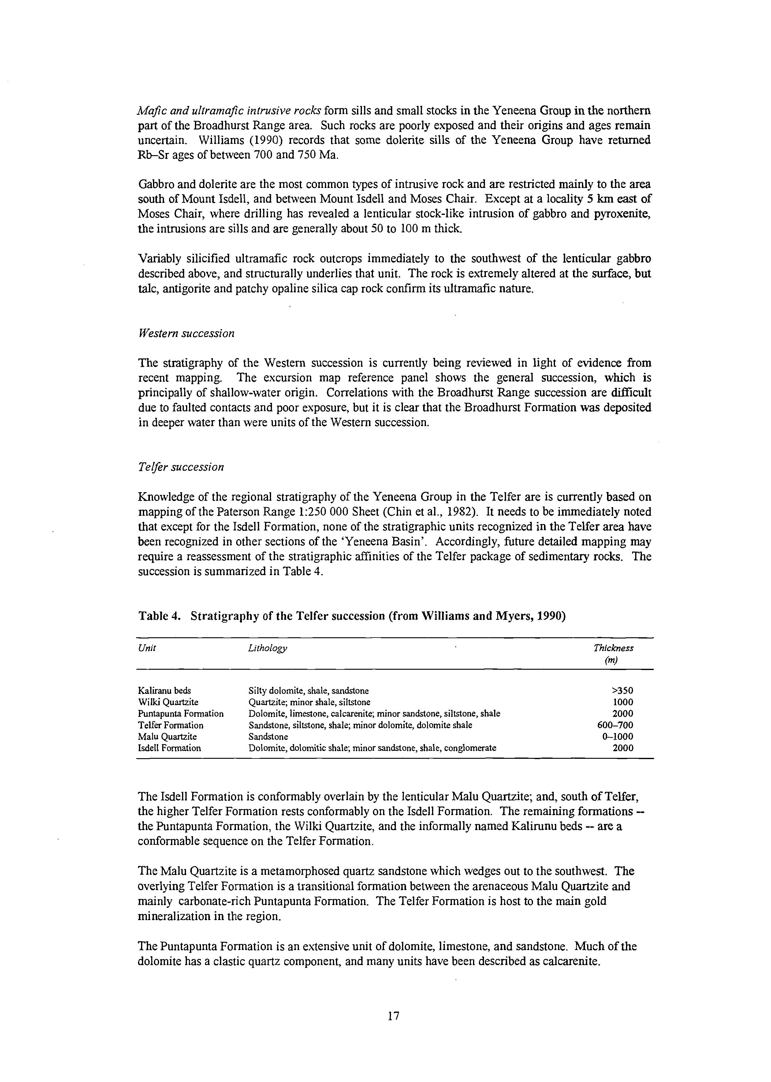
Knowledge of the regional stratigraphy of the Yeneena Group in the Telfer are is currently based on mapping of the Paterson Range 1:250 000 Sheet (Chin et al., 1982). It needs to be immediately noted that except for the Isdell Formation, none of the stratigraphic units recognized in the Telfer area have been recognized in other sections of the ‘Yeneena Basin’. Accordingly, future detailed mapping may require a reassessment of the stratigraphic affinities of the Telfer package of sedimentary rocks. The succession is summarized in Table 4.
Table 4. Stratigraphy of the Telfer succession (from Williams and Myers, 1990)
Unit
Kaluanu beds
Wilki Quartzite
Puntapunta Formation
Telfer Formation
Malu Quartzite
Isdell Formation
Lithology Thickness
Silty dolomite, shale, sandstone
Quartzite; minor shale, siltstone
Dolomite, limestone, calcarenite; minor sandstone, siltstone, shale
Sandstone, siltstone, shale; minor dolomite, dolomite shale
Sandstone
Dolomite, dolomitic shale, minor sandstone, shale, conglomerate
The Isdell Formation is conformably overlain by the lenticular Malu Quartzite; and, south of Telfer, the higher Telfer Formation rests conformably on the Isdell Formation. The remaining formationsthe Puntapunta Formation, the Wilki Quartzite, and the informally named Kalirunu beds -- are a conformable sequence on the Telfer Formation.
The Malu Quartzite is a metamorphosed quartz sandstone which wedges out to the southwest. The overlying Telfer Formation is a transitional formation between the arenaceous Malu Quartzite and mainly carbonate-rich Puntapunta Formation. The Telfer Formation is host to the main gold mineralization in the region.
The Puntapunta Formation is an extensive unit of dolomite, limestone, and sandstone. Much of the dolomite has a elastic quartz component, and many units have been described as calcarenite.
Interbedded shale and sandstone at the top of the formation mark the transition to the conformably overlying Wilki Quartzite.
The Wilki Quartzite is a 1 000 m thick, medium- grained quartzite similar to the Malu Quartzite. The unit is widespread north of Telfer. It is overlain by the informally named Kaliranu beds of poorly outcropping silty dolomite, shale, and sandstone.
Both granitoid and mafic intrusions occur in the Telfer area. Regional metamorphism is generally very low grade and is associated tvith a weak, penetrative foliation. The metamorphic grade and deformation intensity increase to the northeast. Recrystallization of quartz and calcite together with the growth of sericite are the main features. A static contact metamorphism, associated with intrusive granitoid rocks, overprints the regional low-grade metamorphism. This reached pyroxene- hornfels facies in some areas; and skarns, marble, and calc-silicate rocks, occur in carbonate-rich formations adjacent to the granitoid rocks.
The Yeneena Group of the Telfer area is interpreted as a marine sequence that was deposited in a slowly subsiding basin. The deepest part of the basin is thought to underlie the region north of Telfer, where the stratigraphically highest formations are preserved. However, the type of basement underlying the Isdell Formation is unknown. The tectonic history of the area was terminated by the emplacement of granitoid rocks, of which the Mount Crofton Granite is representative.
STRUCTURE
The Rudall Complex is the product of many depositional, intrusive, tectonic and metamorphic events, apparently operating over a period of more than 1000 million years and including at least two orogenies. Mapping conveys something of the resulting geological complexity, but the true level of complexity is best appreciated at outcrop-scale where isoclinally folded, compositionally layered paragneiss has commonly been ‘sheeted’ by granitoid phases, sheared and refolded. At outcrop-scale, orthogneiss-paragneiss contacts are almost invariably parallel to compositional banding in the metasedimentary rocks, and it is generally impossible to determine the relative importance of tectonic interleaving and sill-form granitoid intrusion.
Angular xenoliths of paragneiss and othogneiss are visible in some outcrops of orthogneiss, but elsewhere lenticular paragneiss inclusions are clearly boundins or detached fold cores. At 1:25 000 and larger scales, intrusive contacts are indicated by discordant orthogneiss-paragneiss contacts without any evidence of oblique faulting. Most of the granitoid protoliths appear to have been emplaced as broadly concordant sheets, locally up to 3 km thick. These major intrusions have caused fragmentation of the stratigraphic succession, and in the process have limited the use of stratigraphic marker units for regional structural interpretation.
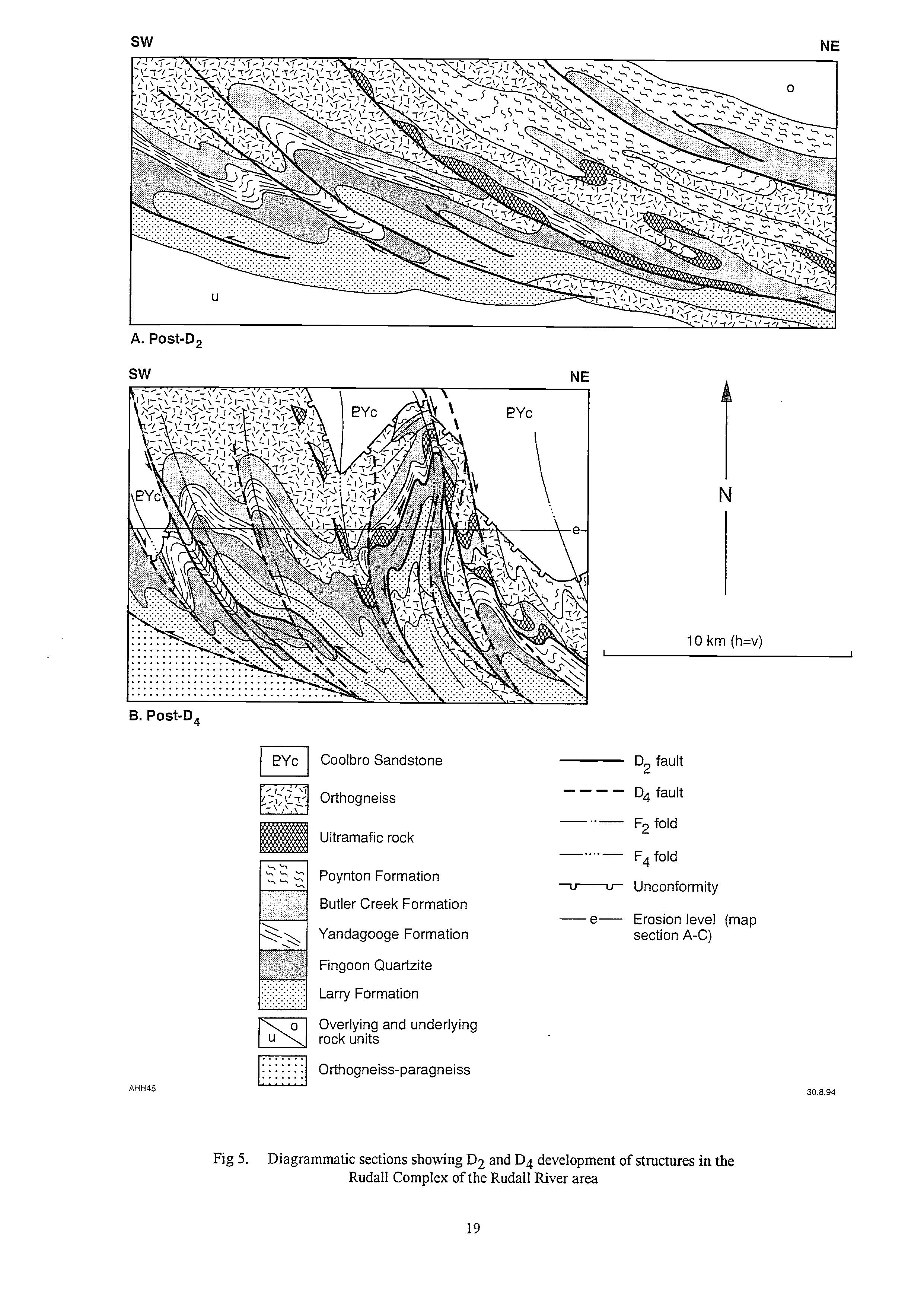
An important conclusion from the mapping, and subsequent structural analysis, is that prior to the Paterson Orogeny the Rudall Complex was composed of nappes and thrust sheets, inclined and stacked towards the northeast (Fig. 5).
Table 5 outlines the recognized episodes of deformation and metamorphism in the area. It should be noted, however, that D2 deformation was not a single event, but probably involved spasmodic thrusting and folding over c. 100-200 million years. The complexity of D2 is illustrated by the presence of distinct tectonostratigraphic domains on RUDALL (Fig. 3). These domains are thrustbounded slices of interfolded paragneiss and orthogneiss, which together form a 40 km-wide imbricate zone. Stacking and contact relationships indicate that northeastern domains have over-ridden older domains to the southwest.
As described under ‘Tectonic evolution’, this deformation was related to plate collision, and involved progressive stacking of thrust slices. It is clear that F2 and S2 structures would have formed at different times in the different tectonostratigraphic domains, and thrusting directions varied with time.
A. Post-D, sw
B. Post-D,
Coolbro Sandstone
Orthogneiss
Ultramafic rock
Poynton Formation
Butler Creek Formation
Yandagooge Formation
Fingoon Quartzite
Larry Formation
Overlying and underlying rock units
Orthogneiss-paragneiss
Metasedimentary rocks and the older varieties of orthogneiss (mainly PRgx) were deformed by the earliest recognized deformation, D1, sometime after crystallization of the orthogneiss (on present geochronological evidence spanning a period between 2015 and 1765 Ma). All major rock units of the complex were affected by deformation assigned to D2. This produced pervasive micaceous schistosities (grouped under S2) parallel to the axial planes of F2 folds. S2 is extremely well developed in K-feldspar augen orthogneiss @Rga), but S1 has not been recognized in this unit. D1 and D2 structures are truncated by the unconformity at the base of the Yeneena Group, and were deformed by post-Yeneena Group folds (mainly F4). Consequently the present orientations of D1 and D2 structures are commonly very different from their original orientations, and cannot be used as criteria for structural classification.
Table 5. Summary of deformation episodes
Episode
D1: Regional layer-parallel shear, direction unknown
D2: SW- and W- directed thrusting and overfold-ing
D3: Local W- or NWdirected isoclinalrecumbent folding
D4:Regional deformation in raponse to SW-directed compression
Dg: Local deformation; ?NEdirected stress release after D4
Dg: Brittle deformation in response to NNE-SSW compression
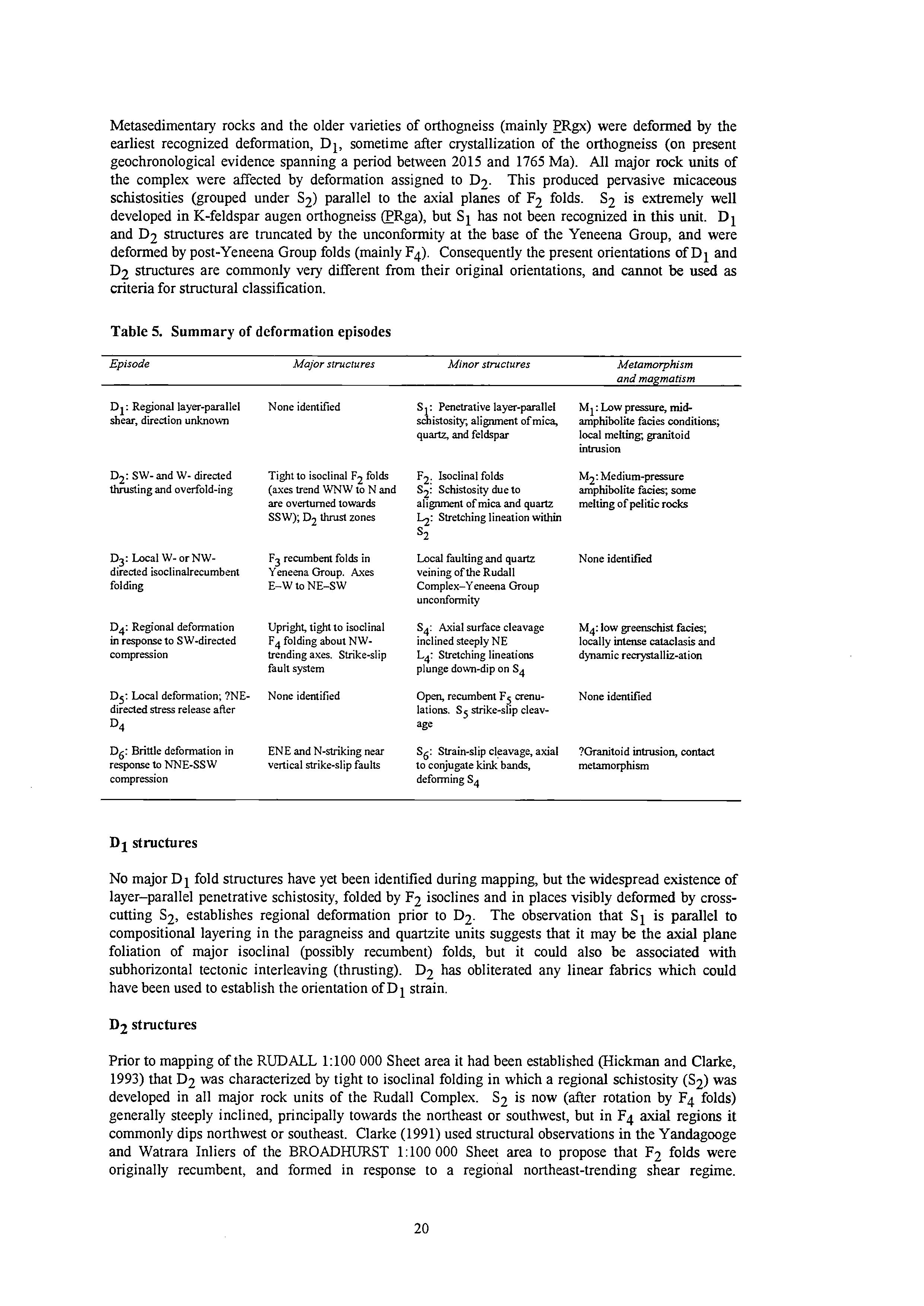
None identified
Tight to isoclinal F2 folds (axes trend WNW to N and are overturned towards SSW); D2 thrusl zones
F3 recumbent folds in Yeneena Group. Axes E-W to NE-SW
Uprighs tight to isoclinal F4 folding about NWtrending axes. Strikeslip fault system
None identified
ENE and N-striking near vertical strike-slip faulfs
S1: Penetrative layer-parallel schistosity, alignment of mica, quartz, and feldspar
F2: Isoclinal folds
S2: Schistosity due to alignment of mica and quartz h: Stretching lineation within
Local faulting and quartz veining of the Rudall Complex-Yeneena Group unconformity
S4: Axial surface cleavage inclined steeply NE L4: Stretching lineations plunge down-dip on S4
Open, recumbent FS crenulations. S5 strike-slip cleavage
s6: Sfrain-slip cleavage, axial to conjugate kink bands, deforming S4
M :'pw pressure, midamphrbolite facies conditions; local melting, granitoid intrusion
M2: Medium-pressure amphibolite facie; some melting of pelitic rocks
None identified
M4: low greenschist facies; locally intense cataclasis and dynamic renystalliz-ation
None identified
?Granitoid intrusion, contact metamorphism
D1 structures
No major D1 fold structures have yet been identified during mapping, but the widespread existence of layer-parallel penetrative schistosity, folded by F2 isoclines and in places visibly deformed by crosscutting S2, establishes regional deformation prior to D2. The observation that S1 is parallel to compositional layering in the paragneiss and quartzite units suggests that it may be the axial plane foliation of major isoclinal @ossibly recumbent) folds, but it could also be associated with subhorizontal tectonic interleaving (thrusting). D2 has obliterated any linear fabrics which could have been used to establish the orientation of D1 strain.
D2 structures
Prior to mapping of the RUDALL 1:lOO 000 Sheet area it had been established (Hickman and Clarke, 1993) that D2 was characterized by tight to isoclinal folding in which a regional schistosity (S2) was developed in all major rock units of the Rudall Complex. S2 is now (after rotation by F4 folds) generally steeply inclined, principally towards the northeast or southwest, but in F4 axial regions it commonly dips northwest or southeast. Clarke (1991) used structural observations in the Yandagooge and Watrara Inliers of the BROADHURST 1:lOO 000 Sheet area to propose that F2 folds were originally recumbent, and formed in response to a regional northeast-trending shear regime.
However, this interpretation made no allowance for re-orientation of D2 structures during D4, an event which Clarke (1991) considered to have had negligible effect on the Rudall Complex.
As noted above, D2 was not a single, short-term event affecting all parts of the Rudall Complex at precisely the same time. This is established by D2 thrust stacking (see 'Tectonic evolution'), with structures in the northeast and east apparently over-riding earlier structures to the southwest. In the absence of precise geochronology, it is possible that structures now assigned to D2 could span a time interval of several hundred million years. Rb-Sr isotopic data (Chin and de Laeter, 1981) suggest metamorphic events at about 1500 Ma and 1300 Ma. Because it is currently impossible to distinguish separate post-DI, pre-Yeneena Group structures in the Rudall Complex, all such structures are assigned to D2.
To remove D4 tilting from S2, and thus determine the attitude of S2 immediately prior to deposition of the Yeneena Group, Hickman and Bagas (in press) paired S2 observations within 1 km of the Rudall Complex-Yeneena Group unconformity with observations of bedding in the immediately overlying Coolbro Sandstone (significantly deformed by only D4). Over a strike length of 50 km in the Poynton and Rooney domains stereographic unfolding of 79 S2 observations firmly established that before D4 the local strike of S2 was west-northwest, and its dip was dominantly between 20° and 40' towards the north-northeast. Given that minor F2 folds are tight to isoclinal, and that S2 is the axial plane foliation of these structures, it was concluded that in the northeastern part of the RUDALL 1: 100 000 Sheet area the axes of any major F2 folds must have trended west-northwest, and the folds were overturned towards the south-southwest. The plunge of mesoscopic F2 folds in northeastern RUDALL is now generally moderate to steep towards the west-northwest. In this region F4 folds plunge northwest at about 15 to 45", implying that prior to F4 the west-northwesterly plunge of F2 folds was low.
D2 shear zones would have been incompetent units subject to reactivation during D4. Consequently, the recognition of D2 shear zones within D4 lags and thrusts depends on criteria such as extreme attenuation inconsistent with adjacent F4 folds, associated minor F2 folds and faults, or sheared preD4 intrusions of microgranite, aplite, or pegmatite. The D2 shear zone along the northern boundary of the Fingoon Domain was refolded by the Dunn-May Antiform. To the northwest of the Fingoon Range, the shear zone coincides with a D4 fault near the Tom Tit prospect, but 8 km northwest where this structure crosses the Rudall River (AMG 145065) lenses of sheared quartzite are preserved. Farther west, the D2 shear zone appears to be displaced dextrally, and is again exposed in Gap Creek (AMG 150040) where it is intruded by sheets of aplite.
Post-Yeneena Group deformation
In the Broadhurst Range area Hickman and Clarke (1993) recognised four phases of post-Yeneena Group deformation, D3-Dg. Dq is the dominant event responsible for the major northwest-trending folds visible on maps and aerial photographs. D6 may have been the last event of the Paterson Orogeny, possibly contemporaneous with intrusion of the .Mount Crofton Granite at 620 Ma. However, the lack of precise geochronological data on both D4 and D6 does not preclude D6 being a much younger and entirely separate event, unrelated to the Paterson Orogeny.
D3 structures
D3 structures include recumbent folds, local S3 foliation almost parallel to bedding, and faulting and quartz veining of the Rudall Complex-Yeneena Group unconformity. In several areas this tectonised unconfomity is transgressed and offset by northwest-striking D4 faults, implying significant horizontal or subhorizontal movement prior to D4.
D4 structures
The most easily recognizable deformation event in both the Rudall Complex and Yeneena Group produced D4 structures trending about 300-320'. These structures represent the main phase of the Paterson Orogeny. The dominant tectonic structures of the Yeneena Group are major, upright to
overturned, tight to isoclinal, northwest- to west-northwest-trendingfolds, generally with intervening northwesterly striking faults and shear zones. Southwards from Mt Isdell most folds are overturned to the southwest, and contain a variably developed axial plane cleavage, S4 dipping steeply northeast. However, in the Telfer region the axial surfaces of F4 folds mainly dip steeply southwest. Individual faults ex3end laterally for tens of kilometres and exhibit both downdip and strike-slip movement. In terms of vertical movement, the southwestern limbs of the anticlines are associated with high-angle thrusts, and complimentary lag faults (normal) occur on their northeastern limbs. Reversals of plunge are displayed by both major and minor F4 folds, and both exhibit en echelon patterns. On a regional scale the faults intersect at acute angles and, overall, present an anastomosing system.
F4 fold geometry in the Rudall Complex is complicated by the fact that D4 was superimposed on a preexisting structural complex in which lithological layering and metamorphic foliations were inclined. The most obvious consequence of this superimposition is that minor F4 folds in the Rudall Complex commonly plunge far more steeply than F4 folds in the Yeneena Group. Plunge directions (northwest or southeast) are far less affected because F4 axial surfaces are steeply inclined. The variable plunge of F4 folds in the Rudall Complex, and the fact that, like F2 folds, F4 folds are tight to isoclinal, locally causes problems in distinguishing between minor F2 and F4 folds in the field. Minor F4 folds can best be distinguished where they deform S2.
A regional reversal of plunge of F4 folds occurs across a northeast-trending zone in the centre of the Rudall 1:lOO 000 Sheet area. This culmination is unlike local F4 culminations in the Yeneena Group in that it is not restricted to an individual fold but equally affects all F4 folds in the area. Lateral displacement of the northeast-trending zone along D4 faults, implies that it is a pre-Dq antiform. Thus, it could be related to D3 northwesterly directed movements.
D5 structures
Dg structrues appear to be restricted to open, near-recumbent folds which deform S4. In the Sunday Creek area of the Broadhurst Range their axial surfaced dip at low angles towards the southwest, implying northeasterly directed movement. The regional significance of these folds is currently unclear.
Dg structures
D6 structures consist of northerly to northwesterly striking dextral faults, east-northeasterly striking sinistral faults, and associated strain-slip cleavage, s6. Along the contact between the Western succession and the Broadhurst Range succession intense F6 folding, with associated northwesterly to west-northwesterly striking dextral D6 faults and cleavage, s6, are developed in the Broadhurst and Choorun formations. This D6 fold belt appears to be related to dextral strike-slip movement adjacent to the eastern margin of the Pilbara Craton, and was probably associated with reactivation of Yeneena Basin growth faults and D4 faults.
METAMORPHISM
The metamorphic history of the Paterson Orogen is related to its deformation (Table 5). As noted under ‘Structure’, the dominant structural and metamorphic features of the area were produced by D4 (Paterson Orogeny) with the result that earlier structures and metamorphic mineral assemblages are over-printed and incompletely preserved. Even so, there is abundant evidence that the Rudall Complex was metamorphosed to the amphibolite facies prior to deposition of the Yeneena Group, and that this metamorphism was principally related to D2. M1 @I) mineral assemblages are extremely poorly preserved. Greenschist metamorphism, associated with the Paterson Orogeny, affected both the Rudall Complex and Yeneena Group, but it is also possible that some greenschist assemblages in the Rudall Complex represent late M2 retrogression.
Chin et al. (1980) recognized two metamorphic events prior to deposition of the Yeneena Group. The first event was associated with D1, and produced middle- to upper- amphibolite mineral assemblages,
with development of sillimanite, staurolite and kyanite. Chin et al. (1980) imply associated partial melting to produce granitoid magmas. The second event accompanied D2 and was considered to be lower grade, with prograde garnet, muscovite and biotite (and possibly andalusite) and retrograde sericite, chlorite, tremolite and epidote. Dynamic effects were said to characterize D2, with granulation of D 1 gneissic fabrics, alignment of platy minerals, and development of feldspar augen. Post-Yeneena Group metamorphism was low grade, and dominated by dynamic effects associated with D4 @3 of Chin et al., 1980).
Clarke (1991) considered that, on the limited evidence preserved, M1 @I) was a low-pressure, midamphibolite facies event in the Yandagooge Inlier, with development of andalusite and staurolite, and probably accompanied by partial melting. Clarke (1991) stated that M2 @2) included prograde midampbibolite facies assemblages with kyanite, biotite, and staurolite, and garnet, biotite and staurolite (both assemblages including muscovite and quartz, and locally plagioclase). Retrogressive chlorite, sericite and fibrous sillimanite were considered to be syn- or post-D2. M2 conditions involved lower temperatures or higher pressures than MI.
Hickman and Clarke (1993) observed that M4 metamorphism, associated with D4, did not exceed greenschist facies on the BROADHURST 1:lOO 000 Sheet area. The principal effects were recrystallization of quartz, particularly in deformation zones, regrowth of calcite and dolomite along S4, and sericitic alteration.
Any study of the metamorphic history of the Rudall Complex will be complicated by factors such as structural complexity, polymetamorphism with retrogression of early medium-high grade mineral assemblages characteristic of the amphibolite facies, and the unit's predominantly quartzofeldspathic composition.
It is clear that the Rudall Complex was metamorphosed to the amphibolite facies preceding deposition of the Yeneena Group because all units of the Yeneena Group exhibit only greenschist facies effects. However, D4 deformation of the Rudall Complex resulted in structural juxtaposition of segments fiom different positions in the crust. Thus, any pre-Dq regional metamorphic zonation has been fragmented, and any present observations of regional metamorphic variations must take account of D4 movement, where this can be estimated.
As noted by Clarke (1991), it is difficult to identify M1 mineral assemblages because of M2 recrystallization. Retrograde metamorphism possibly late in D2, and also in D4, has also partially replaced M2 assemblages. Even so, M2 prograde metamorphic minerals are locally preserved, particularly in pelitic and semipelitic schists. Metamorphic grades attained by quartzite, psammitic gneiss and most orthogneiss units are generally difficult to establish in the absence of useful index minerals. Quartzite and orthogneiss typically contain only retrogressive mineral assemblages, but exceptions include prograde garnet in orthogneiss and some relict sillimanite in quartzite.
Most of the Rudall Complex has been subjected to prograde amphibolite facies metamorphism, with maximum grade possibly reaching the amphibolite-granulite transition. However, most present mineral assemblages were formed by greenschist facies retrogression, and relics of diagnostic medium- to high-grade prograde minerals are too infrequent for reconstruction of regional metamorphic patterns. Retrogression was probably post-peak M2 and syn-Mq.
TECTONIC EVOLUTION
Understanding the tectonic evolution of a geological terrane such as the Paterson Orogen not only serves to explain the relationships between its components, but is essential to permit an informed evaluation of its mineral potential.
The recent 1:100 000-scale mapping combined with previous regional observations and specialized studies in the orogen, has revealed geological features that show the Rudall Complex to be the product of plate convergence. Appropriate evolutionary models could be those provided by either the Himalayas (continental collision) or the Cordilleran belt of western North America (oceancontinent collision).
Limited geochronologicaldata on the oldest variety of orthogneiss @R@) indicate that at least part of the sedimentary succession of the Rudall Complex was deposited at about 2000-1800 Ma. In the following discussion it is assumed that this in the age of the sedimentary succession. However, it is the K-feldspar augen orthogneiss @Rga) which has widespread intrusive relations with the main succession. The crystallization age of this granitoid type has been determined (current SHRTMP zircon U-Pb studies) at 1765 +. 15 Ma, which is now taken as the minimum age of the main succession.
To the west of the Paterson Orogen the Capricorn Orogen contains 2000-1600 Ma metasediments lithologically similar to those of the Rudall Complex. The most recent tectonic interpretations of the Capricorn Orogen by Thome and Seymour (1991) and Tyler (1991) invoke a convergent platetectonic model involving B-subduction between the Pilbara and Yilgam Cratons. Tyler (1991, p. 80-83) makes a case for oblique collision of these geologically different Archaean cratons at about 2000-1600 Ma. In the Gascoyne Complex this collision was accompanied by extensive intrusion of granitoids at 1800-1500 Ma (Muhling, 1988). Sedimentary rocks in the northern part of the Capricorn Orogen were deposited on the southern margin of the Pilbara Craton in a foreland basin-active margin environment. Along the Capricorn Orogen’s southern margin, deposits of the Glengarry Sub-basin were derived from erosion of the Yilgarn Craton, probably in foreland, back-arc basin, and island arc environments (Tyler, 1991).
Although the limited geochronological data point to broadly contemporaneous evolution of the Rudall Complex and the Capricorn Orogen, there are clearly important geological differences between these tectonic units:
o Lack of imbricate interleaving of metasediments and granitoids over the greater part of the Capricorn Orogen.
e Higher metamorphic grade of the Rudall Complex compared to most of the Capricorn Orogen (excluding the Gascoyne Complex).
* The E-W trend of the Capricorn Orogen compared to the NW-SE trend of the Rudall Complex (and corresponding difference in directions of thrusting).
Accordingly, the relevance to the Rudall Complex of information derived from the Capricorn Orogen mainly relates to the identification of the tectonic processes which were operating in northwestern Australia at about 2000-1600 Ma.
Rudall Complex
The first recognizable stage in the evolution of the Rudall Complex involved the deposition of a c. 3000 m thick siliclastic succession, Larry Formation-Butler Creek Formation, prior to 1765 Ma. The succession indicates shoreline-shelf-slope environments in a subsiding foreland basin. The observations that the turbiditic Butler Creek Formation thickens eastwards, and that the relatively shallow-water sand deposits of the Fingoon Quartzite become thinner northeastwards, imply a continent to the west. Set against this is the local occurrence of much quartzofeldspathic sandstone in the Yandagooge Formation of northeastern RUDALL, indicating a source of feldspar-rich detritus to the northeast. Palaeocurrent evidence has been destroyed, and complex deformation on a regional scale creates difficulties when palaeogeographic reconstructions are attempted. Nevertheless, the observed features are consistent with shallow-water deposition in a foreland basin on the eastern margin of a continent. Northwest from RUDALL the Paterson Orogen is in contact with the Pilbara Craton, and this almost certainly underlies the area west from RUDALL. Thus, the ‘Rudall basin’ can be regarded as depositionally analogous to the Ashburton Basin, except that for the latter the Pilbara Craton lay to the north. In this interpretation, the felsic source region for parts of the Yandagooge Formation could have been either a volcanic arc or a fold-thrust belt lying to the northeast of RUDALL.
The lowest part of the Poynton Formation consists of well-sorted quartz sands and minor pebble beds, a shallow-shelf facies quite distinct from the underlying turbidites of the Butler Creek Formation.
This abrupt change is not associated with an angular unconformity, but a disconformity could be present. The Poynton Formation becomes thicker to the east, but its stratigraphic top is not preserved and thickness variations could result entirely from a combination of thrusting and granitoid intrusion. Altered fine-grained units at some localities may include metamorphosed felsic volcanics or felsic volcanogenic sediments. This indicates prior or contemporaneous felsic volcanism, but there are no volcanic remnants of a magmatic arc in the Rudall Complex. If such an arc existed it must have been situated to the east or northeast of RUDALL. A pre-1765 Ma age for the Poynton Formation is inferred from the observation that it is intruded by the protolith of the K-feldspar augen orthogneiss (1765 f 15 Ma, D. Nelson, 1993, pers. comm.).
The most striking geological feature of the Rudall Complex is the widespread intrusive and structural interleaving of metasediments and orthogneiss. Examination of the map reveals that, although detailed relationships are complex, two valid generalizations can be made:
1. The lithologically layered and xenolithic orthogneiss @Rgx) is almost entirely restricted to Clayton Domain on the western margin of the Rudall Complex.
2. The K-feldspar augen orthogneiss @Rga) is mainly confined to sheets within the Yandagooge Formation-Butler Creek Formation section of the stratigraphic column. Exceptions occur in the Larry Formation of the Dunn Antiform and Wartumkurru Domain, and where the K-feldspar orthogneiss is interlayered with PRgx.
This establishes that the lithologically layered orthogneiss occurs in the lowermost structural levels of the complex, immediately above the Southwestern Thrust, whereas the K-feldspar orthogneiss has been preferentially emplaced at a higher structural level, probably along thrusts or shear zones. If the imbricate zone of the Rudall Complex is viewed as a foreland thrust belt, it is probable that the most westerly thrust slices involving the layered orthogneiss are parautochthonous. The sheets of Kfeldspar orthogneiss could range from autochthonous to allochthonous, depending on the dominant mode of emplacement.
The origin of the granitoids in the Rudall Complex is a subject requiring specialized geochemical investigation. As yet there have been no such studies and evidence is restricted to that from field observations. There is currently no evidence that any of the granitic orthogneisses represent upthrusted Archaean or Palaeoproterozoic basement. Therefore, all are assumed to bear an intrusive relationship to the sedimentary succession, and most are probably genetically related to the orogenic belt. The Rudall Complex exhibits features expected of a plate-tectonic regime, and its granitoids could currently be interpreted in terms of either magmatic arc or fold-thrust belt environments. This is similar to in other Proterozoic orogenic belts of Western Australia, but appears to differ form intracontinental environments of central Australia (Wyborn, 1988; Foden et al., 1988).
The western zone of lithologically layered orthogneiss @Rgx) with numerous enclaves of paragneiss, paraschist and mafk-ultramafk rocks is intruded by the relatively homogenous K-feldspar augen orthogneiss. The layered orthogneiss contains both S1 and S2, but only S2 has been recognized in the K-feldspar orthogneiss. Providing this is not merely a consequence of the general homogeneity of the latter (making s1-S~ distinction difficult) the inference must be that the D1 event (sub-horizontal thrusting) occurred prior to crystallization of the K-feldspar orthogneiss protoliths (mainly biotite monzogranite and biotite granite). Thus, D1 could have led to partial melting, and the intrusion of sheets of the K-feldspar granitoids into the layered orthogneiss and the metasedimentary succession.
The stratigraphic succession of the Rudall Complex on RUDALL contains no mafk volcanic rocks, but sheared serpentinized peridotite, associated with pelitic schist and turbiditic metasediments, occurs in three west-northwest- trending zones. The best developed of these zones extends 50 km from southeast of Rudall Crossing to northeast of May Creek. It coincides with a major tectonic break along the southwestern boundary of the Poynton Domain. Scattered mafic amphibolite lenses represent metamorphosed dolerite and gabbro. Lithologically the assemblage is similar to compressed and attenuated ophiolitic units in many of the world's orogenic belts, for example the Cordilleran belt of western North America and the Himalayas (Windley, 1983). From a detailed study of the ultramafc units Carr, (1989) concluded that they represent slices of Proterozoic oceanic crust.
The deformation and metamorphism assigned to D2-M2 indicate major collisional forces, probably, on the very limited isotopic data, sometime between 1750 and 1500 Ma. Overfolding and thrusting from the northeast and east (see Structure) were produced by an advancing plate (no remnants of this have yet been identified, but may be concealed beneath the Canning Basin). The extent of deformation suggests either continent-continent collision mmalayan-style), or continent-ocean collision in which the ocean contained non-subductable accretionary terranes (Cordilleran-style). In the Sylvania Dome area, 250 km west-southwest from Paterson Orogen, Tyler (1991) described a 2000-1600 Ma event of continent-continent collision producing north-northeast-directed thrusting against the southern margin of the Pilbara Craton. Therefore it appears that the Palaeoproterozoic successions on the eastern and southern margins of the Pilbara Craton were sandwiched between two obliquely converging plates.
There is substantial isotopic evidence for an important event of metamorphism and felsic magmatism at 1250-1100 Ma. As mentioned below (‘Geochronology’),felsic intrusions have been dated at 1247 f 5 Ma (crystallization age), 1132 f 21 Ma (?metamorphic age) and c. 1080 Ma. On the southeastern margin of the Pilbara Craton sheared Archaean granitoids at Lookout Rocks provided Rb-Sr biotite ages of 1226 Ma and 1194 Ma (de Laeter et al., 1977). This biotite forms part of a metamorphic foliation which is unconformably overlain by the Yeneena Group (Hickman 1975, de Laeter et al., 1977). Williams (1992, p. 81) records tight, overturned, northwesterly trending folds in the c. 1300 Ma Manganese Subgroup immediately southwest from the Paterson Orogen and has observed that these structures pre-date the unconformably overlying Yeneena Group. The axial planes of the folds dip northeastwards, indicating that the c. 1250 Ma event, like D2, involved movement towards the southwest. Clarke (1991) referred to the c. 1250 Ma episode as the ‘Watrara Orogeny’, but correlated it with D2. This is no longer accepted because S2 (foliation produced by D2 ) is cut by the felsic intrusions interpreted to belong to the c. 1250 Ma episode, and because Rb-Sr isotopic data suggest that M2 probably occurred at about 1500 Ma. Use of the name ‘Watrara Orogeny’ is therefore deferred to avoid confusion between D2 and the c. 1250 Ma episode.
The cause of the c. 1250Ma magmatic and metamorphic event may have been raised isotherms associated with uplift and rapid erosion as the Pilbara and eastern plates moved closer together. Further thrusting probably occurred, but this would now be difficult to distinguish from earlier parallel thrusting @2).
Yeneena Group
In comparison to the geology of the Rudall Complex, that of the unconformably overlying Yeneena Group is relatively simple. Structural modification is mainly confined to upright folding, and associated high-angle faults generally involve displacements of no more than 2-3 km. Metamorphic grade is low, and the succession is not fragmented by ubiquitous granitoid sheets. Granitoidpegmatite intrusion is confined to the northern part of the Paterson Orogen around Telfer where the post-orogenic Mount Crofton suite of granitoids (620 Ma) forms a series of circular to ovoid plutons.
Despite these differences, the Yeneena Group does have two important features in common with the Rudall Complex.
e The overall lithological succession is that of a continental margin. For the Yeneena Group the interpretation that a continental landmass lay to the southwest is supported by abundant palaeocurrent data, and by lateral facies changes.
e Deformation 04) included NE-SW compression, upright folding and thrusting from the northeast, and total crustal shortening of many kilometres.
These similarities suggest that the evolution of the Yeneena Basin might represent later stages in progressive stages of the NE-SW convergence. Information obtained from the 1:lOO 000 mapping program supports this, and explains differences between the Yeneena Group and the Rudall Complex. The interpretation reached by Hickman and Bagas (in press) is that plate convergence was significantly retarded after the major collision of D2 (in much the Same way as collision reduced convergence of the Indian and Eurasian plates during evolution of the Himalayan orogenic belt -
Windley, 1984). Plate collision impeded further subduction with the result that continued crustal shortening was mainly accommodated by strike-slip faulting. The Yeneena Basin developed as a strike-slip basin or, more probably, as a series of such basins.
There is no evidence concerning the northern or eastern margins of the Yeneena Basin. The observation that the basal succession of the group on southern CONNAUGHTON (Bagas and Smithies, in prep.) is very similar to that in the northeastern part of the Balfour Downs 1:2501000 Sheet area (Williams, 1989) suggests that a NW-SE trending continental margin lay to the southwest of RUDALL, and to the west of the Telfer-N@ region. Palaeocurrent data from the Coolbro Sandstone, Gunanya Sandstone and Choorun Formation support transport of clastic material from the southwest.
The extent and orientation of the Paterson Orogen demonstrate continental-scale convergence varying from NE-SW in the east Pilbara to N-S in central Australia. In view of the fact that orogenic belts are typically oriented parallel to the sedimentary basins that they deform it is probable that the Yeneena Basin was elongate NW-SE.
On sedimentological grounds the sandstone-shale-carbonate succession of the Yeneena Group could be either a continental-margin succession or part of an intracontinental basin. From the evidence already discussed it is clear that the source of clastic detritus lay to the southwest and west, and that the overall deepening of the basin was to the northeast. The succession commences with basal conglomerate in most areas, and this commonly fills channels cut into the underlying basement. This is true not only along the present western and southwestern boundaries of the Yeneena Basin, but also in the Broadhurst Range, at least 50 km into the basin. Basal conglomerate is always thin (generally less than 10 m), and conglomerate is absent from the overlying fluviodeltaic clastics of the Coolbro Sandstone. Deposition of the Broadhurst Range succession commenced in a continental environment of stream channels and alluvial fans, and progressed, probably due to subsidence, to a more pelagic environment.
Stratigraphic and lithological features of the Coolbro Sandstone and Broadhurst Formation, regional palaeocurrent data, and structural criteria provide some important constraints on the early stages of basin development.
The Coolbro Sandstone is absent from the Western succession, but reaches a thickness of at least 4000 m only 5-10 km into the adjacent Broadhurst Range area. The boundary between these two ‘zones’ of the Yeneena Group approximately coincides with the Southwestern Thrust in the south, and with the Vines Fault in the northwest. A common feature of ensialic sedimentary basins is that normal growth faults (actively controlling deposition) can subsequently be reactivated with reverse movement during the tectonism responsible for basin closure (Mitchell and Reading, 1986). Thus, during the Coolbro Sandstone stage of Yeneena Group deposition the southwestern margin of the basin may have been abrupt and faultcontrolled.
From its maximum development in the Broadhurst Range the Cooibro Sandstone thins to 1500-2000 m south of the Rudall River and in the Mt Sears Range and Throssell Range areas. Eastwards it becomes somewhat more argillaceous and contains several thin intercalations of siltstone and shale. Southeastwards, in the central part of the RUDALL 1:lOO 000 Sheet area, the formation appears to have thinned and wedged out completely.
Palaeocurrent analysis of the Coolbro Sandstone in the Broadhurst Range (Hickman and Clarke, 1993) revealed relatively uniform northeasterly to northerly flowing currents across the entire 1500 km2 of outcrop. This flow regime continues to the Rudall River area, except that in the east the currents were almost entirely northerly. These patterns are consistent with sediment supply from a continent to the southwest. The northerly currents of Miles Ridge could be a consequence either of a local source to the south, or of changing current directions in deeper water approaching the eastern edge of the delta.
The Broadhurst Formation conformably overlies the Coolbro Sandstone, and has broadly the same regional distribution; it appears to be absent from the Western succession. However, unlike the Coolbro Sandstone this dominantly pelitic formation is most thickly developed in the
eastern part of the Broadhurst Range. Instability during the early stages of deposition is indicated by graded turbidites, slump folding and local conglomeratic sandstone units (H~ckman and Clarke, 1993). Shale and intercalated carbonates of the Broadhurst Formation are generally carbonaceous and include stratabound sulfides. Anoxic deposition of black muds and sulfidic grey carbonates indicates a pelagic environment into which periodic turbidity currents carried mixed sand and mud from the basin margin.
In Broadhurst Range the Coolbro Sandstone is relatively thin adjacent to structurally exposed inliers of the Rudall Complex. This could be taken as evidence of basement highs located in the present positions of D4 anticlines. Because the latter are fault-bounded it is possible that D4 faults may in places have reactivated earlier, syn-depositional faults of a horst and graben system. However, as noted below, the remarkably constant northeasterly to northerly directed palaeocurrents of the Coolbro Sandstone indicate that the effects of such intrabasinal rifting were subordinate to the larger-scale geometry and slope of the Broadhurst Range basin.
On a regional scale, the western limit of the Coolbro Sandstone-Broadhurst Formation succession is fault-controlled. Along its eastern boundary the succession is exposed only in the Mt Isdell area (BROADHURST), where it is faulted against the Isdell Formation. Aerornagnetic evidence indicates that southeast and northwest from Mt Isdell the boundary is a structural discordance (either a fault or an angular unconformity).
The northwest-trending D4 and D6 faults of the Paterson Orogen exhibit both strike-slip and downdip movement. The faults are curved and anastomizing, and break the area into lenticular, northwestelongate blocks. This type of pattern is characteristic of strike-slip regimes elsewhere Mtchell and Reading, 1986). In the Broadhurst Range-Rudall River area the curvatures and convergent relationships of the Southwestern Thrust and the Mt Isdell magnetic lineament would be consistent with strike-slip faults towards the northwestern end of a strike-slip basin (dextral movement). Such a basin (Fig. 6) would be deepest in the north and northeast (i.e. along the northern side of the Broadhurst Range). If the Mt Isdell fault was subaqueous (given the regional northeasterly slope off the Pilbara Craton), clastic sediment would be derived from the southwest.
The western part of the Western succession is composed of shallow-water facies and is interpreted as a near-shore assemblage (marine or lacustrine). The change from shallow- to relatively deep-water occurs across a line linking the Southwestern Thrust with the Vines Fault. The postulated growth fault along this line must have become submerged at the time Coolbro Sandstone deposition stopped. It is probably significant that the highest beds of the Coolbro Sandstone exhibit slump folding indicative of basin subsidence.
The Isdell Formation is of major stratigraphic importance in the Yeneena Group, but is still poorly understood. In the type area around Mt Isdell the formation is chiefly composed of dark grey, Midic dolomitic limestone and dolostone, with subordinate silty pale greycream carbonate and shale. No stromatolites have been found, and the facies appears to be relatively deep-water. However, in the western part of the Western succession, Williams (1989, 1990) describes the formation as a shallowwater assemblage of stromatolitic carbonate, clastic dolostone, sandstone and conglomerate, and dolostone containing scours and erosion channels filled by sandstone and conglomerate. If present correlations (Williams, 1990) are correct the Isdell Formation passes from a near-shore, shallow-water unit in the west to a deeper water, partly anoxic carbonate in the east.
The formation's key role in the Yeneena Group is the position it occupies between the Broadhurst Range and Telfer successions (Williams, 1990). However, as noted above, the contact between the Broadhurst Formation and the Isdell Formation involves a structural discordance, and is probably faulted along much of its length. If a strike-slip-related growth fault coincides with the Mt Isdell magnetic lineament (discussed above), the Isdell Formation of the Mt Isdell area could have been deposited on a platform to the northeast of the Broadhurst Range basin. The stratigraphic relations between the Telfer succession and the Yeneena Group of the Broadhurst Range are still unclear.
Deformation of the Yeneena Group occurred mainly during D4 which produced northwest- and southeast-plunging, tight to isoclinal, overturned folds vvith axial planes dipping steeply northeast.
Most fold limbs are sheared and partly replaced by high-angle faults (thrusts and lags). Where fault planes are exposed they generally show more than one linear fabric, testifymg to reactivation, usually
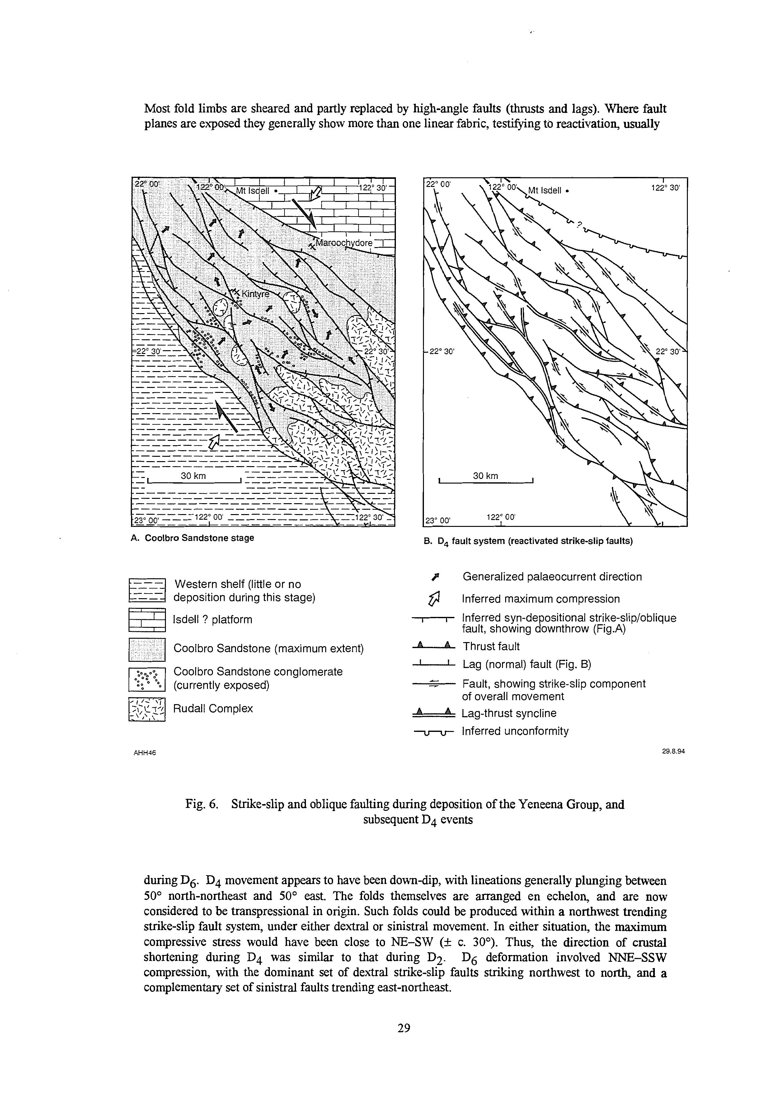
A. Coolbro Sandstone stage
Western shelf (little or no deposition during this stage)
Isdell? platform
Coolbro Sandstone (maximum extent)
Coolbro Sandstone conglomerate (currently exposed)
Rudall Complex
B. D, fault system (reactivated strike-slip faults)
p Generalized palaeocurrent direction (1 Inferred maximum compression
Inferred syn-depositional strike-slip/oblique fault, showing downthrow (Fig.A)
Thrust fault
Lag (normal) fault (Fig. B)
I - Fault, showing strike-slip component of overall movement
____ Lag-thrust syncline
-LN- Inferred unconformity 29.8.94
6. Strike-slip and oblique faulting during deposition of the Yeneena Group, and subsequent D4 events
during D6. D4 movement appears to have been downdip, With lineations generally plunging between 50' north-northeast and 50" east. The folds themselves are arranged en echelon, and are now considered to be transpressional in origin. Such folds could be produced within a northwest trending strike-slip fault system, under either dextral or sinistral movement. In either situation, the maximum compressive stress would have been close to NE-SW (k c. 30'). Thus, the direction of crustal shortening during D4 was similar to that during D2. D6 deformation involved NNE-SSW compression, with the dominant set of dexxral strike-slip faults striking northwest to north, and a complementary set of sinistral faults trending east-northeast.
Lategranitoids
In the Telfer area the Mt Crofton Granite suite post-dates D4 structures (Chin et al., 1982) and has been dated at c. 620 Ma (zircon U-Pb, D Nelson, unpublished data, 1993). The suite is described by Goellnicht et al. (1991) who conclude that the granitoids are syn- to post-collisional. Aeromagentic evidence suggests that granitoid intrusion may have occurred during late-stage southwesterly movement of the Telfer succession, but this possibility requires testing by precise geochronology across the suite.
Metallogenic implications
The newly acquired information suggests interpretion of the tectonic evolution of the Paterson Orogen, from c. 2000 Ma to 600 Ma, in terms of plate-tectonic processes. Previous workers (Clarke, 1991; Goellnicht et al., 1991; Myers, 1993) have used broader, regional geological data to infer that this tectonic unit was formed by plate convergence.
Because particular types of mineral deposit are associated with specific geological environments, interpretations of depositional and tectonic settings are used in assessing mineral potential. Table 6 summarizes phases in the Proterozoic evolution of the area, and suggests types of mineralization which might be present.
GEOCHRONOLOGY
Geochronological data for the Rudall Complex and Yeneena Group are currently extremely limited and provide only a very loosely constrained time-frame for the sequential events established from geological mapping. Table 7 summarizes the geochronological results, sources of data, and cited interpretations obtained from the Paterson Orogen.
The Rudall Complex includes orthogneisses that are interpreted, by field observations, to represent at least two pre-D2 granitoids.
The ion microprobe U-Pb zircon dates of 2015 f 26 and 1787 f 12 Ma @. Nelson, 1994, pers. comm.) were obtained from PRgx. The sample giving the older date is a garnet-biotite-muscovite gneiss from drill core. This gneiss may have been derived, or may include material from, a sedimentary protolith and has a complex zircon age structure The 2015 f 26 Ma age may date a granitoid component, but uncertainty as to the precise nature of the sample requires follow-up investigations. The 1787 f. 12 Ma result was obtained on drill core of orthogneiss (part of the ERgx complex) containing only one zircon population. K-feldspar augen orthogneiss @Rga) has recently been dated (U-Pb zircon) at 1765 k 15 Ma @. Nelson, 1994, pers. comm.). The zircon data and field relations between orthogneiss and paragneiss establishes that protoliths of much of the paragneiss were deposited before 1765 Ma. The orthogneiss with 2015 f 26 Ma zircons contains abundant paragneiss enclaves and zircon xenocrysts @. Nelson, 1990, unpublished) dated at ca 2600 Ma. In the east Pilbara rocks of ca 2600 Ma age occur in the Gregory Range where de Laeter et al. (1977) obtained a Rb-Sr age of 265 1 f 60 Ma for a sheared granitoid, and Arndt et al (199 1) reported zircon U-Pb ages indicating that felsic volcanics in the upper Fortescue Group are about 2680 Ma. From evidence presented in the previous section, ‘Tectonic evolution’, it is probable that the eastern part of the Pilbara Craton was the main source region for sedimentary rocks of the Rudall Complex.
Chin and de Laeter (1981) analysed a suite of randomly selected rocks from the headwaters of Rudall River to determine the minimum age of D2 (their randomly collected series). This series produces a 1533 i 29 Ma isochron. If the orthogneiss @Rga) samples from this series are combined with the less metasomatized samples from their 48925 series, which are also from flRga, an isochron at about 1500 Ma is produced. If the Rb-Sr age marks a metamorphic event this could be M2.
Chin and de Laeter (1981) gave a well-fitted Rb-Sr isochron at 1333 f 44 Ma for an orthogneiss from southwestern CONNAUGHTON (their 48929 series). They interpreted this date as the age of the pervasive metamorphism and deformation in the Rudall Complex @2). It was also considered to represent the oldest possible age for the Yeneena Group. A suggested explanation for the discrepancy between this younger date and the result obtained from the headwaters of Rudall River was either that there was a lack of complete Sr isotope homogenization throughout the Rudall Complex, or that the 1533 Ma age is a ‘composite of an older age largely modified by the younger F2 metamorphism’. The sampling site €or the 1333 Ma orthogneiss is 60 km southeast of the Rudall River in an area where banded orthogneiss appears to have been intruded by a K-feldspar-rich and biotite-poor granitoid containing amphibolite (metadolerite and gabbro) xenoliths (Bagas and Smithies, in prep.). The later granitoid is now a poorly foliated orthogneiss, and though affected by D4, may be post-D2. These rocks are unconformably overlain by the Yeneena Group about 700 m to the south. If the 1333 f 44 Ma result was obtained on the poorly foliated orthogneiss this could provide an age for the felsic magmatic event after D2 (‘Tectonic evolution’).
A locally tectonized pegmatite on northwestern CONNAUGHTON, interpreted as post-D2, has a U-Pb zircon crystallization age of 1247 f 5 Ma indicating that D2 occurred prior to 1247 f 5 Ma. The relationship between this pegmatite and the Yeneena Group has not been determined.
Chin and de Laeter (1981) reported a Rb-Sr isochron age of 1132 f 21 Ma from pegmatite dykes cutting orthogneiss in the Rooney Creek area and interpreted this as the minimum age for the Yeneena Group. No pegmatite veins intrude the Yeneena Group on RUDALL or BROADHURST, despite being extremely common in the immediately underlying Rudall Complex. If the 1132 Ma result dates pegmatite intrusion this age represents a maximum age for the Yeneena Group. If it is a metamorphic age, this metamorphism could still be pre-Yeneena Group in age. Accordingly, the result has limited significance.
On the southeastern margin of the Pilbara Craton metamorphic biotite predating the Yeneena Group provided Rb-Sr ages of 1226Ma and 1194Ma (de Laeter et al., 1977). Subject to the isotopic composition of the biotite not having been reset by post-Yeneena Group metamorphism, these results provide a minimum age for the Yeneena Group.
The Runton adamellite, from RUNTON, gave a two-point Rb-Sr isochron age of 1080 Ma (Chin and de Laeter, 1981) and a Pb-Pb age of 1067 f 260 Ma (G. L. Clarke and N. McNaughton, unpubl. data). This adamellite is non-foliated to weakly foliated. It may postdate D4 in the southeastern part of the Paterson Orogen or could be situated in a D4 low-strain zone. There are no contact relationships between the adamellite and the Yeneena Group, preventing any reliable interpretation of these isotopic data in relation to the age of the Yeneena Group.
Galena sampled from the Broadhurst Formation has provided Pb model ages between 940 and 520 Ma (Blockley and Myers, 1990; I. Fletcher pers comm, 1993; Hickman and Clarke, 1993). The regional distribution of the galena isotopic data appears to establish that the minimum age of the Broadhurst Formation is 900 Ma.
Preliminary geochronological and biostratigraphic data suggests that the Savory Basin, that unconformably overlies the Yeneena Group in the southwestern portion of RUDALL, evolved sometime between 900 and 600 Ma (Williams, 1992).
Several unfoliated to partly foliated granitoid intrusions, later than and sharply discordant to D4 structures intrude the upper part of the Yeneena Group near Telfer. One of the unfoliated granitoids, the Mt. Crofton Granite ‘Complex’, gave a Rb-Sr age of about 601 f 42Ma (Williams, 1992recalculation of data in Trendall, 1974) Pb-Pb ages of 690 f 48 Ma (McNaughton and Goellnicht, 1990; Goellnicht et al, 1991) and a zircon U-Pb age of c. 620 Ma (D. Nelson, unpublished data, 1993). This demonstrates that D4 is older than 620 Ma in the northern part of the Paterson Orogen.
From the geochronological results reported here and the geological knowledge of the Paterson Orogen, the chronological sequence of events is summarized in Table 8.
Table 6. Summary of the Proterozoic tectonic evolution of the Paterson Orogen, with theoretical metallogenic implications (from Hickman and Bagas, in press)
9 Granitoid intrusion
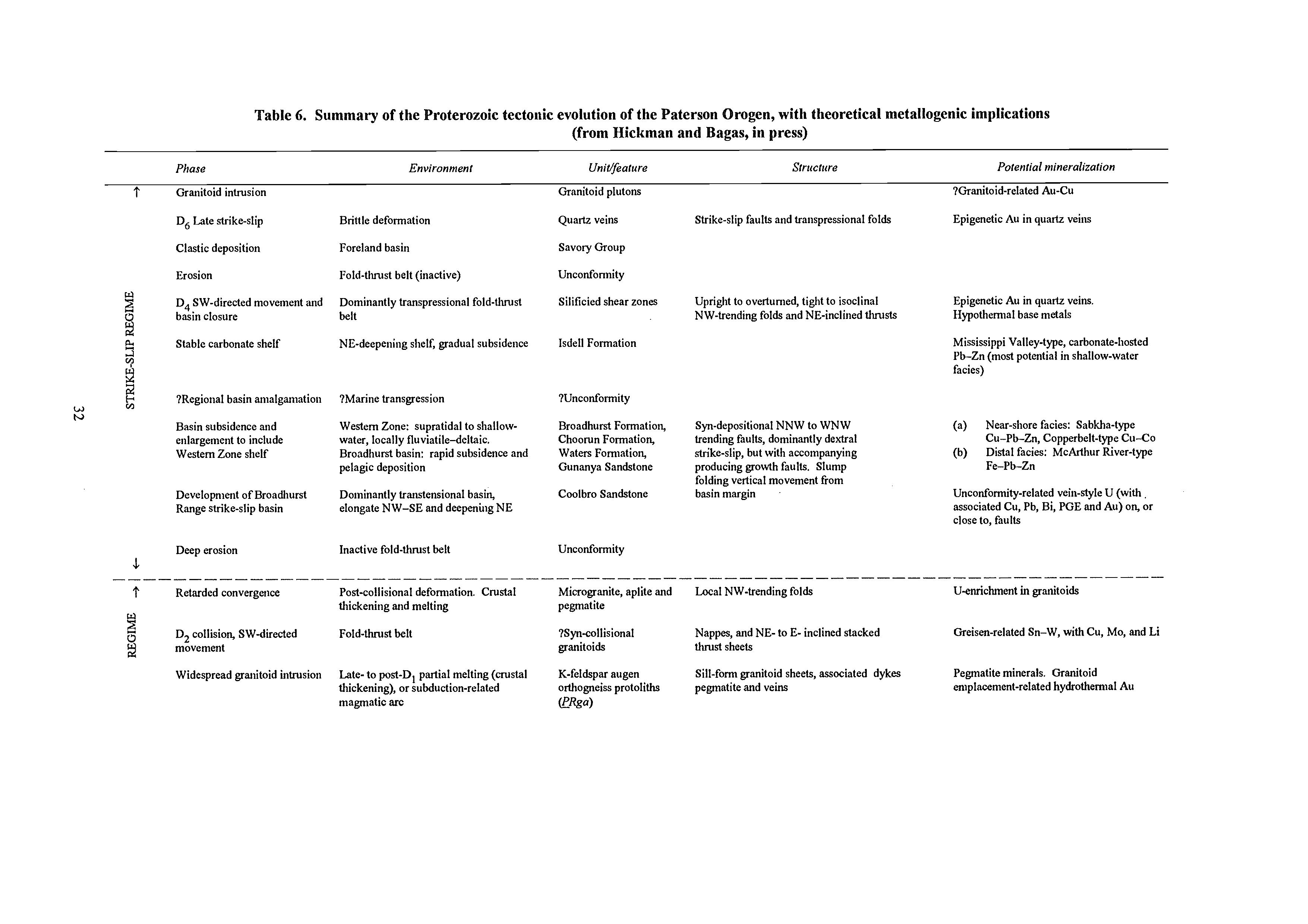
Granitoid plutons
D6 Late strike-slip Brittle deformation Quartz veins
Clastic deposition Foreland basin Savory Group
Erosion Fold-tluust belt (inactive) Unconformity
D4 SW-directed movement and basin closure belt
Dominantly transpressional fold-Uuust Silificied shear zones
Stable carbonate shelf NE-deepening shelf, gradual subsidence Isdell Formation
?Regional basin anialgamation ?Marine transgression 7Unconformity
Basin subsidence and enlargement to include Western Zone shelf
Development of Broadhurst Range strike-slip basin
Deep erosion ---------
Retarded convergence
D, collision, SWdirected movement
Western Zone: supratidal to shallow- Broadhurst Formation,
Strike-slip faults and transpressional folds
7Granitoid-related Au-Cu
Epigenetic Au in quartz veins
Upright to overturned, tight to isoclinal Epigenetic Au in quartz veins.
NW-trending folds and NE-inclined Uuusts Hypothermal base metals
Mississippi Valley-type, carbonate-hosted Pb-Zn (most potential in shallow-water facies)
Syn-depositional NNW to WNW (a) Near-shore facies: Sabkha-type water, locally fluviatile-deltaic. Choorun Formation, trending faults, dominantly dextral Cu-Pb-Zn, Copperbelt-type Cu-Co Broadhurst basin: rapid subsidence and Waters Formation, strike-slip, but with accompanying (b) Distal facies: McArthur River-type pelagic deposition Gunanya Sandstone producing growth faults. Slump Fe-Pb-Zn
Dominantly transtensional basin, Coolbro Sandstone basin margin
Unconformity-related vein-style U (with elongate NW-SE and deepening NE
folding vertical movement from associated Cu, Pb, Bi, PGE and Au) on, or close to, faults
Inactive fold-thrust belt
Post-collisional deformation. Crustal
Unconformity
Microgranite, aplite and Local NW-trending folds
U-enrichment in granitoids thickening and melting pegmatite
Fold-thrust belt
7Syncollisional granitoids thrust sheets
Widespread granitoid intrusion Late- to post-D1partial melting (msliil K-feldspar augen
Nappes, and NE- to E- inclined stacked Greisen-related Sn-W, with Cu,Mo, and Li
Sill-form granitoid sheets, associated dykes
Pegmatite minerals. Granitoid thickening), or subduction-related orthogneiss protoliths pegmatite and veins emplacement-related hydrothermal Au magmatic arc (!?&a)
Clastic deposition, local Rifted shelf, adjacent volcanic arc Poynton Formation volcanism
D, Subhorizontal tectonic ?Thin-skinned thrusting along fold-thrust Lilhologically layered Layer-parallel shear zones interleaving belt margin orlhogneiss CRgx)
Granitoid intrusion ?Partid melting beneath rifled basin Chnitoid protoliths for Sill-form granitoid sheets
lithogically layered orthogneiss (fRgx)
Clastic deposition, rnatic Subsiding foreland basin with shoreline, Larry Formation, felsic volcanics in areas to
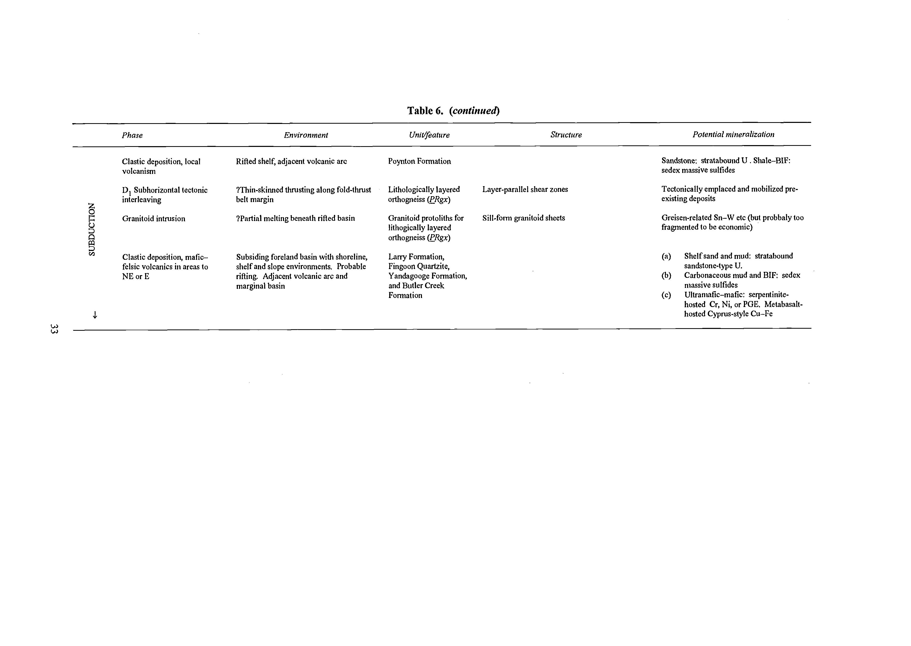
Sandstone: stratabound U . Shale-BIF: sedex massive sulfides
Tectonically emplaced and mobilized preexisting deposits
Greisen-related Sn-W etc (but probbaly too fragmented to be economic)
(a)
shelf and slope environments. Probable marginal basin and Butler Creek Fingoon Quartzite, Formation
NE or E rifling. Adjacent volcanic arc and Yandagooge Fomiation,
(b)
(c) Ultramatic-mafic: serpentiniteShelf sand and mud: stratabound sandstone-type U. Carbonaceous mud and BIF sedex massive sulfides hosted Cr, Ni, or PGE. Metabasalthosted Cyprus-style Cu-Fe
i-26
12
f 15
f 29
f 44
f 5
+21
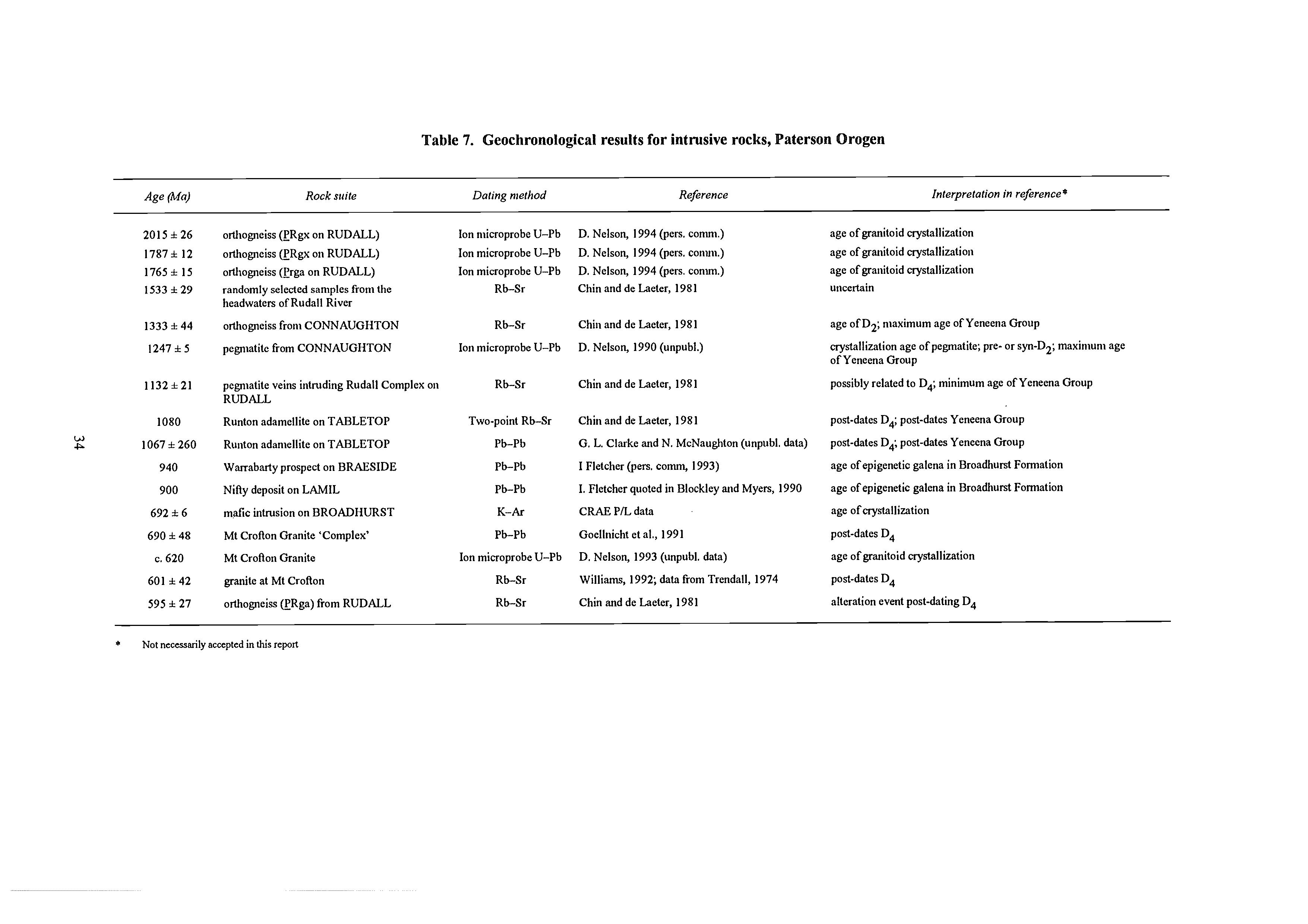
f 260
orthogneiss (HRgx on RUDALL)
orthogneiss @Rgx on RUDALL)
orthogneiss @rga on RUDALL)
randomly selected samples from the headwaters of Rudall River
orthogneiss from CONNAUGHTON
pegmatite from CONNAUGHTON
Table 7. Geochronological results for intrusive rocks, Paterson Orogen
Ion microprobe U-Pb
Ion microprobe U-Pb
Ion microprobe U-Pb
Rb-Sr
Rb-Sr
Ion microprobe U-Pb
pegmatite veins intruding Rudall Complex on RUDALL
Runton adamellite on TABLETOP
Runton adamellite on TABLETOP
Warrabarty prospect on BRAESIDE
Nifty deposit on LAMIL
f 6 690 f 48 c. 620
601 f 42
595 f 27
rnafic intrusion on BROADHURST
Mt Crofton Granite ‘Complex’
Mt Crofton Granite
granite at Mt Crofton
orthogneiss @Rga) &om RUDALL
* Not necessarily accepted in this report
Ion microprobe U-Pb Rb-Sr
Rb-Sr
D. Nelson, 1994 @ers. comm.)
D. Nelson, 1994 (pen. comm.)
D. Nelson, 1994 @en. conun.)
Chin and de Laeter, 1981
Chin and de Laeter, 1981
D. Nelson, 1990 (unpubl.)
Chin and de Laeter, 1981
Chin and de heter, 1981
G. L. Clarke and N. McNaughton (unpubl. data)
I Fletcher (pers. comm, 1993)
I. Fletcher quoted in Blockley and Myers, 1990
CRAE P/L data
Goellriicht et al., 1991
D. Nelson, 1993 (unpubl. data)
Williams, 1992; data &om Trendall, 1974
Chin and de Laeter, 1981
age of granitoid crystallization
age of granitoid crystallization
age of granitoid crystallization
uncertain
age of D2; maximum age of Yeneena Group
crystallization age ofpegmatite; pre- or syn-D2; maximum age of Yeneena Group
possibly related to D4; minimum age of Yeneena Group
post-dates D4; post-dates Yeneena Group
post-dates Dk post-dates Yeneena Group
age of epigenetic galena in Broadhurst Formation
age of epigenetic galena in Broadhurst Formation
age of crystallization
post-dates D4
age of granitoid crystallization
post-dates D4
alteration event postdating D,
Table 8. Geochronological summary of the evolution of the Paterson Orogen
Isotopicage(Ma)
pre-I765
2015 f 1787
1765 I15
M 1500 1333 f 44
1247 f 5
c. 1300 c. 1200 1132 f 21 loso
940-820
900-600
c. 620 C
ECONOMIC GEOLOGY
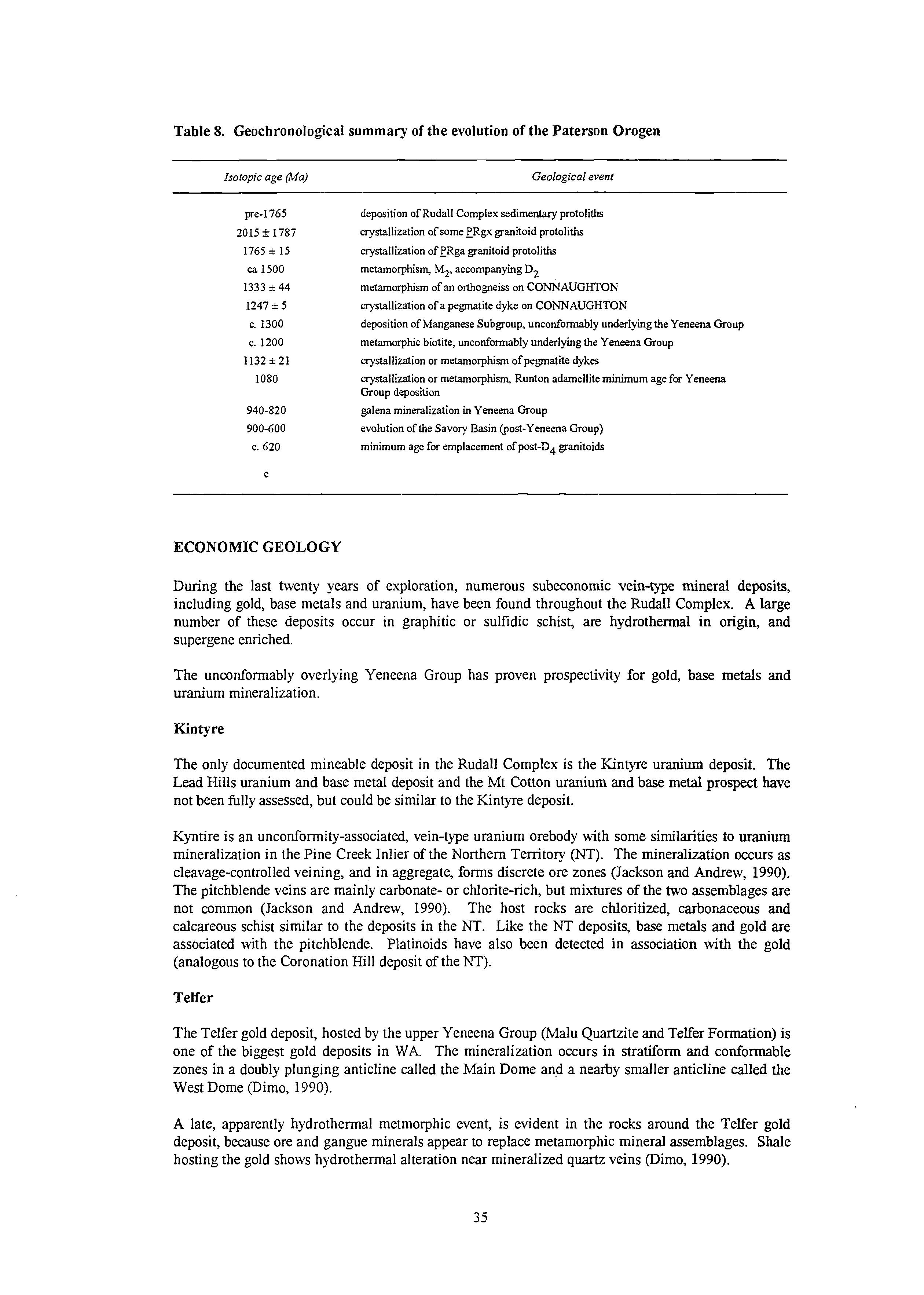
Geologicalevent
deposition of Rudall Complex sedimentary protoliths crystallizationof some PRgx granitoid protoliths crystallizationofPRga granitoid protoliths metamorphism, M2, accompanyingD2 metamorphism of an orthogneisson CONNAUGHTON crystallizationof a pegmatite dyke on CONNAUGHTON deposition of Manganese Subgroup, unconformably underlying the Yeneena Group metamorphicbiotite, unconformably underlying the Yeneena Group crystallizationor metamorphism of pegmatite dykes crystallizationor metamorphism,Runton adamellite minimum age for Yeneena Group deposition
galena mineralizationin Yeneena Group evolution of the Savory Basin (post-Yeneena Group) minimum age for emplacement of post-D4 granitoids
During the last twenty years of exploration, numerous subeconomic vein-type mineral deposits, including gold, base metals and uranium, have been found throughout the Rudall Complex. A large number of these deposits occur in graphitic or sulfidic schist, are hydrothermal in origin, and supergene enriched.
The unconformably overlying Yeneena Group has proven prospectivity for gold, base metals and uranium mineralization.
Kintyre
The only documented mineable deposit in the Rudall Complex is the Kintyre uranium deposit. The Lead Hills uranium and base metal deposit and the Mt Cotton uranium and base metal prospect have not been fully assessed, but could be similar to the Kintyre deposit.
Kyntire is an unconformity-associated, vein-type uranium orebody with some similarities to uranium mineralization in the Pine Creek Inlier of the Northern Temtory m).The mineralization occurs as cleavage-controlled veining, and in aggregate, forms discrete ore zones (Jackson and Andrew, 1990). The pitchblende veins are mainly carbonate- or chlorite-rich, but mixtures of the two assemblages are not common (Jackson and Andrew, 1990). The host rocks are chloritized, carbonaceous and calcareous schist similar to the deposits in the NT. Like the NT deposits, base metals and gold are associated with the pitchblende. Platinoids have also been detected in association with the gold (analogous to the Coronation Hill deposit of the NT).
Telfer
The Telfer gold deposit, hosted by the upper Yeneena Group (Malu Quartzite and Telfer Formation) is one of the biggest gold deposits in WA. The mineralization occurs in stratiform and conformable zones in a doubly plunging anticline called the Main Dome and a nearby smaller anticline called the West Dome (Dimo, 1990).
A late, apparently hydrothermal metmorphic event, is evident in the rocks around the Telfer gold deposit, because ore and gangue minerals appear to replace metamorphic mineral assemblages. Shale hosting the gold shows hydrothermal alteration near mineralized quartz veins (Dimo, 1990).
The mineralization is hydrothermal and mainly consists of pyrite and quartz with minor copper mineralization. The pyrite commonly occurs in crudely banded conformable zones in quartz reefs that mimic bedding. The gold occurs as minute inclusions in pyrite @imo, 1990). The grade of this type of mineralization rarely exceeds 3 g/t. This mineralization has been supergene-enriched, and it is this enriched zone that was mined at Telfer until recently. The sulfide zone, rich in chalcopyrite and chalcocite is presently been mined.
There is laterally and vertically widespread vein mineralization with hydrothermal micaquartztourmaline alteration haloes (Dimo, 1990). The source of the hydrothermal fludis has not been demonstrated, but granitoids are though to have provided the ‘heat engine’ to ‘drive’ the fluids.
Base metal mineralization
Copper, lead and zinc mineralization occurs in stratabound and stratifom deposits in the Broadhurst Formation of the Yeneena Group. These occur at essentially the Same stratigraphic level in shale or carbonate units. Examples of these deposits include the Nifiy and Maroochydore deposits. This indicates that the Broadhurst Formation is prospective over a large area.
Mineral potential
This guidebook uses newly acquired information to interpret the tectonic evolution of the Paterson Orogen, from c. 2000 Ma to 600 Ma, in terms of plate-tectonic processes.
Because particular types of mineral deposit are associated with specific geological environments, interpretations of depositional and tectonic settings are used in assessing mineral potential. Table 6 summarizes the area’s tectonic evolution, and suggests types of mineralization which might be present.
The Paterson Orogen has proven potential for Au, Cu-Pb-Zn and U mineralization. Additionally, mineral exploration and the recent mapping and accompanying geochemical investigations have indicated significant prospectivity for Pb-Zn, Mo, Bi, and possibly W, Ni, Cr and PGE mineralization.
Figure 7 shows zones of mineral potential in the Broadhurst Range-Rudall River area. Assessment of other areas will follow completion of mapping. Several northwest-striking zones encompass all known significant gold anomalies. The southern two zones coincide with D4 faults involving the Yandagooge Formation, with the Poynton Domain zone also involving mineralization of the Butler Creek and Poynton formations.
Most of the gold mineralization is hosted by D4 faults. The present deposits therefore appear to be syn- or post-Dq in age, although because Dq faults commonly coincide with D2 faults, and probably also with growth faults during deposition of the Yeneena Group, the original age of some gold mineralization in the Rudall Comples is uncertain. Gold mineralization in the Kintyre area is associated with uranium mineralization.
Uranium mineralization on the RUDALL 1:lOO 000 Sheet area is confined to a relatively narrow northwest-striking belt along the southwestern boundary of the Fingoon Domain. This belt is essentially a D4 graben, and may have been a down-faulted block during deposition of the Coolbro Sandstone. Uranium deposits are hosted by fractures in the Yandagooge Formation, presumably not far below the level of the unconformity at the base of the Coollbro Sandstone. Figure7 shows U potential declining southeast based on the interpretation that the Coolbro Sandstone probably wedged out in this direction. Potential for U mineralization in the Poynton and Rooney domains is considered to be low due to an absence of suitable pelitic or carbonate host-rocks close to the basal Coolbro Sandstone unconformity.
SAVORY GROUP
YENEENA GROUP
elfer succession
lsdell Formation
Choorun and Waters Formations
Gunanya Sandstone and Pungkuli Formation
Coolbro Sandstone and Broadhurst Formation
RUDALLCOMPLEX
Yandagooge Formation
% Established prospect
K Kintyre
M Maroochydore
Zone of established or interpreted
mineral potential
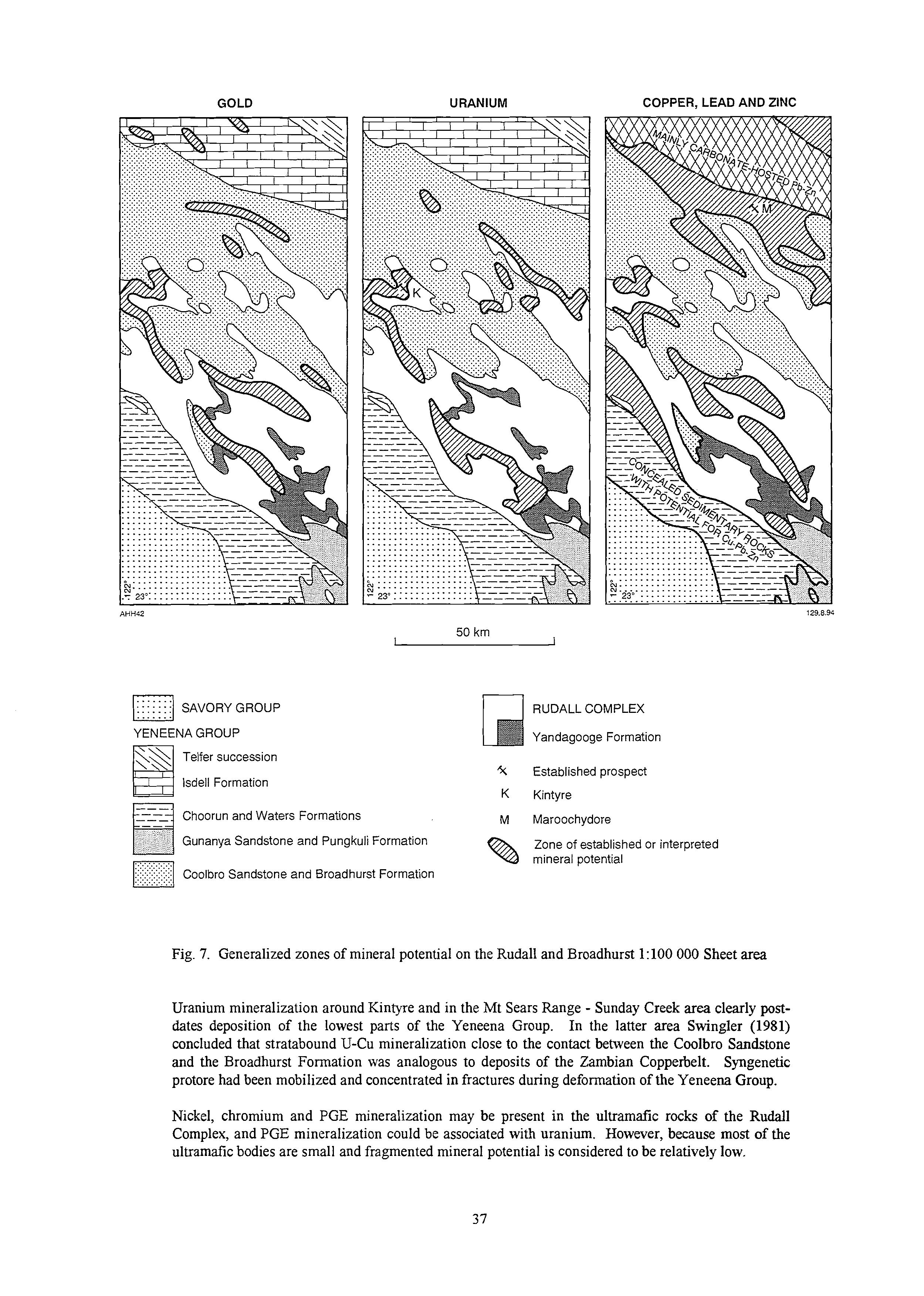
7. Generalized zones of mineral potential on the Rudall and Broadhurst 1:lOO 000 Sheet area
Uranium mineralization around Kintyre and in the Mt Sears Range - Sunday Creek area clearly postdates deposition of the lowest parts of the Yeneena Group. In the latter area Swingler (1981) concluded that stratabound U-Cu mineralization close to the contact between the Coolbro Sandstone and the Broadhurst Formation was analogous to deposits of the Zambian Copperbelt. Syngenetic protore had been mobilized and concentrated in fractures during deformation of the Yeneena Group.
Nickel, chromium and PGE mineralization may be present in the ultramafk rocks of the Rudall Complex, and PGE mineralization could be associated with uranium. However, because most of the ultramafk bodies are small and fragmented mineral potential is considered to be relatively low.
Figure 7 shows several large zones with Cu, Pb and Zn potential. The zone in the Clayton Domain coincides with a belt of major D4 thrusts and lags, but it is unclear to what extent these have acted as conduits for hydrothermal fluids. The Poynton Domain zone partly corresponds to the central zone of gold mineralization (discussed above).
The Western succession of the Yeneena Group on the Rudali 1:lOO 000 Sheet area is composed of shallow-water arenites, shale, and carbonate rocks. The succession occupies an area of about 1000km2 (Fig. 7), but is largely concealed and has not yet been explored. The geochemical investigation revealed local Cu anomalies, and the belt is clearly prospective for Sabkha-type Cu-Pb-Zn, and possibly Copperbelt-type Cu-Co or Mississippi Valley-type carbonate-hosted Pb-Zn deposits. Further northwest deeper water sediments in the Three Sisters-Vines Fault area may have potential for the type of Cu and Pb-Zn mineralization which occurs in the Broadhurst Formation.
The Broadhurst Formation has proven potential to host significant deposits of Cu (N@ and Maroochydore), although the precise origins of these are still uncertain. Present information indicates that the deposits are probably rift-related, sedimentary-exhalative massive sulphide deposits, partly mobilized by later deformation. Mt Isa and Zambian Copperbelt models have been suggested during mineral exploration. No economically significant Pb-Zn mineralization has yet been announced, although Pb-Zn anomalies are widespread in carbonate-shale units of the Broadhurst and Isdell formations.
EXCURSION LOCALITIES
Stop 1, Permian Glaciation Site, Carawine Pool area: AMG (3155) 989271
This stop is one of the best preserved examples of Permian glaciation in the East Pilbara. Lower Permian (Asselian Stage, 280-290 Ma) diamictite (now indicated by surface boulders) lies adjacent to glaciated Pinjian Chert Breccia (Palaeoproterozoic)and Carawine Dolomite (Archaean, c. 2600 Ma). The glaciated surface exibits glacial grooves, striations and chattermarks. These indicate ice movement from south to north (axis about 340'). The outcrops are examples of large roche moutontes.
The Carawine Dolomite, in this area, was deposited in a shallow water platformal environment. This is supported by thin beds of silicified domal stromatolites. The unconformable contact between the shallow-dipping Carawine Dolomite and Pinjian Chert Breccia is interpreted as the infilling of a Proterozoic palaeokorst surface.
The mesas lying to the west of this stop are capped by Cainozoic Oakover Formation (possibly as old as Miocene). The formation consists of a siliceous opaline cap on sandy limestone. The Oakover Formation is probably lacustrine. It post-dates laterite development in the Oakover River valley.
Stop 2, Waltha Woora Formation, Muddauthera Creek AMG (3154) 162115
The Waltha Woora Formation is a western outlier of the Yeneena Group. It is patchily preserved west of the Gregory Range between Braeside and Warri Wani Creek. The formation unconformably overlies Carawine Dolomite, Pinjian Chert Breccia and Fortescue Group basalts.
The formation is correlated, on stromatolite tam, with the Waroongunyah Formation which belongs to the Western succession of the Yeneena Group. The Waroongunyah Formation lies 70 km to the south-southeast of Stop 2.
Stop 2 consists of a c. 30 m section of interbedded pink and grey shale, calcareous shale, dolomite, stromatolite dolomite and thin-bedded, brown calcareous sandstone. Stromatolitic bioherms occur at several levels in the sequence. About 100 m downstream from stop 2 basal cross-bedded medium-to coarse-grained red-brown sandstone underlie the carbonate sequence. The eastern margin of the carbonate sequence is down-faulted against Carawine Dolomite, active during the Paterson Orogeny,.
Stop 3, Unconformity between Yeneena Group and Gregory Granitic Complex, Nifty Mine road: AMG (3154) 372092
This well-exposed unconformity (an erosional nonconformity) occurs between moderately eastdipping (c. 30') Googhenama Formation, the basal unit of the Western succession of the Yeneena Group, and porphyroidal microgneiss of the Archaean Gregory Granitic Complex. The Googhenama Formation consist of a sequence of quartz-pebble conglomerate, fermginous sandstone and fine- to coarse-grained quartz sandstone. Graded-bedding and cross-bedding indicate way-up to the east.
The porphyroidal microgneiss appears to be a strongly metamorphosed and deformed felsic lava. This unit, together with metamorphosed and deformed syenogranite, granophyre and rapakivi-style syenogranite make up the Gregory Granitic Complex. Recent studies support the suggestion that the Gregory Granitic Complex is a late plutonic equivalent of the felsic volcanism represented by the Koongaling Volcanics (base of the Archaean Fortescue Group) (Trendall, 1990).
The Vines Fault which marks the boundary between the Western succession and Broadhurst Range succession of the Yeneena Group lies 5 kms to the east of Stop 3.
Stop 4, Nifty Copper Mine (description by P. Dare)
INTRODUCTION
Nifty copper operation is located about 300 metres above sea level within the Great Sandy Desert, some 70 kilometres west of Telfer. Nifty is a stratabound epigenetic, sediment-hosted copper deposit. The mineralisation is hosted within silicified carbonate and shale units of the Broadhurst Formation.
Copper is the only economic mineral within the Nifty deposit. Production currently is fiom the secondary (oxide) mineralisation which is mined via open cut with the copper being extracted by heap leach, solvent extraction, electro-winning techniques. Target production is 16500 t per annm copper metal. The mine has a projected life of nine years for the secondary ore reserve.
The current secondary planned ore reserve is 5.6 mt @ 3.2% Cu, depletion to date is 0.6 mt @ 4.0%. Primary pre-mining reserves are 10 mt @ 5.0. Feasibility studies area ongoing for the primary reserve. Global resources are estimated at 23 mt at 3.0% Cu.
Nlfty Operation operates on a fly in fly out basis commuting both from Perth and Port Hedland. Most staff are employed on a two weeks on, two weeks off roster.
EXPLORATION HISTORY
During the early 1980s the western edge of the Yeneena Basin was highlighted by Douglas Haynes as a potential area for the formation of stratiform and stratabound copper mineralisation. As a result of this targeting, copper mineralisation was discovered at Nifty following reconnaissance geochemical surveys in 1981.
At Nlfty, high grade secondary and primary mineralisation were intersected in 1983, after the drilling of 69 percussion and 9 diamond holes. Between May 1983 and December 1984 the deposit was investigated with 262 reverse circulation and 25 diamond drill holes, with the secondary mineralisation being the main target.
Exploration was carried out elsewhere in the project area from 1984 to 1988. During this period a large concealed low grade lead-zinc resource (Warrabarty) was discovered north of Nlfty. In 1988 diamond drilling recommenced at NO, when two holes were drilled looking for a lead-zinc accumulation, and two short holes were drilled to provide samples of secondary ore types for metallurgical examination.
During 1989 the primary mineralisation was investigated by 25 further diamond drill holes which concentrated on the high grade core of the deposit.
PROJECT GEOLOGY
The Nifty sediment-hosted stratabound epigenetic copper deposit occurs within the Broadhurst Formation of the Yeneena Group of the late Proterozoic Yeneena Basin. Within the project area the lowermost units of the Yeneena Group are of greatest concern, the rift-phase sediments of the Coolbro Sandstone, the restricted marine sediments of the Broadhurst Formation and the deep-water carbonate sequences of the Isdell Formation.
There is very little regional exposure of the lower Yeneena Group (exposures make up approximately 4% of the surface area). The rocks are deeply weathered and generally covered by Tertiary indurated gravelly or lateritic sand, and clay which may be over 150 m thick. Some areas are also overlain by Permian glacial sediments. Detailed regional geology is difficult to establish. A regional stratigraphy has been interpreted from the geophysical signatures of various domains which have in part been confirmed by drilling. The main subdivisions are:
1. Mag Low TEM low non graphitic, non-magnetic Isdell Fm
Ambiguous, may be Coolbro Sst or
2. Mag Low TEM high pyrite bearing Upper Broadhurst Fm graphitic carbonaceous Carbonaceous shale and siltstone
3. Mag high TEM low pyrrhotite bearing non graphitic Lower Broadhurst Fm CNoritic pyrrhotite bearing unit.
4. Mag High TEM high Pyrrhotitic and graphitic Possible superposition of signatures of division 2 and 3, or a transitional lithology. Lower Broadhurst Fm.
5. Circular mag high Magnetite Grantiic intrusive
6. Circular mag low Magnetite depletion Granitic intrusive
7. This lineral mag high Magnetite/pyrrhotite Dolerite intrusives
Other local subdivisions occur but are of limited regional significance. The above table reflects that for project purposes the Broadhurst Formation has been subdivided into three units. The validity of the subdivision has been rudimentarily tested by drilling and has been found to generally support the above lithological subdivisions.
Regional structural interpretation is difficult due to the lack of exposure. The main structural elements of the project area were developed during D4. Structurally we believe the western edge of the Yeneena Basin to have been within a dex3ral transpressional zone resulting from southsouthwesterly tectonic transport during D4. The main features of this system are
(0
(ii)
(iii)
Throughgoing NNW-SSE orientated predominantly dextral, steepened, ENE dipping, thrust faults.
NW-SE trending imbricate fauitshransfer zones, with both or either sinistral or dextral displacement.
NW to NNW trending, periclinal, asymmetrical, southwesterly verging folds with axial planar slatey cleavage.
MINE GEOLOGY
The Nifty deposit lies within the geophysical geological subdivision 2 of the Broadhurst Formation, the mine stratigraphy has been broken further subdivided into Hanging wall units, the Nifty Carbonate Member, and Footwall units.
Nifty Mine Stratigraphy
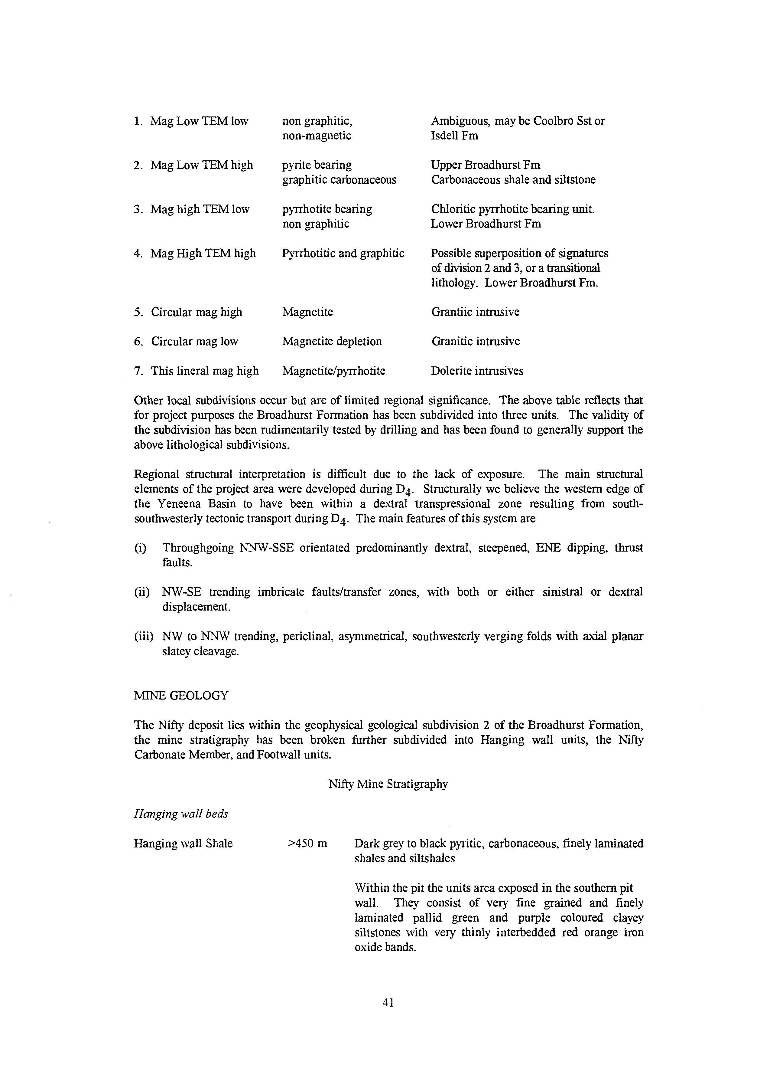
Hanging wall beds
Hanging wall Shale >450 m Dark grey to black pyritic, carbonaceous, finely laminated shales and siltshales
Within the pit the units area exposed in the southern pit wall. They consist of very fine grained and finely laminated pallid green and purple coloured clayey siltstones with very thinly interbedded red orange iron oxide bands.
Upper Carbonate 4-60 Pale grey finely laminated clacareous and dolomitic shales and siltstones.
This unit is not exposed in the current pit.
(The upper Carbonate occurs 20-60 m above the N@ Carbonate Member. Pyrite is abundant below it, increasing downwards.)
NijiiCarbonateMember Pyritic Marker 1.5-22
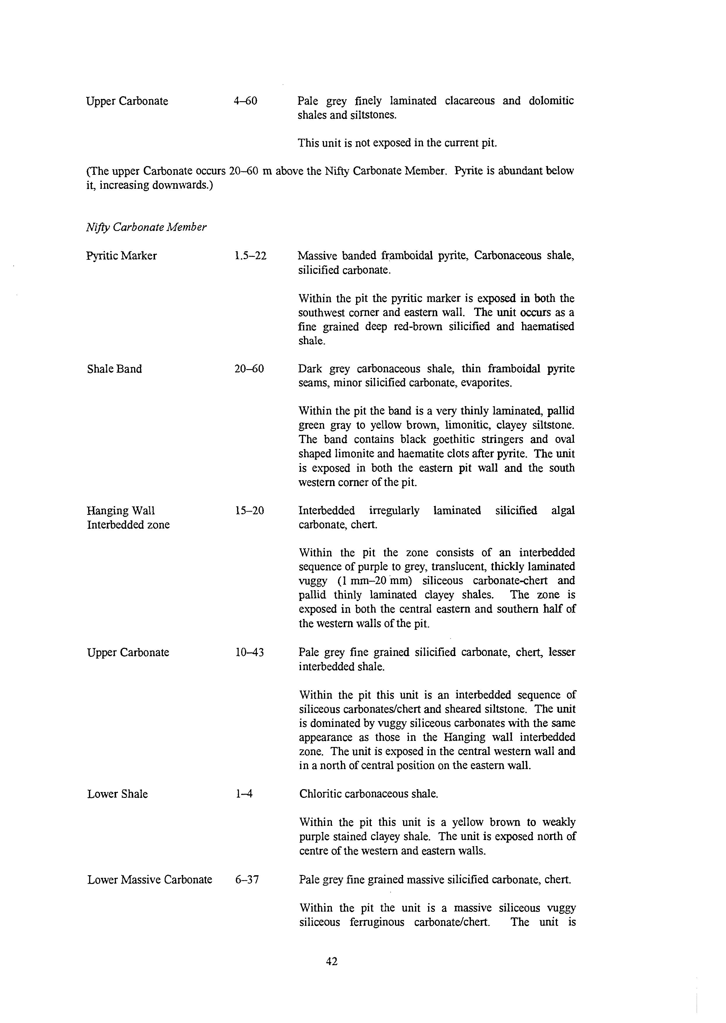
Band
Massive banded frambidal pyrite, Carbonaceous shale, silicified carbonate.
Within the pit the pyritic marker is exposed in both the southwest comer and eastern wall. The unit OCCUTS as a fine grained deep red-brown silic5ed and haematised shale.
Dark grey carbonaceous shale, thin framboidal pyrite seams, minor silicified carbonate, evaporites.
Within the pit the band is a very thinly laminated, pallid green gray to yellow brown, limonitic, clayey siltstone. The band contains black goethitic stringers and oval shaped limonite and haematite clots after pyrite. The unit is exposed in both the eastern pit wall and the south western comer of the pit.
Interbedded irregularly laminated silicified algal carbonate, chert.
Within the pit the zone consists of an interbedded sequence of purple to grey, translucent, thickly laminated vuggy (1 mm-20 mm) siliceous carbonate-chert and pallid thinly laminated clayey shales. The zone is exposed in both the central eastern and southern half of the western walls of the pit.
Pale grey fine grained silicified carbonate, chert, lesser interbedded shale.
Within the pit this unit is an interbedded sequence of siliceous carbonatedchert and sheared siltstone. The unit is dominated by vuggy siliceous carbonates with the same appearance as those in the Hanging wall interbedded zone. The unit is exposed in the central western wall and in a north of central position on the eastem wall.
Chloritic carbonaceous shale.
Within the pit this unit is a yellow brown to weakly purple stained clayey shale. The unit is exposed north of centre of the western and eastern walls.
Pale grey fine grained massive silicified carbonate, chert.
Within the pit the unit is a massive siliceous vuggy siliceous fenuginous carbonatekhert. The unit is
Footwall interbedded Zone 14-32
FootwaNBeds
generally massive but may contain gossanous boxworks after sulfide. The unit is exposed in the ramp, north eastern comer of the pit and towards the northern comer of the eastern pit wall.
Bluish black siliceous chloritic shales with interbedded silicified carbonate (2 m - 4 m).
Within the pit the zone occurs as interbedded sequence of yellow brown, siliceous, fermginous wbonatdchert and purple and yellow brown shales. The zone is exposed in the northeast comer of the pit.
900 Grey to bluish black siliceous micaceous and chloritic shales and siltstones with abundant framboidal pyrite interbeds. Sandy interbeds increase downwards.
Within the pit this unit is a monotonous sequence of pallid cream clayey shales with fermginous purple bands. The unit is moderately sheared and is exposed in the northern wall.
Outcrop in the vicinity of the Nlfty deposit is poor, with the'synclinal trace being marked by the silicified carbonates, which are irregularly exposed on both limbs. The hanging wall and footwall beds are deeply oxidised to about 80 m and are poorly exposed outside of the pit (the pit lies on the northem limb of the Nifty syncline). The hanging wall beds are overlain by massive pisolitic laterite up to 20 m thick.
D4 @2 in the Yeneena Group) is the main deformation event affecting the mine stratigraphy. The Nifty deposit lies within a D4 SE plunging (1.5' -+ 142') syncline. The axial surface of the syncline is steeply NE to NNE dipping and trending NW-SE. A large parasitic anticline-syncline pair is exposed in the western wall of the pit. The fold is doubly plunging. Penetrative crenulate cleavages (S4;S2 in the Yeneena Group) are observed within the siltshale units whilst a more strongly spaced fracture cleavage (S4) is developed in the siliceous carbonate bands. Transposition of bedding by penetrative S4 crenulate cleavage occurs in some shale.
Both the footwall and hangingwall of the deposit is affected by faulting with a sigmfkant strike slip movement component. Abrupt bedding rotations occur in the footwall beds as result of this faulting causing significant pit wall stability problems. The footwall faults dip steeply southwest whereas the hangingwall faults dip moderately to steeply to the northeast.
A northerly trending, easterly dipping dolerite dyke with sinistral offset intrudes the sequence towards the eastern end of the deposit. The massive carbonate beds become thinner and contain increasing shale interbeds, also towards the eastern end.
MINERALISATION
Three types of copper mineralisation, of which one is primary and two are secondary (oxidised), occur at Nifty.
Primary Chalcopyrite Mineralisation
Disseminated to massive chalcopyrite occurs within all units of the N&y Carbonate Member, being best developed and most exTensive within the Lower Massive Carbonate. High grade ore typically occurs immediately beneath shale beds, and there is a strong correlation between mineralisation and stratigraphy. In the western part of the deposit individual bands are thinner and occur in five stacked lenses.
In the central part continuous high grade mineralisation can extend from the Footwall Interbedded Zone to the Hangingwall Interbedded Zone. Mineralisation is best developed in carbonate beds replaced either wholly or in part by silica, dolomite and chalcopy~ite;hence the informal name of silicified carbonate. Within the high grade core the host lithologies are completely obliterated by silica and chalcopyrite. No other copper sulfides occur in significant amounts within the primary zone. Gangue sulfides are restricted to pyrite which occurs in three generations, the first as a diagenetic framboidal pyrite and nodular pyrite, the second as coarser euhedral pyrite associated with mineralisation, and the third type as coarse grained silicacarbonate and pyrite veins.
Mineralisation occurs in a multitude of textural forms. It varies within silicified carbonate from coarse grained disseminations or homogenous impregnations in bedding-parallel stringers, to inclusions within discordant quartddolomite veins, to semi-massive to massive bands occasionally transverse to bedding, to matrix infill in breciated silicified zones. It also occurs as disseminations to stringers or blebs in interbedded carbonaceous shales. The chalcopyrite here is usually rimmed by silica and dolomite.
Silver is associated with the Pyntic Marker and the footwall beds, but values are negligible in the ore zones. Gold values reach a maxima of 220 ppb within the high grade copper zone but generally average 20-40 ppb. Traces of uranium occur in apatite within shale interbeds, especially in the Footwall Interbedded Zone. Individual U3O8 assays may reach 350 ppm but the average content is only 34 ppm. There is no correlation between copper and uranium.
Chalcopyrite mineralisation occurs over an area of at least 1200 m by 450 m. It is restricted to the hinge of the syncline, extending up the north limb and a shorter distance up the south limb. Mineralisation occurs between 200 m and 500 m below surface.
Silicified Carbonate-hosted Secondary Mineralisation
Low grade primary mineralisation within the silicified carbonates has been oxidised and concentrated by ground water to form a significant stratabound deposit within the oxidised zone of the Nifty Carbonate Member. The dominant copper mineral is malachite, but a classical vertical zonation is exhibited downwards from malachite 2 .azurite through a malachitecuprite-tenorite-native copper zone to a chalcocite-rich supergene zone, and eventually to a low grade chalcopyrite protore. Sporadic high values and traces of gold occur, especially within the mixed supergene ore types.
The mineralisation exhibits both a sub-vertical morphology from the original primary stratigraphic control and a masking horizontal component reflecting reprecipitation from ground water.
Mineralisation is restricted to the northern limb of the syncline. The near surface rocks are strongly leached and barren, with mineralisation extending from 30 m to about 120 m below surface. Low grade chalcopyrite mineralisation exTends from the base of the secondary mineralisation to the high grade core in the keel of the syncline.
Shale-hosted Secondary Mineralisation
A second oxidised deposit consisting predominantly of malachite with minor azurite has formed by precipitation of copper, originally from the Nifty Carbonate Member, between the current water table and the base of oxidation. It occurs as a horizontal blanket within steeply dipping oxidised shale of the Hangingwall Beds on the south side of the syncline. Locally it merges with the silicified carbonate- hosted mineralisation. The shale-hosted malachite blanket averages about 15 m thick between 40 and 80 m below surface.
Lead-zinc-silver Mineralisation
Sub-economic sphalerite and galena with associated silver occurs over several metres with the massive framboidal pyrite of the pyritic marker. The best intersection was 3.0 m @ 2.61% Pb 4.92% Zn 18 ppm Ag.
Stop 5, Mt Crofton Granite: AMG (3254)915155
Good exposures of the c. 620 Ma Mt Crofton Granite occur south of the Telfer-Port Hedland road, about 35 km west of Telfer. At this locality tongues of the granite intrude the Wilki Quartzite, and xenoliths of quartzite locally occur in the granite. Mapping and aeromagnetic data show that the suite of granitoids to which this pluton belongs clearly post-date major fold structures of the D4 episode of deformation. Since the earliest years of mineral exploration in the Telfer region there has been considerable debate over possible relationships between these late granitoids and gold-copper mineralization (eg. Telfer).
Stop 6, Telfer Gold Mine (description by A. Richards)
Geology
The Telfer Gold Mine, 1300 km north of Perth, Western Australia has been operating as an open pit since 1977, incorporating an underground operation in 1990. Telfer operates the largest dump leach operation in the Southern Hemisphere and combined with milling is currently producing around 400,000 ounces of gold per year. Reserves as at December 1993 stand at 3.6 million ounces and resources at 7.5 million ounces. Gold produced since 1977 plus current reserves total nearly 8 million ounces for the deposit, and this figure is increasing dramatically with recent exploration in and around the mine.
Telfer is located within the northeastern part of the Proterozoic Yeneena Basin and occurs in a Proterozoic sedimentary sequence exposed through thin QuaternaIy cover and remnant Permian fluvioglacials. The sequence is intruded by granitoids which may have been instrumental in gold and other mineralisation. The Telfer deposit is primarily a goldcopper system in a district that contains different styles of deposits including unconformity related uranium, porphyry Cu and skams.
Most of the mineralisation being mined is found in two en-echelon, doubly plunging anticlines. It is already extensive with thin, high grade stratabound units being intesected down to 1000 m below surface in Telfer Main Dome.
Recent thinking on the origin of mineraliztion at Telfer has moved away from being a synegenetic deposit within specific formations (Telfer Formation) to structurally controlled epigenetic mineralisation that can occur in any formation within the mine sequence.
Mineralisation
Styles of mineralisation found in and around Telfer include:
* Stratabound, sub-parallel zones of quartz-sulfide-carbonate mineralisation, often brecciated. Laterally extensive, these are locally termed ‘reefs’.
* Well developed 3-Dstockworks associated with stratabound mineralised reefs.
0 Shear or fault controlled quartz-sulfide lenses often steeply dipping.
* Late Stage Leader Hills style sheeted veins.
Wilki Quartzite