Sixth International Platinum Symposium Guidebook for the Post-Symposium Field Excursion
Edited
by S.J. Barnes and R.E.T. Will CSIRO, Division of Exploration Geoscience
EXCURSION GUIDEBOOK No. 3
Geological Society of Austrdiz (W.A. Division) Perth, 1991
First edition 1991
0 Geological Society of Australia (W.A. Division), all rights reserved 1991
ISSN 0819-6613
ISBN 0 909869 79 0
Available for purchase from: Geological Society of Australia (W.A. Division) P.O. Box 6014 East Perth, W.A. 6004 Australia
AUSTRALIA
Production by:
Front cover by:
Printed by: Orebusters Pty Ltd, 4 Handley Close, Leeming, W.A. 6155 and CSIRO, Division of Exploration Geoscience, Private Bag, Wembley, W.A. 6014 C.R. Steel, CSIRO Vanguard Press, 26 John Street, Perth, W.A. 6000
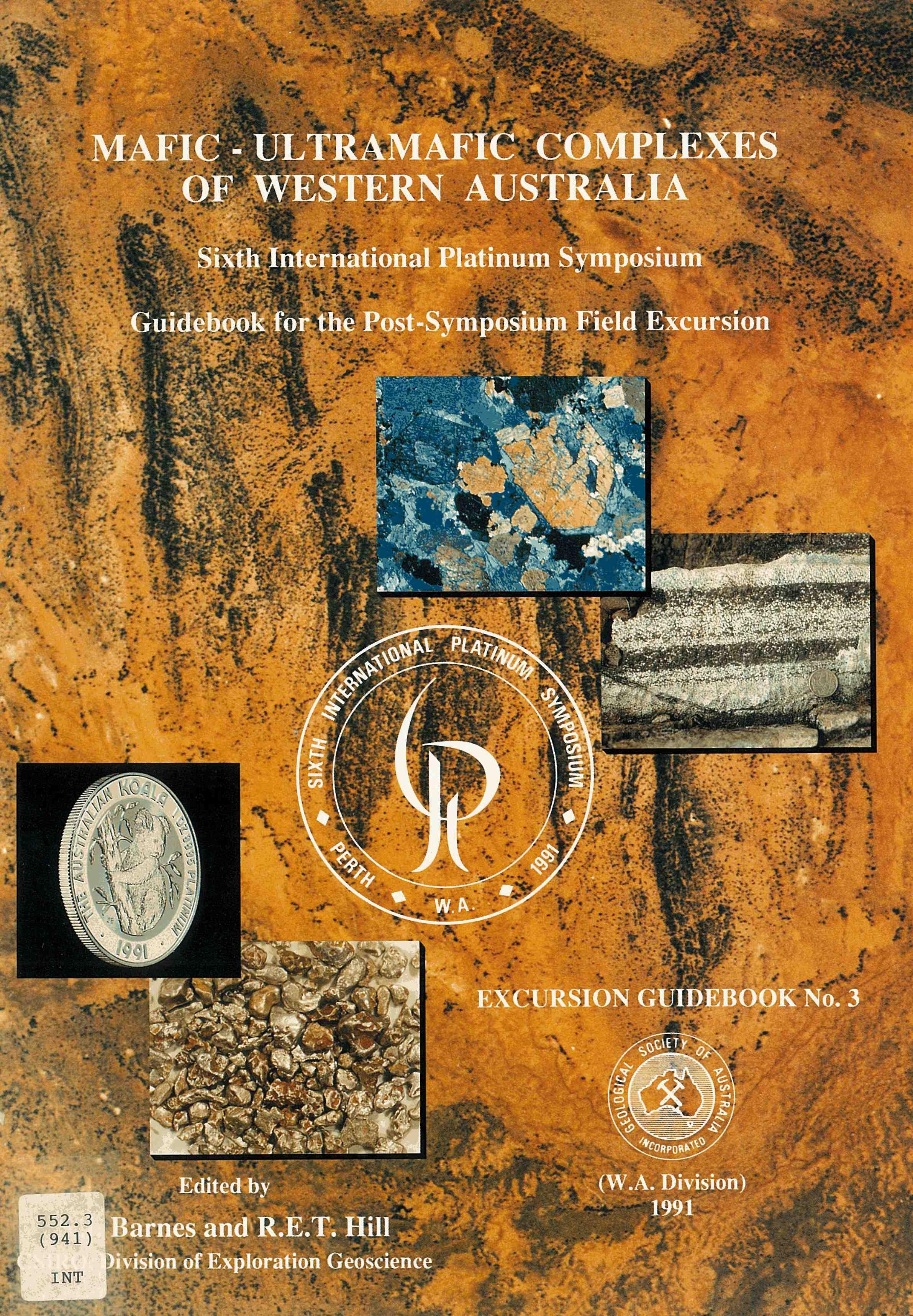
FRONT COVER
BACKGROUND
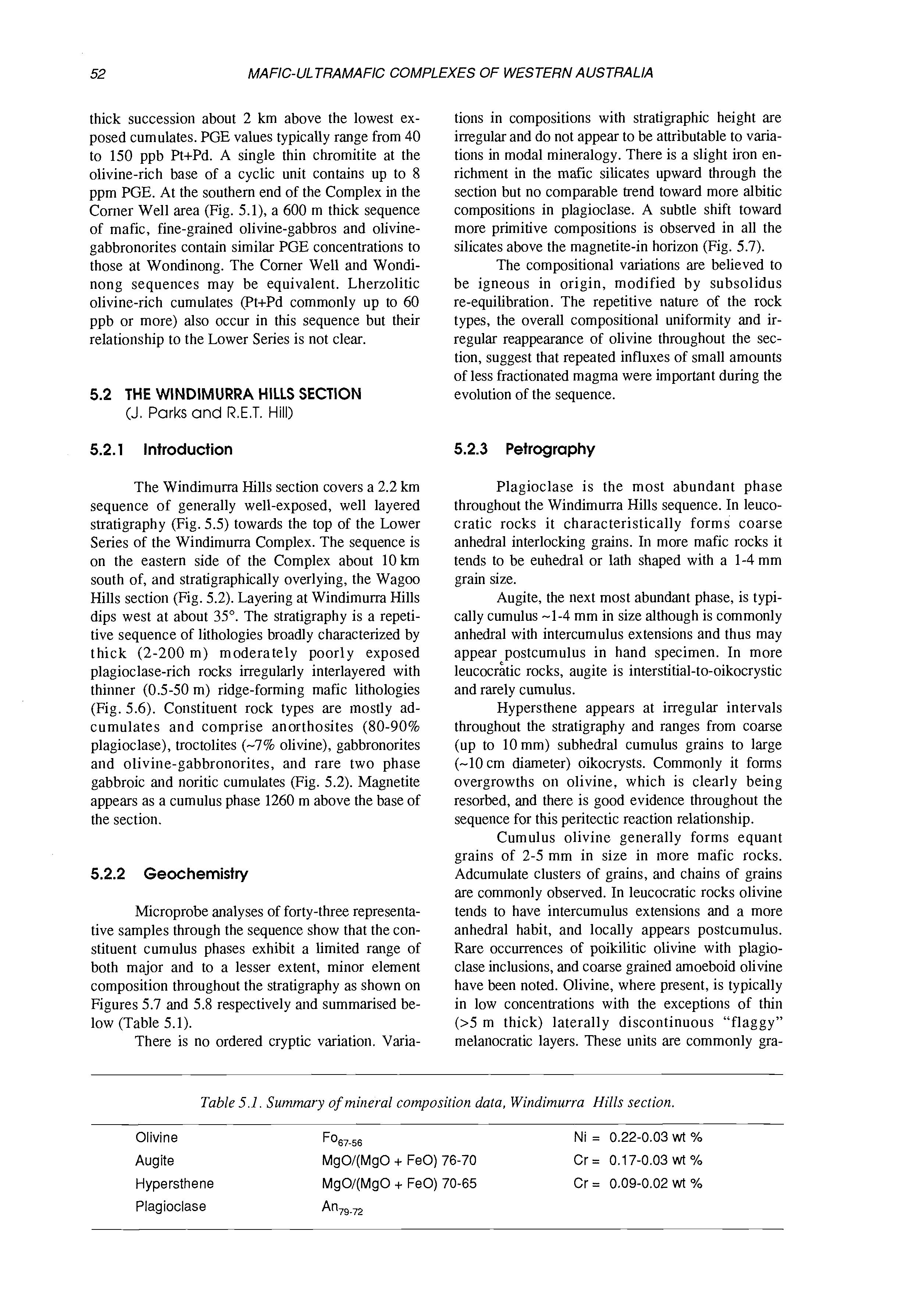
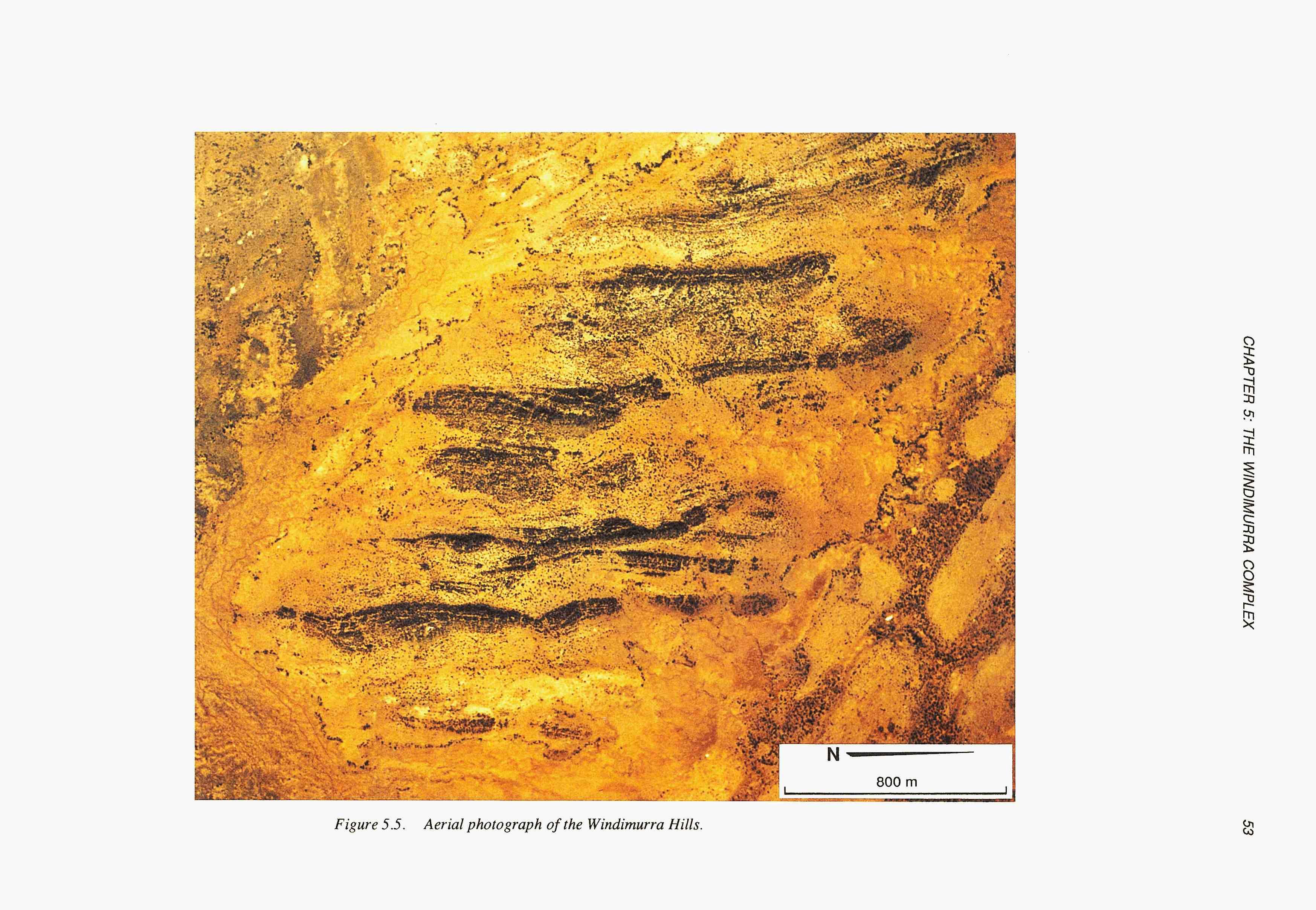
Aerial photograph of the Windimurra Hills region of the Windimurra Layered Gabbroic Complex, Western Australia, showing about 2 km of stratigraphy.
INSETS (clockwise from top right)
- Hand specimen showing layering (chromite - black; altered olivine - white) from the Fanton Sill, Western
- Thin section of mineralized websterite, Munni Munni Layered Mafic-Ultramafic Intrusion, Western Australia.
- Platinum nuggets from Fifield, New South Wales (size about 1 mm).
- The Australian Koala, Gold Corporation, Perth, Western Australia. Australia. Width of view 1.5 cm (crossed nicols).
This volume is an official Excursion Guidebook for the 6th International Platinum Symposium, Perth, Western Australia, July 1991. The International Platinum Symposium is held under the auspices of the International Association for the Genesis of Ore Deposits (IAGOD) by the Commission on Ore Deposits in Mafic and Ultramafic Rocks (CODMUR).
The purpose of the symposium is to bring together international scientists working on aspects of the genesis, exploration, exploitation and beneficiation of platinum group metal deposits, to discuss current research and present new concepts relevant to the field. Of specific importance is the opportunity for delegates to visit locations of important platinum mines and prospects in the host nation in conjunction with the symposium. These symposia foster good will and collaboration, between scientists and institutes from different participating countries. They not only enhance international cooperation, but provide the continuity necessary for long-term research success.
The Australian working groups of CODMUR are proud to present this volume as Number 3 of a series of Guidebooks published by the Western Australian Division of the Geological Society of Australia. The Organizing Committee for the 6th International Platinum Symposium thank this Division for underwriting the printing costs of the publication.
The Organizing Committee extends appreciation to all authors who contributed to the volume, to their representative Companies for releasing data, to those Companies who sponsored research on certain areas, and to those Companies who gave access to locations visited during the excursion.
Robin E.T. Hill Chairman 6th
International Platinum Symposium
ACKNOWLEDGEMENTS
We wish to thank Colin Steel, Keny Cheesewright and Angelo Vartesi for drafting, and Cheryl Harris for assistance with manuscript preparation.
S.J. Barnes and R.E.T. Hill, Editors
A.L. Ahmat
Geological Survey of Western Australia, Perth
S.J. Barnes
CSIRO Division of Exploration Geoscience, Perth
J.A. Bunting
Geopeko Exploration, Perth
I.H. Campbell
Research School of Earth Sciences, Australian National University, Canberra
M. Elias
Western Mining Corporation, Perth
M.J. Gole
M.J. Gole and Associates, Perth
R.E.T. Hill
CSIRO Division of Exploration Geoscience, Perth
D.M. Hoatson
Bureau of Mineral Resources, Geology and Geophysics, Canberra
D.R. Hudson
CSIRO Division of Exploration Ceoscience, Perth
C.I. Mathison
Key Centre in Strategic Mineral Deposits, The University of Western Australia, Perth
J.R. McIntyre
Hunter Resources Ltd., Perth
J. Parks
Perth
R.J. Perring
Pancontinental Mining, Perth
J.R. Vogt
Pancontinental Mining, Perth
W.K. Witt
Geological Survey of Western Australia, Kalgoorlie
SPONSORS
The Organizing Committee of the Sixth International Platinum Symposium expresses sincere appreciation to the following sponsors:
Ansett Airlines of Australia
Australian Federal Government, Department of Industry, Trade and Commerce
CSIRO
Delta Gold N.L.
Geological Society of Australia, Federal Committee and W.A. Branch
Gold Corporation
Helix Resources N.L.
Hendry Rae and Court
Hunter Resources Ltd
Jane Brook Estate Wines
Johnson Matthey
Lachlan Resources N.L.
Ord Partners
Parker and Parker
Pancontinental Mining Ltd
QANTAS
Society of Economic Geologists
CONTENTS
CHAPTER 1
LAYERED MAFIC-ULTRAMAFIC COMPLEXES OF WESTERN AUSTRALIA: INTRODUCTION
1.1 1.2 1.3
MAFIC-ULTRAMAFIC COMPLEXES IN THE YILGARN BLOCK
NIAFIC-ULTRAMAFIC INTRUSIONS OF THE WEST PILBARA BLOCK
MAFIC-ULTRAMAFIC INTRUSIONS OF THE EAST KIMBERLEY REGION
CHAPTER 2
THE JIMBERLANA INTRUSION
2.1 INTRODUCTION
2.2 FIELD LOCATIONS
CHAPTER 3
KOMATIITE-HOSTED NICKEL SULPHIDE DEPOSITS OF THE KAMBALDAWIDGIEMOOLTHA REGION
3.1 AUSTRALIAN PGE PRODUCTION
3.2
GEOLOGICAL SETTING OF THE NICKEL SULPHIDE DEPOSITS
3.3 NICKEL SULPHIDE ORES
3.4
3.5
PLATINUM METALS IN THE KAMBALDA NICKEL DEPOSITS
GEOLOGY OF THE DORDIE ROCKS LOCALITY
CHAPTER 4
LAYERED MAFIC-ULTRAMAFIC COMPLEXES OF THE NORSEMAN-WILUNA
GREENSTONE BELT
4.1 INTRODUCTION
4.2 THE MOUNT THIRSTY SILL
4.3 THE ORA BANDA SILL
4.4 LAYERED KOMATllTlC ROCKS AT KURRAJONG
CHAPTER 5
THE WINDIMURRA COMPLEX
5.1
OVERVIEW OF THE WlNDlMURRA COMPLEX
5.2 THE WlNDlMURRA HILLS SECTION
5.3 THE WAG00 HILLS SECTION
5.4 THE WONDINONG-MULLYUBRAYA SECTION
CHAPTER 6
THE MUNNI MUNNI COMPLEX
6.1 INTRODUCTION
6.2 STRUCTURE AND GEOMETRY
6.3 STRATIGRAPHY
6.4 FIELD TRIP LOCALITIES
CHAPTER 7
THE PANTON SILL
7.1 INTRODUCTION
7.2 STRATIGRAPHY AND MINERALOGY
7.3 PGE-BEARING CHROMlTlTE MINERALIZATION
7.4
INTERPRETATION OF THE ULTRAMAFIC SERIES
7.5 FIELD LOCATIONS
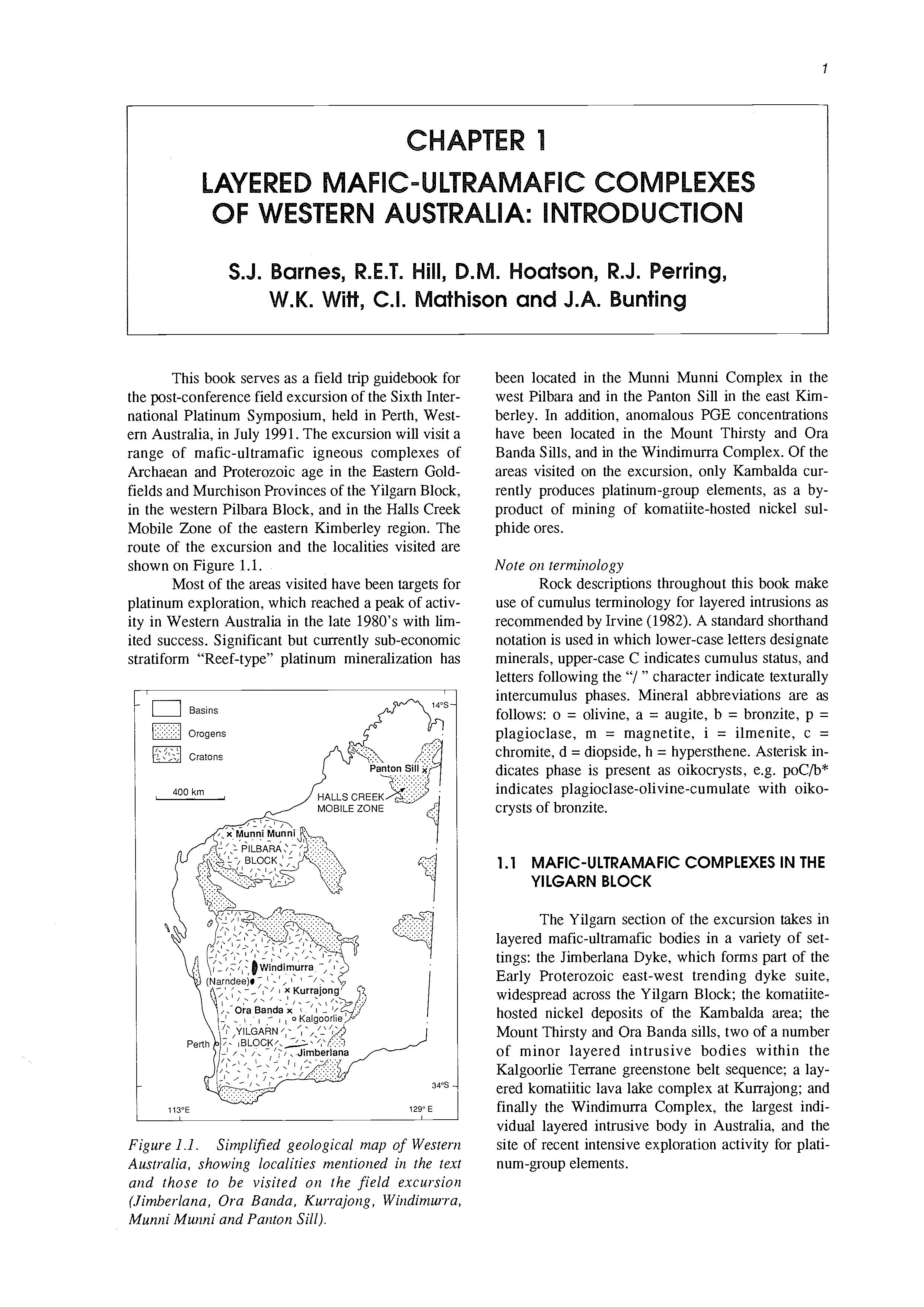
This book serves as a field trip guidebook for the post-conference field excursion of the Sixth International Platinum Symposium, held in Perth, Westem Australia, in July 1991. The excursion will visit a range of mafic-ultramafic igneous complexes of Archaean and Proterozoic age in the Eastern Goldfields and Murchison Provinces of the Yilgarn Block, in the western Pilbara Block, and in the Halls Creek Mobile Zone of the eastern Kimberley region. The route of the excursion and the localities visited are shown on Figure 1.1.
Most of the areas visited have been targets for platinum exploration, which reached a peak of activity in Western Australia in the late 1980’s with limited success. Significant but currently sub-economic stratiform “Reef-type’’ platinum mineralization has
Figure 1 .I. Simplified geological map of Western Australia, showing localities mentioned in the text and those to be visited on the field excursion (Jimberlana, Ora Banda, Kurrajong, Windimurra, Munni Munni and Panton Sill}.
been located in the Munni Munni Complex in the west Pilbara and in the Panton Sill in the east Kimberley. In addition, anomalous PGE concentrations have been located in the Mount Thirsty and Ora Banda Sills, and in the Windimurra Complex. Of the areas visited on the excursion, only Kambalda currently produces platinum-group elements, as a byproduct of mining of komatiite-hosted nickel sulphide ores.
Note on terminology
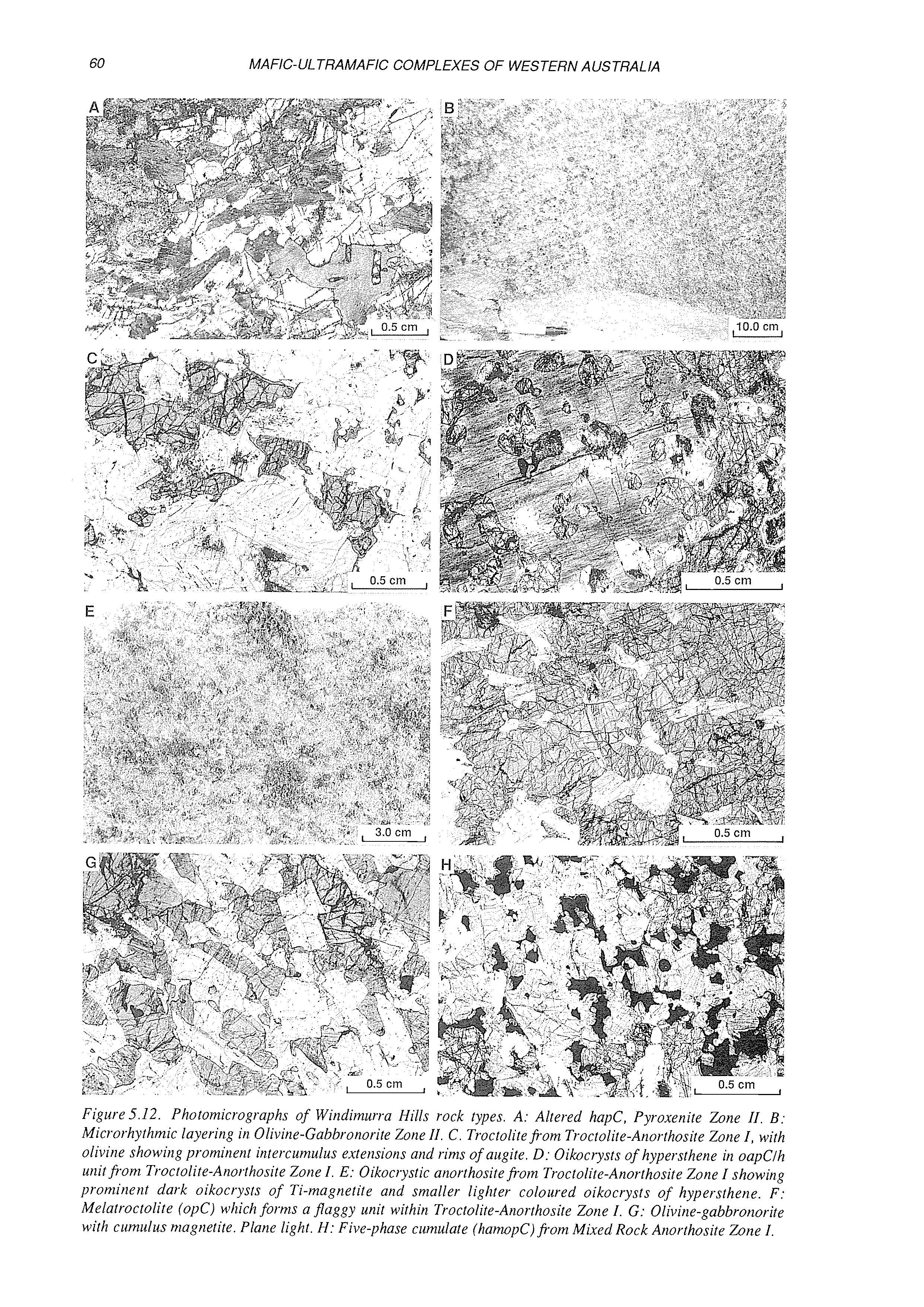
Rock descriptions throughout this book make use of cumulus terminology for layered intrusions as recommended by Irvine (1982). A standard shorthand notation is used in which lower-case letters designate minerals, upper-case C indicates cumulus status, and letters following the “/ ” character indicate texturally intercumulus phases. Mineral abbreviations are as follows: o = olivine, a = augite, b = bronzite, p = plagioclase, m = magnetite, i = ilmenite, c = chromite, d = diopside, h = hypersthene. Asterisk indicates phase is present as oikocrysts, e.g. poC/b* indicates plagioclase-olivine-cumulate with oikocrysts of bronzite.
1.1 MAFIC-ULTRAMAFIC COMPLEXES IN THE YILGARN BLOCK
The Yilgarn section of the excursion takes in layered mafic-ultramafic bodies in a variety of settings: the Jimberlana Dyke, which forms part of the Early Proterozoic east-west trending dyke suite, widespread across the Yilgarn Block; the komatiitehosted nickel deposits of the Kambalda area: the Mount Thirsty and Ora Banda sills, two of a number of minor layered intrusive bodies within the Kalgoorlie Terrane greenstone belt sequence: a layered komatiitic lava lake complex at Kurrajong; and finally the Windimuna Complex, the largest individual layered intrusive body in Australia, and the site of recent intensive exploration activity for platinum-group elements.
1.1.1 Post-cratonizationmafic and ultramafic dykes of the Yilgarn Block (R.E.T. Hill)
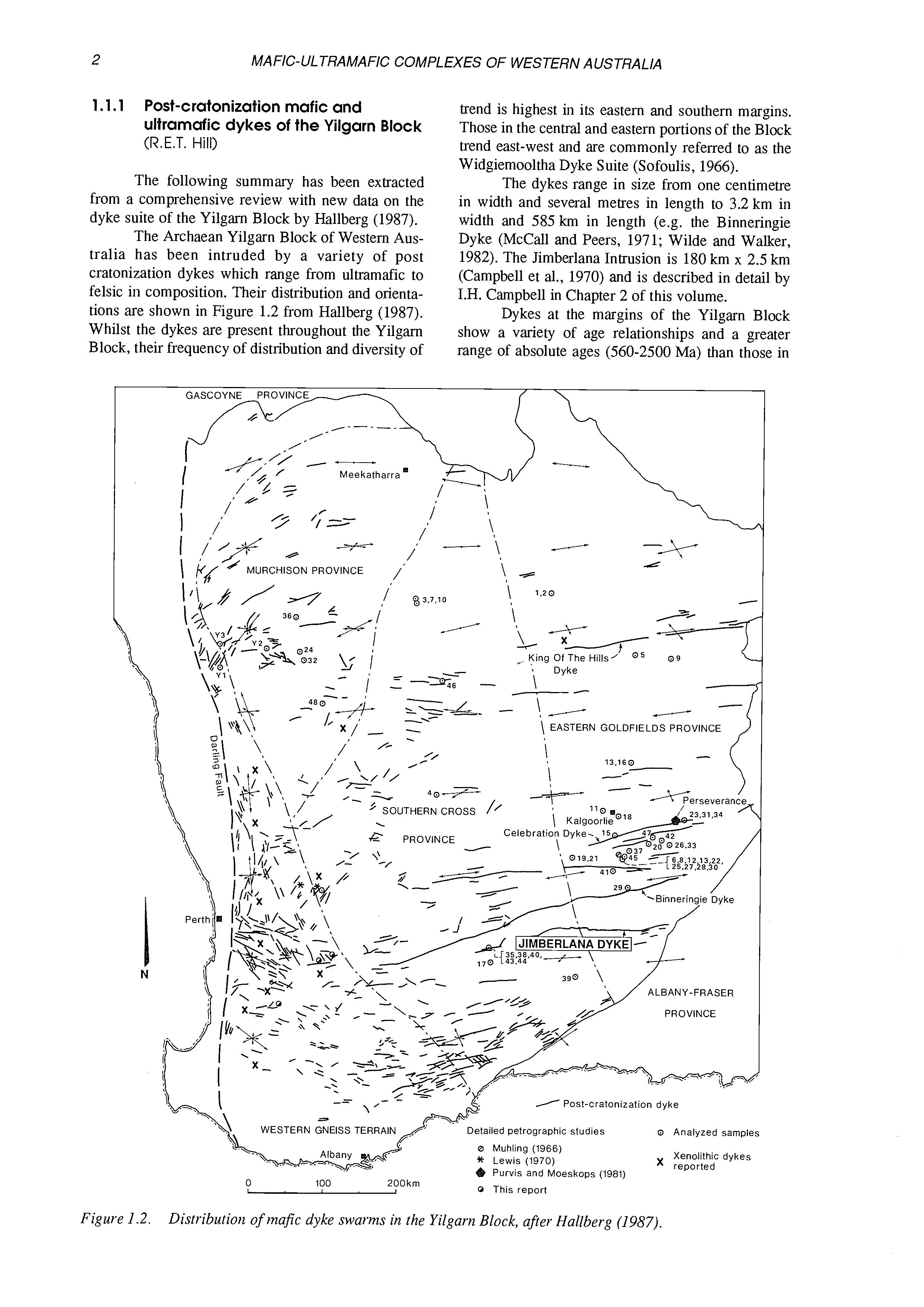
The following summary has been extracted from a comprehensive review with new data on the dyke suite of the Yilgam Block by Hallberg (1987). The Archaean Yilgarn Block of Western Australia has been intruded by a variety of post cratonization dykes which range from ultramafic to felsic in composition. Their distribution and orientations are shown in Figure 1.2 from Hallberg (1987). Whilst the dykes are present throughout the Yilgam Block, their frequency of distribution and diversity of
trend is highest in its eastern and southern margins. Those in the central and eastern portions of the Block trend east-west and are commonly referred to as the Widgiemooltha Dyke Suite (Sofoulis, 1966).
The dykes range in size from one centimetre in width and several metres in length to 3.2 km in width and 585 km in length (e.g. the Binneringie Dyke (McCall and Peers, 1971; Wilde and Walker, 1982). The Jimberlana Intrusion is 180 km x 2.5 km (Campbell et al., 1970) and is described in detail by I.H. Campbell in Chapter 2 of this volume.
Dykes at the margins of the Yilgarn Block show a variety of age relationships and a greater range of absolute ages (560-2500 Ma) than those in
Figure 1.2. Distribution of mafic dyke swarms in the Yilgarn Block, afer Hallberg (1987).
WESTERN GNEISS TERRAIN
the Central Yilgarn Block. They seldom exhibit cross-cutting relationships and are believed to have been emplaced in a more restricted time interval during the late Archaean and Early Proterozoic.
Two broad petrographic processes are recognized within the post cratonization dyke suite - a central province dominated by picrite and olivine dolerite/gabbro, and a marginal province containing olivine-free dolerite/gabbro.
1.1.2 Layered mafic-ultramafic sills in the Eastern Goldfields Province (W.K. Witt)
Layered and differentiated mafic-ultramafic sills form an important component of greenstone sequences in the Archaean Eastern Goldfields Prov-
Table 1 .I. Archaean
1. Sills with a high-Mg bulk composition (> 10% MgO)
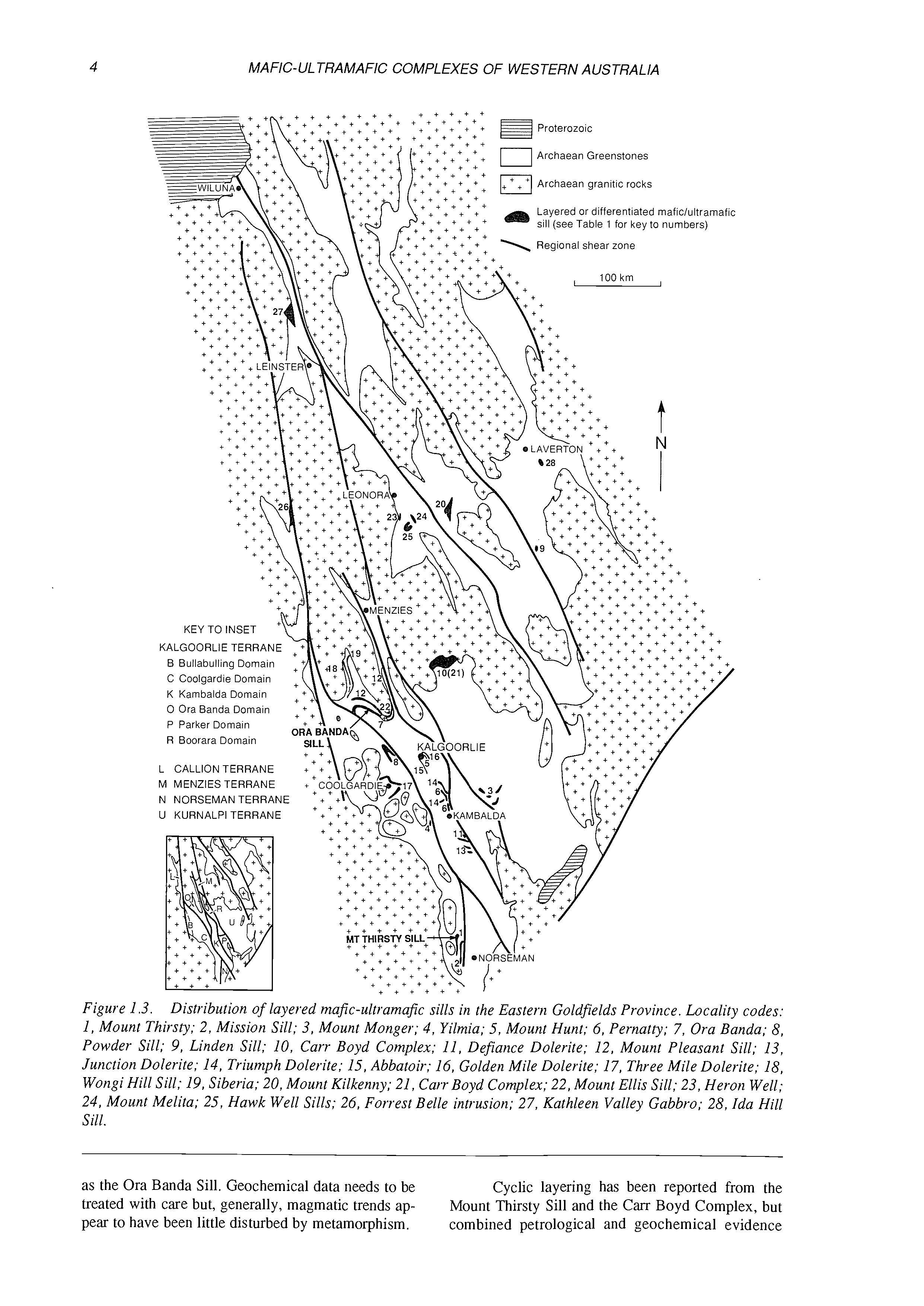
ince. Some of the more important Archaean maficultramafic sills in the Eastern Goldfields are listed in Table 1.1, and their locations are shown in Figure 1.3. Bulk compositions define a similar range to that of volcanic rocks, from high-Mg basalt to high-Fe tholeiite. Three distinct categories of layered complexes are recognized, on the basis of their bulk composition (Table 1.1), internal stratigraphy and inferred parent magma composition: a high-Mg basaltparented group, a group of tholeiitic sills, and a third category of plagioclase-rich intrusions with abundant anorthositic rocks. All sills have undergone greenschist facies, or higher, regional metamorphism, and original mineralogy must commonly be interpreted. Interpretation is assisted by widespread preservation of igneous textures and, in some samples, relic mineralogy. Rarely, pristine igneous mineralogy is preserved in adcumulate zones of thick intrusives such
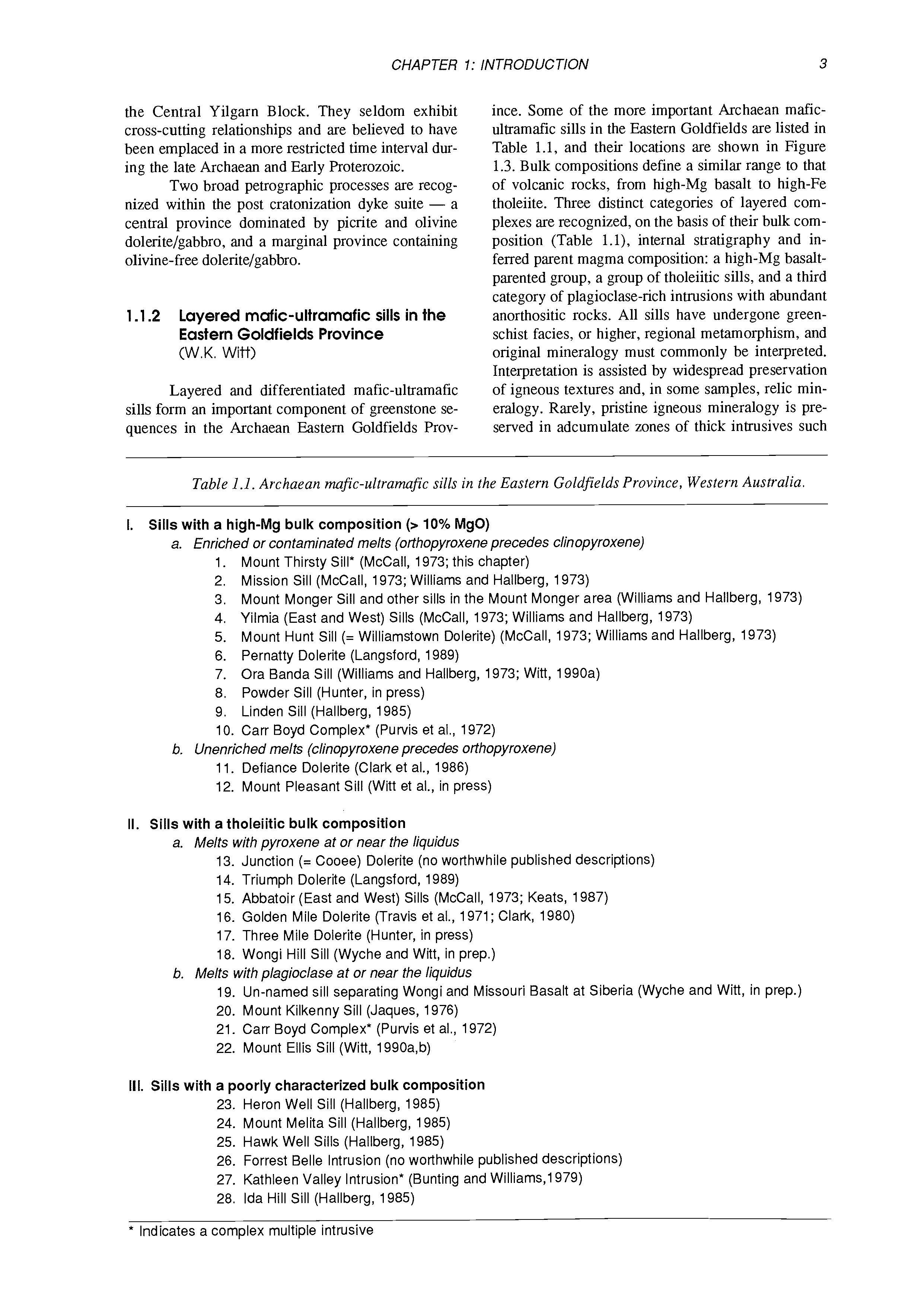
a. Enriched or contaminated melts (orthopyroxene precedes clinopyroxene)
1. Mount Thirsty Sill* (McCall, 1973; this chapter)
2. Mission Sill (McCall, 1973; Williams and Hallberg, 1973)
3. Mount Monger Sill and other sills in the Mount Monger area (Williams and Hallberg, 1973)
4. Yilmia (East and West) Sills (McCall, 1973; Williams and Hallberg, 1973)
5. Mount Hunt Sill (= Williamstown Dolerite) (McCall, 1973; Williams and Hallberg, 1973)
6. Pernatty Dolerite (Langsford, 1989)
7. Ora Banda Sill (Williams and Hallberg, 1973; Witt, 1990a)
8. Powder Sill (Hunter, in press)
9. Linden Sill (Hallberg, 1985)
10. Carr Boyd Complex* (Purvis et al., 1972)
b. Unenriched melts (clinopyroxeneprecedes orthopyroxene)
11. Defiance Dolerite (Clark et al., 1986)
12. Mount Pleasant Sill (Witt et al., in press)
II. Sills with a tholeiitic bulk composition
a. Melts with pyroxene at or near the liquidus
13. Junction (= Cooee) Dolerite (no worthwhile published descriptions)
14. Triumph Dolerite (Langsford, 1989)
15. Abbatoir (East and West) Sills (McCall, 1973; Keats, 1987)
16. Golden Mile Dolerite (Travis et al., 1971; Clark, 1980)
17. Three Mile Dolerite (Hunter, in press)
18. Wongi Hill Sill (Wyche and Witt, in prep.)
b. Melts with plagioclase at or near the liquidus
19. Un-named sill separating Wongi and Missouri Basalt at Siberia (Wyche and Witt, in prep.)
20. Mount Kilkenny Sill (Jaques, 1976)
21. Carr Boyd Complex* (Purvis et al., 1972)
22. Mount Ellis Sill (Witt, 1990a,b)
111. Sills with a poorly characterized bulk composition
23. Heron Well Sill (Hallberg, 1985)
24. Mount Melita Sill (Hallberg, 1985)
25. Hawk Well Sills (Hallberg, 1985)
26. Forrest Belle Intrusion (no worthwhile published descriptions)
27. Kathleen Valley Intrusion* (Bunting and Williams,l979)
28. Ida Hill Sill (Hallberg, 1985)
* Indicates a complex multiple intrusive
mufic-ultramafic sills in the Eastern Goldfields Province, Western Australia.
Figure 1.3. Distribution of layered majic-ultramafic sills in the Eastern Goldfields Province. Locality codes: 1, Mount Thirsty; 2, Mission Sill; 3, Mount Monger; 4, Yilmia; 5, Mount Hunt; 6, Pernatty; 7, Ora Banda; 8, Powder Sill; 9, Linden Sill; 10, Carr Boyd Complex; 11, Defiance Dolerite; 12, Mount Pleasant Sill; 13, Junction Dolerite; 14, Triumph Dolerite; 15, Abbatoir; 16, Golden Mile Dolerite; 17, Three Mile Dolerite; 18, Wongi Hill Sill; 19, Siberia; 20, Mount Kilkenny; 21, Carr Boyd Complex; 22, Mount Ellis Sill; 23, Heron Well; 24, Mount Melita; 25, Hawk Well Sills; 26, Forrest Belle intrusion; 27, Kathleen Valley Gabbro; 28, Ida Hill Sill.
as the Ora Banda Sill. Geochemical data needs to be treated with care but, generally, magmatic trends appear to have been little disturbed by metamorphism.
Cyclic layering has been reported from the Mount Thirsty Sill and the Carr Boyd Complex, but combined petrological and geochemical evidence
suggest that most sills crystallized in-situ from a single batch of magma. Evidence includes smooth mineral and whole-rock geochemical trends which lack reversals to more primitive compositions, and broad agreement between analyses of relatively unfractionated marginal zones and calculated bulk composition. All sills are characterised by bottom-dominated crystallization. Most also crystallize more slowly from the roof downwards to yield a most fractionated zone in the upper half of the intrusion. The “Stillwater-type” sills, however, appear to crystallize from the bottom upwards with little or no crystallization near the roof until the latest stages of solidification. This may be due to partial melting of roof rocks by the hotter, more magnesian magmas. A light, silica-rich layer, ponded beneath the roof of the sill, would inhibit crystallization (Turner and Campbell, 1986; Campbell and Turner, 1987). More detailed discussion of the diversity of the Eastern Goldfields mafic-ultramafic complexes is given in Chapter 4 of this volume.
1.1.3 Komatiites and related maficultramafic bodies in the Eastern Goldfields Province (R.E.T. Hill)
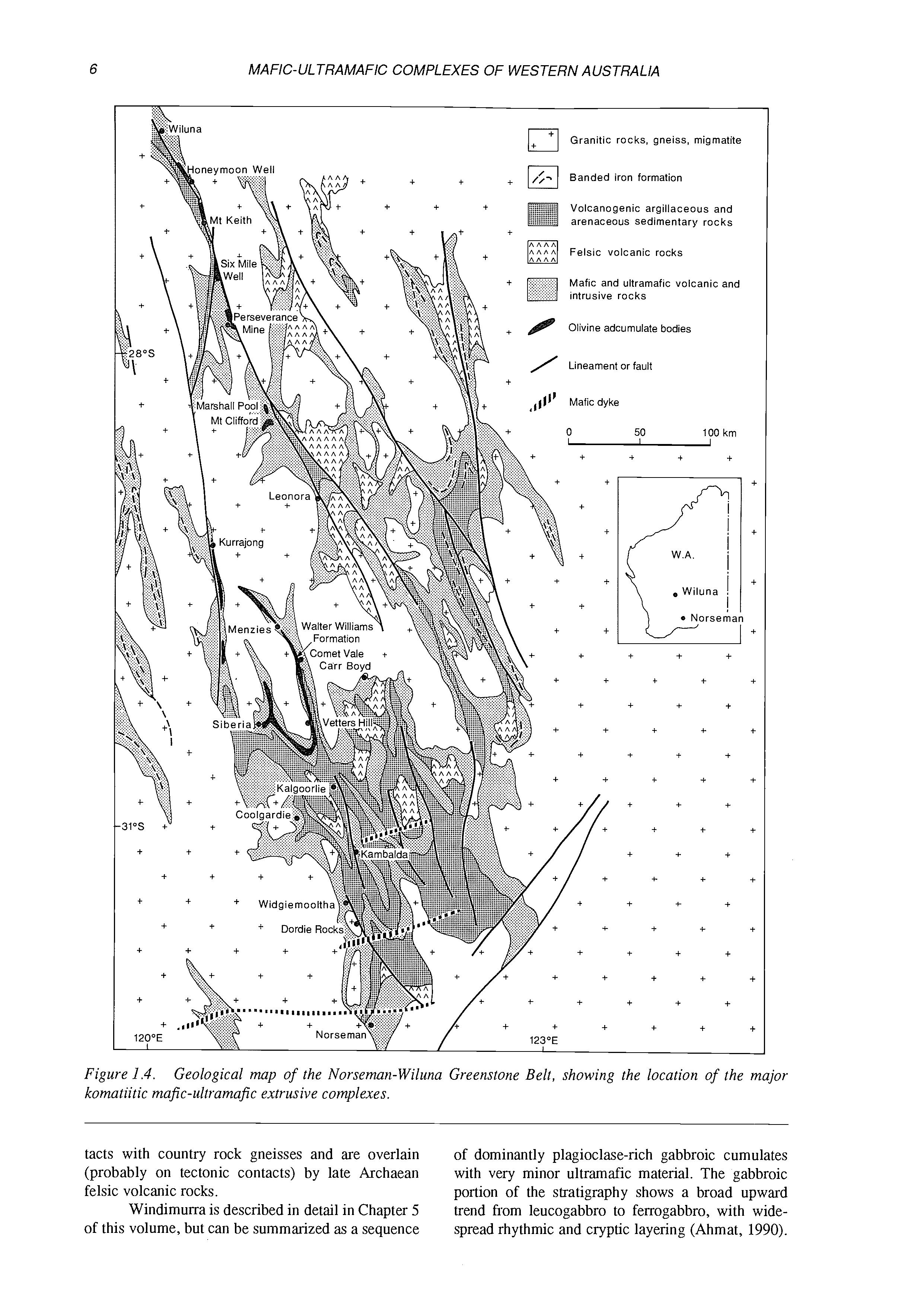
The Norseman-Wiluna Greenstone Belt contains enormous volumes of komatiitic volcanic rocks (Fig. 1.4). A large body of data is now available on the field relationships, petrology and geochemistry of these rocks, mainly arising from exploration activity directed towards their associated nickel sulphide deposits.
A spectrum of styles of komatiite volcanism occurs in the southern, central, and northern regions of the Norseman-Wiluna Greenstone Belt. A number of volcanic regimes are represented: thin compound flow environments, flow channels and terrestrial rilles, massive sheet flows and lava lakes (Hill et al., 1989, 1990). South of Kalgoorlie, in the KambaldaWidgiemooltha region, the komatiite stratigraphy contains thin differentiated flows separated by interflow sedimentary units. The differentiated flows exhibit internal textural features similar to those of the classic komatiite locality of Munro Township in Canada. Within the komatiite sequences, complex thick flows occupy narrow zones which were the loci of focussed lava flow and are associated with economic basal accumulations of massive and disseminated nickel sulphides from which come all of Australia’s present PGE production.
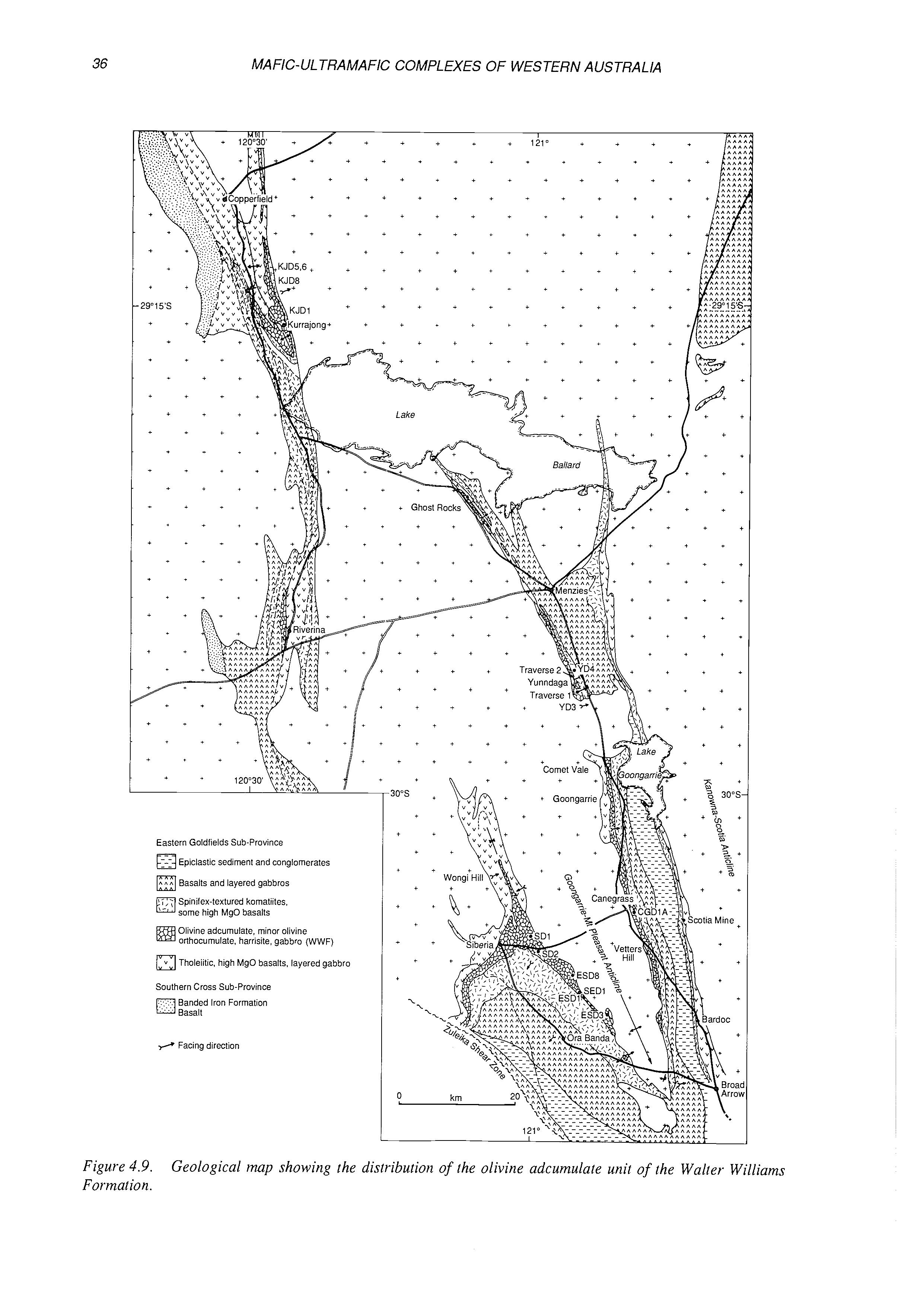
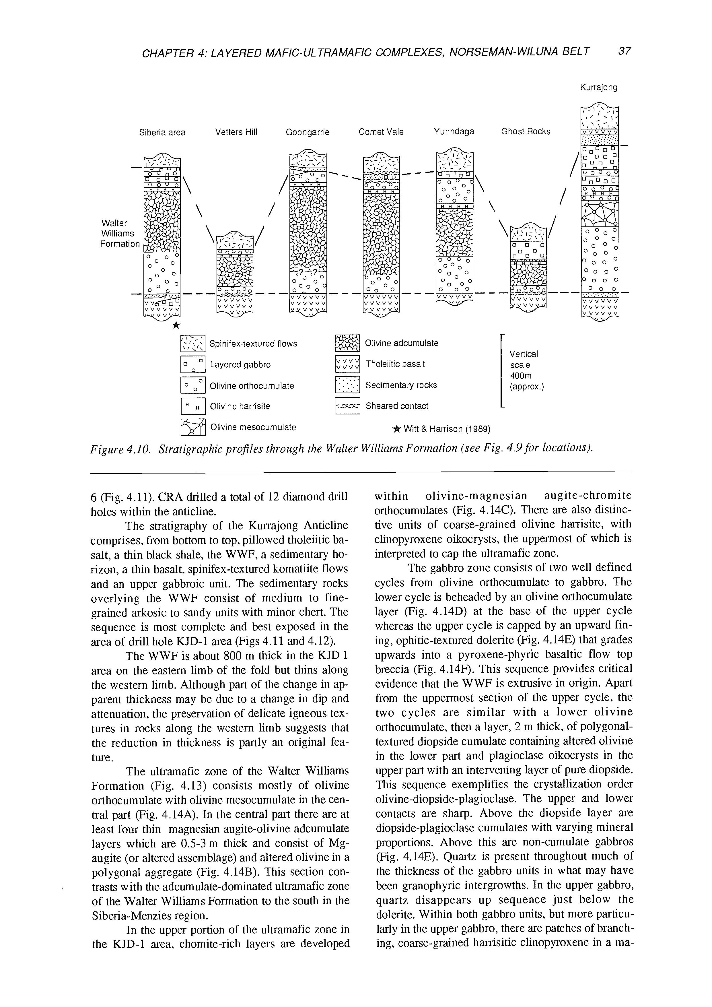
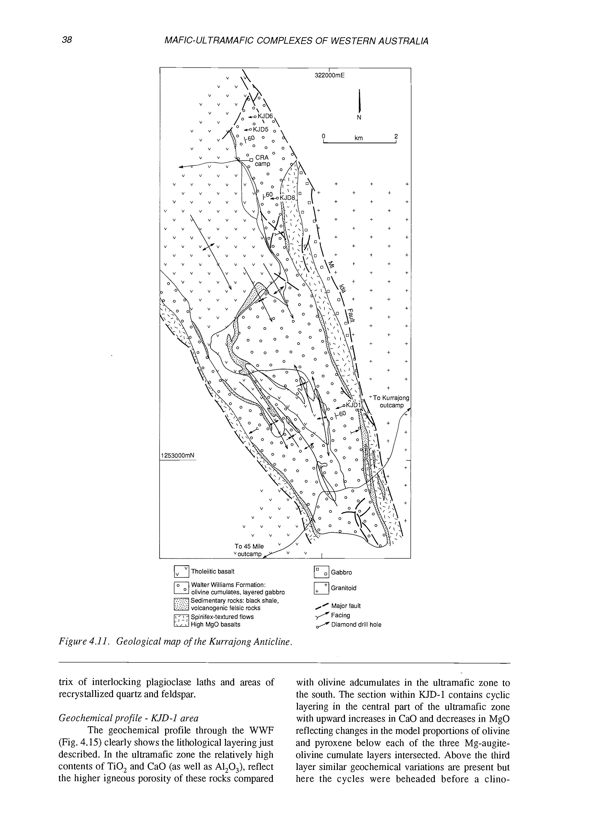
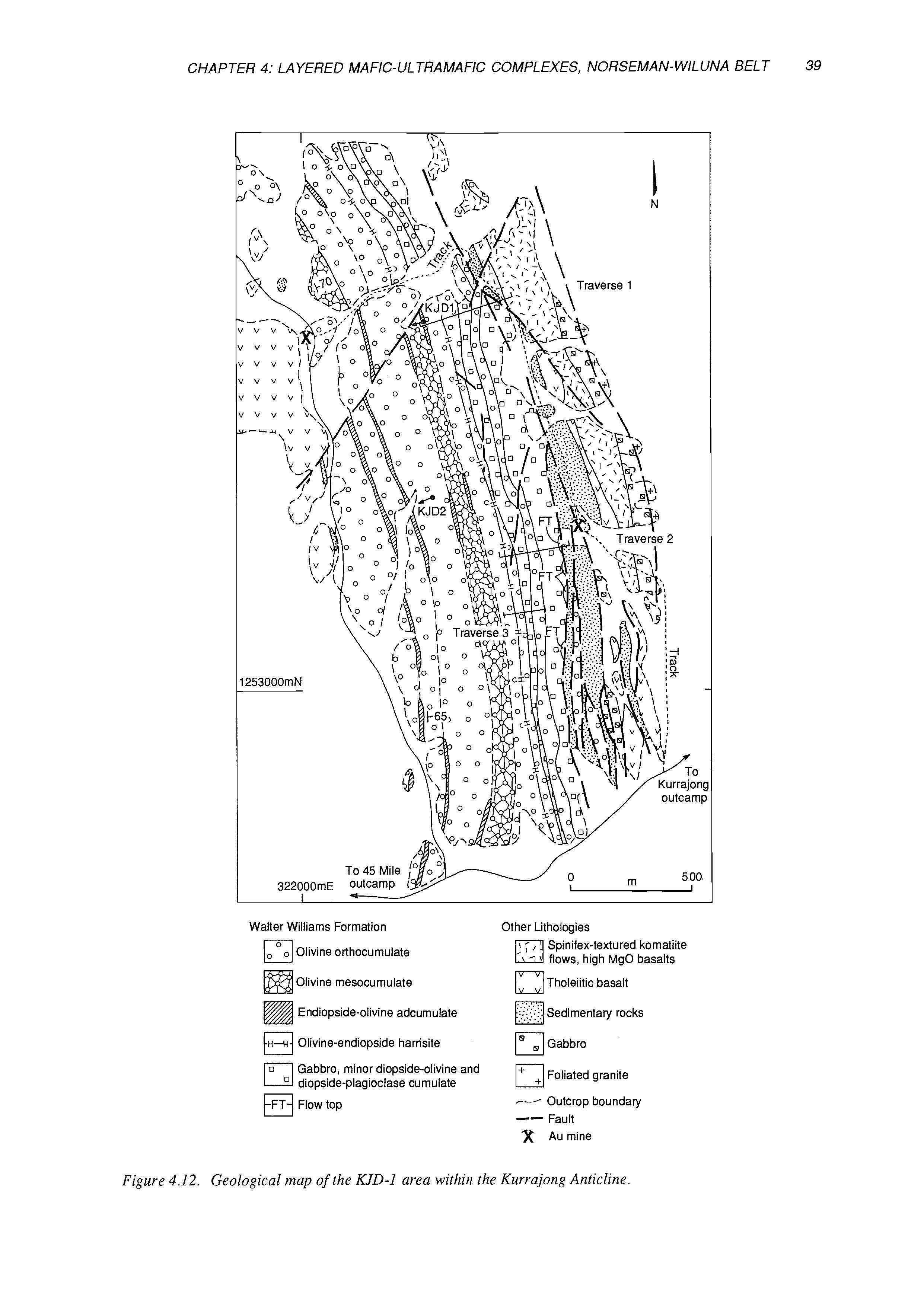
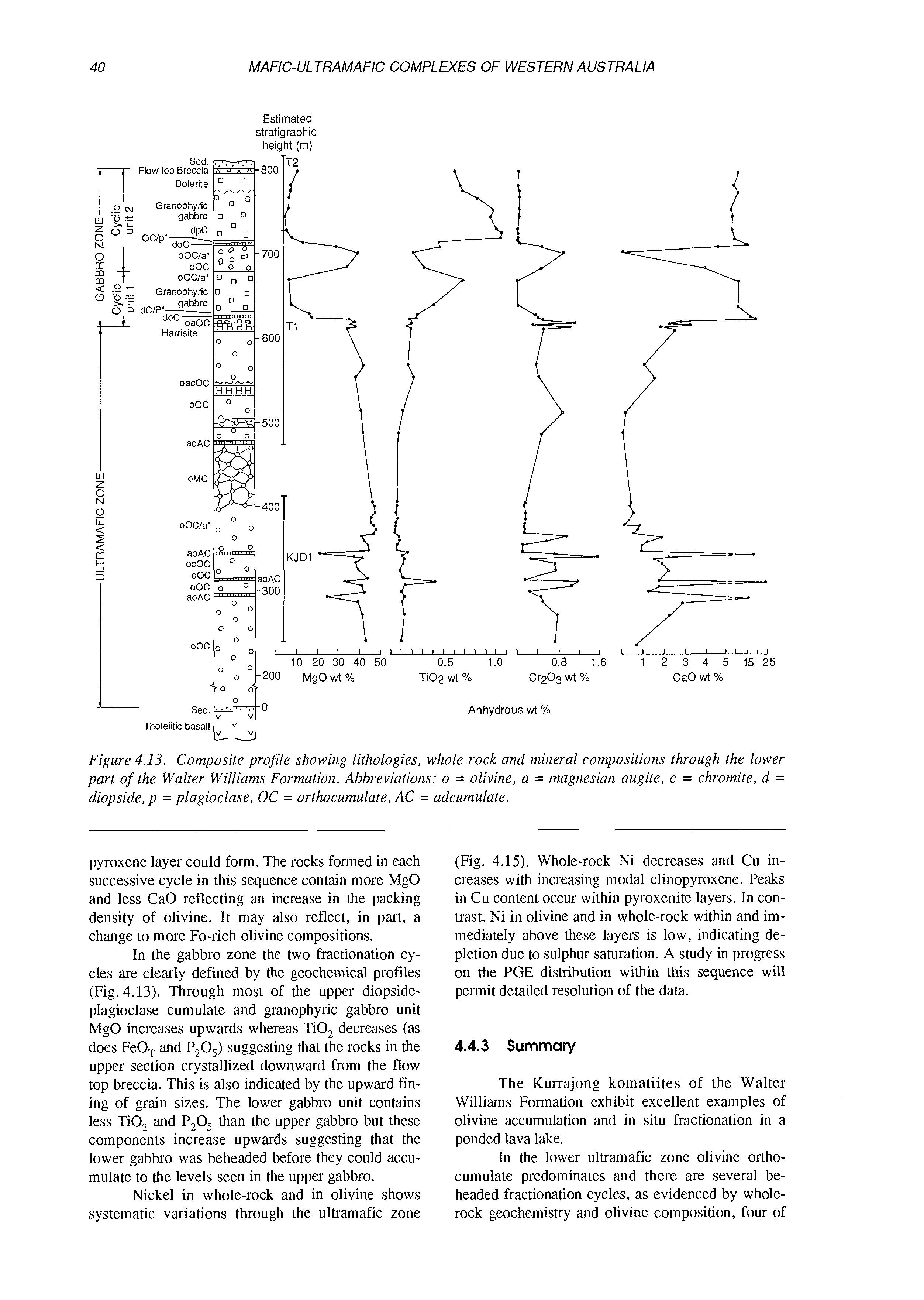
In the central part of the belt, between Siberia and Kurrajong (Fig. 1.4), an extensive (35 x 150 km) unit predominantly composed of layered, coarsegrained olivine adcumulate occupies the basal portion of the komatiite stratigraphy. This unit, the Walter Williams Formation, also includes basal olivine-orthocumulates, thin units of pyroxenite, and
an upper differentiated sequence of lithologies comprising varying proportions of olivine, pyroxene and plagioclase. A layered sequence of differentiated cumulates, interpreted as a lava lake facies of the Walter Williams Formation, is exposed at Kurrajong and will be visited on the excursion. Similar lithological distributions are present in the Mount CliffordMarshall Pool area (Fig. 1.4).
The Agnew-Wilma belt forms the northern third of the Norseman-Wiluna Greenstone Belt. It contains regionally correlatable stratigraphic packages of komatiite consisting mainly of thick, massive bodies of olivine orthocumulate and differentiated spinifex-textured flows. Within these packages are several large zones of thickening, lenticular in plan, occupied by bodies of layered coarse grained olivine adcumulates and mesocumulates. In parts of the belt, accumulations of massive nickel sulphide are associated with sequences of thin flows, viz., Rocky’s Reward, Perseverance, and Cliffs-Mount Keith. In contrast, some of the adcumulate bodies host large tonnages of low-grade disseminated nickel sulphide, viz, Mount Keith, Six Mile Well.
The lenticular dunite bodies of the AgnewWiluna Belt, and the sheet-like adcumulate unit of the Walter Williams Formation, are integral parts of the volcanic stratigraphy and are interpreted as extrusive in origin. They formed during cataclysmic eruptions, comparable in scale and volume to the largest flows recorded in continental flood basalt provinces and in the lunar maria. A combination of large volume eruptions and the low viscosity of komatiitic lava resulted in the formation of komatiitic volcanic complexes tens to hundreds of kilometres across, which have great regional significance as laterally extensive stratigraphic marker units. Sequences of differentiated flows as seen in the Kambalda-Widgiemooltha region may represent the distal facies of such complexes.
1.1.4 layered Intrusions in the Murchison district
(S.J. Barnes and C.I. Mathison)
Two major intrusions, the Windimurra and Narndee Complexes, and the smaller and poorly exposed Youanmi and Atley Complexes, occur within the north central part of the Yilgam Block (Fig. 1.1). These intrusions are approximately 2.8 billion years old (Ahmat, 1990; Scowen, pers. comm., 1991), falling within the age range of the older Murchison greenstone sequences to the west. They occupy an intermediate situation between the Murchison and Southern Cross Provinces, and do not clearly belong to either (Ahmat, 1990; Ruddock, 1990).
Windimurra and Namdee are both large intrusions, with surface areas of approximately 2300 km2 and 200 km2 respectively and stratigraphic sequences in excess of 5 km thick. Both have tectonized con-
Granitic rocks, gneiss, migmatite
Volcanogenic argillaceous and arenaceous sedimentary rocks
Felsic volcanic rocks
Mafic and ultramafic volcanic and intrusive rocks
Olivine adcurnulate bodies
Figure 1.4. komatiitic mafic-ultramafic extrusive complexes.
Geological map of the Norseman-Wiluna Greenstone Belt, showing the location of the major
tacts with country rock gneisses and are overlain (probably on tectonic contacts) by late Archaean felsic volcanic rocks.
Windimurra is described in detail in Chapter 5 of this volume, but can be summarized as a sequence
of dominantly plagioclase-rich gabbroic cumulates with very minor ultramafic material. The gabbroic portion of the stratigraphy shows a broad upward trend from leucogabbro to ferrogabbro, with widespread rhythmic and cryptic layering (Ahmat, 1990).
Widgiemoolth
Parks and Hill (1986) have likened it to the upper portions of the Stillwater Complex in terms of cumulus mineralogy and mineral compositions. Cumulus magnetite is abundant in the upper portions, and locally forms massive vanadiferous magnetite seams.
In contrast, Narndee (Ruddock, 1990; Scowen, in prep.) contains a substantial proportion of ultramafic cumulates. The well-exposed southern two-thirds of the intrusion consists of a 6 km thick well-layered sequence containing at least sixteen cyclic units. The units have pyroxenitic or peridotitic bases with gabbroic tops, and are traceable laterally for up to ten km. The northern third of the intrusion is poorly exposed and structurally complex, and consists primarily of cumulate pyroxenite and peridotite with subordinate gabbro. A feature of the intrusion as a whole is the common presence of primary oikocrystic hornblende, indicating a relatively high primary water content in the parent magma. Narndee has been the site of extensive platinum exploration activity by BHP and Hunter Resources Ltd from 1985 to 1989, with no success. The cyclically layered portion of the complex was found to be uniformly very poor in PGE. Concentrations of Pd up to 1 ppm were located within lateritized ultramafic rocks in the northern portion, but in all cases drilling revealed that these anomalous values were related to enrichment of Pd in the lateritic weathering profile. The only
anomalous concentrations of PGE known in fresh rocks are values of less than 500 ppm in thin chromitite seams in the northern portion of the intrusion. Exploration activity has now ceased.
1.2 MAFIC-ULTRAMAFIC INTRUSIONS OF THE WEST PILBARA BLOCK
(D.M. Hoatson and S.J. Barnes)
1.2.1 Introduction
The Pilbara Block is an elongate east-west trending Archaean granite-greenstone terrain covering an area of approximately 60,000 km2. It consists primarily of domal granite batholiths separated by synclinal belts of greenschist to lower amphibolite facies metasedimentary and metavolcanic rocks (Hickman, 1981, 1983). The greenstone belts of the Pilbara are substantially older than those of the Yilgarn Block, dating back to 3500 Ma. The Pilbara Block is unconformably overlain by shallow-dipping, undeformed late Archaean sedimentary and volcanic rocks of the Mount Bruce Supergroup to the south, and by Phanerozoic sediments to the north.
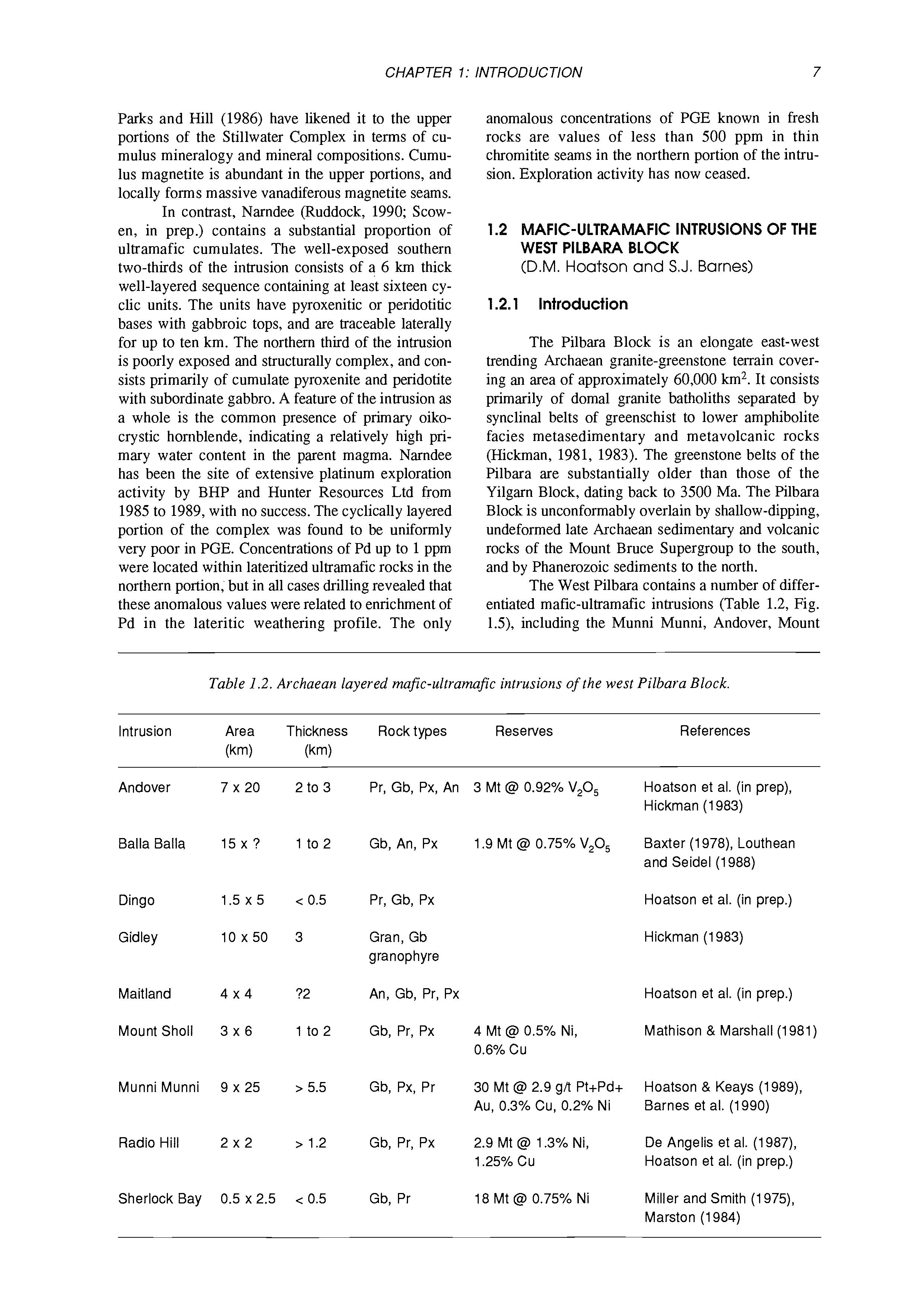
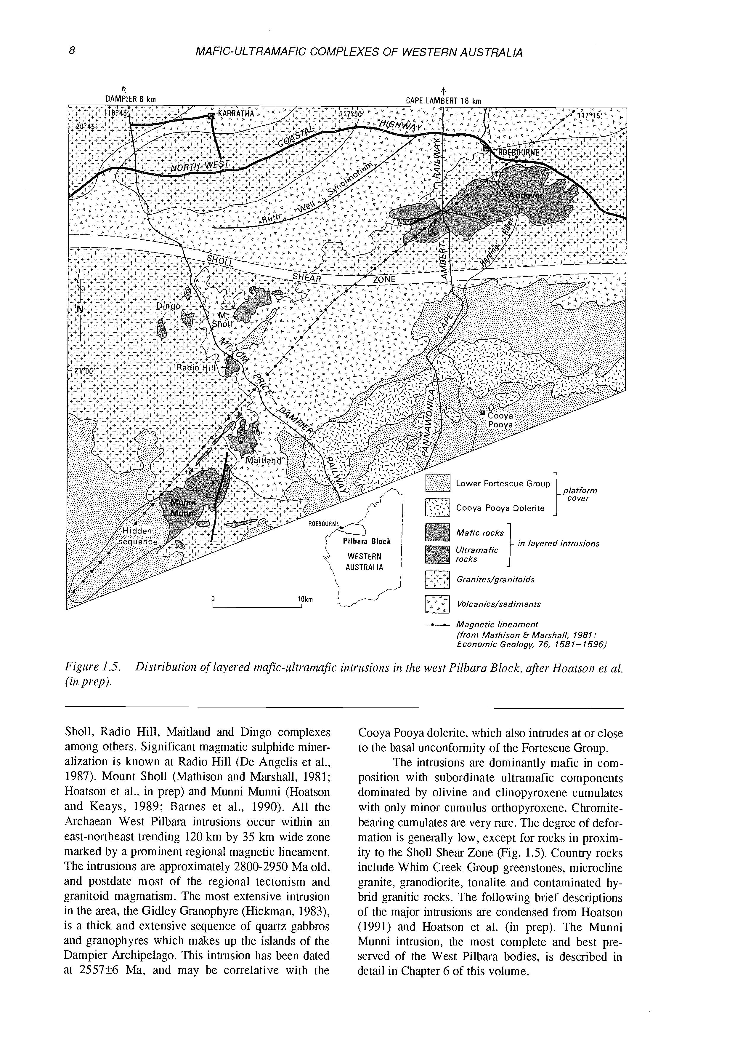
The West Pilbara contains a number of differentiated mafic-ultramafic intrusions (Table 1.2, Fig. lS), including the Munni Munni, Andover, Mount
Table 1.2. Archaean layered mafic-ultramafic intrusions of the west Pilbara Block.
Intrusion Area Thickness Rock types Reserves (km) (krn)
Andover 7 x 20
Balia Balla 15 x ?
Dingo 1.5 x 5
Gidley 10 x 50
Maitland 4x4
Mount Sholl 3 x 6
Munni Munni 9 x 25
Radio Hill 2x2
Sherlock Bay
References
Pr, Gb, Px, An 3 Mt @I 0.92% V,O, Hoatson et al. (in prep), Hickrnan (1983)
Gb, An, Px 1.9 Mt @I 0.75% V,O, Baxter (1978), Louthean and Seidel (1988)
Pr, Gb, Px
Gran, Gb granophyre
An, Gb, Pr, Px
Gb, Pr, Px 4 Mt @ 0.5% Ni, 0.6% Cu
Gb, Px, Pr 30 Mt @ 2.9 g/t Pt+Pd+ Au, 0.3% Cu, 0.2% Ni
Gb, Pr, Px 2.9 Mt @ 1.3% Ni, 1.25% CU
Hoatson et al. (in prep.)
Hickrnan (1983)
Hoatson et al. (in prep.)
Mathison & Marshall (1981)
Hoatson & Keays (1989), Barnes et al. (1990)
De Angelis et al. (1987), Hoatson et al. (in prep.)
Gb, Pr 18 Mt @ 0.75% Ni Miller and Smith (1975), Marston (1984)
-CI Magnetic lineament (from Mathison 8 Marshall, 1981: Economic Geology, 76, 158 1- 1596)
Figure 1.5. (in prep). Distribution of layered mafic-ultramafie intrusions in the west Pilbara Block, after Hoatson et al.
Sholl, Radio Hill, Maitland and Dingo complexes among others. Significant magmatic sulphide mineralization is known at Radio Hill (De Angelis et al., 1987), Mount Sholl (Mathison and Marshall, 1981; Hoatson et al., in prep) and Munni Munni (Hoatson and Keays, 1989; Barnes et al., 1990). All the Archaean West Pilbara intrusions occur within an east-northeast trending 120 km by 35 km wide zone marked by a prominent regional magnetic lineament. The intrusions are approximately 2800-2950 Ma old, and postdate most of the regional tectonism and granitoid magmatism. The most extensive intrusion in the area, the Gidley Granophyre (Hickman, 1983), is a thick and extensive sequence of quartz gabbros and granophyres which makes up the islands of the Dampier Archipelago. This intrusion has been dated at 2557rt6 Ma, and may be correlative with the
Cooya Pooya dolerite, which also intrudes at or close to the basal unconformity of the Fortescue Group. The intrusions are dominantly mafic in composition with subordinate ultramafic components dominated by olivine and clinopyroxene cumulates with only minor cumulus orthopyroxene. Chromitebearing cumulates are very rare. The degree of deformation is generally low, except for rocks in proximity to the Sholl Shear Zone (Fig. 1.5). Country rocks include Whim Creek Group greenstones, microcline granite, granodiorite, tonalite and contaminated hybrid granitic rocks. The following brief descriptions of the major intrusions are condensed from Hoatson (1991) and Hoatson et al. (in prep). The Munni Munni intrusion, the most complete and best preserved of the West Pilbara bodies, is described in detail in Chapter 6 of this volume.
A major distinction within the West Pilbara intrusions is the state of sulphur saturation on emplacement. The smaller intrusions, such as Radio Hill, Mount Sholl and Maitland are sulphur-saturated throughout the stratigraphy and host basal segregations of PGE-poor Ni-Cu sulphides. However, the largest intrusion, the Munni Munni Complex, is in part S-undersaturated, and contains PGE-rich Ni-Cu sulphides at higher stratigraphic levels. The proposed parent magmas for the West Pilbara intrusions are believed to be alumina-poor high-magnesium basalts of Barberton-type komatiite affinity (Hoatson et al., 1990; Sun et al., 1991).
1.2.2 Andover Complex
The Andover Complex occupies an area of about 7 by 20 km, with an aggregate stratigraphic thickness of about 2 to 3 km. Much of the complex is shallow dipping with indistinct layering, and the geometry is poorly understood. There is a north-eastern ultramafic zone with crudely cyclic alternations of peridotite, pyroxenite and gabbro, giving way to a gabbroic zone to the south west. At the western end of the complex there are seventeen discontinuous lenses of vanadiferous titaniferous magnetite lenses up to 200 m long and 2 to 5 m thick, amounting to a total resource of 3 Mt @ 0.92% V,O,. There is extensive intrusion of pegmatite dykes and aplite veins throughout the intrusion.
1.2.3 Maitland Complex
This is a small tectonized 4 by 4 km mafic intrusion 5 km northeast of the Munni Munni Complex. It consists mainly of anorthosite, leucogabbro and quartz gabbro with weakly disseminated sulphides with discordant plug-like bodies of peridotite and pyroxenite in the centre. The intrusion is extensively dislocated by high angle faults, and is intruded by various generations of mafic dykes. The Maitland Complex differs from the other West Pilbara intrusions in having a high proportion of anorthositic rocks, and in the discordant nature of the ultramafic rocks.
1.2.4 The Radio Hill Complex
The Radio Hill Complex is a small 2 by 2 km intrusion consisting of a lower 330 m thick cyclically layered ultramafic zone, overlain by a gabbroic zone at least 870 m thick. The ultramafic zone cornpriscs a 30 rn thick basal gabbroic subzone, overlain by six macrorhythmic cycles of lherzolite, wehrlite, websterite and clinopyroxenite. This grades into a layered sequence of gabbronorite, olivine gabbronorite, gabbro, olivine gabbro and plagioclase
websterite. A steeply-dipping leucogabbro unit, which forms the topographic ridge at Radio Hill, truncates and probably intrudes the upper part of this sequence.
Nickel-copper sulphide mineralization occurs in the basal gabbroic subzone on the northwestern side of the intrusion. This sulphide zone is a shoot about 600 m long by 25 m wide of massive and remobilized stringer ore close to the basal gabbro contact, Finely disseminated sulphides are present throughout the overlying cumulate sequence. Copper concentrates from massive sulphide ore contain 0.4 1 ppm Pt and 5.63 ppm Pd, while nickel concentrates have 0.11 ppm Pt and 1.67 ppm Pd. Reserves are estimated at 2.9 Mt @ 1.29% Ni and 1.25% Cu at 0.8% Cu+Ni cut off grade (De Angelis et al., 1988). AGIP Australia Ltd plan to mine the deposit from late 1991 at 150,000 t/y over seven years.
1.2.5 The Mount Sholl Complex
The Mount Sholl Complex (Hoatson, 1991; Hoatson et al., in prep.) occupies an irregular bowtie-shaped area of about 3 by 6 km, with an exposed thickness of 1 to 2 km. Disseminated and minor massive Ni-Cu sulphides are hosted within a basal gabbroic phase, overlain by pyroxenitic cumulates. Reserves are estimated at 4 Mt @ 0.5% Ni and 0.6% Cu. The Mount Sholl Complex has similar rock types, wispy layering of the gabbroic units, basal setting of Ni-Cu sulphides and stratigraphic thickness to the nearby Radio Hil! Complex. A basaltic komatiite parent magma was inferred by Mathison and Marshall (1981). As with most other West Pilbara intrusions, the Mount Sholl Complex has a northeasterly trend and contains dominantly gabbroic rocks. Ultramafic rocks are restricted to the northern half of the intrusion.
1.2.6 The Dingo Complex
The Dingo Complex comprises a group of small isolated hills of mafic and ultramafic rocks, 6 km west of Mount Sholl, separated by alluvium. Mapping by Hunter Resources of one of these areas (Toorare Pool) suggests that it is an extensively block-faulted shallow-dipping body with similarities to Radio Hill and Mount Sholl, containing minor weakly PGE-enriched disseminated sulphides in irregular gabbroic units.
1.2.7 Summary
While geochronological data are limited, it is likely that the West Pilbara mafic-ultramafic suite described above is a cogenetic, late-Archaean suite of intrusions emplaced along a NE-SW trending crustal
lineament. The intrusions crystallized at upper crustal pressures of less than 5 Kb, under conditions of low water pressure. A slightly younger suite of more easterly-trending dykes, including the Pinderi Hills Dyke, East Munni Munni Dyke and the Zebra Hill Dyke in the Munni Munni area, postdate these intrusions but are themselves unconformably overlain by the basal Fortescue rocks. It is likely that the intrusions of this area record prolonged mafic magmatism during the early phases of development of the major intercratonic rift, now occupied by the Fortescue Group and overlying Proterozoic iron formations.
1.3 MAFIC-ULTRAMAFIC INTRUSIONS OF THE EAST KIMBERLEY REGION
(S.J. Barnes, R.J. Perring and J.A. Bunting)
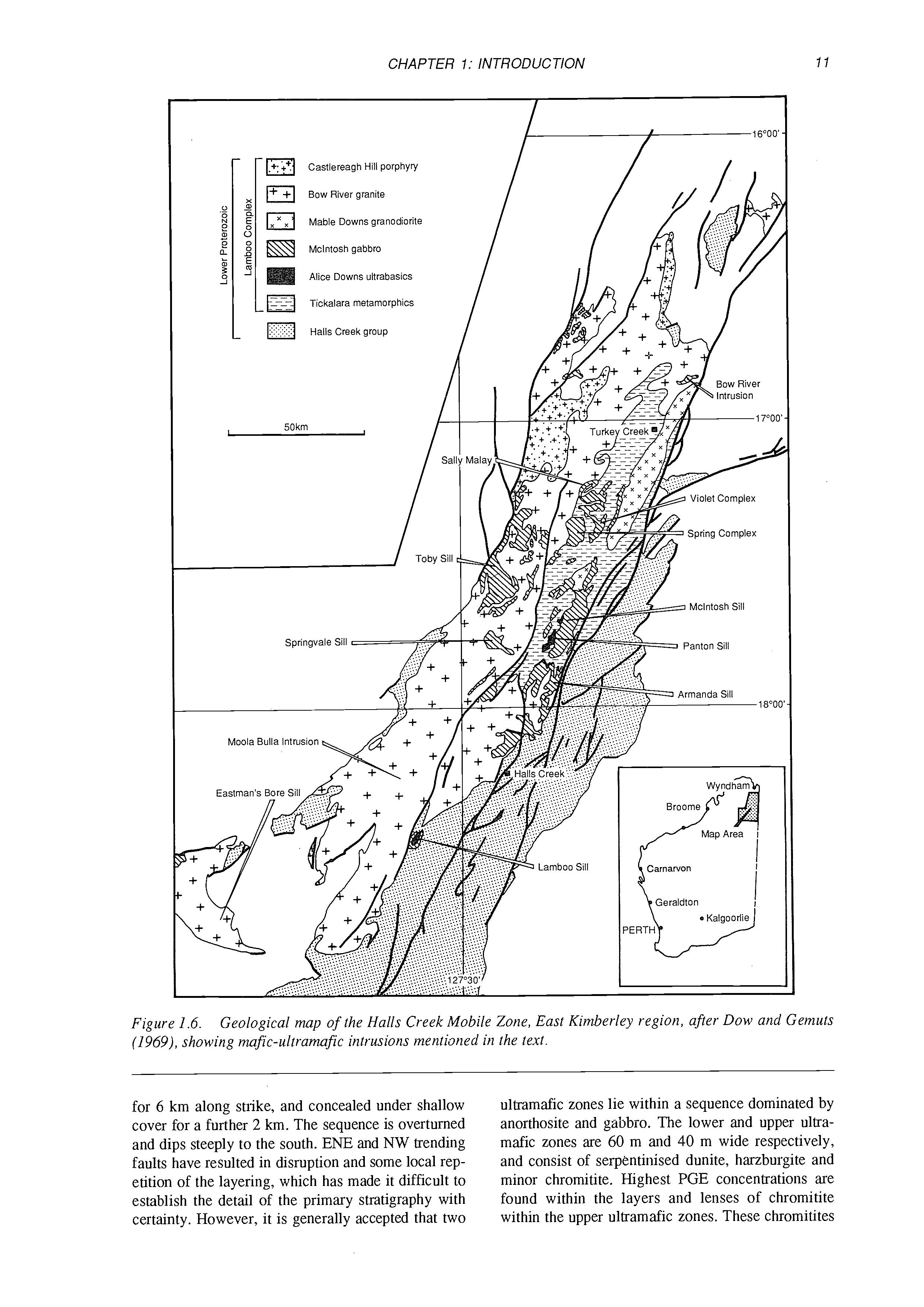
The Halls Creek Mobile Zone is a linear northeast trending belt of early to mid-Proterozoic metamorphic rocks and granitoids (Figs 1.1 and 1.6), containing a suite of probably contemporaneous small differentiated mafic-ultramafic intrusions. These bodies were grouped by Dow and Gemuts (1969) into the McIntosh Gabbros and the Alice Downs Ultramafics, with the implication that the Alice Downs Ultramafics were tectonically disrupted lower portions of large McIntosh Gabbro intrusions. Subsequent more detailed studies (Hamlyn, 1980; Mathison and Hamlyn, 1986; unpublished company reports) have shown that the Alice Downs Ultramafics are discrete differentiated mafic-ultramafic complexes in themselves. The McIntosh Gabbro suite ranges from well-preserved, relatively complete layered gabbroic intrusions (e.g. the McIntosh Sill) to small, highly deformed amphibolite bodies occurring as screens between different phases of the extensive Bow River Granite batholith. A late phase of gabbroic to doleritic rocks occurs as intrusion breccias formed by injection of mafic magma into semi-consolidated Bow River Granite.
The most extensive layered complexes in the Halls Creek Mobile Zone are the Panton Sill, the Lamboo Sill and the Eastman’s Bore Complex (together constituting the “Alice Downs Ultramafics”), and the McIntosh Sill, the Toby Sill, the Springvale Sill, the Sally Malay Complex and the Violet Hill Gabbro (the “McIntosh Gabbros”). Potentially economic stratifom PGE mineralization has been located within the Panton Sill (Hamlyn, 1980; Perring, this volume and in prep.). Significant PGE concentrations have also been located at Lamboo and Eastman’s Bore, and minor localized concentrations in the Springvale and Toby Sills. Sally Malay hosts a small Ni-Cu sulphide deposit (Thornett, 1981). The Panton Sill is covered in detail in Chapter 7 of this volume, and the others are described briefly below.
1.3.1 The Lamboo Sill
The Lamboo Sill is a differentiated body consisting of a lower ultramafic sequence at least 1500 m thick, and an upper sequence of anorthosite and gabbro at least 1000 m thick. The sill is tightly folded into an “S” shaped outcrop pattern about a shallow south-westerly plunging, almost isoclinal synclineanticline pair. All contacts with country rock are tectonized, no original contacts are preserved, and the upper portions of the stratigraphy have been faulted off. The well-exposed ultramafic zone consists of a monotonous sequence of serpentinized olivine orthocumulates with bronzite oikocrysts, with abundant laterally impersistent chromite seams, typically less than 10 cm thick, restricted to the upper 300 m of section. The ultramafic sequence is overlain at a very abrupt contact by about 400-600m of massive anorthosite with poikilitic pyroxene, containing minor thin layers of gabbro. This is overlain by an unknown thickness of altered gabbroic cumulates, containing lenses of magnetite-bearing granophyre.
Elevated concentrations of PGE were located by Hunter Resources Ltd within the upper 300 m of the ultramafic zone. Mineralization was located by sampling of residual soils, whose PGE concentrations turned out to be similar to those of the underlying fresh rock. The PGE mineralization corresponds broadly with the interval which contains the chromite seams, but there is no direct correlation between chromite and PGE abundances on outcrop or hand specimen scale. Typical PGE grades are about 500 ppb combined Pt+Pd at a ratio of about 1:1, over intervals of up to 40 m, with maximum grades of about 2.5 ppm over 0.5 to 2 m intervals. Lateral continuity of the higher grade intervals is limited to less than 400 m. The interval of PGE enrichment corresponds to the presence of cumulus sulphides as indicated by elevated Cu concentrations, but, as with chromite, sample-by-sample correlation between Cu and PGE is very poor. Mineralization seems to take the form of a series of overlapping lenses of weakly disseminated magmatic sulphides, each of which shows an upward trend from very sparse but strongly PGE-enriched sulphides to more abundant, PGE-depleted sulphides. Similar patterns are seen in the Ora Banda Sill (Chapter 4, this volume) and at Munni Munni (Chapter 6, this volume). No economically exploitable PGE mineralization was located despite extensive drilling, and exploration activity in the area has now ceased.
1.3.2 The Eastman’s Bore Complex
The Eastman’s Bore Complex (Bridson, 1987; Vogt, 1989) was emplaced into a sequence of metasediments and acid volcanics of the Lower Proterozoic Biscay Formation. The ultramafic-mafic sequence is approximately 950 m thick. It is exposed
I I
Figure 1.6. Geological map of the Halls Creek Mobile Zone, East Kimberley region, after Dow and Gt 110x0 I ehmrri,ro mnG~-~ilt~nmnG~intwivinnr munti.?nud in tho tPyf
cover for a further 2 km. The sequence is overturned and dips steeply to the south. ENE and NW trending faults have resulted in disruption and some local repetition of the layering, which has made it difficult to establish the detail of the primary stratigraphy with certainty. However, it is generally accepted that two anorthosite and gabbio. The lower and upper ultramafic zones are 60 m and 40 m wide respectively, and consist of serpentinised dunite, harzburgite and minor chromitite. Highest PGE concentrations are found within the layers and lenses of chromitite within the upper ultramafic zones. These chromitites
Tmuts
are made up of 40-8070 cumulus chromite and 2060% serpentinised olivine. Layers thicken and thin rapidly along strike, and range between 5 cm and 100 cm in thickness. Typical PGE grades over intervals of 0.8 to 1.25 m range from 1.0 to 6.0 ppm, at a Pt:Pd ratio of approximately 1:1.
The high degree of structural complexity that has resulted in along-strike discontinuity of PGEbearing chromitite layers, combined with erratic PGE grades, has so far frustrated efforts to define a potentially mineable PGE resource.
1.3.3 The Mclntosh Sill
The McIntosh Sill (Mathison and Hamlyn, 1987) is a well-exposed mafic intrusion located just to the north east of the Panton Sill (Fig. 1.4). It is not a sill at all, but rather a beautiful example of a steepsided, funnel-shaped layered intrusion. The intrusion outcrops as a spectacular set of concentric ridges, clearly visible from the air, corresponding to resistant layers of olivine gabbro which dip inwards towards the centre of the intrusion at angles between 30 and 75". It is intruded into highly deformed gneissic rocks of the Tickalara Metamorphic group. The lowermost rocks in the intrusion are hidden, and the top has been eroded off. The exposed stratigraphy. about 6 km thick, consists of almost 100 cyclic units of troctolite and olivine gabbro, with Fe-Ti oxidebearing gabbronorite layers occurring in the upper 3 km. The crystallization order in each cycle is plagioclase first, followed by olivine, then successively augite, orthopyroxene and magnetite. There is a gradual trend towards more fractionated compositions from base to top of the exposed sequence, with an overall range of compositions from An,, to An,, in plagioclase and Fo,, to Fo,, in olivine. Rapid temporary fluctuations towards much more fractionated compositions occur within the oxide-rich gabbronorite layers, possible reflecting temporary ponding of dense fractionated melt on the chamber floor (Mathison and Hamlyn, 1987). The parent magma is interpreted to have been an aluminous olivine tholeiite. The cumulate sequence contains small proportions of disseminated sulphide blebs throughout, suggesting that the magma was continuously sulphur saturated. No significantly anomalous PGE concentrations have been located to date.
1.3.4 The Toby Sill
The Toby Sill has dimensions of 20 x 16 km, with gentle inward-dipping stratigraphy, making it by area one of the largest undisturbed layered intrusions in the East Kimberley region. The following is based on unpublished reports for Geopeko Exploration by F.M. Barrett.
Exposure, though apparently good, is decep-
tively poor, and many erosionally recessive units can only be seen in drill holes. Two different stratigraphic levels are exposed. In the area east of Toby Dam a WNW-dipping sequence of troctolites, anorthosites, peridotites and leucogabbros displays poorly developed layering. Textures are well preserved but amphibolite-facies metamorphism has commonly obscured the distinction between orthoand clinopyroxene. The olivine cumulates have olivine overgrown by coarse oikocrysts of pyroxene, with minor interstitial plagioclase. A layer of disseminated to semi-massive chromitite 10-15 cm wide occurs in the central part of the area.
In the central, northern and western part of the intrusion a broad scale concentric layering is apparent on aerial photographs and aeromagnetic maps. The dominant rock types are non-cumulus finegrained metabasic rocks and doleritic gabbro which are interlayered with, intruded into, or occur as xenoliths within cumulate troctolites and olivinebearing norites. The cumulates contain olivine (Fos9FOG,), plagioclase (AnsS-An,,), inverted pigeonite and minor intercumulus biotite and quartz. Oxide phases are chromite and magnetite. Chromitite seams in outcrop reveal up to 9.2% Cr with maxima of 420 ppb Pt and 150 ppb Pd. Similar PGE levels in chromitites were found in drill core, with background PGE levels ranging from 1 to 50 ppb.
1.3.5 The Springvale Sill
The Springvale Intrusion consists of two concentric inward-dipping lobes giving a total 13 x 6 km area and a WNW elongation. The following is based on unpublished reports for Geopeko Exploration by F.M. Barrett.
Dips vary between horizontal in the centre and vertical in the northwestern margin, although mostly they are between 25 and 40". The main rock types are norite, troctolite, gabbronorite and anorthosite. Ultramafic rocks have not been found in outcrop, although minor occurrences of altered olivine-rich rock were reported by Freeport.
The lowest part of the exposed Springvale stratigraphy is a troctolite-anorthosite unit, which is separated from an upper chromite-bearing troctolite by 600-700 m of gabbronorite with only thin troctolite layers. Layering is poorly developed in the gabbronorites, but more pronounced in the troctolites and anorthosites where both modal layering and igneous lamination are developed.
The amount of olivine in the troctolites varies from trace amounts to 25%. Olivine compositions vary between Fo,, and Fo,,. Plagioclase is very calcic (An,*-,,) in the troctolites irrespective of olivine composition. Chromite is present as a minor phase in the troctolites and in two zones of disseminated chromitites associated with troctoliteanorthosite layers. Metamorphism of the intrusion
reached mid-upper amphibolite facies.
The PGE contents of all drill hole samples assayed by Geopeko and earlier explorers are uniformly low, irrespective of rock type or stratigraphic position, with a maximum of 15 ppb Pt and 27 ppb Pd.
1.3.6 Sally Malay
The Sally Malay intrusion consists of four small connected bodies of ultramafic and mafic rocks occupying a total area of about 2 km2, emplaced
within granulite facies migmatites (Fig. 15), and themselves intruded by younger norite. The dominant rock-types are harzburgite, olivine clinopyroxenite. norite and troctolite. Thomett (1981) tentatively interprets the four bodies as a single pluton. Mineral composition trends indicate periodic replenishment of the chamber. Subeconomic disseminated sulphide mineralization is hosted by a marginal norite unit. roughly 5 m thick, showing extensive country rock contamination. Data on PGE concentrations in the sulphide zone or elsewhere in the intrusion are lacking.
2.1 INTRODUCTION
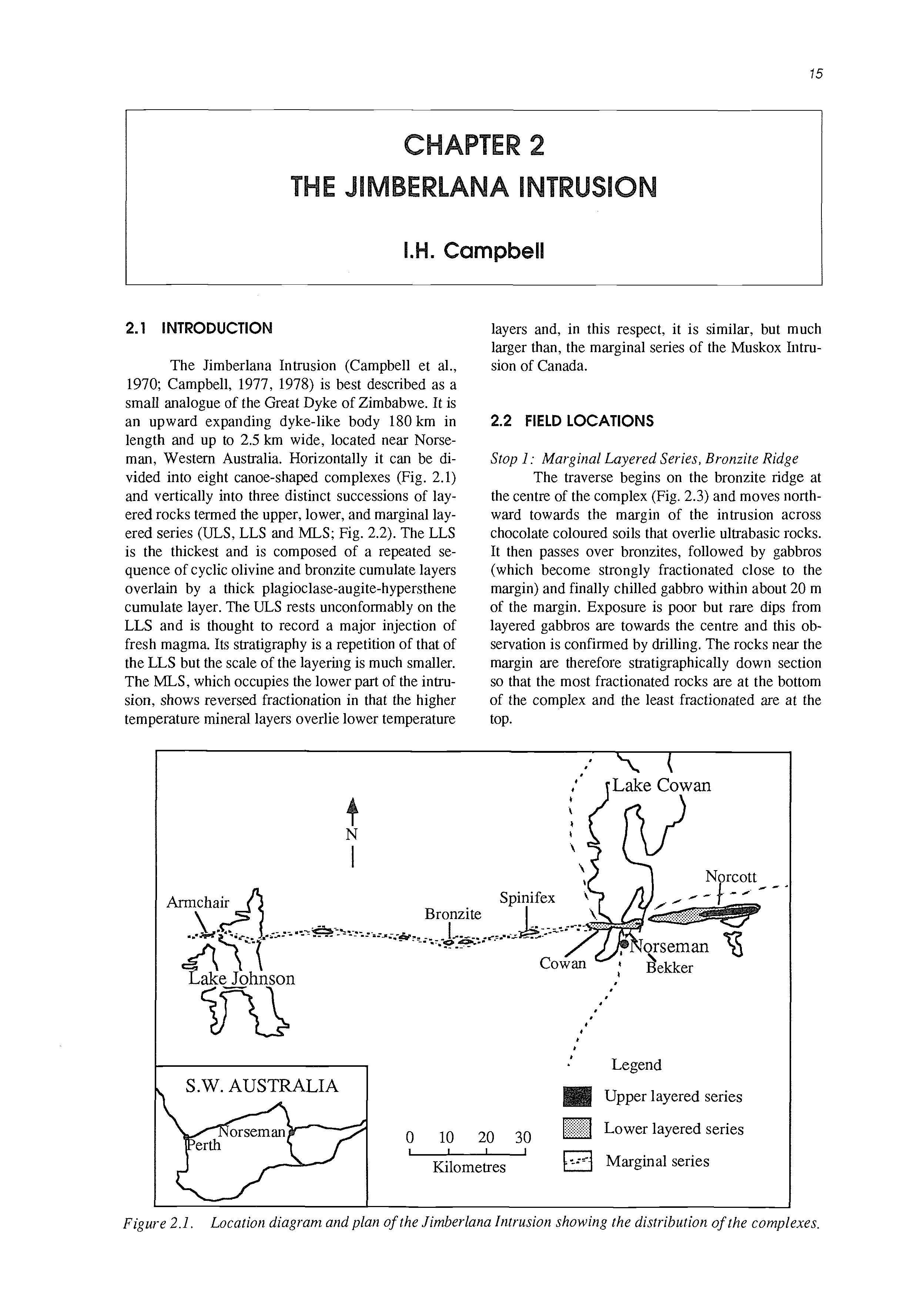
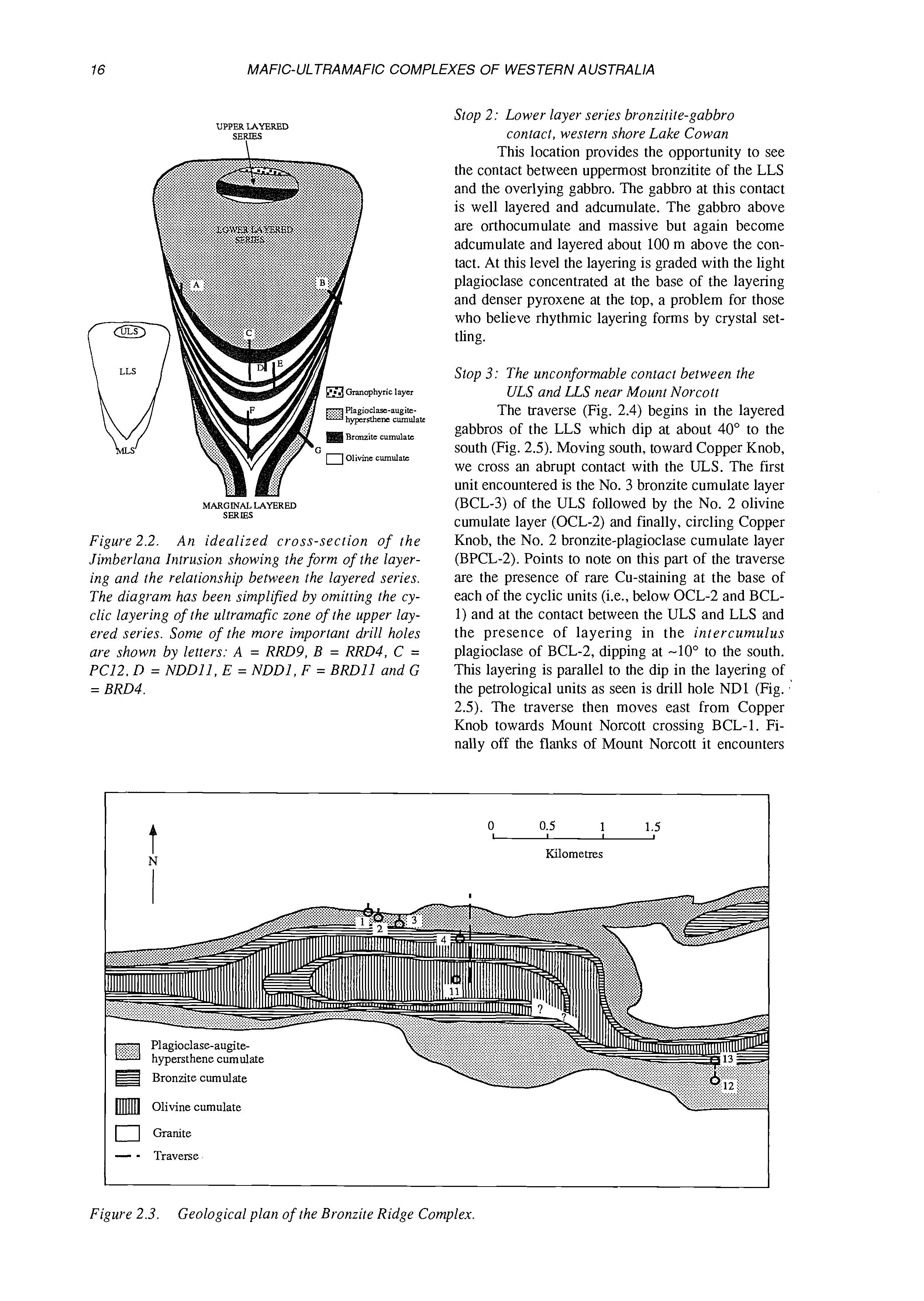
The Jimberlana Intrusion (Campbell et al., 1970; Campbell, 1977, 1978) is best described as a small analogue of the Great Dyke of Zimbabwe. It is an upward expanding dyke-like body 180 km in length and up to 2.5 km wide, located near Norseman, Western Australia. Horizontally it can be divided into eight canoe-shaped complexes (Fig. 2.1) and vertically into three distinct successions of layered rocks termed the upper, lower, and marginal layered series (ULS,LLS and MLS; Fig. 2.2). The LLS is the thickest and is composed of a repeated sequence of cyclic olivine and bronzite cumulate layers overlain by a thick plagioclase-augite-hypersthene cumulate layer. The ULS rests unconformably on the LLS and is thought to record a major injection of fresh magma. Its stratigraphy is a repetition of that of the LLS but the scale of the layering is much smaller. The MLS, which occupies the lower part of the intrusion, shows reversed fractionation in that the higher temperature mineral layers overlie lower temperature
layers and, in this respect, it is similar, but much larger than, the marginal series of the Muskox Intrusion of Canada.
2.2 FIELD LOCATIONS
Stop 1 : Marginal Layered Series, Bronzite Ridge
The traverse begins on the bronzite ridge at the centre of the complex (Fig. 2.3) and moves northward towards the margin of the intrusion across chocolate coloured soils that overlie ultrabasic rocks. It then passes over bronzites, followed by gabbros (which become strongly fractionated close to the margin) and finally chilled gabbro within about 20 m of the margin. Exposure is poor but rare dips from layered gabbros are towards the centre and this observation is confirmed by drilling. The rocks near the margin are therefore stratigraphically down section so that the most fractionated rocks are at the bottom of the complex and the least fractionated are at the top.
2.1. Location diagram and plan of the Jiinberlana Intrusion showing the distribution of the complexes.
Figure
UPPER LAYERED SERIES \ MARGINALLAYERED SERBS
Figure 2.2. An idealized cross-section of the Jimberlana Intrusion showing the form of the layering and the relationship between the layered series. The diagram has been simplified by omitting the cyclic layering of the ultramafic zone of the upper layered series. Some of the more important drill holes are shown by letters: A = RRD9, B = RRD4, C = PC12. D = NDDII, E = NDDl, F = BRDll and G = BRD4.
Stop 2: Lower layer series bronzitite-gabbro contact, western shore Lake Cowan
This location provides the opportunity to see the contact between uppermost bronzitite of the LLS and the overlying gabbro. The gabbro at this contact is well layered and adcumulate. The gabbro above are orthocumulate and massive but again become adcumulate and layered about 100 m above the contact. At this level the layering is graded with the light plagioclase concentrated at the base of the layering and denser pyroxene at the top, a problem for those who believe rhythmic layering forms by crystal settling.
Stop 3: The unconformable contact between the ULS and US near Mount Norcott
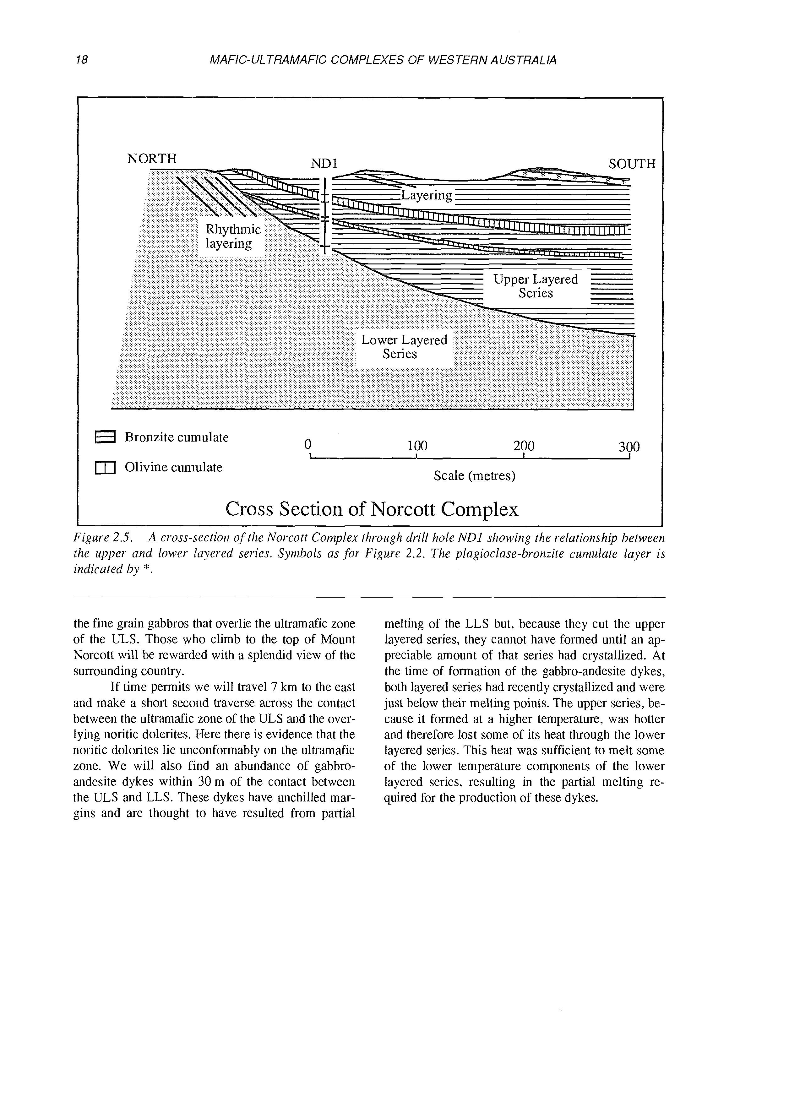
The traverse (Fig. 2.4) begins in the layered gabbros of the LLS which dip at about 40" to the south (Fig. 2.5). Moving south, toward Copper Knob, we cross an abrupt contact with the ULS. The first unit encountered is the No. 3 bronzite cumulate layer (BCL-3) of the ULS followed by the No. 2 olivine cumulate layer (OCL-2) and finally, circling Copper Knob, the No. 2 bronzite-plagioclase cumulate layer (BPCL-2). Points to note on this part of the traverse are the presence of rare Cu-staining at the base of each of the cyclic units (i.e., below OCL-2 and BCL1) and at the contact between the ULS and LLS and the presence of layering in the intercumulus plagioclase of BCL-2, dipping at -10" to the south. This layering is parallel to the dip in the layering of the petrological units as seen is drill hole ND1 (Fig. 2.5). The traverse then moves east from Copper Knob towards Mount Norcott crossing BCL-1. Finally off the flanks of Mount Norcott it encounters
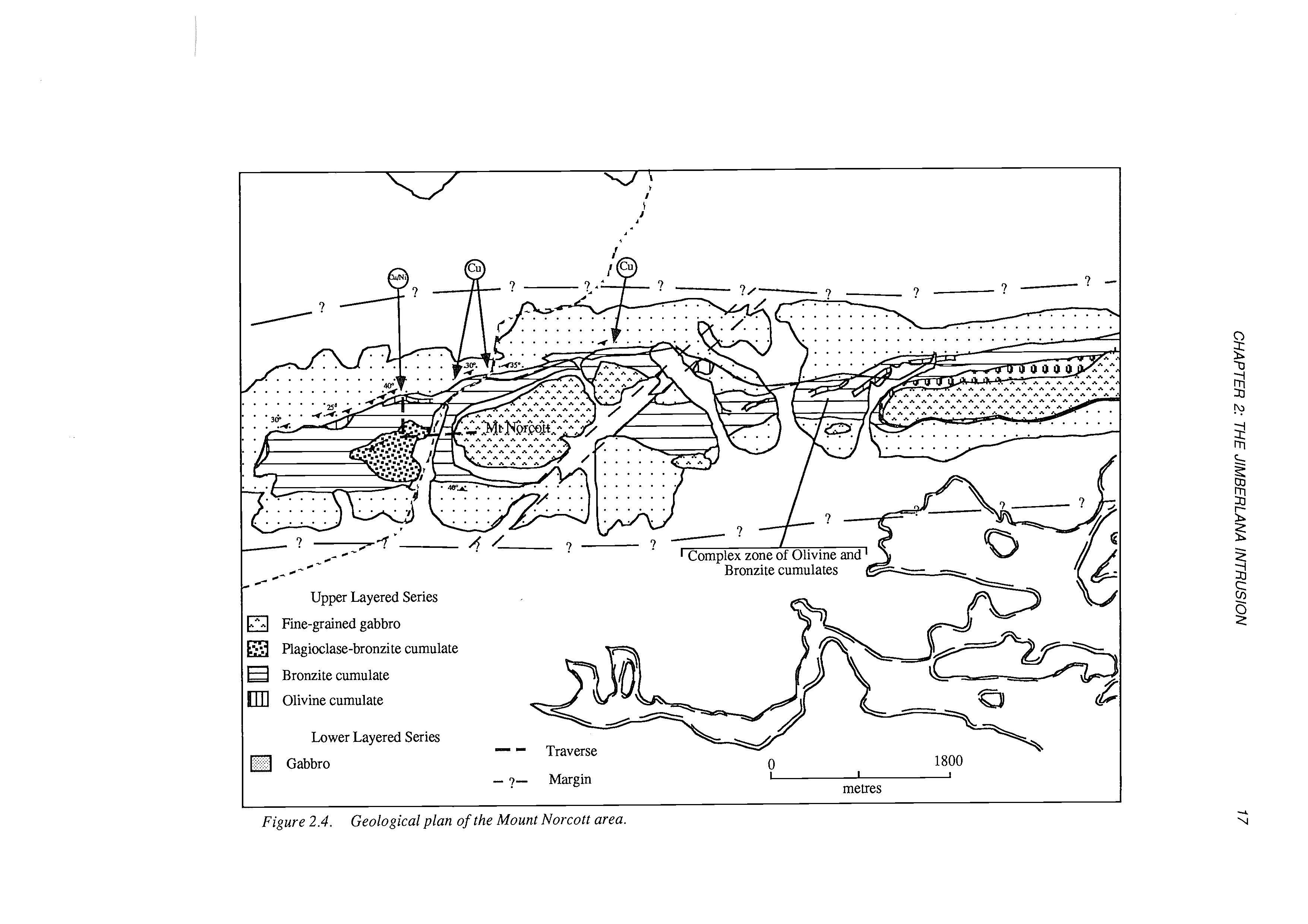
Figure 2.4. Geological plan of the Mount Norcott area.
Bronzite cumulate
nr] Olivine cumulate
Cross Section of orcott Complex
Figure 2.5. A cross-secrion of the Norcott Complex through drill hole ND1 showing the relationship between the upper arid lower layered series. Symbols as for Figure 2.2. The plagioclase-bronzite cumulate layer is indicated by *.
the fine grain gabbros that overlie the ultramafic zone of the ULS. Those who climb to the top of Mount Norcott will be rewarded with a splendid view of the surrounding country.
If time permits we will travel 7 km to the east and make a short second traverse across the contact between the ultramafic zone of the ULS and the overlying noritic dolerites. Here there is evidence that the noritic dolorites lie unconformably on the ultramafic zone. We will also find an abundance of gabbroandesite dykes within 30 m of the contact between the ULS and LLS. These dykes have unchilled margins and are thought to have resulted from partial
melting of the LLS but, because they cut the upper layered series, they cannot have formed until an appreciable amount of that series had crystallized. At the time of formation of the gabbro-andesite dykes, both layered series had recently crystallized and were just below their melting points. The upper series, because it formed at a higher temperature, was hotter and therefore lost some of its heat through the lower layered series. This heat was sufficient to melt some of the lower temperature components of the lower layered series, resulting in the partial melting required for the production of these dykes.
3.1 AUSTRALIA PGE PRODUCTION
(D.R. Hudson)
Australia’s most significant platinum group element (PGE) production has come as a consequence of the mining of komatiite-associated nickel sulphide ores at Kambalda.
Early PGE production in Australia was based on recovery of osmiridium from mainly alluvial deposits derived from ultramafic rocks in northwest and southern Tasmania and from placer deposits near Fifield in New South Wales. The Tasmanian deposits produced some 1000 kg to 1965, but in recent years production has been meagre. Historic production of isoferroplatinum and associated PGM from the Platina Lead and other deposits near Fifield totalled about 650 kg, and in recent years there has been considerable exploration activity in the area, both for placer deposits and primary mineralization.
Mining commenced at Kambalda in 1967, and to 1988 the deposits produced about 600 thousand tonnes of nickel metal. Current production is reported at somewhat less than 40 thousand tonnes of nickel per year, which is associated with some 80 kg of platinum and 500 kg of palladium. The average composition of in situ Kambalda ore (calculated to 100% sulphide) has been estimated as (in %) Ni 14.4, Cu 1.1, Co 0.3, S 39.9, (in ppb) Pt 1630, Pd 2104,Os 537, Ir 293, Rh 240, Ru 1074, Au 1721, and Ag 5710 (Hudson and Donaldson, 1984). This estimate equates reasonably well with reported recoveries of palladium, but suggests a much higher value for platinum than is presently stated in production figures.
3.2 GEOLOGICAL SETTING OF THE NICKEL SULPHIDE DEPOSITS
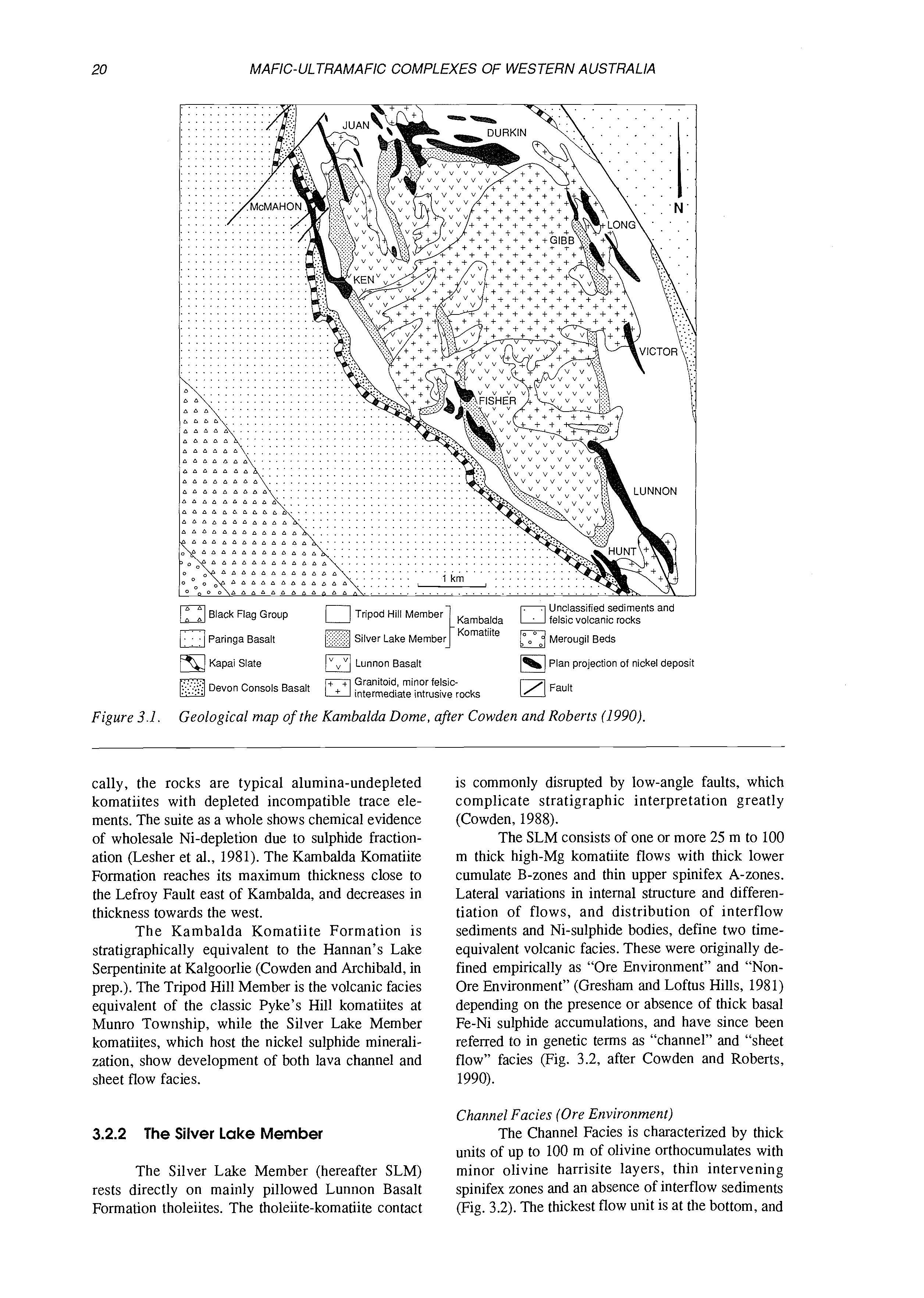
This summary draws principally on the review by Cowden and Roberts (1990), and also on comprehensive studies by Gresham and Loftus-Hills (198l), Lesher (1983), Lesher et al. (1984), Lesher and Groves (1986), Gresham (1986), and Cowden (1988).
The komatiites and associated ore deposits of the Kambalda area occur in the south-central part of the Norseman-Wiluna greenstone belt, in the
Kambalda-Buldania corridor, a tectonic unit bounded to the east and west by major NNW-trending wrench faults (Archibald, 1987). The stratigraphy in the area of interest is dominated by mafic and ultramafic volcanic rocks. The lowermost unit is the Lunnon Basalt, a sequence of pillowed to massive tholeiitic basalts. This is overlain by the Kambalda Komatiite formation, up to 1200 m thick, and a thick sequence of 1000 to 1600 m of siliceous high magnesium basalts, the Devon Consols and Paringa Basalt Formations, separated by the 1-10 m thick Kapai Slate and including numerous dolerite sills or thick flows. The area has undergone a complex structural history, beginning with thrusting and layer-parallel mylonite development, followed by asymmetric inclined to recumbent folds overprinted by open upright folds with a pervasive NNW cleavage, and culminating in regional NNW trending wrench faults. The peak regional metamorphism corresponds to the D, upright folding episode. Metamorphic grade ranges from upper greenschist in the Kambalda area to midamphibolite in the Widgiemooltha and Carnilya Hill areas (Cowden and Roberts, 1990 and references therein). Talc-carbonate alteration is widespread in the ultramafic lithologies.
3.2.1 The Kambalda Komatiite Formation
Stratigraphy
The Kambalda Komatiite Formation (Fig. 3.1) consists of up to 1200 m stratigraphic thickness of komatiite flows, divided into two members on the basis of regional lithofacies variations (Gresham and Loftus Hills, 1981; Cowden and Archibald, in prep.). The lower Silver Lake Member, named after the type location close to the Lunnon Shoot shaft, comprises 25 m to 100 m thick magnesian flows with thin intercalated sulphidic sediments. This is overlain by the Tripod Hill Member, up to 1000 m thick, named for the type locality near Fisher Shoot, consisting of thinner (1-20 m) less magnesian flows without intercalated sediments. There is an overall decrease in MgO content of the komatiitic rocks upward through the Kambalda Komatiite, from values up to 45% in cumulate rocks near the base to 16% in rocks typical of the upper part of the Tripod Hill Member. Chemi-
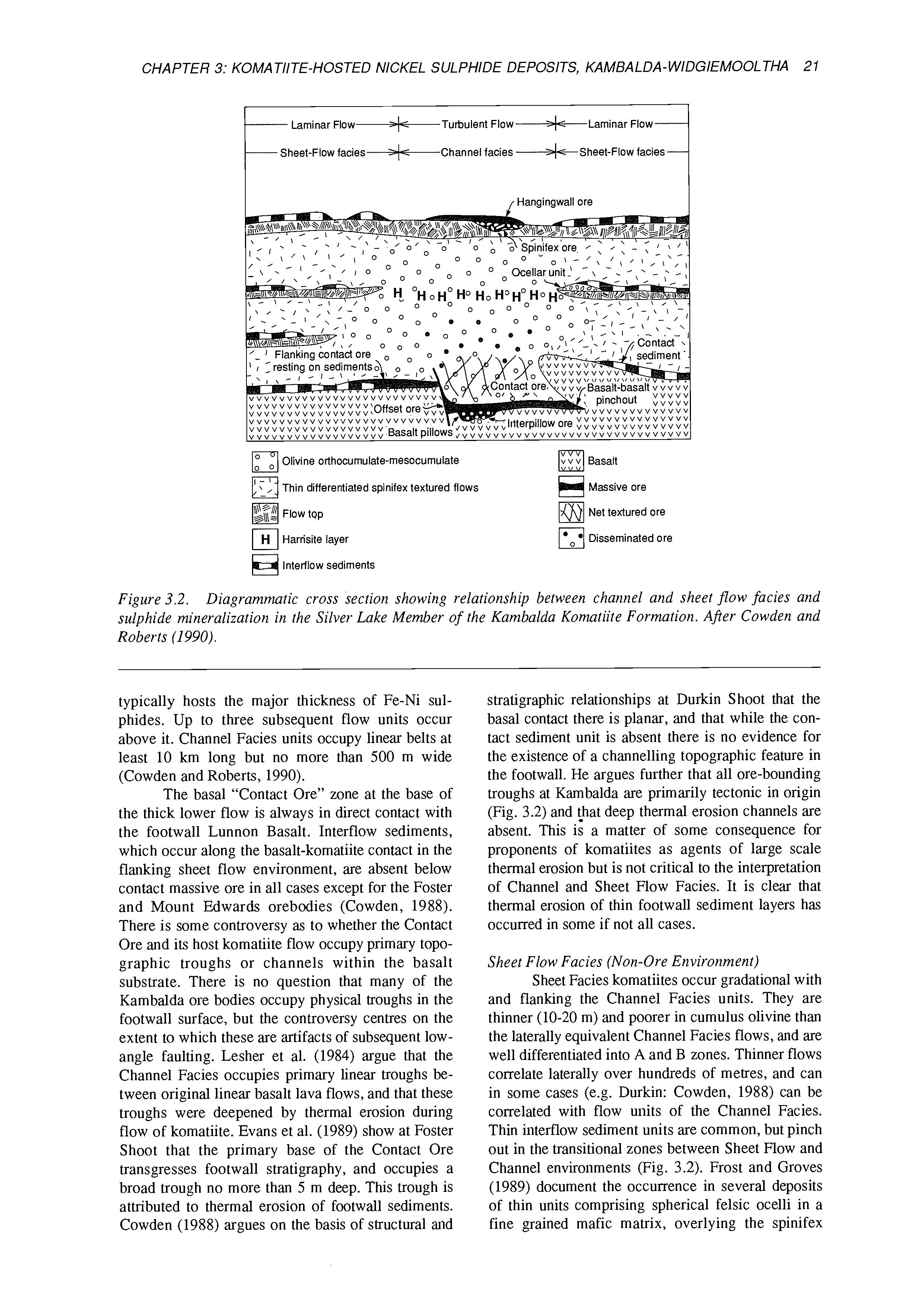
Sheet-Flow facies-Channel facies -*--Sheet-Flow facies / Hangingwall ore
Flow tQp
Harrisite layer
Interflow sediments
Figure 3.2. Diagrammatic cross section showing relationship between channel and sheet jlow facies and sulphide mineralization in the Silver Lake Member of the Kambalda Komatiite Formation. After Cowden and Roberts (1990).
typically hosts the major thickness of Fe-Ni sulphides. Up to three subsequent flow units occur above it. Channel Facies units occupy linear belts at least 10 km long but no more than 500 m wide (Cowden and Roberts, 1990).
The basal “Contact Ore” zone at the base of the thick lower flow is always in direct contact with the footwall Lunnon Basalt. Interflow sediments, which occur along the basalt-komatiite contact in the flanking sheet flow environment, are absent below contact massive ore in all cases except for the Foster and Mount Edwards orebodies (Cowden, 1988). There is some controversy as to whether the Contact Ore and its host komatiite flow occupy primary topographic troughs or channels within the basalt substrate. There is no question that many of the Kambalda ore bodies occupy physical troughs in the footwall surface, but the controversy centres on the extent to which these are artifacts of subsequent lowangle faulting. Lesher et al. (1984) argue that the Channel Facies occupies primary linear troughs between original linear basalt lava flows, and that these troughs were deepened by thermal erosion during flow of komatiite. Evans et al. (1989) show at Foster Shoot that the primary base of the Contact Ore transgresses footwall stratigraphy, and occupies a broad trough no more than 5 m deep. This trough is attributed to thermal erosion of footwall sediments. Cowden (1988) argues on the basis of structural and
stratigraphic relationships at Durkin Shoot that the basal contact there is planar, and that while the contact sediment unit is absent there is no evidence for the existence of a channelling topographic feature in the footwall. He argues further that all ore-bounding troughs at Kambalda are primarily tectonic in origin (Fig. 3.2) and \hat deep thermal erosion channels are absent. This is a matter of some consequence for proponents of komatiites as agents of large scale thermal erosion but is not critical to the interpretation of Channel and Sheet Flow Facies. It is clear that thermal erosion of thin footwall sediment layers has occurred in some if not all cases.
Sheet Flow Facies (Non-Ore Environment)
Sheet Facies komatiites occur gradational with and flanking the Channel Facies units. They are thinner (10-20 m) and poorer in cumulus olivine than the laterally equivalent Channel Facies flows, and are well differentiated into A and B zones. Thinner flows correlate laterally over hundreds of metres, and can in some cases (e.g. Durkin: Cowden, 1988) can be correlated with flow units of the Channel Facies. Thin interflow sediment units are common, but pinch out in the transitional zones between Sheet Flow and Channel environments (Fig. 3.2). Frost and Groves (1989) document the occurrence in several deposits of thin units comprising spherical felsic ocelli in a fine grained mafic matrix, overlying the spinifex
zones of flanking flows in the transition zone between Channel and Sheet Flow facies (Fig. 3.2).
Volcanological interpretation
The volcanic stratigraphy of central Channel Facies with flanking Sheet Flow facies is now generally accepted as the result of flow of komatiite lava down primary central feeder channels, with episodic overflow to form thin “overbank” sheet flows (Cowden, 1988; Lesher et al., 1984). Precisely the same geometry and process is seen in modern day basaltic lava flows on Hawaii. The open nature of the central channels is recorded by the high proportion of cumulus olivine to spinifex zones. Lava was continuously flushed through the channel, spilling periodically over the side, and leaving behind an olivinerich residue formed by crystallization at the temporary channel floor. Periodic stagnation within the channel is recorded by the development of distinctive harrisite zones, which probably grew upward from the channel floor from temporarily stagnant lava beneath a quenched flow top. Flow down the channel occurred beneath a floating quenched skin, which was periodically absorbed into the flowing lava and remelted as observed in modern day basalt flows. During periods of particularly rapid extrusion, komatiite lava overflowed levee banks on either side of the main channel to form thin sheet flows, which differentiated in situ to form typical thin layered flows with well developed spinifex zones.
The ocellar units described by Frost and Groves (1989) in the transition zone between channel facies and flanking sheet flows are interpreted to have formed as a result of partial melting and assimilation of interflow sediment at the base of the main channel. Contaminated siliceous melt rose as a “scum” on the flowing komatiite lava, and accumulated at the banks of the channel. The contaminated melt then unmixed to result in spherical droplets of immiscible felsic liquid in a matrix of mafic material.
3.3 NICKEL SULPHIDE ORES
Nickel sulphide ore bodies occur as linear shoots along the bases of the major channel facies units. They are best developed at the base of the lowermost thick flow (“contact ore”), with minor accumulations at the bases of the next overlying flow (“hanging wall ore”). Ore bodies have ribbon-like morphologies and are typically <5 m thick, although thicknesses of over 40 m have been observed.
3.3.1 Contact ores
Ore layers are commonly stratified from massive at the base upward through matrix ore (40 to 80% sulphide) to disseminated. Matrix and disseminated ores form 60 to 80% of the total thickness,
while massive ores vary greatly in thickness (typically up to 2 m) and extent. Blebby ores, consisting of disseminated sulphide blebs up to 1 cm in diameter, occur within the central parts of the lower cumulate division of some flow units. Massive ores may themselves be internally layered, with pyriteand chromite-rich bands.
3.3.2 Hanging Wall ores
In some cases “Hanging Wall” ore zones occur stratigraphically vertically above the major “Contact Ore” zones and consist of massive sulphide bodies directly overlying spinifex zones of the underlying flow. At Lunnon Shoot (Groves et al., 1986) spinifex ore has formed by thermal erosion of the underlying flow top, and percolation of liquid sulphide into the interstices between spinifex olivine plates. This is the best documented field evidence so far of thermal erosion of komatiites by komatiites.
3.3.3 Mineralogy
The mineralogy of fresh sulphides is dominated by pyrrhotite, pentlandite and pyrite, with magnetite, chromite and chalcopyrite. Millerite and rare tellurides and arsenides are minor constituents. Pyrite tends to be more abundant in massive ore than in adjacent matrix ore. Supergene processes have resulted in the replacement of pentlandite by violarite and pyrrhotite by pyrite.
3.4 PLATINUM METALS IN THE KAMBALDA NICKEL DEPOSITS
(D.R. Hudson)
Studies by Cowden et al. (1986) determined an average value from a typical medium tenor nickel ore shoot (10% Ni in 100% sulphides) as: Pt 1650, Pd 2050,Os 480, Ir 230, Rh 240, Ru 980, Au 500 (all values ppb). They confirmed previous observations that PGE values were highest in high tenor nickel ores, and established that the elements Pd, Os, Ir, Rh and Ru correlate strongly with Ni, but Pt has only a weak to moderate correlation with Ni.
Keays et al. (1981) determined that there was considerable variation in PGE values through a section of massive and overlying matrix sulphide ore in Lunnon Shoot. Palladium values were lowest in massive ores close to the basal contact and highest in matrix ore. This was explained as being due either to fractional crystallisation from the base upwards (Keays and Davidson (1976) or to metamorphic mobilisation of Pd to form PGE-enriched sulphide veinlets in the basalt footwall (Keays, et al., 1981).
Cowden et al. (1986) analysed similar profiles through sections at Lunnon Shoot, Juan Complex and
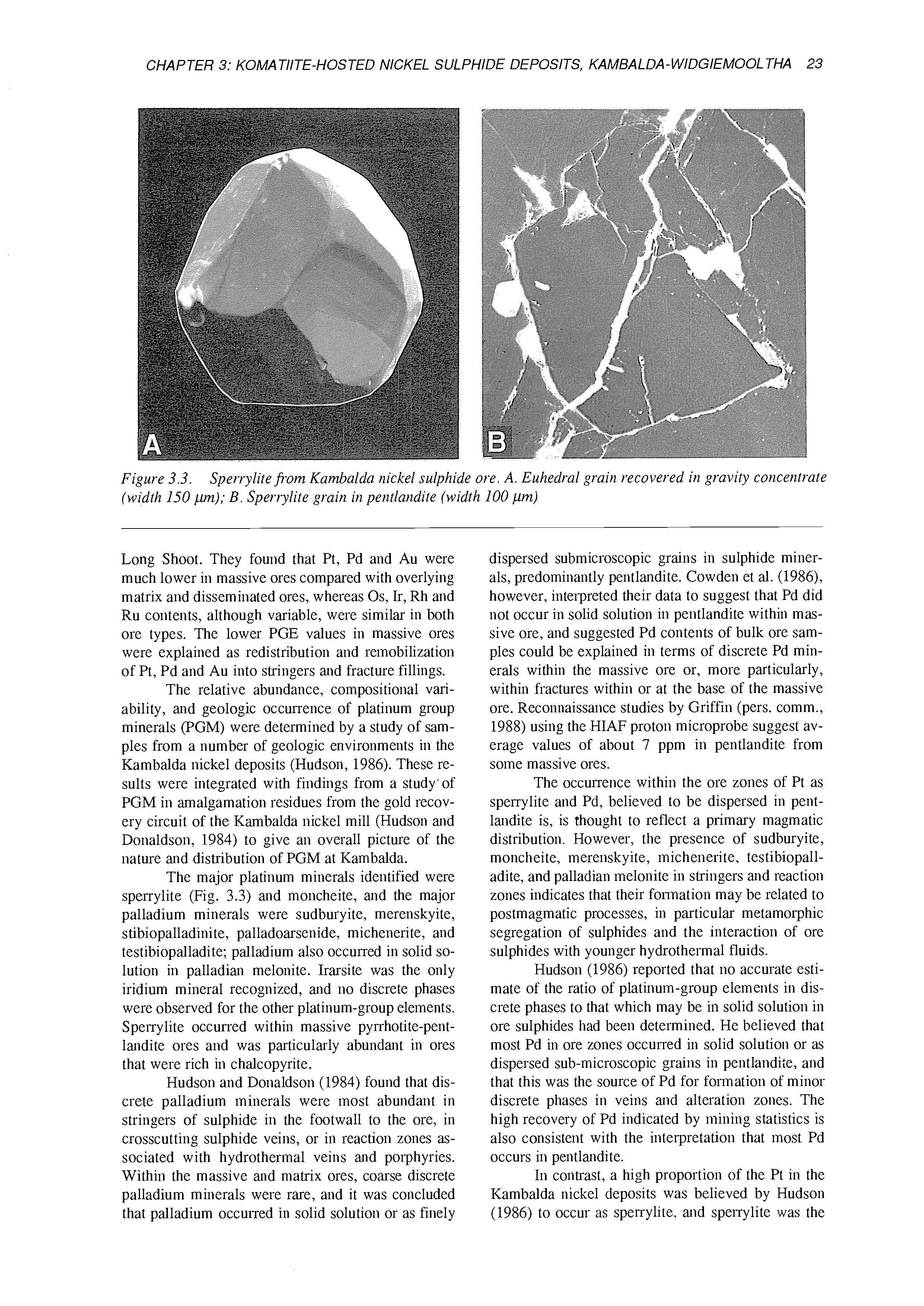
Figure 3.3. (width 150 pn);B. Sperrylite grain in pentlandite (width 100 pm)
Sperrylite fi-om Kambalda nickel sulphide ore. A. Euhedral grain recovered in gravity concentrate
Long Shoot. They found that Pt, Pd and Au were much lower in massive ores compared with overlying matrix and disseminated ores, whereas Os, Ir, Rh and Ru contents, although variable, were similar in both ore types. The lower PGE values in massive ores were explained as redistribution and remobilization of Pt, Pd and Au into stringers and fracture fillings.
The relative abundance, compositional variability, and geologic occurrence of platinum group minerals (PGM) were determined by a study of samples from a number of geologic environments in the Kambalda nickel deposits (Hudson, 1986). These results were integrated with findings from a study' of PGM in amalgamation residues from the gold recovery circuit of the Kambalda nickel mill (Hudson and Donaldson, 1984) to give an overall picture of the nature and distribution of PGM at Kambalda.
The major platinum minerals identified were sperrylite (Fig. 3.3) and moncheite, and the major palladium minerals were sudburyite, merenskyite, stibiopalladinite, palladoarsenide, michenerite, and testibiopalladite; palladium also occurred in solid solution in palladian melonite. Irarsite was the only iridium mineral recognized, and no discrete phases were observed for the other platinum-group elements. Spei-rylite occurred within massive pyrrhotite-pentlandite ores and was particularly abundant in ores that were rich in chalcopyrite.
Hudson and Donaldson (1984) found that discrete palladium minerals were most abundant in stringers of sulphide in the footwall to the ore, in crosscutting sulphide veins, or in reaction zones associated with hydrothermal veins and porphyries. Within the massive and matrix ores, coarse discrete palladium minerals were rare, and it was concluded that palladium occurred in solid solution or as finely
dispersed submicroscopic grains in sulphide minerals, predominantly pentlandite. Cowden et al. (1986), however, interpreted their data to suggest that Pd did not occur in solid solution in pentlandite within massive ore, and suggested Pd contents of bulk ore samples could be explained in terms of discrete Pd minerals within the massive ore or, more particularly, within fractures within or at the base of the massive ore. Reconnaissance studies by Griffin (pers. comm., 1988) using the HIAF proton microprobe suggest average values of about 7 ppm in pentlandite from some massive ores.
The occurrence within the ore zones of Pt as sperrylite and Pd, believed to be dispersed in pentlandite is, is thought to reflect a primary magmatic distribution. However, the presence of sudburyite, moncheite, merenskyite, michenerite, testibiopalladite, and palladian melonite in stringers and reaction zones indicates that their formation may be related to postmagmatic processes, in particular metamorphic segregation of sulphides and the interaction of ore sulphides with younger hydrothermal fluids.
Hudson (1986) reported that no accurate estimate of the ratio of platinum-group elements in discrete phases to that which may be in solid solution in ore sulphides had been determined. He believed that most Pd in ore zones occurred in solid solution or as dispersed sub-microscopic grains in pentlandite, and that this was the source of Pd for formation of minor discrete phases in veins and alteration zones. The high recovery of Pd indicated by mining statistics is also consistent with the interpretation that most Pd occurs in pentlandite.
In contrast, a high proportion of the Pt in the Kambalda nickel deposits was believed by Hudson (1986) to occur as spei-rylite. and sperrylite was the
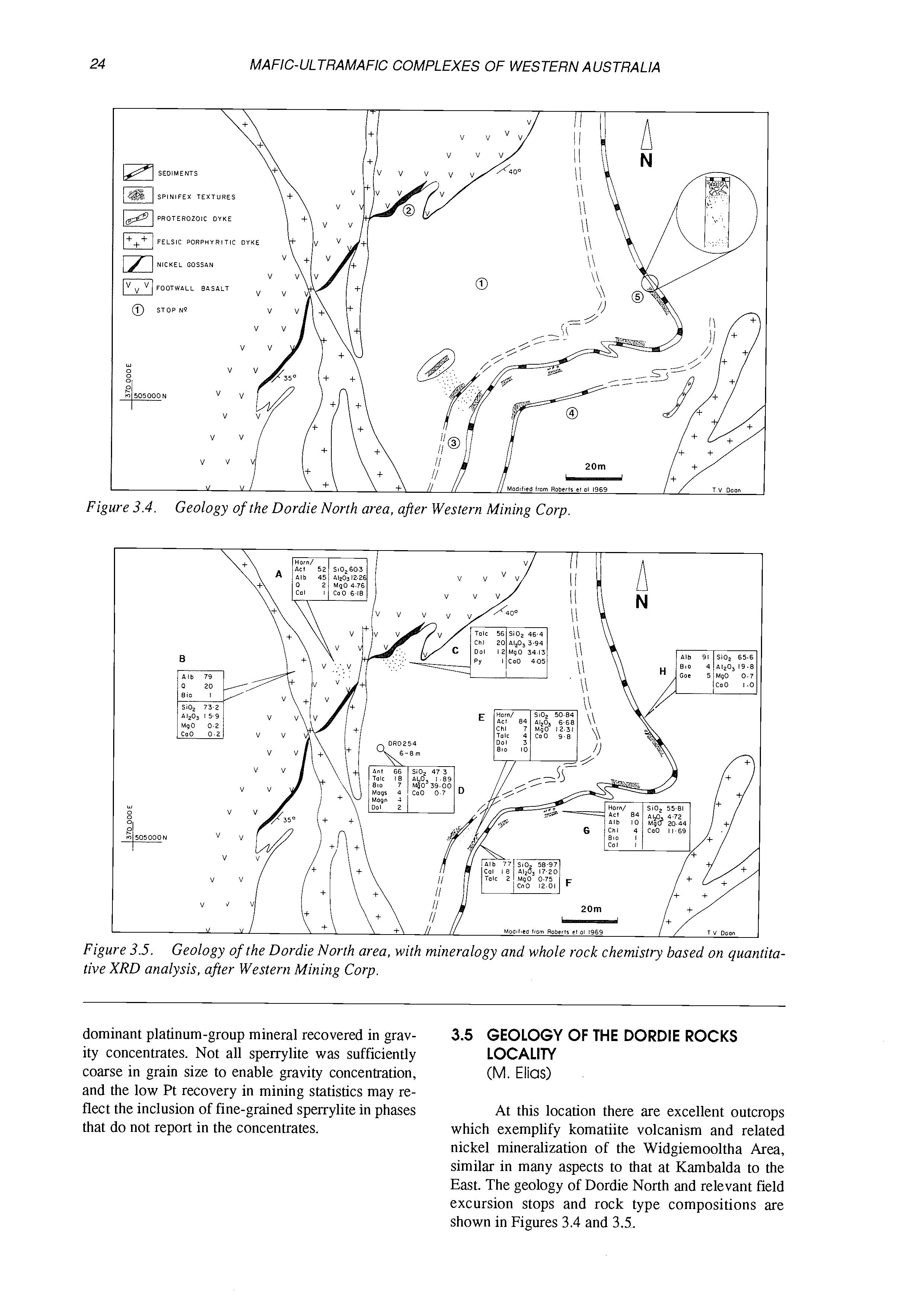
Figure 3.4. Geology ofthe Dordie North area, after Western Mining Corp
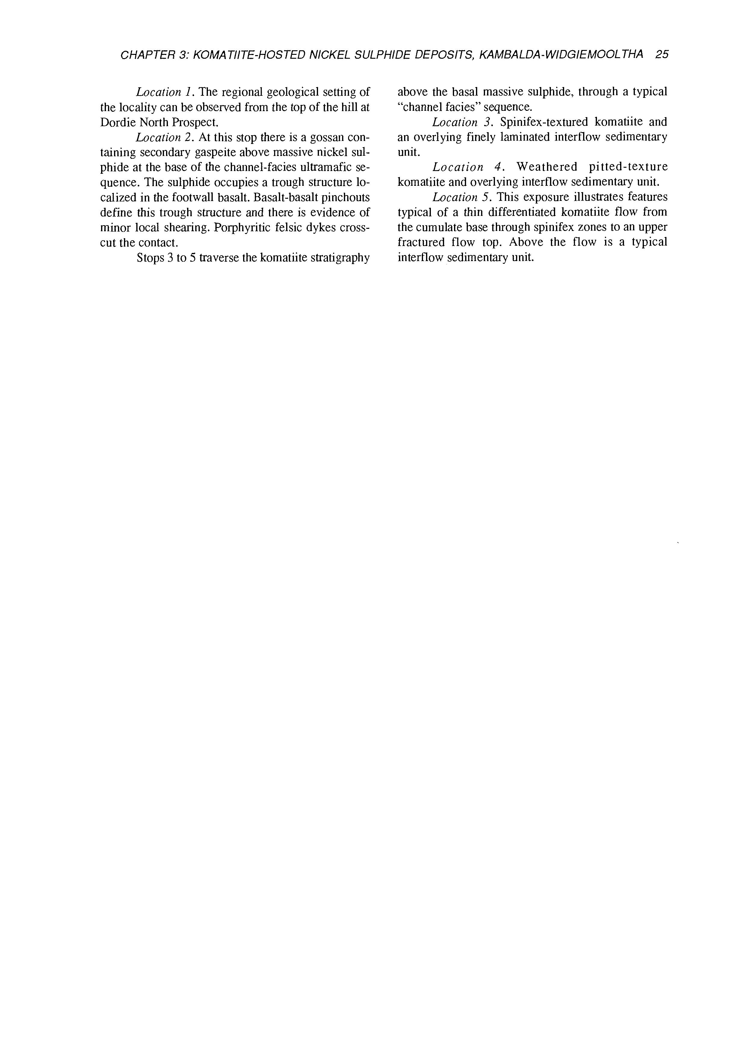
Figure 3.5. tive XRD analysis, after Western Mining Corp.
Geology of the Dordie North area, with mineralogy and whole rock chemistry based on quantita-
dominant platinum-group mineral recovered in gravity concentrates. Not all sperrylite was sufficiently coarse in grain size to enable gravity concentration, and the low Pt recovery in mining statistics may reflat the inclusion of fine-grained sperrylite in phases that do not report in the concentrates.
3.5 GEOLOGY OF THE DORDIE ROCKS LOCALITY
(M.Elias)
At this location there are excellent outcrops which exemplify komatiite volcanism and related nickel mineralization of the Widgiemooltha Area, similar in many aspects to that at Kambalda to the East. The geology of Dordie North and relevant field excursion stops and rock type compositions are shown in Figures 3.4 and 3.5.
Location 1. The regional geological setting of the locality can be observed from the top of the hill at Dordie North Prospect.
Location 2. At this stop there is a gossan containing secondary gaspeite above massive nickel sulphide at the base of the channel-facies ultramafic sequence. The sulphide occupies a trough structure localized in the footwall basalt. Basalt-basalt pinchouts define this trough structure and there is evidence of minor local shearing. Porphyritic felsic dykes crosscut the contact.
Stops 3 to 5 traverse the komatiite stratigraphy
above the basal massive sulphide, through a typical “channel facies” sequence.
Location 3. Spinifex-textured komatiite and an overlying finely laminated interflow sedimentary unit.
Location 4. Weathered pitted-texture komatiite and overlying interflow sedimentary unit.
Location 5. This exposure illustrates features typical of a thin differentiated komatiite flow from the cumulate base through spinifex zones to an upper fractured flow top. Above the flow is a typical interflow sedimentary unit.
4.1 INTRODUCTION
(W.K. Witt)
Layered and differentiated mafic-ultramafic sills form an important component of greenstone sequences in the Achaean Eastern Goldfields Province. Three distinct categories of layered complexes are recognized, on the basis of their bulk composition (Table 1.1, Fig. 4.1), internal stratigraphy and inferred parent magma composition: a high-Mg basaltparented group, a group of tholeiitic sills, and a third category of plagioclase-rich intrusions with abundant anorthositic rocks.
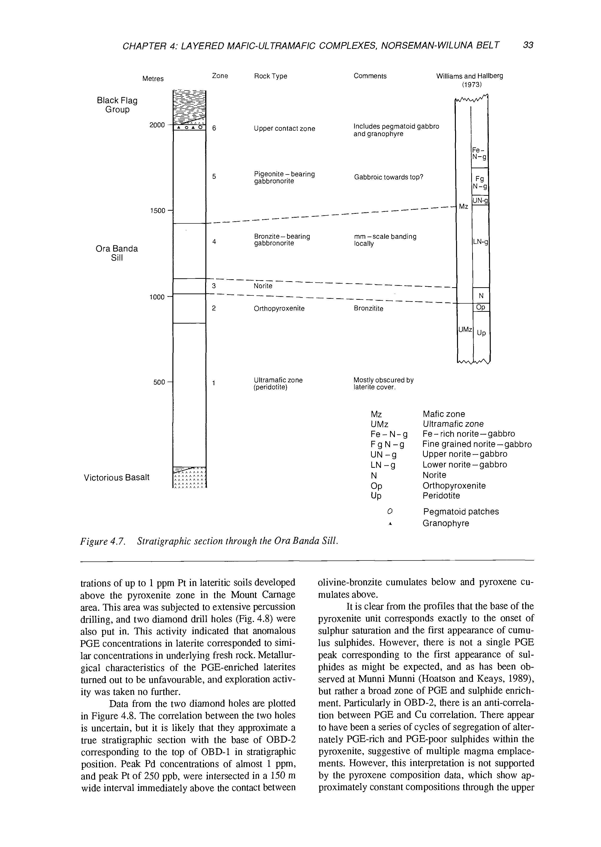
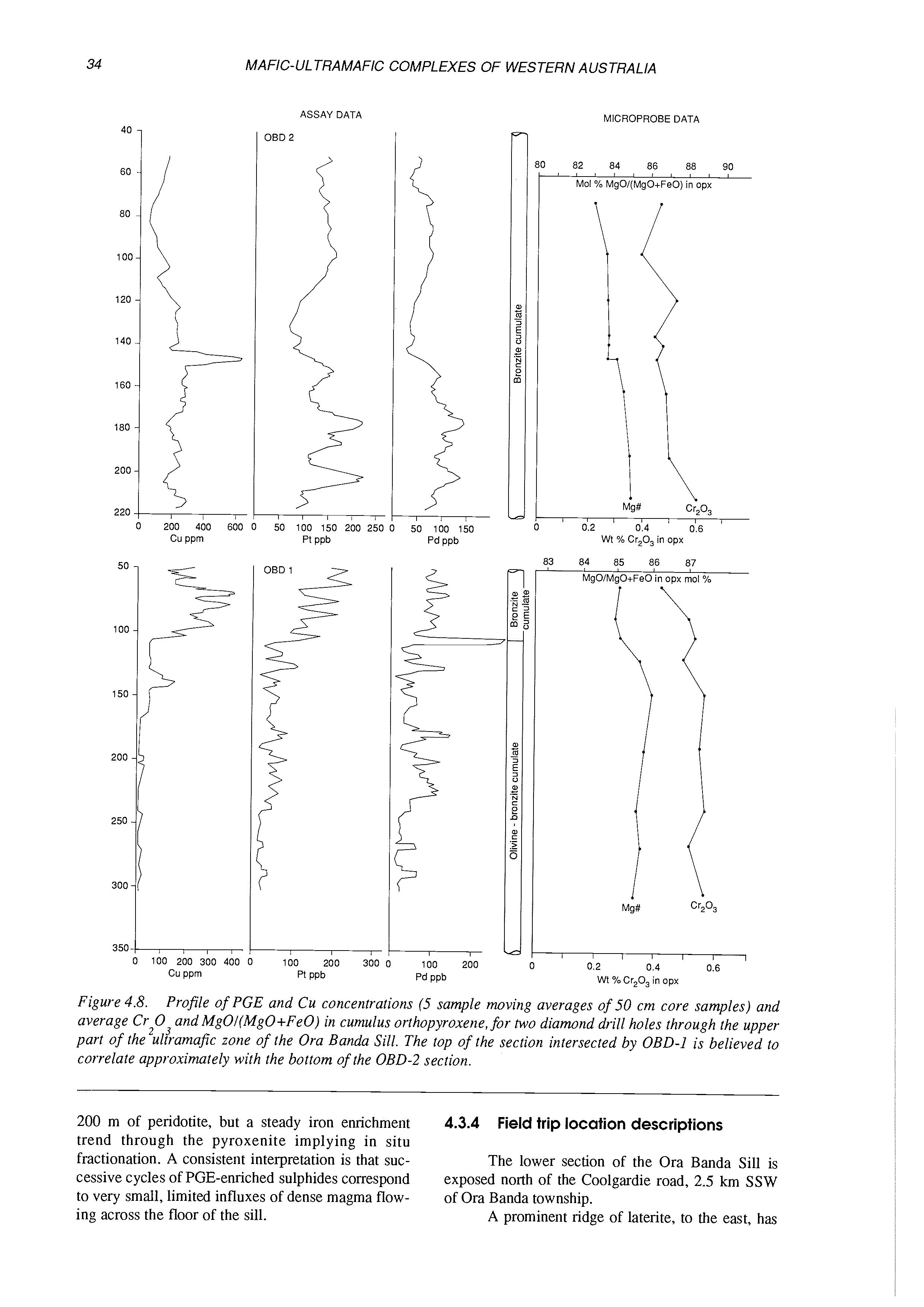
The most relevant group for the purposes of the field excursion is category 1, differentiated bodies with high-Mg basalt bulk composition. This category includes the Mount Thirsty and Ora Banda Sills (Fig. 1.3), both of which will be visited on the excursion. Both of these bodies are known to contain anomalous PGE concentrations, and both of have been targets for PGE exploration in the late 1980’s.
Layered komatiitic complexes (bulk composition >18% MgO) are also widespread within the Norseman-Wiluna Greenstone Belt (Hill et al., 1990). Similar bodies have been described from South Africa (Viljoen and Viljoen, 1970; Anhaeusser, 1985) and are interpreted as intrusive, but a volcanic lavalake or lava river origin has been proposed for layered komatiitic cumulates at Kurrajong, Bulong and Agnew, in the Eastern Goldfields (Hill et al., 1987; Ahmat, in press, Barnes et al., 1988). The layered complex at Kurrajong, part of the Walter Williams komatiite flow (Hill et al, 1990), will be visited on the excursion.
4.1 .I Sills with highcomposition
Williams and Hallberg (1973) described sills, between Norseman and Ora Banda, with bulk MgO contents of 1518% and well developed phase layering. Cumulate textures and mineralogy define a consistent order of crystallization (olivine-orthopyroxene-plagioclase-clinopyroxene), identical to that recognized in the lower, ultramafic sections of the Bushveld and S tillwater Complexes. Complete
sequences in the sills comprise a basal peridotite, succeeded by orthopyroxenite, norite, gabbro-norite, and gabbro. Cryptic layering of plagioclase and pyroxenes was established for the Ora Banda Sill, where igneous mineralogy is widely preserved. The Mount Thirsty Sill, near Norseman, appears to belong to this group but is more complex (McCall et al., 1970). Cyclic phase layering and thin internal sedimentary horizons suggest that the Mount Thirsty Sill crystallized from two or three pulses of high-Mg magma. EarIy “Stillwater-type” magma pulses formed the lower part of the Can Boyd Complex, but later additions of magma were tholeiitic (Purvis et al., 1972).
Thick, layered flows in Canada indicate that orthopyroxene is a rare and relatively late cumulus phase in most komatiitic magmas. The normal crystallization sequence is olivine-clinopyroxeneplagioclase (Arndt, 1977; Arndt et al., 1977; Bedard, 1987; Stone et al., 1387). Similarly, the Mount Pleasant Sill (Witt et al., in press) is a high-Mg intrusion (11-12% MgO) in which phase layering defines a similar order of crystallization (olivine-clinopyroxene-orthopyroxene-plagioclase).
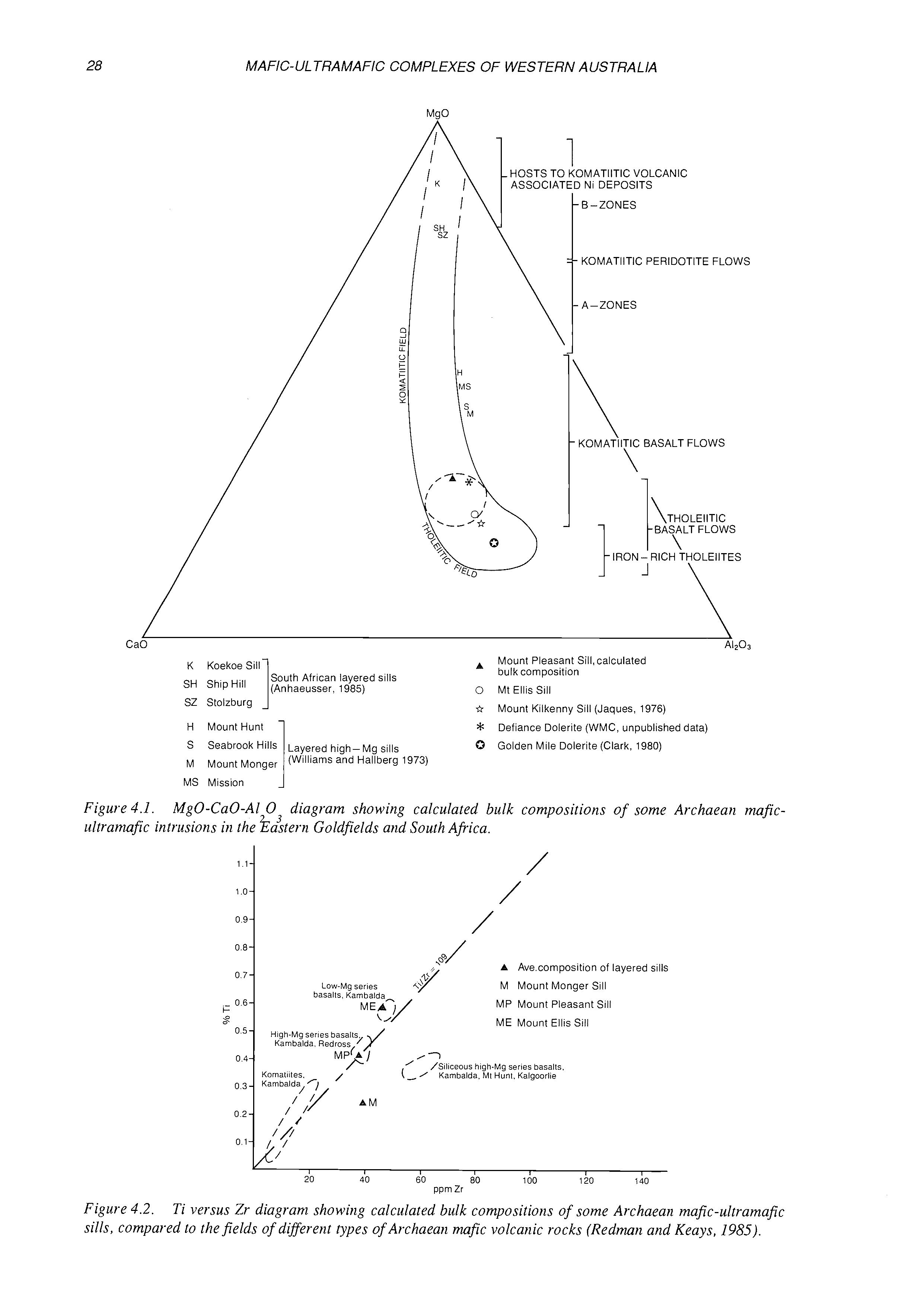
Sparks (1986) predicted that komatiitic magmas could melt and assimilate crustal material to generate SO,-rich, Mg-rich basaltic komatiites and Mg-rich andesite. The higher SiO, contents of the contaminated magmas would expand the stability field of orthopyroxene relative to that of clinopyroxene, resulting in the “S tillwater-type” crystallization sequence. It is possible that the “Stillwatertype” high-MgO sills in the Eastern Goldfields are intrusive equivalents of the siliceous high-Mg series basalts of Redman and Keays (1985) which are commonly interpreted to be crustally contaminated komatiitic melts (Barley, 1986; Arndt and Jenner, 1986; Sun et al., 1990). Although data are limited, this suggestion is consistent with the similar SiO, contents at higher MgO contents, and lower Tar ratios of the “Stillwater-type” sills, compared to the Mount Pleasant Siii (Table 4.1; Fig. 4.2).
4.1.2 Sills with tholeiitic bulk composition
Sills with bulk tholeiitic chemistry are divided
K KoekoeSill SH South African layered sills
(Anhaeusser, 1985)
SZ Stolzburg 1
H MountHunt
Seabrook Layered high-Mg sills
Mount Monger (Williams and Hallberg 1973)
MS Mission
3MATIITIC VOLCANIC 1 Ni DEPOSITS
KOMATllTlC PERlDOTlTE FLOWS
A-ZONES
KOMATllTlC BASALT FLOWS 1 \
A Mount Pleasant Sill, calculated
0 Mt Ellis Sill bulk composition
Sr* 0
Figure 4.1. ultranufic intrusions in the ?&tern Goldfields and South Africa.
Mount Kilkenny Sill (Jaques, 1976)
Defiance Dolerite (WMC, unpublished data)
Golden Mile Dolerite (Clark, 1980)
Mg0-Ca0-A1 0 diagram showing calculated bulk compositions of some Archaean mfic/ / / /
A Ave composition of layered sills M Mount Monger Sill MP Mount Pleasant Sill
ME Mount Ellis Sill
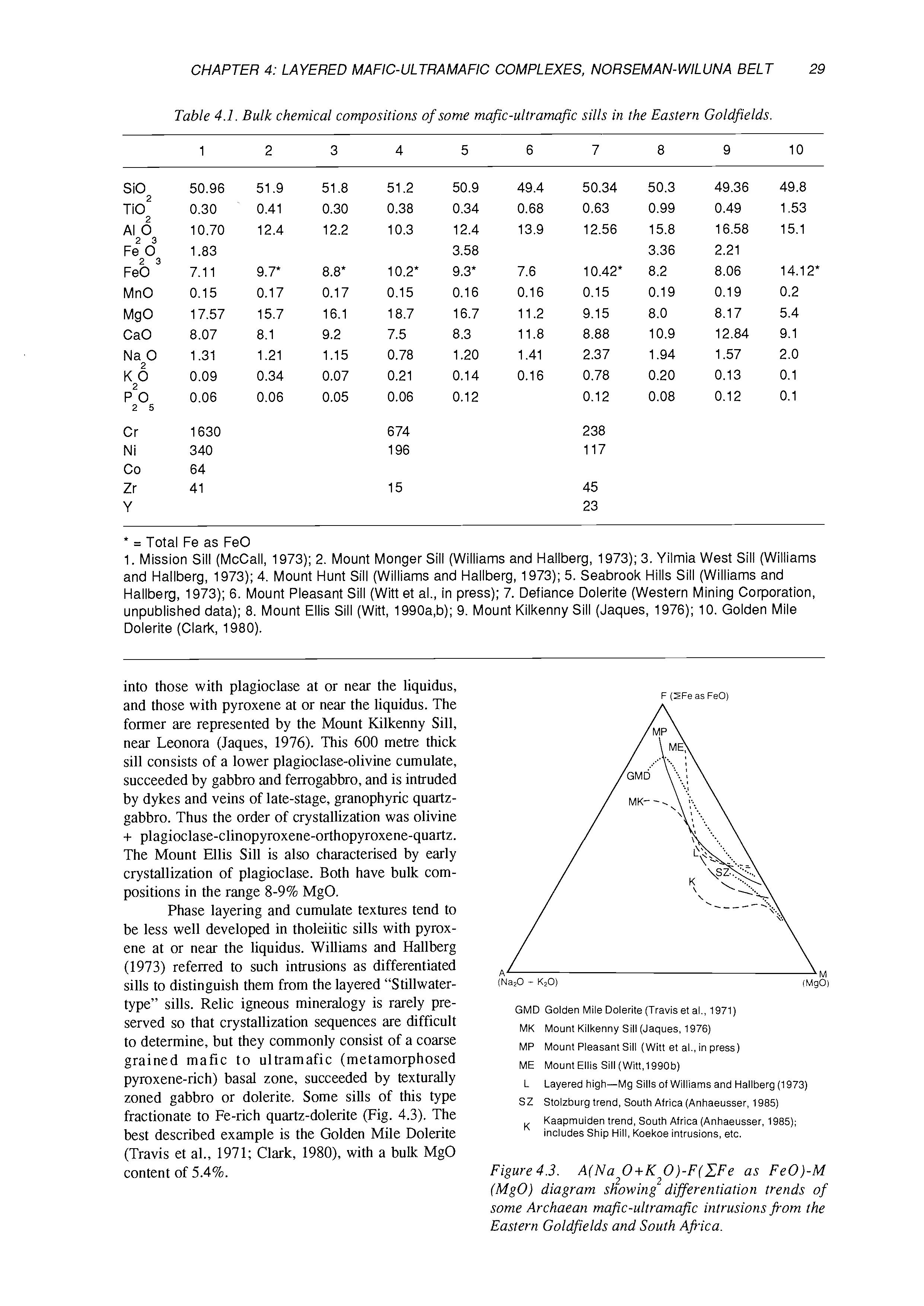
Table 4.1. Bulk chemical compositions of some mafic-ultramafic sills in the Eastern Goldfields. 1 2 3 4
* = Total Fe as FeO
1. Mission Sill (McCall, 1973); 2. Mount Monger Sill (Williams and Hallberg, 1973); 3. Yilmia West Sill (Williams and Hallberg, 1973); 4. Mount Hunt Sill (Williams and Hallberg, 1973); 5. Seabrook Hills Sill (Williams and Hallberg, 1973); 6. Mount Pleasant Sill (Witt et al., in press); 7. Defiance Dolerite (Western Mining Corporation, unpublished data); 8. Mount Ellis Sill (Witt, 1990a,b); 9. Mount Kilkenny Sill (Jaques, 1976); 10. Golden Mile Dolerite (Clatk, 1980).
into those with plagioclase at or near the liquidus, and those with pyroxene at or near the liquidus. The former are represented by the Mount Kilkenny Sill, near Leonora (Jaques, 1976). This 600 metre thick sill consists of a lower plagioclase-olivine cumulate, succeeded by gabbro and ferrogabbro, and is intruded by dykes and veins of late-stage, granophyric quartzgabbro. Thus the order of crystallization was olivine + plagioclase-clinopyroxene-orthopyroxene-quartz. The Mount Ellis Sill is also characterised by early crystallization of plagioclase. Both have bulk compositions in the range 8-9% MgO.
Phase layering and cumulate textures tend to be less well developed in tholeiitic sills with pyroxene at or near the liquidus. Williams and Hallberg (1973) referred to such intrusions as differentiated sills to distinguish them from the layered “Stillwatertype” sills. Relic igneous mineralogy is rarely preserved so that crystallization sequences are difficult to determine, but they commonly consist of a coarse grained mafic to ultramafic (metamorphosed pyroxene-rich) basal zone, succeeded by texturally zoned gabbro or dolerite. Some sills of this type fractionate to Fe-rich quartz-dolerite (Fig. 4.3). The best described example is the Golden Mile Dolerite (Travis et al., 1971; Clark, 1980), with a bulk MgO content of 5.4%.
GMD Golden Mile Dolerite (Travis el al., 1971)
MK Mount Kilkenny Sill (Jaques, 1976)
MP Mount Pleasant Sill (Witt et al., in press)
ME Mount Ellis Sill (Witt,l990b)
L Layered high-Mg Sills of Williams and Hallberg (1973)
SZ Stolzburg trend, South Africa (Anhaeusser, 1985) Kaapmuiden trend, South Africa (Anhaeusser, 1985); includes Ship Hill, Koekoe intrusions, etc.
Figure 4.3. A(Na20+K20)-F(CFe as Fe0)-M (MgO) diagram showing differentiation trends of some Archaean mafic-ultramafic intrusions from the Eastern Goldfields and South Africa.
F (HFe as FeO)
(NazO - K20)
MOi
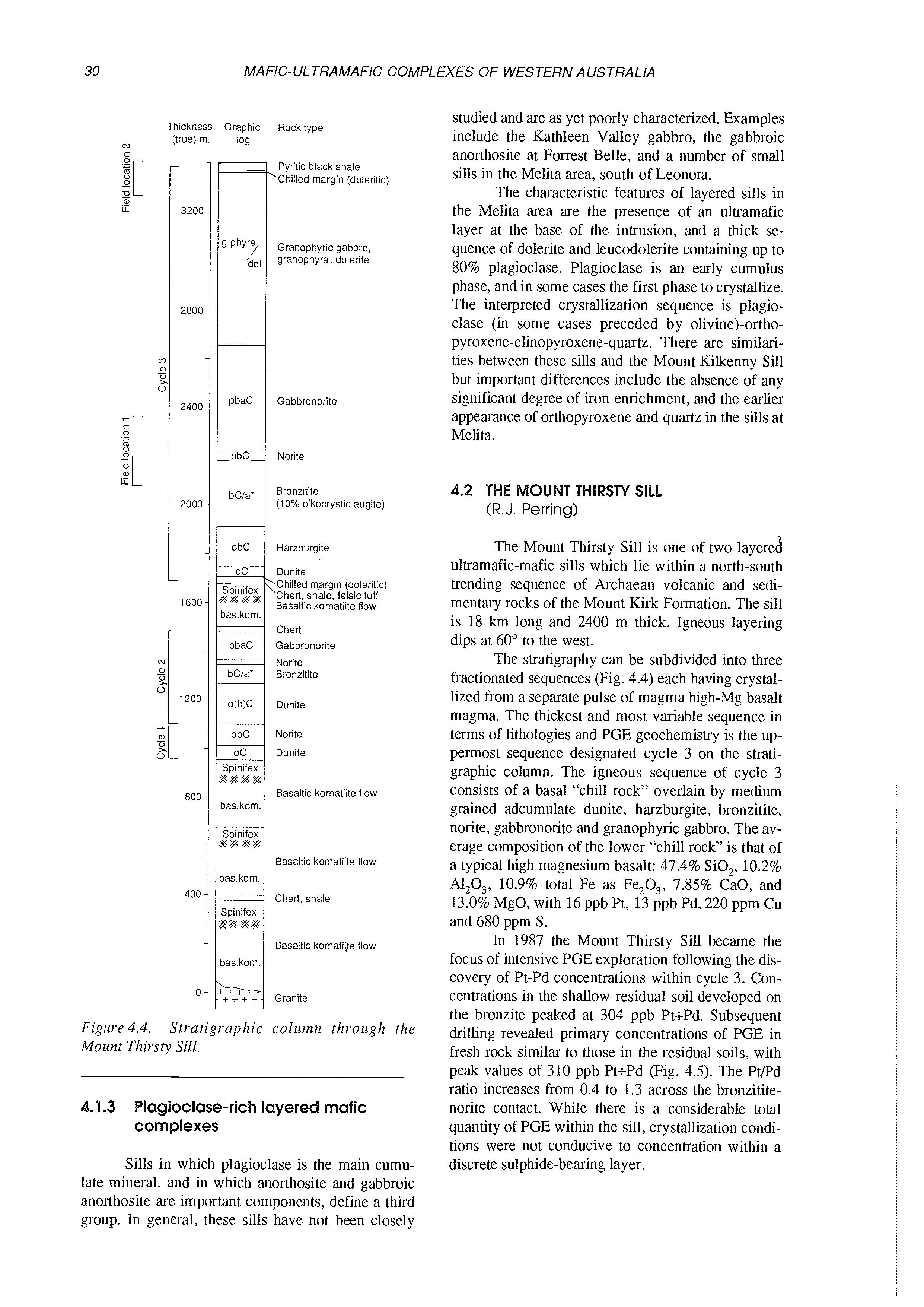
Thickness GraDhic Rock type (true) m. log N
Pyritic black shale ‘Chilled margin (doleritic)
Granophyric gabbro granophyre, dolerite
Gabbronorite
Norite
Bronzitite (10% oikocrystic augite)
Harzburgite
Dunite
Chilled rn,argin (doleritic) ‘Chert, shale, felsic tuff Basaltic kornatiite flow
Chert
Gabbronorite
Norite Bronzitite
Dunite
Norite
Dunite
Basaltic kornatiite flow
Basaltic kornatiite flow
Chert. shale
Basaltic kornatiite flow
studied and are as yet poorly characterized. Examples include the Kathleen Valley gabbro, the gabbroic anorthosite at Forrest Belle, and a number of small sills in the Melita area, south of Leonora.
The characteristic features of layered sills in the Melita area are the presence of an ultramafic layer at the base of the intrusion, and a thick sequence of dolerite and leucodolerite containing up to 80% plagioclase. Plagioclase is an early cumulus phase, and in some cases the first phase to crystallize. The interpreted crystallization sequence is plagioclase (in some cases preceded by olivine)-orthopyroxene-clinopyroxene-quartz. There are similarities between these sills and the Mount Kilkenny Sill but important differences include the absence of any significant degree of iron enrichment, and the earlier appearance of orthopyroxene and quartz in the sills at Melita.
(R.J. Perring)
The Mount Thirsty Sill is one of two layered ultramafic-mafic sills which lie within a north-south trending sequence of Archaean volcanic and sedimentary rocks of the Mount Kirk Formation. The sill is 18 km long and 2400 m thick. Igneous layering dips at 60” to the west.
The stratigraphy can be subdivided into three fractionated sequences (Fig. 4.4) each having crystallized from a separate pulse of magma high-Mg basalt magma. The thickest and most variable sequence in terms of lithologies and PGE geochemistry is the uppermost sequence designated cycle 3 on the stratigraphic column. The igneous sequence of cycle 3 consists of a basal “chill rock” overlain by medium grained adcumulate dunite, harzburgite, bronzitite, norite, gabbronorite and granophyric gabbro. The average composition of the lower “chill rock” is that of a typical high magnesium basalt: 47.4% SiO,, 10.2% A1,0,, 10.9% total Fe as Fe,O,, 7.85% CaO, and 13.0% MgO, with 16 ppb Pt, 13 ppb Pd, 220 ppm Cu and 680 ppm S.
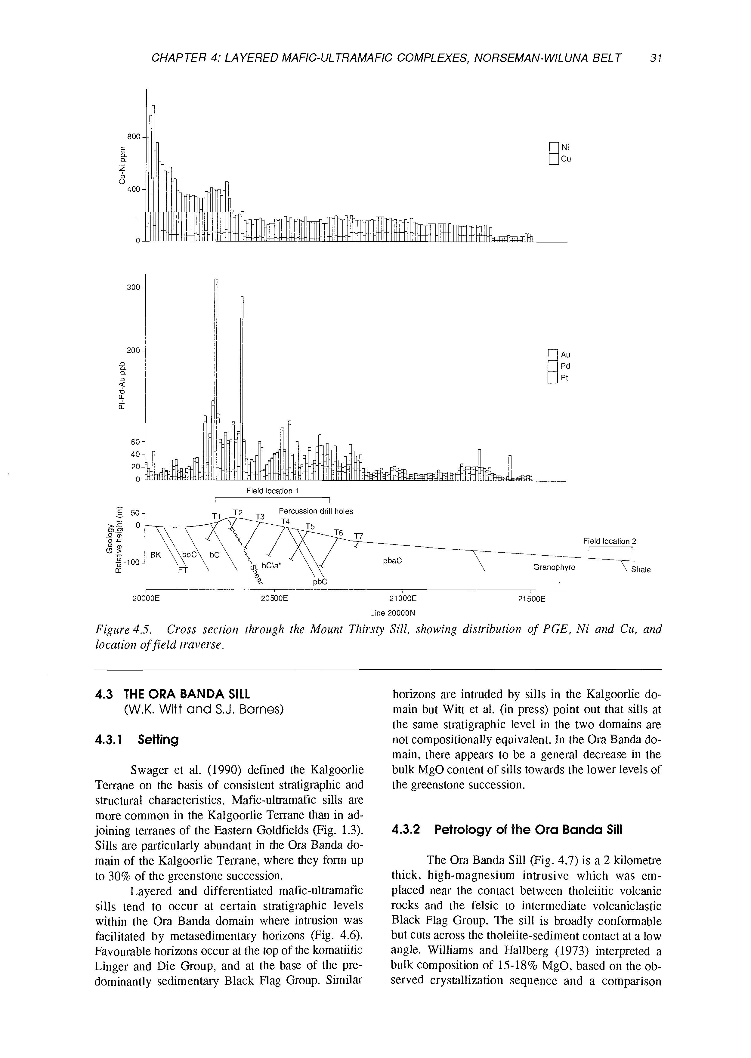
Sills in which plagioclase is the main cumulate mineral, and in which anorthosite and gabbroic anorthosite are important components, define a third group. In general, these sills have not been closely
In 1987 the Mount Thirsty Sill became the focus of intensive PGE exploration following the discovery of Pt-Pd concentrations within cycle 3. Concentrations in the shallow residual soil developed on the bronzite peaked at 304 ppb Pt+Pd. Subsequent drilling revealed primary concentrations of PGE in fresh rock similar to those in the residual soils, with peak values of 310 ppb Pt+Pd (Fig. 4.5). The Pt/Pd ratio increases from 0.4 to 1.3 across the bronzititenorite contact. While there is a considerable total quantity of PGE within the sill, crystallization conditions were not conducive to concentration within a discrete sulphide-bearing layer.
Granite
Figure 4.4. Mount Thirsty Sill. Stratigraphic column through the
.1.3 Blagioclase-richlayered mafic complexes
Figure4.5. location offield traverse.
Cross section through the Mount Thirsty Sill, showing distribution of PGE, Ni and Cu, and
4.3 THE ORA BANDA SILL (W.K. Witt and S.J.
Barnes)
4.3.1 Setting
Swager et al. (1990) defined the Kalgoorlie Terrane OII the basis of consistent stratigraphic and structural characteristics. Mafic-ultramafic sills are more common in the Kalgoorlie Terrane than in adjoining terranes of the &stern Goldfields (Fig. 1.3). Sills are particularly abundant in the Ora Banda domain of the Kalgoorlie Terrane, where they form up to 30% of the greenstone succession.
Layered and differentiated mafic-ultramafic sills tend to occur at certain stratigraphic levels within the Ora Banda domain where intrusion was facilitated by metasedimentary horizons (Fig. 4.6). Favourable horizons occur at the top of the komatiitic Linger and Die Group, and at the base of the predominantly sedimentary Black Flag Group. Similar
horizons are intruded by sills in the Kalgoorlie domain but Witt et al. (in press) point out that sills at the same stratigraphic level in the two domains are not compositionally equivalent. In the Ora Banda domain, there appears to be a general decrease in the bulk MgO content of sills towards the lower levels of the greenstone succession.
4.3.2 Petrology of the Ora Banda Sill
The Ora Banda Sill (Fig. 4.7) is a 2 kilometre thick, high-magnesium intrusive which was emplaced near the contact between tholeiitic volcanic rocks and the felsic to intermediate volcaniclastic Black Flag Group. The sill is broadly conformable but cuts across the tholeiite-sediment contact at a low angle. Williams and Hallberg (1973) interpreted a bulk composition of 1.518% MgO, based 011 the observed crystallization sequence and a comparison
NORTH & WEST
SOUTH & EAST (SIBERIA, GRAlvTS PATCH-MT
KURRAWANG FORMATION
Figure 4.6.
Quartz-rich sandstone, siltstone, conglomerate
Felsic to intermediate volcaniclastic sediments LIIIII[IIIl Minor gabbroic units
Layered mafic ultramafic sills
Porphyritic low-Mg series basalt
BLACK FLAG GROUP
VICTORIOUS BASALT
BENT TREE BASALT
BIG DICK BASALT
SIBERIA KOMATIITE
WALTER WILLIAMS FORM! MISSOURI BASALT
,TION -
GRANTS PATCH GROUP
LINGER & DIE GROUP
POLE GROUP
WONGI BASALT
Low-Mg series basalt
High-Mg series basalt
Olivine orthocumulate and adcumulate rocks
Granite
Stratigraphic column for the greenstone succession in the Ora Banda domain of the .Kalgoorlie
Terrane, showing position of the main mafic-ultramafie sills.
with similar sills in the Eastern Goldfields. Although the upper half of the sill is well exposed, the basal peridotite (olivine orthocumulate) is covered by laterite, preventing direct determination of bulk composition. Cryptic layering, based on the composition of orthopyroxene (En,,Fs,,-EnSOFs,,), clinopyroxene (Wo,,En,,Fs, ,-Wo,,En,,Fs,,) and plagioclase (An,,Ab,,-An,oAb,,) has been documented by Williams and Hallberg (1973). Mineral compositions show a broadly uninterrupted fractionation trend upward through the sill.
Coarse, adcumulate orthopyroxenite and norite, near the centre of the sill, are unmetamorphosed and contain cumulus bronzite +_ cumulus andesine. The upper half of the sill is predominantly gabbro-norite (orthopyroxene-clinopyroxene-plagioclase cumulate). Millimetre-scale igneous lamination, and irregular patches and lenses (up to 2 x 15 cm) of anorthosite are common in the lower gabbro-norite zone. Lower and upper gabbro-norite zones are distinguished by the presence of bronzite and inverted pigeonite, respectively.
The uppermost 50-100 metres of the intrusion are characterised by variable grainsize, locally ap-
proaching pegmatoid gabbro, a feature attributed to the accumulation of volatiles near the roof. Minor muscovite and quartz also occur.
The high-Mg composition of the sill indicates that the parent melt would have been hotter than other sills in the Ora Banda domain. A thin felsic granophyre layer (80-90% feldspar and quartz) immediately below the roof of the intrusion is interpreted to result from partial melting of the hanging wall (c.f. Campbell and Turner, 1986). Witt (1987) described a locality south of Ora Banda where partial melting of a coarsely plagioclase-phyric basalt roof has incorporated plagioclase phenocrysts into a relatively thin granophyre zone directly beneath the roof. Thickest granophyre development occurs north of Ora Banda where the roof is formed by sedimentary rocks although the apparent thickness may have been structurally accentuated (Witt, 1990a).
4.3.3 PGE mineralization
Exploration activity for PGE was initiated by Carbine Gold in 1988, with the discovery of concen-
Banda Sill
zone (peridotite)
obscured by laterite cover.
Mafic zone
Ultramafic zone
Fe- rich norite-gabbro
Fine grained norite-gabbro
Upper norite-gabbro
Lower norite - gabbro
Norite
Orthopyroxenite
Peridotite
0 Pegmatoid patches L Granophyre
trations of up to 1 ppm Pt in lateritic soils developed above the pyroxenite zone in the Mount Carnage area. This area was subjected to extensive percussion drilling, and two diamond drill holes (Fig. 4.8) were also put in. This activity indicated that anomalous PGE concentrations in laterite corresponded to similar concentrationsin underlying fresh rock. Metallurgical characteristics of the PGE-enriched laterites turned out to be unfavourable, and exploration activity was taken no further.
Data from the two diamond holes are plotted in Figure 4.8. The correlation between the two holes is uncertain, but it is likely that they approximate a true stratigraphic section with the base of OBD-2 corresponding to the top of OBD-1 in stratigraphic position. Peak Pd concentrations of almost 1 ppm, and peak Pt of 250 ppb, were intersected in a 150 m wide interval immediately above the contact between
olivine-bronzite cumulates below and pyroxene cumulates above.
It is clear from the profiles that the base of the pyroxenite unit corresponds exactly to the onset of sulphur saturation and the first appearance of cumulus sulphides. However, there is not a single PGE peak corresponding to the first appearance of sulphides as might be expected, and as has been observed at Munni Munni (Hoatson and Keays, 1989), but rather a broad zone of PGE and sulphide enrichment. Particularly in OBD-2, there is an anti-correlation between PGE and Cu correlation. There appear to have been a series of cycles of segregation of alternately PGE-rich and PGE-poor sulphides within the pyroxenite, suggestive of multiple magma emplacements. However, this interpretation is not supported by the pyroxene composition data, which show approximately constant compositions through the upper
Figure 4.7. Stratigraphic section through the Ora Banda Sill.
Figure 4.8. Profile of PGE and Cu concentrations (5 sample moving averages of 50 cm core samples) and average Cr 0 and MgOl(MgO+FeO) in cumulus orthopyroxene, for two diamond drill holes through the upper part of the 2ul~ramaficzone of the Ora Banda Sill. The top of the section intersected by OBD-1 is believed to correlate approximately with the bottom of the OBD-2 section.
200 m of peridotite, but a steady iron enrichment trend through the pyroxenite implying in situ fractionation. A consistent interpretation is that successive cycles of PGE-enriched sulphides correspond to very small, limited influxes of dense magma flowing across the floor of the sill.
4.3.4 Field trip location descriptions
The lower section of the Ora Banda Sill is exposed north of the Coolgardie road, 2.5 km SSW of Ora Banda township.
A prominent ridge of laterite, to the east, has
developed over the basal, ultramafic layers (Zones 1, 2) of the sill. Secondary silica, in the form of “moss agate”, and magnesite, are commonly associated with the laterite, where it develops over peridotite. The “moss agate” is prized as a gemstone of local repute, and is presumably produced as a by-product of serpentinization.
The basal peridotite and orthopyroxenite are rarely exposed. However, at this locality, weathered orthopyroxenite is exposed in a creek bed which dissects the western face of the laterite ridge. The orthopyroxenite is a massive, equigranular, adcumdate bronzite, with a grainsize of 1-2 mm.
Fresh norite (Zone 3) occurs as scattered outcrops, towards the foot of the laterite ridge. The norite is a massive, equigranular adcumulate, consisting of cumulate plagioclase and orthopyroxene with a grainsize of 1-2 mm. The relative proportions of plagioclase and orthopyroxene are quite variable, indicating that some fine-scale layering may be present, but this is not obvious at outcrop scale.
West of the laterite ridge, the dominant lithology is gabbro-norite (Zone 4) consisting of subequant plagioclase, clinopyroxene (augite) and orthopyroxene (bronzite). The proportion of clinopyroxene to orthopyroxene increases to the west, towards the overlying pigeonite-bearing Zone 5 (the prominent hill across the Coolgardie road, to the west). Cumulus textures are well preserved, and vary from adcumulate at the base of Zone 4, to mesocumulate towards the top. A weakly developed mm-scale banding, which dips 40-60” W and is defined by alternating layers of pyroxene and feldspar, can be observed at many outcrops. Also present are pale brown-grey, plagioclase-rich domains which occur as thin, lens-shaped masses, subparallel to igneous banding, and as larger, xenolith-like blocks up to about 10 cm across. The thin lenses appear to merge with the feldspar-rich igneous layers at the finer end of their size scale, and probably represent feldsparrich ,intercumulus liquids which have been squeezed out from surrounding areas into their present position. The origin of the larger blocks is more difficult to explain. Anorthosite layers have not been observed in the Ora Banda Sill.
4.4
LAYERED KOMATIlTlC ROCKS AT KURRAJONG
(R.E.T. Hill and M.J. Gole)
4.4.1 Introduction
The ultramafic rocks of the Siberia-Menzies region in the Norseman-Wiluna Greenstone Belt are dominated by a regionally extensive komatiite unit, the Walter Williams Formation (WWF) (Fig. 1.4). The Walter Williams Formation is a layered body traceable over 130 km from south-west of Siberia to the Kurrajong Anticline in the Mount Ida Greenstone Belt (Fig. 4.9). It comprises a lower zone of olivine
cumulates and an upper zone of gabbroic rocks. Stratigraphic columns through the Walter Williams Formation show its gross layering and lateral variations (Fig. 4.10). South of Ghost Rocks the lower ultramafic zone of the Walter Williams Formation is dominated by a thick olivine adcumulate layer, which grades laterally to olivine mesocumulates and orthocumulates to the north between Ghost Rocks and Lake Ballard and at Kurrajong. North from Yunndaga, the upper zone of the WF is a layered gabbro which thickens northwards from approximately 30-40 m at Yunndaga to 100 m at Ghost Rocks and 180 m at Kurrajong. Estimates of the true thickness of the unit are greatly hampered by the lack of dip information, and the relative thicknesses shown in Figure 4.10 are somewhat conjectural. The true thickness of the unit in the southern part is probably 600-900 m. At Vetters Hill the outcrop thickness is about 200 m, just south of Menzies it is only 50 m and at Ghost Rocks it is again 100-200 m. The unit certainly appears to thin from about 10 km south of Menzies northward to Lake Ballard although this may in part be due to deformation as some of the rocks in this area are highly strained.
This thick sheet of olivine adcumulates, and the similar but laterally restricted lenticular bodies in regional sequences of olivine-rich komatiites in the Agnew-Wiluna belt to the north (Fig. 1.4) for many years had been interpreted as intrusive. They have now been shown to be extrusive, forming integral parts of the komatiite lava sequence (Hill et al., 1989, 1990), having crystallized from continuously flowing lava sheets, lava rivers and periodically replenished lava lakes.
The WWF is the crystallization product of a massive sheet flow with different lobes experiencing different crystallization conditions. In the Ghost Rocks-Siberia area, crystallization conditions within the flow favoured the growth of olivine adcumulate and were relatively constant with in-situ fractionation restricted Lo isolated ponded areas during the waning stages of eruption. At Kurrajong, ponding, in situ differentiation and influxes of new magma occurred throughout the history of the flow. In this area, the Walter Williams Formation exhibits field evidence for fractionation of komatiite liquids from olivine through chromite, magnesian augite and plagioclase to quartz, consistent with experimental data of Arndt (1977).
4.4.2
The Kurrajong Komatiite Sequence
The Kurrajong sequence is exposed in the fault-bounded Kurrajong anticline, located in the Mount Ida greenstone belt about 35 km northwest of Ghost Rocks (Fig. 4.9). The area was explored by CRA for Ni in the late 1960’s and early 1970’s and Ni sulfides were discovered in the northern part of the east limb of the anticline around KJD-5 and KJD-
4.9. Formation. Geological map showing the distribution of the olivine adcumulate unit of the Walter Williams
Figure
Walter Williams Formation
Ghost Rocks \
Spinifex-texturedflows
Layered gabbro
Olivine orthocumulate a
Olivine harrisite
Olivine adcumulate
Tholeiitic basalt
Sedimentary rocks
Sheared contact L
Olivine mesocumulate *
Witt & Harrison (1989)
Vertical scale 400m (approx.)
Figure 4.10. Stratigraphic profiles through the Walter Williams Formation (see Fig. 4.9 for locations).
6 (Fig. 4.11). CRA drilled a total of 12 diamond drill holes within the anticline.
The stratigraphy of the Kurrajong Anticline comprises, from bottom to top, pillowed tholeiitic basalt, a thin black shale, the WWF, a sedimentary horizon, a thin basalt, spinifex-textured komatiite flows and an upper gabbroic unit. The sedimentary rocks overlying the WWF consist of medium to finegrained arkosic to sandy units with minor chert. The sequence is most complete and best exposed in the area of drill hole KJD-1 area (Figs 4.11 and 4.12).
The WWF is about 800 m thick in the KJD 1 area on the eastern limb of the fold but thins along the western limb. Although part of the change in apparent thickness may be due to a change in dip and attenuation, the preservation of delicate igneous textures in rocks along the western limb suggests that the reduction in thickness is partly an original feature.
The ultramafic zone of the Walter Williams Formation (Fig. 4.13) consists mostly of olivine orthocumulate with olivine mesocumulate in the central part (Fig. 4.14A). In the central part there are at least four thin magnesian augite-olivine adcumulate layers which are 0.5-3 m thick and consist of Mgaugite (or altered assemblage) and altered olivine in a polygonal aggregate (Fig. 4.14B). This section contrasts with the adcumulate-dominated ultramafic zone of the Walter Williams Formation to the south in the Siberia-Menzies region.
In the upper portion of the ultramafic zone in the KJD-1 area, chomite-rich layers are developed
within olivine-magnesian augite-chromite orthocumulates (Fig. 4.14C). There are also distinctive units of coarse-grained olivine harrisite, with clinopyroxene oikocrysts, the uppermost of which is interpreted to cap the ultramafic zone.
The gabbro zone consists of two well defined cycles from olivine orthocumulate to gabbro. The lower cycle is beheaded by an olivine orthocumulate layer (Fig. 4.14D) at the base of the upper cycle whereas the upper cycle is capped by an upward fining, ophitic-textured dolerite (Fig. 4.14E) that grades upwards into a pyroxene-phyric basaltic flow top breccia (Fig. 4.14F). This sequence provides critical evidence that the WWF is extrusive in origin. Apart from the uppermost section of the upper cycle, the two cycles are similar with a lower olivine orthocumulate, then a layer, 2 m thick, of polygonaltextured diopside cumulate containing altered olivine in the lower part and plagioclase oikocrysts in the upper part with an intervening layer of pure diopside. This sequence exemplifies the crystallization order olivine-diopside-plagioclase.The upper and lower contacts are sharp. Above the diopside layer are diopside-plagioclase cumulates with varying mineral proportions. Above this are non-cumulate gabbros (Fig. 4.14E). Quartz is present throughout much of the thickness of the gabbro units in what may have been granophyric intergrowths. In the upper gabbro, quartz disappears up sequence just below the dolerite. Within both gabbro units, but more particularly in the upper gabbro, there are patches of branching, coarse-grained harrisitic clinopyroxene in a ma-
Siberia area
Vetters Hill
Kurrajong
Walter Williams Formation: olivine cumulates, layered gabbro
Sedimentary rocks: black shale, volcanogenicfelsic rocks
Granitoid
,'Major fault -, Spinifex-texturedflows ./'Facing ,/ Diamond drill hole High MgO basalts
Figure 4.1 1. Geological imp of the Kurrajong Anticline.
trix of interlocking plagioclase laths and areas of recrystallized quartz and feldspar.
Geochemical profile - KJD-1 area
The geochemical profile through the WWF (Fig. 4.15) clearly shows the lithological layering just described. In the ultramafic zone the relatively high contents of TiO, and CaO (as well as A1,0,), reflect the higher igneous porosity of these rocks compared
with olivine adcumulates in the ultramafic zone to the south. The section within KJD-1 contains cyclic layering in the central part of the ultramafic zone with upward increases in CaO and decreases in MgO reflecting changes in the model proportions of olivine and pyroxene below each of the three Mg-augiteolivine cumulate layers intersected. Above the third layer similar geochemical variations are present but here the cycles were beheaded before a clino-
Tholeiitic basalt
Gabbro
Walter Williams Formation
Olivine orthocumulate
Olivine mesocumulate
Endiopside-olivine adcumulate
Olivine-endiopside harrisite
Gabbro, minor diopside-olivine and % diopside-plagioclase cumulate
Flow top
4.12.
Other Lithologies
Spinifex-textured komatiite
Tholeiitic basalt ,,.,.,.. Sedimentary rocks
Gabbro
Foliated granite .--’ Outcrop boundary -- Fault x Aumine
Figure
Geological map of the KJD-1 area within the Kurrajong Anticline.
Estimated stratigraphic height (rn)
Anhydrous wt YO
Figure 4.13. Composite profile showing lithologies, whole rock and mineral compositions through the lower part of the Walter Williams Formation. Abbreviations: o = olivine, a = magnesian augite, c = chromite, d = diopside, p = plagioclase, OC = orthocumulate, AC = adcumulate.
pyroxene layer could form. The rocks formed in each successive cycle in this sequence contain more MgO and less CaO reflecting an increase in the packing density of olivine. It may also reflect, in part, a change to more Fo-rich olivine compositions.
In the gabbro zone the two fractionation cycles are clearly defined by the geochemical profiles (Fig.4.13). Through most of the upper diopsideplagioclase cumulate and granophyric gabbro unit MgO increases upwards whereas TiO, decreases (as does FeO, and P,O,) suggesting that the rocks in the upper section crystallized downward from the flow top breccia. This is also indicated by the upward fining of grain sizes. The lower gabbro unit contains less TiO, and P,Os than the upper gabbro but these components increase upwards suggesting that the lower gabbro was beheaded before they could accumulate to the levels seen in the upper gabbro.
Nickel in whole-rock and in olivine shows systematic variations through the ultramafic zone
(Fig. 4.15). Whole-rock Ni decreases and Cu increases with increasing modal clinopyroxene. Peaks in Cu content occur within pyroxenite layers. In contrast, Ni in olivine and in whole-rock within and immediately above these layers is low, indicating depletion due to sulphur saturation. A study in progress on the PGE distribution within this sequence will permit detailed resolution of the data.
4.4.3 Summary
The Kurrajong komatiites of the Walter Williams Formation exhibit excellent examples of olivine accumulation and in situ fractionation in a ponded lava lake.
In the lower ultramafic zone olivine orthocumulate predominates and there are several beheaded fractionation cycles, as evidenced by wholerock geochemistry and olivine composition, four of
Figure 4.14. Photomicrographs of rock types from the Kurrajong area of the Walter Williams Formation. A: Oliviiie mesocumulate, partly serpentinised. B: Magnesian augite-olivine adcumulate (augite fresh - white; olivine - dark grey). C: Olivine-chromite orthocumulate (olivine serpentinised - white; augite fresh - grey, top left). D: Olivine (white) orthocumulate with oikocrystic augite (black). E: Gabbro. F: Fine-grained flow top breccia. All transmitted light photomicrographs.
which are capped by augite-olivine adcumulate. The thin augite-olivine adcumulates can be tracea in outcrop for at least 3 km of strike (Fig. 4.12) suggesting that the lava pond was extensive and coherent. The high proportion of olivine indicates that the fractionated lava must have been periodically swept away by new pulses of magma. The upper two olivine-orthocumulate-to-gabbro cyclic units reflect normal fractionation processes in komatiite liquids, exhibiting the rapidity with which olivine gives way to pyroxene and plagioclase, and how quickly quartz
appears in the fractionated residuum after olivine stops crystallizing.
The upper parts of the gabbroic units are noncumulate rocks %d reflect the composition of fractionated residua. These rocks contain only 5-6 weight % MgO and record the extent to which komatiite liquids can fractionate.
The flow-top breccia has 8-10 weight % MgO; higher than the dolerite and gabbroic rocks in the upper cyclic unit. This indicates that limited fractionation continued within this cyclic unit after
Estimated stratigraphic height (m)
CaO wt % Nix1000 pprn Anhydrous
CuxlOO pprn
Figure 4.15. Lithological, whole rock atid olivine composition profiles from diamond drill hole KJD-I, Kurrajong.
formation of the flow top breccia. Flow tops would have formed and been destroyed throughout the flow's history until a relatively late stage at which the presently preserved flow top breccia formed. The cyclicity between olivine cumulates and gabbros may be relatively common in komatiite terrains. Similar associations in the Norseman-Wiluna Belt have been described by Dowling et al. (1989) in the Mount Keith Region, and Witt and Harrison (1989) in the Grants Patch Area.
4.4.4 Description of field trip traverses
The field excursion involves two traverses shown on Figure 4.12. Locations of interest are depicted on lithologic columns (Fig. 4.16).
Traverse I
Traverse 1 covers the upper portion of the
ultramafic zone and the lower of the two olivine orthocumulate-gabbro cyclic units. The traverse begins at the collar of diamond drill hole KJD-1 (Fig. 4.12). To the west of KJD-1, rubble of lateritic silica cap is developed over olivine cumulates of the lower portion of the ultramafic zone. The traverse proceeds eastwards from Location I over subdued outcrop of two thin augite-olivine cumulate layers, (Location 2), then over rubble and outcrop of olivine orthocumulate, and a small outcrop of olivine mesocumulate, to Location 3 where there is one of several chromite-rich zones.
Location 4 is the lower of two distinct coarsegrained olivine harrisite layers. Here the outcrop is mostly rubbly and better examples of this unit outcrop 100 metres to the south. Just above this harrisite at Location 5, is another distinctive chromite rich zone (oacOC). The olivine orthocumulates continue over the top of the hill to Location 6, the upper of the two harrisite units which is here in complex fault
Figure
contact with gabbroic rocks of the lower gabbro cyclic unit. Traverse 1 then moves south about 100 metres to Locatioii 4a, which is once again the lower olivine harrisite unit and proceeds eastwards over the lower of the two olivine orthocumulate-gabbro cyclic units.
Locatioii 6 is an olivine harrisite which marks the top of the ultramafic zone. From this location the traverse passes over olivine orthocumulate at the base of the cyclic unit, to Locations 7 and 8 which together span a few metres over which the sequence oOC-odC-doc-dpC-gabbro (d = diopside) can be observed. Individual units are difficult to decipher because the pyroxene-rich rocks do not outcrop well. Location 9 is over the ridge just short of a small gully, and is on gabbro outcrop. This completes Traverse 1.
Traverse 2
Traverse 2 covers the Kurrajong stratigraphy one kilometre south of Traverse 1 (Fig. 4.12). The traverse begins at the upper harrisite unit which marks the top of the Ultramafic Zone, Location 6c (Fig. 4.16). Here, there are excellent textures preserved in the harrisite and overlying olivine orthocumulate. The traverse proceeds eastwards over the
stratigraphy to Location 9a which marks the top of the gabbro of the lower cyclic unit of the gabbro zone, and is equivalent to the last stop of Traverse 1.
Just above this contact at Location 10, there are two layers of diopside cumulate and olivinediopside cumulate, the latter grading into olivine orthocumulate up-slope. These layers form a marginal zone at the base of the upper olivine orthocumulate-gabbro cyclic unit and they have crystallized from gabbro-contaminated magma at the base of the new magma pulse responsible for the cyclic unit.
Locations 11, 12 and 13 are in the olivine orthocumulate which in places exhibits a peculiar pillow-like weathering pattern. At the top of the ridge, Locations 14, 15 and 16 span 3 metres of stratigraphy including layers of diopside-olivine cumulate, diopside-plagioclase cumulate and gabbro.
The traverse proceeds over the gabbro which exhibits several textural variants including those with feathery plagioclase, harrisitic pyroxene and granophyric clots.
The grain size decreases up-stratigraphy in dolerites at Locations I7 and 18 and the traverse ends in the flow top breccia at Location 19.
5.1 OVERVIEW OF THE COMPLEX
(C.I. Mathison and A.L. Ahmat)
The Windimurta Complex (Fig. 5.1) is located 500 km NE of Perth and about 50 km east of Mount Magnet, on the poorly defined border between the Murchison and Southern Cross Provinces of the Archaean Yilgarn Block. It covers an elliptical area of 2300 km2 (85 km N-S by 37 km E-W), and has a stratigraphic thickness of 10- 13 km. Unpublished Sm-Nd data of Ahmat and Fletcher indicate an age of about 2.8 Ga. Windimurta is probably the largest single layered intrusion in Australia, and has been explored extensively for V and PGE deposits.
The complex is a basin-like stratiform layered gabbroic body, elliptical in plan with layering dipping inwards at angles decreasing from 50"-70" near the margins to 10" in the middle. Dip data are lacking for much of the western side of the complex (Fig. 5.1). Gravity modelling, based on two detailed E-W traverses, suggests that it is a tabular body 3-4 km thick with an elongate central root zone 5 km thick and with margins dipping inwards at about 80". Greenschist to amphibolite facies metamorphism and alteration of gabbros is more complete near the margins and generally decreases inwards.
The Windimurra Complex is enveloped by younger biotite monzogranites (2.68 Ga) separated from the gabbros by steeply inward-dipping (60" to 80") dextral shear zones. The eastern shear zone (Wyemandoo Shear) contains minor greenstone lithologies. Chilled margins and metamorphic aureoles are lacking, although finer-grained noritic rocks and crescumulate-like gabbroic rocks with bladed pyroxenes near the eastern contact suggest proximity to the original margin of the intrusion. The Kantie Murdana Volcanics, consisting of felsic lavas and tuffs, BIF, chert, granophyre and dolerite, possibly up to 1.5 km thick, overlies about 15% of the northern middle portion of the Complex, and could represent either younger cover rocks or original roof rocks.
Internally, the Complex contains two main sets of major faults and shear zones: NW-SE (sinistral) and NE-SW (dextral). The Wyemandoo Shear (E margin) in the southeast, separates the main mass of the Complex from the Palagea Block, a large rotated block of layered gabbros (25 km long, 5-8 km
stratigraphic thickness). Narrow shears (1 m wide) occur along the eastern side parallel to the Wyemandoo Shear. The Complex may be gently folded about a N-S axis and tilted slightly west, increasing the dips on the eastern side.
The stratigraphy of the intrusion is dominated by coarse-grained, plagioclase-rich cumulates showing several types of layering. The complex as a whole shows a typical tholeiitic fractionation trend of decreasing anorthite in plagioclase (An8s-s6)and decreasing MgO/(MgO+FeO) in cumulus ferromagnesian phases, ranging from 90 to 56 in augite, 88 to 53 in orthopyroxene, and 80 to 32 in olivine (Ahmat, 1986). There is no well-developed ultramafic zone, and ultramafic rocks are almost entirely absent except for a small area (Muleryon Hill: Fig. 5.1) in the south of the complex, whose structural relationship to the rest of the intrusion is enigmatic. The parent magma is thought to be an aluminous tholeiite. Much of the complex is blanketed by laterite and there is only about 10% outcrop, although what there is, is of good quality. Stratigraphic correlation between the widely spaced areas of outcrop presents major difficulties, compounded by the presence of large-scale unconformities and structural discordances.
5.1.1 Stratigraphy
Ahmat (1986) presented a stratigraphic subdivision based on the appearances and disappearances of the cumulus minerals olivine and inverted pigeonite, and on the abundances of the dominant lithologies (Fig. 5.2). Terminology has been revised here to bring it into line with the recommendations of Irvine (1982). It is assumed that there is no major structural repetition of stratigraphy. The column is probably incomplete as some of the layered series near the floor remains hidden (including the possible Ultramafic Series and lower parts of the Lower Series), and the top of the intrusion has been removed by erosion and tectonism. The following major subdivisions are recognised (Fig. 5.2):
1. Ultramafic Series (UMS). The exposed portion of the UMS consists of 0.5 km of serpentinized olivine-chromite mesocurnulate with disseminated and semi-massive chromite. The chromite is an iron-
WlNDlMURRA COMPLEX Upper Series WONDINONG 0
Figure 5.1. visited, and distribution of stratigraphic zones (inset).
Geological map of the Windimurra Complex, showing the main areas of outcrop, localities to be
rich, low-Cr variety having 31 weight % Cr,O, and 5% MgO, 21% A1,0, 12% Fe,O, and 28% FeO.
2. Lower Series (LS) (maximum thickness 10.4 km). This is characterized by the presence of cumulus plagioclase, augite, orthopyroxene and olivine, with cumulus magnetite in the upper 2 km. The dominant rock type is a modally layered coarse-grained leucogabbronorite (3- 10 mm grain size) containing plagio-
clase (average 77 vol%, Ans5&, augite (average 12%, Mg 90 to 671, orthopyroxene (8%, Mg 88 to 61), olivine (2%, Mg 80 to 50), and in the upper 2 km magnetite (l%, commonly 10-15% TiQ,, maximum 1.8% V205). The range of whole-rock Mg numbers is 80 to 47.
3. Middle Series (MS) (maximum thickness. 1.5 km). The Middle Series is defined by the disap-
Figure 5.2. Stratigraphic column for the Windimurra Complex, compiled from correlation of the stratigraphy of six main subareas. Distribution of cumulus phases is shown by vertical lines, together with a summary of mineral composition data. UMS = Ultramafic Series, CW = Corner Well. Rock type codes: Dun = dunite, Cr = chromitite seams, LGN = leucogabbronorite, GN = gabbronorite, N = norite, LN = leuconorite, LOGN = olivine-leucogabbronorite,OG = olivine gabbronorite, LT = leucotroctolite, Mt = magnetite seams. Mineral codes: p = plagioclase, a = augite, o = olivine, b = bronzite, h = hypersthene, m = magnetite; e.g. polah indicates plagioclase-olivine cumulate with oikocrysts of augite and hypersthene.
pearance of olivine as a cumulus phase and the presence of cumulus pigeonite (now inverted). The dominant rock type is a medium-grained (2 mm) magnetite-bearing gabbronorite with minor macro-
layering, containing cumulus laminated plagioclase laths (average abundance 48 vol. %, An,,,,), augite (33%, Mg 67 to 61), inverted pigeonite (1 1%, Mg 53 to 59), magnetite (about 50 mol. % ulvospinel, 0.8%
V,O,) and ilmenite (total 8%). Magnetite seams and anorthositic layers are present.
4. Upper Series (US) (maximum thickness 0.8 km). The base of the Upper Series is defined by the disappearance of cumulus pigeonite and the reappearance of iron-rich olivine. Lithologies are mainly magnetite-bearing olivine gabbros, texturally similar to MS rocks, minor troctolite and rarer anorthositic rocks. Cumulus phases are plagioclase (average 38 vol%, An 58.j6), augite (33%, Mg 56), olivine (13%, Mg 37 to 32), magnetite (40 mol. % ulvospinel, 0.4% V,O,) and ilmenite (total 16%); whole-rock Mg numbers 53 to 35.
Ultramafic Series rocks are restricted to an isolated block 1-2 km2 in area at Muleryon Hill at the southern limit of the complex (Fig. 5.1). The boundaries of this block are not exposed, and it has an uncertain relationship to Lower Series rocks. Middle Series and Upper Series rocks are relatively weathered, with poor outcrops in the Canegrass area (Fig. 5.1). The Lower Series comprises most of the exposed area of the Windimurra Complex, and is represented by five main areas: Mullyubraya-Wondinong (northwest), Wagoo Hills and Windimurra Hills (east), Boulder (southeast) and Corner Well (south). Stratigraphic subdivision and correlation within the Lower Series are hampered by the presence of only one distinct marker horizon, the “magnetite-in” horizon 2 km below the top. Macrolayering and lithologies are highly repetitive. Cryptic variation is limited in much of Lower Series, and oscillations and reversals are common. The relative proportion of olivine to orthopyroxene increases upwards, the lower portions containing very little olivine. The Canegrass Magnetitite Zone (CMZ) at the top of the Lower Series is a relatively conformable macrolayered package of magnetite-rich rocks about 500 m thick, containing numerous massive magnetitite seams. The Shephards Discordant Zone (SDZ) is a similar package, but cuts discordantly across most of Lower Series stratigraphy (Fig. 5.1). The Palagea Block contains mainly Lower Series rocks. A 1-2 km wide zone of virtually non-layered altered anorthositic leucogabbro extends along much of the eastern side of the Windimurra Complex next to the mar-
gin. Ahmat (1986) classed these as a Border Group, although they probably belong to the Lower Series.
5.1.2 Lifhologies
Plagioclase, augite, orthopyroxene, olivine, magnetite-ilmenite, and pigeonite (now inverted) are the main cumulus phases. Cumulus plagioclase is ubiquitous through the Lower, Middle and Upper Series. Modal layering is defined by wide fluctuations in the proportions of these minerals. Additional intercumulus phases are quartz, brown hornblende, quartz and apatite. Trace amounts of disseminated pyrrhotite, pentlandite and chalcopyrite are present throughout the section. Rock types are mainly leucogabbronorites with gabbronorites, leucogabbros, leucotroctolites, olivine-gabbronorites, olivinegabbros, norites and magnetitites in approximate order of decreasing abundance (Fig. 5.3). Magnetitite seams, generally <I m thick but up to 10 m, contain a wide variety of combinations and modal proportions of silicates (Fig. 5.4). Ultramafic and ultrabasic rocks are rare and restricted mainly to olivine-chromite cumulates of the Ultramafic Series, lherzolitic olivineaugite-plagioclase cumulates (Fig. 5.3b) and feldspathic pyroxenites (Fig. 5.3e).
Most rocks (particularly the more mafic cumulates with <75% plagioclase) are adcumulates with reverse-zoned plagioclase. Many leucogabbronorites (commonly SO% plagioclase) are mesocumulates with postcumulus Fe-Ti oxides, hornblende, quartz and rarer apatite and normal-zoned plagioclase in more extreme examples (Fig. 5.4e). Compared with adjacent mafic layers (Fig. 5.4d) these leucogabbros also have more Fe-rich mafic minerals and lower incompatible element concentrations and whole-rock Mg numbers (Mathison and Booth, 1990).
Gabbroic pegmatites (Fig. 5.3g) with pyroxenes up to 50 cm in size are common in the lower half of Lower Series. Some are stratiform and of uncertain origin, while others are clearly discordant and probably formed by replacement. Laterally extensive 1-2m thick layers of fine-grained gabbronorites (Fig.
Figure 5.3 (see opposite page). Photomicrographs of rock types in the Windimurra Complex. Order of presentation (’om base upwards) broadly corresponds to relative stratigraphic position. Field of view is the same for all rocks (length of photograph = 14 mm). All jields except i and j are in plane-polarised light. Abbreviations: p = plagioclase, a = augite, b = orthopyroxene, o = olivine, m = magnetite, i = ilmenite, pi = inverted pigeonite, c = chromite; symbols listed in order of decreasing modal abundance; C = cumulate. a. Ultramafic Series: serpentinised ocC with disseminated chromitite. b. Lower Series: partly serpentinised oapcC with postcumulus bronzite. c. Lower Series: pbC (norite, with very minor cumulus augite). d. Lower Series: pbaC leucogabbronorite-adcumulate in contrast to Figure 5.4e. e. Lower Series: bapC (melagabbronorite or plagioclase websterite). f. Lower Series: pC (anorthosite) showing part of a large postcumulus augite oikocryst. g. Lower Series: pbaC (pegmatoidal gabbronorite). h. Lower Series: pbC (leucogabbronorite) showing reversed crystallisation order (orthopyroxene cumulus and distinctly before post-cumulus augite). i. Lower Series: pbaC (gabbronorite) showing a cumulophyric cluster of plagioclase grains - common in mafic layers. j. Lower Series: pabC (“chill” gabbronorite) showing orthopyroxene oikocrysts.
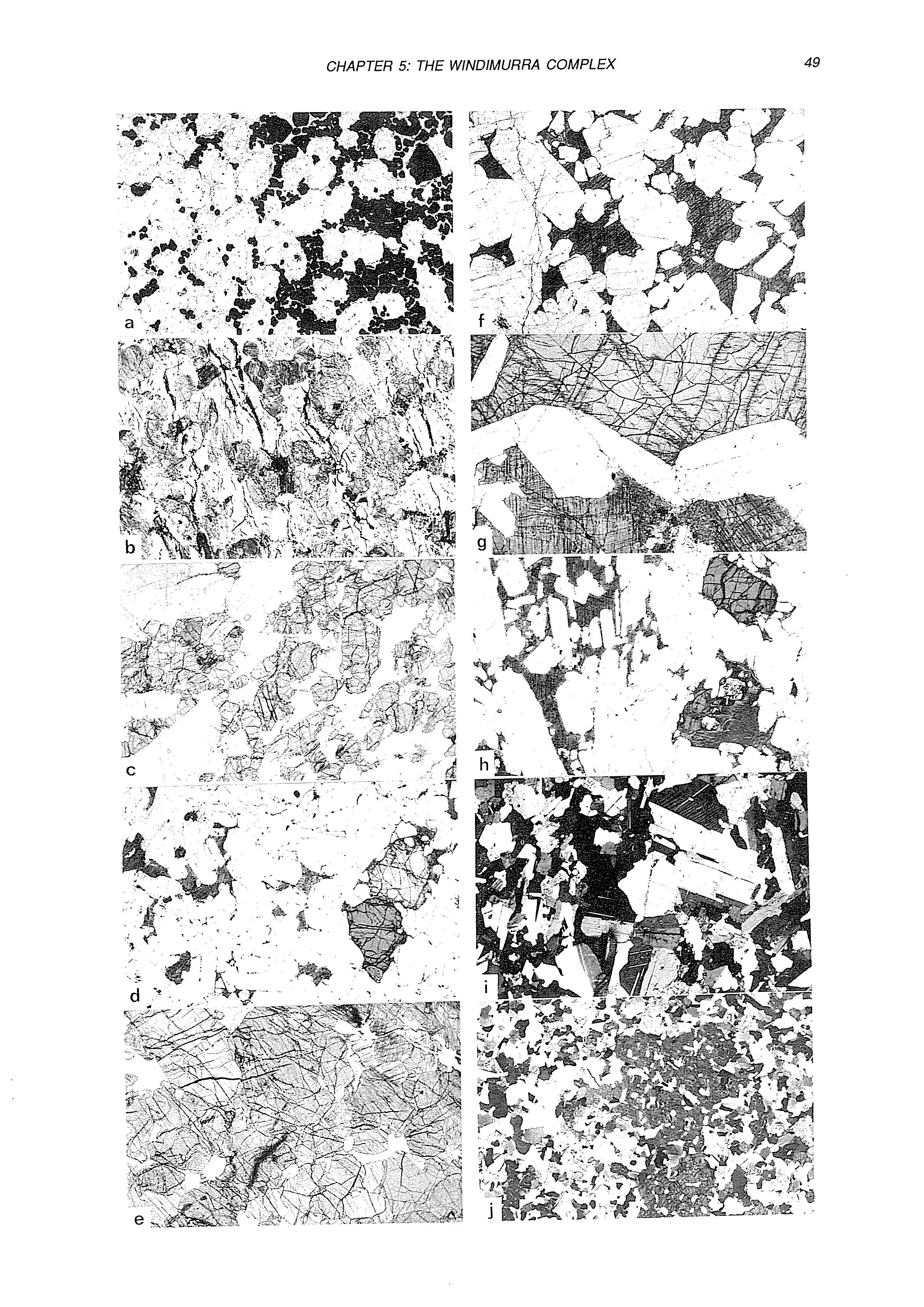
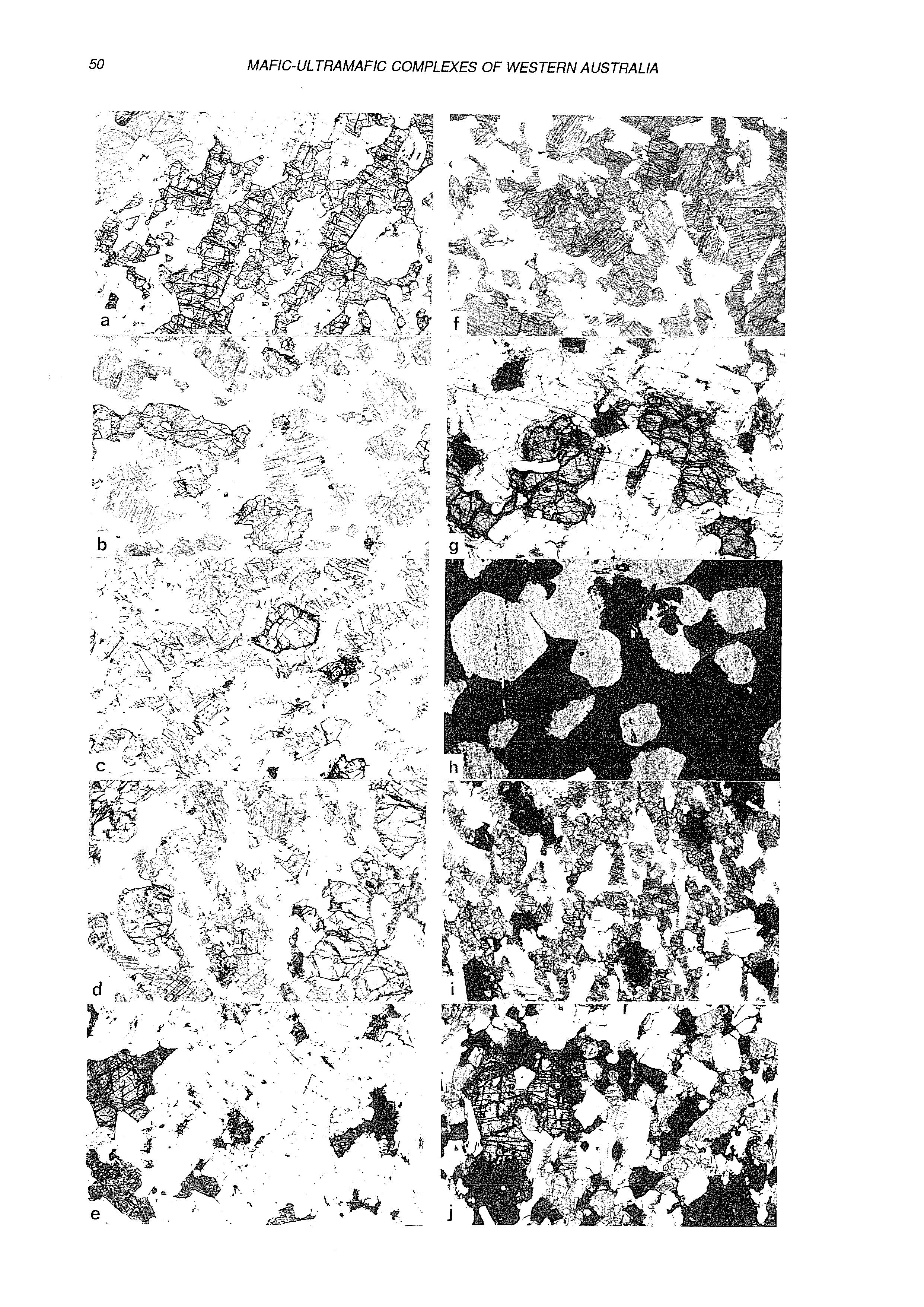
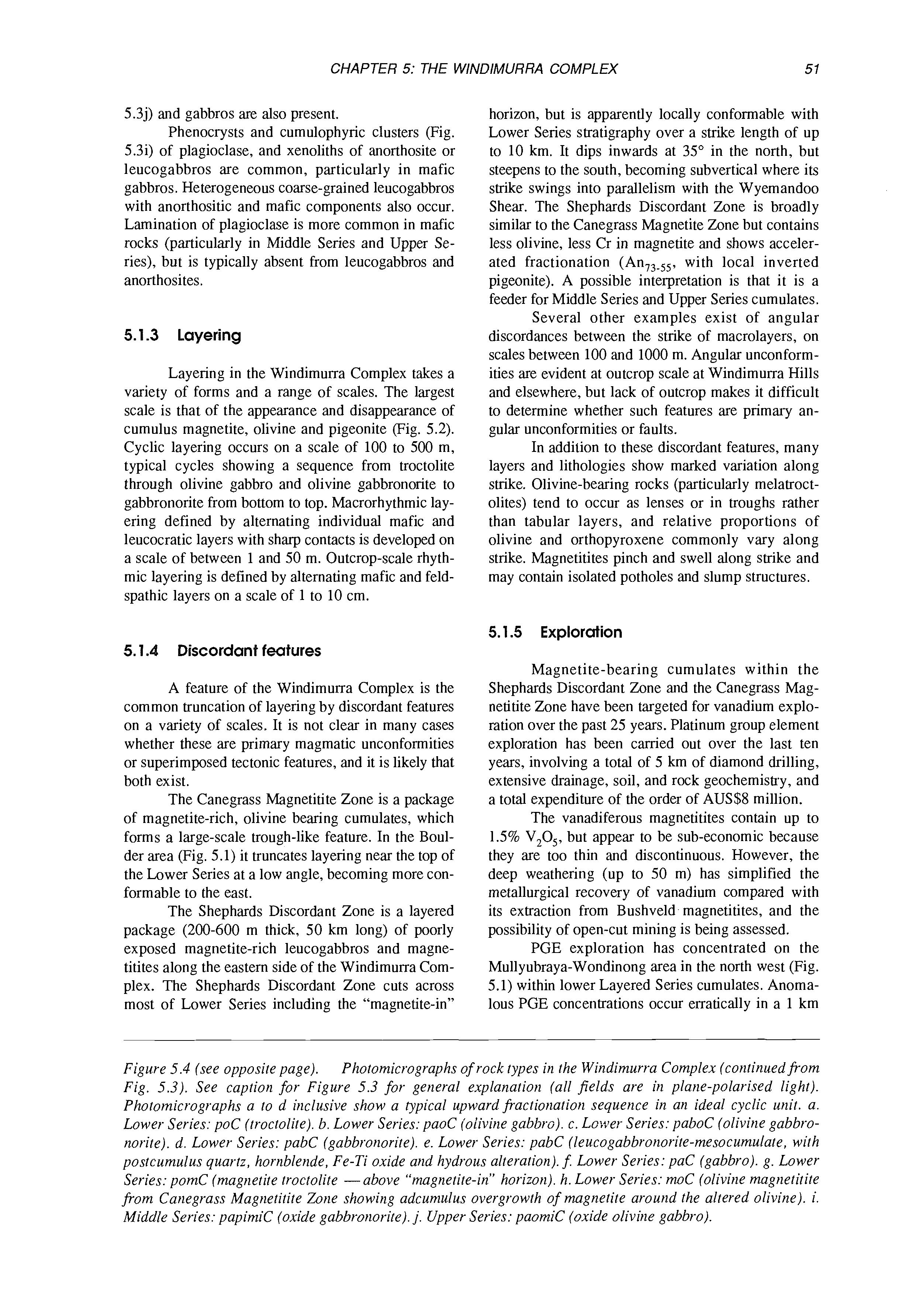
5.3j) and gabbros are also present. Phenocrysts and cumulophyric clusters (Fig. 5.3i) of plagioclase, and xenoliths of anorthosite or leucogabbros are common, particularly in mafic gabbros. Heterogeneous coarse-grained leucogabbros with anorthositic and mafic components also occur. Lamination of plagioclase is more common in mafic rocks (particularly in Middle Series and Upper Series), but is typically absent from leucogabbros and anorthosites.
5.1.3 Layering
Layering in the Windimurra Complex takes a variety of forms and a range of scales. The largest scale is that of the appearance and disappearance of cumulus magnetite, olivine and pigeonite (Fig. 5.2). Cyclic layering occurs on a scale of 100 to 500 m, typical cycles showing a sequence from troctolite through olivine gabbro and olivine gabbronorite to gabbronorite from bottom to top. Macrorhythmic layering defined by alternating individual mafic and leucocratic layers with sharp contacts is developed on a scale of between 1 and 50 m. Outcrop-scale rhythmic layering is defined by alternating mafic and feldspathic layers on a scale of 1 to 10 cm.
5.1.4 Discordant features
A feature of the Windimurra Complex is the common truncation of layering by discordant features on a variety of scales. It is not clear in many cases whether these are primary magmatic unconformities or superimposed tectonic features, and it is likely that both exist.
The Canegrass Magnetitite Zone is a package of magnetite-rich, olivine bearing cumulates, which forms a large-scale trough-like feature. In the Boulder area (Fig. 5.1) it truncates layering near the top of the Lower Series at a low angle, becoming more conformable to the east.
The Shephards Discordant Zone is a layered package (200-600 m thick, 50 km long) of poorly exposed magnetite-rich leucogabbros and magnetitites along the eastern side of the Windimurra Complex. The Shephards Discordant Zone cuts across most of Lower Series including the “magnetite-in”
horizon, but is apparently locally conformable with Lower Series stratigraphy over a strike length of up to 10 km. It dips inwards at 35” in the north, but steepens to the south, becoming subvertical where its strike swings into parallelism with the Wyemandoo Shear. The Shephards Discordant Zone is broadly similar to the Canegrass Magnetite Zone but contains less olivine, less Cr in magnetite and shows accelerated fractionation (An,,-SS, with local inverted pigeonite). A possible interpretation is that it is a feeder for Middle Series and Upper Series cumulates. Several other examples exist of angular discordances between the strike of macrolayers, on scales between 100 and 1000 m. Angular unconformities are evident at outcrop scale at Windimurra Hills and elsewhere, but lack of outcrop makes it difficult to determine whether such features are primary angular unconformities or faults.
In addition to these discordant features, many layers and lithologies show marked variation along strike. Olivine-bearing rocks (particularly melatroctolites) tend to occur as lenses or in troughs rather than tabular layers, and relative proportions of olivine and orthopyroxene commonly vary along strike. Magnetitites pinch and swell along strike and may contain isolated potholes and slump structures.
5.1.5 Exploration
Magnetite-bearing cumulates within the Shephards Discordant Zone and the Canegrass Magnetitite Zone have been targeted for vanadium exploration over the past 25 years. Platinum group element exploration has been carried out over the last ten years, involving a total of 5 km of diamond drilling, extensive drainage, soil, and rock geochemistry, and a total expenditure of the order of AUS$8 million.
The vanadiferous magnetitites contain up to 1.5% V,Os, but appear to be sub-economic because they are too thin and discontinuous. However, the deep weathering (up to 50 m) has simplified the metallurgical recovery of vanadium compared with its extraction from Bushveld magnetitites, and the possibility of open-cut mining is being assessed.
PGE exploration has concentrated on the Mullyubraya-Wondinong area in the north west (Fig. 5.1) within lower Layered Series cumulates. Anomalous PGE concentrations occur erratically in a 1 km
Figure 5.4 (see opposite page). Photomicrographs of rock types in the Windimurra Complex (continued from Fig. 5.3). See caption for Figure 5.3 for general explanation (all fields are in plane-polarised light). Photomicrographs a to d iticlusive show a typical upward fractionation sequence in an ideal cyclic unit. a. Lower Series: poC (troctolite). 0. Lower Series: paoC (olivine gabbro). c. Lower Series: paboC (olivine gabbronorite). d. Lower Series: pabC (gabbronorite). e. Lower Series: pabC (leucogabbronorite-mesocumulate, with postcumulus quartz, hornblende, Fe-Ti oxide and hydrous alteration). 5 Lower Series: yaC (gabbro). g. Lower Series: pomC (magnetite troctolite -above “magnetite-in”horizon). h. Lower Series: mC (olivine magtietitite from Canegrass Magnetitite Zone showing adcumulus overgrowth of magnetite around the altered olivine). i. Middle Series: papimic (oxide gabbronorite). j. Upper Series: paomiC (oxide olivine gabbro).
thick succession about 2 km above the lowest exposed cumulates. PGE values typically range from 40 to 150 ppb Pt+Pd. A single thin chromitite at the olivine-rich base of a cyclic unit contains up to 8 ppm PGE. At the southern end of the Complex in the Corner Well area (Fig. 5.1), a 600 m thick sequence of mafic, fine-grained olivine-gabbros and olivinegabbronorites contain similar PGE concentrations to those at Wondinong. The Corner Well and Wondinong sequences may be equivalent. Lherzolitic olivine-rich cumulates (Pt+Pd commonly up to 60 ppb or more) also occur in this sequence but their relationship to the Lower Series is not clear.
5.2 THE WINDIMURRA HILLS SECTION
(J. Parks and R.E.T. Hill)
5.2.1
Introduction
The Windimurra Hills section covers a 2.2 km sequence of generally well-exposed, well layered stratigraphy (Fig. 5.5) towards the top of the Lower Series of the Windimurra Complex. The sequence is on the eastern side of the Complex about 10 km south of, and stratigraphically overlying, the Wagoo Hills section (Fig. 5.2). Layering at Windimurra Hills dips west at about 35”. The stratigraphy is a repetitive sequence of lithologies broadly characterized by thick (2-200 m) moderately poorly exposed plagioclase-rich rocks irregularly interlayered with thinner (0.5-50 m) ridge-forming mafic lithologies (Fig. 5.6). Constituent rock types are mostly adcumulates and comprise anorthosites (80-90% plagioclase), troctolites (-7% olivine), gabbronorites and olivine-gabbronorites, and rare two phase gabbroic and noritic cumulates (Fig. 5.2). Magnetite appears as a cumulus phase 1260 m above the base of the section.
5.2.2 Geochemistry
Microprobe analyses of forty-three representative samples through the sequence show that the constituent cumulus phases exhibit a limited range of both major and to a lesser extent, minor element composition throughout the stratigraphy as shown on Figures 5.7 and 5.8 respectively and summarised below (Table 5.1).
There is no ordered cryptic variation. Varia-
tions in compositions with stratigraphic height are irregular and do not appear to be attributable to variations in modal mineralogy. There is a slight iron enrichment in the mafic silicates upward through the section but no comparable trend toward more albitic compositions in plagioclase. A subtle shift toward more primitive compositions is observed in all the silicates above the magnetite-in horizon (Fig. 5.7).
The compositional variations are believed to be igneous in origin, modified by subsolidus re-equilibration. The repetitive nature of the rock types, the overall compositional uniformity and irregular reappearance of olivine throughout the section, suggest that repeated influxes of small amounts of less fractionated magma were important during the evolution of the sequence.
5.2.3 Petrography
Plagioclase is the most abundant phase throughout the Windimurra Hills sequence. In leucocratic rocks it characteristically forms coarse anhedral interlocking grains. In more mafic rocks it tends to be euhedral or lath shaped with a 1-4 mm grain size.
Augite, the next most abundant phase, is typically cumulus -1-4 mm in size although is commonly anhedral with intercumulus extensions and thus may appear postcumulus in hand specimen. In more leucocr&ic rocks, augite is interstitial-to-oikocrystic and rarely cumulus.
Hypersthene appears at irregular intervals throughout the stratigraphy and ranges from coarse (up to 10mm) subhedral cumulus grains to large (-10 cm diameter) oikocrysts. Commonly it forms overgrowths on olivine, which is clearly being resorbed, and there is good evidence throughout the sequence for this peritectic reaction relationship.
Cumulus olivine generally forms equant grains of 2-5 mm in size in more mafic rocks. Adcumulate clusters of grains, and chains of grains are commonly observed. In leucocratic rocks olivine tends to have intercumulus extensions and a more anhedral habit, and locally appears postcumulus. Rare occurrences of poikilitic olivine with plagioclase inclusions, and coarse grained amoeboid olivine have been noted. Olivine, where present, is typically in low concentrations with the exceptions of thin (>5 m thick) laterally discontinuous “flaggy” melanocratic layers. These units are commonly gra-
Table 5.1. Summary of mineral composition data, Windimurra Hills section.
Olivine
Augite
Hype rsth en e
F%7-56
MgO/(MgO + FeO) 76-70
MgO/(MgO + FeO) 70-65
Plagioclase An,,,,
Ni = 0.22-0.03 wt Yo
Cr = 0.1 7-0.03 wt o/o
Cr = 0.09-0.02 wt Yo
Figure 5.5. Aerial photograph ofthe Windimurra Hills.
Olivine-gabbro
Gabbro Zone II Cumulus
Troctolite Zone I
Mixed rock
Anorthosite Zone I
Gabbronorite Zone II
Troctolite
Anorthosite Zone I
Anorthosite
Gabbro magnet ite
Olivine-gabbronoritt Zone II
Olivine-gabbronoritc
Zone I
Gabbronorite Zone I
Pyroxenite Zone I
Olivine-gabbro Gabbro Zone I
Gabbronorite
Troctolite
Noritic-troctolite m
Olivine-gabbronorite
Olivine-gabbro
"Mixed" rock
Figure 5.6. Simplified geological map, Windimurra Hills.
3livine-gabbro 3abbro I
Olivine Augite Hypersthene Plagioclase
100MgO/MgO+FeO IOOMgO/MgO+FeO 100MgO/MgO+FeO 100CaO/Ca0+Na20
o Anorthosite (oikocrystic) pC, pC/a, pC/h, pC/ah
Gabbro
EZlPaC, apC
Gabbronorite pahC, phaC
Troctolite . poc,-7% olivine
Olivine-gabbro pJJj poaC, paoC
Noritic troctolite pohC, phoC
Olivine-gabbronorite paohC, poahC, DhaoC etc xxxxx ElPyroxenite ahPC. haDC
Olivine-rich rocks )pC, oapC, aopC, aohpC E Xenolith, cordieritehypersthene- magnetite
Figure 5.7. Major element electron microprobe data for olivine (o),augite (a),hypersthene (h) and plagioclase (p)from the Windimurra Hills section. Each point is the average of several analyses. For pyroxenes all data are for bulk composition (focussed rastered beam) except points designated "X" which are spot analyses on exsolution host.
Olivinegabbronorite II
Pyroxenite IT
Olivine-gabbro Gabbro I
Windimurra Complex: Malor Stratiaraphic Subdivisions
(Ahmat, 1983)
Series
I-9 km
Middle
GabbroI
1 Troctolite I
“Mixed” rock, AnorthositeI 1 GabbronoriteII
Olivine-gabbronorite I[
Pyroxenite 11
Olivine-gabbronoriteI
Gabbronorite I
Pyroxenitel
Olivine-gabbro. Gabbro I
Figure 5.9. als.. Stratigraphic heights (m) shown in relation to the “magnetite-in” horizon.
Stratigraphic subdivisions of the Windimurra Hills section, showing range of key cumulus miner-
dational to pyroxene pegmatoid and in some places are also associated with “Mixed-Rock”. These thin olivine-rich units may have resulted from small influxes of more primitive magma. Much of the early PGE exploration at Windimurra Hills focussed 011 sampling these olivine-rich units; results were generally negative.
The principal crystallization order observed in the sequence is plagiocIase-olivine-augite-hypersthene, as typifies the Lower Series. The crystallization order of the two pyroxenes is reversed in a section immediately overlying a 50 m x 10 m thick xenolith. This can be attributed to increased asio2locally due to contamination from the xenolith. Equivocal textural evidence (i.e. the tendency of hypersthene to form large subhedral grains in contrast to the smaller augite grains although both are probably cumulus) suggests that hypersthene precedes augite in some of the gabbronorite units.
lates mark the base or top of cyclic units, although the former alternative is favoured. Finally there is a lack of critical exposures in some areas, in particular, the contacts between major leucocratic and mafic units are generally obscured by scree at the base of hills.
Olivine-Gabbro, Gabbro Zone I (OGGZl)
Irregularly rhythmically layered paoC and paC to pC/a are dominant lithologies within OGGZI. An altered pC/a unit in the centre of the Zone has up to 2 modal % secondary pyrite (+chalcopyrite). A little higher in the sequence there is a “Mixed-Rock” unit. There is a general increase in mafic minerals upward and hypersthene appears as a cumulus phase in the upper units.
Pyroxenite Zone I (PZI)
The Windimurra Hills sequence has been subdivided into 11 zones based on the range of key cumulus minerals (Fig. 5.9). These zones do not necessarily reflect fractionation sequences, as commonly the succession of rock types observed cannot readily be explained in terms of simple fractionation models. In addition, as has been observed at Wagoo Hi!ls, it is unclear whether single phase plagioclase cumu-
A fine-grained equigranular apC unit defines the lower boundary of this Zone. Rock types consist of thin (-1 m) altered pyroxene-rich cumulates with good igneous lamination interlayered with thicker massive p(h)C units. There are minor amounts of olivine locally.
Gabbronorite Zone I (GNZI)
This zone consists mostly of massive monotonous phaC to pahC with some minor lateral and vertical textural and compositional variation. The base of the zone is defined by a thin ap(o)C adcumulate unit. A pahoC unit in the central part of the zone is grada-
Figure 5.8 (see opposite page). are means of several analyses, bars show I standard deviation. Legend as for Figure 5.7.
Minor element microprobe data for olivine, augite and hypersthene. Points
Mode
Windimurra Hills section
Olivine-gabbronorite ZonelI
Olivine
Plagioclase
Augite
Hypersthene
Figure 5.10. Profile through olivine-bearing melagabbronorite layer in Olivine-Gabbronorite Zone II. Stratigraphic height relative to “magnetite-in”
tional up and down section to gabbronorite.
Olivine-Gabbronorite Zone I (OGNZI)
This zone is characterized by the appearance of olivine as an important cumulus phase. There is a basal plagioclase adcumulate containing pyroxenite pods overlain by a rhythmically layered sequence of pahoC units and more plagioclase-rich cumulates. A central thin oahC unit is gradational to pyroxene pegmatoids laterally. Ti-magnetite oikocrysts occur sporadically and there is a general increase in mafic minerals upward through the zone.
Pyroxenite Zone 11 (PZII)
The exact placement of this zone within the stratigraphy is problematical because of major structural dislocations. These dislocations may be magmatic but are probably tectonic (Fig. 5.6). The zone consists of thin (-1 m) altered pyroxenite units with igneous lamination interlayered with thicker massive p(h)C units. There is a general increase in augite upward through the zone and hypersthene appears to precede augite in the crystallization sequence. An
olivine gabbronorite unit is tentatively placed at the top of this zone for geographical reasons. However it may be better placed in the overlying zone.
Olivine-Gabbronorite Zone II (OGNZ II)
This zone may be better placed as the upper part of OGNZI if the intervening wedge of stratigraphy designated PZI is ignored. OGNZII broadly consists of three macrorhythmic pahoC units. There are at least three narrow pyroxenite units within this Zone which locally contain olivine and assume a flaggy appearance. The uppermost of these units is 9 m thick, extends at least 800 m along strike and underlies the uppermost pahoC macrorhythmic unit (Fig. 5.10). It is underlain and overlain by p(h)C. About 700 m to the north along strike of the section line, the flaggy unit has thinned to about 1 m and the overlying p(h)C unit has distinctive microrhythmic layering.
Troctolite-Anorthosite Zone 1 (TAZI)
The lower half of TAZI is a leucotroctolite which contains up to about 7 modal % olivine with minor postcumulus augite. Six narrow (-1 m) flaggy oapC/h units within the leucotroctolite contain large poikilitic hypersthene grains that appear to contain resorbed olivine grains. There is a minor development of “mixed rock” about halfway up the zone, overlain by a thick unit of oikocrystic anorthosite (pC/(ah)m) which contains Ti-magnetite oikocrysts. Coarse grained cumulus hypersthene reappears in generally low concentrations toward the top of the oikocrystic anorthosite. The top of the zone is gradational to a leuco-olivine gabbronorite unit that becomes more mafic upward and culminates in gabbronorite which contains 2 modal 9% cumulus Ti-magnetite, the first appearance of this cumulus phase. A large trough-like feature terminates the underlying layering and marks the top of TAZI. This trough is best observed on the aerial photograph (Fig. 5.5) and is considered to be of primary magmatic origin.
Gabbronorite Zone II (GNZll)
This zone is a macrorhythmic unit of extremely well layered centimetre-metre hapC and phC units containing about 2 modal % cumulus Ti-magnetite. A major northeast trending shear disrupts the stratigraphy. Minor cumulus olivine appears toward the top of the zone.
Mixed Rock Anorthosite Zone I (MR.AZI)
This zone exhibits a lithological complexity not noted on this scale elsewhere at Windimurra Hills. It is characterized by an abundance of plagioclase-rich rocks, the development of thin units of five-phase cumulates (hypersthene, augite, olivine, plagioclase, magnetite), the irregular intermixing of dissimilar rock types and lack of continuity of rock units. These latter features are thought to be indica-
tive of large-scale primary igneous disturbance. Altered and jointed plagioclase-rich rocks form the basal unit of the sequence. These are overlain by thin pyroxenite, thin flaggy gabbronorites and olivinegabbronorites with abundant ilmenite and magnetiteulvospinel, and an upper 100m of “Mixed Rock” comprising plagioclase cumulates with mafic clasts up to 40 cm across, and poddy mafic pegmatoids.
In the gabbronorite units the grains of magnetite-ulvospinel solid-solution have exsolved early fine-grained acicular rods of hercynite parallel to (111) of the host and suffered subsequent oxidation, producing lamellae of ilmenite-hematite concentrated mainly along fractures but also present as irregular patches within the spinel crystals.
Troctolite Zone I (TZI)
This zone has been subdivided into three subzones based on the disappearance of augite in the central subzone.
The lowermost subzone is essentially p(o)C to poC/ah and includes two laterally extensive oapC units (Fig. 5.11). The central subzone overlies a hypersthene-cordierite-magnetite xenolith and wedges out to the north. A flaggy hoC unit overlies the xenolith. The remainder of the subzone contains a prevalence of pohC rocks.
Augite reappears as a cumulus phase in two olivine gabbronorite macrorhythmic units which constitute the uppermost subzone.
Olivine-Gabbro, Gabbro Zotte I1 (OGGZII)
Oikocrystic anorthosite dominates in the lower part of OGGZII. This is overlain by rhythmically layered, mostly altered, pa(h)C. Olivine-gabbro is dominant in the top half of the zone and hypersthene reappears as a cumulus phase toward the top. A pyroxenite unit marks the top of the mapped section.
5.2.5 Field traverse
This traverse covers about 900 m of stratigraphy from Pyroxenite Zone I1 up to Mixed Rock Anorthosite Zone I.
Location 1. Pyroxenite Zone I1 (rhythmic layering)
The bulk of this Zone is a rhythmically layered sequence of thin (-1 m) hapC and thicker p(h)C units. The pyroxene-rich units display an igneous lamination and as is typical at Windimurra, outcrop better than the plagioclase-rich units. The rocks are mostly altered, however relic textures show that the coarse-grained (7- 10 mm) subhedral purple-brown hypersthene is more abundant than medium-grained green-black anhedral augite (Fig. 5.12A). In the p(b)C units, clusters formed by three to four coarse hyhersthene laths give the outcrops a distinctive spotted appearance.
Mode
Windimurra Hills Section Troctolite Zone1
Olivine
Plagiociase
Augite
Hypersthene
Figure 5.11. Profile through olivine cumulate units at the base of Troctolite Zone 1. Stratigraphic height relative to “magnetite-in”
Location 2. Contact of Pyroxenite Zone I1 and Olivine-Gabbronorite Zone I1
The contact between PZII and OGNZII is not exposed. The aerial photograph (Fig. 5.5) shows a prominent NNW trending arcuate lineament at this locality that apparently truncates the underlying stratigraphy. The scale of this truncation is 200300 m. It is considered too large to be an igneous unconformity and is probably tectonic. Scree and subdued outcrop of sheared rocks in this vicinity also tends to confirm the latter hypothesis.
Location 3. Olivine-Gabbronorite Zone I1 (microrhythmic layering)
This is one of the rare exposures of microrhythmic layering at Windimurra (Fig. 5.12B). The boulders observed are from outcrop at the top of the hill which has a restricted lateral extent. The mafic laminae are defined by one-grain-wide randomly oriented hypersthene laths. Leucocratic laminae are formed of plagioclase mesocumulate with minor postcumulus augite.
The traverse continues over the hill. Propor-
Figure 5.12. Photomicrographs of Windimurra Hills rock types. A: Altered hapC, Pyroxenite Zone II. B: Microrhythmic layering in Olivine-Gabbronorite Zone II. C. Troctolite from Troctolite-Anorthosite Zone I, with olivine showing prominent intercumulus extensions and rims of augite. D: Oikociysts of hypersthene in oapClh unit from Troctolite-Anorthosite Zone I. E: Oikocrystic anorthosite froin Troctolite-Anorthosite Zone I showing prominent dark oikocrysts of Ti-magnetite and smaller lighter coloured oikocrysts of hypersthene. F: Melatroctolite (opC) which form a flaggy unit within Troctolite-Anorthosite Zone I. G: Olivine-gabbronorite with cumulus magnetite. Plane light. H: Five-phase cumulate (haiopC)from Mixed Rock Anorthosite Zone I.
tions of mafic minerals generally increase and olivine reappears as a cumulus phase. Toward the top of the Zone, olivine virtually disappears and minor distinctive Ti-magnetite oikocrysts can be observed.
Location 4. Troctolite-Anorthosite Zone I (hypersthene heteradcumulate)
Outcrop in this area is dominated by massive leuco-troctolite (p900,7C/a,,,). Olivine can be observed in outcrop as small rounded surface pits which give the rock a distinctive “raisin pudding” appearance. The olivine is anhedral with prominent intercumulus extensions, and locally appears distinctly postcumulus (Fig. 5.12C). The interstitial pyroxene in these rocks is augite (not the more usual hypersthene) which rims apparently resorbed olivine. Within the leucotroctolite are six narrow (<2 m) discontinuous oapC/h units with the typical flaggy subdued exposure of melanocratic rocks at Windimurra. These units are transitional to pyroxene pegmatoid to the south. The olivine-rich units contain increased proportions of cumulus augite from the basal to the uppermost unit with a concomitant decrease in cumulus olivine. Hypersthene forms prominent oikocrysts (up to 10 cm) within each of these units and encloses all cumulus phases (Fig. 5.12D).
Location 5. Troctolite-Anorthosite Zone I (oikocrystic anorthosite)
The traverse continues westward to the base of the next large hill where there is a massive oikocrystic anorthosite unit which constitutes a major part of the upper part of TAZI. This rock contains large distinct Ti-magnetite oikocrysts that are up to 6cm across and which contain rare grains of relict olivine. The rock contains about 10 modal % of mostly fine-grained anhedral augite and sporadic poikilitic hypersthene (Fig. 5.12E). Coarse-grained hypersthene reappears as a cumulus phase in low concentrations higher in this unit. To the south, a saddle can be observed in the hill. A “Mixed Rock” unit is exposed on the east flank of the saddle and underlying the anorthosite. There is a flaggy narrow opC unit in the saddle within the anorthosite (Fig. 5.12F). The traverse continues to the saddle and then westward over the hill over a distinctive spotted p h C unit to a weakly rhythmically-layered leucocratic olivine gabbronorite unit near the top of TAZI. This unit generally becomes more mafic upward. 9 1.
Location 6. Troctolite Anorthosite Zone I (magnetite-in)
At the top of TAZI is a massive laterally variable fine- to medium-grained olivine-gabbronorite unit that locally contains up to 20 modal % olivine. It also contains minor 1-2 cm domains of plagioclase adcumulate distinct from the tabular plagioclase grains in the remainder of the rock. These domains of plagioclase adcumulate are observed at several other localities at Windimurra. Preliminary microprobe
analyses indicate that the plagioclase adcumulate is enriched in anorthite (-An,,) relative to the tabular matrix component plagioclase. This olivine gabbronorite is significant as it contains up to 2 modal % euhedral cumulus Ti-magnetite and marks the first appearance of magnetite as a cumulus phase (Fig. 5.12G).
Location 7. Gabbronorite Zone 11 (rhythmic layering)
The traverse continues into GNZII which contains the best developed rhythmic layering observed in the Windimurra Complex. Layering is developed on a centimetre to metre scale defined by alternating mafic and leucocratic layers which can be traced laterally for several km. Layer contacts are notably sharp although some mafic layers exhibit “normal” grading. Locally, layers are lenticular and bifurcate, and rarely small-scale cross-bedding and “load” structures are observed. The mafic layers are adcumulate and contain variable but almost equal proportions of augite, hypersthene and plagioclase with up to 5 modal % cumulus Ti-magnetite. There is a general increase in augite upward through the Zone. Mineral proportions can readily be determined from outcrop. The distinctive purple brown knobbly weathered surface is characteristic of hypersthenebearing rocks. The smaller dark-green-black augite is less distinctive. Leucocratic layers are adcumulate to mesocumulate p(h)C/a(m). Minor olivine appears toward the top of the zone. Glomerophyric clusters of adcumulate plagioclase and discrete coarse (-1 cm) anhedral plagioclase grains distinct from the finer more tabular plagioclase in the remainder of the rock, can also be observed toward the top of the zone.
Location 8. Mixed Rock Anorthosite Zone I (fivephase ciiniulate and mixed rock)
Stratigraphically above an area with extensive scree of altered plagioclase cumulate at the base of MR.AZI, there is a distinctive outcrop of flaggy melanocratic rocks. This pod-like unit is up to 3 m thick and underlain by a coarse-grained altered pyroxenite. The laminated rocks are adcumulate hapmC with silicate phases in about equal proportions and up to 25 modal % Ti-magnetite. There is an increase in the proportion of plagioclase upward in the pod accompanied by the appearance of olivine. Up to 10 modal % Ti-magnetite remains as a cumulus phase (Fig. 5.12H). To the north and possibly on strike, a similar pod locally displays microrhythmic layer defined by one grain wide laminae (1 mm) of cumulus Ti-magnetite interlayered with altered olivine-rich laminae about 2 mm thick.
The traverse continues over an interval of “Mixed Rock”. Lithologies are generally plagioclaserich cumulates that exhibit a wide range of textures and local variations in mafic minerals. Units lack lateral continuity. There are distinct mafic clasts of up to 40 cm within plagioclase cumulate, but more
6 Stratigraphic height (krn)
4 5- t Pa t pao t pa1 Pa0 FIELD 4- TRAVERSE -I + Pab Pab pabo
BASE = contact at eastern margin
Figure 5.13. Stratigraphic column for Wagoo Hills. MZ = niafic zones (black),LZ = leucocratic Zones (white); vertical ranges of cumulus minerals are shown as solid vertical lines with some compositions for plagioclase (An mol. %) and olivine (Fo mol. %);fractionation sequences are represented by arrows (arrow head = top of each cycle); T = troctolite, OG = olivine gabbro, OGN = olivine-gabbronorite, LG = leucogabbro, LGN = leiicogabbronorite; p = plagioclase, a = augite, b = orthopyroxene, o = olivine).
commonly clasts have diffuse boundaries edged with patchy pegmatoid. Pod-like and discordant pegmatoids are developed in the central part of this Zone.
Location 9. "Mixed Rock" Anorthosite Zone I
In the central part of MR.AZI there are two pods of flaggy adcumulate opC. Olivine in these pods is very coarse (up to 1.5 cm) and displays irregular amoeboid textures in contrast to the more typical medium-grained equant texture observed in most of the olivine-rich cumulates.
Location 10. Troctolite Zone I
The traverse continues to the xenolith and adjacent augite-deficient rocks in the central noritic troctolite subzone of TZI.The base of the subzone is marked by a flaggy hoC cumulate. The remainder of the subzone is mostly phoC/m. About halfway up the subzone is a flaggy adcumulate hp(a)C with up to 15% augite. The hypersthene in this rock is unusual in that it forms equant or euhedral stubby grains.
5.3 THE WAG00 HILLS SECTION (C.I. Mathison)
5.3.1 General description of Wagoo Hills section
The Wagoo Hills area (Fig. 5.1) comprises Lower Series cumulates covering a 7 km by 5 km area. The Wagoo Hills sequence (Fig. 5.13) consists of about 3 km of well exposed and preserved stratigraphy dipping west at 47" overlying about 2 km (assuming the same dip) of poorly exposed Border Group rocks as defined by Ahmat (1986). The original mafic mineralogy in this poorly or non-layered lower sequence is difficult to decipher because of the more intense amphibolite facies metamorphic and alteration overprints near the margin. Olivine compositions (FO~~)indicate that the main part of the Wagoo Hills sequence (the upper 3.5 km) is about halfway up the Lower Series (Fig. 5.2). Ground magnetometer data suggests the "magnetite-in" horizon passes about 2 km west of Wagoo Hills, 1.4 km stratigraphically above the highest Wagoo Hills lay-
ers. Thus, the Wagoo Hills sequence lies mostly below the Windimurn Hills sequence and the upper part of Wagoo Hills could be stratigraphically equivalent to the lower part of Windimurra Hills.
The Wagoo Hills sequence is broadly divisible into a relatively olivine-rich, more mafic upper portion, 1.5 km thick, and a 4 km thick anorthositic lower portion with only minor olivine (Fig. 5.13). Modal layering becomes more conspicuous upwards. The sequence is subdivided into mafic zones (100600 m thick) alternating with thicker anorthositic zones. The sequence becomes more mafic upwards and the proportion of olivine to orthopyroxene increases. Mineral compositions show slight reverse fractionation upwards through the sequence, then a more pronounced reversal associated with the thickest olivine-bearing mafic zone, followed by normal fractionation trends to the top.
Rock types are anorthositic leucogabbronorites with minor gabbronorite in the lower 4 km, and olivine-gabbro, leucogabbro and troctolite with minor gabbronorite in the upper 1.5 km. bch of the mafic zones is a cyclic unit with decreasing olivine upwards, a typical sequence being troctolite-olivine gabbro-olivine gabbronorite-gabbronorite. (Anorthosite typically occurs beneath the troctolite, but it is not clear whether this is the basal unit of the cycle or the top of the underlying leucocratic zone). Modal macrorhythmic layering is superimposed on the cyclic layering. Each of the three main mafic zones has been diamond drilled (800 m total) to test for PGE mineralisation associated with the new magma inputs inferred to have occurred at its base, but no values greater than about 15 ppb Pt+Pd were found.
The following stratigraphic subdivisions are recognized (Fig. 5.13), from base to top.
Leucocratic Zone 1 (LZ I): Few data are available for this poorly exposed and preserved interval (2 km thick). Anorthositic leucogabbronorites probably dominate and pegmatoids are common. A mafic gabbronorite about 1 km above the marginal contact has minor sporadic olivine and bladed pyroxenes resembling crescumulate texture. Apatitebearing magnetitites (4 m thick) are locally developed within about 100 m of the eastern contact.
Mafc Zotie I (MZ I): This weakly developed group of three mafic intervals of mainly olivine gabbronorite and gabbronorite is interlayered with a leucogabbronorite, which is commonly pegmatoidal with sporadic magnetite oikocrysts.
Leucocratic Zone II (LZ II). This zone is dominated by anorthositic leucogabbronorites with thin mafic gabbronorite layers and minor troctolite. The leucogabbronorites are mainly mesocumulates with postcumulus quartz, Fe-Ti oxides, hornblende and rare apatite, and some have normal-zoned plagioclase instead of the typical reverse zoning.
Mafc Zone 2 (MZ II): A well-defined cyclic unit, consisting of troctolite followed by olivine gabbro, then olivine gabbronorite, then a 300 m thick
sequence of alternating gabbronorite and leucogabbronorite.
Leucocratic Zone III (LZ 111): This resembles LZ 11, but contains a 200 m thick regularly macrorhythmically layered sequence of gabbronorites and leucogabbronorites (the field traverse begins in this sequence). Slightly more mafic intervals are present (75 volume % plagioclase instead of 85-90%), as well as rare troctolite and fine-grained gabbronorite layers. Anorthosite with augite oikocrysts forms the top of the zone.
Mafic Zone 111 (MZ 111): This is the thickest, most complex and most olivine-rich mafic zone containing troctolites, olivine-gabbros, anorthosites and leucogabbros, commonly pegmatoidal and xenolithic. It is irregularly layered with marked lateral variation in the lower 300 m, then becomes more regularly layered and more leucocratic. It grades into the next subzone (LZ IV).
Leucocratic Zone IV (LZ IV): This zone is mainly composed of leucogabbro with minor olivinebearing cumulates at the bases of incomplete cyclic units, then leucogabbronorite (some mesocumulate with postcumulus quartz) and minor gabbronorite with magnetite oikocrysts near the top, heralding the incoming of cumulus magnetite further up the column. Troctolite and olivine-gabbro form the stratigraphically highest outcrops, and may represent the start of another mafic zone.
5.3.2 Field traverse
The excursion traverses about 500 m (true thickness) of leucocratic and mafic stratigraphy showing two contrasted styles of layering: (a) regular, laterally extensive, olivine-deficient, leucogabbronorite-gabbronorite with macrorhythmic layering, in the upper part of LZ 111. (b) irregular, laterally variable macrorhythmic layering in a relatively olivine-rich sequence, from the lower part of MZ 111.
The field locations are indicated on the aerial photograph (Fig. 5.14), on which the mafic rocks have a darker signature and show more vegetation.
Location I. Macrorhythmically Layered Gabbrotiorites
The 200 m thick sequence is the subject of a paper by Mathison and Booth (1990). Features of the two contrasting rock types are summarised in Table 5.2 and illustrated in Figure 5.4d and 5.4e. Greater amounts of trapped intercumulus liquid in the leucogabbronorites have contributed to more fractionated pyroxene compositions and more extensive hydrous alteration. The more orthocumulate rocks contain lower PGE concentrations, possibly due to selective loss of PGE during hydrous alteration. One of the mafic gabbronorite layers is associated with a finegrained chill-like adcumulate gabbronorite (Fig.
VllVWlSnV
Table 5.2. Comparison of mafic and leucocratic gabbronorites at location 1, Wagoo Hills.
Mafic Gabbronorite Leucocratic Gabbronorite
Layer thickness
Cumulus assemblage
Cumulate type
Plagioclase zoning
Opx Mg no.
Cpx Mg no.
Whole rock Mg no.
Vol. Yo alteration
Cr ppm (rock)
Ni ppm
the first pulse of new magma near the top of LZ 111, as the precursor to MZ 111.
PLEASE DO NOT COLLECT SPECIMENS STRICTED.
SUPPLY IS OBVIOUSLY RE-
Location 3. Oikociystic Anorthosite (-100 m thick)
Large boulders in the topographically low area between the more mafic ridges contain pyroxene oikocrysts (20 cm maximum diameter) now altered to pale green hornblende or uralite. Up to 3% of postcumulus quartz is present, commonly as sporadic interstitial optically continuous grains (3-6 mm). This unit may mark the first major influx of fresh magma forming MZ 111.
Location 4. Lower part of Mafic Zone III (250 m thick)
This sequence begins with a unit of olivinegabbro, followed by troctolite and then olivinegabbro again. Leucogabbro units are interlayered throughout the sequence, which extends from the valley to the top of the hill. Macrolayering in this relatively olivine-rich sequence contrasts strongly with that at Location 1. Layer contacts are commonly irregular and non-parallel along strike, and lithologies wedge out laterally, making it difficult to represent this sequence in a single stratigraphic column. Common rock types are leucotroctolite, olivine gabbro and various leucogabbros: some coarse-grained or pegmatoidal and heterogeneous "mixed" rocks with pillow fragments of anorthosite and mafic patches (including clusters of coarse olivine). Olivine grains are commonly clustered together in leucotroctolites and are commonly elongate (5 mm long x 1 mm wide), probably due to higher degrees of supercooling. Augite oikocrysts are common in the troctolites. Some highly irregular rhythmic layering is visible. Plagioclase compositions range from (the most calcic known in Wagoo Hills) but olivine compositions are similar to those in other parts of Wagoo Hills.
This sequence was drilled about 0.5 km to the south of this location to test for PGE mineralisation associated with inferred new magma inputs. Troctolites near the base of the sequence here are locally ultramafic with cumulus sulphide blebs, but contain no anomalous PGE.
Location 5. Pegmatoidal Leucogabbro (100 m thick)
This is close to the highest point in Wagoo Hills. The Windimurra Hills are clearly visible 10 km to the south and the more rugged topography of the antie Murdana Volcanics 15 km to the northwest. At this level, coarse-grained, almost pegmatitic heterogeneous leucogabbros alternate with finer grained homogeneous olivine gabbros, resulting in sharp grainsize and modal contacts. A prominent leucogabbro layer varies greatly over 500 m of strike from about 20 m to 100 m in thickness, and has a domal upper surface resembling a diapir. The overlying olivine gabbro layer seems to be draped around the diapir. Elongate olivines occur locally in the olivine gabbros above and below the leucogabbro diapir. The leucogabbros composing the diapiric layer are highly variable and locally could be termed "mixed rocks".
THE WONDINONGSECTION
(R.J. Perring and J.H. Vogt)
5.4.1 General features
The Wondinong-Mullyubraya area (Fig. 5.15) displays a well exposed section of the lower part of the Lower Zone, that spans about 4 km of stratigraphy above the northwestern contact (Fig. 5.1). The layering dips southeasterly towards the centre of the complex at 35" to 50°, although locally dips may range from 20" to 80" due to faulting and minor folding. Rock-types are dominantly medium-grained adcumulate to mesocumulate anorthosites and leucogabbronorites, with the proportion of mafic
28'00s
ONG AREA
ZOOS -
,F SPRICORN
120% 140°E Q I
Figure 5.15, Simplified geological map of the Wondinong-Mullyubraya area, showing location of field traverses.
rRoPlc
minerals (olivine, augite, bronzite) very rarely exceeding 35 modal %. Individual mineral compositions fluctuate with stratigraphic height but tend to become less fractionated upwards (e.g. plagioclase An,, to An,,, olivine Fo,, to Fo,,).
A close spatial association exists between some olivine-bearing rocks (leucotroctolite, leucoolivine-gabbronorite and lherzolite) and anomalous whole-rock Pt-Pd concentration (20-200 ppb Pt+Pd). Lateral changes in the modal proportion of olivine makes correlation of many olivine-bearing layers between sections speculative. Correlation in some areas has been further complicated by the presence of large irregular bodies of pegmatoidal leuconorite which may have formed either as part of the cumulate sequence or represent later recrystallization of the cumulate sequence.
5.4.2 Mineral exploration
Pancontinental Mining Limited in joint venture with Degussa Explorations GmbH commenced PGE exploration in the Wondinong area during mid1987. Regional mapping at 1:25,000 scale combined with the results of detailed -180 micron drainage sampling rapidly identified the coincidence between some olivine-bearing layers and Pt-Pd anomalous sections of the stratigraphy (Fig. 5.16).
Drainages sampled were generally immature first-order channels which carry water for only 2-3 days per year following heavy rain. Average rainfall is 230 mm per annum. Samples were analysed by 50 g fire-assay (lead collection ICP-mass spectrometry), with a lower detection limit of 0.5 ppb for Pt and Pd. Background concentration of platinum in drainages was found to be 3 ppb Pt. A threshold of 8 ppb Pt was chosen following a basic statistical analysis of the data.
Follow-up 1:5,000 scale mapping of Pt anomalous drainage areas lead to the discovery of outcropping PGE-bearing chromite mineralization in October 1987. While this narrow mineralization with an average grade of 1.7 ppm Pt+Pd does not represent an economic deposit, its discovery confirms the pedigree of the Windimurra Complex as a prospective layered igneous complex for on-going mineral ' exploration.
5.4.3 Mullyubraya-Naluthanna section
The Mullyubraya-Naluthanna section was compiled from data gathered on a mapping and sampling traverse which crossed some of the least deformed, least altered and least disrupted sections of the Wondinong sequence (Fig. 5.15). The section has been subdivided into 38 zones named after the dominant rock-type present in each zone (Figs 5.17 and 5.18). Rock-types, in decreasing order of abundance
are anorthosite (39%), leucogabbronorite (33%), leucotroctolite (17%), leuconorite (9%), and leucogabbro (2%). Anorthosite and gabbronorite zones occur at intervals throughout most of the sequence. Olivine-bearing rock-types are less common in the lower parts of the section, but predominate towards the top of the section.
There is a prevalence for anomalous concentrations of Pt (20-50 ppb) to be found in rocks within or adjacent to Olivine-Bearing Zones 111, IV, V and VII. By contrast, the relatively thick Olivine-Bearing Zone VIII, located towards the top of the section assays less than 10 ppb Pt. Reversals in fractionation trend, seen as an increase in whole-rock Mg number, coincide with Olivine-BearingZones IV, V and VII.
PGE concentration is interpreted to have resulted from the interaction of new small pulses of PtPd enriched, possibly sulphur-undersaturatedmagma, with a more fractionated sulphur-saturated anorthositic resident magma. Introduction of the new magma triggered the crystallisation of cumulus olivine. The magma which gave rise to the relatively Pt-depleted Olivine-Bearing Zone VIII may have reached a state of sulphur-saturation prior to injection, resulting in Pt being stripped from the magma and becoming concentrated in residual sulphide.
5.4.4 Field traverse no. 1
The traverse crosses 1500 m of the Mullyubraya-Naluthanna section across the principal Pt-Pd anomalous layers. This traverse shows very good examples of characteristic Wondinong sequence rocktypes, as well as several more unusual rock-types and textures.
Location 1 .I. Olivine-Bearing Zone IV, Gabbronorite Zone Vll, Olivine-Bearing Zone V Olivine-Bearing Zone IV consists of interlayered leucotroctolite (poC) and anorthosite (pC). Although olivine comprises less than 5% of the rock, its presence is highlighted by spherical pits, 3 mm in diameter, dotted over the rock surface. Rock-chip sample assays range from 6 ppb to 62 ppb Pt+Pd. Pt:Pd ratio is 1:l. Overlying Gabbronorite Zone VII consists of a coarse-grained unit of leucogabbronorite (pbaC, Fig. 5.19). Rare centimetre-size amoeboidlike olivines can be found towards the base of the zone, coincident with Pt+Pd concentrations up to 68 ppb Pt+Pd. Olivine-Bearing Zone V consists of troctolite (poC), with the olivines rimmed by postcumulus bronzite.
Location 1.2. Harrisitic gabbronorite within Gabbronorite Zone VIII
Harrisitic growths of orthopyroxene are present in what appears to be a xenolith of gabbronorite several metres long, within Gabbronorite Zone VIII. The two rocks are texturally very different and
WONDINONG PLATINUM DRAINAGE GEOCHEMISTRY
FREQUENCY HISTOGRA
n = 582
Figure 5.16. Map showing the results of platinum geochemistry drainage sampling in the Wondinong area.
Metres Zones Cumulus
Anorthosite VI I
Anorthosite V
Gabbronorite V I
Norite 111
Anorthosite IV no outcrop
Anorthosite Ill? 1 I ,bronzih
Olivine-biaring II
Anorthosite II plaqioclass I no outcrop
Gabbronorite 111
FNorite II no Outcrop -
Gabbronorite I
Anorthosite I
Figure 5.1 7. Lower half of Mullyubraya-Naluthanna columnar section in the Wondinong area, showing variations in modal proportions of cumulus minerals and whole rock Pt (ppb),Ptl(Pt+Pd) and Mg NO., 100 x MgOl (MgO+FeO),mol. percent.
Jletres Zones Cumulus %
Anorthosite Xlll I
3 75c
3 500 3 250
Anorthosite XI1
Anorthosite X
3 000
Gabbronorite X
2 750
2 500
Anorthosite Vlll Norite V
2 250 2 000
Figure 5.18. Upper half of Mullyubraya-Naluthanna columnar section in the Wondinoiig area, showing variations in modal proportions of cumulus minerals and whole rock Pt (ppb), Ptl(Pt+Pd) and Mg No., 100 x MgOl (MgO+FeO),mol. percent.
Figure 5.19. A: Leucogabbronorite (pbaC), Gabbronorite Zone Vll. B: Troctolite with gostcumulus augite (poCla”),Olivine-Bearing Zone Vll. Field of view 13 mm.
contacts are sharp.
The harrisitic gabbronorite may represent a raft of the marginal facies rocks which broke away from the wall and “floated’ into the body of the intrusion. Similar harrisitic rocks are found in-place near the margin of the Complex on the northeastern contact.
Location 1.3. Gabbronorite Zone IX
This unusually fine-grained gabbronorite (pbaC) marks the stratigraphic position above which
there is a gradual increase in Pt concentration and Pt:Pd ratio. There has been considerable discussion as to whether this fine-grained layer might represent a “chill-rock’’ resulting from the introduction of a pulse of new magma into a relatively cooler resident magma.
Location 1.4. Gabbronorite Zone X, Olivine-Bearing Zone Vll
Drilling of these two zones to follow-up surface Pt+Pd anomalous rock-chip samples located a
Figure 5.20. A: Leucotroctolire with intercumulus augite, (yoCla"), Olivine-Bearing zone VIII. B: Anorthosite with intercumulus bronzite (pClb"), olivine-bearing zone VIII. Field of view 13 inm.
60 m wide interval of coarse-grained gabbronorite (pbaC) which assayed between 120 ppb and 200 ppb Pt+Pd. Olivine-Bearing Zone VII which consists of leucotroctolite (poC, Fig. 5.19) and troctolite (opC) has assayed up to 3 1 ppb Pt and 59 ppb Pd in surface samples.
Location 1.5. Olivine-Bearing Zone VIII
Towards the base of Olivine-Bearing Zone VIII, unusual centimetre-size megacrysts of plagioclase lie clustered into crude layers within mediumgrained leucotroctolite (poC). The origin and signifi-
cance of these pebble-like anorthositic clusters are presently unknown. Unlike stratigraphically lower Olivine-bearing zones, no anomalous concentrations of Pt+Pd have been located with Olivine-Bearing Zone VIII. Both postcumulus augite and bronzite are present within the zone, although never together in the same sample (Fig. 5.20).
5.4.5 Field traverse no. 2
The traverse (Fig. 5.21) covers about 800 m of
Olivine-bronzite-augite cumulate
Bronzite cumulate
Plagioclase-olivine cumulate
Plagioclase-bronzite cumulate
Plagioclase-bronzite-augite-olivinecumulate
Plagioclase cumulate
Plagioclase-bronrite pegmatoid
Talc-carbonate schist
Plagioclase-augite-bronrite cumulate W0-l. Drill hole
Figure 5.21. Geological outcrop map of an area centred on an occurrence of PGE-bearing chromite mineralization located at Wondinong.
Figure5.22. Cross-section showing geology and profiles of Pt, Pd, Cu and Ni soil geochemistry across outcropping PGE mineralization located at Wondinong.
PALLADIUM (ppb)
Table 5.3. PGE concentrations in disseminated chromite mineralization, location 2.2.
Table 5.4 PGE concentrations in chromitite samples, location 2.3.
Table 5.5. PGE assay data in drill hole intersections, location 2.4.
1
the Mingyngura section. Weak Pt+Pd mineralization (+1 ppm) is found in anorthosite (pC), chromitite (cC), and pegmatoidal leuconorite.
Location 2.1. Sulphide mineralization in anorthosite
Relatively unoxidised PGE-bearing sulphide mineralization can be seen on the surface in medium to coarse-grained anorthosite (pC). Rock-chip samples have assayed up to 1.05 ppm Pt+Pd, with a Pt:Pd ratio of 1:2.4. A coincident Pt-Pd-Cu-Ni soil anomaly lead to the discovery of this mineralization (Fig. 5.22). Lenses of feldspathic lherzolite (obapC) containing megacrysts of plagioclase up to 10 cm in diameter lie at the same stratigraphic position 50 m northeast along-strike of the anorthosite mineralization.
Location 2.2. Disseminated chromite in gabbronorite
A 2 m-thick layer of coarse-grained chromitebearing gabbronorite (pbacC) containing megacrysts of plagioclase rimmed with chromite lies beneath a 5 m-thick layer of lherzolite (oabC). Analytical results for 2 samples taken of the disseminated chromite mineralization are listed in Table 5.3.
Location 2.3. PGE mineralization in chromitite
Three hundred metres to the northeast alongstrike of Location 2.2, the chromite mineralization at the base of the lherzolite (oabC, Fig. 5.23) is principally confined to a 20 cm wide layer of olivine-bearing chromitite (coC, Fig. 5.23). Some small trenches
reveal irregular pieces of the chromitite which have broken away from the main layer and settled into the underlying anorthosite (pC). Analytical results for three samples taken of the chromitite mineralization are listed in Table 5.4. This mineralization has a strike-length of only 100 m, and has not been intersected at depth in drill-core.
The mineralization is interpreted to have formed as a result of the interaction between a new small pulse of PGE-enriched, possibly sulphurundersaturated primitive magma, mixing with the more evolved sulphur-saturated anorthositic resident magma. The footwall anorthosite (pC) must have been a “crystal mush” at the time of chromite deposition because it was unable to support the more dense overlying chromitite layer.
Location 2.4. PGE-enriched pegmatoidal leuconorite
An 80 cm wide layer of PGE-bearing pegmatoidal leuconorite within medium-grained anorthosite (pC) lies 50 m stratigraphically above the chromite mineralization. This layer has been traced in scattered outcrop and by drilling for 600 m to the northeast along-strike. Analytical results for three drill intercepts are listed in Table 5.5.
The origin of this layer is enigmatic. The existence of a pegmatoidal layer within an otherwise medium-grained sequence could suggest the layer crystallized slowly, and may have been a conduit or reservoir for intercumulus fluid displaced by crystal settling and compaction in adjacent layers. Sulphide
6.1 INTRODUCTION
The Munni Munni Complex is located 42 km south of Karratha in the Pilbara region of Western Australia, at latitude 21"07'S and longitude 116"51'E, on the 1:250,000 Yarraloola SF/50-6 map sheet. Covering an exposed area of about 4 by 9 km, and having an aggregate stratigraphic thickness of over 5 km of ultramafic and gabbroic cumulates, Munni Munni is one of Australia's best preserved layered intrusions (Donaldson, 1974; Hoatson and Keays, 1989; Barnes et al., 1990; Williams et al., 1990).
PGE mineralization was discovered by Hunter Resources Ltd in 1984 (Williams et al., 1990), in the form of a persistent 1-5 m thick layer of disseminated PGE-rich sulphides in pyroxenite. Over 60 diamond drill holes have been drilled through the mineralized horizon, defining a resource of approximately 30 million tonnes at 2.9 g/t Pt+Pd+Au, with grades locally up to 8 g/t over half-metre widths.
The Complex intrudes granitoids of the Pilbara Craton dated at approximately 3000 Ma (Sun, pers. comm., 1985). The best estimate of the age of the complex is a U-Pb zircon date of 2925L-16 Ma from a ferrogabbro pegmatite near the top of the Ultramafic Series of the intrusion (Arndt et al., in press). This pegmatite almost certainly represents the final crystallization product of migrating differentiated intercumulus liquid, and the age is therefore a genuine crystallization age and not a date inherited from assimilated xenocrystic zircon. A late Archaean age for the intrusion is confirmed by a Sm-Nd mineral isochron of 2930 Ma (Sun, pers. comm., 1991) for a plagioclase websterite from the top of the Ultramafic Series.
The intrusion is unconformably overlain (Fig. 6.1) by the sedimentary and volcanic rocks of the Fortescue Group, the lowest group of the Mount Bruce Supergroup which unconformably blankets the southern part of the Pilbara Craton. The basal member of the Fortescue Group has been dated at 2765 Ma (average of six U-Pb zircon ages) by Arndt et al. (in press).
Magnetic and gravity data (Fig. 6.2) indicate that approximately two-thirds of the Munni Munni Complex extends to the southwest under the Fortescue cover. The overall dimensions of the intrusion are approximately 9 by 25 km. A strong curvilinear
magnetic anomaly parallel with the long axis of the Complex and coincident with its western mar,'Gin extends a further 80 km to the south, and may represent the trace of a deep-seated feeder dyke (Hoatson, 1991). The centre of a regional scale Bouguer gravity anomaly is localized about mid-way along the northwestern margin of the complex, beneath the unconformity. This probably corresponds to the thickest development of the Ultramafic Series.
6.2 STRUCTURE A
The Munni Munni Complex shows strong stratigraphic and geometrical similarities with the Great Dyke of Zimbabwe, differing mainly in having a substantially smaller length to width ratio. The overall shape is that of a gently listing boat (Fig. 6.3). The Complex is divided into two distinct stratigraphic intervals: a cyclically layered Ultramafic Series up to 1800 m thick, occupying the "keel" of the "boat", and an overlying Gabbroic Series of which a thickness of 2500 m is exposed. The top of the intrusion is covered by the Fortescue Group sequence. Layering within the Ultramafic Series and the lower part of the Gabbroic Series dips between 20" and 60" inward towards the centre of the inuusion. Dips of layering are slightly steeper along the northwestern margin of the intrusion, and the northwestern margin dips more steeply than the eastem margin, implying that the intrusion has been tilted by no more than 20" to the southeast since emplacement. Near the southern limit of exposure of the Gabbroic Series, dips within highly altered quartzbearing magnetite gabbros are gently northward, while the margin of the intrusion dips 45" to the north west. In general, layering within the intrusion dips slightly more shallowly than the walls and is truncated by them, except for the Porphyritic Websterite Zone. Along the northwestern side of the intrusion, layering tends to approach the walls at a low angle, while on the eastem side layering trends at a relatively high angle into the wall (Fig. 6.4).
On the northwest side of the intrusion, a narrow band of ultramafic cumulates, representing an extension of the uppermost cycles of the Ultramafic Series, extends along the sloping wall of the intrusion, and bulges northwards to meet the narrow north-south striking Cadgerina Dyke (Figs 6.1 and
Figure 6.1. (1990),and unpublished maps by Hunter Resources geologists including T. Lemmon and J. Parks.
Geological map of the Munni Munni Complex, modij?ed from Hoatson (1986), Williams et al. 6.3), which extends approximately 2 km northwards from the intrusion proper. Lithologies within the dyke vary from olivine websterite where it intersects the main intrusion through websterite to pigeonite gabbro and magnetite-pigeonite gabbro to the north.
At its most northerly extent it turns into a swarm of narrow metre-wide dykes dipping at 4.5' to the west, consisting of porphyritic dolerite with 30% augite phenocrysts and clasts of granitic country rock. The gradational relationship between the dyke and the
Figure 6.2. cover to the southwest. Modijiedfrom Hoatson (1986),magnetic data from the BMR.
Gravity and aeromagnetic data over the Munni Munni Complex, indicating extent under For tescue
main intrusion suggests that it may have been a feeder conduit active during formation of the upper part of the Ultramafic Series, or it may represent a fracture system along which magma was squeezed out of the chamber during emplacement. The regional gravity high corresponds to the region where the projected position of the Cadgerina Dyke would intersect the main axis of the Ultramafic Series (Figs 6.2 and 6.3).
The boundary between the ultramafic and Gabbroic Series is marked by a 20 to 70 m thick layer of distinctive porphyritic augite-orthopyroxene ortho- to mesocumulate, referred to as the Porphyritic Websterite Zone. PGE-rich disseminated sulphide mineralization occurs within the upper 5 to 20 m of this zone (Barnes et al., 1990). This layer is not truncated by the intrusion walls, but rather continues up the sloping side walls forming a contiguous marginal websterite zone. This marginal websterite is up to 200 m thick in the vicinity of the Zebra Hill Dyke to the south. Disseminated sulphides with sub-economic PGE grades are present close to the top of this unit.
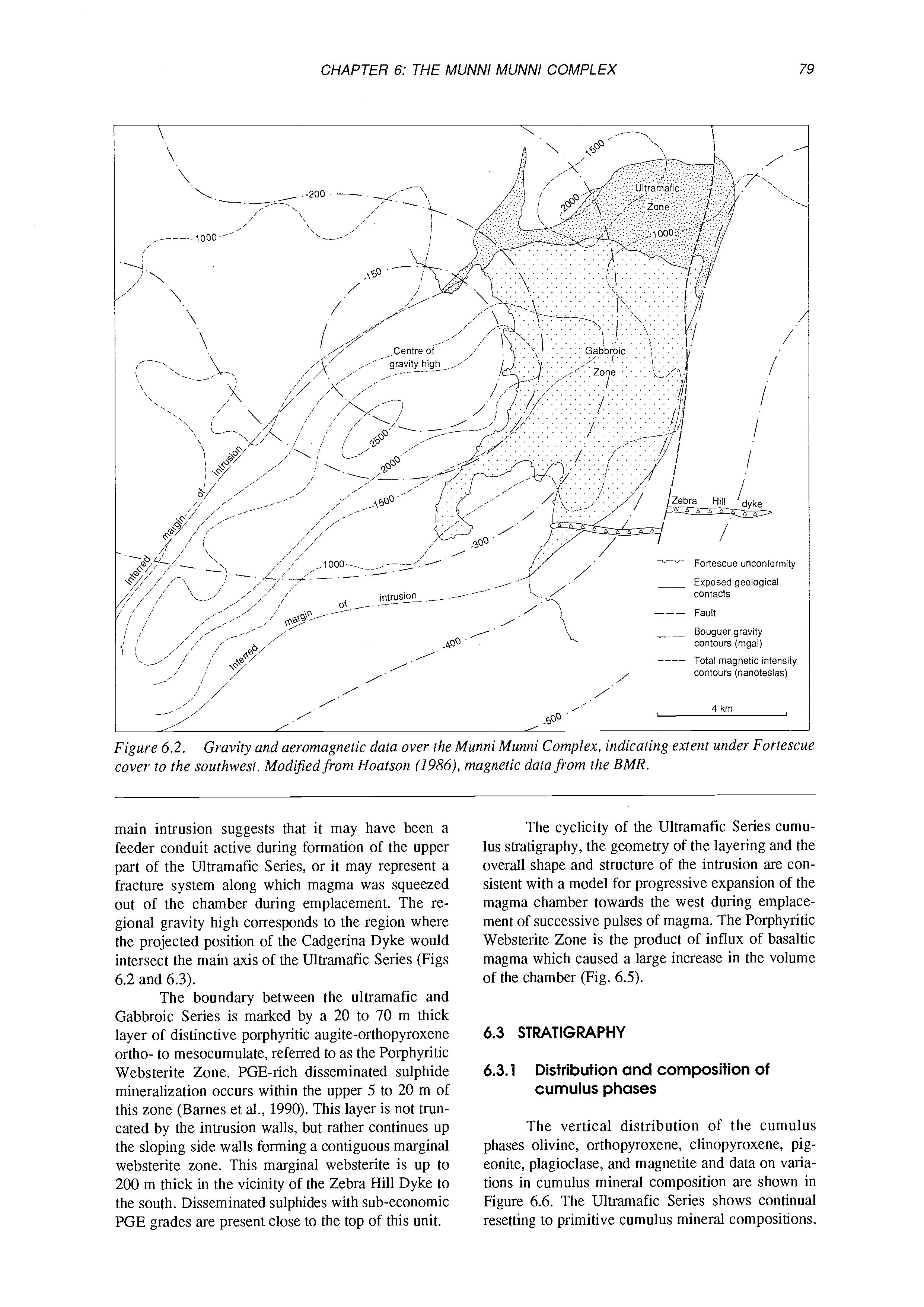
The cyclicity of the Ultramafic Series cumulus stratigraphy, the geometry of the layering and the overall shape and structure of the intrusion are consistent with a model for progressive expansion of the magma chamber towards the west during emplacement of successive pulses of magma. The Porphyritic Websterite Zone is the product of influx of basaltic magma which caused a large increase in the volume of the chamber (Fig. 6.5).
6.3 STRATIGRAPHY
6.3.1 Distribution and composition of cumulus phases
The vertical distribution of the cumulus phases olivine, orthopyroxene, clinopyroxene, pigeonite, plagioclase, and magnetite and data on variations in cumulus mineral composition are shown in Figure 6.6. The Ultramafic Series shows continual resetting to primitive cumulus mineral compositions,
Figure 6.3 (see opposite page). ing and dykes omitted for clarity.
Simplified block diagram of the Munni Munni Complex. Post-intrusion fault-
Figure 6.4. margin of the intrusion. Position of the PGE horizon at the base of the Gabbroic Series (GS) is indicated.
Photograph from the air over the Munni Munni Complex, from north of the Ultramufic Series ' looking approximately south west. Layering within the ultramafic series tilts upwards towards the western
Figure 6.5. expansion of the chamber.
Cartoon showing model for emplacement of the Munni Munni Complex by lateral and vertical
Ultrarnafic cumulates
Table 6.1. Whole rock analyses of chilled margin rocksffom the Munni Munni Marginal Zone, MMD-15 area (data from Hoatson, 1991).
consistent with steady state replenishment and fractionation. The Gabbroic Series, in contrast, shows a steady increase in iron content of pyroxene and albite content of plagioclase, indicative of closed system fractionation in a magma chamber undergoing little if any replenishment. The uppermost 50 m of the Ultramafic Series shows an abrupt trend towards the more fractionated compositions seen at the base of the Gabbroic Series. This trend is to steep to be due simply to in situ fractionation, and is attributed to a prolonged period of magma mixing between the Ultramafic Series parent magma and the relatively fractionated tholeiitic magma which gave rise to the Gabbroic Series.
6.3.2 Marginal rocks
Marginal rocks to the intrusion are exposed along the northern and eastern sides of the Ultramafic Series, along the western extension of the Ultramafic Series where it meets the Fortescue unconformity, and at the northernmost extent of the Cadgerina Dyke. They are also known from drill core in the southern area close to the Zebra Hill Dyke. There is a variety of lithologies within the marginal zone, but a common feature is the presence of granophyric patches derived by assimilation of the neighbouring granite wall rock. Whole-rock analyses of marginal rocks (Table 6.1) are consequently silica-enriched in
Figure 6.6 (see opposite page). Simplified stratigraphic column of the Munni Munni Complex showing variations in cumulus and intercumulus mineral compositions. Modified from Hoatson (1991) and Hoatson et al. (in prep.).
Figure 6.7. Photomicrographs of rocks from the marginal zone of the intrusion. A: Subophitic textured dolerite ffom within I metre of granite contact. B: Granophyric patch in medium-grained clinopyroxene orthocumulate, 10 m into intrusion from sample A. A and B both from stop 7 area. C: Dolerite with euhedral, presumed cumiilus clinopyroxene and xenocryst of quartz. D: Chilled dolerite with acicular pyroxene developed between a fine-grained clinopyroxene orthocumulate and granitic wall rock, Cadgerina Dyke.
many cases, and must be used with caution when attempting to estimate parent magma compositions. Marginal rocks almost always carry phenocryst clinopyroxene, and in many cases the rock is transitional from a clinopyroxene-phyric dolerite towards a clinopyroxene orthocumulate with interstitial granophyre patches and occasional quartz xenocrysts (Fig. 6.7). One sample from the Cadgerina Dyke (Fig. 6.7) shows a few-mm thick chilled margin with acicular pyroxene developed between a fine-grained clinopyroxene orthocumulate and granitic wall rock.
6.3.3
Ultramafic Series
The Ultramafic Series consists of a sequence of cumulates 1850 m thick at its maximum thickness, consisting of approximately 20 cyclic units with olivine and clinopyroxene as cumulus phases. A typical cycle passes upwards from a basal olivineclinopyroxene cumulate to a clinopyroxene (augite) cumulate with a gradual upward increase in clinopyroxene. Many of the cycles are incomplete or beheaded. Orthopyroxene is present mainly as oikocrysts. Orthopyroxene and inverted pigeonite occur rarely as cumulus phases in thin lenticular layers. Typical lithologies are illustrated in Figure 6.8.
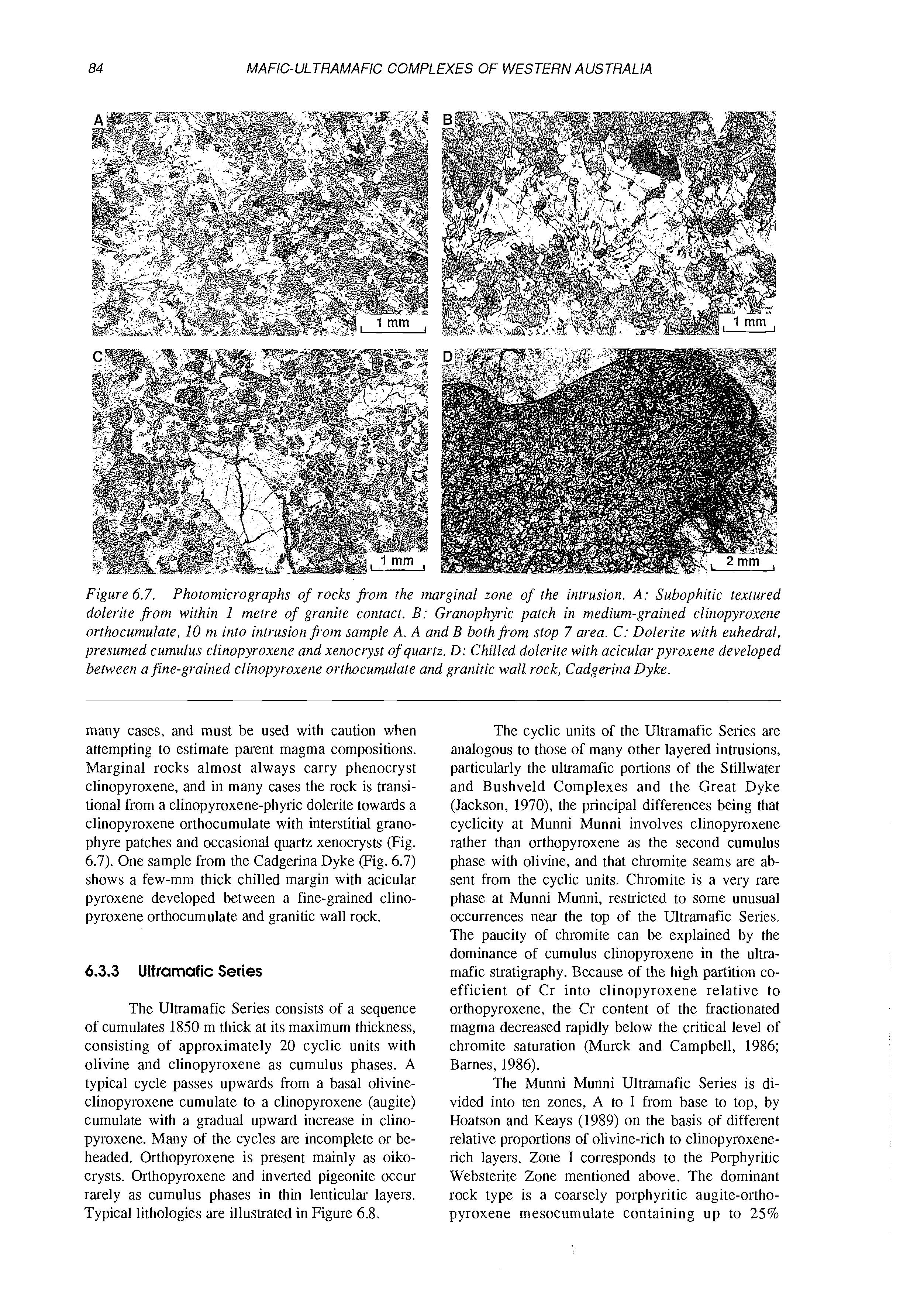
The cyclic units of the Ultramafic Series are analogous to those of many other layered intrusions, particularly the ultramafic portions of the Stillwater and Bushveld Complexes and the Great Dyke (Jackson, 1970), the principal differences being that cyclicity at Munni Munni involves clinopyroxene rather than orthopyroxene as the second cumulus phase with olivine, and that chromite seams are absent from the cyclic units. Chromite is a very rare phase at Munni Munni, restricted to some unusual occurrences near the top of the Ultramafic Series. The paucity of chromite can be explained by the dominance of cumulus clinopyroxene in the ultramafic stratigraphy. Because of the high partition coefficient of Cr into clinopyroxene relative to orthopyroxene, the Cr content of the fractionated magma decreased rapidly below the critical level of chromite saturation (Murck and Campbell, 1986; Barnes, 1986).
The Munni Munni Ultramafic Series is divided into ten zones, A to I from base to top, by Hoatson and Keays (1989) on the basis of different relative proportions of olivine-rich to clinopyroxenerich layers. Zone I corresponds to the Porphyritic Websterite Zone mentioned above. The dominant rock type is a coarsely porphyritic augite-orthopyroxene mesocumulate containing up to 25%
Figure 6.8. Lithologiesfi.om the Ultramafic (A and B) and Gabbroic Series (C and D). A: Modally laminated altered olivine (serpentinized - white)-clinopyroxene adcumulate. B: Unlayered olivine clinopyroxene mesocumulate with minor intercumulus plagioclase. C: Laminated plagioclase-pigeonite-augite adcumulate, typical of lower forty metres of the Gabbroic Series. D: Plagioclase-augite-magnetite-pigeonitecumulate, 400 m above base of Gabbroic Series.
subhedral bronzite (or rarely hypersthene) phenocrysts typically 1-2 cm across (Fig. 6.9), but a wide variety of other rock types is present within the zone, in many cases as xenolithic blocks. Detailed descriptions of this unit are given below in sections dealing with specific field localities.
As well as megascopic cyclic layering, Ultramafic Series cumulates display outcrop-scale layering on a variety of scales (described here using the terminology recommended by Irvine (1982, 1987). Layering takes a number of forms.
1. Rhythmic layering. Rhythmic units are defined by paired isomodal layers of olivine-rich olivine-clinopyroxene cumulate and clinopyroxene cumulate pig. 6.8). Individual units vary from a few centimetre to several tens of metres thick. The lower surfaces of the olivine-rich layers are sharp, while the contact with the overlying clinopyroxene cumulate is more diffuse. In some outcrops there is a systematic change in thickness for several successive rhythmic units, with an overall upward increase in the proportion of clinopyroxene to olivine. This type of layering occurs throughout most of the major cyclic units.
2. Modal lamination in clinopyroxene-olivine cumulates is also common (Fig. 6.8), featuring cmscale fluctuation in modal proportions and a weak preferred orientation of grains parallel to the layer-
ing. Within the lower part of the Ultramafic Series, there are complex sequences of modally laminated, rhythmically layered and unlayered massive isomodal cumulates, with layering types displaying no recognizable pattern of occurrence.
3. Microrhythmic or “inch scale” layering is common in olivine websterites in the upper stratigraphic levels of the Ultramafic Series, and within the Porphyritic Websterite Zone.
4. Modally graded layers are restricted to the stratigraphic interval just below the Porphyritic Websterite Zone. These layers range from a few centimetres to a few metres in thickness, and consist of a basal serpentinized olivine cumulate (sometimes with minor cumulus clinopyroxene) grading up into olivine-clinopyroxene cumulate with increasing amounts of oikocrystic orthopyroxene, and finally into clinopyroxene-olivine and clinopyroxene cumulates. Contacts between these modally-graded layers are sharp.
6.3.4
Gabbroic Series
The base of the Gabbroic Series is marked by the first appearance of cumulus plagioclase, which also corresponds to the appearance of pigeonite in
Figure 6.9. Lithologies fsom the Porphyritic Websterite Zone. A: Typical porphyritic websterite (augitebronzite orthocumulate), showing typical semi-continuous plagioclase rim around bronzite phenocrysts. B: Mineralized augite orthocumulate with poikilitic plagioclase (white).Dissemiriated sulphides (black) interstitial and along pyroxene cleavages. C: Weakly porphyritic websterite (augite-bronzite orthocumu1ate)fsom marginal websterite zone in the Zebra Hill Dyke area. Bronzite partially uralitized. D: “Megacrystic orthopyroxenite”large optically continuous bronzite grain (black), showing randomly oriented crystal faces of numerous originally separate pigeonite grains, and augite exsolution lamellae (white) exsolved fsom the original pigeonite (crossed polars).
significant proportions as an essential cumulus phase. (Minor amounts of cumulus pigeonite occur within the Porphyritic Websterite Zone and elsewhere through the Ultramafic Series). The lower part of the gabbroic sequence consists of monotonous, mostly unlayered, coarse-grained plagioclase-augitepigeonite cumulates (Fig. 6.8) These rocks show a characteristic texture, clearly visible in outcrop, identical to that first described from the Bushveld Complex by von Gruenewaldt (1970). Large groups of cumulus pigeonite grains in random orientations have inverted to large optically continuous single crystals of hypersthene up to 10 cm across, within which the crystal faces and augite exsolution lamellae of the original pigeonite grains can clearly be seen. Campbell (1978) describes the same texture from the Jimberlana Dyke, and points out that it provides clear evidence for heterogeneous nucleation of chains and clumps of thousands of pigeonite grains.
The lowermost 50 m of the Gabbroic Series in the central part of the intrusion is characterized by a strong igneous lamination defined by alignment of plagioclase laths and prismatic pyroxenes (Fig. 6.9), and contains abundant xenoliths of characteristic
fine-grained schlieren-layered gabbronorite, norite and bronzitite, described in more detail below.
Magnetite makes a gradual appearance as a cumulus phase between 200 and 500 m above the base of the Gabbroic Series. It appears first as scattered small oikocrysts, which over about 100 m of section gradually increase in abundance to about ten percent, and decrease in grainsize to take on a distinctive lobate habit (Fig. 6.8), related to the small equilibrium interfacial angle between magnetite and pyroxene (Hunter, 1987). The stratigraphic height of the magnetite cumulus appearance above the Porphyritic Websterite Zone varies across the intrusion (Fig. 6. l), being greatest south of the Cadgerina Dyke, and gradually decreasing towards the intrusion walls. In the Zebra Hill Dyke area to the south, the marginal websterite is in direct contact with plagioclase-pigeonite-augite cumulates with oikocrystic magnetite, which grade into cumulus magnetite-bearing rocks within about 200 m.
Hoatson (1986) distinguished an upper zone of the Gabbroic Series consisting of interlayered gabbros, anorthositic gabbros and anorthosites, adjacent to the unconformity just north of the Eastern
Munni Munni Dyke. The highest exposed level of the intrusion is found in the southern part of the map area (Fig. 6.1) between the Eastern Munni Munni Dyke and the Zebra Hill Dyke close to the Fortescue unconformity. Rocks in this area are very poorly exposed and have been subjected to intense carbonate alteration. Outcrops immediately beneath the Fortescue unconformity have been mapped previously as “quartz monzonite” or “granophyric gabbro”. Correct identification of these rocks is difficult owing to advanced alteration, but it is likely that they represent highly altered orthocumulate magnetite gabbros with interstitial quartz and granophyre patches derived from trapped interstitial liquid. Granitoid roof rock xenoliths may also be present.
6.4 FIELD TRIP LOCALITIES
Location 1. PGE mineralization at the UltramajicGabbroic Series contact
The discovery location of PGE mineralization at Munni Munni is marked by a trench which contained 2 m of 4 g/t combined Pt+Pd. Drill hole MMD-I drilled immediately behind it intersected 2.5 m of 3.7 g/t Pt+Pd. The discovery trench was localized over a 40 ppb Pt, 150 ppb Pd soil anomaly (over a background of less than 10 ppb Pt+Pd in soils). This locality shows typical textures in the porphyritic websterite, and the contact with overlying pigeonite gabbronorite. The characteristic inverted pigeonite chain texture can be seen in the gabbronorite. Drill hole MMD-10 (Fig. 6.10) was drilled in this area, and shows a fairly typical intersection.
Location 2. Zone H of the Ultramfic Series
A prominent outcrop of clinopyroxene-olivine adcumulate shows characteristic modal lamination on a scale of a few cm.
Location 3. Central part of the Porphyritic Websterite Zone
This area (Figs 6.1 1 and 6.12) shows most of the distinctive and characteristic features of this part of the stratigraphy. The dominant rock type is the porphyritic websterite itself, which in this locality is a coarse-grained augite mesocumulate containing up to 25% euhedral phenocrysts of bronzite up to 2 cm in size. Bronzite phenocrysts are typically almost completely surrounded by a narrow rim of plagioclase. The Porphyritic Websterite Zone is capped in places by one to five metres of bronzitefree augite orthocumulate, which in places carries weathered sulphides in outcrop. Within the Porphyritic Websterite Zone and the lowermost 20 m or so of the overlying gabbro, there is a complex assemblage of xenolithic blocks with a wide range in composition and rock type. Within the area of Figure 6.1 1, these blocks form outcrop-sized units of the
following rock types:
1. Fine to medium grained bronzitite and olivine bronzitite, in some cases with thin wispy disseminated chromite seams (Fig. 6.13). In one outcrop these seams can be seen to have a dip strongly discordant to the regional dip of the layering. These blocks range from 1 m to upwards of 20 m in size. Bronzite in this rock type shows substantially more primitive compositions (higher Mg# and Cr) than bronzite in the enclosing websterite (Hoatson, 1991). Chromite shows unusually aluminous compositions (Table 6.2), and is in fact closer to picotite than true chromite.
2. Fine- to medium-grained banded norite and pigeonite gabbronorite showing prominent layering defined by bronzite-rich bands and lenses (Fig. 6.13B). The layers are typically folded and smeared out, suggestive of soft-sediment style deformation probably caused by slumping of a semi-consolidated fine-grained crystal mush (Fig. 6.10). Individual blocks are typically 50 cm to 2 m in size, and occur almost entirely within pigeonite gabbronorite just above the top of the Porphyritic Websterite Zone. The blocks are typically concentrated in outcrop scale units mapped as “mixed rock” (Figs 6.11 and 6.12). (This rock type is best exposed at Locality 5).
Location 4. Traverse through Zones H and I of Ultramfic Series
This traverse, located just to the east of stop 3, passes from cyclically layered olivine-clinopyroxene cumulates of Zone H into porphyritic olivine websterites of Zone I, and illustrates some of the variability in layering typical of this part of the section. A distinct cycle can be seen at the top of Zone H, beginning with a layer of olivine mesocumulate with minor intercumulus pyroxene, passing abruptly into a clinopyroxene-olivine adcumulate with gradually decreasing olivine. This unit grades into porphyritic olivine websterite of Zone I, showing indistinct modal layering defined mainly by varying proportions of bronzite phenocrysts. Cumulus olivine is present in cumulates well above the first appearance of cumulus bronzite.
Location 5. “Mixed Rock” exposure and ultramajic xenolith
A roughly circular outcrop of serpentinized olivine cumulate approximately 30 m in diameter occurs at this locality, and is believed to be either a discordant intrusive pipe (Hoatson, 1986) or a large ultramafic xenolith of the type seen at the last stop. The presence of gabbroic “veins” through this ultramafic body favours its interpretation as a xenolith. Between this outcrop and the track is an exposure of anorthosite, which probably belongs to the basal part of the Gabbroic Series. Immediately south and west of the ultramafic outcrop is an excellent exposure of fine- to medium-grained layered gabbronorite and norite with bronzitite lenses and stringers, containing
PlGEONlTE GABBRO
PORPHYRITIC WEBSTERITE
LAYERED OLIVINE CLINOPYROXENITE
LAYERED WEHRLITE
CUMULUS CL QXE
Figure 6.10. Petrology and geochemistry of diamond drill hole DDH 10, discoveiy area.
n... Olivine-augite cumulate. olivine cumulate
Augite-olivine cumulate. augite cumulate
"Porphyry websterite"-augite+bronzite kpigeonite cumulate
Porphyritic olivine webserite-augitebronzite-olivinecumulate
"Mixed rock"-fine grained norite, bronzitite, gabbronorite with flow & slump structures
Fine grained ultramafic xenoliths, mainly bronzite- :izs!+: olivine cumulate with disseminated chromite & minor chromite seams
Piagioclase-augite-pigeonitecumulate
Inferred gabbro/ultramafic contact
Strike & dip of igneous layering
Diamond drill hole collar
Figure 6.11. Geological map of the central part of the Porphyritic Websterite Zone, mod#ed porn Hoatson (1986), Hoatson and Keays (1989),and unpublished Hunter Resources mapping.
Plagioclase-augite-pigeonite cumulate
Banded norite. bronzitite, gabbronorite
Augite (+minor bronzite) orthocumulate
Porphyritic websterite-augite bronzite + pigeonite cumulate
Porphyritic-augite-bronzite-olivine cumulate (olivine websterite)
;rpz;;hne f chrornite cumulates,
Augite-olivine cumulate
Olivine-augitecumulate
Dolerite dyke
Igneous layering
Fault
Drainage -____ I 100 m 1
Figure 6.12 (see opposite pages). Detailed geology of the Porphyritic Websterite Zone east of hole MMD-2, showing distribution of “mixed rock” lithologies and ultramafic xenoliths.
Figure 6.13. Xenolithic rocksfiom the PWZ and immediately overlying gabbro,fi.om the area of Figure 6.12. A: Outcrop photograph of small block offine-grained bronzite cumulate within weakly porphyritic websterite. B: Slump fold in finely layered, fine- to medium-grained layered norite-bronzitite xenolith. C: Photomicrograph of “chromite” seam in medium grained bronzitite.