GSA-WA Excursion Guidebook No.10: Rock Cycle and Geology of the Perth metropolitan area (1998)
Geological Society of Australia (Western Australia Division)
Excursion Guidebook No. 10
The Prider Field Trip – the rock cycle and geology of the Perth metropolitan area
A Professional Development Day For High School Geology & Science Teachers
Prepared by Steve J. Moss, Mike J. Freeman, Annette D. George, Alan Marshall, Janet M. Dunphy and the WA Division of the Geological Society of Australia
Important Notice:
This fieldguide was initially compiled for the 1998 Prider Fieldtrip, and is intended for use by school educators on field excursions with upper primary or secondary students, or interested members of the general public.
Natural cliff sections, and rock faces and cliffs within disused quarries can present lifethreatening hazards. Due care and supervision should be exercised when visiting these sites. All sites have been included in good faith, but teachers and visitors should check with local authorities regarding access on the intended dates of the visits. We strongly urge that people visiting any of the sites described in this guidebook do so with extreme caution.
FRONT COVER:
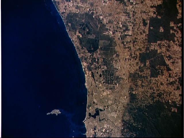
NASA Photo ID: STS056-155-058, Date Taken: 17-April-1993
Title: STS-56 Earth observation of Perth in Western Australia
Description: STS-56 Earth observation taken aboard Discovery, Orbiter Vehicle (OV)103, is probably the best view of Perth in Western Australia. The major feature on the coast is the large estuary of the Swan River. Inland lies a prominent escarpment, more than 200 metres high, seen running down the middle of the view. Here, the line of the Darling Fault separates the Yilgarn Craton to the east from the Swan Coastal Plain to the west. The Moore River can be seen entering the sea at the top of the frame. Rottnest Island is visible in the sea, and Garden Island near bottom edge of the frame. Image reproduced with the permission of NASA.
Preferred reference for this volume:
Moss, S. J., Freeman, M., George, A. D., Marshall, A., & Dunphy, J. M., 1998, The Prider Field Trip – the rock cycle and geology the Perth metropolitan area. A Professional Development Day for High School Geology and Science Teachers. Geological Society of Australia (WA Division), Excursion Guidebook, No. 10, 72pp.
ISSN0819-6613
ISBN 1-876125-06-3
Printed copies of the Adobe Acrobat PDF are available for purchase from:
Geological Society of Australia (W.A. Division), PO Box 6014, East Perth, WA, 6892
Geological Society of Australia (Western Australia Division)
Excursion Guidebook No. 10
The Prider Field Trip – the rock cycle and geology of the Perth metropolitan area
A Professional Development Day For High School Geology & Science Teachers
Friday 8th May 1998
Prepared by Steve J. Moss, Mike J. Freeman, Annette D. George, Alan Marshall, Janet M. Dunphy and the WA Division of the Geological Society of Australia
List of Illustrations
Figure 1Location of sites to be visited in the Perth region. ............................................................4
Figure 2 The Rock Cycle .............................................................................................................5
Figure 3Principal attributes of the three rock groups ....................................................................7
Figure 4Main geological sub-divisions of SW Western Australia ..................................................9
Figure 5Geological map of the Perth region ...............................................................................10
Figure 6Simplified cross section of the Perth Basin ....................................................................11
Figure 7Geomorphic map of Perth and surrounding region of Western Australia. ........................12
Figure 8Schematic East - West cross-section showing the main geomorphic and geological units of the Perth region and the relative location of the three localities to be visited ....................13
Figure 9Locality details for the Mountain and Government Quarries at Boya. .............................16
Figure 10Location map of the sites to be visited in Mountain Quarry ............................................17
Figure 11 Sketch of the northern side of the quarry entrance at Mountain Quarry ..........................18
Figure 12Base map of the Mountain Quarry for use in Basalt dyke mapping exercise. ..................20
Figure 13Locality details for the Armadale Shale Quarry .............................................................25
Figure 14Simplified map of the Armadale Shale Quarry ...............................................................26
Figure 15Locality details for the Peppermint Grove Section .........................................................31
Figure 16Simplified Geological section through the Peppermint Grove section. .............................33
Figure AE1Diagram depicting the relationship between Dip, Strike and Apparent Dip. ....................46
Figure AE2Diagrammatic example of Dip and Strike for inclined strata in outcrop. ..........................46
Figure AE3 Relationship between contour interval and contour spacing on a map projection. ............47
Acknowledgements
Various members of the Department of Minerals and Energy, the Department of Geology & Geophysics (University of Western Australia) and the School of Applied Geology (Curtin University) have helped with the production of this guide, and they are gratefully acknowledged. Myra Keep is acknowledged for her unending patience with the senior author whilst this fieldguide was being written, and for producing the original front cover.
Purpose of the Guidebook
The guidebook was primarily designed for use on the fieldtrip and also as a source of information and data for the participants to use subsequently in teaching geology. All information contained in the guidebook is publicly available. There is a glossary of technical terms at the back of this guidebook.
The Prider Fieldtrip 1998
Itinerary - suggested itinerary for the fieldtrip
Time LocationActivity
7.45 amCar park, The CausewayGroup assembles & departs for Boya
11.40 amArmadale QuarryMetamorphic & old sedimentary rocks
12.50 pm Armadale QuarryLunch
1.20 pmArmadale QuarryDepart for Peppermint Grove
Traverse across Swan Coastal Plain to Swan Estuary
2.00 pmPeppermint GroveLandforms & young sedimentary rocks
3.00 pmPeppermint GroveEnd of trip refreshments
3.35 pmPeppermint Grove Return to Causeway Car park
3.45 pmCar park, The Causeway End of field trip
N.B. The timings are approximate and subject to change depending upon conditions during the day.
Figure 1The localities to be visited during the Prider Fieldtrip.
The rock cycle
Rocks are aggregates of minerals that form in an amazing number of different physical environments both within and upon the surface of the Earth. The sort of rock produced is determined by the materials present and the surrounding physical conditions (temperature, pressure, fluid activity).
A useful concept to understand the origins and relationships of the three groups of rock and how they form is the rock cycle. This is shown in Figure 2. The three rock groups, igneous, sedimentary and metamorphic, are shown on this figure. Each can form at the expense of the another if it is forced out of equilibrium with its physical environment. We hope to be able to demonstrate most of these the main features of each rock group, as well as other features, others at the localities we shall visit during the course of the day.
Igneous rocks form from molten material called magma or lava, as it cools and crystallises. Both magma and lava are molten rock. Rock can become molten at range of temperatures, dependent upon the pressure levels at the time and the composition of the rock, although temperatures of around 700 to over 1000°C are common temperatures for rocks to melt and become molten. Magma is the term used if the molten rock is beneath the Earth’s surface. Lava is the term used for molten rock above the Earth’s surface. When magma cools it forms intrusive igneous rocks and when lava cools it forms extrusive igneous rocks (also referred to as volcanic rocks). As magma and lava cool, elements combine to form crystals of minerals. The minerals with higher melting points will form first, and as the temperature lowers and other minerals will form. When all the magma or lava has cooled a solid mosaic of (typically) randomly orientated, interlocking crystals is produced. In some lava flows the crystals may have a preferred orientation imparted whilst the lava was flowing. Often there will be several different sizes of crystals.
Figure 2The rock cycle.
The Prider Fieldtrip 1998
Once both intrusive or extrusive rocks have formed from cooling of molten rock, they may sooner or later become exposed at the Earth’s surface and subjected to the agents of weathering and erosion (mainly wind, water, ice, solar heat). They are also at this stage experiencing physical conditions very different to those under which they formed, under such that they can be considered to be out of equilibrium. They weather, break down and produce debris which is usually transported by combinations of water, wind and/or gravity and are eventually deposited. This loose debris is called sediment. If an accumulation of sediment is cemented (or otherwise consolidated) it forms a sedimentary rock. During weathering some material also goes into solution. This material is often precipitated out of solution at a later stage in a sedimentary environment. For example calcium carbonate (CaCO3) is biologically precipitated by organisms such as molluscs and corals. Sedimentary rocks may also form through the accumulation of the shells of these organisms when they die. Regolith is a product of intense weathering over a long period of geological time and are viewed as another type of sedimentary rock. Other sedimentary rocks include salt deposits and sedimentary iron deposits, both these are called chemical sediments as they are chemically precipitated. Sedimentary rocks formed adjacent to active volcanoes typically contain abundant volcanic detritus and form by sedimentary reworking of pyroclastic deposits from the volcano.
If the sedimentary rock is buried by additional layers of sediment being deposited on top of it over a long period of time, it will gradually experience higher temperatures and pressures. If buried deep enough (~7-10 km), the rock will no longer be in equilibrium with its physical surroundings and it will alter or metamorphose. The new rock formed is called a metamorphic rock (metamorphose: change nature). Both igneous and sedimentary rocks may change into metamorphic rocks. Metamorphic rocks may form by processes other than deep burial within the Earth’s outer layers. For example, they may form by heat derived from an adjacent igneous intrusion. Certain minerals will only form during metamorphism and can be used to identify metamorphic rocks. As with igneous rocks, metamorphic rocks are often exposed at the Earth’s surface at some time through the processes of uplift and erosion. At the Earth’s surface the minerals that form metamorphic rocks are not in equilibrium with their new physical environment and are susceptible to break down by weathering agents and erosion and eventually form sedimentary rocks.
If, during metamorphism the temperature and the pressure are high enough, the rock will eventually melt and form magma, thus completing the cycle. The cycle can be repeated again and again. However there is no reason to expect all rocks to go through each part in the cycle. For example, sedimentary rocks maybe weathered and eroded to form new sediment and eventually a different sedimentary rock. Likewise, igneous rocks may be metamorphosed to form metamorphic rocks without ever passing through the sedimentary phase of the cycle.
The principal attributes of the three main rock groups are shown in Figure 3.
Figure 3The principal attributes of the three rock groups
Geological Background of the Perth region
Perth, the capital of Western Australia, lies to the west of the Darling Scarp, which is a major topographic feature on the eastern edge of the Swan Coastal Plain an area which is underlain by the Perth Basin. The area east of the Darling Scarp, the Darling Plateau, is underlain by much older (Precambrian) rocks and is referred to by geologists as the Yilgarn Craton (see Figures 4, 5, 6, 7, 8 & 9).
The Swan Coastal Plain has a range of elevation from 0 to 75 m above sea level. The Swan Coastal Plain consists of variably consolidated sediment of late Tertiary (Neogene, ~5 Ma old) and Quaternary age (1.64 to 0 Ma old, see Geological Time Scale, page 61). Beneath this relatively thin veneer (thickness in order of 60 m) of the Swan Coastal Plain is the Perth Basin, which consists of a 15 km thick package of sedimentary rocks (lithified sediments) dated at 290 to 120 Ma old. The oldest sedimentary rocks documented in the Perth area of the Perth Basin are of Permian age (about 290 to 250 Ma), and the youngest are Cretaceous (about 120 Ma). In the northern part of the basin, near Kalbarri, sedimentary rocks of Silurian age (430-400 Ma) are present in the basin and represent the oldest part of the basin (or possibly an older basin overprinted by the Perth Basin). During the Permian period it is believed that the basin was a gulf, open to the north to a sea, with northern India located to the west and Antarctica to the south (at that time WA, Antarctica and India were part of a supercontinent called Gondwanaland). The total thickness of sediment is about 15 km which was deposited in environments ranging from marine to shallow marine, coastal, lake and riverine.
The Darling Plateau has an average elevation of 300 m above sea-level. The Yilgarn Craton can be thought of as a stable nucleus to much of Western Australia. The craton is composed predominantly of crystalline rocks such as granite and gneiss of igneous and metamorphic origin, respectively. Within the granite and gneiss terrain are sub-linear belts of metamorphosed sedimentary and volcanic igneous rocks, traditionally referred to as “Greenstone Belts.” Parts of the craton formed as long ago as 3.7 Ga (1 Ga = 1 billion years = 1000 Ma) and it is one of several very old and large cratons that occur around the world. Others are known from Canada, Antarctica, South Africa and Siberia. Most rocks in the Yilgarn Craton originated either as sedimentary and volcanic rocks which formed between 2.8 Ga and 2.5 Ga, or as part of numerous, very extensive, granite bodies which crystallised about 2.6 Ga. Following initial formation, most of the sedimentary and volcanic rocks and granites were buried to depths in the crust of up to 30 km, at which depth the increased temperature (up to 600°C) and pressures (up to 1 GPa or about 10000 times normal atmospheric pressure) caused the rocks to metamorphose.
The Darling Scarp is the surface expression of a major fault line (the Darling Fault) that separates the Yilgarn Craton from the Perth Basin and can be called a fault scarp. The features of the scarp have been emphasised in recent geological times by marine erosion during Pleistocene interglacial periods and other times in the last 100 Ma when the sea level was much higher than it is today. The Darling Fault extends some 1000 km from down near the south coast northward and is a major northerly trending fault, which separates Archaean-aged gneiss and granitoid rocks of the Yilgarn Craton to the east, from sedimentary rocks of the Perth Basin to the west. There is evidence that the fault has been active since Archaean times (2570 Ma ago). The first movements along the fault line are believed to have been dominantly horizontal in nature, similar to the San Andreas Fault system of California. It represents a major weakness in the Earth’s crust in this area and it has been reactivated several times since then, during the Proterozoic and later in the Phanerozoic. During the Triassic-Jurassic periods (between 250 and 135 Ma ago) major vertical movements occurred, with the western side of the fault lowered by some 15 km in relation to the eastern side of the fault. The Darling Scarp is a classic example of a scarp produced by a fault, a feature seen around in places around the world. Weathering and erosion
The Prider Fieldtrip 1998
has caused the scarp to retreat eastward by as much as 2 km. The fault is still the cause of the scarp, which demonstrates one of the many ways by which geology affects our natural landscapes.
The geology of the Perth region is also of economic interest. There are significant mines and mineral deposits (gold, aluminium, hydrocarbons, coal and mineral sands) within 100 km of Perth. Production of low value commodities such as sand, building stone, lime and peat within the Perth region annually exceed $100,000,000 value.
Figure 4Main geological sub-divisions of SW Western Australia.
Figure 5Simplified geological map of the Perth region, Western Australia. Figure modified from Wilde
Figure 6Simplified cross section of the Perth Basin Figure adapted from Cockbain (1990).
Figure 7Geomorphic map of Perth and surrounding region of Western Australia.
Figure 8Schematic East - West cross-section of the Perth region and the relative location of the three localities.
From the car park at the northern end of The Causeway the route to Boya will take you from the Swan Estuary and Coastal Plain and up onto the western margin of the Darling Scarp. The suggested route is to cross The Causeway, once on the southern side head east along The Great Eastern Highway as far as the Great Eastern Highway bypass. Follow this until you reach the Roe Highway, head north up the Roe Highway until you reach Clayton Street. Follow Clayton Street east (which becomes Jinda Road). You are now on the edge of the locality map shown in Figure 9. From Jinda Road there are various options as to the route to the Mountain Quarry on Hudman Road.
During this traverse you should pass the following geological/geomorphic points of interest.
• Neogene – Quaternary fluvial deposits, lateritised sandstone and shale
• Archaean Yilgarn Craton, locally granites and basic igneous dykes
Localities of economic significance:
• Swan Estuary – oyster shell deposits, cement raw material in 1957
• Maylands Peninsula – brick clays
• Bellevue – brick clays
• Greenmount – granite/dolerite quarries
THE MOUNTAIN QUARRY
PURPOSE
The purpose of this part of the trip is to:
⇒ examine features associated with the formation, composition, emplacement and structures of igneous rocks;
⇒ examine features of a soil / colluvium profile;
⇒ discuss features of economic importance in the quarry.
LOCATION
Mountain quarry is located about 4.5 km east of Midland Junction in the Shire of Mundaring. The quarry is located off Coulston Road (Figure 9) and is administered by DOLA (Department of Land Administration). Before taking parties into the quarry please phone DOLA on 08 9295 2244 to inform them of date, time and purpose of your visit. Car parking for the Mountain Quarry is available in the small car park just off Coulston Road (Figure 9). Alternatively small cars and minibuses may actually drive into the quarry. The nearby Government Quarries (or Hudman Road Quarries) were to be the venue used in this fieldtrip. These quarries are administered by the Shire of Mundaring and are currently closed to public access whilst their safety is reviewed.
REGIONAL GEOLOGY
The Mountain Quarry are located on the western margin of the Yilgarn Craton, a few kilometres to the east of the Darling Fault, overlooking the Swan Coastal Plain.
ROCK TYPES
The rock types exposed in the quarry are all of igneous origin: granodiorite; granite; and dolerite. These are all intrusive igneous rocks which have formed by the cooling of magma below the Earth’s surface. There are several different types of intrusive rock, two of which, plutons and dykes, are exceptional well displayed in the quarry. Plutons are large masses (up to several tens of km across) of intrusive igneous rock that form within the Earths crust from cooling of large bodies of magma. Large granite plutons are commonly found throughout the Yilgarn Craton. Dykes are generally smaller, vertical to sub-vertical igneous bodies that cross-cut older rocks and structures. They form when magma intrudes into, and forces apart, pre-existing rock along linear structures, making a space for the magma to cool within the opening. Within the Yilgarn Craton, dykes composed of medium- to fine- grained basic (or mafic) igneous rocks (called dolerite or basalt, respectively) are very common. As they are usually vertical to sub-vertical they form linear patterns on maps. Maps of the Yilgarn Craton reveal several different dyke trends, indicative of several different periods of dyke intrusion. Geologists use such relationships, called cross-cutting relationships, to place relative age dates on rocks (e.g. if dyke A cross-cuts dyke B, then dyke B must be older than dyke A it had to already have been present in order for dyke A to cut it see Appendix C).
AGE OF THE ROCKS
The rocks exposed in this quarry are part of the Yilgarn Craton and are Precambrian in age (older than 545 Ma, see Geological Time Scale, p.61). More specifically they have been assigned an Archaean age of formation, of between 2690 and 2626 Ma age (Nemchin & Pidgeon 1997) on the basis of measurement of radiometric ages. Radiometric dating of other dykes elsewhere in the Yilgarn craton has yielded ages of 590-560 Ma (Wilde & Low 1978). The variations in orientation and composition of the dykes clearly indicates that there has been more than one phase of dyke formation and realistically they range in age from Proterozoic into the Phanerozoic. On the basis of some of the features present within the quarry, a relative time order for the formation of the rocks can be deduced. Their absolute ages cannot be determined without recourse to sophisticated analytical techniques.
GEOLOGICAL HISTORY
A series of granites were intruded into gneisses and other older metamorphic rocks and cooled in Archean times. The setting for the formation of these granites remains conjectural as this was an early part of the Earth’s history. The granites were locally cut by veins of pegmatite. The granites were then intruded by a several different generations of dolerite dykes. The different orientations, more subtle differences in mineralogy between the dykes, and a range of radiometric ages obtained for the dykes, clearly indicates we are dealing with different phases of dyke generation.
HISTORY OF THE QUARRIES
Blocks of granite from the Boya area were used as long ago as the 1860’s for some of Perth’s public buildings. Granite from the quarry has been used for building stone and aggregate for concrete. Dolerite from the quarry once crushed has been used for road metal in road construction. Both the Mountain Quarry and nearby Government quarries ceased operation in circa. 1930. Since then they have been maintained as public access sites. Mountain quarry is used extensively by abseilors and climbers whilst Government Quarry No. 3 has been used to stage cultural events and performances during the Perth Arts Festival.
Figure 9Locality details for Mountain Quarry and the Government Quarries at Boya. Midland Junction is located to the west of this map.
Figure 10Location map of the sites to be visited at Mountain Quarry.
SPECIFIC LOCATIONS WITHIN THE QUARRIES
Igneous rocks are well exposed around the walls of the quarries, and their internal features as well as relationships between different igneous bodies can be examined. Location numbers are shown on the locality map (Figure 10). A check list of things to see is provided below.
Examine the granite exposed in the northern side of the quarry entrance. Note the following:
• crystalline nature
• igneous texture (random orientation of crystals)
• minerals (size, shape, colour)
Determine that the rock is composed of randomly orientated crystals of different minerals which have different physical appearances (ie they are different minerals).
Figure 11Sketch of the northern side of the quarry entrance at Mountain Quarry.
At this locality note that several sub-horizontal veins of quartz can be seen and a much thicker pegmatite vein.
**Economic significance of pegmatites**
**Economic significance of veins**
Examine the coarse nature of the minerals within both the quartz vein and the pegmatite vein.
• pegmatites - note their grain size and mineralogy
Just a few metres to the north-east another rock type (basalt) is exposed. Examine the basalt.
• contrast the physical appearance, properties & constituent minerals between basalt and granite
To view the relationships between different rock types it is often useful to stand back and view as much of the outcrop as possible. Stand on the south side of the quarry entrance and look north to view the relationship between the basalt, granite and pegmatite veins. Examine dolerite dyke on the northwestern quarry wall of No. 3 quarry
• basalt dyke
• differences in joint patterns between the basalt dyke and the granite
• use of structures to determine relative ages
Using Figure 11, identify all the rock types and structures present and place them into a relative time order.
Having viewed the relationship between the basalt, granite and pegmatite veins from a distance now move in close to the face and examine the contact relationships between these three in detail.
• note how geological contacts are often more complex upon closer inspection
• several small faults can be seen on the SW side of the dyke, make labelled and scaled sketches of the contact.
Go to locality 6 on Figure 10.
At this locality another basalt dyke is well exposed. Can you observe any changes in size of crystals from the centre of the dyke to its edges. If so what do you think produced these changes. This is another good spot to observe the complexity of geological contacts.
• record any crystal grain size changes in dyke
• sketch the contact between the basalt and granite
Standing roughly in the centre of the quarry you should be able to distinguish between basalt dykes and granite. Using the blank map provided (Figure 12) draw a sketch map that represents a plan view of the rocks you can see in the quarry interpreting how you thing the basalt dykes would of linked up originally (ie before the quarry was excavated).
This is will help you appreciate how geologists use maps (2-D) as representation of 3-D rock bodies (NB how the orientation of planar surfaces are recorded in geological mapping is explained in Appendix F in the guidebook)
From the centre of the quarry observe the walls of the quarry and notice how the orientation and spacing of joints varies from areas of basalt to areas of granite. **Economic significance of joints** Examine quarry walls from centre of quarry.
• joint sets including low angle exfoliation
• From the rock relationships exposed in both quarries, try to determine the relative ages and intrusion history of the dyke rocks.
• Examine the nature, orientation and types of joints in this quarry.
a At the top of the quarry note how the granite and basalt have weathered differently.
• sketch the weathering profile at locality 9a
b At the top of the quarry wall notice how roughly circular looking blocks of granite are weathering out. These are called “cornstones”.
• sketch the weathering profile at 9b
• note the differences in weathering product between the basalt and granite
Figure 12 Base map of the Mountain Quarry for mapping the basalt dykes.
Economic significance of the quarries at Boya
Granite and dolerite from the quarries have been used as raw materials for building and road construction for some time. Building materials are low value commodities with economies highly dependent on distance to markets and transportation costs.
Economic significance of pegmatites
Pegmatites are very coarse-grained igneous rocks that are typically found associated with or within bodies of plutonic igneous rocks. They generally form during the late stages of cooling of a plutonic rock (commonly granite). They represent a crystallisation of the residium once most of the magma has cooled. They often contain high concentrations of incompatible elements (such as Li, B, Ta, etc) as these elements are not readily incorporated into the crystal lattices of the common crystallising phases. Pegmatites are commonly mined for economically important minerals such as cassiterite (Sn), spodumene (Li) and feldspar (ceramics). Greenbushes mine, south of Bunbury is an example of pegmatites being economically exploited. In addition to economic mineral deposits, pegmatites are also often sought by mineral and gem collectors, as the coarse-grained nature often produces spectacular and rare mineral crystals.
Economic significance of veins and shears
Economic mineralisation is often associated with veins and shears. Rock fractures (joints) and shear zones form the “plumbing system” for hot mineralised fluids (hydrothermal) which circulate through otherwise impervious rock. Precipitation of dissolved materials (eg silicates, carbonates, sulphides) within a limited section of these “plumbing systems” can occur as veins or as disseminated minerals in shears and adjacent country rock. For example Pit G Gold veins at Boddington.
Economic significance of joints
Joints are surfaces which cut through rocks but have no visible displacement. They form through several mechanisms, including stresses induced by cooling of igneous rocks, tectonic stresses, and the removal of overlying burden. They are essential for the quarrying and extractive industries in that they aid the removal of rock. This ease of removal that high joint densities is also very important in reducing the costs of road cuttings and other constructions which require removal of rock masses.
There are several types of joint displayed in the quarry.
• columnar joints, which define close-packed hexagonal “prisms” seen perpendicular to the upper and lower surfaces of lava flows and sills, or to the walls of dykes. Form by contraction during cooling of the magma/lava.
• exfoliation joints, which roughly parallel topography. Form by the release of stress with removal of overburden.
Traverse 2 - south along the Darling Scarp
From the quarries at Boya the next traverse will take us along the edge of the scarp in a southerly direction. The suggested route to the Armadale Quarry from Boya is to make your way from the quarry to the junction of Clayton Road and Ridge Hill Road and head south along Ridge Hill Road. Follow this road until you reach the T-junction with Kalamunda Road. Here you can either briefly head north-west to join the Roe highway and hence head south to join the Tonkin Highway southbound or follow Kalamunda Road southeast to the junction with Hawtin Road. Follow Hawtin Road, which becomes Hale Road until you reach the Albany Highway and join the Tonkin Highway. Either way you should follow the Tonkin Highway south until you reach the junction with the Albany Highway (just east of central Armadale), you should now be able to locate yourself on the location map provided in Figure 12. Proceed across the junction (i.e. onto the South Western Highway) keeping look-out for a left turn onto Marsh Road.
During this traverse you should pass the following geological/geomorphic points of interest.
Geomorphic units:
• scarp and Helena Valley
• Ridge Hill Shelf
• Pinjarra Plain
Geological units:
• Ridge Hill sandstone, lateritised early Pleistocene strandline deposits
• residual deposits (laterites etc)
• Yoganup and Guildford Formations
• Archeaen Yilgarn Craton
Localities of economic significance:
• Stathams Quarry - source of blocks for Fremantle harbour and other breakwaters
• Ridge Hill Gravel pits
• Sand pits
• Kelmscott quarries
• Yoganup strandline titanium (heavy) mineral deposits, eg Mundijong
• Mineral deposits of the Darling Plateau, e.g. bauxite gold
• Collie basin coal (obviously slightly further to the south)
⇒ examine features associated with deformation of rocks;
⇒ examine the features of a regolith profile;
⇒ discuss features of economic importance in the quarry.
LOCATION
The Armadale Shale Quarry is located about 30 km southeast of Perth. The quarry is located off Marsh Road, Armadale, immediately south of the intersection of the Albany Highway and the Southwest Highway (Fig. 13). The City of Armadale purchased the site in 1995 and maintains the site as a geological resource . The quarry is 200 m long and 90 m wide at the crest of the excavated walls for a total area of 1.8 ha. At the base, which is 22 m below the western rim, the quarry has dimensions of 170 m by up to 30 m (Fig. 14). Further information on the site is contained in Appendix B.
REGIONAL GEOLOGY
The Armadale Shale Quarry is located approximately 500-1000 m east of the western edge of the Darling Fault zone on the extreme western edge of the Darling Plateau (see Geological background and Figs 4 and 5).
ROCK TYPES PRESENT & THEIR STRATIGRAPHY
The quarry exposes rocks which geologists identify as the Cardup Group. The Cardup Group consists of shale, sandstone and siltstone with dolerite intrusives. The Cardup Group is divided into three units: the lowermost being the Whitby Sandstone, overlain by the Nerrigen Formation, which in turn is overlain by the Armadale Shale (Low, 1972). In the quarry the topmost unit exposed is a basalt sill which was intruded into the Armadale Shale. The Whitby Sandstone unconformably overlies the crystalline basement rocks (granitic gneiss of the Yilgarn Craton). These crystalline rocks are thought to be Archaean age; over 2500 Ma old. There is an exposure of the basement-sediment contact in the Maddingon Quarry.
The Whitby Sandstone consists of a quartz rich sandstone bed, overlain by silty shale which is overlain by thinly bedded black and white shale. Stromatolitic structures, termed Collenia, were identified from the sandstone bed. Grey (1987) confirmed the presence of the stromatolites, and placed them in the Nerrigen Formation, although her mapped position suggests they were from within the Whitby Sandstone. The Nerrigen Formation consists of 20 m of pale coloured sandstone and shale. The top most unit exposed is the Armadale Shale. This consists of a basal dark gray to black shale which grades into a cream-coloured to white shale.
The Cardup Group rocks are generally low-grade metamorphic rocks formed by relatively low pressure and temperature metamorphism of sedimentary rocks (usually called metasediments), although some sections appear unmetamorphosed. As such they posses bedding planes which give the rocks a layered appearance and these planes or layers dip steeply west. The age of the Cardup Group and the precise geological setting for the formation of these rocks is poorly understood, and more geological mapping and radiometric dating is needed. The Cardup Group has been mapped only between Mundijong and Perth. Other smaller outcrops of possibly correlative units occur outside this range. The Cardup Group has a similar structural position (i.e. location relative to the fault zone) to the Moora Group, which occurs some 150 km further north. Both of these units seem enigmatic, obviously postdating the formation of the Yilgarn Craton, and probably the crystalline basement beneath the Perth
The Prider Fieldtrip 1998
Basin. One interpretation is that they represent a fault-bounded sliver of “exotic” rocks which have been transported from another locality along the line of the Darling Fault zone by movements on faults of the fault zone. This would explain their lack of continuity away from the fault and lack of correlation with any other rock units in the area.
The rocks in the southern part of the quarry are shales and siltstones (sedimentary rocks), whilst in the northern part of the quarry and along the northeastern wall the rocks are slates. Slates are produced by low grade metamorphism of fine grained sedimentary rocks such as shales and mudstones. The presence of both rock types in close proximity suggests that significant vertical and/or lateral motion has occurred along some of the faults exposed in the quarry.
AGE OF THE QUARRY ROCKS
It has not been possible to directly measure the ages of the rocks using radiometric methods yet, so we must infer an age.
• The rocks exposed in the quarry must be older than the rocks of the Perth Basin (see Geological Background of the Perth Region, p.9) because they have been involved in structural deformation which has not affected those in the Perth Basin, thus they must be pre-Permian in age.
• The rocks postdate the Yilgarn Craton rocks, which are over 2600 Ma old, as Cardup Group rocks unconformably overlie Yilgarn Craton rocks in another quarry. Cardup Group rocks also overlie some of the dolerite dykes (such as those you just saw at Boya Quarry) that intrude the Yilgarn Craton. The youngets radiometric age ofr these dykes is 1800 Ma.
• The only fossils present are the stromatolites, unfortunately the stromatolites present do not provide any specific geological age data.
• The Cardup Group rocks must be older than the dolerite sill that intrudes them. Until the dolerite sill can be accurately dated the above information suggests the Cardup Group rocks are older than Permian (~300 Ma) but younger than ~1800 Ma. Therefore the only means of inferring an age is through regional geological relationships, and there is a need for absolute ages to be determined for this part of the geology of the Perth area. On the basis of regional correlation the Cardup Group rocks are suggested to be between 1500 and 700 Ma old.
GEOLOGICAL HISTORY
Yilgarn Craton rocks originated during the Archaean time (>2500 Ma) as a series of sediments which were deformed and intruded by granite magmas. These were then all deformed again and recrystallised to form an assemblage of gneissic rocks. Ages for both the intrusives and the deformation range between 2800 and 2200 Ma. These rocks were uplifted and eroded over a long period, exposing rocks at the surface which had been buried to depths of 15 km.
A rise in relative sea level then submerged the land and sands were deposited, becoming the Whitby Sandstone. In turn the sediments became muddier, but still mixed with sands, comprising the Nerigen Formation. Subsequently the sediment deposited was entirely mud, and this now constitutes the Armadale Shale. The timing of this transgression of the sea and deposition of the sediments may have been between 1500 and 700 Ma. The rocks were then intruded by a dolerite sill. The Darling Fault zone became active subsequent to deposition of the strata. It has not been possible to accurately define the relationship between the fault zone and the sedimentary strata, but movement on the fault probably resulted in rotation of the sediments down on the western side of the quarry.
Figure 13 Locality details for the Armadale Shale Quarry
Figure 14 Simplified map of the Armadale Shale Quarry
QUARRY
A number of sedimentary and tectonic structures can be seen at several sites around the quarry. Location numbers are shown on the map of the quarry (Figure 14).
• From the entrance, note the bedding and its overall orientation, and any other features such as lithological variation in the quarried rock.
• Note the relationship between the older bedded rock and the overlying loosely consolidated sediments of the regolith. What name is given to the surface which separates these two broad units?
West side of quarry, dolerite sill.
• Describe the texture and mineralogy of the rock type exposed at this site, and provide an appropriate name. What features indicate that it is an igneous rock?
• How do the texture and mineralogy control the weathering of this rock? Can you see if it weathers differently to other rocks in the quarry and if so in what way.
• What is the relationship between this igneous unit and the sedimentary rocks in the quarry? What term do we use for igneous bodies that display this relationship?
Structure at southeastern corner of quarry.
• Examine the stratal disruption at this site and locate the structure/s which caused it.
• What control on the local topography does the fault exert?
Sedimentary features at southern end of quarry.
• Describe the bedding and texture of the rock types and provide appropriate rock names.
• Describe and sketch any sedimentary structures you can see at this locality.
Tectonic structures on the northeastern side of the quarry.
• Cleavage is well developed at this locality and the close spacing of the cleavage produces a slatey rock. Identify the cleavage and note its relationship with the bedding.
Tectonic features at the northern end of quarry.
This locality offers another opportunity to study in detail deformational structures such as small folds small faults and cleavage development and how they affect the bedding of this metasedimentary unit.
• Identify the small folds and faults which are well developed at this site.
• Identify and describe the cleavage at this site and its relationship to the folds.
Regolith profile at south end of quarry.
Economic significance of the Armadale Quarry shales
The shales in this quarry were mined for brick and clay tile production between 1902 and the 1930’s with peak production of 150,000 bricks per week. Today brick clays are being mined from older quarries in the Armadale Shale further south (see Appendix B).
Economic significance of black shales
Black, fine grained and thinly laminated sedimentary rocks (shales) are important source rocks for petroleum and often host base metal sulphide deposits containing copper, lead and zinc in economically abundant percentages. Proterozoic black shale deposits host some of the world’s largest sulphide deposits of lead, zinc and copper. In the quarry itself there are some green secondary minerals which indicate the presence of copper in the shale. Black shales deposited in marine environments are also often rich in organic material from the accumulation of dead, marine, mainly planktonic, organisms. Such organically rich shales are often the source of oil and gas in sedimentary basins.
Economic significance of geological faults
Faults and fractures provide a potential pathway for any circulating fluids to move along. Faults are generally areas of lower confining pressure compared to the surrounding rock. If circulating fluids are carrying any dissolved elements these may be preferentially precipitated along the fault plane due to the sudden drop in pressure. Over geological time this may result in the formation of an economic deposit of that mineral or group of minerals along the fault. Most of Western Australia’s gold deposits have formed in this manner.
Economic significance of regolith
The regolith of the Darling Plateau is characterised by a deep complex profile of strongly oxidised and leached rocks which are the product of tropical weathering over perhaps 60 Ma (i.e. both the Paleogene and Neogene). This laterite profile (detailed in Appendix D) is both directly and indirectly very important for mineral exploration. Within the Perth area (Figure 5) sections of the laterite profile are the sources of economically significant mineral deposits. For example:
• Wundowie iron
• Darling Plateau bauxite (aluminium)
• Boddington gold
• Clacklinefire clays
• Darling Plateau road gravels
The laterite profile extends across the Yilgarn Craton and many of Western Australia’s current gold mining operations commenced with bulk mining of secondary gold deposits in the saprolith.
TRAVERSE 3 -ACROSS THE SWAN COASTAL PLAIN TO SWAN ESTUARY
From Armadale to Peppermint Grove we will leave the Darling escarpment and return to the Swan Coastal Plain. The suggested route is to return to the South Western Highway, head north to the Albany Highway junction but then head west along the Armadale Road. Follow the Armadale Road, which becomes Forrest Road, until you reach the Kwinana Freeway. Join the freeway and head north. Cross the Swan River at the Narrows but make sure to take the Mounts Bay Road exit on gaining the northern side of the river. Follow Mounts Bay Road west, which becomes the Stirling Highway. Follow the Stirling Highway until you reach the Cottesloe/Peppermint Grove area. You are now on the location map provided in Figure 12. There are several options as to which road you turn off to reach the section.
During this traverse you should pass the following geological/geomorphic points of interest.
Geomorphic units:
• Swan Coastal Plain, including the Pinjarra Plain and Bassendean Dune System
• Canning River Estuary
• Spearwood coastal dune system
• Mt. Eliza escarpment
Geological units:
• Neogene sedimentary units - Guildford Formation
• Bassendean and Spearwood aeolian sands and Tamala Limestone (Mt. Eliza escarpment)
• Pleistocene marls and peats
Localities of economic significance:
• Mt. Eliza escarpment and engineering geology
• Diatomite - Mandogalup swamps
• Peat, interdunal swamps on Bassendean dune sands
• Lime sands
• Building stone, Tamala Limestone
• Construction sand from Bassendean Dune System sands
• Silica sand for glass making from Bassendean Dune System sands
THE SWAN ESTUARY AND PEPPERMINT GROVE
PURPOSE
The purpose of this part of the trip is to:
⇒ ⇒ ⇒ ⇒ examine sedimentary rocks;
⇒ ⇒ study structures within sedimentary rocks;
⇒ ⇒ ⇒ ⇒ observe fossils in the field;
⇒ ⇒ ⇒ ⇒ demonstrate the reconstruction of past environments;
⇒ ⇒ ⇒ ⇒ consider the economic importance of such rocks.
LOCATION
The site to be visited is located near the Scotch College Boat Club in Peppermint Grove. From the Stirling Highway, Peppermint Grove, proceed via Forrest Street to The Esplanade. The location is reached via paths to the Scotch College Boat Club located on the banks of the Swan River (Fig. 15). Car parking spaces are provided on The Esplanade and there are toilet facilities at this location.
The cliff section at Peppermint Grove is a geological monument. In addition, parts of the cliff section are potentially unstable. Therefore, hammering and collection of material is not permitted and visitors must always stay away from overhangs and not enter the small cave.
ROCK TYPES PRESENT
The rocks at Peppermint Grove belong to a unit referred to as the Spearwood Dune system (Bastian 1996, see Figures 6 & 7). The Spearwood Dune system is one of a series of coastal dune belts that are progressively younger in age to the west (Figures 7 & 8) and that were deposited during a major interglacial high relative sea level during the Pleistocene. The other dune systems are the Bassendean Dune system to the east and the Quindalup Dune sytem to the west. The rocks of the Spearwood Dune System are called the Tamala Limestone (or sometimes the Tamala aeolinite) by geologists. This unit is a formation, which is a rock unit that is mappable, that is traceable over an area being mapped. The Tamala Limestone Formation contains several local variations or sub-units (called members) which are not so extensive; one of these is the Peppermint Grove Limestone which we will see at Peppermint Grove.
A variety of sedimentary rock types are present within the Tamala Limestone. The dominant rock type are called arenites, which are sedimentary rocks where the size grain falls dominantly within the range 0.06-2 mm (e.g. sand-sized). The term arenite has no implication for the composition of the grains that form the rocks. If the grains are predominately quartz then the prefix quartz (quartz arenite) is used, if the grains are calcareous then the prefix calc (calcarenite) is used. Sandstones are arenites. The Tamala Limestone at Peppermint Grove is mainly a medium- to coarse-grained aeolian (winddeposited) calcarenite (calcareous sandstone to sandy limestone). Compositionally it consists of sandsized fragments of molluscs and foraminiferas with substantial amounts of detrital quartz and lesser amounts of feldspar. The Peppermint Grove Limestone is more shell rich and contains more whole shell fragments.
Sedimentary structures are important attributes of sedimentary rocks. They occur both upon the lower and upper surfaces of beds, as well as within beds. Many of these structures are formed as the sediment is deposited, hence they contain significant amounts of information regarding the processes and conditions of deposition of sediments. For example, the direction of water or air currents can be deduced from certain types of sedimentary structures known as cross-bedding. Good examples of cross bedding are seen at Peppermint Grove.
Another sedimentary structure within the cliff sections at Peppermint Grove is a series of vertically orientated, typically downward tapering structures which testify to the post-depositional history of these rocks. These structures formed after the sediments had been deposited through the calcification (via circulating groundwater) of plant root systems. These structures are called rhizoconcretions and are identical to structures that form The Pinnacles, north of Perth. Post-depositional changes to these sedimentary rocks have been significant, with the leaching of carbonate fragments altering the original nature of the deposited material and producing what are called residual sands.
Figure 16 shows a section through the Tamala Limestone at the Peppermint Grove cliffs. The section displays basal lenses of shallow marine and beach deposits, including shell beds (the Peppermint Grove Limestone). The shallow marine beds at the base grade up into beach rocks and are capped by aeolian deposits which make up the bulk of the ridge. This section illustrates coastal progradation (i.e. gradual retreat of the sea). This sequence is very typical of the Pleistocene coastal dunes in the Perth region and also in other parts of Australia.
AGE OF THE ROCKS
The rocks present are of Pleistocene age, which means they are less than 1.64 million years old. They were dated using isotopic methods.
Figure 15Locality details for the Peppermint Grove Section.
GEOLOGICAL FEATURES OF THE PEPPERMINT GROVE SECTION
A number of sedimentary features can be seen at several sites along the cliff section. Location numbers are shown on the map of the section (Figure 16).
General view of the section
• From either the northern or the southern end of the section observe the general nature of the rocks and in particular their layered nature.
Just north of the small cave
At this location the layered nature of the Tamala Limestone can be easily observed. Sedimentary structures formed during the deposition of the sedimentary rock can also be observed.
• Observe the granular nature of the rock, which is composed of grains cemented together. If possible, try to determine the size and nature of the grains. Notice the pore spaces between the grains **Economic significance of porosity**.
• Describe the bedding in terms of thickness and orientation. Thinking back to the previous locality you visited, how does the bedding at Armadale and Peppermint Grove differ?
• Make an annotated sketch or sketchs of sedimentary structures. Can you determine how they form
Cliffs and loose blocks on the river side of the path south of the small Cave: At this locality (marked approximately on Figure 16) the well preserved shells of bivalves, gastropods and other marine fauna are well displayed both in the cliff section and in several large loose blocks on the river side.
• Note the diversity of organisms preserved. Make sketches of each of the different organisms present.
Southern end of the section, back toward the boat shed.
In the vicinity of this locality (marked very approximately on Figure 16) another type of sedimentary structure is well displayed. Note the vertically orientated structures.
• Make annotated sketches of the structures. Speculate on their mode of formation.
• The presence of these structures within the section implies a change of environment has occurred from the conditions under which the rocks at were deposited. Can you suggest what has happened?
• Taking a vertical profile through the cliff section, describe what changes in palaeoenvironments have occurred.
Economic significance of porosity
Pore spaces are the gaps between the grains in sedimentary rocks. Collectively called porosity, this feature of sedimentary rocks has great economic importance as these pores provide space for water, oil and/or gas to reside within the rock and thus form the aquifers that provide drinking water or the reservoirs in which oil and gas is found.
16Simplified Geological section through
The circled numbers mark the approximate position of parts of the section described in the text.
Figure
the Tamala Limestone at Peppermint Grove.
GLOSSARY OF GEOLOGICAL TERMS
The below are definitions for technical terms used in this guidebook. The list is not meant to be exhaustive.
Acid Igneous Rock
An igneous rock containing more than 60% SiO2. Contains over 10% free quartz. Term arises from concept of silica as an acidic oxide, i.e. in theory, together with water, it can form a range of ‘silicic acids’ and minerals forming the rocks were viewed as products of these acids. Name persists today although the theory behind it is untenable. Granite and rhyolite are common acid igneous rocks. Contrasts with terms intermediate and basic.
Archaean A period of geological time from 4200 to 2500 Ma (see Geological Time Scale).
Arenite
A general name used for consolidated sedimentary rocks composed of sandsized fragments irrespective of composition, e.g. sandstone, arkose, calcarenite.
Basalt A fine-grained (<0.5 mm) basic igneous rock, usually dark colour on fresh surfaces. Mineralogically and chemically identical to dolerite. Typically contains olivine and/or pyroxene as well as calcic feldspars (plagioclase).
Basic Igneous Rock An igneous rock containing a relatively low silica content (less than 45-50% SiO2). Basic igneous rocks are quartz-free and contain feldspars which are generally more calcic than sodic. Pyroxene and olivine are also common. Basalt, dolerite and gabbro are common examples.
Basin (see sedimentary basin)
Batholith
Bedding plane
Calcrete
A very large-scale (measured in kms) mass of intrusive igneous rock. May be made up of several smaller plutons.
A layer or surface commonly seen within sedimentary rocks, which was parallel to the depositional surface at the time of deposition. Typically give sedimentary rocks a layered appearance. Maybe be picked out by changes in grain size, colour and grain composition.
A calcareous duricrust. Term originally introduced to describe conglomerate consisting of surficial sand and gravel cemented into a hard mass by calcium carbonate precipitated from solution by infiltrating groundwaters. A product of weathering calcium carbonate rich rocks typically under arid to semi-arid climatic conditions. Synonymous with caliche.
Chilled margin A finer-grained zone seen at the margins of igneous intrusions and at the base of lava flows where the magma or lava has cooled more quickly and hence has a fine grained nature.
Cleavage (mineral) A flat plane produced on the surface of a mineral when an attempt is made to break the mineral. The cleavage surfaces will typically have a geometric arrangement. Cleavage forms along planes of weakness in the atomic lattice of the mineral. Minerals may have more than one cleavage direction.
Cleavage (rock) A plane within a rock along which the rock may be preferentially split. There are several type of cleavage, all formed in response to varying amounts of compression of the rocks.
Country rock The rock body bodies which enclose an intrusive igneous mass or series of mineral veins. Synonymous with host rock.
Craton A major area of the Earth’s crust which can be considered geologically stable (i.e. limited or no tectonic or igneous activity at present). Typically consists of igneous and/or metamorphic rocks, perhaps with a thin veneer of sediments.
Cross-bedding
Cross-cutting
Diorite
Dolerite
Duricrust
Dyke
Enclave
Fault
Feldspar
Fossil
The Prider Fieldtrip 1998
Synonymous with the shield. Cratons are generally Archaean in age. Western Australia contains two cratons, the Yilgarn and the Pilbarra Cratons.
An arrangement of sedimentary rock layers inclined at an angle to the more horizontal bedding planes of the larger rock unit. Formed by the migration of either wind-blown or sub-aqueous dunes. Can occur on a variety of scales from tens of centimetre to tens of metres.
A relationship between two rock units used to place them in a relative time frame. The rock unit cross-cut is the older of the two in relative terms. See Appendix C.
A coarse grained (2-10 mm) plutonic igneous rock of intermediate composition. Plagioclase (oligoclase to andesine varieties) is the dominant mineral phase with one or more of the ferromagnesium minerals (biotite, hornblende, augite). Quartz is present only in small amounts (up to 10%).
A medium-grained (0.5-2 mm) basic igneous rock. Mineralogically and chemically identical to basalt.
A general term for a hard crust on the surface of, or layer in the upper horizons of, a soil in a semi-arid or arid climate.
A sheet-like body of rock (typically igneous) which is discordant (i.e. cuts across bedding or other planes) with surrounding country or host rock. Often sub-vertical to vertical, dykes are formed by the intrusion of material in a molten or liquefied state into a solid host.
An inclusion within an igneous rock. Synonym of xenolith.
A fracture in the Earth’s surface along which there has been an observable amount of displacement. Rarely occur as single planar units, more commonly as parallel to sub-parallel sets within a fault zone. Several types are recognised depending on the nature of the motion on the fault.
A very common silicate mineral in igneous rocks. Four chemically distinct groups are recognised: potassium feldspars, sodium feldspars, calcium feldspars and barium feldspars (very rare). Sodic and calcium feldspars form a solid solution series. Chemical formulas for the three common types are:
Potassium feldspars - KAlSi3O8
Sodium feldspars - NaAlSi3O8
Calcium feldspars - CaAl2Si2O8
An organic trace which has been buried and preserved by natural processes. Includes actual body parts, impressions, excreta, tracks, trails and borings.
Ga Giga-annum. A period of geological time equaling a thousand million years (109 years)
Gneiss
Banded rocks formed during high grade (high temperature and pressure conditions) regional metamorphism. The bands are typically compositional in nature, i.e. alternations of different light and dark minerals.
Geomorphic Geomorphology - the description and interpretation of landforms.
Gondwanaland
Granite
Greenstone belt
Igneous rocks
Name given to southern “super-continent” consisting of South America, Africa, Madagascar, India, Arabia, Malaya, the East Indies, New Guinea, Australia and Antartica. Existed ca. 200 Ma.
A coarse-grained (2-10 mm) igneous rock. Typically light coloured on fresh surfaces and made up of 20-40% quartz and sub-equal proportions of plagioclase and potassium feldspar.
A belt of low grade metamorphosed basic igneous rocks.
Formed by the cooling of molten material called magma (if below ground) or lava (if above ground). Those formed by cooling below the ground are
The Prider Fieldtrip 1998
intrusive and those formed by cooling above ground are called extrusive. As the magma or lava cools mineral phases crysallise or precipitate. Igneous rocks are characterised by interlocking crystals and a “massive” nature.
Indurated When applied to sedimentary rocks used to described how well held together the rock is. Induration - process by which soft, loose sediment becomes a solid, hard sedimentary rock.
Intermediate Igneous rocks with silica contents intermediate between Igneous Rock acid and basic (i.e. between 50 to 65% SiO2). Rocks typically contain less than 10% quartz with either a plagioclase or alkali feldspar or both. Common rock types include diorite and andesite.
Laminated Any sedimentary rock in which the layering (bedding) is less than 1 cm thick.
Limestone A sedimentary rock typically composed of calcite with/without lesser amounts of aragonite. Typically formed by the accumulation of the shells/body parts of dead organisms (which themselves were originally biochemically precipitated by the organism).
Ma Mega-annum. A period of geological time equaling a million years (106 years)
Metamorphism The process of chemical reconstitution and recrystallisation of a pre-existing rock which accompanies the application of increased heat, pressure and fluid activity often through deep burial of rocks in the Earth’s crust. Earth movements can result in rocks being buried up to 30 km where they are subjected to temperatures of up to 800 degrees and pressures of up to 10,000 atmospheres (1000 MPa). At these conditions, minerals which are formed at shallow depth are unstable and form new minerals; just as baking a cake, the original ingredients are chemically changed to new constituents. There are four types of metamorphism; (a) regional, affecting large areas of the Earth’s crust; (b) contact, caused by heating next to igneous intrusions; (c) cataclasite, caused by friction and pressures generated along faults and (d) shock, generated by force of meteorite and asteroid impacts. The minerals in metamorphic rocks will typically show a preferential alignment.
Metastable Said of a phase with respect to small changes in ambient conditions (temperature, pressure, fluid activity, etc) but is capable of reaction if conditions change.
Mica
Platy silicate minerals, typically either black or clear colour with a perfect basal cleavage. Two common micas are:
Muscovite - K2Al4(Si6Al2)O20(OH,F)4 and Biotite - K2(Mg,Fe”Fe’”,Al)6(Si6-5AlO2-3)O20(OH,F)4
Migmatite Literally means mixed rock i.e. made up from two different sources. Typically the two components are a pre-existing host rock (inevitably a metamorphic rock) and an invading granitic material. Typically associated with the highest grade of metamorphism and partial melting of the host rock.
Monzonite
Pegmatite
Coarse grained igneous rocks ranging in composition from acid (quartzbearing forms) to basic (olivine-bearing forms) with the essential feature of the presence of approximately equal amounts of alkali and calc-alkali feldspar.
A very coarse grained (>1 cm) igneous rock of similar composition to granite. (nb the term “pegmatitic” applies to any igneous rock, regardless of composition, that is exceptional coarse-grained). Pegmatites often form veins in granitic rocks and surrounding country rocks, and can contain significant deposits of economically valuable mineral deposits.
Phanerozoic A sub-division of Geological time from 545 Ma to the present day (see the Geological Time Scale)
Pluton
Precambrian
Pyroclastic
The Prider Fieldtrip 1998
A large mass of igneous rock. Plutonic rocks are intrusive igneous rocks formed by the cooling of a large body of magma within the Earth’s crust. As the magma cools relatively slowly plutonic rocks are often coarse grained. A batholith is made up of several plutons.
A sub-division of Geological time from 2500 to 545 Ma (see the Geological Time Scale).
Clastic rock material formed by volcanic explosion or aerial expulsion from a volcanic vent. Individual fragments are pyroclasts.
Quartz SiO2, a very common mineral in almost all rocks.
Quartzite
Radiometric dating
Regolith
Rhizoconcretions
Originally a near pure quartz sand in which the grains have become so well cemented during rock-forming processes that when the rock breaks, it fractures through the grains as easily as through the cement. Typically a metamorphic product from the alteration of a sandstone.
A method of obtaining absolute ages for rocks that uses the radiometric decay of certain isotopes that occur naturally in minerals.
Comprises the entire altered, unconsolidated or secondary cemented cover that overlies more solid or coherent rock (the bedrock).
Cylindrical or conical concretion-like structure in sedimentary rocks, usually branching or forked, resembling a root of a tree. Formed by precipitation of minerals such as calcium carbonate around the roots of living plant.
Synonymous with rhizocretion.
Ripple More or less regularly spaced undulations on bedding planes within sedimentary rocks (typically sandstones, but also siltstones) produced by the affects of sufficient energy within a body of water or in the wind to move loose sediment. If their relief exceeds 3 cm they are called dunes.
Sandstone
Schlieren
Sedimentary basin
Sedimentary rocks
Strictly any sedimentary rock which consists of particles of sand size (0.062 mm) grains of any composition. Usually applied to rocks which consist mostly of quartz grains, although the presence of quartz is not a pre-requisite. Other components include of feldspar, mica and grains of pre-existing rocks (so-called lithic grains). The grains are moderately well cemented, but in contrast to an quartz arenite, the cement is weaker than the grains and when it breaks, it does so through the cement.
A texture within igneous rocks produced by the mixing of two different phases of magma.
A depression on the Earth’s surface in which sediments accumulate and form sedimentary rocks
Rocks formed by the accumulation and lithification of sediment. There are three major groups of sedimentary rock. They are: (1) Terrigenous - derived from the breakdown of pre-existing rocks, composed of rock fragments, mineral particles and weathering products of pre-existing rocks (eg sandstones). (2) Carbonate - composed predominantly of carbonate minerals (aragonite, calcite, dolomite). Most carbonate rocks are formed biochemically in marine settings (limestones). (3) Chemical - formed by the precipitation of minerals from aqueous solution (evaporites).
Shale
Siltstone
Strandline
A fine grained sedimentary rock composed of grains or particles less than 0.004 mm with a well developed bedding plane fissility. Formed from the consolidation of clays.
A fine grained sedimentary rock composed of grains or particles between 0.062-0.004 mm
The ephemeral line or level at which a body of standing water, (e.g. the sea)
Stromatolite
Texture
The Prider Fieldtrip 1998
meets the land.
Discrete laminated structure with some degree of relief on the lamination. The structures are a product of organosedimentary activity through sediment trapping, binding and/or precipitation activity of micro-organisms, primarily by cyanobacteria. Closely related to stromatolites are microbial mats composed of filamentous and unicellular cyanobacteria which may also trap and bind loose sediment. Modern examples of both can be seen in the vicinity of Hamelin Pool in Shark Bay, Western Australia. Stromatolites are the oldest preserved fossil group (3.5 Ga old).
The relationship between the constituents (minerals) of a rock.
Transgression Invasion of an area of land by the sea in a geological short period of time due to rise in relative sea level. The plane of a transgression often corresponds to a plane of unconformity. The reverse of a transgression is a regression.
Unconformity
Xenolith
A surface that represents a break in the geologic record. Can be considered from several aspects: (1) time - an unconformity develops during a period of time during no rocks are formed and as such they are time gaps with the rocks below the unconformity older than those above; (2) deposition - deposition of rocks cease for a certain period of time and (3) structure - in the rock record an unconformity is represented by a unconformable surface or plane of unconformity, the rocks below may be more structurally complex and deformed whilst the units above undeformed and flat lying. Several types of unconformity are recognised but perhaps the most important are angular unconformities formed by deformation and folding and erosion of older rock units before younger rock units are deposited above. The younger rocks are said to be unconformable on the older rocks.
An inclusion of a pre-existing rock in an igneous rock. The fragment maybe derived from the surrounding country rocks or as a portion of an earlier solidified igneous rock with a different composition.
The Prider Fieldtrip 1998
EVENTS IN EARTH HISTORY
End of last Ice Age11,000 Yrs
First Homo sapiens
500,000 Yrs
First Species Homo genus3 Ma
First Important Mammals66 Ma
Last Dinosaurs65 Ma
First Dinosaurs
First Reptiles
First Land Vertebrates
230 Ma
300 Ma
350 Ma
First Fish fossils ~400 Ma
Oldest Hard-Shelled Fossils 540 Ma
Hamersley Iron Formations WA 2.5 Ga
Oldest preserved life (stromatolites) 3.5 Ga
Oldest rocks in WA 3.730 Billion (4 km south of Jack Hills)
Oldest rocks in the world4.0 Billion (Acaster Gneiss, Slave Province, Northwest Territories of Canada)
Oldest mineral4.275 Billion Years (Zircon - ZrSiO4)(oldest material in the world from two zircon crystals from Jack Hills, WA)
Note: 1 Billion years = 1 Ga; 1 Million Years = 1 Ma
Bastian, L.V. 1996. Residual soil mineralogy and dune subdivision, Swan Coastal Plain, Western Australia. Australian Journal of Earth Sciences, 43, 31-44
Cockbain, A.E. (1990). Perth Basin. In: Geology and Mineral Resources of Western Australia. Geological Survey of Western Australia Memoir 3, 495-525
Grey, K. 1987. Field study of stromatolites in the Cardup Group, Armadale. Palaeontology report 13/1987 of the Geological Survey of Western Australia.
Lemmon, T.C, Gee, R.D., Morgan, W.R., Elkington, C.R. 1979. Important geological sites in the Perth and Southwestern area of Western Australia. Geological Society of Australia, Western Australian Division.
Myers, J.S. & Hocking, R.M. 1998. The Geological Map of Western Australia, 1:2 500 000 (13th edition), Western Australia Geological Survey. Perth, WA, Australia.
Nemchin, A.A. & Pidgeon, R.T. 1997. Evolution of the Darling Range batholith, Yilgarn craton, Western Australia: a SHRIMP zircon study. Journal of Petrology, 38, 5, 625-649
Stephens, Lindsay. Undated (1980s?). A geology excursion to Armadale. Notes prepared at Kelmscott Senior High School.
Wilde, S.A. & Low, G.H. 1978. Perth, Western Australia, 1:250 000 Geological Series. Geological Survey of Western Australia, Perth Western Australia.
SOURCES OF GEOLOGICAL INFORMATION ON THE PERTH REGION
There are several good sources of geological information in Perth. They are:
• Western Australia Geological Survey, Plain Street, Perth
• Western Australia Museum, Perth
• E. de C. Clarke Museum, University Western Australia
• Department of Geology & Geophysics, University Western Australia
• Chamber of Minerals & Energy, Adelaide Terrace
• Geological Society of Australia, WA Division
• School of Applied Geology, Curtin University of Technology
A)A BRIEF HISTORY OF ARMADALE QUARRY
The Armadale Shale Quarry is a former quarry for brickmaking clay, exposing a sequence of steeply dipping weathered shales. Quarrying was discontinued in the mid-1900s, and in the mid 1990s. The quarry was turned into a reserve for geological education. The value of the site for teaching purposes includes exposures of indurated sediments (a somewhat rare commodity near Perth) and a variety of structures and fabrics. The structural geology can be extended from simple faulting and folding to demonstrations of detailed bedding/foliation/linear fabrics with various kinematic indicators present in low grade tectonites (Standing, 1988). It truly contains a comprehensive range of teaching items.
HISTORY OF QUARRY
Lindsay Stevens (undated paper from Kelmscott High School) reported that shales were identified at the site in the 1830s by Captain Theophilus Thomas Ellis, who was appointed as the first Government Resident for Kelmscott. In 1900, a Jack Saw dug a shaft into the shale and submitted samples for analysis in Sydney. A quarry was established the following year, and a brick kiln was established at a site west of the Southwest Highway to use the shale for the brick clay in 1902. The site of the kiln is now occupied by the Dale Cottages. Eventually a tunnel was excavated from greater depths of the southern end of the quarry and the clay was transported in trucks under the highway counterbalanced on a wire with a steam-powered winch for control. As the rock became progressively fresher, blasting became necessary. By the 1930s it has been reported that the blasting was becoming objectionable to nearby residents, and quarrying was stopped. However, production was continued, and still is, from other quarries in the Cardup Group further south (Metro Bricks operates a plant immediately southeast of Byford). The Armadale site was a productive site, and at the peak production, output is reported to have been approximately 150 000 bricks per week.
During the past 40 years, the quarry has been used as a teaching site by the geology departments of UWA, Curtin, and, more recently, by Leederville TAFE. In 1979 it was described in “Important geological sites in the Perth and southwestern area of Western Australia” by Lemmon and others in the first such report for the WA Division of the GSA. The Armadale-Kelmscott Shire Council had accepted comments from the Geological Society of Australia, and had zoned the quarry as a Special Geological Reserve, although it was private land. From about 1980, several attempts were made by the then owners to prevent access from local young residents who delighted in using the void as an adventure ground. It has been reported that all attempts to prevent access were overcome within a week! In 1988 the owners of the land, Armadale Development Pty Ltd, proposed that the quarry be covered by mesh and the void be used as a bird aviary as a tourist attraction, with an accompanying restaurant and museum. It was a controversial proposal and, following much public debate, the proposal was eventually withdrawn with the owners claiming that the delays had turned it into a nonviable proposition. In 1993, new owners proposed using the quarry as a rubbish tip to stabilise the feature which would allow them to subdivide and sell surrounding land. Following several meetings involving representatives of the Department of Minerals and Energy, University of WA, Curtin University of Technology, Leederville TAFE Geology Department, E. De C. Clarke Museum, Armadale City Council and the owners, it was made apparent to the Council that the site was important for teaching geology and should not be filled. However, it left the owners in a difficult situation because they had purchased a block of land and could not realise any value from it, and the City of Armadale had within its area of responsibility a block of land which was a potential eye-sore and hazard. Subsequently in 1995 the Council came to an arrangement with the then owners, and purchased the block. The Council then obtained Commonwealth funding which was used to clear rubbish from the bottom of the quarry, stabilise the walls to a degree, pave the access ramp, construct a high chain mesh fence around the block and a low fence inside this at the top of the face, construct seats, erect a covered sign-board and pergola and make a parking area. The initiative of the Council is excellent, and provides WA with its first dedicated geological education site.
B)RELATIVE DATING AND BASIC GEOLOGICAL PRINCIPLES
Given below are the 5 geological “principles” that geologists use to relatively date rocks (i.e. place them in an order formation)
1/ Principle of Superposition: states that when stratified material is deposited it is deposited on top of the older material. Therefore, in a stratified geological sequence the rocks lying directly above the lower units are younger than those below. For example, unit E is younger than D which is younger than C etc.
2/ Principle of Original Horizontality: states that water-laid sediments are deposited in layers or strata that are horizontal or nearly horizontal, and parallel to the Earth’s surface.
3/ Principle of Original Continuity: states that a water-laid stratum, at the time it was formed, must continue laterally in all directions until it thins out as a result of nondeposition or until it abuts against the edge of the original basin of deposition.
4/ Principle of Crosscutting Relationships: states that structures or geological units that cross-cut or overprint other structures or units are younger than cross-cut or overprinted structures or units.
For example, rock type F cross-cuts units A-E and it therefore younger. Rock type G intrudes and overprints rock type F and H cross-cuts all. Therefore, the geological history for this example is: 1) deposition of A-E, 2) intrusion of F, 3) intrusion of G and finally 4) intrusion of H. Metamorphic aureoles / baked margins can be expected around G, H and F.
5/ Principle of Inclusion: states that if material is included in a rock type or rock unit, then the included material must be older that what it is included in.
For example, a sediment containing granite pebbles - the granite that has been eroded to produce the pebbles must be older then the sediment that now contains them.
C)REGOLITH TERMINOLOGY
Figure AC1. Regolith terminology.
D)ECONOMIC GEOLOGY OF THE PERTH REGION - A SUMMARY
• Coal - Hill River (Jurassic), Irwin River (Permian)
• Hydrocarbons - Dongara (gas), Mount Horner (oil)
• Water - artesian and sub-artesian
• Brick clays - Midland Bellevue
• Waste disposal sites, sand, brickclay and gravel pits
Locality 1 - Darling Escarpment quarries (Boya)
• Material for buildings, break waters, railway ballast, concrete, road metal
• Hydrothermal mineralisation in veins and shears
• Pegmatites
Traverse 2 - south along Darling Scarp
• Laterites - used for road gravel
• Bauxite - Jarrahdale, Wagerup
• Gold deposits - Boddington
• Coal - Collie Basin (Permian)
• Fire clays - Clackline
• Iron ores - Wundowie
Locality 2 - Armadale Quarry
• Shales for bricks
• Black shales, base metal sulphide deposits (Cu, Pb, Zn)
Traverse 3 - across the Swan Coastal Plain to the Swan Estuary
• Heavy mineral sands - ilmenite, rutile, monazite and zircon
• Silica sands - Kendenup
• Building sands
• Marls
• Peats
Locality 3 - Peppermint Grove
• Heavy mineral sands
• Building stones
• Lime sands
E)ORIENTATION OF PLANAR STRUCTURES
All planar structures are represented on the map by a STRIKE and DIP.
STRIKE:is the direction of a horizontal line in the inclined plane (Fig. AE1).
DIP:is the angle between the horizontal and the inclined plane measured in a vertical plane at right angle to the strike (i.e. it is the maximum angle of inclination of the bed to the horizontal plane measured in the vertical plane, Fig. AE1).
There are three components for determining this information. These are :
i)Direction of Strike- measured as a compass bearing ii)Direction of Dip-direction of maximum slope iii) Amount of Dip-angle of inclination of the bed
The inclination of the bed measured in a vertical plane other than at right angles to the strike will give an APPARENT DIP of the stratum which is always less than the TRUE DIP.
Figure AE1Diagram depicting the relationship between Dip, Strike and Apparent Dip.
Figure AE2Diagrammatic example of Dip and Strike for inclined strata in outcrop.
Figure AE3Relationship between contour interval and contour spacing on a map projection.