
ESHG Newsletter 42 - December 2011

Page 1


EARTH SCIENCES HISTORY GROUP

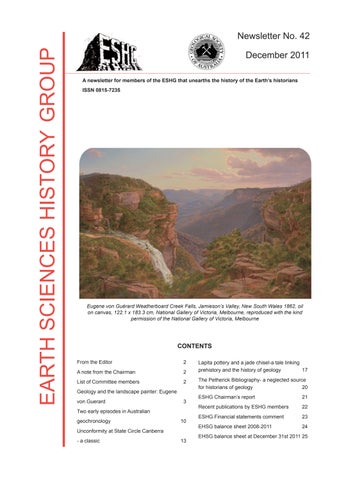
Eugene von Guérard Weatherboard Creek Falls, Jamieson’s Valley, New South Wales 1862, oil on canvas, 122.1 x 183.3 cm, National Gallery of Victoria, Melbourne, reproduced with the kind permission of the National Gallery of Victoria, Melbourne

From the Editor

Welcome to Newsletter 42, the third from your Western Australian committee.

As the new editor, firstly thank you to Jean Johnston for helping me in learning the role and secondly I wish to pay tribute to her work, culminating in Newsletter 41, which draws together contributions that tell the story of the geological mapping of Australia. It is a wonderful summary of a great scientific endeavour and will be a greatlyvalued reference in the future.

This year’s Newsletter displays diverse aspects of earth science and its historians. Ruth Pullin presents the story of Eugene von Guérard whose early training and fascination with geology together with his talent for painting subsequently produced Australian landscape paintings not only of great beauty but depicting features instantly appreciated by geologists. As the author notes-here art informs science. John Blockley tells of the contributions of some famous scientists with the earliest attempts to use isotopes to estimate the age of the earth and the age of the Precambrian Shield of Western Australia. The story of the definition and significance of the unconformity at State Circle, Canberra is outlined by Doug Finlayson. It reminds us of the importance of documenting and preserving such boundaries that are fundamental to our understanding of geological history and harks back to the work of the “Father of Geology” James Hutton. Hugh Davies and Matthew Leavesley show how geology, history, modern techniques of mineralogy and archaeology came together to enhance our understanding of the Lapita people who colonised most of the southern Pacific. A key part of this story was the re-discovery of carefully documented and curated rock samples collected in 1893. Rounding off this Newsletter, David Branagan brings to light the Petherick Bibliography, an unpublished resource, which contains a massive catalogue of rare publications and manuscripts related to Australia, New Zealand and the Pacific region. It is a valuable resource for anyone researching 19th century Pacific geology.

A note from the Chairman

I am pleased to announce that David Branagan has been chosen as the inaugural recipient of the Tom Vallance Medal. David worked closely with Tom Vallance before his untimely death so it is fitting that he has been chosen as the first recipient. The medal will be presented at the IGC/GSA/INHIGEO meeting in Brisbane in August.

On behalf of the committee I thank Jean Johnson for the excellent work she did in editing and producing Newsletters 40 and 41, setting new standards in the quality ofthe publication. Unfortunately Jean had to resign through pressure of work but her replacement has been able to maintain her standards after volunteering to be “thrown in at the deep end” without any previous publishing experience. Well done, Peter!

This last year the ESHG has seen the designing and opening of our new website (www.eshg.gsa.org.au or www. gsa.org.au/specialgroups/eshg ), the coining of theTom Vallance medal and the production of seven informationpacked E-Mail Bulletins as well as many history-based articles published by our members. Our finances are healthy at present, but expenditure currently exceeds income which is mainly derived from membership fees; other means of raising funds, such as organising conferences, have so far proved to be unsuccessful. I therefore ask all members to encourage any colleagues with an interest in the history of earth science to join our group.

Wishing you all the very best for the rest of 2012.

Chairman

Committee members

PeterDunn,Chairman,email:peter.dunn@dmp.wa.gov.au,orpetpat3@optusnet.com.au

PeterDownes,ViceChairman,email:peter.downes@museum.wa.gov.au

JohnBlockley,Secretary,email:tiger-eye@iinet.net.au

MichaelFreeman,Treasurer,email:mike.j.freeman@bigpond.com

AngelaRiganti,Committeemember;email:angela.riganti@dmp.wa.gov.au

PeterMuhling,Newslettereditor,email:peter.muhling@westnet.com.au

MailandtelephoneenquiriesshouldbedirectedtotheSecretary,JohnBlockley 76BeachStreetBictonWA6157,or(08)93171775

Geology and the landscape painter: Eugene von Guérard

Everything I saw incited me to pursue a strict truthfulness: not one line in a mountain range … could ever seem to me accidental or undeserving of precise reproduction.

Carl Gustav Carus, 18311

… unlike history painters, who at least study anatomy –most landscape painters know too little of nature. Some, indeed, seem to have no idea that a sandstone crag differs in character from one composed of porphyry, and that this in turn differs from one composed of granite …

Carl Gustav Carus, 18312

The Austrian-born artist Eugene von Guérard (18111901) was fascinated by rocks and by the geological processes that shaped and continue to shape the Earth’s surface. This in itself may not be surprising. As a landscape painter the Earth’s form – its geomorphology - was his subject. But the level of analysis, accuracy and informed understanding he brought to his subjects was singular and remarkable. His interest in geology was probably sparked when, as a young man then living in Naples, he witnessed the 1834 eruption of Vesuvius, an event he recorded in his sketchbook. Later, in the 1840s, as a student at the famous Düsseldorf Academy, he trekked through the volcanic landscape of Germany’s Eifel region filling his sketchbook with studies of rocks and crater lakes. His engagement with the geology of Australia’s south-eastern colonies began in a very direct and physical way in 1853 with a stint on the Ballarat goldfields as a miner. It continued on sketching expeditions that included multiple treks across Victoria’s volcanic Western District and expeditions into the rugged Gippsland alps, to Cape Otway and to the ancient glacial landscapes of the Kosciuszko plateau and New Zealand’s Milford Sound, to name but a few. Notes on the detailed and closely observed sketches made at these and many more locations – basalt, granite, sandstone, limestone –testify to the artist’s

1 Carl Gustav Carus Neun Briefe über Landschaftmalerei, geschrieben in den Jahren 1815-1824: zuvor ein Brief von Goethe als Einleitung, Gerhard Fleischer, Leipzig, 1831, published in English as Nine Letters on Landscape Painting, Written in the Years 1815-1824: with a letter from Goethe by Way of Introduction, trans. D. Britt, J. Paul Getty Trust, Los Angeles, 2002, p. 137.

2 op. cit., p. 138.

concern with geological accuracy.

As for so many German speakers of his generation von Guérard’s interest in the advances taking place in the natural sciences was inspired by the popular publications of the great natural scientist Alexander von Humboldt. Humboldt regarded scientific precision and an informed understanding of his subject as essential to a landscape painter, a view also argued by the scientist, art theorist and landscape painter Carl Gustav Carus in his Nine Letters on Landscape Painting. For Humboldt and Carus art was not a mere handmaiden to science; they saw art and science as equal and complementary practices, each capable of informing the other. The artist, they argued, had the capacity to communicate information about a subject with immediacy not available to the scientist. Von Guérard’s philosophy of landscape painting was forged in Europe in the context of these ideas. His experiences in Europe, where he spent the first half of his career, provided the essential framework for his response to the geology of southeastern Australia.

The way in which von Guérard’s European experiences shaped his Australian career is most compellingly illustrated in his response to the crater lakes and scoria cones of Victoria’s volcanic Western District. Portrayals of Tower Hill, Lakes Gnotuk and Bullen Merri, Mt Elephant, Mt Eccles and more filled his sketchbooks and canvases throughout the late 1850s. The account of the way von Guérard’s interest in this southern hemisphere volcanic landscape was inspired and informed by his experience of a similar landscape in the northern hemisphere – the volcanic Eifel region in Germany - has been told in detail elsewhere.3 The story began in 1831 when Johann Wilhelm Schirmer, (von Guérard’s teacher at the Düsseldorf Academy in the 1840s) and Schirmer’s colleague, Carl Friedrich Lessing, initiated sketching expeditions to study the rock formations and maar volcanoes of the region. These expeditions, made in the wake of geological research undertaken by Humboldt, Leopold von Buch and 3 See Ruth Pullin ‘The Vulkaneifel and Victoria’s Western District: Eugene von Guérard and the Geognostic Landscape’, David Marshall (ed.) Europe and Australia: Melbourne Art Journal, 11-12, 2009 (6-33), published with the support of the ESHG; Ruth Pullin, ‘Von Guérard, the Vulkaneifel and Victoria’s volcanic Western District’, The history of geology in the second half of the nineteenth century: the story in Australia and in Victoria, from Selwyn and McCoy to Gregory – 1853-1903, Earth Sciences History Group conference, 2007, (62-68); Ruth Pullin, ‘Eugene von Guérard: A Journey through Victoria’s Western Plains’, Lisa Byrne, Harriet Edquist, Laurene Vaughan (eds), Designing Place: An Archaeology of the Western District, RMIT University, Melbourne Books 2010 (114-125); Ruth Pullin, Eugene von Guérard: Nature Revealed, National Gallery of Victoria, Melbourne, 2011, pp. 21,22, and with E.B. (Bernie) Joyce, p. 145.

others, became an entrenched part of the Düsseldorf painters’ training. Von Guérard made his own twomonth expedition to the Eifel in 1843.

When he first encountered Victoria’s Western District twelve years later he was uniquely prepared to comprehend the geological significance of this landscape, a region now known as the Kanawinka Geopark. In 1859, Ferdinand von Hochstetter, the German geologist who travelled with the Austrian Novara expedition and visited Melbourne on his return journey, saw von Guérard’s drawings of Lake Corangamite, Tower Hill, Mt Noorat, Lake Keilambete, the Basin Bank lakes, Mt Gambier, Mt Napier, Mt Elephant, Mt Eccles, Mt Rouse and the Grampians. In his Notes of a Visit to Australia and a Tour of the Victorian Goldfields in 1859 he observed that von Guérard’s ‘splendid drawings’ … ‘have given me better information about them [complete tuff and eruption crater forms] than all that I could ascertain from the geologists.’4

Von Guérard’s response to the volcanic phenomena

4 Hochstetter in Thomas A. Darragh, ‘Ferdinand von Hochstetter’s Notes of a Visit to Australia and Tour of the Victorian Goldfields in 1859’, Historical Records of Australian Science, v. 13, No. 4, December, 2001, p. 411.

of the region extended beyond the subjects mentioned by Hochstetter. His drawings of the Stony Rises near Colac, for instance, capture the distinctive character of this place, the result of a lava flow from Mount Porndon dating from about 7000 B.C. (Figure 1). Eucalypts grow at various angles on the inclines and depressions of the irregular landscape embedded with rocks and boulders of various sizes. The impenetrability of this messy landscape in 1857 is evoked by the small figure heading towards the rock piles laced with roots and fallen saplings.

Von Guérard’s eye for geological detail is particularly evident in a drawing of the Lal Lal Falls (Figure 2). The wall of basalt over which the waters of the Lal Lal Creek fall, resulted from a flow of lava from nearby Mt Buninyong. The vertical hexagonal columns of the basalt, formed when cracks developed as the lava cooled, clearly fascinated the artist. He positioned himself to record the wall of columns on the left, their irregularity, breaks and horizontal clefts highlighted by the strong light and resulting dark shadows. The variations in column widths, now known to be the result of two separate lava flows, are faithfully recorded.

Through his penetrating observation of external

Figure 1 Eugene von Guérard Stony Rises near the Pirron Yallock Creek, pen, ink and wash, 33.4 x 50.24 cm, National Gallery of Victoria, Melbourne (641/5)

phenomena at the Lal Lal Falls von Guérard was able to suggest the underlying forces in operation at this site. From his drawing something of the geological history of the site can be extrapolated. In his Nine Letters on Landscape Painting Carus argued that just ‘as we gain no idea of an animal’s inherent character from a lifeless tracing of its outlines, but only through the lively apprehension of the artist’s eye, it seems that the true type and individuality of a mountain range can be conveyed only by a genuinely artistic representation.’5 For Carus the inner laws of nature could be discovered through a close analysis of its exterior form. Von Guérard’s portrayal of the Lal Lal Falls achieves just this: in his expressive drawing the uneven rise and fall of the land around the open crevasse tells of the pressures that led to the collapse of the lava tunnel, exposing the waterfall and the resistant walls of columnar basalt that frame it.

Von Guérard’s response to the geology of southeastern Australia (and New Zealand’s South Island) was not restricted to volcanic phenomena for which his experiences in the German Eifel had prepared him so well. A range of other geologies – the granite

5 Carus, op. cit. p. 138.

tors and glacial cirques of Kosciuszko, the stratified sandstone cliffs of the Blue Mountains, the sandstone and basalt layers of the exposed coastline at Cape Schanck and the eroded limestone banks of the Murray River near Moorundie - appeared in a series of lithographs produced for an album entitled Eugène von Guérard’s Australian Landscapes between 186668. He selected twenty-four subjects from his most important composition and from the ‘hundreds’ of drawings ‘suitable for publication’.6 Of the twentyfour selected, ten depicted Victorian subjects, six were New South Wales’ views and Tasmania and South Australia accounted for four images each. In their letter to potential subscribers the publishers noted that the album would be ‘especially adapted to communicate to friends & relatives in Europe a vivid idea of the natural beauties of a land, concerning which such vague and erroneous notions prevail at the other end of the world.’7

Von Guérard presented a copy of his album to the Austrian emperor Franz Josef in 1870 along with a

6 Von Guérard quoted by Hochstetter in Heger, op. cit., p.156.

7 Letter, Hamel and Ferguson to J.J. Shillinglaw, March 1866: Shillinglaw papers, Box 251, no. 3, State Library of Victoria.

Figure 2 Eugene von Guérard Lal Lal Falls near Ballarat, pen and ink, pencil, 33.5 x 50.0 cm, Dixson Galleries, State Library of New South Wales, Sydney (DG D24, f. 7)
Figure 3 Eugene von Guérard: South end Tasman’s Island, colour lithograph, 43.2 x 59.8 cm (sheet), Plate 14 from Eugène von Guérard’s Australian Landscapes, Hamel and Ferguson, Melbourne 1866-68 National Gallery of Victoria, Melbourne (134-5)
Figure 4 Eugene von Guérard : Crater of Mount Gambier, S.A., colour lithograph, 43.2 x 59.8 cm (sheet) Plate 11 from Eugène von Guérard’s Australian Landscapes, Hamel and Ferguson, Melbourne 1866-68, National Gallery of Victoria, Melbourne (134-5)
G C f G S ( ) f

copy to Ferdinand von Hochstetter, then resident in Vienna, aware that its content would be of interest to the geologist. The Emperor responded by honouring von Guérard with the award of the Order of the Cross of Franz Josef; Hochstetter for his part recognized the scientific value of von Guérard’s work in a lecture presented at Vienna’s Royal Geographical Society.

Over half of the subjects chosen depict geological phenomena. In his lecture Hochstetter noted the ‘precipitous syenitic rock massif’ on the summit of Kosciusko. He drew comparisons between the granite valleys of Launceston’s Cataract Gorge and the Black Forest or the Riesengebirges in Germany, and between the imposing basalt (dolerite) columns of Tasman’s Island and the Hebridean Island of Staffa.8

He described the ‘precipitous stone needles and stone cliffs of basalt columns on the south coast of Tasman’s Island, assaulted by a wild surf,’ as ‘exceeding the basalt galleries of the Island of Staffa … in aesthetic beauty.’ (Figure 3).

The artist’s representations of Mount Gambier in South Australia and Mount Eccles in Victoria, Hochstetter observed, ‘offer us a view of the small lake filled craters of extinct volcanoes in southern Australia.’ (Figure 4).

He noted that the views of Castle Rock, Cape Schanck and the Weatherboard Falls in the Blue Mountains in New South Wales show the ‘sheer rock formations of powerful horizontal strata of sandstone’ of the eastern part of the continent.9

Of all von Guérard’s compositions his portrayal of the Weatherboard Creek Falls (today known as the Wentworth Falls) was one of the most strikingly ‘geological’. He visited the site in December 1859 and found accommodation at the nearby Weatherboard Inn, where Charles Darwin had stayed on his 1836 visit to the area. With his unerring eye for seeing the composition in nature von Guérard identified a vantage point from which the deep winding valley was dramatically framed by Rocket Point on the left and a sequence of cliffs, including the evocatively named Inspiration Point and Sublime Point, on the right. A large pencil drawing of the view, with a meticulous rendering of the sandstone strata of Rocket Point, was made on site between 20 -22 December 1859 (Figure5).

8 See Ruth Pullin, ‘Eugene von Guérard and the History Painting of Nature’, Island 126, Spring 2011 ( 42-52)

9 Hochstetter in Heger, op. cit, p.157.

Two years later, in his Melbourne studio, the artist began work on Weatherboard Creek Falls, Jamieson’s Valley, New South Wales 1862, the largest and most ambitious canvas of his career (Cover Illustration). His precise and minutely detailed drawing was transferred onto the canvas, and enlarged by more than a factor of ten, in squared sections demarcated with a system of threads.10 The painting itself was produced over many months; it is likely that its detail was achieved with the use of a magnifier and very fine brushes. The accuracy of his view is a testament to the precision of the drawing and the power of the artist’s visual memory.

Unlike earlier artists, such as Augustus Earle, who had portrayed the already famous view of the Wentworth Falls, von Guérard focused specifically on the character of the rock at the site: the stratified sandstone of Rocket Point, its cracks and fissures, is brought into sharp focus in the strong late afternoon light. While such precision reflects the influence of Carus, Humboldt and his colleagues in Düsseldorf, it is also relevant to consider von Guérard’s interest in this subject in relation to the contemporary local debate concerning the origins of the gorges and valleys in the Blue Mountains.11

The views on this subject presented by figures such as Charles Darwin, Thomas Mitchell and W.B. Clarke predated von Guérard’s 1862 painting by twenty or thirty years. But, as R.W. Young points out in his essay on W.B. Clarke’s views on the origin of valleys, this was ‘a problem much debated until at least the 1870s.’12 Given the circles in which von Guérard moved – he was a member of the Royal Society of Victoria between 1859 (then the Philosophical Institute of Victoria) and 1867 and his friends and associates included such figures as A. W. Howitt, Georg Ulrich and Frederick McCoy - and with his own personal history of geological interests, it seems likely that von Guérard would have been aware of contemporary discussions concerning the formation of the Blue Mountains.

Darwin’s views on the formation of the valleys in the Blue Mountains, formulated on his 1836 visit and

10 Michael Varcoe-Cocks, Catalogue entry on Weatherboard Creek Falls, Jamieson’s Valley, New South Wales, in Ruth Pullin Eugene von Guérard: Nature Revealed, National Gallery of Victoria, Melbourne, 2011, p. 206.

11 Von Guérard’s resolve to paint this subject may have been, in part, a response to a view expressed by his friend the art critic James Smith regarding the challenges of the subject for the artist.

12 R.W. Young, ‘The Reverend W.B. Clarke, ‘the Father of Australian Geology’, on the origin of valleys’, in Australian Journal of Earth Sciences, 54, 2007, p. 127.

published in his Journal of the Voyage of the Beagle, followed Lyell’s theory of marine erosion ‘to great effect’.13 The idea that the action of rivers and streams alone was capable of carving out the huge valleys in the Blue Mountains seemed inconceivable to Darwin. Of the Wentworth Falls he wrote:

… one stands on the brink of a vast precipice, and below one sees a grand bay or gulf, for I know not what other name to give it, thickly covered with forest … If we imagine a winding harbor with its deep water surrounded by bold cliff-like shores, to be laid dry, and a forest to spring up on its sandy bottom, we should have the appearance and structure here exhibited.14

Twenty-three years after Darwin’s visit von Guérard took the same route as the scientist from the Weatherboard Inn to the Weatherboard Creek (Wentworth) Falls to sketch the view.

In 1839, a few years after Darwin’s visit, Sir Thomas Mitchell took the position, now the orthodox view that ‘the gorges in the Blue Mountains and nearby areas were ‘vallies of excavation’ cut by the stream(s) that flowed through them’.15 He described ‘the profound depth of the vallies adjacent to the Weatherboard Inn and Blackheath, inclosed by rocky precipices,’observing that they impart ‘a wild grandeur to the scenery, of

13 Op. cit., p. 130.

14 Darwin 1839, p. 320, cited in Young, op. cit, p. 130.

15 Young, op. cit., p. 130.

a very uncommon character’.16 Such an account may have inspired von Guérard’s interest in the view. Evidence of the artist’s knowledge of Mitchell’s works lies in the collection of engravings, and the copies he made from them, taken from Mitchell’s Three Expeditions into the Interior of Eastern Australia.17

The pioneer Australian geologist, W.B. Clarke, remained committed to Darwin’s view that that the valleys in the Blue Mountains were created as the result of marine action, though unlike Darwin he recognized the erosional topography of the Blue Mountains. Although he conceded that rivers may have played a part, for Clarke the ‘argument as to rivers eating their own passage is too unsatisfactory to require further refutation’.18 A key impediment for Clarke and others was the issue of geological time. Taking Niagara as a standard of comparison Clarke concluded that the denudation in the Blue Mountains by rivers would have had to have begun ‘when Father Time was a baby, and nature had not left school some 600,000 or 700,000 years ago!’ It was ‘just not plausible’.19 Clarke’s conclusions were published in The Sydney Morning Herald in December 1842 and January 1843.

16 Major T.L. Mitchell, Three Expeditions into the Interior of Eastern Australia, Vol. 1, T. & W. Boone, London, 1839, p. 153.

17 Eugene von Guérard Australian Reminisunzen, Mitchell Library, State Library of New South Wales, PXA 54.

18 Clarke cited in Young, op. cit., p. 131.

19 Ibid.

Figure 5 Eugene von Guérard: View above the Weatherboard Falls, Blue Mountains N.S.W. 1859, pencil, 32.5 x 66.0 cm, Dixson Galleries, State Library of New South Wales, Sydney (DG V1B/9)

The only record of von Guérard’s position on the debate is his painting of the subject, his Weatherboard Creek Falls, Jamieson’s Valley, New South Wales. Here water and weathering are the dynamic agents of the composition. The stream of white, fast flowing water from the Jamison River cascading over the rocks is the dramatic focal point of the foreground; the vaporous mists that rise from the deep in the valley allude to the continued journey of the flow of water beyond our sight; in the upper left storm clouds shot with lightning move in over the valley. On this large canvas the unfathomable depths of the valley become a metaphor for the new awareness, slowly dawning in the mid nineteenth century, of the unimaginable magnitude of geological time.

The subjects of geological significance portrayed by von Guérard during his twenty-eight years in the colonies were extensive and diverse, ranging from those located in wilderness areas that remain little affected by European settlement to those where the landscape has changed dramatically with the impost of mining, agriculture and settlement. They are invaluable records of the landscape as it was close to the beginnings of European settlement. He was alive to the geological significance of the landscapes he encountered and, as a result of his training in Europe, committed to the detailed and accurate portrayal of them. His wonder at the miracle of nature, its beauty and its diversity, did not diminish over his long career. His achievement is celebrated in this, the 200th anniversary of his birth, in the exhibition Eugene von Guérard: Nature Revealed.

Exhibition: Eugene von Guérard: Nature Revealed

National Gallery of Victoria, 16 April – 7 August 2011

Queensland Art Gallery: 17 December - 25 March 2012

National Gallery of Australia: 27 April - 15 July 2012.

Acknowledgements

I would like to thank Associate Professor E.B. (Bernie) Joyce for kindly reading this manuscript.

All works, including the front cover, reproduced with the kind permission of the National Gallery of Victoria, Melbourne and the Dixson Galleries, State Library of New South Wales, Sydney.

References

Ruth Pullin, Eugene von Guérard: Nature Revealed, National Gallery of Victoria, 2011, ISBN: 9780724103409

(With contributions by, among others, geologists E.B. (Bernie) Joyce, Bill Birch, Neville Rosengren and Ross Cayley)

Biography

Ruth Pullin is the guest curator of the exhibition: Eugene von Guérard: Nature Revealed. She wrote her PhD thesis on Eugene von Guérard (The University of Melbourne, 2007) and was awarded the 2009 C.H. Currey Fellowship at the Mitchell Library, State Library of New South Wales, to research the collection of von Guérard’s sketchbooks held by the Library.

Two Early Episodes in Australian Geochronology

The comprehensive accounts of the history of Australian geochronology that appeared in Volume 55(6/7) of the Australian Journal of Earth Sciences omitted two early episodes in this field, possibly because both, while using at least some Australian material, were carried out in overseas laboratories. These episodes are of historical and scientific interest: one produced the first age determinations in Western Australia using analyses of isotopes and specifically aimed at dating the Western Australian Precambrian Shield. This produced the first ages of Yilgarn greenstone belts and involved identities that became prominent in geoscience in later years. The other was part of a pioneering attempt to obtain an estimate of the age of the Earth.

Episode 1: Helium in Australian Beryl

In the first decade of the Twentieth Century, physicist Robert Strutt, at the Imperial College of London, was investigating the possibility of using the recently discovered fact that helium was produced by the decay of radioactive elements to obtain an estimate of the age of the Earth. At the time many scientists considered this to be no more than a few tens of millions of years based on Lord Kelvin’s calculations of the globe’s cooling rate. However, the discovery of radioactivity had thrown these sums into disarray, while also providing another method of determining the Earth’s age. In 1910 Strutt wrote: “There is a very special interest in searching among the Archaean rocks for minerals showing a high ratio of helium to radioactive matter. It is here that we might expect to find the strongest evidence that this method of enquiry can afford for the antiquity of the globe: nor is the expectation falsified by results” (Strutt, 1910).

He devised a laborious method of extracting helium from rocks and minerals and relating it to the content of uranium and thorium present in the samples. In order to safeguard against the possibility that helium could be produced by other “ionizing” phenomena, he included a range of non-radioactive minerals in his investigations. As we would now expect, he found that, in general, minerals that showed no radioactivity also contained very little helium. The one exception was beryl, most samples of which had far more of this gas than could be explained by their contents of

radionuclides (Strutt, 1908).

At the time he was unable to find any satisfactory explanation for this anomaly and went on to pursue other lines of research. But obviously the issue continued to prey on his mind, and some two decades later, he tackled the problem again when commercial uses of beryllium had brought to light many more occurrences of beryl that he was able to test. He divided the 63 samples at his disposal into four age groups, Archaean, Palaeozoic, Mesozoic and Tertiary, based on the best information available to him at the time. Three of the specimens were from Australia. The two listed in the Archaean group came from Balingup in WA and from near Olary in SA; the latter is almost certainly from the Willyama Group and therefore Mesoproterozoic. The third sample, placed in the Palaeozoic, being an emerald, probably came from Emmaville in NSW.

After exhaustive laboratory procedures he found that, on average, the helium content of the beryls increased with age, although there was wide variability within each group. In summary, his results (expressed in mm3/gm) were as follows:

Results for the Australian samples, in mm3/gm, were Balingup 9.64, Olary 9.68 and Emmaville 0.557.

Strutt concluded that “…helium has accumulated in beryl during geological time, and was not present in it initially, nor generated during the first few millennia by decay of any short-lived radioactive constituent… It is

Figure 1 Beryl crystal from Balingup, W.A. (WA Museum Specimen 679)

also known… not to be due to uranium or thorium”. He attributed the wide variability in each age group to loss of helium over time due to heating or tectonic stress. Therefore: “Unfortunately, the possibility that helium may in individual cases have been lost, prevents the relation being of much use to the geologist, for determining the age of a given sample from helium content”. By the time that Robert Strutt reached these conclusions, he had succeeded to his family’s peerage, so the results were published under his more familiar name of Lord Rayleigh (Rayleigh, 1933).

his focus from radiogenic helium to lead, became a pioneer of the lead-isotope dating techniques that finally established the current estimate of the age of the Earth (Lewis, 2000

Rayleigh, the 4th Baron of that name, was the son of the 3rd Lord Rayleigh who in 1904, along with William Ramsay, was awarded the Nobel Prize in physics for the discovery of argon. Apart from his later experiments with helium in beryl, Robert Strutt had largely abandoned his work on geochronology by about 1910 to follow up his father’s work on light scattering (now known as Rayleigh scattering). He also went on to produce active (i.e. monatomic) nitrogen and prove the existence of ozone in the atmosphere. However, his work on geochronology, although unsuccessful in itself, was by no means wasted, as it inspired one of his Imperial College students by the name of Arthur Holmes to take up the challenge. Holmes, by shifting

The anomalous occurrence of helium in beryl, and its variation over time, still seems to be somewhat of a mystery. One possible explanation that Rayleigh had considered earlier (Strutt, 1908) was that the helium resulted from the decay of some short-lived radioactive element such as radium. However, in 1933, he explicitly rejected this in light of the evidence that the gas accumulated continuously over time, though he could not suggest a mechanism for this. Given the propensity of beryl to incorporate a wide spectrum of trace elements, and our rejection of the uniformitarian view of geology that underpinned Rayleigh’s conclusions, perhaps the earlier suggestion could be re-investigated.

Episode 2: Lead Isotope Ratios in Western Australian Galena

While in England on sabbatical leave in 1952, Professor Rex Prider of the Geology Department of the University of Western Australia, asked the then Chief Geologist of the British Geological Survey’s Atomic Energy Division, Dr C F Davidson, about the possibility of having some isotope determinations done on lead from Western Australian radioactive minerals. This enquiry was passed by Davidson to a Professor of Physics at the University of Toronto, who agreed to undertake some analyses on any samples submitted.

At that time, the Toronto Physics Department was using lead isotopes to determine ages within the Canadian Shield and had found that this large tract of Precambrian rocks was capable of being broken up into different provinces separated by faults. In a letter to Prider dated September 1953, the Canadian professor surmised that a similar situation could apply to the Western Australian Shield, and in particular, wondered if the gneisses along the State’s south coast could be a younger province. As he had already obtained dates on galena from the greenstone belts using material provided by Western Mining Corporation geologist, Don Campbell, he asked specifically for samples from areas near the coast. Prider obliged by sending two galena samples from Northampton, one from the Mundijong lead mine south of Perth, and another from the Narlarla deposit in the Devonian limestones of the Kimberley region. A sample of allanite from the Musgrave Ranges provided by Dr Allan Wilson at UWA was also submitted.

Results of lead isotope determinations on the samples

Figure 2 Robert Strutt (Lord Rayleigh). (Photo courtesy Royal Society London - © Godfrey Argent Studio)

were presented by Prider at the Pan Indian Ocean Science Congress held in Perth in 1954 (Prider, 1954) as follows1:

Pb Isotope SampleAge (Ma)

Phoenix gold mine, Norseman

Copperhead gold mine, Bullfinch

Lake View & Star gold mine, Kalgoorlie

2250 ± 120

2300 ± 120

2340 ±130

Mundijong lead mine850 ± 300

Northampton area (unspecified)

Northampton area, Surprise mine

500

500

These were the first ages calculated for Western Australian material using isotope determinations, the few previous dates having been based on chemical analyses of minerals containing lead, uranium and thorium. They were also the first indication that the greenstone belts within the State’s Precambrian shields

1 Prider did not publish the lead isotope ratios although these appeared later in a book by Russell & Farquhar (1960). The Narlarla lead proved to be anomalous and was not reported by Prider. The allanite sample, also not reported, could not be determined because of lack of information on its thorium content.

were more than 2000 Ma old, previous estimates based on radioactive minerals from Wodgina in the Pilbara being around 1260 Ma. (e.g. Holmes, 1927). More recent determinations on galena from gold deposits in the Yilgarn Craton typically give ages of around 2600 to 2700 Ma (e.g., Browning et al., 1987), the differences reflecting the use of different models for the lead isotope growth curve and more refined techniques.

The isotope ratios published by Russell & Farquhar (1960) show that the Northampton results fall well above the lead isotope growth curve. Nevertheless, the age given by Prider is in the same order as a Rb–Sr date of about 430 Ma obtained on hydrothermal alteration associated with a lead lode (Richards et al., 1985).

Some ten years after Prider’s paper appeared, the Toronto University physicist who had requested the samples published papers on the origin of the Hawaiian Islands and the existence of transform faults— papers that led to general acceptance of the theory of plate tectonics. His name was J. Tuzo Wilson

Acknowledgements

I am indebted to Dr Ian Fletcher at Curtin University for checking the scientific aspects of the paper and suggesting a number of improvements to the text.

I also thank Maria Carvalho and Tanya Vanderzwan of the University of WA Archives and Records Management Services for locating the correspondence between Professors Rex Prider and Tuzo Wilson2 that took place in the early 1950s.

References

Browning, P., Groves, D.I., Blockley, J.G. & Rosman, K.J. 1987. Lead isotopic constraints on the age and source of gold mineralization in the Archaean Yilgarn Block, Western Australia. Economic Geology 82, 971-986.

Lewis, C. 2000. The dating game: One man’s search for the age of the Earth. Cambridge University Press.

Prider, R.T. 1954. The Pre-Cambrian succession in Western Australia. Proceedings Pan Indian Ocean Science Congress Section C, 69-78.

Raleigh, Lord. 1933. Beryllium and helium. I. The helium contained in beryls of varied geological ages. Proceedings Royal Society London A 142, 370-381

Richards, J. R., Blockley, J. G., & de Laeter, J. R. 1985. Rb - Sr and Pb isotope data from the Northampton Block, Western Australia. Australasian Institute of Mining and Metallurgy, Proceedings 290, 43-55.

Russell, R.D. & Farquhar, R.M. 1960. Lead isotopes in geology. Interscience Publishers, New York

Strutt, R.J. 1908. Helium & radioactivity in rare and common minerals. Proceedings Royal Society London 80, 572-594.

Strutt, R.J. 1910. The accumulation of helium in geological time. IV. Proceedings Royal Society London 84, 194-196.

2 The correspondence between Professors R T Prider and J T Wilson is held on UWA Archives Series 39, Consignment 76, Item 22.

Figure 3 Professor J Tuzo Wilson (Photo courtesy Geological Survey of Canada - No. 203499)

Unconformity at State Circle, Canberra, – a classic

Background

Many of the tectonic processes that occurred during the Paleozoic era along the southeastern margin of continental Australia are analogous to those now prevailing in the Western Pacific region (Figure 1). These tectonic processes are identified by many authors in their descriptions of the evolution of the Lachlan Orogen, e.g. Glen (2005).

evolution of the region of the eastern Lachlan Orogen around Canberra can be depicted as shown in the Figure 2.

The early evolution of the orogen has been described by Glen (2005) in terms of three tectonic cycles: the Benambran tectonic cycle (490-428 Ma.), the Tabberabberan tectonic cycle (428 to 385 Ma.), and the Kanimblan tectonic cycle (385 to 318 Ma.). This

Towards the end of each cycle there was a major orogenic event (sometimes more than one) that included uplift and crustal shortening affecting the whole region. Many of these “events” lasted several millions of years. Between episodes of crustal shortening there were lengthy periods of crustal quiescence or extension with magmatic activity and the emplacement of granite plutons. Large and small basins formed and were filled by thick sequences of volcanic sediments partly or wholly in a marine environment. Coral reefs and limestone formed in warm shallow seas at tropical latitudes. During all these early Paleozoic tectonic cycles Australia was part of the Gondwana supercontinent and eastern Australia was associated with a convergent lithospheric plate margin (Figure 1).

The vast majority of the rocks now cropping out across the Canberra Region and Namadgi National Park were formed and emplaced during the tectonic episodes of the middle and late Paleozoic era as a small part of the evolving Lachlan Orogen. A recent publication by the ACT Division of the Geological Society provides a layperson’s guide to local geology (Finlayson et al 2008).

Identifying features such as breaks in deposition at tectonic cycle boundaries is important for constructing tectonic models of the principal early Paleozoic geological events. The unconformity seen in the road cutting that forms State Circle around Parliament House, Canberra, is one such feature, a classic of its type.

Figure 1 Prevailing Siluro-Devonian tectonic environment along the eastern margins of southeastern Australia
Figure 2 Timeline for southeast Australian crustal evolution within the Lachlan Orogen.

Significance of the State Circle and Parliament House unconformities

The importance of the unconformity seen in the road cutting on State Circle near Parliament House and in the rock outcrop preserved in the basement under the

The story goes that the unconformity at State Circle was identified by Keith Carter and others from the Bureau of Mineral Resources, Geology and Geophysics (BMR). It is described in Öpik’s 1958 BMR Bulletin 32 – The Geology of the Canberra City District. This Bulletin was a recompilation of older accidentally destroyed records and reported by Öpik (1954) for the ANZAAS Handbook of that year. In Bulletin 32 Öpik (1958) describes the structures on the Capital Hill – Camp Hill area as follows:

Parliament House building is that it demonstrates clearly the hiatus between the end of the Benambran Tectonic Cycle and the beginning of the Tabberabberan Tectonic Cycle about 428 Ma.

The underlying rocks are those formed during the Benambran Tectonic Cycle – State Circle Shale (deposited about 435 Ma) on State Circle and Black Mountain Sandstone (deposited about 435-430 Ma) under Parliament House. These sequences were deposited between the 1st Phase (about 444-440 Ma) and the 2nd Phase (about 431-428 Ma) of the Benambran Orogeny at the end of the Benambran Tectonic Cycle.

The overlying rocks are those of the Camp Hill Sandstone (deposited 428-425 Ma)-a thinly bedded unit within the Canberra Formation laid down during the early Tabberabberan Tectonic Cycle.

This heritage-listed site is used extensively for educational purposes. Under the Parliament House building there is another excellent exposure of the unconformity, not normally open to the public. There is a depositional hiatus of about 9 m.y. across the unconformity.

“….an upper contact (of the Black Mountain Sandstone) is seen in the unconformity on Capital Hill, and therefore the Sandstone is older than the basal Silurian Camp Hill Sandstone. Moreover, the Camp Hill Sandstone unconformably overlies the Upper Ordovician Acton Shale in Acton, and the next higher Silurian unit (the State Circle Shale) lies unconformably on the Middle Ordovician Pittman Formation in the Pittman Valley. These Silurian and Ordovician units are shown in

Figure 3 Unconformity seen in the road cutting that forms State Circle near Parliament House, Canberra photographed in 2008.
Figure 4 Unconformity seen in the rock preserved in the basement under the Parliament House building during 2010.

Figure 5.

By 1962-63 Prof David Brown (Australian National University) was taking student excursions to the State Circle road cutting. On behalf of the Geological Society he negotiated with Parliament House Construction Authority to preserve the unconformity outcrop in the basement of the new building. When the State Circle road cutting was exposed, Prof Brown reluctantly agreed to let the basement outcrop go in return for the road cutting being preserved. After much argument about the extra cost of extending the foundation

structures for the proposed bridges across State Circle and thus maintaining the road cut exposure, they agreed. However, either by accident or design, the Authority eventually preserved both sites.

The unconformity is an outstanding textbook example of an unconformity and, as such, is of world-wide significance. It’s value lies in not only in the quality of the outcrop but also that it is so easily accessible and according to some opinions ranks with the original outcrop of an unconformity at Siccar Point on the southeast coast in Scotland discovered by James Hutton(the “father” of modern geology) in the late 1700’s.

Siccar Point, southeast Scotland

James Hutton (1726-1797), the “father” of modern geology, was a Scottish farmer who was profoundly interested in the processes affecting his lands including erosion and sedimentation, and the time scales on which these processes took place.

He subsequently became interested in geological processes generally and in 1788 he identified the Siccar Point unconformity, showing a significant break in sedimentary episodes (Figure 6). Later modern analysis indicates that gently dipping 345 Ma Devonian Old Red Sandstone overly steeply dipping 425 Ma Silurian greywacke.(Figure 6). Ever since 1788 the Siccar Point unconformity has been identified as one of the most important sites in the history of geological science. In Australia the State Circle unconformity is identified as a

Figure 5 General Early Silurian sequence description for the Canberra region (Abell, 2007)
Figure 6 Descriptive signage at Siccar Point, Scotland, describing the events leading to the identification of the unconformity seen in the cliff outcrop James Hutton the “father of modern geology”.

heritage listed site that illustrates a similar structure for geology students and the public.

State Circle – Site description

The following description is taken from Owen and others (1988):

“This magnificent exposure clearly shows the unconformable contact between the older State Circle Shale and the Camp Hill Sandstone, the basal member of the Canberra Formation. A number of faults are present in the cutting, and some minor folds can also be seen.

The State Circle Shale is formed at this locality mainly by buff coloured siltstone and very fine sandstone which has been strongly contorted by slumping, with excellent examples of slump rolls in sandstone developed. The graptolite Monograptus exiguus,

indicative of late Llandovery age, was found during excavation of the cutting (Henderson, 1973).

The Camp Hill Sandstone is comprised of fine to coarse quartz sandstone, interbedded with siltstone and silty mudstone, and has weathered to a distinctive red, yellow brown and white colour, following bedding. The unit is fossiliferous, with poorly preserved brachiopods (including the genus Rhipidium), corals and trilobites found during the excavation work.”

The appearance of the cutting has changed markedly since its excavation in the early 1970’s. In its original form there were two vertical faces, of roughly equal height, separated by a bench a few metres wide.

As a result of the building of the New Parliament House on Capital Hill, , two road bridges were built crossing State Circle which led to the destruction of the Capital Hill Unconformity, one of the earliest sites in the A.C.T. to be nominated as a geological monument.. In addition, as part of the landscaping of the area between the New and Old Parliament Houses the hill (Camp Hill) behind the cutting was removed, as was the upper vertical face. One of the bridges directly crosses over the most valuable part of the cutting and initial planning of the bridge design would have led to the destruction of this part of the cutting by the supporting pier of the bridge. Submissions by the Geological Society and the Heritage Commission led to a modification of the design so that the bridge supports were placed behind the face of the cutting, thus saving the exposure from destruction, at an additional cost of over $500,000.

The locality is easily examined from State Circle, and a footpath is present between the road and the face of the cutting.

(Author’s note - In 2008-09 the National Capital Authority reviewed heritage sites within the Parliamentary Triangle and the long-term preservation of the unconformity exposure has been assured.)

The State Circle road cut is probably the most significant geological monument in the A.C.T. The relationships revealed by its excavation in the early 1970’s led to a major reassessment of Ordovician and Silurian geology of the Canberra region (Crook et al. 1973), and led to

Figure 6 The Siccar Point, Scotland-unconformity, photographed in 2010
Figure 7 Unconformity seen in the road cutting that forms State Circle near Parliament House, Canberra, from Owen et al 1988, showing the whole road in 1980 before it was excavated to construct overpass bridges.

the recognition of the Quidongan Movement as a significant tectonic event in southeast New South Wales which resulted in a major mid-Silurian unconformity.

Bibliography

Abell, R., 2007. Geology of the Australian Capital Territory: mapped at 1:100,000 scale. Geological Society of Australia (ACT Division).

Glen, R. A., 2005. The Tasmanides of eastern Australia. In: Terrane Processes of the Margins of Gondwana (Editors – A. P. M. Vaughn, P. T. Leat and R. J. Parkhurst), Geological Society of London special Publication 246, 23-96.

Henderson, G. A. M., 1982. Geological Notes on the excavations for the new Parliament House, Capital Hill, Canberra, ACT. Bureau of Mineral Resources, Geology and Geophysics, Record 1982/13.

Henderson, G. A. M., 1986. Commentary on the Central Canberra 1:10,000 engineering geology sheet, Australian Capital Territory. Bureau of Mineral Resources, Geology and Geophysics, Report 267.

Finlayson, D. M. (author and editor), R. S. Abell, D. L. Strusz, P. Wellman, M. J. Rickard, D. Clark, K. McCue, K. S. W. Campbell, K. G. McQueen and B. Pillans, 2008. A Geological Guide to Canberra Region and Namadgi National Park. Geological Society of Australia (Australian Capital Territory Division), Canberra, 140 pages.

Mayer, W., 2009. Images in Stone – A guide to the building stones of Parliament House. Geological Society of Australia (ACT Division), 2nd edition, 40 pages.

Öpik, A. A., 1954. Geology of the Canberra City District. In: Canberra, a Nation’s Capital (Editor H. L. White) Australia and New Zealand Association for the Advancement of Science, Handbook for Canberra, 131-148.

Öpik, A. A., 1958. The Geology of the Canberra City District. Bureau of Mineral Resources, Geology and Geophysics, Bulletin No. 32.

Owen, M., Senior, D., Owen, J., and Hodgson J., 1988. Geological Monuments in the Australian Capital Territory. Geological Society of Australia (ACT Division), 90 pages.

Lapita pottery and a jade chisel – a tale linking prehistory and the history of geology

and Matthew Leavesley

University of Papua New Guinea

In 2007-08 a team led by Professor Glenn Summerhayes of the University of Otago excavated a newly discovered Lapita pottery site on Emirau Island, a coral islet northwest of Kavieng, New Ireland, in Papua New Guinea (PNG) (Summerhayes et al. 2010). The pottery had been first reported in 2006 by the teacher on the island. At the base of one of the pits they found a jade chisel.

The discovery of the jade chisel triggered a geological investigation that draws together Pacific prehistory with the colonial history of New Guinea and illustrates a fruitful linkage between archaeology and geology. The investigation relied upon the care and thoroughness of early and present-day Dutch geologists and the expertise of American jade expert George Harlow. We hope you will read on.

About Jade

Jade is a hard compact green gemstone and comes in two varieties. The more common jade is a near monomineralic rock composed of nephrite or felted

Figure 1 Emirau jade chisel , showing the front and the back view.

fibrous amphibole; this is known from the literature and has been found in the artefact collection and in the field in PNG. The less common jade is a near-monomineralic rock composed of jadeite, a Na-Al pyroxene.

The Emirau chisel (Figure 1) is of the jadeite or Na-Al pyroxene type. This is not known in the literature or in artefact collections from PNG or Indonesian Papua and so was an exciting discovery because it suggested an external source, perhaps a source in SE Asia. If the source could be identified it would throw light on the origins of the Lapita people.

The Lapita Story

People speaking Austronesian languages are thought to have left the region of Taiwan sometime in the order of 9000 years ago. They travelled probably by sea-craft down through SE Asia before arriving in the Bismarck Archipelago 3200 years ago where we see the first Lapita designs on pottery. In addition to pottery these people brought pigs, dogs, chickens and agricultural technology that allowed them to settle in villages on previously uninhabited small islands. Upon arrival they soon integrated into the pre-existing huntergatherer populations and in the process introduced their agricultural way of life into the region.

The archaeological signature of the Austronesian expansion into the Pacific is Lapita pottery. This is characterized by highly complex designs on the external

surfaces (Figure.2 ).

Within just a few hundred years the Lapita people began to move into the previously unoccupied islands beyond the Solomon Islands and into the Pacific, taking with them their trademark pottery and agricultural lifestyle. During the process of Pacific expansion they maintained a high degree of interaction with the Bismarck Archipelago as is evidenced by the continued movement of obsidian artefacts as far as New Caledonia and Fiji. Some time between 2700 and 200 years ago they stopped producing the iconic Lapita pots and this is seen as the sign of the breakdown of this vast interactive network and the birth of regionalism. By 900 years ago the descendants of the original Lapita migrants had visited or occupied the entire Pacific region as far as Easter Island, Hawaii and New Zealand.

Although jade is synonymous with some Pacific peoples the Emirau jade is the first to have been found in association with the Lapita cultural complex.

The Jade Chisel

The chisel was analysed at Academia Sinica in Taiwan and then by George Harlow at the American Museum of Natural History in New York. The predominant mineral is a jadeite but it has a composition that is unlike any of the known sources of jade gemstone. This jadeite pyroxene is a mixture of four parts of the Na-Al jadeite molecule with one part of the Na-Fe (aegirine or acmite) molecule. Unlike most other jadeites it contains very little or no CaMg (diopside) molecule.

We searched the literature for reports of artefacts or rocks of this composition in the New Guinea region but found none. At this stage our enquiry into the source of the jade seemed to have come to a dead end. However, by good fortune, serendipitous circumstance, and with prompting from Professor Summerhayes, we became aware of an occurrence of jadeite jade in Indonesian Papua in the Cyclops Mountains NW of Jayapura.

It seems that in 1893 a missionary, G. L. Binck, had sent rocks collected from near Jayapura to Carl E. A. Wichmann, Professor of Mineralogy and Petrology at the University of Utrecht. Wichmann described the rocks in a paper published in 1901, but with the exception of one piece, a dark green rock with iron oxide coloured coating that he referred to as

Figure 2 Lapita pottery shards. (Photo courtesy of Glen Summerhayes, Professor of Archaeology, Otago University)

chloromelanite. He studied this rock and prepared a draft paper but did not publish.

In 2000 Diederik Visser discovered the unpublished manuscript in a box that had been in storage in the University since the 1920s. He set about publishing it (in the original German), along with his own research into Wichmann, in a volume that honoured early Dutch geologists (Visser, 2004).

The Wichmann paper includes a petrographic description and two wet chemical analyses of the chloromelanite rock fragment. Analysis (I) by ‘Dr Krug of Berlin’ confirms that the rock is predominantly an iron-rich jadeite or chloromelanite with very low CaO and MgO. As such it has a composition similar to that of the Emirau jade artefact. This was our ‘Ah-hah’ moment.

We determined to trace and if possible recover a piece of this rock for analysis by modern methods. In response to our enquiries, a contact in Utrecht directed us to Professor Reinoud Vissers. It seemed that a part of the original chloromelanite sample was still with Prof Vissers and, yes, he would be pleased to send a

Figure 4 Plot of pyroxene compositions: the apex is aegirine (Na-Fe); Di-Hd is diopside-hedenbergite (Ca-(Fe, Mg); Jd is jadeite (Na-Al). The green circles are of Emirau jade and the green squares are of the “chloromelanite “ of Binck and Wichmann from the Torare River, northwest of Jayapura. This figure is from Harlow and others (2011). (Reproduced with permission from European Journal of Mineralogy.)

Lapita culture was a significant find in itself. The discovery of a possible or likely source for the jadeite rock on the mainland of New Guinea adds a new site to the list of known stone implement quarries in New Guinea, and a new rock type. The discovery also implies, for the first time, that there was a trading link between the people of mainland New Guinea and the Lapita people in the Bismarck Archipelago.

Acknowledgements

The likely solving of the riddle of the source of the jade chisel was possible only because of the careful work of Wichmann in the first instance in describing the chloromelanite rock, then of Diederik Visser who brought Wichmann’s draft manuscript to light, and the careful curating of old rock specimens by the University of Utrecht and, in our case, the care and cooperation of Professor Reinoud Vissers. The encyclopaedic knowledge of world jade occurrences and expert analysis and description of the chisel and the rock fragment by George Harlow were a key to the successful outcome of the investigation.

piece to us for analysis.

Analysis of the Wichmann sample shows it to have the same unusual acmitic jade composition and the unusual niobian titanite (niobian sphene) that was found in the Emirau Island chisel (Harlow et al., 2012). The pyroxene triangular diagram (Figure 4) illustrates the similarity. Although it is not conclusive proof it is likely that the Emirau chisel was fashioned from rocks from this source.

Conclusions

The discovery of a jadeite chisel in association with

References

Harlow, G.E., Summerhayes, G.R., Davies , H.L., and Matisoo-Smith, L., 2012, A jade gouge from Emirau Island, Papua New Guinea (Early Lapita contact, 3300 BP); a unique jadeitite. European Journal of Mineralogy DOI: 10.1127/0935-1221/2012/0024-2175

Summerhayes, G.R., Matisoo-Smith, E., Mandui, H., Allen, J., Specht, J., and McPherson, S., 2010, An Early Lapita Site on Emirau, New Ireland, PNG. Journal of Pacific Archaeology 1, 62-75.

Visser, D., 2004, An unpublished manuscript by C.E.A. Wichmann, in: Dutch Pioneers of the Earth Sciences; Visser, R.P.W., Touret, J.L.R. (eds). Chapter XI, 177-195.

Figure 3 The original chloromelanite rock sample collected by G. L. Bink near Jayapura and described by Professor Carl Wichmann. Scale is in centimetres.

The Petherick Bibliography – A neglected source for historians of geology

The National Library, Canberra, has recently celebrated its centenary. It was established on 17 October, 1911, by the Parliament passing of an Act Relating to the Petherick Collection. This collection had been acquired by the Commonwealth Parliamentary Library several years earlier. The collection had been made by Edward Augustus Petherick (1847 - 1917), and he gave it to the Commonwealth on the condition that he came with it as a package, appointed the first Commonwealth Archivist.

Sadly Petherick did not get on with the first

Commonwealth Chief Librarian, Arthur Wadsworth (Sergeant, 2011).

Perhaps not surprisingly, the bibliography remains unpublished, and is not, to my knowledge, on line. The bibliography is divided into a number of volumes.

For geologists, volume 29 of this catalogue is a now a 100-page list of papers from the late 1700s to the early 1900s. While some of the references might be familiar to researchers through the Catalogue by Etheridge and Jack (1881) and the more recent paper by Vallance (Presidential Address, Proceedings of the Linnean Society of NSW, 1975), there are useful but forgotten German and French references, and it is interesting to see the numerous reprinting of some papers in various overseas journals, an indication of an international ‘network’ reading Australian research.

Possibly some of the most useful aspects are references to items in various journals and newspapers etc., such as the Sydney Monitor, Simmond’s Colonial Magazine and the Calcutta Journal of Natural History.

Figure 1 Edward Augustus Petherick (1814-1917), by unknown photographer, 1890s. (Reproduced with permission of the National Library of Australia).

Petherick is now remembered in the Library by the Petherick Room, reserved for readers of specialised material. But more useful for the researcher is the massive catalogue of rare publications or manuscripts related to Australia, and to a lesser extent New Zealand and the Pacific, the Petherick Bibliography, containing about 100 000 entries. It was originally, I think, a card index.

All in all it is a detailed read, but sure to be useful to anyone researching nineteenth-century Pacific geology. As far as I know you probably have to visit the Library to see the volume 29 entries. However I do have copy, and it might be possible to make an arrangement with the Library to scan this copy and put it on line (or the Library itself might be prepared to do it, but I haven’t asked). However, it needs someone with more energy, time and expertise than I have to get it done.

Reference

Sergeant, Andrew, 2011, The Centenary of the Petherick Collection. The National Library Magazine, 3 (3), September 2011, 25 – 27. [Incidentally this issue of the Magazine contains an interesting article by Terry Birtles on J.B. Jukes’s visit to the Great Barrier Reef.]

Earth Sciences History Specialist Group

Chairman’s Report

Administration

The committee for the Earth Sciences History Group (ESHG) has been based in Western Australia since the Australian Earth Sciences Convention of 2008 and currently comprises Peter Dunn (chairman), Peter Downes (vice chairman), John Blockley (secretary), Mike Freeman (treasurer), Peter Muhling (editor) and members Angela Riganti, David Branagan (NSW) and Bernie Joyce (Victoria). The previous editor, Jean Johnston, had to step down because of pressure of work, and was replaced by Peter Muhling. The Group currently has 99 financial members.

Newsletters

ESHG Newsletter 41 was distributed in February 2011. It was devoted mainly to the papers presented at AESC2010 on the Australia-wide 1:250 000 geological mapping program carried out by the Commonwealth and State geological surveys from the mid-1950s into the 1980s. We are pleased to have been able to put this splendid achievement on the record.

Bulletins

Email Bulletins are sent to members to keep them aware of current activities and notify them of interesting publications and upcoming events. Seven bulletins were distributed during the year with some of the more important issues also being posted to members without an email address.

New ESHG Website

The new ESHG website was placed on-line in November (http://eshg.gsa.org.au). The site has six pages titled:

About Us - a general introduction to the Group with details of contacts;

News - with links to copies of recent Email Bulletins and other announcements;

Publications – giving access to copies of past Newsletters;

Biographies – containing images and information about prominent geoscientists of the past;

Recognition - with information about the Tom Vallance Medal; and finally

Links – guiding Members to other sites of interest.

New material is being added to these pages as it becomes available.

Tom Vallance Medal

At the Business Meeting in 2010, it was agreed that the ESHG should make a biennial award, to be named the Tom Vallance Medal, to a person who had made a significant contribution to the history of the earth sciences in Australia. An appropriate design for the medal, featuring a profile of the late Tom Vallance, was approved in May and 10 copies ordered. It is intended that Tom’s widow will make the inaugural presentation of the medal at the International Geological Convention in Brisbane during August, 2012.

Publications and Activities by ESHG Members

During the period under review, ESHG members have contributed many articles to TAG (The Australian Geologist) and a variety of other journals. A selection of these, together with some earlier items that have been brought to our attention, is listed below. Also, Cathy Brown, Susan White and Doug Finlayson have contributed regular columns to TAG on stratigraphic nomenclature, geoheritage matters, and the proposed Canberra “Rock Garden” respectively. On the wider scene, Barry Cooper and David Oldroyd continued their respective roles as Secretary-General and VicePresident (Australasia/Oceania) of the International Commission on the History of thc Geological Sciences (INHIGEO) while Angus Robinson was appointed as Chair of the GSA’s newly formed Subcommittee on Geotourism.

Acknowledgement

The Committee thanks Sue Fletcher and Sinead Moran at head office for their considerable patience and assistance in setting up the new website, and the GSA’s IT consultants who designed the visually striking page banners using our collection of photographs superimposed on an old map. We are also indebted to the Executive Director of the Geological Survey of Western Australia for making its facilities available for our meetings and for technical assistance in producing Newsletter 41.

Recent Publications by ESHG members

Blockley, John, 2010 Review of “The forgotten explorers: pioneer geologists of Western Australia, 1826-1926” by John Glover and Jenny Bevan. TAG No. 157, p. 41-42

Blockley, John, 2011, First report of Western Australian iron ore? West Australian Geologist No. 490, p. 13-14.

Branagan, David, 2011, Review of “Guide to New South Wales karst and caves” by Department of Environment, Climate Change and Water NSW, Sydney, 2010. TAG No. 161, p. 41-42.

Cooper, Barry, 2010, Review of “A Mirage in the Desert? The discovery, evaluation and development of the Olympic Dam ore body at Roxby Downs, South Australia” by Keith Johns. Journal of Australasian Mining History, v. 8, p. 190-193.

Cooper, Barry, 2011, Review of “Natural stone resources for historical monuments” by R Prikryl and A Torok. TAG No. 161, p. 42.

Downes, Peter; Bevan, Alex and Deacon, Geoff, 2010, The Fletcher collection of minerals at the Western Australian Museum: a late 19th century gem. Australian Journal of Mineralogy, v. 16, p. 3-14

Jago, Jim and Cooper, Barry, 2011, The Emu Bay Shale Lagerstatte: a history of investigations. Australian Journal Earth Sciences v. 58, p. 235-241.

Johns, Keith, 2010, A Mirage in the Desert? The discovery, evaluation and development of the Olympic Dam ore body at Roxby Downs, South Australia. O’Neil Historical and Editorial Services, South Australia.

Joyce, Bernie, 2010, Australia’s Geoheritage: History of Study, A New Inventory of Geosites and Applications to Geotourism and Geoparks. In Geoheritage (2010) Vol 2, p.39–56.

Joyce, Bernie, 2010, Review of “History of Geoconservation” by CV Burek and CD Prosser (eds). Geological Society of London Special Publication No. 300, 2008.

Joyce, Bernie, 2010, Review of “History of Geomorphology and Quaternary Geology” by RH Grapes, DH Oldroyd (eds). Geological Society of London Special Publication No. 301, 2008.

Joyce, Bernie, 2010, Review of “The history and study of landforms of the development of geomorphology, volume 4: Quaternary and Recent processes and forms (1890-1965) and the mid-century revolutions” by TP Burt, RJ Chorley, D Brunsden, NJ Cox and AS Goudie (eds). TAG 157, p.

39-40.

Joyce, Bernie, 2010, Review of “Whatever is under the Earth; Geological Society of London 1807-2007” by GL Herries Davies. TAG No. 157, p. 40.

Joyce, Bernie, 2011, The Risk of Volcanic Eruptions in Mainland Australia. http://web.earthsci.unimelb.edu. au/Joyce/AESC2006volcanicriskpaper.doc

Joyce, Bernie and McCann, Doug, 2010. Scientific Legacy of the Burke and Wills Expedition. TAG No. 156, p.25-27.

Joyce, Bernie and McCann, Doug, 2011, The scientific legacy of the Burke and Wills exploring expedition. CSIRO Publishing, 368 pp.

Joyce, Bernie and McCann, Doug. 2011, The scientific legacy of Burke and Wills. Australasian Science, June 2011 , pp. 29-31.

McNamara, Greg, 2012, Review of “A field guide to Perth and surrounds” by John A Bunting. TAG No. 162, p.48.

McQueen, Ken, 2011, Mercury mining: a quick history of quicksilver in Australia. Journal of Australasian Mining History, v. 9, p. 74-93.

McQueen, Ken and Barnes, Robert, 2010. The Maitland Bar Nugget: A Key Link to the Gold Rush Heritage of New South Wales. Journal of Australasian Mining History, v. 8, p. 88-105.

Pullin, Ruth, 2011, Eugene von Guérard: Nature Revealed. National Gallery of Victoria, Melbourne.

Rickard. Mike, 2011, Review of “Continental tectonics and mountain building: the legacy of Peach and Horne” by RD Law, RWH Butler, RE Holsworth, M Krabbendam and RA Strachan. TAG No. 159, p. 38.

Turner, Susan, 2010, Review of “The Making of the Geological Society of London”, by Cherrie LE Lewis and Simon J Knell (eds). TAG No. 156, p. 40.

Turner, Susan, 2011, Australia’s first fossil fish is still missing! The Geological Curator, 9(5), 285-290.

Turner, Susan, 2011, Beautiful One day; Perfect the Next! 19th–early 20th century geological collectors and collecting in the Great State of Queensland. HOGG Geological Collectors and Collecting, Poster Abstracts, April 4-5, Natural History Museum, London, p. 17.

Turner, Susan, 2011, Dinosaurs and Lost Dreams: the von Huene–Longman story. In: HOGG Dinosaurs, their Kith and Kin: a historical perspective. May 3-6, 2011, SGF and

MNHN, Paris, Abstracts, p. 32.

Turner, Susan, 2011, Jurassic marine and non-marine correlation (2005-2009). – Final report of the Australian working group IGCP 506, TAG No. 158, p. 23

Turner, Susan, 2011, Review of “The Triassic time-scale” by SG Lucas (ed). TAG No. 161, p. 39-40.

Turner, Susan, 2011, Tracking Trackmakers: A Brief History of Dinosaur Ichnology in Australia. In: HOGG, Dinosaurs, Their Kith And Kin: a historical perspective. May 3-6, 2011, SGF and MNHN, Paris, Poster Abstracts, p. 30.

Turner, Susan, Burek, C. and Moody, R.T. 2010, Forgotten women in an extinct Saurian ‘mans’ World. In: Moody, R.T., Buffetaut, E., Martill, D. and Naish, D. Eds. Dinosaurs and Other Extinct Saurians: A Historical Perspective. The Geological Society, London, Special Publication, 343, 111-153.

Financial Statements

2011 and 2008-2011

Dear colleagues.

Since taking up the role of your treasurer, I do not think I have made a report to you of our finances of the period from 2008 to now. I now present summary figures for your reference and information. The first table table shows the finance for the period 2008-2011 and the second table covers the 2011 financial year. We have two accounts, a cheque account and an investment account. The difference in interest earned easily shows why we have the two.

The period commenced with a balance of nearly $12k, which was reduced early on with support of community and Group initiatives. However, since that time the balance in our bank accounts has remained reasonably steady.

Our biggest initiative has been the creation of the Tom Vallance award and the striking of an appropriate medal. That has occurred with the use of the responsible financial constraints of the management committee and has not imposed significant change in our balance. In addition we have paid for printing and mailing of our newsletter.

Our main source of income has been from the membership re-imbursement from Sydney Head Office. Interest on our investment account continues to provide an additional income.

The finances are best put in the category of “Steady as she goes”.

ANNUAL OPENING BALANCE

NationalAustraliaBankchequeaccount$1988.91$3282.13$2520.39$2389.35

NationalAustraliaBankCommonFundA1$9685.70$5504.94$5659.81$5880.49

STATEMENT OF INCOME AND EXPENDITURE FOR THE YEAR ENDED 31ST DECEMBER INCOME

Membershipre-imbursementfromGSAheadoffice*$903.95$575.80$2452.07

InvoicefromDeakinUnipaidbyHeadOffice$290.73

Interestreceived

Chequeaccount$0.35$0.26$0.21$0.20 AtCallinvestmentaccount$392.74$154.87$220.68$251.24 Donation$8.80

Refundfrombankforovercharging$20.00 SalesFieldGuide$10.00$75.00$10.00

EXPENDITURE

Printingcosts$919.61$1375.80$1188.00

$2389.35NationalAustraliaBankchequeaccount$2778.07

$5880.49NationalAustraliaBankCommonFundA1$6131.73

$0.00Membershipre-imbursementfromGSAhead office $2452.07

$8.80Donation

$0.00SalesNewsletter$10.00

$20.00Refundfrombankforovercharging$0.00 Interestreceived

$0.21Chequeaccount$0.20

$220.68AtCallinvestmentaccount$251.24 $249.69Totalincome$2713.51

EXPENDITURE

$16.00Bankcosts

$144.05Newsletter,bookcostsrefundtoHonSec Postage$232.90 Purchase,makenewsletterCD$400.40 Mailers$19.25 Printingnewsletter$1188.00 DesigncastValancemedals$233.00 $ 160.05Total expenditure$2 073.55

$ 89.64SURPLUS/(DEFICIT) FOR YEAR$ 639.96

$8180.20Balancebroughtforwardfrompreviousyear$8269.84

Turn static files into dynamic content formats.

Create a flipbook