
ONSITE WASTEWATER MANAGEMENT PLAN
OWMP Overview
This Plan, which has been developed in consultation with the community and other stakeholders, forms a key Council strategic and operational document to inform the effective and safe management of wastewater throughout the Geelong area. Successful implementation of the plan will help minimise impacts on human health and the environment attributable to human wastewater in our areas not serviced by reticulated sewer. The Plan is intended to guide decision making on important onsite wastewater aspects such as resourcing, management, planning and strategic direction in the Geelong LGA for the next five years. The structure of the document is presented below.
Section 1 Introduction
Section 2 Geelong City
Section 3 Legislative Context
Section 4 Roles and Responsibilities
Section 5 Risk Assessment
Section 6 Township Profiles
Section 7 Risk Management Guidance
Section 8 Action Planning
• This section describes the pupose of the OWMP including the key plan objectives and how the plan has been developed.
• This section provides a broad overview of the Geelong Local Goverment Area including a summary of the areas geographical, environmental, and community attributes.
• This section provides an overview of the legislative context relavent to development of the OWMP.
• Key legislation, standards, guidelines, and Council policies are described.
• This section describes the roles and responsibilities of each stakeholder group.
• This section provides a plain english description of the risk assessment methodology used to understand and evaluate the risks attributed to onsite wastewater management systems.
• This section provides a summary of the risk profile (wastewater) for the major un-sewered townships across the LGA.
• This section documents the broad strategies that Council has available to manage current and future onsite wastewater system.
• This section lists and explains the strategic and operational actions adopted by Council designed to facilitate the successful implementation of the OWMP and management of onsite wastewater systems across the LGA.
Figure 1 OWMP Structure
Glossary of Terms
Table 1 Glossary of Terms
Term
Blackwater
Greywater
Groundwater
Land Capability Assessment
OWMP
On-site Wastewater Management System
On-site Wastewater Treatment Plant
Planning Scheme
Sewage
Sewered land
Unsewered land
Wastewater
Definition
Wastewater from toilets.
Wastewater from showers, baths, hand basins, washing machines, laundry troughs and kitchens.
Any water contained in or occurring in a geological structure or formation or an artificial landfill below the surface of land.
An assessment of the risks of harm to human health and the environment of the proposed or existing on-site wastewater management system at the site, taking into account the proposed or existing use of the system (EP Regulation).
Onsite Wastewater Management Plan
On-site wastewater treatment plant with a design or actual flow rate of sewage not exceeding 5000 litres on any day and includes all beds, sewers, drains, pipes, fittings, appliances and land used in connection with the treatment plant (EP Regulation).
Treatment plant for the bacterial, biological, chemical or physical treatment of sewage generated on site (EP Regulation).
A planning scheme approved under the Planning and Environment Act 1987 as in force from time to time under that Act.
Wastewater containing any of human excreta, urine and toilet flush water and includes greywater (which is also called sullage and may include water from the shower, bath, basins, washing machine, laundry trough and kitchen).
Land that is connected or can be connected to a reticulated sewerage system.
Land that is unable to access a reticulated sewerage system and is reliant on an onsite wastewater management system.
Waste principally consisting of water and includes any of the following:
(a) sewage or another human-derived wastewater,
(b) wash down water or cooling water,
(c) irrigation runoff or contaminated stormwater,
Term Definition
(d) contaminated groundwater,
(e) water containing any commercial, industrial and trade waste.
Water Supply Catchment
A potable water supply catchment area that provides water resources to a water storage/s for domestic water supply.
Acknowledgment of Funding
The development of this plan was made possible thanks to funding from the Victorian Department of Environment, Land, Water and Planning’s Onsite Domestic Wastewater Management Grants Program (now the Department of Energy, Environment and Climate Action).
This Onsite Wastewater Management Plan has been prepared with assistance from Decentralised Water Australia for the City of Greater Geelong.
1 Introduction
Greater Geelong City Council (the City or Council) is responsible for regulating onsite wastewater management systems within the Geelong Local Government Area. Onsite systems are traditionally used to manage sewage and other forms of wastewater on properties not connected to a reticulated (town) sewerage system. They are often preferred for new developments in Low Density Residential, Rural Living, and Rural Zones. When properly designed, constructed, and operated, onsite systems can provide safe, cost-effective, and sustainable wastewater management. However, it is recognised that poorly functioning systems can negatively impact human health and the environment. This underscores the important roles of the City, system operators, property owners, and other stakeholders in the timely identification and implementation of necessary repairs. Early engagement with stakeholders during the planning phase of developments, such as subdivisions, is also critical to developing appropriate, approved long-term wastewater solutions.
The Environment Protection Act (EP Act) and Regulation are the principal legislative instruments that regulate wastewater systems. Recent amendments to the EP Act and several guidelines have resulted in several important changes for Councils, owners of unsewered property, and wastewater system operators. The changes have improved Council's ability to manage systems, including handling permit applications, overseeing their operation and maintenance, and enforcing necessary remedial work. Similarly, for system owners and operators, the changes have applied a greater level of responsibility for system operation, maintenance, record keeping and reporting. In addition, where a property is tenanted, landlords must now provide written information to occupiers regarding the correct operation of the system, its location, and any relevant permit conditions or restrictions.
The requirement for Councils to develop and implement this Onsite Wastewater Management Plan (OWMP), previously captured in the State Environmental Planning Policy (Waters), is now addressed through the EP Act. Under the EP Act, managers of land and infrastructure, such as Councils, have specific obligations to develop and implement OWMPs. This requirement is prescribed in the Order for Obligations of Managers of Land and Infrastructures (OMLI). More information about OMLI requirements is provided in Section 2.
This is plan is a revision of the 2007 City of Greater Domestic Wastewater Management Plan. Since adoption of the plan there has been changes to legislation, risk assessment
methodologies, technologies, and approaches to on-site wastewater management. This plan has been informed by those changes.
1.1 Plan Purpose and Objectives
A fundamental responsibility of Council is to maintain an environmentally sustainable LGA and safeguard public health and wellbeing. These are embedded in legislation as well as Councils Plan and associated strategies and policies.
The purpose of the OWMP is to document measures that will advance the effective and sustainable management of domestic wastewater in alignment with Councils responsibilities and legislative provisions to achieve good environmental and public health outcomes. The successful implementation of the plan will however only be realised through a shared responsibility of Council, landholders, developers, the community and other external stakeholders
Five wastewater focused objectives have been adopted to guide preparation of the plan. These objectives are discussed below and presented in Figure 2.
• Council Plans, Strategies and Policies: It is important that there is alignment, or line-of-sight, between Councils broader organisational, strategic and operational goals relevant to wastewater management and development of the OWMP. To enable this strategic alignment relevant Council plans, strategies and policies have been identified, evaluated and incorporated where applicable.
• Legislation and Guidelines: Ensuring that the OWMP aligns with relevant legislation and guidelines is a key element in the development of a plan that will be effective, compliant, current and contemporary. Programs, activities and management measures proposed in the plan support many of the eleven Principles of Environmental Protection captured in the EP Act.
• Stakeholder and Community Engagement: Successful plan implementation can only be realised through broad acceptance of the OWMP achieved through an appropriate level of consultation with the community and relevant stakeholders. Of importance and a regulatory requirement is consultation with the local Water Authority.
• Risk Identification and Assessment: A key part of the plan is identifying and assessing risks to the environment and human health from on-site wastewater systems. By using recognised risk assessment methods and tools, targeted and proportional risk management measures can be developed. Successfully
implementing these measures will enhance the resilience of wastewater management throughout the City.
• Resourcing: Like any operational plan, the OWMP can only be successfully implemented with an adequate and appropriate level of resourcing.
Resourcing
Council Plans, Strategies and Policies
Onsite Wastewater Management Plan
OSMS Risk Assessments
Legislation and Guidelines
Community and Stakeholders
The plan is intended to guide decision making on important onsite wastewater aspects such as resourcing, management, planning and strategic direction in the Geelong LGA across the next five years.
Figure 2 Strategic Alignment Between the OWMP and Plan Objectives
1.2 Plan Development
As a result of the recent and significant changes to legislation and guidelines, the historical plan developed in 2007 was not suitable as a reference document to base this review. This contemporary and renewed plan has been prepared as a baseline from which future reviews can be performed.
The plan has been developed in collaboration with internal and external stakeholders including the community and Barwon Water. The broader catchment-based risk assessment process was based on the new Risk Assessment Guidance Report (Atom Consulting, 2022) which was a requirement of DEECA funding obligations. Additional risk assessment tools that considered the potential for cumulative impacts and off-site discharge from constrained unsewered allotments at a more refined scale were also performed. The outcomes from both risk assessment methodologies were used to guide risk management measures and action planning.
Figure 3 shows the development stages of the plan and the timeline across which the stages were completed.
Figure 3 Plan Stage Flowchart and Timeline
Project commencement (August 2024)
Inception meeting, data collection and background review (September 2024)
Initial stakeholder engagement and community consultation (Nov 2024 -Jan 2025)
Risk assessmentcatchment based (Oct - Dec 2024)
Risk analysis and evaluation (Nov 2024 - Jan 2025)
Risk treatment and action planning (Feb - Apr 2025)
Plan development and reporting (Mar - Apr 2025)
Draft plan - Internal review (Apr - May 2025)
Final stakeholder engagement and communcity consultation (July '25)
Final OWMP 2025 - 2030 (August 2025)
1.3 Initial Community Consultation
Consultation for the development of this Onsite Wastewater Management Plan was undertaken between mid-December 2024 and the end of January 2025. The aim was to understand local community perspectives and gather insights from industry professionals regarding the challenges and opportunities associated with onsite wastewater management system (OWMS) management across the municipality.
1.3.1 Engagement Process
Property owners in unsewered areas were invited to participate in an online ‘Have Your Say’ survey via a mail-out, supported by local advertising. Council also contacted a number of industry stakeholders directly, including system installers and service agents, to encourage their input.
1.3.2 Community Feedback
A total of 29 community responses were received, representing approximately 1% of OWMS owners in the municipality. Responses were geographically concentrated, with 42% from Lara, Lovely Banks, and Anakie, and a smaller cluster (15%) from Moolap. The remaining responses were distributed across other localities.
Key findings included:
• Awareness and maintenance: A large majority (85%) of respondents considered themselves moderately to extremely familiar with OWMS. Over 75% indicated they maintain their systems quarterly to annually.
• Perceived risks: The most significant risks associated with poorly maintained systems were identified as human health and environmental harm (75%), followed by amenity impacts (50%). Property values were rarely considered a major concern.
• Management priorities: Improved education was considered the most important strategy for improving OWMS management (56%), despite respondents already reporting high awareness levels. Regular inspections (20%) and clearer regulation (20%) were also frequently cited.
• Other suggestions varied widely and included calls for enforcement against illegal systems, standardised maintenance checklists, a cleaning register, and connection to reticulated sewer where feasible.
• Familiarity with Council's previous DWMP was low, with only ~15% indicating awareness of the existing plan.
• Attitudes toward Council's role: While fewer than 50% believed onsite wastewater management should be a high priority for Council, only 21% considered it unimportant, with the remainder being neutral. Most respondents were neutral (57%) or satisfied (20%) with Council’s existing support, though no specific suggestions for improvement were provided.
1.3.3 Industry Feedback
One response was received from a wastewater system installer with over 15 years of experience operating weekly within the municipality. While limited in detail, the submission identified improper maintenance as the key issue affecting existing systems, and land capability constraints as a significant consideration for new developments.
This respondent:
• Reported high familiarity with existing regulations and the current OWMP
• Believed that OWMS are adequately regulated overall
• Cited improper practices by less experienced competitors as a barrier to compliance
• Recommended quarterly maintenance
• Expressed general satisfaction with Council’s Environmental Health (EH) team, while noting a desire for more regular updates and communication
1.3.4 Summary & Implications
The community response although modest in scale was concentrated in the municipality’s key unsewered growth areas. Respondents were typically more informed and proactive system owners, suggesting broader and more systematic engagement may be needed to reach less informed property owners.
There was broad agreement that health, environmental, and amenity impacts are the primary concerns associated with onsite systems, and strong support for more education and inspections. The majority of feedback supported ongoing Council involvement in OWMS regulation and indicated that greater awareness of Council’s role and resources would be beneficial. To view the Have Your Say results summaries refer to Appendix 2.
2 City of Greater Geelong
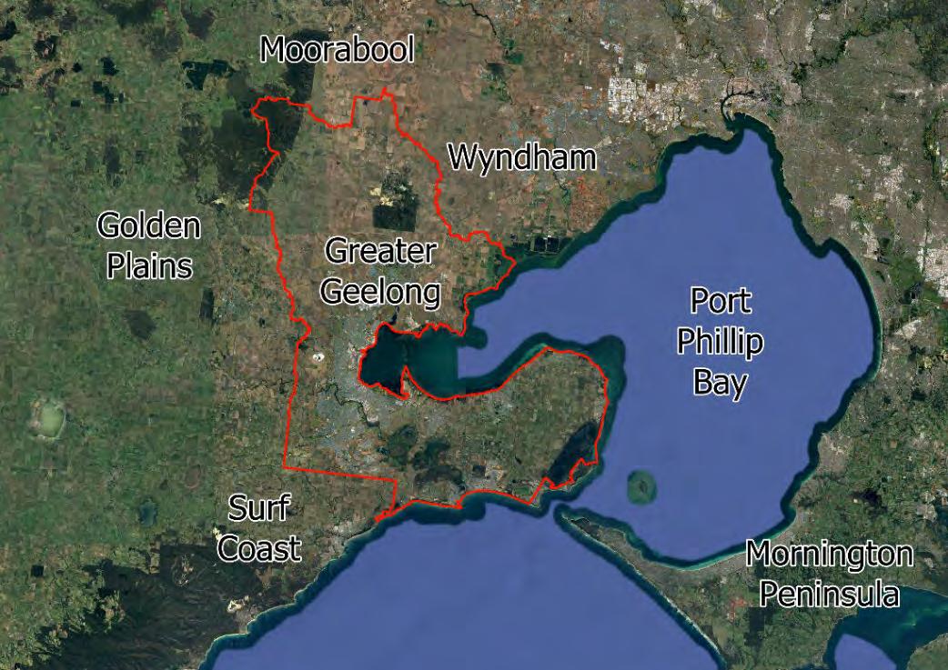
The City of Greater Geelong is situated approximately 70 kilometres southwest of central Melbourne and spans an area of 1,248 square kilometres. The Local Government Area (LGA) is one of the state’s largest municipalities spanning a large and diverse region comprising urban, suburban, and rural areas. It is bordered by Surf Coast Shire to the south, Golden Plains and Moorabool Shires to the west and north, and Wyndham to the north. The city encompasses extensive coastal regions as well as a large segment of the Port Phillip Bay coastline up to Little River.
The main population centres within the City of Greater Geelong include Geelong, the central and most populous urban area. Corio is a large suburban area located north of central Geelong, while Lara is a residential community to the north. Waurn Ponds, a southern suburb, is known for its commercial and residential developments. Other townships include Ocean Grove, Drysdale, Lovely Banks, Armstrong Creek, Mount Duneed and Marshall.
The area enjoys a rich diversity of flora and fauna, including some important ecological communities. It features major waterways, expansive coastal regions, and complex freshwater and marine wetlands. The primary agricultural activities in the area are sheep and beef grazing, with some cropping in the northern regions and horticultural businesses concentrated in the south, particularly on the Bellarine Peninsula.
Figure 4 Greater Geelong Locality
The soil characteristics across the LGA exhibit considerable variation, influenced by the region's diverse topography and land use patterns. In the northern parts of the LGA, the soils are primarily alluvial and volcanic in origin, offering fertile conditions suitable for cropping and intensive agriculture. These soils typically have a loamy to clayey texture, with moderate to high levels of organic matter and good water-holding capacity, which supports agricultural activities.
Towards the southern regions, including the Bellarine Peninsula, the soils tend to be more sandy or loamy with varying levels of fertility. These soils are often well-drained and slightly acidic, making them ideal for horticultural activities such as vitic ulture and vegetable growing. The presence of calcareous sands and sandy loams in some areas contributes to the region's suitability for vineyards and other crops.
In the coastal and wetland areas, the soils are generally sandy and less fertile, with lower organic content and higher salinity levels, especially in the saline wetlands. These soils are more prone to erosion and are often conserved for their ecological value rather than agricultural use. Inland areas may also feature clayey soils with varying degrees of fertility, supporting a mix of grazing and other less intensive agricultural activities.
Water management authorities include Barwon Water (potable water and sewerage servicing), Southern Rural Water (waterways and floodplains), and the Corangamite Catchment Management Authority (Flooding and major drainage). The CoGG also plays a role in the management of waterways, floodplains, drainage, land-use planning and water sensitive urban design.
Unsewered localities across the Local Government Area (LGA) are mostly small rural communities. Unsewered areas include parts of the following towns; St Leonards, a coastal town on the Bellarine Peninsula popular for its beaches and holiday homes; Indented Head, known for its peaceful beaches; and Clifton Springs, a mix of older and newer developments with scenic views over Corio Bay. Mannerim and Connewarre are rural areas where septic systems are common, with the latter known for its wetlands and birdwatching. Wallington, a semi-rural area with vineyards and lifestyle properties, and Moorabool, a sparsely populated rural area, also lack sewerage infrastructure. The outskirts of Lara and Little River, primarily rural or low-density residential areas, rely on septic systems as well. Environmental risks from wastewater management and future infrastructure expansion are ongoing challenges in these areas.
3 Legislation, Council Plans, Standards and Guidelines
Legislation, Council Plans, Standards and Guidelines relevant to this OWMP are described below.
Environmental Protection Act
The Environment Protection Act encompasses a framework designed to safeguard the environment and promote sustainable practices. Under this legislation, the management of on-site wastewater systems is governed by regulations ensuring proper approval, installation, and maintenance. The Act also introduces the Order for Obligations of Managers of Land and Infrastructures (OMLI). The OMLI is specifically relevant to Local Councils and addresses on-site wastewater management. The OMLI require councils to:
Develop and publish an OWMP.
Consult with water corporations and other stakeholders about the plan.
Consider water supply catchments.
Notify the relevant water corporation in writing when Councils identify that a sewage management solution is required.
Planning and Other Legislation
The Victorian Planning and Environment Act addresses OWMS’s as part of its broader regulatory framework for land use planning and environmental protection. It includes guidelines for integration into land use planning processes designed to minimise environm ental impact and safeguard water quality. The legislation captures Planning Permits (statutory) and Planning Schemes (strategic).
Other legislation is in place that supports the and informs matters relating to the approval, management, or operation of On-site Wastewater Management Systems. These include:
Public Health and Wellbeing Act
The Building Act
Local Government Act Water Act
Catchment and Land Protection Act.
Council
Plans and
Strategies
There are several important Council plans that have been considered in the development of this OWMP. These include: Council Planning Scheme.
Community Plan 20212025
Guidelines and Standards
Guidelines and standards which provide direction on the design, installation, and operation of onsite wastewater systems include:
Guideline for Onsite Wastewater Management (2024)
Guideline for onsite wastewater effluent dispersal and recycling systems (2024)
Victorian Land Capability Assessment framework (2014)
AS/NZS 1547:2012 Onsite Domestic Wastewater Management
3.1 Environment Protection Act
The principal piece of legislation is the Environment Protection Act and subordinate regulation. This legislation has been developed around the principal of General Environmental Duty (GED). Relating to OWMS, the GED requires anyone engaging in the construction, installation, alteration, operation and maintenance of onsite systems to minimise the risks of harm to human health or the environment from pollution or waste. It can also apply to how faults and system failures are dealt with and how waste is managed.
A key legislative instrument introduced in the EP Act is the Order for Obligations of Managers of Land and Infrastructures (OMLI). The OMLI is specifically relevant to Local Councils and addresses both urban stormwater management and onsite wastewater management. With respect to onsite wastewater management the OMLI require councils to do certain things such as:
• Develop and publish onsite wastewater management plans (OWMP) that identify, assess and address the risks of harm to human health and the environment from these systems.
• Consult with water corporations and other stakeholders about the plan.
• Consider water supply catchments.
• Notify the relevant water corporation in writing when Councils identify that a sewage management solution is required.
More information about the Act and supporting legislation is provided in the Guideline for onsite wastewater management (GOWM).
3.2 Wastewater Guidelines
The Code of Practice – onsite wastewater management (Publication 891.4, July 2016) has now been superseded by several new guidelines released in 2024. Like the previous CoP, the new guidelines are intended to be used by numerous stakeholders such as local Government, Water Corporations, onsite wastewater consultants, system installers and plumbers. The guidelines are applicable for systems treating or discharging design or actual flows less than 5,000L per day. Both guidelines are available from the Victorian EPA webpage however a brief description for each guideline is provided below. Unlike the CoP, these guidelines are implicitly intended as guidelines with the intention of introducing a level of flexible risk-based decision-making supported by experience, knowledge and data.
Guideline for onsite wastewater management (2024): This guideline (GOWM) provides an overview of onsite wastewater management requirements for systems servicing single and multi-dwelling premises intended to be installed and operated in unsewered and sewered areas (including greywater) at flow rates <5kL/day. The guideline contains six sections addressing regulatory framework, planning, OWMS design, system installation and operation and maintenance.
Guideline for onsite wastewater effluent dispersal and recycling systems (2024): This document provides wastewater practitioners with information, technical and practical guidance on the selection, design, construction and operation of EDRS. The guideline which supports the GOWM, and other guidelines and standards is relevant to system designers, installers and plumbers, land capability assessors and Local Councils. Like the GOWM this guideline contains six sections addressing system classification, system selection, system design, regulatory assessment, system construction and operation and maintenance.
For this guideline:
An effluent dispersal system (EDS) is defined as ‘An engineered system designed to enable controlled distribution of treated effluent into or onto the land for water and nutrient uptake and filtration, sorption, and further biological degradation.
An effluent recycling system (ERS) is defined as ‘A system designed to enable beneficial reuse of appropriately treated effluent from a greywater treatment plant for either indoor or outdoor use’.
Planning in Open Drinking Water Catchments (Planning Practice Note 55): The principal objective of the Practice Note is to provide guidance intended to protect the quality of drinking water sources in Victoria. This is achieved by providing clear directives for land use and development within potable water catchment areas. The guideline outlines requirements and best practices for planning and development activities, with an emphasis on the need for thorough assessment and mitigation of potential risks to water quality. It aims to balance the needs of development with the imperative to maintain clean, safe drinking water, thereby supporting the long-term viability of water resources for communities.
3.3 Australian Standards
Several Australian Standards are relevant to the construction, design, installation and operation of onsite wastewater systems.
AS/NZS 1546: establishes performance criteria and testing requirements for onsite domestic wastewater treatment units in Australia, ensuring they operate effectively and safely to protect public health and the environment.
AS/NZS 1547: provides a comprehensive set of guidelines and standards for the design, installation, and management of onsite domestic wastewater management systems, ensuring they operate effectively and safely to protect public health and the environment.
• AS/NZS 3500: provides a standardised set of guidelines and requirements for the design, installation, and maintenance of plumbing and drainage systems in Australia, ensuring safety, reliability, and regulatory compliance. The standard is applicable to new installations as well as alterations and repairs to existing systems.
3.4 Council Plans
The following Council Plans and Strategies make reference to on-site wastewater management in some context. Consideration has been given in preparation of this OWMP to ensure strategic alignment
• Community Plan 2021 – 2025
• Environment Strategy (2020-2030)
• Sustainability Framework and Action Plan
4 Roles and Responsibilities
Responsibilities for onsite wastewater systems and their management extend across government agencies, private industry, property owners and system operators.
4.1 Greater Geelong City Council
Council plays a crucial role in the management of onsite wastewater management systems (OWMS). Our responsibilities include assessing, approving, and monitoring these systems to ensure they meet public health and environmental standards. We are tasked with issuing permits for the installation, alteration, and operation of OWMS, ensuring that they comply with the Environmental Protection Act, associated regulations, guidelines and standards. We can also conduct inspections to verify proper installation and maintenance and provide guidance to property owners on best practices for managing their wastewater systems. An important role is in educating the community about the importance of effective wastewater management which helps protect water quality and minimise environmental degradation.
4.2 Landholders
It is recognised that landholders have an important role in the management of onsite wastewater systems. They are required to ensure that their systems are correctly designed, installed, and maintained in accordance with relevant regulations and standards. This includes obtaining or maintaining the necessary permits, conducting regular inspections, and arranging regular maintenance to ensure appropriate system performance. Landowners are best placed to ensure that their systems operate in a manner that does not pose a risk to public health or the environment. Additionally, they are responsible for keeping detailed records of system maintenance and any issues encountered, and they must promptly address any problems that arise to ensure the system's continued effective operation.
4.3 Environment Protection Authority Victoria (EPA)
The EPA's responsibilities encompass the development and implementation of environmental legislation, setting regulatory standards and guidelines that ensure the effective treatment and disposal of wastewater, thereby protecting public health and the environment. The EPA develops and enforces policies, conducts research, and provides technical advice to local councils, industry stakeholders, and the public. It also oversees compliance with the Environmental Protection Act and other relevant legislation, ensuring that wastewater systems are designed, installed, and maintained to minimise environmental impact.
The EPA also mandates that all onsite wastewater treatment systems must possess valid certificates of approval to ensure they meet stringent performance and safety standards. These requirements stipulate that systems must be appropriately designed, installed, and maintained to treat and dispose of wastewater effectively, preventing contamination of the environment and protecting public health. Systems must comply with the Australian/New Zealand Standard AS/NZS 1546 (as appropriate to system type) and be regularly inspected and serviced according to the manufacturer's instructions.
4.4 Water Authorities
Water and sewerage services within the LGA are provided by Barwon Water (retailer). Under the OMLI, water corporations must be consulted during development of the OWMP and for sewerage planning matters. The risk assessment contained in this OWMP provides a standardised basis for evaluating where the risk of environmental and health impacts from unsewered townships and areas are high. For areas where sustainable onsite wastewater management is not feasible, water authorities are required to work with Council to develop strategies to manage risk. This can range from support and assistance to Council in management of on-site systems to provision of sewerage services to new areas.
Additionally, Barwon Water are required to provide concurrent approval of onsite systems and unsewered development located within any drinking water catchments.
4.5 Land Capability Assessors
Land capability assessors evaluate the suitability of land for onsite wastewater management systems. Their responsibilities include conducting site and soil assessments and hydraulic analysis with outcomes used to inform wastewater system selection and design. They assess key site features and constraints to develop sustainable, feasible and approvable wastewater management plans that are consistent with regulatory provisions, applicable standards and guidelines. It is important that assessors have the necessary qualifications, experience and insurances to prepare Land Capability Assessment (LCA) reports that are comprehensive and sufficiently rigorous. LCA’s must assess key chemical and physical soil characteristics, as well as local climate and nearby sensitive receiving environments. LCA’s must also provide the necessary mitigation and/or remediation practises necessary to ensure the long-term viability and sustainability of the proposed OWMS. Assessors are engaged by landholders or developers.
4.6 Catchment Management Authority
The Corangamite Catchment Management Authority is the principal custodian for protecting land, water and biodiversity across the catchment. The authority has developed and implemented the Regional Catchment Strategy (2027) which is the overarching plan for integrated catchment management. An important role of the CMA relates to flood management and flood data which is an important consideration for onsite wastewater selection and design.
5 Domestic Wastewater
Domestic wastewater refers to waste and water generated from household or personal activities, such as those from water closets, urinals, kitchens, bathrooms, and laundries. It can also include wastewater from facilities that cater to staff, employees, residents, or guests in institutional, industrial, commercial, or recreational settings. However, it does not encompass trade wastes from industrial, commercial, or home business operations.
Domestic wastewater contains various elements that become significant when improperly discharged into the environment. When released inappropriately, two primary risks emerge:
• Public Health Risks: Untreated or inadequately treated wastewater may contain pathogenic microorganisms and other chemicals in varying concentrations. These pathogens and chemicals can cause diseases in humans and animals upon exposure.
• Environmental Pollution Risks: Wastewater includes physical, chemical, or biological components that can disrupt the normal functioning of sensitive ecosystems, such as surface waters and groundwater.
It is essential to consider the various pathways through which contaminants might spread, leading to potential public health hazards or environmental pollution. For instance, effluent applied to land, whether on the surface or subsurface, can move through soil and water, potentially degrading water quality and posing health risks away from the original site, unknown to the system owner or operator. It is then necessary to develop a strategy to manage these risks in accordance with regulatory requirements. This can include adoption of certain levels of treatment, adequate sizing and siting of EDRS (land application) and establishment of setback distances to sensitive receiving environments or human exposure points.
6 Risk Assessment
Under the OMLI (2024) a council must (as far as reasonably practicable) identify and assess the risk of harm to human health and the environment associated with unsewered allotments and existing and future onsite systems. As part of Victorian onsite wastewater reforms developed in response to the audit Managing the Environmental Impacts of Domestic Wastewater (Victorian Auditor General's Office, 2018), the Department of Energy, Environment and Climate Action (DEECA) released a Risk Assessment Guidance Report intended for use in this process (Atom Consulting, 2022) Geelong City instructed DWA to apply the Atom risk assessment framework as part of this Plan’s development in response to DEECA funding obligations.
The risk assessment methodology (Atom Consulting, 2022) has been supplemented by some additional risk assessment tools that consider the potential for localised cumulative impacts and off-site discharge from constrained unsewered allotments. This section of the OWMP contains a summary of the risk assessment processes and their key outcomes.
6.1 Catchment Based Risk Assessment (Atom Consulting, 2022)
The risk assessment undertaken evaluates risk on a catchment or sub- catchment scale, providing a comprehensive view of how existing onsite wastewater systems interact with local hazards and environmental risk factors. This approach focuses on understanding the spatial relationship between these wastewater systems and various elements that contribute to potential risks, such as proximity to water sources, soil characteristics, land use, and local climate conditions.
The risk evaluation process considers both the likelihood and potential consequence of system failures or underperformance. Specifically, it examines how contaminants from these systems could affect groundwater, surface water, and potable water supplies, as well as sensitive ecosystems and recreational areas.
Data from a variety of sources was utilised in the assessment, with a summary of the data inputs to the assessment provided in Table 2 below:
Table 2 Risk Assessment Data Inputs
Input Data Source Method of Determining
Catchments and sub-catchment areas
Special Water Supply Catchments (where relevant)
Risk points (health and environmental receptors)
On-site System Data
- Property number / street address
- Treatment type i.e. primary or secondary
- Dispersal type i.e. adsorptions, surface irrigation or subsurface irrigation
- Age - De-sludge records
Soil type
Lot size and Proximity
- Cadastre
- Watercourses / bodies
- Flood plain
- Groundwater bores
- Groundwater depth
Topography (slope)
Rainfall data
Data Vic. (Melbourne Water) GIS analysis
Data Vic.
Major receiving waters within the LGA
Council records (where available)
GIS analysis of distance to offtake
Determined by Risk Tool framework
Data Vic and VRO
GIS analysis of existing data and extrapolation based on a set of agreed assumptions.
GIS and expert analysis of landscape data against AS1547 soil class.
Data Vic or Council (flood) GIS analysis
Data Vic.
BOM
GIS analysis using DEM
Data analysis
6.1.1 Data limitations
Council records of onsite wastewater systems did not contain all of the data required to satisfy all of the risk assessment inputs. Some records lacked details, such as system type, desludging frequency, and effluent dispersal method.
To address these gaps, DWA applied the following assumptions in cases where data was missing:
• System type: If the system type (primary or secondary) was unknown, DWA assumed a primary treatment system.
• Effluent dispersal method: If the type of effluent dispersal was not specified, DWA assumed an absorption-based system, i.e., trenches.
• Desludging frequency: If desludging frequency was unknown, DWA assumed that the most recent desludging occurred five or more years ago.
Furthermore, DWA’s initial investigations into Council records suggested that numerous onsite systems were likely unaccounted for. To estimate the location of these missing systems, DWA implemented the following methodology:
• A publicly available vector dataset was used to identify building locations across Victoria.
• DWA isolated one building point per property using the cadastral layer.
• Areas with a wastewater service connection were excluded from this analysis.
• The remaining data from Council’s records was then joined with the building points layer based on the property ID numbers from the cadastral layer.
The resultant dataset approximated all wastewater system locations in the LGA, capturing the data provided by Council records. This dataset assumes that the wastewater system is located near the building point. While this assumption may not always hold true, DWA considered it a reasonable approximation for the purposes of this risk assessment.
Following this process the location of onsite systems was reviewed by Council, and it was noted that there were several areas where building point records were incomplete. As a result, there were several areas where onsite systems were unaccounted for. Council advised DWA of these areas and DWA manually designated onsite system locations, based on aerial photography and the cadastre layer. The resulting combined layer was then used to conduct the risk assessment process.
6.1.2
Risk Tool Limitations
Through previous application of the Risk Tool, DWA has applied the tool to some smaller target areas known to a particular Council as areas with wastewater related problems. The areas investigated were typically small unsewered townships located within relatively large sub-catchments. Smaller sub catchments boundaries were established around these townships, and the risk assessment procedure applied to these new catchment areas. Unfortunately, the results of this ‘close-up’ analysis did not reveal any real difference in results when compared against results from the larger catchment areas.
This process revealed that the risk tool is not sensitive to system density as had been anticipated. When coupled with the strong reliance on the availability of accurate and widespread on-site system data, this does place limitations on the useability to define and manage risk. For this reason, no further analysis of smaller areas was conducted using the risk assessment process. Instead, DWA progressed with analysing onsite system density across the City, along with an analysis of lot size in targeted township areas.
6.2 Risk Assessment Outcomes
The summarised results of the risk assessment are discussed below. To view the risk assessment outcomes in more detail, refer to the produced maps which have been provided in the appendices.
6.2.1 Surface Water Impacts
Surface water environmental risk was evaluated at mixture of low and moderate risk across the various subcatchments, with the moderate risk subcatchments being largely driven by the proximity of onsite systems to watercourses and waterbodies throughout the LGA.
From a human health perspective, surface water risk results were a combination of moderate and high risk subcatchments. Relative to the human health risks evaluated for groundwater and flooding (see below) these results are consistently of a higher risk rating. These results are driven by the high number of primary treatment systems located within the buffer zone of watercourses throughout the LGA.
Cumulative surface water risks were also evaluated as part of the risk assessment, looking at cumulative risk for the downstream endpoints of the major waterways and the major water bodies within the LGA. The major waters considered in this way were the Barwon Basin, Barwon River, Cowies Creek, Hovells Creek, Little River, Moorabool Basin, Thomson Creek and Yarram Creek. Cumulative human health risk results were a mixture of
moderate and high risk. The risk results from an environmental perspective were identical to the human health results.
6.2.2 Groundwater Impacts
When examining potential impacts on groundwater from onsite systems, most subcatchments were deemed to be of low risk from an environmental perspective. The main exceptions were a sub-catchment of little river, along with the large sub catchment area which wraps around the peninsula between Moolap and Swan Bay, which have both been evaluated as moderate risk. Both of these subcatchments contain onsite systems perched above shallow groundwater. Both of the aforementioned sub-catchments were also identified as being of moderate risk to human health, along with subcatchments around Moorabool, Lara and Breamlea.
6.2.3 Flooding Impacts
Flood driven risks from onsite systems were identified as low across almost the entire LGA, with the exception of a small sub-catchment on the south-east bank of the Little River. Human health risks from flooding varied between low and moderate risk. Unsurprisingly, these moderate risk sub-catchments correlated with areas where onsite system locations overlapped with the 1 in 20-year and 1 in 100-year flood layers.
6.3 Onsite Containment Risk Evaluation
The ability of a property to treat and disperse all wastewater on the property, usually referred to as onsite containment, is often limited by the availability of usable land within the lot. A major factor in this constraint is the size of the lot itself. An analysis of unsewered lot sizes within the City, with particular focus on the areas of high-system density, found that many of the small townships with a high concentration of onsite systems presented a challenge for onsite containment.
General guidance on lot size threshold values applicable to Geelong is provided in the table below.
Table 3 Lot Size Guidance
Onsite Containment Capacity
Onsite containment of wastewater is generally difficult to achieve on allotments smaller than 2,500 m2, particularly where one or more environmentally sensitive features are present. This is especially true for modern residential dwellings with four to five bedrooms, which typically generate higher wastewater volumes.
For such allotments, partial or full off-site wastewater management is the preferred strategy. Alternative approaches may include:
- Connection to a reticulated sewer network,
- Connection to a shared or cluster wastewater system,
≤ 2,500 m2
2,501 m2 – 3,999 m2
- Installation of an onsite system that is managed by a recognised sewer authority.
Where Council determines that an owner-managed onsite system is the only feasible option, the application must be supported by a Land Capability Assessment. This assessment must include a suitable system design and be prepared by a qualified consultant with expertise in onsite wastewater management.
Proposed developments that generate significantly lower volumes of wastewater may be suitable for onsite containment. Each proposal will be assessed by Council on a case-bycase basis, considering the specific merits and site conditions of the development.
Onsite wastewater containment of wastewater is generally achievable for typical residential dwellings on allotments within this size range. However, feasibility is highly dependent on site-specific land capability constraints and the proximity of sensitive receiving environments.
If environmental receptors are located within prescribed setback distances or site and soil conditions are challenging, Council may require the preparation of a Land Capability Assessment (LCA) and an accompanying system design to confirm that full onsite containment can be achieved.
Where possible, these properties should be considered for partial or full off-site wastewater management. Alternative servicing strategies may include:
- Connection to a reticulated sewer network
- Connection to a shared or cluster wastewater system
Installation of an onsite system managed by a recognised sewer authority
≥ 4,000 m2
Owner-managed onsite wastewater systems are generally an appropriate servicing strategy for properties of this size, provided site-specific land capability constraints can be addressed. When environmental receptor and human health setback distances 1 can be fully achieved, cumulative environmental impacts are typically negligible. A risk based approach to Permit assessment requirements is advocated for lots in this size category. Refer to Section 8.2.2 for guidance.
1 Guideline for onsite wastewater management (EPA Victoria, May 2024)
The table below shows the estimated number of unsewered lots in each zone, divided into the lot size categories described above. The percentage of those lots which have been developed (i.e. are believed to have an existing onsite system) is shown in brackets beside each count. These statistics are based on Barwon Water sewer infrastructure location data and the Victorian Property cadastral layer (sourced from DataVic). DWA has made professional judgements to adjust this data where discrepancies were observed— for example, in cases where new lots or developments are shown in the cadastral layer but are still in the process of being connected to sewer by Barwon Water. However, there is inherent uncertainty in both datasets, and the figures presented should be interpreted as estimates.
The data presented in the table above highlights a number of areas of interest relating to onsite wastewater within the LGA:
• The majority of unsewered lots are located in the Farming Zone (FZ) and Rural Living Zone (RLZ), which together account for over 4,200 lots approximately 70% of all unsewered lots across the municipality.
• Development rates in these zones are high, particularly in the >4000 m² category, with 81.5% of lots developed in the FZ and 89.4% in the RLZ, indicating widespread reliance on onsite wastewater systems in these rural and peri-urban areas.
• The Low Density Residential Zone (LDRZ) contains nearly 300 unsewered lots, with over 85% developed across all lot size categories. These areas are typically semirural in nature and are expected to remain reliant on onsite systems for the foreseeable future.
• Unsewered lots in the General Residential Zone (GRZ) are less common, but small lots (<2500 m²) show a high development rate (85.2%), potentially posing greater challenges for system performance and replacement due to limited available land.
• Industrial Zones contain a notable number of unsewered lots (541 lots, 67% developed), which is largely explained by the suburb of Moolap, a historically industrial area with known gaps in sewer coverage. This is discussed further below in the report.
• Other zones not typically associated with residential development, such as Public Use Zones, Public Conservation and Resource Zone (PCRZ), and Special Use Zones, also contain unsewered lots. These may reflect facilities, legacy uses, or sitespecific developments requiring targeted investigation.
• Some small anomalies occur in low-volume zones such as the Mixed Use Zone, Neighbourhood Residential Zone (NRZ), and Comprehensive Development Zone (CDZ), where a small number of unsewered but developed lots likely reflect isolated or transitional developments.
6.4 Onsite System Density Analysis
Areas with higher densities of onsite wastewater systems are associated with increased risks to both human health and the environment. High-density areas can lead to elevated nutrient loading, increased pathogen presence, and a greater potential for contaminant export. To identify and assess these potential risk zones, a density analysis was conducted across the City
A 1 km² grid was created over the entire LGA using DWA's GIS mapping software, with each grid square representing a defined area for the density analysis. A point count process was then applied, counting the number of known onsite wastewater systems within each grid square. This analysis resulted in a new raster, where each grid square was attributed with the number of systems it contained, representing the density of onsite systems in terms of systems per square kilometre. The results of this analysis are presented in Figure 5 below.
Areas identified where there are significant densities of onsite systems include Wallington, Moolap, Ceres, Lara, Lovely Banks, Portarlington and Anakie. Some of these areas are known to Council as having onsite wastewater related issues, particularly those areas where lot sizes limit the ability for onsite containment. Some of these townships are examined in more detail below in section 7. It should also be noted that there are other smaller areas with localised high densities that were not highlighted in this analysis, but are known to Council as having high concentrations of OWMSs such as Breamlea.
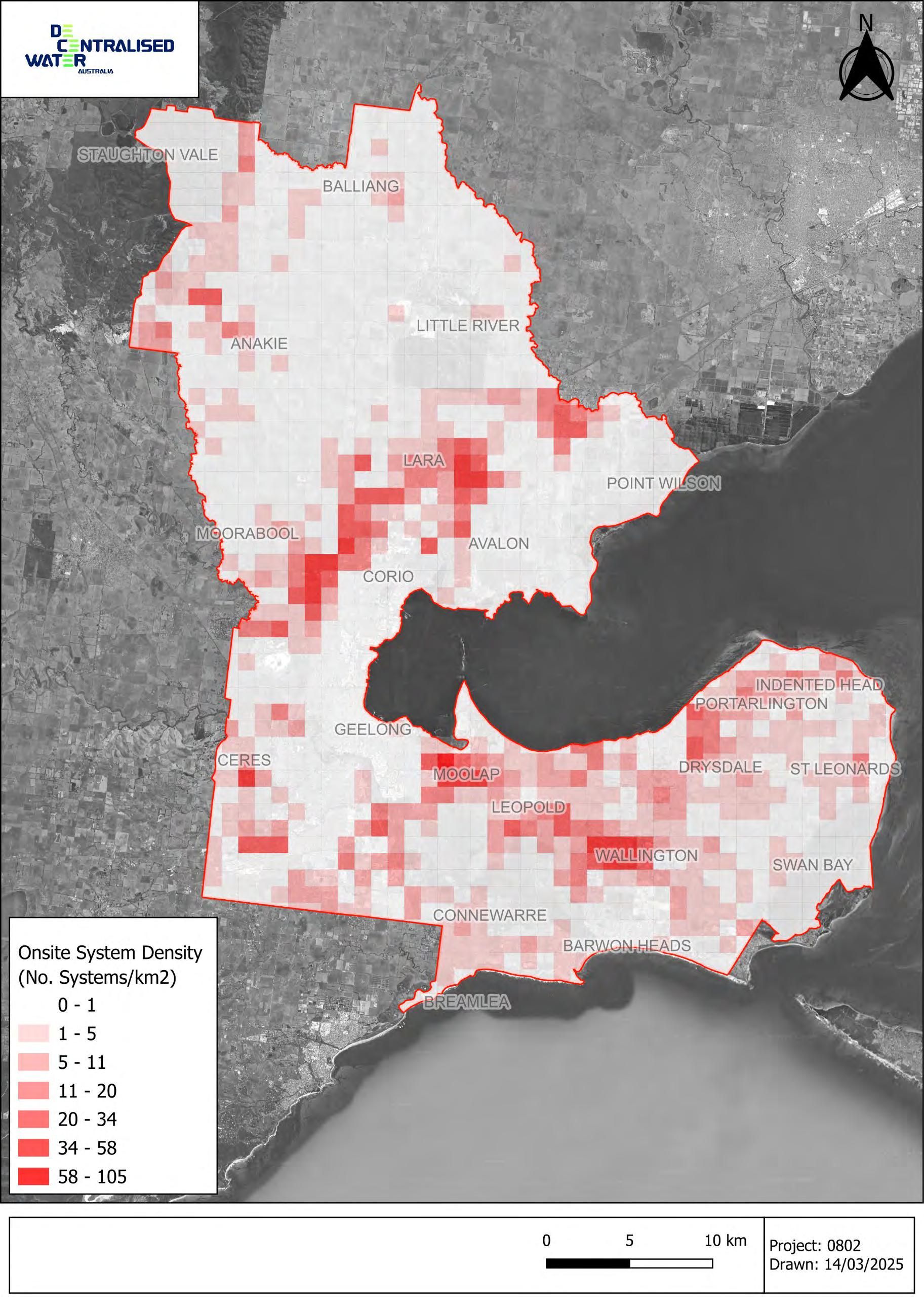
Figure
7 Unsewered Township Wastewater Characterisation
This section of the Onsite Wastewater Management Plan (OWMP) evaluates the wastewater environment across key unsewered townships. The purpose of this assessment is to identify, at a township scale, the factors contributing to the risks imposed by wastewater systems to human health and the environment, both existing and future. The assessment is generally consistent with the Department of Energy, Environment, and Climate Action (DEECA) risk assessment framework but incorporates model data developed specifically for this analysis. Using model inputs, alongside key sitespecific factors from sources such as GIS analysis and Data Vic, the analysis assigns an indication of risk for each township. This approach offers a broad interpretation of risk factors and informs potential risk management measures available to Council, aiding in efforts to mitigate public health and environmental impacts and to support sustainable, site-tailored wastewater solutions.
The table below has been developed to inform assessment and selection of the level of limitation for each risk factor based on the characterisation information for each township. While the chosen wastewater risk factors are well documented, it is acknowledged that development of the corresponding limitation scale at a township level is qualitative.
Further discussion on township specific risk treatment options is discussed in Section 8.7
Table 5
Township Risk Factor Limitation Guidance
Evaluation Guide
Risk Factor
Lot size
System Type
More than 50% of the lots are >4000m2
Limiting Soil Category
>75% of the systems are secondary -
More than 50% of the lots are between 2500 –4000m2
More than 50% of the lots are <2500m2
Cat 2, 3
Soil characteristics Dermosols, Ferrosols
Slope
Most of the township is <5%
Cat 4
>75% of the system are primary
>50% of the systems are not known (unknown)
Cat 1, 5, 6
Kandosols, Kurosols, Chromosols Sodosols, Vertosols, Hydrosols, Podsols
Most of the township is between 5 – 15%
Most of the township is >15%
Named watercourse >100m from township perimeter
Receiving Environments
Groundwater depth >5m
(Also influenced by soil class)
Township not located within a drinking water catchment -
Named watercourse <100m from township perimeter
Named watercourse within township perimeter
Ground water depth between 2 and 5 m
(Also influenced by soil class)
Ground water depth<2m
(Also influenced by soil class)
Township located within a drinking water catchment
Flooding
Above 1% AEP
Township Growth Potential No or limited growth potential
1 – 5% AEP
Some growth potential
Below 5% AEP
High growth potential
7.1 Anakie
Anakie is a small township in the north-west of the Geelong LGA. Anakie contains a number of lots where onsite containment of wastewater presents a challenge due to lot size, with some lots unlikely to be capable of full onsite containment.
There are several unnamed watercourses running through the centre of the township. These watercourses are adjacent to a number of lots less than 2500m2 in size, making them particularly susceptible to offsite exports of wastewater Furthermore the 1% AEP flood layer surrounds some of these watercourses and overlaps the adjacent property boundaries, making these properties within Anakie particularly high risk from an onsite containment perspective.
The predominant soils in the area are sodosols, indicating the potential for sodic soils. Sodic soils are not well suited to the application of wastewater, as they have the potential to become dispersive when they come into contact with effluent containing elevated sodium. The dispersion of soil particles can result in a breakdown of soil structure, leading to poor infiltration rates in the soil. Application of gypsum or lime (depending on soil pH) is recommended in these soils and should be addressed as part of a Land Capability Assessment.
There is also a groundwater bore within the town registered as a water supply bore. There are multiple onsite wastewater systems in close proximity to this bore.
These features can be seen in Figure 6
Approximated for township zone based on 2021 Census data for broader Anakie locality
Onsite Wastewater System Characteristics and Risk Profile 3
Risk Factor
Description/Results
Total Estimated No. Systems: 43
- Primary: 1 (2%)
Wastewater system characteristics
Soils
- Secondary: 5 (12%)
- Unknown: 37 (86%) Greater
Predominantly black sodosols, with some Brown Sodosols and Brown Chromosols Greater
Slope The Anakie township is largely flat, with very little slope
57 lots within the study area
- 26 lots < 2500m2 (46%)
Lot Size
Sensitive receptors
Concluding Comment
- 9 lots 2500 – 4000m2 (16%)
- 22 lots >4000m2 (39%) Greater
- There are several unnamed watercourses running through centre of Anakie township.
- 1% and 5% ARI flood areas within the township
Greater
Lot size, soil permeability and flood constraints mean risks likely to require some level of off-site or cluster solution.
Land Capability Assessment is a requirement for any proposed OWMS works.
LCA must include analysis of site soils and adequately address any constraints arising from these results, including but not limited to application of lime, gypsum or other soil amelioration measures.
Preference for secondary treatment (deemed to comply) unless justification is provided in the LCA.
3 Statistics calculated based on land zoning, using residential, commercial & township zoning to delineate township areas
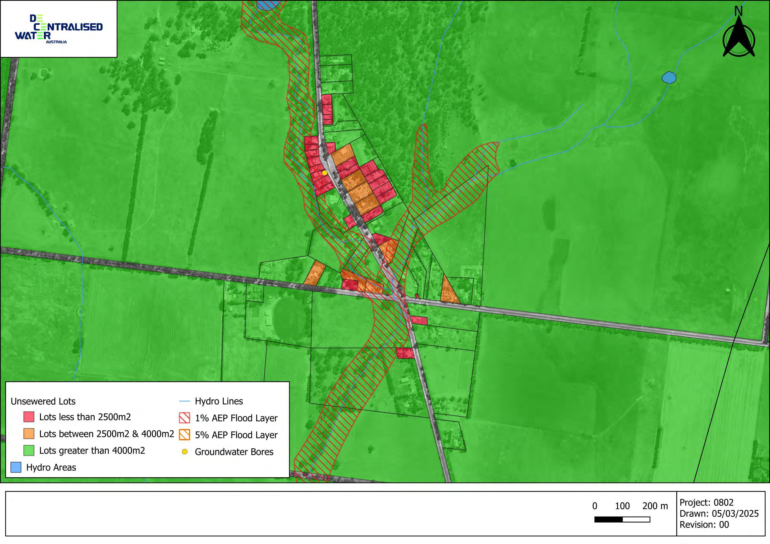
Figure 6 Anakie Township
7.2 Ceres
Ceres is a small township in the west of Geelong city. This small township contains a number of lots where onsite containment of wastewater presents a challenge due to lot size, with most lots unlikely to be capable of full onsite containment. The predominant soils in the area are sodosols, indicating the potential for sodic soils. Sodic soils are not well suited to the application of wastewater, as they have the potential to become dispersive when they come into contact with effluent containing elevated sodium. The dispersion of soil particles can result in a breakdown of soil structure, leading to poor infiltration rates in the soil. Application of gypsum or lime (depending on soil pH) is recommended in these soils and should be addressed as part of a Land Capability Assessment
These features can be seen in Figure 7
Occupied: 63
Unoccupied: 1
Average number of bedrooms: 3.8
Average number of people per household: 3.1
- Unknown: 50 (79%)
Soils Brown Sodosols
Slope The Ceres township is gently sloped i.e. <5%
64 lots within the study area
- 60 lots < 2500m2 (94%)
Lot Size
Sensitive receptors
Concluding Comment
- 2 lots 2500 – 4000m2 (3%)
- 2 lots >4000m2 (3%)
- No hydro areas, groundwater bores or flood overlays within the township
Greater
Lesser
Greater
Lesser
Lot size, soil permeability and flood constraints mean risks likely to require some level of off-site or cluster solution.
Land Capability Assessment is a requirement for any proposed OWMS works.
LCA must include analysis of site soils and adequately address any constraints arising from these results, including but not limited to application of lime, gypsum or other soil amelioration measures.
Preference for secondary treatment (deemed to comply) unless justification is provided in the LCA.
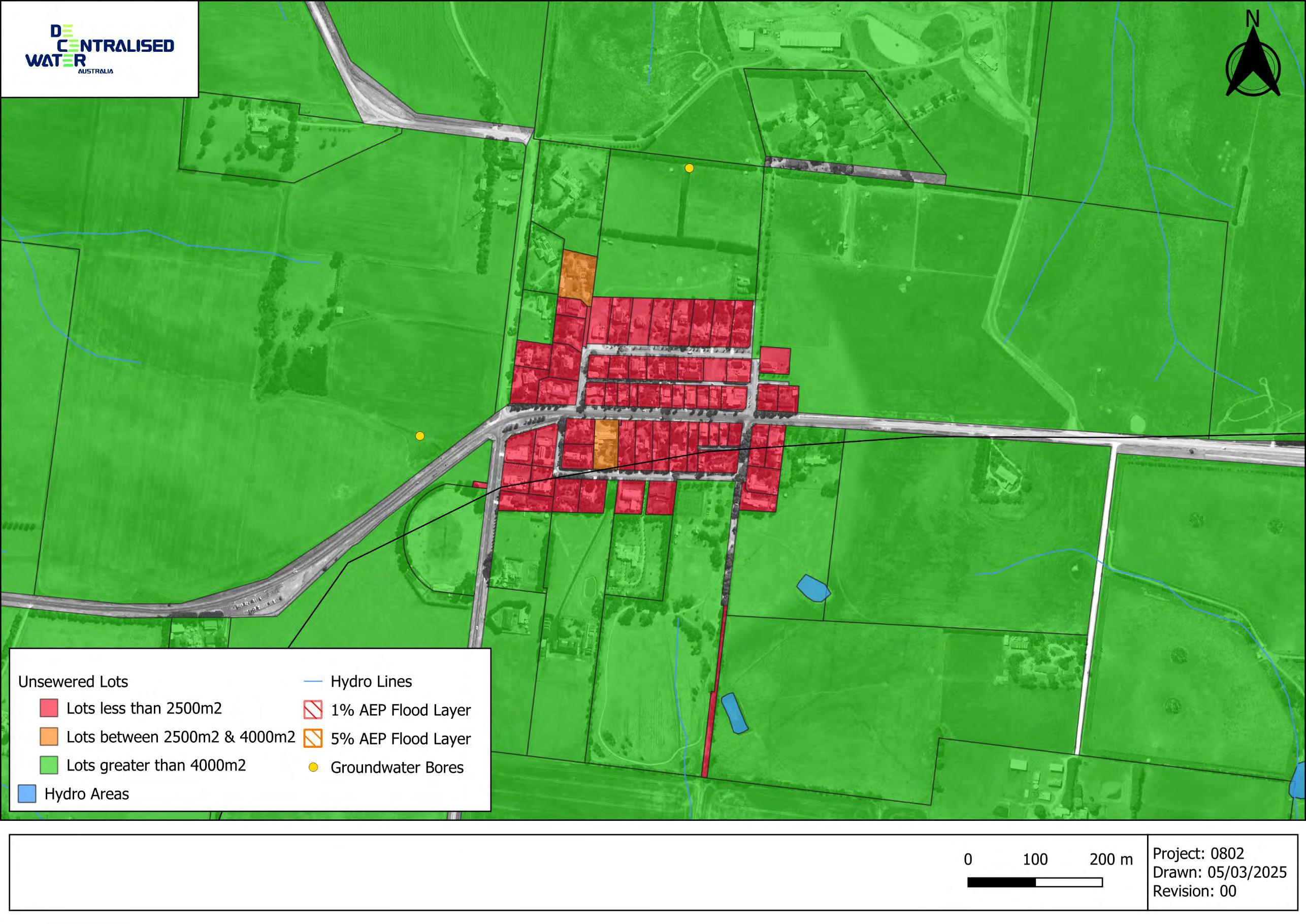
Figure 7 Ceres Township
7.3 Breamlea
Breamlea is a small coastal village south-west of Geelong city. The Breamlea locality is split across the Geelong LGA and the Surf Coast Shire LGA. Barwon water and sewer infrastructure reaches the eastern edge of the township, servicing the surf club, caravan park and a small number of households There are a significant number of lots located along Horwood Drive and the surrounding streets.
The unsewered lots along Horwood Drive are situated near the approximate interface between two soil types: Redoxic Hydrosols and Shelley Calcarosols. Both soils present challenges for wastewater management.
Redoxic Hydrosols are often seasonally or permanently waterlogged and may have high clay or silt content, both of which limit the soil’s ability to absorb and retain effluent, resulting in lower sustainable irrigation rates.
Shelley Calcarosols are typically sandy, calcareous soils with high permeability. While they drain quickly, their low water retention capacity increases the risk of nutrient leaching. These features can be seen in Figure 8 below.
Occupied: ~64
Unoccupied: 43
Average number of bedrooms: 3
Average number of people per household: 2.2
Total Estimated No. Systems: 106
- Primary: 19 (18%)
Wastewater system characteristics
- Secondary: 4 (4%)
- Unknown: 83 (78%)
Soils Shelley Calcarosols and Redoxic Hydrosols
Slope
Lot Size
Sensitive receptors
Breamlea is moderately sloped, with some homes located on slopes >25%
106 lots within the study area
- 106 lots < 2500m2 (100%)
- 0 lots 2500 – 4000m2 (0%)
- 0 lots >4000m2 (0%)
- The town is bordered on it’s northern edge by a 1% AEP flooding layer
- Thomson creek lies to the north, less than 100m from homes in places
- Breamlea beach is ~250m to the south
- Depth to ground water varies between 3 and 10 meters
Greater
Greater
Greater
Greater
Greater
Concluding Comment
Lot size, slope, very high soil permeability and flood constraints mean risks likely to require some level of off-site or cluster solution.
Land Capability Assessment is a requirement for any proposed OWMS works.
LCA must include analysis of site soils and adequately address any constraints arising from these results, including but not limited to application of lime, gypsum or other soil amelioration measures.
Preference for secondary treatment (deemed to comply) unless justification is provided in the LCA.
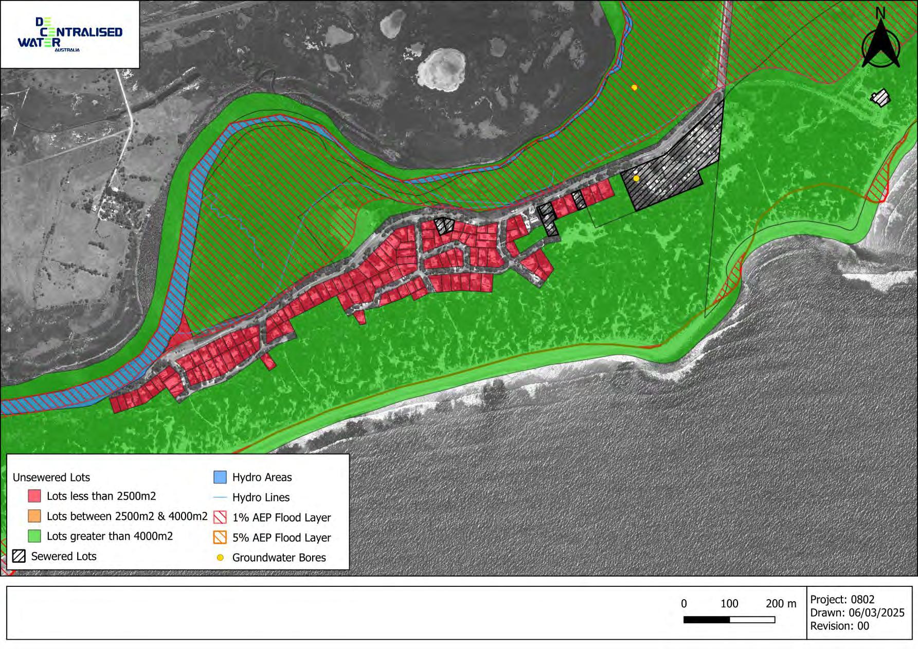
Figure 8 Breamlea
7.4 Barwon Heads
Barwon heads is a town in the southwest area of Geelong, situated on the west bank of the mouth of the Barwon River. Almost all of Barwon Heads is connected to Barwon Water’s sewer network, with the exception being a number of developed lots along Stephens Parade (Figure 10), and 5 lots located at the western end of Saratoga Avenue. Stephens Parade runs parallel with the coastline, approximately 200m to the north of the beach.
Stephens Parade is located on a Shelley Calcarosol soil profile. Shelley Calcarosols are typically sandy, calcareous soils with high permeability. While they drain quickly, their low water retention capacity increases the risk of nutrient leaching.
A review of the Visualising Victoria’s Groundwater (VVG) website indicates that beneficial use values for human groundwater use are not significant (Segment C) which is not surprising given the location. The relatively shallow water table (1-2 metres from ground level) does however increase nutrient pollution risk which in turn can impact groundwater dependent ecosystems such as estuaries and wetlands.
Occupied: ~28
Unoccupied: 10
Dwellings and occupancy
Average number of bedrooms: 3.4
Average number of people per household: 2.5
8 Based on 2021 Census data for Barwon Heads, applied to unsewered lots along Stephens Parade and Saratoga Avenue
9 Statistics calculated based on land zoning, using residential, commercial & township zoning to delineate township areas
Total Estimated No. Systems: 38
- Primary: 15 (40%)
Wastewater system characteristics
- Secondary: 5 (13%)
- Unknown: 18 (47%)
Soils Shelley Calcarosols
Slope
Lot Size
Sensitive receptors
Concluding Comment
Greater
Greater
Stephens Parade is gently sloped, with lots generally having gradients between 0 – 7% Lesser
32 lots within the study area
- 29 lots < 2500m2 (91%)
- 2 lots 2500 – 4000m2 (7%)
- 1 lots >4000m2 (2%)
- Thirteenth beach is ~200m to the south
- Depth to ground water varies between 2 and 6 meters
Greater
Greater
Lot size, slope, very high soil permeability and shallow depth to groundwater, likely to require some level of off-site or cluster solution.
Land Capability Assessment is a requirement for any proposed OWMS works.
LCA must include analysis of site soils and adequately address any constraints arising from these results, including but not limited to application of lime, gypsum or other soil amelioration measures.
Preference for secondary treatment (deemed to comply) unless justification is provided in the LCA.
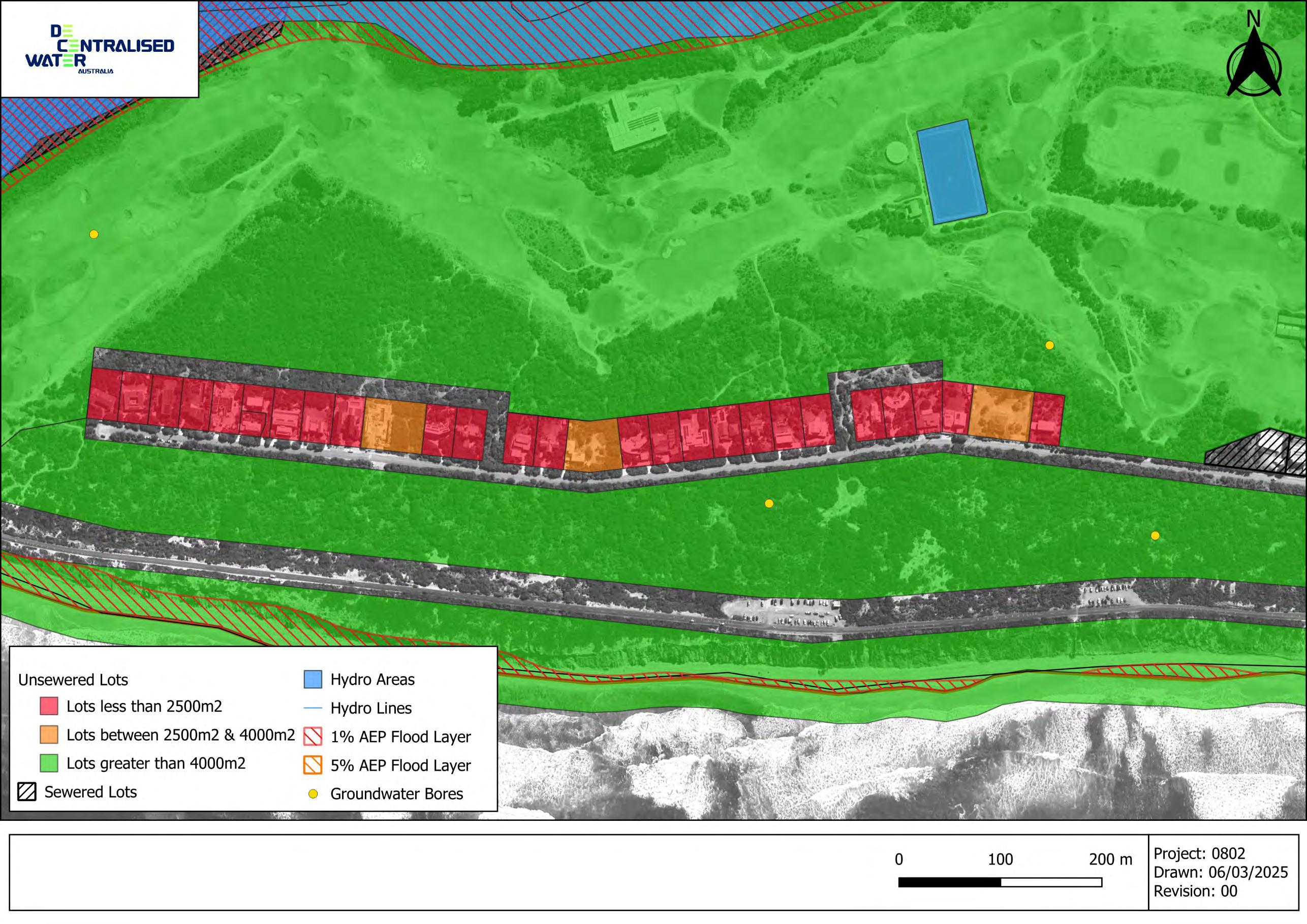
Figure 9 Stephens Parade
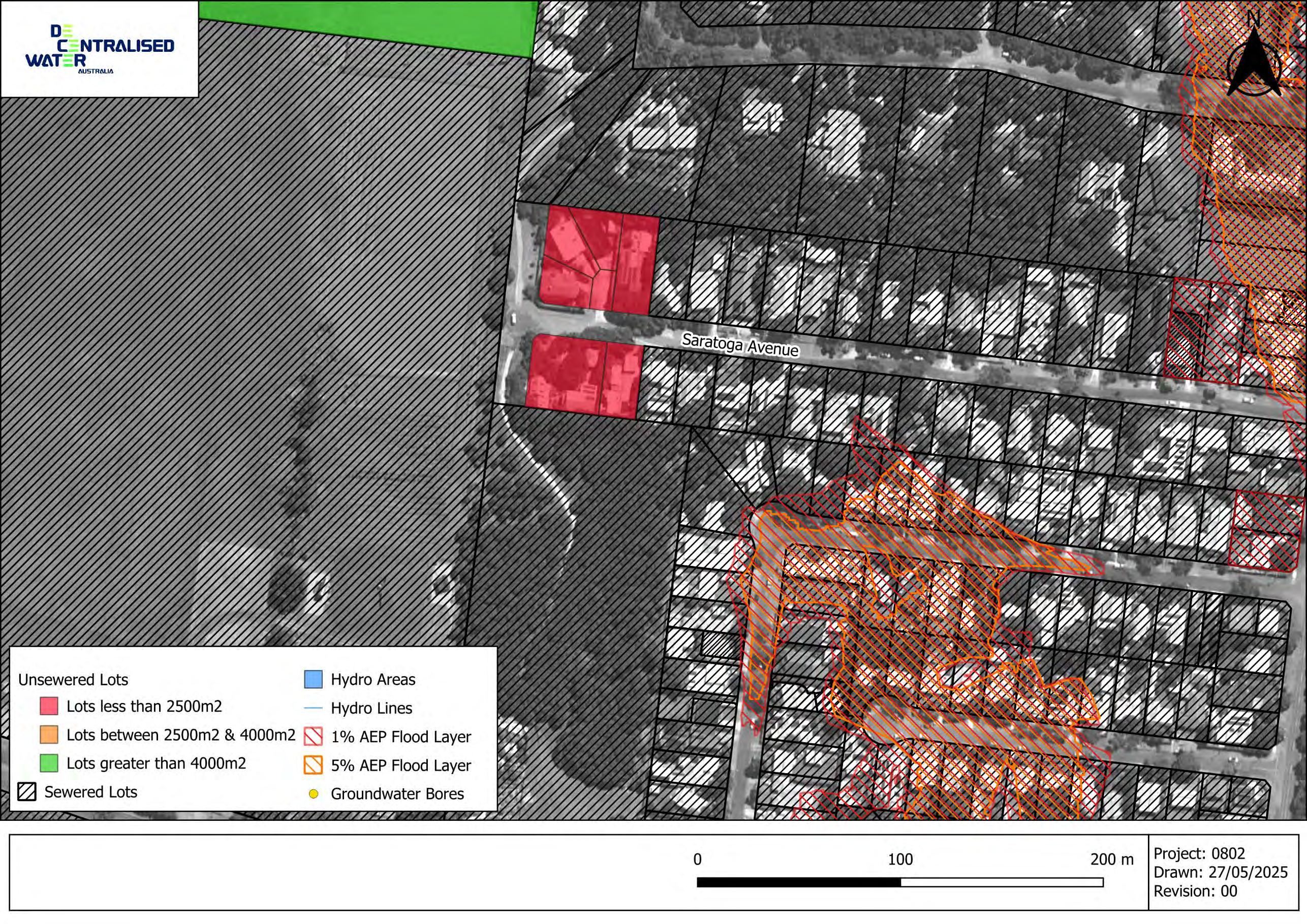
Figure 10 Saratoga Avenue
7.5 Portarlington
Portarlington is a town located southwest of Geelong City on the Bellarine Peninsula. Almost all of Portarlington is sewered by Barwon Water, however there are developed sections along Ramblers Road and Point Richards Road which remain unsewered (see Figure 12).
The predominant soils in this area are Aeric Podosols. Aeric Podosols are typically sandy and acidic, with a distinct subsurface accumulation of organic matter, iron, and aluminium compounds. These soils have low water and nutrient retention capacity, meaning effluent drains rapidly with limited attenuation, increasing the risk of nutrient leaching into groundwater or nearby waterways. Additionally, their often weak structure can lead to uneven infiltration rates, making them less suitable for sustainable irrigation with wastewater.
These unsewered lots are located in an area where ground water is very shallow, typically <1m, and all of these lots are within a 1% AEP flood layer. Groundwater has both moderate human use potential (segment b) and is likely to influence marine water quality and recreational water quality.
Occupied: ~73
Unoccupied: ~44
Average number of bedrooms: 3.1
Average number of people per household: 2
Risk Factor
Description/Results
Total Estimated No. Systems: 104
- Primary: 23 (22%)
Wastewater system characteristics
Soils
Slope
Lot Size
Risk Indication
Sensitive receptors
- Secondary: 2 (2%)
- Unknown: 79 (76%) Greater
Aeric Podosols
Ramblers Road and Point Richards Road are both relatively flat. With slopes generally less than 2%
- lots within the study area
- 117 lots < 2500m2 (100%)
- 0 lots 2500 – 4000m2 (0%)
- 0 lots >4000m2 (0%)
- The lots along Ramblers Road are 20 – 100 m from the edge of Port Phillip Bay
- There is a mapped hydro area 20m east of Point Richards Road
- Depth to ground water is very shallow, being typically less than 1m below ground level
- Both Point Richards Road and Ramblers Road are within the 1% AEP flood layer
- There are several registered bores along Ramblers Road, however they are all exploration bores rather than supply bores
Greater
Greater
Concluding Comment
Lot size, slope, high soil permeability and shallow depth to groundwater, likely to require some level of off-site or cluster solution.
Land Capability Assessment is a requirement for any proposed OWMS works.
LCA must include analysis of site soils and adequately address any constraints arising from these results, including but not limited to application of lime, gypsum or other soil amelioration measures.
Preference for secondary treatment (deemed to comply) unless justification is provided in the LCA.
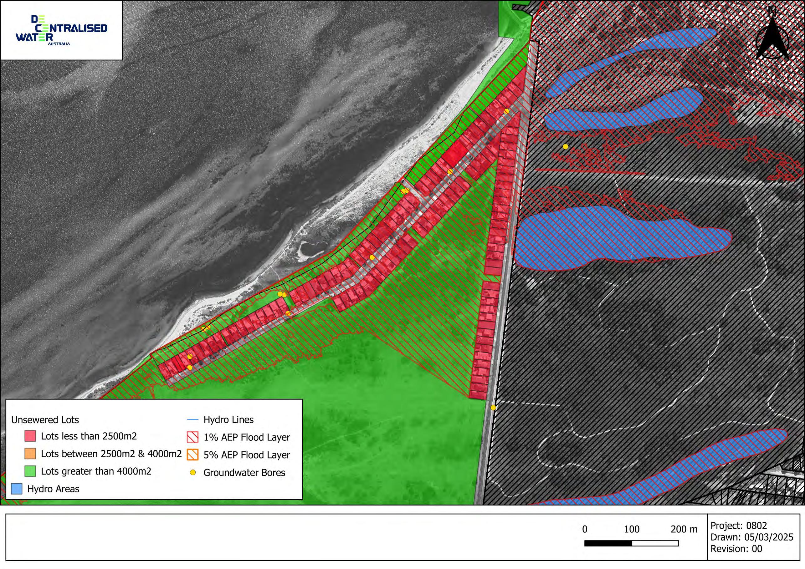
Figure 11 Point Richards Road & Ramblers Road
7.6 Moolap
The majority of Moolap is unsewered; however, most of the rural and rural-residential areas comprise large lots generally exceeding 4000 m², with adequate land available for effluent application. While these areas sit on Brown Vertosols, which do impose soilrelated constraints, the lot sizes mean that appropriately designed onsite wastewater systems can typically achieve sustainable containment. As a result, the broader Moolap area is considered low risk from a township-scale wastewater perspective and does not present the types of systemic constraints identified in other unsewered townships.
In contrast, the northern industrial precinct (see figure 12 below) represents a concentrated area of significant wastewater management risk. This precinct consists of very small industrial lots, most of which are heavily built-up with warehouses, workshops and hardstand areas. These characteristics leave little to no space for effluent management and variable wastewater characteristics. Even with secondary treatment, many sites cannot meet minimum effluent dispersal requirements due to the physical absence of usable land. As a result, many of the lots in this area are serviced by effluent pump out systems.
Suburb and Environmental Characteristics (Moolap industrial area)
Estimated population
Dwellings and occupancy
Zoning profile
Growth opportunities (creation of new lots)
N/A (industrial precinct)
N/A (industrial precinct)
N/A (industrial precinct)
– Industrial Zone
(None without sewer)
Wastewater system
Total Estimated No. Systems: 288
- Primary: 25 (9%) – most of these are pump out systems
- Secondary: 1 (<1%)
- Unknown: 262 (90%)
12 Statistics calculated based on land zoning, using industrial zoning to delineate area
Soils
Slope
Lot Size
Sensitive receptors
Vertosols – cracking clays which are typically poorly suited to subsurface trench and bed systems.
Relatively flat, slopes generally less than 3%
404 lots within the study area
- 344 lots < 2500m2 (85%)
- 41 lots 2500 – 4000m2 (10%)
- 19 lots >4000m2 (5%)
- The north of the suburb borders the edge of Port Phillip Bay
- Depth to ground water is shallow, typically less than 0
– 2 m below ground level
- Most of the estate area is within the 1% AEP flooding area
Greater
Lesser
Greater
Concluding Comment
Greater
Significantly constrained lot sizes ad developed areas, slope, requires some level of off-site or cluster solution.
Land Capability Assessment is a requirement for any proposed OWMS works.
LCA must be able to demonstrate adequate land area for disposal of effluent in the design
Preference for secondary treatment (deemed to comply) unless justification is provided in the LCA.
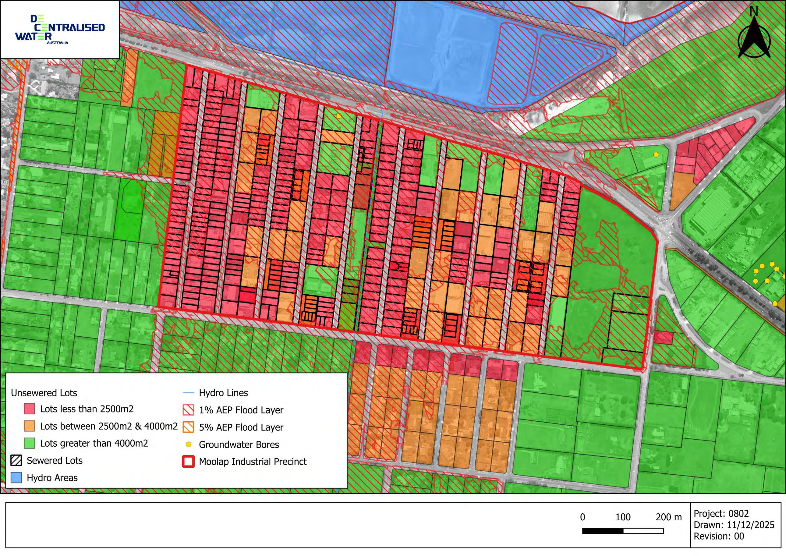
Figure 12 Moolap Industrial Precinct
8 Risk Management Guidance
This section documents the broad strategies that Council has available to manage the risks associated with current and future onsite wastewater systems. Determining the optimum mix of measures while guided by the risk assessment outcomes is also dependent on several other factors such as meeting Councils statutory role, available resourcing and stakeholder expectations.
Council understands and recognises that implementation of these strategies can only be successful with the collaboration and assistance of property owners, developers, Barwon Water and other external agencies. As such, Council is committed to developing and maintaining these important relationships. Council also acknowledges however that implementation is linked to the availability of current and future resourcing, and that continuation or commencement of management programs during the plan period may be dependent on budgetary changes.
The diagram below shows the key risk management areas with further details addressing specific strategies provided in the following sub-sections.
Figure 13 Available Risk Management Measures
8.1 Future Development
The following section summarises the risk management measures and guidance applicable to new or proposed on-site systems and unsewered development. It has been prepared based on legislative requirements, Victorian government guidelines and Australian Standards.
8.1.1 Existing Small Lots
Developing existing small lots in unsewered towns increases risks to public health and the environment due to the potential for effluent to move off-site. This issue often arises from limited land availability for effective effluent management and inability to achieve sufficient setback distances to receiving environments.
Potential strategies available to manage potential risk are discussed below.
• Connection to reticulated sewer. Investigate the feasibility of connecting the lot to a reticulated sewer service where available.
• Investigate (Council and Barwon Water) alternative options for wastewater servicing of small lots where wastewater cannot be contained.
• Completion of land capability assessment in accordance with the Victorian Land Capability Assessment Framework (MAV, 2014), Guideline for onsite wastewater effluent dispersal and recycling systems (2024) and Guideline for onsite wastewater management (2024)
• Alignment of scale and characteristics of proposed development with land capability assessment outcomes and the ability to sustainably manage wastewater onsite.
• Provision of higher level treatment such as secondary or tertiary treatment and more sophisticated effluent dispersal technologies.
• More stringent operational conditions for monitoring of performance and reporting to Council.
8.1.2 Cumulative Impacts
Historical unsewered subdivision in the City has resulted in the creation of lots that are space constrained from a wastewater management perspective. Council continues to manage these existing risks as individual small lots are developed or redeveloped (see Section 8.1.1). Under the Planning Scheme, all new unsewered lots (i.e. created through
subdivision) must be a minimum of 4,000m2 unless connected to a reticulated sewerage system. Minimum lots of 4,000m2 typically provide sufficient available area for on-site management of wastewater in a safe and sustainable manner. Previous work undertaken in NSW and Victoria also supports 4,000m2 as a minimum lot size that adequately manages cumulative impacts to water quality.
All future unsewered subdivision will be required (deemed to comply) to propose lots greater than or equal to 4,000m2 in addition to demonstration that standard setback distances from (EPA Victoria, 2024) can be achieved. Where this is not the case, off-site and cumulative impact risks shall be evaluated via modelling with guidance provided in Section 4.7.1.5 of the Effluent Dispersal and Recycling Guidelines (EPA Victoria, 2024).
8.1.3 Potable Water Supply Catchment
The only area of Geelong LGA with a Potable Water Supply Catchment is a small area in Straughton Vale. The area is a public conservation zone consisting mostly of bushland. There is currently no interaction between onsite wastewater systems and this catchment zone. Given the zoning of this land, it is unlikely that there will be any future onsite systems within the catchment.
8.2 Permit Applications and Land Capability Assessments
Permit applications seeking approval for the installation of new onsite systems provides Council with the opportunity to maximise good long-term outcomes through completion of a systematic assessment process. Four important assessment areas are available for Council to achieve good installation and operational outcomes: the assessment process itself, evaluation of land capability assessments, appropriate conditioning of installation and operational standards and post installation assessment (i.e., approving for use).
8.2.1 Permit Application Assessments
Permit applications are assessed by Council’s Environmental Health Team. Upon receipt, the assessing officer determines whether a Land Capability Assessment (LCA) is required, based on the nature and location of the proposal.
Due to the range of site constraints and environmental risks across the municipality, Council generally prefers secondary treatment in areas requiring higher protection. General guidance on when an LCA and/or secondary treatment may be required is provided in the table below. Typically, the following guidance applies:
• If one or more of these conditions are encountered an LCA is required
• If two or more of these conditions are encountered secondary treatment is required
This guidance is not exhaustive, and Council may at their discretion request that an LCA or secondary treatment is required to satisfy an application. Applications may also be subject to other requirements such as effluent quality standards and minimum setbacks in accordance with the Guideline for Onsite Wastewater Management (2024).
Table 6 Hazards typically requiring an LCA, secondary treatment or specialist design
Hazard / Constraint
High Groundwater and High Permeability
(<1m depth and Category 1-2 soils)
Small Lot Size i.e.
<4000 m2
Already Developed / Constrained Blocks
Low Permeability Soils
(Category 5 and 6 from AS1547)
High Sodicity or Dispersive Soils
Shallow Soils / Rock
(<0.6m from point of application)
Why It May Trigger the Need for Secondary Treatment
Reduces vertical separation for pathogen removal; increases risk of groundwater contamination or effluent surface ponding.
Limited space for effluent dispersal; reduced buffer distances to boundaries, and other sensitive receptors.
Existing infrastructure (buildings, driveways) may limit options for LAAs.
Poor infiltration can be further exacerbated by the application of primary effluent, due to the formation of a biofilm in LAAs.
Sodic/dispersive soils can break down on wetting, leading to structural failure, and reduced infiltration.
Limited vertical separation and storage capacity; increases risk of system failure or effluent surfacing.
Why Primary May Still Be Acceptable 13
If groundwater is seasonal, and engineered systems such as Wisconsin mounds ensure separation, risk can be managed.
If setbacks are met and soils are favourable, a properly designed and installed primary system may still be suitable.
A detailed site assessment may identify sufficient area for a properly designed and installed primary system.
If large LAA is available and soil conditions are stable, effluent can still be managed by a properly designed and installed primary system.
Soil amendments may stabilise soil sufficiently for primary effluent dispersal.
Engineered systems such as Wisconsin mounds or raised systems can provide separation from subsurface hazards,
13 All permit applications for primary treatment systems on sites featuring one or more of these constraints must be accompanied by a Land Capability Assessment in accordance with (Municipal Association of Victoria, 2014).
Hazard / Constraint
Flood-Prone Areas
Why It May Trigger the Need for Secondary Treatment
Presence of rock can facilitate ‘short circuiting’ of effluent from the point of application to groundwater bodies.
Risk of inundation of tanks or LAAs; potential for system failure and environmental harm during floods.
Why Primary May Still Be Acceptable 13
Steep Slopes (>10%)
Proximity to Sensitive Environmental Receptors
Increases runoff and erosion potential; secondary effluent allows for more controlled distribution methods (e.g. PC drip subsurface).
Higher risk of nutrient or pathogen transport into sensitive receptors.
8.2.2 Land Capability Assessments
Well-vegetated and stable slopes with stormwater diversion may still suit primary treatment with careful design.
Adequate setback distances, suitable soils, and proper design may still enable dispersal of primary effluent.
In some cases, an LCA is required to support a permit application with Council. An LCA is an assessment of the local site and soil conditions in order to identify and address any constraints to the onsite management of wastewater. All LCAs need to be prepared in accordance with the Victorian Land Capability Assessment Framework developed by the Municipal Association of Victoria (Municipal Association of Victoria, 2014), which provides a consistent methodology for assessing land suitability for onsite wastewater management. It should also be consistent with relevant elements of AS1547:2012 (Standards Australia, 2012).
An LCA must identify and address any constraints to wastewater management on the site, including but not limited to;
• Soil type, depth and permeability
• Soil chemistry – including laboratory analysis of Cation Exchange Capacity (CEC), Electrical Conductivity (EC), Emerson Aggregate Class (EAC), pH, sodicity, and Soil Absorption Ratio (SAR)
• Site topography
• Local climatic conditions, specifically rainfall and evapotranspiration
• Any sensitive environmental receptors such us surface waters or groundwater
• Special catchment zones
An LCA should also provide detail on the OWMS proposed for the site and how it adequately mitigates and manages risk to health and/or the environment The LCA should provide justification for the chosen treatment technology and it’s suitability for use on the site. If the OWMS is to be a secondary treatment process (typically the preference of the City) then it should be an independently certified system under the Australian Standard (AS1546.3:2017).
The size of the proposed OWMS should be based upon the anticipated wastewater flows on the site and an estimation of wastewater generation rates should be provided as part of the LCA. This should be supported by calculations for estimated wastewater volumes, based on the anticipated usage/occupancy of the site and accepted wastewater generation rates from the Guideline for Onsite Wastewater Management (EPA Victoria, 2024)
8.2.3
Minimum Installation and Operational Standards
If a permit application is accepted by Council, then the proposed OWMS must be installed in accordance with the following:
• EPA Victoria’s Guideline for Onsite Wastewater Management, 2024
• EPA Victoria’s Guideline for Onsite Wastewater Effluent Dispersal & Recycling Systems, 2024
• The Australian Standard for Onsite Wastewater Management, AS/NZS 1547:2012
8.2.4 Approving for use
A Certificate of Use must be obtained from Council in order to commence operation of an on-site system as a condition of Permit (A20) approval. In order to obtain this certificate applicants will be required to demonstrate that the system has been constructed and commissioned in accordance with all conditions of approval and stamped plans. This certificate of use is required in order to issue an occupancy certificate for a development.
8.3 Onsite System Inspections and Data Collection
At present, Geelong City Council does not have a formal inspection program in place for existing onsite wastewater management systems (OWMS). Like many regional and periurban councils, ongoing resource constraints have meant that statutory obligations such as permit assessments and responding to complaints must be prioritised over proactive monitoring.
Council recognises that a lack of routine inspections limits its ability to verify compliance with permit conditions, assess the long-term performance of installed systems, or systematically identify risks to public health and the environment. The establishment of a General Environmental Duty under the Environment Protection Act 2017 does place additional obligations on property owners that Council are required to regulate.
Council strongly supports the development of a long-term inspection and monitoring program for all OWMS in the municipality. A future program would aim to:
• Verify that systems are functioning as approved and in accordance with permit conditions
• Ensure maintenance schedules are being met, particularly for secondary treatment systems
• Identify failing or high-risk systems requiring upgrade or intervention
• Improve data quality and strategic planning around wastewater risks
Council intends to explore options for staged implementation of a monitoring program as resourcing allows, with priority given to high-risk areas or systems. Over time, this may include proactive inspections, database improvements, and increased engagement with landowners on system maintenance responsibilities.
8.4 Record and Data Management
Accurate and up-to-date records of onsite wastewater management systems (OWMS) are critical for effective oversight, strategic planning, and risk management. A comprehensive understanding of the number, type, location, and condition of systems within the municipality enables Council to better identify potential risks to public health and the environment, target education and compliance efforts, and plan for future service needs.
Council records should aim to include the following information for each onsite system where available:
• Property address and owner details
• System type (e.g. septic tank, aerated wastewater treatment system, sand filter)
• Date of installation and permit approval
• Details of the treatment and land application system (e.g. trench layout, irrigation type)
• Permit conditions, including any maintenance or servicing requirements
• Supporting documentation such as land capability assessments and asconstructed drawings
At present, the primary opportunity to collect this information is during the permit approval process for new systems or significant alterations. Due to the absence of a proactive inspection program, there are limited opportunities to update or verify information for legacy systems installed prior to permit data being digitised or standardised.
Council recognises the importance of improving the completeness and accessibility of OWMS records and will continue to seek opportunities to enhance its internal data systems over time.
To help supplement the existing dataset, Council may explore the use of a voluntary mailout survey to OWMS property owners. Such a survey could gather additional information about older systems, including the system type, age, condition, and maintenance practices. This data would help fill current knowledge gaps and inform the planning and prioritisation of future inspection or education programs.
8.5 Customer Request Management, Complaints and Compliance
Poorly operating onsite wastewater systems can pose risks to human health and the environment as well as causing nuisance to neighbours through impact on local amenity such as odour. Council staff will respond to requests and complaints in accordance with legislative provisions and Councils Complaints policy.
When a complaint is received, Council staff will review existing information about the property and its onsite system. The complainant is contacted to confirm the details of their concern, as information may occasionally be unclear or incomplete when passed through customer service.
An initial assessment may involve contacting the property owner to arrange a site inspection or conducting a door knock. Depending on the issue, Council staff may provide education, advice, or a direction to rectify the problem. A timeline for action is ag reed upon and follow-up is undertaken to confirm whether the issue has been addressed.
If the issue remains unresolved, further time may be provided where appropriate. In situations involving serious or imminent risks to public health or the environment, or where permit conditions have not been met, enforcement action may be required. Council prioritises resolving matters cooperatively in the first instance but will utilise its regulatory powers under relevant legislation where necessary.
8.6 Wastewater Information and Resources
Information and resources relating to onsite wastewater management systems are available on Councils website. The information is reviewed regularly and updated to reflect changes in legislation, policy changes and updates to wastewater guidelines. Information is available on permit requirements and application forms, fees and charges, land capability assessments, operating and maintaining an OWMS, dealing with system failure and general resources.
8.7 Township Risk Management Options
Assessing and managing risks associated with onsite wastewater systems at a township level is important for safeguarding public health and protecting the environment. Each township faces unique conditions that influence the effectiveness and potential impacts of wastewater systems, including factors such as population density, lot size, soil characteristics, topography, and proximity to sensitive receiving environments. This section builds on the findings of the township wastewater characterisation by assigning one or more risk management options tailored to address specific challenges identified for each township. Included is a table detailing risk management options that are suitable in responding to various township identified challenges (Table 7), followed by a matrix table (Table 8) indicating suitable management options applicable to each township. By using this framework, Council can make informed decisions on selecting and implementing risk management measures that best address local conditions and fulfill community expectations and regulatory requirements. The township response matrix should be regularly reviewed through the plan period to ensure that it remains upto-date and relevant.
- Update Council records.
- Community engagement - Data collection - Education and information Gather system data through a mail-out to property owners (type, age, LAA type).
- Evaluate data.
- Develop and implement response options based on the data.
- Community engagement - Data collection - System operating performance
- Regulatory compliance - Education and information
Develop and complete an inspection program of systems located within the township zone.
- Update Council records.
- Evaluate data against regulatory requirements and wastewater guidelines.
- Develop and initiate response to owners of systems identified as not containing onsite, operating poorly or not meeting regulatory provisions.
- Sewerage planning - Stakeholder engagement Engage with the appropriate water authority on undertaking a sewerage feasibility investigation of the town. Seek funding and resourcing options to fund the study.
Table 8 Township Management Option Matrix
Breamlea
Barwon Heads
Portarlington Moolap
9 Action Planning
Action planning is an important process designed to bring together the outcomes from the work associated with achieving the five plan objectives into a list of action tasks for implementation It involves identifying specific actions, assigning responsibilities, and setting timelines that address potential issues. This structured approach helps to ensure that all aspects of the management plan are addressed systematically thereby reducing the risk of failure, ensuring compliance with Councils statutory obligations and meeting community expectations. Additionally, action planning facilitates communication and coordination among stakeholders, ensuring that everyone involved is aware of their roles and the progress of the plan.
9.1 Previous Action Plan Review
In developing the Action Plan for this current OWMP, a review of the previous actions arising from Councils Domestic Wastewater Management Strategy (2007).
This section documents the outcomes from a review of the Action Plan from the 2007 Domestic Wastewater Management Strategy. The purpose of the review is to:
• Identify and recognise actions that have been successfully completed or implemented.
• Identify and evaluate the barriers to completion of actions that were unable to be completed or implemented. What prevented the action from being commenced, completed or implemented.
• Determine if incomplete actions remain relevant to the new plan and align with either the risk assessment outcomes, Councils strategic objectives, statutory requirement or stakeholder expectations.
The outcomes from the review are presented in the table below
Review Outcomes of 2007 DWMP Action Plan
Legislation/Codes of Practise
Discuss with the EPA the merits of giving Council the power to remedy septic tank systems that are operating in accord with their permits but do not satisfy current standards 1 Env. Health EPA, MAV
Discuss with the EPA the feasibility of introducing a legislative provision to allow Council to stipulate a minimum life span for septic tank systems in the permits to use
Discuss with the EPA the merits of giving Councils the same power as Water Authorities to repair septic tank systems and retrieve the costs from homeowners
14 Low = Actions that can be undertaken using existing resources and/or requiring minor additional resources
Medium = Actions that require further investigation and/or a reasonable level of additional resources
High = Actions that require significant investigation and/or potentially significant resources.
(City of Greater Geelong, 2007, Appendix A)
EPA unlikely to make any changes to existing legislation. Existing legislation does provide Council with some capacity to remedy.
Remove
Discussed with the EPA but not progressed Remove
EPA unlikely to make any changes to existing legislation Remove
Request the EPA to ensure that the proper legislative framework is in place to encourage greater re-use of grey water
Policy
Develop a policy position on the re-use of grey water in sewered and unsewered areas (including rural areas). The policy should identify what, where and when it will be allowed, the processes for approval, who will manage and how it will be funded
Planning
Develop a protocol for the referral of planning applications to the Environmental Health Unit. The protocol should identify the range of applications that will be forwarded and timelines for responses
Identify and map the vacant blocks in the unsewered townships which could be unsuitable for development. Give consideration as to what action should be
EPA unlikely to make any changes to existing legislation
already have a guidance document on greywater.
GIS polygon layer of estimated unsewered lots has been produced as part of the Risk Assessment.
taken with respect to these blocks –advising the owners, requiring consolidation with adjacent vacant blocks prior to development, changing the zoning of the blocks.
Investigate the merits of advising owners of developed properties blocks that would be difficult to further develop from a wastewater perspective of the limitations of their properties. Introduce the system.
Ask Barwon Water to identify developed properties in sewered areas that are not connected to sewer. Determine which properties should be connected to sewer and either ask Barwon Water to force connection or issue a nuisance notice from Council requiring connection if appropriate
Request the Planning Office where feasible to require developers of blocks near sewer, through a condition on the permit, to connect to the sewer
Env. Health, Planning, GIS, Rates
Env. Health, Planning Barwon Water Low
Advice will be provided to owners when/if permit application is lodged
Env. Health, Planning Barwon Water Low
Barwon Water’s enforcement of connection is outside the control of Council Remove
Environmental Health Department currently provides direction on this to the Planning department
Approval processes and record systems
Require Building Surveyors to submit ‘report and consent’ forms for all house extension projects in unsewered areas (not required if a permit to install a septic tank system has already been issued)
Review the fees charged for ‘report and consent’ forms and the process of submission. Investigate the feasibility of sending forms directly to the Health Unit not through the Building Dept.
Reaffirm to Building Surveyors that a certificate of occupancy is not be issued until a permit to use the septic tank is issued. Request Building Surveyors to advise their clients that their house should not occupied, or the septic tank system used until a permit to use is issued
Identify the reports that are required from the Pathways systems and write the appropriate program
Education Program
Introduce a wastewater management community education program. The components of the program should be as follows:
An education kit for homeowners on the proper use and maintenance of septic tank systems. The kit should be specific to the types of system installed at the property. This should include statements/information on:
- The importance of knowing the location of the septic system and making sure it is accessible and what type of septic tank system has been installed and how if functions
- The importance of not driving over the septic tanks system and of considering the septic tank when planning any extension to the house or other project which might impact on the septic tank system
Information already on our website that provides information and we send links to this info to the property owner when issuing the Approval to Use . Remove
- The vegetation that is suitable to plant around septic tank systems
- The importance of and advice on water conservation practices
- The importance of regularly desludging septic tanks and emptying grease traps
- The things that could typically go wrong with the system and how the homeowner should respond.
- The things that do go wrong when owners attempt to repair or upgrade systems without reference to experienced drainers/plumbers and Council
- A notice indicating that systems cannot be altered without Council’s consent and a suggestion that they always contact Council before undertaking any works other than basics repairs on their systems
Developing an education kit for new homeowners which provides the same information as above. Meeting each new owner to explain kit
Env. Health, Public Relations
Conducting annual forums with plumbers, treatment plant installers, maintenance contractors, liquid waste removal contractors etc to discuss relevant waste management issues 2 Env. Health Plumbers, Maintenance contractors, Liquid waste removal contractors
Investigate the best mechanism for advising prospective purchasers of unsewered properties, of the implications of the property not being sewered – e.g. maintenance of septic tank system, potential restriction on development etc. Introduce the process
Monitoring Activities
Introduce a monitoring program of onsite wastewater management systems. This monitoring program should involve the following: 2, 3, ongoing
Env. Health, Rates Barwon Water, Local solicitors, Real estate agencies, Conveyancing firms
Env. Health, Finance, Tendering Barwon Water High
It is something that Council have considered implementing but discarded due to resource limitations. May be reconsidered in future if resources become available. Remove
- Inspection of 50 township and 25 rural OWMS each year.
- Ensuring that tanks, pits, drains, etc are accessible and in good working order
- Ensuring that systems have not been altered and are not being driven on or built over
- Identifying the OWMS that are located near watercourse are ensuring that they are functioning properly
- Routinely sampling sand filter effluent
- Requiring rectification where there is a problem
Examine the feasibility of introducing a Council co-ordinated compulsory maintenance and monitoring program for treatment plants. This program should involve the following:
- Developing a register of treatment plants 2, 3, ongoing
- Engaging contractors through a tender process to monitor systems
- Coordinating the visits by maintenance contractors
- Coordinating the annual water sampling process
- Arranging repair works
- Arranging payments homeowners
If not feasible, revert to systems where owner is responsible. This will involve the following:
- Developing a register of treatment plants
- Sending a letter to owners requiring them to arrange inspection of their systems and submission of reports and water samples
- Matching reports and samples against register
- Following up/sending notices to owners who are not submitting reports
- Requiring rectification works where necessary
Explore the feasibility of introducing a centrally run, compulsory desludging program. This would involve:
- Confirming that Barwon Water can receive greater volumes of sludge at their treatment plants
- Developing a register of septic tank systems
- Developing a program for desludging
- Engaging contractors
- Coordinating desludging
- Arranging payments from homeowners 3, ongoing Env. Health, Finance, Tendering Barwon Water
If not feasible, introduce a program for advising residents when their tanks are due for desludging 3, ongo ing
Health Barwon Water
Undertake quarterly water sampling at the locations listed in Table 13 of the 2007 DWWMS.
(Ceres, Breamlea, Batesford, Fyansford, Moolap, Avalon Beach)
Townships
Adopt a policy that only treatment plants can be installed in areas with high water tables – Breamlea, Moolap, Port Arlington, Barwon Heads.
Request Barwon Water consider the provision of sewer to Moolap, Breamlea, Port Arlington (Ramblers Rd) and Barwon Heads (Stephens Parade)
Upgrade old systems in all townships when the opportunities arise
Identify the source of grey water discharges in Anakie and Ceres and either require that the discharges be contained on-site or improve treatment before discharge
No policy has been written/adopted Instead, Council have adopted a preference for secondary treatment for all OWMS’s at these locations.
Undertake quarterly water sampling at the locations listed in Table 13.
Funding
Investigate funding sources, including a special charge, for implementing this action plan
9.2 New Action Plan
A strategic and systematic approach has been adopted in development of the action plan. This approach is designed to assess and improve overall onsite wastewater management program performance and effectiveness with the aim of maintaining amenity and reducing risk to human health and the environment. By evaluating available data, program outcomes and stakeholder feedback, the City of Geelong have developed this new action plan that achieves Councils statutory obligations, community expectations however considerate of available resourcing. The plan is not a wish list of new or modified programs, activities or tasks but a list of specific actions considered relevant to Geelong that are realistic and achievable within the period of the plan or beyond.
In developing the action plan the following broad elements have been reviewed and/or considered.
• Legislative changes since development of the previous DWMP.
• Council plans and policies.
• Changes to guidelines and standards.
• Review of the previous DWMP action plan.
• Risk assessment outcomes discussed in this plan.
• Review of current wastewater operational program outcomes (e.g., inspections).
• Evaluation of the current permit application process.
• Stakeholder feedback (Water Authorities, property owners, consultants and system operators), and
• Available resourcing.
Specific action tasks have been separated into the following two groups depending on an alignment with strategic or operational intent.
Strategic Actions involve actively changing and/or improving wastewater related processes, procedures, and infrastructure that support council’s the onsite wastewater program (operations). This includes two distinct sub-elements. The first involves identifying and implementing improved practices, optimising workflow efficiencies, and ensuring that adopted systems are aligned with legislative provisions, strategic objectives and customer needs. The second sub-element involves strategic actions that aim to address specific risks or issues in particular locations where there is a significant risk to human health and/or the environment. This might include targeted investigations in a
specific unsewered town or locality to better understand risk or evaluate options for improves wastewater servicing.
Operational Actions involve day-to-day activities and tasks performed within the existing onsite wastewater management program to ensure that wastewater related activities operate smoothly, effectively and are consistent with legislative requirements.
Township or Locality Specific Actions are addressed in Section 8.7 as they are an outcome of the risk assessment process.
The developed actions have been evaluated against several criteria to provide guidance on priority, resourcing responsibility, implementation period and measures of success (MoS).
Task Prioritisation: this provides a guide to the level of urgency for task commencement or implementation. It has been subjectively determined based on the likely ability of the task to achieve real improvements in risk minimisation and with consideration to budget and resourcing.
Responsible Position or Team: this refers to the principal person or team responsible for managing or implementing the action tasks.
Resourcing: this provides an indication of Councils capacity to resource or fund the action task at the time of the plan development. That is, within available resources and funding or subject to future resources and funding.
Implementation Period: this provides an indication of the length of time for task implementation or completion. The task may be implemented for the period of the plan or other task/resource dependent time frame.
Measures of Success (MoS): measure of success refers to one or more criteria used to determine whether the action task has achieved the strategic or operational objectives.
The Action Plan is presented in Table 9 below
SA1 OWMP Revision
- Review and revise OWMP against requirements of OMLI and relevant guidelines.
- Undertake a suitable risk assessment (or update existing if applicable) that identifies and assesses the risk of harm to human health and the environment from onsite wastewater systems. Use the outcomes from the risk assessment to inform the plan.
- Review the Action Plan from the previous OWMP and use outcomes in plan review.
- Conduct community engagement to inform the plan.
- Develop suitable actions that address the identified risks.
- Consider the Planning permit applications in open, special water supply catchment areas guidelines where onsite wastewater management systems are in special water supply catchment areas.
High EH Team
Within existing resourcing and funding Complete prior to end of plan period (interval no more than 5 years)
MoS 1: Task completion.
MoS 2: Adoption of revised OWMP by Council within 5 years of previous plan.
MoS 3: Plan published on Council website.
SA2 Water Authority Engagement
- Notify the water authority in writing of any identified actions involving an alternative sewage management solution.
- Investigate the feasibility of developing a closer working relationship with Barwon Water through one or more meetings each year. The intent of the meetings is to facilitate information sharing on relevant matters such as sewage planning, proposed or existing developments, and land use planning. This could be an informal or formal arrangement through development of a (non-binding) Memorandum of Understanding (MoU).
SA3 Records Management
EH Team
SA4 Data Collection
- Review current system record attribute fields within existing database. Ensure the following attributes are captured in Council records: date of install, treatment process/type, land application type, location (including GIS location), date of any inspections,
- Investigate feasibility of growing the onsite system database (i.e., system type and location). An example of how this could be achieved is through a survey (online and mail out) or brief non-regulatory inspections.
Medium EH Team
Within existing resourcing and funding
Complete throughout the plan period
High EH Team
Within existing resourcing and funding
Subject to future resources and funding
Period of plan
Completion of one or more meetings within the plan period.
Period of plan
Database is successfully modified resulting in the ability to capture additional wastewater related attributes.
MoS 1: Successful task completion.
MoS 2: Increase in the
High
number of onsite records.
SA5 Permit Applications
SA6 Inspection program
- Review current permit application assessment process against revised EDRS Guideline (2024) to determine opportunities for improvement.
- Implement assessment improvements if available and achievable.
- Undertake a review of the current inspection program to determine drivers for change and opportunities for improvement.
- E.g., General increase in the number of inspections performed within unsewered townships with a high-risk wastewater profile identified from risk assessment outcomes.
- E.g., Targeted inspections related to planning proposals or unsewered subdivision developments to inform assessment and decision making.
High EH Team
Medium EH Team
Within existing resourcing and funding Year 1 Process is modified in line with EDRS Guideline.
SA7 Planning Proposals
- Build relationships with internal staff and external stakeholders on proposed future development of unsewered areas to elevate importance of wastewater with intent of achieving sustainable outcomes that align High EH Team
Subject to future resources and funding Period of plan
MoS 1: Successful task completion. MoS 2: Inspection program is revised and implemented based on task outcomes.
Subject to future resources and funding Period of plan Planning proposals are successfully determined based on wastewater outcomes.
SA8 Education and Information
Operational Actions
with regulatory requirements, community expectations and contemporary guidelines.
- Develop policy recommendations and/or a guideline that informs future developments in areas and townships without access to sewer.
- Review and update wastewater information on Councils webpage to ensure currency.
Medium EH Team
Medium EH Team
Subject to future resources and funding Period of plan Development and adoption of policy or guideline.
Within existing resourcing and funding Period of plan
Successful task completion.
OA1 Permit Applications
OA2 Inspection Program
- Continue to assess permit application against regulatory requirements and internal procedure.
High EH Team
- Continue to perform inspections of wastewater systems in accordance with current procedure, schedule and resourcing.
- E.g., Customer request based.
High EH Team
Within existing resourcing and funding
Period of plan
Permit applications are received, assessed and approved in accordance with regulatory requirements.
Within existing resourcing and funding
Period of plan
Increase in number of inspections performed.
OA3 Customer Requests Management and Complaints
OA4 Planning and Building Permit Applications
- Wastewater related customer requests are received, assessed and completed in accordance with Council CRM and complaints policy and timeframes.
OA5 Records Management
- Regularly review the permit application process to ensure that onsite wastewater applications include assessments from qualified consultants, demonstrating compliance, sustainability, feasibility, and constructability
High EH team
OA6 Review and Reporting
- Continue to use existing Council database to its full potential to capture wastewater related data.
High EH Team
Within existing resourcing and funding Period of plan
CRMs are satisfactorily completed within required time frames.
- Review, assess and report on the progress of the Onsite Wastewater Management Plan implementation and action plan.
High EH Team
Within existing resourcing and funding
Period of plan
Conduct one or more reviews within the plan period
High EH Team
Within existing resourcing and funding Period of plan
Increase in the number of wastewater records
Within existing resourcing and funding
Period of plan Plan implementati on report published on Council website.
Appendix 1 Catchment Based Risk Assessment (Atom Consulting, 2022)
The following methodology was followed in applying the DEECA Risk Tool to Geelong LGA Council.
Appendix 1.1 Data Collection
The table below summarises each of the different data inputs to the risk tool, along with their source.
Catchments and sub-catchments
Special Water Supply Catchments (where relevant)
Risk points (health and environmental receptors)
On-site System Data
- Number / location
- System type
- Age
- Desludge period
Soil type
Lot size and Proximity
- Cadastre
- Watercourses / bodies
- Flood plain
- Groundwater bores
- Groundwater depth
Topography (slope)
Data Vic. (Melbourne Water)
Data Vic.
N/A
Council (partial availability)
Data Vic and VRO
GIS analysis
GIS analysis of distance to offtake
Determined by Risk Tool framework
Data Vic or Council (flood)
GIS analysis of existing data and extrapolation based on a set of agreed assumptions.
GIS and expert analysis of landscape data against AS1547 soil class.
GIS analysis
Data Vic.
GIS analysis using DEM
Rainfall data
- Average annual rainfall
- No. of days rainfall exceeds 10mm
Data Source Method of Determining
BOM
GIS analysis
Because the Risk Tool requires data points for each onsite system in the LGA, it was necessary to develop a way to ‘fill the blanks’ in the council records provided by Geelong Because Council records changed over to being digital around INSERT YEAR, there are many wastewater systems throughout the LGA which are not captured in their digital records. In consultation with Council, DWA developed the following methodology to estimate the number and location of these systems missing from Council records.
• Take the Building Point Layer for the LGA
• Reduce the number of building points such that there is only building point per Lot.
• Assume a primary septic discharging to trenches is present at this location. This estimation is based upon the following assumptions:
• Most lots containing a building will also contain a wastewater system.
• Most wastewater systems installed prior to the introduction of digital records, or installed without a permit are likely to be septic tanks discharging to trenches. All building points within the sewered areas of the LGA were excluded from the data set.
In addition to estimating system locations, it was also necessary to make some assumptions about the data which was provided. Desludge frequency was not available in the recorded data, treatment system age was used without accounting for desludging frequency. Furthermore, whenever the provided data point did not contain system type or dispersal type, it was assumed that these systems were primary septic tanks discharging to trenches.
To use the soil landscapes data in the analysis an AS1547 soil class had to be assigned to each of the landscapes within the LGA. To do this, DWA interrogated each soil landscape, and applied a soil classification based on a professional judgement.
It was also necessary to assign ‘risk points’ to be used in the risk assessment process. The DEECA Risk Tool makes an assessment based on the estimated risk posed to a specific receiving end point. In the case of Geelong, the following receiving waters were selected
as the risk points to be used in the assessment: Little River, Hovells Creek, Cowies Creek, Yarram Creek, Moorabool River, Moorabool Basin, Barwon River, Thomson Creek and Barwon Basin. In addition to these major waters, all catchments draining directly to the ocean were assessed together with the receiving body being the ocean.
Appendix 1.2 GIS Processing
Before inputting the data into the risk tool, GIS processing was essential. This process entailed buffering spatial features such as watercourses, bores, and SWSC offtakes. Subsequently, all pertinent datasets were integrated with the onsite system data, ensuring that each data point encompassed attributes from all other relevant datasets.
The following data was ‘joined’ with each of the onsite data points:
• Site slope
• Proximity to surface waters
• Proximity to groundwater bores
• Proximity to Special Water Supply Catchment offtakes
• Intersection with flooding overlays
• Localised rainfall data
• Soil classification
9.2.1
Risk Analysis Results
Once all of the GIS processing was completed, the now update onsite system data was exported to an excel spreadsheet. This spreadsheet was used to provide all the necessary inputs to the Risk Tool. All risk assessment results have been provided below as maps.
Appendix 2 Stakeholder Engagement and Community Consultation
CITY OF GREATER GEELONG
Wadawurrung Country PO Box 104
Geelong VIC 3220
P: 5272 5272
E: contactus@geelongcity.vic.gov.au www.geelongcity.vic.gov.au
© City of Greater Geelong 2026
LATEST NEWS:
@CityofGreaterGeelong
@GreaterGeelong
@CityofGreaterGeelong
CityofGreaterGeelong