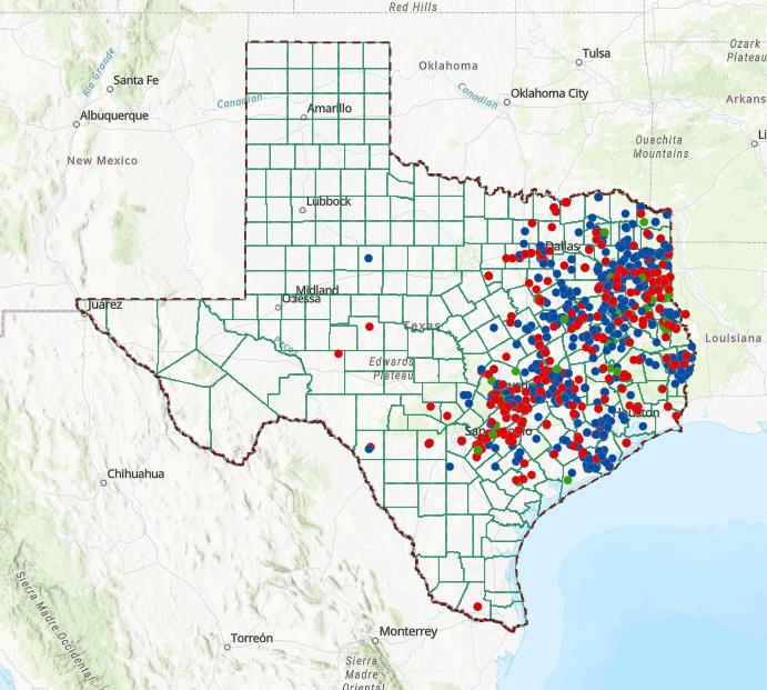


This booklet provides guidance on using The Texas Freedom Colonies Atlas.�� Information in the Atlas is organized by layers, and each layer displays a different kind of data. This booklet specifically covers layers that will help you identify the U.S. House of Representatives district (congressional district) in which your Freedom Colony is located.
Within this booklet, you will find: A glossary of mapping and political terms
Instructions for accessing U.S. House district layers
Tips for interpreting U.S. House district layers alongside other Atlas layers
Tools and information that project descendants, community members, and stakeholders can use to communicate with lawmakers
The definitions of words and terms in bold blue font throughout this booklet can be found in the glossary on the following page.
Whenever you see this icon, it means that a QR code to quickly access the resource is listed at the end of the guide in the “Scan and Explore” section.
demographic: related to or describing the characteristics of a group of people in a particular place district: a division of a town, city, or state made for political administration purposes. In this guidebook, the districts referred to are United States House of Representatives district. Each district has an elected representative. Texas has 38 districts and thus 38 representatives.
layer: an element of an online map, like the Atlas, containing specific information like district boundaries or demographic information. Layers can be turned on and off, and you can turn on more than one layer at once to compare the information in each.
stakeholder: anyone who can affect or will be affected by a solution, decision, or project
On August 20, 2025, the Texas State House passed House Bill 4 (HB4), approving maps redrawing five U.S. House of Representatives districts. The Texas State Senate passed the maps three days later on August 23, 2o25, and Gov. Greg Abbott signed the bill into law on August 29, 2025.
The redrawn districts are largely in racially and ethnically diverse areas. There are Freedom Colonies in many redistricted areas.

Photo credit: Jonathan Cutrer, https://jcutrer.com/photos/
1. Click on "The Atlas: Map & Database” in the right-hand menu to view the Atlas. ��
2. Agree t0 the terms and conditions of using the Atlas
3. Select the icon in the upper right-hand corner in the green bar that looks like a stack of paper. This is the list of the Atlas’ layers.
4. Click the checkboxes next to “Current Districts” and “Proposed New Districts” to turn on the layers

5. Click within the red or blue district boundaries on the map to learn more about a district (see next page).

The Former Districts layer (blue lines) will tell you: the name of your district’s representative the district number
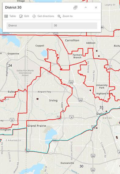
The New Districts layer (red lines) will tell you: the district number
Because representation may change during redistricting, the New Districts layer will not give you the name of a representative. You can use the resources on pages 9 and 10 to find the name and contact information of your new representative.
As you will see on the following pages, combining the district layers with demographic or Freedom Colony layers can help visualize how Freedom Colonies might be affected by redistricting.
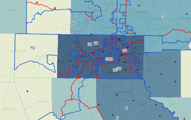
You can turn on the congressional district layers at the same time as other layers. For example, the Atlas also has a layer named “% African American Population by County 2020.” When you turn on this layer, the higher the percentage of African Americans living in a county, the darker blue the county will be. In the example above, from the DallasFort Worth area, turning on the congressional district layers and the population layer at the same time shows that redistricting occurred in an area with a high African American population.
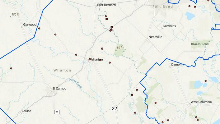

You can also examine how redistricting may impact Freedom Colonies. For example, this cluster of Freedom Colonies near Houston was previously in the 22 District (left). However, now that the district boundaries have changed, some Freedom Colonies will be in the 27 District (right). This means that the person representing this Freedom Colony may change. It is important to know which district your community is in if you are interested in contacting lawmakers.
THERE ARE MANY ACTIONS YOU CAN TAKE TO ENSURE THE FUTURE OF FREEDOM COLONIES. HERE ARE SOME RESOURCES TO GET YOU STARTED.
Texas Tribune – Redistricting Coverage
Nonpartisan coverage of redistricting and its impact on Texas communities.
https://www.texastribune.org/topics/redistricting/ ��
League of Women Voters of Texas
The League of Women Voters is a nonpartisan, grassroots organization working to protect and expand voting rights and ensure everyone is represented.
https://lwvtexas.org/#gsc.tab=0 ��
Voting Rights Issue Page
Voting Rights and Democracy ��
Texas Legislative Black Caucus
The Texas Legislative Black Caucus is an organization comprised of all of the state’s African American lawmakers.
http://txlbc.org/ ��
Not sure what congressional district your Freedom Colony is in? Find out on the U.S. House of Representatives website. www.house.gov ��
1st district: Nathaniel Moran (R) (since 2023)
2nd district: Dan Crenshaw (R) (since 2019)
3rd district: Keith Self (R) (since 2023)
4th district: Pat Fallon (R) (since 2021)
5th district: Lance Gooden (R) (since 2019)
6th district: Jake Ellzey (R) (since 2021)
7th district: Lizzie Fletcher (D) (since 2019)
8th district: Morgan Luttrell (R) (since 2023)
9th district: Al Green (D) (since 2005)
10th district: Michael McCaul (R) (since 2005)
11th district: August Pfluger (R) (since 2021)
12th district: Craig Goldman (R) (since 2025)
13th district: Ronny Jackson (R) (since 2021)
14th district: Randy Weber (R) (since 2013)
15th district: Monica De La Cruz (R) (since 2023)
16th district: Veronica Escobar (D) (since 2019)
17th district: Pete Sessions (R) (since 2021)
18th district: Vacant (since 2025)
19th district: Jodey Arrington (R) (since 2017)
20th district: Joaquin Castro (D) (since 2013)
21st district: Chip Roy (R) (since 2019)
22nd district: Troy Nehls (R) (since 2021)
23rd district: Tony Gonzales (R) (since 2021)
24th district: Beth Van Duyne (R) (since 2021)
25th district: Roger Williams (R) (since 2013)
26th district: Brandon Gill (R) (since 2025)
27th district: Michael Cloud (R) (since 2018)
28th district: Henry Cuellar (D) (since 2005)
29th district: Sylvia Garcia (D) (since 2019)
30th district: Jasmine Crockett (D) (since 2023)
31st district: John Carter (R) (since 2003)
32nd district: Julie Johnson (D) (since 2025)
33rd district: Marc Veasey (D) (since 2013)
34th district: Vicente Gonzalez (D) (since 2017)
35th district: Greg Casar (D) (since 2023)
36th district: Brian Babin (R) (since 2015)
37th district: Lloyd Doggett (D) (since 1995)
38th district: Wesley Hunt (R) (since 2023)
USE THE QR CODES AND SHORT LINKS BELOW TO QUICKLY ACCESS THE RESOURCES MENTIONED THROUGHOUT THIS GUIDE.
TEXAS FREEDOM COLONIES ATLAS
https://www.thetexasfreedomcoloniesproject.com/atlas
Referenced p. 4
https://www.texastribune.org/topics/redistricting/ Referenced p. 8
https://lwvtexas.org/#gsc.tab=0 Referenced p. 8
LEGISLATIVE BLACK CAUCUS www.txlcb.org Referenced p. 8
https://www.aclutx.org/en/issues/voting-rights Referenced p. 9
