Stamford Site Walk Handouts

Page 1


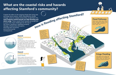
What are the coastal risks and hazards affecting Stamford’s community?

Coastal risk refers to the ongoing threat that rising seas and large storm events—both intensified by climate change—pose to coastal communities. In Stamford, the most frequent coastal hazards are tidal flooding and storm surge. These coastal flood hazards are projected to pose even more challenges for the City in the future, resulting in repeated property damage, infrastructure disruption, and long-term economic and environmental consequences.

Hazard

TIDAL FLOODING

Flood Pathways

Inlets and tidal channels saltwaterallow to push inland storms,duringflooding neighborhoods and infrastructure far from the shore

Coastal flooding can damage critical infrastructure— like roads, power lines, storm drains, and wastewater systems—causing service disruptions and expensive repairs

Inland areas flood when water enters through low-lying areas between higher grounds as water levels rise

Tidal flooding is the inundation of the coast by seawater from the ocean or tidally influenced water bodies. Flooding from high tides (“sunny day” flooding, king tides) will be experienced as a chronic stress due to sea level rise.

Hazard STORM

frequent event-based

SURGE

Storm surge is the quick rise in seawater level during a storm, measured as the height of the water above the normal predicted high tide. The surge is caused primarily by a storm’s winds pushing water onshore.

Wetlands are threatened by sea level rise, yet they play a vital role in absorbing floodwaters, limiting erosion, and shielding coastal communities

Low-lying areas along the waterfront are flooded as water levels rise above the existing ground elevation

and

Fringe Flooding

Understanding Stamford’s Geography

In 2024 the highest tide observed was 6 9* feet, which is almost the 2100 MHHW elevation!

The lowest elevation in 2024 was -5 35* feet, which means 12 25 feet tidal range!

The state anticipates sea level rise by 19 6 inches by 2050 and by 39 3 inches by 2100

* Elevation referenced to NAVD88 (North American Vertical Datum of 1988)

Tidal elevation source: NOAA, at Bridgeport

station

Hurricane Barrier

The Hurricane barrier was designed to reduce the risk from coastal flooding up to 13 69' NAVD88 stillwater elevation, plus 2' of storm surge The elevation at the top of the barrier ranges from 15 89' NAVD88 in the East and West branches, to 16 89' NAVD88 in Westcott Cove branch Source; USACE Hurricane Barriers in New England, September 2007

.

Cummings Pond .

tides

Mean Lower Low Water (MLLW) is the average height of the two daily low tides observed over a 19-year period Mean Higher High Water (MHHW) is the average height of the two daily high tides observed over a 19-year period

The Cummings Pond area, along with the Cove and East Side neighborhoods, are particularly vulnerable to flooding due to their low-lying elevation.

What is at Risk?

Reduced Risk

The area behind the Hurricane Barrier is designated as 'Area with Reduced Risk Due to a Levee' This zone indicates areas protected by an accredited levee system, while the risk of flooding is reduced, it's not eliminated  Area with

Prone to fringe flooding, this coastal inlet quietly overflows during high tides and storms, exposing the growing risks faced by nearby neighborhoods. Holly Pond

As water levels rise above the existing ground elevation, low-lying waterfront areas such as Shippan, Waterside, and Cove are increasingly affected These neighborhoods are more likely to experience flooding during high tides and storms, with water reaching and damaging streets, open spaces, and nearby buildings

In FEMA flood maps, Zone VE designates a Special Flood Hazard Area along coastlines where there is a high risk of flooding due to both inundation from the 1% annual exceedance probability (AEP) flood hazard and the added hazards of storm-induced waves VE zone

Adaptation Strategies

KEEP THE WATER OUT

FLOODWALLS AND DEPLOYABLES

BERMS AND LEVEES

TIDE GATES

Hazards addressed Hazards addressed Hazards addressed

Floodwalls are structures engineered to keep water out by physically blocking floodwaters. Deployable floodgates are mobile elements, integrated into static floodwalls, that are closed during flood events to fill gaps in protective barriers and prevent floodwater intrusion. They allow access in a “Sunny Day” and prevent floodwater intrusion during storms.

Berms and levees are raised earthen structures erected to protect from floodwater. They can support with recreational walkways and bike paths. Their natural sloped sides can be used for recreational purposes.

Tide gates are one-way valves for water, found at the openings of streams, culverts, or under small bridges. When water levels rise, tide gates close automatically or manually per type. This acts as a barrier, stopping saltwater from flowing inland and preventing flooding of homes, roads, and natural areas. When water levels are low enough, the gates remain open, allowing freshwater to drain out into the bay or ocean, which prevents inland flooding from backed-up freshwater.

Adaptation Strategies

ADAPT IN PLACE

WET / DRY FLOODPROOFING

Hazards addressed Applicable areas

ELEVATING STRUCTURES / RAISING CRITICAL SYSTEMS

Hazards addressed

Wet Floodproofing: Allows floodwaters to pass through lower levels of a building or structure, while limiting damage to the rest of it.

Dry Floodproofing: Seals off a building or structure using permanent or deployable barriers, keeping them usable and protecting assets and utilities below the Design Flood Elevation (DFE).

Elevated Structures: Reduces the risk during flood events, while allowing ground level to be used for storage or parking.

Raised Critical Systems: Reduces service disruptions and speeds up recovery, strengthening resilience for homes and businesses that may be impacted by flooding.

EMERGENCY ROUTES

By creating redundant routes, residents and emergency services can have mobility options during flood events when other, more susceptible routes are impassible. This strategy applies to instances where critical emergency routes are often compromised by floodwaters.

RETREAT

Hazards addressed Hazards addressed

Description

Relocating buildings, utilities, infrastructure, and assets away from flood-prone areas to safer zones, reducing long-term risk, damage, and recovery costs.

Adaptation Strategies

LEVERAGE NATURAL SYSTEMS

COASTAL FLOODING STRATEGIES

Hazards addressed

areas

RIVERINE FLOODING STRATEGIES

Hazards addressed

areas

STORMWATER MANAGEMENT

Hazards addressed

areas

Coastal Wetlands / Living Shorelines: Natural or restored vegetated edges that buffer wave energy, reduce erosion, and support habitat, while allowing water to flow through.

Constructed Reefs / Living Breakwaters: Offshore structures that break wave energy, reduce shoreline erosion, and enhance marine habitats by mimicking natural reefs.

Groins: Walls or barriers that extend from the shoreline into the water, built to trap sediment, control erosion, and maintain or widen beaches. They are designed to prevent sand from being carried away. Essentially, groins act as a barrier, causing sand to accumulate on the updrift side (the side facing the incoming current) while potentially leading to erosion on the downdrift side.

Stream Daylighting: Involves uncovering previously buried streams to restore natural flow, reduce flood risk, and improve water quality and habitat.

Culvert Modification: Upgrades undersized or blocked culverts to improve water passage, prevent backups, and support ecological connectivity.

Erosion Control: Focuses on preventing or mitigating soil erosion, particularly along stream banks, to protect them from degradation and maintain water quality.

Green Infrastructure: A resilient approach to managing stormwater runoff “by mimicking natural systems.” Unlike detention systems which typically discharge runoffs from a single outlet pipe, green infrastructure solutions are based on infiltration systems that allow accumulated water to percolate into subsoil, improving water quality and reducing pressure on the municipal stormwater system during storm events. Examples of such solutions are:

Bioswale: Vegetated courses located adjacent to, or along sidewalks to capture, detain, and infiltrate runoff from the streets.

Retention Ponds: Artificial retention ponds that promote infilration. By capturing runoff they can reduce downstream or localized flooding and enable groundwater discharge.

Living Breakwaters, NY (Source: SCAPE) Cummings Park, Stamford, CT (Source: beaches-searcher.com) Mill River Ecosystem Restoration Project at Stamford, CT (Source: Landzine.com)
Rippowam Place Bioswale, Stamford, CT (Source: City of Stamford)
Living Breakwaters Groins
Stream Bioswale

What does a more resilient Stamford mean to you?

Join the conversation-protecting Stamford’s future starts with you!

Resilience is the capacity of a community, business, or natural environment to prevent, withstand, respond to, and recover from a disruption

Use this

to learn more about the plan and share your thoughts!

Turn static files into dynamic content formats.

Create a flipbook
Issuu converts static files into: digital portfolios, online yearbooks, online catalogs, digital photo albums and more. Sign up and create your flipbook.