High-resolution digital terrain model of a rocky coastal site (Cala del Leone, Livorno, Italy) used for detailed geomorphological and hazard analysis within the AMIS project. © AMIS project / Liguria Region
Regional-scale wave modelling used to characterise marine forcing and extreme storm conditions affecting Mediterranean coastal areas. © AMIS project / LaMMA – CNR
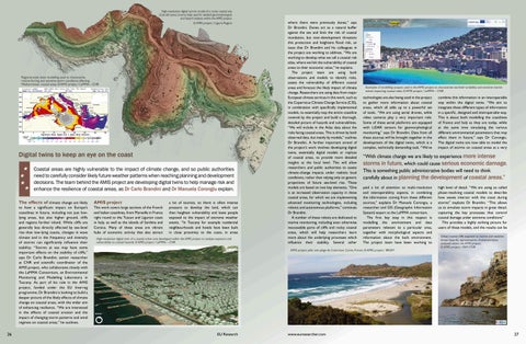
Digital twins to keep an eye on the coast Coastal areas are highly vulnerable to the impact of climate change, and so public authorities need to carefully consider likely future weather patterns when reaching planning and development decisions. The team behind the AMIS project are developing digital twins to help manage risk and enhance the resilience of coastal areas, as Dr Carlo Brandini and Dr Manuela Corongiu explain.
26
The effects of climate change are likely
AMIS project
to have a significant impact on Europe’s coastlines in future, including not just lowlying areas, but also higher ground, cliffs and regions further inland. While cliffs are generally less directly affected by sea-level rise than low-lying coasts, changes in wave climate and in the frequency and intensity of storms can significantly influence their stability. “Storms at sea may have some important effects on the stability of cliffs,” says Dr Carlo Brandini, senior researcher at CNR and scientific coordinator of the AMIS project, who collaborates closely with the LaMMA Consortium, an Environmental Monitoring and Modelling Laboratory in Tuscany. As part of his role in the AMIS project, funded under the EU Interreg programme, Dr Brandini is looking to build a deeper picture of the likely effects of climate change on coastal areas, with the wider aim of enhancing resilience. “We are interested in the effects of coastal erosion and the impact of changing storm patterns and wind regimes on coastal areas,” he outlines.
This work covers large sections of the French and Italian coastlines, from Marseille in France right round to the Tuscan and Ligurian coast in Italy, as well as the islands of Sardinia and Corsica. Many of these areas are vibrant hubs of economic activity that also attract
a lot of tourists, so there is often intense pressure to develop the land, which can then heighten vulnerability and leave people exposed to the impact of extreme weather events. “In Tuscany for example residential neighbourhoods and hotels have been built in close proximity to the coast, in areas
High-resolution digital twin of a coastal urban area developed within the AMIS project to analyse exposure and vulnerability to coastal hazards. © AMIS project / LaMMA – CNR
where there were previously dunes,” says Dr Brandini. Dunes act as a natural buffer against the sea and limit the risk of coastal inundation, but over-development threatens this protection and heightens flood risk, an issue that Dr Brandini and his colleagues in the project are working to address. “We are working to develop what we call a coastal risk atlas, where we link the vulnerability of coastal areas to their economic value,” he explains. The project team are using both observations and models to identify risks, assess the vulnerability of different coastal areas and forecast the likely impact of climate change. Researchers are using data from major European climate services in this work, such as the Copernicus Climate Change Service (C3S), in combination with specifically implemented models, to essentially map the entire coastline covered by the project and build a thorough, detailed picture of hazards and vulnerabilities. “We will include in the Atlas data about the risks facing coastal areas. This is driven by both observed data, but mainly by models,” outlines Dr Brandini. A further important strand of the project’s work involves developing digital twins, essentially digital models or replicas of coastal areas, to provide more detailed insights at the local level. This will allow researchers and public authorities to assess climate-change impacts under realistic local conditions, rather than relying only on generic projections of future sea-level rise. These models are based on two key elements. “One is an increased observation capacity in these coastal areas, for which we are implementing advanced monitoring technologies, including robotic and autonomous platforms,” continues Dr Brandini. A number of these robots are dedicated to marine monitoring, including even otherwise inaccessible parts of cliffs and rocky coastal areas, which will help researchers learn more about the underlying processes which influence their stability. Several other
Examples of modelling outputs used in the AMIS project to characterise sea-level variability and extreme marine events impacting coastal cities. © AMIS project / LaMMA – CNR
technologies are also being used in the project to gather more information about coastal areas, which all adds up to a powerful set of tools. “We are using aerial drones, while video cameras play a very important role. Some of these aerial platforms are equipped with LiDAR sensors for geomorphological monitoring,” says Dr Brandini. Data from all these sources will be brought together in the development of the digital twins, which is a complex, technically demanding task. “We’ve
“With climate change we are likely to experience more intense storms in future, which could cause serious economic damage. This is something public administrative bodies will need to think carefully about in planning the development of coastal areas.” paid a lot of attention to multi-resolution and interoperability aspects, in combining the information coming from these different sources,” explains Dr Manuela Corongiu, a researcher and GIS (Geographic Information System) expert at the LaMMA consortium. The first key step in this respect is modelling the environment and data parameters relevant to a particular area, together with morphological aspects and information about the built environment. The project team have been working to
AMIS project pilot site: plage de L’ostriconi, Corse, France. © AMIS project / BRGM
EU Research
www.euresearcher.com
combine this information in an interoperable way within the digital twins. “We aim to integrate these different types of information in a specific, designed and interoperable way. This is about both modelling the coastlines of France and Italy as they are today, while at the same time simulating the various different environmental parameters that may affect them in future,” says Dr Corongiu. The digital twins are now able to model the impact of storms on coastal areas at a very
high level of detail. “We are using so called phase-resolving coastal models to describe how waves interact with the coast during storms” explains Dr Brandini. “This allows us to simulate storm impacts in great detail, capturing the key processes that control coastal damage under extreme conditions” This provides a highly striking picture for users of these models, and the results can be Urban coastal cliffs exposed to marine and weatherdriven hazards, representative of environments analysed within the AMIS project. © AMIS project / INM CNR
27