Northern Grampians Planning Scheme Review
October 2025



October 2025
The purpose of this addendum is to update specific sections of the original review based on new information over the past 12 months, since the review was completed. This addendum covers the 12 months from completion of the Planning Scheme Review in September 2024 through to October 2025.
The following sections of the Northern Grampians Planning Scheme Review 2024 have been amended by this Addendum.
Table 1: Table of Changes
3.1.1 Council Plan 20252029
3.4 Victorian government amendments, policy and guidance (including Appendix 2)
Updated to remove reference to Council Plan 2021-2025 and insert reference to Council Plan 2025-2029.
Updated recommendation R2 to reflect the new Council Plan.
Updated to include reference and discussion of new Victorian government amendments, policy and guidance.
6.Planning Scheme Performance
6.1 Planning permit activity
Updated to reflect planning permit activity over the 12 months following the completion of the planning scheme review.
Updated to include three VCAT cases heard in the 12 months following the completion of the Planning Scheme Review.
New recommendation R15 added.
New recommendation R16 added.
7.Stakeholder engagement
7.1 Planners’ feedback
Updated to include changes to strategic planning staffing.
Updated recommendation R8 to reflect resourcing changes.
The following sections of the Northern Grampians Planning Scheme Review 2024 have been amended by this Addendum.
Table 2: New/Amended Recommendations
Existing Recommendation
R1: Include the updated Council Plan 20212025 Council Plan vision of 8 goals in the MPS Vision
R8: It is recommended that Council review delegations for planning applications and better resource the strategic planning area planning enforcement function
New/Amended Recommendation
R1: Include the updated Council Plan 20252029 vision and goals in the MPS vision
R8: It is recommended that Council review delegations for planning applications and better resource the planning enforcement function
N/A
N/A
R15: Prepare a Township Land use and Development Framework Plan for Great Western.
R16: Remove reference to the Great Western Future Plan 2014-2024 (SED, July 2014) listed in the Schedule to Clause 72.08 ‘Background Documents’
Since the completion of the Planning Scheme Review 2024, Council has prepared a new Council Plan.
The planning scheme review references the 2021-2025 Council Plan. The 2025-2029 Council Plan was adopted on 6 October 2025.
It identifies five goals
• ‘Live it up’ – Health wellbeing and community
• ‘Build it up’ – Education, housing and skills
• ‘Business buzz’ – Agriculture, economy and tourism
• ‘Clean it up’ – Sustainability, climate and waste
• ‘Do it well’ – Infrastructure, finance and corporate service
The community vision remains the same ‘to love where we live’.
The recommendation in the planning scheme review is “R1: Include the updated Council Plan 2021-2025 Council Plan vision of 8 goals in the MPS Vision”.
This is to be replaced with “R1: Include the updated Council Plan 2025-2029 vision and goals in the MPS vision”.
The Planning Scheme Review considers new Victorian Government Amendment, Policy and Guidance, and the extent to which these may impact existing local content, or the drafting of new local content within the planning scheme
Since the completion of the planning scheme review, 22 VC Amendments 2 GC amendments have introduced new policy and provisions into the Northern Grampians Planning Scheme. These are listed in Table 3 below, along with consideration of their impact on this review. This table should be considered in addition to the existing content in Appendix 2 of the Planning Scheme Review.
Since the completion of the planning scheme review, several new Practice Notes (PPNs) and guidance materials that have been introduced or amended These are listed in Table 4. This table should be considered in addition to the existing content in Appendix 2 of the Planning Scheme Review.
In addition to the amendments, there has been new policy direction from the State Government. These includes the release of Plan for Victoria, which replaces Plan Melbourne and the Regional Growth Plans, and a new Victorian Transmission Plan. These are discussed below.
Plan for Victoria is a long-term strategic vision developed by the Victorian Government to guide growth and development of the State through to 2050. The plan is designed around five pillars:
1. Housing for all Victorians
2. Accessible jobs and services
3. Great places, suburbs, and towns
4. Sustainable environments
5. Self-determination and caring for Country
The Plan sets out 22 Actions to achieve this. The actions are very metro-centric with the majority of the actions focused on metropolitan Melbourne. A number of actions are focused on regional cities, with very few actions focused on regional towns or rural areas.
Actions of relevance to the review include the identification of housing targets. A housing target of 750 new dwellings by 2051. This target is lower than the projected housing demand of 1054 (The Housing Blueprint, Wimmera Development Association, 2021), and lower than the planning undertaken within the Stawell Future Growth Area Masterplan alone. In addition, there significant infill capacity within Stawell and St Arnaud. Development of areas identified with the Stawell and St Arnaud Structure Plan would result in this target being exceeded. Whilst the target is just that, a target, it is unclear on whether there are any implications of exceeding this target.
Another relevant action relates to identification of settlement boundaries to manage the outward sprawl of regional cities and towns. It is unclear at this stage the extent to which this will impact on the structure planning for Stawell and St Arnaud
The Victorian Government released the Victorian Transmission Plan in August 2025. The Plan identifies a long-term plan for renewables energy zones and transmission infrastructure needed to support Victoria’s transition to renewables. The intent of the renewable energy zones is to identify areas where renewable energy projects should be focused. An area of land within the central part of the Shire has been included within the Western renewable energy zone.
Significant additional policy and guidelines will flow from the actions within the Victorian Transmission Plan including a Renewable Energy Zone Community Benefit Fund, Access and Connection Handbook, Grid Impact Assessment Guidelines and Guide to Community Engagement. These will create additional workload for Council as it seeks to understand and respond to these, along individual development proposals for energy generation and transmission.
VC270 11 OCT 2024
Amendment VC270 extends the outdoor dining planning exemptions under clause 52.18 (Coronavirus (COVID 19) pandemic and recovery exemptions) for a further 12 months.
Impact on Northern Grampians Planning Scheme: Impact is negligible as it continues exemptions currently applied.
VC263 22 NOV 2024
VC269 3 DEC 2024
The Amendment makes changes to state policy relating to special water supply catchments and water quality, as well as improving references to the Catchment and Land Protection Act 1994 and updating references to policy documents.
Impact on Northern Grampians Planning Scheme: Moderate. Strengthens policy to protect groundwater resources.
Amendment VC269 makes changes to improve the operation of clause 53.24 Future Homes in the Victoria Planning Provisions (VPP) and all planning schemes
Impact on Northern Grampians Planning Scheme: Limited. Relates to apartment developments of which there are unlikely to be any in the near future within the Shire.
VC272 18 DEC 2024
VC273 19 DEC 2024
VC237 14 JAN 2025
The amendment modifies the timeframes at clause 52.10 (Reconstruction After an Emergency) from 5 to 7 years
Impact on Northern Grampians Planning Scheme: Minor impact in the event that reconstruction is required post emergency event.
Amendment VC273 makes changes to clause 52.20 to apply to housing development that are wholly or partly funded by the Victorian or Commonwealth governments
Impact on Northern Grampians Planning Scheme: Is administrative in nature and has minimal impact.
The Amendment changes the VPP and all planning schemes in Victoria by introducing a permit exemption for a remote sellers packaged liquor licence under Clause 52.27, replacing references to EPAs Recommended Separation Distances for Industrial Residual Air Emissions document with the new Separation Distance Guideline and Landfill Buffer Guideline, replacing existing references to superseded state and regional waste and resource recovery plans with the new Victorian Recycling Infrastructure Plan, correcting typographical errors, updating formatting and ensuring language and references are accurate and up to date
Impact on Northern Grampians Planning Scheme: Is administrative in nature and has minimal impact on land in the municipality.
VC275 27 JUNE 2025
The amendment introduces a planning exemption for outdoor dining on public land
Impact on Northern Grampians Planning Scheme:
Moderate impact as it will allow for increased economic activity.
VC257 25 FEB 2025
VC274 28 FEB 2025
Amendment VC257 makes changes to the Victoria Planning Provisions (VPP) and all planning schemes to introduce Clause 32.10 Housing Choice and Transport Zone (HCTZ) and Clause 43.06 Built Form Overlay (BFO) to support housing growth in and around activity centres and other well-serviced locations in line with Victorias Housing Statement, The Decade Ahead 2024-2034.
Impact on Northern Grampians Planning Scheme: Minimal, and unlikely to be applied as the Shire’s townships do not meet most of the current criteria for activity centres and transport zones outlined in Plan for Victoria
Amendment VC274 introduces the Precinct Zone (PRZ) at Clause 37.10 to support housing and economic growth in priority precincts across Victoria in line with Victorias Housing Statement, The Decade Ahead 2024-2034 and the Victorian Governments vision for priority precincts, including Suburban Rail Loop precincts.
Impact on Northern Grampians Planning Scheme: Minimal as the Shire’s townships do not meet most of the current criteria for precincts outlined in Plan for Victoria.
VC266 3 MAR 2025 The amendment extends the timeframe for the temporary planning provisions that allow for the use and development of land for a Dependent persons unit (DPU) by one year to 28 March 2026. The amendment also updates the permit requirements for DPU proposals affected by particular overlays.
Impact on Northern Grampians Planning Scheme: Impact is negligible as it continues exemptions currently applied.
GC242 21 MAR 2025
Introduces planning controls to land to protect the Helicopter Emergency Medical Service (HEMS) flight paths and landing sites of the Alfred Hospital, Austin Hospital, Frankston Hospital (new), Monash Medical Centre and Victorian Heart Hospital from future inappropriate or uncontrolled development that may impact on the function, capacity and effectiveness of emergency operations. It also updates or removes redundant planning controls.
Impact on Northern Grampians Planning Scheme:
VC267 21 MAR 2025
VC276 2 APR 2025
The planning scheme review identified the need to update the Victorian Government Department names in the Schedule to Clause 66.04. This has been actioned by GC242
Amendment VC267 implements new residential development planning assessment provisions to boost housing construction to meet the housing needs of Victorians.
Impact on Northern Grampians Planning Scheme:
Has ongoing impacts as facilitates quicker and more efficient decision making, provides greater transparency and certainty for applicants, decision makers and the community about what is acceptable development and how it is assessed and will ensure residential development is sustainable and provides reasonable standards and amenity for existing and new residents.
Amendment VC276 amends all residential zone schedules and Neighbourhood Character Overlay schedules to implement the new residential development planning assessment provisions and correct technical errors resulting from Amendment VC267.
Impact on Northern Grampians Planning Scheme:
Amendment VC276 provides for economic benefits by allowing time and resource savings for permit applicants through a less complex and more certain application process.
VC280 07 APR 2025
VC286 01 JUL 2025
Amendment VC280 introduces the Great Design Fast Track into the Victoria Planning Provisions and all planning schemes in Victoria. The Great Design Fast Track implements a new planning assessment pathway to facilitate the delivery of high-quality townhouse and apartment developments.
Impact on Northern Grampians Planning Scheme:
Currently minimal as the Shire receives few applications of the scale, density and energy rating that are requirements for the assessment pathway. Potential for significant future impact as residential development increases in the Shire.
The Amendment removes the requirement for a planning permit for licensed premises to make it simpler to do business in Victoria
Impact on Northern Grampians Planning Scheme:
Will have economic benefits by removing duplicated regulation relating to the sale and consumption of liquor, enabling hospitality businesses to commence, change or expand their services faster and at less cost. This will support the provision of wider hospitality options for Victorians across the state and help increase economic activity in Victoria. Amenity considerations will need to be considered as part of any planning permit application, as these changes could create issues in residential areas.
VC258 04 JUL 2025 The amendment improves the operation of the existing Development Facilitation Program (DFP) planning provisions at clauses 53.22 and 53.23 and expands the program eligibility to include gas projects and saleyards.
Impact on Northern Grampians Planning Scheme:
Applications to Clause 53.22 (Significant Economic Development) or 53.23 (Significant Residential Development with Affordable Housing) will be determined by the Minister for Planning, reducing the burden on Councils however, the Shire receives few applications of the scale outlined in the category conditions. Potential for significant future impact as residential development increases in the Shire.
GC262 08 AUG 2025
Deletes references to incorporated documents relating to the completed Wimmera Mallee Pipeline Project from the Buloke, Gannawarra, Hindmarsh, Horsham, Northern Grampians, Swan Hill and Yarriambiack Planning Schemes and corrects a technical error in Schedule 1 to Clause 42.02 in the Buloke Planning Scheme.
Impact on Northern Grampians Planning Scheme:
The planning scheme review identified the need to remove this incorporated document from the planning scheme. This has been actioned by GC262.
VC290 15 AUG 2025
VC282 08 SEPT 2025
The amendment makes Abattoir a section 1 use in the Table of Uses where specified siting, design and amenity conditions are met in clause 35.04 Green Wedge Zone, clause 35.07 Farming Zone and clause 35.08 Rural Activity Zone.
Impact on Northern Grampians Planning Scheme:
Will reduce the amount of planning permits requirements for applicants and associated costs and workload on council to determine applications for low impact abattoirs.
The amendment introduces a new clause 54 (One dwelling on a lot or a small second dwelling on a lot), making consequential changes to give effect to the new residential development planning assessment provision and correcting technical errors made by Amendment VC267.
Impact on Northern Grampians Planning Scheme:
Will allow time and resource saving for planning permit applicants and Council, however it removes review and referral rights in the Township, Mixed Use, General Residential, Neighbourhood Residential Zones for construction and extension of one dwelling on a lot and small second dwelling on a lot
VC279 21 AUG 2025
VC283 2 SEPT 2025
The amendment makes changes to the land use definition of Minor utility installation in the Victoria Planning Provisions and all planning schemes to ensure the appropriate planning assessment of large battery storage systems.
Impact on Northern Grampians Planning Scheme:
Moderate. Changes ensure that batteries over 5MW are not exempt from permit requirements.
The Amendment changes the Victoria Planning Provisions and all planning schemes in Victoria to implement Plan for Victoria (Department of Transport and Planning, 2025), update and introduce policy, remove reference to Plan Melbourne 20172050: Metropolitan Planning Strategy and make general drafting improvements and clarifications.
Impact on Northern Grampians Planning Scheme:
Plan for Victoria sets a housing target for Northern Grampians Shire of an additional 750 dwellings by the year 2050. Council will need to ensure housing is well considered through a strategic plan that should identify the appropriate locations and type of dwellings to deliver the housing target. The completion of the St Arnaud Township Framework Plan and Stawell Structure Plan will be the first step to understanding where to appropriately locate housing.
VC268 5 SEPT 2025 Amendment VC268 gives effect to the Victorian Transmission Plan and updates strategies to facilitate renewable energy development in declared renewable energy zones. Changes to references to the Climate Action Act 2017 are required to ensure that planning schemes are accurate.
Impact on Northern Grampians Planning Scheme:
The Amendment has significant implications on the Northern Grampians Shire as it will support the development of the Victorian Transmission Line and allocation of the Renewable Energy Zones.
VC292 11 SEPT 2025
VC289 15 SEPT 2025
Amendment VC292 makes changes to the Victoria Planning Provisions (VPP) and all planning schemes to include reference to the Neighbourhood Character Overlay (NCO) in the 'Application' section of clause 54 that was inadvertently omitted by Amendment VC282.
Impact on Northern Grampians Planning Scheme:
Negligible impact.
Amendment VC289 introduces a planning permit requirement to remove, destroy or lop a canopy tree in residential areas at clause 52.37 (Canopy trees) into the Victoria Planning Provisions (VPP) and all planning schemes. Minimum canopy tree replacement requirements will apply to an application to remove a canopy tree. The amendment is required to implement Action 12 of Plan for Victoria to protect and enhance canopy trees.
Impact on Northern Grampians Planning Scheme:
The amendment may increase the administrative costs and resources required by the responsible authority, as it may increase the number of permit applications for tree removal across the state.
Resource Summary of Document Implications for Northern Grampians Planning Scheme
Rural Residential Development (Planning Practice Note 37)
February 2025 (New)
This practice note provides guidance on rural residential use and development planning. The practice note explains:
• ‘Rural residential’ development and the zones usually applied to rural residential land.
• Why rural residential development requires special consideration.
• Where rural residential development should take place.
• The importance of protecting natural resources such as productive agricultural land, environmental areas, and biodiversity.
Provision of social and physical infrastructure for rural residential development communities.
Ministerial Direction on the Form and Content of Planning Schemes, April 2025 (Update)
A Practitioner's Guide to Victorian Planning Schemes, August 2025 (Version 8) (Update)
This Direction provides the schedule template for zone, overlay, particular provision and general provision schedules and how local planning schemes are to be prepared based on the VPP. It includes requirements and parameters about how State provisions can be applied at the local level and how local provisions can be given effect.
The guide applies to the preparation and application of a planning scheme provision in Victoria. It is primarily intended for use by practitioners considering or preparing a new or revised provision for a planning scheme. The guide sets out and explains:
• The principles that should underpin the creation, selection and application of a planning scheme provision.
• How a planning scheme relates to the VPP.
• Rules and advice about how the various components of a planning scheme operate.
• How to select, write and apply various elements of a planning scheme.
This PPN provides guidance on rural residential land use and development.
Ministerial Direction 22 –Climate Change, September 2025 (New)
This Direction mandates planning authorities in Victoria to consider climate change impacts when preparing planning schemes or amendments, focusing on reducing greenhouse gas emissions and enhancing resilience. It also ensures the prioritisation of urban renewal and infill development over new greenfield development outside of defined growth areas.
These templates can change from time to time and have been used as the basis for the preparation of schedules in the planning scheme.
This guide establishes the VPP principles and good drafting conventions and examples.
It must be followed when preparing a planning scheme policy or provision and has been updated and in operation since the last review.
Ministerial Direction will need to be considered as part of any future planning scheme amendments that will result in a significant change to, or intensification of, the use and development of urban land; or a new use and development of land that may be exposed to a natural hazard that arises from, or is likely to arise
from, the impacts of climate change.
Findings/Recommendations
There have been significant changes in State Government policy over the 12 months since the initial planning scheme review was completed that have implications for planning and development in Victoria. Locally, these policy changes affect the Northern Grampians Shire in various ways.
Most significantly, the implementation of the Victorian Transmission Plan has substantial implications on the Northern Grampians Shire as it identifies a significant portion of the Shire within the Western Renewable Energy Zone, and along with the identification of two transmission projects, Western Renewables Link and VNI West within the Shire. Council has been undertaking significant advocacy in relation this new policy direction and plans. This advocacy is centred on the impact the transition is having on farmers, the needs for improvement communication and consultation, and the need for strategic and coordinated investment in matters such as housing, infrastructure and roads to support the transition. Advocacy is also being focused on the individual renewable projects, and has centred on review of technical reports, and concerns re the adequacy of these reports.
Other policy changes have been made in an effort to address housing affordability and unlock underutilised land within the State. The State Government introduced reforms to simplify the planning process for single dwellings and small subdivisions. If certain planning permit applications meet certain policy requirements it can be approved without further assessment or third-party review. These changes have not impacted the Northern Grampians Shire yet; however, Council may see more planning permit applications of this type once Council undertakes strategic work to guide housing development, particularly in Stawell and St Arnaud.
As noted earlier, the State Government has set a target for Northern Grampians Shire of 750 new dwellings by 2051. This target is lower what is being planning for through the Infill Housing project, Stawell Growth Area Masterplan and St Arnaud Framework Plan. Development of areas identified through these projects will result in the housing target being met. No additional strategic planning or interventions are needed by Council in order to meet the target.
Other ‘low hanging fruit’ include changes to planning processes that aim to see greater efficiencies in the planning pathways without resulting in significant changes to the overall planning system. The Statutory Planning Department are affected by these changes, as officers will no longer need to consider applications for liquor licenses, second dwellings on a lot (for residential zones only) and low impact abattoirs Permit applications of this nature are not common in the Northern Grampians Shire, so again, this is a very low impact change. While second small dwellings are required to be constructed to industry standards, there is a risk that second small dwellings are potentially non-compliant, leaving Council to enforce illegal building works. It is recommended that this is monitored into the future and over the course of this council term.
Other State policy changes that may have an impact on the resourcing of Councils Statutory Planning Department is the introduction of a permit trigger to remove a canopy tree for areas that sit outside a bushfire affected area and the requirement to assess subdivision of a particular nature within a short timeframe.
No new or amended recommendations are required to address Victorian Government Amendments, Policy and Guidance over the past 12 months. Council will continue to advocate on renewable energy matters, and will continue to progress strategic planning projects that will assist in meeting Councils housing target.
It is noted that as a result of GC242 and GC262 several planning scheme changes that were identified through the planning scheme audit, are no longer required as these have been actioned by these amendments.
The following information relates to the 12 months following the completion of the planning scheme review.
6.1.1 Number of permits issued
106 permits were issued during the 2024-2025 financial year.
6.1.2 Most common application types by year
As identified in previous years, applications for ‘Change or extension of use’ (10), ‘One or more new buildings’ (45), ‘Single dwelling’ (10) and ‘Subdivision of land’ (14) remain the four most common types of applications in the most recent financial year, accounting for 74.5% of all applications.
6.1.3 Service Performance
93.46% of all applications were processed within the required timeframes, which exceeds and continues an upward trend on previous years The median number of days taken between receipt of a planning application and a decision on the application was 49 days, which is significantly less than the previous 4 years.
6.1.4 Decision Making by Council
102 permits were issued by delegate of the responsible authority, include 5 ‘Notice of Decision’s. 1 permit was issued by Council as the responsible authority. 5 permits were withdrawn/lapsed and there were no refusals to grant a planning permit.
6.1.5 Geographic spread of applications
77% of applications come from the four main towns in the shire – Stawell (40), Halls Gap (23), St Arnaud 10) and Great Western (7).
6.1.6 VCAT Decisions
Evidence
Northern Grampians had three planning matters that were heard by VCAT in the 12 months following the completion of the planning scheme review.
12 June 2024
The proposal was for a residential hotel in a twostorey building and alterations to the existing food and drinks premises, basement car park, reduction in the number of required parking spaces, and associated works in Great Western.
Council had issued a Notice of Decision to grant the permit. The case concerns 1) a review sought by objectors to the proposal, and 2) a proceeding by the permit applicant against conditions of the permit.
The review raised a number of concerns relating to neighbourhood character and built form.
This case highlights the need to consider reviewing the planning controls and policy applying to Great Western, noting concern raised with the existing controls, and the extent to which these may not reflect the communities aspirations for the town. The existing
The “Great Western Future Plan 2014-2024 (SED, July 2014)” listed in the Schedule to Clause 72.08 ‘Background Documents’ is now
VCAT determined that whilst the site has strong strategic support via planning policies within the planning scheme, the design of the proposal was not an acceptable response to the site context, planning controls and policies. Rather than refuse the application, VCAT provided the opportunity to amend the proposal, with specific design recommendations provided.
Toomy v Northern Grampians SC [2024]
VCAT 1034
28 October 2024
Tack v Northern Grampians SC [2024]
VCAT 937
1 October 2024
The case relates to the above matter, and the redesign of the proposal.
Whilst the objector did not support the changes, VCAT found the amended proposal acceptable, concluding that the site is strategically suitable for development and that a permit should be issued subject to conditions.
The proposal was for the construction of a dwelling, shed, water tank, removal of native vegetation and associated works, on an 11ha site in Halls Gap. The site is zoned RCZ2 and is subject to the VPO, DDO, LSIO, and EMO.
Council had issued a Notice of Decision to grant the permit. An objector sought a review of Councils decision based on several grounds, including:
• Erosion and water runoff and sediment impacts on adjoining properties.
• Excessive height of the dwelling that will impact the visual amenity enjoyed from her property.
• The dominance of buildings and works when viewed from adjoining properties and key viewpoints within the Gariwerd/Grampians National Park.
• The extent of vegetation removal required.
• The impact on wildlife by interfering with a fauna corridor.
Council stated that the siting of the dwelling and associated buildings and works have been selected to use existing disturbed and partly cleared land to minimise the removal of native vegetation, bushfire risks and the various environmental impacts. The location also avoids areas more vulnerable areas of the land to which the Land subject to Inundation Overlay (‘LSIO’) and Erosion Management Overlay (‘EMO’) have been applied.
VCAT determined that the proposal represents an acceptable planning outcome having regard to the provisions on the scheme.
outdated Council has not updated this document however it is noted that the Great Western Future Committee y have prepared their own plan Great Western Future Plan 2022-2035. This is not a Council adopted plan.
The planning scheme provided sufficient policy direction to support the decision made by Council, which was in turn supported by VCAT.
This decision has no relevance to this review.
Recent pre application discussions, and assessment of permit applications has identified that the planning framework for Halls Gap is outdated, in particular concerns have been identified with the DDO1 and VPO1 Recent concerns have also been raised by CFA in relation to the bushfire landscape hazard risk that exists within Halls Gap Further concerns have been raised by the community that the planning controls don’t
reflect the communities’ aspirations. This was also identified through engagement to inform the Council Plan 2025-2029
There is an existing recommendation in the Planning Scheme Review 2024 that a structure plan be undertaken for Halls Gap. The need for this work, is further highlighted and reinforced by the above discussion.
Findings/Recommendations
As a result of the discussions above the following new recommendations should be added.
▪ R15: Prepare a Township Land use and Development Framework Plan for Great Western.
▪ R16: Remove reference to the Great Western Future Plan 2014-2024 (SED, July 2014) listed in the Schedule to Clause 72.08 ‘Background Documents’
Since the completion of the Planning Scheme Review 2024, the following additional context has been provided from those who most use the planning scheme, including Council, Councillors and community representatives:
The review outlined a high volume of work in Strategic Planning, and recommended additional resourcing in Strategic Planning.
Since the Planning Scheme Review report was drafted in September 2024, the two student planner placements have finished. A new strategic planning role, Coordinator Strategic Planning has been created. The introduction of this role will assist in progressing the backlog of strategic planning work.
The recommendation in the planning scheme review is “R8: It is recommended that Council review delegations for planning applications and better resource the strategic planning area and planning enforcement function”.
This is to be replaced with “R8: It is recommended that Council review delegations for planning applications and better resource the planning enforcement function”.
Final Report
Version 2
Date: 2 September 2024



This report was prepared by Plan2Place Consulting in partnership with Wayfarer Consulting on behalf of Northern Grampians Shire Council and funded in partnership with the Department of Transport and Planning.
Photo sources all by Plan2Place Consulting
Planning and Environment Act 1987
Planning scheme review pursuant to Section 12B of the Act
Northern Grampians Planning Scheme
Northern Grampians Shire is located on Djandak, the land of the Dja Dja Wurrung Jaadwa, Jadawadjali, Jupagulk, Wergaia and Wotjobaluk Peoples’ Country and we pay our respects to their Elders past and present, and to the Aboriginal Elders of other communities who may reside here today.
Abbreviation
Meaning
BAO Buffer Area Overlay
BMO Bushfire Management Overlay
C1Z
Commercial 1 Zone
C2Z Commercial 2 Zone
C Council Amendment
DTP Department of Transport and Planning
DEECA Department of Energy, Environment and Climate Action
DDO Design and Development Overlay
DPO Development Plan Overlay
EES Environmental Effects Statement
ESD Environmentally Sustainable Development
ESO Environmental Significance Overlay
EPA Environment Protection Authority
FZ Farming Zone
FO Flooding Overlay
GC Group Council Amendment
GRZ General Residential Zone
HO Heritage Overlay
LSIO Land Subject to Inundation Overlay
LGA Local Government Area
LDRZ Low Density Residential Zone
MDFC Ministerial Direction on the Form and Content of Planning Schemes
MPS Municipal Planning Strategy
NCO Neighbourhood Character Overlay
NGSC Northern Grampians Shire Council
NRZ Neighbourhood Residential Zone
PG Practitioner’s Guide to Victoria’s Planning Schemes
P&E Act Planning and Environment Act 1987
PPF Planning Policy Framework
PPN Planning Practice Note
PUZ Public Use Zone
PSR Northern Grampians Planning Scheme Review
RCZ Rural Conservation Zone
RLZ Rural Living Zone
SLO Significant Landscape Overlay
The Scheme, ngra Northern Grampians Planning Scheme
TZ Township Zone
VC Victoria and Council Amendment
VCAT Victorian Civil and Administrative Tribunal
VPP Victoria Planning Provisions
VPO Vegetation Protection Overlay
Appendix 1
Marked up ordinance with policy neutral and strategically justified changes to the planning scheme.
Appendix 2
State and regional planning scheme amendments, and planning practice notes and guidance materials issued since last planning scheme review
Table
Table
Table
Table
Table 8:
Table 9: V, VC and GC Amendments to Northern Grampians Planning Scheme From 2018 - Appendix 2
Table 10: New or Updated Ministerial Directions and Planning Practice Notes From 2019 – Appendix 2
Council as the planning authority for the Northern Grampians Planning Scheme is required to review its planning scheme every four years under Section 12(B) of the Planning and Environment Act 1987 (P&E Act).
Council last undertook a comprehensive review of the planning scheme in 2018 The findings of this review were translated into the planning scheme primarily through two amendments, being C59ngra in 2021 and C61ngra in 2022.
In 2021, the planning scheme was restructured to insert a new Municipal Planning Strategy (MPS) and local planning policies in an integrated Planning Policy Framework (PPF) to replace the former Local Policy Planning Framework (LPPF). This was implemented via Amendment C59ngra and was a policy neutral amendment undertaken by the Victorian government.
This review will be forwarded to the Minister for Planning as required under section 12(B) of the P&E Act once completed A planning scheme amendment to implement the findings of the review has been prepared and is attached in the form of marked up ordinance as Appendix 1 to this report.
Overall, the Northern Grampians Planning Scheme (the scheme) provides a robust strategic and statutory framework for land use and development in Northern Grampians Shire The planning scheme was translated into the new structure with an MPS and integrated PPF and now needs updating as a result of improvements that have been to the MPS and PPF structure over the last few years.
The scheme’s MPS requires some administrative and population updates and some very minor administrative corrections. Planning policies in the PPF also require some administrative updates and minor restructuring. There is an opportunity to enhance the MPS to express recent strategic planning work including structure plans, Western Highway directions, tourism and Council wide strategies and include them in the PPF as local policies.
There is a need to separate local planning policies for each town with improved framework plans and to undertake minor housekeeping matters to provide consistency with guidelines. The Environmental Significance, Vegetation Protection, Significant Landscape and Design and Development Overlays should be updated and revised to be consistent with guidelines and Ministerial Directions.
There continue to be some tensions in rural zones between farming/agriculture and dwellings and between environmental hazards and values in the municipality. These are underpinned by the Shire’s economic development strategy and the need to integrate this into the Shire’s planning framework
There is a very high number of delegated planning decisions and decisions have mostly matched the number of applications lodged with Council. Council has a very low number of appeals and refusals and there are a relatively high number of withdrawn applications and no permit required, which partly explains low number of refusals. This suggests the need for better prepared applications to support better and quicker decisions and that that Council is assessing applications and administering its scheme well There are some periods in which applications determined have lagged behind those lodged, which reflects the resourcing constraints and challenges for a rural Council.
Further strategic work is needed to reinforce and improve strategic directions of planning scheme including further structure plans for towns, rural land use strategy, signage, and protecting proclaimed water catchments.
There were issues raised about the resourcing of the planning functions at Council in both the statutory and strategic planning areas. There have been significant difficulties in recruiting staff to regional Victorian Councils historically, which has been recently exacerbated.
More recently, there has not been a large discrepancy between applications received and determined which suggests that there is a reasonable application workload for statutory planning staff. There is a significant amount of planning enforcement actions that planners are tasked with which suggests that this could be better dealt with by a specific planning enforcement officer. Council should consider employing a specific planning enforcement officer.
There are only two student planners and one strategic planner employed at Council to manage many existing strategic projects currently underway and the new projects proposed through future strategic work. This level of resourcing does not enable multiple planning scheme amendments and strategic projects to be progressed, multiple project briefs and consultancy projects to be managed, called-in proposals from State Government to be overseen and planning advice to be provided throughout Council. This suggests the need for a Principal Strategic Planner supported by at least one Strategic Planner plus student planners to lead the strategic projects underway and proposed
Matters raised by internal staff have provided useful comments about the review relating to the types of planning applications that are referred and some of the strategic gaps in the scheme. Fortnightly planning referral meetings are held between internal Departments to exchange information and discuss issues, projects and applications. Most referrals are addressed through Council’s planning software and system. Generally, internal referrals were considered to be working effectively and efficiently.
There were several good suggestions made by referral authorities for the review currently underway. These relate to referrals or notice of permit applications under local provisions as detailed in the schedules to Clauses 66.04 and 66.06. There are several matters listed incorrectly in relation to referral or notice requirements that should be updated in either Clause 66.04 or 66.06 and Department or agency name updates. Any duplication of referral requirements or seeking the views of various organisations in overlays to Clauses 66.04 and 66.06 have been removed from overlays as these are all contained in Clauses 66.04 and 66.06.
The funding of strategic projects and their implementation is also a significant issue for Council in a rate capped and inflationary fiscal environment. There are many other strategic projects including the Rural Land Strategy, structure plans, flooding studies and an updated heritage study with contemporary statements of significance for all heritage places identified in the HO. Council needs to prioritise funding to these and several other projects in order to implement this planning scheme review. To assist with this, Council should investigate external funding and partnership opportunities that are provided by Victorian Government Departments and Agencies and regional organisations.
Council delegations for planning functions currently state that any application with a value of development up to $15 Million or where between 1 - 4 objections have been received, the application must be determined at a Council meeting In the case of an amended permit application, the same triggers apply with an additional ability for a Councillor to call in the application for decision by a Council meeting.
The level of delegation could be revised to increase the trigger for the number of objections to a larger number. This would be consistent with an efficient and well-functioning planning scheme and application process.
Briefings about strategic planning matters are regularly reported to Council and these matters must be determined by Council as the planning authority. This is appropriate under the Planning and Environment Act 1987.
During this planning scheme review, it has become clear that the executive team at Council and Councillors both understand and are committed to addressing the underlying issues and directing adequate resources to improve the performance of the planning function at Council. This process relies on time, resourcing and budget and is integrally linked to undertaking strategic planning projects that will make the most difference to the wider community and building the capacity and confidence of the statutory and strategic planning team.
The review has identified the following priorities for Council over the next four years:
▪ Implementation of flood studies for Marnoo, St Arnaud, Upper Avon, Charlton and Central Goldfields.
▪ Continued advocacy and allocation of funds to progress heritage assessments/studies
▪ Implementation of structure plans for Stawell and St Arnaud into the Planning Scheme.
▪ Preparation of a rural land use strategy to guide decisions in the FZ, RCZ, RAZ and RLZ (and potentially LDRZ) in areas outside town boundaries.
▪ Preparation of a structure plan to guide Halls Gap.
▪ Prepare Medium Density Housing Guidelines to manage and stimulate infill housing in towns.
▪ Implementing a new ESO over the Special Water Supply Catchment.
▪ Advocacy about the issue of dwelling subdivision and impacts on farming/agriculture.
▪ Partnering with North Central and Wimmera Catchment Authority to investigate extending the Environmental Significance Overlay to include all declared open potable water supply catchments.
This section of the report outlines the recommendations and next steps for this planning scheme review. Recommendations are grouped as follows:
▪ Planning scheme recommendations
▪ Further strategic work recommendations
▪ Process improvement recommendations.
▪ Advocacy recommendations.
▪ Minister for Planning recommendation
These recommendations relate to the planning scheme amendment that should be progressed to implement the findings of this review relating to administrative matters or to incorporate Council or State adopted strategic planning work into the scheme.
The planning scheme review has identified many policy-neutral changes that should be made to the planning scheme to bring it into alignment with the Ministerial Direction on the Form and Content of Planning Schemes (MDFC) These are administrative matters and do not change the policy intent of the scheme
There are several factual changes that should be made to the Municipal Planning Strategy (MPS) to bring it up to date with the most recent ABS and economic data, and the Council Plan.
The planning permit audit and consultation with referral authorities and Council staff identified that some provisions can be better drafted, particularly overlay schedules and some referral and notice provisions for applications can be revised or removed. As well as sometimes being difficult to understand in terms of permit requirements, these provisions are unclear and generate unnecessary regulatory burden that does not value add to the planning process. Revising these will help to provide a clearer planning scheme, leading to a reduction in workload and the ability to redirect resources to higher priority planning matters. A key matter raised by the catchment management authorities was including improved policy about the proclaimed water catchment.
Opportunity has been taken to make several other changes to the planning scheme to reflect Council policy and practice including:
▪ Minor administrative corrections and updates to the MPS including an updated vision and including clearer policy directions on strategic directions from Council’s Economic Development Strategy and Tourism Action Plans
▪ Administrative, updated and new policy content to Clauses 11.01-1L-01-05, 14.01-1L, 15.032L, 17.04-1L. 18.01-1L, 18.02-7L, 19.02-3L and 19.03-2L.
▪ Updating zone and overlay schedules to be consistent with the MDFC.
▪ Updating Clause 74.02 to align with the strategic work that has been completed by Council and the future strategic work that is pending.
Most of these matters can be progressed with through a Ministerial Amendment; others will need to be part of an exhibited Amendment and these differences are clearly marked in the audit template
An audit of local and regional strategies and policies that have been completed since the last planning scheme review has been undertaken and planning policy from these strategies incorporated into the planning scheme as relevant. The working documents that were used to undertake the analysis have been provided to Council officers for reference The record of engagement with officers, referral authorities and Council has been summarised in this report and provided to Council for reference
These planning scheme changes are marked as track changes on the supporting Northern Grampians Planning Scheme (the scheme) ordinance at Appendix 1.
Within the Ordinance, the reason for each change is included in orange text in brackets like this: [source code] This reason will take the reader back to the correct page of the parent document or the correct provision in the planning scheme as appropriate and enable changes to be understood in their original context. If the words NEW is at the start of the source code, it means that this is new, strategically justified policy to be included in the scheme and will require a full, or exhibited, amendment.
Recommendation:
It is recommended that Council:
1. Prepare a planning scheme amendment or amendments using the marked-up ordinance at Appendix 1 to:
a) Incorporate the policy neutral changes identified in Chapter 5 to align the ordinance with the Ministerial Direction on the Form and Content of Planning Schemes.
b) Include revised or new policy and/or provisions to improve the strategic directions of the scheme and to include adopted Council strategies and policies.
1.4.2. Further strategic work
Section 10 of this report outlines the strategic planning work that has been identified through this planning scheme review.
The list below represents the further strategic work that will have the most positive impact for the Northern Grampians community and the efficient functioning of the planning service.
Only work that can be completed in the next four years should be included in Clause 74.02 of the planning scheme. A recommended Clause 74.02 is included in the marked-up ordinance at Appendix 1. This should be considered by Council to ensure that the work is reasonable to complete over the next four years and, if not, the priority projects that should be included in Clause 74.02.
Recommendations:
It is recommended that Council:
2. Prioritise the following further strategic work over the next four years:
a) Partner with the NCCMA and the WCMA and relevant water authorities to complete and implement updated flooding studies.
b) Review the Northern Grampians Heritage Study and extend the Heritage Overlay to the most important places identified in the Northern Grampians Heritage Study as a result of additional heritage studies and statements of significance.
c) Implement the Stawell and St Arnaud Structure Plans/Framework Plans into the planning scheme.
d) Implement the Western Highway Urban Design Framework into the planning scheme.
e) Prepare a rural land use strategy and local policy to guide decisions in the FZ, RAZ, RCZ and RLZ (and potentially LDRZ) in areas outside town boundaries.
f) Prepare a structure plan for Halls Gap.
g) Partner with the NCCMA and the WCMA to investigate extending the Environmental Significance Overlay to include all declared open proclaimed water supply catchments.
h) Investigate application of the Restructure Overlay to old and inappropriate small rural lots.
i) Undertake an open space strategy and prepare specific requirements to a schedule to Clause 52.01 for a 5 percent (or greater) public open space contribution for residential, commercial and industrial land.
j) Apply a BAO instead of ESO3 to Stawell wastewater plant, and apply the BAO to the St Arnaud, Halls Gap and Great Western wastewater plants. At the same time consider application of the PUZ to the Halls Gap and Great Western wastewater treatment plants.
k) Prepare a signage policy and guidelines
l) Undertake a Cultural Values Assessment for the Shire in consultation with the Dja Dja Wurrung Clans Aboriginal Corporation and the Barengi Gadjin Land Council.
1.4.3.
These recommendations are drawn from both the analysis of the planning scheme and consultation with Council staff and referral authorities.
The recommendations relate to improvements that could be made to the processes associated with collection and analysis of data (such as planning permits), processing and referral of applications, and communication. Process improvements may apply to Council, the Victorian government or referral agencies.
Recommendations:
It is recommended that Council:
3. Include the following matters about internal Council processes that could be improved:
a) Councilreview delegations for planning applications and better resource the strategic planning area and planning enforcement function.
b) Consider the employment of a Principal Strategic Planner and a Strategic Planner in the Strategic Planning Area.
c) Consider the employment of Planning Enforcement Officer in the Statutory Planning Area.
d) Undertake a renewed and updated MOU with water authorities on water, sewerage, flooding and drainage related issues.
e) Partner with the NCCMA and the WCMA to prepare an MOU for the proclaimed water supply catchment and planning applications in that area.
1.4.4.
These recommendations are generally beyond the scope of what Council can achieve in its planning scheme under the current Victoria Planning Provisions or scope of the Planning and Environment Act 1987. They are matters that Council may wish to discuss with the Victorian government to highlight the issue and advocate for change.
Recommendations:
It is recommended that Council:
4. Advocate to the Victorian Government for stronger provisions to be included in the Farming Zone, Rural Conservation Zone and Rural Activity Zone to prohibit a second dwelling on a lot and subsequent residential subdivisions less than the minimum lot size in these zones where located on high value agricultural land.
1.4.5.
Northern Grampians Shire Council, with funding from DTP and assistance from Plan2Place Consulting has prepared a planning scheme review as required by section 12B(1) of the Planning and Environment Act 1987 (the Act).
In accordance with section 12B(3) of the Act, this review identifies opportunities, set out in this report, enhances the effectiveness and efficiency of the planning scheme in achieving the objectives of planning in Victoria and the objectives of the planning framework established in the Act.
In accordance with section 12B(4) of the Act, the review evaluates the planning scheme to ensure that it:
▪ Is consistent with Ministerial Direction on the Form and Content of Planning Schemes.
▪ Sets out the policy objectives for the use and development of land.
▪ Makes effective use of state and local provisions to achieve state and local planning policy objectives.
Recommendation:
5. That Northern Grampians Shire Council adopt this Planning Scheme Review and forward it to the Minister for Planning as evidence that Northern Grampians Shire Council, as the planning authority for Northern Grampians Planning Scheme, has met its obligations in accordance with Section 12B of the Planning and Environment Act 1987 to review the planning scheme every four years.
Council as the planning authority for the Northern Grampians Planning Scheme is required to review its planning scheme every four years under Section 12(B) of the Planning and Environment Act 1987 (The Act).
The scope of a planning scheme review is established under Section 12(B) and planning scheme reviews should focus on:
▪ The effectiveness and efficiency of the planning scheme in achieving the objectives of planning and the planning framework in Victoria.
▪ Aligning the planning scheme with the Ministerial Direction on the Form and Content of Planning Schemes.
▪ Ensuring the planning scheme contains a clear narrative about the way use and development of land will be managed to achieve the planning vision or objectives of the area.
Planning scheme reviews also provide the opportunity to:
▪ Align Council’s policy position with the planning scheme.
▪ Update out of date or redundant information.
▪ Educate and inform stakeholders about how the planning scheme works and the process by which to improve it.
Council last undertook a comprehensive review of the planning scheme in 2018, which followed a review in 2014 Since the 2018 review, the NGPS has been transformed through the translation by the Smart Planning Program reforms with a new MPS and PPF. Amendment C59ngra restructured the planning scheme by inserting a new Municipal Planning Strategy and local planning policies to replace the former Local Policy Planning Framework (LPPF) into the new Planning Policy Framework (PPF). This was a policy neutral amendment undertaken by the Victorian government in partnership with Council. Many of the remaining recommendations of the 2018 Review were not included in this Amendment.
The new MPS and local policies in the PPF have responded to one of the significant recommendations from the 2018 planning scheme review to rewrite the front section of the planning scheme to meet the new structure of the PPF and to ensure all schedules comply with revised Ministerial Directions
This review will be forwarded to the Minister for Planning as required under section 12(B) of the Act once complete. A planning scheme amendment to implement the findings of the review has been prepared and is attached in the form of marked up ordinance as Appendix 1 to this report.
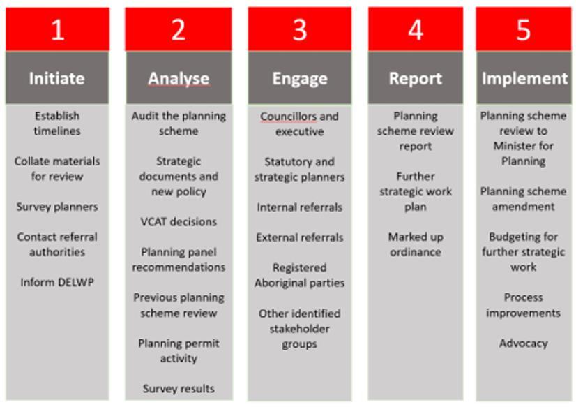
A six-stage methodology has been developed by DTP to undertake planning scheme reviews as shown in Figure 1.
The methodology is supported by the ‘Good Practice Guide to Planning Scheme Reviews’ and templates that have been developed to assist with each stage of the process.
Plan2Place Consulting has been engaged by DTP to conduct Stages 1 to 4 for the Northern Grampians Shire Council.
Stage 5 will involve a planning scheme amendment to implement the recommendations of the review, which the community will be consulted on. The amendment will be exhibited and submissions invited from community members in accordance with the requirements of the Planning and Environment Act 1987. If submissions cannot be resolved, Council is obliged to ask the Minister for Planning to appoint an independent Planning Panel to consider submissions and make recommendations to the Minister
1: Planning Scheme Review Methodology
This planning scheme review has been prepared with consideration to the following directions and guidance provided by DTP.
Ministerial directions:
▪ Ministerial Direction on the Form and Content of Planning Schemes.
▪ Ministerial Direction No. 11 Strategic Assessment of Amendments.
Planning practice notes and advice:
▪ A Practitioner’s Guide to Victoria’s Planning Schemes.
▪ PPN46 – Strategic Assessment Guidelines.
▪ PPN32 – Review of planning schemes.
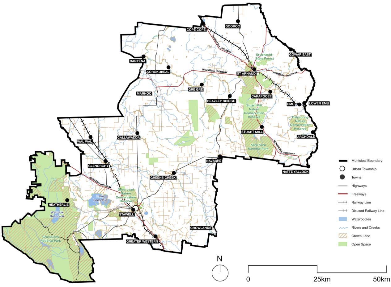
Northern Grampians Shire is located in the Wimmera Southern Mallee Region of Victoria, and shares its boundaries with Yarriambiack Shire and Buloke Shire to the north, the Loddon Shire, Central Goldfields Shire and Pyrenees Shire to the east, the Rural City of Ararat and Southern Grampians Shire to the south and the Rural City of Horsham to the west.
The shire covers 5,918 square kilometres of land and contains a number of natural features, including the Grampian Ranges in the south, the foothills of the Pyrenees Mountains in the north-east and the Wimmera Plains in the north-west. The Grampians are a mountainous landscape of national significance consisting of rugged landscape ridges and escarpments. The surrounding farming country is attractive, containing mature river red gums and other native trees in paddocks and along roads and streams.
The richness of indigenous cultural heritage within Northern Grampians sets the region apart under the stewardship of the Traditional Owners of the region, the Dja Dja Wurrung, Jaadwa, Jadawadjali, Jupagulk, Wergaia and Wotjobaluk Peoples. Over 80 percent of Victoria’s Aboriginal rock art is located within the Grampians, including the only known rock art painting of Bunjil and widely regarded as one of the most significant cultural sites in south-eastern Australia.
The Avoca, Avon, Richardson and Wimmera Rivers are all within the Shire. The upper catchment of the Wimmera River supplies a secure water supply to thousands of farms and over fifty towns in the Wimmera and Mallee regions. Stawell and St Arnaud townships are supplied water from Lake Fyans, Lake Bellfield and the area known as the Volcano.
Other major environmental assets of the Shire include Lake Lonsdale, Lake Fyans, Teddington Reservoir, Lake Batyo Catyo and the Kara Kara State Forest.
In 2021, there were 11,948 people living in the municipality with most of the shire’s population residing in the major towns of Stawell and St Arnaud. Halls Gap is a significant regional town and the small settlements of Great Western, Navarre, Stuart Mill, Marnoo and Glenorchy provide important focal points for local communities. The Shire generated $720 Million worth of gross regional product in 2021 with the aim to grow this to $920 Million by 2031.
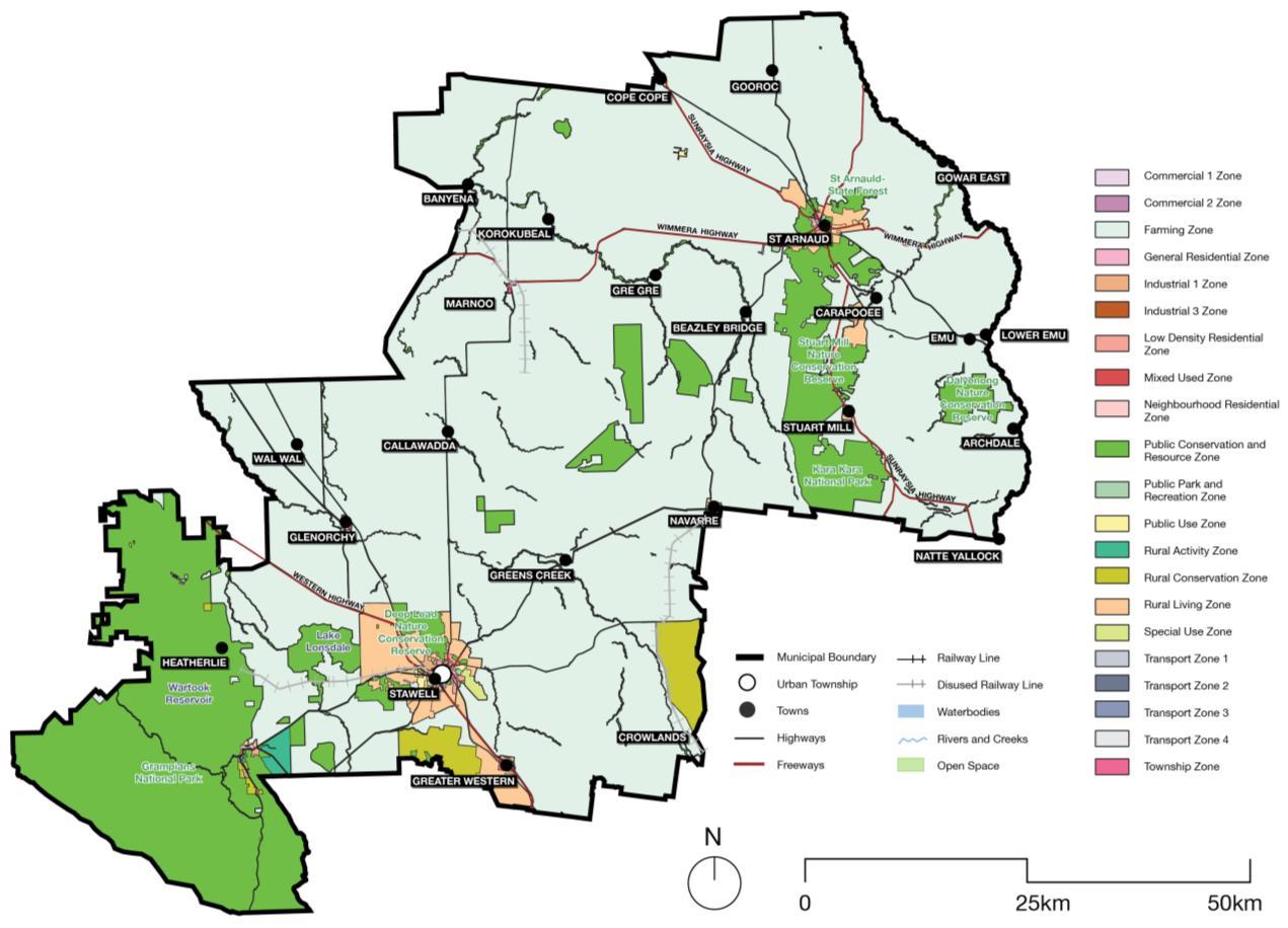
The context for the Northern Grampians Shire is shown in Figure 2
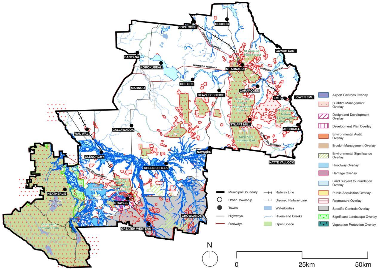
The existing Zones and Overlays applied in Northern Grampians Shire that are currently included in the Northern Grampians Planning Scheme (the scheme) and that are subject to this review are shown in Figures 3 and 4.
There are a total of 18 zones in the Northern Grampians Planning Scheme containing 24 separate schedules as follows:
▪ Commercial 1 Zone (1 schedule).
▪ Commercial 2 Zone (no schedule).
▪ Farming Zone (1 schedule).
▪ General Residential Zone (1 schedule).
▪ Industrial 1 Zone (1 schedule).
▪ Industrial 3 Zone (1 schedule).
▪ Low Density Residential Zone (1 schedule).
▪ Mixed Use Zone (1 schedule).
▪ Neighbourhood Residential Zone (1 schedule).
▪ Public Conservation and Resource Zone (1 schedule).
▪ Public Park and Recreation Zone (1 schedule).
▪ Public Use Zone (1 schedule).
▪ Rural Activity Zone (3 schedules)
▪ Rural Conservation Zone (2 schedules).
▪ Rural Living Zone (5 schedules).
▪ Special Use Zone (2 schedules)
▪ Township Zone (1 schedule).
▪ Transport Zone (no schedule).
There are a total of 14 overlays in the Northern Grampians Planning Scheme, with 23 schedules, as follows:
▪ Environmental Significance Overlay (3 schedules).
▪ Vegetation Protection Overlay (1 schedule).
▪ Significant Landscape Overlay (1 schedule).
▪ Heritage Overlay (1 schedule including 33 individual heritage places).
▪ Design and Development Overlay (7 schedules).
▪ Development Plan Overlay (1 schedule).
▪ Erosion Management Overlay (2 schedules).
▪ Floodway Overlay (1 schedule).
▪ Land Subject to Inundation Overlay (1 schedule).
▪ Bushfire Management Overlay (1 schedules).
▪ Public Acquisition Overlay (1 schedule).
▪ Airport Environs Overlay (1 schedule)
▪ Environmental Audit Overlay (1 schedule).
▪ Specific Controls Overlay (1 schedule).
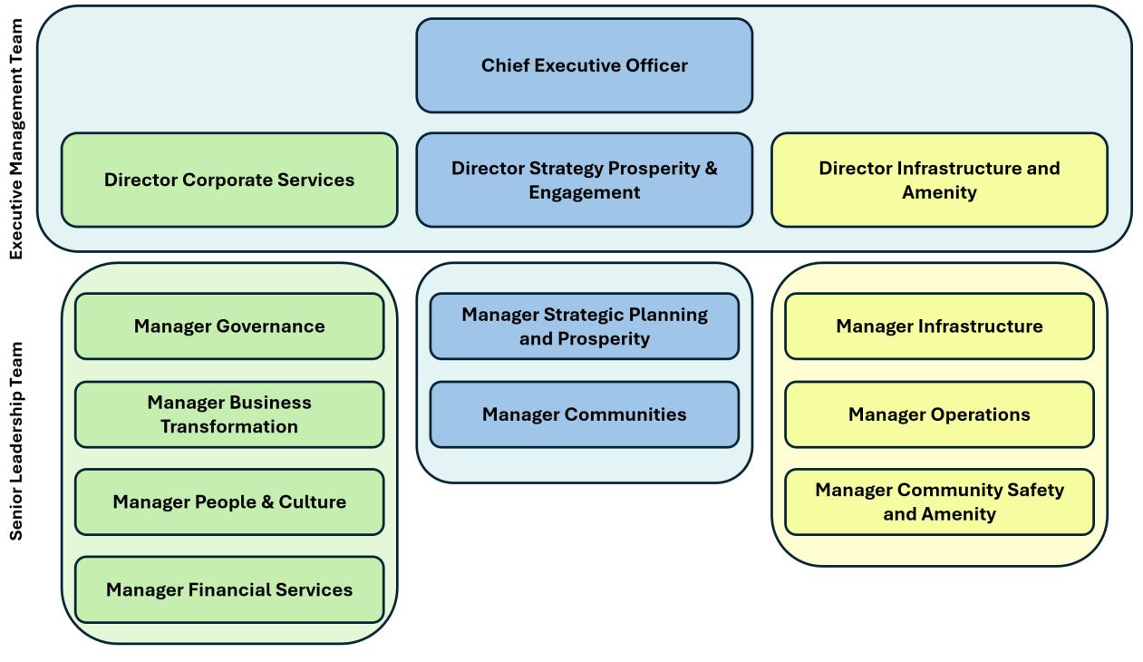
Council’s organisational structure includes the Chief Executive Office and three Directors that report directly to the CEO. Strategic planning report through the Manager Strategic Planning and Prosperity to the Director Strategy Prosperity and Engagement as shown in Figure 5.
Statutory planning report through the Manager Community Safety and Amenity to the Director Infrastructure and Amenity as shown in Figure 5
5: Northern Grampians Shire Council Organisational Structure
In 2021, there were 11,948 people (up from 11,439 in 2016) living in Northern Grampians with most of the Shire’s population residing in the major towns of Stawell and St Arnaud. Halls Gap is a significant regional town and the small settlements of Great Western, Navarre, Stuart Mill, Marnoo and Glenorchy provide important focal points for local communities. The Shire generated $720 Million worth of gross regional product in 2021, and the aim is to grow this to $920 Million by 2031.
The two major towns, Stawell and St Arnaud, are within proximity to the major regional centres of Ballarat, Bendigo and Horsham. Both Stawell and St Arnaud are less than three hours’ drive to Melbourne. Businesses located in the Shire are dependent on excellent infrastructure and transport assets providing a competitive advantage in terms of supply and distribution cost savings.
Many people within the Shire suffer from high levels of social and economic disadvantage and Northern Grampians is now the fourth most disadvantaged LGA in Victoria. The Shire lags the majority of Victoria in overall levels of income, education, internet access, professional occupations and housing type, with a high percentage of the community of working age, not engaged in paid work, study or community life. It is challenging for many people in the Shire to access the things they need to thrive.
Northern Grampians provides stronger social support and welfare services than other comparable regional and rural towns in Western and Northern Victoria and comparable to large regional centres. The Shire’s providers are leading the way in Victoria for contemporary aged care in Stawell with modern facilities and a strong commitment to keeping people in and connected to their own community.
Tourism plays an important role in helping to grow the visitor offering and build resilience in the Shire’s economy. This can help to identify commonality in tourism experiences, areas of competitive advantage and opportunities to leverage major tourism projects in the wider Grampians region. There are significant opportunities to grow tourism employment and visitor spending throughout the Shire.
The Wimmera region is attracting an increasing visitor segment as a result of the Silo Art Trail; Australia’s largest outdoor gallery, spanning an area of over 200kms through small rural communities. The Shire, and particularly St Arnaud, is ideally located as a hub for visitors to explore the region, owing to the supply of township accommodation and visitor amenities.
Northern Grampians is at the southern end of Victoria’s grain production heartland and has partnered in the innovations and practices which have propelled Australia’s dryland production systems to become the most efficient in the world. Varied soil types, favourable climatic conditions, and the advantages of space are reflected in the region’s agricultural sector through the diversity and volume of crops and livestock produced in Northern Grampians.
The Grampians National Park is heritage-listed for its animal and plant life, Aboriginal heritage and stunning natural beauty and is a significant tourism drawcard. Most of the Park’s hero destinations are located within the Shire, including Pinnacle Lookout, MacKenzie Falls, Reed Lookout and the Balconies. For over 100 years, Halls Gap has been a major tourist destination in the wider Grampians region.
Known for shiraz and sparkling wines, the Grampians has been a quality wine-producing region for more than 150 years. Northern Grampians’ gold and wine growing history is regarded as being nationally significant and the longest wine producing region in Victoria, with some of the most extensive collection of pre-phylloxera plantings in Australia – and possibly the world. Great Western
is also home to the longest underground drives in the southern hemisphere at Seppelt, with strong links to Victoria’s gold rush era.
Created within the active Stawell Gold Mine, the Stawell Underground Physics Lab (SUPL) is the only underground lab in the Southern Hemisphere. It is part of a world-wide scientific network of similar underground facilities in the US, Europe, UK, China and South Korea. This type of emerging innovation and research capacity should be fostered for the wider public benefits that are potentially provided by significant scientific research into scientific challenges such as the implications of dark matter on our world and the universe.
Renewable Energy is a growing area of development within the Shire. A number of renewable energy generation projects already operate within the Shire, including the Stawell and Ledcourt Solar Farms, and the Ararat and Bulgana Windfarms. A number of additional electricity generation projects are proposed. Further two transmission infrastructure projects are proposed – the Western Renewables Link, and VNI West.
Proposals to construct renewable energy infrastructure further intensifies existing challenges related to the protection of productive agricultural land from encroaching development, fragmentation of rural landscapes, shortages of adequate housing, the development of associated infrastructure including service roads and social infrastructure, and visual impacts to significant landscapes and environs.
Housing availability is a critical issue for residents in the Shire, with very low rental housing availability driving up rents and deterring workers from taking up jobs in the Shire. The region's low housing vacancy rate forces many workers to commute from neighbouring areas, hindering economic and population growth, contributing to an ageing demographic and limiting regional economic growth. Increasing housing supply and diversifying housing stock are essential to making the Shire an attractive place to live and work.
Vacancy rates are 0.17%, significantly lower than other localities such as Hamilton (0.29%), Ararat (0.57%), and Horsham (0.45%), leaving a scarce number of housing options available for workers in the region. The price of rentals rose 8.6% in NGS from Mar 2023 to Mar 2024https://www.domain.com.au/news
The Shire also experiences high levels of disadvantage, and there is an urgent need for social and affordable housing as a result. The lack of available, suitable and affordable housing is acting as a brake on the Shire’s businesses, economic growth and citizens’ wellbeing.
The Council Plan 2021-2025 was adopted by Council to guide Northern Grampians Shire’s work and priorities, decisions and efforts with a Community Vision. It includes 8 goals; supported by objectives and actions. The actions are split up into the timelines of complete, in progress and future.
The Council plan could provide a more overarching vision but the current vision as a set of 8 goals is sufficient to include in the MPS. It could be better expressed and potentially clearer in the next Council Plan which would enable improved implementation in the MPS’s 02.02 Vision.
R1. Include the updated Council Plan 2021-2025 Council plan vision of 8 goals in the MPS Vision.
Northern Grampians Shire recently adopted the Economic Development Strategy and Action Plan 2021 -2031. This strategy aims to address the Shire’s three biggest challenges which are:
▪ Population decline and growing social and economic disadvantage which causes workforce and skills shortages which are restraining the Council's economy.
▪ Vulnerability to natural disasters and global market events, undermining consistent economic growth.
▪ Investment preparedness, signalling priorities and ensuring investment competitiveness.
New strategic work should inter-relate to the strategic directions of this document and address implementation through township structure plans, urban design frameworks, rural land use and development and tourism initiatives.
The challenges of workforce and skills shortages as well as supply chain disruptions are a key focus of the strategy. Access to affordable housing and services, as well as greater transport and digital connectivity are key to retaining and attracting people to the region.
The strategy discusses how climate change has the potential to have adverse impacts on the key industries of agriculture, horticulture, mining and tourism and the economic prosperity and viability of the Shire. While significant costs are incurred by direct damage to public and private property, indirect costs to the community such as long-term economic impacts, loss of productivity, displacement of residents, closure of roads, trauma and ill health are also significant.
Directing future growth to existing townships and away from higher risk areas from bushfire and flooding through the appropriate siting, design and management of uses and developments can significantly improve community safety, enhance economic development of the Shire and region and help to mitigate climate change impacts.
As an initial first step, this can be done by referencing the strategy as a background document in the planning scheme and using this as the foundation for future strategic projects.
The document includes a large amount of contextual information that underpin the land and use development framework for the Shire. Some of this information from the strategy should be placed into the MPS at 02.03-4, 02.03-7, 02.03-8 and 02.03-9 with accompanying strategic directions for some clauses. This wording includes the following text.
For the MPS at 02.03-4:
“Northern Grampians is at the southern end of Victoria’s grain production heartland and has partnered in the innovations and practices which have propelled Australia’s dryland production systems to become the most efficient in the world. Varied soil types, favourable climatic conditions, and the advantages of space are reflected in the region’s agricultural sector through the diversity and volume of crops and livestock produced in Northern Grampians.”
For the MPS at 02.03-7:
“The Grampians National Park is heritage-listed for its animal and plant life, Aboriginal heritage and stunning natural beauty and is a significant tourism drawcard. Most of the Park's hero destinations are located within the Shire, including Pinnacle Lookout, MacKenzie Falls, Reed Lookout and the Balconies. For over 100 years, Halls Gap has been a major tourist destination in the wider Grampians region.
Known for shiraz and sparkling wines, the Grampians has been a quality wine-producing region for more than 150 years. Northern Grampians' gold mining and wine growing history is regarded as being nationally significant It is the longest wine producing region in Victoria, with one of the most extensive collections of pre-phylloxera plantings in Australia - and possibly the world. Great Western is also home to the longest underground drives in the southern hemisphere at Seppelt, with strong links to Victoria's gold rush era.
The Wimmera region is attracting an increasing visitor segment as a result of the Silo Art Trail; Australia’s largest outdoor gallery, spanning an area of over 200kms through small rural communities. The Shire, and particularly St Arnaud, is ideally located as a hub for visitors to explore the region, owing to the supply of township accommodation and visitor amenities.
Tourism plays an important role in helping to grow the visitor offering and build resilience in the Shire’s economy. This can help to identify commonality in tourism experiences, areas of competitive advantage and opportunities to leverage major tourism projects in the wider Grampians region.
Created within the active Stawell Gold Mine, the Stawell Underground Physics Lab (SUPL) is the only underground lab in the Southern Hemisphere. It is part of a world-wide scientific network of similar underground facilities in the US, Europe, UK, China and South Korea. Fostering this type of emerging innovation and research capacity will deliver wider public benefits that are potentially provided by significant scientific research into scientific challenges such as the implications of dark matter on our world and the universe.
Additional Strategic Directions:
▪ “Support innovation and research capacity for emerging industries such as gold and rare earth resources and the Stawell Underground Physics Lab.
▪ Harness the economic and social benefits from tourism into the Shire's towns and rural economy.”
For the MPS at 02.03-8:
“The two major towns, Stawell and St Arnaud, are within proximity to the major regional centres of Ballarat, Bendigo and Horsham. Both Stawell and St Arnaud are less than three hours’ drive to Melbourne. Businesses located in the Shire are dependent on excellent infrastructure and transport assets providing a competitive advantage in terms of supply and distribution cost savings.”
Additional Strategic Directions:
▪ “Develop St Arnaud’s role as an important freight link to neighbouring regions such as Swan Hill and Mildura.”
For the MPS at 02.03-9:
“Providing residents with access to community infrastructure is a key issue throughout the Shire. This includes providing integrated social infrastructure, based on the needs of the Shire’s diverse range of residents.
The Northern Grampians is the fourth most disadvantaged LGA in Victoria, with many people within the Shire experiencing high levels of social and economic disadvantage The Shire lags the majority of Victoria in overall levels of income, education, internet access, professional occupations and housing type. A high percentage of the community of working age are not engaged in paid work, study or community life. It is challenging for many people in the Shire to access the things they need to thrive.
Northern Grampians provides stronger social support and welfare services than other comparable regional and rural towns in Western and Northern Victoria and comparable to large regional centres. The Shire’s providers are leading the way in Victoria for contemporary aged care in Stawell with
modern facilities and a strong commitment to keeping people in and connected to their own community.”
Additional Strategic Directions:
▪ “Facilitate the development of community facilities throughout the municipality’s urban and rural communities, particularly in Stawell and St Arnaud.
▪ Support social and community infrastructure provision that aims to redress social and economic disadvantage.”
R2. Include reference to the Economic Development Strategy and Action Plan 2021 -2031 in the Municipal Planning Strategy and as a background document at Clause 72.08 as outlined above.
Updates to both these plans are occurring through separate planning scheme amendments and not as part of this review. Further context is provided below.
The Stawell Structure Plan is a part of the Town Plan project which also includes the Urban Design Framework. It has set out a long-term vision for the township and provides a roadmap to guide the future planning of the area over the next 20 to 30 years. The plan establishes a framework and outlines key directions and opportunities for change to foster the future growth and development of the township.
To assist with a future planning scheme amendment, it is proposed through the review to revise Clause 11.01-01L Settlement to introduce a new separate local policy for Stawell in a policy neutral approach This will enable the Stawell Structure Plan to be implemented more easily at a later time through the restructuring of the local policy.
The report sets out future growth and development directions for housing, commercial and industrial development to reinforce St Arnaud as a key district centre. It aims to facilitate growth while celebrating the valued history and culture of St Arnaud and identifying public open space and active transport opportunities. There are seven identified issues: housing diversity, industrial and agribusiness land supply, rural living, open spaces, community services, transport, environmental constraints and opportunities and identity, heritage and culture.
To assist with a future planning scheme amendment, it is proposed through the review to revise Clause 11.01-01L Settlement to introduce a new separate local policy for St Arnaud in a policy neutral approach. This will enable the St Arnaud Township Framework Plan to be implemented more easily at a later time through the restructuring of the local policy.
The Victoria Planning Provisions (VPP) are constantly being reviewed and updated at a state level with numerous VC and GC amendments occurring each year. The State also provides advice to planners in the form of updates to the Practitioner’s Guide (PG) and new planning practice notes. The full list of Victorian and regional amendments that have been gazetted, and practice notes that have been released since the last review forms Appendix 2
The way in which the Northern Grampians Planning Scheme should respond at a local level to these changes to the VPP and how they should be applied has been considered in this review and includes the following.
The introduction of more sophisticated schedules to the residential zones (through Amendment VC169), including the ability to include place-based objectives (essentially a preferred neighbourhood character statement), provides an opportunity for Council to introduce controls to manage built form in residential areas more effectively. Planning Practice Notes 90 – Planning for Housing and 91 – Using the Residential Zones provide advice about how this should be done. Council has identified the need to undertake this work for through neighbourhood character work for St Arnaud, Stawell and Halls Gap to support structure planning.
This strategic work will better achieve housing diversity, housing affordability, sustainability and neighbourhood character objectives. Council’s settlement hierarchy is clearly detailed in its adopted settlement hierarchy that focuses on Stawell as the primary township for growth. Other townships such as St Arnaud and Halls Gap play a supportive role but are often more constrained due to bushfire, flooding and other environmental factors. Further work to implement structure plans, local planning policies, more specific and tailored residential schedules could follow further strategic work for townships, housing and neighbourhood character.
The release of the Victorian housing statement has placed housing provision as one of the key challenges of the 2020s. It aims to refresh Victoria’s housing policy settings with a series of initiatives that respond to short-term issues of affordability and supply while still promoting long term economic growth
Victoria’s population is forecast to reach 10.3 million by 2051 and Melbourne is set to become Australia’s biggest city by the end of the decade with an additional 3.5 million people by 2056. To ease housing pressures, 2.24 million homes will be required by 2051 state-wide to house the increased population which is around 80,000 additional dwellings per year.
The housing statement is supported by Amendments VC242, VC243 and VC253 which aim to facilitate well-located, integrated and diverse housing that meets community needs and to support the delivery of housing in Victoria. The amendments seek to provide social benefits by supporting the delivery of more housing close to jobs, transport and services, facilitating social and affordable housing through private and public investment and supporting significant development projects
Amendment VC242 introduced two new particular provisions to facilitate significant residential development and significant economic development through clauses 53.22 and 53.23 with the Minister for Planning as the responsible authority The Residential Growth Zone, Township Zone, General Residential Zone and Neighbourhood Residential Zone have also been revised by changing permit requirements for office and retail premises subject to meeting specific land use conditions. The use of the new particular provisions pathway is voluntary and a permit applicant still has the option for their development to be assessed in the usual manner by the local Council as the responsible authority
Amendment VC243 introduced state-wide changes to all planning schemes to codify residential development standards, implement the Future Homes project across Victoria, remove permit requirements for single dwellings on lots of 300 square metres or more and introduce VicSmart permits for single dwellings on lots less than 300 square metres.
Amendment VC253 introduced a new land use term and siting, design and amenity requirements for a ‘small second dwelling’ into a range of residential and rural zones across Victoria. This replaced the land use term ‘dependent person’s unit’ and made the planning provisions more consistent and easier to build a small second dwelling of 60 square metres or less that meets specified requirements.
Amendment VC175 introduced the Buffer Area Overlay (BAO) and applied updated separation distances for industries that may have amenity impacts to sensitive uses. The BAO is a new amenity buffer that is designed to ensure that industry can operate according to acceptable standards with no encroachment from sensitive uses such as schools and dwellings that may be affected by odour or dust from industries operating nearby. This control may be suitable for application around a range of infrastructure assets in the Shire, including wastewater treatment plants, and transfer stations where a risk assessment related to the environmental hazard has been undertaken This work is best led by the owners of the assets but should have some Council involvement
Amendment VC202 Introduced a land use term and definition for ‘Rural worker accommodation’ and modified clause 35.07 (Farming Zone) to introduce exemptions for the land use of Rural worker accommodation that accommodates no more than 10 persons This Amendment also introduced a permit requirement for the land use of Rural worker accommodation for more than 10 persons. This change has enabled rural worker accommodation to be more easily provided on Farming Zone land throughout the Shire, assisting with key worker accommodation.
Changes have not been made to address issues related to a second dwelling and subsequent subdivision in the rural zones (the Farming Zone, Rural Conservation Zone and Rural Activity Zone in particular) which can negatively affect farming and agricultural production and viability. Greater advocacy on this issue to the Victorian Government is needed.
Amendments VC216 and VC221 revised the VPP and all planning schemes by altering the PPF to support Environmentally Sustainable Development (ESD) and to facilitate all-electric developments to support implementation of Victoria’s Climate Change Strategy 2021 and Gas Substitution Roadmap 2022 These Amendments have ongoing impacts to land in the Shire around ESD policy and requirements and reflects updated climate change forecasts and energy related considerations for land in the Shire.
R3. As a result of Amendments VC169, VC175, VC202, VC216, VC221, VC242, VC243 and VC253 further work around the following strategic projects and/or advocacy should be undertaken around:
▪ Continuing with the implementation of structure plans/framework plans for Stawell and St Arnaud and preparation of structure plans Halls Gap for areas of identified growth and/or change into the scheme.
▪ Consider undertaking updated housing and neighbourhood character review work for townships for implementation into the scheme.
▪ Advocate to the Victorian Government for stronger provisions to be included in the Farming Zone, Rural Conservation Zone and Rural Activity Zone to prohibit a second dwelling on a lot and subsequent residential subdivisions less than the minimum lot size in these zones where located on high value agricultural land.
▪ Strengthening ESD policy and requirements and climate change risks and mitigation into the scheme.
The scheme was last reviewed in 2018 which found that the scheme was generally sound and provided a good basis for making land use decisions in the scheme. It was recommended that the scheme be updated in order to remain contemporary, further embrace opportunities the Shire offers and provide direction of key land use issues. It also highlighted the significant opportunity to rewrite zone and overlay schedules and rewrite the Local Planning Policy Framework as part of the translation into the PPF. The strategic performance of the scheme was identified for improvement through 36 planning projects and planning scheme changes including:
▪ Rewrite the LPPF in accordance with the conclusions and recommendations in this review and the new PPF model, as and when required by DELWP – completed as part of new MPS and PPF translation.
▪ All schedules be modified to comply with the Ministerial Direction on Form and Content. As a guide, the following schedules are non-compliant:
ESO1 has five objectives (instead of one) and the others have at least two.
VPO1 has seven objectives (instead of one) as well as a long list (two pages) of vegetation species.
SLO1 has four objectives (instead of one) and a list of reference documents. The DDO schedules contain no reference to subdivision and they also include reference documents contrary to the Direction.
▪ The Ministerial Direction specifies that there be a number of requirements that are either not catered for, or are included in the existing DPO schedule. - This was commenced as part of the last PSR and the PPF translation work and will be addressed through the current PSR based on the Ministerial Direction.
▪ Adopt and implement the Infrastructure Design Manual – Needs to be endorsed by Council and then can be referenced in the scheme at 19.03-2L. Currently no plans by Council to adopt the Infrastructure Design Manual
▪ Conduct a review of commercial zones in light of the outcomes of the Retail Gap Analysis –this is being undertaken as part of the township structure planning projects.
▪ Conduct a review of residential zones in light of the outcomes of the Residential Land Strategy – – this is largely being undertaken as part of the township structure planning projects.
▪ All zones in Halls Gap be reviewed and rationalised, including GRZ compromised by the BMO – this work is yet to be undertaken.
▪ All overlays in Halls Gap be reviewed and rationalised –this has recently been undertaken with the Halls Gap Framework.
▪ Desktop review and ground-truthing of the Northern Grampians Heritage Study and extend the Heritage Overlay to the most important places identified in the Northern Grampians Heritage Study – needed for additional heritage studies which are currently underway or proposed
▪ The Heritage Overlay: replace DDO2 in St Arnaud – this is yet to be undertaken
▪ The EAO be applied to all sites nominated on the EPA register and to all known former petrol station sites and depots – this work is outstanding.
▪ Prepare Western Highway Urban Design Framework – focus needs to be on implementation.
▪ Prepare Structure Plans for St Arnaud, Stawell and Halls Gap to analyse opportunities and constraints and review the zoning and overlay regime to align with environmental constraints – this is being undertaken and DTP are assisting with implementation.
▪ Halls Gap Structure Plan: review the zoning and overlay regime to align with environmental constraints – this has recently been undertaken with the Halls Gap Framework
▪ Revise MSS Township Framework Plans to correct anomalies and update to reflect existing conditions – this still needs to be undertaken.
▪ Prepare Clause 22 local 'policies' based on similar schemes for: dwellings in FZ small lot subdivision in FZ. non-residential uses in residential areas. non-rural uses in FZ.
If this is still required, local planning policies in the PPF format are required at 13.07-1L and 14.011L.
▪ Review and amend referral requirements in Clause 52 and Clause 66 – this has been reviewed previously but will be review as part of the current PSR.
▪ That the Township Zone in Great Western be reviewed and replaced with more specialised zones – this work still needs to be undertaken.
▪ That anomalies such as a public school being in the General Residential Zone in Stawell be addressed – still needs to be undertaken to rezone part of the school in Skene Street to PUZ2.
▪ That the Industrial 3 Zone on the Western Hwy in Stawell be replaced with the Industrial 1 Zone – the only IN3Z land is on the corner of the Western Highway and Maddocks Road, it is surrounded by RLZ2 and C1Zand IN1Z land opposite. This land should remain as IN1Z.
▪ That the commercial zones on and near the Pleasant Creek site in Stawell be rationalised and aligned with property boundaries – this still requires correction and revised mapping will be undertaken through the current review.
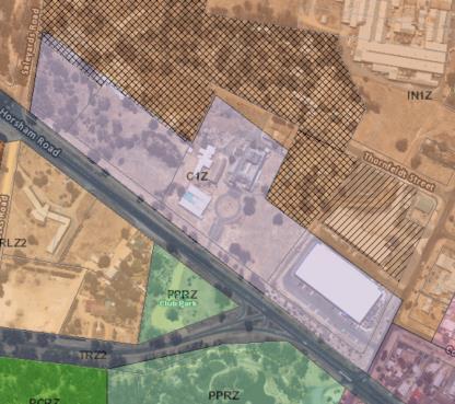
▪ That the five schedules to the Rural Living Zone be reviewed and addressed – this has been previously addressed through Amendment C61ngra.
▪ That the schedule to the Farming Zone make explicit reference to ‘dams’ in the earthworks controls – the schedule relates to earthworks in excess of 200 mm above or below natural ground level and no longer needs to refer to dams as they are regulated by the water authority.
▪ That the Special Use Zone schedules be re-written – this has been previously addressed through Amendment C61ngra but will be considered further through the current review.
▪ That ESO1 be considered for replacement with the EMO or SMO – this relates to land adjacent to Glynwylln Reserve and other areas east and south of Stawell and Great Western. This could be further strategic work or just converted into an EMO.
▪ That ESO3 be applied to the St Arnaud wastewater plant – ESO3 has been applied to the Stawell wastewater treatment plant but this should now be translated to the BAO. The same
should be undertaken for the St Arnaud wastewater treatment plant zoned PUZ1 on the corner of Macroberts and Cemetery Roads.
▪ That VPO1 be deleted – the VPO1 potentially conflicts with the BMO and could align exemptions in VPO1 to those for bushfire prone areas in further strategic work.
▪ That SLO1 be simplified and rationalised – this has been previously addressed through Amendment C61ngra but will be considered further through the current review.
▪ That EMO2 be named ‘Landslides’ – this will be undertaken through the review.
▪ That consideration be given to splitting DDO1 at Halls Gap into the commercial area and the residential area – this can be undertaken through future strategic work.
▪ Investigate the application of the Restructure Overlay on old, small lots in rural areas (linked to project 2.9. – this has not been progressed and should be left to further strategic work.
▪ That the Restructure Overlay be applied to old and inappropriate small rural lots as an outcome of a comprehensive review (linked project 3.21) – this has not been progressed and should be left to further strategic work.
▪ That the schedule to Clause 52.01 (Open Space) specify a requirement for a 5% open space contribution – this has not been progressed and should be left to further strategic work.
▪ Targeted Rural Land Use Project (Low) to identify:
Areas of most productive agricultural land.
Areas to promote development of renewable energy facilities including an analysis of the capacity of the grid.
Areas to promote intensive animal industries.
Areas to encourage/discourage rural industries.
Has not been progressed. Should be left to further strategic work.
▪ Investigations into equine activity in RLZ and RCZ (linked to project 3.16) – this has not been progressed and should be left to further strategic work.
▪ Identification of known former mine sites by the most appropriate tool in the planning scheme. – this has not been progressed. Should be left to further strategic work
▪ Develop a referral protocol for applications in Special Water Supply Catchment Areas – this has not been progressed and should be left to further strategic work in partnership with the NCCMA, WCMA and water authorities.
▪ Modifications to the FZ schedule to introduce permit trigger for dams (linked to project 3.6) - the schedule relates to earthworks in excess of 200 mm above or below natural ground level and no longer needs to refer to dams as they are regulated by the water authority.
There were also several advocacy projects. Many of the above planning projects, some of them significant pieces of strategic work, were implemented or have been commenced in the last 4 years Others are yet to be commenced or implemented.
Prior to the 2018 review, the Northern Grampians Planning Scheme was reviewed in 2010 and 2014 which implemented recommendations from that time through Amendment C54 to the Northern Grampians Planning Scheme
4.2.1. Completed projects
Council has implemented two of the recommendations from the last review through the:
▪ Rewrite the LPPF in accordance with the conclusions and recommendations in this review and the new PPF model, as and when required by DELWP – completed as part of new MPS and PPF translation
▪ That the five schedules to the Rural Living Zone be reviewed and addressed – this has been previously addressed through Amendment C61ngra
▪ All overlays in Halls Gap be reviewed and rationalised –this has recently been undertaken with the Halls Gap Framework.
Council is currently undertaking several of the projects identified in the previous review plus a range of other projects and inputs to projects including:
▪ All overlays in Halls Gap be reviewed and rationalised –this has recently been undertaken with the Halls Gap Framework.
▪ Desktop review and ground-truthing of the Northern Grampians Heritage Study and extend the Heritage Overlay to the most important places identified in the Northern Grampians Heritage Study – needed for additional heritage studies which are currently underway or proposed.
▪ Prepare Western Highway Urban Design Framework – focus needs to be on implementation.
▪ Prepare Structure Plans for St Arnaud, Stawell and Halls Gap to analyse opportunities and constraints and review the zoning and overlay regime to align with environmental constraints – this is being undertaken and DTP are assisting with implementation.
▪ Halls Gap Structure Plan: review the zoning and overlay regime to align with environmental constraints – this has recently been undertaken with the Halls Gap Framework.
Items that are outstanding from the last planning scheme review are:
▪ All schedules be modified to comply with the Ministerial Direction on Form and Content. As a guide, the following schedules are non-compliant:
ESO1 has five objectives (instead of one) and the others have at least two.
VPO1 has seven objectives (instead of one) as well as a long list (two pages) of vegetation species.
SLO1 has four objectives (instead of one) and a list of reference documents. The DDO schedules contain no reference to subdivision and they also include reference documents contrary to the Direction.
▪ The Ministerial Direction specifies that there be a number of requirements that are either not catered for, or are included in the existing DPO schedule. - This was commenced as part of the last PSR and the PPF translation work and will be addressed through the current PSR based on the Ministerial Direction.
▪ Adopt and implement the Infrastructure Design Manual – Needs to be endorsed by Council and then can be referenced in the scheme at 19.03-2L. Currently no plans by Council to adopt the Infrastructure Design Manual
▪ Conduct a review of commercial zones in light of the outcomes of the Retail Gap Analysis –this is being undertaken as part of the township structure planning projects.
▪ Conduct a review of residential zones in light of the outcomes of the Residential Land Strategy. – – this is largely being undertaken as part of the township structure planning projects.
▪ All zones in Halls Gap be reviewed and rationalised, including GRZ compromised by the BMO – this work is yet to be undertaken.
▪ Desktop review and ground-truthing of the Northern Grampians Heritage Study and extend the Heritage Overlay to the most important places identified in the Northern Grampians Heritage Study – needed for additional heritage studies which are currently underway or proposed.
▪ The Heritage Overlay: replace DDO2 in St Arnaud – this is yet to be undertaken
▪ The EAO be applied to all sites nominated on the EPA register and to all known former petrol station sites and depots – this work is outstanding.
▪ Prepare Western Highway Urban Design Framework – focus needs to be on implementation.
▪ Prepare Structure Plans for St Arnaud, Stawell and Halls Gap to analyse opportunities and constraints and review the zoning and overlay regime to align with environmental constraints – this is being undertaken and DTP are assisting with implementation.
▪ Halls Gap Structure Plan: review the zoning and overlay regime to align with environmental constraints – this has recently been undertaken with the Halls Gap Framework but could be further undertaken through a structure plan for Halls Gap.
▪ Revise MSS Township Framework Plans to correct anomalies and update to reflect existing conditions – this still needs to be undertaken.
▪ Review and amend referral requirements in Clause 52 and Clause 66 – this has been reviewed previously but will be review as part of the current PSR.
▪ That the Township Zone in Great Western be reviewed and replaced with more specialised zones – this work still needs to be undertaken.
▪ That anomalies such as a public school being in the General Residential Zone in Stawell be addressed – still needs to be undertaken to rezone part of the school in Skene Street to PUZ2.
▪ That the Industrial 3 Zone on the Western Hwy in Stawell be replaced with the Industrial 1 Zone – the only IN3Z land is on the corner of the Western Highway and Maddocks Road, it is surrounded by RLZ2 and C1Zand IN1Z land opposite. This land should remain as IN1Z.
▪ That the commercial zones on and near the Pleasant Creek site in Stawell be rationalised and aligned with property boundaries – this still requires correction and revised mapping will be undertaken through the current review.
▪ That the Special Use Zone schedules be re-written – this has been previously addressed through Amendment C61ngra but will be considered further through the current review
▪ That ESO1 be considered for replacement with the EMO or SMO – this relates to land adjacent to Glynwylln Reserve and other areas east and south of Stawell and Great Western - this could be further strategic work or just converted into an EMO.
▪ That ESO3 be applied to the St Arnaud wastewater plant – ESO3 has been applied to the Stawell wastewater treatment plant but this should now be translated to the BAO. The same should be undertaken for the St Arnaud wastewater treatment plant zoned PUZ1 on the corner of Macroberts and Cemetery Roads.
▪ That VPO1 be deleted – the VPO1 potentially conflicts with the BMO and could align exemptions in VPO1 to those for bushfire prone areas in further strategic work.
▪ That SLO1 be simplified and rationalised – this has been previously addressed through Amendment C61ngra but will be considered further through the current review.
▪ That EMO2 be named ‘Landslides’ – this will be undertaken through the review.
▪ That consideration be given to splitting DDO1 at Halls Gap into the commercial area and the residential area – this can be undertaken through future strategic work with a structure plan for Halls Gap
▪ Investigate the application of the Restructure Overlay on old, small lots in rural areas (linked to project 2.9. – this has not been progressed and should be left to further strategic work.
▪ That the Restructure Overlay be applied to old and inappropriate small rural lots as an outcome of a comprehensive review (linked project 3.21) – this has not been progressed and should be left to further strategic work.
▪ That the schedule to Clause 52.01 (Open Space) specify a requirement for a 5% open space contribution – this has not been progressed and should be left to further strategic work.
▪ Targeted Rural Land Use Project (Low) to identify:
Areas of most productive agricultural land.
Areas to promote development of renewable energy facilities including an analysis of the capacity of the grid.
Areas to promote intensive animal industries.
Areas to encourage/discourage rural industries.
Has not been progressed. Should be left to further strategic work.
▪ Investigations into equine activity in RLZ and RCZ (linked to project 3.16) – this has not been progressed and should be left to further strategic work.
▪ Identification of known former mine sites by the most appropriate tool in the planning scheme. – this has not been progressed. Should be left to further strategic work.
▪ Develop a referral protocol for applications in Special Water Supply Catchment Areas – this has not been progressed and should be left to further strategic work in partnership with the NCCMA, WCMA and water authorities.
The projects identified above remain important projects to progress so as to reinforce and improve the strategic directions of the scheme. Some of the projects listed have been rescoped so that they are focused on implementation through the scheme or combined with other high priority projects
There are several recommendations that are now obsolete for Council to undertake:
▪ Prepare Clause 22 local 'policies' based on similar schemes for: dwellings in FZ. small lot subdivision in FZ.
non-residential uses in residential areas.
non-rural uses in FZ.
If this is still required, local planning policies in the PPF format are required at 13.07-1L and 14.011L.
▪ That the schedule to the FZ make explicit reference to ‘dams’ in the earthworks controls –the schedule relates to earthworks in excess of 200 mm above or below natural ground level and no longer needs to refer to dams as they are regulated by the water authority.
▪ Modifications to the FZ schedule to introduce permit trigger for dams (linked to project 3.6) - the schedule relates to earthworks in excess of 200 mm above or below natural ground level and no longer needs to refer to dams as they are regulated by the water authority.
▪ That VPO1 be deleted – the VPO1 potentially conflicts with the BMO and could align exemptions in VPO1 to those for bushfire prone areas in further strategic work. This is an issue of balancing completing parts of the planning scheme and should be considered on a case by case basis for planning applications.
▪ Adopt and implement the Infrastructure Design Manual – Needs to be endorsed by Council and then can be referenced in the scheme at 19.03-2L. Currently no plans by Council to adopt the Infrastructure Design Manual. Not recommended until such time that Council adopts the Infrastructure Design Manual.
A range of further strategic work was inserted into the scheme as part of Amendment C59ngr. This combined a range of items similar to the planning scheme review along with additional actions These actions were:
▪ Prepare structure plans for Stawell, Halls Gap and St Arnaud including identified settlement boundaries, existing and future land use outcomes, housing needs and types assessment and an overall strategic framework plan for each settlement.
▪ Investigate residential development opportunities of land in Darlington Lane, Stawell.
▪ Prepare a local Planning Policy for non-agricultural uses in the Farming Zone.
▪ Prepare a new local Policy for rural dwellings and subdivisions to guide development in rural areas (if required) upon completion of a rural strategy.
▪ Investigate the provision of commercial services adjacent to the Western Highway, that will not impact on the function of the highway.
Council has undertaken several important strategic planning projects since the last review and has a large work program of projects underway. It has implemented or is near to finalising a significant work program detailed from that review.
There remains a list of strategic projects that have not been undertaken and/or implemented which should be undertaken in the next 4-5 years. These include:
▪ Implementation of the Stawell and St Arnaud Structure Plans/Framework Plans into the planning scheme.
▪ Implementation of the Western Highway Urban Design Framework into the planning scheme
▪ Preparation of a rural land use strategy to guide decisions in the FZ, RCZ, RAZ and RLZ (and potentially LDRZ) in areas outside town boundaries.
▪ Desktop review and ground-truthing of the Northern Grampians Heritage Study and extend the Heritage Overlay to the most important places identified in the Northern Grampians Heritage Study through additional heritage studies.
▪ Prepare a structure plan for Halls Gap.
▪ Partner with relevant water authorities to complete and implement updated flooding studies.
▪ Partner with the NCCMA and the WCMA to investigate extending the Environmental Significance Overlay to include all declared open potable water supply catchments.
▪ Partner with the NCCMA and the WCMA to prepare an MOU for the proclaimed water catchment and planning applications in that area.
▪ Investigating application of a Restructure Overlay to old and inappropriate small rural lots
▪ Undertaken an open space strategy and prepare specific requirements to a schedule to Clause 52.01 for a 5 percent (%) public open space contribution for residential, commercial and industrial land.
▪ Apply a BAO instead of ESO3 to Stawell wastewater plant, and apply the BAO to the St Arnaud, Halls Gap and Great Western wastewater plants. At the same time consider application of the PUZ to the Halls Gap and Great Western wastewater treatment plants.
▪ Preparing a signage policy and guidelines (see further details in section 7)
▪ Undertaking cultural values assessment work with the in consultation with the Dja Dja Wurrung Clans Aboriginal Corporation and the Barengi Gadjin Land Council (see further details in section 7).
Findings / recommendations:
R4. The following further strategic work that should be undertaken in the next four years:
▪ Partner with the NCCMA and the WCMA and relevant water authorities to complete and implement updated flooding studies.
▪ Review the Northern Grampians Heritage Study and extend the Heritage Overlay to the most important places identified in the Northern Grampians Heritage Study as a result of additional heritage studies and statements of significance.
▪ Implement the Stawell and St Arnaud Structure Plans/Framework Plans into the planning scheme.
▪ Implement the Western Highway Urban Design Framework into the planning scheme.
▪ Prepare a rural land use strategy and local policy to guide decisions in the FZ, RCZ, RAZ and RLZ (and potentially LDRZ) in areas outside town boundaries.
▪ Prepare a structure plan for Halls Gap.
▪ Partner with the NCCMA and the WCMA to investigate extending the Environmental Significance Overlay to include all declared open proclaimed water supply catchments.
▪ Investigate application of the Restructure Overlay to old and inappropriate small rural lots.
▪ Undertake an open space strategy and prepare specific requirements to a schedule to Clause 52.01 for a 5 percent (or greater) public open space contribution for residential, commercial and industrial land.
▪ Apply a BAO instead of ESO3 to Stawell wastewater plant, and apply the BAO to the St Arnaud, Halls Gap and Great Western wastewater plants. At the same time consider application of the PUZ to the Halls Gap and Great Western wastewater treatment plants.
▪ Prepare a signage policy and guidelines.
▪ Undertake a Cultural Values Assessment for the Shire in consultation with the Dja Dja Wurrung Clans Aboriginal Corporation and the Barengi Gadjin Land Council.
An audit of each local provision (policies and schedules) in the planning scheme has been undertaken. This audit has compared the drafting and application of each local provision against the Ministerial Direction on the Form and Content of Planning Schemes, a Practitioners’ Guide to Victorian Planning Schemes (Version 6, March 2024) and relevant planning practice notes.
Each provision has also been assessed against how it is achieving the strategic objectives that are set out in the State, regional and local planning provisions.
The detailed outcomes of the audit have been provided to Council officers, and changes that can be made without further strategic work have been made to the ordinance at Appendix 1.
Findings on improvements that could be made are listed below. Some of these can occur as part of a planning scheme review based on the findings in this report and are included in the marked-up ordinance at Appendix 1 Others require further strategic work to justify the change and are listed as findings.
As well as the assessment outlined above, the MPS was cross referenced against all the other local provisions in the scheme to ensure that there is a link to all local policies in the MPS.
PSR complies.
PSR further strategic work. PSR policy neutral amendment.
PSR full amendment.
02.01 Context
Make minor amendments to the Context (02.01) to include First Nations recognition and incorporate key economic and population data.
02.02 Vision Complies. Will need to be updated to reflect the new Council plan vision when the new Council Plan is adopted.
02.03 Strategic directions
02.03-1 Settlement
02.03-2 Environmental values and landscapes
Need to add a sentence prior to the strategic directions and revise for each theme such as “Council’s strategic directions for settlement are to:”
Update contextual text relating to Stawell and St Arnaud as a result of structure planning [Source: Stawell Structure Plan, 2023; St Arnaud Township Framework Plan, 2023] but leave the significant changes to strategic directions from those documents to future amendments
Update text and strategic directions relating to environmental values of Walkers Lake [Environmental and Heritage Management Advice: Walkers Lake Management Plan, Walkers Lake, Avon Plains, Victoria, 2022]
Include following context paragraph and strategic direction at 02.03-2:
PSR policy neutral amendment
PSR complies
PSR policy neutral amendment
PSR policy neutral amendment
PSR policy neutral amendment
Clause no and name
Compliance or changes required
02.03-3 Environmental risks and amenity
02.03-4 Natural resource management
“Five state and national significant vegetation species have been identified in the Walker Lake Environs. The lake and their environs are also of significance to the Dja Dja Wurrung Traditional Owners.”
Additional Strategic Directions:
• Rehabilitate and protect the environmental values of Walker Lake and its environs.
Update text and strategic directions to emphasise flood risk and impact of climate change.
Complies but could be supplemented with additional text [Source: Economic Development Strategy and Action Plan 2021-2031 (Northern Grampians Shire, 2021)] as follows:
Northern Grampians is at the southern end of Victoria’s grain production heartland and has partnered in the innovations and practices which have propelled Australia’s dryland production systems to become the most efficient in the world. Varied soil types, favourable climatic conditions, and the advantages of space are reflected in the region’s agricultural sector through the diversity and volume of crops and livestock produced in Northern Grampians.
Action
PSR complies.
PSR further strategic work.
PSR policy neutral amendment.
PSR full amendment.
02.03-5 Built environment and heritage
02.03-6 Housing
02.03-7 Economic development
Update text relating to aboriginal cultural heritage at Walkers Lake [Source: Environmental and Heritage Management Advice: Walkers Lake Management Plan, Walkers Lake, Avon Plains, Victoria, 2022]
Update text relating to better recognition given to protection of goldfields heritage and relationship to town economies.
Update text and strategic directions relating to housing supply challenges.
Update contextual text relating to Stawell and St Arnaud as a result of structure planning [Source: Stawell Structure Plan, 2023; St Arnaud Township Framework Plan, 2023]. Better reference given to local industries and St Arnaud’s role.
Update text and strategic directions relating to tourism in St Arnaud and Stawell, and from the Economic Development Strategy [Source: St Arnaud Tourism Strategy, 2022-2032, Stawell Tourism Strategy, 20222032 and Economic Development Strategy and Action Plan 2021-2031 (Northern Grampians Shire, 2021)] as follows:
“The Grampians National Park is heritage-listed for its animal and plant life, Aboriginal heritage and stunning natural beauty and is a significant tourism drawcard. Most of the Park’s hero destinations are located within the Shire, including Pinnacle Lookout, MacKenzie Falls, Reed Lookout and the Balconies. For over 100 years, Halls Gap has been a major tourist destination in the wider Grampians region.
Known for shiraz and sparkling wines, the Grampians has been a quality wine-producing region for more than 150 years. Northern Grampians’ gold mining and wine growing history is regarded as being nationally significant. It is the longest wine producing region in
PSR policy neutral amendment
PSR full amendment
PSR full amendment
PSR full amendment
PSR full amendment
Clause no and name
Compliance or changes required
Victoria, with one of the most extensive collections of pre-phylloxera plantings in Australia – and possibly the world. Great Western is also home to the longest underground drives in the southern hemisphere at Seppelt, with strong links to Victoria’s gold rush era. Created within the active Stawell Gold Mine, the Stawell Underground Physics Lab (SUPL) is the only underground lab in the Southern Hemisphere. It is part of a world-wide scientific network of similar underground facilities in the US, Europe, UK, China and South Korea. Fostering this type of emerging innovation and research capacity will deliver wider public benefits that are potentially provided by significant scientific research into scientific challenges such as the implications of dark matter on our world and the universe.
The Shire is rich in mineral resources including minerial sands and gold. Northern Grampians encompasses part of the largest mineral sands deposits in the world and holds some of the largest and cleanest sources of rare earths in the State’s mineral sands. The Donald Mineral Sands project is one of the largest known zircon and titanium resources in the world, with St Arnaud being the closest service centre to the project.
Additional Strategic Directions:
• Support the growth of the tourism industry in St Arnaud and Stawell
• Support development that respects natural, cultural and heritage assets to support an expanded visitor economy
• Support innovation and research capacity for emerging industries such as gold and rare earth resources and the Stawell Underground Physics Lab.
• Harness the economic and social benefits from tourism into the Shire’s towns and rural economy.”
Text to merge into the MPS at 02.03-7, 3rd paragraph in economic development from the St Arnaud Tourism Strategy and Action Plan 2022-2032 (Northern Grampians Shire, 2022) and Stawell Tourism Strategy and Action Plan 2022-2032 (Northern Grampians Shire, 2022) and:
“The Wimmera region is attracting an increasing visitor segment as a result of the Silo Art Trail; Australia’s largest outdoor gallery, spanning an area of over 200kms through small rural communities. Tourism plays an important role in helping to grow the visitor offering and build resilience in the Shire’s economy. This can help to identify commonality in tourism experiences, areas of competitive advantage and opportunities to leverage major tourism projects in the wider Grampians region” . Also revisions/additions to the existing strategic directions on tourism
02.03-8 Transport Complies but could be supplemented with additional text from the Economic Development Strategy as
Action
PSR complies.
PSR further strategic work.
PSR policy neutral amendment.
PSR full amendment.
full amendment
Clause no and name
Compliance or changes required
02.03-9 Infrastructure
Action
PSR complies.
PSR further strategic work.
PSR policy neutral amendment.
PSR full amendment.
02.04 Strategic framework plans
follows [Source: Economic Development Strategy and Action Plan 2021-2031 (Northern Grampians Shire, 2021)]:
“The two major towns, Stawell and St Arnaud, are within proximity to the major regional centres: Ballarat, Bendigo and Horsham. Both Stawell and St Arnaud are less than three hours’ drive to Melbourne. Businesses located in the Shire are dependent on excellent infrastructure and transport assets providing a competitive advantage in terms of supply and distribution cost savings.”
Complies but could be supplemented with the following from the Economic Development Strategy as follows [Source: Economic Development Strategy and Action Plan 2021-2031 (Northern Grampians Shire, 2021)]:
“Providing residents with access to community infrastructure is a key issue throughout the Shire. This includes providing integrated social infrastructure, based on the needs of the shire’s diverse range of residents.
The Northern Grampians is the fourth most disadvantaged LGA in Victoria, with many people within the Shire experiencing high levels of social and economic disadvantage The Shire lags the majority of Victoria in overall levels of income, education, internet access, professional occupations and housing type. A high percentage of the community of working age are not engaged in paid work, study or community life. It is challenging for many people in the Shire to access the things they need to thrive.
Northern Grampians provides stronger social support and welfare services than other comparable regional and rural towns in Western and Northern Victoria and comparable to large regional centres. The Shire’s providers are leading the way in Victoria for contemporary aged care in Stawell with modern facilities and a strong commitment to keeping people in and connected to their own community.
Additional Strategic Directions:
• Facilitate the development of community facilities throughout the municipality’s urban and rural communities, particularly in Stawell and St Arnaud.
• Support social and community infrastructure provision that aims to redress social and economic disadvantage.”
Should be redrafted to show future directions. Currently shows existing conditions and has not been undertaken at this stage.
PSR full amendment
PSR policy neutral amendment
All the Local PPF policies that are included in the planning scheme are included in the table below, and a notation is included about whether they comply or require changing because of this review. Changes may be required to align with the Ministerial Direction on the Form and Content of Planning Schemes, or they may be suggested to clarify the policy as identified through the analysis and engage stages of the review.
Clause no. and name
e.g. 11.01-1L-01 Settlement –Northern Grampians
Changes required
Revise policy to create individual policies for each town.
11.01-1L-01 General settlement
11.01-1L-02 Stawell
11.01-1L-03 St Arnaud
11.01-1L-04 Halls Gap
11.01-1L-05 Great Western
No edits to text, other than moving into separate policies.
Further edits will be needed to policies for Stawell and St Arnaud as a result of structure planning [Source: Stawell Structure Plan, 2023; St Arnaud Township Framework Plan, 2023] but these changes should be made as apart of separate amendments to implement these plans.
ENVIRONMENT VALUES AND LANDSCAPES
13.03-1L Floodplain management – Northern Grampians
Fix minor typo under ‘buildings and works’
Opportunities to improve alignment to State Policy at 13.03-S and to the FO and LSIO parent provisions and schedule provisions.
ENVIRONMENTAL RISKS AND AMENITY Nil
NATURAL RESOURCE MANAGEMENT
(New) 14.02-1L Catchment and land protection
Include a new catchment planning policy at 14.02-1L to apply to the proclaimed catchment.
BUILT ENVIRONMENT AND HERITAGE
15.01-5L Neighbourhood Character – Northern Grampians
15.03-1L Heritage interpretation – Northern Grampians
(New) 15.03-2L Aboriginal cultural heritage – Northern Grampians
HOUSING
ECONOMIC DEVELOPMENT
Opportunity to undertake neighbourhood character work for key towns and include in planning policy at 15.01-1L.
Capitalise the ‘S’ in Shire
Include a new aboriginal cultural heritage planning policy at 15.03-2L.
Nil
Action
PSR complies.
PSR further strategic work.
PSR policy neutral amendment.
PSR full amendment.
PSR policy neutral amendment
PSR policy neutral amendment
PSR further strategic work
PSR full amendment
PSR further strategic work
PSR policy neutral amendment
PSR full amendment
Clause no. and name Changes required
17.01-1L Wineries – Northern Grampians Complies
17.02-1L Business - Northern Grampians Complies
(New) 17.04-1L Tourism –Northern Grampians
Prepare a local (or supplement the existing regional) planning policy for tourism.
Update text and strategic directions relating to tourism in St Arnaud [St Arnaud Tourism Strategy, 2022-2032] and Stawell [Stawell Tourism Strategy 2022-2032] as follows:
Add to existing Clause 17.04-1R or a new policy at Clause 17.04-1L – Tourism Northern Grampians
Clause 17.04-1L – Tourism Northern Grampians Strategies
• Grow tourism employment and visitor spending throughout the Shire.
• Facilitate opportunities for private sector investment in the tourism offering.
• Increase the competitiveness of St Arnaud and Stawell as a visitor destination and enable strong promotion by leveraging off existing opportunities.
• Diversify the Shire’s visitor offering to reduce impact of National Park closures particularly following fire events.
Action
PSR complies.
PSR further strategic work.
PSR policy neutral amendment.
PSR full amendment.
PSR complies
PSR complies
PSR full amendment
18.01-1L Western Highway Minor rewording required to improve readability. PSR policy neutral amendment
18.01-3L Sustainable personal transport – Northern Grampians Complies
PSR complies
Clause no. and name Changes required
18.02-7L Stawell Aerodrome
Update to reflect the outcomes of the Stawell Aerodrome Masterplan Review, 2023 expanding runways to west and significant upgrade to hangars and other infrastructure.
Include additional strategies at Cl 18.02-7L that complement the existing strategy: Strategies (existing to be retained)
• Facilitate the extension of Stawell Aerodrome Runway 11/29. Additional strategies
• Support the staged development of taxiways, aprons, hangars, utility requirements and internal access roads to meet ongoing demands.
• Ensure the orderly development of hangar buildings and the protection of access by taxiing aircraft.
• Support improvements to the aerodrome if, and when, larger fire suppression aircraft are required to be based at the aerodrome.
• Facilitate the closure of road reserves that cross the aerodrome site.
• Consolidate all landholdings at the aerodrome site.
(New) 19.02-3L Cultural facilities – Northern Grampians
19.02-4L Social and cultural infrastructure – Northern Grampians
Include a new local policy at Cl 19.02-3L that references land use and development relationships from the Arts and Culture Strategy as follows: Cultural facilities – Northern Grampians Strategies
• Build a collaborative and connected community with activated town centres and rural communities through arts and culture.
• Develop the visitor economy by promoting arts and cultural activities.
• Encourage a public art component in new developments.
• Consider arts and cultural opportunities in the future planning of local communities and in community plans.
Add the word ‘strategies’ above the existing strategies.
19.02-6L Open Space –Northern Grampians Complies
Action
PSR complies.
PSR further strategic work.
PSR policy neutral amendment.
PSR full amendment.
PSR full amendment
PSR full amendment
PSR policy neutral amendment
PSR complies
All the zone schedules that are included in the planning scheme are included in the table below, and a notation about whether they comply or require changing as a result of this review. Changes may be required to align with the Ministerial Direction on the Form and Content of Planning Schemes, or they may be suggested to clarify the policy as identified through the analysis and engage stages of the review.
Clause no. and name
Changes required (if relevant)
RESIDENTIAL ZONES
32.03s Low Density Residential Zone
32.04s Mixed Use Zone
32.05s Township Zone
32.08s1 General Residential Zone
32.09s1 Neighbourhood Residential Zone
INDUSTRIAL ZONES
33.01s Industrial 1 Zone (IN1Z)
33.03s Industrial 3 Zone (IN3Z)
COMMERCIAL ZONES
34.01s Commercial 1 Zone (C1Z)
34.02s Commercial 2 Zone (C2Z)
RURAL ZONES
35.03s1 Rural Living Zone (RLZ1)
35.03s2 Rural Living Zone (RLZ2)
35.03s3 Rural Living Zone (RLZ3)
35.03s4 Rural Living Zone (RLZ4)
35.03s5 Rural Living Zone (RLZ5)
Include Schedule number ‘1’ to comply with MDFC and remap with LDRZ1 notation
Include Schedule number ‘1’ to comply with MDFC and remap with MUZ1 notation
Include Schedule number ‘1’ to comply with MDFC and remap with TZ1 notation
Needs a full stop next to “None Specified” under Neighbourhood character objectives
Action
PSR complies.
PSR further strategic work.
PSR policy neutral amendment.
PSR full amendment.
PSR policy neutral amendment
PSR policy neutral amendment
PSR policy neutral amendment
PSR policy neutral amendment
PSR complies
PSR complies
PSR complies
PSR complies
No schedule that can be varied
Missing this row from the schedule: “Minimum setback from a waterway, wetlands or designated flood plain (metres)”. Include “None specified”.
Missing this row from the schedule: “Minimum setback from a waterway, wetlands or designated flood plain (metres)”. Include “None specified”.
Missing this row from the schedule: “Minimum setback from a waterway, wetlands or designated flood plain (metres)”. Include “None specified”.
Missing this row from the schedule: “Minimum setback from a waterway, wetlands or designated flood plain (metres)”. Include “None specified”.
Missing this row from the schedule: “Minimum setback from a waterway, wetlands or designated flood plain (metres)”. Include “None specified”.
PSR complies
PSR policy neutral amendment
PSR policy neutral amendment
PSR policy neutral amendment
PSR policy neutral amendment
PSR policy neutral amendment
Clause no. and name Changes required (if relevant)
35.06s1 Rural Conservation Zone (RCZ1)
35.06s2 Rural Conservation Zone (RCZ2)
35.07s Farming Zone (FZ)
RCZ1 is currently mapped as RCZ. Mapping should be updated with RCZ1 notation
There are three parcels of RCZ land within the Grampians National Park. Two of these are located in Laharum and one in Roses Gap. They were not included in Amendment C44 Ararat-Stawell-Halls Gap Triangle Rural Zone Review, which rezoned land abutting the National Park in Halls Gap to RCZ2. Further investigation should be undertaken as to whether these properties should be rezoned to RCZ2.
Include Schedule number ‘1’ to comply with MDFC and remap with FZ1 notation
Missing this row from the schedule: “Minimum setback from a waterway, wetlands or designated flood plain (metres)”. Include “None specified”.
Action
PSR complies.
PSR further strategic work.
PSR policy neutral amendment.
PSR full amendment.
PSR policy neutral amendment
PSR further strategic work
35.08s1 Rural Activity Zone (RAZ1)
Too many purposes, can only have a maximum of 5 –two have been consolidated
Missing this row from the schedule: “Minimum setback from a waterway, wetlands or designated flood plain (metres)”. Include “None specified”.
PSR policy neutral amendment
35.08s2 Rural Activity Zone (RAZ2)
35.08s3 Rural Activity Zone (RAZ3)
PUBLIC USE ZONES
36.01s Public Use Zone (PUZ)
36.02s Public Park and Recreation Zone (PPRZ)
36.03s Public Conservation and Resource Zone (PCRZ)
SPECIAL PURPOSE ZONES
37.01s1 Special Use Zone (SUZ1) Stawell Gold Mine
Remove “and” from first purpose.
Missing this row from the schedule: “Minimum setback from a waterway, wetlands or designated flood plain (metres)”. Include “None specified”.
Remove “and” from first purpose.
Missing this row from the schedule: “Minimum setback from a waterway, wetlands or designated flood plain (metres)”. Include “None specified”.
PSR policy neutral amendment
PSR policy neutral amendment
PSR policy neutral amendment
Needs full stop under section 2.0 Use of Land, 3.Subdivision and 5.0 Signs.
Land use terms need to be updated and to meet requirements from recent Amendment VC253 (e.g. small second dwellings instead of dependent person’s unit).
Rows for uses in the table of uses should not be separated by internal borders
Need to remove text in table of uses from the MDFC SUZ template “See Section 1 of 37.01-1 for relevant provisions”
PSR complies
PSR complies
PSR complies
PSR policy neutral amendment
Clause no. and name Changes required (if relevant)
37.01s2 Special Use Zone (SUZ2) earth and Energy Resources Industry
Land use terms need to be updated and to meet requirements from recent Amendment VC253 (e.g. small second dwellings instead of dependent person’s unit).
Rows for uses in the table of uses should not be separated by internal borders
Need to remove text in table of uses from the MDFC SUZ template “See Section 1 of 37.01-1 for relevant provisions”
Action
PSR complies.
PSR further strategic work.
PSR policy neutral amendment.
PSR full amendment.
PSR policy neutral amendment
All the overlay schedules that are included in the planning scheme are included in the table below, and a notation about whether they comply or require changing as a result of this review. Changes may be required to align with the Ministerial Direction on the Form and Content of Planning Schemes, or they may be suggested to clarify the policy as identified through the analysis and engage stages of the review.
Clause no. and name Changes required (if relevant)
ENVIRONMENTAL AND LANDSCAPE OVERLAYS
42.01s1 Environmental Significance Overlay (ESO1) –Significant Ridge Environs
42.01s2 Environmental Significance Overlay (ESO2) –Significant Lake Environs
42.01s3 Environmental Significance Overlay (ESO3) –Stawell Wastewater Treatment Plant Buffer Area
Schedule contains 5 objectives, MDFC only allows one but is difficult to reduce down further.
“None specified” needs a full stop in 4.0
Note: Need to review this ESO noting it is trying to cover off on several matters including erosion and landscape significance. These matters may be more appropriately dealt with by an EMO and/or SLO.
Schedule contains 2 objectives, MDFC only allows one so they need to be amalgamated.
The notification section can be removed from clause 5.0 as this is dealt with in the schedule to Cl 66.06.
Schedule contains 2 objectives, MDFC only allows one but is difficult to reduce down further.
The notice requirement section can be removed from clause 3.0 as this is dealt with in the schedule to Cl 66.06.
Background documents cannot be included in an ESO schedule.
Note: The correct tool to apply to these areas is now the Buffer Area Overlay and that could be considered instead of the ESO.
ACTION
PSR complies.
PSR further strategic work.
PSR policy neutral amendment.
PSR full amendment.
PSR policy neutral amendment
PSR further strategic work
42.02s1 Vegetation Protection Overlay (VPO1) –
Schedule contains 7 objectives, MDFC only allows five so they need to be amalgamated.
PSR policy neutral amendment
PSR policy neutral amendment
PSR further strategic work
PSR policy neutral amendment
Clause no. and name Changes required (if relevant)
ACTION
PSR complies.
PSR further strategic work.
PSR policy neutral amendment.
PSR full amendment.
Halls Gap/Lake Bellfield Environs
42.03s1 Significant Landscape Overlay (SLO1) – Grampians Environs
Need to remove dot point format from objectives. Decision guideline related to the “benefit of a condition requiring” needs rewording as a DG. Landscape plan which precludes environmental weeds should be placed in the permit requirements section rather than as a DG.
Note: This schedule needs to be reviewed and consideration given to its removal. The introduction of the bushfire protection exemptions at Clause 52.12 has rendered this schedule largely obsolete.
Background documents need to be removed from schedule.
43.01s Heritage Overlay (HO)
43.02s1 Design and Development Overlay (DDO1) – Halls Gap/Lake Bellfield Environs
43.02s2 Design and Development Overlay (DDO2) – St Arnaud Commercial Precinct
43.02s3 Design and Development Overlay (DDO3) – Pleasant Creek Estate
43.02s4 Design and Development Overlay (DDO4) – Stawell Aerodrome Obstacle Limitation Surface Protection Area
43.02s5 Design and Development OveClause 66.04 as a detrermining referral authority)rlay (DDO5) – Former Department of Environment, Land, Water and Planning Depot-Brudenell Street, St Arnaud
43.02s6 Design and Development Overlay (DDO6)
– Hospital Emergency Medical Services Helicopter Flight Path Protection (Inner Area)
43.02s7 Design and Development Overlay (DDO7)
– Hospital Emergency Medical Services Helicopter Flight Path Protection (Outer Area)
Need to include a decision guideline for signage Need to remove background document.
Need to remove background document.
Insert table number.
Need to remove background document.
Need to remove referrals of applications reference and background document.
PSR further strategic work
PSR policy neutral amendment
PSR complies
PSR policy neutral amendment
PSR policy neutral amendment
PSR policy neutral amendment
PSR policy neutral amendment
Full stop to be added under Section 2.0
PSR policy neutral amendment
Need to remove referrals of applications reference Department of Health are included under the schedule to Clause 66.04 so their views have to be considered as a determining referral authority. This decision guideline should be removed from the schedule.
Need to remove referrals of applications reference. Department of Health are included under the schedule to Clause 66.04 so their views have to be considered as a determining referral authority. This decision guideline should be removed from the
PSR policy neutral amendment
PSR policy neutral amendment
Clause no. and name Changes required (if relevant)
43.04s1 Development Plan Overlay (DPO1) – Valley Drive
44.01s Erosion Management Overlay (EMO1) – St Arnaud Erosion prone Area
44.01s2 Erosion Management Overlay (EMO2)
44.03s1 Floodway OverlayGlenorchy, Upper Wimmera, Mt William Creek and Concongella Floodway
44.04s1 Land Subject to Inundation Overlay (LSIO) –Glenorchy, Upper Wimmera, Mt William Creek, Concongella Overland Flow Areas and Halls Gap
44.06 Bushfire Management Overlay (BMO1) - Glenorchy, Stawell, St Arnaud BAL-12.5 Areas
45.01s Public Acquisition Overlay
45.02s2 Airport Environs Overlay (AEO2)
45.12 Specific Controls Overlay (SCO)
OTHER OVERLAYS
Nil
ACTION
PSR complies.
PSR further strategic work.
PSR policy neutral amendment.
PSR full amendment. schedule.
Unnecessary paragraph under Valley Drive that should be deleted.
Include the following words under 2.0 Requirement before a permit is granted: “A permit may be granted to use or subdivide land, construct a building or construct or carry out works before a development plan has been prepared to the satisfaction of the responsible authority (retaining words past this)”. Rewording of clause 3.0 Conditions and requirements for permits to include: “The following conditions and/or requirements apply to permits’.
Need to reword the permit requirement to be consistent with the MDFC
Relevant Government Department and the NCCMA are included under the schedule to Clause 66.04 so their views have to be considered as a determining referral authority.
Notice requirement should be removed.
PSR policy neutral amendment
PSR policy neutral amendment
Schedule needs a name of “Landslip Area” PSR policy neutral amendment
PSR complies
PSR complies
Wording needs to be replaced under section 8.0 Mandatory Condition with “None specified”
PSR policy neutral amendment
PSR complies
PSR complies
PSR complies
5.6. Particular provisions
All the particular provision schedules that are available to be applied in the planning scheme are included in the table below, and a notation about whether they comply or require changing as a result of this review. Changes may be required to align with the Ministerial Direction on the Form and Content of Planning Schemes, or they may be suggested to clarify the policy as identified through the analysis and engage stages of the review
Clause no. and name Is it applied?
Changes required (if relevant)
51.01s Specific sites and inclusions
52.02s Easements, restrictions, and reserves
52.05s Signs
52.16s Native vegetation precinct plan
52.17s Native vegetation
Need to review whether the first three documents still valid and required to be listed? Investigate further with DTP noting that these apply to multiple planning schemes.
• Rail Gauge Standardisation Project, Integrated Approval Requirements, December 2002 - VC17.
• Wimmera Mallee Pipeline Project Headworks and Western Leg January 2007 - C21.
• Wimmera Mallee Pipeline Project Northern Grampians Planning Scheme Incorporated Document - C28.
Action
PSR complies.
PSR further strategic work.
PSR policy neutral amendment.
PSR full amendment.
PSR further strategic work.
52.27s Licenced premises
52.28s Gaming
52.32s Wind energy facility
52.33 Post boxes and drystone walls
53.01s Public open space contributions and subdivision.
53.06s Live music entertainment venues
Need to review whether this project completed and whether this exemption can be removed? Investigate further with DTP noting that these apply to multiple planning schemes.
“All native vegetation necessary for the construction of the Wimmera Mallee Pipeline Project- Headworks and Western Leg Stage 1 in accordance with the Wimmera Mallee Pipeline Project Environmental Management Plan- Headworks and Western Leg dated 19 January 2005 and endorsed by the Secretary, Department of Sustainability and Environment on 11 July 2006.”
PSR Complies
PSR Complies
PSR Complies
PSR further strategic work
PSR Complies
PSR Complies
PSR Complies
PSR Complies
PSR Complies
PSR Complies
Clause no. and name Is it applied?
Changes required (if relevant)
53.15s Statement of underlying provisions
59.15s Local VicSmart applications
Schedule 1 to Clause 59.16 Information requirements and decision guidelines for local VicSmart applications
Action
PSR complies.
PSR further strategic work.
PSR policy neutral amendment.
PSR full amendment.
PSR Complies
PSR Complies
PSR Complies
There are two local schedules under General Provisions relating to referral of applications and notice of permit applications. Changes have been made to the names of Departments based on machinery of government changes
Clause no. and name Is it applied?
Changes required (if relevant)
Schedule to Clause 66.04 Referral of Permit Applications Under Local Provisions
Schedule to Clause 66.06 Notice of permit applications under local provisions
Victorian Government Department names have been updated in schedule.
Victorian Government Department names have been updated in schedule.
Reference to “Clause 4 of Schedule to Clause 44.01 (EMO)” has been revised to “Clause 3 of Schedule 1 to Clause 44.01 (EMO)”
Action
PSR policy neutral amendment
PSR policy neutral amendment
All the operational provision schedules that are available to be applied in the planning scheme are included in the table below, and a notation about whether they comply or require changing as a result of this review. Changes may be required to align with the Ministerial Direction on the Form and Content of Planning Schemes, or they may be suggested to clarify the policy as identified through the analysis and engage stages of the review.
Clause Name
Considerations
ADMINISTRATION AND ENFORCEMENT OF THIS SCHEME
72.01s Schedule to Responsible Authority for this Planning Scheme
All relevant responsible authorities specified correctly.
Recommendations
Complies
PSR further strategic work.
PSR policy neutral amendment.
PSR full amendment.
PSR Complies
72.02s Schedule to What Area is Covered by this Planning Scheme?
72.03s Schedule to What Does this Scheme Consist of?
72.04s Schedule to Documents Incorporated in this Planning Scheme
The Municipal district is named correctly
All currently applicable Planning Scheme maps are listed correctly except for 38ESO which has now been added
Are the below three documents still valid and required to be listed?
Investigate further with DTP noting that these apply to multiple planning schemes.
• Rail Gauge Standardisation Project, Integrated Approval Requirements, December 2002 - VC17.
• Wimmera Mallee Pipeline Project Headworks and Western Leg January 2007 - C21.
• Wimmera Mallee Pipeline Project Northern Grampians Planning Scheme Incorporated Document - C28.
PSR further strategic work.
PSR policy neutral amendment.
PSR full amendment.
PSR Complies
PSR policy neutral amendment
PSR further strategic work
PSR Complies
72.05s Schedule to When did this planning scheme begin?
Clause Name Considerations Recommendations Complies PSR further strategic work. PSR policy neutral amendment. PSR full amendment.
72.08s Schedule to Background Documents Document list needs to be updated accordingly with new strategic documents including:
• Arts and Culture Strategy 2020-2024 (Northern Grampians Shire Council, 2020)
• Economic Development Strategy and Action Plan 2021-31 (Northern Grampians Shire Council, 2021)
• Northern Grampians Domestic Wastewater Management Plan 20222027 (Northern Grampians Shire, 2022).
• Stawell Aerodrome Master Plan Review (Specialist Airport Solutions Pty Ltd, 2023).
• Stawell Wastewater Treatment WorksEstablishment of an Odour Buffer Distance (Sinclair Knight Merz, June 2005).
• Stawell Tourism Strategy and Action Plan 2022-2032 (Northern Grampians Shire, 2022).
• St Arnaud Tourism Strategy and Action Plan 2022-2032 (Northern Grampians Shire, 2022).
• Walkers Lake Management Plan, Walkers Lake, Avon Plains, Victoria (Ecology & Heritage Partners, 2022
PSR policy neutral amendment
STRATEGIC IMPLEMENTATION
74.01s Schedule to Application of Zones, Overlays and Provisions
74.02s Schedule to further strategic work
Add in the role of ESOs in enhancing environmental values. Add in the role of BMOs to areas of high bushfire risk.
Updated to reflect the further strategic work listed in recommendation R4.
PSR policy neutral amendment
PSR full amendment 5.9. Recommendations
R5. Amend the MPS, local PPF policies and schedules to zones, overlays and other provisions to include changes identified in the audit of the planning scheme review and shown on the marked up ordinance at Appendix 1.
This section contains an analysis of planning permit activity that has taken place during the last five financial years. It draws on both publicly available Planning Permit Activity and Reporting System (PPARs) data and data provided by Council.
6.1.1. Number of permits assessed
Evidence
Table 1 shows the number of permit applications received between the 2018/19 financial year and the 2023/24 financial year (to the 31 May 2024) over six consecutive years. The numbers of applications received varied, with a low of 99 in 2019/20 and a high of 137 in 2021/22. Over the six financial years, there was some annual variation, but over the entire six years, there were 691 applications received and 687 decisions.
Table 1: PPARs Report for Permits Issued Between the 2018/19 and 2023/24 financial years
(including refusals)
Discussion
Analysis of Table 1 shows that applications received and determined have remained relatively consistent for the last five years but that applications received have increasingly exceeded those determined in the last two financial years. Applications received in the last five years have averaged 414 per financial year but exceeded this average during the period of the Covid-19 pandemic restrictions in 2020-21. Greater resourcing would help to enable more applications to be determined so that they could exceed the number of applications lodged.
There is a low percentage of refusals, which at a yearly average of less than 2% is typical for rural municipalities but there is also a moderately high degree of withdrawn/not required/lapsed applications. The large rate of withdrawn and no permit required applications is explained in part by the low number of refusals, as applications that are inconsistent with Council’s MPS and local planning
policy are often withdrawn before they are refused. A high number of withdrawn and no permit required applications also suggests that greater clarity could be provided in the Northern Grampians Planning Scheme so that it is clearer to applicants and Council about when a permit is required.
As shown in Table 2 and Figure 6, applications for ‘Change or extension of use’, ‘One or more new buildings’, and ‘Single dwelling’ are consistently most common types of applications between the 2018/19 and 2023/24 (up to 31 May) financial years. Applications for ‘Other’, ‘Native vegetation removal’ and ‘Signage’ are the next most common application types year on year, with very few applications for ‘Multi-dwellings’ and ‘Waiving of parking requirement’.
Table 2: Most Common Application Types by Year
Source: PPARS (Note: aggregates for application types do not equate to the annual application outcomes by the responsible authority from PPARS due to combined applications)
2018/19 2019/20 2020/21 2021/22 2022/23 2023/24
Discussion:
Table 2 includes the most common types of applications received in the municipality, with applications for various land uses, one or multiple new buildings (often sheds and industrial and commercial developments), single dwellings and subdivision reflecting the development settings of the Northern Grampians Planning Scheme. Native vegetation removal, signage and other applications are the next most regular application types (note that other includes those types of applications not specifically listed in Table 2. A low number of multi-dwelling and parking waiver applications is typical for a rural municipality such as Northern Grampians. This application data is often characteristic of rural municipalities with relatively low growth rates where new single housing forms are often developed on conventional and larger lots within or on the edges of townships.
Table 3 and Figures 7-10 set out data against four different indicators for Northern Grampians Shire Council against other comparable councils and the statewide average.
Table 3: Comparison of service performance against comparable councils and the statewide average
Planning applications decided within required time frames (Percentage of VicSmart planning application decisions made within 10 days and regular planning application decisions made within 60 days)
Cost of statutory planning service per planning application
(Direct cost to council of the statutory planning service per planning application received)
Council planning decisions upheld at VCAT
(Percentage of council planning application decisions subject to review by VCAT that were not set aside)
Time taken to decide planning applications (Median number of days taken between receipt of a planning application and a decision on the application)
Source: www.knowyourcouncil.vic.gov.au
Figure 7: Planning Applications Decided Within Required Time Frames
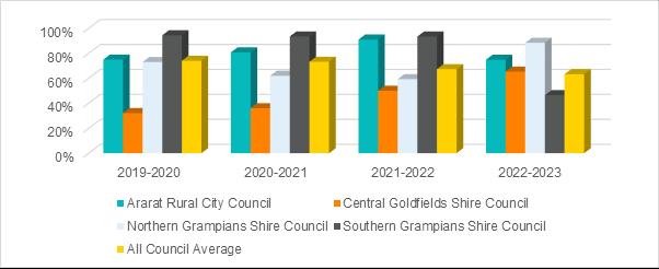
8: Cost of Statutory Planning Service per Planning Application
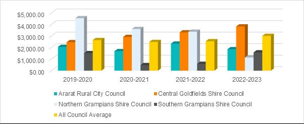
9: Council Planning Decisions Upheld at VCAT
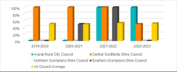
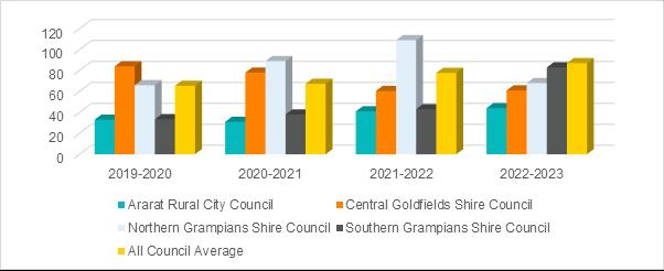
Discussion
Northern Grampians Shire’s performance has been benchmarked against three other neighbouring Councils being Ararat Rural City, Central Goldfields Shire and Southern Grampians Shire. This benchmarking shows that Northern Grampians compares generally favourably against:
▪ Median number of days taken between receipt of a planning application and a decision on the application, except Ararat Rural City Council who compared more favourably.
▪ Percentage of VicSmart planning application decisions made within 10 days and regular planning application decisions made within 60 days, particularly since 2021/22.
▪ Direct cost to council of the statutory planning service per planning application received, with overall costs showing a decreasing trend which may change with extra resourcing in future years.
▪ No council planning application decisions subject to review by VCAT, with no appeals over the last five years.
6.1.4. Decision making by Council
Evidence
Source: Council supplied data
Discussion:
There were a large number of applications determined by Council’s delegate, with just over 88% of permits decided. Over 8.8% of applications were withdrawn by the permit applicant, lapsed or no permit was required, which means that no permit was issued. Around 1.7% of applications were determined by Council which is a very low number of applications being reported to Council There were 1.2% of refusals issued by Council’s delegate which is a very low amount. Overall, there is a high level of permit approval for planning applications in the Shire.
Evidence
Table 5 and Figure 11 shows the geographic spread of applications across the municipality by locality between 1 January 2018 and May 2024.
Table 5: Distribution of Applications from 1 January 2018 to May 2024
Discussion:
There is a large spread of applications over the municipality reflecting the dispersed nature of localities in the Shire. Concentrations of applications occur in the townships of Stawell and St Arnaud and to a lesser extent in Halls Gap. Heritage overlay controls and the mix of residential and commercial areas reflect the significant numbers of applications in these two towns and their regional status. The tourism significance of Halls Gap and Great Western and the numbers of applications reflect their tourism roles at the local and regional levels. There have also been moderate numbers of applications in the smaller townships or localities of Deep Lead and Lake Fyans There is a low number of applications in agricultural and farming areas affected by the Farming Zone, the Rural Conservation Zone and the Rural Activity Zone.
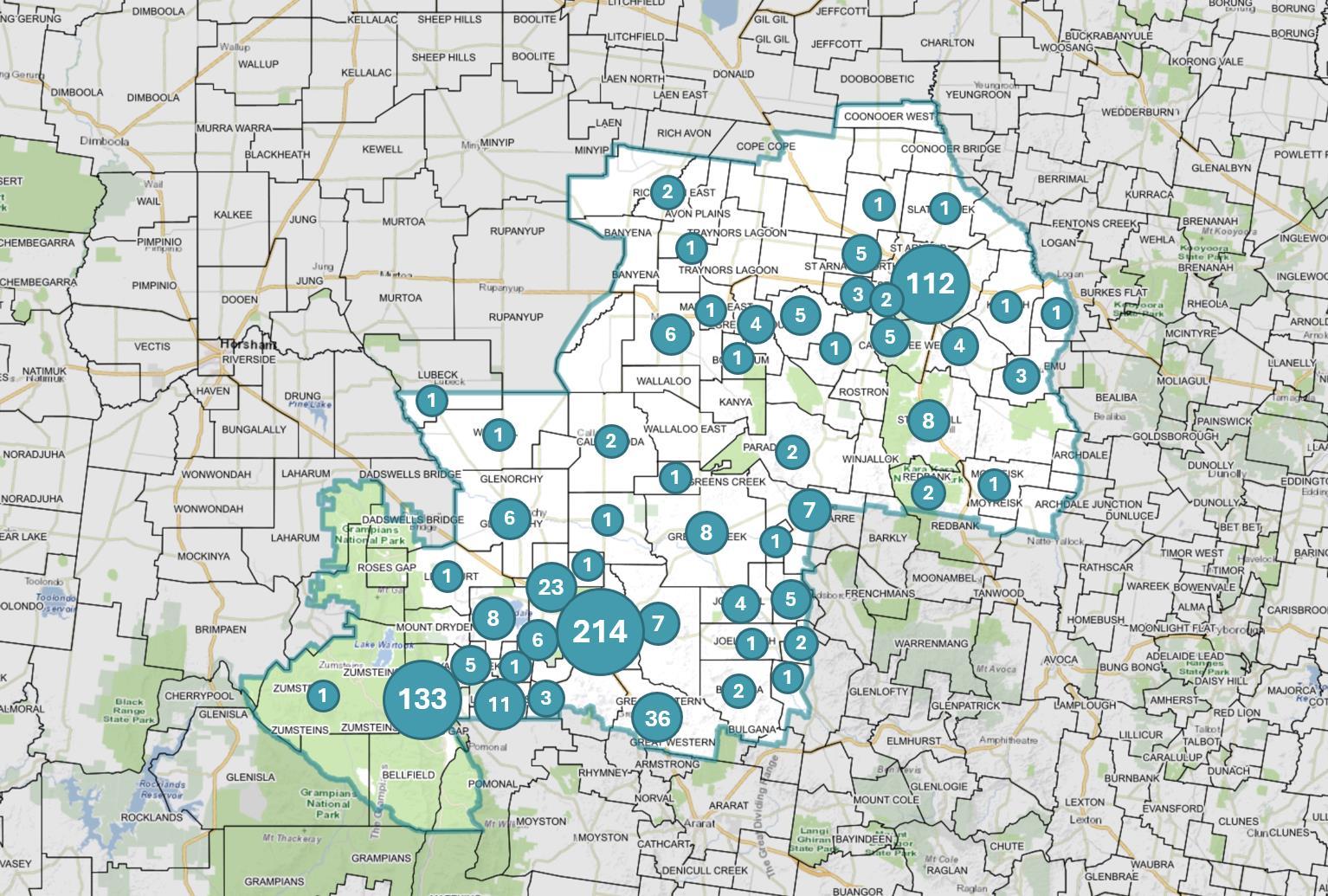
6.1.6. VCAT Decisions
Evidence
Northern Grampians had no planning matters that were appealed to VCAT during the period 2018/19 to 31 May 2024.
Discussion:
There is a low rate of refusals and Notices of Decision issued with almost 90% of decisions being a permit. The absence of VCAT appeals is not unusual for a rural municipality, particularly with a relatively high rate of withdrawn or lapsing applications.
6.2.1. Summary of planning scheme amendments
Council has undertaken or been part of 7 ‘C’ and been part of 3 “GC’ planning scheme amendments since the last planning scheme review as shown in Table 6. A detailed analysis of these has been provided to Council officers. Most amendments were not considered by a Panel. Implications for three Amendments, C60ngra, C59ngra and GC200, are further discussed below.
There are also several wind turbine, solar and other state or regionally significant proposals that are also discussed below.
In operation from
Brief description of the amendment What sort of amendment:
- Policy related - Site specific - Administrative
C035 08/03/ 2018 Corrects a minor error relating to the mapping of DDO6 and DDO7 (Helicopter Paths)
C031pt1 14/02/ 2019 Amendment C31 Part 1 implements the findings of flood investigations undertaken for Concongella, Upper Wimmera, Glenorchy and Mount William Creek by applying flood controls to affected land areas to ensure that flooding is considered in development proposals, exempting planning permit requirements for some development.
GC122 28/03/ 2019 Made administrative, format and technical changes to the Ararat, Ballarat, Golden Plains, Hepburn, Hindmarsh, Horsham, Moorabool, Northern Grampians, Pyrenees, West Wimmera, and Yarriambiack planning schemes in the Grampians region to support the publishing of these planning schemes from the Amendment Tracking System (ATS).
GC175 18/02/ 2021 Updates the existing Schedules to Clause 53.06 to make them consistent with the Ministerial Direction on the Form and Content of Planning Schemes
C59ngra 18/06/ 2021 The Amendment translated the Local Planning Policy Framework of the Northern Grampians Planning Scheme into
Status of amendment - Did not progress - Approved
- Underway Was there a Planning Panel Hearing? Does this require assessment in Part Two - Yes - No
Site specific Approved No No
Site specific Approved with changes No No
Administrative Approved No No
Administrative Approved No No
Policy related Approved No No
C031pt2
ngra Lapsed on the 01/09/ 2021
the new Municipal Planning Strategy at Clause 02, Planning Policy Framework at Clauses 11-19, and a selected number of new and updated local schedules to Operational Provisions in a manner consistent with changes to the Victoria Planning Provisions introduced by Amendment VC148.
The Amendment was prepared by Council but requested by the Wimmera Catchment Management Authority. It was the second part of Amendment C031 to apply the FO and LSIO schedules and mapping to the Halls Gap area on land which is subject to flooding in a 1 in 100 year flood event. Updates were also proposed to Clause 21.03 and referencing the flood study as a reference document.
C60ngra 10/02/ 2022 The amendment applied the LSIO1 and FO1 to areas in Halls Gap and implemented the document 'Halls Gap Planning Scheme Amendment (Water Technology, 2020)' as a background document into the scheme.
GC200 07/04/ 2022
Facilitates the East Grampians Rural Pipeline Project by introducing a new incorporated document titled East Grampians Rural Pipeline Project Incorporated Document, December 2021 to the Ararat, Northern Grampians and Pyrenees Planning Schemes and applying the SCO to the land required for the project.
C61ngra 25/08/ 2022 Corrections amendment to remove
Site specific Lapsed A Panel was appointed but unclear if they met. Yes
Site specific Approved with changes No No
Policy related Approved No No
Policy related Approved No No
C63ngra 07/12/ 2023
inconsistencies in local schedules with the VPP and Ministerial Direction - The Form and Content of Planning Schemes as part of the Smart Planning Local Schedules Update.
The amendment rezoned a portion of the Stawell urban growth area from RLZ and GRZ to the NRZ combined with a subdivision permit application.
Amendment No: C031pt1, C031pt2 and C60ngra
Amendment common name
Further strategic work required:
with changes No No
New and updated flood controls and provisions
Additional flood studies and flooding amendments that will be required in future years based on new climate change predictions and flood modelling.
In operation from: Amendment C31 part 1 from 24 July 2019; Amendment C31pt2ngra lapsed in 2021 and replaced by C60ngra from 10 February 2022.
Brief description of the amendment:
Policy matters raised by the Panel that require further consideration or action by Council.
Changes to ordinance required:
The Amendment aimed to implement the findings of five flood investigations for the catchments of Glenorchy, Upper Wimmera, Mt William Creek, Concongella and Halls Gap with the Land Subject to Inundation Overlay and Flood Overlay to land affected by 1% AEP flood (the 1 in 100- year flood). It also sought to introduce new overlay schedules with additional exemptions for development, new Municipal Strategic Statement references, a new Clause 22 local planning policy and list the flood investigation reports as reference documents.
The Panel recommended the amendment be split into two parts by removing the Halls Gap flood mapping from the amendment.
Amendment C31 part 1 implemented the findings of flood investigations undertaken for Concongella, Upper Wimmera, Glenorchy and Mount William Creek by applying flood controls to affected areas for development with a range of exemptions. This was gazetted on 24 July 2019
The Hall Gap component of the Amendment became Amendment C31pt2ngra which lapsed in 2021 and was replaced by C60ngra which was gazetted in February 2022.
The implications of flood mapping to land within the Shire, particularly townships and land where development is encouraged and discouraged
Updated local planning policy (previously Cl 22.02 and now Cl 13.03-1L), schedule 1 to Cl 44.03, schedule 1 to Cl 44.04 and schedule to Cl 72.08.
Discussion
There were three Amendments that were related but considered separately to provide improved flood mapping for land within the Shire. Amendment C30 was split into two parts, with the implementation of the flood investigations for Concongella, Upper Wimmera, Glenorchy and Mount William Creek implemented through Amendment C30 part 1. The Halls Gaps component of the Amendment was included in Amendment C30 part 2 which subsequently lapsed. A revised flood study was then prepared and implemented through Amendment C60ngra in 2022.
There remain several towns and settlements where flood studies are yet to be implemented. Flooding and updated climate change predictions are ongoing issues for Council and the relevant CMA (WCMA and the NCCMA). There will be future Amendments required to better plan for flooding impacts to land, particularly the Shire’s settlements.
6.2.3. Issue Two
Evidence
Matter Response
Amendment No: C59ngra
Amendment common name
Further strategic work required:
New MPS and PPF Translation
The MPS and integrated PPF translation provided the foundation for further strategic work to be undertaken based on Clause 74.02 and for new strategy and policy to be developed and provisions to be applied, responding to many recommendations of the 2018 planning scheme review
In operation from: 18/06/2021
Brief description of the amendment:
The Amendment translated the Local Planning Policy Framework of the Northern Grampians Planning Scheme into the new Municipal Planning Strategy at Clause 02, Planning Policy Framework at Clauses 11-19, and a selected number of new and updated local schedules to Operational Provisions in a manner consistent with changes to the Victoria Planning Provisions introduced by Amendment VC148.
Policy matters raised by the Panel that require further consideration or action by Council. Nil.
Changes to ordinance required:
Discussion
Replaced Clause 21 with Clause 02 Municipal Planning Strategy and an integrated Planning Policy Framework at Clauses 10-19.
This Amendment was a policy neutral translation of the previous Municipal Strategic Statement and Local Planning Policy Framework into the new Municipal Planning Strategy and integrated Planning Policy Framework from the Victorian Government.
The translation process implemented many recommendations from the 2018 Northern Grampians Planning Scheme Review to synthesise planning content and make the scheme easier to use and understand. There were significant resource implications to Council from the translation process and planning scheme content gaps have been identified, prompting several future strategic projects
Amendment No: GC200
Amendment
common name East Grampians Pipeline Renewal Project
Further strategic work required: Referral Decision Made by Minister for Planner that an EES was not required subject to a range of conditions.
In operation from: Date of Decision to not require an EES: 21 July 2019; Amendment GC200 gazetted on 7 April 2022
Brief description of the amendment:
Policy matters raised by the Panel that require further consideration or action by Council.
The Grampians Wimmera Mallee Water Corporation (the proponent) proposed to construct a pipeline network to provide secure stock and domestic water supply to landowners living in the climate stressed region of eastern Grampians, western Victoria. The project extent is approximately 3,320 km2 of public (95%) and private (5%) land within the local government areas of Ararat Rural City, Northern Grampians Shire and Pyrenees Shire. The proposed pipeline network will connect Lake Fyans to the existing Ararat water main and consist of a trunk line (~400km), distribution lines (~1000km), fourteen pump stations (20m x 30m), an open storage space (20m x 20m), a storage tank (1 ML), air and scour valves, power line extensions and connections to landholders.
The design of the pipeline has the capacity to supply all 1,500 rural landholdings within the project extent however connection to the scheme is voluntary. Modelling has indicated the demand for farming and lifestyle use across the project area to be a maximum of 750 ML/yr, with water to be sourced from the existing supplies in the Grampians catchment (via Lake Bellfield).
Reasons for Decision:
• With the exception of potential adverse effects on native vegetation and biodiversity values, the environmental effects of the project are unlikely to be of high significance and complexity.
• Although the proponent has a broad intention to avoid and minimise impact through design, site-selection and construction methods, uncertainties remain on the extent of potential adverse environmental effects and the likely feasibility and effectiveness of avoid and mitigation measures.
• The conditions set out through this decision provide the most appropriate means for examining these effects and uncertainties, in particular for the potential adverse biodiversity effects. They will also enable examination of the adequacy of the measures proposed to avoid and mitigate impacts in the context of the relevant policy and regulatory requirements.
• Potential adverse effects on Aboriginal cultural heritage and historic heritage values can be addressed through the statutory processes under the Aboriginal Heritage Act 2006 and Heritage Act 2017.
• Other potential effects should be readily addressed through respective statutory requirements under the Environment Protection Act 1970 and Water Act 1989.
Changes to ordinance required:
Discussion
Schedule to Clause 45.12 (SCO2) and the incorporated document East Grampians Rural Pipeline Project Incorporated Document, December 2021 plus planning scheme maps that detail the SCO2.
The gazettal of Amendment GC200 is providing improved water security for the region and will be implemented through a voluntary scheme over future years The incorporated document will need to be retained in the scheme for ongoing effect.
Amendment No: N/A
Amendment
common name Watta Wella Renewable Energy Project
Further strategic work required: Referral Decision Made by Minister for Planner that an EES was not required subject to a range of conditions.
In operation from: Date of Decision to not require an EES: 26 October 2022.
Brief description of the amendment:
Policy matters raised by the Panel that require further consideration or action by Council.
The Project is located in north-west Victoria on the lands of the Wotjobaluk, Jaadwa, Jadawadjali, Wergaia and Jupagalk first nations people, 16 km north-east of Stawell. The project comprises of up to 47 wind turbine generators (WTGs) with a maximum blade tip height of 255 m, up to 170 ha of solar photovoltaic (PV) panels and a battery storage energy system (BESS) facility to cover approximately 12 ha. The project site covers an area of about 5,200 ha. The project has an anticipated operational life of 30 years, after a 27 month construction period. Further associated infrastructure includes approximately 60 km of access tracks, onsite substations, approximately 600 m overhead 220 kV connection to existing Bulgana substation, approximately 65 km of on-site underground cabling, operational and maintenance facilities, meteorological mast, as well as potential on-site borrow pits.
Reasons for Decision:
• There is potential for significant effects to some biodiversity values, particularly associated with the removal of native vegetation, large trees, risks to potential groundwater dependant ecosystems and waterways. This includes the potential for impacts to habitat, including fragmentation, and potential for collision and cumulative impacts for some listed species such as the Swift Parrot, Powerful Owl, Barking Owl and Eastern Bent Wing Bat.
• Aside from potential adverse effects on biodiversity values, the environment effects of the project are unlikely to have the significance or complexity to warrant an environment effects statement.
• The conditions set out through this decision provide the most appropriate means for examining the uncertainties for the limited scope of potentially significant effects that may occur as a result of the delivery of the project.
• Other potential adverse effects of the project are more understood and will be readily addressed through other existing statutory requirements under the Planning and Environment Act 1987, the Aboriginal Heritage Act 2006, Heritage Act 2017, Water Act 1989, Mineral Resources (Sustainable Development) Act 1990 and Environment Protection Act 2017.
Changes to ordinance required:
Further strategic work required:
6.2.6. Issue Five
Evidence
Not determined at this stage.
Not determined at this stage.
Matter Response
Amendment No: N/A
Amendment common name
Further strategic work required:
Western Renewables Link Project (formerly known as the Western Victoria Network Transmission Project)
Referral Decision Made by Minister for Planner that an EES was required for a range of reasons.
In operation from: Date of Decision to require an EES: 22 August 2022 (EES currently being considered).
Brief description of the amendment:
Policy matters raised by the Panel that require further consideration or action by Council.
Construction and operation of a 500kV double circuit transmission line between Bulgana and Sydenham. The project also includes upgrades to the existing Bulgana Terminal Station, works to enable connection of the transmission line into the Sydenham Terminal Station and minor upgrades to existing terminal stations at Elaine and Ballarat.
Reasons:
• The area of interest for the project supports significant environmental values, including native vegetation and ecological values, residential and agricultural and other land uses, heritage values, visual and landscape values and other social values, potential aggregate impacts on which are of at least regional significance.
• Multiple alignment and design alternatives for the project within the area of interest require rigorous and transparent assessment and refinement in relation to opportunities for avoidance and/or minimisation of potentially significant effects to inform both project and statutory decision-making.
• An EES process will provide a robust, transparent and integrated framework through which: i. the project’s potential environmental effects can be rigorously assessed, including in the context of the comparative effects of feasible siting, alignment, design and operational alternatives for key components of the project; and
ii. the effectiveness and acceptability of proposed measures to avoid, minimise, manage and offset environmental effects and related risks can be evaluated/ examined.
• An EES responds to community interest in project siting, alignment and design alternatives by providing appropriate opportunities for public input.
• The construction of a new Sydenham Terminal Station is excluded from this decision as that is excluded from the referral, and is no longer proposed as part of the project.
Changes to ordinance required:
Further strategic work required:
Evidence
Not determined at this stage.
Not determined at this stage.
Matter Response
Amendment No: N/A
Amendment common name
Navarre Green Power Hub
In operation from: Date of decision to require an EES: 16 May 2024 (EES yet to be commissioned)
Brief description of the amendment:
Policy matters raised by the Panel that require further consideration or action by Council.
The Navarre Green Power Hub project is a proposed wind energy facility near the township of Navarre within the Northern Grampians and Pyrenees Shire Councils, expected to be operational for approximately 30 years. The proposal is to develop up to 102 wind turbine generators (WTG), with heights up to 270m above ground level and a total generation capacity of approximately 600 megawatts (MW).
The WTGs will be located within two project sections referred to as the Eastern Layout (5,266ha, 50 WTG) and Western Layout (4,873ha, 52WTG), with two proposed easement corridors for overhead transmission lines (Eastern and Western Layout Connection and Bulgana Terminal Station Connection).
The project has the potential for a range of significant effects that require rigorous assessment. In particular, the project as proposed could have significant effects on:
- listed threatened species and communities under the Flora and Fauna Guarantee Act 1988 and Environment Protection and Biodiversity Conservation Act 1999;
Changes to ordinance required:
Further strategic work required:
- other ecological values of the area including habitats, ecological communities, native vegetation and the adjacent National Park and conservations reserves; - freshwater environments, including wetlands and creeks; and - tangible and intangible Aboriginal cultural heritage values.
• There is uncertainty about the extent and magnitude of potential effects related to noise, historic heritage, traffic, soils, groundwater, aviation, landscape values, visual amenity and socio-economic values that also require some assessment to inform statutory decisions.
• The project has potential for cumulative adverse effects on local and regional environmental values in the context of other existing and proposed projects within the region.
• Assessment of potentially significant effects is necessary to ensure their extent and acceptability are appropriately investigated, particularly for biodiversity values. This includes examining the further avoidance and minimisation of effects via alternative siting, layouts, design and operational procedures for aspects of the proposal, as well as evaluating their effectiveness in achieving acceptable residual environmental impacts.
An EES is warranted to enable a single, integrated and transparent assessment of the environmental effects of the project, which will inform relevant statutory decision-making particularly under the Planning and Environment Act 1987, Flora and Fauna Guarantee Act and Aboriginal Heritage Act 2006.
Not determined at this stage.
Not determined at this stage.
Matter Response
Amendment No: N/A
Amendment common name
Further strategic work required:
Victoria to New South Wales lnterconnector West (VNI West)
Referral Decision Made by Minister for Planner that an EES was required for a range of reasons.
In operation from: Date of Decision to require an EES: 24 April 2024; (EES yet to be commissioned).
Brief description of the amendment:
Policy matters raised by the Panel that require further consideration or action by Council.
Development, construction and operation of a 500kV double-circuit electricity transmission line and associated infrastructure, located between a proposed switchyard in Bulgana (which is part of the proposed Western Renewables Link project) at the southern end of the project and a crossing point at the Murray River, north of Kerang, to connect to the New South Wales portion of VNI West. The project also includes the development, construction and operation of a proposed terminal station near Kerang at Tragowel and modifications to the existing 220kV line which runs between Kerang and Bendigo at the proposed terminal station. Construction laydown areas, access tracks and site offices would also be required for the project. A draft corridor for the transmission line has been developed, to provide an indication of a potential route, within a nominated area of interest.
Reasons
• The nominated area of interest for the project is significant in length and size and includes areas of significant environmental values, including native vegetation and ecological values, agricultural and other land uses, Aboriginal cultural values, visual and landscape values and other social values.
• The project has the potential for a range of significant environmental effects on biodiversity, surface water and groundwater, Aboriginal cultural values, agriculture, landscape values, amenity and socioeconomic values.
Changes to ordinance required:
Further strategic work required:
Discussion
• There are alignment and design alternatives for the project requiring assessment and refinement in relation to opportunities for avoidance and/or minimisation of potentially significant effects.
• An EES process will provide a robust, transparent and integrated assessment through which the potential environmental effects can be rigorously assessed, including alternatives for key components of the project, and the effectiveness and acceptability of proposed measures to avoid, minimise, manage and offset environmental effects.
• An EES responds to community interest in project siting, alignment and design alternatives by providing appropriate opportunities for public input.
Not determined at this stage.
Not determined at this stage.
There are three significant renewable energy proposals that will be considered through EES processes. An EES often raises significant issues, and has resourcing implications, for Council and the local community. Council will need to keep a watching brief on these projects and any resourcing implications that they may have.
Findings / recommendations
R6. Update Clause 74.02 – Future Strategic Work for delivery of strategic work to areas of existing strategic gaps with a focus on the implementation of town structure plans and flooding studies.
This section contains an overview and analysis of stakeholder engagement that has informed the Planning Scheme Review. It includes data collected as part of a Council planner survey, responses from key referral agencies and external stakeholders as well as feedback provided by planning staff, key internal staff, and Councillors through a series of workshops.
The intention of this part of the review is to provide context from those who most use the planning scheme and Councillors, as the community representatives. The findings of this engagement help refine the key issues that Council needs to address and prioritise the scope of further strategic work that should be undertaken during the next four years.
Detailed tabulated survey results have been provided separately to Council.
Council planning officers were asked to respond to a survey about the Northern Grampians Planning Scheme, prior to any analysis documents or findings being shared. The survey included questions from an officer perspective, about how well the scheme is performing, controls that need refining or could be removed, applications that are taking more time than they should, and policy gaps.
R7. Recommendations included the following matters about the operation of the Scheme including the:
▪ Further details in the schedules to Zones to guide land use particularly in the NRZ1.
▪ The RLZ has too many schedules with very large lot sizes and setback triggers for buildings in schedules to the RLZ and FZ from boundaries, roads and waterways should be reviewed.
▪ Fences in the LSIO that trigger a permit could be exempted.
R8. Recommendations included the following matters about further strategic work and/or implementation to address policy gaps for:
▪ The Introduction of Flood Overlay and Land Subject to Inundation Overlay for all flood affected land.
▪ Further work to identify and introduce the heritage overlay to protect heritage places and buildings in the municipality.
▪ Further work to underpin and review the settings in the Farming Zone, and the Rural Living Zone and provide further policy in relation to dwellings in farming zones.
▪ Strengthening neighbourhood character protection through preferred future character statements and schedules.
▪ Introduction of an ESO to trigger a permit in the Declared Water Supply Catchment.
▪ Further policies in relation to gateways and entrances into the towns.
Feedback from the initial planner survey provided the basis for a workshop with Council planners held on 23 April 2024 The workshop expanded on the issues raised in the Planners’ survey and analysed planning scheme performance more broadly.
Matters raised in this workshop echoed the survey results but there were further issues raised about:
▪ No trigger for water authorities – mandatory referral but no permit requirement. Causes issues for VicSmart Applications with the request for further information to determine if the Grampians Wimmera Mallee Water Authority approves Council end up seeking water
authority approval but applicant should be. Trying to get an MOU with the water authority and the CMAs.
▪ Consider introducing a DPO for the Halls Gap Zoo. They come in approximately once a year for a permit for enhancements or upgrades to their enclosures. These could be handled by a DPO.
▪ Community require further education about the Commercial 2 Zone. Owners wanting to develop additional housing on their site which is prohibited by the zone.
▪ Resistance in community to preparing a CHMP due to the cost. Results in some unusual ways to negate the need for a CHMP, e.g. 2 lot subdivision.
▪ The preparation of medium density housing guidelines is being explored
▪ Advocacy to work with DEECA around native vegetation removal. Council hampered by lack of enforcement officer. Council planning staff undertake enforcement but not trained and lack skills to take to Magistrates Court. Council is not securing the offsets and not helped by the fine being less than the permit cost. Challenge is also compounded by aerial photography being very out of date and this is required to monitor native vegetation removal. Google Street view is also very out of date in the region. Difficult for Council staff to even assess native vegetation as they are not trained. Should DEECA have an enforcement arm? Community and many Councillors are not that concerned about loss of native vegetation although this is changing.
▪ Emergency tree removal – a lot of people in the community don’t understand the requirements for a permit for tree removal and when it is and isn’t required. If can call Council to ask, it probably isn’t an emergency. Council require an arborist report.
▪ Quality of applications is poor meaning a lot of back and forth to obtain all requirements. A lack of drafts people in the area to assist with drawing up applications doesn’t help.
There were also issues raised about the resourcing of the planning functions at Council in both the statutory and strategic planning areas The current structure consists of a Director and Manager overseeing the strategic and statutory planning areas, with a planner and two student planners in strategic planning and three planners in statutory planning. There is no planning enforcement officer. There have been significant difficulties in recruiting staff to regional Victorian Councils historically, which has been recently exacerbated.
More recently, there has not been a large discrepancy between applications received and determined which suggests that there is a reasonable application workload for statutory planning staff There is a significant amount of planning enforcement actions that planners are tasked with which suggests that this could be better dealt with by a specific planning enforcement officer. Council should consider employing a specific planning enforcement officer.
The rapid pace of renewable energy transition is also placing significant stress on Council’s ability to consider and respond as required to project proposals and policy changes implemented by the Victoria State Government. Council must be adequately resourced to respond to the transition to renewable energy, support the community, and represent the communities’ views. Council is limited in staff resources, impacting on its ability to undertake and deliver preexisting projects and commitments whilst simultaneously responding to proposed renewable energy projects and State Government plans and policy proposals.
There are only two student planners and one strategic planner employed at Council to manage many existing strategic projects currently underway and the new projects proposed through future strategic work. This level of resourcing does not enable multiple planning scheme amendments and strategic projects to be progressed, multiple project briefs and consultancy projects to be managed, called-in proposals from State Government to be overseen and planning advice to be provided throughout Council. This suggests the need for a Principal Strategic Planner supported by at least one Strategic Planner plus student planners to lead the strategic projects underway and proposed
The funding of strategic projects and their implementation is also a significant issue for Council in a rate capped and inflationary fiscal environment. There are many other strategic projects including the Rural Land Strategy, structure plans, flooding studies and an updated heritage study with contemporary statements of significance for all heritage places identified in the HO. Council needs to prioritise funding to these and several other projects in order to implement this planning scheme review. To assist with this, Council should investigate external funding and partnership opportunities that are provided by Victorian Government Departments and Agencies and regional organisations.
Council fees are not large for its planning function. Many Councils charge significant fees for providing advice about the planning scheme and for tasks such as advertising of applications. Council could consider increasing fees for particular matters such as letters of advice, advertising and other matters that are not covered by a current statutory charge through the Planning and Environment Fees Regulations
Council delegations for planning functions currently state that any application with a value of development up to $15 Million or where between 1 - 4 objections have been received, the application must be determined at a Council meeting. In the case of an amended permit application, the same triggers apply with an additional ability for a Councillor to call in the application for decision by a Council meeting.
The level of delegation could be revised to increase the trigger for the number of objections to a larger number. This would be consistent with an efficient and well-functioning planning scheme and application process.
Briefings about strategic planning matters are regularly reported to Council and these matters must be determined by Council as the planning authority. This is appropriate under the Planning and Environment Act 1987. This leads to an additional recommendation.
R9. It is recommended that Council review delegations for planning applications and better resource the strategic planning area and planning enforcement function.
Refer to Chapter 10 for a more detailed discussion about the matters raised.
Council staff identified as having an interaction with the Northern Grampians Planning Scheme, either in an internal referral capacity or as an administrator of its policies, were asked to participate in a survey. While there was limited response, a meeting was held on the 23 April 2024 to seek further input. These responses are detailed below.
▪ Received some referrals through green light system, larger business developments tends to go towards more senior officers for referral.
▪ Deal with small businesses - Business Growth Program.
▪ Fortnightly meeting with the permit support team; discussing any permits effecting businesses.
▪ Suggest to businesses to have a pre-application meeting
▪ Big business: big industrial development, or change with the caravan park
▪ Automotive businesses wanting to start from a home business
▪ Signage: businesses get confused about what they can and cant do; prohibited advertising
▪ Council doesn’t really have a signage policy.
Engineering
▪ Priority based projects; fixing things/assets.
▪ Don’t use the planning scheme with most things.
▪ IDM not adopted by Council.
▪ Flood study- recommendations and mitigations.
Open space and recreation
▪ Trying to keep everyone happy
▪ Middle person role; helping clubs understand what they are trying to do
▪ Need female friendly changing rooms, murals etc, Walkers Lake
▪ Crossover between recreational use and conservation, native heritage etc.
Matters raised by internal staff have provided useful comments about the review relating to the types of planning applications that are referred and some of the strategic gaps in the scheme. Fortnightly planning referral meetings are held between internal Departments to exchange information and discuss issues, projects and applications Most referrals are addressed through Council’s planning software and system. Generally, internal referrals were considered to be working effectively and efficiently.
Projects underway that may have future implications for the scheme include the introduction of the Stawell and St Arnaud Structure Plans/Framework Plans and the updates to the flood mapping.
R10. Recommendations included the following matters about internal Council processes that could be improved:
▪ Consider the employment of a Principal Strategic Planner and a Strategic Planner in the Strategic Planning Area.
▪ Consider the employment of Planning Enforcement Officer in the Statutory Planning Area.
▪ Undertake a renewed and updated MOU with water authorities on water, sewerage, flooding and drainage related issues.
R11. Recommendations included the following matters about planning scheme requirements or further strategic work that should be prepared:
▪ Prepare a signage policy and guidelines.
The Executive team and Councillors were briefed on 27 May 2024. At this meeting, the planning scheme review background, and what the review should achieve, and a summary of analysis findings to date were presented and discussed.
All relevant referral and notice agencies and the Registered Aboriginal Party were invited to provide their written comments and feedback regarding the current performance of the Northern Grampians Planning Scheme, in relation to their specific areas of responsibility. Referral and notice agency responses were provided to Council and are summarised below.
In summary, there were several good suggestions made by referral authorities for the review currently underway. These relate to referrals or notice of permit applications under local provisions as detailed in the schedules to Clauses 66.04 and 66.06. There are several matters listed incorrectly in relation to referral or notice requirements that should be updated in either Clause 66.04 or 66.06 and Department or agency name updates. Any duplication of referral requirements or seeking the views of various organisations in overlays to Clauses 66.04 and 66.06 have been removed from overlays as these are all contained in Clauses 66.04 and 66.06.
There are a number of flood studies completed or underway within the NCCMA catchment.
▪ Marnoo.
▪ St Arnaud.
▪ Charlton.
ESO
NCCMA are keen to introduce a new ESO4 to cover watercourses they manage under the Water Act. This would deal with water quality issues, structures and erosion. The NCCMA can provide the details of the waterways and apply a buffer area with mapping. An example of a similar ESO is that provided for Amendment C145macr and the NCCMA would seek a regionally consistent approach
There is an opportunity to work with Council on devising an ESO schedule with the NCCMA with associated changes to the MPS and mapping. Consideration should be made to also involving the Wimmera CMA as well.
Wimmera CMA
There are a number of flood studies completed or underway within the Wimmera CMA catchment.
▪ Amendment C60ngra for the Halls Gap Upper Flooding Study was recently completed.
▪ A flood study for Stawell is currently being prepared.
Wimmera CMA have been working through some exemptions for the FO and LSIO in the Horsham and Hindmarsh Planning Schemes that could be applied to Northern Grampians.
ESO
Discussed the proposed new ESO4 watercourses schedule that the NCCMA are keen to introduce and whether the WCMA would be interested. The WCMA feel they are already seeing most higher risk applications and have a range of bylaws and permit triggers within 30m of watercourses. Large scale developments would be the only other type of application that are important to see but the EPA would probably be on top of these due to the nature of the proposed development.
Otherwise the WCMA feel they are getting everything they need and are pleased that Council sometimes contacts them for advice. A number of EESs pick up watercourse management so this is covered off.
The WCMA were receiving a large amount of dam applications at one stage but not so many recently It was not clear who was responsible authority It was discussed if a planning policy was required and the response was a clear “No”
No response was received in relation to the Planning Scheme Review
A meeting was held with DEECA and a letter was later provided. Many issues below were discussed between DEECA and Council.
There are two schedules to the Erosion Management Overlay (EMO). Schedule 1 (EMO1) relates to the St Arnaud Erosion Prone Area. Schedule 2 (EMO2) is untitled but relates to areas around the township of Halls Gap. EMO1 sub-clause 3.0 states that the responsible authority must consider as appropriate the comments of the Department of Environment, Land, Water and Planning and North Central Catchment Management Authority. It also references notice requirements in Clause 66.06. On this basis, it is assumed that Clause 66.06 is intended to read “Clause 3.0 of Schedule 1 to Clause 44.01 (EMO)”. DEECA recommends Clause 66.06 is revised to reflect this. Reference to “the Department of Environment, Land, Water and Planning” under sub-clause 3.0 of EMO1 should be updated to “the Department of Energy, Environment and Climate Action”
Other key recommendations from the DEECA include the following:
DEECA are a Referral Authority under 66.06 for local provisions applications in the EMO and authority under 66.03 for applications in the SMO (state provisions). Both of these triggers are for expertise which the Department no longer has in house. Clause 66.02 also triggers DEECA as a Referral Authority in their role administering the Catchment And Land Protection Act and the Flora and Fauna Guarantee Act.
It was noted that the statewide referral provisions for the SMO are beyond the current review process. DEECA interested in exploring a ‘codified’ set of conditions with an MOU process for those sort of applications, with process improvements possible. A local VicSmart provision is an option but this will still require the opinion of the Referral Authority to be submitted as part of the VicSmart Application.
Advocacy – there is a need for strategic work with DTP Planning Systems which DEECA could assist Council with
DEECA cannot undertake enforcement in relation to native vegetation removal under the Planning and Environment Act DEECA Can attend site visits with Council and provide supporting information such as EVCs, threatened species, etc. An example was provided of a Council that took a landowner to VCAT or Magistrates Court and cost Council money even though Council won the case.
DEECA can provide training for the road safety exemption.
There are guidance materials available to Council to assist them with emergency native vegetation removal. Only part that relates to an emergency for a dangerous limb which can be removed under this clause. Otherwise a permit is required for vegetation removal with a report from an arborist.
The process of Council sending through applications for pre-referral advice works well and should continue.
DEECA can prepare a further written response and look at issues such as any issues in relation to Crown land zones or anomalies, and the extent of overlays.
GHCMA advised that they have no comments to make on the review. There is only a small portion of land impacted on their region with the majority being in the Gariwerd National Park.
Requested consideration of changes to Clause 66.02-7 which are state based changes that cannot be made through this Planning Scheme Review.
The CFA advised that given all of CFA’s relevant referral triggers are associated with state-based planning provisions, they address referral requirements with the Department directly to ensure a consistent approach is applied across all of the Country Area of Victoria. They recommend that any other potential policy changes are prepared through the lens of Clause 13.02-1S. This will assist in ensuring that the update will not have any undue policy impacts that influences bushfire outcomes, or increase/change bushfire risk, hazards or policy responses.
DJAARA acknowledged its shared aspiration with Northern Grampians Shire in the protection and promotion of the area’s heritage, and the opportunities presented in the review. DJAARA’s shared interest extends to areas such as cultural tourism and initiatives including the Central Goldfields World Heritage bid, exemplifying the important link between protecting and promoting shared heritage.
DJAARA noted that the review presents some key opportunities in the protection and promotion of the area’s heritage and specifically DJAARA’s cultural heritage. Where the planning scheme is powerful tool in ensuring a positive future for Country, there is an opportunity to acknowledge, recognise and respect Dja Dja Wurrung as Traditional Owners of Country within the Shire. For example, within the Planning Scheme, the Municipal Planning Strategy presents an opportunity to include an Acknowledgement, as well as statements in support of Djaara’s interests and cultural heritage. Specific examples of edits were provided.
Further to this, DJAARA also proposes the inclusion of an additional local schedule to 15.03-2L Aboriginal Cultural Heritage, detailing further strategies and policy guidance in relation to Djaara’s cultural heritage (with examples provided).
DJAARA also noted that there are further opportunities for Council to assist in strengthening processes involving cultural heritage and planning such as sharing of due diligence reports written by heritage advisors for Council, ACHRIS information and training of Council staff.
Barengi Gadjin Land Council
Discussions with a representative from the Barengi Gadjin Land Council (BGLC) raised the following issues:
▪ Resolution under the review may not be necessary, but other avenues exist, such as in the Plan for Victoria, rezonings, etc.
▪ Scheme control that applies to “Sister Rocks” being transferred to BGLC.
▪ Potential to exempt RAPs through Section 16 orders.
▪ Consider giving RAPs powers as public land managers with a remit similar to DEECA.
▪ Some planning scheme controls relate to biodiversity significance and cultural heritage protections (e.g., for Red-tailed Cockatoos).
▪ Caring for Country is key for BGLC.
▪ “Recognition of Settlement Agreement”: exploring planning interests for BGLC.
▪ BGLC's desired role in LGA-level involvement - legal agreement between BGLC and the Victorian Government.
▪ Work should inform a broad range of reviews, assessing how well cultural heritage is mapped.
▪ Consider including scar trees in HO; explore if that’s the appropriate method.
▪ Tight curtilage around HO places/objects; larger areas may need to be applied, avoiding centring solely on heritage artefacts.
▪ Transfer of land/ownership for some assets between Council and BGLC.
▪ Suitability of SUZ or PCRZ controls, depending on context.
▪ Need to let the work guide a wide array of reviews.
▪ Cultural heritage mapping effectiveness is under review.
▪ Exploring new steps in identification, particularly in National Parks (NP) and NP regulations.
▪ Open space placement near waterways should be reconsidered, as many artefacts fall outside the metre distance; CHMP must be signed by the RAP
▪ Early involvement in planning could enhance outcomes, e.g., in golf course locations.
▪ RAPs prefer not to be called in on every application; most cultural heritage is found along waterways.
▪ Mapping is a useful starting point.
▪ “House of Feathers” is a significant site in Western Victoria.
▪ Early engagement in the strategic stage is crucial.
▪ Acknowledgements are often incorrect; each RAP has its own and it’s important to reflect this accurately.
▪ Councils often hold a fair share of their mandate, which may differ from State policy and strategy.
▪ West Wimmera Senior Planner work highlighted differences in policy application, such as native vegetation policy.
▪ Values may not always align, emphasising the importance of relationship building and trust.
▪ Capacity, capability, and understanding must be built.
▪ Land ownership is also about economic development, intergenerational wealth transfer, and self-determination, leading to improved reconciliation.
R12. The following recommendations are included:
▪ Update the Schedule to Clause 66.04 - Referral of permit applications under local provisions to change reference to the “Department of Health and Human Services” to the “Department of Health”.
▪ Update the Schedule to Clause 66.06 - Notice of permit applications under local provisions to change reference to the “Secretary to the Department of Environment, Land, Water and Planning” to the “Secretary of the Department of Energy, Environment and Climate Action” and include updates to the correct EMO schedule.
▪ Prepare a new ESO for watercourses in future strategic work.
▪ Prepare a new ESO for the proclaimed water catchment in future strategic work
▪ Undertake a renewed and updated MOU with water authorities on water, sewerage, flooding and drainage related issues.
▪ Undertake a Cultural Values Assessment for the Shire in consultation with the Dja Dja Wurrung Clans Aboriginal Corporation and the Barengi Gadjin Land Council.
Agencies that did not respond.
There was no response from the EPA, Department of Transport and Planning or Parks Victoria.
7.5. Summary of issues raised through engagement
The following table outlines the various matters raised during the Stakeholder Engagement phase of the review.
Table 7: Summary of Issues raised through engagement
Issue
Dwellings and subdivision in the Rural Zones
Identification of High and Low Value Agricultural Land through a Rural Land Strategy
Internal processes, communication and delegations.
Significant landscapes and Significant Landscape Overlay
Water, Sewerage, Flooding, Stormwater and Drainage
Environment and Environmental Significance Overlays
Neighbourhood Character
Bushfire and Bushfire Management Overlay
Affordable housing
Environmentally sustainable development
Post contact heritage and Aboriginal cultural heritage
Climate Change Impacts


New strategic work that has been adopted by Council was reviewed to identify whether any policy should be included into the scheme.
The intention of this part of the review process is to include policy that may have been developed by another part of Council (for example, Economic Development, Sustainability, Community Planning etc.) and that is unlikely to be incorporated into the planning scheme through a stand-alone amendment.
The scope of this does not include significant strategic land use planning projects such as Structure Plans for townships, or Housing Strategies, which should go through a separate, dedicated planning scheme amendment process.
Regional documents, such as Catchment Management Plans, are also reviewed, to identify if there are any Council specific proposals that should be reflected in the planning scheme. (For example, the construction of a new wetland or an integrated water management plan).
8.1.1. Documents reviewed
The following documents that have been prepared since the last planning scheme review were reviewed:
▪ Arts and Culture Strategy 2020-2024 (Northern Grampians Shire, Hansen Partnership, 2020)
▪ Economic Development Strategy and Action Plan 2021-2031 (Northern Grampians Shire, 2021).
▪ Northern Grampians Community Health and Wellbeing Plan 2021-2025 (Northern Grampians Shire, 2021).
▪ Halls Gap Village Centre Action Plan: Stage 1 (Northern Grampians Shire, Hansen Partnership, 2018).
▪ Marnoo Community Action Plan 2021-2025 (Northern Grampians Shire, 2021).
▪ Northern Grampians Council Plan 2021-2025 (Northern Grampians Shire Council, 2021).
▪ Northern Grampians Domestic Wastewater Management Plan 2022-2027 (Northern Grampians Shire, 2022).
▪ Retail Gap Analysis for Stawell and St Arnaud (Northern Grampians Shire, Retail Doctor Group, 2018)
▪ St Arnaud Tourism Strategy and Action Plan 2022-2032 (Northern Grampians Shire, 2022)
▪ Stawell Tourism Strategy and Action Plan 2022-2032 (Northern Grampians Shire, 2022)
▪ Great Western Public Park & Gardens Reserve Redevelopment Masterplan 2018-2028 (Northern Grampians Shire, 2018)
▪ Stawell Aerodrome Master Plan Review (Specialist Airport Solutions Pty Ltd, 2023)
▪ Stawell Parks Precinct Plan Directions (Leisure Planners, 2019).
▪ Stawell Western Highway Urban Design Framework (Northern Grampians Shire Council, 2021)
▪ Walkers Lake Management Plan, Walkers Lake, Avon Plains, Victoria (Ecology & Heritage Partners, 2022)
8.1.2. Documents with policy implications
Arts and Culture Strategy 2020-2024 (Northern Grampians Shire, Hansen Partnership, 2020)
This report advocates for increased Council support and participation in arts and culture activities by linking in with existing activities, promoting new ones and building capacity within the creative community to capitalise on the potential for growth in this industry. It is based off community feedback from the Arts and Culture Audit and Opportunities Report 2016 along with Council policy, the broader Council Plan, and community consultation undertaken on the draft version of this document The strategy should be reflected through a new local policy at Clause 19.02-3L that references land use and development relationships from the strategy
Economic Development Strategy and Action Plan 2021 -2031
The Economic Development Strategy and Action Plan aims to address the Shire’s three biggest challenges being workforce and skills shortages due to population decline and growing social and economic disadvantage, vulnerability to natural disasters and global market events undermining consistent economic growth and ensuring investment competitiveness. The document includes a large amount of contextual information that should underpin the land and use development framework for the Shire. This contextual information should be placed into the MPS at 02.03-4, 02.03-7, 02.03-8 and 02.03-9 with accompanying strategic directions for some clauses.
Northern Grampians Domestic Wastewater Management Plan 2022-2027 (Northern Grampians Shire, 2022)
Council is required to prepare a Wastewater Management Plan (WMP) under the State Environment Protection Policy (Waters). Council’s Wastewater Management Plan 2022 provides oversight of domestic onsite wastewater management systems that process flows under 5000 litres each day. They are used at residential, community and business premises where access to the reticulated sewer system is not possible. The WMP assesses domestic wastewater (often referred to as on-site wastewater or septic tank) risks in the municipality and develops prioritised actions to address potential impacts. There are no maps included in this document so it is difficult at this stage to reference it spatially but a catchment and land protection policy should be included in the scheme. Preparing a specific ESO schedule could occur at a later date and be subject to future strategic work This could help to better manage unsewered land for urban development particularly for planning applications that are lodged with Council and the document should be added as a background document in the scheme
St Arnaud Tourism Strategy and Action Plan 2022-2032 (Northern Grampians Shire, 2022)
The St Arnaud Tourism Strategy and Action Plan (SATSAP) sets out the vision and aspirations for the visitor economy of St Arnaud and surrounds over the next ten years. It is an important part of growing the visitor offering and building resilience in the Northern Grampians economy. It will contribute to informing overall tourism strategic directions for the NGSC, identifying commonality in experience themes in the Northern Grampians, areas of competitive advantage and opportunities to leverage major tourism projects in the wider Grampians region.
This could be introduced into Clause 17.04-1R or a separate L policy to position St Arnaud and the wider region for increased tourism and as a visitor destination. The document should also be included and as a background document at the schedule to Clause 72.08
Stawell Tourism Strategy and Action Plan 2022-2032 (Northern Grampians Shire, 2022).
The Stawell Tourism Strategy and Action Plan (STSAP) sets out the vision and aspirations for the visitor economy of Stawell and surrounds over the next ten years. It is an important part of growing the visitor offering and building resilience in the Northern Grampians economy. It will contribute to informing overall tourism strategic directions for the NGSC, identifying commonality in experience themes in the Northern Grampians, areas of competitive advantage and opportunities to leverage major tourism projects in the wider Grampians region.
This could be introduced into Clause 17.04-1R or a separate L policy to position Stawell and the wider region for increased tourism and as a visitor destination. The document should also be included and as a background document at the schedule to Clause 72.08.
Stawell Aerodrome Master Plan Review (Specialist Airport Solutions Pty Ltd, 2023)
This document is a review of the previous Masterplan by Airports Plus Pty Ltd (2008). It was conducted in order to adhere to the new Civil Aviation Safety Authority (CASA) regulations made in August 2020.
It could be introduced into an update of Clause 18.02-7L Stawell Aerodrome to include plans for future expansion and upgrades to hangars and other infrastructure. The document should also be included and as a background document at the schedule to Clause 72.08
Walkers Lake Management Plan, Walkers Lake, Avon Plains, Victoria (Ecology & Heritage Partners, 2022)
The management plan provides ecological and cultural heritage management advice and action management plan recommendations for Walkers Lake and Avon Plains. It reviews the existing NGSC Walkers Lake Management Plan and other relevant ecological and cultural heritage reports. It also updates the implementation of the Walkers Lake Management Plan to protect and enhance biodiversity and cultural heritage values while providing an area for visitors and recreational activities. It provides advice regarding the likely or potential regulatory and legislative considerations (e.g. permits, additional assessments and approvals) associated with the continued management, including any works that are outlined in the Management Plan.
This document should be included as a Background document at the Schedule to Clause 72.08: Walkers Lake Management Plan, Walkers Lake, Avon Plains, Victoria (Ecology & Heritage Partners, 2022). Additional information could be added with a strategic direction to the environmental and landscape values section of the MPS in 02.03-2.
Recommendations are made with regard to the following policy documents:
R13. Reference the following documents in the planning scheme:
▪ Arts and Culture Strategy 2020-2024 through Clause 19.02-3L and as a background document at the schedule to Clause 72.08.
▪ Economic Development Strategy and Action Plan 2021 -2031 at Clauses 02.03-4, 02.03-7, 02.03-8 and 02.03-9 with accompanying strategic directions where relevant and as a background document at the schedule to Clause 72.08.
▪ Northern Grampians Domestic Wastewater Management Plan 2022 -2027 in a new local policy at Clause 14.02-1L Catchment planning and management and as a background document at the schedule to Clause 72.08 to better protect catchment waterways and ground water.
▪ St Arnaud Tourism Strategy and Action Plan 2022-2032 into a new Clause 17.04-1L and as a background document at the schedule to Clause 72.08.
▪ Stawell Tourism Strategy and Action Plan 2022-2032 into a new Clause 17.04-1L (Northern Grampians Shire, 2022).
▪ Stawell Aerodrome Master Plan Review into a revised Clause 18.02-7L Stawell Aerodrome and as a background document at the schedule to Clause 72.08.
▪ Walkers Lake Management Plan, Walkers Lake, Avon Plains, Victoria into a revised Clause 02.03-2 and as a background document at the schedule to Clause 72.08.
8.2.1. Documents reviewed
The following documents were reviewed:
▪ Wimmera Southern Mallee Regional Economic Development Strategy
▪ The Housing Blueprint, Wimmera Development Association
These three regional strategies have high level implications for the review but much of their content is too high level to be specifically included in the planning scheme. Application of these regional strategies should be undertaken through the lens of regional policy rather than local policy and considered further by the Victorian Government The strategies could be referenced as background documents in the planning scheme at a later stage rather than through this review
This document sets out a strategy to provide the region with a consistent socio-economic evidence base, and strategic framing of medium to long-term directions to activate economic development opportunities. It defines four strategic directions for economic development in the region, based on comprehensive data analysis and review of existing policies and strategies which include to:
▪ Strengthen agriculture and food product manufacturing through diversification.
▪ Promote growth and development of the visitor economy, leveraging natural assets and Aboriginal heritage.
▪ Support and expand economic opportunities in growing sectors (health and social services).
▪ Position the region to benefit from emerging growth opportunities in natural resources.
The strategy identifies opportunities in key areas that can help drive regional economic growth. However, it is identified that the region’s capacity to activate these opportunities and grow is partly determined by cross-cutting enabling factors that support economic activity. Consideration of these enabling factors – and targeted investments and initiatives to strengthen them – will help support achievement of the strategic directions in this REDS.
In terms of implementation, the focus is on the region’s future economic development activities, including through policy, investment and program delivery. It is not a prescriptive roadmap for Victorian Government economic development action in the Wimmera Southern Mallee and as such needs a regional, partnership and policy based approach which cannot be easily implemented through this review.
This document sets out a strategy to address the complex housing challenges facing the six Councils in the Wimmera to ensure future regional growth and prosperity. It provides a strategy to intervene in the regional housing market through innovative land sub-division models, retirement/other accommodation for the ageing population, increased rental housing and residential investment models. The multi-facet foundations working in unison, are aimed at delivering a shared vision, through collaboration with all regional and government stakeholders, including the WDA six local government areas, to deliver effective and diverse housing solutions. This document needs to be consistently implemented over the six Wimmera planning schemes in future and this could include adding more directions on housing to the housing section of the MPS at Clause 02.03-6, regional or local policy at Clauses 16.01-1 (R or L) Housing supply or 17.01-1 (R or L) Employment and as a background document to the schedule to Clause 72.08.
Council has a number of strategic planning projects underway. These are outlined below.
▪ C64 St Arnaud Township Framework Plan
▪ St Arnaud and Stawell Heritage Amendment
▪ Flood studies for St Arnaud, Stawell and Marnoo
▪ Stawell Structure Plan and Western Highway Urban Design Framework Amendment and future growth area masterplan.
▪ Infill housing project
These projects will require significant strategic planning resources in order to be delivered. Grants and other funding opportunities could also be explored from the Victorian and Commonwealth Governments as well as other avenues.
The following list of work is a comprehensive list of all the further strategic work that has been identified through this planning scheme review (Table 8). The list below represents the further strategic work that will have the most positive impact for the Northern Grampians community and the efficient functioning of the planning service. This list is included in the recommendations below.
Only work that can be completed in the next four years should be included in Clause 74.02 of the planning scheme. A recommended Clause 74.02 is included in the marked-up ordinance at Appendix 1. This should be considered by Council to ensure that the work is reasonable to complete over the next four years and, if not, the priority projects that should be included in Clause 74.02.
Table 8: Further Strategic Work identified
Project Name
Partner with the NCCMA and the WCMA and relevant water authorities to complete and implement updated flooding studies.
Review the Northern Grampians Heritage Study and extend the Heritage Overlay to the most important places identified in the Northern Grampians Heritage Study as a result of additional heritage studies and statements of significance.
Implement the Stawell and St Arnaud Structure Plans/Framework Plans into the planning scheme.
Implement the Western Highway Urban Design Framework into the planning scheme.
Prepare a rural land use strategy and local policy to guide decisions in the FZ, RCZ, RAZ and RLZ (and potentially LDRZ) in areas outside town boundaries.
Prepare a structure plan for Halls Gap.
Partner with the NCCMA and the WCMA to investigate extending the Environmental Significance Overlay to include all declared open proclaimed water supply catchments.
Partner with the NCCMA and the WCMA to prepare an MOU for the proclaimed water supply catchment and planning applications in that area.
Investigate application of the Restructure Overlay to old and inappropriate small rural lots.
Undertake an open space strategy and prepare specific requirements to a schedule to Clause 52.01 for a 5 percent (or greater) public open space contribution for residential, commercial and industrial land. Apply a BAO instead of ESO3 to Stawell wastewater plant, and apply the BAO to the St Arnaud, Halls Gap and Great Western wastewater plants. At the same time consider application of the PUZ to the Halls Gap and Great Western wastewater treatment plants.
Prepare a signage policy and guidelines.
Undertake a Cultural Values Assessment for the Shire in consultation with the Dja Dja Wurrung Clans Aboriginal Corporation and the Barengi Gadjin Land Council.
Recommendations:
It is recommended that Council prioritise the following further strategic work over the next four years to:
R14. The following further strategic work that should be undertaken in the next four years:
▪ Partner with the NCCMA and the WCMA and relevant water authorities to complete and implement updated flooding studies.
▪ Review the Northern Grampians Heritage Study and extend the Heritage Overlay to the most important places identified in the Northern Grampians Heritage Study as a result of additional heritage studies and statements of significance.
▪ Implement the Stawell and St Arnaud Structure Plans/Framework Plans into the planning scheme.
▪ Implement the Western Highway Urban Design Framework into the planning scheme.
▪ Prepare a rural land use strategy and local policy to guide decisions in the FZ, RCZ, RAZ and RLZ (and potentially LDRZ) in areas outside town boundaries.
▪ Prepare a structure plan for Halls Gap.
▪ Partner with the NCCMA and the WCMA to investigate extending the Environmental Significance Overlay to include all declared open proclaimed water supply catchments.
▪ Partner with the NCCMA and the WCMA to prepare an MOU for the proclaimed water supply catchment and planning applications in that area.
▪ Investigate application of the Restructure Overlay to old and inappropriate small rural lots.
▪ Undertake an open space strategy and prepare specific requirements to a schedule to Clause 52.01 for a 5 percent (or greater) public open space contribution for residential, commercial and industrial land.
▪ Apply a BAO instead of ESO3 to Stawell wastewater plant, and apply the BAO to the St Arnaud, Halls Gap and Great Western wastewater plants. At the same time consider application of the PUZ to the Halls Gap and Great Western wastewater treatment plants.
▪ Prepare a signage policy and guidelines.
▪ Undertake a Cultural Values Assessment for the Shire in consultation with the Dja Dja Wurrung Clans Aboriginal Corporation and the Barengi Gadjin Land Council.
Marked up ordinance with policy neutral and strategically justified changes to the planning scheme.
How to read this document
This document shows all the changes recommended to the planning scheme as a result of the Planning Scheme Review.
Additions and deletions are shown as ‘track changes’.
Changes generally have a source code to explain where the policy has come from or where it has gone. [Source codes look like this].
Where the policy is new, the source code includes NEW in front of it. [NEW: Gumnut Council Plan, page 6]
If a change requires an explanation, it has a reason code against it. [Reason codes look like this]
The list of documents that have been referred to in the ordinance, and the abbreviations used, is in the table below. Document
Arts and Culture Strategy 2020-2024 (Northern Grampians Shire Council, 2020) [ACS]
Economic Development Strategy and Action Plan 2021-2031 (Northern Grampians Shire, 2021) [EDSAP]
Environmental and Heritage Management Advice: Walkers Lake Management Plan, Walkers Lake, Avon Plains, Victoria (Ecology & Heritage Partners, 2022) [WLMP]
Ministerial Direction on Form and Content [MDF&C]
Northern Grampians Planning Scheme Review (Northern Grampians Shire, 2024 [PSR2024]
Stawell Aerodrome Master Plan Review (Specialist Airport Solutions Pty Ltd, 2023) [SAMPR]
St Arnaud Tourism Strategy and Action Plan 2022-2032 (Northern Grampians Shire, 2022) [SATSAP]
Stawell Tourism Strategy and Action Plan 2022-2032 (Northern Grampians Shire, 2022) [STSAP]
02.01
18/06/2021
C59ngra
/ / CXXngra
Northern Grampians Shire is located on Djandak, the land of the Dja Dja Wurrung, Jaadwa, Jadawadjali, Jupagulk, Wergaia and Wotjobaluk Peoples’ Country and we pay our respects to their Elders past and present, and to the Aboriginal Elders of other communities who may reside here today. [NEW: Engagement with Traditional Owners]
Northern Grampians Shire is located in the Wimmera Southern Mallee Region of Victoria, and shares its boundaries with Yarriambiack Shire and Buloke Shire to the north, the Loddon Shire, Central Goldfields Shire and Pyrenees Shire to the east, the Rural City of Ararat and Southern Grampians Shire to the south and the Rural City of Horsham to the west.
Theshirecovers5,918squarekilometresoflandandcontainsanumberofnaturalfeatures,including the Grampian Ranges in the south, the foothills of the Pyrenees Mountains in the north east and the Wimmera Plains in the north west. The Grampians are a mountainous landscape of national significance consisting of rugged landscape ridges and escarpments. The surrounding farming country is attractive, containing mature river red gums and other native trees in paddocks and along roads and streams.
The richness of indigenous cultural heritage within Northern Grampians sets the region apart under the stewardship of the Traditional Owners of the region, the Dja Dja Wurrung, Jaadwa, Jadawadjali, Jupagulk, Wergaia and Wotjobaluk Peoples. Over 80 percent of Victoria’s Aboriginal rock art is located within the Grampians, including the only known rock art painting of Bunjil, and widely regarded as one of the most significant cultural sites in south eastern Australia. [NEW: Engagement with Traditional Owners]
The Avoca, Avon, Richardson and Wimmera Rivers areall withinthe shire The upper catchment of the Wimmera River supplies a secure water supply to thousands of farms and over fifty townsin the Wimmera and Mallee regions. Stawell and St Arnaud townships are supplied water from Lake Fyans, Lake Bellfield and the area known as the Volcano.
Other major environmental assetssites of the shire include Lake Lonsdale, Lake Fyans, Teddington Reservoir, Lake Batyo Catyo and the Kara Kara State Forest. Many of these sites are also places of cultural heritage significance to traditional owners. [NEW: Engagement with Traditional Owners]
The majorityIn 2021, there were 11,948 people living in the municipality with most of the shire’s population residinge in the major towns of Stawell and St Arnaud. HallsGap andGreat Westernareis a significant regional smalltowns and the small settlements of Great Western, Navarre, StuartMill, Marnoo and Glenorchy provide important focal points for local communities. The Shire generated $720 Million worth of gross regional product in 2021 with the aim to grow this to $920 Million by 2031. [NEW: EDSAP and ABS 2021] [ABS updated data and Eco Dev Strategy information, p. 24]
02.02
18/06/2021 C59ngra
Northern Grampian Shire’s vision for the shire from a land use and development perspective is to:
Enhance lifestyles and community by:
▪ Maximising the benefits of predicted population growth.
▪ Promoting the key livability aspects of the region.
▪ Developing spaces that encourage activity and participation.
Boost economic growth by:
▪ Facilitating business to increase workforce.
Provide sustainable infrastructure to:
▪ Enhance the natural and built environment.
▪ Improve lifestyles and visitation.
02.03
18/06/2021
C59ngra
/ / CXXngra
02.03-1
18/06/2021
C59ngra
/ / CXXngra
Stawell
Stawell has a diverse range of land uses, with industries interspersed with residential uses. The major industrial land uses include gold mining, brick making, and meat processing. The resulting land use conflicts are being managed by locating industry in specific areas with the appropriate infrastructure.
Stawell contains an established network of open space comprising of both active and passive recreational areas and bushland reserves. The dwelling types within Stawell are mixed and are generally on large lots. The town has a rich heritage character and an attractive environment in which to live, shop and spend leisure time.
Stawell’scloserelationshipswithAraratprovidesanopportunitytodevelopthetownsasa cohesivesub-regional cluster of housing, employment and services.
StArnaudisthesecondlargesttownshipintheshireandplaysanimportantroleasaservicecentre for the surrounding rural districts. It is strategically located at the junction of the Wimmera and Sunraysia Highways and on the route of Melbourne-Mildura freight. The St Arnaud rail line (on the freight line) connects Maryborough to Mildura providing access from the region to the ports of Portland, Geelong, and Melbourne. It is the centre of local retail and includes a cluster of agribusinesses. The township offers both residents and visitors a rich heritage character and an attractive environment in which to live, shop and spend leisure time. St Arnaud has an established networkof open space, comprising a mix of passive and active recreation reserves, and a defined main street, characterised by heritage buildings and features.
The Halls Gap/Lake Bellfield area is the main focus for development activities associated with the Grampians National Park. Halls Gap is a unique township located in the heart of the Grampians National Park. The township is located in a river valley with steep, densely vegetated slopes either side posing severe development constraints. Halls Gap has the ability to accommodate 10,000 people in peak periods in a range of accommodation styles. The township and the immediate area contain business, residential, rural and public land and it serves an important social, economic, tourist and landscape role in the local community.
Great Western is a small town with a rich heritage character located on the Western Highway, midway between Stawell and Ararat. The town, with a history of grape growing and wine making, has a strong viticulture identity and rural village character. In recent years expansion of the Seppelt and Best wineries operations has seen this role within the town consolidated. The town is bisected by the Western Highway and the main Melbourne-Adelaide rail link.
Strategic directionsCouncil’s strategic directions for settlement are to:
Encourage the growth of Stawell as the sShire’s largest town.
Encourage development that supports the existing rural service role of St Arnaud.
Manage the development ofHalls Gap whilst protectingits environmental and tourism values.
Enhance the role of Great Western as a wine village and tourist destination.
02.03-2
18/06/2021
C59ngra
/ / CXXngra
02.03-3
18/06/2021
C59ngra / / CXXngra
Encourageresidentialdevelopmentwithincurrenttownshipboundariesandparticularly withinthe respective township centre and in proximity to the town sewerage scheme.
Limit rural living to areas where such development currently exists and on the periphery of Stawell and St Arnaud.
With the Grampian Ranges to the south and the Pyrenees Ranges to the east, the shire contains some of the most significant environmental features in the State.
The shire Shire has a wide range of habitat areas supporting a diverse range of flora and fauna. The shire Shire includes parts of the three distinctive catchments of Glenelg Hopkins, Wimmera and North Central. Five state and national significant vegetation species have been identified in the Walker Lake Environs. The lake and their environs are also of significance to the Dja Dja Wurrung Traditional Owners. [New: WLMP] [Updated strategic context and direction from plan]
Strategic directionsCouncil’s strategic directions for environmental and landscape values are to: [New] [MDF&C]
Protect habitats for local flora and fauna, including remnant vegetation.
Protect the environmental and landscape values of the Grampians National Park, locally and as a major natural feature tourist attraction.
Conserve existing wildlife corridors to establish strong biolinks between important habitats. Support development on land that is already cleared to avoid the removal of remnant vegetation.
Promote recreational and tourism opportunities based around the landscape value of the Shire’s floodplains and wetlands.
Rehabilitate and protect the environmental values of Walker Lake and its environs.
Land in the shire Shire is subject to environmental risks such as bushfire, landslides, flooding and salinity that are forecast to be exacerbated by the impacts of climate changes. [New: EDSAP, p. 33] [Updated contextual information]
Active riverine flooding occurs along the Avoca, Avon, Richardson and Wimmera systems and further sheet flooding also occurs throughout parts of the shire creating overland flow paths.
St Arnaud is located on low-lying, flood prone land and is bisected by the St Arnaud Creek. Flooding, drainage and poor water supply are emerging issues in the township.
Halls Gap is situated within the Grampians National Park in the Fyans Valley. The surrounding catchment is very steep with inundation caused by Fyans Creek and the gullies flowing from Mount Difficult (including Stoney Creek). The steep terrain contributes to the rapid generation of significant runoff volumes from relatively minor rainfall events.
Glenorchy is positioned close to the Wimmera River, which in turn exposes the town to risks from flooding. Glenorchy Township suffers significant inundation in moderate to major flood events, and there is substantial documentation of historic flood events that affected the town.
Flooding in Glenorchy is a result of both direct inundation from the Wimmera River, and breakout flow from upstream areas flowing through the town. The sShire also has land susceptible to landslides and land with a high risk of potential instability including land located in the Grampians National Park, and the township of Halls Gap.
Bushfire is a significant hazard in the shire Shire and around townships, with Halls Gap, St Arnaud and land around Kara Kara State Forest being at high risk.
02.03-4
18/06/2021
C59ngra
Strategic directionsCouncil’s strategic directions for environmental risks and amenity are to: [New] [MDF&C]
Ensure land use and development does not increase the level of bushfire risk and includes adequate fire protection measures.
Reduce salinity risk by reducing ground water accessions, preventing development within high risk salinity areas and stabilising salinised areas.
Ensure that development does not increase the landslide risk to life or property.
Maintain the free passage and temporary storage function of floodplains.
Ensure development minimises the potential for flood risk and damage from flood water.
Northern Grampians is at the southern end of Victoria’s grain production heartland and has partnered in the innovations and practices which have propelled Australia’s dryland production systems to become the most efficient in the world.
Varied soil types, favourable climatic conditions, and the advantages of space are reflected in the region’s agricultural sector through the diversity and volume of crops and livestock produced in Northern Grampians. [New: EDSAP, p. 25] [Updated contextual information]
Agriculture is the dominant land use and industry in the sShire, with key activities being sheep farming, cattle farming and crop raising. Viticulture, poultry farms and pig farms are also growing industries in the region. The sShire has a temperate climate ideal for wool, grain and wine production. The Stawell gold mine is Victoria’s largest operating gold mine. Earth and energy resources are continuing to be developed and extracted throughout the sShire and are important to the regional economy.
Strategic directionsCouncil’s strategic directions for natural resource management are to:
Support sustainable agriculture and horticultural industries, as the foundation to a strong and prosperous economy.
Support sheep farming, cattle farming and crop raising as the dominant agricultural activities of the shire and encourage the continued growth of intensive agricultural industry such as viticulture, poultry farming and pig farming.
Protect productive agricultural land for the purposes of agricultural production and valueadding industries.
Ensure agricultural land is managed to protect its productive use.
Support the clustering of agricultural functions and associated rural industries in locations which are compatible with adjoining and nearby land uses.
Support earth and energy resource industries provided they address environmental, amenity, health and rehabilitation issues to ensure the long term impacts of mining and extractive industry on the surrounding environment and community are minimised.
Ensure intensive animal industries and earth and energy resource industries have sufficient buffers to sensitive land uses to minimise conflict.
02.03-5
18/06/2021
C59ngra / / CXXngra
The Grampians and Wimmera Plains region is a rich indigenous cultural location. The Northern Grampians Shire is part of the broader Grampians Region that contains over 70 80 per cent of Victoria's indigenous art sites. The Brambuk Cultural Centre at Halls Gap and Aaboriginal art at significant sites at Bunjils Cave, Lake Lonsdale and within the Grampians National Park help to promote and preserve the Aboriginal cultural heritage of the region. Walkers Lake also has significance for the Dja Dja Wurrung Traditional Owners.
The sShire has a diverse range of urban areas and townships. They represent the built and cultural heritage of the development of the Wimmera, Grampians region and its mining past and agricultural industry. The presentation of the towns from the highways and major roads is important in building civic and community pride, in protecting existing heritage values, in the attraction of tourism and providing a sense of place.
The sShire’s two main towns, Stawell and St Arnaud were developed and settled by Europeans in Victoria’s 1850’s gold rush. The built heritage within these towns reflects their gold rush origins. Protection of the goldfields heritage is a key priority for the character, amenity and economy of these towns.
Strategic directionsCouncil’s strategic directions for built environment and heritage are to:
Protect the neighbourhood character and heritage values of the shire’s towns.
Conserve the sShire’s natural, spiritual, cultural and built form heritage including heritage buildings, monuments, streetscapes and precincts.
Ensure development along main streets within townships recognises heritage values and enhances the pedestrian experience.
Define township entrances through high-quality visual and amenity improvements.
Ensure development respects vistas to and from the Grampians National Park.
02.03-6
18/06/2021
C59ngra
/ / CXXngra
Housing within the townships of the shire has traditionally comprised single dwellings on large lots. With a trend towards an ageing population, the household make-up and size are expected to also change. This is anticipated expected to result in a need for a greater diversity of housing to accommodate a changing population demographic. There is a mismatch between the changing structure of households and the available housing stock.
There are major significant challenges for the municipality in retaining an ongoing supply of rental, key worker and affordable housing. Facilitating the development of different forms of housing is critical in attracting more people to the Shire and to support the needs of the existing and future residential population. [NEW ] [Updated context]
Strategic directionsCouncil’s strategic directions for housing are to: [New] [MDF&C]
Increase the diversity of housing styles and living opportunities throughout the municipality to ensure the attractiveness of the municipality as a place to live, work and invest.
Ensure the provision of a range of lot sizes and housing types in response to changes in familystructure and an ageing population.
Accommodate additional residential growth in Stawell.
Provide rural residential housing around and outside of the townships with the Rural Living Zone applied extensively around Stawell and St Arnaud as well as parts of Halls Gap.
Accommodate the demand for low density allotments in planned estates rather than through the ad hoc subdivision and excision from rural land holdings.
Encourage innovative forms of residential development such as those based on recreation andopen space areas in suitable locations.
02.03-7
18/06/2021
C59ngra
/ / CXXngra
Industry is generally concentrated in the towns of Stawell and St Arnaud and includes agribusiness activities such as brick making, meat processing, steel fabrication, animal feed factories, farm machineries production and service, broiler farms, piggeries feed production, supply and service of farm machinery and small service industry. Agribusinesses are important to local economies, with St Arnaud known as the Shire’s “Rural Industrial Hub”. The inappropriate siting of industry next to sensitive land uses such as residential is an issue in the shireShire
The Shire’s main primary retail and commercial concentrations are of a local service nature and are located in Stawell and St Arnaud. The shire’s Shire’s residents obtain higher order goods and services from Melbourne and the regional cities of Bendigo, Ballarat and Horsham.
The Sshire has a vibrant and expanding tourism industry, particularly in the settlementstowns of Great Western and St Arnaud (tourism based on the wine industry), St Arnaud (tourism based on the wine industry and heritage assets) and Halls Gap (tourism based on the Grampians National Park). Stawell is developing its tourist infrastructure as a gateway location to the Grampians, in addition to its internationally famous sporting festival, the annual Easter Gift.
The Grampians National Park is heritage-listed for its animal and plant life, Aboriginal heritage and stunning natural beauty and is a significant tourism drawcard. Most of the Park’s hero destinations are located within the Shire, including Pinnacle Lookout, MacKenzie Falls, Reed Lookout and the Balconies. For over 100 years, Halls Gap has been a major tourist destination in the wider Grampians region.
Known for shiraz and sparkling wines, the Grampians has been a quality wine-producing region for more than 150 years. Northern Grampians’ gold mining and wine growing history is regarded as being nationally significant. It is and the longest wine producing region in Victoria, with one of the most extensive collections of pre-phylloxera plantings in Australia and possibly the world. Great Western is also home to the longest underground drives in the southern hemisphere at Seppelt, with strong links to Victoria’s gold rush era.
The Wimmera region is attracting an increasing visitor segment as a result of the Silo Art Trail; Australia’s largest outdoor gallery, spanning an area of over 200kms through small rural communities.
Tourism plays an important role in helping to grow the visitor offering and build resilience in the Shire’s economy. This can help to identify commonality in tourism experiences, areas of competitive advantage and opportunities to leverage major tourism projects in the wider Grampians region.
Created within the active Stawell Gold Mine, the Stawell Underground Physics Lab (SUPL) is the only underground lab in the Southern Hemisphere. It is part of a world-wide scientific network of similar underground facilities in the US, Europe, UK, China and South Korea. Fostering thisThis type of emerging innovation and research capacity should be fostered will deliverfor the wider public benefits that are potentially provided by significant scientific research into scientific challenges such as the implications of dark matter on our world and the universe.
The Shire is rich in mineral resources including mineral sands and gold. Northern Grampians encompasses part of the largest mineral sands deposits in the world and holds some of the largest and cleanest sources of rare earths in the State’s mineral sands. The Donald Mineral Sands project is one of the largest known zircon and titanium resources in the world, with St Arnaud being the closest service centre to the project. [New: EDSAP, pp. 25, 28] [Updated contextual information]
02.03-8
18/06/2021
C59ngra / / CXXngra
Strategic directionsCouncil’s strategic directions for economic development are to: [New] [MDF&C]
Encourage sustainable industrial development around Stawell and St Arnaud in order to build the capacity of these towns, in a manner which does not affect the safety and amenity of localcommunities.
Support the growth of the tourism industry in St Arnaud and Stawell.
Support development that respects natural, cultural and heritage assets to support an expanded visitor economy.
Encourage convenience shopping in smaller rural settlements. Consolidate retail and service businesses in Stawell and St Arnaud.
Limit impacts on sensitive land uses from inappropriately located industrial uses.Protect industrial uses from the encroachment of sensitive uses.
Direct industrial uses to areas that are serviced by power, water and gas.
Support innovation and research capacity for emerging industries such as gold and rare earth resources and the Stawell Underground Physics Lab.
Harness the economic and social benefits from tourism into the Shire’s towns and rural economy. [New: EDSAP, pp. 25, 28] [Updated strategic directions]
Supportthedevelopmentoftheshire’stourismindustrybasedontheGrampiansNationalPark, historic buildings and places, the ironbark forests, the lakes, events such as the Stawell EasterGift, and the wine and food industry.
The main road transport corridor in the region is the Western Highway (a National Highway), which connects Horsham, Stawell and Nhill with Melbourne (via Ballarat) and Adelaide. The planned duplication of the Western Highway is expected to significantly increase the capacity of this key corridor. Other important road corridors include the Sunraysia Highway, which runs north west to south east through the region and the Wimmera Highway, which provides a regional east west link.
Grampians Road, Stawell-Avoca Road, Sunraysia Highway and St Arnaud-Ararat Road are crucial connections amongst the more rural areas of the Sshire.
Rail infrastructure is important to the success of the region’s economy, including the transportation of a majority of produce grown in the region.
The Sshire has two main rail lines, with Stawell and Glenorchy located on the interstate rail corridor (which connects Melbourne to Adelaide,) and St Arnaud on the freight line (which connects Maryborough to Mildura). These lines allow convenient freight access from the region to the ports of Portland, Geelong and Melbourne.
The Stawell Aerodrome is a valuable economic and strategic asset within the region, including serving as a major emergency response base. The aerodrome caters for the general aviation needs of the region and is home to many aviation-related businesses, such as fire bombing, aircraft maintenance and restoration, crop-spraying, flying instruction, charter and recreational flight services. Planning must seek to protect the Stawell Aerodrome, as a key element in the local transport infrastructure of the region.
Stawell’s proximity to major road, rail and air transport infrastructure makes it an ideal location to serve as a logistics hub for the region.
02.03-9
18/06/2021
The two major towns, Stawell and St Arnaud, are within proximity to the major regional centres: of Ballarat, Bendigo and Horsham. Both Stawell and St Arnaud are less than three hours’ drive to Melbourne. Businesses located in the Shire are dependent on excellent infrastructure and transport assets providing a competitive advantage in terms of supply and distribution cost savings.
Council’s strategic directions for transport are to: [New] [MDF&C]
Develop Stawell as a logistics hub connecting key freight routes and discourage the development of freight and logistics related facilities in locations that require passage through residential areas.
Protect the role of the Western Highway as a bypass by locating new urban development away from the Western Highway.
Maintain access to the shire from the Western Highway, the Sunraysia Highway, and passenger and freight rail.
Support the ongoing operation of the Stawell Aerodrome, including any future expansions.
Providing residents with access to community infrastructure is a key issue throughout the Shire. This includes providing integrated social infrastructure, based on the needs of the shire’s diverse range of residents.
The Northern Grampians is the fourth most disadvantaged LGA in Victoria, with many people within the Shire experiencing high levels of social and economic disadvantage. Many people within the Shire suffer from high levels of social and economic disadvantage and Northern Grampians is now the fourth most disadvantaged LGA in Victoria. The Shire lags the majority of Victoria in overall levels of income, education, internet access, professional occupations and housing type., with a A high percentage of the community of working age are, not engaged in paid work, study or community life. It is challenging for many people in the Shire to access the things they need to thrive.
Northern Grampians provides stronger social support and welfare services than other comparable regional and rural towns in Western and Northern Victoria and comparable to large regional centres. The Shire’s providers are leading the way in Victoria for contemporary aged care in Stawell with modern facilities and a strong commitment to keeping people in and connected to their own community. [New: EDSAP, pp. 26, 32] [Updated strategic directions]
Providing residents with access to community infrastructure is a key issue throughout the shire. This includes providing integrated social infrastructure, based on the needs of the shire’s diverse range of residents.
Strategic directions Council’s strategic directions for infrastructure are to: [New] [MDF&C]
Concentrate development around existing community infrastructure to maximise the efficient use of community services in the municipality and surrounding region.
Facilitate the development of community facilities throughout the municipality’s urban and rural communities, particularly in Stawell and St Arnaud
Facilitate the development of integrated social infrastructure across the municipality which meets the community’s needs.
Support social and community infrastructure provision that aims to redress social and economic disadvantage.
02.04
18/06/2021
C59ngra
The plan contained in Clause 02.04 is to be read in conjunction with the strategic directions in Clause 02.03.
Strategic framework plan
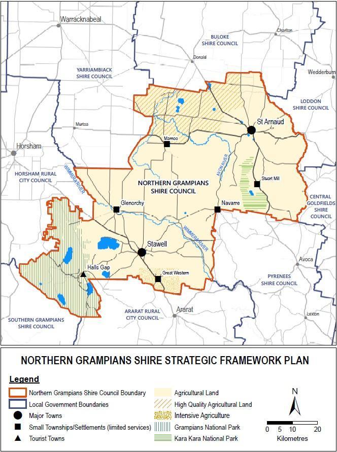
11.011L.01
18/06/2021
C59ngra / / CXXngra
Strategies
General
Discourage the expansion of township boundaries.
Concentrate retail and professional service uses in existing commercial centres.
Direct low-density development to planned estates to protect farming land.
Stawell
Encourage residential development to be located in the south east of the town, and north of the Western Highway.
Encourage infill development with smaller lot subdivisions close to the commercial area.
Encourage industrial and intensive commercial development in areas to the north east of the town, including in the vicinity of the gold mine, and to the west of the town.
Encourage retail and tourism development that capitalises on Stawell’s proximity to the Grampians National Park.
Ensure development in the central commercial area does not negatively impact on the safety and operation of the adjacent highway.
Ensure land supply meets demand for bulky goods retail.
Support retail and tourism development in Stawell that enhances its aesthetic appearance and heritage assets.
Facilitate the growth of St Arnaud as a major sub-regional centre for rural service industries, machinery and processing plants.
Maintain and promote the botanical and landscape significance of Queen Mary Gardens. Support industrial and commercial development that offers services and goods for rural industry.
Reinforce the main street as a vibrant commercial centre through urban design improvements and land use attractions.
Encourage the development of Pioneer Park and Lord Nelson Park as active recreational and social centres.
Ensure land supply meets demand for bulky goods retail.
Encourage development that enhances St Arnaud’s scenic appearance, winery/heritage qualities and reputation as a destination for arts and culture.
Ensure the central village area of Halls Gap is the focal point of the town, through public infrastructure improvements and land use attractions.
Encourage consolidation of urban development in and around the existing subdivided areas in Halls Gap.
Discourage industrial uses on land zoned for rural or commercial purposes. Discourage agriculture and other rural activities within Halls Gap and Lake Bellfield.
Reinforce key gateway locations at Grampians Estate to the east and Bests Winery to the west, through development which emphasises the importance of the town entry locations and their roleas local landmarks.
Facilitate Great Western’s role as a tourism destination for heritage and winemaking.
Encourage residential development within the Village Precinct, as shown on the Great Western Strategic Framework Plan.
11.011L.02
18/06/2021
C59ngra / / CXXngra
Strategies
Encourage residential development to be located in the south east of the town, and north of the Western Highway.
Encourage infill development with smaller lot subdivisions close to the commercial area.
Encourage industrial and intensive commercial development in areas to the north east of the town, including in the vicinity of the gold mine, and to the west of the town.
Encourage retail and tourism development that capitalises on Stawell’s proximity to the Grampians National Park.
Ensure development in the central commercial area does not negatively impact on the safety and operation of the adjacent highway.
Ensure land supply meets demand for bulky goods retail.
Support retail and tourism development in Stawell that enhances its aesthetic appearance and heritage assets. [Relocated clause] [MDF&C with same content from previous clause]
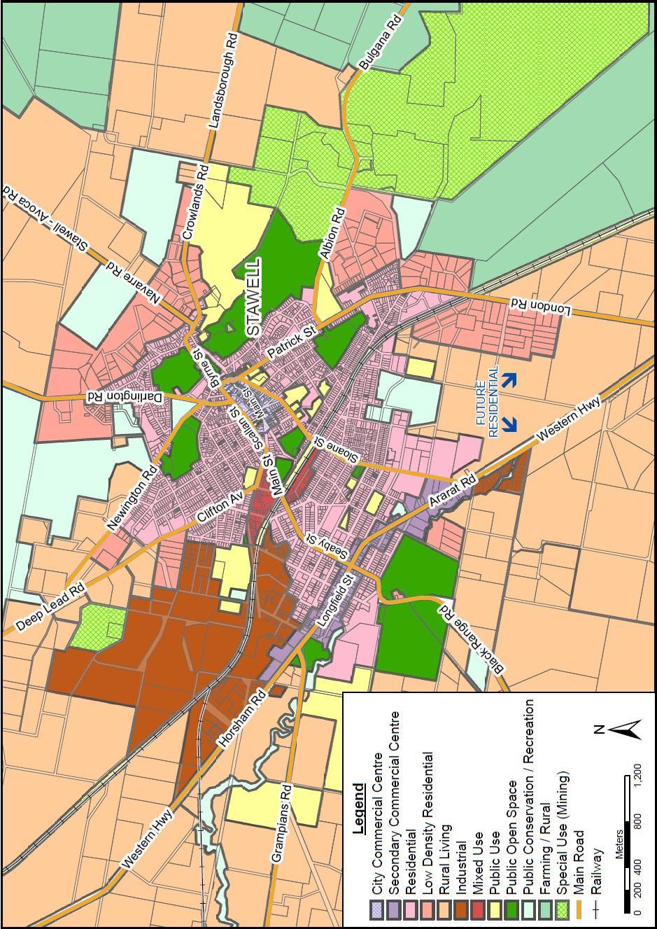
11.011L.03
18/06/2021
C59ngra / / CXXngra
Strategies
Facilitate the growth of St Arnaud as a major sub-regional centre for rural service industries, machinery and processing plants.
Maintain and promote the botanical and landscape significance of Queen Mary Gardens. Support industrial and commercial development that offers services and goods for rural industry.
Reinforce the main street as a vibrant commercial centre through urban design improvements and land use attractions.
Encourage the development of Pioneer Park and Lord Nelson Park as active recreational and social centres.
Ensure land supply meets demand for bulky goods retail.
Encourage development that enhances St Arnaud’s scenic appearance, winery/heritage qualities and reputation as a destination for arts and culture. [Relocated clause] [MDF&C with same content from previous clause]
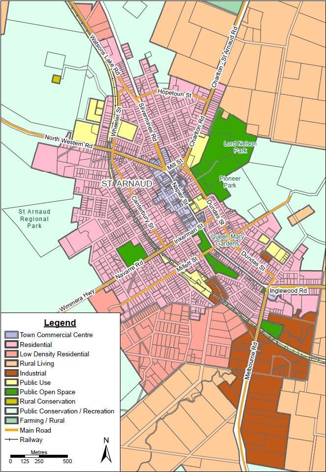
11.011L.04
18/06/2021
C59ngra / / CXXngra
Strategies
Ensure the central village area of Halls Gap is the focal point of the town, through public infrastructure improvements and land use attractions.
Encourage consolidation of urban development in and around the existing subdivided areas in Halls Gap.
Discourage industrial uses on land zoned for rural or commercial purposes.
Discourage agriculture and other rural activities within Halls Gap and Lake Bellfield.
[Relocated clause] [MDF&C with same content from previous clause]
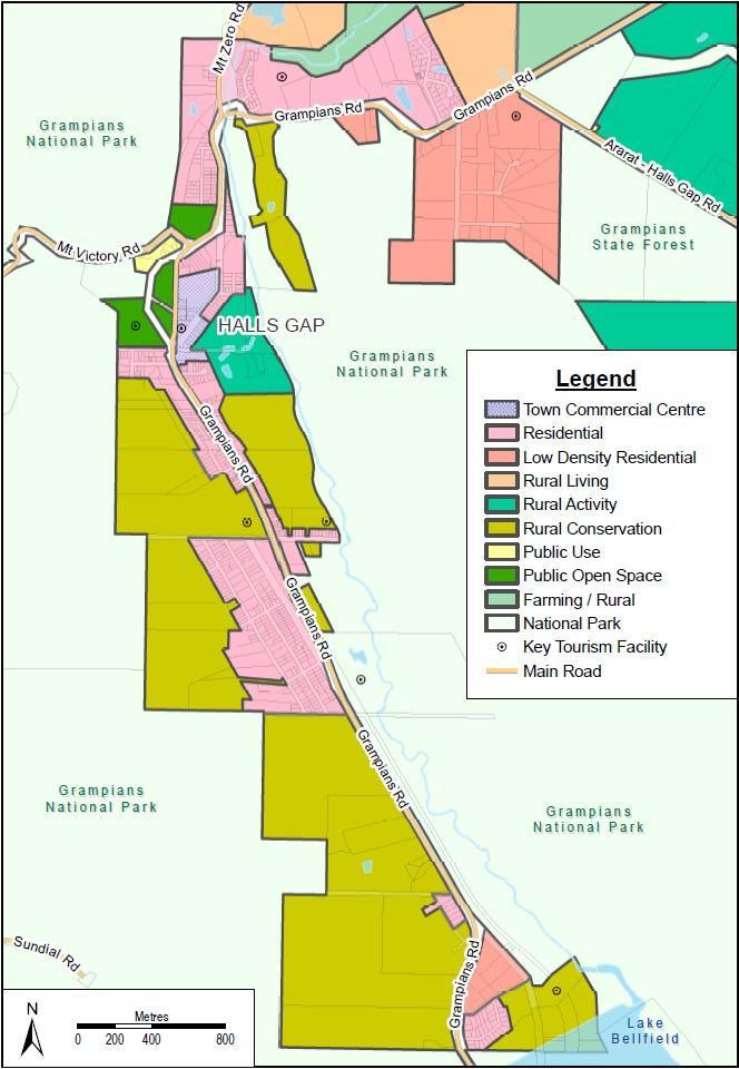
11.01-1L.05 Settlement – Great Western
18/06/2021
C59ngra / / CXXngra
Strategies
Reinforce key gateway locations at Grampians Estate to the east and Bests Winery to the west, through development which emphasises the importance of the town entry locations and their roleas local landmarks.
Facilitate Great Western’s role as a tourism destination for heritage and winemaking.
Encourage residential development within the Village Precinct, as shown on the Great Western Strategic Framework Plan.
[Relocated clause] [MDF&C with same content from previous clause]
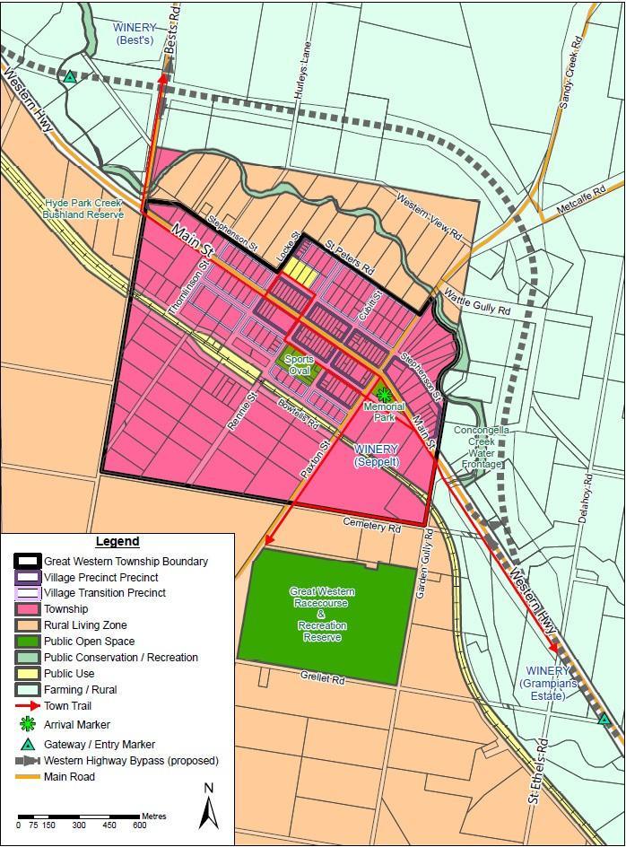
13.03-1L
18/06/2021
C59ngra
/ / CXXngra
Policy application
This policy applies to all land affected by the Floodway Overlay (FO) or Land Subject to Inundation Overlay (LSIO).
Strategies
Design buildings and works to:
Minimise the impacts of flooding on a building.
Minimise site coverage and hard surface areas and maximise permeable surfaces to minimise runoff.
Avoid landfill in flood prone areas.
Maintain adjacent natural drainage corridors including the natural drainage function, stream habitat, wildlife corridor and landscape values.
Avoid earthworks or the construction of levees in areas that obstruct natural flow paths or drainage lines, unless required to protect existing dwellings and their immediate curtilage.
Encourage fencing that enables the free movement of floodwaters.
Encourage the location of water tanks outside of land affected by inundation, where at all possible.
Policy guidelines
Consider as relevant:
Buildings and works
Encouraging building or works that are:
– Sited on land outside the defined flood prone area, or if not possible on the highest ground level.
– Sited with their longitudinal axis parallel to the predicted predominant direction of flood flow.
– Constructed with a minimum floor level at least 300 millimetres above the 1 per cent Annual Exceedance Probability (AEP) flood level.
– Constructed on foundations compatible with flood risk.
– Constructed on a building site which has a 1 per cent AEP flood level less than 500 millimetres above the ground level.
– Where applicable, constructed on a building (fill) pad sized to match, as near as practical, the exterior of the building.
– Providing access to the building from outside the defined flood prone area on roads, driveways or access tracks where the 1 per cent AEP flood depth is less than 300 millimetres above the ground level.
– Storing chemicals at least 300 millimetres above the 1 per cent AEP flood level.
– Providing aa minimum 30 metres wide vegetated buffer along each side of adjacent waterways.
Avoiding the creation of new lots unless the lots:
– Are used for passive open space or environmental purposes; or
– Can be accessed from a public road that is subject to inundation depths less than 300 millimetres above ground level.
Where located on land affected by inundation:
– Discouraging the location of the watertanks in a continual line.
– Encouraging the tanks to be sited at least 1 metre apart to enable the passage of water and debris around them.
– Restricting the size of the fill or pad to the footprint of the water tank.
Discouraging fencing that:
– Is constructed of solid contiguous material,including timber palings, metal sheet,concrete, brick or masonry.
– Has a plinth more than 300 millimetres above the ground.
Policy application
This policy applies to all land that is subject to the Environmental Significance Overlay –Schedule 2 (ESO2).
Objective
To ensure that use and development in a special water supply catchment protects, restores and enhances the quality and quantity of the natural resources and environmental systems for the long term supply of quality water for future generations.
Strategies
Ensure that use and development incorporates measures to protect, restore and enhance the natural resources and environmental systems, including waterways in special water supply catchments.
Provide for the effective control of stormwater drainage and wastewater disposal in a manner that prevents any detrimental impacts to the natural resources and environmental systems.
Manage the cumulative effects of unsewered development by ensuring land can accommodate effective on-site treatment of all wastewater generated from the land.
Encourage best practice approaches for all effluent disposal systems, effluent fields, irrigation fields and stormwater disposal
Minimise the impact of use and development on the existing condition, health and capacity of natural resources and environment systems including waterways, soil types, soil structure, soil condition, vegetation and aquatic and terrestrial habitats
Maximise, maintain and enhance riparian edges and vegetation cover all year round.
Policy guidelines
Consider as relevant:
▪ The ‘precautionary principle’ when assessing the likelihood of impact of an application on natural resources and environmental systems.
▪ The ability and suitability of the land capability to accommodate the impacts of the use or development.
▪ Avoid locating use and development that includes a wastewater treatment and disposal system: On any overland flow path or in any land depression.
Upstream of any dam used for domestic or stock supply.
Within 100 metres of the edge of a waterway, dam or reservoir.
Within 200 metres of any wastewater treatment and disposal system on any neighbouring or adjoining land.
▪ The availability and suitability of alternative effluent and waste water disposal systems.
[New: CMA Comments] [Provides regional consistency with proclaimed catchment area and planning and with Amendments C80hepb and C145macr]
15.01-5L
18/06/2021
C59ngra
Strategies
Provide landscaping that is integrated with the design of new development and complements the vegetation of the wider area and local character.
Encourage the retention of existing canopy trees.
Encourage new buildings to:
Match prevailing setbacks.
Address the street.
Visually contribute to the streetscape character.
Design development within Great Western to complement the village and vineyardfeatures, rural and rustic character and design attributes of the township.
Design subdivision within Great Western to complement the existing character of the village and vineyard heritage with wide street frontages and lot sizes that respect the prevailing density.
Encourage larger lot sizes in Halls Gap with heavily treed boundaries (rather than fences) to maintain the village character of the town, unless treed boundaries would compromise the safety of the premises.
15.03-1L
18/06/2021 C59ngra
/ / Proposed CXXngra
Strategies
Encourage development to include functional and attractive interpretative signs and fixed heritage information to aid in the interpretation and awareness of the Sshire’s heritage.
Strategies
Protect and conserve identified indigenous cultural heritage places and values as decided by Aboriginal people.
Reflect pre and post contact Aboriginal cultural heritage values in the use and development of land. Ensure that new uses, development and works do not adversely impact on sites, vegetation, wetlands and features of the Aboriginal peoples’ cultural and archaeological significance.
Policy guidelines
Consider as relevant:
▪ The indigenous traditional knowledge of the Aboriginal people in providing for the conservation and enhancement of places, sites, vegetation and objects of cultural value.
▪ Any Aboriginal cultural heritage study documents from the Dja Dja Wurrung, Jaadwa, Jadawadjali, Jupagulk, Wergaia and Wotjobaluk Peoples and other relevant organisations when considering a planning scheme amendment or an application for use, buildings or works or subdivision of land.
▪ A land use activity agreement prepared for an application on existing or unalienated Crown land.
[New: RAP Comments] [Provides regional consistency with Amendment C80hepb and incorporates comments from the DJARRA and BGLC]
17.01-1L
18/06/2021
C59ngra
Strategies
Support the expansion of wineries in the foothills of the Pyrenees mountain range. Encourage viticulture and wine production industries within Great Western, together with boutique and gourmet food production and sales.
17.02-1L
18/06/2021
C59ngra
Strategies
Direct bulky goods retailing, general retail and rural supplies and services along major roads including the Western Highway.
17.04-1L / / CXXngra
Strategies
Grow tourism employment and visitor spending throughout the Shire.
Facilitate opportunities for private sector investment in the tourism offering.
Increase the competitiveness of St Arnaud and Stawell as a visitor destinations and enable strong promotion by leveraging off existing opportunities.
Diversify the Shire’s visitor offering to reduce impact of National Park closures particularly following fire events.
Policy document
Consider as relevant:
▪ St Arnaud Tourism Strategy and Action Plan 2022-2032 (Northern Grampians Shire, 2022)
▪ Stawell Tourism Strategy and Action Plan 2022-2032 (Northern Grampians Shire, 2022)
[NEW: SATSAP, p. 5] [NEW: STSAP, p.5] [Provides implementation of updated tourism strategies]
18.01-1L
09/12/2021
VC204 / / CXXngra
Western Highway Strategies
Design or and layout use and development in the vicinity of the Western Highway to allow convenient and safe movement for residents and workers.
Ensure that residents and workers can to access other localities within the Sshire while minimising the use of the Western Hhighway.
Design or and layout use and development fronting the Western Highway to reduce impacts from road traffic noise.
[Redrafted clause and new] [Improved drafting to improve clarity]
18.01-3L
09/12/2021
VC204
Strategies
Support the establishment of walking and cycling networks within road, rail and stream reserves to link tourist precincts across the municipality and to adjoining municipalities.
18.02-7L
09/12/2021
VC204 / / CXXngra
Strategies
Facilitate the extension of Stawell Aerodrome Runway 11/29.
Support the staged development of taxiways, aprons, hangars, utility requirements and internal access roads to meet ongoing demands.
Ensure the orderly development of hangar buildings and the protection of access by taxiing aircraft.
Support improvements to the aerodrome if, and when, larger fire suppression aircraft are required to be based at the aerodrome.
Facilitate the closure of road reserves that cross the aerodrome site.
Consolidate all landholdings at the aerodrome site.
Policy document
Consider as relevant:
▪ Stawell Aerodrome Master Plan (Specialist Airport Solutions Pty Ltd for Northern Grampians Shire Council, 2023)
[NEW: SAMPR] [Updated strategic document]
19.02-3L / / CXXngra
Strategies
Build a collaborative and connected community with activated town centres and rural communities through arts and culture.
Develop the visitor economy by promoting arts and cultural activities.
Encourage a public art component in new developments.
Consider arts and cultural opportunities in the future planning of local communities and in community plans.
[NEW: ACS] [Updated strategic document]
19.02-4L
18/06/2021
C59ngra / / CXXngra
Strategies
Encourage lifecycle-targeted facilities and services, such as those for children, young people and older people.
Encourage facilities and services to cater for groups with different needs, such as families, people with a disability and people from indigenous or culturally diverse backgrounds.
Encourage children’s services and activities for children in the townships of Stawell and St Arnaud.
19.02-6L
18/06/2021
C59ngra
Strategies
Increase usage of the open space network through integrating community infrastructure.
Shown on the planning scheme map as LDRZ1.
25/08/2022
Shown on the planning scheme map as MUZ1
NORTHERN GRAMPIANS MIXED USE AREAS
1.0
25/08/2022 C61ngra Objectives None
2.0
25/08/2022 C61ngra
3.0
25/08/2022
4.0
25/08/2022
5.0
25/08/2022
6.0
25/08/2022
7.0
25/08/2022 C61ngra Signs
None specified. [NEW] [MDF&C for schedule numbering]
25/08/2022
C61ngra / / CXXngra
1.0
25/08/2022 C61ngra
2.0
3/05/2024 VC255
Shown on the planning scheme map as TZ1
Neighbourhood character objectives
None specified.
Clause 54 and Clause 55 requirements
Standard
Minimum street setback A3 and B6
Site coverage A5 and B8
Permeability
A6 and B9
Landscaping B13
Side and rear setbacks
Walls on boundaries
A10 and B17
A11 and B18
Private open space A17
B28
Front fence height
A20 and B32
3.0
3/05/2024 VC255
4.0
3/05/2024 VC255
Requirement
None specified
None specified
None specified
None specified
None specified
None specified
None specified
None specified
None specified
Maximum building height requirement for a dwelling or residential building
None specified.
Application requirements
None specified
5.0
3/05/2024 VC255
Decision guidelines
None specified. [NEW] [MDF&C for schedule numbering]
25/08/2022 C61ngra / / CXXngra
1.0
25/08/2022
C61ngra / / CXXngra
2.0
3/05/2024 VC255
SCHEDULE 1 TO CLAUSE 32.08 GENERAL RESIDENTIAL ZONE
Shown on the planning scheme map as GRZ1
3.0
3/05/2024
Neighbourhood character objectives
None specified [NEW] [MDF&C]
4.0
3/05/2024
Requirements of Clause 54 and Clause 55
5.0
3/05/2024
6.0
3/05/2024 VC255 Decision guidelines
07/12/2023 C63ngra
Shown on the planning scheme map as NRZ1
1.0
07/12/2023
2.0
07/12/2023 C63ngra
3.0
3/05/2024
4.0
3/05/2024
5.0
3/05/2024
3/05/2024
25/08/2022 C61ngra
25/08/2022 C61ngra
25/08/2022 C61ngra
25/08/2022 C61ngra
25/08/2022 C61ngra
25/08/2022
C61ngra
Maximum leasable floor area requirements Land
Maximum leasable floor area for Office (square metres)
None specified None specified
MaximumleasablefloorareaforShop(other than Restricted retail premises) (square metres)
None specified
25/08/2022
C61ngra / / CXXngra
1.0
25/08/2022
C61ngra /--/ CXXngra
Shown on the planning scheme map as RLZ1.
[NEW] [MDF&C for schedule template] Land
Minimum subdivision area (hectares)
Minimum area for which no permit is required to use land for a Dwelling (hectares)
Maximum floor area for which no permit is required to alter or extend an existing dwelling (square metres)
Maximum floor area for which no permit is required to construct an out-building associated with an existing dwelling (square metres)
Maximum floor area for which no permit is required to alter or extend an existing building used for Agriculture (square metres)
Minimum setback from a road (metres)
Minimum setback from a boundary (metres)
Minimum setback from a dwelling not in the same ownership (metres)
Minimum setback from a waterway, wetlands or designated flood plain (metres)
All land 4 hectares
All land 4 hectares
None specified None specified
None specified None specified
None specified None specified
All land 30 metres
All land 30 metres
All land 100 metres
None specified None specified
Permit requirement for earthworks Land
Earthworks which change the rate of flow or the discharge point of water across a property boundary
Earthworks which increase the discharge of saline groundwater
All land where the earthworks are in excess of 200 millimetres above or below ground level.
All land where the earthworks are in excess of 200 millimetres above or below ground level
25/08/2022
C61ngra /-/ CXXngra
1.0
25/08/2022
C61ngra / / CXXngra
Shown on the planning scheme map as RLZ2.
[NEW] [MDF&C for schedule template] Land
Minimum subdivision area (hectares)
Minimum area for which no permit is required to use land for a Dwelling (hectares)
Maximum floor area for which no permit is required to alter or extend an existing dwelling (square metres)
Maximum floor area for which no permit is required to construct an out-building associated with an existing dwelling (square metres)
Maximum floor area for which no permit is required to alter or extend an existing building used for Agriculture (square metres)
Minimum setback from a road (metres)
Minimum setback from a boundary (metres)
Minimum setback from a dwelling not in the same ownership (metres)
Minimum setback from a waterway, wetlands or designated flood plain (metres)
All land 8 hectares
All land 8 hectares
None specified None specified
None specified None specified
None specified None specified
All land 30 metres
All land 30 metres
All land 100 metres
None specified None specified
Permit requirement for earthworks Land
Earthworks which change the rate of flow or the discharge point of water across a property boundary
Earthworks which increase the discharge of saline groundwater
All land where the earthworks are in excess of 200 millimetres above or below ground level
All land where the earthworks are in excess of 200 millimetres above or below ground level
25/08/2022
C61ngra / / CXXngra
1.0
25/08/2022
C61ngra / / CXXngra
Shown on the planning scheme map as RLZ3.
Subdivision and other requirements
Minimum subdivision area (hectares)
Minimum area for which no permit is required to use land for a Dwelling (hectares)
Maximum floor area for which no permit is required to alter or extend an existing dwelling (square metres) None specified None specified
Maximum floor area for which no permit is required to construct an out-building associated with an existing dwelling (square metres) None specified None specified
Maximum floor area for which no permit is required to alter or extend an existing building used for Agriculture (square metres)
Minimum setback from a road (metres)
Minimum setback from a boundary (metres)
Minimum setback from a dwelling not in the same ownership (metres)
Minimum setback from a waterway, wetlands or designated flood plain (metres)
None specified None specified
land 30 metres
land 30 metres
None specified None specified
Earthworks which change the rate of flow or the discharge point of water across a property boundary
Earthworks which increase the discharge of saline groundwater
[MDF&C for schedule template]
25/08/2022
C61ngra / / CXXngra
1.0
25/08/2022
C61ngra /--/ CXXngra
Shown on the planning scheme map as RLZ4.
Minimum subdivision area (hectares)
Minimum area for which no permit is required to use land for a Dwelling (hectares)
Maximum floor area for which no permit is required to alter or extend an existing dwelling (square metres) None specified None specified
Maximum floor area for which no permit is required to construct an out-building associated with an existing dwelling (square metres) None specified None specified
Maximum floor area for which no permit is required to alter or extend an existing building used for Agriculture (square metres)
None specified None specified
Minimum setback from a road (metres) All land 30 metres
Minimum setback from a boundary (metres) All land 30 metres
Minimum setback from a dwelling not in the same ownership (metres) All land
Minimum setback from a waterway, wetlands or designated flood plain (metres)
metres
None specified None specified
Earthworks which change the rate of flow or the discharge point of water across a property boundary
Earthworks which increase the discharge of saline groundwater
[MDF&C for schedule template]
25/08/2022
C61ngra / / CXXngra
1.0
25/08/2022
C61ngra / / CXXngra
Shown on the planning scheme map as RLZ5.
Subdivision and other requirements
Minimum subdivision area (hectares)
Minimum area for which no permit is required to use land for a Dwelling (hectares)
Maximum floor area for which no permit is required to alter or extend an existing dwelling (square metres) None specified None specified
Maximum floor area for which no permit is required to construct an out-building associated with an existing dwelling (square metres) None specified None specified
Maximum floor area for which no permit is required to alter or extend an existing building used for Agriculture (square metres)
Minimum setback from a road (metres)
Minimum setback from a boundary (metres)
Minimum setback from a dwelling not in the same ownership (metres)
Minimum setback from a waterway, wetlands or designated flood plain (metres)
None specified None specified
land 30 metres
land 30 metres
None specified None specified
Earthworks which change the rate of flow or the discharge point of water across a property boundary
Earthworks which increase the discharge of saline groundwater
[MDF&C for schedule template]
25/08/2022
C61ngra
Shown on the planning scheme map as RCZ1.
To protect erosion prone land from inappropriate use and development.
To protect remnant native vegetation.
1.0
25/08/2022
C61ngra
Subdivision and other requirements
Permit requirement for earthworks Land Land
Minimum subdivision area (hectares) All land 80 hectares
Maximum floor area for which no permit is required to alter or extend an existing dwelling (square metres)
Maximum floor area for which no permit is required to construct an out-building associated with a dwelling (square metres)
Maximum floor area for which no permit is required to alter or extend an existing building used for agriculture (square metres).
None specified None specified
None specified None specified
None specified None specified
Earthworks which change the rate of flow or the discharge point of water across a property boundary.
Earthworks which increase the discharge of saline groundwater.
All land within the zone where the earthworks are in excess of 200 millimetres above or below ground level.
All land within the zone where the earthworks are in excess of 200 millimetres above or below ground level.
25/08/2022
C61ngra
Shown on the planning scheme map as RCZ2.
To recognise the significance of the environmental and landscape values of the Grampians National Park.
1.0
25/08/2022
C61ngra
Subdivision and other requirements
Minimum subdivision area (hectares)
Maximum floor area for which no permit is required to alter or extend an existing dwelling (square metres)
Maximum floor area for which no permit is required to construct an out-building associated with a dwelling (square metres)
Maximum floor area for which no permit is required to alter or extend an existing building used for agriculture (square metres).
land
None specified None specified
None specified None specified
None specified None specified
Earthworks which change the rate of flow or the dischargepointofwateracrossapropertyboundary
Earthworks which increase the discharge of saline groundwater
All land within the zone where the earthworks are in excessof200millimetresaboveorbelowgroundlevel.
All land within the zone where the earthworks are in excessof200millimetresaboveorbelowgroundlevel.
25/08/2022
C61ngra / / CXXngra
25/08/2022
C61ngra / / CXXngra
Shown on the planning scheme map as FZ1.
Minimum subdivision area (hectares). All land 80 hectares
Minimum area for which no permit is required to use land for a dwelling (hectares). All land 80 hectares
Maximum area for which no permit is required to use land for timber production (hectares).
Maximum floor area for which no permit is required to alter or extend an existing dwelling (square metres).
Maximum floor area for which no permit is required to construct an out-building associated with a dwelling (square metres).
Maximum floor area for which no permit is required to alter or extend an existing building used for agriculture (square metres).
None specified
None specified
None specified
None specified
Minimum setback from a road (metres). A Transport Zone 2 or land in a Public Acquisition Overlay if:
The Head, Transport for Victoria is the acquiring authority; and
The purpose of the acquisition is for a road.
A Transport Zone 3 or and in a Public Acquisition Overlay if:
The Head, Transport for Victoria is not the acquiring authority; and
The purpose of the acquisition is for a road.
None specified
None specified
None specified
None specified
100 metres
40 metres
Any other road. 20 metres
Minimum setback from a boundary (metres). Any other boundary. 5 metres
Minimum setback from a dwelling not in the same ownership (metres). Any dwelling not in the same ownership. 100 metres
Minimum setback from a waterway, wetlands or designated flood plain (metres)
None specified
Permit requirement for earthworks Land
Earthworks which change the rate of flow or the discharge point of water across a property boundary.
Earthworks which increase the discharge of saline groundwater.
[NEW] [MDF&C for schedule template and numbering]
None specified
All land where the earthworks are in excess of 200 millimetres above or below ground level.
All land where the earthworks are in excess of 200 millimetres above or below ground level.
25/08/2022
C61ngra / / CXXngra
Shown on the planning scheme map as RAZ1.
Purpose
To recognise the Halls Gap Valley for its environmental and tourism values and to encourage boutique agriculture, accommodation and facilities, together with commercial enterprises which support the development of Halls Gap town centre.
To achieve a balanced mix of agriculture, environmental and tourism uses.
To facilitate the subdivision of land to enable its use for rural industries and tourism related facilities, such as accommodation (other than dwelling), food and drink premises, art and craft, boutique rural industries and recreation activities in accordance with an approved Development Plan.
To ensure that non-agricultural uses, including dwellings, achieve a balanced mix of agriculture, environmental and tourism uses and do not adversely affect the use of land for agriculture.
To encourage the retention of employment and population to support rural communities.
To encourage use and development of land based on comprehensive and sustainable land management practices and infrastructure provision.
1.0
25/08/2022
area for which no permit is required to use land for timber production (hectares).
specified
Maximum floor area for which no permit is required to alter or extend an existing dwelling (square metres). None specified None specified
Maximum floor area for which no permit is required to construct an out-building associated with an existing dwelling (square metres).
Maximum area for which no permit is required to alter or extend an existing building used for agriculture (square metres).
None specified
specified
Minimum setback from a road (metres). A Transport Zone 2 or land in Public Acquisition Overlay if:
The Head, Transport for Victoria is the acquiring authority; and
The purpose of the acquisition is for a road.
specified
specified
metres A Transport Zone 3 or land in Public Acquisition Overlay if:
metres Any other road
The Head, Transport for Victoria is the acquiring authority; and
The purpose of the acquisition is for a road.
Minimum setback from a boundary (metres).
Minimum setback from a dwelling not in the same ownership (metres).
Minimum setback from a waterway, wetlands or designated flood plain (metres)
Any other boundary 5 metres
Any dwelling not in the same ownership 100 metres
None specified
Permit requirement for earthworks Land
Earthworks which change the rate of flow or the discharge point of water across a property boundary.
Earthworks which increase the discharge of saline groundwater.
[NEW] [MDF&C for schedule template]
None specified
All land where the earthworks are in excess of 200 millimetres above or below ground level.
All land where the earthworks are in excess of 200 millimetres above or below ground level.
25/08/2022
C61ngra / / CXXngra
Shown on the planning scheme map as RAZ2.
Purpose
To achieve a mix of small scale farming, horticultural, agricultural, tourism development and recreation activities based on encouraging the following land uses in areas adjoining the Grampians. and:
To provide for residential use in a rural environment.
To provide for agricultural land uses which do not adversely affect the amenity of surrounding land uses.
To protect and enhance the natural resources, biodiversity and landscape and heritage values of the area.
To encourage use and development of land based on comprehensive and sustainable land management practices and infrastructure provision.
1.0
25/08/2022
C61ngra / / CXXngra
Subdivision and other requirements
Minimum subdivision area (hectares)
Minimum area for which no permit is required to use land for timber production (hectares)
land 8 hectares
None specified None specified
Maximum floor area for which no permit is required to alter or extend an existing dwelling (square metres) None specified None specified
Maximum floor area for which no permit is required to construct an out-building associated with an existing dwelling (square metres) None specified
Maximum area for which no permit is required to alter or extend an existing building used for agriculture (square metres) None specified
Minimum setback from a road (metres).
land 30 metres
Minimum setback from a boundary (metres). All land 30 metres
Minimum setback from a dwelling not in the same ownership (metres).
Minimum setback from a waterway, wetlands or designated flood plain (metres)
land 100 metres
None specified None specified
Earthworks which change the rate of flow or the discharge point of water across a property boundary
Earthworks which increase the discharge of saline groundwater
[MDF&C for schedule template]
25/08/2022
C61ngra / / CXXngra
Shown on the planning scheme map as RAZ3.
Purpose
To achieve a mix of small scale farming, horticultural, agricultural, tourism development and recreationactivitiesbasedonencouragingthefollowinglandusesinareasadjoiningtheGrampians and:
To provide for residential use in a rural environment.
To provide for agricultural land uses which do not adversely affect the amenity of surrounding land uses.
To protect and enhance the natural resources, biodiversity and landscape and heritage values of the area.
To encourage use and development of land based on comprehensive and sustainable land management practices and infrastructure provision.
1.0
25/08/2022
C61ngra /--/ CXXngra
Subdivision and other requirements
Minimum subdivision area (hectares) All land 20 hectares
Minimum area for which no permit is required to use land for timber production (hectares)
Maximum floor area for which no permit is required to alter or extend an existing dwelling (square metres)
Maximum floor area for which no permit is required to construct an out-building associated with an existing dwelling (square metres)
Maximum area for which no permit is required to alter or extend an existing building used for agriculture (square metres)
None specified None specified
None specified None specified
None specified None specified
None specified None specified
Minimum setback from a road (metres). All land 30 metres
Minimum setback from a boundary (metres). All land 30 metres
Minimum setback from a dwelling not in the same ownership (metres). All land 100 metres
Minimum setback from a waterway, wetlands or designated flood plain (metres)
None specified None specified
Permit requirement for earthworks Land
Earthworks which change the rate of flow or the discharge point of water across a property boundary
Earthworks which increase the discharge of saline groundwater
All land where the earthworks are in excess of 200 millimetres above or below ground level
All land where the earthworks are in excess of 200 millimetres above or below ground level
25/08/2022
25/08/2022
25/08/2022
25/08/2022 C61ngra
25/08/2022 C61ngra 3.0
25/08/2022 C61ngra Permit
25/08/2022 C61ngra 2.0
25/08/2022 C61ngra 3.0
25/08/2022 C61ngra Permit
25/08/2022 C61ngra / / CXXngra
Shown on the planning scheme map as SUZ1
Purpose
To recognise or provide for the use and development of land for gold mining.
To encourage use of the land compatible with the use and development of nearby land.
To encourage land management practice and rehabilitation minimises adverse impact on the use and development of nearby land.
1.0
01/12/2023
Table of uses
Section 1 - Permit not required
Automated collection point
Mustmeet the requirements ofClause 52.13-3 and 52.13-5.
The gross floor area of all buildings must not exceed 50 square metres.
Crop raising (other than Rice growing and Timber production)
Extensive Aanimal husbandryproduction
Informal outdoor recreation
Mineral exploration
Mining
Railway Road
Stone exploration
Tramway
Any use listed in Clause 62.01
See Section 1 of 37.01-1 for relevant provisions
Section 2 - Permit required Use
Must meet the requirements of Clause 52.08
Must not be costeaning or bulk sampling
Must meet the requirements of Clause 62.01
Agriculture (other than Animalkeeping, Animal training, Crop raising, Extensive animal husbandry, Horse stables, and Intensive animal husbandry)
Animal keeping husbandry (other than Animal Domestic animal boardinghusbandry)
Caretaker's house
Dependant person’s unit
Fuel depot
Industry (other than Automated collection point and Materials recycling)
Landscape gardening supplies
Leisure and recreation (other than informal outdoor recreation)
Must comply with any condition in Section 2 of the schedule to this zone.
Must be no more than four animals
Use Condition
Mineral, stone, or soil extraction (other than Mineral exploration, Mining, and Stone exploration)
Place of assembly (other than Amusement parlour and Nightclub)
Small second dwelling
Store
Utility installation (other than Minor utility installation)
Any other use not in Section 1 or 3
Section 3 - Prohibited
Use
Accommodation (other than Caretaker's house and Dependent person's unit Small second dwelling)
Amusement parlour
Animal boarding
Cinema based entertainment facility
Display home
Domestic animal husbandry
Horse stables
Intensive animal husbandry
Nightclub
Office
Retail premises (other than Landscape gardening supplies and Manufacturing sales)
Saleyard
Service station
Transport terminal
Veterinary centre
Warehouse
2.0 / / CXXngra Use of land
None specified.
3.0 / / CXXngra Subdivision
4.0
25/08/2022 C61ngra / / CXXngra
None specified
Buildings and works
Permit requirement
The requirement for a permit does not apply to the construction of a building or the construction or carrying out of works which are a modification necessary to comply with a direction or licence under the Dangerous Goods Act 1985 oraWasteDischarge Licence,WorksApproval or PollutionAbatement Notice under the Environment Protection Act 1970.2017.
5.0
25/08/2022 C61ngra / / CXXngra
Signs
None specified.
[NEW] [MDF&C for schedule template]
25/08/2022 C61ngra / / CXXngra
SCHEDULE 2 TO CLAUSE 37.01 SPECIAL USE ZONE
Shown on the planning scheme map as SUZ2.
Purpose
To recognise or provide for the use and development of land for earth and energy resources industry.
To encourage interim use of the land compatible with the use and development of nearby land.
To encourage land management practice and rehabilitation that minimises adverse impact on the use and development of nearby land. 1.0
01/12/2023
Table of uses
Section 1 - Permit not required
Automated collection point
Must meet the requirements of Clause 52.13-3 and 52.13-5.
The gross floor area of all buildings must not exceed 50 square metres.
Extensive aAnimal productionhusbandry
Home based business
Informal outdoor recreation
Railway
Tramway
Any use listed in Clause 62.01
Section 2 - Permit required
Use
Agriculture (other than Animal keepinghusbandry, Animal training, ExtensiveaAnimalhusbandryproduction, Domesticanimalhusbandry andHorsestables,andIntensive animalhusbandry)
Animal keeping husbandry (other than Animal Domestic animal boardinghusbandry)
Caretaker's houseDependent person's unit
Industry (other than Materials recycling, Refuse disposal, and Transfer station)
Landscape gardening supplies
Leisure and recreation (other than Informal outdoor recreation)
Manufacturing sales
Materials recycling
Place of assembly (other than Amusement parlour and Nightclub)
Refuse disposal
Small second dwelling
Transfer station (other than Automated collection point)
Utility installation
Must be no more than four animals.
Must not be a purpose listed in the table to Clause 53.10
Warehouse Must not be a purpose listed in the table to Clause 53.10
Use
Any other use not in Section 1 or 3
See Section 2 of 37.01-1 for relevant provisions
Section 3 - Prohibited
Use
Condition
Accommodation (other than Caretaker's house and Dependant person's unit Small second dwelling)
Amusement parlour
Animal boarding
Animal training
Cinema based entertainment facility
Domestic animal husbandry
Horse stables
Intensive animal husbandry
Nightclub
Office
Retail premises (other than Landscape gardening supplies and Manufacturing sales)
Saleyard
Service station
Transport terminal
Veterinary centre
2.0
25/08/2022
C61ngra
3.0
25/08/2022
Use of land
None specified.
C61ngra Subdivision
None specified.
4.0
25/08/2022
C61ngra / / CXXngra
Buildings and works
Permit requirement
The requirement for a permit does not apply to the construction of a building or the construction or carrying out of works which are a modification necessary to comply with a direction or licence under the Dangerous Goods Act 1985 oraWasteDischarge Licence,WorksApproval or PollutionAbatement Notice under the Environment Protection Act 19702017.
5.0
25/08/2022
C61ngra Signs
None specified.
[NEW] [MDF&C for schedule template]
25/08/2022
C61ngra / / CXXngra
Shown on the planning scheme map as ESO1
1.0
25/08/2022
C61ngra Statement of environmental significance
There are significant ridges on the highest land in the municipality which display erosion characteristics and which are susceptible to further environmental degradation.
2.0
25/08/2022
C61ngra
Environmental objective to be achieved
To protect significant ridges from development which may accentuate erosion.
To maintain the natural beauty of the ridge system.
To protect the remnant native vegetation and to encourage the re-establishment of native communities in degraded areas.
To prevent erosion of the ridge system.
To maintain the landscape qualities of the ridge system especially when viewed from surrounding areas.
25/08/2022
C61ngra Permit requirement
A permit is not required for the removal, lopping or destruction of non-native vegetation.
A permit is not required for buildings and works if the slope of the land where the buildings and works are to be carried out is less than 10 per cent.
4.0
25/08/2022
C61ngra / / CXXngra
5.0
25/08/2022
Application requirements
None specified. [NEW] [MDF&C for schedule template]
C61ngra Decision guidelines
The following decision guidelines apply to an application for a permit under Clause 42.01, in addition to those specified in Clause 42.01 and elsewhere in the scheme which must be considered, as appropriate, by the responsible authority:
The capability of the land to accommodate the proposed development without detriment to the natural physical features of the area.
The availability of access to the site.
Any proposal for planting, re-planting, re-afforestation or sowing down the land, where clearing of existing vegetation is proposed.
The value of the trees to be removed.
Any alternative means of locating buildings and works in order to conserve trees.
The likely stability of the soil after the removal of the trees.
The protection and enhancement of the landscape.
25/08/2022
C61ngra / / CXXngra
Shown on the planning scheme map as ESO2
1.0
25/08/2022
C61ngra Statement of environmental significance
Lake Fyans and Lake Lonsdale are major water storages within the Wimmera Mallee Water Supply System. Much of the water within the lakes system services towns within the Grampians Region Water Authority District. Wimmera Mallee Water supplies domestic and stock water to more than 60,000 people and properties across the supply region. The security of supply and protection of lakes, channels and reservoirs from potential sources of pollution is critical to the operation of one of Victoria's largest water supply systems.
2.0
25/08/2022
C61ngra
Environmental objective to be achieved
To maintain and enhance the quality and supply of irrigation and domestic water throughout the Wimmera region, and
Tto protect lakes, reservoirs and channels from potential sources of pollution.
3.0
25/08/2022
C61ngra Permit requirement
None specified.
4.0
25/08/2022
C61ngra Application requirements
5.0
25/08/2022
C61ngra / / CXXngra
None specified.
Decision guidelines
The following decision guidelines apply to an application for a permit under Clause 42.01, in addition to those specified in Clause 42.01 and elsewhere in the scheme which must be considered, as appropriate, by the responsible authority:
The need to prevent pollution of the lakes system which forms part of the regional water supply network.
The need to prevent the contamination of water supply.
The need to protect water supply resources.
The desirability of locating any effluent or waste water disposal systems, or other potential sources of pollution at least 50 metres from Lake Fyans or Lake Lonsdale.
The ability of any proposed effluent or other treatment system to prevent effluent or other waste affecting water quality in the lakes system.
The desirability of preventing the development of any building and works including dams within 20 metres of Lake Fyans or Lake Lonsdale.
Notification
Notice of all permit applications must be given in accordance with Section 52(1)(c) of the Act to the person or body specified as a person or body to be notified in Clause 66.06 or a schedule to that clause.
[NEW] [MDF&C for schedule template]
25/08/2022
C61ngra / / CXXngra
Shown on the planning scheme map as ESO3
1.0
25/08/2022
C61ngra Statement of environmental significance
The Stawell waste water treatment plant provides sewerage treatment and wastewater disposal for the Stawell urban area.
The plant's operation is critical to the continued economic and environmental prosperity of Stawell.
It is important that the wastewater treatment plant be protected from inappropriate land use and development that may compromise or be detrimental to the plant's ongoing operations.
The area covered by this schedule has been identified as potentially subject to non-routine emissions of odour from the Stawell wastewater treatment plant.
2.0
25/08/2022
C61ngra Environmental objective to be achieved
To ensure that the siting and location of a sensitive use within proximity to the wastewater treatment plant will not have detrimental impact on the ongoing operation of the plant.
To ensure that there is suitable separation between the Stawell wastewater treatment plant and the location of a sensitive use.
3.0
25/08/2022
C61ngra / / CXXngra
Permit requirement
A permit is not required to:
Construct a building or carry out works unless the building or works are associated with Accommodation, Child Care Centre, Education Centre or Hospital on land which iswithin the area covered by this schedule.
This does not apply to an extension to an existing building or works. Notice requirement
Notice of the kinds of application listed below must be given under section 52(1)(c) of the Planning and Environment Act 1987 to the person or body specified as a person or body to be notified in Clause 66.06.
An application to subdivide land or construct a building or construct or carry out works associated with Accommodation, Child Care Centre, Education Centre or Hospital on landwhich is within the area covered by ths schedule.
This requirement does not apply to an application to extend an existing building or works.
4.0
25/08/2022
C61ngra Application requirements
None specified.
5.0
25/08/2022
C61ngra Decision guidelines
The following decision guidelines apply to an application for a permit under Clause 42.01, in addition to those specified in Clause 42.01 and elsewhere in the scheme which must be considered, as appropriate, by the responsible authority:
The potential effect of odours caused by non-routine emissions from the wastewater treatment plant operations on the amenity of nearby sensitive land use.
Whether the grant of a permit will adversely affect the ongoing operation of the wastewater treatment plant.
Whether the proposal is a sensitive land use and/or development that may be detrimentally affected by the wastewater treatment plant.
Capacity and operation of the plant to provide for future growth needs of the service district.
Any provisions, conditions or requirements in a Works Approval and/or a Licence issued by the Environment Protection Authority for the wastewater treatment plant.
The comments received from any person or body specified in the schedule to Clause 66.06.
Background documents
State Environment Protection Policy (Air Quality Management)
Recommended Buffer Distances for Industrial Residual Air Emissions, Publication AQ2-86, Environment Protection Authority, 1990, or as amended.
SKM final report titled 'Stawell Wastewater Treatment Works - Establishment of an Odour Buffer Distance' dated 30 June 2005.
[NEW] [MDF&C for schedule template]
25/08/2022
C61ngra / / CXXngra
1.0
25/08/2022
C61ngra
Shown on the planning scheme map as VPO1
Statement of nature and significance of vegetation to be protected
The Halls Gap and Lake Bellfield area is the main focus for settlement activities associated with the Grampians National Park. The area is framed by native vegetation which is the dominant environmental characteristic of the area and complements the National Park.
2.0
25/08/2022
C61ngra / / CXXngra
3.0
25/08/2022
C61ngra / / CXXngra
4.0
25/08/2022
C61ngra
5.0
25/08/2022
C61ngra / / CXXngra
Vegetation protection objectives to be achieved
To conserve the existing pattern of vegetation and landscape quality within the area.
To conserve, protect, manage and enhance trees, shrubs and vegetation communities of local landscape and botanical significance.
TorecognisethenaturallandscapeattributesoftheareainthecontextoftheGrampiansNational Park.
To encourage the planting of vegetation wherever possible and To conserve existing wildlife habitats.
To protect land and water resources from future degradation due to the removal or destruction of native vegetation and .
To prevent further invasive and noxious weeds and plants being introduced into areas near to the Grampians National Park.
Permit requirement
A permit is required to remove, destroy or lop any vegetation on any land, regardless of the size of the land, except:
Wwithin 5 metres of a dwelling.
Application requirements
None specified.
Decision guidelines
The following decision guidelines apply to an application for a permit under Clause 42.02, in addition to those specified in Clause 42.02 and elsewhere in the scheme which must be considered, as appropriate, by the responsible authority:
The extent and character of native vegetation and the likelihood of its destruction.The conservation and enhancement of the area.
The preservation of and impact on the natural environment or landscape values.
The need to retain native vegetation:
where ground slopes are more than 20 per cent.
within 30 metres of a wetland or watercourse.
– on land subject to or which may contribute to soil erosion or slippage.
on land where the soil or sub-soil may become unstable if cleared.
in the proclaimed Wimmera Water Supply Catchment.
in areas where removal, destruction or lopping could jeopardise the integrity or longterm preservation of any identified site of scientific, nature conservation or cultural significance. – if it is rare or supports rare species of flora or fauna.
that forms part of a wildlife corridor.
Whetherprovisionismadeoristobemadetoestablishandmaintainnativevegetation elsewhereon the land.
The benefit of a condition requiring:
planting, replanting or other treatment of any part of the land.
– the retention of a buffer strip of native vegetation within specified distances of wetlands, watercourses, roads, the Grampians National Park, and property boundaries.
– the identification of native vegetation that is to be retained, including the methods used to protect and manage the native vegetation.
– a landscape plan which precludes (or provides for the removal of) any environmental weed as listed belowin Table 1 [NEW] [MDF&C for schedule template]
Table 1: Environmental Weeds
Acacia decurrens
Acacia elata
Early Black Wattle
Cedar Wattle
Acacia saligna Golden Wreath Wattle
Acer pseudoplatanus Sycamore Maple
Agapanthus praecox ssp. orientals
Agave americana
Agapanthus
Century Plant
Ailanthus altissima Tree-of-Heavan
Ale saponaria
Aloe saponaria
Amayllus Belladonna Belladonna Lily
Angophora costata
Smooth Angophora
Anopterus glandulosus Tasmanian Laurel
Arbutua unedo Strawberry Tree
Cestrum elegans Cestrum
Coprosma repens
New Zealand Mirror-bush
Cortaderia jubata Pink Pampas Grass
Cortaderia selloana Pampas Grass
Cotoneaster divaricata Cotoneaster glaucophyllus
Contoneaster pannosus Cotoneaster
Crataegus monogyna Hawthorn
Name Common Use
Crocosmia x crocosmiiflora Montbretia
Cytisus multiflorus White Spanish Broom
Cytisus palmensis Tagasaste
Cytisus scoparius English Broom
Delairea odorata Cape Ivy
Erica baccans Berry-flower Heath
Erica lusintanica Spanish Heath
Eucalyptus botryoides Southern Mahogany
Eucalyptus cladocalyx Sugar Gum
Freesia leichtlinii Freesia
Genista linifolia Flax-leaf Broom
Genista monspessulana Montpellier Broom
Hakea salicifolia Willow-leaf Hakea
Leycesteria formosa Himalayan Honeysuckle
Lonicera japonica Japanese Honeysuckle
Lythrum junceum Mediterranean Loosestrife
Myosotis laxa ssp. caespitosa Water Forget-me-not
Myosotis sylvatica Wood Forget-me-not
Myrsiphyllum asparagoides Bridal Creeper
Myrsiphyllum scandens Myrsiphyllum
Oles Europea European Olive
Oxalis pes-caprae Soursob
Oxalis purpurea Large-flower Wood-sorrel
Paraserianthes lophantha Cape Wattle
Passiflora mollissima Banana Passionfruit
Pennisetum alopecuroides Swamp Foxtail-grass
Pinus radiata Monterey Pine
Pittosporum undulatum Sweet Pittosporum
Populus alba White Poplar
Populus nigra var. italica Lombardy Poplar
Prunus lusitanica Portugal Laurel
Name Common Use
Salix babylonica
Sollya heterophylla
Tradescantia albiflora
Vinca major
Weeping Willow
Bluebell Creeper
Wandering Jew
Blue Periwinkle
Watsonia mariana cv. Bulbillifera Bulbil Watsonia
Zantedeschia aethiopica
Source:
White Arum Lily
“Environmental Weed Invasions in Victoria: Conservation and Management Implication” by Carr, Yugovic, Robinson, published by Department of Conservation and Environment and Ecological Horticulture Pty. Ltd, 1992.
25/08/2022
C61ngra / / CXXngra
Shown on the planning scheme map as SLO1
1.0
25/08/2022
C61ngra Statement of nature and key elements of landscape
The Grampians are a mountainous landscape of national significance consisting of rugged landscape ridges and escarpments. The surrounding farming country is attractive, containing mature river red gums and other native trees in paddocks and along roads and streams. The farmland is enhanced by the spectacular mountain backdrop. The land identified by this overlay has a National Trust of Australia (Victoria) Regional Classification.
2.0
25/08/2022
C61ngra
Landscape character objectives to be achieved
To recognise the significance of the environmental and landscape values of the Grampians National Park in the local context and as a major natural feature tourist attraction.
To maintain the quality of vistas towards and from Grampians National Park.
To ensure development does not adversely impact upon the landscape qualities of the Grampians National Park and the surrounding rural areas.
To consider farm buildings and associated structures as an integral element of the rural landscape.
3.0
25/08/2022
C61ngra Permit requirement
A permit is not required for buildings or works related to the use of the land for extensive animal husbandry and crop raising provided the buildings (including silos) are clad in nonreflective cladding in earthy tones.
A permit is required to remove, destroy or lop all native vegetation.
A permit is not required for the layout of underground sewerage, water and gas mains, oil pipelines, underground telephone lines and underground power lines provided they do not alter the topography of the land.
25/08/2022
C61ngra Application requirements
5.0
25/08/2022
C61ngra / / CXXngra
None specified.
The following decision guidelines apply to an application for a permit under Clause 42.03, in addition to those specified in Clause 42.03 and elsewhere in the scheme which must be considered, as appropriate, by the responsible authority:
Whether the proposed building or works will be visible from prominent locations within Grampians National Park.
Whether the building or works will detract from views of the Grampians National Park.
The desirability of discouraging the location of buildings on ridge lines or other prominent locations.
The size and bulk of the proposed building.
The ability of existing vegetation to screen the proposed buildings and works.
The desirability of planting indigenous vegetation to screen the proposed building.
The desirability of requiring buildings to be clad in non-reflective materials of muted shades of green, brown or grey, if the building is found to impose on significant views towards or from the Grampians National Park.
The desirability of allowing the construction of farm buildings associated with extensive animal husbandry or traditional crop raising without a requirement to clad the building in non-reflective materials or muted shades.
The desirability of maintaining existing indigenous vegetation.
The value of the trees to be removed because of rarity, variety or physical condition.
Any alternative means of locating buildings and works in order to conserve the trees.
The likely stability of the soil after removal of the trees.
The effect on fauna of the removal of the trees.
The protection and enhancement of the landscape.
The desirability of requiring the replanting, sowing down or other treatment of any area to be cleared.
Background documents:
The Grampians National Park Plan of Management, October 1985
The Grampians Surround Strategy, September 1991 [NEW] [MDF&C for schedule template]
25/08/2022 C61ngra
1.0
25/08/2022 C61ngra Application requirements None specified.
2.0
20/03/2023 VC229 Heritage places
The requirements of this overlay apply to both the heritage place and its associated land.
PS
energy system controls apply? Outbuildings or fences not exempt under Clause 43.01-4 Included on the Victorian Heritage Register under the Heritage Act 2017? Prohibited uses permitted? Aboriginal heritage place?
HO22 St Peters Anglican Church, 367 Dunolly Road, Carapooee
HO20 LedcourtHomestead,125LedcourtRoad, Ledcourt
HO32 Balance Ledcourt Homestead, 125 Ledcourt Road, Ledcourt
HO26 Heatherlie (Mt. Difficult) Quarry, Grampians National Park, Grampians Road Ledcourt
WESTERN
HO7 Hard Hill Mining Site, Garden Gully Road Great Western
HO1 Seppelts Champagne Cellars, 36 Cemetery Road Great Western
ARNAUD
PS map ref Heritage place
HO2 Court House, Napier St St Arnaud
HO4
Crown Land Office, 4 Napier St St Arnaud
HO5 St Arnaud Railway Station, Queens Avenue, St Arnaud
HO30 Lloyds Whip Gold Mining Site, Stuart Mill Historic Site, Sunraysia Highway, Stuart Mill
HO24 OldStuartMill GeneralStore, CA1 &Part 20, Section 2, Township of Stuart Mill, Parish of Boola Boloke
External paint controls apply? Internal alteration controls apply? Tree controls apply? Solar energy system controls apply?
Outbuildings or fences not exempt under Clause 43.01-4
Included on the Victorian Heritage Register under the Heritage Act 2017? Prohibited uses permitted? Aboriginal heritage place?
Post Office, 87 Gold Reef Mall, Stawell
HO9 Powder Magazine, 113-117 Gold Reef Mall, Stawell
HO10 Former Police Superintendent's Residence, 17 Leslie St Stawell
42 Longfield St Stawell
H1594
PS map ref Heritage place
HO13 Former Literary & Scientific Institute, 54 Longfield St Stawell
HO14 Former Pleasant Creek Court House, 46-48 Longfield St Stawell
HO33 Central Park, 10-18 Main St Stawell
HO15 Railway Station, Napier St Stawell
HO16 St Matthews Presbyterian Church, 13 Scallan St Stawell
HO17 Baptist Church, 17 Scallan St Stawell
External paint controls apply? Internal alteration controls apply? Tree controls apply? Solar energy system controls apply?
Outbuildings or fences not exempt under Clause 43.01-4 Included on the Victorian Heritage Register under the Heritage Act 2017? Prohibited uses permitted? Aboriginal heritage place?
HO31 Diamond House, 24 Seaby St Stawell The heritage place includes adjacent house
HO19 Stawell Gas Holder, 47-49 Wimmera St Stawell
HO27 Former Pleasant Creek Hospital (Nara building), Entrance driveway, central fountain and surrounds
HO28 Commonwealth Memorial, Cnr Main Street and Barnes Street Stawell
HO29 Stawell Court House, 11 Patrick Street Stawell
H2178
H1085
H1943
PS map ref Heritage place
HO23 Swanwater Homestead Ruins, Lot 2, LP 61763, Parish of Swanwater
TOTTINGTON
HO21 The Wool Shed, Tottington Homestead and Stone Cottage, 5018 Ararat-St Arnaud Road Tottington
ZUMSTEINS
HO25 Zumsteins Recreation Centre, Mount Victory Road Zumsteins
External paint controls apply? Internal alteration controls apply? Tree controls apply? Solar energy system controls apply?
Outbuildings or fences not exempt under Clause 43.01-4
Included on the Victorian Heritage Register under the Heritage Act 2017?
Prohibited uses permitted? Aboriginal heritage place?
H1049
25/08/2022
C61ngra /-/ CXXngra
Shown on the planning scheme map as DDO1.
25/08/2022
C61ngra
Design objectives
To ensure the design, siting and bulk of buildings has regard to the natural environment in which it is located.
To ensure that development recognises and complements the natural attributes of the Grampians National Park.
To ensure that buildings do not impact on views to and from the National Park.
25/08/2022
C61ngra Buildings and works
A permit is required for buildings and works except if:
The external surfaces of the buildings or works are non-reflective and are of a colour(s) which harmonises with the natural environment. In particular, untreated metal surfaces are not permitted.
The building is not more than 5 metres in height as measured from the highest point of the building to the natural ground surface immediately below.
25/08/2022
C61ngra
25/08/2022
Subdivision
None specified.
C61ngra Signs
A permit is required for a sign.
A sign must not exceed 0.2 square metres in area on land zoned General Residential or Farming.
A sign must not be illuminated on land zoned General Residential or Farming.
5.0
25/08/2022
C61ngra Application requirements
6.0
25/08/2022
C61ngra / / CXXngra
None specified.
Decision guidelines
The following decision guidelines apply to an application for a permit under Clause 43.02, in addition to those specified in Clause 43.02 and elsewhere in the scheme which must be considered, as appropriate, by the responsible authority:
The effect of the proposed development on the natural features of the surrounding National Park.
The impact of the proposed development on views to and from the National Park.
Thewaytheproposeddevelopmentaddressessiteconstraintssuchaslopeandvegetationcover. Whetherasplitlevelorotherdesigncouldreducetheimpactofthebuildingontheenvironment and integrate it with and complement the natural features of the site.
The effect of signs on the views to and from the National Park and its surrounds
Background document: [NEW] [MDF&C for schedule template]
A Land Use Planning Framework for Halls Gap/Lake Bellfield, October, 1991.
25/08/2022
C61ngra / / CXXngra
1.0
25/08/2022
Shown on the planning scheme map as DDO2
C61ngra Design objectives
To conserve and enhance the historic streetscape of the St Arnaud commercial precinct.
To encourage developments which are compatible withthe historic streetscape of the commercial precinct of St Arnaud.
To ensure building scale, height, bulk and design are sympathetic with the character of the area and the integrity of heritage buildings is not compromised.
2.0
25/08/2022
C61ngra Buildings and works
3.0
25/08/2022
A permit is required to construct a fence.
C61ngra Subdivision
None specified.
4.0
25/08/2022
C61ngra Signs
None specified.
5.0
25/08/2022
C61ngra Application requirements
6.0
25/08/2022
C61ngra / / CXXngra
None specified.
The following decision guidelines apply to an application for a permit under Clause 43.02, in addition to those specified in Clause 43.02 and elsewhere in the scheme which must be considered, as appropriate, by the responsible authority:
The bulk, scale and height of the building or works.
The impact of the proposed building or works on the character of the area and the integrity of the heritage buildings.
Whether the proposal will adversely affect the natural or cultural significance of the streetscape.
Any applicable heritage study and any applicable conservation policy.
Whether the location, bulk, form or appearance of the proposed building will adversely affect the significance of the streetscape.
Whether the location, bulk, form and appearance of the proposed building is in keeping with the character and appearance of adjacent buildings and the streetscape.
Whether the demolition, removal or external alteration will adversely affect the significance of the streetscape.
Whether the proposed works will adversely affect the significance, character or appearance of the streetscape. Background documents: [NEW] [MDF&C for schedule template] Northern Grampians Planning Strategy
25/08/2022
C61ngra / / CXXngra
Shown on the planning scheme map as DDO3
25/08/2022
C61ngra
To ensure new development demonstrates a high standard of visual amenity.
To ensure that the scale, form and external finish of new buildings enhances the special character of the Pleasant Creek Precinct as a regionally significant heritage place and major entrance to the Stawell township.
To ensure that building setbacks and development recognise the role and proximity of the Western Highway frontage.
To improve the visual amenity of the Western Highway through landscaping.
25/08/2022
C61ngra / / CXXngra
A permit is required to construct a fence.
Requirements
General
Zincalume should not be used as an external surface for a building that is visible from the Western Highway or a heritage place.
External lighting should not illuminate or adversely impact on the Western Highway, other roads or any adjoining landholdings.
External storage should not be visible from the roadways, Western Highway or heritage places.
Vegetative screenings should be used in preference to fencing wherever possible.
Security fencing should be located at the building line and not at the street frontage title boundary.
Fencing should not be constructed within the front setback areas identified in Table 1 to this policy.
Site design should not provide new vehicle access points to the Western Highway.
Vehicle accessways should be designed to allow vehicles to enter and exit a site in a forward direction.
New buildings should be sited in accordance with the setback requirements detailed in Table 1 to this policyclause
Setback areas should only be developed for access, car parking and landscaping purposes.
A permit may not be granted to vary the setbacks from the Western Highway frontage.
3.0
25/08/2022
C61ngra
4.0
25/08/2022
C61ngra / / CXXngra
Site coverage
Buildings, outside storage and non-permeable surfaces should not cover more than 50 per cent of the lot.
Landscaping of the Western Highway frontage should incorporate single stand or small clusters of indigenous eucalyptus species with significant canopies, appropriately spaced across the length of the frontage to provide a transition from the rural environment to township environs.
Landscaping within the specified frontage setback areas should incorporate low growing, low maintenance native and indigenous shrubs and ground covers interspersed between car parking areas. A minimum 1.5 metre width for any individual planted area applies.
Landscaping should screen operation, service and storage areas from public view.
Subdivision
None specified.
Signs
Sign requirements are at Clause 52.05. All land located within Pleasant Creek Estate is in Category 3.
Requirements
Signs must only provide information identifying the premises, name of the occupier, and the activity conducted on the allotment without detracting from the amenity of the area or adjoining land uses.
Signs for multiple occupancy developments should be of uniform size, shape and presentation. Only one combined group directory sign should be provided to businesses on land without direct visual access to the Western Highway. Such signs should be located at the established road intersections with the Western Highway (Saleyards Road, the former Pleasant Creek Centre gateway and Playford Street).
Signs should be proportional to the size and scale of the building or premises on which they are to be erected and be sympathetic to design lines of adjoining buildings.
Business identification signs should not exceed four (4) metres in height.
Signs should generally be provided on the building and below the roofline.
Only one pole sign should be provided per lot.
Use of A-frame signs and other temporary signs including bunting should be avoided.
Table 1: Precinct Setback Requirements
Precinct Setback to front, side and rear walls of buildings
Precinct 1
Larger industrial Uses 10 metres from front boundary 3 metres to side boundary
to rear boundary
Precinct 2 Commercial Industrial Uses
Precinct 3
Precinct 4 15 metres to the Western Highway frontage
Precinct Setback to front, side and rear walls of buildings
Heritage 6 metres from any other road frontage
3 metres to side boundary
3 metres to rear boundary
Precinct 5
Highway Frontage 15 metres to the Western Highway frontage 6 metres from any other road frontage 3 metres to other boundaries.
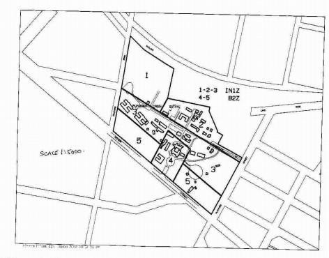
5.0
25/08/2022
Background documents:
Pleasant Creek Site Western Highway Stawell - Development Options Study, October 2000
Development options study Pleasant Creek Centre, Stawell
Pleasant Creek Site Study - Western Highway Stawell
Part A - Preferred planning and development options and recommended disposal strategy, Tract Consultants, March 1998
Draft Stawell Urban Design Framework, 2004 [NEW] [MDF&C for schedule template]
C61ngra Application requirements
None specified.
6.0
25/08/2022
C61ngra
Decision guidelines
None specified.
25/08/2022
C61ngra / / CXXngra
Shown on the planning scheme map as DDO4
25/08/2022
C61ngra Design objectives
To maintain the efficiency and safety of aircraft operations at the Stawell Aerodrome.
To ensure development and landscaping does not present a hazard to aircraft take offs and landings at the Stawell Aerodrome.
To ensure that development is appropriately sited and compatible with the operation of the Stawell Aerodrome.
To ensure that all buildings and works minimise impacts on the safe operation of the Stawell Aerodrome.
To recognise and implement any approved Obstacle Surface Limitation chart.
25/08/2022
C61ngra / /
CXXngra
Buildings and works
General
A permit is not required for:
Buildings and works associated with an existing building where the height of the building is not increased and building materials are non-reflective.
DDO4-1: Obstacle Height Area 1
Permit requirement
A permit is not required to construct a building or construct or carry out works unless:
The height of a building or works exceeds 5 metres above ground level, including an antenna, a domestic or a rural wind turbine or flagpole and landscaping where the height of any plant at maturity exceeds 5 metres.
External materials and finishes are reflective.
DDO4-2: Obstacle Height Area 2
Permit requirement
A permit is not required to construct a building or construct or carry out works unless:
The height of a building or works exceeds 10 metres above ground level, including an antenna, a domestic or a rural wind turbine or flagpole and landscaping where the height of any plant at maturity exceeds 10 metres.
External materials and finishes are reflective.
DDO4-3: Obstacle Height Area 3
Permit requirement
A permit is not required to construct a building or construct or carry out works unless:
The height of a building or works exceeds 20 metres above ground level, including an antenna, domestic or rural wind turbines or flagpole and landscaping where the height of any plant at maturity exceeds 20 metres.
External materials and finishes are reflective.
3.0
25/08/2022
An application under this schedule must be referred in accordance with Section 55 of the Act to the referral authority specified in Clause 66.04 or a schedule to that clause.
C61ngra Subdivision
None specified.
4.0
25/08/2022
C61ngra Signs None specified.
5.0
25/08/2022
C61ngra
The following application requirements apply to an application for a permit under Clause 43.02, in addition to those specified elsewhere in the scheme and must accompany an application, as appropriate, to the satisfaction of the responsible authority:
Ground levels including both natural and any altered ground levels of the site.
Geographic coordinates.
The AHD of the highest point of the proposed development.
Description of roof colour and external materials.
Description of vegetation including species and growth form including height reached at maturity.
6.0
25/08/2022
C61ngra / / CXXngra
The following decision guidelines apply to an application for a permit under Clause 43.02, in addition to those specified in Clause 43.02 and elsewhere in the scheme which must be considered, as appropriate, by the responsible authority:
The Stawell Aerodrome Obstacle Limitation Surfaces chart.
The Stawell Aerodrome Master Plan Review (2015).
The need to prevent buildings, structures or works including planting of vegetation and landscaping from being built, constructed or planted which could interfere with and cause a safety hazard to aircraft operations in the immediate vicinity of the airport.
The existing and likely future use and development of the airport.
Whether the mature height of vegetation does not interfere with or cause a safety hazard to aircraft operations.
The effect of the proposed development and building materials on maintaining a clear aircraft flight path.
The intended use and purpose of the proposed building and development.
Background documents
Stawell Aerodrome Master Plan Review 2015. [NEW] [MDF&C for schedule template]
25/08/2022
C61ngra / / CXXngra
Shown on the planning scheme map as DDO5.
FORMER DEPARTMENT OF ENVIRONMENT, LAND, WATER AND PLANNING DEPOTBRUDENELL STREET, ST ARNAUD
25/08/2022
C61ngra
Design objectives
To manage interface amenity issues between industrial uses on the subject land and adjoining residential properties through the provision of a landscape buffer and a nominated vehicle access location.
25/08/2022
C61ngra / / CXXngra
25/08/2022
C61ngra
Buildings and works
Application requirements
An application must be accompanied by the following information, as appropriate:
A site layout plan that shows:
– The main vehicle access to the site from Brudenell Street, located to minimise disturbance to neighbouring residential properties
– A 3-metre wide landscape buffer on the southern (Sawbench Lane), western (Wills Street)and eastern boundaries.
ApermitmaynotbegrantedtovarytheserequirementsunlesstherResponsibleaAuthority considers that the design objectives are satisfied.
Subdivision
Application requirements
An application must be accompanied by the following information, as appropriate:
A site layout plan that shows:
– The main vehicle access to the site from Brudenell Street, located to minimise disturbanceto neighbouring residential properties.
– A 3-metre wide landscape buffer on the southern (Sawbench Lane), western (Wills Street) and eastern boundaries.
ApermitmaynotbegrantedtovarytheserequirementsunlesstherResponsibleaAuthority considers that the design objectives are satisfied.
25/08/2022
C61ngra Signs
None specified.
5.0
25/08/2022
C61ngra
Application requirements
None specified.
25/08/2022
C61ngra
The following decision guidelines apply to an application for a permit under Clause 43.02, in addition to those specified in Clause 43.02 and elsewhere in the scheme which must be considered, as appropriate, by the responsible authority:
Whether the positioning of the vehicle access to the site will minimise amenity effects on neighbouring residential properties.
Whethertheproposal designresponseappropriatelyconsiderstheretentionofthematurenative vegetation on the site.
25/08/2022
C61ngra / / CXXngra
Shown on the planning scheme map as DDO6
HOSPITAL
AREA)
25/08/2022
C61ngra
To ensure that the height of buildings and works do not encroach on the flight path areas associated with the hospital helicopter landing sites.
To ensure that the height of development avoids creating a hazard to aircraft using the hospital helicopter landing sites.
25/08/2022
C61ngra / / CXXngra
A permit is not required to construct a building or to construct or carry out works that would result in the height of the building or works being less than the referral height specified in Table 1.
3.0
25/08/2022
A permit is not required to construct or carry out buildings and works in relation to an existing dwelling that exceeds the heights specified in Table 1 provided:
The buildings and works do not exceed the existing height of the building (measured at theapex of the roofline); and
The lot does not immediately adjoin the hospital land (hospital land is defined by the extent ofthe Public Use Zone 3).
Apermitisnot requiredtoconstruct abuildingortoconstructorcarryout workswithinthePublic Use Zone 3.
Note: Check the "Hospital Emergency Medical Services - Helicopter Flight Path Protection Areas Incorporated Document June 2017" for additional requirements for land affected by this schedule.
An application must be referred in accordance with Section 55 of the Act to the referral authority specified in Clause 66.04 or a schedule to that clause. [NEW] [MDF&C for schedule template]
An application is exempt from notice requirements of section 52(1)(a), (b) and (d), the decision requirements of section 64(1), (2) and (3) and the review rights of section 82(1) of the Act.
C61ngra Subdivision
A permit is not required to subdivide land.
25/08/2022 C61ngra Signs None specified.
25/08/2022
C61ngra
The following application requirements apply to an application for a permit under Clause 43.02, in addition to those specified elsewhere in the scheme and must accompany an application, as appropriate, to the satisfaction of the responsible authority:
The location and topography of the subject land in relation to the helicopter landing site.
The location and height of the main features on the subject land, including existing buildings, structures, trees or any other tall features.
The proposed buildings and works on the land including details of the maximum height of the proposed buildings, works and construction equipment measured relative to the height of the helipad (AHD).
Note: AHD means Australian Height Datum.
25/08/2022
C61ngra / / CXXngra
The following decision guidelines apply to an application for a permit under Clause 43.02, in addition to those specified in Clause 43.02 and elsewhere in the scheme which must be considered, as appropriate, by the responsible authority:
Whether the height and design of any proposed buildings or works will have an impact on the flight paths associated with the helicopter landing sites at St Arnaud Hospital and Stawell Hospital.
The views of the Department of Health and Human Services (Vic). [NEW] [MDF&C for schedule template]
25/08/2022
C61ngra / / CXXngra
Shown on the planning scheme map as DDO7
HOSPITAL
AREA)
25/08/2022
C61ngra
To ensure that the height of buildings and works do not encroach on the flight path areas associated with the hospital helicopter landing sites.
To ensure that the height of development avoids creating a hazard to aircraft using the hospital helicopter landing sites.
25/08/2022
C61ngra / / CXXngra
A permit is not required to construct a building or to construct or carry out works that would result in the height of the building or works being less than the referral height specified in Table 1.
3.0
25/08/2022
C61ngra
A permit is not required to construct or carry out buildings and works in relation to an existing dwelling that exceeds the heights specified in Table 1 provided:
The buildings and works do not exceed the existing height of the building (measured at the apex of the roofline), and
The lot does not immediately adjoin the hospital land (hospital land is defined by the extent of the Public Use Zone 3).
Apermitisnot requiredtoconstruct abuildingortoconstructorcarryout workswithinthePublic Use Zone 3.
Note: Check the "Hospital Emergency Medical Services - Helicopter Flight Path Protection Areas Incorporated Document June 2017: for additional requirements for land affected by this schedule.
An application must be referred in accordance with Section 55 of the Act to the referral authority specified in Clause 66.04 or a schedule to that clause. [NEW] [MDF&C for schedule template]
An application is exempt from notice requirements of section 52(1)(a), (b) and (d), the decision requirements of section 64(1), (2) and (3) and the review rights of section 82(1) of the Act.
Subdivision
A permit is not required to subdivide land.
25/08/2022 C61ngra Signs None specified.
25/08/2022
C61ngra Application requirements
The following application requirements apply to an application for a permit under Clause 43.02, in addition to those specified elsewhere in the scheme and must accompany an application, as appropriate, to the satisfaction of the responsible authority:
The location and topography of the subject land in relation to the helicopter landing site.
The location and height of the main features on the subject land, including existing buildings, structures, trees or any other tall features.
The proposed buildings and works on the land including details of the maximum height of the proposed buildings, works and construction equipment measured relative to the height of the helipad (AHD).
Note: AHD means Australian Height Datum.
25/08/2022
C61ngra / / CXXngra Decision guidelines
The following decision guidelines apply to an application for a permit under Clause 43.02, in addition to those specified in Clause 43.02 and elsewhere in the scheme which must be considered, as appropriate, by the responsible authority:
Whether the height and design of any proposed buildings or works will have an impact on the flight paths associated with the helicopter landing sites at St Arnaud Hospital and Stawell Hospital.
The view of the Department of Health and Human Services (Vic).
[NEW] [MDF&C for schedule template]
25/08/2022
C61ngra / / CXXngra
Shown on the planning scheme map as DPO1
The subject area comprises a number of smaller allotments totally approximately 16.85 hectares of land located approximately 350 metres from the town centre. Adjoing land is zoned General Residential Zone, Commercial 1 Zone and Public Conservation and Resource Zone.
25/08/2022
C61ngra
2.0
25/08/2022
C61ngra / / CXXngra
None specified.
Requirement before a permit is granted
The responsible authority may grant a permit for subdivision, use or development prior to the approval of a A permit may be granted to use or subdivide land, construct a building or construct or carry out works before a development plan has been prepared to the satisfaction of the responsible authority provided it is satisfied that the subdivision, use or development will not prejudice the future use or development of the land consistent with the objectives of this schedule.
25/08/2022
C61ngra / / CXXngra
A permit granted must include tThe following conditions and/or requirements apply to permits, as appropriate to theapplication:
An architectural design response for all residential and commercial buildings.
A planning report outlining how the development is generally in accordance with the approved Development Plan and the Halls Gap Township Urban Design Framework.
A traffic report assessing the car parking requirements and traffic impacts of the proposed development.
A report detailing how Environmentally Sustainable Design techniques such as energy and water conservation, waste minimisation, vegetation retention and promotion of alternative transport options have been incorporated in the proposed development.
Anypermitgrantedtosubdivide,useordevelopthelandmustinclude,whererelevant,the following requirements: [NEW] [MDF&C for schedule template]
The submission of a Construction Management Plan prepared to the satisfaction of the responsible authority which includes the following information:
– A construction staging program.
– How the subject site is to be accessed during the construction period.
– How surplus material resulting from future earthworks on the site will be dealt with.
– The storage of all plant and equipment during the construction period.
– The methods designed to ensure that the amenity of the neighbouring residential area is protected throughout the construction period.
– Themethodstocontroladverseenvironmentaleffectsincludingerosionandsedimentrunoff.
25/08/2022
C61ngra
A development plan must include the following requirements:
Design and development objectives
A report demonstrating how the proposed development or subdivision supports the following objectives for the site:
To provide tourism and residential opportunities that complement the role and function of the Halls Gap town centre.
To achieve high quality architectural and landscape design outcomes that maintain the open landscape character of the valley floor and are visually recessive when viewed from the Grampians National Park.
To manage risks associated with environmental hazards such as bushfire and flooding.
To ensure that buildings, landscape works and infrastructure incorporate environmentally sustainable design and water sensitive urban design features.
To ensure buildings, landscaping and open space areas are designed and sited to protect and enhance native vegetation and waterways.
Building/development envelopes/building materials
Details as to how the strategies and objectives of the Design and Development Overlay which apply to all of the site are to be addressed.
An indicative lot layout for the site showing:
The size and dimensions of lots.
A minimum 30 metre vegetated buffer distance between Fyans Creek and the boundary of thedevelopment.
An explanatory statement describing how the subdivision responds to the purpose of the Rural Activity Zone schedule 1.
An explanatory statement describing the demand for the range of lots provided.
An Environmental Management Plan to be submitted to include: Identify potential risks to the environment.
A statement describing the environmental features of the proposed development to address energy efficiency, reduction in potable water use, stormwater and run-off management and quality control, waste minimisation, and the prevention of litter and sediment being discharged into the Fyans Creek.
Habitat management and landscape provisions to ensure that disturbance to native flora is minimised and any lost flora habitat is replaced. Appropriate consistent landscaping is carried out in identified areas of environmental significance.
A statement describing how the development plan addresses the Vegetation Protection Overlay that applies to all of the land.
The location design and purpose of all proposed water bodies and wetlands.
Provision of defendable space for the precinct to effectively manage bushfire risk.
Public access/open space
Provision of an area of public open space associated with the proposed wetlands.
Road and pedestrian network
An indicative Road and Pedestrian Network Plan showing:
The location and dimensions of the Valley Drive extension, that considers existing and future traffic needs.
The location of any road access points from other proposed or existing roads.
Provision of adequate pedestrian paths.
Landscaping
A Landscape Plan to be submitted showing:
The application of key landscape design principles that considers species selection throughout road reserves, along the site's key internal and external interfaces and within proposed communal open spaces and car parking areas.
The provision of significant tree canopy and tree planting areas extended throughout the site.
The provision of wetland protection and areas.
Identification of existing vegetation to be retained and removed.
Buffers and interface treatment to Fyans Creek.
25/08/2022
C61ngra /--/ CXXngra
Shown on the planning scheme map as EMO1.
1.0
25/08/2022
C61ngra
2.0
25/08/2022
Erosion management objectives to be achieved
None specified.
C61ngra Statement of risk
None specified.
3.0
25/08/2022
C61ngra / / CXXngra
Permit requirement
Before deciding on an application the Rresponsible Aauthority must consider as appropriate: Whether the proposal addresses and overcomes the severe erosion risk in the area.
The comments of the Department of Environment, Land, Water and Planning and the North Central Catchment Management Authority.
Notice requirement
Notice of any application must be given in accordance with Section 52(1)(c) of the Act to the person or body specified as a person or body to be notified in Clause 66.06 or a schedule to that clause. [NEW] [MDF&C for schedule template]
4.0
25/08/2022
C61ngra Application requirements
None specified.
5.0
25/08/2022
C61ngra Decision guidelines
None specified.
25/08/2022
C61ngra / / CXXngra
1.0
25/08/2022
SCHEDULE 2 TO CLAUSE 44.01 EROSION MANAGEMENT OVERLAY
Shown on the planning scheme map as EMO2.
LANDSLIP AREA [NEW] [MDF&C for schedule template: needs heading]
C61ngra Erosion management objectives to be achieved
None specified.
2.0
25/08/2022
C61ngra Statement of risk
None specified.
3.0
25/08/2022
C61ngra Permit requirement
A permit is not required to construct a building or construct or carry out buildings and works on anexistingbuildingifthereisnoincreaseinbuildingheight,nogrounddisturbance,novegetation clearance and no change to stormwater runoff.
4.0
25/08/2022
C61ngra / / CXXngra
Application requirements
An application must be accompanied by the following information to the satisfaction of the responsible authority :
Detailed plans of the proposed development drawn to scale and dimensioned, showing as appropriate:
– A site plan and building elevations, and any proposed cut and fill, retaining wall or effluent disposal system.
– Any existing development, including buildings, water tanks and dams on both the subject lot and adjacent land, cut and fill, stormwater drainage, subsurface drainage, water supply pipelines, sewerage pipelines or effluent disposal installations and pipelines and any otherwise identified geotechnical hazard ;
– Details and location of existing vegetation, including any vegetation to be removed.
A Preliminary Geotechnical Assessment prepared by a suitably qualified geotechnical engineer or engineering geologist with experience in landslide risk assessment and must include the following information:
– A qualitative risk assessment of the site in accordance with the Australian Geomechanics Society Guidelines.
– A description of any landslide hazard including the location, volume (or area), classification and velocity of any potential landslide, any resultant detached material and the probability of occurrence within a given period of time.
–Plans and sections of the site and related land from survey and field measurements with contours and key features identified, including the locations of the proposed development, buildings/structures on both the subject site and adjoining site, stormwater drainage, subsurface drainage, water supply and sewerage pipelines.
–A conclusion as to whether the site is suitable for the development proposed to be carried out either with conditions to the satisfaction of the responsible authority or unconditionally. In the event that the development is only appropriate to be carried out on the site subject to conditions, recommendations must be made in respect of all the conditions which should be imposed upon the carrying out of the development, including but not limited to:
Footing levels and foundation materials.
Degree of earth and rock cut and fill, recommendations for excavations and fill construction.
Loadbearingcapacitiesforuseinthedesignofallstructuralworksincludingallfootings, retaining walls, surface and sub-surface drainage.
Recommendations for the selection and design of a building structure system to minimise the effects of all identified geotechnical hazards.
Any necessary ongoing mitigation and maintenance measures.
A statement indicating that the risks for all slope instability hazards identified, are of acceptable risk level (as defined by the Australian Geomechanics Society Guidelines) and will remain at an acceptable risk level over the design life of the development such that a Quantitative Risk Assessment is not required.
A Geotechnical Declaration and Verification Development Application that is generally consistent with form A in the Australian Geomechanics Society Guidelines.
Verification the level of professional indemnity that the author of the Geotechnical Assessment is a suitably qualified geotechnical engineer or engineering geologist with experience in landslide risk assessment.
Verification that the Geotechnical Assessment is capable of being verified by a peer review by an independent and suitably qualified geotechnical engineer or engineering geologist with experience in landslide risk assessment.
Where the risk to property or life is found to be low or very low (as defined by the Australian Geomechanics Society Guidelines) no further geotechnical analysis is required.
Where a Preliminary Geotechnical Assessment identifies risk to property or persons as greater than low, a Quantitative or Semi Quantitative Risk Assessment prepared by a suitably qualified geotechnical practitioner must be prepared.
The Quantitative Risk Assessment must contain all information required for the Preliminary Geotechnical Assessment and:
– An assessment of the risks to property and risk to persons in accordance with the methodology set out in the Australian Geomechanics Society Guidelines.
– A conclusion as to whether the subject lot is suitable for the proposed development. This must be in the form of a specific statement that the subject lot is suitable, or can be made suitable, for the proposed development and that the subject lot and/or the proposed development can meet the tolerable risk criteria, as defined by the Australian Geomechanics Society Guidelines.
– All conditions required to achieve the tolerable risk criteria.
Information requirements may be waived, to the satisfaction of the responsible authority. In deciding whether or not to waive any of the above requirements, the responsible authority will consider, as appropriate:
Whether the proposed building or works generally presents a very low or low risk to life and property.
Whether the proposed building or works are a minor extension or alteration of an existing development.
Whether any earthworks have a depth of one metre or less from natural ground level.
Whether a geotechnical practitioner has submitted a Declaration of Minor Impact that is generally consistent with the Australian Geomechanics Society Guidelines.
Whether in view of any Declaration of Minor Impact, a risk assessment and Declaration requirement are considered to be generally necessary.
The qualifications, depth and relevance of experience and professional recognition of any geotechnical practitioner who has made a declaration or assessment.
5.0
25/08/2022 C61ngra
Decision guidelines
None specified.
25/08/2022
C61ngra
Shown on the planning scheme map as FO1
1.0
25/08/2022
C61ngra
2.0
25/08/2022
Floodway objectives to be achieved
None specified.
C61ngra Statement of risk
None specified.
3.0
25/08/2022
C61ngra
Permit requirement
A permit is not required to construct a building or construct or carry out works for:
Land subject to an existing planning permit, restriction or agreement
If land has been developed in accordance with a planning permit, restriction or section 173 agreement requiring its ground level to be finished at least 300 millimetres above the 100-year ARI (average recurrence interval) flood level; and
Survey plans confirm that the ground level has been constructed in accordance with the requirements of a planning permit, restriction or subdivision; and
Any buildings and works do not lower the ground level or result in a finished floor level for a dwelling that is below 300 millimetres above the 100-year ARI flood level.
Extensions and alterations to existing buildings
An upper storey extension to an existing building provided the extension is within the existing building footprint and the total number of bedrooms are not increased.
Other buildings and works
Anin-grounddomesticswimmingpool orspa,andassociatedmechanicalandsafetyequipment and open-style security fencing where:
– Theexcavatedspoildoesnotraisethegroundleveltopographybymorethan150millimetres; and
– The perimeter edging of the pool is finished at no more than 150 millimetres above natural ground level.
A trough associated with agriculture.
Works
Repairs and routine maintenance that do not affect the height, length or location of a levee, embankment or road.
Earthworks that do not alter the ground level topography by more than 150 millimetres. Footpaths, bicycle pathways and trails that do not raise the ground level topography by more than 150 millimetres.
25/08/2022
C61ngra
The following application requirements apply to an application for a permit under Clause 44.03, in addition to those specified in Clause 44.03 and elsewhere in the scheme and must accompany an application, as appropriate, to the satisfaction of the responsible authority:
A site description, which may use a site plan (drawn to scale), photographs or any other relevant technique, that accurately describes:
– The boundaries, dimensions, shape, size, orientation, slope and elevation of the site.
– Relevant existing and proposed ground levels of the site, to Australian Height Datum, and the difference in levels between the site and surrounding properties.
– Location, layout, size and use of existing and proposed buildings and works on the site and on surrounding properties.
– Floor levels of any existing or proposed buildings, to Australian Height Datum.
– The use of surrounding properties and buildings.
– Location of significant environmental values including flora, fauna and wetlands on the site and surrounding properties.
– Adjoining roads, internal driveways and access tracks.
– Any other notable features or characteristics of the site.
Plans, including elevations, of all proposed buildings, drawn to scale.
Construction details of all proposed buildings, fences, works and driveways.
25/08/2022
C61ngra Decision guidelines
None specified.
25/08/2022
C61ngra
Shown on the planning scheme map as LSIO1
1.0
25/08/2022
C61ngra
2.0
25/08/2022
Land subject to inundation objectives to be achieved
None specified.
C61ngra Statement of risk
None specified.
3.0
25/08/2022
C61ngra Permit requirement
A permit is not required to construct a building or construct or carry out works as follows:
On land subject to an existing planning permit, restriction or agreement
If land has been developed in accordance with a planning permit, restriction or section 173 agreement requiring its ground level to be finished at least 300 millimetres above the 100-year ARI (average recurrence interval) flood level; and
Survey plans confirm that the ground level has been constructed in accordance with the requirements of a planning permit, restriction or subdivision; and
Any buildings and works do not lower the ground level or result in a finished floor level for a dwelling that is below 300 millimetres above the 100-year ARI flood level.
Extensions and alterations to existing buildings
An extension to an existing dwelling provided the floor level of the proposed extension is not lower than the existing floor level and the gross floor area of the building is less than 20 square metres.
An upper storey extension to an existing building provided the extension is within the existing building footprint.
New and replacement buildings
A single dwelling in a residential zone where the floor level is at least 300 millimetres above the designated 1 per cent AEP flood level.
A non-habitable building (including a shed), including replacement of an existing nonhabitable building provided:
– The floor area is less 20 square metres; and
– The floor level is at least 150 millimetres above the 1 per cent AEP flood level
Other buildings and works
An outdoor advertising sign or business sign that is attached to the wall of a building or orientated parallel to the direction of floodwater flow.
An open sided pergola, carport or verandah with a finished floor level not more than 150 millimetres above ground level.
An open sided agricultural shed with a floor area not more than 200 square metres, provided the shed is located on land in a rural zone.
An in-ground swimming pool or spa, and associated mechanical and safety equipment and open-style security fencing where:
– The excavated spoil does not raise the ground level topography by more than 150 millimetres; and
– The perimeter edging of the pool is finished at no more than 150 millimetres above natural ground level.
A domestic rainwater tank provided:
– The rainwater tank has a capacity less than 25,000 litres; and
– The rainwater tank is on a stand more than 300 millimetres above the 1 per cent AEP flood level which allows the free passage of floodwater
A maximum of four rainwater tanks, with a combined capacity not greater than 25,000 litres, and which are sited at least 1 metre apart.
A trough associated with agriculture.
Repairs and routine maintenance that do not affect the height, length or location of a levee, embankment or road.
Roadworks that do not raise the ground level topography by more than 150 millimetres.
Footpaths, bicycle pathways and trails that do not raise the ground level by more than 150 millimetres.
Earthworks that do not raise the ground level topography by more than 150 millimetres.
Earthworks associated with sports ground, racecourse or recreation area with no permanent grandstands or raised viewing areas.
Works associated with cropping or pasture improvement which do not alter the ground level by more than 150 millimetres.
25/08/2022
C61ngra
The following application requirements apply to an application for a permit under Clause 44.04, in addition to those specified in Clause 44.04 and elsewhere in the scheme and must accompany an application, as appropriate, by the responsible authority:
Asitedescription,whichmayuseasiteplan(drawntoscale),photographs oranyotherrelevant technique, that accurately describes:
– The boundaries, dimensions, shape, size, orientation and elevation of the site.
– Relevant existing and proposed ground levels of the site to Australian Height Datum, and the difference in levels between the site and surrounding properties.
– Floor levels of any existing and proposed buildings, to Australian Height Datum.
– The use of surrounding properties and buildings.
– Location of significant environmental values including flora, fauna and wetlands on the site and surrounding properties.
– Adjoining roads, internal driveways and access tracks.
– Any other notable features or characteristics of the site.
Plans, including elevations, of all proposed buildings, drawn to scale.
Construction details of all buildings, fences, works and driveways.
5.0
25/08/2022 C61ngra
Decision guidelines
None specified.
25/08/2022
C61ngra / / CXXngra
1.0
25/08/2022
C61ngra
25/08/2022
SCHEDULE
Shown on the planning scheme map as BMO1.
Statement of the bushfire management objectives to be achieved
To specify bushfire protection measures to construct or extend one dwelling on a lot.
To specify referral requirements for applications to construct or extend one dwelling on a lot.
C61ngra Application
The application to construct or extend one dwelling on a lot must include all the requirements set out in this schedule.
Clause 53.02 applies in all other circumstances.
3.0
25/08/2022
C61ngra
4.0
25/08/2022
C61ngra
Permit requirement
None specified.
Application requirements
The following application requirements apply to an application for a permit under Clause 44.06:
Shows all of the required bushfire protection measures specified in this schedule.
Includes written conditions that implement the required bushfire protection measures.
Identifies water supply including the location of any fire hydrant within 120 metres of the rear of the building.
Details vehicle access.
25/08/2022
C61ngra Requirements to be met
The following requirements apply to an application to construct a single dwelling on a lot:
The dwelling must be constructed to BAL-12.5.
Defendable space is to be provided for a distance of 30 metres around the dwelling or to the property boundary, whichever is the lesser and maintained in accordance with the vegetation management requirements of Clause 53.02 with the following variation:
– The canopy of trees must be separated by at least 2 metres.
A static water supply must be provided in accordance with Clause 53.02, andVehicle access must be provided in accordance with Clause 53.02.
If these requirements are not met, the requirements of Clause 53.02 apply.
6.0
25/08/2022
C61ngra
Substitute approved measures for Clause 53.02
Approved Measure
AM3.2
AM4.1
AM4.2
AM5.1
AM5.2
AM5.3
AM5.4
7.0
25/08/2022
C61ngra
8.0
25/08/2022
C61ngra / / CXXngra
Substitute approved measure
None specified.
None specified.
None specified.
None specified.
None specified.
None specified.
None specified.
Additional alternative measures for Clause 53.02
None specified.
Mandatory Condition
An application must include the mandatory conditions as specified in Clause 44.06-5None specified [NEW] [MDF&C for schedule template]
9.0
25/08/2022
C61ngra
10.0
25/08/2022
C61ngra
11.0
25/08/2022
C61ngra
Referral of application not required
An application for a single dwelling on a lot meeting all of the required bushfire protection measures is not required to be referred under Section 55 of the Act to the person or body specified as the referral authority in Clause 66.03.
Notice and review
None specified.
Decision guidelines
Before deciding on an application, in addition to the decision guidelines in Clause 65, the responsible authority must consider whether all of the bushfire protection measures in this schedule have been met.
25/08/2022
25/08/2022
C61ngra
25/08/2022
C61ngra
Shown on the planning scheme map as AEO2.
An application to use land for the following must be referred to the airport owner under Section 55 of the Act unless, in the opinion of the responsible authority, the proposal satisfies requirements or conditions previously agreed in writing between the responsible authority and the airport owner:
Accommodation.
Art and craft centre.
Bar.
Display home centre.
Education centre.
Hospital.
Hotel.
Office.
Place of assembly.
Research and development centre.
Research centre.
Restricted recreation facility.
1.0
08/07/2021 GC161
Address of land

The Mildura Line (Gheringhap to Yelta) shown on the project area maps for the Rail Gauge Standardisation Project in the incorporated document.
Land between Lake Bellfield and Yaapeet required for the construction of the Wimmera Mallee Pipeline ProjectHeadworks and Western Leg Stage 1 as shown in the incorporated document.
Land in the shire required for the construction of the Wimmera Mallee Pipeline Project.
Theland requiredfortheWestern Highway Project,Section 3 (Ararat to Stawell), as identified in Section 3 of the Incorporated Document
The land identified in clause 3 of the South West Loddon Pipeline Project Incorporated Document, January 2018.
RailGaugeStandardisationProject,December 2002
Title of incorporated document

Wimmera Mallee Pipeline Project Headworks and Western Leg January 2007
Wimmera Mallee Pipeline Project Northern Grampians Planning Scheme Incorporated Document.
Western Highway Project: Section 3 – Ararat to Stawell, Incorporated Document, September 2014
South West Loddon Pipeline Project Incorporated Document, January 2018
25/08/2022 C61ngra
25/08/2022 C61ngra
25/08/2022 C61ngra
Under Section 23 of the Subdivision Act 1988 Land
None specified
Under Section 24A of the Subdivision Act 1988 Land Person Action
None specified
25/08/2022 C61ngra
Under Section 36 of the Subdivision Act 1988
Land
None specified
or right of way Requirement
25/08/2022
C61ngra
25/08/2022
C61ngra
Exemption from notice and review
Land
None specified
Condition
25/08/2022
25/08/2022 C61ngra Native vegetation precinct plan
Name of plan
None specified
25/08/2022
C61ngra
1.0
25/08/2022
C61ngra
2.0
25/08/2022
C61ngra
Scheduled area
Area
Land required for the construction of the Wimmera Mallee Pipeline ProjectHeadworks and Western Leg Stage 1 from Lake Bellfield to Yaapeet as shown on Figures 2, 3 and 4 on pages 29, 30 and 31 of the Environmental Management Plan.
Scheduled weed
Area
None specified
Description of native vegetation for which no permit is required to remove, destroy or lop
All native vegetation necessary for the construction of the Wimmera Mallee Pipeline Project- Headworks and Western Leg Stage1in accordance withthe WimmeraMallee Pipeline Project Environmental Management Plan- Headworks and Western Leg dated 19 January 2005 and endorsed by the Secretary, Department of Sustainability and Environment on 11 July 2006.
25/08/2022
C61ngra SCHEDULE TO CLAUSE 52.27 LICENSED PREMISES
1.0
25/08/2022 C61ngra
Permit not required
Land
None specified
2.0
25/08/2022 C61ngra
Permit may not be granted
Land
None specified
Type of licence
Type of licence
25/08/2022 C61ngra SCHEDULE
1.0
25/08/2022 C61ngra
2.0
25/08/2022 C61ngra
Objectives
None specified.
Prohibition of a gaming machine in a shopping complex
Installation or use of a gaming machine as specified in Clause 52.28-4 is prohibited on land described in Table 1 below.
Table 1
Name of shopping complex and locality
None specified
3.0
25/08/2022 C61ngra
4.0
25/08/2022
C61ngra
5.0
25/08/2022
C61ngra
6.0
25/08/2022
C61ngra
7.0
25/08/2022
C61ngra
Land description
None specified
Prohibition of a gaming machine in a strip shopping centre
A gaming machine as specified in Clause 52.28-5 is prohibited in all strip shopping centres on land covered by this planning scheme.
Locations for gaming machines
None specified.
Venues for gaming machines
None specified.
Application requirements
None specified.
Decision guidelines
None specified.
Permit requirement for dry stone walls
None specified Land
25/08/2022 C61ngra
1.0
25/08/2022 C61ngra
2.0
25/08/2022 C61ngra
Table 1 Classes of VicSmart application under zone provisions
3.0
25/08/2022 C61ngra

Name of zone or class of Class of zone application
None specified
Permit requirement Information requirements provision and decision guidelines
Table 2 Classes of VicSmart application under overlay provisions

Name of overlay or class of Class of overlay application
None specified
Permit requirement Information requirements provision and decision guidelines
Table 3 Classes of VicSmart application under particular provisions

None specified

Name of particular provision Class of application
Permit requirement Information requirements provision and decision guidelines
25/08/2022
C61ngra
1.0
25/08/2022
SCHEDULE 1 TO CLAUSE 59.16 INFORMATION REQUIREMENTS AND DECISION GUIDELINES FOR LOCAL VICSMART APPLICATIONS
C61ngra Information requirements
None specified.
2.0
25/08/2022
C61ngra Decision guidelines
None specified.
25/08/2022
C61ngra / / CXXngra
1.0
25/08/2022
C61ngra / / CXXngra
SCHEDULE TO CLAUSE 66.04 REFERRAL OF PERMIT APPLICATIONS UNDER LOCAL
Referral of permit applications under local provisions
Clause Kind
Schedule 2 to Clause 45.02 Uses listed in Schedule 2 to Airport owner. Determining referral (AEO) Clause. authority
Schedule 4 to Clause 43.02 All applications. Stawell Aerodrome Determining referral (DDO) Manager authority
Schedule to Clause 52.03 - Anyapplication to construct Department of Health Determining referral Hospital Emergency Medical a building or to construct or and Human Services authority Services - Helicopter Flight carry out works.
Path Protection Areas
IncorporatedDocument,June 2017
Clause 2.0 of Schedule 6 to Anyapplication to construct Department of Health Determining referral Clause 43.02 (DDO) a building or to construct or and Human Services authority carry out works.
Clause 2.0 of Schedule 7 to Anyapplication to construct Department of Health Determining referral Clause 43.02 (DDO) a building or to construct or and Human Services authority carry out works.
[NEW] [Updated Government Department Names]
25/08/2022
C61ngra / / CXXngra
SCHEDULETO CLAUSE 66.06NOTICEOFPERMITAPPLICATIONS UNDER LOCAL PROVISIONS
1.0
25/08/2022
C61ngra / / CXXngra
Notice of permit applications under local provisions
Clause
Clause 5 of Schedule 2 to Clause 42.01 (ESO)
Kind of application
All applications
Person or body to be notified
Grampians Wimmera Mallee Water Authority
Clause 4 of Schedule 3 to All applications to subdivide land or Grampians Wimmera Mallee Water Clause 42.01 (ESO) construct a building or construct or carry out works associated with Accommodation, Child Care Centre, Education Centre or Hospital on land which is within the area covered by this schedule. Authority
Clause 4 3 of Schedule 1 to Clause 44.01 (EMO)
All applications
NEW] [Updated Government Department Names]
Secretary to the Department of Energy, Environment and Climate Action, Land, Water and Planning
North Central Catchment Management Authority
31/07/2018 VC148
1.0
31/07/2018 VC148
2.0
31/07/2018 VC148
3.0
31/07/2018 VC148
4.0
22/09/2023 VC243
Responsible authority for administering and enforcing this planning scheme:
The Northern Grampians Shire Council is the responsible authority for administering and enforcing the planning scheme, except for matters specified in Clause 72.01-1 and matters listed in this schedule.
Responsible authority for administering and enforcing a provision of this planning scheme:
None specified.
Person or responsible authority for issuing planning certificates: Minister for Planning.
Responsible authority for VicSmart and other specified applications:
The Chief Executive Officer of Northern Grampians Shire Council is the responsible authority for considering and determining VicSmart applications to which Clause 71.06 applies, in accordance with Divisions 1, 1A, 2 and 3 of Part 4 of the Act.
The Chief Executive Officer of Northern Grampians Shire Council is the responsible authority for considering and determining applications to which Clause 53.24 applies, in accordance with Divisions 1, 1A, 2 and 3 of Part 4 of the Act.
The Chief Executive Officer of Northern Grampians Shire Council is the responsible authority for considering and determining any application that the notice and review exemption in Clause 52.10-2 applies to, in accordance with Divisions 1, 1A, 2 and 3 of Part 4 of the Act.
31/07/2018 VC148
1.0
31/07/2018 VC148
SCHEDULE TO CLAUSE 72.02 WHAT AREA IS COVERED BY THIS PLANNING SCHEME?
Area covered by this planning scheme: Northern Grampians Shire.
14/02/2019
C031pt1 / / CXXngra
1.0
07/04/2022
GC200 / / CXXngra
SCHEDULE TO CLAUSE 72.03 WHAT DOES THIS PLANNING SCHEME CONSIST OF?
Maps comprising part of this planning scheme: Zoning and Overlay maps 1
2, 2LSIO
3, 3BMO, 3HO, 3LSIO
4, 4BMO, 4LSIO
5, 5BMO, 5LSIO
6
7, 7BMO, 7LSIO
8, 8BMO, 8LSIO
9, 9BMO, 9EMO, 9HO, 9LSIO
10, 10BMO, 10DDO, 10SCO
11, 11BMO, 11DDO
12, 12BMO, 12DDO, 12HO, 12SCO
13, 13BMO, 13DDO, 13HO
14, 14BMO, 14LSIO
15,15BMO, 15LSIO-FO
16,16BMO, 16LSIO-FO
17, 17BMO, 17LSIO-FO
18, 18BMO, 18LSIO-FO
19, 19BMO, 19ESO, 19LSIO-FO
20, 20BMO, 20HO, 20LSIO-FO
21, 21LSIO-FO
22, 22BMO, 22HO, 22LSIO-FO
23, 23BMO, 23LSIO
24, 24BMO, 24HO, 24LSIO-FO
25, 25BMO, 25ESO, 25HO, 25LSIO-FO, 25SLO
26, 26AEO, 26BMO, 26DDO, 26ESO, 26LSIO-FO, 26PAO, 26SCO
27, 27BMO, 27DDO, 27LSIO-FO, 27SCO
28, 28BMO, 28EAO, 28HO
29, 29AEO, 29BMO, 29DDO, 29EAO, 29HO, 29LSIO-FO, 29SCO
30, 30BMO, 30DDO, 30EAO, 30HO, 30SCO
31, 31BMO, 31ESO, 31LSIO-FO, 31SCO
32, 32BMO, 32LSIO-FO, 32SCO
33, 33BMO
34, 34BMO
35, 35BMO, 35DDO, 35EMO, 35ESO, 35LSIO-FO, 35SCO, 35SLO, 35VPO
36, 36BMO, 36DDO, 36DPO, 36EAO, 36EMO, 36LSIO-FO, 36VPO
37, 37BMO, 37DDO, 37EMO, 37LSIO-FO, 37VPO
38, 38BMO, 38ESO, 38LSIO-FO, 38PAO, 38SCO
39, 39BMO, 39ESO, 39HO, 39LSIO-FO, 39PAO, 39SCO
40, 40BMO, 40ESO, 40LSIO-FO, 40SCO
41, 41AEO, 41BMO, 41DDO, 41ESO, 41LSIO-FO
[NEW] [Updated Map from PS Maps Online]
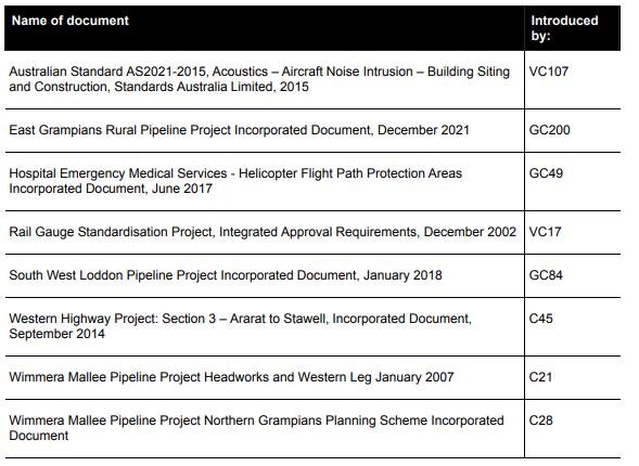
31/07/2018 VC148 SCHEDULE TO CLAUSE 72.05 WHEN DID THIS PLANNING SCHEME BEGIN?
1.0
31/07/2018 VC148
Date this planning scheme began: 15 June 2000
31/07/2018
1.0
10/02/2022
C60ngra / / CXXngra
Background documents
Name of background document
Amendmentnumberclause reference

Arts and Culture Strategy 2020-2024 (Northern Grampians Shire Council, 2020) CXXngra Clause 02 Clause 19.02-3L
Ararat – Stawell- Halls Gap Triangle Rural Zone Review, Final Report (Planisphere, August 2012) C59ngra Clause 02
Defendable Spaces Project: Planning Analysis and Implementation Final Report (Tract Consultants, August 2014)
Clause 02
Economic Development Strategy and Action Plan 2021-31 (Northern Grampians Shire Council, 2021) CXXngra Clause 02
Glenorchy Flood Study (Water Technology, April 2006)
Great Western Future Plan 2014-2024 (SED, July 2014)
C59ngra Clause 02
C59ngra Clause 02
Halls Gap Master-Plan for Commercial Investment and Public Land Development (MVS Architects, SGS Economics and Planning and Professor Maudie Palmer AO, October 2016) C59ngra Clause 02
Halls Gap Planning Scheme Amendment (Water Technology, 2020) C60ngra Clause 02
Halls Gap Township Urban Design Framework, a Pride of Place Project (THA Landscape Architects, May 2001) C59ngra Clause 02
Land Development Strategy 2013-2017 (Northern Grampians Shire Council, 2013)
Mount William Creek Flood Investigation – Planning Scheme Report (BMT WBM Pty Ltd, August 2014)
Northern Grampians Shire Council, Report for Landslide Susceptibility Zoning, Halls Gap Township (GHD, September 2011)
C59ngra Clause 02
C59ngra Clause 02
C59ngra Clause 02
Northern Grampians Shire Heritage Study Stage 2 (Wendy Jacobs, Vicki Johnson, David Rowe, Phil Taylor, 2004)
Northern Grampians Shire Municipal Public Health and Wellbeing Plan 2017-2021 (Northern Grampians Shire Council, 2017)
Northern Grampians Municipal Domestic Wastewater Management Plan 2022-2027 (Northern Grampians Shire, 2022)
Review of the Halls Gap Flood Investigation – Final Report (Water Technology, April 2017)
Stawell Aerodrome Master Plan 2014 (Airports Plus Pty Ltd, April 2015
C59ngra Clause 02
C59ngra Clause 02
CXXngra Clause 02, Schedule 2 to Clause 42.01
C59ngra Clause 02
(Specialist Airport Solutions Pty Ltd for Northern Grampians Shire Council, 2023)
C59ngra CXXngra
Clause 18.02-7L, Schedule 4 to Clause 0243.02
Stawell Wastewater Treatment Works - Establishment of an CXXngra, Schedule 3 to Clause 42.01
Odour Buffer Distance (Sinclair Knight Merz, June 2005)
St Arnaud Tourism Strategy and Action Plan 2022-2032 (Northern Grampians Shire, 2022)
Stawell Tourism Strategy and Action Plan 2022-2032 (Northern Grampians Shire, 2022).
CXXngra, Clause 02
C59ngra Clause 02
Upper Wimmera Flood Investigation Final Report (BMT WBM Pty Ltd, 2014)
Walkers Lake Management Plan, Walkers Lake, Avon Plains, (Ecology & Heritage Partners, 2022) CXXngra Clause 02
[NEW] [Updated background documents adopted by Council and those removed from previous overlay background documents section that are discoverable]
18/06/2021
C59ngra / / CXXngra
1.0
07/12/2023
C63ngra / / CXXngra
This planning scheme applies the following zones, overlays and provisions to implement the Municipal Planning Strategy and the objectives and strategies in Clauses 11 to 19:
Apply the General Residential Zone to facilitate residential development in urban areas.
Apply the Neighbourhood Residential Zone as appropriate in urban areas.
Apply the Low Density Residential Zone in areas close to towns where the land is of marginal agricultural value.
Apply the Rural Living Zone to existing rural living areas or on the periphery of Stawell and St Arnaud.
Apply the Significant Landscape Overlay to protect landscapes of significance.
Apply the Farming Zone to protect and support agricultural uses in rural areas.
Apply the Special Use Zone to facilitate the use and development of the Stawell gold mine.
Apply the Industrial Zones to facilitate industrial development in the shire in appropriate locations.
Apply the Commercial Zones, Industrial Zones, Township Zones, Rural Activity Zone and the Heritage Overlay, Design and Development Overlay and Development Plan Overlay where appropriate to enhance commercial development opportunities within the shire.
Apply the Commercial Zones, Industrial Zones, Township Zones, Rural Activity Zone and the Heritage Overlay, Design and Development Overlay and Development Plan Overlay where appropriate to enhance tourism development opportunities within the shire.
Apply appropriate zoning to land to provide access to open space, renewable energy, services, social infrastructure and transport.
Apply the most appropriate zone and overlays around the Statewide Landfill, Pomonal Road Bellellen and waste and recovery infrastructure to protect the ongoing operation of these facilities.
Apply the Apply the Transport Zone 2 or Transport Zone 3 to protect the function of the road network in the shire and ensure appropriate subdivision of adjoining land.
Apply the Transport Zone 1 to protect the rail network.
Apply specific controls to facilitate the Western Highway Project: Section 3 - (Ararat to Stawell) project.
Apply the Public Acquisition Overlay to reserve land for the duplication of the Western Highway.
Apply the Environmental Significance Overlay to areas where environmental values and potable water supply are to be protected.
Apply the Bushfire Management Overlay to areas of high bushfire risk. [NEW] [Updated application of existing overlays: provide greater clarity]
18/06/2021
C59ngra / / CXXngra
1.0
18/06/2021
C59ngra / / CXXngra
Prepare structure plans for Stawell, Halls Gap and St Arnaud including identified settlement boundaries, existing and future land use outcomes, housing needs and types assessment and an overall strategic framework plan for each settlement.
Investigate residential development opportunities of land in Darlington Lane, Stawell.
Prepare a Local Planning Policy for non-agricultural uses in the Farming Zone.
Prepare a new local policy for rural dwellings and subdivisions to guide development in rural areas (if required) upon completion of a rural strategy.
Investigate the provision of commercial services adjacent to the Western Highway, that will not impact on the function of the highway.
▪ Partner with the NCCMA and the WCMA and relevant water authorities to complete and implement updated flooding studies.
▪ Review the Northern Grampians Heritage Study and extend the Heritage Overlay to the most important places identified in the Northern Grampians Heritage Study as a result of additional heritage studies and statements of significance.
▪ Implement the Stawell and St Arnaud Structure Plans/Framework Plans into the planning scheme.
▪ Implement the Western Highway Urban Design Framework into the planning scheme.
▪ Prepare a rural land use strategy and local policy to guide decisions in the FZ, RCZ, RAZ and RLZ (and potentially LDRZ) in areas outside town boundaries.
▪ Prepare a structure plan for Halls Gap.
▪ Partner with the NCCMA and the WCMA to investigate extending the Environmental Significance Overlay to include all declared open proclaimed water supply catchments.
▪ Investigate application of the Restructure Overlay to old and inappropriate small rural lots.
▪ Undertake an open space strategy and prepare specific requirements to a schedule to Clause 52.01 for a 5 percent (or greater) public open space contribution for residential, commercial and industrial land.
▪ Apply a BAO instead of ESO3 to Stawell wastewater plant, and apply the BAO to the St Arnaud, Halls Gap and Great Western wastewater plants. At the same time consider application of the PUZ to the Halls Gap and Great Western wastewater treatment plants.
▪ Prepare a signage strategy for the municipality.
Undertake a Cultural Values Assessment for the Shire in consultation with the Dja Dja Wurrung Clans Aboriginal Corporation and the Barengi Gadjin Land Council
[NEW] [Updated future strategic work based on PSR2024]
State and regional planning scheme amendments, and planning practice notes and guidance materials issued since last planning scheme review
VC (Victorian) and GC (group of council) amendments.
Since the last planning scheme review in 2018, 105 VC and GC amendments have introduced new policy and provisions into the Northern Grampians Planning Scheme. These are listed below, along with consideration of their impact on this review.
Table 9: VC and GC Amendments to Northern Grampians Planning Scheme From 2018
VC144 27 FEB 2018 The Amendment changed the VPP and all planning schemes by:
▪ Amending Clause 52.05 (Advertising signs) to specify ‘electronic sign’ in Section 2 of Category 3 - High amenity areas (Clause 52.05-9), with a condition that the advertisement area must not exceed three square metres.
▪ Increase the size of the permitted maximum advertisement area of a ‘promotion sign’ in Section 2 of Category 3 from two to three square metres.
▪ Amending Clauses 52.05 and 73 to replace the term ‘home occupation’ with ‘home based business’.
▪ Correcting minor errors in Clauses 52.05 and 62.
Impact on Northern Grampians Planning Scheme: Largely administrative impact only, although the increase to the size allowed for electronic signage in high amenity issues could create issues in residential areas.
VC145 28 MAR 2018
The amendment amended the VPP and all planning schemes by:
▪ Amending Clause 11.05-2 – Distinctive areas of state significance, to reference the Yarra Ranges Localised Planning Statement;
▪ Amending Clause 43.01 – Heritage Overlay, to reinstate administrative corrections that were made in Amendment VC132 but inadvertently removed by Amendment VC141;
▪ Amending Clause 52.19 – Telecommunications Facility, to clarify notice and review exemptions for telecommunications facility permit applications that are funded (or partly funded) by the Victorian or Commonwealth government; and
▪ Separating clauses and subclauses into separate documents and the consequential renumbering and rationalisation of certain clauses to enable their migration into the Planning Scheme Information Management System (PSIMS).
Impact on Northern Grampians Planning Scheme: Largely administrative impact.
VC143 15 MAY 2018 The Amendment changed the VPP and all planning schemes by:
▪ Amending Clause 32.07 (Residential Growth Zone) to remove Food and drink premises and Shop from Section 1 – Permit not required and make them Section 2 – Permit required uses subject to conditions.
▪ Amending Clause 32.08-4 (General Residential Zone) to enable an area to be exempt from the minimum garden area requirement through a schedule to the zone.
▪ Amending Clauses 32.08-3 (General Residential Zone) and 32.09- 3 (Neighbourhood Residential Zone) to:
▪ Exclude the creation of a vacant lot of 400 square metres or greater from the minimum garden area requirement.
▪ Clarify that the minimum garden area requirement does not apply to:
- The creation of a vacant lot less than 400 square metres where there is a precinct structure plan or equivalent strategic plan.
- The creation of a vacant lot less than 400 square metres where there is an incorporated plan or approved development plan.
- The creation of a vacant lot less than 400 square metres where there is an approved residential development.
▪ Amending clauses 32.08-4 (General Residential Zone) and 32.09- 4 (Neighbourhood Residential Zone) to:
▪ Remove the minimum garden area requirement from applying
▪ to the construction or extension of a dwelling or residential building where a planning permit is not required.
▪ Remove the reference to garden area being required to be provided at ground level.
▪ Clarify that the minimum garden area requirement does not apply to:
- A medium density housing site in an approved precinct structure plan or equivalent strategic plan.
- A medium density housing site in an incorporated plan or approved development plan.
- An existing building that did not meet the minimum garden area requirement prior to approval of Amendment VC110.
▪ Amending the Garden area definition at Clause 72 (General Terms) to provide greater clarity about garden area inclusionsand exclusions.
Impact on Northern Grampians Planning Scheme:
Significant and includes a minimum garden area requirement in residential zones. Relates to the application of the General Residential Zone and Neighbourhood Residential Zone in the Shire’s townships.
VC146 15 MAY 2018 Amendment VC146 introduced a new overlay, Clause 45.11 (Infrastructure Contributions Overlay).
Impact on Northern Grampians Planning Scheme:
The planning scheme does not currently have an infrastructure contributions plan. It is however a possibility in the future.
VC148 31 JUL 2018
The amendment changed to the VPP and all planning schemes by:
▪ Deleting the State Planning Policy Framework (SPPF) and replacing it with a new integrated Planning Policy Framework (PPF) in Clauses 10 to 19.
▪ Deleting Clauses 1.0 (Preliminary) 2.0 (User Guide).
▪ Moving the planning scheme purposes from Clause 1.0 to new Clause 01 (Purposes of this planning scheme) and inserting new Clause 00 (Purpose and Vision).
▪ Moving the operational provisions for the Local Planning Policy Framework (LPPF) to new Clauses 23.02 and 23.03 and inserting a new Clause 23.01 to explain the relationship between the LPPF and the PPF.
▪ Amending provisions (including schedules) to update references to the new MPS and PPF and as a result of the restructure and reorganising of provisions.
▪ Amending Clauses 37.03 (Urban Floodway Zone); 42.01 (Environmental Significance Overlay); 42.02 (Vegetation Protection Overlay); 42.03 (Significant Landscape Overlay); 43.01 (Heritage Overlay); 43.02 (Design and Development Overlay); 43.04 (Development Plan Overlay); 44.01 (Erosion Management Overlay); 44.02 (Salinity Management Overlay); 44.03 (Floodway Overlay); 44.04 (Land Subject to Inundation Overlay); 44.05 (Special Building Overlay and 52.28 (Gaming) to enable schedules to specify additional matters.
▪ Amending Clause 43.01 (Heritage Overlay) to require the schedule to the overlay to specify a statement of significance for each heritage place included in the schedule and the ability to incorporate heritage design guidelines for a heritage place.
▪ Amending Clause 43.04 (Development Plan Overlay) to clarify when an application is exempt from the notice and review requirements.
▪ Introducing the Specific Controls Overlay (Clause 45.12).
▪ Organising particular provisions into three new categories at Clauses 51, 52 and 53.
▪ Inserting a new section, ‘Operational provisions’ (Clauses 70 to 74) that consolidates operational, administrative and otherprovisions.
▪ Making various changes to advertising signs provisions at Clauses 32.04 (Mixed Use Zone), 52.05 (Signs), 62.02, 62.01 and at newly numbered
Clauses 73.02 (Sign terms) and 73.03 (Land use terms).
▪ Amending Clause 52.29 (Land Adjacent to a Road Zone 1, Category 1, or a Public Acquisition Overlay for a Category 1 Road) to exempt an application from notice and review requirements and to clarify permit exemptions.
▪ Amending Clause 33.01 (Industrial 1 Zone) to remove the requirement to obtain a planning permit to use land for a 'convenience shop' and 'take away food premises'.
▪ Amending Clause 33.03 (Industrial 3 Zone) to remove the requirement to obtain a planning permit to use land for a 'service industry' (in certain circumstances) and a 'take away foodpremises'
▪ Deleting Clause 52.12 (Service station).
▪ Amending Clauses 33.01 (Industrial 1 Zone) and 32.04 (Mixed Use Zone) to ensure impacts of service stations are considered.
▪ Deleting Clauses 52.13 (Car wash) and 52.14 (Motor vehicle, boat or caravan sales).
▪ Amending Clause 52.06 (Car parking) to change the planning permit requirements and number of spaces to be provided in certain circumstances.
▪ Introducing incorporated document Principal Public Transport Network Area Maps (State Government of Victoria, 2018).
▪ Deleting the VicSmart provisions in Clauses 90 to 95 and consequently: relocating classes of State VicSmart applications to the applicable zones, overlays and particular provisions, local VicSmart provisions to a new Clause 59 (VicSmart applications and requirements) and operational provisions to new Clause71.06.
▪ Making consequential changes to the schedules of applicable particular provisions in planning schemes, including inserting new schedules.
Impact on Northern Grampians Planning Scheme: Significant. The Amendment began the translation of the Northern Grampians Planning Scheme into the new format required by the State Government and provided the basis for Amendment C95malx.
VC151 6 AUG 2018 Updated the Principal Public Transport Network Area Maps (State Government of Victoria, 2018) with a corrected version of the document.).
Impact on Northern Grampians Planning Scheme: Limited. This is a policy neutral amendment.
VC147 14 SEP 2018 The amendment made administrative (formatting and clerical matters) changes to the VPP and all planning schemes.
Impact on Northern Grampians Planning Scheme: Minimal. This is a policy neutral amendment
VC150 21 SEP 2018 The Amendment changed the VPP and all planning schemes by updating reference documents and provisions relating to animal industries.
Impact on Northern Grampians Planning Scheme: Significant as it clarifies and changes the way many farming uses are considered in the Northern Grampians Planning Scheme and assessed.
VC149 4 OCT 2018 The Amendment changed the VPP by inserting a new Commercial 3 Zone at Clause 34.03.
Impact on Northern Grampians Planning Scheme: Minimal. The Shire has no C3Z land. Other aspects of the amendment further support solar and wind energy.
VC153 4 OCT 2018 Amended Clause 52.13-7 (2009 Bushfire – Recovery Exemptions) to extend the expiry date to 30 September 2019.
Impact on Northern Grampians Planning Scheme: Administrative and has now expired.
VC152 26 OCT 2018 Responded to various accommodation matters for shared housing, rooming houses, aged care, nursing homes and crisis accommodation.
Impact on Northern Grampians Planning Scheme:
VC154 26 OCT 2018
VC155 26 OCT 2018
Supports and augments current housing provisions for various types of important accommodation and aged care facilities
Changed the VPP and all planning schemes by:
▪ Deleting Clause 14.02-3S (Water conservation) and integrating these policy statements into a new Clause 19.03-3S (Integrated water management).
▪ Amending Clause 19.03-3S (Water supply, sewerage and drainage) to update and broaden water, drainage and stormwater policies to integrated water management policies.
▪ Deleting Clause 19.03-4S (Stormwater) and integrating this policy into the new Clause 19.03-3S (Integrated water management), with consequential renumbering throughout Clause 19.03.
▪ Inserting a new particular provision at Clause 53.18 for ‘Stormwater management in urban development’.
▪ Amending Clause 55 (Two or more dwellings on a lot and residential buildings) to provide transitional provisions for residential development applications to be assessed against the Clause 55 provisions as they existed before the approval date of Amendment VC154.
▪ Amending Clause 55.03-4 (Permeability) to rename the standard “Permeability and stormwater management’ and amend the standard to include a new stormwater purpose, requirements and decision guidelines.
▪ Amending Clause 55.07 (Apartment developments), Clause 56.07 (Integrated water management) and Clause 58.03 (Site layout) to generally align with the new particular provision.
▪ Amending Clause 73.01 (General terms) to insert a new general term and definition for ‘stormwater’.
Impact on Northern Grampians Planning Scheme:
Significant and supports current provisions relating to water management for two or more dwellings on a lot and commercial and industrial developments.
Amended the VPP and all planning schemes by:
▪ Amending Clause 15.03-1S (Heritage conservation) to include an additional strategy and policy guideline.
▪ Amending Clauses 54.03-5 (Energy efficiency protection), 55.03-5 (Energy efficiency) and 55.07-1 (Energy efficiency) to replace the word ‘capacity’ with ‘performance’ and specify that a rooftop solar energy facility must exist at the time an application is lodged.
Impact on Northern Grampians Planning Scheme: Significant and supports and augments current provisions.
VC157 15 MAR 2019 Introduced changes to the VPP and all planning schemes to require planning approval for power lines to connect new large-scale electricity generation facilities to the electricity network.
Impact on Northern Grampians Planning Scheme: May impact on future transmission lines connecting wind farms across the state and existing and proposed facilities across the Shire
GC122 28 MAR 2019 The Amendment made administrative, format and technical changes to the Ararat, Ballarat, Golden Plains, Hepburn, Hindmarsh, Horsham, Moorabool, Northern Grampians, Pyrenees, West Wimmera, and Yarriambiack planning schemes in the Grampians region to support the publishing of these planning schemes from the Amendment Tracking System (ATS).
Impact on Northern Grampians Planning Scheme: Significant but was administrative and policy neutral in effect
VC156 11 APR 2019 Introduced changes to the VPP and all planning schemes to correct formatting and spelling errors and omissions and to clarify the operation of certain provisions.
Impact on Northern Grampians Planning Scheme: Minimal. This was a policy neutral amendment.
VC159 8 AUG 2019 The Amendment supported Smart Planning and addressed land use terms.
Impact on Northern Grampians Planning Scheme: Minimal and largely administrative with updated land use definitions used in planning applications.
VC163 16 AUG 2019 Corrected an error in Clause 73.04 (nesting diagrams)
Impact on Northern Grampians Planning Scheme: Minimal. This was a policy neutral amendment.
VC161 17 SEP 2019
Amended the VPP and all planning schemes to introduce new requirements for renewable energy facilities and a State planning policy for the protection of declared irrigation districts, and makes an administrative correction in relation to Amendment VC157.
Impact on Northern Grampians Planning Scheme: Mostly minimal, with some effect on existing and proposed facilities across the Shire.
VC164 26 SEP 2019 The Amendment changed the VPP and all planning schemes by amending Clause 52.137 (2009 Bushfire – Recovery Exemptions) to extend the expiry date to 31 March 2020.
Impact on Northern Grampians Planning Scheme: Minimal as this Clause has expired.
VC158 26 NOV 2019 Introduced a new particular provision to exempt combustible cladding rectification on buildings subject to an emergency order, building notice or building order under Part 8 of the Building Act 1993.
Impact on Northern Grampians Planning Scheme: Minimal due to the low rise residential nature of the Shire.
VC165 3 DEC 2019
Amended the VPP and all planning schemes to introduce notice and review exemptions and to amend the responsible authority status for certain planning applications for non-government primary and secondary schools.
Impact on Northern Grampians Planning Scheme: Minimal.
VC160 24 JAN 2020 Amended the VPP and all planning schemes to correct errors and omissions, clarify the operation of certain provisions, and implement planning reforms for extractive industries.
Impact on Northern Grampians Planning Scheme: Minimal but has some impact on the assessment of extractive industries.
VC170 31 JAN 2020 Introduced a new particular provision to facilitate the Level Crossing Removal Project. Impact on Northern Grampians Planning Scheme: Minimal.
VC168 11 FEB 2020
Updated the PPF and Operational Provisions to reference the Plan Melbourne 20172050: Addendum 2019 and introduced a new strategy and spatial framework at Clause 11.01-1R Settlement-Metropolitan Melbourne.
Impact on Northern Grampians Planning Scheme: Minimal.
VC177 11 MAR 2020 The Amendment changes the VPP and all planning schemes in Victoria by inserting a new particular provision at Clause 52.07 to facilitate and support recovery from bushfire.
Impact on Northern Grampians Planning Scheme: Has ongoing impact on the Shire due to the nature of bushfire risk and ongoing recovery efforts from bushfires.
VC181 6 APR 2020 Changes the VPP and all planning schemes were revised with a new Clause 52.18 (State of emergency exemption), to facilitate the delivery of food and other essential goods
Amendment number In operation from
VC178 9 APR 2020
during and following a state of emergency declared in relation to Novel Coronavirus 2019 (2019-nCoV).
Impact on Northern Grampians Planning Scheme: Had some impact on the Shire but its effect is now negligible.
Changes the VPP and all planning schemes were revised with an amended expiry date for Clause 52.13-7 (2009 Bushfire – Recovery Exemptions) to 30 June 2020 as well as changes to the terms ‘extractive industry’ and 'solar energy system' to align with the intent of Amendment VC160.
Impact on Northern Grampians Planning Scheme: Had ongoing impact on the Shire but the Clause has expired.
VC179 6 MAY 2020 Inserts a new provision at Clause 52.10 to facilitate rebuilding following the 2019/20 bushfires and amends the Schedule to Clause 72.01 in all planning schemes to designate the Council CEO as the responsible authority for Clause 52.10.
Impact on Northern Grampians Planning Scheme: Has no impact on the Shire.
VC175 26 MAY 2020 Improves the way the planning system addresses buffers for amenity, human health and safety impacts by updating the PPF and Clause 53.10, as well as introducing the Buffer Area Overlay (BAO).
Impact on Northern Grampians Planning Scheme:
Has ongoing impacts on separation distances for industrial and other hazardous land uses to more sensitive land uses and enables the BAO to be applied to uses where risk assessments related to the environmental hazard have been undertaken.
VC176 5 AUG 2020 Changes the VPP and all planning schemes by amending Clause 52.12 (Bushfire Protection: Exemptions) to align the 10/30 and fence line vegetation exemptions with the Bushfire Prone Area map across all Victorian councils, making administrative updates and further clarifies the exemptions for dwellings and defendable space under the BMO.
Impact on Northern Grampians Planning Scheme: Has ongoing impacts on the Shire and bushfire requirements.
VC186 27 AUG 2020 The amendment inserts a new particular provision at Clause 51.06 (Secondary Dwelling) to facilitate the development of a secondary dwelling in the Greater Bendigo, Kingston, Moreland and Murrindindi Planning Schemes.
Impact on Northern Grampians Planning Scheme: Had no impact on secondary dwellings in the Shire.
VC183 28 SEP 2020 Introduces a new state planning policy Clause 13.07-3S (Live Music) and makes changes to Clause 53.06 (Live Music Entertainment Venues) of the VPP and all planning schemes to encourage, create and protect opportunities for the enjoyment of live music.
Impact on Northern Grampians Planning Scheme: Had ongoing impacts on live music venues in the Shire.
VC169 9 OCT 2020 Changes the VPP and all planning schemes by changing the PPF to help direct balanced outcomes for housing growth and built form while also clarifying and consolidating housing policy.
Impact on Northern Grampians Planning Scheme: Has ongoing impacts on residential development in the Shire in townships and settlements.
VC193 21 OCT 2020 Amends clause 52.18 (State of emergency exemption) to support Victoria’s social and economic recovery from the coronavirus (COVID-19) pandemic through temporary planning scheme and permit condition exemptions that enable outdoor dining and facilitate the reopening and safe operation of restaurants and other food and drink businesses.
Impact on Northern Grampians Planning Scheme:
Had some impact on the Shire but its effect is now negligible.
VC191 5 NOV 2020 Clarifies permit requirements for rectification works on government buildings related to Clause 52.01 (‘Combustible cladding rectification exemptions’).
Impact on Northern Grampians Planning Scheme: Is administrative in nature but has ongoing impacts on development in the Shire.
VC192 16 NOV 2020 Clarifies Clause 72.01-1 to make the Minister for Planning the responsible authority for all large energy generation facilities and electrical utility installations, including large renewable energy facilities and large scale battery facilities that store electricity from any source.
Impact on Northern Grampians Planning Scheme: Is administrative in nature and clarifies decision making roles.
VC187 1 DEC 2020 Introduces a new particular provision for ‘Housing by or on behalf of the Director of Housing’ at Clause 53.20 and streamlines the planning permit process for residential development made by or on behalf of the Director of Housing.
Impact on Northern Grampians Planning Scheme: Is administrative in nature and reflects existing roles for social and affordable housing.
VC190 1 DEC 2020 Introduces a new particular provision for ‘Victoria’s Big Housing Build’ at Clause 52.20. Clause 52.20 and streamlines the planning permit process for residential development made by or on behalf of the Director of Housing.
Impact on Northern Grampians Planning Scheme: Is administrative in nature and reflects existing roles for social and affordable housing.
VC180 4 DEC 2020 Facilitates the development of new, and the upgrade and expansion of existing, nongovernment primary and secondary schools.
Impact on Northern Grampians Planning Scheme: Has an ongoing role for the development of non-government schools.
VC188 14 DEC 2020 Removes Clause 52.13 2009 Bushfire: Recovery Exemptions and references to it from all planning schemes following its expiry.
Impact on Northern Grampians Planning Scheme: Is administrative in nature and removes an expired clause.
GC175 18 FEB 2021 Updates the Schedules to Clause 53.06 and changes the parent provision to reflected scheduled provisions
Impact on Northern Grampians Planning Scheme: Is administrative in nature and relates to live music venues.
VC195 11 MAR 2021 Modifies the particular provision at clause 52.32 (Wind energy facilities) to streamline the application process for minor changes to approved wind energy facilities, clarify consent requirements and simplify review and panel exemptions.
Impact on Northern Grampians Planning Scheme: Is administrative in nature and clarifies existing responsibilities.
VC194 25 MAR 2021 The amendment inserts two new particular provisions at clauses 52.30 and 52.31 to facilitate state projects and local government projects.
Impact on Northern Grampians Planning Scheme: Reflects the ability to identify state and locally significant projects, exemption and permit requirements.
VC185 30 APR 2021 Modifies Clause 72.01-1 to make transitional provisions for an energy generation facility or utility installation to be determined by the council instead of the Minister for Planning if made prior to the approval date of Amendment VC192.
Impact on Northern Grampians Planning Scheme: Is administrative in nature and clarifies existing responsibilities.
VC198 14 MAY 2021 The amendment introduces new particular provisions at clauses 52.35 (Major Road Projects) and 52.36 (Rail Projects) and makes other changes related to delivery of projects carried out by or on behalf of Major Road Projects Victoria and Rail Projects Victoria.
Impact on Northern Grampians Planning Scheme: Reflects the ability to identify state significant projects, exemptions and permit requirements.
VC189 3 JUN 2021
Amends Clause 12.04-1S Sustainable development in alpine areas, to reference the Alpine Resorts Strategic Plan 2020-2025, a new Municipal Planning Strategy at Clause 02 and local policies within the Planning Policy Framework at Clauses 11-19, and administrative changes.
Impact on Northern Grampians Planning Scheme: Has no impact on the Shire.
VC203 1 JUL 2021 Implements a new environment protection framework in the VPP and all planning schemes through updates to the PPF to align with new requirements for contaminated and potentially contaminated land, revises clause 45.03 (Environmental Audit Overlay) and replaces references to State Environment Protection Policies with new content references to related to the Environment Protection Act 2017.
Impact on Northern Grampians Planning Scheme: Has ongoing impacts on land in the Shire.
GC161 08 JUL 2021 Includes maps and transfers sites from the Schedule to Clause 51.01 (Specific Sites and Exclusions) into the Schedule to Clause 45.12 (Specific Controls Overlay) or deletes expired documents from the Schedule to Clause 51.01 and makes other related consequential changes.
Impact on Northern Grampians Planning Scheme: Is administrative in nature and reflects existing requirements.
VC206 3 AUG 2021 Changes the VPP and all planning schemes by aligning planning provisions for a wind energy facility with the requirements of the Environment Protection Act 2017 for the regulation of wind turbine noise and updates licencing references in the Port Zone.
Impact on Northern Grampians Planning Scheme: Is administrative in nature but reflects updated requirements.
VC196 19 AUG 2021
VC171 6 SEP 2021
Changes the VPP and all planning schemes by providing stronger recognition and protection of existing extractive industries, and to designate land with State-significant earth resources, where extractive industries may be established in the future, as strategic extractive resource areas.
Impact on Northern Grampians Planning Scheme: Has ongoing requirements for land identified as strategic extractive resource areas.
Changes the VPP and all planning schemes to implement the Marine and Coastal Policy, support coastal hazard planning and sea level rise adaptation, and update policy references.
Impact on Northern Grampians Planning Scheme: Has little impact on the Shire given its inland location.
VC211 14 SEP 2021 Modifies clause 67.02 to enable the application of exemptions set out in clause 52.31 and updates clauses 66.05 and 67, consolidates clauses 67.02, 67.03 and 67.04 under clause 67.02, and deletes clauses 67.03 and 67.04.
Impact on Northern Grampians Planning Scheme: Is administrative in nature and has little impact.
VC208 5 OCT 2021 Amends Clause 52.10 to apply the use, notice and review exemptions to other types of emergencies.
Impact on Northern Grampians Planning Scheme: Is administrative in nature and has little impact.
VC202 12 OCT 2021 Introduces a land use term and definition for Rural worker accommodation and modifies clause 35.07 (Farming Zone) to introduce exemptions for use of land for Rural worker accommodation that accommodates no more than 10 persons and introduces a permit requirement for use of land for Rural worker accommodation for more than 10 persons.
Impact on Northern Grampians Planning Scheme: Has an ongoing impact on Farming Zone land throughout the Shire and enables rural worker accommodation to be more easily provided.
VC212 13 OCT 2021 Makes changes to Clause 35.07 (Farming Zone) and to notice requirements to minimise the potential for land use conflict from as-of-right accommodation uses in the Farming Zone, in the vicinity of proposed and approved wind energy facilities.
Impact on Northern Grampians Planning Scheme: Is administrative in nature and has little impact.
VC214 19 NOV 2021 Amends the exemptions at clause 52.18 (State of Emergency and Recovery Exemptions) to apply to a broader range of uses.
Impact on Northern Grampians Planning Scheme: Is administrative in nature and has little impact.
VC204 9 DEC 2021 Changes the VPP and all planning schemes in Victoria by modifying Clause 18 of the Victoria Planning Provisions to implement changes to State planning policy for transport.
Impact on Northern Grampians Planning Scheme: Is administrative in nature and has little impact.
VC174 20 DEC 2021 Changes the VPP and all planning schemes by implementing the Better Apartment Design Standards for all apartment developments.
Impact on Northern Grampians Planning Scheme: Minimal due to the low rise residential nature of the Shire.
VC207 20 DEC 2021 Changes the VPP and all planning schemes by implementing the revised Better Apartment Design Standards into clauses 52.20 and 53.20. Impact on Northern Grampians Planning Scheme: Minimal for the Shire.
VC205 20 JAN 2022 Introduces a new Transport Zone to replace the Road Zone and Public Use Zone Schedule 4 with consequential changes.
Impact on Northern Grampians Planning Scheme: Is administrative in nature but affects all transport land.
VC199 3 FEB 2022 Changes the VPP and all planning schemes by aligning existing provisions with current policy, guidelines and legislation, deleting redundant content and correcting clerical errors.
Impact on Northern Grampians Planning Scheme: Is administrative in nature and has little impact.
VC200 17 FEB 2022
VC209 8 MAR 2022
Changes the VPP and all planning schemes by introducing planning permit exemptions for specified types of transport projects and specifies the Minister for Planning as the responsible authority for transport projects.
Impact on Northern Grampians Planning Scheme: Is administrative in nature and has little impact.
Changes the VPP and all planning schemes by removing clause 51.06 (Secondary dwelling) from the VPP and the Greater Bendigo, Kingston, Moreland and Murrindindi planning schemes, and updating clause 52.18 (State of emergency and recovery exemptions) to reflect the new pandemic declaration powers under the Public Health and Wellbeing Act 2008
Impact on Northern Grampians Planning Scheme:
VC219 22 MAR 2022
GC200 7 APR 2022
Has no impact on land in the Shire
Changes the VPP and all planning schemes to support the ongoing operation of extractive industry across Victoria and increase amenity protections for nearby accommodation.
Impact on Northern Grampians Planning Scheme: Has ongoing requirements for extractive industry and adjoining sensitive uses in the Shire.
The amendment facilitates the East Grampians Rural Pipeline Project by introducing a new incorporated document titled East Grampians Rural Pipeline Project Incorporated Document, December 2021 to the Ararat, Northern Grampians and Pyrenees Planning Schemes and applying Clause 45.12 (Specific Controls Overlay) to the land required for the project.
Impact on Northern Grampians Planning Scheme: Has ongoing positive impacts for the Shire in providing a reliable potable water supply
VC210 4 MAY 2022 Makes changes to the VPP and all planning schemes to ensure they are current and correct obvious or technical errors.
Impact on Northern Grampians Planning Scheme: Is administrative in nature.
VC218 18 MAY 2022
Changes the VPP by updating the PPF to further implement the National Airports Safeguarding Framework in Victoria.
Impact on Northern Grampians Planning Scheme: Has some, but limited, impact on most land in the Shire apart from the Stawell Aerodrome.
VC220 30 MAY 2022 Changes the VPP and all planning schemes by supporting the efficient delivery of neighbourhood batteries into the electricity distribution network by amending clause 73.03 Land use terms.
Impact on Northern Grampians Planning Scheme: Has ongoing impact to land in the Shire.
VC216 10 JUN 2022 Changes the VPP and all planning schemes by altering the PPF to support Environmentally Sustainable Development (ESD).
Impact on Northern Grampians Planning Scheme: Has ongoing impact to land in the Shire around ESD.
VC213 14 JUL 2022 Makes changes to the VPP and all planning schemes to ensure consistency with existing requirements under the Melbourne Strategic Assessment (MSA) Program to achieve specific biodiversity outcomes within Melbourne’s growth corridors.
Impact on Northern Grampians Planning Scheme: Has no impact on land in the Shire.
VC230 14 JUL 2022 Updates clauses 52.20 (Victoria’s Big Housing Build) and 72.01 (Responsible authority for this planning scheme) to replace the Minister for Planning as the responsible authority.
Impact on Northern Grampians Planning Scheme: Is administrative and has little impact on the Shire.
VC221 4 AUG 2022 Facilitates all-electric developments to support implementation of Victoria’s Climate Change Strategy 2021 and Gas Substitution Roadmap 2022 and changes the VPP and all planning schemes by amending clauses that require developments to be connected to reticulated gas and amending the referral requirements.
Impact on Northern Grampians Planning Scheme: Reflects climate change and energy related considerations for land in the Shire.
VC223 12 AUG 2022
VC225 15 SEP 2022
VC222 29 SEP 2022
Amends Clause 73.01 (General terms) to define Minister for Planning to mean a Minister for the time being administering the Planning and Environment Act 1987
Impact on Northern Grampians Planning Scheme: Is administrative and has little impact on the Shire.
Makes changes to the VPP and all planning schemes to correct obvious or technical errors and ensure they are current.
Impact on Northern Grampians Planning Scheme: Is administrative and has little impact on the Shire.
Changes to the VPP and all planning schemes to support the co-location of new government primary schools with kindergartens and facilitate projects that support the 2026 Commonwealth Games.
Impact on Northern Grampians Planning Scheme: Has ongoing and potentially large impacts on the Shire’s early childhood education provision and facilities.
VC224 28 OCT 2022
Changes the VPP and all planning schemes that relate to declared irrigation districts and solar energy facilities, delivery exemptions, electorate offices, Future Homes, healthy waterways, land use terms, stormwater management and tree removal under VicSmart.
Impact on Northern Grampians Planning Scheme: Is largely administrative in nature but has ongoing impacts for land in the Shire.
VC226 4 NOV 2022 Makes changes to the VPP and all planning schemes to support emergency recovery, telecommunications, solar energy systems and community care accommodation. Impact on Northern Grampians Planning Scheme: Is largely administrative in nature.
VC227 14 NOV 2022 Changes the VPP and all planning schemes to support the facilitation of container deposit scheme (CDS) infrastructure under the Victorian Government’s Recycling Victoria: a new economy policy
Impact on Northern Grampians Planning Scheme: Has ongoing impacts for recycling in the Shire.
VC228 22 NOV 2022
Changes to the VPP and all planning schemes to facilitate Victoria’s recovery from emergencies by allowing an exemption from operation hours for extractive industries.
Impact on Northern Grampians Planning Scheme: Is administrative in nature.
VC201 16 DEC 2022 Updates the PPF, introduces two new regional policies and a series of new Significant Landscape Overlays to recognise, protect and improve waterway health, amenity, access and community values.
Impact on Northern Grampians Planning Scheme: Provides updates to waterway policy across the State including the Shire.
VC215 3 MAR 2023 Implements the Melbourne Industrial and Commercial Land Use Plan in the PPF.
Impact on Northern Grampians Planning Scheme: Has no impact on land in the Shire.
VC229 20 MAR 2023 Makes changes to the VPP and all planning schemes to correct obvious or technical errors and ensure they are current.
Impact on Northern Grampians Planning Scheme: Is administrative in nature.
VC231 6 APR 2023 Amends the VPP and 60 planning schemes in Victoria by amending existing planning permit exemption thresholds for dwelling extensions, out-buildings and buildings used for agriculture in clauses 35.03 (Rural Living Zone), 35.07 (Farming Zone) and 35.08 (Rural Activity Zone).
Impact on Northern Grampians Planning Scheme:
Reduces permit requirements for some rural zones in the municipality.
VC234 4 JUL 2023 Clarifies noise requirements for wind energy facilities and the responsible authority for enforcement matters. Clause 52.32 is revised to refer to Division 5 Part 5.3 of the Environment Protection Regulations 2021.
Impact on Northern Grampians Planning Scheme: Clarifies requirements but has minimal impact on land in the municipality.
VC238 3 AUG 2023
VC236 14 AUG 2023
VC242 20 SEP 2023
Amends clause 52.13, Victoria’s container deposit scheme by revising the permit exemption threshold in clause 52.13 to enable an automated collection point to occupy 5 car spaces instead of 4 if the land contains 50 or more car spaces.
Impact on Northern Grampians Planning Scheme: Is administrative in nature
Supports renewable hydrogen gas production and distribution and makes the Minister for Planning the responsible authority for large-scale production of hydrogen gas.
Impact on Northern Grampians Planning Scheme: Supports renewable energy but at this point has minimal impact on land in the municipality.
Introduces two new particular provisions to facilitate significant residential development and significant economic development through clauses 53.22 and 53.23 It also makes changes to the RGZ, GRZ and NRZ to allow retail premises and offices subject to specific land use conditions.
Impact on Northern Grampians Planning Scheme:
Has significant impact on residential and commercial land in the municipality for the provision of affordable and social housing as well as retailing and commercial premises Makes the Minister for Planning the responsible authority for applications subject to these two clauses.
VC243 22 SEP 2023
VC246 26 SEP 2023
Supports the delivery of housing in Victoria by codifying residential development standards, implementing the Future Homes project across Victoria, removing permit requirements for single dwellings on lots of 300 square metres or more and introducing VicSmart permits for single dwellings on lots less than 300 square metres
Impact on Northern Grampians Planning Scheme:
Has significant impact on residential land in the municipality for the provision of all types of housing and their assessment
Introduces new land use controls to improve facilitation of Victoria’s Container Deposit Scheme by introducing a new land use term, Container deposit scheme centre, nested under Transfer station and corrections to ordinance in clause 52.13.
Impact on Northern Grampians Planning Scheme: Is administrative in nature but supports recycling in the municipality.
VC247 6 OCT 2023
Extends planning exemptions under clauses 52.07 (Emergency recovery) and 52.18 (Coronavirus (COVID 19) pandemic and recovery exemptions) and makes corrections to ordinance introduced in VC246 related to Container deposit scheme centres.
Impact on Northern Grampians Planning Scheme: Is administrative in nature and has minimal impact on land in the municipality
VC241 17 OCT 2023 The amendment removes prohibitions for specified sign types for a Freeway service centre, Service station and Open sports ground in a zone where Category 4 - Sensitive areas sign controls apply.
Impact on Northern Grampians Planning Scheme:
Has some impact on signage at Freeway service centres, service states and open sports grounds in the municipality by removing the prohibitions on signage where Category 4 signage controls apply
VC234 18 OCT 2023
Clarifies noise requirements for wind energy facilities and the responsible authority for enforcement matters.
Impact on Northern Planning Scheme: Is administrative in nature and has minimal impact on land in the municipality.
VC238 1 NOV 2023 The amendment changes the permit exemption threshold in clause 52.13 to enable an automated collection point to occupy 5 car spaces instead of 4 if the land contains 50 or more car spaces.
Impact on Northern Grampians Planning Scheme: Is administrative in nature and has minimal impact on land in the municipality.
VC253 14 DEC 2023 The amendment introduces a new land use term and siting, design and amenity requirements for a small second dwelling into the VPP and all planning schemes to implement Victoria’s Housing Statement: The decade ahead 2024-2034 by making it easier to build a small second dwelling.
Impact on Northern Grampians Planning Scheme: Is significant and will have a large impact on land in the municipality for the provision of small secondary dwellings.
VC250 1 JAN 2024 The amendment supports Victoria’s Gas Substitution Roadmap (Victorian Government, 2022) by prohibiting new gas connections for new dwellings, apartments and residential subdivisions where a planning permit is required.
Impact on Northern Grampians Planning Scheme: Will have ongoing impact for the Shire
VC249 15 JAN 2024 Revises the VPP and all planning schemes in Victoria by exempting development for a small second dwelling from Development Contributions Plan requirements and correcting typographical errors related to small second dwellings.
Impact on Northern Grampians Planning Scheme: Is administrative in nature and has minimal impact
VC254 12 FEB 2024 Revises the VPP and all planning schemes related to the Birrarung-Bolin Framework Plan, proof of continuous use, signs in the Transport Zone and State projects.
Impact on Northern Grampians Planning Scheme: Impacts signs in the Transport Zone and makes changes to proof of continuous use requirements in the municipality.
VC244 16 FEB 2024 Makes administrative corrections to Clause 72.04 and various schedules to Clause 72.04.
Impact on Northern Grampians Planning Scheme: Is administrative in nature and has minimal impact
VC256 15 MAR 2024 Revised the VPP and all planning schemes to ensure provisions are current and accurate by correcting obvious or technical errors to ensure consistency with current formatting, numbering and naming conventions, legislation, policy documents and guidelines.
Impact on Northern Grampians Planning Scheme: Is administrative in nature and has minimal impact
VC259 28 MAR 2024 Changes the VPP and all planning schemes in Victoria by extending the transitional arrangements for a dependent persons unit for a period of 12 months.
Impact on Northern Grampians Planning Scheme: Is administrative in nature and has minimal impact
VC261 4 APR 2024 Expands the operation of the existing Development Facilitation Program (DFP) planning provisions that fast-track the assessment of significant economic development by enabling an application for renewable energy facility, utility installation and associated subdivision to be assessed.
Impact on Northern Grampians Planning Scheme: Potentially has ongoing impact for applications in the Shire.
VC252 26 APR 2024
VC255 3 MAY 2024
VC262 16 AUG 2024
Changes the VPP and 64 planning schemes in Victoria by correcting obvious or technical errors and by making consequential changes to local schedules to align with Amendment VC243 and Amendment VC253.
Impact on Northern Grampians Planning Scheme: Is administrative in nature and has minimal impact
Changes the VPP and 52 planning schemes in Victoria by correcting obvious or technical errors and by making consequential changes to local schedules to align with Amendment VC243 and Amendment VC253.
Impact on Northern Grampians Planning Scheme: Is administrative in nature and has minimal impact
Exempts applications to remove, destroy or lop vegetation that comply if a fire prevention notice has been issued under the Fire Rescue Victoria Act 1958.
Impact on Northern Grampians Planning Scheme: Is administrative in nature and has minimal impact
Since the last planning scheme review in 2018, Several Planning Practice Notes (PPNs) and guidance materials have been introduced which impact on the strategic directions and drafting of the Northern Grampians Planning Scheme.
Table 10: New or Updated Ministerial Directions and Planning Practice Notes From 2019 Resource Summary of Document Implications for Northern Grampians Planning Scheme
A Practitioner's Guide to Victorian Planning Schemes, March 2024 (Version 6)
Practitioners Guide
Managing buffers for land use compatibility (Planning Practice Note 92)
Planning-Practice-Notes
The guide applies to the preparation and application of a planning scheme provision in Victoria. It is primarily intended for use by practitioners considering or preparing a new or revised provision for a planning scheme. The guide sets out and explains:
• The principles that should underpin the creation, selection and application of a planning scheme provision.
• How a planning scheme relates to the VPP.
• Rules and advice about how the various components of a planning scheme operate.
• How to select, write and apply various elements of a planning scheme.
The PPN provides guidance about planning for land use compatibility and the PPF and planning requirements relating to the management of buffers such as Clause 53.10 Uses and activities with potential adverse impacts and Clause 44.08 Buffer Area Overlay.
The BAO supports implementation of the objective and strategies in Clause 13.07-1S - Land use compatibility.
The BAO complements Clause 53.10 to help ensure that industry establishes appropriately and addresses the reverse situation so that land use and development around existing industry is appropriate.
Buffers can be used to manage both land use and development and should be applied to address different issues of risk and land use compatibility.
This guide establishes the VPP principles and good drafting conventions and examples. It must be followed when preparing a planning scheme policy or provision and has been updated and in operation since the last review.
This PPN relates to Amendment VC175 and was prepared after the last review in 2018. It provides clearer guidance for industrial uses and maintaining separation distances to sensitive uses and how to apply the BAO to industrial facilities.
Ministerial Direction on the Form and Content of Planning
Schemes, Am VC253, 13 December 2023
Ministerial directions (planning.vic.gov.au)
Strategic Assessment Guidelines (Planning Practice Note 46)
Planning-Practice-Notes
This Direction provides the schedule template for zone, overlay, particular provision and general provision schedules and how local planning schemes are to be prepared based on the VPP. It includes requirements and parameters about how State provisions can be applied at the local level and how local provisions can be given effect.
Planning Practice Note 46 – Strategic Assessment Guidelines, requires a planning authority to evaluate and determine how an amendment addresses strategic considerations and what should be considered as part of the Ministerial Direction 11. The PPN outlines a consistent framework for preparing and evaluating a proposed planning scheme amendment and its outcomes. The appropriate application of these outcomes is a requirement of the authorisation process for a planning scheme amendment.
These templates can change from time to time and have been used as the basis for the preparation of schedules in the planning scheme
This PPN is critical in terms of determining the strategic basis for an amendment and the level of strategic justification and information requirements for a planning scheme amendment.
Ministerial Direction 19 – Preparation and Content of Amendments That May Significantly Impact the Environment, Amenity and Human Health
October 2018
The role of the Minister (planning.vic.gov.au)
Ministerial Direction 20 – Major Hazard Facilities
October 2018
The role of the Minister (planning.vic.gov.au)
This Direction requires planning authorities to seek the views of the Environment Protection Authority (EPA) in the preparation of planning scheme reviews and amendments that could result in use or development of land that may result in significant impacts on the environment, amenity and human health due to pollution and waste. The Direction applies to any strategic plan or its review that forms the basis of a planning scheme amendment relating to the use or development of land within a buffer area or separation distance of industry and specified industrial uses.
This Direction aims to minimise potential human and property exposure from the risk of incidents that may occur at a major hazard facility and ensure their ongoing viability. The Direction requires planning authorities to seek and have regard to the views of WorkSafe Victoria and the Minister for Economic Development when preparing a planning scheme amendment which rezones land for, or is within the threshold distance of, a major hazard facility.
This Direction is triggered for any planning scheme amendment or a planning scheme review.
Activity Centre Zone Mapping Style Guide
Activity Centre Zone and boundaries (planning.vic.gov.au)
Structure Planning for Activity Centres
(Planning Practice Note 58)
Planning-Practice-Notes
The guidelines assist in the production of Framework Plans and Precinct Maps to be included in an Activity Centre Zone Schedule. It explains what needs to be shown on the maps, how to best represent this, the importance of accuracy, cartography and legibility and the relationship to planning scheme provisions. The principles can be applied universally to mapping preparation.
Structure plans define a council’s preferred direction of future growth within an activity centre or regional centre. They are a tool to help manage, influence and facilitate change within an individual centre and articulate how this will be managed. This PPN has also been used for township planning, although new tools
This Direction is triggered for any planning scheme amendment that relates to a threshold distance for a major hazard facility.
The mapping style guide provides useful tips in the preparation of maps for planning scheme schedules.
This PPN is tailored to metropolitan Melbourne activity centres and regional cities with a CBD type function. The PPN has previously been used
have recently been developed for smaller towns that are more suitable.
The practice note provides the methodology for preparing a structure plan and includes the reasons for structure planning in activity centres, the policy context, and possible inputs and outputs of the process.
for townships and provides a useful methodology but the recently developed Emerald Town Structure Plan now provides a more useful approach.
Role of Mandatory Provisions in Planning Schemes (Planning Practice Note 59)
Planning-Practice-Notes
Planning for Housing and Using the Residential Zones (Planning Practice Notes 90 and 91)
July 2023
Planning-Practice-Notes
This PPN outlines the role of mandatory provisions in planning schemes where mandatory provisions are to provide certainty and ensure a preferable and efficient outcome with an overall net community benefit. It outlines the principle of the performance based approach of the VPP and that good planning outcomes should not be compromised by a mandatory planning scheme control.
The PPN provides criteria for the assessment of whether a provision should be mandatory or not and how to draft a mandatory provision if that is included.
In the last decade, the Victorian Government has revised housing and residential zone resources and approaches with extensive changes and improvements to residential zones, overlays and guidelines through Planning Practice Notes (PPN) 90 and 91.
A residential development framework is required to be prepared usually at a municipal level that identifies residential changes areas and implementation mechanisms. Built form outcomes are driven by the application of specific types of residential zones.
In 2017 changes to residential zones restricted building height to 9 metres in the Neighbourhood Residential Zone and 11 metres in the General Residential Zone with a garden area requirement. Application of the Residential Growth Zone encourages four storey development and Mixed Use Zones have no height limit unless specified in a schedule to the zone. Low Density Residential Zones are applied to low density areas usually between 0.2 and 0.4 hectares (minimum) with no minimum height requirement in the zone. Township Zones continue to apply in smaller townships with a minimum height requirement only if specified in a schedule to the zone and allow a wide range of commercial, residential, industrial and community uses.
This PPN provides guidance for the use of mandatory provisions and in the drafting of mandatory controls such as built form controls.
Mandatory controls should be based on achieving a clear strategic outcome that are unable to be achieved with discretionary controls.
The principles established through these PPNs are sound and need to be nuanced to settlement hierarchies based on a housing and settlement strategy and the preferred neighbourhood character for residential areas. These PPNs have been in operation since the last review and provide different guidance to previous documentation.