Northern Grampians Shire Council Municipal Fire Management Plan 2023-26
Northern Grampians Shire
Amendment history
Version Date Author(s)
Version 1.0 20/10/2011 NGS MFMPC
Version 1.1 25/11/2011 J Annear
Version 1.2 28/01/2016 NGS MFMPC
Version 2.0 04/07/2016 NGS MFMPC
J Matthews (MFPO)
Version 3.0 July 2019 NGS MFMPC
K Boladeras (MFPO)
Version 3.1 June 2020 NGS MFMPC
K Boladeras (MFPO)
Version 3.2 May 2021 NGS MFMPC
K Boladeras (MFPO)
Version 4.0 June 2023 NGS MFMPC
Kelly Boladeras (MFPO)
Tony Miles (Commander D16)
Description of Change
Adoption of Version 1.0.
Updated to reflect amended legislation around the ‘10/50 Rule’ and the Bushfire Management Overlay.
Extension of the period of the MFMP for a further 18 months to 30/06/2016.
Prepared for the 2016-19 period and adopted by Council.
General update with structural changes. Prepared for the 2019-22 period.
General update.
General update.
Plan rewritten to align with changes under the Emergency Management Legislation Amendment Act 2018
Version 4.1 Sept 2023
Kelly Boladeras (MFPO)
Version 4.2 August 2025 Kelly Boladeras (MFPO); Joshua Hodges (CFA VMO); Tony Miles (CFA D16 Commander)
Minor amendment – change of Bushfire Place of Last Resort location in Halls Gap.
Minor updates, including CFA Brigade Works List in Appendix D2 Strategic Fire Breaks Table and change of ‘Code Red’ Fire Danger Rating to ‘Catastrophic’ .
1. Introduction
1.1 Acknowledgement of Country
The Northern Grampians Shire (NGS) Municipal Fire Management Planning Committee (MFMPC) acknowledges the Traditional Owners and other Aboriginal and Torres Strait Islander peoples across the Northern Grampians municipality and pays respect to Elders, past and present. Today, the municipality coincides with multiple, diverse Traditional Owner groups, including the Wotjobaluk, Jaadwa, Jadawadjali, Wergaia, Jupagulk and Dja Dja Wurrung peoples. This plan acknowledges the important role of Traditional Owners of this Country.
1.2 Plan context
This Municipal Fire Management Plan (MFMP) has been developed under legislation introduced in Victoria in 2018 to provide greater cohesion through integrated arrangements for emergency management planning in Victoria at the state, regional and municipal levels.
This plan is prepared and maintained as a sub-plan to the Municipal Emergency Management Plan (MEMP) to ensure that the linkages across fire prevention, preparedness, response and recovery programs are consistent and holistic.
This plan has been developed in line with the:
• Emergency Management Act 2013 (the Act) which provides the authority under which Municipal Emergency Management Planning Committees (MEMPC) operate
• Ministerial Guidelines for Preparing State, Regional and Municipal Emergency Management Plans
• State Fire Management Planning Guidance to Regional and Municipal Fire Management Planning Committees.
This plan does not intend to override or contradict local government or individual agency plans, or legislated responsibilities of any individual agency. It is designed to complement and enhance planning undertaken at a Regional and State level within emergency management arrangements.
This plan takes an integrated approach across agencies and partners to the identification and management of fire risks within the municipality. It recognises the shared responsibility between government, agencies, business and community in reducing those risks.
1.3 Authority
In 2020, the Emergency Management Legislation Amendment Act 2018 amended the Emergency Management Act 2013 (the Act) to provide for new integrated arrangements for emergency management planning in Victoria at the state, regional and municipal levels. It created an obligation for a MEMPC to be established in each of the municipal districts of Victoria. Each MEMPC is a multi-agency collaboration group whose members bring organisation, industry, or personal expertise to the task of emergency management planning for the municipal district.
This plan has been prepared in accordance, and complies, with the requirements of the Act including having regard to the guidelines issued under s77, Guidelines for Preparing State, Regional and Municipal Emergency Management Plans
1.4 Plan assurance and approval
This plan was been written and endorsed by the NGS MFMPC on 28 June 2023 and assured by the NGS MEMPC on 4 August 2023. A Statement of Assurance, including a checklist and certificate, was prepared and submitted to the Grampians Regional Emergency Management Planning Committee (REMPC) pursuant to the Act (s60AG).
The current Version 4.2 is a result of minor updates, and was endorsed by the NGS MFMPC on 8 August 2025 and approved for publishing by the NGS MEMPC on 21 August 2025.
This Plan comes into effect on date of signed approval and remains in effect until superseded by an approved and published update. Recipients should remove superseded versions from circulation.
1.5 Plan review
The MFMPC acknowledges that at the time of reviewing this plan, a new MFMP template was provided by the Country Fire Authority (CFA). This version of the NGS MFMP does not reflect the changes in the new template. However,the MFMPC is committed toworking collaboratively towards further improvements to this plan including consideration of the new template.
To ensure the plan provides for a current integrated, coordinated, and comprehensive approach to emergency management and is effective, it is to be reviewed at least every three years or as required.
MFMPC member agencies and organisations will have the opportunity to participate in relevant emergency exercises during the three-year plan review period.
Urgent update of this plan is permitted if there is significant risk that life or property will be endangered if the plan is not updated (the Act s60AM). Urgent updates come into effect when published on the municipal council website and remain in force for a maximum period of three months.
Administrative updates will be made to this plan from time to time that will be noted in the Amendment history. Administrative amendments do not substantially change the content or intent of this plan, and do not require the Plan to be endorsed by the MEMPC.
This plan is available on council’s website: www.ngshire.vic.gov.au.
All comments regarding this plan should be forwarded to:
MEMPC Chair
Northern Grampians Shire Council
PO Box 580
Stawell Vic 3380
1.6 Plan audience, aim and objectives
The NGS MFMP is intended for the use of the members of the NGS MFMPC, NGS MEMPC and the Grampians REMPC
This plan takes an integrated approach across agencies and partners to the identification and management of fire risks within the municipality. It recognises the shared responsibility between government, agencies, business, and community in reducing those risks.
The NGS MFMP seeks to achieve consistent and effective fire management planning within the municipality through commitment and cooperation, including sharing and building of collective knowledge and experience at municipal and regional levels.
The primary aim of the MFMP is to create greater community awareness and communicate fire management information more effectively. Ultimately, the community will share responsibility for implementing the strategies contained within the plan and create a safer municipality through undertaking the following tasks.
• Ensure that plans and actions are in place (and that responsible authorities are advised of actions which the Committee deems necessary) for minimising the risk of an outbreak of fire or for suppressing any fire that may occur within the area (Section 55 of the CFA Act 1958).
• Develop programs that are relevant to the community
• Measure fire safety outputs to assess the reduction in community vulnerability to fire
• Engage community groups and businesses in ongoing dialogue about fire mitigation solutions including fire prevention activities
• Liaise with other agencies and committees to ensure integration and consistency of purpose.
The primary objectives of the NGS MFMP are to:
• Effectively manage and reduce the risk of fire, with a view to protecting life and property and with due regard to our natural environment; and
• Align and integrate existing fire management planning and practices across agencies and the community.
The NGS MFMP is a strategic and operational document that identifies communities and assets at risk through an Environmental Risk Scan incorporating the existingNGSMFMPand MEMP,usingthe Victorian Fire Risk Register (VFRR) tool to identify assets at risk from bushfire and treatments currently applied to mitigate risk.
1.6.1 Strategic direction
This plan addresses both public and private land across all emergency management phases. The MFMP will be reviewed and updated annually to ensure it incorporates any new strategies, programs and tools developed to meet the needs and expectations of agencies, organisations, and the community. Adopting the principles of continuous improvement, the strategic direction of the MFMP aligns directly to the State Emergency Management Plan – Bushfire Sub-Plan (2021) which articulates the following guiding principles
• Leadership
• Protection of human life
• Responsibility for building resilience
• Community involvement
• A seamless approach
• Risk-driven
• Learning and knowledge
1.7 Northern Grampians Shire Municipal Fire Management Planning Committee
1.7.1
Membership of the NGS MFMPC
Core membership of the NGS MFMPC, as appointed by the MEMPC, comprises representatives from the following key agencies and organisations as per the Committee’s Terms of Reference (Appendix E).
• Northern Grampians Shire Council (NGSC)
• Country Fire Authority (CFA)
• Forest Fire Management Victoria (FFMV)
• Victoria Police
• Department of Transport (DOT)
• Grampians Wimmera Mallee Water (GWMWater)
1.7.2 Role of the NGS MFMPC
The role of the Committee, along with developing the MFMP, is to provide a local level forum to build and sustain organisational partnerships, generate a common understanding and shared purpose with regard to fire management, ensure that the plans of individual agencies are linked and complement each other, and to collectively achieve a reduction in fire risk to the municipal community For more detail on the functions of the NGS MFMPC, refer to the Committee’s Terms of Reference (Appendix E).
2. Engagement and communications
2.1
Communications objectives
The achievement of fire management objectives and the success of fire management outcomes will be dependent on effective communications in all planning and implementation phases. The objectives of the communications plan will be to:
• Build a collaborative approach to integrated fire management
• Identify internal communication flows within organisations
• Ensure that communication across agencies is effective in developing a shared understanding of the issues and key responsibilities and that all agencies deliver a consistent message to the community and their stakeholders
• Build resilient relationships and sound networks between key stakeholders
• Consult with communities so that local knowledge is captured in the planning process that the communications plan supports
• Foster better communication and planning between the agencies and local communities
• Achieve greater consistency from all levels of government on key policy issues.
2.2 Stakeholder engagement and participation
Stakeholder engagement and participation is an essential element of fire management planning. Stakeholders are required to participate for a range of reasons, including (but not limited to):
● Legislative fire management responsibilities
● Leadership
● Provision of hazard expertise and technical advice
● Subject to hazard impact – directly and/or indirectly
● Land tenure and management arrangements
● Expressed expectation
● Influence and / or support mitigation.
The aim is for all stakeholders to participate in the collaborative development, delivery, and monitoring of the MFMP. Engaging with stakeholders in the development and implementation of the MFMP is an essential tool for drawing on existing knowledge and experience and to build support for and involvement in this plan.
Communication and engagement tasks are guided by the International Association for Public Participation (IAP2) Public Engagement Spectrum (Figure 1), which is a framework for planning effective communication and engagement on any issue or plan.
Provide balanced information to stakeholders
Obtain feedback on analysis and decisions
Work directly together to ensure issues are understood
Partner in each aspect of decision making
Place final decision making in the hands of primary stakeholders
To support this plan, a Stakeholder Analysis and Communications and Engagement Plan have been developed and are included in Appendix F
3. Environmental profile
3.1 Municipal map
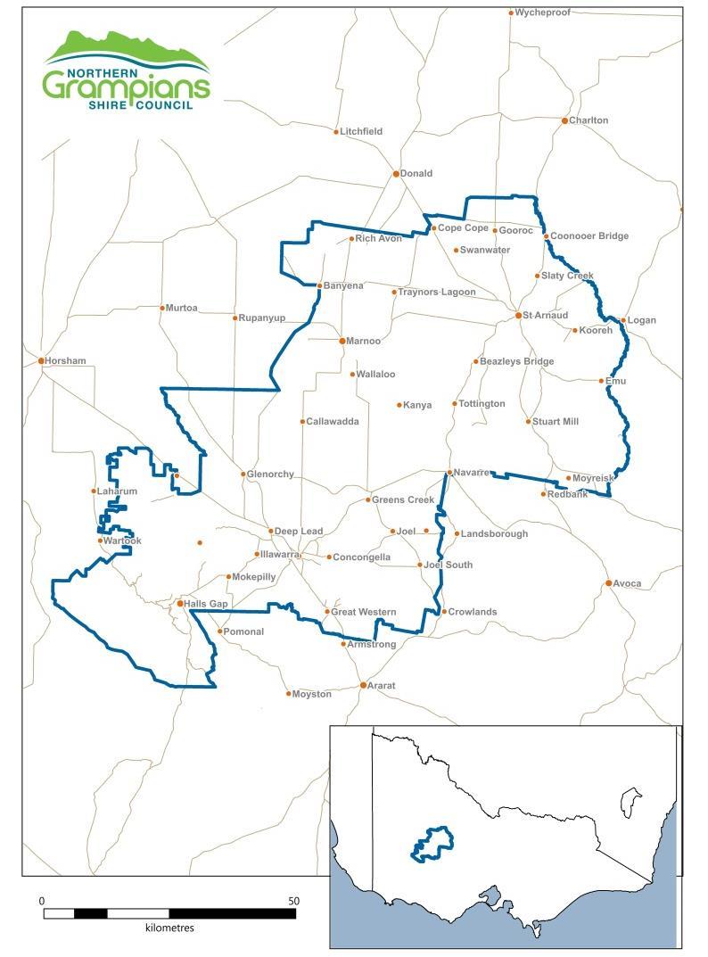
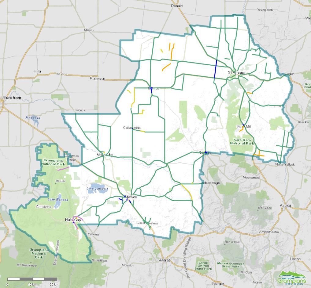
The Northern Grampians Shire lies northeast of the Grampians National Park (Gariwerd), between the cities of Ballarat, Bendigo and Horsham. The municipality covers an area of 5,918 square kilometres.
Council’s public mapping portal provides information on emergency services, bus routes, and vulnerable facilities. Council’s internal map layers can also provide locations of strategic fire breaks, hydrants, and tanks. Mapping is available through the Municipal Emergency Management Officer. The map below (Figure 3) details the municipal area.
Figure 1 The IPA2 Public Engagement Spectrum
Figure 2: NGS municipal map.
3.2 Climate and bushfire season
The climate in the Grampians region is dominated by warm dry summers and cool wet winters, with most rainfall occurring in winter and spring. The bushfire season generally runs from December to April.
Prevailing weather conditions associated with the bushfire season in the Northern Grampians Shire are warm to hot north westerly winds accompanied by high temperatures and low relative humidity followed by a cool south westerly change.
Climate change projections for the Grampians region include harsher fire weather and longer fire seasons Fire weather is a measure of fuel dryness and hot, dry, windy conditions. An increase in frequency of very high and extreme fire danger days is projected.
The impacts of climate change need to be continually monitored and the MFMP reviewed accordingly to ensure that seasonal fire risk is addressed appropriately.
3.3 History of fire and ignition causes
Historically, Northern Grampians Shire experiences a major fire once every five to ten years. This is partially due to the municipality being situated in a known lightning belt and agricultural activities including stubble burning practices. Often ignitions occur in remote and difficult to access terrain, allowing the fire to gain momentum. A complete list of major bushfires which have occurred in the last 10 years, or which have provided significant learning, can be found in the NGS MEMP
Aging buildings, buildings with shared roof space, and elderly housing stock present a higher fire risk to occupants and residents due to the nature of their construction and the materials used.
Major interstate and national transport links traverse the municipality. These have led to the ignition of fires from transport accidents and malfunctions. This characteristic also presents a major risk for hazardous material incidents.
3.4 Future fire management implications
Future vulnerabilities include increased larger landholdings managed by consortiums and serviced by contractors, leading to declining populations in broadacre cropping areas. This demographic combined with an aging population has seen previously robust rural communities relocate to more populated centres. This shift in population could potentially lead to delayed suppression activities in rural areas.
The installation of the Bulgana Green Power Hub wind farm east of Stawell presents an additional potential source of fire risk. The wind farm is also a large asset requiring protection which would impact local resources in the event of a fire.
An emerging trend in line with the green movement is the introduction of Electric Vehicles (EVs) globally. In Victoria, the Government has set a Zero Emission Vehicle target that by 2030, 50% of all new light vehicle sales will be EV’s. This could have implications in the Fire Management Sector with a dramatic increase in Lithium Ion (Li ion) battery use, charging stations in residential premises and outside commercial ventures. Li ion battery fires are an emerging risk to fire response agencies and with a main transportation highway running through the shire, it would be expected that EV fires may occur.
A further push is being made to increase the number of solar panels and Battery Energy Storage Systems (BESS) in residential properties. The bulk installation of li ion batteries to store energy presents new challenges to fire managers.
An increase in individuals purchasing land for rest and relaxation purposes has resulted in more absentee landowners, particularly in the Halls Gap area. These landowners traditionally have less knowledge of fuel and fire management requirements, little engagement with the community, and live externally to the municipality. This limits their capacity and ability to undertake regular fuel management work and participate in local community networks.
Changes in the use of controlled fire management practices on public land may lead to changes in vegetation characteristics and its dependence on fire.
Large, privately owned areas of remnant vegetation present additional fire management challenges as the owners may not have the capacity to undertake appropriate fuel management works for a variety of reasons, including access to knowledge and resources and legislative constraints.
Enforcement of compliance also presents complexities in terms of cost recovery and allocation of resources for management agencies.
4. Fire risk management strategies
4.1 Risk assessment methodologies
4.1.1 Analysis and prioritisation of municipal bushfire risk
To determine the bushfire risk within NGS, assessment was undertaken using the environments contained within the VFRR process. The VFRR application is a systematic process that identifies assets at risk from bushfire and assesses their level of risk on a consistent state-wide basis using ISO 31000:2009 Risk Management.The VFRR data provided the startingpoint to assess the effectiveness ofexistingtreatments and determine residual risk levels for the purpose of developing further mitigation treatments as required.
4.1.2 Alignment to regional objectives
The plan also references treatments for the six priority risks in relation to bushfire as determined by the Grampians Regional Strategic Fire Management Plan (RSFMP) using the VFRR risk assessment process (Table 1). These are aligned to the asset classes and subclasses contained within the VFRR tool (administered by the CFA)
Table 1 Bushfire Priority and VFRR Asset Classes and Subclasses
3. Communications
4. Water Supplies & Catchments
5. Transport
6. Natural Environment Environmental
Cultural Heritage
4.1.3 Treatment of municipal bushfire risk
• Commercial
• Infrastructure
• Tourist & recreational
• Mines
• Commercial forests
• Water catchments
• Locally Important
• Endangered
• Vulnerable
• Aboriginal Significance
• Non-Indigenous
In developing this plan, the MFMPC has considered the State strategic control priorities as the municipal fire management priorities. They are:
• Protection and preservation of life is paramount - this includes safety of emergency services personnel, and safety of community members including vulnerable community members and visitors/tourists located within the incident area.
• Issuing community information and community warnings detailing incident information that is timely, relevant, and tailored to assist community members make informed decisions about their safety.
• Protection of critical infrastructure and community assets that supports community resilience.
• Protection of residential property as a place of primary residence.
• Protection of assets supporting individual livelihoods and economic production that supports individual and community financial sustainability.
• Protection of environmental and conservation values that considers the cultural, biodiversity, and social values of the environment.
Following the State strategic control priorities, the MFMP aims to reduce the number and severity of fires within the municipality with the intent of creating a more fire resilient community.
The State strategic control priorities inform and are integrated into the primary fire risk management strategies used in this plan, which are as follows.
• Community education and engagement.
• Hazard reduction.
• Preparedness.
• Regulatory controls.
There are several state-wide and municipal treatments that have been identified for each fire risk management strategy, which can be used by agencies to reduce the risk and effects of fire on the community. The generic state-wide and municipal wide treatments include the following.
• Community education programs.
• Community education and engagement activities.
• Public awareness – multimedia communications.
• Powerline hazard tree identification, management, and reporting.
• Fire hazard inspection program and issue of notice.
• Compliance and enforcement of legislation.
• Bushfire Management Overlays.
• Building Code of Australia.
• Permits to Burn.
• Local Laws.
To effectively reduce community vulnerability to fire requires more than inter-agency effort alone. It requires the facilitation of a more self-reliant and self-aware community who have the knowledge, motivation and capacity to manage the risks to reduce the threat of fire in their own communities as an active partner with fire management agencies.
The key objectives and outcomes sought through the implementation of the primary fire risk management strategies for bushfire are outlined in Appendix G.
In addition, there are a range of site-specific plans to reduce specific risks within the municipality that are required by other legislation.
4.1.4 Analysis and prioritisation of structure fire risk
The definition of structure fire is any uncontrolled fire inside, on, under or touching a building or structure that needs to be extinguished.
This Plan recognises that there is currently no Risk Assessment Tool for structure fires. Once an appropriate Risk Assessment Tool has been developed (at state level), this will be implemented by the MFMPC to complete and incorporate a full Risk Register for structure fires in later iterations of this Plan.
Risk assessment will consider likelihood factors, such as structural fire history (number and type) across the municipality and across the relevant industry, and the consequences, or potential consequences of those occurrences (death, injury, economic and property loss statistics).
Consideration will also be given to high-risk premises and assets. Examples of high-risk premises may include (for life risk) nursing homes, aged care facilities and institutional care facilities, (and for property loss risk) commercial and industrial premises.
4.1.5 Future objectives
Priority risks for structure fires within NGS have mostly been defined. The tables below identify possible Asset Sub Classes aligned to the VFRR Asset Classes which would need to be considered in the development of future risk assessment tools for these risk environments (Tables 6 & 7).
Structural assets have not yet been assessed or prioritised. Additionally, current treatments for these structure risks are yet to be identified.
Table 2 Proposed Structure Fire Asset Sub Classes Structure Fire Grampians
1. Houses
2. Accommodation
3. Places of public gathering
4. Infirm, assisted living Human Settlement • Residential
o High density
o Urban
o Interface living
o Rural
o Short term accommodation
• Public Assembly
o Entertainment & leisure venues
o Institutions
• Healthcare
o Hospitals & medical centres
o Nursing homes
o Special care accommodation
o Day care centres
o Hostels/hospices
5. Retail
6. Commercial businesses
7. Industrial
8. Infrastructure Economic
To be defined Environmental
9. Buildings of significant heritage or cultural value Cultural Heritage
• Commercial & industrial
o Business centres
o Shopping centres
o Industrial complexes
• Agricultural & farming
• Transport
o Road
o Rail
o Marine
o Air
• Eco tourism venues
• Flora parks & reserves
• Fauna parks & reserves
• Indigenous structures
• Heritage listed structures
• Locally significant structures
4.1.6 Treatment of municipal structure fire risk
The key objectives and outcomes sought through the implementation of the primary fire risk management strategies for structure fires are outlined in Appendix H
4.2 Localised community information
Community Information Guides were developed in response to the Victorian Bushfire Royal Commission as a tool to support councils with local bushfire planning for communities at risk. With changing communities and needs the CFA has modernised this resource and the information is now available online as part of CFA Local: https://www.cfa.vic.gov.au/home/local-information
Local information includes the details of all Bushfire Places of Last Resort (BPLRs) (also known as Neighbourhood Safer Places) within the map area; any planned CFA events: the local government area; CFA Brigade; a 4-day Fire Danger Rating forecast; Total Fire Ban information; Community meetings planned; and links to additional information
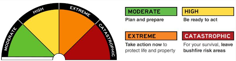
In September 2022, the new Australian Fire Danger Rating System was implemented to achieve a simplified and nationally consistent system. The new Fire Danger Ratings are shown below. The CFA website contains information regarding the new system: www.cfa.vic.gov.au
4.3 Bushfire Places of Last Resort
Bushfire Places of Last Resort (BPLRs) are council designated locations within the community that may provide some protection from a bushfire, but do not guarantee safety. BPLRs are existing locations and not purpose-built fireproof structures.
BPLRs are not designed to replace a personal bushfire survival plan. BPLRs may assist people when there is an imminent threat of bushfire and they have no plan, or their planned options are not possible.
They are not locations to relocate to when leaving early. On days when there is advice to leave early people should relocate to an appropriately distant area of lower risk as early as possible.
BPLR sites are nominated by the council and assessed annually by CFA for suitability. Northern Grampians Shire BPLRs are located at the following sites.
Figure 3 The Australian Fire Danger Rating System.
• Stawell - Cato Park, Victoria Street (opposite Haitts Lane)
• St Arnaud - Lord Nelson Park Oval, Dunstan Street (off Charlton-St Arnaud Road)
• Halls Gap - Halls Gap Picnic Reserve, Grampians Road (opposite petrol station)
These locations can be viewed on council's Community Map
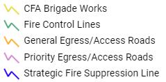
4.4 Strategic fire break definitions
4.4.1
Strategic Fire Suppression Lines
Vegetation managed from fence line to fence line where practicable. Grass will be slashed to a height of 100mm or less, and elevated fine fuels will not surpass a ‘high’ fuel hazard rating as assessed in the Victorian Government’s Overall Fuel Hazard Assessment Guide 2010
4.4.2
Fire Control Lines
Vegetation managed 3 metres behind the guideposts where practicable. Vegetation will be slashed to a height of 100mm or less.
4.4.3
Priority Egress / Access Roads (PEAR)
The primary function of PEAR will be to determine what treatments are required along the nominated road to maintain access and egress to an isolated community prior to or after a bushfire event. All priority roads in the municipality will be assessed and treated in accordance with the Victorian Government’s Road Bushfire Risk Assessment Guideline 2013
4.4.4
General Egress / Access Roads (GEAR)
These roads are deemed important for emergency vehicles and community access and egress during a fire. The treatment for a GEAR is the same as for a Fire Control Line.
4.4.5
CFA Brigade Fire Prevention Works
Brigade works may enhance Strategic Fire Suppression Lines and Fire Control Lines however, the implementation is not compulsory and will be subject to seasonal conditions and Brigade resource availability.
4.5
Community fire refuges
Community Fire Refuges are purpose-built or modified buildings that provide protection from radiant heat and embers. They are designed to be a last resort option where nearby residents or visitors can seek shelter if they are trapped by a significant fire.
There are no designated Community Fire Refuges in the Northern Grampians Shire. For information on the location of Community Fire Refuges in Victoria, go to the CFA website
4.6 Individual bushfire risk treatments
4.6.1
Vegetation management rights
In November 2011, the Victorian Government introduced permanent planning controls as part of implementing the recommendations of the Victorian Bushfire Royal Commission.
In December 2017, the Victorian Government introduced changes to the Native Vegetation controls under Clause 52.17 of the Planning Scheme.
Planning permit exemptions for ‘Fire Protection’ have been included in Victoria’s planning schemes to enable residents to manage vegetation for bushfire protection around their property.
Other exemptions to assist the landowner include the following.
● Fencing - (minimum extent necessary) for the operation or maintenance of an existing fence, or the construction of a boundary fence between properties in different ownership (with consent from the neighbouring landowner).
● Existing buildings - (minimum extent necessary) for the maintenance of a building but does NOT apply to native vegetation more than 10m from a building and does NOT apply to a property which has the Vegetation Protection Overlay control.
● Emergency works - in the case of an emergency by, or on behalf of, a public authority or municipal council to create an emergency access associated with emergency works; or where it presents an immediate risk of personal injury or damage to property. Only that part of the vegetation that presents the immediate risk may be removed, destroyed, or lopped under this exemption.
To determine if you need a planning permit for native vegetation removal, please contact the planning department. To determine if your property is within the Bushfire Management Overlay, visit https://www2.delwp.vic.gov.au/maps/maps-and-spatial-data.
4.6.2 Permits to burn under the CFA Act
During the declared Fire Danger Period, limited permits may be obtained by individuals to conduct a fuel reduction or stubble burn within the municipality. These permits are issued by the CFA (District 16) under the authority of the CFA Act 1958 These permits contain stringent conditions that must be complied with. Refer to Fire Permits | CFA (Country Fire Authority)
4.6.3 Permits to burn under council Local Laws
Under council’s General Local Law 2022, outside the declared Fire Danger Period, within a residential, commercial or industrial area a person must not, without a permit, burn in the open air any material, substance or thing in a heap that exceeds the size of 1 cubic metre. A permit is not required if the fire is being used for heating, cooking, cultural or social purposes, or if it is generated by a tool of trade while being used for the purpose for which it was designed.
4.6.4
Inspection of private properties and issue of notices
The NGSC will conduct fire hazard inspections within the municipality, concentrating on high-risk areas. Fire prevention notices will be issued on land considered to be a fire risk as soon as practicable after the declaration of the Fire Danger Period.
4.6.5
Planning permits
When applications are lodged with NGSC for permits under the Planning and Environment Act 1987 for the subdivision of land or the construction of buildings in areas of high fire risk, council may consider the following documents in determining any such application and refer the application to the relevant fire agencies for comment.
● Northern Grampians Planning Scheme - State and Local Planning Policies.
● State Govt (Planning) website - Bushfire Management Overlay.
● CFA website - Planning and Bushfire Management Overlay.
● Other documentation if required.
For further information on any of the above, please contact council’s Planning department.
4.7 Cross boundary arrangements
The NGS MFMP seeks to ensure risk environments that cross municipal and regional boundaries are treated in a seamless manner with regard to risk assessment and treatments. This is achieved through a collaborative approach and the use of consistent processes and tools.
The Northern Grampians municipal area borders Buloke, Central Goldfields, Horsham Rural City, Pyrenees, Ararat Rural City, Southern Grampians and Yarriambiack Shires. It is the shared responsibility of these MFMPCs to ensure that risks contiguous across these borders are consistently planned for
Clear links to existing organisational cross-boundary agreements and Memorandums of Understanding (MOU) between agencies dealing with preparedness, preparation, response and recovery activities and resource allocation arrangements are also vital.
Current identified cross boundary and contiguous risk from bushfire for the NGS municipal area includes:
Grampians National Park Ararat Rural City, Horsham Rural City, Southern Grampians Shire
Ensure alignment of planning and prevention activities in relation to these risks are
Ararat Rural City discussed and coordinated with relevant municipalities. Ensure that these arrangements and plans are included in relevant MFMPs.
It is also recognised that agencies and municipalities have existing planning relationships across multiple boundaries and that these planning arrangements need to be considered when developing future plans.
Ararat Regional Park (Dunneworthy Block)
Kara Kara National Park Pyrenees Shire
Appendices
Appendix A – Acronyms
ARTC Australian Rail Track Corporation
AV Ambulance Victoria
BESS Battery Energy Storage System
BPLR Bushfire Place of Last Resort
CFA Country Fire Authority
DEECA Department of Energy, Environment & Climate Action
DET Department of Education & Training
DFFH Department of Families, Fairness & Housing
DoH Department of Health
DOT Department of Transport
EPA Environment Protection Authority
ERV Emergency Recovery Victoria
EMV Emergency Management Victoria
EV Electric Vehicle
FFMV Forest Fire Management Victoria
GEAR General Access / Egress Road
GWMWater Grampians Wimmera Mallee Water
IAP2 International Association for Public Participation
MEMP Municipal Emergency Management Plan
MEMPC Municipal Emergency Management Planning Committee
MFMP Municipal Fire Management Plan
MFMPC Municipal Fire Management Planning Committee
Shire Boundary, 500m S of Railway Overpass , Armstrong RRV Slash, 3m cut behind guide posts*
Western Hwy (A8), Great Western Mailes Rd, Great Western NGSC Slash, 3m cut behind guide posts*
Great Western Sandy Creek Rd St Peters Rd, Great Western Mailes Rd, Great Western NGSC Slash, 3m cut behind guide posts*
Great Western St Ethels Rd, Great Western Garden Gully Rd, Great Western Western Hwy (A8) NGSC Slash, 3m cut behind guide posts*
Great Western Melbourne-Adelaide Railway Line St Georges Rd, Great Western St Ethels Rd, Great Western ARTC Spray first, slash if needed (3m cut behind guide posts*)
Greens Creek Wimmera Downs Rd Stawell-Avoca Rd (C221), Greens Creek Landsborough Rd, Joel Joel NGSC Slash, 3m cut behind guide posts*
Wallaloo East Wallaloo East Rd
Stawell-Avoca Rd (C221), Greens Creek
Kabinga Rd, Wallaloo East
NGSC Slash, 3m cut behind guide posts*
Gre Gre Carrols Bridge Rd
Halls Gap Grampians Rd (C216)
Halls Gap Grampians Road
Joel South Joel South Rd
Joel Joel Joel Joel Rd
Kooreh Wedderburn Rd
Kooreh Stockham Bridge Rd
Kooreh Gowar East Rd
Kooreh Proctor Road
Baldwin Plains Rd, Gre Gre South
Ararat-Halls Gap Rd (C222), Halls Gap
Fyans Creek Rd
Wimmera Hwy (B240), Gre Gre North NGSC Slash, 3m cut behind guide posts*
Halls Gap Lakeside Caravan Park NGSC Slash, 3m cut behind guide posts*
Sunraysia Hwy (B220) Smith Rd NGSC Spray first, possible slash if needed
Grants Rd
St ArnaudMaryborough Rd NGSC Spray first, possible slash if needed
Sunraysia Hwy (B220) 3km south along Teddington Rd NGSC Spray first, possible slash if needed (both sides)
Wells Rd
Wells Rd
Wrights Rd
Banyena Rd NGSC Slash, 3m cut behind guide posts*
Volcano Rd NGSC Slash, 3m cut behind guide posts*
Bryce Rd NGSC Slash, 3m cut behind guide posts*
Carapooee Harman Rd Dunolly Rd
CFA Brigade Works
Kooreh Rd NGSC Spray first, possible slash if needed
Locality Road Name From To CFA Brigade Treatment
Avon Plains Donald-Avon Plains Rd Harvey Rd
Callawadda Willaring Rd
Glenorchy Glenorchy Oval
Avon Plains Rd Avon Plains Burn (Walkers Lake)
Between Aitken Rd and Walter Rd Walter Rd
Callawadda Burn (north side)
Clarke St Glenorchy As mapped Glenorchy & Riachella Burn
Joel Joel Wimmera Downs Rd Greens Creek
Joel Joel Joel Joel Rd
Landsborough Rd Joel Joel Burn
Landsborough Rd Joel South Rd Joel Joel Burn
Joel Joel Joel Joel Public Hall Joel Joel Road Joel Joel Road Joel Joel Burn
Landsborough West Tulkara Railway Rd
Landsborough Rd
Landsborough West tennis courts Joel Joel Burn
Marnoo Frying Pan Rd Richardsons River Frews Loop Rd Marnoo Burn
Marnoo Soldiers Rd
Navarre Disused Tulkara Rail Yard, Nobbys Lane - Private Rd / Nobbys Lane
Raluana Rd
Bains Road
Navarre Navarre Sports Association Reserve Ararat - St Arnaud Rd
Wallaloo East Major Track & Hazeldene Rds
Hazeldene Rd
Carrs Plain Rd Marnoo Burn
Rickards Rd - west side Navarre Burn
Disused Road - west end of reserve Navarre Burn
Bolangum Silo Rd Wallaloo East Burn
Northern Grampians Shire
Municipal Fire Management Planning Committee (MFMPC)
Terms of Reference
June 2023
1. CONTEXT
The Northern Grampians Shire (NGS) Municipal Fire Management Planning Committee (MFMPC) is established and undertakes planning as a subcommittee of the Municipal Emergency Management Planning Committee (MEMPC) formed under the Emergency Management Act 2013
• The MFMPC will be chaired from within its membership.
• The MFMPC will receive support and guidance from the Regional Emergency Management Planning Committee (REMPC) (via the MEMPC).
• Composition will be determined by the MEMPC.
2. SCOPE
The Committee’s scope, of which the development of a Municipal Fire Management Plan (MFMP) is part, is to provide a local level forum to build and sustain organisational partnerships, generate a common understanding and shared purpose regarding fire management, ensure that the plans of individual agencies are linked and complement each other, and to collectively achieve a reduction in fire risk to the municipal community.
3. FUNCTIONS
The Northern Grampians Shire MFMPC functions as a subcommittee of the MEMPC to:
• Plan the burning or clearing of firebreaks.
• Advise the appropriate authorities as to the existence of and steps to be taken for the removal of fire hazards within the area.
• Advise and make recommendations to the MEMPC in the preparation of its MFMP.
• Recommend to CFA or to the appropriate authorities (as the case may require) any action which the committee deems necessary or expedient to be taken for reducing the risk of an outbreak of fire or for suppressing any fire which may occur within the area.
• Advise the Municipal Fire Prevention Officer (MFPO) concerning the removal of fire hazards under S41 of the CFA Act 1958
• Refer to the REMPC (via the MEMPC) for consideration all matters which in the opinion of the MFMPC should be so referred.
• Carry out such other functions as are conferred or imposed upon the MFMPC by the MEMPC.
4. MEMBERSHIP
4.1 Core membership
The MFMPC, appointed by the MEMPC, has core representation from the following organisations:
• Northern Grampians Shire Council (NGSC)
• Country Fire Authority (CFA)
• Forest Fire Management Victoria (FFMV)
• Victoria Police
• Department of Transport (DOT)
• Grampians Wimmera Mallee Water (GWMWater)
4.2
Chairperson
The CFA District 16 Commander is the nominated Chairperson for the NGS MFMPC. If the Chairperson is unable to attend a meeting, they will nominate a proxy from within their agency who will act as Chairperson for that meeting.
4.3 Proxies
Representatives of core member agencies / organisations who are unable to be present at MFMPC meetings must nominate a suitably skilled and authorised representative from their agency / organisation a minimum of 24 hours to the MFMPC Chairperson, in writing, before the meeting is scheduled to occur. This proxy is considered to have the same voting rights as the substantive MFMPC member, unless the MFMPC Chairperson is advised otherwise.
4.4 Additional representation
The core MFMPC may invite additional representation from other agencies or organisations with key skills and knowledge to join the MFMPC as necessary. These members will not have right to propose or vote on motions requiring a decision by the MFMPC, but are welcome to contribute knowledge, information, and insight on behalf of their organisation to the MFMPC. The following agencies and organisations may be invited to meetings when required.
• Ambulance Victoria
• AusNet Services
• Department of Families, Fairness & Housing
• Powercor
• Others as required.
5. MEETING FREQUENCY
The MFMPC will meet at least two times per year (pre and post fire season) unless otherwise required.
6. MEETING VENUE
NGS MFMPC meetings will be held in the Stawell Council Chambers unless determined otherwise by the committee. Online meeting options will be enabled to support remote access as needed.
7. QUORUM
A quorum is greater than 50% (50% + 1) attendance of the current voting members and includes the MFMPC Chairperson or Deputy Chairperson. The MFMPC may meet in the absence of a quorum being
present, however no decision-making processes, such as motions, may be actioned until a quorum is present.
8. VOTING RIGHTS
The core member agencies and organisations are allocated 1 vote per agency / organisation for the purposes of decision making within the MFMPC. The Chairperson has a casting vote if votes on a matter are equal. Additional representatives do not have voting rights for the purposes of decision making within the MFMPC.
9. ADMINISTRATIVE AND REPORTING REQUIREMENTS
The MFMPC will report two times per year to the MEMPC.
Administrative support requirements will be determined by the committee and resourced through committee members where possible. Planning processes will be managed and supported with technical expertise by relevant fire services.
The administration of the MFMPC includes maintaining the committee contact list, scheduling meetings, providing committee members with the meeting agenda, and documenting and distributing minutes and other relevant correspondence. This role is performed by council’s MFPO
The proceedings, information, and documentation of the MFMPC is considered confidential unless determined by the MFMPC, however these records remain discoverable under the Freedom of Information Act 1982.
Any member can submit items to be included on the agenda. The agenda will be confirmed prior to each meeting. Minutes of MFMPC meetings will be forwarded to all representative members of the MFMPC (including additional members, excluding observers).
Core member organisations / agencies of the MFMPC are asked to submit a written report a minimum of 7 days prior to the scheduled MFMPC meeting. Written reports are to be also presented verbally to the MFMPC during the scheduled meetings and will be recorded within the minutes of the meeting.
Representatives of additional member agencies / organisations may submit a written report to the MFMPC Chairperson if the issue / topic is considered of importance to the MFMPC, otherwise a verbal report may be submitted at the MFMPC and will be recorded in the minutes of the meeting.
Any issues that require escalation will be conveyed by the MFMPC Chairperson to the NGS MEMPC.
Appendix F – Stakeholder Analysis & Communications & Engagement Plan
Stakeholder type and engagement level
Stakeholder type Description
Internal Formal responsibilities for MFMP process and outcomes.
Primary MFMPC membership, responsibility for the development of the plan, communication, and engagement across and within organisations
Secondary REMPC membership or fire management role within municipality, may be requested to provide specific inputs, dependent upon outputs, or requested to be involved in specific tasks.
IAP2 participation level
Collaborate & empower
Collaborate & empower
Consult & involve
Tertiary Strong interest in outcomes and may have valuable information / viewpoints to share. Inform & consult
Fire management role definitions
Role Definition
Coordination Coordination of emergency fire incidents.
Control Agency Control of fire incidents.
Land manager Manages land within Northern Grampians Shire.
Response Has a role in responding to a fire incident.
Relief / Recovery Has a role in relief / recovery phases of a fire incident.
Community Info Provides information to the community in relation to a fire incident.
Community Care Provides community care and support during and after a fire incident.
Asset protection Responsible for protection of identified (private or public) assets within Northern Grampians Shire (for mitigation purposes not during Response).
Regulate Responsible for regulation related to fire management (i.e., legislation, guidelines, local laws, planning regulations).
Regional Development
Telstra
Department of Education & Training (DET)
Wimmera Catchment
Management Authority (WCMA)
Tertiary
Australian
Uniting Wimmera
NGS MFMP Communication and Engagement Plan
Appendix G – Bushfire risk treatments
Community Education and Engagement
Objectives
1. To build capacity and knowledge, resilience and understanding of the dangers of bushfire.
2. To provide the tools and education opportunities for community and individuals to better prepare and understand the risks of bushfire.
3. To build awareness and understanding of the role of fire in the environment.
For the Plan duration.
• Community education programs
• Agency Integrated Community engagement activities
• Bushfire awareness training
• Multimedia communications
• Victorian Bushfire Information Line
• Tourism fire safety campaigns
• Increase legislative and regulatory awareness
• Increased awareness of planning controls
• Targeted education campaign regarding the use and role of fire in the environment
• To be proactive and seek information
• To be involved in community education and engagement programs
All agencies will review and evaluate programs and participation of community as part of the review process of the MFMP.
Hazard Reduction
1. To strategically reduce fuel to minimise impact, intensity and spread of bushfire.
2. To plan and establish strategic points to effectively combat and manage bushfire activity.
For the Plan duration.
• Slashing program
• Burn program
• Spraying program
• Pruning program
• Use appropriate incident modelling tools to identify potential impacts to communities, such as the phoenix modelling tool
Preparedness
1. To understand appropriate actions to reduce the risk and impact of bushfire, initiatives include: Ignition prevention Risk identification and treatment Resource preparation Response planning Operational restrictions
For the Plan duration.
• VFRR process
• Establishment of Incident Control Centres
• Catastrophic days
• Powerline inspections
• Township Protection Plans
• Neighbourhood Safer Places –Places of Last Resort
• Fire breaks
• Private property hazard reduction:
o Cleaning gutters
o Slashing
o Mowing
o Ploughing
o Grazing
o Fuel reduction burns
Shared responsibility between agencies and individuals to minimise fire hazards.
• Personal bushfire preparedn ess plans
• Daily readiness
• Practice / rehearse plans
• All agencies regularly evaluate preparation and readiness to respond to fire.
• Strengthened capacity for agencies to provide an integrated response.
• Measurable reduction of the impact of bushfire.
System testing Security of water supply
• Emergency Management Plan
• Evacuation Plans
• Brigade Pre Plans
Regulatory Controls Objectives
1. To implement regulation aimed at reducing the risk and impact of bushfire.
2. To create and maintain effective linkages between planning functions to better inform proposed residential developments.
For the Plan duration.
• Fire hazard inspections
• Total fire bans
• Planning schemes
• Fire danger period
• Building codes
• Enforcement of fire hazard notices
• Response to planning applications
Comply with regulations
• Compliance with regulatory controls.
• Appropriate residential development.
Appendix H – Structure fire risk treatments
Community Education and Engagement
1. To build capacity and knowledge, resilience and understanding of the dangers of structure fire.
2. To provide the tools and education opportunities for community and individuals to better prepare and understand the risks of structure fire.
Hazard Reduction
For the Plan duration.
• Community education programs
• Community engagement activities
• Multimedia communications
• Increase legislative and regulatory awareness
• Increased awareness of planning controls
• To be proactive and seek information
• To be involved in community education and engagement programs
• All agencies will review and evaluate programs and participation of community as part of the review process of the MFMP.
1. To strategically reduce fuel to minimise impact, intensity and spread of structure fire.
2. To plan and establish strategic points to effectively combat and manage structure fire activity.
For the Plan duration.
• Conduct fire safety inspections
• Buildings constructed according to the National Construction Code
• Use appropriate incident modelling tools to identify potential impacts to communities, such as the plume modelling tool
• Installation of sprinklers, smoke detectors, fire blankets, and extinguishers
• Comply with regulations Agencies and individuals working towards minimising the loss and damage caused by structural fires in the community
Preparedness
1. To understand appropriate actions to reduce the risk and impact of structure fire, initiatives include:
Ignition prevention Risk identification and treatment
Resource preparation Response planning
Operational restrictions System testing
Security of water supply
Regulatory Controls
For the Plan duration.
• Emergency Management Plan
• Evacuation Plans
• Brigade Pre Plans
• Daily readiness
• Maintenance of sprinklers, smoke detectors and fire extinguishers
• Building/staff fire drills
• All agencies regularly evaluate preparation and readiness to respond to fire.
• Measurable reduction of the impact of structure fire.
1. To implement regulation aimed to reducing risk and impact of Structure fire.
2. To create and maintain effective linkages between planning functions to better inform proposed residential developments.