
The Asset Plan helps council effectively maintain the assets we already have and ensures we allocate capital spend wisely delivering a suite of reliable services as a result.
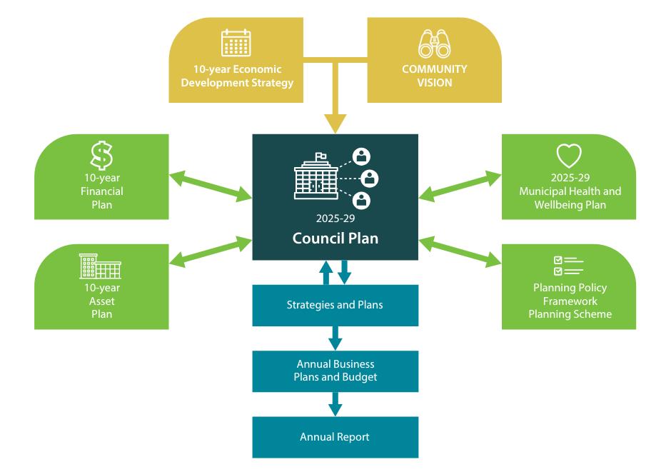
The Asset Plan is part of a suite of strategic documents required under the Local Government Act 2020. It is guided by the four-year Council Plan and 20-year Community Vision and aligns with other key plans such as the 10-year Financial Plan. These plans outline the financial and non-financial resources, along with the technical elements required for managing assets to achieve the objectives set out in the Council Plan. You can view how they interconnect in the figure below.
As these plans are developed together, council carries out a deliberative community engagement process to collectively inform them all. The outcomes of that engagement have directly shaped the priorities set out in this plan. You can review the outcomes of the community engagement process on our website here https://www.ngshire.vic.gov.au/Council/Vision-and-Goals/2025-2029-Community-Engagement/Review-theCommunity-Engagement-Report
How assets support our community Council assets such as roads, buildings, and parks, support daily life, deliver vital community services, and enhance community wellbeing.
Our assets follow a familiar lifecycle no matter what they are, be that a road or a building. As you read through this plan you will notice that budgets are allocated into similar parts of the following lifecycle.
We manage them through a clear and strategic lifecycle that involves thorough planning and design, assessment as to whether we need to build something new or upgrade an existing resource, investment in the renewal and maintenance of our resources over a period, and eventually either disposing of them or retiring them depending on their longevity. This ensures council infrastructure stays safe, functional, and cost-effective with supporting today’s needs while also planning for future generations across our shire.
Council is now required by law to create a new 10-year Asset Plan and a 10-year Financial Plan with each four-year Council Plan cycle. This ensures council resources are adequately aligned to deliver the priorities councillors have determined for their council term.
However back in 2022, council conducted community engagement to inform the 2022-32 Asset Plan as a separate exercise. This engagement shaped council’s long-term asset planning approach which underpinned the previous plan and continues to influence the direction set in our 2025-35 Asset Plan.
Through engagement activities such as community surveys, in-person talking posts and stakeholder meetings, we gathered community insights on areas such as asset values, priorities, and funding alternatives
It is worth noting that while the Asset Plan and the Financial Plan are collated as 10-year plans, both are now updated every four-years to coincide with the Council Plan cycle, as mentioned above, under council’s integrated planning framework. The 2025-29 Council Plan cycle marks the first time this strategic approach has been delivered
Roads were essential
Roads were considered vital to daily life and the local economy. The community expressed strong concern about deterioration and called for increased renewal investment.
Support for rural transport
Fairness between rural and urban
Prioritising renewals over new assets
Focus on access and safety
Some willingness to contribute more
87% of participants supported heavy vehicle access, reinforcing the need for infrastructure that supported freight, farming, and the practical needs of rural areas.
The community emphasised fairness in how council invested, calling for more balanced service delivery between rural communities and urban centres.
There was a clear preference to maintain and renew existing infrastructure - particularly roads and buildings - rather than fund new developments.
Participants frequently raised concerns about safe, reliable accessespecially on gravel roads for reaching homes, farms and essential services.
While trade-offs were challenging, some community members indicated they were open to higher rates or reprioritising budgets for better long-term outcomes
We used this collective feedback to shape our priorities and guide investment decisions across our local infrastructure over the past four years as part of our 2022-32 Asset Plan approach. As a result, we delivered tangible improvements to our shire including:
Investing in growth: We installed critical infrastructure in the Stawell growth corridor to enable future housing and private investment
Focusing on renewals and strategic upgrades: We prioritised renewing ageing facilities and upgrading key local roads and bridges to improve access and meet our diverse community needs.
Extending the life of assets: We improved areas such as road grading, tree trimming, and drainage to help extend asset life. Staff training, best practices, and fast flood response also boosted resilience
Better data, better decisions: We use asset data and modelling to make more confident, evidence-based decisions on lifecycles and asset value.
Smarter planning and more advocacy: Smarter planning and stronger advocacy guided infrastructure investments. Community feedback shaped priorities, while post-COVID funding enabled the delivery of key projects and eased long-term budget pressures. We actively pursued, and secured, more grants to support capital works.
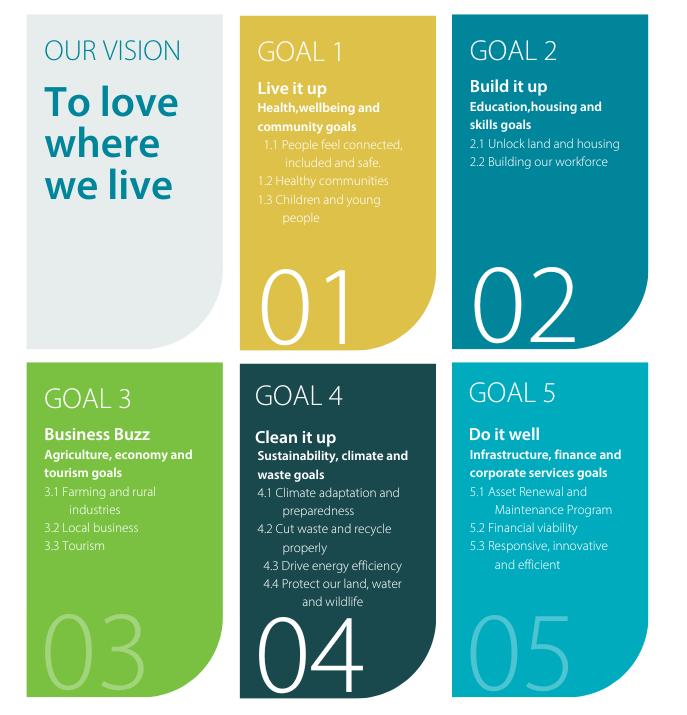
Guiding council’s next 10-year Asset Plan is a clear vision supported by five strategic goals which are underpinned by 15 strategies, 40 actions and hundreds of tasks. These are all outlined in council’s 2025-29 Council Plan and set the overarching direction for all council services and operational requirements.
The Community Vision was created by the community as part of the development of the 2021-2025 Council Plan. Community engagement undertaken to inform the development of the 2025-2029 Council Plan reconfirmed this is as the Community Vision. The Community Vision is a shared hope of how our community sees life here in the next 15 years. It is all about what the community wants and hopes for people living in the Northern Grampians. It serves as a guide for collective action and decision-making to make that vision a reality.
This vision is at the forefront of the 2025-29 Council Plan, informing the development of the goals, strategies, initiatives and actions we have determined as the priorities for the next four years which are outlined in the figure below.
This Asset Plan must support delivering the priorities outlined in the 2025-29 Council Plan. As such, our Infrastructure and Amenity team must also balance the same challenges and opportunities presented in the Council Plan, including funding limitations and various industry, economic and community pressures.
To support the achievement of these goals, our team has identified the following way-of-working priorities that will underpin our asset management approach.
We will make infrastructure actions across asset classes.
• Include street trees in standard asset inventories and renewal programs.
• Emphasise modular and flexible design to maximise asset utilisation.
• Maintain strong standards of hygiene and cleanliness, especially in central business locations.
• Prioritise fit-for-purpose solutions across all new and upgraded assets.
We will adopt a strategic lens for asset planning.
• Multi-use and modular configuration of buildings and facilities.
• High utilisation rates through flexible planning.
• Strong focus on fit-for-purpose standards.
• Managing community expectations post-COVID peak funding period.
• Delivering clear value through asset lifecycle planning.
We will monitor industry and external influences.
Industry drivers such as:
• Safe System principles
• Department of Transport Road Safety Strategy
• Circular economy transition
External pressures such as:
• Renewable energy project impacts
• Mining activities and land use
• Environmental resilience and climate adaptation
• Freight efficiency and mode shifts (i.e. PBS, rail freight)
We will close the loop with Asset Plan reporting.
We will ensure annual reporting aligns our Asset Plan outcomes with our Council Plan goals through a performance framework based on:
• Asset condition
• Service levels
• Lifecycle investment
• Strategic action
Community engagement ensures council-managed assets and services reflect the values, needs and priorities of the people who use them.
To shape the 2025–2029 Council Plan, council connected with the community through an inclusive but structured process for community input and reflection. This approach is known as a deliberative engagement approach, required by the Local Government Act 2020. That means we did not just ask for opinions, we sought to create space for real conversations, shared learning and respectful discussion of different perspectives. As part of this engagement, we also gathered input to help shape the shire's Asset Plan and Financial Plan, ensuring alignment across all key strategic documents.
These efforts helped surface what is most important to people in the Northern Grampians and provided a strong foundation for building plans that reflect the community’s collective voice. For further information on the engagement process, how council promoted the engagement, and engagement statistics, please refer to the 2025-2029 Community Engagement Report available on our website via https://www.ngshire.vic.gov.au/Council/Vision-and-Goals/2025-2029-Community-Engagement/Review-theCommunity-Engagement-Report.
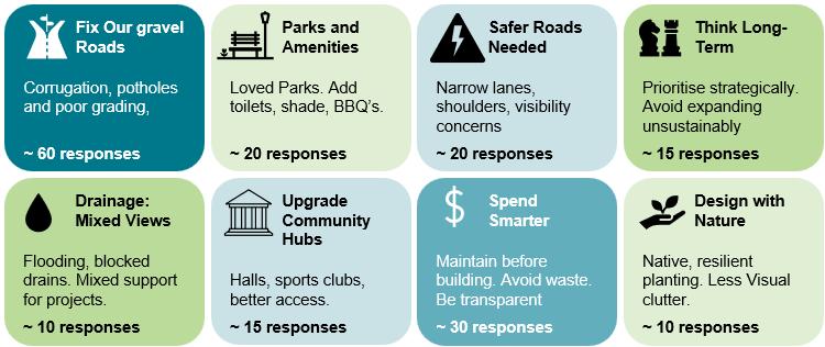
The following insights are based on the responses we received via the survey specifically about council’s asset management approach, including 188 free text responses.
Road type preferences
All-weather sealed access to homes is the clear priority. Low-use and remote roads receive the lowest support.
Top priorities
• 56% of people ranked sealed roads to every home in town as their first priority.
• 36% of people placed sealed roads with regular truck use in second priority
Low priorities
• 53% of people placed gravel roads to rural homes as a low priority.
• 34% of people ranked dirt tracks used less than once per day a low priority.
roads and road compromises
Residents who completed the survey favoured strategic compromises when they led to greater community outcomes, especially when reviewing opportunities in the absence of rate increases.
Most supported outcome
Residents accept having some local roads remain unsealed to reduce ongoing management costs allowing council to redirect funds into sealing higher-priority gravel roads.
Least supported outcome
Increasing annual rates so council has greater financial capacity to increase the number of sealed roads, thus reducing the number of gravel roads across the shire.
Funding reallocation preferences
Residents favour strategic compromises when they lead to greater outcomes especially without rate increases.
Most supported
• Expecting all roads to be sealed, regardless of cost or usage.
• Paying higher rates specifically to reduce the number of unsealed roads.
Least supported
• Raising rates
• Doing nothing/rejecting acceleration
Sealing roads with truck use
Sealing roads based on minimal truck traffic is not supported residents want better justification and datadriven decisions.
Preference
• 22% support sealing roads used by one truck per day
• 42% oppose the idea
• 36% are unsure
Strategic use of dirt roads to enable reinvestment
Strong preference for a function-based, risk-aligned road network with minimum viable standards rather than blanket upgrades.
Most supported
• Strategic tolerance for lower service levels on low-use roads.
• Reinvest savings into higher-priority upgrades.
Least supported
• Paying more for universal upgrades.
• Sealing roads based on minimal use without rationale.
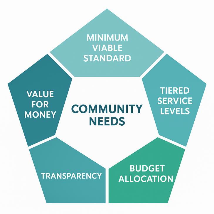
It is evident that the community continues to prioritise practical, reliable infrastructure, especially when it comes to managing our extensive road network. However, what has notably shifted since our 2022 engagement is how the community would like council to deliver those outcomes. There is a stronger demand for strategic clarity, fairness, and transparency when it comes to the prioritisation of council’s limited resources.
Community expectations in 2025 have matured in the following ways:
Support for tiered service levels
Residents are increasingly open to roads being serviced based on their function and usage. Roads with low traffic volumes or that only serve on-farm infrastructure for example, do not need to receive the same level of maintenance as major routes or high-traffic connections.
Value for money and measurable outcomes
There is a clear shift toward prioritising functionality and access over aesthetics. Investment in road grading and sealing is seen as more urgent than beautification or decorative upgrades.
Transparency and strategic decision-making
The community expects council to clearly outline why certain projects are prioritised over others, what outcomes are expected for the community, and how these decisions relate to broader strategic goals.
You didn’t want to pay more
Residents want to see existing budgets reallocated more effectively before being asked to contribute more. There is little support for sealing roads simply because one truck uses them daily.
Endorsement of Minimum Viable Standards
Both internal modelling and community sentiment support establishing clear service levels for assets based on their use, risk, and benefit. This helps ensure fairness, sustainability, and maximum public value.
We operate in an environment significantly influenced by external challenges, such as State Government funding decisions, which council has no control over. These have the potential to substantially impact our ability to provide an appropriate asset management approach.
Council manages one of the most expensive infrastructure networks per capita in our region due to operating across a large footprint with a relatively small population.
Council held more than $44,000 worth of assets per resident in 2021. Among the eight councils in our region, we have the second highest asset value per capita behind Loddon Shire Council. This figure is more than three times that of Yarriambiack Shire Council which has the lowest asset-to-population ratio.
Please note, the above is based on 2021 Asset Plan insights. The 2025 asset per capita is $53,059 based on approximately $634million of assets and 11,950 people obtained from 2021 census population data.
More assets, fewer people and limited funds.
Maintaining this extensive network with limited financial resources presents an ongoing operational challenge. While community expectations for service and infrastructure remain high, our capacity to meet these needs is increasingly constrained by factors beyond our control.
For example, under Victorian Government legislation the allowable increase in rate revenue per year is specified by the State Government’s “rate cap”. This cap limits the total amount council can raise from general rates each year regardless of increases in property values. Between 2016 and 2024, the rate cap rose by just over 20% while the cost of delivering and maintaining road infrastructure increased by almost 40%. This widening gap is placing greater strain on our ability to renew assets and meet service expectations.
In addition, user fees and charges that council generates through rates do not cover the full cost of replacing the assets that provide the community service. This shortfall is funded through general rates placing further pressure on an already limited budget. In short, our income is not keeping pace with the cost of maintaining our ageing infrastructure.
The renewal gap, which is currently almost $40 million and growing, represents the estimated cost to bring ageing assets back to an acceptable condition standard Without changes to the way we manage our assets, this gap could grow to more than $120 million over the life of this 10-year Asset Plan.
The renewal gap ratio measures the cost to fix poor-condition assets compared with the total value of all council assets. In 2021, this ratio was 4.3%. In 2025, it is sitting at 6.2%.
For these reasons, council must take a more strategic and financially sustainable approach to asset management.
One key change we are adopting is the active management of our gravel road network. In lower-use areas, such as where roads serve paddocks, some roads will naturally revert to formed-only condition which is suitable for agricultural vehicles such as tractors, trucks and four-wheel drives.
In contrast, roads with higher traffic volumes will be prioritised for sealing to modern standards that are wider, safer and longer lasting. We will also recalibrate our maintenance efforts to ensure gravel roads serving homes and rural industries are maintained to a standard the community expects.
The above approach aligns with our commitment to:
• Deliver targeted infrastructure renewals and/or upgrades across all asset categories, ensuring sustainable service levels and optimised long-term outcomes;
• Improve infrastructure outcomes through evidence-based planning;
• Deliver capital works programs that prioritise sustainability and long-term value; and
• Support liveable, inclusive communities by investing where the benefits are greatest.
We will also defer projects that cannot be delivered to a standard that meets community expectations. This ensures public funds are directed towards infrastructure that provides long-term benefits rather than shortterm results By focusing on what is essential, viable, and valued, we can build a sustainable and resilient infrastructure network that supports the future of Northern Grampians.
Council has about $634 million in assets under our operational care with more than half a billion dollarsworth of transport assets to maintain.
Everything from roads and footpaths, to libraries, sporting venues and community hubs, these assets are the foundation of the services that shape our daily life.
Despite strong advocacy in recent years, external funding for capital works remains inadequate for our shire’s needs. Since the 2015/16 financial year, council has consistently secured more grant funding per capita than many similar sized councils in the region, on some occasions exceeding others by more than 200%. However, even with this success, one fact remains
We cannot sustainably maintain all our current assets with existing funding levels.
Modelling shows that, under current financial settings, our gravel road network is projected to shrink by about 44%, decreasing from 2,070 kilometres to approximately 1,150 kilometres over time. Advocacy alone will not bridge this gap. A fundamental shift in how we manage our assets is required. This is not a decision we take lightly but is a practical response to the financial challenges our shire faces.
Please note, the above population insights were obtained from census data and grants obtained from annual reports via other councils.
To better serve our community, we will prioritise gravel roads essential for rural residents and local industries. Over the next four years, we will shift our resheeting program away from low-use roads primarily serving farm paddocks. These roads will still be adequately maintained but not prioritised for resurfacing.
By reclassifying roads mainly used by trucks, tractors and four-wheel drives for paddock access, we can redirect resources to roads that support regular travel, community connection, and economic activity. This approach will help us preserve about 84% of gravel roads that provide two-wheel-drive access to homes and businesses.
Our strategy focuses on delivering the best value from limited funding by investing in roads that matter most, sustaining access, supporting local industry and strengthening community wellbeing.
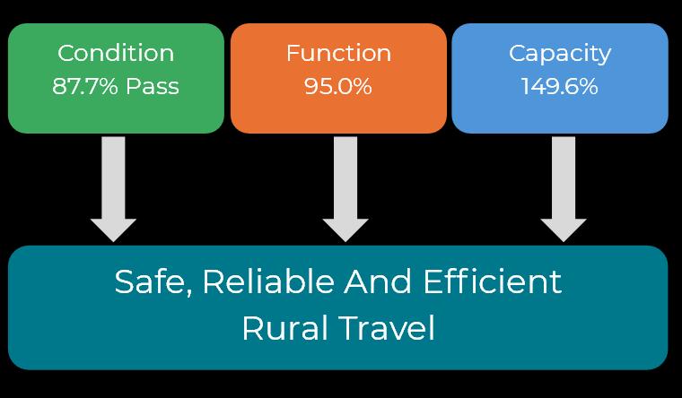
Council manages 2,070 kilometres of gravel roads as lower-cost alternatives to sealed roads, providing safe and efficient access to rural homes and industries.
This tiered network supports freight movement and guides sustainable, cost-effective infrastructure investment based on community needs.
Condition report
This pass/fail metric assesses whether gravel roads meet a minimum standard for safe and reliable use based on surface condition and gravel depth. Roads that pass are considered suitable for passenger vehicles. In 2025, 87.7% of gravel roads in our municipality meet this standard.
Please note, the above report is based on 255.7 kms of gravel roads with condition state 4, 5 or 6 per the 2021 Condition Assessment.
Capacity report
This describes whether the extent of the gravel road network is sufficient to meet community needs and operational demands. This is measured by:
• The number of roads graded more than once per year, indicating they may be better suited to sealing. On average, between 2021 and 2025, 170 km of gravel roads were graded at least twice per year
• The number of roads that serve homes that still require gravelling. There are approximately 76.5 kms of Rural Access Residential (roads classified as serving homes) that are not gravelled
• The proportion of roads that have gravel but only serve paddocks and may be more suitable as formedonly roads. There are 1058 kms of Rural Access Property that could potentially be allowed to naturally degrade to formed-only roads as they only serve paddocks. This will be subject to careful review before any changes are made.
An oversupply currently exists with some roads requiring frequent maintenance. Targeted sealing works will reduce maintenance costs and allow some roads to naturally degrade back to formed-only roads. This will improve council’s asset management efficiency and reduce ongoing maintenance costs
Function report
This describes the useability of gravel roads to ensure reliable access to rural homes and industry. This is measured by:
• The proportion of roads graded multiple times annually, typically in response to community requests.
• The number of roads that serve homes but still require graveling to provide dependable access.
Enhancing gravel road availability ensures reliable access to homes and supports the movement of freight and rural industry. Targeted upgrades based on community needs help improve connectivity, extend the life of road assets and ensure investment delivers long-term value
Operational challenges for gravel roads
Challenge Details
Unsustainable costs and a shrinking network
Expensive maintenance
Low reliability
A changing climate
There is more than $8 million in overdue resheeting. Based on our Predictor modelling, about $2.6 million per year is needed to resheet the network, yet the average yearly budget is only $1.12 million per year over the next decade. Road condition has been declining since 2016 and is on track to fall below national benchmarks. In 2025, council is only replacing 43% of what’s needed, meaning the network will naturally shrink over time.
Grading roads is far cheaper in winter periods when most roads are moist. In summer, it becomes 8 to 10 times more expensive due to needing water carts.
The current grading program falls short by about 30%. The grading budget would need to increase from $857,100 to $1.11 million to maintain gravel roads at a basic standard.
Drier weather decreases the grading season which leads to either higher costs or less frequent grading. This reduces reliability and increases wear on roads.
Other challenges for our gravel road network include:
1 Road hierarchy
The road register specifies road hierarchies which may not align with the function specified in the Road Management Plan.
2 Missing traffic count data
There are 727 km of Rural Access Property roads with unknown traffic volumes. This information will be necessary to complete task 1, the road register review.
Programming of road grading relies on subjective, manual assessment. The four-yearly condition assessments are too infrequent to be useful for planning purposes. Council obtains the services of an external provider to report on the condition of the network every four years.
4 Maintenance demand
Other maintenance demands are not well understood, as they are not included in the four-yearly condition assessments. For example, these assessments do not capture whether roadside trees need to be limbed to accommodate agricultural equipment or if verges require slashing. Identifying these needs currently relies on labour-intensive, manual inspections.
5 Backlog impact and potential loss of all-weather access for rural homes
Asset modelling shows that, even if resheeting prioritises current home access, up to 27.5% (229 km) of rural residential access roads may temporarily revert to formed-only roads over the next 10 to 15 years. This could leave many rural homes without reliable all-weather access.
Roads Condition NGSC All other Councils
Please note, all other councils’ data referenced in the above table has been obtained from the National State of the Assets publication by the Australian Local Government Association
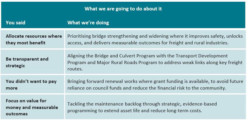
What we are going to do about it
You said What we’re doing
Allocate resources where they most benefit
Be transparent and strategic
You didn’t want to pay more
Council will stop resheeting low-use gravel roads that do not serve homes. Instead, we will redirect these funds to expand our grading program so roads that matter most to the community will remain usable and safe. This will ensure we focus on roads that people frequently use.
We are investing in technology to measure road roughness helping council make smarter, data-driven decisions. This removes guesswork and ensures roads are graded at the right time and under the right conditions.
With rates capped and limited funding available, council cannot afford to maintain everything we need to operationally prioritise Council will focus its budget on the most important roads meaning some low-use gravel roads may naturally return to formed-only roads. We will ensure they are graded enough to remain usable by four-wheel drives and agricultural equipment, even if not allyear round.
Focus on value for money and measurable outcomes
Grading is far cheaper than resheeting. By shifting more funds to grading council will ensure that gravel and even dirt roads are smooth enough for regular use maximising impact for every dollar spent.
Other things we will continue to do include:
1 Resheeting roads
Continue resheeting roads that provide access to rural homes ensuring reliable year-round connectivity for residents and businesses.
2 Sealing gravel roads
Seal gravel roads that require grading more than once per year reducing long-term maintenance costs and improving road condition.
3 Expand tree pruning program
Expand our vegetation pruning program which includes trimming branches that interfere with the movement of agricultural equipment.
4 Update the road register
Use new AI technology to identify houses and sheds in rural areas and better align the road hierarchy with the intended function.
5 Review road roughness
Invest in technology to measure road roughness and better schedule grading works which removes the ‘human element’ of this activity.
6 Investigate better materials
Extend the life of our resheeting treatments by continuing to explore more durable materials and construction methods.
7 Advocate for grant funding
Continue to seek additional state and federal funding to reduce the resheeting backlog and improve longterm network sustainability.
8 Improve coordination of our works program
We will introduce a ‘’portfolio of works’’ approach by grouping works programs that deliver similar outcomes. These programs need realignment to ensure they are coordinated with each other and focused on delivering what our community values. While overall funding for each portfolio may remain unchanged, rebalancing will help achieve more efficient and targeted outcomes.
9 Exploring smarter road maintenance with AI
Explore AI-driven road inspections to identify defects more efficiently and improve safety, works consistency, and long-term value across our transport network.
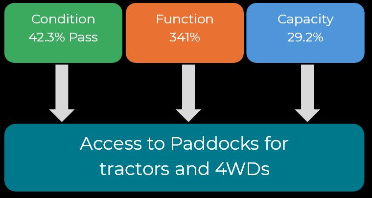
Formed-only roads are the lowest-cost roads designed for low-speed use, lacking a gravel surface and maintained only by grading and tree limbing.
Designed to support agricultural access, they are suitable for vehicles that operate in paddocks such as four-wheel drives, trucks and farm machinery and may not be suitable for two-wheel drive sedan vehicles. There are currently 438 kms of formed-only roads within our network.
This pass/fail metric assesses whether formed-only roads meet a minimum standard for low-speed use by fourwheel drives and agricultural equipment based on surface condition. In 2025, 42.3% of formed-only roads in the municipality meet this standard
Maintaining these roads in serviceable condition is essential for supporting the productivity of farming and agricultural activities. This informs our renewal and upgrade programs ensuring investment is targeted, transparent, and aligned with community needs.
Please note, the above report is based on the 185 kms of formed-only roads with condition state 4, 5 or 6 per the 2021 Condition Assessment.
This describes whether the extent of the formed-only road network is sufficient to meet community needs and operational demands. This is measured by:
• Whether the road services a home or significant on-farm infrastructure. This insight is based on current Rural Access Residential classification, with significant on-farm infrastructure constituting shearing sheds with yards and large hay sheds or silos with gravel driveways and working areas
• If the road is gravelled and provides access solely to farm paddocks. There are 1058 kms of Rural Access Property that could potentially be allowed to naturally degrade to formed-only roads as they only serve paddocks which will be subject to careful review before any changes are made.
An oversupply current exists of gravel roads that serve only low-use agricultural access. This represents a high ongoing cost and inefficient use of council resources. In many cases, these roads would be better classified and managed as formed-only roads allowing us to redirect investment where it better supports housing access, economic activity and essential services.
This describes the useability of formed-only roads to provide access to paddocks for use by trucks, tractors and four-wheel drives. This is measured by:
• Whether paddock access is provided via a gravel or formed-only road. As mentioned above, there are 1058 kms of Rural Access Property that could potentially be allowed to naturally degrade to formed-only roads
Given limited resources, it is not feasible to maintain gravel roads to every farm paddock. A more strategic approach is to reallocate funding towards higher-impact activities such as additional grading, tree limbing and targeted sealing within the transport infrastructure portfolio.
As part of this shift, some existing gravel roads will naturally revert to formed-only status ensuring funds are directed where they deliver the greatest value for communities and the economy.
Challenge Details
Poor road condition
Expanding road network
Only 42.3% of the formed-only road network is suitable for its intended purpose providing access for trucks, tractors, and four-wheel drives to farm paddocks. Without intervention, this impacts agricultural productivity and rural connectivity. Targeted investment is required to maintain functionality.
The formed-only network is expected to grow as the ongoing cost of maintaining an extensive gravel road network becomes unsustainable. To prevent deterioration across the network, funding will need to be reallocated from other areas of the transport portfolio to support essential maintenance of the formed-only network and avoid systemic failure.
Road hierarchy
Accurately identifying which roads should be formed-only (serving farm paddocks) and which should remain gravel (serving homes and significant onfarm infrastructure) is essential. Clear classification will help prevent community disruption and guide investment decisions.
Allocate resources where they most benefit
Be transparent and strategic
You didn’t want to pay more
Focus on value for money and measurable outcomes
Reducing resheeting on low-priority gravel roads that do not serve homes will redirect funds into grading formed-only roads.
Council is exploring the use of new AI tools to identify houses and sheds in rural areas ensuring road hierarchy matches how roads are actually used.
Continue seeking additional state and federal funding to reduce the resheeting backlog and reduce the need for gravel roads to naturally revert back to formedonly roads.
Grading costs far less than resheeting. By investing more in grading, council will ensure both gravel and formed-only roads stay smooth, functional, and costeffective for all users.
Other things we will continue to do include:
1 Expand tree pruning program
Expand our vegetation pruning program such as trimming branches that interfere with the movement of agricultural equipment
2 Improve coordination of our works program
We will introduce a ‘’portfolio of works’’ approach by grouping works programs that deliver similar outcomes. These programs need realignment to ensure they are coordinated with each other and focused on delivering what our community values. While overall funding for each portfolio may remain unchanged, rebalancing will help achieve more efficient and targeted outcomes.
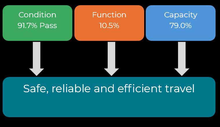
Council manages 806 kilometres of sealed roads that support safe, efficient movement in urban areas and connect key rural destinations. This network enables freight, public transport, and cycling activities
Condition report
This pass/fail metric assesses whether sealed roads meet a minimum standard for safe and reliable use based on surface and pavement condition. Roads must be free of major defects such as potholes or excessive roughness. In 2025, 91.7% of sealed roads meet this standard.
This measure informs targeted renewal works that reduce road trauma, improve urban and rural access and optimise lifecycle costs through strategic, long-term investment in sealed road infrastructure.
Please note, the above report is based on the 66.3 kms of sealed roads with condition state 4, 5 or 6 per the 2021 Condition Assessment.
Capacity report
This describes whether the extent of the sealed road network is sufficient to meet community needs. This is assessed by:
• The amount of gravel roads that should be sealed due to growing demand. There are approximately 170 kms of roads that are currently gravel that do not meet the reliability test (i.e. graded no more than once per year).
• Whether every urban home is serviced by a sealed road. There are 44.1 kms of urban access roads that are classified as serving urban homes that are gravel
Improving capacity ensures reliable access, enhances liveability, and supports coordinated growth, particularly in expanding communities and freight corridors.
Function report
This describes the usability of sealed roads to ensure safe, efficient, and reliable access for residents, freight, public transport and active travel. This is measured by:
• The proportion of rural roads with widths satisfying the AustRoads guidelines. There are approximately 491 kms of rural roads that do not meet the widths specified in these guidelines
• The proportion of urban roads with widths satisfying the Infrastructure Design Manual guidelines There are approximately 57 kms of urban roads that do not meet these guidelines
A well-functioning sealed road network supports liveability, connects growing communities, and enables freight and rural industries to operate efficiently. Targeted upgrades based on community priorities improve safety, reduce road trauma and maximise the value of long-term infrastructure investment.
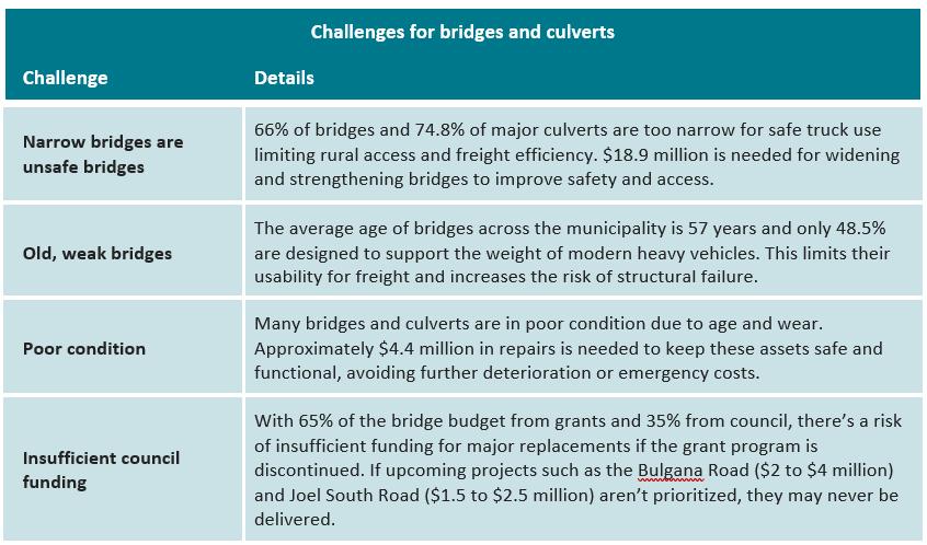
Narrow roads are unsafe roads
Road condition is getting worse
Only 10.5% of our sealed roads are wide enough to meet user needs. That means most of our roads are too narrow, which makes drivers feel unsafe and frustrated. On our rural link and collector roads (about 500 km in total), just nine kilometers are wide enough. That’s less than 2%.
From January 2012 to June 2024, there were 167 accidents on our roads:
• Seven people lost their lives
• 68 people were seriously injured
That is one life lost every two years, and a serious injury every 10 weeks. More than half of the serious injuries, and all of the deaths, happened on sealed roads, even though these roads comprise only 24% of our whole network.
Sealed roads are in better shape than most other councils, but they are getting worse over time, just like our gravel roads. If nothing changes, they will continue to decline. There is about $2.5 million worth of resealing work still to be done. The good news is, this work is expected to be finished by 2030.
More trucks, heavier loads
Freight is growing. It is estimated to increase by 1.5% every year. Trucks are not only getting more frequent, but also bigger and heavier. This puts extra pressure on our already narrow and ageing roads making them less safe and more expensive to maintain in the future.
1 Road hierarchy
The current road hierarchies listed in the road register do not fully reflect the intended roles and functions outlined in the Road Management Plan
2 Maintenance demand
Current four-yearly condition assessments use technology that cannot capture all defect types limiting their usefulness for long-term planning. While manual inspections are accurate, their labour-intensive nature means data collection is not detailed enough to fully support proactive, well-informed planning for maintenance and road renewal activities.
3 Missing pavement strength data
There is currently no data on the strength of sealed road pavements. Without this, council cannot determine how close pavements are to being overloaded and failing. This limits our ability to plan renewals effectively meaning issues may only be identified once failures begin, negatively impacting road users.
Please note, all other councils’ data referenced in the above table has been obtained from the National State of the Assets publication by the Australian Local Government Association
You said
Allocate resources where they most benefit
Be transparent and strategic
You didn’t want to pay more
Focus on value for money and measurable outcomes
We will continue prioritising upgrades to rural roads that support larger vehicles, improving freight movement and boosting agriculture and local industries across the shire.
We are investing in new technology to better understand the condition of our roads. This data will help us plan smarter repairs and upgrades that improve safety, accessibility and long-term sustainability.
We have successfully secured grant funding in the past and will continue to actively pursue these opportunities to fund road improvements without increasing costs to the community.
We are aligning maintenance, renewal and upgrade programs to work together more effectively. With new technology to better identify road defects, we will be able to target investment where it delivers the most value ensuring limited funds are used efficiently to maintain what we have, while upgrading roads that matter most to the community.
Other things we will continue to do include:
1 Improve useability
Council is committed to building roads that are wide, strong and designed to industry best practice, ensuring safety, durability and value. If we cannot afford to deliver a project to these standards we will not proceed. Instead, we will defer it until it can be done properly so we invest in long-term outcomes and not short-term fixes.
2 Continue investing in road resealing
Resealing protects road surfaces and prevents major deterioration, while also helping avoid costly future repairs Ongoing resealing will keep our roads safe, serviceable and more affordable to maintain
3 Seal high-use gravel roads
Sealing heavily used gravel roads reduces grading needs, lowers maintenance costs and improves access and safety for rural residents, freight and emergency vehicles
4 Enhance liveability
Council aims to ensure every home in every town has access to a sealed road, supporting access to community services, community pride and more equitable outcomes across the shire.
5 Support freight and industry
Expanding the gazetted network for high-productivity freight vehicles will reduce the need for permits making it easier and more efficient for agriculture and industry to move goods across the region. Special vehicles such as B-Doubles, A-Doubles, and mobile cranes must obtain a permit from the National Heavy Vehicle Regulator (NHVR) to operate on local roads unless they are travelling on the gazetted network, where permits are not required.
6 Coordinate infrastructure investment
We are bringing together all our capital works and maintenance programs into a single transport infrastructure portfolio. This will help us better manage road, footpath and drainage spending which will improve operational coordination and maximise the impact of every dollar spent
7 Invest in smarter technology
Council will explore AI-enabled inspections and pavement testing tools to improve how we assess and maintain roads. These technologies will help us deliver better-targeted repairs, improve safety and get more value from our transport investments.
8 Review the road register
Council will review the road register to ensure our road classifications reflect how roads are used today. This will help us make more strategic decisions about where and how we invest in upgrades, maintenance and renewal works.
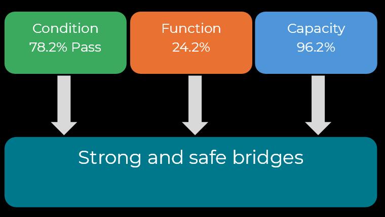
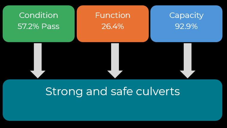
Council manages 136 bridges and 283 major culverts collectively worth $121,000,000, providing vital access for vehicles, freight, pedestrians and cyclists. These structures need to be safe, connect communities and support industry.
Condition report
This pass/fail metric assesses whether each bridge or culvert component is sufficiently free of defects for safe and reliable use, an essential benchmark for delivering our future-focused infrastructure renewal program.
With only 78.2% of bridge components and 57.2% of major culvert components currently meeting this standard in 2025, targeted renewal works are essential to maintaining safety, and supporting rural and residential access, freight and active transport. Addressing these condition gaps will also minimise long-term lifecycle costs.
Please note, the above insights have been obtained through the 2023 Condition Assessment.
Capacity report
This describes whether there are enough bridges or major culverts to meet community needs. It is based on the number of bridges or major culverts council has evaluated as being necessary to construct in the future, which includes one road bridge, four pedestrian bridges and 20 floodways.
Improving capacity ensures reliable access, supports industry and assists with coordinated growth, particularly along and freight corridors
Function report
This describes the usability of bridges and major culverts to ensure safe, efficient, and reliable access for residents, freight, public transport, and active travel. This is measured by:
• The proportion of bridges (33.8%) and major culverts (26.4%) that meet the widths specified in AustRoads. This includes 90 bridges that are too narrow, with 187 out of the total 250 pipe and box culverts in our shire needing widening.
• The proportion of bridges (50.7%) and major culverts (100%) that are strong enough to support modern vehicles, with 67 bridges identified.
A well-functioning bridge and major culvert network supports liveability, connects growing communities and enables freight and rural industries to operate efficiently. Targeted upgrades based on community priorities improve safety, reduce road trauma and maximise the value of long-term infrastructure investment.
1 Improve useability
We are committed to upgrading bridges and major culverts to industry best practices, ensuring they are wide, strong and durable. If a project cannot meet these standards, we will defer it until funding allows for proper execution, prioritising long-term outcomes over short-term results.
2 Continue investing in bridgeworks
Strengthening and widening existing bridges enables larger, higher-productivity vehicles to use them, reducing transport costs for industry and agriculture. Current grant funding arrangements facilitate these improvements, enhancing freight efficiency and supporting rural industries.
3 Coordinate infrastructure investment
We are consolidating all capital works and maintenance programs into a unified transport infrastructure portfolio. This approach ensures that bridge and major culvert works are aligned with other transport programs, such as roads, paths and drainage, optimising overall infrastructure outcomes.
4 Continue advocacy for the Heath Street Bridge, Halls Gap
The Heath Street bridge is a critical infrastructure project aimed at reducing traffic in the Halls Gap village centre. We will continue to advocate for funding to build this bridge, which will enhance walkability and activate outdoor dining and retail spaces, fostering resilient, connected local economies.
5 Find the weak links
Bridges often represent the weak link along a freight corridor. We plan to identify and strengthen bridges that are bottlenecks, removing obstacles to expanding the gazetted road network and improving connectivity for freight movement.
6 Investigate new concrete technology
We are exploring innovative concrete repair methods which offer cost-effective and durable solutions. Implementing these technologies can reduce maintenance demand and extend the lifespan of infrastructure assets.
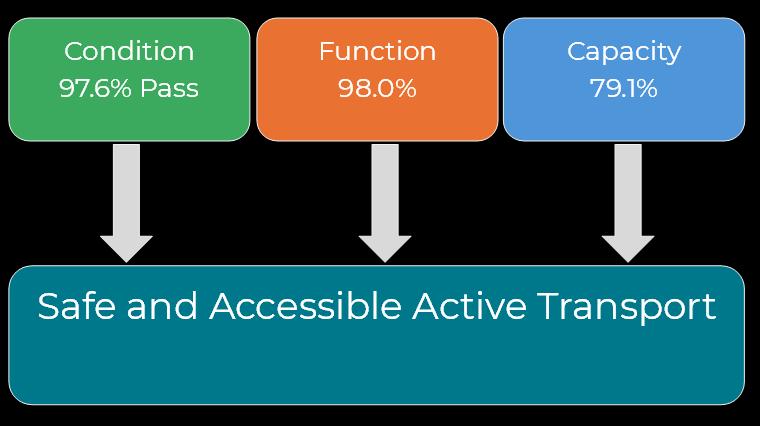
Council manages 122 kilometres of footpaths worth $18 million, which provide safe and accessible active transport in urban areas for pedestrian walkways and micromobility services.
By separating pedestrian and vehicular traffic, they enhance safety, improve mobility and promote active, sustainable travel for people of all ages and abilities.
This pass/fail measure assesses whether footpaths meet a minimum standard for safe and accessible use based on surface quality. To pass, paths must be free from major defects such as cracking, heaving or unevenness. In 2025, 97.6% of paths meet this safety standard.
This indicator informs targeted renewal works that improve safety, walkability and access for people of all ages and abilities, while supporting long-term asset sustainability through strategic, evidence-based investment.
Please note, the above report is based on the 2.9 kms of paths in condition state 4, 5 or 6 per the 2021 Condition Assessment.
This describes whether the existing path network is extensive enough to meet the needs of the community. It is based on the length of new paths identified in council’s Open Space and Active Transport Strategy. Up to 25.2 kms of new paths were identified in the strategy to help achieve the outcomes of inclusive access, improved health and wellbeing, and connected communities
Improving network capacity enhances active living opportunities, strengthens community connectivity, and supports safe, inclusive access across townships and growth areas, particularly for those who rely on walking and cycling as primary forms of transport.
This describes the usability of the path network to ensure safe, inclusive and reliable access for all users including people with disabilities, older adults, and those walking or using mobility aids. This is measured by:
• The proportion of paths that fall below the absolute minimum width of 1.2m There are approximately 2.4 kms of footpaths with widths less than 1.2m
A well-functioning path network enhances liveability, promotes active lifestyle, and supports social inclusion by connecting people to services, community spaces and each other. Targeted upgrades based on community priorities improve safety, accessibility, and comfort maximising long-term infrastructure value while meeting the needs of a diverse and growing population.
Other things we will continue to do include:
1 Coordinate infrastructure investment
Footpath works are now part of a broader more integrated transport portfolio, ensuring that paths connect with roads, bridges, drainage and cycling infrastructure for better, more connected outcomes.
2 Only build what we can afford
We are committed to upgrading footpaths to meet accessibility standards, improve lighting and safety, and deliver more comfortable walking conditions. Where projects cannot meet these standards, we will defer them until they can be delivered properly.
Council’s drainage network features more than 72 kilometres of pipes and drains, more than 2,700 pits, and just over 130 kilometres of kerb and channel, a system which is essential for reducing urban flooding risks
Valued at $27 million, this system helps protect homes, streets, and public spaces while keeping our community safe, resilient and ready for heavy rainfall.
Condition report
This pass/fail measure assesses whether our drainage systems meet a minimum standard to drain stormwater safely To pass, drainage must be free from major defects such as cracking, holes, or spalling In 2025, 97.4% of drains and pits and 99.4% of kerb meet this standard.
This indicator informs targeted renewal works that protect people and property from stormwater damage, while supporting long-term asset sustainability through strategic, evidence-based investment.
Please note, the above report is based on 1,630 metres of pipe and drains, nine pits and headwalls, and 800 metres of kerb in condition state 4, 5 or 6 per the 2021 Condition Assessment.
Capacity report
This describes whether the existing drainage network is extensive enough to meet the needs of the community. As parts of our municipality remain affected by stormwater, it is clear there is a need for more drainage solutions, however how much more still requires further investigation.
Function report
This describes how well the drainage system protects people and property from damage by stormwater. This is measured by:
• The proportion of pits and pipes that are not overloaded during a 20% Annual Exceedance Probability (AEP) event This estimate is based on the proportion of pipes that have sufficient capacity during a 20% AEP storm in Stawell only
A well-functioning drainage network reduces flood risk, supports safer and more resilient neighbourhoods, and helps ensure our community can continue to thrive during heavy rainfall events.

Urban drainage includes both minor systems (kerbs, channels, drains, and pipes) and major overland flow paths. In Stawell, 33% of the minor network cannot manage a 20% AEP storm event. When overloaded, water spills into the major system which can also exceed capacity and cause property flooding.
While the condition of the minor drainage system is below that of many comparable councils, regular inspections using cameras confirm the network is performing appropriately for its current role. This evidence-based approach helps us target maintenance where it's needed most.
Although there is approximately $300,000 in annual depreciation, we currently prioritise expanding the drainage network over renewing existing infrastructure. This strategic choice reflects the network's current condition and allows us to extend protection to more properties across the community.
Other challenges for our drainage network include:
1 Some drainage elements do not belong to council
Some drainage infrastructure, particularly open drains, is located on land that is not owned or managed by council. While council receives service requests about these assets, they are not part of our network, causing confusion for property owners.
2 Drainage works are not integrated with other works
Drainage works are not always integrated with other infrastructure projects such as road or footpath upgrades. This lack of coordination can lead to missed opportunities for efficiency and long-term planning.
3 Drainage capacity isn’t clearly understood
Our community frequently report flooding, often after damage has occurred. However, without a full understanding of system capacity and performance, it is difficult to prioritise upgrades or proactively address problem areas
4 A changing climate
As rainfall patterns become more intense and unpredictable, older drainage infrastructure designed using historical climate data may no longer perform as intended, increasing the risk of flooding.
Other things we will continue to do include:
1 Coordinate infrastructure investment
Drainage works will now be delivered as part of a broader, integrated transport portfolio. This means drainage upgrades will be planned and implemented alongside roads, bridges, kerbs, channels and paths, resulting in more efficient delivery and better-connected infrastructure outcomes.
2 Advocate for urban creeks
We will advocate to transform urban creeks in Stawell and St Arnaud into vibrant, connected green corridors to enhance biodiversity and improve water quality that supports public health and sustainable recreation.
3 Continue renewal and expansion
We will continue to expand the drainage network where it supports other key projects such as road sealing, kerb and channel works, and path upgrades. Renewal of existing assets will occur when condition assessments confirm it is needed, ensuring we get the best value from every dollar invested.
4 Kerb and channel progress
We will continue to expand the kerb and channel network. Along with improving drainage, kerbs also improve the amenity of an urban space and is an efficient use of limited space.
We will create cooler, greener and more resilient communities by increasing street tree canopies and building wetlands to help manage stormwater and improve urban liveability.
Through smart planning, community collaboration and sustainable investment, green infrastructure will support climate readiness and enhance the quality of our public spaces.
Street trees, wetlands and urban creeks have long been part of our towns, providing shade, managing stormwater, and making our neighbourhoods more attractive and comfortable. However, until recently, these areas have not been formally recognised in our Council Plan or included in the way we plan, manage, and invest in our infrastructure.
This is changing.
Council is now committed to delivering a coordinated green infrastructure program that recognises the vital role these assets play in improving liveability, supporting climate resilience and enhancing public space enjoyment. This includes:
• A dedicated street tree planting and beautification capital program, which is guided by our Tree and Nature Strip Management Plan.
• Strategic planting to increase shade and comfort for walking, cycling and recreation.
• Advocacy to rehabilitate Mooney Dam to store harvested stormwater and support wetland development.
• Advocacy to transform urban creeks into connected green corridors for cooling, water quality and recreation.
To facilitate these outcomes we have created a new green infrastructure asset area. This means street trees, wetlands and urban creeks will now be planned, maintained and funded just like other core council infrastructure.
We are also taking practical steps including:
• Recording the location of street trees and other important information
• Recognising and updating our existing street tree condition assessments.
• Modelling the funding needed to renew and replace trees over time.
• Including the community benefits of green infrastructure in our long-term Asset Plan.
By embedding green infrastructure into how we plan for the future, council is making our townships more liveable, sustainable and ready for a changing climate.
Council manages 134 buildings worth $113 million, which support vital community services such as sport and recreation activities.
Buildings include Stawell Sports and Aquatic Centre newly opened Great Western community pavilion, and facilities for early learning centres and council administration
Unlike other asset classes, buildings enable a highly diverse set of services, from recreation and community events to early learning and local governance. To support evidence-based planning and ensure long-term sustainability, council engaged an independent assessment in 2023 to evaluate each building’s condition, function, and capacity. This approach aligns with our goal to improve infrastructure outcomes through smart, cost-effective asset management and informed community engagement.
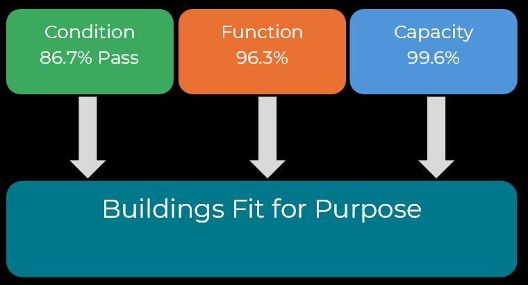
Condition report
This pass/fail measure assesses whether our buildings meet a minimum standard to be able to provide a service. To pass, buildings must be free from major defects such as cracking, broken equipment, or deteriorated coverings. In 2025, 86.7% of council’s buildings meet this standard.
This data guides targeted renewal and maintenance efforts to uphold safety and performance while supporting lifecycle sustainability.
Capacity report
This describes whether a building is adequately sized to meet community needs. In 2025, 99.6% of council’s buildings meet this standard.
Function report
This describes how well a building supports the service it houses. Due to the diversity of services, each facility is assessed individually, with 96.3% currently meeting functional requirements.
Challenge Details
Ageing building fabric
Major asset pressures
Limited capacity to consolidate
Cost recovery constraints
In 2025, 22.6% of building components including walls, floors, and roofs are in need of renewal. Since the 2019/2020 financial year, $2.23 million was spent on building fabric. The annual depreciation of walls, floors, and roofs is about $750,000, which must be matched in order to maintain the current condition of assets. Positively, the overall condition of the building stock remains above the benchmark for other councils, although the trend is gradually declining.
Key sites such as the Stawell Sports and Aquatic Centre require significant investment far beyond council’s financial capability.
Our ‘twin city’ arrangement duplicates infrastructure between Stawell and St Arnaud by providing full services at both locations. This results in $35.44 million worth of buildings support services such as municipal administration, depots, and pounds.
Cost recovery is limited. Depreciation for aquatic centres alone is around $121,000 a year. Covering depreciation alone would require the centre to generate 152 bronze memberships per year which isn’t achievable in the current operational climate.
Other challenges for our building portfolio include:
1 Underutilised assets
While council owns a range of quality community facilities, many are not being used to their full potential. These underutilised assets represent missed opportunities to support local participation, connection and service delivery.
2 Limited accessibility
Some council buildings do not meet contemporary accessibility standards. This limits access for people with disabilities and those who may face barriers with using public spaces. The gap between current infrastructure and inclusive access remains a significant challenge in ensuring equity across all community assets.
You said What we’re doing
Allocate resources where they most benefit
Be transparent and strategic
You didn’t want to pay more
Focus on value for money and measurable outcomes
Seek funding for priority upgrades such as the Stawell Entertainment Centre and Central Park grandstand and netball change rooms. These are critical high-use community assets that need improvement.
We are investigating the feasibility of future projects, such as the Cato Park Sound Shell, using evidenced-based planning to guide decisions and ensure community value.
Advocate for energy-efficient upgrades to reduce long-term operating costs and environmental impact.
We are prioritising activation of existing assets, such as theatres, parks and sports facilities, to deliver stronger community outcomes without building new infrastructure.
Other things we will continue to do include:
1 Seek funding for Stawell’s theatre
We will continue seeking funding opportunities to improve the Stawell Entertainment Centre theatre’s accessibility and performance facilities which supports our local arts and culture.
2 Investigate the feasibility of a sound shell
We will explore options for a sound shell at Cato Park assessing location, costs and community benefits to enhance public event spaces.
3 Seek funding to repair grandstand
We will continue to seek funding to repair the Central Park No. 1 Grandstand preserving this important community asset through effective maintenance.
4 Seek funding for the upgrade of the Central Park netball change rooms
We will continue to seek funding to provide suitable change room facilities that meet community needs and encourage active living.
5 Advocate for energy efficiency upgrades
Energy is expensive. Upgrading buildings to be more energy efficient reduces operating costs and helps us lead by example with reducing emissions.
6 Deliver an audit and community engagement process
An audit and community consultation will identify barriers to accessing public facilities and services, ensuring inclusive access for people of all abilities.
There are nearly 5,000 open space assets collectively valued at $32.9 million, including parks, playgrounds, sports fields and community reserves. These assets foster a vibrant, connected community by providing sustainable, accessible outdoor recreation for residents and visitors.
Much like our buildings, open space assets such as parks and recreation reserves, enable a wide range of community services, particularly those related to active living, leisure, and wellbeing
The provision of open space assets is guided by council’s Open Space and Active Transport Strategy 2024-34 as well as Sport and Active Recreation Strategy 2024-34. The below estimates of function and capacity are derived from these two strategies, with the condition estimate based on a condition assessment completed on behalf of council in 2023.
This pass/fail measure assesses whether our open space assets meet a minimum standard to be able to provide a service. In 2025, 97.9% of our open space assets meet this standard.
This data guides targeted renewal and maintenance efforts to uphold safety and performance while supporting lifecycle sustainability.
Both strategies identify that there is a surplus of land for recreation, sport and parks.
This describes how well an open space asset delivers its intended purpose be that for sport, play, social gathering or connection with nature.
Opportunities for improvement were identified across a range of parks and facilities. In addition to the two core strategies listed above, the following plans were also reviewed to determine overall asset functionality:
• Memorial Park Master Plan
• Stawell Park Precinct Plan
• Lord Nelson Park Precinct Plan
• North Park Master Plan 2022-32
• Walkers Lake Management Plan and action plan
• Great Western Redevelopment Master Plan 2018-28
• Market Square St Arnaud Master Plan
• Marnoo Community Action Plan 2021-25
• Navarre Community Planning Strategy 2021-25
• St Arnaud Community Plan
• Wayfinding Signage Strategy

Challenge Details
Insufficient infrastructure and lighting
Inclusive design and facilities
Environmental and safety issues
There is a shortage of public amenities such as BBQs and shelters with seating in open space areas. Additionally, lighting is insufficient around courts, trails and event spaces, and there is a lack of shade and shelter over pools, playgrounds and play equipment across the shire
Open spaces lack child-safe infrastructure, including play areas and adequate fencing, especially near high traffic roads. Age-friendly amenities such as water aerobics areas for the elderly are also limited. Few spaces support youth engagement or informal sporting and community activities.
The absence of rubbish bins in central locations contributes to open space pollution. Additionally, poor weed management creates a fire hazard stemming from unclear or uncoordinated land management practices.
Other challenges for the open space portfolio include:
1 Large demand for improvements
There are 11 council plans and strategies that consider open space utilisation, all with potential demands on council resources which include funding and the employment of people.
You said What we’re doing
Allocate resources where they most benefit
Be transparent and strategic
You didn’t want to pay more
Focus on value for money and measurable outcomes
We are prioritising upgrades to high-need areas where the community benefit is greatest. We are severely constrained by the funding allocated to manage our various assets and are dependent on grants and other sources of revenue.
We are prioritising activation of existing assets, such as parks and sports facilities, to deliver stronger community outcomes removing the need to build new infrastructure.
We are seeking external funding and partnerships for open space improvements.
We are applying the data we obtain from our community engagement to focus effort where it delivers the most impact.
Other things we will continue to do include:
1 Accessible recreation
We will continue to seek funding for the construction of an accessible fishing platform in Stawell, expanding inclusive recreational opportunities for people of all abilities.
2 Outdoor exercise infrastructure
We are delivering outdoor exercise equipment in St Arnaud to promote active lifestyles for all ages and abilities.
3 Memorial Park development
We will support the continuing development of the Great Western Memorial Park including delivering a detailed design for key elements.
4 St Arnaud Bowling Club Precinct
We will advocate for and support a St Arnaud Bowling Club precinct, and assist with the implementation of an endorsed master plan
5 Review Market Square Master Plan
We will deliver a review of the Market Square Master Plan and seek funding to upgrade youth play spaces, supporting engagement and wellbeing for young people.
6 Advocate for Federation Park
We will advocate for the development of a detailed design for the Federation Park rest area to improve the visitor experience.
7 Advocate for Mooney Dam
We will advocate for the rehabilitation of Mooney Dam to support stormwater harvesting, wetland creation, enhanced green space and infrastructure that benefits nearby sporting precincts
We will seek funding to upgrade the Central Park netball courts to support active living and improve sporting facilities (at the time of this Asset Plan being collated in July 2025, funding had been secured to deliver this project).
We will deliver priority actions identified in the Walkers Lake Management Plan 2022 to support environmental protection and community access.
We will continue to seek funding to renew the North Park Athletic Track, ensuring it remains safe, accessible and fit for future use
Council’s forecast expenditure over the next 10 years (2025-35) has been projected in our Long-term Investment Plan. These figures include maintenance, renewal upgrades and acquisition of assets.
• Maintenance to ensure our assets remain safe and functional to all users.
• Renewals to replace aging infrastructure and avoid more expensive repairs at a later date
• New / upgraded assets to meet the changing needs of our community and support active living, economic growth and social inclusion.
Understanding these numbers:
Depreciation is the estimated cost to replace our assets with similar ones when they wear out. We calculate this cost based on how long each asset is expected to last and how much it would cost to replace. These numbers are checked and reviewed every year by third party auditors.
Renewal gap shows the difference between how much we spend on renewing assets and how much we should spend to keep up with wear and tear. This only reflects like-for-like replacements. In reality, we often need to upgrade assets as well. These upgrades often cost more meaning the renewal gap does not always show the true cost of keeping our infrastructure up to date.
The Renewal gap in our transport portfolio is large and growing. It currently sits at nearly $30 million and is expected to exceed $76 million by 2034/35.
This shortfall also reflects council’s evolving approach to managing unsealed roads. Some low-use gravel roads will be allowed to revert to a formed-only condition, enabling funds for higher-priority transport infrastructure. However, this still registers as a renewal shortfall in financial terms.
There are a few key points to keep in mind, including:
• The breakdown between maintenance, renewals and upgrades may shift as community needs and asset conditions change over time.
• The total investment, which is about $133.5 million over 10 years, is expected to remain steady unless there are significant changes to external funding.
Maintaining flexibility with how funds are allocated will be essential to meeting service expectations, managing risk, and ensuring long-term financial sustainability of our organisation
Understanding these numbers
The building portfolio is showing a steadily increasing renewal gap.
• The renewal gap currently sits at just over $9 million and is projected to grow to $30.7 million by 2034/35.
• From 2027/28 onwards, no funding is allocated to renewals despite annual depreciation costs remaining above $2.3 million.
• Over the 10-year period, only $2.68 million is budgeted for renewals, compared with $24.1 million in depreciation. This is 11% of the value required to keep pace with asset wear and tear.
• Majority of the $21.6 million total spend is directed to maintenance and minor upgrades.
The above summary suggests a significant shortfall in renewal investment relative to asset value, with funding currently focused on maintaining buildings rather than restoring or replacing them.
Understanding these numbers
Investment in open space assets is heavily weighted toward maintenance, with minimal funding allocated to renewals.
• Over the next 10-year period, $19.8 million is planned for maintenance and just $50,000 for renewals, compared with $13.2 million in depreciation.
• The renewal gap starts at $356,000 in 2024/25 and grows steadily to more than $13.5 million by 2034/35.
• By 2026/27, no renewal funding is allocated at all.
While maintenance is vital for open space daily upkeep, it does not extend the life of ageing infrastructure.
Northern Grampians Shire Council manages a substantial asset base, valued at more than $53,000 per resident in 2025. This creates ongoing challenges as costs continue to rise faster than revenue growth, and the renewal gap continues to widen.
To meet this challenge, council must make strategic, and sometimes difficult decisions to ensure our limited resources deliver the greatest benefit to the community Our priority is to invest in infrastructure that connects homes, supports local industry and keeps our community safe.
Some low-use gravel roads that primarily serve paddocks and are accessed by trucks, tractors or four-wheel drives will be reclassified. This allows us to redirect investment where it is needed most, improving service levels from 56% to 84% for roads that service rural homes and economic activity
We will leverage advanced data and AI tools to guide evidence-based, efficient investment decisions. This approach ensures funding is directed toward sustainable renewals, preventative maintenance and high-impact projects. If an asset does not meet long-term community needs, we will not build it.
Council will also address emerging risks from climate change by improving drainage infrastructure, expanding green spaces and enhancing active transport facilities to create safer, more resilient communities.
While our ongoing financial concerns are tangible, largely driven by infrastructure cost increases of nearly 40% since 2016 but with revenue growth constrained by rate caps, council remains committed to responsible, longterm stewardship. We will continue to advocate strongly for external funding opportunities, coordinate capital works to achieve maximum community benefit, and maintain flexibility to respond to emerging priorities without compromising our long-term vision. We are focused on building what the community truly needs for tomorrow, not just delivering short-term projects that offer limited value today.
The challenges ahead require clear focus, strong leadership, and a commitment to long-term planning. By making prudent, evidence-based choices, council can protect critical infrastructure, support community wellbeing and build a resilient shire prepared for the future
Planning our asset management approach and program of work is an ongoing and evolving process. This enables us to get the most value from what we own. To do this well, we must regularly check on our progress, report what we find, and make updates as needed.
Continuous improvement is the foundation upon which we intend to leverage the maximum value from our assets. The following are some of the essential tasks we aim to accomplish over the coming period
1 Review our Asset Plan regularly
We will review and update our Asset Plan every four years in line with the Local Government Act 2020. This ensures our planning remains current, responsive and informed by the latest data.
2 Asset Gap Ratio (AGR)
The AGR compares outstanding renewal needs to the total replacement cost of assets. It has increased from 4.3% to 6.2% since the last 10-year Asset Plan. We will report on it annually, focusing on the trend over time to track how effectively we are meeting renewal needs and managing long-term asset condition.
3 Set and report on condition targets
We will introduce condition targets across asset categories to guide maintenance and renewal decisions. Our target is that no more than 10% of assets in each category fall into poor condition (condition state four, five or six)
4 Set and report on function targets
We will introduce function performance measures to ensure our assets meet community expectations:
• All new assets will be designed to meet 100% of their intended function.
• We will aim to improve the functional performance of sealed roads by 2% annually.
• We will aim to improve the function of bridges and major culverts by 5% annually. Progress will be reported annually to the Executive Leadership Team, with targets next reviewed in 2026/27.
5 Establish Maintenance Targets
As we adopt AI-assisted inspection technology, we expect to detect asset defects. Within 12 months of implementation, we will introduce realistic maintenance targets that reflect both identified needs and available resources. These targets will be based on our Road Management Plan.
6 Assess asset management maturity
We will complete a formal Asset Management Maturity Assessment, consistent with the Institute of Asset Management and International Infrastructure Management Manual (IIMM). Based on the results, we will develop and implement an Asset Management Improvement Plan to strengthen our systems and processes
7 Define technical levels of service
We will prepare clear documentation that sets out the technical service levels for each asset type. These will align with customer level-of-service expectations and guide our decision-making around maintenance, upgrades, and renewals This will apply to both existing and new assets.
8 Measure and validate cost savings
We will evaluate the long-term financial impacts of transitioning from a large gravel road network to a more sustainable configuration. This includes assessing potential cost savings and understanding any changes to our Financial Assistance Grant revenue. This will ensure decisions are both cost-effective and fiscally responsible