
Three Centuries of Stewardship Lessons: Below, Above & Across the Bean River Valley

Page 1


“The soil was the parent of wealth”

Recognizing Value in Land: Three Centuries of Stewardship Lessons Looking Below, Above and Across the Bean River Valley

- Huntting, History of the Little Nine Partners, 1897 Dutchess County, New York

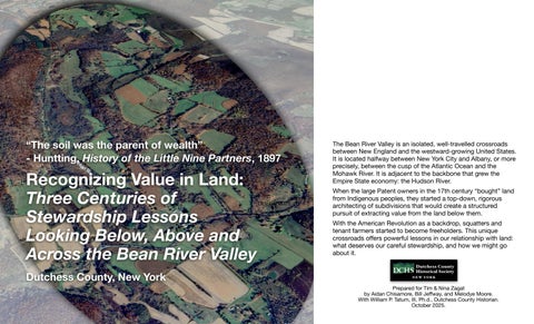
The Bean River Valley is an isolated, well-travelled crossroads between New England and the westward-growing United States. It is located halfway between New York City and Albany, or more precisely, between the cusp of the Atlantic Ocean and the Mohawk River. It is adjacent to the backbone that grew the Empire State economy: the Hudson River.

When the large Patent owners in the 17th century “bought” land from Indigenous peoples, they started a top-down, rigorous architecting of subdivisions that would create a structured pursuit of extracting value from the land below them.

With the American Revolution as a backdrop, squatters and tenant farmers started to become freeholders. This unique crossroads offers powerful lessons in our relationship with land: what deserves our careful stewardship, and how we might go about it.

Prepared for Tim & Nina Zagat by Aidan Chisamore, Bill Jeffway, and Melodye Moore. With William P. Tatum, III, Ph.d., Dutchess County Historian. October 2025.

Migration Across:

Valleys and waterways determine movement and offer sustenance and economic growth

In Pursuit of the Value Below:

A wide range of persons saw a wide range of possibilities.

10,000 YEARS

Indigenous Migration Across:

Not defined by strict borders, not a European sense of “ownership.”

European Top-down Planning:

Top-down planning still allowed for differing early New England and Hudson Valley settlement patterns.

This historical ad ran in local newspapers in 1905 as part of a series explaining what was distinct about our local history. The fact that wealthy landlords did not sell, but only rented farmland into the late 19th century, was a distinct, familiar and unhappy situation for farmers.

Unique Challenge to Ownership:

”Notorious” tenant farming lasted into the late 19th century.

A Unique, Powerful Crossroads:

O

ffers insight into the complexities and dynamics of the United States’ rapid diversification in faith, wealth and political and social status.

This

Three Dimensional View Yields a Rich Understanding:

1700 s to 1740 s

A period of definitions

The Little Nine Partners began to focus on extracting value from land. The Partners and Moravians reshaped and restricted the Shekomeko settlement to one square mile; the latter with a stated goal of moral conversion.

The German Palatine immigrant experiment failed at Germantown and its 3,000 largely impoverished people dispersed, many of them becoming “squatters.”

The Moravians formed close ties with the local Indigenous population. This started to seriously concern the Little Nine Partners.

Images left to right: The eastern portion of Little Nine Partners subdivision (DCHS Collections); The Power of the Gospel: Zeisberger Preaching to the Indians by Christian Schusele, 1862, Moravian Archives; the tri-state marker at the northern end of the oblong.

1700 s to 1740 s

A period of definitions

1706 The Patent granted to nine Partners came to be known as the “Little” or “Upper” Nine Partners Patent to differentiate from the much larger, Greater Nine Partners Patent to the south.

1710 to 1711 The Palatine experiment failed in what is today Germantown leaving 3,000 impoverished migrants without a plan.

1731 Connecticut ceded the Oblong to New York, getting the panhandle that today is Greenwich in return.

The partners of the Little Nine Patent began to systematically assess the value and use of the land.

1740 Ore test samples were sent to England and Amsterdam for evaluation but did not get a high rating.

1742 Indigenous community was forced into one square mile.

European settlers lived locally as squatters and extracted value through a combination of growing crops and forestry.

1743 A lottery in Poughkeepsie randomly assigned roughly 900 acre rectangular lots to partners.

1746-1747 Moravians were forced out, mission closed, beginning of exodus of Indigenous people.

1746 Round Top Church was built on the site of the Moravian Mission, Palatines continued Moravian legacy.

1750 s to 1790 s

A period of settlement between the Oblong and the emerging village of Pine Plains

As the Moravian Mission declined, wealthy landholders quickly commercialized what would become the town of Pine Plains. Shifting relationships to land and increasing populations prompted the growth of emerging local identities and cultural centers tied to location, kin group, and faith. Starting at the end of the 1740s, patentees (like Clarke and Sackett) began to issue formal deeds and leases, dividing major lots into smaller freeholds and tenant lands. These newcomers, nominally composed of Palatine families, supplanted many informally organized European settlers or “squatters.” The increasing population spurred growth of Pine Plains as a village and surrounding hamlets along valleys and streams.

1750 s to 1790 s

A period of settlement between the Oblong and the emerging village of Pine Plains

1749 Michael Rowe deeded 50 acres in lot 50.

1766 The “Great Rebellion” in Southern Dutchess saw tenant farmers pitted against landlords

1767 The land for Round Top church formally deeded at Bethel.

1772 Peter Pulver and Wendal Pulver purchase land that would become Pulver’s Corners

1776 Declaration of Independence signed.

1783 Conclusion of the American War of Independence put pressure on large land owners or “landlords” to abandon tenant farming and sell freehold titles, with notable holdouts. At the same time, Pacifist Quakers moved into Northern Dutchess to move away from the more militarized southern Dutchess.

1788 The Town of Northeast was formed from Northeast Precinct.

s to 1830 s

A period of local social and division locally while cross-state infrastructure grew

The turn of the century signified a cultural, legal, and physical change throughout the valley. The departure from Palatine cultural dominance, the division of personal and municipal control, and physical alterations in the landscape reflect these shifts. Movement away from established Palatine social structures and cultural influence is poignantly seen in the decline of the community at Bethel in favor of more northern population centers. The continued subdivision of parcels throughout the period meant greater populations worked smaller pieces of land. At the same time, the rapidly growing infrastructure of turnpikes and canals was creating a network of connections.

1800 s to 1830 s

A period of local social and division locally while cross-state infrastructure grew

1802 The Salisbury Turnpike was created which largely followed what today is Route 199.

1803 The Quaker meeting in Bethel was formed.

1816 Pine Plains Union Meeting house was established, lessening the influence of Round Top Lutheran Church.

1818 The Town of Milan was created and split off from the town of Northeast.

1821 The New York/Sharon canal was proposed to connect Great Barrington, MA to the Housatonic River in Connecticut to the mouth of the Croton at the Hudson River.

1823 The Town of Pine Plains was created and split off from the Town of Northeast.

1825 The Erie Canal opened, putting pressure on local farmers due to cheaper wheat from the US west.

1827 The abolition of slavery in New York State meant many men, women and children needed to entirely reengage with society without any support

1827 The Roundtop Lutheran Church closed.

ca. 1830 Pulver’s Corners was fully established as a business center (hotel/tavern, store, tailor, and blacksmith).

1833 and 1836 Attempts to build a railroad connecting Poughkeepsie to Pine Plains failed.

1840 s to 1860 s

A period of memorializing the past and improving land and local infrastructure.

The growth of social and municipal infrastructure altered the lived experience of residents in eastern Pine Plains. Increasing industries, new expressions of faith, an influx of new populations, and strengthening public services brought about the high point of hamlets surrounding Bean River. New industries and business throughout the region, particularly along the Shekomeko, in Pine Plains Village, and in Pulvers

Corners offered new services and goods to greater populations. New churches at Bethel and Pulvers

Corners expanded the presence of ecumenical meeting houses, providing important new community centers. Municipal services such as schools and roadways addressed deficiencies and offered to better the standard of living in the town.

1840 s to 1860 s

A period of memorializing the past and improving land and local infrastructure.

1833, William N. Sayre began ministry in Pine Plains, continued throughout this period

1840s Pulvers Corners became a political center driven by new construction in the hamlet (1840, 1844 election).

ca.1854 Pulvers Corners Union Church was constructed. A growth of ecumenical meetings contributed to the development of social infrastructure.

1857 Sheldon R. Davis published, “Shekomeko,” showing renewed interest in Moravian mission.

1858 dedication of the Moravian Monument

1861-1865 The American Civil War saw men go off to southern battles, and pressure was put on agriculture and natural resources.

Optimistic predictions of the coming railroad and accompanying “dairy factories” circulated.

1870 s to 1890 s

A period of traversing and romanticizing the land

The arrival of the railroad acted as the dominant motivating force for cultural and physical change in the period. As the ND&C reached across Pine Plains–connecting the Harlem and Hudson lines–agriculture quickly shifted to small-scale dairy farming. The completion of the line in 1871 helped to popularly define smaller localities in the region, like Bean River (Husted Station), as destinations. The introduction of the railroad, in conjunction with significant changes in land ownership, contributed to fluid personal and geographic identities.

Tripp Road
Husted Station

1870 s to 1890 s

A period of traversing and romanticizing the land

1869 ND&C railroad reached Pine Plains.

1871 The ND&C railroad was completed and connected the Bean River Valley to Millerton and Pine Plains village.

1872 Pulvers Corners post office changed its name to Husted Station.

1873-1877, Financial panic or Long Depression destabilized railroad industry

1889 Clarke family sold holdings from Little Nine Partners at auction resulting in overnight change in ownership.

1897 Isaac Huntting published the History of Little Nine Partners.

1900 s to 1930 s

A period of consolidated dairy and beef farms, of centralizing schools, and expanding highways

National events–such as WWI and the Great Depression–enabled the arrival of large-scale cattle industries. Land consolidation under these businesses shifted community structures, economic stability, and population centers throughout Pine Plains. Cattle farmers (beef and dairy) from southern New York bought large tracts of land, consolidating small-scale family farms. The gradual reduction of the trainline and the rising importance of automobile travel deepened the decline of local hamlets as communities while promising a new industry: tourism. Pine Plains successfully pushed back on New York City plans to create a massive reservoir system that would have flooded significant parts of the town.

1900 s to 1930 s

A period of consolidated dairy and beef farms, of centralizing schools, and expanding highways

1907 CNE railroad assumed ownership of the ND&C railroad further expanding consolidation

1914-1918, American involvement in World War I put demands on agriculture, raw materials.

1914, Dutchess County Historical Society (DCHS) founded

1927 Rededication of Moravian monument at Briarcliff Farms, DCHS Pilgrimage

1929-1939 Great Depression, empowered arrival of cattle industry

1932 Publication of The New Resort District: District Featuring a Region of Scenic Beauty in Northern Dutchess and Southern Columbia County

1933 Last passenger train on old ND&C line

1937 Last freight train ran on old ND&C line

1940 s to 1970 s

A period of urban influence and renewal

Waves of urbanization and mechanization following the Second World War shifted local identities from hamlets to town and county. This development paralleled steep population growth in the area. As large-scale agricultural operations continued to expand in the region, Pine Plains became a testing ground for innovative farming techniques.

Construction of the Taconic State Parkway and New York State Throughway provided greater access between Northeastern Dutchess and Pine Plains. During this period migration from New York City to Pine Plains expands, many individuals are notable business people purchasing temporary homes. The impacts of centralization hastens the decline of hamlets, overseeing the closure of many traditional community centers.

1940 s to 1970 s

A period of urban influence and renewal

1941-1945 World War II created demands on food and materials

1941 IBM opened its plant in Poughkeepsie and came to be responsible for one in ten jobs in Dutchess County by the 1970s.

1949 Taconic State Parkway connected NYC to Route 199.

1957 The Kingston-Rhinecliff Bridge opened to connect Route 199.

1954-1957 Gradual opening of the New York State Throughway.

1963 Taconic State Parkway completed the route north of Route 199.

1960s Urban renewal across the county, locally affected Pine Plains.

1963 Little Nine Partners Historical Society (LNPHS) was founded.

1965 LNPHS began stewardship of historic buildings, “preservation and restoration” became a “focal point” of the organization.

1970 s to Present

A period of uncertainty about land use and identity

As we move into the current chapter we find a severe departure from earlier periods’ relationship to land. The most defined characteristic is the general movement towards large personal estates, often seasonally inhabited by individuals whose economic security comes from outside of the county. Concurrently, we see a significant return to small-scale local farms (nominally experimental) both as pastime and as a livelihood. Despite an ongoing struggle to identify regional communities and consistent interest in the local landscape, there continue to be popular efforts to protect this natural and historic treasure. The concluding decades of the 20th century revealed a strong desire among the town's residents to preserve the natural resources and beauty of the Bean River. This same desire continues in the 21st century as the valley becomes increasingly identified as a critical environmental area and more land is being put into conservation.

1970 s to Present

A period of uncertainty about land use and identity

1970 Little Nine Partners Historical Society published “Pulvers Corners,” the first publication on the area since the turn of the century.

1980s Public push to retain name “Bean River.”

1985 Dutchess Land Conservancy founded in Millbrook, NY.

1987 Dutchess County Master Plan outlines the need for protection of historic and natural features, especially for streams and wetlands in Pine Plains.

1990s Local movement to combat increasing commercial use of Bean River Road

2006 Publication of Our Town, Our Voices, first oral history of Pine Plains

2018-2019, Bean River identified as a critical wetland and sensitive water resource through the Pine Plains Comprehensive Plan.

2001 Durst Organization purchased 2,000 acres (1,650 in Pine Plains and 550 in Milan) for $12 million with a plan to build 951 homes and an 18-hole golf course.

2024 Durst Organization put the 2,000 acre, undeveloped lot for sale for $36 million.

2024-2025 Deep investigation of BRV as platform for next step in stewardship.

APPENDIX

Turn static files into dynamic content formats.

Create a flipbook