LONDON: THE ROGER CLINE COLLECTION (PRINTS I)
DANIEL CROUCH RARE BOOKS
1
The Cline Collection - Prints Volume I —— Volume I - Prints
Foreword / 5 Introduction to Prints / 11 Roger Cline / 15 Panoramas and Prospects / 16 - 227 Bridges / 230 - 317 Life on the River / 320 - 359
Volume II - Prints
Transport for London / 6 - 31 Palaces, Politics, and Princes / 34 - 115 Parks and Promenades / 118 - 155 Churches and Chapels / 158 - 189 Industry, Education, and Amusement / 192 - 261 Markets and Sqaures / 264 - 273 Sets / 276 - 313 Handkerchiefs / 316 - 339
Volume III - Maps 1572-1840 Introduction to Maps / 5 - 7
Volume IV - Maps 1841-1933 Volumes V - Books
Introduction to Books / 5 - 7 London City is Mighty Pretty / 10 - 183 Plans and Prospects / 186 - 225 Life on the River / 228 - 303
Volume VI - Books
Transport for London / 6 - 15 Palaces, Politics and Princes / 18 - 51 Parks and Promenades / 54 - 61 Churches and Chapels / 64 - 115 Industry, Education and Amusement / 118 - 185 Suburban Sprawl / 188 - 215 Bibliography / 216
Daniel Crouch Rare Books Ltd 4 Bury Street, St James’s London SW1Y 6AB +44 (0)20 7042 0240 info@crouchrarebooks.com crouchrarebooks.com
ISBN 978-1-7384410-9-9 Catalogue edited by Arnie Anonuevo, Daniel Crouch, Rose Grossel, Kate Hunter, Ellida Minelli, Théophile De-Proyart, Mia Rocquemore, Dawlat Simko and Nick Trimming Design by Ivone Chao and Nicky Valsamakis Photography by Louie Fasciolo and Marco Maschiao Cover: item 97 Terms and conditions: The condition of all books has been described. Each item may be assumed to be in good condition, unless otherwise stated. Dimensions are given height by width. All prices are net and do not include postage and packing. Invoices will be rendered in £ sterling. The title of goods does not pass to the purchaser until the invoice is paid in full.
Printed by Park Communications on FSC® certified paper. Park is an EMAS certified company and its Environmental Management System is certified to ISO14001. 100% of the inks used are vegetable oil based, 95% of press chemicals are recycled for further use and, on average 99% of any waste associated with this production will be recycled. This document is printed on Galerie Matt made of material from wellmanaged, FSC®-certified forests and other controlled sources. The pulp used in this product is bleached without the use of chlorine (ECF).
London: The Roger Cline Collection (Prints I)
Foreword
“At best the graphic expression of almost infinite complication and endless variety of circumstance cannot but be imperfect”. So said Charles Booth of his own iconic map of London, with areas delineated according to the wealth or poverty of those inhabiting it. The same applies to the cartography and chronicling of the capital in general. Attempts to confine to the page such an ever-changing and multi-layered city inevitably fail to capture the living London. While no one individual map, print or book, however, could itself serve as a comprehensive representation, the Cline Collection, consisting of almost 40,000 items, captures every facet of the protean city. Founded by the Romans in the first century, London was originally built within the confines of a city wall. Although this wall fell during the Saxon period, it was restored in part after the Norman Conquest and continued to mark the boundaries of the City of London until population surges of the later Middle Ages forced its borders outwards. Eventually it was joined by the City of Westminster and the ancient Borough of Southwark to form the urban centre around which the city and country evolved. Early printed depictions of London blur the boundary between map and view. During the sixteenth and first half of the seventeenth century, cartographers and printmakers generally portrayed the city in three dimensions, with its buildings, river, and population illustrated in wonderful detail. After the Great Fire of London in 1666, however, there was a shift towards two-dimensional cartography. In the wake of the disaster, the need to assess the damage and plan the reconstruction of the city spurred cartographers to undertake new and more accurate surveys than ever before. The eighteenth century saw a London not only rebuilt but also greatly expanded, in every sense. Technology was slowly beginning to advance in the run-up to the Industrial Revolution, the population was increasing at a constant rate, and the borders of the city continued to creep into the fields of the surrounding counties. The first map of London and its environs, at a range of fifteen miles, had been produced in 1683, and throughout the following decades, such maps extended their scope to cover more and more of the capital’s growing suburbs. Simultaneously the city itself was growing in density as industrialization led to extensive construction and urban migration. And yet, despite all the developments occurring across London, the capital’s cartographers did not seem to feel the changes warranted the undertaking of new surveys, or the making of new maps. In fact, for the majority of the eighteenth and nineteenth centuries, old maps were simply updated with new additions to the city’s infrastructure, or had novel information superimposed on existing topographical plans.
LONDON: THE ROGER CLINE COLLECTION (PRINTS I)
DANIEL CROUCH RARE BOOKS
5
6
DANIEL CROUCH RARE BOOKS
LONDON: THE ROGER CLINE COLLECTION (PRINTS I)
The latter often resulted in thematic maps which revealed as much about the cultural make-up of the city as they did about its geography or topography. The information included on these maps covered a wide range of topics, including disease, poverty, the sewage system, geology, education, the postal service, and London’s innumerable pubs. Maps of the final kind were not made to direct revellers to their next pint, but commissioned by concerned campaigners to raise awareness of the depth of the city’s alcohol problem! The clues about life in eighteenth and nineteenth century London given by such maps are complimented by the wealth of prints produced during this time, depicting everything from newly-constructed buildings to the fashion of the day. As the Industrial Revolution began in earnest, London’s rate of expansion reached new heights. Maps and prints of the nineteenth century show the rapid development of new infrastructure, including embankments, markets, bridges, roads, canals, and railways. While maps of such changes were typically commissioned by the engineers, architects or boards behind them, they were also sold in individual sheets that allowed residents to see how their area would be affected. Construction around the city’s periphery also forced mapmakers to extend their range of focus: the rebuilding of the Crystal Palace at Sydenham pushed the map of London southwards, as did Alexandra Palace in Muswell Hill to the north. Likewise, the improvement and extension of London and Britain’s railway network triggered a change: not only were maps and views of the capital now dominated by stations and tracks, but there was also an increased demand for them as a result of tourism. Better travel and communications meant that more and more people were able to visit the city, and consequently the production of guide books, excursion maps, and souvenir prints all boomed during this period. As London expanded, so did the British Empire, making the city not only the capital of Great Britain but also the centre of a superpower spanning almost a quarter of the world’s landmass. People and artefacts from across the Empire were brought to London in 1851 for the Great Exhibition. Interestingly, no new maps of London were made for this event, which triggered the production of numerous books and prints, although practically all contemporary maps were updated to show the great Crystal Palace in Hyde Park. Since the mid-nineteenth century, London has continued to shift and evolve. Its aspect has been altered by events such as the Blitz, and much new construction necessary to accommodate its millions of residents, while the question of what it means to be a Londoner has been opened up to previously unheard ideas and perspectives. Ultimately, all efforts to organize, categorize and neaten the living city are hampered by its scale and diversity, providing a powerful reminder that nature, whether rural or urban, organic or human, is impossible to pin down.
LONDON: THE ROGER CLINE COLLECTION (PRINTS I)
DANIEL CROUCH RARE BOOKS
7
Order of the Catalogue Roger Cline’s collection of London material spans nearly 40,000 items, which are listed in full in the final volumes of this catalogue. We have selected 1500 items that best represent the rich history of publication in and about the city, and examined these in greater detail in the five other catalogues presented here. They have been divided into prints (Volumes I and II), maps (Volumes III and IV) and books (Volumes V and VI), although the distinctions between these three media are sometimes blurred. Within the volumes dedicated to prints and books, the items have been grouped according to subject, which we feel allows this vast and varied collection to be navigated most easily. Categories include subjects such as ‘Life on the River’, ‘Transport for London’, ‘Palaces, Politics, and Princes’ and ‘Industry, Education, and Amusement’. Items are then listed by date within their respective groups, demonstrating how individual features of the capital have evolved throughout the centuries. Date depicted has been, on the whole, preferred over date of publication in order for the illustrations to “read” in the correct order for the story of London. To best show the legacy of certain cartographers and maps, the maps of London have been ordered according to their reference numbers in the important works of Ida Darlington, James Howgego and Ralph Hyde. Darlington and Howgego’s ‘Printed Maps of London circa 1553-1850’ (1964), and its 1978 second edition by Howgego alone, and Hyde’s ‘Printed Maps of Victorian London 1851-1900’ (1975). By adhering to these ordering principles where possible, Volumes III and IV help to illustrate the importance of specific maps in the historic cartographical depiction of London. In cataloguing the general views of London, we are indebted to the unpublished notes of the late Ralph Hyde, who sadly died before he could complete his planned book on ‘Prospects and Panoramas’. Ralph and Roger were firm friends and it is fitting that something of Ralph’s work on this subject is published here.
8
DANIEL CROUCH RARE BOOKS
LONDON: THE ROGER CLINE COLLECTION (PRINTS I)
LONDON: THE ROGER CLINE COLLECTION (PRINTS I)
DANIEL CROUCH RARE BOOKS
9
10
DANIEL CROUCH RARE BOOKS
LONDON: THE ROGER CLINE COLLECTION (PRINTS I)
Prints
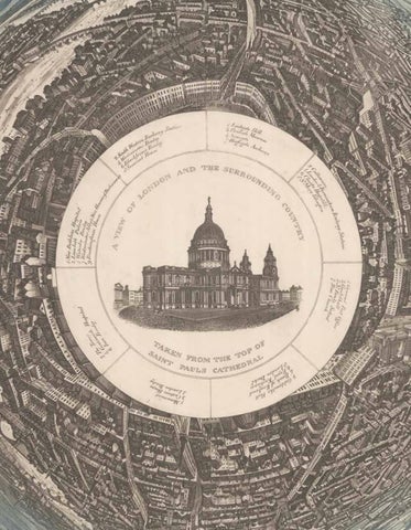
The introduction of printing in England is generally attributed to William Caxton, who brought the technology back from his travels to Germany and set up the first English press in roughly 1474. He chose as his base of operations a workshop just south of Westminster Abbey. In doing so, Caxton planted a flag for London’s print trade, which remained centred in Westminster throughout the following century. Over time, new presses and firms began to be established across the capital, albeit under the strict control of the state, chiefly exercised by the Archbishop of Canterbury and the Stationers’ Company. In fact, in the early seventeenth century the latter even issued an order restricting the number of presses permitted within the City of London to just 19! Thus the early history of printing in London is limited to a rather small number of printers, engravers, and draughtsmen who nonetheless made a great impact on the depiction and (self-)perception of the city. Among these was Wenceslaus Hollar, a Czech artist who lived in the city almost consistently from 1637 until his death in 1677. Hollar’s prospects, landscapes, and scenes of London provide an indispensable source of information about the history, topography, architecture, and culture of the capital during the seventeenth century. In particular, his prospect of London (items 11-13) offers an unparalleled view of the city as it stood before it was devastated by the Great Fire of 1666. Another important prospect of early modern London was the work of Johannes Kip, again a foreigner who moved to the city and soon became one of the key figures in its print trade. In “the largest view of London ever to be published” (item 40), Kip eschewed the typical view taken from the South Bank in favour of an innovative perspective, showing the city from the roof of Buckingham House. None other than George I, with the Prince and Princess of Wales in tow, is shown crossing St James’s Park, a feature for which the print was initially suppressed during the Jacobite rebellion in 1715, but which served to prove Kip’s loyalty to the monarchy when finally published in 1720. Kip’s view thus demonstrates how such prints can convey all manner of biases and subtleties, as well as the straightforward appearance of a person or place. Although the urban vista had already been captured in a vast range of prints, it was not until the end of the eighteenth century that the first true panorama of London was made. Depicting the city from the southern end of Blackfriar’s Bridge, Barker’s original painting spanned a canvas of almost 1500 square feet and was taken on a tour of Europe. Simultaneously, printmaker Frederick Birnie produced “six elegant aquatint prints, which, if joined, will represent the City of London and the entire surrounding country as seen from the top of the Albion Mill” (item 63), thereby giving the public access to an original new form of art. It was not only the lofty prospect of London, however, that printmakers felt worth committing to paper. The opening of a new building or bridge,
LONDON: THE ROGER CLINE COLLECTION (PRINTS I)
DANIEL CROUCH RARE BOOKS
11
12
DANIEL CROUCH RARE BOOKS
LONDON: THE ROGER CLINE COLLECTION (PRINTS I)
such as the 1751 iteration of Westminster Bridge (items 160-164), often encouraged the city’s publishers to produce commemorative prints of the structure, and likewise important events were almost inevitably accompanied by a wave of celebratory prints, some even produced at the event itself, as was the case with the Frost Fair of 1814 (items 211-213). Scenes such as William Hogarth’s series showing the capital’s streets at various times of the day (item 448),, Edwin Edward’s collection of inns (item 453), and Benjamin Read’s advertisements for his new sartorial collections (items 411-414) also shed light on day-to-day life for London’s inhabitants, both at work and play. A constant feature on the changing face of London is the travel network. Coaching stations, memorably depicted by James Pollard (items 245, 247, and 248), would eventually come to be replaced by the railway (items 253-256), which was later joined by the underground system, imaginatively represented by MacDonald Gill in 1914 (item 987) before Beck’s iconic map of 1931 won its continued monopoly. Another key communications and travel route was provided by the Thames, which long served as the arterial pathway through the city. This contributed to its overcrowding, as shown in Joseph Stadler’s view from the South Bank (item 67), and contamination, hinted at in Haywood’s plan of the London sewer system (item 883), which was improved in response to the “Great Stink of 1858”. The prints within this two-volume catalogue serve as a visual chronicle of an ever-expanding city, encompassing its people, buildings, culture, geography, politics, and history. They are testament to Dr Johnson’s claim that “when a man is tired of London, he is tired of life”.
LONDON: THE ROGER CLINE COLLECTION (PRINTS I)
DANIEL CROUCH RARE BOOKS
13
Roger Cline
Roger Cline is a true collector. A patent attorney by trade, Roger was educated at Queen’s College, Oxford. His library started life as a reference collection for teaching Railway History at The City Lit adult education college almost 50 years ago. As time went on, interest became concentrated in the London area and the library soon became more of a London Topographical library, and Roger spent his Saturdays navigating home counties bookshops using Driffield’s idiosyncratic directory as his guide. As the library grew, it absorbed several other important collections, including those of: Bernard Adams, author of ‘London Illustrated 1604-1851’ (1983); the bookseller Ben Weinreb (1912-1999), who had amassed a great number of books in order to prepare with Christopher Hibbert ‘The London Encyclopaedia’ (also 1983); the artist Peter Jackson (1922-2003), who had contributed to numerous books on the subject, including ‘London Bridge: a Visual History’ (2002), George Scharf ’s ‘London’ (1987), ‘Walks In Old London’ (1993), ‘London: 2,000 Years of a City and its People’ (1974), ‘The History of London in Maps’ (1990), and ‘Pleasures of London’ (2003). Roger also acquired some 300 maps from the library of Joel Tabor (1922-1997), and a private collection of 500 large format prints. Over half a century, Roger Cline has curated a collection of London material “Conteyning the Originall, Antiquity, Increase, Moderne estate, and description of that City” ( John Stowe’s ‘A Survey of London’).
Roger, in the middle, University of Oxford Road Racing Team, 1960.
LONDON: THE ROGER CLINE COLLECTION (PRINTS I)
DANIEL CROUCH RARE BOOKS
15
PANORAMAS AND PROSPECTS
The “earliest general view of London” (Hyde)
1
THE TYPOGRAPHIC ETCHING COMPANY; [after] Antony van den WYNGAERDE View of London (cir. A.D. 1550) by Antony Van den Wyngaerde. Publication London, London Topographical Society, 1881-1882. Description Facsimile, printed on seven sheets, housed in original portfolio. Dimensions (if joined approx) S: 800 by 460mm (31.5 by 18 inches). P: 550 by 301mm (21.75 by 12 inches). I: 510 by 2870mm (20 by 11.5 inches). References Colvin and Foister, ‘The Panorama of London circa 1544, by Antonis van den Wyngaerde’, 1996; Hyde, [private notes].
18
DANIEL CROUCH RARE BOOKS
The “Wyngaerde Panorama” (1543/1544) is the earliest general view of London. Three metres in length, it is the work of Flemish artist Anton van den Wyngaerde, and was quite possibly commissioned by King Henry VIII. Wyngaerde’s original drawings, together with instructions as to how they should be coloured, are held in the Sutherland Collection, first housed in the Bodleian Library, now the Ashmolean Museum. The present example is a seven-sheet facsimile of Wyngaerde’s work, with notes by Henry B. Wheatley, published by the London Topographical Society (LTS), between 1881 and 1882, as their first publication. A facsimile of the “Wyngaerde Panorama” had first been proposed around 1826 by the booksellers Messrs. Harding, Tiphook, and Lepard. After their venture foundered, Nathaniel Whittock (1791-1860), draughtsman, lithographer, and aquatint engraver, produced two tracings of the original drawings, presenting one set to Frederick Crace (now in the British Museum), and the other to the Corporation of London (now in the Guildhall Library), with a published facsimile following (for which, see items 2 and 3).
LONDON: THE ROGER CLINE COLLECTION (PRINTS I)
The London Topographical Society reprinted Wyngaerde’s panorama in 1996, as their publication No. 151, with a key to the buildings (see Colvin and Foister). Anton van den Wyngaerde (1525-1571) made panoramic sketches and paintings of towns in the southern Netherlands, northern France, Italy, and, famously, 32 topographical studies of Spanish cities for Christopher Plantin (c1520-1589). In addition to his large prospect of London, he drew another series of sketches of English towns, while travelling through the country with Phillip II, King of Spain, and his wife, Queen Mary I of England.
LONDON: THE ROGER CLINE COLLECTION (PRINTS I)
DANIEL CROUCH RARE BOOKS
19
The “earliest general view of London” (Hyde) - Whittock’s version
2
WHITTOCK, N[athaniel]; [after] Ant[on]y van den WYNGRERDE London, Westminster and Southwark as they appeared A.D. 1543. From a drawing by Anty. van den Wyngrerde, Sutherland Collection, Bodleian Library, Oxford. Publication London, H. A. Rogers, 83 Hanley Road, [c1896]. Description Etching, printed on two sheets. Dimensions (if joined) S: 480 by 1640mm (19 by 64.5 inches). P: 410 by 1555mm (16 by 61.25 inches). I: 300 by 1425mm (12 by 56 inches).
In producing his sweeping panorama of London, which extends from the Palace of Westminster, on the left, to the Palace of Placentia, on the right, Nathaniel Whittock (1791-1860) made use of the “Wyngaerde Panorama”, Anton van den Wyngaerde’s three-metre panoramic view, the earliest of London, held at the time in the Bodleian Library (for a full description of which, see item 1). Whittock also incorporated other sources, adding further detail to Wyngaerde’s work, for example in his depiction of Bermondsey Abbey. Such additions are, however, to be treated with caution, branded by Wheatley, in the introduction to his London Topographical Society facsimile (item 1), as “entirely untrustworthy”. The present example is, according to Hyde, the second state of Whittock’s panorama, with the imprint of H.A. Rogers, the first published in 1849.
References Hyde, [private notes]; cf [first state] BM, 1880,1113.1114; Crace, I.6.
The “earliest general view of London” (Hyde) - Whittock’s version, in full colour
3
WHITTOCK, N[athaniel]; [after] Ant[on]y van den WYNGRERDE London, Westminster and Southwark, as they appeared A.D. 1543. From a drawing by Anty. van den Wyngrerde, Sutherland Collection, Bodleian Library, Oxford.
A further example of Whittock’s panorama of London, after Wyngaerde, here in full colour. For a full description of the print, see item 2.
Publication London, H. A. Rogers, 83 Hanley Road, [c1896]. Description Etching, printed on two sheets, with contemporary hand-colour in full, laid on card. Dimensions (if joined) S: 400 by 1482mm (15.75 by 58.5 inches). I: 305 by 1440mm (12 by 56.75 inches). References Hyde, [private notes]; cf [first state] BM, 1880,1113.1114; Crace, I.6.
20
DANIEL CROUCH RARE BOOKS
LONDON: THE ROGER CLINE COLLECTION (PRINTS I)
22
DANIEL CROUCH RARE BOOKS
LONDON: THE ROGER CLINE COLLECTION (PRINTS I)
LONDON: THE ROGER CLINE COLLECTION (PRINTS I)
DANIEL CROUCH RARE BOOKS
23
London Bridge in 1546
4
WHITTOCK, N[athaniel]; [after] Ant[on]y van den WYNGRERDE Southwark and London Bridge as they appeared about 1546. From a drawing by Anty. van den Wyngrerde, Sutherland Collection, Bodleian Library, Oxford. Publication London, Virtue & Co., Limited, [c1878]. Description Lithograph. Dimensions S: 270 by 450mm (10.75 by 17.75 inches). I: 155 by 330mm (6 by 13 inches).
Whittock’s ‘Southwark and London Bridge as they appeared in about 1546’ was first published in 1844, appearing as an illustration in Edward Brayley’s ‘A Topographical History of Surrey’. The present print is from the 1878 edition, revised by Edward Walford. The aerial view looks over Southwark towards the River Thames and London Bridge, with notable points, ranging from Queen Hythe, to St Saviour’s Church, to “The Stews”, to St Thomas’s Hospital, detailed using a 20-point key, set out below the image. Also depicted is Borough, a market-town which had been populated since early Saxon times and, by the Middle Ages, had become a notorious hot-bed of criminality. In the mid-sixteenth century it became known as the “Bridge Ward Without”, or the ward of “Bridge Without”.
References cf [1844 state] BM, 1880,1113.5197; Crace, XXXIV.48.
24
DANIEL CROUCH RARE BOOKS
LONDON: THE ROGER CLINE COLLECTION (PRINTS I)
The brass neck to ban the press gang
5
PYE, I.; [after] Tho[ma]s WOOD
This view of London from Southwark is dedicated to Brass Crosby (1725-1793), a radical lawyer, who became Lord Mayor of London in 1770. One of his first acts as Lord Mayor was to refuse to enforce Admiralty warrants to coerce Londoners into joining the Royal Navy, ordering constables to be positioned “at all avenues” of the City to prevent men being press ganged into service. Since the view is derived from that by Merian (for which, see item 9), the date of 1599, given in the title, as Hyde notes, “should not be taken seriously”. The print was engraved by John Pye (fl1769-1789), engraver and printseller, who produced a range of landscapes, views, and trade-cards, after a work by Thomas Wood, about whom little is known.
To the Right Honourable Brass Crosby Esqr. Lord Mayor the Worshipfull Aldermen & the Common Council of the City of London. This South View of the said City and part of Southwarke as it appeared about the year 1599 is Dedicated by their most obedient humble Servant. Publication [London], T. Wood in Bishops Court, Chancery Lane, Novr. 7, 1771. Description Engraving. Dimensions S: 380 by 600mm (15 by 23.75 inches). P: 360 by 590mm (14.25 by 23.25 inches). I: 280 by 560mm (11 by 22 inches). References GAC, 10388; Hyde, [private notes].
LONDON: THE ROGER CLINE COLLECTION (PRINTS I)
DANIEL CROUCH RARE BOOKS
25
“one of the ... most important of the early London panoramas” (Howgego) - Pullam’s version
6
[PULLAM, J.]; [after] C[laesz] J[ansz] VISSCHER London. Publication [London, Anne Evans & Son, 1848]. Description Engraved panorama, on four sheets, with contemporary hand-colour in full. Dimensions (if joined) S: 505 by 2280mm (20 by 89.75 inches). P: 450 by 2210mm (17.75 by 87 inches). I: 420 by 2153mm (16.5 by 84.75 inches). References: BM, 1880,1113.1125; Crace, I.17; Howgego, p7; Hyde [Gilded Scenes], 5; Hyde, [private notes].
26
DANIEL CROUCH RARE BOOKS
Visscher’s 1616 panorama of London is “one of the best known and most important of the early London panoramas” (Howgego). It is “a view of the City from the south and its title ‘LONDON’ appears in the sky on a ribbon held by herald angels. Generally pleasing to the eye – it is a favourite for photo-murals in home, office and showroom – it has certain weaknesses topographically. The Thames is shown flowing in a straight line from west to east (though some versions show an odd change of course at the east end); the vertical scale is greatly exaggerated, some of the architectural detail is suspect and although many of the buildings are shown in detail others are omitted altogether. Internal evidence suggests that the view was drawn about 1600. The Globe Theatre on Bankside, built in 1598, is shown but Northampton House constructed 1605-9 at Charing Cross, and Salisbury House, where Elizabeth I was entertained in 1603, are not. The arms of the Tudors, whose dynasty ended in 1603, appear on Bulmer’s water tower and on the banner of the royal barge. Some editions of the panorama bear the signature ‘C.J. Visscher delineavit’. C.J. Visscher, the
LONDON: THE ROGER CLINE COLLECTION (PRINTS I)
engraver, was born in 1587, son of another C.J. Visscher, variously described as a goldsmith and as a shipwright. There is no firm evidence that either the father or the son ever visited London and saw the City himself, and the inaccuracies in major buildings suggest that they did not” (Howgego). The present example is a “crudely etched” (Hyde) copy of Visscher’s panorama by J. Pullam, published in 1848. The etcher has bungled the name of Ludovicus Hondius, in the cartouche in the top-right corner, citing him as “tndo vicnc Bondius”…
LONDON: THE ROGER CLINE COLLECTION (PRINTS I)
DANIEL CROUCH RARE BOOKS
27
In original covers
7
[PULLAM, J]; [after] C[laesz] J[ansz] VISSCHER London.
A further example of Visscher’s ‘London’ by Pullam, this one folding into original covers. For a full description of the panorama, see item 6.
Publication London, F. S. Nichols & Co., 12 Boro’ High St. London Bridge. S. E., [c1848]. Description Etching, folding into original covers. Dimensions S: 520 by 2280mm (20.5 by 89.75 inches). P: 450 by 2150mm (17.75 by 84.75 inches). I: 420 by 2050mm (16.5 by 80.75 inches).
28
DANIEL CROUCH RARE BOOKS
LONDON: THE ROGER CLINE COLLECTION (PRINTS I)
LONDON: THE ROGER CLINE COLLECTION (PRINTS I)
DANIEL CROUCH RARE BOOKS
29
The London Topographical Society’s version
8
THE TYPOGRAPHIC ETCHING COMPANY; [after] C[laesz] J[ansz] VISSCHER View of London. A Facsimile of the probably unique example of the original edition in the King’s Library, British Museum. Publication [London], London Topographical Society, 1883-1884. Description Etching, printed on four sheets; loose in original printed paper portfolio.
A further example of Visscher’s ‘London’, for a full description of which, see item 6. The present example was engraved by the Typographic Etching Company for the London Topographical Society and boasts to be the most faithful facsimile to date: “there are several so-called reproductions of the original, that abound in topographical anachronisms and inconsistencies. The chief interest of the View is that it represents London as it was known to Shakespeare” (front cover). Provenance With the blind library stamp of Chetham Library, Manchester, the oldest free public reference library in the world, on the front cover.
Dimensions (if joined) S: 570 by 2380mm (18.5 by 93.75 inches). P: 450 by 2270mm (17.75 by 89.5 inches). I: 415 by 2145mm (16.5 by 84.5 inches). References Hyde, [private notes].
30
DANIEL CROUCH RARE BOOKS
LONDON: THE ROGER CLINE COLLECTION (PRINTS I)
LONDON: THE ROGER CLINE COLLECTION (PRINTS I)
DANIEL CROUCH RARE BOOKS
31
The “gally fuste” and “eel schipes”
9
[MERIAN, Matthaeus] London. Publication [Frankfurt, Matthaeus Merian, c1638]. Description Engraving and etching. Dimensions S: 320 by 716mm (12.5 by 28 inches). P: 225 by 700mm (8.75 by 27.5 inches). I: 206 by 696mm (8 by 27.5 inches). References BM, 1948,0315.1.3; Hyde, [private notes]; Scouloudi, pp42-44; V&A, S.1113-1982.
32
DANIEL CROUCH RARE BOOKS
A pre-Fire view of London and the Thames taken from a vantage point over Southwark. Matthaeus Merian (1593-1650) was a Swiss engraver and publisher active in Germany. He moved to Frankfurt and worked for the de Bry publishing house, at that time run by Johann Theodor de Bry. Merian married Johann’s daughter Maria, and took over the publishing house in 1623 after his father-in-law’s death, before setting up as an independent publisher in 1626. The plate was first used in ‘Neuwe Archontologia Cosmica’ by Johann Ludwig Gottfried, published by Merian in Frankfurt in 1638 (and republished in 1646, 1649, and 1695), but was also issued separately. It is based on earlier views by Visscher (see items 6-8) and John Norden.
LONDON: THE ROGER CLINE COLLECTION (PRINTS I)
Merian’s view provides some insight into life on the river. The “gally fuste” (41) is the galley foist, the official barge of the city of London, used for ceremonial occasions by the Mayor. The “eell schipes” (40) nearby were Dutch merchant vessels, which would transport live eels from Scandinavia in hold tanks full of muddy water, before anchoring in the Thames, ready for customers to row out to buy fresh eels. “Lion Kay” (27) was a busy water station, from which, ten years after this print was made, James II, then Duke of York, would escape during the Civil War.
LONDON: THE ROGER CLINE COLLECTION (PRINTS I)
DANIEL CROUCH RARE BOOKS
33
Greenwich
10
HOLLAR, W[enceslaus] Graenwich. Publication London, Peter Stent at Crowne in Giltspur Stree, [1644, or later]. Description Engraving. Dimensions S: 150 by 845mm (6 by 33.25 inches). I: 146 by 837mm (5.75 by 33 inches). References BM, 1880,1113.5510; Crace, XXXVI.13; New Hollstein, 246.V; Pennington, 977.iv.
34
DANIEL CROUCH RARE BOOKS
A panoramic view of Greenwich, “the first important work” (Pennington), after his arrival in England, by one of “the most accomplished” of all etchers (Pennington), Wenceslaus Hollar. Hollar (1607-1677) was a Czech-born engraver, printmaker, and cartographer. He joined the train of Thomas Howard, Earl of Arundel, while he was travelling through Europe, and returned to England with the Earl in 1637, making this panorama, the first state of which was published in 1637, one of Hollar’s earliest views of London. The panorama highlights the features that made seventeenth-century Greenwich an important place. At the centre is the Queen’s House, gifted by King Charles I to his wife, Henrietta Maria. Only completed in 1635, this was the first major commission for renowned architect Inigo Jones, and the first building in England to be designed in classical style. To the left is Greenwich Palace. The birthplace of many Tudor monarchs and a favoured hunting lodge among London nobility, the palace would be used as a biscuit factory and prisoner-of-war camp during the English Civil War (1642-1651). Subsequently falling into disrepair, it would largely be demolished in 1660, with King Charles II’s ambitious plans for its reconstruction never coming to fruition. The present example is, according to Hollstein, the fifth state of the panorama, with the Latin verse following “orbem” erased and replaced by a translation of the verses into English, “W. Hollar fecit” below the cartouche, and the imprint “London Printed and Sould by Peter Stent at the Crowne in Giltspur street betwixt new gate and pie Corner” in the margin bottom-left.
LONDON: THE ROGER CLINE COLLECTION (PRINTS I)
LONDON: THE ROGER CLINE COLLECTION (PRINTS I)
DANIEL CROUCH RARE BOOKS
35
Hollar’s magnificent panorama of London Martin’s version
11
MARTIN, Robert; [after] Wenceslaus HOLLAR London. De Celeberrima & Florentissima rinobantiados Augustae Civitate... Publication [London], 24, High Holborn, 1832. Description Lithograph, printed on four sheets. Dimensions S: 540 by 2390mm (21.25 by 94 inches). I: 455 by 2320mm (18 by 91.5 inches). References BM, 1880,1113.1127; Crace, I.19; Darlington and Howgego, p10; GAC, 6180; Hyde, [private notes]; New Hollstein, 954 copy; Pennington, 1014 copy.
36
DANIEL CROUCH RARE BOOKS
A facsimile example of “the most important... and the most accurate of the pre-Fire panoramas” (Darlington and Howgego). Hollar lived in London between 1637 and 1644, during which time he made the drawings for his great panorama of the city, probably supplementing them by referring to an earlier panorama of London by Claesz Visscher when he came to publish it in 1647. As an immigrant in the service of a recusant Catholic lord, he judged it best to leave England when the Civil War began. Luckily for history, this meant that he kept the Globe Theatre in the picture, although it had been demolished three years earlier. Like Visscher, Hollar gets the Globe confused with another theatre nearby: the Globe is in fact the structure labelled as a “beer bayting h[ouse]”, not the building with the flagpole. It stands on the South Bank of the Thames, which had became a centre of entertainment in the late-sixteenth century, hosting numerous brothels and bear baiting houses. The Rose and Swan Theatres opened their doors here in 1587 and 1595 respectively. It was the perfect location for Shakespeare and his company, the Lord Chamberlain’s Men, to open their new theatre in 1599. The first globe was actually constructed using the timbers from an earlier theatre in Shoreditch. The father of the Burbage brothers, the major shareholders in the company, had built the theatre in 1576. After the owner of the land
LONDON: THE ROGER CLINE COLLECTION (PRINTS I)
on which the Shoreditch theatre was built threatened to seize the building when the lease expired, Shakespeare and the rest of the company dismantled the theatre and hid it in a warehouse, before ferrying it down the river to rebuild it in Southwark. The theatre on the panorama is actually the second Globe: the first burnt down in 1613. Although other engravers had produced views of London, Hollar’s panorama was unusual in that it had a single viewpoint: the tower of St Saviour in Southwark, which is now Southwark Cathedral. He made all his preliminary sketches from this tower, and his sketch of the Globe is now in the Paul Mellon Collection at Yale. At the far left is a dedication to Mary, Princess Royal, the daughter of Charles I and Princess of Orange, surmounted by a “Nympha Brittanorum”. The dedication refers to Charles I as “the invincible king of Great Britain” - Pennington cites this as evidence that Hollar must have been working in exile, as a British audience might have found that statement questionable at a time when Charles was actually a prisoner of Parliament. At the far right there is a cartouche containing an ode to London between two panels symbolizing commerce and surmounted by a figure of a river god, emphasizing the importance of the River Thames to London’s position as a centre of trade. The present example is a nineteenth-century facsimile, by Robert Martin.
LONDON: THE ROGER CLINE COLLECTION (PRINTS I)
DANIEL CROUCH RARE BOOKS
37
Hollar’s magnificent panorama of London Broinowsky’s version
12
BROWNE, Gracius J[oseph]; [after] Wenceslaus HOLLAR London. De Celeberrima & Florentissima Trinobantiados Augustae Civitate... Publication Melbourne, Walker, May & Co., Printers, Mackillop Street (off 56 Bourke Street West), 1879.
A further example of Hollar’s 1647 panorama of London, here an 1879 photolithographic replica of the original. The facsimile was produced by “Gracius J. Browne”, that is, the Polish-Australian artist Gracious Joseph Broinowsky (1837-1913). Broinowsky was also responsible for the six-volume series ‘Birds of Australia’. For a full description of Hollar’s panorama, see item 11.
Description Photo-lithograph, folding into original covers. Dimensions S: 515 by 2270mm (20.25 by 89.5 inches). I: 485 by 2255mm (19 by 88.75 inches). References Hyde, [private notes].
38
DANIEL CROUCH RARE BOOKS
LONDON: THE ROGER CLINE COLLECTION (PRINTS I)
LONDON: THE ROGER CLINE COLLECTION (PRINTS I)
DANIEL CROUCH RARE BOOKS
39
Hollar’s magnificent panorama of London - for the London Topographical Society
13
WALKER, Emery; [after] Wenceslaus HOLLAR London. De Celeberrima & Florentissima rinobantiados Augustae Civitate... Publication London, London Topographical Society at 32 George Street Hanover Square, December 1907. Description Photo-engraving.
A further example of Hollar’s 1647 panorama of London, here a facsimile published by the London Topographical Society in 1907, as their publication No. 19, and engraved by artist and prominent figure in the Arts and Crafts Movement, Emery Walker (1851-1933). For a full description of Hollar’s panorama, see item 11. Provenance With the blind library stamp of Chatham Library, Manchester, the oldest free public reference library in the English-speaking world, in the margin of each sheet.
Dimensions S: 540 by 2390mm (21.25 by 94 inches). I: 455 by 2320mm (18 by 91.5 inches). References Hyde, [private notes].
40
DANIEL CROUCH RARE BOOKS
LONDON: THE ROGER CLINE COLLECTION (PRINTS I)
LONDON: THE ROGER CLINE COLLECTION (PRINTS I)
DANIEL CROUCH RARE BOOKS
41
A thermal switch
14
BENNING, R; [after Wenceslaus HOLLAR] A View of London as it was in the Year 1647/ Vue de Londres comme il etait dans L’an 1647. Publication London, John Boydell, 1756. Description Engraving, printed on two sheets, joined. Dimensions S: 300 by 960mm (12 by 38 inches). I: 290 by 935mm (11.5 by 36.75 inches). References BM, 1948,0315.2.87-88.
42
DANIEL CROUCH RARE BOOKS
A beautifully engraved view of pre-fire London, drawn and engraved by Richard Benning, after Hollar’s famous “London”, published in 1647 (for which, see items 11-13). The view, as Hollar’s, extends from Westminster Abbey, in the west, to “St. Catryns” (the hospital of St Katharine, near the Tower of London), in the east. Benning also, as Hollar, transposes the names of Shakespeare’s Globe and the Bear Garden. He deviates from Hollar, however, in giving the title, below the image, in English and French, along with an explanatory key, numbered 1-20, for each sheet. He has also removed the title-banner and the putti from the sky, and the cartouches, bottom-left and bottom-right. Little is known about Benning (fl1743-1781), beyond his work. Born, perhaps, in St Martin in the Fields, in 1720, he was possibly related to William Benning (fl1746-1756), a copperplate printer. He engraved several plans and maps for John Rocque (of Paris, London, Berkshire).
LONDON: THE ROGER CLINE COLLECTION (PRINTS I)
LONDON: THE ROGER CLINE COLLECTION (PRINTS I)
DANIEL CROUCH RARE BOOKS
43
“behold her Landschip here, and tru pourfile”
15
[HOLLAR, Wenceslaus] London. The glory of Great Britaines ile behold her Landschip here, and tru pourfile. Publication [London, 1657 or before]. Description Etching. Dimensions S: 287 by 376mm (11.5 by 14.75 inches). P: 270 by 340mm (10.75 by 13.5inches). I: 190 by 310mm (7.5 by 12 inches). References Adams, 7.2; BM, 1868,0612.245; New Hollstein, 1632; Pennington, 1012.
44
DANIEL CROUCH RARE BOOKS
The present view extends from Charing Cross, in the west, to the Tower of London, in the east, with the four hills rising in the background labelled as “Harrowe”, “Hamsted”, “Hygate”, and “Hackney”. The title cartouche, in the sky, is held by two lions, with the arms of the city of London at the top. The view was published in James Howell’s 1657 ‘Londinopolis’. It is difficult, however, to assign this date to the print, given that it does not show the Banqueting House, completed in 1622, nor the alterations to St Paul’s, completed in 1642. Some have even questioned whether the print can be attributed to Hollar, given that the foreground, as Pennington notes, is “not characteristic” of his work, and the Tower is illustrated without the round north-east turret, as usually depicted by Hollar. The most likely explanation for these anomalies, as proposed by Pennington, is that Hollar is copying an earlier view, probably that by Merian (for which, see item 9).
LONDON: THE ROGER CLINE COLLECTION (PRINTS I)
Going Dutch
16
JONGHE, Clemendt de; [after Rombout van den HOEYE] London. Londinum Celeberrimum Angliae Emporium. Publication Amsterdam, Gedruckt by Clement de Jonghe, [c1660]. Description Engraving. Dimensions S: 440 by 545mm (17.5 by 21.5 inches). P: 400 by 505mm (15.75 by 20 inches). I: 400 by 505mm (15.75 by 50 inches).
A print of the London skyline, with the crest of the Prince of Wales, top-left, and of the City of London, top-right. It is after Rombout van den Hoeye’s bird’s-eye print of the same subject, which in itself is a variant of Matthaeus Merian’s view (see item 9). While the example in the British Library is catalogued with a possible date of 1670, that the prospect shows both the old St Paul’s Cathedral (suggesting a date pre-1666 and the Great Fire) and the Globe theatre (suggesting a date before its closure in 1642) indicates that it might be earlier. Clement de Jonghe (1624-1677) was a Dutch engraver, publisher, and print-dealer, a friend of Rembrandt, who, owning more than 60,000 plates, was a prominent figure in the art world in his own right.
References BL Maps *3518.(6); [van den Hoeye] BM, 1880,1113.1128.
LONDON: THE ROGER CLINE COLLECTION (PRINTS I)
DANIEL CROUCH RARE BOOKS
45
Jollain family view of pre-fire London
17
JOLLAIN, [Gerard]
Dimensions S: 415 by 545mm (16.5 by 21.5 inches). P: 387 by 515mm (15.25 by 20.25 inches). I: 377 by 510mm (14.75 by 20 inches).
Based on de Jonghe’s view of London (item 16), the image shows London before the Great Fire. This print, however, must have been published after the fire, as the French description beneath the image has been re-engraved to squeeze in an additional final sentence: “Le feut prit en cete ville le 12 Septembre 1666 et senbrasa tellement q.l consoma en cinq Iours plus des trois quarts dicelle aiant laise des marques de la plus funeste incendie quisesoit jamais veue” (“The fire took hold in this town on 12th September 1666 and spread such that it consumed in five days more than three quarters of the city, having made its mark as the most deadly fire that it had ever seen”). Active in Paris from 1630 to 1683, engraver and printmaker Gerard Jollain founded a publishing dynasty consisting of his son François, grandson Jacques, great-grandson François-Gerard and great-greatgrandson Gerard. The publishing business continued to operate from the workshop Gerard had taken over from Jacques Honervogt in the rue St Jacques. Chez Jollain was responsible for a wide range of engraved material, from portraits to maps, and even the first harpsichord score printed in France.
46
LONDON: THE ROGER CLINE COLLECTION (PRINTS I)
Londres. Origo et Descriptio Civitatis Londinensis. Publication [Paris, c1666]. Description Engraving.
DANIEL CROUCH RARE BOOKS
La vue française - its rare first state
18
[AVELINE, Pierre] Londres. Ville Capital du Royaume D’Angleterre. Publication Paris, Aveline, rue S. Jacques a la Reine de Fr, [c1686]. Description Engraving, with later hand-colour. Dimensions S: 490 by 683mm (19.25 by 27 inches). P: 350 by 530mm (13.75 by 21 inches). I: 327 by 520mm (13 by 20.5 inches). References: BL Maps * 3518.(5.); BnF, online; Scouloudi, pp48-49 (second state).
The first state of Aveline’s print showing London before the Fire from Southwark. The key identifies the most important buildings, including the Swan and Globe theatres, the old St Paul’s Cathedral, and the first London Bridge, complete with its buildings and the heads of traitors. The view is derived from Visscher’s prospect (for which, see items 6-8), via Merian’s (item 9). It shows London from Whitehall to St Katherine’s and beyond, with the fictitious north bend in the river on the right. Rather more of Southwark is shown, though the new topographical detail is also fictitious. In the foreground is an array of equestrian, perambulating, and seated figures, including an artist sketching the view. This early state with Aveline’s imprint is rare; it is usually found in later states with the new St Paul’s Cathedral, or with the imprint “A Paris chez Jean, a rue de Jean Beauvais”, as recorded by Scouloudi. The example held by the British Library is catalogued with a tentative date of 1665, presumably to accommodate the pre-fire St Paul’s, but, as Aveline was only born in 1656 and only set up his business at le Petit-Pont in 1676, this is unlikely. It is possible, instead, that the print might date to c1686, at which point Aveline was granted a privilege to publish 115 views of royal residences (BnF). Pierre Aveline (1656-1722) was a French printmaker and publisher, who specialized in topographic prints.
LONDON: THE ROGER CLINE COLLECTION (PRINTS I)
DANIEL CROUCH RARE BOOKS
47
La vue française - après la conflagration
19
[AVELINE, Antoine] Londres. Ville Capitale du Royaume D’Angleterre. Publication Paris, chez Jean, rue Jean de Beauvais No.32, [c1690]. Description Engraving, with hand-colour in full. Dimensions S: 395 by 500mm (15.5 by 19.75 inches). P: 350 by 520mm (13.75 by 20.5 inches). I: 325 by 515mm (12.75 by 20.25 inches).
An engraved view of London with fine hand-colour, showing St Paul’s Cathedral, rebuilt after the Great Fire of 1666, London Bridge, complete with buildings and traitors’ heads, and the Globe and Swan theatres (although the latter two are not named in the ten-point key beneath the view). This is a later state of item 18, the most significant difference being the addition of Wren’s domed St Paul’s. As Scouloudi notes, the view is “topographically useless”, but “is an interesting example of how earlier pre-Fire views were often adapted to show the post-Fire metropolis”.
References Scouloudi, pp48-49.
48
DANIEL CROUCH RARE BOOKS
LONDON: THE ROGER CLINE COLLECTION (PRINTS I)
La vue française - Latinized
20
[ANONYMOUS; after Pierre or Antoine AVELINE] Londinum/Londinium Urbs Praecipua Regni Angliae. Publication [Paris, c1700]. Description Engraving. Dimensions S: 430 by 530mm (17 by 21 inches). P: 395 by 505mm (15.5 by 20 inches). I: 365 by 490mm (14.5 by 19.25 inches).
A Latin version of Pierre Aveline’s prospect of London (for a full description of which, see item 18), which views London from Southwark, before the Great Fire of 1666. Although the engraver has changed the title cartouche, to read “Londinum”, instead of “Londres”, they have not updated the topography, with the London skyline still showing the Old St Paul’s and the Elizabethan theatres on Bankside, which had long since shut their doors. Scouloudi records this as a variant of the view published by Antoine Aveline (1691–1743) in the early-eighteenth century, but she does not record the copy published by his father, Pierre Aveline. The present example could therefore be a variant on either the father’s or the son’s.
References: Scouloudi, pp59–60.
LONDON: THE ROGER CLINE COLLECTION (PRINTS I)
DANIEL CROUCH RARE BOOKS
49
Southwarkians
21
LEOPOLD, Joseph Fridrich Londinium London. Publication Augsburg, cum Privileg. Sacrae Casarea Maiestat, [from 1690]. Description Etching and engraving, text in Latin and German. Dimensions S: 224 by 321mm (9 by 12.75 inches). P: 205 by 300mm (7.75 by 11.75 inches). I: 200 by 290mm (7.75 by 11.5 inches). References: BM, 1948,0315.1.12; Marsch, in Paas (ed), ‘Augsburg, die Bilderfabrik Europas’, 2001, pp131-152..
50
DANIEL CROUCH RARE BOOKS
A view of London before the Fire of 1666, with Old St Paul’s in the centre of the background. In the foreground, there are people in conversation and travelling, both on foot and by horse and cart. Behind them is Southwark, at the time considered squalid, for its association with actors and prostitutes - a target for the Puritans from the 1640s onwards. In the background is the Thames and, running over it, London Bridge, with the City, extending from Westminster to the Tower of London, on the north side of the river. Joseph Friedrich Leopold (1668-1726), was a publisher, engraver, printseller, and bookseller in Augsburg, and father of Johann Christian Leopold who succeeded him. This is one of many city views produced by Leopold, which the British Museum describes as a “German version of the standard Dutch view of London of the late seventeenth century”.
LONDON: THE ROGER CLINE COLLECTION (PRINTS I)
More Southwarkians
22
LEOPOLD, Joseph Fridrich
A variant issue of Leopold’s ‘Londinium’, here with “No. 4” scratched through lower left, and “L.8” added lower right. For a full description of the print, see item 21.
Londinium London. Publication Augsburg, cum Privileg. Sacrae Casarea Maiestat, [from 1690]. Description Etching and engraving, text in Latin and German. Dimensions S: 224 by 321mm (9 by 12.75 inches). I: 200 by 290mm (7.75 by 11.5 inches). References BM, 1948,0315.1.12; Marsch, in Paas (ed), ‘Augsburg, die Bilderfabrik Europas’, 2001, pp131-152.
LONDON: THE ROGER CLINE COLLECTION (PRINTS I)
DANIEL CROUCH RARE BOOKS
51
London from de Wit’s town book
23
DE WIT, F[rederick] London. Publication Amsterdam, [c1694]. Description Engraving. Dimensions S: 534 by 622mm (21 by 24.5 inches). P: 398 by 510mm (15.75 by 20 inches). I: 388 by 509mm (15.25 by 20 inches). References BM, 1880,1113.1180; V&A, 24429.
52
DANIEL CROUCH RARE BOOKS
The present work is part of de Wit’s ‘Townbook’, which was published from 1694. In it, he compiled views of famous European and Asian cities, to be collected by armchair travellers across the continent. While the present example and that held by the V&A show St Paul’s in its pre-Wren state, the example held by the British Museum, which must be a later state, shows St Paul’s with its Wren dome. Below the image is a description in Dutch, French, German, and English, with a list of buildings on either side. After moving to Amsterdam at around 18 years of age, in 1648, Frederick de Wit (1629-1706) studied the art of engraving and publishing under none other than Willem Jansz. Blaeu. By 1654, he had established a business on his own. In 1666, the year of the Great Fire, de Wit published a detailed broadside map of London.
LONDON: THE ROGER CLINE COLLECTION (PRINTS I)
“The ages live in history through their anachronisms” (Wilde)
24
SCHENK, Pet[er] De so vermaerde Kerk van S. Paul tot London./ Templum D. Pauli apud Londinales Spectatis Semu. Publication Amsterdam, [c1702]. Description Engraving. Dimensions S: 260 by 300 mm (10.25 by 12 inches). P: 210 by 260 mm (8.25 by 10.25 inches). I: 209 by 250mm (8.25 by 9.75 inches).
54
DANIEL CROUCH RARE BOOKS
The present view, taken from the South Bank of the Thames, anachronistically shows the old St Paul’s Cathedral, long since destroyed and rebuilt. Also visible on the North Bank are York Water Gate (also known as Buckingham Gate), York Water Tower, and the Savoy. At the age of 15, Peter Schenk (1660-1711) moved to Amsterdam from his native Germany to learn the art of mezzotint. After completing his training he established himself as an engraver and printer, and produced a vast array of prints, including portraits, prospects, and urban views. It was not until the 1690s, however, that Schenk properly entered the field of cartography, acquiring the stock of Jan Janssonius and subsequently printing a wide range of maps by the likes of Janssonius, Visscher, de Wit, Van Keulen, Danckerts, and his mentor, business partner, and brotherin-law, Gerard Valk.
LONDON: THE ROGER CLINE COLLECTION (PRINTS I)
Now in colour
25
SCHENK, Pet[er] De so vermaerde Kerk van S. Paul tot London./ Templum D. Pauli apud Londinales Spectatis Semu.
A further example of Schenk’s view of the Thames (for a full description of which, see item 24), here with full hand-colour.
Publication Amsterdam, [c1702]. Description Engraving, with fine early colour. Dimensions S: 285 by 335mm (11.25 by 13 inches). P: 210 by 260mm (8.25 by 10.25 inches). I: 209 by 250mm (8.25 by 9.75 inches).
LONDON: THE ROGER CLINE COLLECTION (PRINTS I)
DANIEL CROUCH RARE BOOKS
55
Fire, Fire!
26
DE JONGHE, Clemendt Londinum Celeberrimum Angliae Emporium. London. Publication [Amsterdam, Clement de Jonghe, c1666]. Description Engraving.
De Jonghe’s view shows London in the midst of the Great Fire of 1666, smoke rolling up into the sky, the city ablaze. Below the plate, explanatory text is given in Latin, Dutch, and French. Churches and places of interest are identified by a numerical key on the bottom-right, while in the sky the title, ‘London’, appears in a scroll, with the coats-of-arms of the city of London and the Prince of Wales on either side.
Dimensions S: 460 by 592mm (18 by 23.25 inches). P: 405 by 530mm (16 by 20.75 inches). I: 392 by 515mm (15.5 by 20.25 inches). References BM, 1880,1113.1157; Crace, II.49.
56
DANIEL CROUCH RARE BOOKS
LONDON: THE ROGER CLINE COLLECTION (PRINTS I)
Feuer! Feuer!
27 [MERIAN, Matthaeus, the Younger] Abbildung der Statt London sambt dem erschrocklichen brandt daselsten.
Merian’s prospect of London, as viewed from Southwark, shows the City engulfed by flames. In the banderole below the image, a numbered key with 20 references sets out points of interest. Matthaeus Merian the Younger (1621-1687) would take over the business of his father, also Matthaeus, along with his brother, Caspar, in 1650.
Publication [Frankfurt am Main, Matthaeus Merian, c1670]. Description Engraving. Dimensions S: 355 by 385mm (14 by 15 inches). P: 220 by 350mm (8.75 by 13.75 inches). I: 220 by 350mm (8.75 by 13.75 inches). References Museum of London, A13123.
LONDON: THE ROGER CLINE COLLECTION (PRINTS I)
DANIEL CROUCH RARE BOOKS
57
Incendio! Incendio!
28
[ANONYMOUS] Londra lncendio della Gran Città di Londra Metropoli del Regno d’lnghilterra Successo Adi 21 di settembre 1666, Dal quale in 4 giorni fu abbruciata la piu gran pares con danno inestimabile. Publication [Vienna, 1674]. Description Engraving. Dimensions S: 300 by 940mm (12 by 37 inches). P: 320 by 890mm (12.75 by 35 inches). I: 265 by 880mm (10.5 by 34.75 inches). References BM, 1872,0113.591; BM, 1880,1113.1171; Hyde, [private notes]; Scouloudi, p35.
58
DANIEL CROUCH RARE BOOKS
An unusual prospect of London during the fire, showing the Norman St Paul’s Cathedral in flames, and viewed from Southwark with the Globe and Swan theatres in the foreground, and severed heads raised on poles over the gate to London Bridge. Scouloudi records this as a variant of Visscher’s view, and dates it around 1666, citing the Fire. However, Hyde notes that the print appears in Galeazzo Gualdo Priorato’s ‘Historia Leopoldo Cesare’, published in three volumes in 1674. The work is a detailed history of the military campaigns conducted by Emperor Leopold I (1640-1705), Holy Roman Emperor and King of Hungary and Bohemia. The engraving is unsigned, but the numerous plans in the work were engraved by F. van den Steen, C. Meijssens, G. Bouttats and others after J. Toorenvliet, A. Bloem, and others. Galeazzo Gualdo Priorato (1606-1678), Count of Gomazzo, was one of the last Renaissance men: a condettiere who fought in battles from the siege of La Rochelle to expeditions in Brazil; historian in the service of Leopold I, Cardinal Mazarin and Christina of Sweden; and a military theorist whose drills were used by commanders across Europe.
LONDON: THE ROGER CLINE COLLECTION (PRINTS I)
Escaping the fire
29
BIRCH, W[illiam]; [after] Jan GRIFFIER The Great Fire of London in the Year 1666. Publication London, W. Birch, No 2. Macclesfield Street, Soho, 1792. Description Engraving with aquatint, printed in sepia and finished by hand. Dimensions S: 291 by 392mm (10.5 by 15.5 inches). I : 234 by 325mm (9.25 by 13 inches).
This dynamic view of London during the Great Fire features a man running, with his arms flailing, down the street from Ludgate. A castellated gateway to his left is in flames, and another man lies among the rubble of the adjoining jail on the right. This building appears to have fallen in, revealing behind it Old St Paul’s Cathedral and Bow Church. In the foreground a couple are loading a horse-drawn cart with bundles of clothes and a baby, who lies waiting in a cradle on the ground. The print was engraved by William Birch (1755-1834), after a work by Jan Griffier (c1645-1718), etcher and landscape artist, known for the views of London that he produced from a yacht, sailing along the Thames.
References BM, 1978,U.1739; GAC, 12831.
LONDON: THE ROGER CLINE COLLECTION (PRINTS I)
DANIEL CROUCH RARE BOOKS
59
A re-imagined city
30
[HOSMER SHEPHERD, Thomas] London and Westminster 1669. Publication London, J. Mawman, January 1st 1821. Description Etching with aquatint, printed in sepia. Dimensions S: 230 by 864mm (9 by 34 inches). P: 210 by 853mm (8.5 by 33.5 inches). I: 160 by 812mm (6.5 by 32 inches).
This imagined view shows London from Lambeth just three years after the Great Fire of 1666. Many of the churches, including St Paul’s, have yet to be rebuilt, and much of Lambeth and Southwark is fields, dotted with houses. Shepherd produced the drawings, after which this aquatint was made, from a drawing held in the British Museum, which, itself, was after a work in the journals of Cosmo III, housed in the Laurentian Library, in Florence. Thomas Hosmer Shepherd (1793-1864),was a successful topographical draughtsman and watercolourist, who specialized in London topography, supplying numerous drawings for the print trade and as illustrations.
References BM, 1880,1113.1176; Crace, II.68; Hyde, [private notes].
60
DANIEL CROUCH RARE BOOKS
LONDON: THE ROGER CLINE COLLECTION (PRINTS I)
LONDON: THE ROGER CLINE COLLECTION (PRINTS I)
DANIEL CROUCH RARE BOOKS
61
A prospect and a perspective of London
31
NUTTING, Jos[eph]; and Sutton NICHOLLS A New Prospect of ye. North Side of ye City of London with New Bedlam & Moore Fields [and] A New Perspective View of London from the South with the Navigation on the River Thames, London and Black Friers Bridges, &c. &c. Publication London, James Walker at ye Star in Pycorner near West Smith Field [and] Robt Sayer Map and Printseller near Serjeants Inn, Fleet Street, [1704 and after 1762]. Description A pair of engravings, each printed on three joined sheets. Dimensions [North Side] S: 700 by 1455mm (27.5 by 57.25 inches). I: 680 by 1440mm (26.75 by 56.75 inches). [From the South] S: 670 by 1530mm (26.5 by 60.25 inches). P: 640 by 1475mm (25.25 by 58 inches). I: 625 by 1440mm (24.5 by 56.75 inches). References BM, 1880,1113.4086 [north]; Hyde, [private notes]; Peltz, for ODNB online; Sharp, for ODNB online.
62
DANIEL CROUCH RARE BOOKS
A magnificent pair of engravings from the north side and south side of the river. First edition of Joseph Nuttings’s ‘New Prospect of ye North-Side’. It extends from St Peter Cornhill on the left to St Martin Ludgate on the right. Dominating the foreground is Bethlehem Hospital (a psychiatric hospital, also known as “Bedlam”), which, founded in 1247, had opened at its new site in Moorefields in 1676, its building designed by Robert Hooke. Among the churches in the background are St Paul’s, its dome inaccurately rendered (understandable, given that it would not be completed until 1710), and St Michael’s, Crooked Lane, still lacking a spire. Staffage includes: booksellers, selling their wares from the hospital fance; a boy climbing over the fence into the hospital grounds; figures folding laundry on the hospital lawn; criers; and beggars. Later edition of Sutton Nicholls’s ‘New Prospect of ye South-Side’, first published c1704, with the houses removed from London Bridge, and Blackfriars Bridge added on the left. The City of London is seen across the river extending from the Temple to the Tower of London. Joseph Nutting (1660–1722), was apprenticed to John Savage in about 1680, before setting up in business as a “printmaker and printseller in Fleet Street, at the Gold and Blue Fans, near Salisbury Court. His output consisted mainly of portraits of near-contemporaries, such as Sir Edmund Berry Godfrey and John Locke, although one of his best prints is of Nicholas Monk, bishop of Hereford (d1661), and another shows Charles I with a group of his most prominent supporters (1706). Since Nutting worked extensively for the book trade, it is not surprising that many portraits by him were used as frontispieces, including those of Thomas Greenhill, ‘The Art of Embalming’ (1705), Sir Bartholomew Shower, ‘The Reports of Sir Bartholomew Shower of Cases Adjudg’d in the Court of King’s Bench’ (1708), and Dr Henry Sacheverell, ‘The Tryal of Dr Henry Sacheverell before the House of Peers’ (1710). He also engraved other subjects, among them topographical plates for John Slezer’s ‘Theatrum Scotiae’ (1693, 1710), an unusually large three-sheet ‘New Prospect of the North Side of the City of London, with New Bedlam and Moore Fields’ (c1690), and a book of penmanship (untraced). According to Vertue, Nutting was still working in London in 1713” (Sharp).
LONDON: THE ROGER CLINE COLLECTION (PRINTS I)
Sutton Nicholls (fl1680–1740), draughtsman and engraver, is “remembered primarily for his bird’s-eye prospects, sometimes depicting gentlemen’s seats but most often representing panoramic views of the streets and squares of the City of London and Westminster. No details are known of his life, but in 1713 George Vertue included his name in a list of ‘ye Engravers or Impres-gravers Burinators. Sculpture-Gravers Living in London’ (Vertue, Note books, 2.11). As he worked almost exclusively for book publishers, the clearest picture of Nicholls’s career can be derived from the various publications with which his name is associated... Throughout his career, however, Nicholls specialized in topographical designs and architectural elevations, many of which he either engraved or etched himself. Despite his rather ‘crude and hasty draughtsmanship’ (Adams, 69), the frequent inaccuracy of his views, and an apparently shaky grasp of perspective, he was repeatedly employed to produce illustrations for antiquarian accounts and topographical surveys of London... Aside from his book illustrations, Nicholls produced a few large-scale London prints, most of which were published by Henry Overton; however, one view, of the Tower of London, he published himself from the Golden Ball in St Paul’s Churchyard” (Peltz).
64
DANIEL CROUCH RARE BOOKS
LONDON: THE ROGER CLINE COLLECTION (PRINTS I)
Proof before letters
32
[KIP, Johannes, attributed to] [A Prospect of the City of London/ La Ville de Londres Prospectus Londinensis]. Publication [London, c1713]. Description Engraving, printed on two sheets, proof impression without letters. Dimensions (if joined) S: 522 by 1220mm (20.5 by 48 inches). P: 490 by 1180mm (19.25 by 46.5 inches). I: 445 by 1165mm (17.5 by 45 inches). References BM, 1880,1113.1183 [later state]; Hyde, [private notes].
70
DANIEL CROUCH RARE BOOKS
A fine view of the City of London, of particular note in that it is a proof impression, without the title in the banderole and text in the margin. The prospect shows the city as seen from a high point on Southwark and extends from St Clement’s Church to the Tower of London. The dome of St Paul’s Cathedral and the many church towers dominate the skyline. As it is a contracted view, as Hyde notes, many riverside buildings have not been included, and there are further inaccuracies: St Michael’s Crooked Lane is, erroneously, illustrated with a regular-shaped spire, rather than one made up of three circular stages, and the tower of St Andrew’s, Holborn, appears without its urn pinnacles. Johannes Kip (1653-1722) was a draughtsman, engraver, and print dealer. He briefly apprenticed with the printmaker Bastiaen Stopendaal in Amsterdam before setting up his own business. Shortly afterwards he followed William and Mary to London, where he settled in St John Street and conducted a thriving printselling business.
LONDON: THE ROGER CLINE COLLECTION (PRINTS I)
LONDON: THE ROGER CLINE COLLECTION (PRINTS I)
DANIEL CROUCH RARE BOOKS
71
Kip’s London prospects
33
[KIP, Johannes, attributed to] La Ville de Londres Prospectus Londinensis - A Prospect of the City of London [and] La Ville de Westmunster - A Prospect of Westminster. Publication [London, c1713 and c1710]. Description A pair of engravings, each printed on two joined sheets. Dimensions (if joined) [London] S: 530 by 1240mm (20.75 by 48.75 inches). P: 480 by 1160mm (19 by 45.75 inches). I: 465 by 1150mm (18.25 by 45.25 inches). [Westminster] S: 510 by 1150mm (20 by 45.25 inches). P: 480 by 1110mm (19 by 43.75 inches). I: 470 by 1105mm (18.5 by 43.5 inches).
A pair of fine views of London from the ‘Nouveau Théâtre de la Grande Bretagne’ published by David Mortier. For a description of the ‘Prospect of the City of London’, see item 32. Here, the title has been written in the banderole and text added to the lower margin. The plate number (“I & II”) in the bottom-right corner of the panel below the view indicates, as Hyde notes, that this is the first state, published between 1713 and 1715 by David Mortier. Forming a pair to the ‘Prospect of the City of London’ is Kip’s ‘Prospect of Westminster’, which extends from Millbank, in the west, to Temple, in the east. On the river, detail includes ferries carrying horses, while, on the North Bank, Westminster Abbey stands out, oriented, interestingly, north to south, not east to west. The present example is the first state, as set out by Hyde, with the plate number “1 & 2” bottom-right, the Maypole still visible on the Strand (which would be demolished in 1714), St Clement Danes with its pre-Gibbs (i.e. pre-1720) spire, and St Anne Soho without the spire that would be added to it in 1717.
References [Westminster] Adams 22.37; [London] BM 1880,1113.1183; [Westminster] BM, 1880,1113.1184; Hyde, [private notes].
72
DANIEL CROUCH RARE BOOKS
LONDON: THE ROGER CLINE COLLECTION (PRINTS I)
The Morden/Lea panorama
34
MORDEN, Rob[er]t; [and] Phil[ip] LEA A Prospect of London and Westminster Taken at several Stations to the Southward thereof. Publication London, Robt. Morden & Phl: Lea at the Atlas in Cornhill and at the Atlas and Hercules in Cheapside, [c1715]. Description Engraving, printed on four sheets, laid on card. Dimensions (if joined) S: 282 by 2405mm (11 by 94.75 inches). References BM, 1880,1113.1190; Hyde, [private notes].
76
DANIEL CROUCH RARE BOOKS
The present panorama extends from the Palace of Westminster, on the left, to Shadwell Dock, on the right. At the bottom of the image, centreleft and centre-right, are two boxes filled with 105 references, corresponding to numbers in the cityscape above, with points of interest including the “New Chapel” (that is, St Margaret’s Chapel, Westminster), the tennis court at Whitehall Palace, and Wren’s “New Canal” (that is, the Fleet River, dredged and improved). The prospect was first published by William Morgan, as the first four sheets of his map ‘London &c. Actually Survey’d’ (1682). As advertised in the ‘Term Catalogue’ of November, 1682: “they that please may have the Map, without the Prospect; or the Prospect and Ornaments without the Map, at reasonable rates”. Morden and Lea acquired the plates for the prospect amongst Morgan’s stock. This is the second of the two states that they published, with the title, in its panel surrounded by putti (including a pair playing with a goat), altered to name Morden and Lea, and “at the Atlas in Cornhill and at the Atlas and Hercules in Cheapside” added after this.
LONDON: THE ROGER CLINE COLLECTION (PRINTS I)
Robert Morden and Philip Lea were map- and print-sellers trading respectively at the Atlas in Cornhill and the Atlas and Hercules in Cheapside near the corner of Friday Street. Morden published treatises on geography and navigation, cartographical pocket-books, military maps in conjunction with William Berry, and Hollar’s 1675 map of London with Robert Green. It was, perhaps, as a result of the sale of William Morgan’s maps and books conducted by Berry and other stationers at Garraway’s Coffee House (London Gazette 2235, 18-21 April 1687) that Morden became the publisher, in partnership with Lea, of two later issues (c1692 and 1720) of William Morgan’s 1681-1681 map ‘London Actually Survey’d’, complete with its 13 inset views, ornaments, and carefully drawn prospect of London from the Thames. The map and its appendages are described in detail in Lea’s undated ‘Catalogue of Globes, spheres, maps, Mathematical Projections, books and instruments’, probably compiled at the turn of the century, but by the date of their second issue both publishers had been dead for nearly 20 years and Lea’s widow Anne was carrying on the business. This catalogue also advertises, under the heading ‘Books of Maps &c. by Philip Lea’, ‘The Prospects of London, Westminster, and Southwark in 35 leaves, price 2s 6d’.
LONDON: THE ROGER CLINE COLLECTION (PRINTS I)
DANIEL CROUCH RARE BOOKS
77
London, est “Agreable”
35
[AA, Pieter van de] Londres. Capitale de l’Angleterre. Publication [Leiden, c1720]. Description Engraving. Dimensions S: 355 by 415mm (14 by 16.5 inches). P: 220 by 270mm (8.75 by 10.75 inches). I: 215 by 268mm (8.5 by 10.5 inches).
78
DANIEL CROUCH RARE BOOKS
Elegant and detailed view of London, which extends from a group of people and dogs in conversation, in the foreground, to the bustling metropolis of London, behind, with Southwark, the Thames, the City, and Whitehall all clearly marked. The view derives from that by De Wit (item 23), lacking the arms top-left and top-right, and the explanatory text below the image. Pieter van de Aa’s (1659-1733) career culminated with the publication of his illustrated atlas of the world, the ‘Galerie Agreable du Monde’, from which this print comes, the largest book of prints ever published. The ‘Galerie’ did not just cover geography, but also included more than 3,000 plates of native people, architecture, and historical events from around the world, and was issued in an astonishing 66 parts. Most of the plates were by other contemporary publishers, to which van der Aa added his signature broad decorative borders. A complete copy of the ‘Galerie’ cost the equivalent of a master craftsman’s annual salary.
LONDON: THE ROGER CLINE COLLECTION (PRINTS I)
First state of Wolff ’s London
36
WOLFF, Jeremias London. Publication Aug[sburg], Ieremias Wolff, excud, [c1720]. Description Engraving, printed on two sheets. Dimensions S: 416 by 1130mm (16.5 by 44.5 inches). P: 320 by 1072mm (12.5 by 42 inches). I: 295 by 1065mm (11.5 by 42 inches). References Hyde, [private notes].
80
DANIEL CROUCH RARE BOOKS
First state of Jeremias Wolff ’s magnificent view of London. The prospect shows nearly 40 of the new churches (many designed by Sir Christopher Wren) built following the 1711 Act, which called for the creation of 50 new churches to replace those lost in the 1666 Great Fire. It also shows Wren’s Monument to the Fire, which was for many years the highest isolated column in the world, standing at 202 feet. A numbered key, in German, identifies the churches, as well as 25 other buildings. Jeremias Wolff (1686-1724) was originally a clock and automaton maker, who later turned printer-publisher. Though he was never an engraver himself, he eventually became the biggest Augsburg publisher of his day. While the plate is otherwise unsigned, the engraving could be attributed to Frederick Bernhard Werner (1690-1776), who specialized in panoramic town views and, from about 1729, made some 100 views of European towns for Jeremias Wolff and his heirs.
LONDON: THE ROGER CLINE COLLECTION (PRINTS I)
LONDON: THE ROGER CLINE COLLECTION (PRINTS I)
DANIEL CROUCH RARE BOOKS
81
First state of Wolff ’s London - in colour
37
WOLFF, Jeremias London.
A further example of Wolff ’s ‘London’, here with hand colour and some reworking to the plate. For a full description of the print, please see item 36.
Publication Aug[sburg], Ieremias Wolff, excud, [c1720]. Description Engraving, with hand-colour, on two sheets joined. Dimensions S: 335 by 1065mm (13 by 42 inches). P: 310 by 1060mm (12.25 by 41.75 inches). I: 290 by 1004mm (11.5 by 39.5 inches). Reference Hyde, [private notes].
82
DANIEL CROUCH RARE BOOKS
LONDON: THE ROGER CLINE COLLECTION (PRINTS I)
LONDON: THE ROGER CLINE COLLECTION (PRINTS I)
DANIEL CROUCH RARE BOOKS
83
Probst’s panorama of London - new and improved
38
WERNER, F[riedrich] B[ernhard], [after] London. Publication Aug[sburg], Ioh. Fried. Probst, Hoeres Ier: Wolffy excud, [c1750]. Description Engraving, on two sheets. Dimensions (joined) S: 440 by 1170mm (17.25 by 46 inches). P: 320 by 1072mm (12.5 by 42.25 inches). I: 295 by 1065mm (11.5 by 42 inches). References BM, 1880,1113.1193; Crace, II.85; Hyde, [private notes].
84
DANIEL CROUCH RARE BOOKS
Probst’s panorama of London, after Friedrich Bernhard Werner (16901776), clearly draws on that by Jeremias Wolff (for which, see items 36 and 37), but is original in several points, among them: the explanatory key is now given both in German below the image and in English in the top-left and top-right corners; the heavy traffic of boats that clogs up the river to the right of London Bridge in Wolff ’s view has been cleared; and the title roll has been re-engraved. Johann Friedrich Probst (1721-1781) was the grandson of Jeremias Wolff. His father, Johann Balthasar Probst (1689-1750) had inherited Wolff ’s firm, operating as “Wolff ’s Heirs” (“Hoeres Jer. Wolffii”), and, after Johann’s death, his son acquired a part of the business, publishing under his own imprint, alongside his brothers, Georg Balthasar Probst (1732-1801) and Johann Michael Probst.
LONDON: THE ROGER CLINE COLLECTION (PRINTS I)
LONDON: THE ROGER CLINE COLLECTION (PRINTS I)
DANIEL CROUCH RARE BOOKS
85
Another Probst, another panorama
39
S[AUR], F.I. [after] London. Publication Augsburg, Georg Balthasar Probst exe: Aug V; Cum Gratia et Privilegio Sac: Caes: Majestatis., [c1780]. Description Engraved panorama on two joined sheets. Dimensions S: 435 by 1175mm (17.25 by 46.25 inches). P: 380 by 1120mm (15 by 44 inches). I: 379 by 1108mm (15 by 43.5 inches).
The present panorama is, essentially, a re-engraved version of item 37, here with the imprint “Cum Gratia et Privilegio Sac. Caes: Majestatis”, added top-left, and Georg Balthasar Probst named as the publisher, bottom-right. Georg Balthasar Probst (1732-1801) was the brother of Johann Friedrich Probst (1721-1781) and, most likely, published this panorama after his brother’s death. In his own right, Probst is known for his urban views of European and Asian cities, as well as his plates depicting scenes from the Bible. The present example is, as Hyde notes, the first state of three.
References Hyde, [private notes].
86
DANIEL CROUCH RARE BOOKS
LONDON: THE ROGER CLINE COLLECTION (PRINTS I)
LONDON: THE ROGER CLINE COLLECTION (PRINTS I)
DANIEL CROUCH RARE BOOKS
87
“largest view of London ever to be published”
40
KIP, Johannes Veue et Perspective de la Ville de Londre, Westminster et Parc St. Jaques. Publication [London, ?Thomas Millward, after 1726]. Description Engraving with etching, printed on eight sheets, joined as four. Together with KIP, Johannes [after], ‘View of London and Westminster’, London, London Topographical Society, 16 Clifford’s Inn, Fleet St, 1903. Lithograph, printed on 12 sheets and laid down on linen (S: 1680 by 2400mm (66.25 by 94.5 inches)). Dimensions (if joined) S: 990 by 2030mm (39 by 80 inches). I: 980 by 2010mm (38.5 by 79.25 inches). References BM 1880,1113.1181.1-1 [first state]; Hyde, [private notes]; Hyde and Jackson, ‘Jan Kip’s Prospect of London’, 2003.
88
DANIEL CROUCH RARE BOOKS
A fine example of Kip’s view of London, the “largest view of London ever to be published” (Hyde and Jackson). Kip’s prospect was not only innovative in scale, but also in perspective. Most prospects of London focused on the city, usually viewed from the south of the river. Kip used “an entirely novel view-point - the roof of Buckingham House” (Hyde and Jackson). The cost of giving the Palace such prominence is a radical distortion of the more distant townscape. A satisfactory profile view of the City of London is achieved only by doubling the Thames back on itself. The focus of the print is on St James’s Park, an epicentre of urban life. There is a herd of deer, who were tame enough to eat out of visitors’ hands, and a flock of cows who were driven to the Whitehall end of the park every day to be milked (Kip has changed this to the Buckingham House end). The inhabitants range from the trio of women selling oranges (wearing kerchiefs as a sign of respectability), to the men playing pall-mall, a game similar to croquet which gave the London street its name, to the family of beggars just outside the gate. The most important characters, however, are George I, shown in his coach, and the Prince and Princess of Wales in their own coach just behind, escorted by a group of Horse Guards. Kip’s decision to include them, as well as to use the viewpoint from Buckingham House, is a clear statement both of his loyalty and of where power in Britain now lay - in Westminster. Publication was delayed by the Jacobite rebellion in 1715, and by the rift between the King and the Prince of Wales. Kip was left in a difficult position. Not only was the view dedicated to Caroline, Princess of Wales, who had defiantly chosen to go into political exile with her husband, even though it meant losing access to her children, but it also showed the Prince and Princess riding in a coach immediately behind the King. Luckily, the two were eventually reconciled and Kip was able to publish his view in 1720. Hyde notes that most surviving copies, like this one, have eight sheets rather than the original 12, and identifies this as the third state, distinguished by the updated James Gibbs steeple on the church of St Martin in the Fields on sheet six (numbered 14) and the continuation of the neat lines around the references and title below the image. It must have been published after 1726, when St Martin in the Fields was reconsecrated, possibly by Thomas Millward who also published the second state (Hyde). Together with a 1903 facsimile of the first state of Kip’s view, published by the London Topographical Society.
LONDON: THE ROGER CLINE COLLECTION (PRINTS I)
“the Metropolis and Glory of the Kingdom of England”
41
BOWLES, John The South Prospect of London and Westminster. Publication London, John Bowles, Black Horse in Cornhill, [c1730]. Description Engraving, printed on two sheets, joined. Dimensions (if joined) S: 490 by 1201mm (19.25 by 47.25 inches). I: 475 by 1145mm (18.75 by 45 inches).
A fine prospect of the city of London and Westminster, extending from Westminster Stairs, in the west, to the Tower, in the east. The title, on a banderole in the sky, is flanked by the arms of the See of Westminster, on the left, held by two putti, and by the arms of the city of London, on the right. In the scrolls in each of the top corners of the print is explanatory text in English, on the left, and, on the right, translated into French. The text includes panegyric of the city of London, describing it as: “the Metropolis and Glory of the Kingdom of England, the Residence of the British Monarchs, and the Source of all Trade and Commerce. It is the largest in Extent, the fairest Built, the best Inhabited by a Rich and Sober People, and the greatest Trading City of any in the
References BM, G,8.1; Hyde, [private notes].
94
DANIEL CROUCH RARE BOOKS
LONDON: THE ROGER CLINE COLLECTION (PRINTS I)
whole World”. Below the image are 118 references to points of interest, mainly to churches, ranging from “St. Vedast alias Foster”, “St. Mildred in Breadstreet”, and “St. Iames at Garlick Hill”. As Hyde notes, the prospect is unusual in that it accurately indicates the southward bend of the river at Westminster. The print was first published c1722, illustrating St Clement Danes with its tower redesigned by Gibbs (completed 1720), but St Martin in the Fields with its tower as it was before its Gibbs renovation (1724). The present example, according to Hyde, is the third state, with Bowles’s post-1730 address (“ye Black Horse in Cornhill...”) given in the imprint.
LONDON: THE ROGER CLINE COLLECTION (PRINTS I)
DANIEL CROUCH RARE BOOKS
95
Carriages south of the River
42
RUPPRECHT, Marc Abraham Londinium Londen. Publication I. Christoph Haffner, [c1740]. Description Engraving. Dimensions S: 290 by 750mm (11.5 by 29.5 inches). P: 283 by 635mm (11 by 25 inches). I: 232 by 620mm (9 by 24.5 inches). References BM, 1880,1113.1192; Crace, II.84; Hyde, [private notes].
96
DANIEL CROUCH RARE BOOKS
Marc Rupprecht (1730-1800) was an Augsburg-based engraver, who inherited Christian Hafner’s business in 1754 and went on to run an important engraving company. This plate offers a long view from the South Bank over London Bridge towards St Paul’s Cathedral and the City, with St Clement’s on the left and the Tower on the right, taken from an imaginary hill in south London, across which an elegant carriage and a pair on horseback, preceded by a figure in Russian-style dress, travel. The view is, as Hyde notes, “a curiosity and of very little topographical value”, still, in the eighteenth century, showing the Swan and Globe Theatres on the South Bank, both of which had closed in the mid-seventeenth century. Hyde dates the view, tentatively to 1730, while the BM dates it to c1740. It is possible that the print should be dated even later, since Marc Rupprecht was born only in 1730.
LONDON: THE ROGER CLINE COLLECTION (PRINTS I)
LONDON: THE ROGER CLINE COLLECTION (PRINTS I)
DANIEL CROUCH RARE BOOKS
97
“Here’s the church, here’s the steeple...”
43
ENGELBRECHT, Martin Londinum/Londen. Publication Aug[sburg, c1740]. Description Engraving with etching. Dimensions S: 302 by 417mm (12 by 16.5 inches). I: 290 by 400mm (11.5 by 15.75 inches).
98
DANIEL CROUCH RARE BOOKS
A fine depiction of London’s regeneration in the aftermath of the Great Fire of 1666, with the huge number of steeples visible across London’s skyline reflecting the over 52 churches and monuments erected by Sir Christopher Wren in the wake of the disaster, and the peacock which stands alongside the city’s coat of arms in the foreground symbolizing London’s pride in its new appearance. Martin Engelbrecht (1684-1756) was an engraver based in Augsburg, best known for his invention of the diorama.
LONDON: THE ROGER CLINE COLLECTION (PRINTS I)
Observed from the Observatory
44
[NICHOLLS, Sutton] A Prospect of Greenwich. Deptford and London taken from Flamstead [sic] Hill in Greenwich Park. Publication London, Robt. Sayer at the Golden Buck in Fleet Street, [c1748-1766]. Description Engraving with etching. Dimensions (if joined) S: 590 by 980mm (23.25 by 38.5 inches). P: 570 by 979mm (22.5 by 38.5 inches). I: 525 by 955mm (20.75 by 37.5 inches). References [earlier state] BM, G,9.227; cf RMG, ZBA1750.
A prospect of London as seen from Greenwich. On the left stands Flamsteed house, the original Royal Observatory building at Greenwich. Designed by Sir Christopher Wren, it is named after John Flamsteed, the first Astronomer Royal, appointed to the position by King Charles II in 1676. Also illustrated is the Queen’s House, to this day one of the most important buildings in British architectural history, being the first building in Britain to be built in classical style and Inigo Jones’s first major commission. Here, as was fairly common in the eighteenth century, it has been named “The King’s House”. In the background, Wren’s many churches dominate London’s skyline. The print was initially published by Henry Overton, in 1723. The present example is a later state, published by Robert Sayer (c1725-1794), with Sayer’s imprint replacing that of Overton. With Sayer’s address given as the Golden Buck, in Fleet Street, it can be dated to between 1748 and 1766.
LONDON: THE ROGER CLINE COLLECTION (PRINTS I)
DANIEL CROUCH RARE BOOKS
99
Taking the loooooong view
45
BUCK, S[amuel]; and N[athaniel] BUCK This drawing, taken from Mr Scheve’s Sugar House, opposite to York House, & engraved by S & N Buck. Publication London, No.1 Garden Court, Middle Temple, Sep 11th 1749 [but London, Robert Sayer, 1774]. Description Etching. Dimensions Joined S: 435 by 4040mm (17.25 by 159 inches). P: 320 by 4005mm (12.5 by 157.75 inches). I: 280 by 3980mm (11 by 156.75 inches).
This engraving presents a long view of London and Westminster from the new bridge at Westminster eastwards towards the Tower. The panorama, spread across five sheets, shows many boats on the Thames, as well as the North Bank’s many magnificent buildings, some of which are identified in a numerical key beneath the view. In the ‘London Evening Post’, February 13-15, 1746, the Buck brothers announced they would be publishing four prospects of London and Westminster. These, together with two prospects of Portsmouth, would complete their English series. The advertisement concludes: “N.B. Though the Prospects of London &c. will take much more Time in performing than any of the former sets, the subscriptions will be no more than the former sets, that is, 5s. paid at the time of Subscribing, and 10s. upon Delivery”.
References cf BM, 1880,1113.1197.1-2; Crace, III.89; Hyde, [private notes].
100
DANIEL CROUCH RARE BOOKS
LONDON: THE ROGER CLINE COLLECTION (PRINTS I)
Nineteen months later, in the ‘London Evening Post’, November 24-26, 1747, subscribers were informed that five drawings of London and one of Portsmouth had been taken. Drawings and subscription lists could be examined at the Bucks’s Middle Temple chambers, from where proposals could be obtained. In the same newspaper a year and a half later, they asked subscribers to pardon them for the delay in publishing the London and Portsmouth views, a situation caused by Samuel’s indisposition and their desire to render the engravings as perfect as possible. Publication was assured for 1st September. On the 2nd, the Bucks announced in the ‘General Advertiser’ that the plates for London and Portsmouth were at last completed, and impressions were now being printed off. Delivery would be on the 11th, after which date no more subscriptions would be accepted. Gough in ‘British Topography’ records that the Bucks were “four months about it” - presumably the engraving of the London plates. The prints were extremely successful and continued to be marketed in the nineteenth century. They are listed in the catalogues of Sayer & Bennett, (1775), Robert Sayer, (1786), Laurie & Whittle, (1795), and Whittle & Laurie, (1813) (Hyde). The present example is, as Hyde notes, the second state, published by Robert Sayer in ‘Buck’s Perspective Views’, in 1774, with the plate numbers “41” to “45” in the margin top-right.
LONDON: THE ROGER CLINE COLLECTION (PRINTS I)
DANIEL CROUCH RARE BOOKS
101
Taking the loooooong view - the fourth state
46
[BUCK, Samuel and Nathaniel BUCK] A General View of London and Westminster. Publication London, R. Sayer & J. Bennett N°53 Fleet Street, 10 Jany. 1777. Description Engraving on five sheets, some marginal repairs, occasionally affecting the image.
A further example of Samuel and Nathaniel Buck’s monumental panorama of London, here the second Sayer and Bennett issue (the first issue was published in November 1776, with the Adelphi, Blackfriars Bridge, and the New Bridge added), and the fourth state overall, with the title, ‘A General View of London and Westminster’, added to the top margin of the third sheet. For a full description of the panorama, see item 45.
Dimensions If joined S: 316 by 4160mm (12.5 by 163.75 inches). I: 276 by 4035mm (11 by 158.75 inches). References Hyde, [private notes]; Hyde [Prospect of Britain], p22, pp47-48.
102
DANIEL CROUCH RARE BOOKS
LONDON: THE ROGER CLINE COLLECTION (PRINTS I)
LONDON: THE ROGER CLINE COLLECTION (PRINTS I)
DANIEL CROUCH RARE BOOKS
103
Ten-pin Bowles
47
BOWLES, T[homas] A General View of the City of London next to the River Thames Vue Generale de la Ville de Londres du cote de la Tamise. Publication London, Robt. Sayer at the Golden Buck opposite Fetter Lane, Fleet Street, August 20, 1751.
The present view looks along the Thames, towards Westminster Abbey, in the distance on the left, and St Paul’s, in the distance on the right, with London Bridge running across the river. Thomas Bowles (c1695-1767) was a prolific map publisher. His father, also called Thomas, was an engraver, and Bowles II took over the family business and established his own print shop in St Paul’s Churchyard in 1712. His brother, John Bowles, also ran a publisher at 13 Cornhill.
Description Engraving, with hand-colour. Dimensions S: 345 by 510mm (13.5 by 20 inches). P: 260 by 4O0mm (10.25 by 15.75 inches). I: 228 by 385mm (9 by 15.25 inches). References BL Maps, Ktop 21-45; BM, 1880,1113.1657; GAC, 0/78A.
104
DANIEL CROUCH RARE BOOKS
LONDON: THE ROGER CLINE COLLECTION (PRINTS I)
Ten-pin Bowles?
48
[?BOWLES, Thomas] A General View of the City of London next to the River Thames Vue Generale de fa Ville de Londres qui comprend la partie la plus voisine de la Tamise.
The present print closely resembles Thomas Bowles’s view of the city of London (item 47) and is also, possibly, to be attributed to him. Here, however, London Bridge is shown as it stood after 1761, following the demolition of the buildings on top of the bridge. Further, the river is crowded with more boats, many in full sail.
Publication London, John Bowles at the Black Horse in Cornhill & Carington Bowles in St. Pauls Church Yard, [after 1761]. Description Engraving. Dimensions S: 215 by 310mm (8.5 by 12 inches). P: 175 by 270mm (6.75 by 10.75 inches). I: 153 by 255mm (6 by 10 inches).
LONDON: THE ROGER CLINE COLLECTION (PRINTS I)
DANIEL CROUCH RARE BOOKS
105
After Canaletto
49
STEVENS, [John]; [after] [Antonio] CANALETTO A North view of London I Vue Septentrionale de la Ville de Londres. Publication [London], 1753.
Canaletto (1697-1768) visited Britain repeatedly from 1746, building on contacts he had made in Italy and painting many scenes of British urban life. The present print, engraved by John Stevens (fl1750s), a topographical engraver, views London from the north. The print was first published in 1751, again, in 1753, as here, and would then be republished as late as 1793, by Laurie and Whittle. Canaletto’s drawing is now held in the British Museum.
Description Engraving. Dimensions S: 340 by 482mm (13.5 by 19 inches). P: 260 by 400mm (10.25 by 15.75 inches). I: 225 by 380mm (8.75 by 15 inches). References [Canaletto drawing] BM, 1862,1213.51.
106
DANIEL CROUCH RARE BOOKS
LONDON: THE ROGER CLINE COLLECTION (PRINTS I)
The view from Somerset House
50
PHILIPS, C[aspar] Junior; [after] I[saak] TIRION I Gezigt van den Tuin van Somerset’s Paleis, Langs den Theems tot op de Brig van Londen. Publication [Amsterdam], 1753. Description Etching. Dimensions S: 195 by 455mm (7.75 by 18 inches). P: 175 by 435mm (7 by 17 inches). I: 155 by 420mm (6 by 16.5 inches). References Hibbert and Weinreb, ‘The London Encyclopedia’, p796.
Somerset House is the site of the first Renaissance palace built in England, constructed around 1550. It was rendered possible thanks to the demolition of inns previously located there, which were owned by the Bishops of Chester and Worcester. In 1552, the Duke of Somerset was executed and the building was later given to Princess Elizabeth in exchange for Durham House. The palace was a meeting-place for the Council under Elizabeth I’s reign. During the Restoration, it was occupied by Henrietta Maria and then by Catherine of Braganza, with whose encouragement Italian opera was performed for the first time in England. Isaak Tirion (1705-1765) was an eighteenth-century publisher from the Northern Netherlands, where he encountered Caspar J. Philips, an engraver and architectural historian of the Low Countries. He is best known for his work on façades of Amsterdam and for his meticulous depiction of buildings.
LONDON: THE ROGER CLINE COLLECTION (PRINTS I)
DANIEL CROUCH RARE BOOKS
107
Park Life
51
[ANONYMOUS] [Vue Perspective de l’Hospital de Greenwich prise de la Thamise [and] Vue du Parc de St James à Londres et du Canal de Buckingham prise de la cour de l’hôtel du même nom]. Publication [Paris, c1760]. Description A pair of engravings with contemporary hand-colour, laid on card.
A pair of engravings of St James’s Park and Greenwich. The first illustrates the Royal Hospital, Greenwich, designed by Christopher Wren, with fishermen, rowing boats, and the stern of a larger ship in the foreground. The second illustrates St James’s Park, as seen from Buckingham Palace. St James’s Park had been redesigned by Charles II in the 1660s, with the help of French landscape architect André Mollet (1600-1665). Inspired by Charles’s love for formal French gardens, the remodelled St James’s Park, constructed along a series of straight lines, as the present print illustrates, featured lawns, walkways, and a showstopping tree-lined canal.
Dimensions [Greenwich] S: 280 by 440mm (11 by 17.25 inches). I: 225 by 395mm (8.75 by 15.5 inches). [St James’s] S: 280 by 440mm (11 by 17.25 inches). I: 265 by 430mm (10.5 by 17 inches).
108
DANIEL CROUCH RARE BOOKS
LONDON: THE ROGER CLINE COLLECTION (PRINTS I)
Row, row, row the boat
52
[ANONYMOUS]
A view from Southwark, with Borough in the foreground. A dense flow of rowing boats illustrated towards the northern bank reflects the importance of the River Thames for the traffic which moved across it no matter the tide. On either side of the title, an explanatory key sets out points of interest including a variety of churches and the Tower of London.
Londres. Capitale de l’Angleterre Evesche et Célèbre Port de Mer. Publication Paris, chez Chereau, [c1760]. Description Engraving, with hand-colour, laid on paper. Dimensions S: 208 by 305mm (8.25 by 12 inches). I: 163 by 223mm (6.5 by 8.75 inches).
LONDON: THE ROGER CLINE COLLECTION (PRINTS I)
DANIEL CROUCH RARE BOOKS
109
Bowles from a bowling green
53
BOWLES, Carington A General View of the City of London, taken from the Bowling Green at Islington. Vue Generale de la Ville de Londres, du Boulin Grin a Islington. Publication London, Carington Bowles, Map & Printseller, No.69 in St. Pauls Church Yard, [1766-1790].
A view over the City from the Bowling Green at Islington, with the works of the New River Company, at Sadler’s Wells, in the foreground. The New River Company was founded in c1609 by Sir Hugh Myddelton, with the aim of constructing the “New River”, which would supply fresh water to London. Taken over by the Metropolitan Water Board in 1904, it is a direct ancestor of Thames Water. Carington Bowles (1724-1793) worked as a publisher in partnership with his father John Bowles from about 1752 until 1763, before taking over the business of his uncle, Thomas Bowles.
Description Engraving. Dimensions S: 220 by 316mm (8.75 by 12.5 inches). P: 175 by 275mm (7 by 11 inches). I: 150 by 265mm (6 by 10.5 inches). References BM, 1875,0710.4903.
110
DANIEL CROUCH RARE BOOKS
LONDON: THE ROGER CLINE COLLECTION (PRINTS I)
Adam’s Adelphi
54
PASTORINI, B View of the South Front of the New Buildings called Adelphi, formerly Durham Yard, and also that part of the cities of London & Westminster which extends along the River Thames to the Monument. The above Print exhibits the Royal Terras, the Houses, and Openings of the Streets leading to the Strand; Together with the Wharfs, Arcade, and entrances to the Subterraneous Streets, and Warehouses of the Adelphi, which is a private Undertaking of Messrs. Adam, designed by them, and begun to be carried into Execution in July 1768, Being so contrived as to keep the Access to the Houses, level with the Strand, and distinct from the Traffic of the Wharfs and Warehouses.
The Adelphi, a block of 24 neoclassical terraced houses, were designed by the Adam brothers (and so-named in an act of self-promotion: “adelphoi”, in ancient Greek, means brothers). In a remarkable feat of engineering, the houses were raised above the Thames on a series of vaulted warehouses, transforming the long-unfashionable area, known as Durham Yard. Benedetto Pastorini (c1740-1806) was an engraver and etcher, who had worked for Robert Adam in Rome, between 1761 and 1762, and most likely came to London on his instigation.
Publication [London], 1770. Description Engraving with etching. Dimensions S: 420 by 812mm (16.5 by 32 inches). I: 365 by 788mm (14.5 by 31 inches). References BL Maps, K.Top.22.7.b.; BM, 1880,1113.1390.
112
DANIEL CROUCH RARE BOOKS
LONDON: THE ROGER CLINE COLLECTION (PRINTS I)
LONDON: THE ROGER CLINE COLLECTION (PRINTS I)
DANIEL CROUCH RARE BOOKS
113
Two tondi by a friend of Garrick
55
GREEN, V[alentine];, and F[rancis] JUKES; [after] W[illiam] MARLOW View Near Westminster Bridge From a Picture in the Possession of David Garrick Esq [and] View near Black Friers Bridge from a picture in the collection of David Garrick. Publication London, Boydell, J. Cheapside, Feb 20, 1777. Description Pair of engravings with aquatint, printed in sepia. Dimensions Each S: 440 by 550mm (17.25 by 21.5 inches). References BL Maps K.Top.22.37.n.; BL Maps K. Top.22.38.h; Gatrell, ‘The First Bohemians: Life and Art in London’s Golden Age’, plxxv; London Review and Literary Journal, January 1813.
114
DANIEL CROUCH RARE BOOKS
Two prints of the Thames after paintings by William Marlow (1740-1818), an English maritime painter. Marlow served as apprenticeship under Samuel Scott for five years, and in his early career specialized in similar maritime views. He was known amongst his peers for his somewhat unorthodox living arrangements. Joseph Farington recorded in his diary that Marlow moved to Twickenham to live in a ménage à trois with a butcher and his wife whom he had met in Vauxhall Pleasure Gardens (Gatrell). He went on to design scientific instruments, and, according to a contemporary obituary, the seals for the original 13 states of the United States of America. The same obituary notes that he was close friends with David Garrick (London Review). David Garrick (1717-1779) was an English actor and playwright: the most famous thespian of his time, instrumental in transforming the theatre in England into a more respectable pastime and profession, and a noted connoisseur. Garrick was not only a collector of maritime art, but was also concerned with river life itself. He was nominated to a commission to build a new bridge at Richmond in 1773 and briefly took out a mortgage on Fresh Wharf near London Bridge, before the debtor ran away to the far east.
LONDON: THE ROGER CLINE COLLECTION (PRINTS I)
Camberwell and Hampstead - rural outskirts of London
56
LERPINIERE, Daniel; [after] George ROBERTSON A South View of the Cities of London and Westminster, taken from Denmark Hall near Camberwell. From the Original Picture in the Possession of Mr Smart. [and] A North View of the Cities of London and Westminster, with part of Highgate taken from Hampstead Heath, near the Spaniards. Publication London, John Boydell, Cheapside, May 1st 1779, [and] June 10th 1780. Description A pair of lozenge-shaped engravings, each within an intricate etched border.
Robertson’s south view of London from Camberwell demonstrates just how rural the outskirts of the capital were in the late-eighteenth century. Camberwell was then a village, known for its flowers and fruit trees. Westminster Abbey and St Paul’s Cathedral are visible in the distance amid the general urban sprawl. In the centre is Denmark Hall, an upmarket entertainment venue, supposedly so-called after a visit by the King of Denmark, in 1768. Robertson’s north view of London from Hampstead Heath is taken from near ‘The Spaniard’, a pub built in 1585 and still in operation today. ‘The Spaniard’ had played a crucial role in the Gordon Riots of 1780, the year in which this engraving was made. When a crowd descended on Hampstead Heath intent on attacking and burning Earl of Mansfield’s house, the landlord of the Spaniard gave each rioter a pint, keeping them occupied until the local militia arrived, thereby saving the house.
Dimensions [Camberwell] S: 580 by 680mm (22.75 by 26.75 inches). P: 485 by 610mm (19 by 24 inches). I: 435 by 580mm (17.25 by 22.75 inches). [Hampstead] S: 495 by 610mm (19.5 by 24 inches). P: 485 by 610mm (19 by 24 inches). I: 435 by 580mm (17.25 by 22.75 inches). References [Camberwell] BM, 1880,1113.5551; Crace, XXXVI.54; Hyde, [private notes]; [Hampstead] BM, 1880,1113.5600; Crace, XXXVI.103; Hyde, [private notes].
116
DANIEL CROUCH RARE BOOKS
LONDON: THE ROGER CLINE COLLECTION (PRINTS I)
A national allegory
57
SHARP, William; [after] W[illia]m COLLINS; [after] Ralph WILLETT Britannia. Publication [London, c1785]. Description Engraving. Dimensions S: 446 by 650mm (17.5 by 25.5 inches). I: 397 by 620mm (15.75 by 24.5 inches).
Ralph Willett (1719-1795) was both a prolific collector of art, his fortune derived from estates that he had inherited in the West Indies, and an artist in his own right, his work including this imaginative prospect of London from a columned window in St Paul’s Cathedral. The Cathedral, designed under Wren’s supervision, was conceived with St Peter’s basilica in Rome, in mind. In the foreground, prominent figures of English science and exploration, among them Sir Isaac Newton, John Cabot, and Sir Francis Drake, are depicted studying a map of New Albion. Britannia leads King George III towards the group.
References BM, 1853,1210.378.
118
DANIEL CROUCH RARE BOOKS
LONDON: THE ROGER CLINE COLLECTION (PRINTS I)
Rural south London
58
ELLIS, W[illia]m; and Eliz[abeth] ELLIS; [after] Cha[rle]s TOMKINS; and Tho[ma]s HEARNE A View of London from Flamstead Hill in Greenwich Park [and] A view of London from Wandsworth Hill in the County of Surry. Publication London, W. Ellis, No. 9. Gwynne’s Buildings, Islington and J Harris, No. 3 Sweetin’s Alley, Cornhill, 22nd May, 1786. Description A pair of engravings with etching.
A pair of images of rural landscapes on the outskirts of south London: from Greenwich Park, with figures by the Royal Observatory and on the hill, and ships on the River Thames below; and from Wandsworth during the annual harvest. Far away, Westminster Abbey and St Paul’s Cathedral can be seen looming above the city’s smaller buildings. Both prints were etched by Elizabeth Ellis (fl1783-1792) and engraved by her husband William (1747-1810). Charles Tomkins (1757-1823) was an artist and engraver, who exhibited landscapes and views at the Royal Academy. Thomas Hearne (1744-1817) was a watercolour painter and topograhpical draughtsman, who spent three years working in the Leeward Islands.
Dimensions Greenwich S: 440 by 530mm (17.25 by 20.75 inches). I: 390 by 495mm (15.25 by 19.5 inches). Wandsworth S: 480 by 570mm (19 by 22.5 inches). P: 455 by 525mm (18 by 20.75 inches). I: 390 by 495mm (15.25 by 19.5 inches). References [Greenwich] BM, G,12.2; [Wandsworth] BM, 1880,1113.5555.
LONDON: THE ROGER CLINE COLLECTION (PRINTS I)
DANIEL CROUCH RARE BOOKS
119
Rural south London - in colour
59
ELLIS, W[illia]m; and Eliz[abeth] ELLIS; [after] Cha[rle]s TOMKINS; and Tho[ma]s HEARNE A View of London from Flamstead Hill in Greenwich Park [and] A view of London from Wandsworth Hill in the County of Surry.
A further example of Tomkins and Hearnes’s pair of views of London, from Greenwich Park and from Wandsworth, engraved by William and Elizabeth Ellis, here in full colour. For a full description, see item 58.
Publication London, J. Harris, No 3. Seething Alley, Cornhill and W. Ellis, No.9 Gwynne’s Buildings, Islington, 22nd May, 1786. Description A pair of engravings with etching, each with contemporary hand-colour in full, on card. Dimensions [Greenwich] S: 440 by 510mm (17.25 by 20 inches). I: 390 by 495mm (15.25 by 19.5 inches). [Wandsworth] S: 440 by 510mm (17.25 by 20 inches). I: 390 by 495mm (15.25 by 19.5 inches). References [Greenwich] BM, G,12.2; [Wandsworth] BM, 1880,1113.5555.
120
DANIEL CROUCH RARE BOOKS
LONDON: THE ROGER CLINE COLLECTION (PRINTS I)
The Islington set
60
SWERTNER, John A view of the cities of London and Westminster with the Suburbs and Circumjacent Country Shewing the Steeples of all the Churches and many of the Public Buildings as are seen from the gallery of the steeple of Islington which Town appears in the fore ground. Publication London, John Swertner No 10 Nevils Court Feuer Lane, July 1st 1789. Description Engraving with aquatint, with engraved key sheet (320 by 810mm (12.5 by 32 inches)). Dimensions S: 320 by 795mm (12.5 by 31.5 inches). P: 320 by 760mm (12.5 by 30 inches). I: 275 by 725mm (11 by 28.5 inches).
This engraving is drawn from St Mary’s church in Islington. As Hyde notes, the prospect is “highly professional and, in the selection of viewpoint, novel”, with Swertner providing us, in the foreground, with “a view of a North London suburb at a time of change and development”. A woman feeds a herd of pigs, while, behind her, a group of tilers are illustrated working on the roof of the chapel for the dissenting Islington blacksmith, John Ives. Mid-centre is Islington Green, with the backs of houses on Old Paradise Row. In the background of the image, London appears as an urban vista, with the Surrey Hills just visible, cresting the horizon, behind. The plate was originally accompanied by an index, which extends from Shoreditch in the east, to the Tottenham Court Road, and up to the Thames. Jan Swertner (1746-1813), born in Haarlem, was a Moravian minister, engraver, and publisher.
References BM, 1880,1113.4963; Crace, XXXII.154; Hyde, [private notes].
122
DANIEL CROUCH RARE BOOKS
LONDON: THE ROGER CLINE COLLECTION (PRINTS I)
York Stairs
61
EDY, J[ohn] W[illiam] A View of London Taken on the Thames near York Stairs. Publication London, J. Harris. Sweedings Alley, 198 Broad Street, Octr. 9 1792. Description Engraving with aquatint. Dimensions S: 580 by 830mm (22.75 by 32.5 inches). P: 560 by 800mm (22 by 31.5 inches). I: 485 by 755mm (19 by 29.75 inches).
In the foreground, on the left, stands the elaborate “water gate” to York House, constructed in 1626 (possibly to a design by Inigo Jones), for George Villiers, 1st Duke of Buckingham. Today, the gate stands in Embankment Gardens. Behind this is the Adelphi, and, in the background, St Paul’s Cathedral and Blackfriars Bridge. In the foreground, on the Thames, are numerous ceremonial barges. John William Edy (1760-1820) was a painter and engraver. He trained at the Royal Academy Schools from 1779, and made a successful career in landscapes, often working with the publisher John Boydell, who sent him to make drawings for his best known work, ‘Picturesque Scenery of Norway’.
References BM, G,5.263; Hyde, [private notes].
124
DANIEL CROUCH RARE BOOKS
LONDON: THE ROGER CLINE COLLECTION (PRINTS I)
York Stairs in colour
62
EDY, John William
A further example of Edy’s view of London, taken from near York Stairs, a later impression, with the caption faint, and with full contemporary hand-colour. For a full description of the view, see item 61.
A View of London Taken on the Thames near York Stairs. Publication London, J. Harris Seething Alley nr 8 Broad Street, March 17, 1792. Description Engraving with aquatint, in full contemporary hand-colour, a closed tear crossing the image. Dimensions S: 555 by 810mm (21.75 by 32 inches). I: 485 by 755mm (19 by 29.75 inches). References RMG, PAI7127; Hyde, [private notes].
LONDON: THE ROGER CLINE COLLECTION (PRINTS I)
DANIEL CROUCH RARE BOOKS
125
The world’s first panorama
63
[BIRNIE, Frederik; [after] Henry Aston BARKER; and Robert BARKER] [London From the Roof of the Albion Mills]. Publication [London, Published as the Act Directs, 1792-1793]. Description Engraving with aquatint, with hand-colour in full, printed on six sheets. Dimensions (if joined) S: 430 by 3300mm (17 by 130 inches). Reference Abbey, p460; Altick, ‘Shows of London’, pp130-132; ‘London from the roof of the Albion Mills: a facsimile of Robert and Henry Aston Barker’s panorama of 1792-3’; Hyde [Gilded Scenes], 59; Hyde, [Panoramania], 28; Hyde, [private notes]; Pragnell, ‘London panoramas of Robert Barker and Thomas Girtin’, 1968.
126
DANIEL CROUCH RARE BOOKS
A fine example of the world’s first panorama, in the original sense of the word. A panorama in the eighteenth century was a circular painting showing a landscape in the round, housed in a specially - built viewing structure. The first panorama was conceived by the British painter Robert Barker, who patented the idea in 1787, and began with the city of Edinburgh in the round. This first attempt was unsuccessful, and was dismissed by Sir Joshua Reynolds. Barker persevered, however, and his son Henry made the drawings for their London panorama from the roof of the Albion Sugar Mills at the south end of Blackfriars Bridge in the winter of 1790-1791. The vantage point was chosen because it was then the highest structure between St Paul’s Cathedral and Westminster Abbey, before the Mills burnt down shortly after the drawings were completed in March 1791. Robert enlarged the drawings onto a canvas measuring 1479 square feet, displaying it in a temporary rotunda in 1792. It was very popular, sparking interest in his panoramas of other cities, and Reynolds had a change of heart: “Nature can be represented so much better there than in a painting restricted by the normal format”. In 1793 Barker commissioned an Edinburgh architect, Robert Mitchell, to design a special building for exhibiting panoramas. Mitchell’s rotunda was erected in Cranbourne Street, on the north side of Leicester Square. The building allowed for the simultaneous display of two panoramas in an Upper and a Large Circle, as shown in an aquatinted
LONDON: THE ROGER CLINE COLLECTION (PRINTS I)
cross-section of the building which Mitchell published in 1801. The panorama then toured Europe, visiting Hamburg, Leipzig, Vienna, Paris, and perhaps Amsterdam. Frederick Birnie’s aquatints were made while the panorama was still on show, demonstrating the level of public interest. The aquatints also served as the source for the first panorama show in North America (Altick). The image was copied onto canvas by William Winstanley, who exhibited the resulting panorama in 1795 in Greenwich Street, New York. To inform the public of the intended publication of the prints a handbill was circulated. A copy of it is to be found in ‘Preparations for a Third Edition of R. Gough’s British Topography’ in the Bodleian Library, Oxford. It reads: “Proposals for publishing six elegant aquatinta prints, which, if joined will represent the City of London and the entire surrounding country as seen from the top of the Albion Mill, Conditions. No money additional at the time of subscribing. Each print to be 22 Inches by 17 Inches. To Subscribers 7s., if Coloured 14s. and to be paid for on delivery. Printed by James Adlard, No. 39 Duke Street, Smithfield”.
LONDON: THE ROGER CLINE COLLECTION (PRINTS I)
DANIEL CROUCH RARE BOOKS
127
129
DANIEL CROUCH RARE BOOKS
LONDON: THE ROGER CLINE COLLECTION (PRINTS I)
LONDON: THE ROGER CLINE COLLECTION (PRINTS I)
DANIEL CROUCH RARE BOOKS
130
Doing the Lambeth Walk
64
STADLER, J[oseph] C[onstantine]; [after] J[oseph] FARINGTON View of London from Lambeth. Publication [London], J & J Boydell, Shakespeare Gallery Pall Mall, and N. 90, Cheapside, June 1. 1795. Description Engraving with aquatint in full contemporary hand-colour, laid on card. Dimensions S: 405 by 635mm (16 by 25 inches). I: 310 by 530mm (12.25 by 21 inches). References Abbey, 432.59; Adams, 75.59; BM, 1875,0710.4407; Hyde, [private notes].
132
DANIEL CROUCH RARE BOOKS
View from the tower of St Mary Lambeth, with Lambeth Palace in the foreground, Westminster Abbey and Westminster Bridge behind, and, in the background, St Paul’s Cathedral and Blackfriars Bridge. The curve of the river appears to have been adjusted to include St Paul’s and Blackfriars, since the angle would, in real life, exclude them from the prospect. Joseph Farington wrote in his diary, on 17th August 1794: “Went to the top of Lambeth steeple to look at the view of London” (Farington). On 18th August, he writes: “Went this morning to Lambeth & from the top of the Steeple began the view of London.” Joseph Stadler (1780-1822) was a German engraver, who settled in London in the 1780s and specialized in aquatint engraving, reproducing many works by the English artist and diarist, Joseph Farington (1747-1821). Farington was an original member of the Royal Academy, and helped found the now defunct British Institution. He specialized in topographical views of Britain, which were particularly popular while continental war prevented travel. Published in John and Josiah Boydell’s ‘An History of the River Thames’.
LONDON: THE ROGER CLINE COLLECTION (PRINTS I)
In the meantime, London from Greenwich
65
STADLER, J[oseph] C[onstantine]; [after] J[oseph] FARINGTON View of London from Greenwich Park. Publication [London], J & J Boydell, ShakespeareGallery, Pall Mall; and N.90 Cheapside, June 1, 1796. Description Engraving with aquatint, fine contemporary hand-colour. Dimensions S: 418 by 577mm (16.5 by 22.75 inches). I: 326 by 535mm (13 by 21 inches).
A picturesque view of London as seen from the Royal Observatory. Published in John and Josiah Boydell’s ‘An History of the River Thames’, as a companion to item 64. On the left are illustrated the houses at the bottom of Croom’s Hill, with the church of St Alphege to the right of these, and in the far right, the town of Greenwich. In the middle distance, at Deptford, three ships are shown mid-construction. Joseph Farington records in his diary, on 14th August 1794, how he used the camera obscura at Greenwich to make the view: “Dr. Maskelyline [the Astronomer Royal] shewed me the Camera at the top of the Observatory. Finding it wd. answer to me to trace the outline of the view of London from it, I procured the Doctor’s leave”.
References Abbey, 432.66; Adams, 75.66; BM, 1880,1113.5535; Crace, XXXVI.38; Hyde, [private notes].
LONDON: THE ROGER CLINE COLLECTION (PRINTS I)
DANIEL CROUCH RARE BOOKS
133
London Fields
66
SWERTNER, John London. Publication Bristol, J. Swertner, Maudlin Lane, St James’s, Juy 1st. 1801.
A view looking south-south-west, from Canonbury Tower, in Islington. Canonbury Place is visible in the foreground on the left, with its gardens and summerhouse, while the rest of the foreground is taken up with a haymaking scene. The New River flows towards Islington parish, with the church of St Mary, Islington, to the right.
Description Etching. Dimensions S: 543 by 782mm (21.5 by 30.75 inches). P: 493 by 737mm (19.5 by 29 inches). I: 430 by 695mm (17 by 27.5 inches). References BM, 1865,0520.276; Guildhall Library, Ln.Pr.V GP.4; Hyde, [private notes].
134
DANIEL CROUCH RARE BOOKS
LONDON: THE ROGER CLINE COLLECTION (PRINTS I)
London from Blackfriars Bridge
67
STADLER, J[oseph] C[onstantine]; [after] N.R. BLACK View of London taken from Albion Place Blackfryars Bridge. Vue de Londres prise d’Albion Place Pont de Blackfryars. Publication London, N.R. Black at the Engravers, no.15 Villiers Street Strand, May 2nd 1802. Description Engraving with aquatint in full contemporary hand-colour.
A striking view of London from Blackfriars Bridge. The bridge was one of the busiest in London, as the numerous vehicles going across it (an omnibus, private carriages, wagons full of barrels and hay) reflect. The iteration of Blackfriars Bridge shown in this view is the original bridge, designed by Robert Mylne, which opened in 1769. Initially named “William Pitt Bridge”, as voted by the citizens of London, after the Prime Minister, it was colloquially known as “Blackfriars Bridge”, after the Dominican priory which had once stood nearby. Due to structural instability, the Bridge was demolished in 1860, with a new bridge opened in 1869.
Dimensions S: 585 by 940mm (23 by 37 inches). P: 578 by 935mm (22.75 by 36.75 inches). I: 510 by 904mm (20.25 by 35.5 inches). References BM, 1880,1113.1201; Hyde, [private notes].
LONDON: THE ROGER CLINE COLLECTION (PRINTS I)
DANIEL CROUCH RARE BOOKS
135
Looking west
68
DANIELL, William London. Publication London, William Daniell, No 9, Cleveland Street Fitzroy Square, August, 1804. Description Engraving with aquatint in full contemporary hand-colour.
The present view looks westward across the Pool of London, the name given to the stretch of the Thames between London Bridge and Limehouse, here hosting a mass of vessels of various sizes. William Daniell (1769-1837) was a painter and engraver, specializing in scenery, who often worked with George Dance the Younger (1741-1825), the architect and designer.
Dimensions S: 525 by 680mm (20.75 by 26.75 inches). P: 465 by 720mm (18.5 by 28.5 inches). I: 395 by 650mm (15.5 by 25.5 inches). References BM, G,13.12.
136
DANIEL CROUCH RARE BOOKS
LONDON: THE ROGER CLINE COLLECTION (PRINTS I)
LONDON: THE ROGER CLINE COLLECTION (PRINTS I)
DANIEL CROUCH RARE BOOKS
137
Hampstead and Highgate
69
JUKES, F[rancis]; [after] F[rancis] J[ames] SARJENT A View on Hampstead Heath looking towards London [and] A View from the Park near Highgate, looking over the Hampstead Reservoirs towards London. Publication London, F. Jukes. No.10 Howland Street, Novr. 30, 1804. Description A pair of engravings with aquatint, fine contemporary hand-colour. Dimensions Each S: 532 by 760mm (21 by 30 inches). P: 440 by 585mm (17.5 by 23 inches). I: 385 by 565mm (15 by 22.25 inches).
In the late-eighteenth century, the growth of the middle-class had a noticeable effect on the villages surrounding London. While London’s environs remained undeniably rural until the first quarter of the nineteenth century, with main roads improved by the turnpike trusts, to make commuting a possibility, people began to choose to move out from the centre to places such as Hampstead. Francis Jukes (1745-1812) was a prolific engraver and publisher, chiefly known for his topographical and shipping prints, the majority in aquatint, who produced this pair of engravings after works by Francis James Sarjent (fl1780-1812). The dome of St Paul’s Cathedral dominates the background of both views, while the shrubs and parkland of Highgate occupy the foreground of one, and cows, women hanging out washing, and a group of buildings feature in the foreground of the other.
References Nurse, ‘London Prints & Drawings before 1800’, 2017, p131; [Hampstead] BM, 1877,0609.1868; GAC, 4789; [Highgate] BM, 1877,0609.1869; GAC, 4790.
138
DANIEL CROUCH RARE BOOKS
LONDON: THE ROGER CLINE COLLECTION (PRINTS I)
The view from Greenwich Park
70
JUKES, F[rancis]; [after] F[rancis] J[ames] SARJENT To the Patron and Promoter of Arts, Manufactures, and Commerce, Matthew Boulton, Esqr. This View of the River Thames, The Cities of London and Westminster, with part of the Royal Hospital and adjacent Buildings taken from Greenwich Park, is most respectfully inscribed by his Old & faithful Servant Francis Jukes.
A further collaboration between Jukes and Serjent (for which, see also item 69). The present prospect is taken from One Tree Hill, in Greenwich.
Publication London, F. Jukes No 10 Howland Street, March 1st 1804. Description Engraving with aquatint, fine contemporary hand-colour. Dimensions S: 595 by 805mm (23.5 by 31.75 inches). P: 570 by 782mm (22.5 by 30.75 inches). I: 538 by 766mm (21 by 30 inches). References BL Maps, K.Top.17.1- 3.e.; Hyde, [private notes].
140
DANIEL CROUCH RARE BOOKS
LONDON: THE ROGER CLINE COLLECTION (PRINTS I)
Southwark from the North
71
[ANONYMOUS] Southwark, with part of Saint Georges Fields, Taken from an elevated situation at the back of Beaufort Buildings, Strand. Publication [London], W. Richardson, York House, 31, Strand, June 1 1807. Description Etching. Dimensions S: 465 by 1160mm (18.25 by 45.75 inches). I: 335 by 1110mm (13.25 by 43.75 inches).
A view of Southwark from the north bank of the River Thames, extending from London Bridge, in the east, to the church of St Mary Newington, in the west. Various buildings of interest are labelled along the lower edge, including the church of St John Horslydown, in Bermondsey, with its distinctive Hawksmoor spire, the Patent Shot Manufactory, the Windmill at Great Charlotte Street, and the Leverian Museum. The Leverian Museum had been opened by Ashton Lever (1729-1788), in 1775, as a home in which to exhibit his vast natural historical collection, which included specimens collected by Captain James Cook. By 1806, the collection would be sold at auction, and the museum closed. The view was published by London print-dealer and publisher William Richardson (fl1778-1812), a noted specialist in portrait prints.
References BM, 1880,1113.1205; Crace, III.97.
LONDON: THE ROGER CLINE COLLECTION (PRINTS I)
DANIEL CROUCH RARE BOOKS
141
A steam engine
72
PUGIN, [Augustus]; [and] [Thomas] ROWLANDSON; [and] J. BLUCK A View of London from the Thames, taken opposite the Adelphi. Publication London, Ackermann’s Repository of Arts 101 Strand, Nov. 1st 1809.
This plate presents a view of the Thames, with the Adelphi at far left on the opposite bank, St Paul’s Cathedral in mid-distance, Blackfriars Bridge to the right, and a steam engine at the York Buildings waterworks on the far right. The plate was drawn and engraved by painter, etcher, and caricaturist Thomas Rowlandson (1757-1827) and Augustus Pugin (1762-1832), skilled architectural draughtsman, writer, and artist in his own right, with aquatint by John Bluck (fl1791-1819).
Description Engraving with aquatint in full contemporary hand-colour. Dimensions S: 260 by 325mm (10.25 by 12.75 inches). P: 230 by 275mm (9 by 11 inches). I: 185 by 260mm (7.25 by 10.25 inches). References Abbey, 212.104; Adams, 99.104; BM, 1880,1113.5852; Crace, V.170*.
142
DANIEL CROUCH RARE BOOKS
LONDON: THE ROGER CLINE COLLECTION (PRINTS I)
Lambeth Stairs
73
FELLOWS, W[illiam] M.; [after] G[eorge] ARNALD View of Westminster, taken from Lambeth Stairs. Publication London, John Thomas Smith, No.4 Polygon, Somers Town, 9 Janry. 1809.
George Arnald (1763-1841), while best known for his painting of the Battle of the Nile, largely produced topographical views and landscapes. The present view, of Westminster, as seen from Lambeth Stairs, was engraved by William Fellows (fl1803-1827), about whom little is known, beyond his work.
Description Engraving with aquatint, fine contemporary hand-colour. Dimensions S: 255 by 330mm (10 by 13 inches). P: 250 by 320mm (10 by 12.5 inches). I: 185 by 255mm (7.25 by 10 inches). References Abbey, 210.91; Adams, 98.91; BM, 1880,0911.1113.
LONDON: THE ROGER CLINE COLLECTION (PRINTS I)
DANIEL CROUCH RARE BOOKS
143
Dedicated to the Mayor
74
BENNET, W.; [after] G[eorge] F[ennel] ROBSON South West view of Saint Paul’s Cathedral and Blackfriars Bridge. Dedicated by permission to the Right Thomas Smith Esqr. Lord Major of London, by his Lordship’s most obedient humble servant G.F. Robson. Publication London, G. F. Robson. No 36 Percy Street, Octr. 9th 1810. Description Engraving with aquatint in full contemporary hand-colour.
Thomas Smith (1746-1823) was a wineseller on Bridge Street near Blackfriars for many years, and also served as a magistrate after his ascent to the position of Mayor. The present view of St Paul’s Cathedral and Blackfriars Bridge just to its south is dedicated to him. William James Bennett (1787−1844) was a British painter and engraver, active in the United States from 1816. He was a founding member of the Associated Artists in Watercolour in 1808, and 12 years later was elected an Associate of the Water Colour Society. George Fennel Robson (1788-1833) was an English watercolour painter, exhibited at the Royal Academy in 1807. He was a member of the Society of Painters in Oil and Watercolour, and was elected president in 1819 for a year.
Dimensions S: 535 by 710mm (21 by 28 inches). P: 510 by 700mm (20 by 27.5 inches). I: 410 by 695mm (16 by 27.5 inches). References BM, 1880,1113.1485; Crace, VI.265.
144
DANIEL CROUCH RARE BOOKS
LONDON: THE ROGER CLINE COLLECTION (PRINTS I)
LONDON: THE ROGER CLINE COLLECTION (PRINTS I)
DANIEL CROUCH RARE BOOKS
145
One Tree hill
75
HAVELL, D[aniel]; [after] H[enry] HASELER A View of London from Greenwich Park. Publication London, T. Clay, 18 Ludgate Hill, Feb 20 1815. Description Engraving with aquatint, fine contemporary hand-colour. Dimensions S: 490 by 660mm (19.5 by 26 inches). P: 435 by 615mm (17 by 24 inches). I: 390 by 570mm (15.5 by 22.5 inches).
This view of Greenwich and London, taken from One Tree Hill, shows in the foreground the Deer Park, replete with deer. Also visible is the Queen’s House, erected under Inigo Jones’s plan, and the famous Royal Hospital for Seamen, albeit slightly hidden by treetops. This last building was designed by Christopher Wren and erected between 1692 and 1712. Behind Greenwich and the river, the Isle of Dogs is still empty, undeveloped land, as it would remain until the construction of the West India Docks commenced, in 1802. Daniel Havell (1785-1822) was an English topographical engraver, whose works fuelled the booming demand for aquatint views during the reign of George III. Henry Haseler (fl.1814-1825) was an English artist and engraver.
References BL, Ktop XXI 57-5.
146
DANIEL CROUCH RARE BOOKS
LONDON: THE ROGER CLINE COLLECTION (PRINTS I)
London on a grey day
76
HAVELL, D[aniel]; [after] H[enry] HASELER A View of London, from near the Adelphi. Publication London, T. Clay, 18 Ludgate Hill, 1815. Description Engraving with aquatint. Dimensions S: 489 by 660mm (19 by 26 inches). P: 445 by 622mm (17.5 by 24.5 inches). I: 387 by 572mm (15.25 by 22.5 inches). References BL, Ktop XXI 57-4; Graham, ‘Arbiter of Elegance: A Biography of Robert Adam’, 2009, p264.
A view of Waterloo Bridge, with the sun setting behind it, after an original by the British landscape painter Henry Haseler, one of only three views of London that the artist produced. The Adelphi of the title are the Adelphi Buildings, a block of terraced houses designed by the Adams brothers. They named the buildings in an act of self-promotion (from ‘adelphoi’, meaning brothers) and through royal favour were allowed to develop the shore from the Strand to the river by Act of Parliament in 1771, fuelling derisive commentary from a contemporary satirist: “The Princess, fond of raw-boned faces, May give you all our posts and places; Take all to gratify your pride But dip your oatmeal in the Clyde” (Graham).
LONDON: THE ROGER CLINE COLLECTION (PRINTS I)
DANIEL CROUCH RARE BOOKS
147
London on a grey day - in colour
77
HAVELL, D[aniel]; [after] H[enry] HASELER A View of London, from near the Adelphi.
A further example of Havell’s view of London, from near the Adelphi, for a description of which, see item 76.
Publication London, T. Clay, 18 Ludgate Hill, 1815. Description Engraving with aquatint, fine contemporary hand-colour. Dimensions S: 418 by 600mm (16.5 by 23.5 inches). I: 387 by 590mm (15.25 by 23.25 inches). References BL, Ktop XXI 57-4.
148
DANIEL CROUCH RARE BOOKS
LONDON: THE ROGER CLINE COLLECTION (PRINTS I)
London Docks
78
HAVELL, D[aniel]; [after] H[enry] HASELER A View of the London Dock, from St. Georges in the East. Publication London, T. Clay, 18 Ludgate Hill, 1816. Description Engraving with aquatint, fine contemporary hand-colour.
Constructed from 1714 to 1729, St George-in-the-East is one of just six Hawksmoor churches in London. The London Docks are viewed, here, as if from the church’s steeple. Until St Katharine Docks opened in 1828, the London Docks, which specialized in high-value commodities, such as ivory, spices, coffee, and cocoa, were the closest to the City. The warehouses which dominate the left-hand side of the plate would be destroyed by Nazi bombing raids during the Second World War.
Dimensions S: 472 by 675mm (18.5 by 26.5 inches). P: 450 by 620mm (17.75 by 24.5 inches). I: 391 by 581mm (15.5 by 23 inches). References Museum of London, C104; YCBA, B1977.14.16541.
LONDON: THE ROGER CLINE COLLECTION (PRINTS I)
DANIEL CROUCH RARE BOOKS
149
Greenwich Park
79
WEBER, [?Frederick] Vue de la Ville de Londres. Publication Paris, chez l’Editeur, Rue Hauteville, No. 28. Et chez Rauland, Md. D’Estampes, Places de Victoires, [c1820]. Description Engraving with aquatint, with hand-colour in full. Dimensions S: 612 by 823mm (24 by 32.5 inches). P: 585 by 810mm (23 by 32 inches). I: 510 by 732mm (20.25 by 29 inches).
A view of the capital from Greenwich Park, taken, as Hyde notes, from an imagined road, leading into Greenwich. Greenwich is one of the oldest parks in London, enclosed for royal use in 1433 and the site of the Royal Naval College and the Queen’s House, built for Anne of Denmark. Although a popular place to escape from the hustle and bustle of the city, the area was still relatively rural at the time the print was made, as reflected by the countryman resting with his sheep and cows in the foreground. It was only when the railway reached Greenwich, a few decades after this print was made, that the population began to rise.
References Hibbert and Weinreb, ‘The London Encyclopedia’, p336; Hyde, [private notes].
150
DANIEL CROUCH RARE BOOKS
LONDON: THE ROGER CLINE COLLECTION (PRINTS I)
Entrenched views
80
BAYNES, T[homas] M[ann] View of the North Bank of the Thames from Westminster Bridge to London Bridge Shewing that part of the improvements suggested by Lt. Col Trench, which it is intended to carry into execution. Publication London, Ackermann 101 Strand, Jan. 1825. Description Lithographed panorama, printed on 10 sheets. Dimensions (if joined) S: 250 by 5520mm (10 by 217 inches). I: 190 by 4965mm (7.5 by 194 inches).
In 1824, Lt Col Frederick William Trench MP (1775-1859) issued a proposal for the Thames Quay. His vision was for an elegant quay, or embankment, designed by architects Philip (1785-1835) and Benjamin (1775-1852) Wyatt, which would extend along the North Bank, from Scotland Yard through to Blackfriars, incorporating such features as fountains, a promenade, and an impressive statue of George IV. While Trench proposed the scheme with the aim both of improving the aesthetic of the North Bank and of relieving traffic on the Strand, he was met with sustained opposition from diverse quarters: wharf managers, aristocrats whose houses faced onto the Thames, Strand tradesmen, and Temple lawyers.
References BM, 1880,1113.1210-1211; Crace, III.102; Hyde, [private notes].
152
DANIEL CROUCH RARE BOOKS
LONDON: THE ROGER CLINE COLLECTION (PRINTS I)
The present panorama was published in an attempt to convince the public of the viability of the scheme, issued, as an advertisement in the ‘Times’ from 5th March 1825 attests, just ten days before the debate on the Quay was to be held in the Houses of Parliament (and whilst protests against the plans were being organized). Trench’s plans would never come to fruition. The panoramas are after drawings by Thomas Mann Baynes (1794– 1876), English artist and lithographer, who was probably the son of the watercolour artist James Baynes (1766-1837). The plates were printed by Charles Joseph Hullmandel (1789–1850), who would become the finest, and most prolific, lithographic printer in Britain of his day, having met Alois Senefelder, the inventor of the technique, in Paris in 1818.
LONDON: THE ROGER CLINE COLLECTION (PRINTS I)
DANIEL CROUCH RARE BOOKS
153
Entrenched views - in original covers
81
BAYNES, Thomas Mann View of the North Bank of the Thames from Westminster Bridge to London Bridge Shewing that part of the improvements suggested by Lt. Col Trench, which it is intended to carry into execution.
A further example of Hullmandel’s and Baynes’s panorama (for a description of which, see item 80), here housed in its original covers, together with a ‘Prospectus of Proposed Improvement on the Banks of the Thames’, and a ‘Plan of the River Thames, from Westminster Bridge to Blackfriars Bridge. Shewing the line of New Quay, as proposed by Colonel Trench. M.P. &c. &c. &c.’, lithographed by T. Dighton.
Publication London, Ackermann 101 Strand, Jan. 1825. Description Lithograph panorama, printed on 10 sheets, plus map (S: 330 by 470mm (13 by 18.5 inches)), all laid on buff paper, together with a ‘Prospectus’, tipped in at front, housed in original marbled paper boards, title gilt. Dimensions Each sheet approximately: S: 250 by 405mm (9.75 by 16 inches). I: 200 by 350mm (7.75 by 13.75 inches).
154
DANIEL CROUCH RARE BOOKS
LONDON: THE ROGER CLINE COLLECTION (PRINTS I)
High water mark
82
GLADWIN, G[eorge]; R[obert] HAVELL Jnr.; and W. A. LIND; [after] Frederick WOOD; and William MOFFAT To the King Most Excellent Majesty George the Fourth, this geometrical Landscape with tables of the Relative Altitudes calculated from the Trinity High Water Mark of the River Thames to the principal public & other Edifices, parks, squares & Reservoirs. Publication London, J. Gardner, 163, Regent Street, September 1828. Description Engraving with aquatint in full contemporary hand-colour, laid on linen.
This rare geometrical landscape survey of the altitudes of London’s most prominent features is based on the survey and measurements carried out by land-surveyors Frederick Wood (1807-1893) and William Moffat, and is dedicated to King George the Fourth. It contains two index boxes on the left, the first alphabetical by subject and the second numerical by height. The landscape is divided from zero (the High Water Mark) into 44 parallels, each ten feet in height: the difference between the High Water Mark and the Low Water Mark is 18 feet. For example, St Paul’s Cathedral is placed on parallel number six in the landscape, its altitude being 52 Ft, 8 In and 40 Pts. The interesting design was aquatinted by established artist Robert Havell Jr. (1793-1878), its buildings and text engraved by George Gladwin (fl1821-1854) and W.A. Lind, respectively, and published in September 1828 by J. Gardner.
Dimensions S: 932 by 610mm (36.75 by 24 inches). I: 905 by 595mm (36 by 23.5 inches).
156
DANIEL CROUCH RARE BOOKS
LONDON: THE ROGER CLINE COLLECTION (PRINTS I)
“the most comprehensive view that has hitherto appeared”
83
CLARK, [John Heaviside] View of London (from the Adelphi). Publication London, Samuel Leigh, 18, Strand, [c1829]. Description Engraving with aquatint, folding into original buckram backed boards. Dimensions S: 240 by 1650mm (9.5 by 65 inches). I: 180 by 1615mm (7 by 63.75 inches). References BM, 1880,1113.1208; Crace, III.100; Hyde, [private notes].
84
CLARK, [John Heaviside] View of London (from the Adelphi).
The present view is taken from the upper part of a house near the Adelphi, a position which “presents a greater portion of interesting objects than any other spot in the Metropolis”, according to the panorama’s introductory note, and which afforded a stunning 180-degree view of London. While no date of publication is given on the print, Hyde suggests a date of 1829, seeing as the view was advertised as “Just Published”, in the ‘Literary Gazette’, on 19th December 1829. Hyde has also suggested that the view might be after a work by Thomas Hornor (for whom, see also items 97 and 452), given that Hornor, himself, lived in the Adelphi: “one may speculate in view of the date of publication, the lack of an
A further example of Clark’s view of London, here with contemporary hand-colour. For a full description of the panorama, see item 83.
Publication London, Samuel Leigh, 18, Strand, [c1829]. Description Engraving with aquatint, with contemporary hand-colour, folding into original buckram backed boards. Dimensions S: 240 by 1650mm (9.5 by 65 inches). I: 180 by 1615mm (7 by 63.75 inches). References BM, 1880,1113.1208; Crace, III.100; Hyde, [private notes].
158
DANIEL CROUCH RARE BOOKS
LONDON: THE ROGER CLINE COLLECTION (PRINTS I)
artist’s name, and the fact that Hornor planned the production of one hundred select views of London [...] that Hornor was in fact the artist responsible for this image”. Leigh claimed in the text that accompanied his panorama of Constantinople that the present London panorama was “the most comprehensive view that has hitherto appeared”. Indeed, detail on the view is extensive and includes, bottom-left, the sea water bath at the Adelphi, and, on the South Bank, the College Wharf Saw Mills and Peache Fowler’s Iron Works, with steamers, colliers, and ceremonial barges taking part in the Lord Mayor’s Parade visible on the Thames.
LONDON: THE ROGER CLINE COLLECTION (PRINTS I)
DANIEL CROUCH RARE BOOKS
159
Traffic on the Thames
85
SCHULTZ, Jos[eph]; [after] RUNK Vue de la Ville de Londres.
Schultz’s view of London taken from the south side of Blackfriars Bridge is closely based on that by Stadler, for a description of which, see item 67.
Publication Vienne, chez Artaria et Comp, [c1830]. Description Engraving with contemporary hand-colour, laid on card. Dimensions S: 487 by 760mm (19 by 30 inches). P: 474 by 742mm (18.75 by 29.25 inches). I: 397 by 695mm (15.75 by 27.5 inches).
160
DANIEL CROUCH RARE BOOKS
LONDON: THE ROGER CLINE COLLECTION (PRINTS I)
LONDON: THE ROGER CLINE COLLECTION (PRINTS I)
DANIEL CROUCH RARE BOOKS
161
The Rhinebeck panorama
86
[HAVELL, Robert, Junior] [An Aeronautical View of London]. Publication [London, c1831-1836]. Description Aquatint in full contemporary hand-colour. Dimensions S: 270 by 1000mm (10.75 by 39.25 inches). References: Burtt, ‘Steamers of the Thames & Medway’, 1949; Hyde, [private notes]; Hyde and Jackson, ‘The Rhinebeck Panorama of London, c1810’, 1981; Sotheby’s, ‘Important British Pictures’, sale catalogue, 9 June 1998.
162
DANIEL CROUCH RARE BOOKS
The viewpoint is midway between Bermondsey and St Katherine’s from a station, according to the key, 402 feet above the Thames, looking west. It shows St Katherine’s Dock, opened in 1828, and New London Bridge, due to be opened on 1 August 1831. Old London Bridge, demolished in 1832, is not shown. The panorama’s title is likely to have been chosen to capitalize on the intense ballooning interest of the day. The four large drawings for this panorama, measuring 2615 mm (103”) in total length, were purchased at auction by the Museum of London (Sotheby’s, 9 June 1998, lot 18). Discovered in 1940 stored in a barrel in the loft of a house in Rhinebeck, NY, they show London as it was in c1810 (conceivably 1814, during the visit of the Allied Sovereigns). Initially the drawings may have served as the illustration for a cosmorama-type entertainment; series of such views during this period were being exhibited at Spring Gardens. Three unidentified artists may have been involved, one providing the marine detail, the second the topography, and the third the more distant landmarks. Evidently by 1831 the drawings were in the hands of Robert Havell Junior who reduced the view and updated it, incorporating the newly built Custom House and St Katherine’s Dock, etc, and introducing some new vessels, such as the steam packets Dart and Columbine. The likelihood is that the drawings were taken by Havell to the US when he emigrated in 1839. The Havells ultimately settled on the Hudson, first at Ossining, then at Tarrytown, NY, approximately 50 miles down river from where the drawings were discovered. A thumbnail version of the panorama appears on one of Havell’s trade cards. It can also be identified hanging on the wall in an interior view of Havell’s Zoological Gallery, Oxford Street, which features on another trade card. A separate key sheet, consisting of a key-block and 192 refs. was published. Two states of it are known, one with the imprint of R. Havell, Messrs. Treuttel, and Wurtz and Co., the other with the imprint consisting of Havell’s details only. The publication of the print was announced in the ‘Literary Gazette’, 14 May 1831: “Interesting Novelty, just published. An Aeronautical View of London and its Environs, arranged in a novel and interesting Style, exhibiting every Feature of the British Metropolis, disposed in the form of a Rotunda, and viewed through the medium of Magnifying Glasses, producing an Appearance of Nature hitherto unattainable in other than large Panoramic Views. Price of the Print in Rotunda, with Magnifying Glasses and Portfolio, £1.15s. The Print with Key, 15s.” Aeronautical views were enjoying a period of popularity. Moving panoramas at pantomimes at the Theatre Royal, Covent Garden, included Harlequin and Poor Robin (1824) - “The Clown’s Aeronautical Excursion from London to Paris, including various views from the English Metropolis till his Arrival in the Gardens of Thuilleries in Paris” (the clown being Grimaldi); and Harlequin and the Magick Rose (1826) with “A Panoramick
LONDON: THE ROGER CLINE COLLECTION (PRINTS I)
Aerial Voyage Representing the following Cities and Capitals... Constantinople, St Petersburgh... Amsterdam... Dover... Ramsgate Pier, and London Bridge, Nearer view of London Bridge, which changes to the intended New Bridge” painted by T. Grieve, Luppino, W. Grieve. ‘The Dart’ was built in 1823 by Evans of Rotherhithe for the London and Margate service. ‘The Columbine’ belonged to the General Steam Navigation Co. It was built by Evenden at Deptford, and in the 1840s was running to Havre. In 1855 it was stranded near Rotterdam. We are aware of four states of this engraving: the first dated “April 20, 1831” (cf BM, Huntingdon, Yale); the second dated “1831”; the third with the date in the imprint altered to 1836 (BI, LMA, MoL); and the fourth, with a hot-air balloon, labelled ‘Graham’, added to the sky, with the aeronaut and artist, sketching, in the cockpit, and with wooden strips and eye-hooks attached to each end, to make the print suitable for a rotunda. Since the present example has been trimmed to the image, and the imprint has been lost, it is difficult to date with certainty, though the fourth state can be ruled out.
164
DANIEL CROUCH RARE BOOKS
LONDON: THE ROGER CLINE COLLECTION (PRINTS I)
LONDON: THE ROGER CLINE COLLECTION (PRINTS I)
DANIEL CROUCH RARE BOOKS
165
The Rhinebeck panorama - another state
87
HAVELL, R[obert] An Aeronautical View of London. Publication London, R. Havell, 77 Oxford Street, April 20, 1836.
A further example of Havell’s ‘Aeronautical View of London’, here the third state, with the date in the imprint altered to 1836. For a full description of the panorama, see item 86.
Description Aquatint in full contemporary hand-colour. Dimensions S: 396 by 1100mm (15.5 by 43 inches). P: 350 by 1040mm (13.75 by 41 inches). I: 272 by 1090mm (10.75 by 39 inches). References Hyde [Gilded Scenes], 72; Hyde, [private notes]; YCBA, 583158.
166
DANIEL CROUCH RARE BOOKS
LONDON: THE ROGER CLINE COLLECTION (PRINTS I)
LONDON: THE ROGER CLINE COLLECTION (PRINTS I)
DANIEL CROUCH RARE BOOKS
167
A French version of Havell’s famed panorama
88
[ANONYMOUS; after Robert HAVELL] Panorama de Londres de La Nacelle du Ballon.
A French edition of Havell’s great panorama of London (for which, see item 86), here with the references in French, without key numbers, in the lower margin.
Publication [Paris, Le Roi Place du Louvre, No 8, c1840]. Description Engraving with aquatint. Dimensions S: 305 by 1005mm (12 by 39.5 inches). I: 250 by 985mm (10 by 38.75 inches). References Hyde, [private notes].
168
DANIEL CROUCH RARE BOOKS
LONDON: THE ROGER CLINE COLLECTION (PRINTS I)
Cathedral view
89
HENSHALL, J[osiah]
The present view shows a panorama of London, as viewed from St Paul’s Cathedral. In essence, it is a reduced version of the Hornor-Parris panorama (for which, see items 97 and 452), exhibited at the Colosseum, in Regents Park. Over 239 buildings are identified in the accompanying key sheet, most likely, also the work of Henshall. Josiah Henshall (1806-1869) was an engraver and printer, who produced many maps for the Society for the Diffusion of Useful Knowledge.
A Panoramic view of London and Surrounding Country as taken from the upper gallery of Saint Paul’s Cathedral. Publication [London, c1836]. Description Engraved panorama, with engraved key (260 by 1190mm (10.25 by 46.75 inches)). Dimensions S: 230 by 1080mm (9 by 42.5 inches). I: 100 by 1070mm (4 by 42 inches). References BM, 1880,1113.1213; BM, 1880,1113.1214; Crace, III.105; Crace, III.106; Hyde, [private notes].
LONDON: THE ROGER CLINE COLLECTION (PRINTS I)
DANIEL CROUCH RARE BOOKS
169
Two bridges in watercolour
90
YATES, G[ideon] London from the Tower of St Saviour’s Church. Publication [London], 1838. Description Pen and ink with gouache and watercolour.
The present plate depicts Blackfriars Bridge and London Bridge, the latter overcrowded with carriages and pedestrians. A number of boats travel along and across the river, a mode of transport which would remain one of the most efficient ways to cross from one side of the Thames to the other until the advent of the underground in the mid-nineteenth century. Gideon Yates (1790-1837) made 11 watercolours of London, all painted between 1827 and 1837 and most showing bridges over the Thames.
Dimensions S: 394 by 653mm (15 by 25.75 inches). I : 345 by 616mm (13.5 by 24.25 inches). References cf BM, 1880,1113.1595.
170
DANIEL CROUCH RARE BOOKS
LONDON: THE ROGER CLINE COLLECTION (PRINTS I)
St Paul’s
91
[ANONYMOUS] Vue de Londres - Vista de Londres. Publication Paris, chez Gosselin Imp. Et edit rue St. Jacques 71, [c1840].
St Paul’s Cathedral dominates this scene, the perspective and colours used emphasizing its importance. The scene is, largely, imagined, with a building vaguely resembling Greenwich Hospital, on the left, and a woman, regal in appearance, being escorted towards a barge on the river.
Description Lithograph, with hand-colour. Dimensions S: 547 by 692mm (21.5 by 27.25 inches). I: 460 by 610mm (18 by 24 inches). References Hyde, [private notes].
LONDON: THE ROGER CLINE COLLECTION (PRINTS I)
DANIEL CROUCH RARE BOOKS
171
Tribute to the memory of Sir Christopher Wren
92
RICHARDSON, William; [after] C[harles] R[obert] COCKERELL Christopher Wren, D.D.D. Carolus Robertus Cockerell. Dum Praeclare Opifex Tua quae Manus Una Creavit/ Compono en facta est Altera Roma Tibi. Note -The Principal Works only of Sir Chr .r . Wren, are given in this plate; but the number of them altogether (never yet collected) probably exceeds 100. The Parentalia cites 53 Churches built by him in London alone & a synopsis of his public works published in 1724 cites 63 buildings. Publication Edinburgh, Alexander Hill, Publisher to the Royal Scottish Academy, 67 Princes Street, [c1841].
A striking montage of the works of Sir Christopher Wren. The image is dominated by Wren’s greatest achievement, St Paul’s Cathedral. Also featured are not only the great completed works such as the Royal Hospital at Greenwich, Temple Bar, the Royal Observatory at Greenwich, and Monument, but also unfinished masterpieces such as Winchester Palace. Intended as a mini-Versailles, the project ran into financial problems and the work was never completed. The print was usually sold with a key which marked all 62 buildings shown on the plan. This ambitious vision was the brainchild of Charles Robert Cockerell (1788-1863), an architect who was appointed surveyor of St Paul’s Cathedral in 1819, sparking an interest in Wren’s work. He was also Professor of Architecture at the Royal Academy from 1839, and was the second president of the Royal Institute of British Architects (1860-1861). Cockerell began gathering information for the print as early as 1825. All 136 preparatory sketches and the original watercolour on which the print is based are now housed in the RIBA Library.
Description Steel engraving, printed on india paper, and laid down on heavy stock, separations at platemark, “first class proof”. Dimensions S: 612 by 717mm (24 by 28.5 inches). P: 567 by 660mm (22.5 by 26 inches). I: 518 by 560mm (20.5 by 22 inches). References cf, BM, 1879,0308.7.
172
DANIEL CROUCH RARE BOOKS
LONDON: THE ROGER CLINE COLLECTION (PRINTS I)
London from the Observatory
93
[BOYS, Thomas Shotter] London from Greenwich. Publication [London, c1842]. Description Lithograph, with contemporary hand-colour, laid on card. Dimensions S: 515 by 640mm (20.25 by 25 inches). I: 490 by 437mm (19.25 by 17 inches). References GAC, 2083.
Thomas Shotter Boys (1803-1874) was well-known during his career for his urban landscapes. As a young man he went to Paris, where he met and worked with Richard Bonington. Together with Adolphe Rouargue and Turgis, he produced the collection entitled: ‘Picturesque Architecture Drawn from Life’ in 1833. On his own, he produced the 28 lithographs included in ‘Picturesque Architecture in Paris, Ghent, Antwerp, Rouen’, published in London in 1839. The present view shows London from Greenwich Observatory, looking down the slope of the hill from Greenwich to the River Thames beneath. Many figures are enjoying the park, all dressed in finery and looking out at the city skyline below.
LONDON: THE ROGER CLINE COLLECTION (PRINTS I)
DANIEL CROUCH RARE BOOKS
173
The view atop the Duke of York’s Column
94
[ANELAY, Henry] London in 1842, taken from the summit of the Duke of York’s Column. This Picture of the Metropolis of the British Empire is presented to the Subscribers of the Illustrated London News by The Proprietors. Publication London, Little, 198, Strand, January, 7, 1843. Description Wood engraving. Dimensions S: 890 by 1310mm (35 by 51.5 inches). I: 295 by 1200mm (11.5 by 47.25 inches). References Hyde, [private notes].
174
DANIEL CROUCH RARE BOOKS
A pair of views, the first looking north, the second south, taken from the top of Duke of York’s Column. Details to the north include the church of St Martin in the Fields, its spire covered by scaffolding, following damage by lightning, and Nelson’s column, mid-construction. To the south stand the Houses of Parliament can be seen, half-built, as well as Marble Arch, still, at this time, serving as the entrance to Buckingham Palace. Both prospects were drawn by Henry Anelay (1817-1883), after daguerrotypes taken from the top of Duke of York’s Column. The print was issued as a “freebie”, for subscribers to the ‘Illustrated London News’. It was well-received, praised, by the ‘Morning Advertiser’, as the “most extraordinary example of pictorial illustration which has yet been offered by a paper”. The present example is, as Hyde notes, the first state, with the title given in the top margin, the publication details in the bottom margin, and a vignette illustrating Duke of York’s Column in the middle. In the second state, the two views are linked, side-by-side, to form one continuous strip, then wound onto a wooden roller.
LONDON: THE ROGER CLINE COLLECTION (PRINTS I)
A “cosmoramic” view of London
95
BANKS, J[ohn] H[enry] A Cosmoramic view of London. Publication London, E. Wallis, 42 Skinner St. Snow Hill. & by I. H. Banks, 31 Tonbridge Place, Kings Cross, June 1st. 1843. Description Engraving with aquatint, with index booklet with key of reference (120 by 100mm). Dimensions S: 485 by 1090mm (19 by 43 inches). P: 450 by 1040mm (17.75 by 41 inches). I: 395 by 990mm (15.5 by 39 inches). References Hyde, [private notes].
Aerial view from a point just south of Elephant & Castle and valuable therefore in depicting the topography of South London. On the left edge are Vauxhall Bridge, Hyde Park Corner, and Regent’s Park; on the right the Tower and West India Docks; in the foreground Lambeth Palace and Elephant & Castle; and on the far horizon Highgate Archway. Street names appear on the image as they would on a map. About 300 buildings carry reference numbers. Shows Hungerford Suspension Bridge, though it was not completed until 1845, and the Houses of Parliament, though they were not completed until 1860. A compass features in the centre of the title. This, the first state of the print, carries the title ‘Cosmoramic View’, one presumes because its proportions and presentation of the subject were similar to those of the views exhibited in the Cosmorama Rooms, 209 Regent Street. Later views are entitled ‘Panoramic View…’. It would be intriguing to know the circumstances for the title change. An advertisement for this print appears in ‘Brighton As It Is’ (London: Wallis 1844): ‘London at a Glance. Extraordinary Curiosity! A Cosmoramic View of London. Engraved on steel and exhibiting at one view every Public Building, with the Docks, Railroads, Parks, Bridges, Squares, Palaces, and every object worthy of notice; equally interesting and useful to the resident, stranger, or foreigner. Especially adapted for Coffee Rooms, Hotels, Libraries, and Public Buildings. Price 5s. Plain, or 15s. Coloured. Published by E. Wallis, 42 Skinner St. London.’ John Henry Banks (1816-1879) was a printer, engraver, and publisher active in London during the middle of the nineteenth century. He is most noted for his bird’s-eye views of London taken from both the north and the south.
LONDON: THE ROGER CLINE COLLECTION (PRINTS I)
DANIEL CROUCH RARE BOOKS
175
A “panoramic” view of London
96
BANKS, J[ohn] H[enry] A Panoramic view of London. Publication London, Edward Wallis. No 42. Skinner St. Snow Hill, [1845].
A further example of Banks’s view of London (for a full description of which, see item 95), here in its third state, with the title changed from ‘A Cosmoramic View of London’ to ‘A Panoramic View of London’.
Description Engraving with aquatint with some hand-colour. Dimensions S: 440 by 1000mm (17.5 by 39.5 inches). I: 390 by 990mm (15.25 by 39 inches). References BM, 1880,1113.5504; Hyde, [private notes].
176
DANIEL CROUCH RARE BOOKS
LONDON: THE ROGER CLINE COLLECTION (PRINTS I)
LONDON: THE ROGER CLINE COLLECTION (PRINTS I)
DANIEL CROUCH RARE BOOKS
177
The Hornor-Parris panorama as a fish-eye view
97
[ANONYMOUS] A View of London and the Surrounding Country taken from the top of Saint Pauls Cathedral. Publication [London, c1845]. Description Tinted aquatint. Dimensions S: 785 by 850 inches (31 by 33.5 inches). I: [diameter] 755mm (29.75 inches). References Hyde [Panoramania], 79.
178
DANIEL CROUCH RARE BOOKS
This fish-eye view of London was “intended to be viewed in a viewing cabinet, recreating the vertigo feeling which visitors experienced at the Colosseum. Although derived from the Hornor-Parris panorama, the ‘View of London and Surrounding Country...’ was updated. The new Houses of Parliament, started in 1840, are referenced in the centre of the print though only the foundations are shown in the image. The third Royal Exchange, opened by Queen Victoria in 1844, is shown. One can also see the London & South Western Railway (until 1839 called the London & Southampton Railway), and the London & Birmingham Railway (which would change its name in 1846 to the North Western Railway). From this evidence it would seem that this print was produced between 1844 and 1846. The possibility is that it was published at the time of the reopening of the Colosseum by David Montague in 1845” (Hyde). To create this wonderful image, “the keys to John Britton’s ‘Brief Account of the Colosseum in Regent’s Park’ (1829) must have been squared, and these squares lettered and numbered. A drawing in the first place consisting of concentric circles would have been made, each circle corresponding with one of the horizontal lines superimposed on Britton’s keys. Spokes would then have been added, each corresponding with a vertical line on the keys. Then the trapezoid cells would have been lettered and numbered. At this point the topographical detail could be transferred from the squares to the trapezoids. The fish-eye view is the outcome” (Hyde).
LONDON: THE ROGER CLINE COLLECTION (PRINTS I)
“Given with the Illustrated London News”
98
SMYTH, [James Frederick] Panorama of the River Thames in 1845. Given with The Illustrated London News. Publication London, William Little, 198, the Strand, January 1845. Description Wood engraved panorama, with engraved key (S: 255 by 390mm (10 by 15.5 inches)). Dimensions S: 890 by 1310mm (35 by 51.5 inches). I: 295 by 1200mm (11.5 by 47 inches).
To launch the third year of its publication, on January 11th, 1845, readers of the ‘Illustrated London News’, the world’s first illustrated weekly news magazine, were invited to buy, for just one penny, a copy of the ‘Panorama of London’. James Frederick Smyth had been commissioned by the magazine to produce the ‘Panorama of London’ as a 12-page supplement, in 1844, the illustration occupying “the Artists for several months, so that the strictest reliance may be place on its accuracy” (advertisement). Little is known about Smyth, except that he produced a number of prints between 1842 and 1867, for publishers including Charles Knight’s magazines (Charles Knight & Company), William Little, and the ‘Illustrated London News’.
References BM, 1880,1113.5503.1; BM, 1880,1113.5503.2; Bill Douglas Cinema Museum, ‘Digitisation of Smyth’s ‘Panorama of London’ by Ollie Anthony, https://www. bdcmuseum.org.uk; Crace, XXXVI.6.
182
DANIEL CROUCH RARE BOOKS
LONDON: THE ROGER CLINE COLLECTION (PRINTS I)
Vues du ciel en ballon
99
ARNOUT, Jules Excursions Aeriennes. London, Charing Cross, The Strand, St. James Park, view taken in Balloon / Londres en Ballon, Charing Cross, Le Strand, Le Parc St. James, vue prise au dessous de Waterloo Road.
An aerial view of London, looking west from Waterloo Road. Jules Arnout (1814-1882) was a French painter and lithographer, who published his ‘Excursions Aériennes. Villes Européennes Vues du Ciel en Ballon’ in 1846. This series of aerial views - which included St Cloud, Versailles, Rouen, Epsom Races, and London, as here - was created from sketches that Arnout produced from a hot air balloon, a balloon which he then drew into each print.
Publication Paris, Bulla Freres et Jouy rue Tiquetonne 18 / London, Gambert, Junin & Co 25 Berners St. Oxford St, [c1846]. Description Lithograph. Dimensions S: 390 by 545mm (15.5 by 21.5 inches). I: 280 by 440mm (11 by 17.5 inches). References BM, 1880,1113.5506; Crace, XXXVI.9; Hyde, [private notes].
184
DANIEL CROUCH RARE BOOKS
LONDON: THE ROGER CLINE COLLECTION (PRINTS I)
LONDON: THE ROGER CLINE COLLECTION (PRINTS I)
DANIEL CROUCH RARE BOOKS
185
Appert’s London - the first state, proof before letters
100
[APPERT, Arnaud; after Nicolas Marie Joseph CHAPUY] [Aspect General de Londres, vue prise de I’ Abbaye de Westminster]. Publication [Paris, Alfred Chardon, c1850]. Description Engraving with aquatint, proof before letters. Dimensions S: 590 by 885mm (23.25 by 35 inches). I: 520 by 830mm (20.25 by 32.75 inches). References Hyde, [private notes].
186
DANIEL CROUCH RARE BOOKS
The rare first state of Appert’s impressive bird’s-eye view of Victorian London, here a proof before letters. The view looks east over the city, as if from a balloon above Westminster. In the foreground are Westminster Abbey and the Houses of Parliament, still under construction, with the Victoria Tower and the Clock Tower incomplete, and the ventilator tower incorrectly positioned. Hungerford Suspension Bridge, the construction of which was completed in 1845, is shown, and trains run into Waterloo Station, which had opened in 1848. Nothing much is known about Appert, beyond his various addresses in Paris, and that he engraved a series of views of major European cities: Rome, Naples, Paris, and possibly St Petersburg, in addition to this magnificent one of London. Little is known, too, about Nicolas Marie Joseph Chapuy (1790-1858), a lithographer, who signed himself as “Chapuis”, and specialized in images of cathedrals.
LONDON: THE ROGER CLINE COLLECTION (PRINTS I)
Appert’s London - the third state
101
APPERT, A[rnaud]; [after Nicolas Marie Joseph] CHAPUY Aspect General de Londres, vue prise de l’Abbaye de Westminster. Publication Paris, N. Rémond, Impr. rue de la Vieille Estrapade 15, Publiée par A. Appert, 65 Rue de Paris à Belleville (B. de Paris), [c1850]. Description Engraving with aquatint.
A further example of Appert’s view of London from Westminster (for a full description of which, see item 100), here in its third state, with the imprint “N. Rémond, Impr. rue de la Vieille Estrapade 15, Paris”, directly below the image, and, beneath the title, “Publiée par A. Appert, 65 Rue de Paris à Belleville (B. de Paris)”. The ventilator tower in the Houses of Parliament has now been correctly positioned, and the construction of the Houses of Parliament is complete, with a cluster of buildings which had stood in its shadow removed. In addition, tracery has been added to the south transept window of Westminster Abbey.
Dimensions S: 635 by 927mm (25 by 36.5 inches). I: 520 by 830mm (20.5 by 32.75 inches). References Hyde, [private notes].
LONDON: THE ROGER CLINE COLLECTION (PRINTS I)
DANIEL CROUCH RARE BOOKS
187
Appert’s London - a variant issue
102
APPERT, A[rnaud]; [after Nicolas Marie Joseph] CHAPUY Aspect General de Londres, vue prise de l’Abbaye de Westminster. Publication Paris, A Salmon Imp. rue de la Vieille Estrapade, 15, Publiée par A. Appert, 65 Rue de Paris à Belleville (B. de Paris), [c1852].
A further example of Appert’s view of London from Westminster (for a full description of which, see item 100), here a variant issue, somewhere between the third and fourth state, as described by Hyde, with “A Salmon” named below the image and King’s Cross Station added (as in state four), but Appert’s address still given as “65 Rue de Paris à Belleville (B. de Paris)” (as in state three).
Description Engraving with aquatint. Dimensions S: 635 by 927mm (25 by 36.5 inches). I: 520 by 830mm (20.5 by 33 inches). References Hyde, [private notes].
188
DANIEL CROUCH RARE BOOKS
LONDON: THE ROGER CLINE COLLECTION (PRINTS I)
Appert’s London - the fourth state
103
APPERT, A[rnaud]; [after Nicolas Marie Joseph] CHAPUY Aspect General de Londres, vue prise de l’Abbaye de Westminster. Publication Paris, A Salmon Imp. rue de la Vieille Estrapade, 15, Publiée par A. Appert, Grande Rue, No. 111 aux Près St. Gervais (Banlieu de Paris), [c1852].
A further example of Appert’s view of London from Westminster (for a full description of which, see item 100), here in its fourth state, with King’s Cross Station added, “A Salmon” named below the image, and Appert’s address given as “Grande Rue, No. 111 aux Près St. Gervais (Banlieu de Paris)”.
Description Engraving with aquatint, small tear to lower margin skilfully repaired. Dimensions S: 702 by 960mm (27 by 37.75 inches). P: 650 by 905mm (25.5 by 35.5 inches). I: 520 by 830mm (20.5 by 32.5 inches). References Hyde, [private notes].
LONDON: THE ROGER CLINE COLLECTION (PRINTS I)
DANIEL CROUCH RARE BOOKS
189
Appert’s London - the fourth state, in colour!
104
APPERT, A[rnaud]; [after Nicolas Marie Joseph] CHAPUY Aspect General de Londres, vueprise de l’Abbaye de Westminster.
A further example of the fourth state of Appert’s view of London and Westminster (for a full description of which, see item 100), here with contemporary hand-colour in full.
Publication Paris, A Salmon Imp. rue de la Vieille Estrapade, 15, Publiée par A. Appert, Grande Rue, No. 111 aux Près St. Gervais (Banlieu de Paris), [c1852]. Description Engraving with aquatint in full contemporary hand-colour. Dimensions S: 690 by 980mm (27.25 by 39.25 inches). P: 650 by 905mm (25.5 by 35.75 inches). I: 520 by 830mm (20.25 by 33 inches). References Hyde, [private notes].
190
DANIEL CROUCH RARE BOOKS
LONDON: THE ROGER CLINE COLLECTION (PRINTS I)
A trilingual view
105
WENDLAND, J.; [after] DIEDRICH London. Die Sudostliche Ansicht von Westminster von Somerset Pallast nach der Westminster Bruche gesehen. The South East Prospect of Westminster From Somerset House to Westminster Bridge.
This view of London, which has the title printed below the image in both German, English, and Cyrillic, focuses on the Thames, which extends towards the west, with Westminster Abbey the most prominent building on the North Bank.
Publication Berlin, A. Martin jun, Friedrich Str. 31. [c1850-1880]. Description Lithograph printed from two tint stones. Dimensions S: 300 by 376mm (12 by 15 inches). I: 235 by 360mm (9.25 by 14.25 inches).
LONDON: THE ROGER CLINE COLLECTION (PRINTS I)
DANIEL CROUCH RARE BOOKS
191
The Banks view
106
BANKS, John Henry A Balloon view of London as seen from Hampstead. Publication London, Banks & Co. 4 Little Queen Street, Holborn. Effingham Wilson, 11 Royal Exchange, May 1st 1851. Description Engraving with aquatint. Dimensions S: 680 by 1090mm (26.75 by 43 inches). I: 630 by 950mm (24.75 by 37.5 inches). References Hyde, [private notes].
192
DANIEL CROUCH RARE BOOKS
Panoramic views started to gain popularity in the mid-nineteenth century and, combined with the new technological opportunities for survey by balloon, they also became something of a fashionable novelty. Contemporaneously with the present view, the publishers Appleyard and Hetling also produced ‘A Balloon View of London Taken by Daguerreotype Process’; the claim that it was made from a daguerreotype is misleading, since the first combination of balloon flight and photography famously occurred in Paris in 1858. The present aerial view shows London from the north, Regents Park in the foreground and Camberwell and the North Downs in the far distance. In the east the view extends to Greenwich Reach, and crosses the city all the way to Kensington Palace in the west. Originally made by Banks for the Great Exhibition of 1851, the northern perspective of the view was probably chosen to emphasize the grandeur of the Crystal Palace, with the open space of Hyde Park in front of it. Other classically - Victorian features include the Vauxhall Pleasure Gardens, the Great Western Railway, the Millbank Prison, and the Surrey Zoological Gardens. Vauxhall Bridge, Hyde Park Corner, Kensington Gardens, and Battersea are seen to the right, while on the left the Tower and the Docks at Limehouse and Deptford are represented. Six states of the map are known, each showing minor changes or small additions: this is Hyde state two, with the imprint of Effingham Wilson. For further examples of aerial views by Banks, please see items 95 and 96.
LONDON: THE ROGER CLINE COLLECTION (PRINTS I)
“I built for eternity”
107
[?DEACON, Octavius Dix] [View of St Paul’s from Southwark Bridge]. Publication [London, William Tegg, c1851]. Description Lithograph printed from blue tint stones. Dimensions S: 255 by 505mm (10 by 20 inches). I: 185 by 435mm (7.25 by 17.25 inches).
194
DANIEL CROUCH RARE BOOKS
In Wren’s visionary redesign of London after the Great Fire of 1666, the magnificent St Paul’s Cathedral was to be the central point from which the streets extended. 35 years after construction started on the new cathedral, when Wren placed the last stone of the cupola, he said: “I built for eternity”. Octavius Dix Deacon (1836-1916) was an artist, based in Essex, known for his scenes of Loughton, the Essex town in which he lived, as well as his views of London, and caricatures. An eccentric, who lived up to his initials “O.D.D.”, he was also a prolific letter-writer to the ‘Times’, waging some committed epistolary campaigns, among them for the erection of monuments to Thomas Newcomen and James Wyatt, the pioneers of steam power.
LONDON: THE ROGER CLINE COLLECTION (PRINTS I)
LONDON: THE ROGER CLINE COLLECTION (PRINTS I)
DANIEL CROUCH RARE BOOKS
195
An omnibus to the Great Exhibition
108
WILLIAMSON, J[ames]; [after] G[eorge Housman] THOMAS Sketches in London in 1851. Publication London, William Little, 198, Strand, August, 23, 1851. Description Wood engraving. Dimensions S: 795 by 995mm (32 by 39.25 inches). I: 690 by 930mm (21.25 by 36.5 inches). References Science Museum Group, 2001-638; Worcester Art Museum, 1926.1726.
196
DANIEL CROUCH RARE BOOKS
Issued as a supplement to accompany the ‘Illustrated London News’, in August 1851. The Great Exhibition, housed in the “Crystal Palace” in Hyde Park, had opened in May 1851. Showcasing art, design, and industry from across the globe, exhibits ranged from the Koh-i-Noor, at the time the largest diamond in the world, to an iron piano frame, to a machine that used leeches to predict the weather . The ‘Illustrated London News’ also featured at the Exhibition, the Applegath Vertical Printing Machine, which could print 5,000 copies of the newspaper per hour, on display among the machinery. In the central panel of the present print, an omnibus overflowing with passengers, making their way to the Great Exhibition, passes through the City. A roundel in each corner illustrates an allegorical figure (Sciences, Arts, Manufactures, and Commerce), surely an allusion to the Royal Society for the Encouragement of Arts, Manufactures, and Commerce, pivotal in organizing the Exhibition.
LONDON: THE ROGER CLINE COLLECTION (PRINTS I)
Whittock’s aerial view
109
WALKER, Edmund; [after] N[athaniel] WHITTOCK London in the Reign of Queen Victoria. Publication London, Lloyd Brothers & Co., Gracechurch street, January, 1st, 1859. Description Coloured lithograph.
Nathaniel Whittock (1791-1860) made the drawings for this panoramic aerial view of London from above Southwark. “Though by what means he could in that locality have attained such an elevation that enabled him to draw his plan, we are at a loss to conceive”, marvelled a contemporary writer in the ‘Art Journal’ (vol. V, p128). Edmund Walker (c1813-1882) transferred Whittock’s drawing onto the plate, and the leading lithographers of the day printed it.
Dimensions S: 543 by 1412mm (21.5 by 55.5 inches). I: 341 by 1192mm (13.5 by 47 inches). References Hyde, [private notes].
LONDON: THE ROGER CLINE COLLECTION (PRINTS I)
DANIEL CROUCH RARE BOOKS
197
River craft
110
JOURDAN, J.; [after] “CHAPUIS” [i.e. Nicolas Marie CHAPUY] Londres Vue prise sur la Tamise / Londres Vista tomada sobre el Tamesis. Publication Paris, Ve. Turgis, iditeur, 10 rue Serpente, [c1860]. Description Lithograph, with hand-colour. Dimensions S: 440 by 530mm (17.5 by 21 inches). I: 324 by 440mm (12.75 by 17.5 inches).
198
DANIEL CROUCH RARE BOOKS
A charming river scene looking towards London Bridge, with St Paul’s Cathedral visible in the background. The print is from a series by Nicolas Marie Joseph Chapuy showing well-known European sea ports. Chapuy (1790-1858) was a French architect and artist, serving initially in the French civil service and overseeing the restoration of medieval buildings. After the fall of Bonaparte, he refused to renounce his allegiance to the Emperor and left the government in 1817, beginning a career as an architecture and landscape artist. He travelled throughout Europe and found success through portraying well-known landmarks.
LONDON: THE ROGER CLINE COLLECTION (PRINTS I)
Industrial Revolution
111
SULMAN, Thomas; [after] Robert LOUDAN London from the South side of the Thames. Publication London, printed by Joseph Clayton for ‘The Illustrated London News’, February 9, 1861. Description Wood engraving, old folds.
Thomas Sulman (1834-1900) was an English draftsman who served as engraver for Dante Gabriel Rossetti. He was best known for his aerial views of various cities, which he often made from the vantage point of a hot air balloon. The present example is a panoramic aerial view of London as seen from the south side of the Thames. The view extends from Millbank, in the west, to St Katharine Docks, in the east, with Westminster Abbey and Hyde Park prominent features, and St Paul’s Cathedral the central focus.
Dimensions S: 560 by 1360mm (22 by 53.5 inches). I: 425 by 1320mm (16.75 by 52 inches). References Boston Public Library, Leventhal Center, G5754.L7A31861.S85 ; Hyde, [private notes].
200
DANIEL CROUCH RARE BOOKS
LONDON: THE ROGER CLINE COLLECTION (PRINTS I)
The print was included in the February 9, 1861, issue of the ‘Illustrated London News’, where it was accompanied by six pages of text, ‘London as it is’, with a key identifying 282 buildings. Based on a series of photographs, Hyde states that this panorama “reveals more effectively than any other print hitherto engraved “the thickly populated districts of Southwark and Lambeth which have contributed so largely to the vast increase of the extent of the metropolis within the present century”. The advertisement carried by the ‘Times’ proclaimed it to be “the largest, most beautiful, and correct view of London ever published”.
LONDON: THE ROGER CLINE COLLECTION (PRINTS I)
DANIEL CROUCH RARE BOOKS
201
A Japanese take on a vue d’optique
112
KOKUSAI, Konishi [YOSHIMORI, Utagawa, pseud] View in London [Kakkoku Hanko zu Irigisu Rondon]. Publication [Japan, c1872].
This triptych of the River Thames claims to be the work of Konishi Kokusai, whose name is a play on words: Konishi means “little west” and Kokusai sounds like the Japanese word for “international”, it is, in fact, by Utagawa Yoshimori. It was printed at the beginning of the opening of contact between Japan and the West, a process which had started with the Perry
Description Oban Ukiyo-e Triptych, on three sheets, printed in colours on mulberry leaf paper. Dimensions Each sheet approximately: S: 370 by 250mm (14.5 by 10 inches). References Met, 2007.49.242a–c.
202
DANIEL CROUCH RARE BOOKS
LONDON: THE ROGER CLINE COLLECTION (PRINTS I)
Expedition (1852-1853 and 1854-1855), and was included in the artist’s ‘Popular Parts in Various Countries’. Kokusai never saw London, and instead created this image from a French “vue d’optique”: note the green windows, which are copied from the green paper backing of French “hold to light” prints.
LONDON: THE ROGER CLINE COLLECTION (PRINTS I)
DANIEL CROUCH RARE BOOKS
203
A London triptych
113
YOSHITORA, Utagawa [The Port of London in England]. Publication [Yamadaya Shojiro, 1862]. Description Oban Ukiyo-e Triptych, on three sheets, printed in colours on mulberry leaf paper.
Yoshitora specialized in “Yokohama-e” (“Pictures of Yokohama”). Yokohama was the area to which foreigners were at first confined, after Japan opened up its ports to international trade in 1858. “Yokohama-e”, therefore, illustrate western culture (customs, dress, people, cities - often fictionalized), reflecting contemporary Japanese curiosity about the West. Yoshitora never saw any of the foreign scenes he depicted, probably copying them directly from Western paintings, drawings, and engravings.
Dimensions Each sheet approximately: S: 340 by 235mm (13.5 by 9.25 inches). References Harvard Art Museum, 2007.214.48.2.
204
DANIEL CROUCH RARE BOOKS
LONDON: THE ROGER CLINE COLLECTION (PRINTS I)
Indeed, in the present print, the depiction of St Paul’s, in the central panel, is taken from the embossed cover of the ‘Illustrated London News’. The print illustrates those features of London that might reasonably be assumed to have reached the eyes and ears of a curious Japanes draughtsman: the yacht ships, carriages, costumes, courtiers, and bridge.
LONDON: THE ROGER CLINE COLLECTION (PRINTS I)
DANIEL CROUCH RARE BOOKS
205
The Tower of London as a lighthouse
114
HIROSHIGE II [London Bridge and Port]. Publication [1862]. Description Oban Ukiyo-e Triptych, on three sheets, printed in colours on mulberry leaf paper. Dimensions Each sheet approximately: S: 345 by 235mm (13.5 by 9.25 inches).
Hiroshige II (1826-1869) was a Japanese artist who produced “ukiyo-e”, having been a pupil of Hiroshige (1797-1858), the last great master of the genre. “Ukiyo-e” translates as “pictures of the floating world”, the “floating world” being a reference to the brothel and theatre districts that were to be found in cities of the Edo period. Common themes of these woodblock prints include courtesans, kabuki actors, landscapes, and folk tales. The present print is a view of London Bridge, either imagined or taken from a Western drawing or print, with some notable inaccuracies, namely the depiction of the “Tower” of London as a lighthouse...
References Art Institute of Chicago, 1926.1766.
206
DANIEL CROUCH RARE BOOKS
LONDON: THE ROGER CLINE COLLECTION (PRINTS I)
LONDON: THE ROGER CLINE COLLECTION (PRINTS I)
DANIEL CROUCH RARE BOOKS
207
The South Bank
115
[?YOSHITORI, Utagawa] [London Bridge and Port]. Publication [Edo, ?Yamadaya Shojiro, c1862]. Description Oban Ukiyo-e, printed in colours on mulberry leaf paper.
In this scene, Londoners are seen promenading along the South Bank, directly opposite St Paul’s Cathedral, with Blackfriars Bridge not far away. Yoshitori (fl1850-1880) was an artist, perhaps best-known for his “Yokohama-e” prints. He would never have seen the London that he depicts, deriving his image, instead, as many Japanese artists did, from Western paintings, drawings, and engravings - in this instance, as item 113, St Paul’s is drawn after the masthead of the ‘Illustrated London News’.
Dimensions S: 240 by 360mm (9.5 by 14.25 inches). I: 220 by 332mm (8.75 by 13 inches).
208
DANIEL CROUCH RARE BOOKS
LONDON: THE ROGER CLINE COLLECTION (PRINTS I)
A “Graphic” view of London
116
WYLLIE, W[illiam] L[ionel]; [and] H[enry] W[illiam] BREWER Bird’s-Eye view of London as Seen from a Balloon, 1884. Publication London, The Graphic, 31 May 1884. Description Wood-engraving; [with] one leaf accompanying ‘...Key-Block...’ [p537] S: 405 by 297mm (16 by 11.75 inches)). Dimensions S: 950 by 1180mm (37.5 by 4.5 inches). I: 830 by 1105mm (32.75 by 43.5 inches). References Hyde, [private notes].
210
DANIEL CROUCH RARE BOOKS
A large and impressive view of Victorian London (“one of the largest wood-engravings ever issued by a newspaper” (Hyde)), with the rare key-sheet. The city is pictured as if seen from a balloon flying above Westminster, looking east. In the foreground are Westminster Abbey, the Houses of Parliament, and Whitehall, with St Paul’s Cathedral and the City in the distance. The view is reminiscent of Appert’s view of c1850 (for which, see item 100), but distinctive in its swirling clouds, with factories, houses, and steamboats on the river, pouring out swathes of steam and smoke. The work is a collaboration between William Wyllie (1851-1931) and Henry Brewer (1836-1903). While the note, in the ‘Graphic’, accompanying the print, explains that it was produced from sketches that “one of our artists” had taken from a balloon, this would necessarily have been supplemented by sketches taken from such vantage points as the Victoria Tower, Westminster Abbey, and the summit of shot towers. Such an endeavour, was, as Hyde notes, not without mishap: once, Brewer armed with a black bag, a map scribbled with red lines and crosses, and a folding easel, was arrested outside the Houses of Parliament, on suspicion of being a Fenian. William Lionel Wyllie (1851-1931), best remembered as a marine artist, began his career at the ‘Graphic’, an illustrated newspaper established in 1869 to compete with the ‘Illustrated London News’. Henry Brewer (1836-1903) was an architectural draughtsman, renowned for his detailed city panoramas.
LONDON: THE ROGER CLINE COLLECTION (PRINTS I)
100 years later
117
WYLLIE, W[illiam] L[ionel]; [and] H[enry] W[illiam] BREWER Bird’s eye view of London as seen from a Balloon 1884.
A further example of Wyllie and Brewer’s bird’s-eye view of London, here a reproduction produced 100 years after the original publication. For a full description of the original prospect, please see item 116.
Publication London, PRT Offset Ltd, 2 Brandon Rd, for J.R. Woods, [c1984]. Description Offset lithograph mounted on paste-board. Dimensions I: 830 by 1100mm (32.75 by 43.5 inches). S: 855 by 1100mm (33.75 by 43.25 inches).
212
DANIEL CROUCH RARE BOOKS
LONDON: THE ROGER CLINE COLLECTION (PRINTS I)
The West End
118
BREWER, H[enry] W[illiam] A bird’s eye view of the West End of London. Publication [London], The Graphic, September 21, 1889. Description Wood engraving. Dimensions S: 480 by 1170mm (19 by 46 inches). I: 400 by 1110mm (15.75 by 43.75 inches). References Hyde, [private notes].
214
DANIEL CROUCH RARE BOOKS
This aerial view of the West End of London is dominated by the gothic architecture of Westminster Abbey, which looms large in the bottom-right corner. Also illustrated are Whitehall, Buckingham Palace, the Westminster Aquariam, the Brompton Oratory, and the Albert Hall. The view was published as a supplement to the ‘Graphic’, in 1889. Brewer, in his accompanying description, explained the genesis of the project: “when our artists prepared the large view of London which we published some years back [i.e., item 116] it was found that, owing to the vastness of the capital city, it was simply impossible to include in the same illustrations the extreme Eastern and the extreme Western suburbs, and we determined therefore to take an early opportunity of supplementing the large view by another, taken from the same spot, but looking in the opposite direction, so as to show the Western or Court end of London, with as much of its suburbs as was found practicable...”
LONDON: THE ROGER CLINE COLLECTION (PRINTS I)
From Shakespeare to Dickens in the first daily newspaper in England
119
BREWER, H[enry]W[illiam]; after C[laesz] J[ansz], VISSCHER London/London: 1890. Publication London, The Graphic, November 1, 1890. Description Wood engraving. Dimensions S: 445 by 1110mm (17.5 by 43.75 inches). I: 404 by 1025mm (16 by 40.25 inches). References Howgego, p7; Hyde, [private notes]; Ordish, ‘Notes on Visscher’s View of London, 1616’, pp24-29.
Visscher’s iconic 1616 prospect of London (for which, see items 6, 7, and 8) is here juxtaposed with a plan of the city as it stood in 1890. While the River remains the city’s constant centre, its vista has changed dramatically: steam has replaced the sails of boats; five new bridges connect the North and South Banks; the city has grown into the hills of Highgate and Hampstead; and buildings have been built and rebuilt. The Tower of London and Southwark Priory, now Southwark Cathedral, are among the few points that have remained static. In the issue of the ‘Graphic’ in which it was published, the newspaper asked: “If you would see how it has all changed look at the view beneath. Have we improved upon the London of our forefathers? Our readers must answer that question according to their own ideas”.
LONDON: THE ROGER CLINE COLLECTION (PRINTS I)
DANIEL CROUCH RARE BOOKS
215
Signed by the artist
120
GAUTIER, Lucien [London looking past the Adelphi [and] London across from Somerset House].
Lucien Gautier’s (1850-1925) dark and brooding images of London, retain a sense of photo-realism and experiment with light, as the city emerges from the smoke and clear skies break through the clouds. Gautier began producing such cityscapes on a grand scale from 1875.
Publication Paris, Jules Hautecoeur, January 1893. Description A pair of etchings printed on India paper and laid down on heavier stock. Dimensions Each S: 625 by 930mm (24.75 by 36.75 inches). P: 460 by 750mm (18 by 29.5 inches). I: 385 by 700mm (15 by 27.5 inches).
216
DANIEL CROUCH RARE BOOKS
LONDON: THE ROGER CLINE COLLECTION (PRINTS I)
Palace of Westminster
121
BRUNET DEBAINES, [Alfred Louis] [The House of Westminster from the Thames].
An atmospheric view looking towards the Houses of Parliament from the Thames, by Debaines (1845-1939), a French artist and printmaker, who had real success with his series of plates called ‘The Ruined Abbeys of Yorkshire’ (1883).
Publication [London, Thomas Agnew and Sons. Publishers, 39, Old Bond Street, 1894]. Description Etching. Dimensions S: 650 by 950mm (25.5 by 37.5 inches). P: 560 by 800mm (22 by 31.5 inches). I: 450 by 740mm (17.75 by 29.25 inches).
218
DANIEL CROUCH RARE BOOKS
LONDON: THE ROGER CLINE COLLECTION (PRINTS I)
LONDON: THE ROGER CLINE COLLECTION (PRINTS I)
DANIEL CROUCH RARE BOOKS
219
The Heart of the Empire
122
LUND, Niels M[oeller] The Heart of the Empire. View of London from the Tower of the Royal Exchange at the accession of his Majesty King Edward the Seventh. [with] Key plan of The Heart of the Empire by Niels M. Lund. Publication Paris, London, New York, Berlin, Mani Toyant & Co / London, Manzi, Joyant & Co, 1905. Description Photogravure; with separate lithographed key-sheet, listing 80 landmarks (S: 507 by 634mm (20 by 25 inches)).
Photogravure of Niels Moeller Lund’s iconic painting, ‘The Heart of the Empire’. Lund (1863-1916) was a Danish-born artist who grew up in Newcastle. The print shows the heart of London’s financial district, viewed from the roof of the Royal Exchange. It looks down on Bank Junction, with Mansion House on the left, surmounted by an English flag. Lund’s print presents London’s financial district as the powerhouse of British imperialism, providing the resources for expansion; Westminster and the Houses of Parliament appear only in the background. The architecture, such as that of Mansion House with its classical pediment and columns, also references the Roman Empire, to which the British Empire felt itself to be the heir. The original painting now hangs in the Guildhall Art Gallery.
Dimensions S: 900 by 1220mm (35.5 by 48 inches). P: 665 by 800mm (26.25 by 31.5 inches). I: 520 by 700mm (20.5 by 27.5 inches).
220
DANIEL CROUCH RARE BOOKS
LONDON: THE ROGER CLINE COLLECTION (PRINTS I)
Walk-er the walk
123
WALKER, Emery; [after] Edmund Hort NEW The City and Port of London. Publication Oxford, Edmund Hort New, at 17 Worcester Place, 1919. Description Photo-engraving, printed on three sheets. Dimensions (if joined) S: 392 by 1352mm (15.5 by 53.25 inches). I: 340 by 1100mm (13.5 by 43.5 inches).
222
DANIEL CROUCH RARE BOOKS
Elegant print of London, which reflects the bustling and increasingly industrial nature of the city in the early-twentieth century, with trains and cars now crossing the river, chimneys pouring out smoke, and buildings (for example the Port of London Authority) mid-construction. An explanatory key below the prospect illustrates the principal buildings from left to right, identifying them not with a number, but with a reduced illustration of their façade. Emery Walker (1851-1933) was an engraver, photographer, printer, and key figure in the Arts and Crafts Movement, perhaps most influential for his role in the development of the Private Press Movement. A close friend of William Morris (who is said to have thought a day “without a sight” of Walker not complete), it was a lecture given by him that inspired Morris to set up the Kelmscott Press, in 1891. In 1900, Walker would set up his own Press, Doves Press, with T.J. Cobden-Sanderson. This partnership, however, soured, with a dispute over the rights to the Doves Type font culminating in Cobden-Sanderson, in a dramatic gesture, throwing the type into the Thames. Edmund Hort New (1871-1931) was an artist and member of the Birmingham School, a group associated with the Arts and Crafts Movement. In addition to his work designing bookplates and providing illustrations for magazines, New worked with William Morris, taught drawing to T.E. Lawrence (“Lawrence of Arabia”), and designed the banner for the Oxford Women Students’ Society for Women’s Suffrage.
LONDON: THE ROGER CLINE COLLECTION (PRINTS I)
LONDON: THE ROGER CLINE COLLECTION (PRINTS I)
DANIEL CROUCH RARE BOOKS
223
London in a haze
124
WYLLIE, W[illiam] L[ionel] [View of the City of London from Westminster]. Publication [London, c1924]. Description Etching. Dimensions S: 276 by 465mm (11 by 18.5 inches). P: 162 by 379mm (6.5 by 14.75 inches). I: 161 by 378 mm (6.5 by 15 inches).
224
DANIEL CROUCH RARE BOOKS
This etching depicts in the foreground Southwark with its lighthouse and dark chimneys. Houses and warehouses on the South Bank blur, while the river is cluttered with small boats, and St Paul’s looms in the background above the rest of the city. William Lionel Wyllie (1851-1931) began his career at ‘The Graphic’, an illustrated newspaper, set up in 1869 to compete with ‘The Illustrated London News’. He would later become one of the leading marine artists of his day.
LONDON: THE ROGER CLINE COLLECTION (PRINTS I)
The Blitz
125
BROWN, Cecil A Prospect of the City of London from the South East in the Year 1945 Shewing its architecture. The destruction caused by the King’s enemies during the previous five years and some of the means whereby the safety of the citizens was Maintained. Publication [London], London Topographical Society, 1949. Description Lithograph. Dimensions S: 420 by 585mm (16.5 by 28 inches). I: 375 by 530mm (14.75 by 21 inches).
At the centre of this prospect, which shows the destruction wrought by the tens of thousands of bombs dropped on London by the Luftwaffe during the Second World War, stands St Paul’s Cathedral, which, despite suffering two direct hits, remarkably survived the war. Cecil Brown dedicated his prospect to the citizens of London, commemorating their bravery with the extract, quoted in the cartouche, from a speech made by General Eisenhower, on 12th June 1945, after receiving the “Freedom of the City”, at London’s Guildhall: “You worked. From your needed efforts you would not be deterred. You carried on, and from your midst arose no cry for mercy, no wail of defeat. Your faith and endurance have finally been rewarded”. Brown (1902-1983) was an architect, responsible for the reconstruction of several London churches destroyed during the Blitz, among them St Lawrence Jewry, one of the churches designed by Wren after the Great Fire of 1666.
LONDON: THE ROGER CLINE COLLECTION (PRINTS I)
DANIEL CROUCH RARE BOOKS
225
The sky’s the limit
126
INGAMELLS, Andrew Lost London. Publication [London, c1985-1986]. Description Etching, with hand-colour. Dimensions S: 910 by 630mm (36 by 25 inches). P: 720 by 465mm (28.25 by 18.25 inches). I: 720 by 465mm (28.5 by 18.5 inches).
Limited edition, numbered XL/L, and signed by the artist, at the bottom of the plate. Ingamells (b1956) produces, in effect, “portraits of buildings” (Martin). “Without doubt he is working - without any formal architectural training - in the tradition of fine architectural elevations, although what takes him beyond the constraints of functional drawing, where attention to detail is everything, is his aesthetic interest in atmosphere” (Martin). The present work is an architectural fantasy, an eclectic selection of buildings of “lost” London sitting alongside recognizable landmarks, as the city expands to fill the very sky.
References http://www.andrewingamells.co.uk/; Martin, introduction to ‘Andrew Ingamells’, exhibition at Grosvenor Gallery, 1994.
226
DANIEL CROUCH RARE BOOKS
LONDON: THE ROGER CLINE COLLECTION (PRINTS I)
The City after the Big Bang
127
CHANNER, Belinda The City. Publication [London, c1988]. Description Etching with aquatint.
Limited edition, number 10 of 25, signed by the artist. Belinda Channer (b1961) is a contemporary British artist. Blackfriars Railway Bridge sits on the left of the plate, with the bridge constructed in 1869 under the direction of Joseph Cubitt on the right. St Paul’s Cathedral and numerous cranes can be seen in the distance.
Dimensions S: 390 by 100mm (15.5 by 39.5 inches). P: 192 by 915mm (7.5 by 36 inches). I: 190 by 915mm (7.5 by 36 inches).
LONDON: THE ROGER CLINE COLLECTION (PRINTS I)
DANIEL CROUCH RARE BOOKS
227
Hollar’s echo
128
INGAMELLS, Andrew London. Haec pictura ad cives Londinii preateriti praesentesque futurique dedicata est anno MM Auctor operosus Andrew Ingamells. Publication [London, Capital Prints and Art Contact, 2000]. Description Etching.
This urban vista, numbered 9/125 and signed by the artist, is taken from Southwark Cathedral, just as Wenceslaus Hollar’s famous prospect of 1647 (for a description of which, see item 11).It presents modern London, with the O2, Canary Wharf, and the Barbican standing out in its skyline (though a seventeenth-century boat on the Thames serves as a nod to Hollar). An elaborate cartouche, with four vignettes of notable buildings, houses the title at the bottom-centre, while in each corner is a cartouche with Latin text, one topped with Themis, the other by Poseidon.
Dimensions S: 520 by 1340mm (20.5 by 52.75 inches). P: 347 by 1210mm (13.75 by 47.75 inches). I: 345 by 1200mm (13.5 by 47.25 inches). References http://www.andrewingamells.co.uk/; Hyde, [private notes].
Hollar’s echo - in colour
129
INGAMELLS, Andrew London. Haec pictura ad cives Londinii preateriti praesentesque futurique dedicata est anno MM Auctor operosus Andrew Ingamells.
A further example of Ingamell’s prospect of London, here in colour. For a full description of the print, see item 128.
Publication [London, Capital Prints and Art Contact, 2000]. Description Etching, with hand-colour. Dimensions S: 520 by 1340mm (20.5 by 52.75 inches). P: 347 by 1210mm (13.75 by 47.75 inches). I: 345 by 1200mm (13.5 by 47.25 inches). References http://www.andrewingamells.co.uk/; Hyde, [private notes].
228
DANIEL CROUCH RARE BOOKS
LONDON: THE ROGER CLINE COLLECTION (PRINTS I)
BRIDGES
Old London Bridge - in the year 1500
130
MARTIN, Robert A View of the East Side of London Bridge, with the Chapel of St. Thomas, in the Reign of King Henry VII, circa 1500, from an illumination in a Manuscript in The British Museum, Royal M.SS.16. F.ii. XV. Publication [London], R. Martin & Co., 26, Long Acre, [c1830]. Description Lithograph, laid on paper. Dimensions S: 400 by 590mm (15.75 by 23.25 inches). I: 300 by 510mm (11.75 by 20.75 inches).
A view of London Bridge, the oldest river crossing in London. There has been a bridge on the site since Roman times, with Old London Bridge, as illustrated in the present print, opening in 1176, the first great stone arch bridge in Britain. It was the only bridge to cross the Thames east of Kingston-upon-Thames until Putney Bridge opened, in 1729. The present print highlights the bustling nature of the Bridge, crammed with shops, houses, and even a chapel. The Chapel of St Thomas on the Bridge, dedicated to Thomas Becket, had been constructed in 1209. Although it would be deconsecrated in 1548, during the Reformation, the building would not be completely demolished until the demolition of the Old Bridge itself, in 1832, used in the meantime as a warehouse. The lithograph was produced by Robert Martin (fl1770s-1838), engraver, lithographer, printer, and publisher.
References Abbey, 230.1; Adams, 168.1; BM, 1880,1113.1526; Crace, VII.1
232
DANIEL CROUCH RARE BOOKS
LONDON: THE ROGER CLINE COLLECTION (PRINTS I)
Old London Bridge - under Elizabeth I
131
[ANONYMOUS; after John NORDEN] The View of London Bridge from East to West. Publication [London, c1804]. Description Engraving. Dimensions S: 400 by 580mm (15.75 by 22.75 inches). P: 295 by 520mm (11.5 by 20.5 inches). I: 265 by 515mm (10.5 by 20.25 inches).
This view shows Elizabethan London Bridge, packed with buildings, and with the heads of traitors, impaled on spikes, visible on a gate on the left, as would be customary until c1660 (famous heads included William Wallace, Thomas Cromwell, and Thomas More). Below the main image is a letter to John Gore, who had been elected Lord Mayor of the City of London, in 1624, and was a member of the Worshipful Company of Merchant Taylors. In it, Norden calls London Bridge “one of the Wonders of the World”. John Norden (c1547-1625) was a peripatetic cartographer and antiquary whose most significant work was his ‘Speculum Britanniae’, his chorography of Britain, first published in 1593.
References BM, 1859,1210.1004.
LONDON: THE ROGER CLINE COLLECTION (PRINTS I)
DANIEL CROUCH RARE BOOKS
233
Old London Bridge - under Elizabeth I, Walker’s version
132
WALKER, Emery; [after] John NORDEN The View of London Bridge Photoengraved by the Courtesy of Sir. Sidney Lee from an impression, unique in this state, engraved, in the year 1597.
A further interpretation of Norden’s view of London Bridge, here a 1919 facsimile by artist and prominent figure in the Arts and Crafts Movement, Emery Walker (1851-1933), for the London Topographical Society. For a description of the print, see item 131.
Publication London, London Topographical Society at 17 Baker Street in the Borough of St. Maryle-bone, 1919. Description Photo-zincograph. Dimensions S: 380 by 635mm (15 by 25 inches). P: 420 by 520mm (16.5 by 20.5 inches). I: 385 by 510mm (15 by 20 inches). References University of Chicago Library, G5754. L7:2L6A35 1597 .N6 1919 c.1.
234
DANIEL CROUCH RARE BOOKS
LONDON: THE ROGER CLINE COLLECTION (PRINTS I)
Old London Bridge - under Elizabeth I, Martin’s version
133
MARTIN, R[obert]; [after] John NORDEN A View of the East Side of London Bridge from South to North, in the Reign of Queen Elisabeth, circa 1600, from an Engraving by John Norden.
A further example of Norden’s view of the East Side of London Bridge (for a description of which, see item 131, here an 1830 lithograph by Robert Martin. While keeping the distinctive architecture of Norden’s view of London Bridge, Martin has re-engraved both the sky and the Thames, softening the lines of the river and bringing more fluid movement to the clouds.
Publication [London], R. Martin & Co., 26, Long Acre, [c1830]. Description Lithograph. Dimensions S: 415 by 645mm (13.5 by 25.5 inches). I: 300 by 505mm (12 by 20 inches). References Adams, 168.2; BM, Heal, Topography.85.
LONDON: THE ROGER CLINE COLLECTION (PRINTS I)
DANIEL CROUCH RARE BOOKS
235
Old London Bridge - in the year 1616
134
MARTIN, R[obert]; [after] [Claesz Jansz] VISSCHER A View of London Bridge in the year 1616, from an Engraving by John Visscher. Publication [London], R. Martin & Co., 26, Long Acre, [c1830].
This view of London Bridge in 1616 is a detail taken from Visscher’s panorama of the city (for which, see items 6, 7, and 8). As well as the prominent landmarks of the chapel, the drawbridge tower, and the stone gate, the Bridge is packed with buildings. Indeed, so filled was it with shops that it served as one of the four or five main shopping streets in the City of London.
Description Lithograph. Dimensions S: 400 by 590mm (15.75 by 23.25 inches). I: 300 by 505mm (12 by 20 inches). References Abbey, 230.3; Adams, 168.3; BM, Heal, Topography.85.c.
236
DANIEL CROUCH RARE BOOKS
LONDON: THE ROGER CLINE COLLECTION (PRINTS I)
Old London Bridge - in the year 1647
135
MARTIN, R[obert]; [after Wenceslaus] HOLLAR
The River Thames was a subject in which Hollar delighted. Martin engraved this lithograph from a detail of Hollar’s 1647 panorama of London (for which, see items 11-13). Martin also produced a much larger panorama, again after Hollar, in 1832. This suggests not only a nineteenth-century interest in topographical history, but also a passion for and pride in the city of London.
A View of London Bridge in the year 1647 from an engraving by Hollar. Publication [London], 124, High Holborn, [c1830]. Description Lithograph. Dimensions S: 410 by 640mm (16.25 by 25.25 inches). I: 300 by 510mm (12 by 20 inches). References Abbey, 230.4; Adams, 168.4; BM, Heal, Topography.85.d.
LONDON: THE ROGER CLINE COLLECTION (PRINTS I)
DANIEL CROUCH RARE BOOKS
237
Old London Bridge - from both sides now
136
NICHOLLS, Sutton The West-Side of London Bridge The East-Side of London Bridge. Publication [London], J. Smith in Exeter Exchange in the Strand, [c1710]. Description Engraving. Dimensions S: 647 by 938mm (25.5 by 37 inches). P: 570 by 880mm (22.5 by 34.75 inches). I: 510 by 880mm (20 by 34.75 inches).
London Bridge as seen from both the west and east sides, with a panel of descriptive text (‘An Historical Description of the great and admirable Bridge in the City of London over the River Thames’), a poem (‘London Bridge and the Stupendous Site, and Structure thereof...’), and a key beneath. First issued in 1710, but included in Joseph Smith’s ‘Britannia Illustrata’, in 1724. Sutton Nicholls (fl1680-1740) is known only by his work, which consisted of topographical engravings of London and Westminster, published by Philip Ayres, Henry Overton, David Mortier, John Bowles, and John Stow.
References Adams, 22.57; BM, 1880,1113.1531; Crace, VII.6.
238
DANIEL CROUCH RARE BOOKS
LONDON: THE ROGER CLINE COLLECTION (PRINTS I)
Old London Bridge - now from one side
137
MARTIN, R[obert]; [after] Sutton NICHOLLS A View of the West Side of London Bridge, in the year 1710, from an Engraving by Sutton Nicholls.
Robert Martin’s engraving of the west side of London Bridge, after the view by Sutton Nicholls (for a description of which, see item 136). In Martin’s view, the Thames is calm, with fewer boats, and the water has been re-engraved so that it reflects the buildings on the Bridge above.
Publication [London], R. Martin, 124, High Holborn, [c1830]. Description Lithograph. Dimensions S: 410 by 640mm (16 by 25.25 inches). I: 295 by 500mm (11.75 by 19.75 inches). References Abbey, 230.5; Adams, 168.5; BM, Heal, Topography.85.e; YCBA, B1977.14.15401.
LONDON: THE ROGER CLINE COLLECTION (PRINTS I)
DANIEL CROUCH RARE BOOKS
239
Old London Bridge - don’t pass the Buck
138
MARTIN, R[obert]; [after] S[amuel]and N[athaniel] BUCK A view of the West Side of London Bridge, with the Water Works, in the year 1749, from an engraving by S. and N. Buck.
Robert Martin has taken his detail of the view of the West Side of London from Samuel and Nathaniel Buck’s long view of London from Westminster Bridge (for which, see item 45). In his customary fashion, Martin has remained faithful to the architecture of the original print, but plays with the light, reflecting the buildings on the North Bank in the water of Thames.
Publication [London], R. Martin & Co., 26, Long Acre, [c1830]. Description Lithograph. Dimensions S: 400 by 600mm (15.75 by 23.75 inches). I: 300 by 500mm (12 by 20 inches). References Abbey, 230.6; Adams, 168.6; BM, Heal, Topography.85.f; Crace, VII.12.
240
DANIEL CROUCH RARE BOOKS
LONDON: THE ROGER CLINE COLLECTION (PRINTS I)
Old London Bridge - from St Olave’s
139
MARTIN, R[obert]; [after] John BOYDELL A View of London Bridge taken from Saint Olave’s Stairs, in the Year 1751, from an Engraving by John Boydell. Publication [London], R. Martin & Co., 26, Long Acre, [c1830]. Description Lithograph.
The present view looks out at London Bridge, complete with shops and houses, from St Olave’s Church, which was dedicated to an early Christian King of Norway and ally of Ethelred the Unready. There was a small dock next to the church that disappeared around this time, although the landing place, or St Olave’s Stairs, survived for another century. John Boydell (1719-1804) was a British artist who specialized in landscapes, urban vistas, and architectural views. At the age of 20, inspired by W.H. Toms’s ‘View of Plawarden Castle’, he resolved to learn the art of engraving, and went to London, where he trained under Toms himself.
Dimensions S: 330 by 530mm (13 by 21 inches). I: 300 by 513mm (12 by 20.25 inches). References Abbey, 230.7; Adams, 168.7; BM, Heal, Topography.85.g.
LONDON: THE ROGER CLINE COLLECTION (PRINTS I)
DANIEL CROUCH RARE BOOKS
241
Old London Bridge - the Great Arch
140
BICKHAM, Geo; [after] George DANCE; [and] Robert TAYLOR
References Sir John Soane’s Museum, Vol. 19/28.
This plate illustrates the structure, designed by surveyors George Dance and Robert Taylor, which supported London Bridge’s Great Arch (proposed to replace the two central arches of the Bridge, in order to facilitate navigation beneath it), during its construction. The explanation below the image asserts the success of this feat of engineering: “when taken away in August 1759 every joint of the Arch stones was at perfect rest”. Dance and Taylor’s confidence was, however, misguided. The creation of the Great Arch, in fact, weakened the structure of the Bridge, necessitating constant repairs and leading to repeated accidents (some fatal). As a result, pressure intensified for a modern replacement to the Bridge, which would culminate in the construction of New London Bridge, designed by John Rennie, and its opening in 1831.
242
LONDON: THE ROGER CLINE COLLECTION (PRINTS I)
A Description of the Centre for the Great Arch of London Bridge. Publication [London], Feb. 1st 1760. Description Engraving, with hand-colour. Dimensions S: 421 by 550mm (16.5 by 21.75 inches).
DANIEL CROUCH RARE BOOKS
Old London Bridge - before it fell down
141
CANOT, P[ierre] C[harles]; [after] Sam[ue]l SCOTT A View of London Bridge before the late alteration as in the Year 1760. Engraved from the Original painting. Publication [London], February 25, 1761. Description Engraving, with hand-colour. Dimensions S: 327 by 543mm (13 by 21.5 inches). I: 290 by 543mm (11.5 by 21.5 inches).
Scott’s view of Old London Bridge was made shortly before the demolition of the buildings on the bridge, in 1761. This demolition followed decades of increasing decay: fire, subsidence, and structural instability. Scott’s London Bridge shows the Great Stone Gateway, on the left, and the elegantly colonnaded shops, known as “The Piazza”, on the right. In the middle is a cluster of houses with roof gardens, known - creatively - as “The Middle”. Through the masts of the large ship on the right, the Monument is visible. First worked by Scott as oil on canvas, in 1758, the image was engraved by French engraver Pierre-Charles Canot. Scott (1702-1772), a friend of Hogarth, was prominent among the English view painters influenced by Canaletto, and is known for his seascapes and his cityscapes.
References BM, 1877,0609.1872; [Scott’s painting] Tate, N00313.
LONDON: THE ROGER CLINE COLLECTION (PRINTS I)
DANIEL CROUCH RARE BOOKS
243
Old London Bridge - with St Magnus’s Church
142
STADLER, J[oseph] C[onstantine]; [after] Jos[ep]h FARINGTON View of London Bridge, Including the Church of St. Magnus, and the Monument. Publication London, May 15, 1790. Description Engraving with aquatint, in full contemporary hand-colour, laid on card. Dimensions S: 450 by 645mm (17.75 by 25.5 inches). I: 400 by 610mm (15.75 by 24 inches).
The present view includes the church of St Magnus, at the north end of London Bridge, which was one of the many churches refurbished by Sir Christopher Wren after the Great Fire of London in 1666. At a cost of £9,579, St Magnus’s was the most expensive church to be built during the reconstruction of London. The print was engraved by Joseph Constantine Stadler (fl17801822), a German engraver, who settled in London in the 1780s, and specialized in aquatint engraving, after a work by Joseph Farington (1747-1821), artist, diarist, and original member of the Royal Academy, who helped found the now defunct British Institution.
References BL, Maps, K.Top.22.36.k; BM, 1880,1113.1550; Crace, VII.25.
244
DANIEL CROUCH RARE BOOKS
LONDON: THE ROGER CLINE COLLECTION (PRINTS I)
A new London Bridge - Dance’s proposal
143
DANIELL, William View of London, with its improvements of its Port. Publication London, William Daniell n°9 Cleveland Street Fitzroy Square, August, 15th 1802. Description Engraving with aquatint, in full contemporary hand-colour, laid on card. Dimensions S: 465 by 800mm (18 by 31.5 inches). I: 405 by 780mm (16 by 30.75 inches). References BL, Maps, K.Top.21.31.4.11 TAB.
This aerial view of London was produced and published in 1802 by the English landscape painter William Daniell (1769–1837), after his own painting exhibited at the Royal Academy that year. Daniell’s work visualizes a design for a new London Bridge by George Dance the Younger (1741–1825). Dance put forward a set of plans for improvements to the Port of London in his capacity as surveyor to the City, a post inherited from his father. He proposed that there should be two bridges, replacing the current London Bridge, to ease the traffic, linked by a piazza at each end, with monuments in the centre. The existing Monument to the Great Fire of London by Sir Christopher Wren would be retained, and a new naval monument erected on the opposite side. The challenge for the architects submitting designs was that tall river traffic had to pass through the bridge. Most submissions dealt with this by making the arches of the bridge higher. Dance chose to give each bridge a drawbridge in the middle, allowing ships to pass through one while traffic continued uninterrupted on the other.
LONDON: THE ROGER CLINE COLLECTION (PRINTS I)
DANIEL CROUCH RARE BOOKS
245
Old London Bridge - turn off the water works
144
MARTIN, R[obert]; [after] G[ideon] YATES A View of the West Side of London Bridge, in the year 1823, after the removal of the Water Works, from a Drawing by Major G. Yates. Publication [London], 74, St Martin’s Lane, & 26, Long Acre, [c1830]. Description Lithograph. Dimensions S: 400 by 600mm (15.75 by 23.75 inches). I: 300 by 500mm (12 by 19.75 inches). References Adams, 168.9; BM, 1880,0911.573; Crace, VII.32.
246
DANIEL CROUCH RARE BOOKS
Martin’s print shows Old London Bridge as it stood in 1823, with the waterworks, which once operated underneath its arches, removed. The multiple arches of London Bridge made the water that flowed through them flow fast. The potential of this was first realized by Pieter Morice (d1588), a Dutch engineer. Morice installed his first waterwheel under the northernmost arch of the Bridge in 1581, paying the City of London a princely rent of ten shillings per year. From here, water was pumped into a tank, then into a network of underground wooden pipes, which provided (foul) water to the City. In 1822, however, an Act of Parliament was passed to remove the waterworks, with the aim of improving navigation under the bridge. This resulted in the dissolution of the London Bridge Waterworks Company and the purchase of their licence, in 1822, by the New River Company. Gideon Yates (1790-1837) made 11 watercolours of London, all painted between 1827 and 1837. He is particularly known for his views of bridges and buildings in London, mainly in the areas of Bermondsey and Southwark.
LONDON: THE ROGER CLINE COLLECTION (PRINTS I)
Old London Bridge - from the south
145
HULLMANDEL, C[harles Joseph]; [after] W[illiam] WESTALL London Bridge. Publication London, R. Ackermann, Strand, Decr., 1824. Description Lithograph, laid on paper. Dimensions S: 335 by 485mm (13 by 19 inches). I: 260 by 400mm (10.25 by 15.75 inches).
This print depicts London Bridge taken from the South Bank. In the foreground, sailing boats are mooring at a wharf, contending with the intense current flowing under the bridge. Charles Joseph Hullmandel (1789-1850) was a key figure in the development of lithography, innovative in the method that he developed for recreating the effects of soft colour washes and of gradations in tone, which allowed Romantic landscape paintings, such as those by J.M.W. Turner, to be printed.
References Twyman, for ODNB online.
LONDON: THE ROGER CLINE COLLECTION (PRINTS I)
DANIEL CROUCH RARE BOOKS
247
Old London Bridge - rhapsody in blue
146
[ANONYMOUS] London Bridge 1824. Publication London, J. Hudson, 85 Cheapside, May 1 1824.
This print of London Bridge, from the southwest, looking towards Fishmonger’s Hall and the Monument, is saturated in blue, from the Thames and the sky to the bridge itself.
Description Engraving with aquatint, in contemporaryl hand-colour. Dimensions S: 393 by 594mm (15.5 by 23.5 inches). I: 336 by 489mm (13.25 by 19.25 inches).
248
DANIEL CROUCH RARE BOOKS
LONDON: THE ROGER CLINE COLLECTION (PRINTS I)
Old London Bridge - going against the tide
147
MARTIN, R[obert]; [after] G[ideon] YATES A View of the East Side of London Bridge in the Year 1827, after a drawing by Major G.Yates.
With the Thames flowing fast under the arches of London Bridge, a small boat fights against the current, while a dog watches from the southern wharfs. Fishmonger’s Hall, the Monument, and the spire of St Magnus the Martyr are all visible on the north side of the river.
Publication [London], R. Martin & Co., 26, Long Acre, [c1830]. Description Lithograph. Dimensions S: 340 by 540mm (13.5 by 21.25 inches). I: 300 by 510mm (11.75 by 20 inches). References Abbey, 230.8; Adams, 168.8; BM, Heal, Topography.85.i.
LONDON: THE ROGER CLINE COLLECTION (PRINTS I)
DANIEL CROUCH RARE BOOKS
249
Old London Bridge - Long-Entry-Lock
148
COOKE, Edw[ar]d Will[ia]m Arch of Old London-Bridge called Long-Entry-Lock taken from the Sterling at Low Water Oct 1. 1831. Publication London, J. Brown 17 Old Broad Street, 1832.
A depiction of one of the arches (“Long-Entry-Lock”) of Old London Bridge, taken at low tide, with the wooden structures underneath the arch revealed. Each arch of the Bridge was given a nickname by the boatsmen who sailed through them, among them “Gut Lock”, “Pedlar’s Lock”, and “Rock Lock”.
Description Etching. Dimensions S: 330 by 476mm (13 by 18.75 inches). P: 250 by 305mm (9.75 by 12 inches). I: 185 by 250mm (7.25 by 9.75 inches). References Adams, 172.3; BM, 1880,1113.5869; Crace, VII.52*.
250
DANIEL CROUCH RARE BOOKS
LONDON: THE ROGER CLINE COLLECTION (PRINTS I)
Old London Bridge - an original watercolour
149
YATES, [Gideon] [London Bridge from Chamberlain’s Wharf, Tooley Street]. Publication [London], 1832. Description Pen and ink, with gouache and watercolour.
In this watercolour by Gideon Yates (1790-1837), carriages and pedestrians make their way over London Bridge, while a number of boats (a preferred mode of transport for Londoners until the advent of the underground in the mid-nineteenth century) sail along the river. The scene is viewed from a wooden wharf where a gentleman and a boy are looking to the arrivals from the river. Under the main arch of the bridge, a boat has lowered its mast to avoid height problems. On the opposite bank, St Paul’s Cathedral, the Monument, and many other grand buildings are shown.
Dimensions S: 372 by 609mm (14.75 by 24 inches). I: 317 by 558mm (12.5 by 22 inches).
LONDON: THE ROGER CLINE COLLECTION (PRINTS I)
DANIEL CROUCH RARE BOOKS
251
New London Bridge - enhancing movement within the city
150
MARTIN, Robert New London Bridge, first stone laid by the right Honble. John Garratt, Lord Mayor, on the 15th of June 1825, opened by his Most Gracious Majesty William the Fourth the Ist of August, 1831. Publication [London], R. Martin & Co., 26, Long Acre, [c1830].
At the end of the eighteenth century, a competition was launched to design a new London Bridge, a competition which was won by Scottish engineer John Rennie (1761-1821), who was also responsible for Waterloo Bridge and Southwark Bridge. The present lithograph illustrates Rennie’s five-arch bridge, both in profile and from above. Construction was funded by the British Government and by the Corporation of London, on the grounds that it would enhance movement and communications within the city. New London Bridge would open in 1831.
Description Lithograph. Dimensions S: 400 by 620mm (15.75 by 24.5 inches). I: 330 by 520mm (13 by 20.5 inches). References BM, 1880,0911.585.
252
DANIEL CROUCH RARE BOOKS
LONDON: THE ROGER CLINE COLLECTION (PRINTS I)
Old London Bridge - “works in progress”
151
KNIGHT, William To the Right Honorable Mathias Prime Lucas Lord Mayor of London. This sketch reprensenting the South View of a Portion of the Old London Bridge... [with] This sketch representing the North View of a Portion of the Old London Bridge with the works in progress...
This pair of etchings present the two sides of Old London Bridge, with “the works in progress for the relief of the navigation ... during the execution of the new bridge”, as the note underneath the image explains. The south side of the bridge is illustrated as it appeared in June 1826, while the north side is illustrated as it appeared in April 1827. The note also declares that the work was accomplished in just six weeks “without interrupting the public thoroughfare”.
Publication [London, 1827]. Description A pair of etchings signed by the artist, proof after the letter. Dimensions [South view] S: 505 by 675mm (20 by 26.5 inches). P: 310 by 530mm (12.25 by 21 inches). I: 265 by 430mm (10.5 by 17 inches). [North view] S: 505 by 675mm (20 by 26.5 inches). P: 310 by 530mm (12.25 by 21 inches). I: 275 by 460mm (11 by 18 inches). References [South view] BM, 1880,1113.1568; Crace, VII.43; [North view] BM, 1880,1113.1567; Crace, VII.42.
LONDON: THE ROGER CLINE COLLECTION (PRINTS I)
DANIEL CROUCH RARE BOOKS
253
New London Bridge - the construction of the approaches
152
SCHARF, G[eorge] A View of High Street Southwark being The Ancient Roadway leading from Old London Bridge taken July, 1830, previous to its removal for the New Line of Approach [and] A View of the Northern Approach to London Bridge while in a state of progress shewing St. Michael’s Church, Crooked Lane, since taken down: taken on the spot, June, 1830. Publication [London], C. Hullmandel, [1830]. Description A pair of panoramic views, each printed on two sheets, joined, marginal repairs. Dimensions [Southern approach (if joined)] S: 530 by 1480mm (21 by 58.25 inches). I: 492 by 1460mm (19.5 by 57.5 inches). [Northern approach (if joined)] S: 530 by 1414mm (21 by 55.75 inches). I: 490 by 1500mm (19.5 by 59 inches). References [Southern approach] BM, 1861,0608.586; [Northern approach] BM, 1861,0608.587.
254
DANIEL CROUCH RARE BOOKS
A pair of views of the construction of the approaches to the new London Bridge, which opened in 1831. Proposals for a new London Bridge were opened in 1799, but it would not be until 1824 that work on the bridge, designed by John Rennie, some 30 metres west of the old bridge, would commence, and a further seven years until it was completed. The first view shows the building of the Southwark (southern) approach road, which along with its northern counterpart would cost three times as much as the bridge to construct. The second view shows London Bridge being constructed, with workmen and architects occupied to the left of the structure. In the background are many of London’s notable buildings, including St Michael’s Church, which was later demolished. George Scharf (1788-1860) was a watercolourist, draughtsman, and lithographer, principally of contemporary London life. Born in Germany he first worked in Munich, coming to England in 1816 with the British army after Waterloo. He exhibited at the RA in 1817, 1826, 1828-1837, 1841, and 1848-1850, and was a member of the New Watercolour Society. He also worked as a scientific illustrator for different societies and even for Charles Darwin himself. This last project, however, was considered something of a failure, and Scharf ’s career slowly dried up. Despite his precise way of etching and his skilfully varied use of dark tones, Scharf struggled to sell his works. After his death, Scharf ’s widow sold over a thousand of his drawings and watercolours to the British Museum. Today, he is known as a prolific artist of the 1830-1840s.
LONDON: THE ROGER CLINE COLLECTION (PRINTS I)
New London Bridge - flotillas, banquets, and a hot air balloon
153
MOTTLE, C.; [after] T[homas] S[idney] COOPER New London Bridge. As it appeared August 1st 1831. Publication London, Ackermann 96 Strand / Cambridge, W. Mason, [1831]. Description Lithograph, with hand-colour, with albumen highlights. Dimensions S: 292 by 430mm (11.5 by 17 inches). I: 196 by 367mm (7.75 by 14.5 inches).
A vibrantly colourful scene, which reflects the jubilant atmosphere that accompanied the opening of the new London Bridge by King William IV and Queen Adelaide, on 1st August 1831. Described as “the most splendid spectacle that has been witnessed on the Thames for many years” The Times, it included a royal procession from Somerset House, with a flotilla of boats and the royal bargemen in their new liveries, and, later in the day, an elaborate banquet for the King in a pavilion on the bridge. The hot air balloon illustrated in the top-right of the plate depicts the balloon ascension undertaken by celebrated aeronaut Charles Green (1785-1870), known for his record-breaking 480-mile flight, in 1836, from Vauxhall Gardens to Nassau in Germany.
References Met Museum, 62.696.28.
256
DANIEL CROUCH RARE BOOKS
LONDON: THE ROGER CLINE COLLECTION (PRINTS I)
New London Bridge - the pageantry continues
154
HAVELL, R[obert] The Opening of New London Bridge by their most Gracious Majesties William the 4th & Queen Adelaide.
A further illustration of the opening of the new London Bridge by King William IV and Queen Adelaide, in 1831 (for a description of which event, see item 153). Here, a numerical key below the image identifies the passengers of each barge in the stately flotilla processing along the middle of the river.
Publication London, R. Havell 77, Oxford St, [1831]. Description Engraving with aquatint, printed in two colours and finished by hand. Dimensions S: 370 by 560mm (14.5 by 22 inches). P: 310 by 510mm (12.25 by 20 inches). I: 248 by 432mm (9.75 by 17 inches). References BM, 1880,1113.1592; Crace, VII.67; Science Museum Group, 1950-304/15.
LONDON: THE ROGER CLINE COLLECTION (PRINTS I)
DANIEL CROUCH RARE BOOKS
257
Old London Bridge - demolition
155
PYALL, H[enry]; [after] H. C. Esq.r The demolition of Old London Bridge 26th January 1832. Publication London, S. Knight Sweetings Alley Cornhill, 31st March 1832. Description Aquatint, printed in sepia. Dimensions S: 310 by 408mm (9 by 16 inches). P: 300 by 376mm (12 by 15 inches). I: 225 by 320mm (8.75 by 12.5 inches).
This print records the demolition, in 1832, of Old London Bridge, which had stood (in various permutations) for over 600 years, replaced by the bridge designed by John Rennie, which opened in 1831. The fabric of the Old Bridge has not disappeared completely, however, with fragments having been reused in some surprising locations: its pedestrian alcoves have been repurposed in Hackney’s Victoria Park and Guy’s Hospital, and the royal crest from the southern gateway of the bridge now adorns the façade of the King’s Arms pub in Southwark.
References Science Museum of London, 1984-459.
258
DANIEL CROUCH RARE BOOKS
LONDON: THE ROGER CLINE COLLECTION (PRINTS I)
New London Bridge - a French view
156
SABATIER, L.; [and] LEBRETON; [after] CHAPUIS [CHAPUYS, Nicolas Marie Joseph] Londres prise du pont de Londres.
The clouds and the steamboat in the foreground provide the only elements of movement in the present image. London itself, with its many churches, palaces, and smaller buildings, is peacefully still under the sun.
Publication Paris, Jacomme et Cie, rue de Lancry, 12, Bulla Freres &Jouy Editeurs / Berlin, Ferd Ebner, 195, Friedrichsstrassel / London, E. Gambart & Co, 25 Berners St. Oxford Street / New York, Emile Seitz, 233 Broadway, ?[c1840]. Description Lithograph, with hand-colour. Dimensions S: 460 by 620mm (18 by 24.5 inches). I: 395 by 570mm (15.5 by 22.5 inches).
LONDON: THE ROGER CLINE COLLECTION (PRINTS I)
DANIEL CROUCH RARE BOOKS
259
New London Bridge - from the southwest
157
SIMPSON, W[illiam]; [after] E. WALKER London Bridge, from above Bridge. Publication London, Messrs. Lloyd, Brothers & Co. 22 Ludgate Hill, May 1st 1852.
A view of New London Bridge, which opened in 1831, from the southwest. In the foreground, tradesmen unload their wares from small rowing boats. Traffic on the bridge and in the river is heavy, and the buildings of the North Bank noticeably grander and cleaner than those on the South.
Description Lithograph, with hand-colour. Dimensions S: 350 by 440mm (13.75 by 17.5 inches). I: 300 by 400mm (12 by 15.75 inches).
260
DANIEL CROUCH RARE BOOKS
LONDON: THE ROGER CLINE COLLECTION (PRINTS I)
New London Bridge - so much flotsam
158
NEVINSON, Christopher Richard Wynne [London Bridges]. Publication [London, 1919].
Christopher Nevinson (1889-1946) was a successful drypoint etcher, and renowned war artist. During the First World War, he created a series of prints about life in the trenches, and devasted areas such as Arras or Flanders. Here, he presents a blurry vision of London with heavy dark tones and small boats floating lifelessly on the slowly flowing river.
Description Etching with drypoint. Dimensions S: 382 by 522mm (15 by 20.5 inches). P: 255 by 355mm (10 by 14 inches). I: 250 by 350mm (10 by 13.75 inches). References Black, ‘C.R.W. Nevinson The Complete Prints’, 2014; Leicester Galleries catalogue, ‘Nash and Nevinson in War and in Peace’, 1977; Met Museum, 2019.592.212.
LONDON: THE ROGER CLINE COLLECTION (PRINTS I)
DANIEL CROUCH RARE BOOKS
261
New London Bridge - double-deckers
159
ALDIN, Cecil [London Bridge]. Publication [London, c1925]. Description Crayon lithograph, finished by hand. Dimensions S: 310 by 450mm (12 by 17.75 inches).
262
DANIEL CROUCH RARE BOOKS
In this lithograph of London Bridge, the Thames is peaceful in the dawn light, with the double-decker buses crossing the bridge just beginning to carry commuters into the City. This iteration of London Bridge, designed by John Rennie and opened in 1831, would, by the 1960s become too narrow for its traffic of vehicles and pedestrians and would start to sink. As a result, Mott, Hay & Anderson were commissioned, in 1967, to design a new bridge, which would open in 1973 and still stands today. Rennie’s bridge, meanwhile, would be sold to American entrepreneur Robert Paxton McCulloch, and reconstructed at Lake Havasu on the Colorado River in Arizona. Urban legend has it that McCulloch thought he was buying (the architecturally more iconic) Tower Bridge, but this is, in fact, a myth. Cecil Aldin (1870-1935) was an illustrator best known for his paintings and sketches of animals.
LONDON: THE ROGER CLINE COLLECTION (PRINTS I)
Westminster Bridge - bridging the gap
160
FOURDRINIER, P[ierre]; [after] J[ohn] MAURER A View of Westminster Bridge from Lambeth / Vue du Pont de Westminster du Lambeth. Publication [London, Thomas Bowles and John Bowles], 1 August 1744. Description Engraving. Dimensions S: 350 by 500mm (13.75 by 19.75 inches). P: 250 by 410mm (10 by 16 inches). I: 217 by 395mm (8.5 by 15.5 inches). References BM, 1948,0315.1.142.
In the early part of his career, Pierre Fourdrinier (1698-1758) was employed in engraving portraits and book illustrations. He later moved from Amsterdam to England, where he opened a stationery business. There he produced a series of books consisting of numerous folding charts and marine paintings, which were displayed in Vauxhall Gardens. The present engraving is a view from Westminster Bridge, with a title in English and in French, followed by a numbered key identifying five buildings depicted in the image. Westminster Bridge was designed by the Swiss architect Charles Labelye. Construction began in 1739, with the bridge opening in 1750. The bridge is notable in that it was the first bridge to be built nearer the City than Kingston-upon-Thames for 600 years. In this, it provoked spirited opposition, with both the Corporation of the City of London and the Watermen’s Guild reluctant to have their income (from tolls paid to cross London Bridge and from ferry fares, respectively) encroached upon.
LONDON: THE ROGER CLINE COLLECTION (PRINTS I)
DANIEL CROUCH RARE BOOKS
263
Westminster Bridge - £389,500!
161
PARR, R[emigius]; [after] S[amuel] WALE; [after] CANALETTO The South East Prospect of Westminster Bridge. Publication [London], J. Brindley in New Bond Street, 1747. Description Engraving. Dimensions S: 470 by 610mm (18.5 by 24 inches). I: 435 by 580mm (17.25 by 22.75 inches).
A view of Westminster Bridge from the south east, with a description of the construction of the bridge and its cost (£389,500!) underneath the image. The project was notable in that it pioneered the use of caissons, to support the bridge, as opposed to the traditional coffer dams. The view is after Canaletto’s 1747 painting ‘Westminster Bridge, with the Lord Mayor’s Procession on the Thames’ (for which, see also items 164 and 167), which illustrated the festivities that accompanied the Lord Mayor’s Show, an annual event which has taken place since the thirteenth century and still takes place to this day. As Westminster Bridge had not, in 1747, yet been opened, the scene is, in part, imaginary.
References BM, Mm,15.119.
264
DANIEL CROUCH RARE BOOKS
LONDON: THE ROGER CLINE COLLECTION (PRINTS I)
Westminster Bridge - underneath the arches
162
PARR, R[emigius]; [after] S[amuel] WALE; [after] CANALETTO View of the City of London to Sir Hugh Smithson Bart. Taken through one of the Centres of the Arches of the new bridge at Westminster from a Painting of Antonio Canaletto, is most humbly Dedicated this view of the City of London the new Bridge and engraved by his most Obliged Humble Servant.
An unusual view, framed by one of the arches of Westminster Bridge, still, in 1747, under construction. Several rowing boats enjoy the shade afforded by the Bridge, while the wharfs and warehouses of the South Bank bustle with activity. The York Water Tower stands out on the left of the plate, while St Paul’s dominates the right. The print is after a 1747 painting by Canaletto (1697-1768), dedicated to Sir Hugh Smithson Bart (1714-1786), first Duke of Northumberland and an important patron of Canaletto. The painting remains in the private collection of the Dukes of Northumberland. As Hyde notes, the print differs from the painting, in that the skyline features the church of St Mary le Strand.
Publication [London], J. Brindley, New Bond Str, 1747. Description Engraving, with hand-colour, laid on card. Dimensions S: 474 by 634mm (18.75 by 25 inches). P: 438 by 595mm (17.25 by 23.5 inches). I: 370 by 565mm (14.5 by 22.5 inches). References Hyde, [private notes]; RMG, PAH9890; Yale, 10996689.
LONDON: THE ROGER CLINE COLLECTION (PRINTS I)
DANIEL CROUCH RARE BOOKS
265
Westminster Bridge - all the stones
163
WILLSON, Tho[mas] An Exact prospect of the Magnificient stone bridge at Westminster with a View of the abbey, Lambeth Palace & up the river Thames. Publication London, H. Overton at the White Horse, Newgate, 1751. Description Engraving, on two sheets joined, with handcolour.
The first stone of Westminster Bridge was laid by Henry Herbert, Earl of Pembroke (1693-1759), in 1739. Afterward, four different types of stones were used to erect the bridge’s 13 arches: Portland, Cornish Moor, Kentish Rag, and Purbeck. Herbert was known for his architectural skill: for Horace Walpole “no man had a purer taste for construction”, and he was highly influenced by Inigo Jones and Andrea Palladio. Herbert was present at each of the 120 meetings arranged to plan and erect Westminster Bridge. He was the main advocate of its architect, Charles Labelye, despite vehement and general opposition.
Dimensions (if joined) S: 510 by 1215mm (20 by 48 inches). P: 480 by 1212mm (19 by 47.75 inches). I: 435 by 950mm (17 by 37.5 inches). References BM, G,3.289.
266
DANIEL CROUCH RARE BOOKS
LONDON: THE ROGER CLINE COLLECTION (PRINTS I)
On this plate, Lambeth Palace is shown on the southern bank of the river, which remains the main London residence of the Archbishop of Canterbury today. The other side of the Thames is far denser, with important buildings including Westminster Abbey and the Houses of Parliament.
LONDON: THE ROGER CLINE COLLECTION (PRINTS I)
DANIEL CROUCH RARE BOOKS
267
Westminster Bridge - “Three Carriages & two Horsemen may pass abreast over it, without interrupting Foot Passengers”
164
BOWLES, John; [after CANALETTO] The North Prospect of Westminster Bridge. Publication London, John Bowles at the Black Horse, Cornhill, [1751]. Description Engraving, printed on two sheets. Dimensions (if joined) S: 570 by 936mm (22.5 by 37 inches). I: 520 by 916mm (20.5 by 36 inches).
268
DANIEL CROUCH RARE BOOKS
As the note beneath the image states: “The River Thames is here 1223 feet wide from Wharf to Wharf; which is consequently ye Length of ye Bridge; but there is besides an abutment of strong Stone Work at each end, extending 751/2 into ye Land & 25 Feet on each side beyond ye breadth of ye Bridge which is 44 feet. Three Carriages & two Horsemen may pass abreast over it, without interrupting Foot Passengers, who have a Way on each side 7 feet wide, & raised about 12 inches. The arches are 13 large and 2 small; ye piers 14 each 70 feet long, & terminating in salient angles. They go deeper in Some Places than others according as ye Stratum of Gravel could be found, which lay deepest on ye Surry side, between ye Piers, which in all take up 353 feet ye Water has a free Course of 870 feet which is 4 times more than ye Space between ye Stairings of London Bridge, and prevents any fall. All ye arches spring from about 2 feet above Low-water Mark, and are semicircular .The Middle arch is 76 feet wide, and ye rest decrease each 4 feet to ye abutment arch which is only 25 feet. The Pier from ye Middle decrease 1 foot each. The two largest Piers contain 3000 Cube feet, or near 200 Tons of solid stone. The value of 40-000 £ is computed to be always under water in stone & other Works. The Caison, in which ye first large Pier was sunk contained 150 Loads of Timber. The Stone is of 4 sorts, Portland, Purbeck, Cornish moor & Kentish rag. The Earl of Pembroke laid ye first stone in Jany. 1738-9”. John Bowles (c1701-1779) came from an artistic family that stood as one of London’s major publishing firms. He ran the business with his brother Thomas and together, in 1743, they published prints of the paintings that decorated Vauxhall Gardens. From then onwards they launched a long series of topographical views depicting the sights of London and the surrounding villages. His print of Westminster Bridge is after Canaletto’s 1747 ‘Westminster Bridge, with the Lord Mayor’s Procession on the Thames’ (for which, see also items 161 and 167). The festival atmosphere of Canaletto’s painting has, however, been toned down in Bowles’s print, with the majority of the ceremonial barges now replaced with more ordinary boats. Above the South Bank, in the top left, is an inset view, titled ‘A View of the Center, that the Arch was Turn’d on’, which is after the painting from under the central arch of Westminster Bridge by Canaletto (for a description of which, see item 162).
LONDON: THE ROGER CLINE COLLECTION (PRINTS I)
Westminster Bridge - a pirated view
165
“BOULES”; [after Thomas BOWLES II; after Pierre FOURDRINIER] A North Vien [sic] of Westminster Bridge - Vue du pont de Westminster du Coté du nort.
This crude copy, signed “Boules scup”, of Thomas Bowles’s view of Westminster Bridge, after Pierre Fourdrinier (1698-1758), published in his ‘Views in London’ (1753), illustrates Westminster Abbey and Westminster Hall, visible on the North Bank.
Publication [London, after 1753]. Description Engraving, with hand-colour, within a decorative border printed from a separate plate. Dimensions S: 327 by 505mm (13 by 20 inches). P: 314 by 387mm (12.25 by 15.25 inches). I: 306 by 386mm (12 by 15.5 inches).
270
DANIEL CROUCH RARE BOOKS
LONDON: THE ROGER CLINE COLLECTION (PRINTS I)
Westminster Bridge - a low ebb
166
[BOYDELL, Thomas] [A View of Westminster Bridge]. Publication [London, John Boydell, 1753]. Description Engraving, with later hand-colour, laid on card. Dimensions S: 250 by 432mm (9.75 by 17 inches). I: 234 by 412mm (9.25 by 16 inches). References Adams, 47.23; BM, 1880,1113.1319; Crace, V.99; GAC, 13150.
A view of Westminster Bridge at low tide, published by John Boydell (1720-1804), perhaps the most important print publisher of his day, who laid the foundations for an English tradition in the form, previously dominated by the French. Inspired by W.H. Toms’s ‘View of Plawarden Castle’, aged 20, Boydell resolved to learn the art of engraving and went to London, where he trained under Toms himself. An average engraver, Boydell found his metier as an exceptional print dealer, recognizing the market for engravings of popular works of art. With trade slowed by the French Revolutionary Wars (1792-1802), however, Boydell’s business declined, and he died near-bankrupt. The print was drawn and engraved by Thomas Boydell (fl1751-1753), possibly John Boydell’s brother.
LONDON: THE ROGER CLINE COLLECTION (PRINTS I)
DANIEL CROUCH RARE BOOKS
271
Westminster Bridge - by an engraving dynasty
167
COLE, B[enjamin ]; [after CANALETTO] The South East Prospect of Westminster Bridge. Publication [London, c1756]. Description Engraving. Dimensions S: 420 by 585mm (16.5 by 23 inches). P: 400 by 580mm (15.75 by 23 inches). I: 375 by 570mm (14.75 by 22.5 inches).
A view of Westminster Bridge after Canaletto’s 1747 painting ‘Westminster Bridge, with the Lord Mayor’s Procession on the Thames’ (for which, see also items 161 and 164). Benjamin Cole (c1697-1783) was from a dynasty of engravers and instrument-makers (of whom at least three others were also called Benjamin). His engravings included maps, architectural plates, bookplates, botanical prints, trade-cards, and portraits - the latter of which perhaps comprises his most intriguing work, with portraits including renowned pirates Ann Bonny and Mary Read, notorious poisoner Mary Blandy, and the female soldier Hannah Snell.
References BM, 1865,0520.277; GAC, 5599.
272
DANIEL CROUCH RARE BOOKS
LONDON: THE ROGER CLINE COLLECTION (PRINTS I)
Westminster Bridge - the largest bridge in the world
168
[ANONYMOUS] Prospectus Pontis Westmonasteriensis Londini / Viso del Ponte de Westmiinster a Londra.
View of the 13-arch Westminster Bridge. While the bridge played an important role in enabling economic expansion south of the river and in helping to ease congestion on the Strand, Fleet Street, and New Oxford Street, the present view highlights river, rather than road, traffic, with the Thames filled with boats.
Publication [Paris, c1760]. Description Copper engraving. Dimensions S: 360 by 480mm (14.25 by 19 inches). P: 320 by 425mm (12.5 by 16.75 inches). I: 275 by 400mm (11 by 15.75 inches).
LONDON: THE ROGER CLINE COLLECTION (PRINTS I)
DANIEL CROUCH RARE BOOKS
273
Westminster Bridge - by “the first painter of his own age” (Baetjer)
169
[CANOT, Pierre Charles; after Samuel SCOTT] [A View of Westminster Bridge]. Publication [London, Feby. 25, 1761]. Description Engraving, with hand-colour, proof before letters. Dimensions S: 330 by 565mm (13 by 22.25 inches). I: 290 by 545mm (11.5 by 21.5 inches). References Baetjer, ‘British Paintings in the Metropolitan Museum of Art 1575-1875’, 2009, pp48-50; BM, 1877,0609.1871; GAC, 5624; Tate Gallery, N00314; Waterhouse, ‘Painting in Britain 1530 to 1790’, 1994, pp159-160.
274
DANIEL CROUCH RARE BOOKS
The completed Westminster Bridge, designed by Charles Labelye, based on a picture by the painter Samuel Scott (c1702-1772), and engraved by Pierre Charles Canot (c1710-1777). Pierre Canot arrived in England in 1740, living in London for the following four decades. His first artistic success was an engraving of the shipwreck suffered by the HMS ‘Victory’. He also reproduced Jean Pillement’s work in etchings to supply the demands of the time. He made prints of many contemporary paintings, including the present view after Samuel Scott. Samuel Scott was a great friend of William Hogarth, acting as a Governor of the Foundling Hospital, with which Hogarth was heavily involved, and making up one of the party of four that Hogarth took with him on a journey around Kent, later recorded by Ebenezer Forest and illustrated by Scott and Hogarth. After focusing on purely maritime themes, the arrival and success of Canaletto in London inspired Scott to start painting more city views along the Thames, which were very successful. He was popular with his contemporaries, and was praised by Horace Walpole as “the first painter of his own age” (Baetjer).
LONDON: THE ROGER CLINE COLLECTION (PRINTS I)
Westminster Bridge - by “the first painter of his own age”, with letters
170
CANOT, P[ierre] C[harles]; [after] Sam[ue]l SCOTT A view of Westminster Bridge, with parts adjacent as in the year 1760. Engraved from the original Painting.
A further example of Canot’s view of Westminster Bridge, after Scott (for which, see item 169), here with the title and publication details added to the plate. The present example appears to be a later state, published by Wilkinson, Laurie, and Bowles & Carver.
Publication London, R. Wilkinson, R. H. Laurie and Bowles & Carver, [after 1761]. Description Engraving, with hand-colour. Dimensions S: 370 by 605mm (14.5 by 24 inches). P: 335 by 570mm (13.25 by 22.5 inches). I: 290 by 545mm (11.5 by 21.5 inches).
LONDON: THE ROGER CLINE COLLECTION (PRINTS I)
DANIEL CROUCH RARE BOOKS
275
Westminster Bridge - a golden bridge
171
[ANONYMOUS] [ A View of Westminster Bridge / Vue du Pont de Westminster. Publication Paris, Chez Esnauts et Rapllny Rue St. Jaques a la Vine de Coutances, chez Daumont, Rue St. Martin, [c1768]. Description Engraving, with hand-colour.
In this hand-coloured plate, printed on blue paper, Westminster Bridge appears almost golden, the text below the image noting its beauty: “ce pont que l’on met au nombre des plus beaux de l’Europe” (“this bridge which we put among the most beautiful in Europe”. Jean-François Daumont (fl1740-1775) was a publisher of wallpaper and playing cards, as well as of vues d’optique. He moved to the Rue St Martin address in 1768, so the present example can be dated post-1768, and before the end of his career, in 1775.
Dimensions S: 455 by 610mm (18 by 24 inches). P: 350 by 550mm (13.75 by 21.75 inches). I: 305 by 545mm (12 by 21.5 inches).
276
DANIEL CROUCH RARE BOOKS
LONDON: THE ROGER CLINE COLLECTION (PRINTS I)
Westminster Bridge - the tide is high
172
[ANONYMOUS] Prospectus Pontis Westminster a Septentrione -28e. Vue d’Optique Representant / Le Pont de Westminster du cote du Nord.
A further view of Westminster Bridge published by Daumont (for which, see also item 171), here looking towards Westminster Abbey.
Publication Paris, chez Daumont rue de St Martin, [c1768]. Description Engraving, with contemporary hand-colour. Dimensions S: 290 by 420mm (11.5 by 16.5 inches). P: 280 by 390mm (11 by 9.75 inches). I: 245 by 380mm (9.75 by 15 inches).
LONDON: THE ROGER CLINE COLLECTION (PRINTS I)
DANIEL CROUCH RARE BOOKS
277
Westminster Bridge - from Stangate Stairs
173
[ANONYMOUS] A View of Westminster Bridge from Stangate Stairs - Le Veue du Pont Westminster de Stangate Escalier. Publication London, Jno. Boydell, Cheapside, [1778].
A view of Westminster Bridge and Westminster Abbey, taken from Stangate Stairs. Stangate Stairs no longer exist, having been demolished in the 1860s, when the Albert Embankment was built. From the Stairs, which stood just south of Westminster Bridge, one could take a ferry across the river, transported by the Thames Watermen.
Description Engraving. Dimensions S: 295 by 495mm (11.75 by 19.5 inches). P: 260 by 410mm (10.25 by 16 inches). I: 226 by 395rnm (8.75 by 15.5 inches).
278
DANIEL CROUCH RARE BOOKS
LONDON: THE ROGER CLINE COLLECTION (PRINTS I)
Westminster Bridge - “upon Westminster Bridge...”
174
STADLER, J[oseph] C[onstantine]; [after] Jos[ep]h FARINGTON View of Westminster Bridge Including Westminster Hall and the Abbey. Publication [London, Octr. 1 1790]. Description Engraving with aquatint, in full contemporary hand-colour, laid on card.
A striking view of Westminster Bridge by Joseph Stadler, with the impressive Westminster Palace looming to the north and many vessels on the river beneath. The print was engraved by Joseph Constantine Stadler (fl1780-1822), a German engraver, who settled in London in the 1780s, and specialized in aquatint engraving, after a work by Joseph Farington (1747-1821), artist, diarist, and original member of the Royal Academy, who helped found the now defunct British Institution.
Dimensions S: 450 by 645mm (17.75 by 25.5 inches). I: 400 by 610mm (15.75 by 24 inches). References BM, 1880,1113.1326; Crace, V.106; GAC,3762; Met Museum, 59.508.89; YCBA, B1977.14.1261.
LONDON: THE ROGER CLINE COLLECTION (PRINTS I)
DANIEL CROUCH RARE BOOKS
279
Westminster Bridge - “upon Westminster Bridge...”, still...
175
STADLER, J[oseph] C[onstantine]; [after] J[oseph] FARINGTON View of Westminster Bridge Including Westminster Hall and the Abbey.
A further example of Stadler’s view of Westminster Bridge (for a description of which, see item 174). Here, the pink tone on the plate presents London at dawn.
Publication [London, Octr. 1 1790]. Description Engraving with aquatint, in full contemporary hand-colour. Dimensions S: 450 by 645mm (17.75 by 25.5 inches). I: 400 by 610mm (15.75 by 24 inches). References BM, 1880,1113.1326; Crace, V.106; GAC, 3762; Met Museum, 59.508.89; YCBA, B1977.14.1261.
280
DANIEL CROUCH RARE BOOKS
LONDON: THE ROGER CLINE COLLECTION (PRINTS I)
Westminster Bridge - showing Eleanor Coade’s manufactory
176
EDY, J[ohn] W[illiam] A View of Westminster Bridge, The Abbey &c. From Kings Arms Stairs, Narrow Wall, Lambeth, Marsh. Publication London, Iohn. Harris Seething Alley. n 8, Broad Street, Feby. 17 1791. Description Engraving with aquatint, in full contemporary hand-colour. Dimensions S: 590 by 865mm (23 by 34 inches). P: 560 by 810mm (22 by 32 inches). I: 485 by 755mm (19 by 29.75 inches). References BM, 1880,1113.1323.
Edy’s view of the river shows the river bank at Lambeth in the foreground, with Westminster Bridge and Westminster Abbey in the distance. The river bank is teeming with life: there are porters unloading cargo, a ferry arriving with passengers, and a flower seller with a boat full of plants. On a flight of steps off the shore a fashionably dressed couple converse. There is a lavishly decorated barge moored in the centre, surrounded by more humble craft. An interesting inclusion is the ‘Artificial Stone Manufactory’ visible at the far left: this is most probably the business of Eleanor Coade, a remarkable businesswoman and sculptor who produced durable stone-like products out of ceramic. She took over the factory from Daniel Pincot, a former employee of Josiah Wedgewood. Coade stone was used on buildings from the Royal Pavilion in Brighton to the Royal Naval College in Greenwich. John William Edy (1760-1820) was a painter and engraver. He trained at the Royal Academy Schools from 1779, and made a successful career in landscapes, often working with the publisher John Boydell, who sent him to make drawings for his best known work, ‘Picturesque Scenery of Norway’.
LONDON: THE ROGER CLINE COLLECTION (PRINTS I)
DANIEL CROUCH RARE BOOKS
281
Westminster Bridge - after Canaletto
177
ALIX, Pierre-Michel; [after CANALETTO] Vue du Pont de Westminster. Publication Paris, 1799. Description Engraving with aquatint, printed in colours, with some roulette work, numbered ‘No. 1r.’ at lower left. Dimensions S: 485 by 645mm (19 by 25.5 inches). I: 415 by 615mm (16.5 by 24.25 inches). References BM, 1880,1113.1328; Crace, V.108.
282
DANIEL CROUCH RARE BOOKS
A view of Westminster Bridge, with a single carriage crossing the bridge and boats sailing on the river below. The view looks west, towards a series of hills illustrated in the background. As also items 161, 164, and 167, the print is after Canaletto’s 1747 painting ‘Westminster Bridge, with the Lord Mayor’s Procession on the Thames’. In the present example, however, the buildings in the foreground on the left- and right-hand side of the river are larger. The print is by Pierre Michel Alix (1762-1817), a French engraver and caricaturist, active in Paris, who made a successful career during the French Revolution producing prints of revolutionary leaders and allegories. He quietly destroyed these when the Revolution foundered and was later well-known for a print of Napoleon as Emperor. Alix also, following Jean-François Janinet and Louis-Marin Bonnet, helped to popularize the technique of multiple-plate colour printing for the intaglio processes of mezzotint, aquatint, stipple, and crayon printing. The caption notes that this image is after an original painting hanging in the private collection of Marie Francois Drouhin (fl1791-1813), publisher, printer, and bookseller, self-described as the ‘Editeur & propriétaire des Antiquités Nationales, Rue Christine, No.2. F. S. G.’
LONDON: THE ROGER CLINE COLLECTION (PRINTS I)
LONDON: THE ROGER CLINE COLLECTION (PRINTS I)
DANIEL CROUCH RARE BOOKS
283
Westminster Bridge - after Canaletto... again...
178
MORRET, [Jean Baptiste]; after [CANALETTO] A View of Westminster Bridge. Vue du Pont de Westminster. Publication Paris, chez M.F. Drouhin, Editeur et Impr. Rue Haute Feuille. 5, 1802. Description Engraving with aquatint, with contemporary hand-colour in full, with some roulette work, a few short closed tears, laid down on archival paper.
An example of another view of Westminster Bridge after Canaletto (for which, see also items 161, 164, and 167), here engraved by Jean Baptiste Morret (1789-1820). In the addition to the symmetrical, substantial buildings at each end of the bridge, Morret seems strongly influenced by the version of the image engraved by Alix (see item 177). Indeed, the caption beneath the image notes that this print, too, is after the painting hanging in the private collection of Marie Francois Drouhin (fl1791-1813).
Dimensions S: 468 by 620mm (18.5 by 24.5 inches). I: 410 by 605mm (16 by 24 inches). References Museum of London, A15373.
284
DANIEL CROUCH RARE BOOKS
LONDON: THE ROGER CLINE COLLECTION (PRINTS I)
Westminster Bridge - by Pugin’s father
179
PUGIN, [Augustus]; [and] [Thomas] ROWLANDSON; [and] J. BLUCK View of Westminster Hall and Bridge. Publication London, Ackermann’s Repository of Arts 101 Strand, Feb. 1st 1810. Description Engraving with aquatint, in full contemporary hand-colour. Dimensions S: 270 by 335mm (10.75 by 13.25 inches). P: 235 by 275mm (9.25 by 11 inches). I: 200 by 280mm (8 by 11 inches). References Abbey, 212.103; Adams, 99.103; BM, 1880,1113.1274.2; Crace, IV.54; GAC, 9418.
This view shows Westminster Bridge, to the right, and Westminster Hall, on the left. Westminster Hall, built in 1097, is virtually the only part of Westminster Palace now to survive and is the oldest building in the Parliamentary estate. At the time of its construction, it was the largest hall in England, and probably in Europe. Over the years, it has served various functions, but is perhaps most notable for being the location of the first English parliaments, the first of which was held in 1265, by Simon de Montfort. With knights coming together with representatives from different cities and boroughs to discuss matters of national concern, these meetings were the ancestor of today’s House of Commons. The plate was engraved by painter, etcher, and caricaturist Thomas Rowlandson (1757-1827), aquatint engraver John Bluck (fl1791-1819), and Augustus Pugin (1762-1832), skilled architectural draughtsman, writer, and artist in his own right - and father of the renowned architect of the same name, Augustus Pugin (1812-1852), whose design for the Elizabeth Tower (“Big Ben”) would transform the prospect of Westminster Bridge illustrated in the present plate.
LONDON: THE ROGER CLINE COLLECTION (PRINTS I)
DANIEL CROUCH RARE BOOKS
285
Westminster Bridge - from a Southwark wharf
180
WESTALL, W Westminster Bridge. Publication London and Paris, Engelmann Graf Coindet & Co. 92 Dean Street Soho and Engelmann & Co, 1827.
Westminster Bridge, in this engraving after William Westall, is shown as if viewed from a wharf in Southwark. Small boats are docking and preparing to unload their goods and passengers. On the left-hand side of the plate, masts stand so densely that they obstruct the southern part of the bridge. At the far end of the view, Westminster Abbey stands tall.
Description Lithograph. Dimensions S: 450 by 570mm (17.75 by 22.5 inches). I: 230 by 335mm (9 by 13.25 inches). References BM, 1877,0609.2007; GAC, 1136.
286
DANIEL CROUCH RARE BOOKS
LONDON: THE ROGER CLINE COLLECTION (PRINTS I)
Westminster Bridge - Westminster Abbey standing tall
181
REEVE, R[ichard] G[ilson]; [after] W[illiam] WESTALL Westminster Bridge. Publication London, R. Ackermann, 96, Strand, 1828. Description Engraving with aquatint, in full contemporary hand-colour. Dimensions S: 255 by 330mm (10 by 13 inches). I: 180 by 260mm (7 by 10.25 inches).
William Westall (1781-1850) was an artist, perhaps best known for the landscapes that he painted in Australia, while on the voyage led by Matthew Flinders, on board HMS ‘Investigator’, which had as its aim to map the Australian coastline and to study its plants and animals. Westall undertook the voyage aged just 19, experiencing shipwreck, the loss of some of his work, and being marooned for eight weeks. The present view of Westminster Bridge, engraved by Richard Gilson Reeve (1803-1889), with Westminster Abbey standing tall in the background, was issued as a plate in a ‘Picturesque Tour of the River Thames’, published by Rudolph Ackermann in 1828.
References YCBA, B1977.14.15487.
LONDON: THE ROGER CLINE COLLECTION (PRINTS I)
DANIEL CROUCH RARE BOOKS
287
Westminster Bridge - the Thames at night
182
[ALDIN, Cecil] [View of Westminster Bridge]. Publication [London, c1925]. Description Lithograph, with hand-colour, finished by hand. Dimensions S: 385 by 465mm (15.25 by 18.25 inches).
288
DANIEL CROUCH RARE BOOKS
This lithograph view shows Westminster Bridge as seen from the South Bank of the Thames by night, with steam boats anchored on the river and the light of the street lamps reflecting on the water. The first electric street lights had been introduced in 1878, illuminating the Thames Embankment and the area near the Holborn Viaduct, with more than 4,000 in use by 1881. The view also shows the Houses of Parliament, designed by Sir Charles Barry, with the assistance of Augustus Pugin, which had opened in 1860. Cecil Aldin (1860-1935) was a British artist and illustrator, best known for his depictions of animals, the British countryside, and sports.
LONDON: THE ROGER CLINE COLLECTION (PRINTS I)
Blackfriars Bridge - under construction
183
ROOKER, Edward Part of the Bridge at Blackfriards as it was in July 1766. Publication [London], Edward Rooker, December 1766. Description Engraving with etching. Dimensions S: 440 by 580mm (17.5 by 22.75 inches). P: 410 by 550mm (16.25 by 21.75 inches). I: 377 by 529mm (37.5 by 42.75 inches).
This print shows the Blackfriars Bridge under construction as it appeared in 1766. The two central arches are nearing completion, the closest and the three farthest supported by scaffolding. Among the vessels on the Thames is a rowing boat carrying four figures and another loaded with sacks. Edward Rooker (1724-1774) combined his work as an etcher and engraver, known for his architectural plates, with a career as an actor, singer, and dancer, one of David Garrick’s principal actors at the Drury Lane Theatre, for at least 22 seasons.
References Adams, 58.3; BM, 1872,0113.861.
LONDON: THE ROGER CLINE COLLECTION (PRINTS I)
DANIEL CROUCH RARE BOOKS
289
Blackfriars Bridge - the temporary bridge
184
GODFREY, R. The Temporary Bridge at Blackfriars. Engraved from Original Drawing.
Unusual view of Blackfriars Bridge from the North Bank, which shows the bridge under construction, a temporary wooden structure connecting the two shores. It is printed on wove paper, which began to be industrially produced in the West from 1777, having been used in Asia for centuries.
Publication [London, Feb. 1st 1775]. Description Engraving on wove paper. Dimensions S: 440 by 315mm (17.5 by 12.5 inches). P: 184 by 220mm (7.25 by 8.75 inches). I: 142 by 206mm (5.5 by 8 inches). References BM, 1880,1113.1478; Science Museum Group Collection, 1987-714.
290
DANIEL CROUCH RARE BOOKS
LONDON: THE ROGER CLINE COLLECTION (PRINTS I)
Blackfriars Bridge - Pitt’s rib
185
[ANONYMOUS] One of the Ribs on which the second Arch from the Center of Pitt’s Bridge Blackfriars London was turned, extending 93 feet. Publication London, I. Seago, High Street St Giles, Nov. 17, 1789. Description Engraving, laid on laminated paper. Dimensions S: 225 by 402mm (9 by 16 inches).
William Pitt the Elder (1708-1778) was a deeply influential figure in eighteenth-century British politics. As Secretary of State for the Southern Department and Leader of the House of Commons, he effectively led the country between 1756 and 1761, turning around the failures that had beset the early years of the Seven Years’ War (1756-1763) and ultimately leading Britain to victory. He was appointed Prime Minister in 1766, although resigned in 1768 due to ill health. Pitt was highly popular among the people (though less so among other politicians), a popular appeal which is reflected by the decision to name Blackfriars Bridge in his honour. As the note on the present print, an illustration of the structure of one of the arches, explains: “The Citizens of London voted the Bridge to be inscribed with the name of William Pitt”. The name did not, however, last, with the bridge soon renamed Blackfriars Bridge, after a nearby Dominican priory.
LONDON: THE ROGER CLINE COLLECTION (PRINTS I)
DANIEL CROUCH RARE BOOKS
291
Blackfriars Bridge - admired by George III
186
STADLER, J[oseph] C[onstantine]; [after] Jos[ep]h FARINGTON View of Black-Friars Bridge, and St. Pauls Cathedral. Publication [London, William Byrne, 1790]. Description Engraving with aquatint, printed in colours. Dimensions S: 450 by 650mm (17.75 by 25.5 inches). I: 415 by 630mm (16.5 by 25 inches). References BM 1880,1113.1480; Crace, VI.260; Joseph Farington, Diaries, Vol. 1: 17931802 (Hutchinson & Co., London: 1922).
292
DANIEL CROUCH RARE BOOKS
Blackfriars Bridge and St Paul’s Cathedral from Joseph Farington’s series ‘History of the River Thames’. Farington made 76 drawings of the course of the Thames, which required some negotiation: his wife’s cousin, Horace Walpole, wrote to the Earl Harcourt asking for permission for Farington to sketch on his land. There was some delay between the drawings and publication while a suitable author was found to provide the accompanying text; Farington records in his diary on 15th July 1793 that publication “will now go on uninterruptedly as Mr. Coombe (sic) has promised to supply... manuscript as wanted” (Farington). William Combe was a somewhat surprising choice. Under his pen name, Dr Syntax, Combe had previously satirized travel books, in particular the work of William Gilpin. However, Combe was also notoriously bad with money, and probably welcomed the work. Joseph Farington (1747-1821) was an English artist and diarist. He was an original member of the Royal Academy, and helped found the now defunct British Institution. He specialized in topographical views of Britain, which were particularly popular while continental war prevented travel. The ‘History of the River Thames’ was very successful. A copy was presented to George III, who “turned over every leaf ” with “approbation” (Farington). Joseph Constantine Stadler (fl1780-1822) was a German engraver, who settled in London in the 1780s, and specialized in aquatint engraving.
LONDON: THE ROGER CLINE COLLECTION (PRINTS I)
Blackfriars Bridge - from under the arches
187
EDY, J[ohn] W[illiam] A View of London from Blackfriars Bridge. Publication [London, John Harris, no.3 Seething Alley & no.8 Old Bond Street, April 20, 1795]. Description Engraving with aquatint, in full contemporary hand-colour. Dimensions S: 530 by 780mm (21 by 30.75 inches). I: 485 by 550mm (19 by 21.75 inches).
The present plate presents a view of the Thames from beneath the arch of Blackfriars Bridge nearest to the South Bank, looking towards London Bridge, with St Paul’s on the opposite bank. In the foreground to the right sit a family by a small fire, caulking, with a man lounging in a boat and a ferry setting out behind, while on the left two men row under the bridge. The prominent building on the right is Albion Mills. John William Edy (1760-1820) was a painter and engraver. He trained at the Royal Academy Schools from 1779, and made a successful career in landscapes, often working with the publisher John Boydell, who sent him to make drawings for his best known work, ‘Picturesque Scenery of Norway’.
References BM, 1880,1113.1481; Hyde, [private notes].
LONDON: THE ROGER CLINE COLLECTION (PRINTS I)
DANIEL CROUCH RARE BOOKS
293
294
DANIEL CROUCH RARE BOOKS
LONDON: THE ROGER CLINE COLLECTION (PRINTS I)
LONDON: THE ROGER CLINE COLLECTION (PRINTS I)
DANIEL CROUCH RARE BOOKS
295
Blackfriars Bridge - a woman’s view
188
LEWIS, F[rederick]; and G[eorge] LEWIS; [after] [Baroness] M[argaretta] E[lizabeth] ARDEN Blackfriars Bridge. St. Paul’s &c from the House of M.A. Taylor Esq.r Whitehall. Publication London, 1803. Description Etching with aquatint, printed in sepia. Dimensions S: 440 by 350mm (17.5 by 13.75 inches). I: 160 by 327mm (6.5 by 13 inches). References BM, 1880,0911.564; Cambridge University Library, MS.Add.10198; NPG, D7088.
296
DANIEL CROUCH RARE BOOKS
This prospect shows the river beginning from what is now Victoria Embankment, with the wooden warehouses of Southwark in the foreground, and the City with its many churches standing in the background. Little is known about Margaretta Elizabeth, Lady Arden (1768-1851), described in BMC as an “amateur artist”. Her portrait, engraved by William Skelton, after a painting by George Francis Joseph, is held by the National Portrait Gallery. She seems to have commissioned Thomas Goff Lupton to produce an engraving after a portrait of her husband, Charles George Perceval, 2nd Baron Arden, following his death, which she sent round to minor royals, aristocrats, gentry, bishops, and clergy. A bound volume of letters of thanks, for the portrait, and condolence, addressed to Lady Arden, is held by Cambridge University Library. Printed by brothers Frederick Christian Lewis (1779-1856) and George Robert Lewis (1782-1871), both printmakers and specialists in aquatint and reproducing drawings. Frederick was “Engraver of Drawings to the Queen”, who initially worked for Ottley, and then for many years for Thomas Lawrence. He was also a painter, who exhibited at the RA.
LONDON: THE ROGER CLINE COLLECTION (PRINTS I)
Blackfriars Bridge - the Patent Shot Manufactory, in colour
189
TURNER, Dan[ie]l; [and] Thomas SUTHERLAND; [after] Dan[ie]l TURNER View of Blackfriars Bridge and St. Paul’s from the Patent Shot Manufactory on the South Side of the River.
A view of Blackfriars Bridge, with St Paul’s Cathedral in the background. The shot manufactory tower shown was the cutting edge of military technology. Invented by William Watt in 1782, it was used to create bullets: lead was dropped through a sieve at the top of the tower, formed perfect spheres as it fell, and was caught in a vat of water to cool it. Watts built the tower in London in 1789, with Philip George and Colonel Samuel Worrell as his partners. A further example of Turner and Sutherland’s view of Blackfriars Bridge, with St Paul’s in the background, and the shot manufactory tower in the foreground, here in colour.
Publication London, Laurie & Whittle, 53, Fleet, September 1, 1803. Description Engraving with aquatint, in full contemporary hand-colour, laid on card. Dimensions S: 312 by 440mm (12.25 by 17.5 inches). P: 295 by 415mm (11.75 by 16.5 inches). I: 260 by 400mm (10.25 by 15.75 inches). References BM, 1880,1113.5853; Crace, VI.263*.
LONDON: THE ROGER CLINE COLLECTION (PRINTS I)
DANIEL CROUCH RARE BOOKS
297
Blackfriars Bridge - an industrial city
190
[?DEACON, Octavius Dix] [Panoramic view from Blackfriars Bridge towards the City]. Publication [London, William Tegg, c1851]. Description Tinted lithograph, laid on card. Dimensions S: 242 by 478mm (9.5 by 19 inches). I: 185 by 430mm (7.25 by 17 inches).
The present view shows Blackfriars Bridge, heavy with traffic, with the spires, crowded buildings, and smoking chimneys of the City behind. Octavius Dix Deacon (1836-1916) was an artist, based in Essex, known for his scenes of Loughton, the town in which he lived, as well as his views of London, and caricatures. An eccentric, who lived up to his initials “O.D.D.”, he was also a prolific letter-writer to the ‘Times’, waging some committed epistolary campaigns, among them for the erection of monuments to Thomas Newcomen and James Wyatt, the pioneers of steam power.
References London Picture Archive, 1425.
298
DANIEL CROUCH RARE BOOKS
LONDON: THE ROGER CLINE COLLECTION (PRINTS I)
LONDON: THE ROGER CLINE COLLECTION (PRINTS I)
DANIEL CROUCH RARE BOOKS
299
Blackfriars Bridge - in the smog
191
[ANONYMOUS; after George Haydock DODGSON] [View of Blackfriars Bridge and St. Paul’s from Southwark]. Publication [London, c1860]. Description Chromolithograph, laid on card. Dimensions S: 290 by 456mm (11.5 by 18 inches).
Blackfriars Bridge, here, is shown crowded with traffic of people, horses, and carriages. Behind, St Paul’s stands out over a city shrouded in a layer of smoke, most likely the noxious “smog” (a deadly cocktail of smoke and fog), which had become a common feature of the city in the wake of the Industrial Revolution (1760-1840), with the combination of factories and homes burning low-grade coal causing toxic pollution. It was not until the Clean Air Act of 1956, a response to the 1952 “Great Smog”, which may have caused up to 12,000 deaths, that action would be taken to reduce air pollution.
References BM, 1897,0114.27.
300
DANIEL CROUCH RARE BOOKS
LONDON: THE ROGER CLINE COLLECTION (PRINTS I)
Waterloo Bridge - finally facing my...
192
DUBOURG, M[atthew]; [after] William ANDERSON A view of the Strand Bridge, from the Design of John Rennie, Esqr. FR.S. &c.&c.&c. Engineer to the Company. To Henry Swann Esqr. M.P. Chairman of Directors and the Company of Proprietors of the Strand Bridge this View is with permission Dedicated by their most Obedient Humble Servant William Anderson. Publication London, W. Anderson, Paddington Green, December 5th, 1811. Description Engraving with aquatint, in fine contemporary hand-colour. Dimensions S: 540 by 875mm (21.25 by 34.5 inches). I: 430 by 810mm (17 by 32 inches).
The first Waterloo Bridge was constructed between 1811 and 1817, from a design by John Rennie, the Scottish architect also responsible for the new London Bridge and Southwark Bridge. Originally known as Strand Bridge, it was the brainchild of the Strand Bridge Company, a group of investors who wanted to take advantage of the growing number of people needing to cross the Thames by building a new toll bridge. Strand Bridge was, however, renamed by an Act of Parliament in 1816 in honour of the great victory won by the Duke of Wellington over Napoleon Bonaparte, and was opened by the Prince Regent on the second anniversary of the battle. The Italian sculptor Antonio Canova described it as “the noblest bridge in the world, worth a visit from the remotest corners of the earth”. The print is dedicated to Henry Swann, a Tory politician and the chairman of the Strand Bridge Company. William Anderson (1757-1837) was born in Scotland and became an artist specializing in maritime painting. Matthew Dubourg (fl1786-1838) was an engraver in aquatint who often worked for the London publishers Edward Orme and Thomas McLean.
References BL, Maps, K.Top.22.40.a.
LONDON: THE ROGER CLINE COLLECTION (PRINTS I)
DANIEL CROUCH RARE BOOKS
301
Waterloo Bridge - imminent industrialization
193
STADLER, J[oseph] C[onstantine]; [after] T[homas] H[osmer] SHEPHERD View of Waterloo Bridge from the East end of Somerset House Terrace. Publication London, R. Ackermann of Arts, 101 Strand, April 12th, 1818. Description Engraving with aquatint, in full contemporary hand-colour.
The smoking chimneys of the South Bank, illustrated on the present plate, reflect the increasing industrialization which came at the start of the nineteenth century. In the foreground, a ceremonial barge, possibly the mayoral barge, sails on the Thames, while people stroll on the terrace in front of Somerset House. Joseph Stadler (1780-1822) was a German engraver of the eighteenth century who exhibited his urban landscapes at the Royal Academy from 1787 onwards. Thomas Hosmer Shepherd (1791-1864) was a watercolourist, who specialized in topographical scenes of London.
Dimensions S: 370 by 490mm (14.5 by 19.5 inches). I: 330 by 480mm (13 by 19 inches). References Adams, 221.10; BM, 1880,1113.1412; Crace, VI.192.
302
DANIEL CROUCH RARE BOOKS
LONDON: THE ROGER CLINE COLLECTION (PRINTS I)
Waterloo Bridge - elements of a successful bridge
194
[DUBOURG, Matthew] Plan and Elevation of the Waterloo Bridge over the River Thames. Publication London, J. Taylor at the Architectural Library, High Holborn, [1822]. Description Etching with aquatint, with hand-colour. Dimensions S: 340 by 675mm (13.5 by 26.5 inches). P: 305 by 660mm (12 by 26 inches). I: 258 by 610mm (10.25 by 24 inches).
This panoramic view looks upstream from Waterloo Bridge, with the Shot Tower, Westminster Abbey, the Adelphi, and other London landmarks visible in the background. Below this is a plan of the superstructure of John Rennie’s nine-arch granite bridge, a plan of the piers, an illustration of someone passing through the toll gate on a horse, and a diagram of one of the arches. Matthew Dubourg (fl1806-1838) was an engraver and aquatinter, often in collaboration with John Heaviside Clark (1771-1863).
References BM, 1880,1113.1408; Crace, VI.188.
LONDON: THE ROGER CLINE COLLECTION (PRINTS I)
DANIEL CROUCH RARE BOOKS
303
Waterloo Bridge - by one of the first European artists to work in Australia
195
WESTALL, W[illiam] Waterloo Bridge. Publication London and Paris, Graf., Coindet & Co., 92 Dean Street Soho and Engelemann & Co., 27 Rue Louis le Grand Septr., 1826. Description Lithograph Dimensions S: 355 by 485mm (14 by 19 inches). I: 230 by 335mm (9 by 13 inches).
William Westall (1781-1850) was a British landscape artist best known as one of the first European artists to work in Australia. He travelled also in Madeira, Cape Colony, Jamaica, and China during his career, and was ordered by the Admiralty to depict these long voyages. He was also, however, responsible for less exotic images, including the present print of Waterloo Bridge. Designed by John Rennie in 1807 and opened to traffic ten years later, its elegant shape influenced many painters including John Constable and Claude Monet.
References BM, 1880,1113.1410; Crace, VI.190.
304
DANIEL CROUCH RARE BOOKS
LONDON: THE ROGER CLINE COLLECTION (PRINTS I)
Waterloo Bridge - “the noblest bridge in the world, worth a visit from the remotest corners of the earth” (Canova) 196
REEVE, R[ichard] G[ilson]; [after] W[illiam] WESTALL Waterloo Bridge. Publication London, R. Ackermann, 96, Strand, 1828.
All manner of diplomatic figures were invited to the opening of Waterloo Bridge, in 1817 - although, upon discovering its name, the French and most other continental ambassadors decided not to attend this anglocentric celebration of the bridge described by Canova as “the noblest bridge in the world”.
Description Engraving with aquatint, in full contemporary hand-colour. Dimensions S: 260 by 330mm (10.5 by 13 inches). I: 170 by 260mm (6.75 by 10.25 inches). References GAC, 12476; Hibbert and Weinreb, ‘The London Encyclopedia’, p932.
LONDON: THE ROGER CLINE COLLECTION (PRINTS I)
DANIEL CROUCH RARE BOOKS
305
Waterloo Bridge - a stroll by the river
197
HAVELL, Robert; [and] “Son” [i.e. Robert HAVELL Jr.] View of Waterloo Bridge - Vue du Pont de Waterloo.
Boats dot the Thames, in the present print, while figures stroll along the North Bank. The work was both drawn and engraved by “Havell & Son”, that is the partnership of Robert Havell (1766-1832) and his son, also Robert (1793-1878).
Publication London, F. West 83 Fleet Street, [c18331850]. Description Engraving with aquatint, in fine contemporary hand-colour. Dimensions S: 342 by 435mm (13.5 by 17 inches). P: 278 by 360mm (11 by 14.25 inches). I: 220 by 308mm (9 by 12 inches). References GAC, 2017.
306
DANIEL CROUCH RARE BOOKS
LONDON: THE ROGER CLINE COLLECTION (PRINTS I)
Waterloo Bridge - crowds at Somerset House
198
PARROTT, W[illiam]
Waterloo Bridge here appears as the backdrop to the crowded terraces of Somerset House, and a shore and river packed with people and boats. Topographical painter, watercolourist, and lithographer William Parrott (1813-1869) was the son of a farmer from Aveley, in Essex. He was initially apprenticed to engraver John Pye but later virtually abandoned engraving in favour of watercolour painting.
Somerset House, St. Paul’s & Blackfriars Bridge from Waterloo Bridge. Publication [London, c1840]. Description Lithograph. Dimensions S: 295 by 480mm (11.75 by 19.25 inches). I: 220 by 390mm (8.75 by 15.5 inches).
LONDON: THE ROGER CLINE COLLECTION (PRINTS I)
DANIEL CROUCH RARE BOOKS
307
Waterloo Bridge - the Dewar Challenge Trophy, signed by the artist
199
BURGESS, W[alter] W[illiam] [Waterloo Bridge Shot Tower, and Palace of Westminster from West of Blackfriar’s Bridge]. Publication [London], 1907. Description Etching, signed by the artist in pencil at lower left, laid on card. Dimensions S: 510 by 690mm (20 by 27.25 inches). P: 440 by 590mm (15.75 by 23.25 inches). I: 370 by 585mm (14.75 by 23 inches).
308
DANIEL CROUCH RARE BOOKS
Sir Thomas R. Dewar (1864-1930) was a whisky magnate turned MP, who created several “Challenge Shields” for sports, including cycling, swimming, and shooting, as well as the Dewar Trophy, awarded by the RAC, for “Outstanding British Technical Achievement in the Automotive Industry”. The present certificate, inscribed “This is to certify that Mr W.C. Smith holds the Challenge Trophy for the Year 1907”, was perhaps awarded to the winner of the shooting contest, given its subject. The plate depicts Waterloo Bridge, with the Watts Patent Shot Tower and the Shot Tower at the Lambeth Lead Works in the foreground, the latter, in particular, a prominent landmark which featured in paintings by J.M.W. Turner and would only be demolished in 1962, with the construction of the Queen Elizabeth Hall. Walter William Burgess (1845-1908) was an etcher, who exhibited at the Royal Academy and the Royal Society of Etchers. He is perhaps best known for his collection of etchings, ‘Bits of Old Chelsea’.
LONDON: THE ROGER CLINE COLLECTION (PRINTS I)
Southwark Bridge - before its construction
200
[ANONYMOUS] Southwark Bridge. Publication London, R. Ackermann’s Repository of Arts at 101, Strand, April 1. 1812. Description Engraving with aquatint, in full contemporary hand-colour. Dimensions S: 355 by 535mm (14 by 21 inches). P: 220 by 345mm (8.75 by 13.5 inches). I: 180 by 280mm (7 by 11 inches).
The present plate shows the Thames in shadow, with Southwark Bridge illuminated. Dark clouds shroud the northern side of the river, while the sky to the south is quite clear. Southwark Bridge opened in 1819, with construction having begun in 1814. Designed by John Rennie, the Scottish architect responsible for most London bridges of the early-nineteenth century (also Waterloo Bridge and the new London Bridge), this three-arch bridge was notable for having the largest cast iron span of the time. It was built by the Southwark Bridge Company, whose aim was to make money through tolls. The bridge was not, however, a commercial success, and would be taken over by the City of London, with the tolls removed.
LONDON: THE ROGER CLINE COLLECTION (PRINTS I)
DANIEL CROUCH RARE BOOKS
309
Southwark Bridge - the largest cast iron bridge in the world
201
SUTHERLAND, Thomas; [after] J. GENDALL Southwark Iron Bridge as seen from Bank side. Publication London, R. Ackermann’s Repository of Arts, 101 Strand, Jany 1st 1819. Description Engraving with aquatint, in full contemporary hand colour.
John Gendall began his working life as a servant to James White of Exeter who, recognizing his drawing talent, sent him with introductions to London in 1811. Although he lived in Devon and the bulk of his work is centred on that region, he also collaborated on the publication of a large number of books on various subjects, including ‘A Picturesque Tour of the Seine from Paris to the Sea’ (1821). His view of the newly-built iron bridge linking the Mansion House in the north to Southwark on the South Bank, shows the results of the project started in 1814 and completed five later, at which time it was the largest cast iron bridge in the world.
Dimensions S: 440 by 545mm (17.5 by 21.5 inches). P: 420 by 525mm (16.5 by 20.75 inches). I: 350 by 833mm (13.75 by 32.75 inches).
310
DANIEL CROUCH RARE BOOKS
LONDON: THE ROGER CLINE COLLECTION (PRINTS I)
Southwark Bridge - on a clear day
202
BENTLEY, C[harles]; [after] W[illiam] WESTALL Southwark Bridge. Publication London, R. Ackermann, 96, Strand, 1828. Description Engraving with aquatint, in full contemporary hand-colour.
This view of Southwark Bridge, engraved by Charles Bentley (1806-1854) after William Westall (1781-1850), would have been issued as a plate in ‘A Picturesque Tour of the River Thames in its Western Course: Including Particular Descriptions of Richmond, Windsor and Hampton Court’, published by Ackermann in 1828. The 24 views in the book were all engraved after drawings made “in situ” by either Samuel Owen or, as here, William Westall.
Dimensions S: 260 by 330mm (10.5 by 13 inches). I: 170 by 260mm (6.75 by 10.25 inches). References GAC, 5954; YCBA, B1977.14.15464.
LONDON: THE ROGER CLINE COLLECTION (PRINTS I)
DANIEL CROUCH RARE BOOKS
311
Southwark Bridge - newly opened!
203
HAVELL, Robert; [and] “Son” [i.e. Robert HAVELL Jr.] A View of Southwark Bridge -Vue du Pont de Southwark. Publication London, F. West 83 Fleet Street, [c1833-1850].
Southwark Bridge, which opened in 1819, here appears as the backdrop to a view of the Thames, with relaxed figures lounging on the South Bank, boats rowing across the Thames, and St Paul’s standing tall on the North Bank. The work was both drawn and engraved by “Havell & Son”, that is the partnership of Robert Havell (1766-1832) and his son, also Robert (1793-1878).
Description Engraving with aquatint, in fine contemporary hand-colour. Dimensions S: 342 by 435mm (13.5 by 17.25 inches). P: 278 by 360mm (11 by 14.25 inches). I: 220 by 308mm (8.75 by 12 inches). References GAC, 2018.
312
DANIEL CROUCH RARE BOOKS
LONDON: THE ROGER CLINE COLLECTION (PRINTS I)
Southwark Bridge - Dickens’s “Iron Bridge”
204
[SHOTTER BOYS, Thomas] [View on Southwark Bridge]. Publication [London, c1860]. Description Tinted lithograph. Dimensions S: 255 by 492mm (10 by 19.5 inches). I: 185 by 392mm (7.5 by 15.5 inches).
The present print shows a view of the - minimal - traffic crossing Southwark Bridge. Indeed, the bridge, for which a toll had to be paid, was never a commercial success, with the City of London Corporation renting it from 1864 and buying it outright in 1868, abolishing the toll. Its quietness was renowned, with Charles Dickens writing in ‘Little Dorrit’: “Thus they emerged upon the Iron Bridge, which was as quiet after the roaring streets, as though it had been open country”.
LONDON: THE ROGER CLINE COLLECTION (PRINTS I)
DANIEL CROUCH RARE BOOKS
313
Tower Bridge - as envisioned in June 1885
205
STEVENSON, G. D. Tower Bridge as passed by the House of Commons. Publication London, Sprague & Co, June 1885. Description A pair of “Ink-Photos”, one signed in pencil, lower left, “G.D. Stevenson. del”, laid on card. Dimensions Each S: 335 by 490mm (13.25 by 19.25 inches). I: 275 by 440mm (11 by 17.5 inches).
314
DANIEL CROUCH RARE BOOKS
Two views of how the winning design of Tower Bridge might look on completion. On 10th February 1876, the City of London Corporation commissioned the Bridge Houses Estate to set up the Special Bridge or Subway Committee to consider how a new bridge might be built across the River Thames near the Tower of London. An informal competition ensued, in which engineers and architects began submitting their designs. The challenge lay in designing a bridge that would not disrupt the access of ships to the Pool of London, with innovative solutions including low level bridges, bridges with a rolling road, and duplex bridges with a lock gate system that would allow simultaneous road and river access. No design, however, found success in the initial competition, and the enterprise was abandoned in 1878. In 1884, however, it was decided to revive the design proposed by architect Sir Horace Jones (1819-1887) and, in collaboration with Sir John Wolfe Barry (1836-1918), the pair brought Jones’s bascule bridge to fruition. Construction began in 1886 and the bridge opened in 1894.
LONDON: THE ROGER CLINE COLLECTION (PRINTS I)
Tower Bridge - the roll bridge that never was
206
KELL, Thomas Design of Roll Bridge over the river Thames below London Bridge. Publication London, G. Barclay Bruce, 1876. Description Lithograph with contemporary colour. Dimensions S: 660 by 1015mm (26 by 40 inches). I: 540 by 908mm (21.25 by 35.75 inches).
316
DANIEL CROUCH RARE BOOKS
A scarce lithograph showing a roll bridge on the Thames, as imagined by George Barclay Bruce (1821-1908). Bruce spent most of his career on railway projects across the world, and was selected president of the Institution of Civil Engineers in 1887. The bridge depicted here was proposed to the Special Bridge or Subway Committee, tasked, in 1876, with finding a design for a new bridge across the Thames east of London Bridge, which would not disrupt the river traffic that still needed to access the Port of London. While certainly innovative, Bruce’s design never came to fruition. In the background of the image the Tower of London and all the North Bank of the Thames up to St Paul’s Cathedral is shown.
LONDON: THE ROGER CLINE COLLECTION (PRINTS I)
Tower Bridge - artist’s proof, one of one
207
HANSBRO, Brendan Patrick
The present print depicts Tower Bridge almost like a cartoon, in surreal and disproportionate style, reflecting artist Brendan Patrick Hansbro’s interest in “inverting perspectives, channelling Byzantium and cubism in playful images of London” (Royal Society of Painter-Printmakers).
The Tower Bridge. Publication [London], 1999. Description Etching, printed in two colours (artist’s proof). Dimensions S: 565 by 760mm (22.25 by 30 inches). P: 440 by 520mm (17.5 by 20.5 inches). I: 440 by 520mm (17.5 by 20.5 inches). References Royal Society of Painter-Printmakers, ‘Brendan Hansbro ARE’, https://www.reprintmakers.com.
LONDON: THE ROGER CLINE COLLECTION (PRINTS I)
DANIEL CROUCH RARE BOOKS
317
Vauxhall Bridge - “A great public convenience”
208
DANIELL, William A View of the Bridge now building over the Thames at Vauxhall. Publication London, Wm Daniell, No 9 Cleveland Street, and by Messrs. Longman, Hurt, Rees, Orme & Brown Row, Novr 15. 1810. Description Engraving with aquatint, in full contemporary hand-colour. Dimensions S: 585 by 945mm (23 by 37 inches). P: 490 by 960mm (19.5 by 37.75 inches). I: 400 by 775mm (15.75 by 30.5 inches). References BM, 1880,1113.1236; YCBA, B1977.14.19136.
318
DANIEL CROUCH RARE BOOKS
As the note beneath the images states: “The Metropolis extended upwards along the banks of the Thames & inclosed within its bounds the villages of Lambeth & Vauxhall on one side, & Chelsea on the other, a Magnificent Bridge, for the purpose of connecting these western limits of the Town is now constructing of which this plate gives a correct view, & also of the intended range of buildings on Mill bank. This important work promises to be not only a great public convenience, but an ornament to the capital, equally honourable to the taste and public spirit of the Individuals at whose expence it has been undertaken. It will consist of seven arches of Which the middle one will be 110 feet, the Two adjoining arches 106, the two next 100, & the two land arches 90 feet each; producing a water way of 702 feet & giving the whole an extent of 920 feet from side to side. It will be composed of the Dundee stone which is of great hardness & durability. This Bridge is designed by John Rennie Esqr., Civil Engineer, & is executing under his direction. To his Royal Highness George Prince of Wales this print is dedicated by his Royal Highnesses most obedient and devoted servant, William Daniell”. William Daniell (1769–1837) was a painter and engraver, specializing in scenery, who often worked with George Dance the Younger (1741-1825), the architect and designer. The present view of Daniell’s, however, shows the vision of a different architect, John Rennie, for Vauxhall bridge. Daniell had been commissioned by the Vauxhall Bridge Company, set up in 1809 to construct a bridge between Vauxhall and Pimlico, to produce prints of the proposals. Rennie propsed a seven span bridge, in stone, the foundation stone for which was laid by Lord Dundas in 1811. Unfortunately, the Company failed to raise the required finance as stipulated in the Act of Parliament, and a new Act, for a cheaper iron bridge, was passed in 1812. The subsequent design by Samuel Bentham was also abandoned, and eventually a plan by the engineer James Walker was approved and built, consisting of nine 24-metre arches.
LONDON: THE ROGER CLINE COLLECTION (PRINTS I)
LIFE ON THE RIVER
Drinking on ice
209
[ANONYMOUS] An exact and lively representation of Booths and all the varieties of showes and humours upon the ice on the River of Thames by London, during that memorable Frost in 2nd year of the Reigne of our Soverigne Lord King George Anno. D.ni. MDCCXVI. Publication London, John Lenthall at the Talbott against St Dunstans Church in Fleet street, 1716. Description Engraving. Dimensions S: 315 by 415mm (12.5 by 16.5 inches).
322
DANIEL CROUCH RARE BOOKS
The River Thames has been known to freeze over on several occasions, especially during the “Little Ice Age” of the sixteenth to nineteenth centuries, upon which the inhabitants of London took to the solid ice for business and pleasure. The most important of these “Frost Fairs” occurred in 695, 1608, 1683-1684, 1716 (as illustrated here), 1739–1740, 1789, and 1814. In 1684, during the Great Freeze of 1683-1684, which was the longest in London’s history and during which the ice reached depths of around 28cm, the diarist John Evelyn recorded the attractions of the Frost Fair: “Streetes of Boothes were set upon the Thames... all sorts of Trades and shops furnished, & full of Commodities... Coaches plied from Westminster to the Temple, and from several other stairs too and fro, as in the streets, sleds, sliding with skates, bull-baiting, horse and coach races, puppet plays and interludes, cooks, tippling and other lewd places, so that it seemed to be a Bacchanalian triumph, or a carnival on water”. Many of London’s printmakers capitalized on this carnival atmosphere by producing souvenirs of the great event. These included engraved scenes, portraits, poems, and, perhaps most prolifically, personalized tickets, which gave attendees the opportunity to commemorate their trip onto the ice with a print bearing their own name. This “exact and lively” illustration of the 1716 Frost Fair presents “all the varieties of showes and humours” that could be enjoyed on the river. As the alphabetical key below the image sets out, attractions ranged from the “The Roast Beefe Booth”, to “The Musick Booth”, to “The Lottery Booth”, to (perhaps most tantalizingly) “a Whole Sheep roasted and Crouds of People round it”. In the background, to the left, stand the Tower of London and the Monument, while across the river runs London Bridge, the many arches of which were key in creating the conditions that made the Frost Fairs possible, slowing the flow of the river and helping the water to freeze.
LONDON: THE ROGER CLINE COLLECTION (PRINTS I)
Printing on ice
210
[ANONYMOUS] Frost Fair. Publication [London], Printed upon the River Thames when Frozen, Janu, the 28. 1739/40 / Printed upon the Thames when Frozen, January 30, 1740. Description Engraving, laid on paper. Dimensions S: 363 by 350mm (14.5 by 13.75 inches). I: 210 by 317mm (8.25 by 12.5 inches).
324
DANIEL CROUCH RARE BOOKS
Personalized souvenir print, printed on the Thames, during the Frost Fair of 1739/1740. At the top is an illustration of the fair, filled with revelers, and tents including the “Frost Fare Coffee House”, the “Frozenland Coffee House”, and “The Noble Art of Printing” - quite possibly the printers at which the present example was made. Below the image is a poem, which opens: “Bleak North East, from rough Tartarian Shores, O’er Europe’s Realms its freezing Rigour pours”. Beneath this is a ticket, bearing the names of “Margaret and John Sambach, junior”, possibly a mother and her child, whose souvenir the print was. Their names are set in a decorative cartouche, around which runs text setting out “The Noble Art and Mystery of Printing”.
LONDON: THE ROGER CLINE COLLECTION (PRINTS I)
The last Frost Fair
211
[ANONYMOUS] A view of Frost Fair, on the Thames, February 1814. Publication London, T. Batchelor, 115, Long Alley, Moorfields, 1814. Description Wood engraving, together with a woodcut souvenir ticket, laid on paper (S: 355 by 230mm (14 by 9 inches)). Dimensions S: 404 by 494mm (16 by 19.5 inches). I: 330 by 460mm (13 by 18 inches).
326
DANIEL CROUCH RARE BOOKS
The last Frost Fair took place between Blackfriars Bridge and London Bridge for four days at the beginning of February 1814. As the note beneath the image reports: “The Year 1814 will be long remembered for the severe frost and heavy falls of snow with which it commenced, and by which the river were rendered unnavigable, and the public roads for several days impassable. At the beginning of February the river was completely blocked up with ice, between London and Blackfriars Bridges, where a fair was kept, 3 or four days, with booths, swings, skittle, presses printing tickets in commemoration, &c.”. There was feasting, drinking, and activities such as nine-pin bowling, dancing, and swings. One of the highlights included an elephant being led across the river! On February the 5th, the fair ended when the ice began to break up, tragically resulting in several deaths. Since then, on account of the milder climate, the replacement of the Old London Bridge with a new one with wider arches, and the incremental embankment of the river, the Thames has not frozen over so completely as to allow another fair to take place upon it. During the fair, London’s printmakers took advantage of the widespread enthusiasm and excitement it generated by producing souvenir prints to commemorate the spectacular event. In fact, during the fair of 1814, between eight to ten printers actually set up their presses on the ice, printing images and poems for punters there and then. One of these enterprising printmakers was George Davis, who published a short book, ‘Frostiana; or A History of the River Thames In a Frozen State’, which was actually printed on the frozen Thames. Alongside the present example is a souvenir ticket (“This was Printed on the River Thames, on Friday, February 4, 1814, opposite Queenhithe Stairs”), laid on the verso of a frontispiece to ‘The New Book of Martyrs’, with copious manuscript annotation, including, at the bottom of the ticket: “I saw this printed”.
LONDON: THE ROGER CLINE COLLECTION (PRINTS I)
The ice beginning to melt
212
[CLENNELL, Luke] [Frost Fair]. Publication [London, Richard Reeve, 1814]. Description Engraving. Dimensions S: 314 by 520mm (12 by 20.5 inches).
328
DANIEL CROUCH RARE BOOKS
A further illustration of London’s last Frost Fair, in 1814, for a description of which, see item 211. Clennell’s print is a snapshot taken from life. Drawn on the ice, which is beginning to melt, it shows a printing press being worked, with St Paul’s Cathedral and Blackfriars Bridge in the background. The citizens of London are slipping about, swinging, buying and selling their wares, including the ice itself, which is being cut up, wrapped and tied in striped cloth to be taken home. Best known as a coastal and landscape painter, Luke Clennell (1781-1840), was apprenticed to Thomas Bewick in 1797, and became a talented wood-engraver. “After completion of most ambitious work, ‘Banquet of the Allied Sovereigns in the Guildhall’, became insane in 1819 and from 1831 was permanently in an asylum” (British Museum).
LONDON: THE ROGER CLINE COLLECTION (PRINTS I)
Final days of the last Frost Fair
213
[ANONYMOUS] Frost Fair on the River Thames As it appeared in the hard Frost Feb. 4th. 1814 between London and Blackfriars Bridges &c. Publication [London], G[eorge] Thompson, 1814. Description Engraving, laid down on paper support Dimensions S: 410 by 510mm (16 by 20 inches). P: 370 by 457mm (14.5 by 18 inches). I: 337 by 450mm (13.5 by 17.75 inches).
This view of the 1814 Frost Fair, published by George Thompson (d1826), is taken from Bankside, showing Blackfriars Bridge and St Paul’s on the left, London Bridge, the Monument, and St Magnus on the right. As with other views of the fair in its final days, the ice is full of tents and stalls, and people. The latter are slipping, sliding, swinging, and according to the key, “walking on the ice”, “printing”, and “playing at skittles”. There is a tent offering “Good Gin”, another purporting to be the “City of Moscow”, and advertising a “sheep to be roasted whole”. Also illustrated, at a stall in the centre of the river, is a printing press, where the printer is producing souvenir prints on demand for an eager queue of punters.
References BM, 1931,1114.394; BM Satires, 12347.
LONDON: THE ROGER CLINE COLLECTION (PRINTS I)
DANIEL CROUCH RARE BOOKS
329
Royal Hospital from the river
214
BOWLES, Thomas A View of the Royal Hospital at Chelsea & The Rotunda in Ranelagh Gardens. Publication [London and] Paris chez Mesard rue Greneta a la Renomée de la Cornemuse, August 20. 1761 [?but later]. Description Engraving, with contemporary hand-colour, lower margin repaired. Dimensions S: 330 by 465mm (13 by 18.5inches). P: 258 by 400mm (10 by 15.75 inches). I: 230 by 383mm (9 by 15 inches).
In the foreground, rowing and fishing boats move along the Thames, with one docking at the stairs of the Royal Hospital. The Royal Hospital Chelsea opened its doors in 1692, established as a home for veterans, known as Chelsea Pensioners. To the left of the hospital is the Rotunda in Ranelagh Pleasure Gardens. Modelled on the Pantheon at Rome, but made entirely of wood, this fashionable venue hosted concerts, including, in 1765, Mozart, aged nine. Closing in 1803, the Rotunda would be demolished in 1805, and Ranelagh Gardens subsumed into the grounds of the Royal Hospital. According to Kaldenbach, this view should normally bear a reverse title at the top of the engraving, in French, to be used with a zograscope. This engraving is a later issue.
References Kaldenbach, ‘Perspective Views’, Print Quarterly, vol 2, 1985, pp87-104; cf Wellcome Collection, 20252i.
330
DANIEL CROUCH RARE BOOKS
LONDON: THE ROGER CLINE COLLECTION (PRINTS I)
Canon at the ready!
215
WOOLLETT , W[illiam]; [after] Rich[ard] PATON To the King’s most Excellent Majesty, This View of the Royal Dock Yard at Deptford.ls by Permission and with all Humility Inscribed By His Majesty’s most dutiful Subject and Servant, Rich Paton. Publication London, F. Gamble, Feby. 14th 1775. Description Engraving. Dimensions S: 590 by 870mm (23.25 by 34.25 inches). P: 504 by 680mm (19.75 by 26.75 inches). I: 450 by 650mm (17.75 by 25.5 inches).
The present plate illustrates the Royal Dockyard at Deptford. Established in 1513 by Henry VIII, this was the fourth largest of the royal dockyards, and was responsible for kitting out Captain Cook’s ships ‘Endeavour’, ‘Resolution’, and ‘Discovery’. With the need for facilities to construct wooden warships declining, however, the dockyard would close in 1869. Richard Paton (1717-1791) grew up in poverty, teaching himself to paint and to engrave. Specializing in marine and naval paintings, he first exhibited his work in 1758, subsequently showing a couple of times at the Royal Academy. In 1776, with the approval of King George III, he painted the Royal Dockyards at Deptford (the present print) and at Chatham (item 216). These paintings were engraved by William Woollett (1735-1785), appointed official engraver to George III in 1775, perhaps best known for his 1781 work ‘The Battle of La Hogue’. Woollett had the idiosyncratic habit of firing a little canon, which stood on the roof of his home in Leicester Square, each time that he finished a plate.
References Bryan, ‘Bryan’s dictionary of painters and engravers’, vol 4, 1925, p394.
LONDON: THE ROGER CLINE COLLECTION (PRINTS I)
DANIEL CROUCH RARE BOOKS
331
In the first state
216
CANOT, P[ierre] C[harles] To the King’s most Excellent Majesty, This View of the Royal Dock Yard at Chatham Is by Permission and with all Humility Inscribed By His Majesty’s most dutiful Subject and Servant, Rich Paton.
A further illustration of a dockyard, after Richard Paton (for which, see also item 215). The present plate, the first state of this engraving, shows the Royal Dockyard at Chatham, in Kent, which was in operation from the sixteenth century right up until 1984, responsible for preparing the fleet that would face the 1588 Spanish Armada, constructing HMS ‘Victory’, Nelson’s flagship at the 1805 Battle of Trafalgar, and building submarines in the first half of the twentieth century.
Publication London, F. Gamble, Feby. 14th 1775. Description Engraving. Dimensions S: 590 by 870mm (23.25 by 34.25 inches). P: 504 by 680mm (20 by 26.75 inches). I: 450 by 650mm (17.75 by 25.5 inches). References BM, 1872,0608.117 [later state]; Sunderland, ‘John Hamilton Mortimer: his life and works’, 1986, 41.2c; The Historic Dockyard Chatham, https://thedockyard.co.uk.
332
DANIEL CROUCH RARE BOOKS
LONDON: THE ROGER CLINE COLLECTION (PRINTS I)
The German edition
217
WIRSING, A.L.; [after Thomas BOWLES] The South East Prospect of Westminster from Somerset House to Westminster Bridge - Prospect von Westminster gegen Mittag des Pallasts von Somerset bey der neuen Brucken.
The Thames is shown packed with a large number of boats in the present image, which focuses on the stretch of the river by Westminster. Westminster Bridge, which had only just been completed, opening in 1750, is visible in the distance. Originally engraved and published by Thomas Bowles in London in 1750, the present example is an edition published in Nuremberg in around 1780, with a German title accompanying the English.
Publication Nuremberg, [c1780]. Description Engraving. Dimensions S: 333 by 487mm (13 by 19.25 inches). P: 270 by 433mm (10.75 by 17 inches). I: 248 by 407mm (9.75 by 16 inches).
LONDON: THE ROGER CLINE COLLECTION (PRINTS I)
DANIEL CROUCH RARE BOOKS
333
The windmills of your mind
218
[JUKES, Francis; after John CLEVELY] A view on the Thames near Westminster Bridge /Une Vue Sur la Tamise, pres le Pont de Westminster. Publication London, Mr. Acret, Wardour Street, Soho, June 16th 1786. Description Aquatint, in full contemporary hand-colour. Dimensions S: 445 by 565mm (17.5 by 22.25 inches) I: 330 by 490mm (13 by 19.25 inches). References Ayres, ‘Art, Artisans and Apprentices: Apprentice Painters & Sculptors in the Early Modern British Tradition’, 2014, p236.
334
DANIEL CROUCH RARE BOOKS
John Cleveley the Younger (1747-1786) came from a family of marine painters. Originally a caulker like his father, Clevely turned to painting after his fellow workers laughed at him for wearing gloves (Ayres). He developed his maritime experience under rather unusual circumstances. He acted as draughtsman to Sir Joseph Bank’s expedition to Iceland in 1772 and also to Constantine, 2nd Baron Mulgrave on his expedition to the North Pole the following year, alongside a young Horatio Nelson. Francis Jukes (1745-1812) was an aquatint engraver. He initially worked as a topographical painter, before becoming one of the first British aquatint engravers. He is thought to have learnt the method from Paul Sandby and some of his first aquatints are after Sandby’s designs. Jukes mainly produced landscapes, illustrating the Rev. William Gilpin’s ‘Observations on the River Wye’ (1782). Unfortunately, one consequence of his pioneering work may have been illness caused by fumes from the acid he used in the aquatinting process.
LONDON: THE ROGER CLINE COLLECTION (PRINTS I)
Capable of receiving 30 of the largest East India Ships
219
DANIELL, William Brunswick Dock on the Thames at Blackwall. Publication London, Wm. Daniell, No 9 Cleveland Fitzroy Square, Octr. 20. 1803. Description Engraving with aquatint, in full contemporary hand-colour. Dimensions S: 550 by 875mm (21.75 by 34.5 inches). P: 485 by 830mm (19 by 32.75 inches). I: 400 by 770mm (15.75 by 30 inches). References National Maritime Museum, PAI7125.
As the note beneath the image states: “This noble basin was executed from the design & at the individual expenses of John Perry Esqr. & was chiefly intended for accommodation and protection of Ships of the Humble. The East India Company. The whole excavation which contains about eight acres is divided into two parts (each having its distinct entrance) one of which is capable of receiving thirty of the largest East India Ships, & the other an equal number of smaller Vessels. This great & useful work was begun on the 2nd. March 1789 & the Dock was opened for the reception of Shipping on the 20th of Novr .1790. To John Perry Esqr this print is with his permission inscribed by his obedient Servant William Daniell”. The print of Brunswick Dock was drawn, engraved, and published by Daniell, who also painted the same view in oil. John Perry constructed the dock shown in 1789-1790 and upon his retirement in 1803, he left the entire Blackwall shipyard, of which it was part, in the hands of his partners, the Wells, Wigram, and Green families. William Daniell (1769–1837) was a painter and engraver, specializing in scenery, who often worked with George Dance the Younger (1741-1825), the architect and designer.
LONDON: THE ROGER CLINE COLLECTION (PRINTS I)
DANIEL CROUCH RARE BOOKS
335
Low tide at the water works - proof, before letters
220
SUTHERLAND, Tho[ma]s; [after] Dan[ie]l TURNER [View of the Thames from the Water Works, York Buildings, to Blackfriars Bridge]. Publication [London, Laurie and Whittle, No.53 Fleet Street, 1 September 1803].
This plate depicts the Thames at low tide, with St Paul’s Cathedral, the Adelphi, and Somerset House presented in detail. The York Buildings Water Tower stands out in the foreground on the left. This distinctive octagonal building, 70ft tall, constructed in the late-seventeenth century by the York Buildings Company, was used to pump clean water into houses along the Strand.
Description Engraving with aquatint in contemporary hand-colour. Dimensions S: 320 by 400mm (12.5 by 15.75 inches). I: 255 by 380mm (10 by 15 inches). References cf BM, 1880, 1113.1376; Crace, V.156; National Trust Collections, 22261.
336
DANIEL CROUCH RARE BOOKS
LONDON: THE ROGER CLINE COLLECTION (PRINTS I)
Low tide at the Water Works
221
SUTHERLAND, Tho[ma]s; [and] Dan[ie]l TURNER
A further example of Sutherland and Turner’s view of the Thames from the York Buildings Water Tower, for a description of which see item 220, here with letters.
View of the Thames, from the Water Works, York Buildings, to Blackfriar’s Bridge. Publication London, Laurie & Whittle, 53 Fleet Street, Septr. 1, 1803. Description Engraving with aquatint, fine contemporary hand-colour. Dimensions S: 310 by 425mm (12.25 by 16.75 inches). P: 293 by 395mm (11.5 by 15.5 inches). I: 255 by 380mm (10 by 15 inches). References BM, 1880, 1113.1376; Crace, V.156; National Trust Collections, 22261.
LONDON: THE ROGER CLINE COLLECTION (PRINTS I)
DANIEL CROUCH RARE BOOKS
337
At the cost of £2,000,000
222
DANIELL, William A view of the London Dock. This great national work, the primary object of which was to improve the port of London, besides affording extensive accommodation to shipping [...]. Publication London, Wm. Daniell No 9 Cleveland Street, Fitzroy Square, Octr. 1st. 1808.
The construction of London Dock, in Wapping, was begun in 1802, with the dockyard opening in 1805. Costing upwards of £2,000,000 to build, it was one of London’s first enclosed dockyards. Its aim was, in part, as the note beneath the image explains, to provide “equal security to the revenue & to commercial property”, allowing ships to unload their goods without risk of theft. The warehouses surrounding the dock stored wine, tobacco, tea, spices, and coffee.
Description Engraving with aquatint, in full contemporary hand-colour. Dimensions S: 550 by 875mm (21.75 by 34.5 inches). P: 485 by 830mm (19 by 32.75 inches). I: 400 by 770mm (15.75 by 30.5 inches). References BL, K.Top.21.31.3.b.
338
DANIEL CROUCH RARE BOOKS
LONDON: THE ROGER CLINE COLLECTION (PRINTS I)
LONDON: THE ROGER CLINE COLLECTION (PRINTS I)
DANIEL CROUCH RARE BOOKS
339
Aerial view of St Katharine Docks
223
BAYNES, T[homas] M[ann] View of the Proposed St. Katharine’s Docks. Publication [London], C. Hullmandel, [1827]. Description Lithograph. Dimensions S: 500 by 605mm (19.75 by 24 inches). I: 300 by 460mm (12 by 18 inches).
340
DANIEL CROUCH RARE BOOKS
St Katharine Docks was officially opened in October 1828, its design overseen by Thomas Telford. Although well-used, it was not a great commercial success, since it was unable to accommodate large ships, as shown in this aerial view, in which the bigger boats are shown continuing on upstream. Thomas Mann Baynes (1794–1876) was an English artist and lithographer. He was probably the son of the watercolour artist James Baynes (1766-1837).
LONDON: THE ROGER CLINE COLLECTION (PRINTS I)
Thames beauties
224
GORIN, S. J. Beautés de Londres. Publication ?[c1840]. Description Chromolithograph.
This plate represents an overcrowded Thames with several sailing and steaming boats, a forest of masts and sails hiding London’s buildings. From where the prospect is taken, the masts appear higher even than the steeples of churches in the City and the Monument. The foreground shows a simple boat with three people aboard trying to cling to a buoy.
Dimensions S: 352 by 588mm (19 by 23 inches).
LONDON: THE ROGER CLINE COLLECTION (PRINTS I)
DANIEL CROUCH RARE BOOKS
341
Log-jammed
225
PARROTT, W[illiam] Ship Building at Limehouse, the President on the Stocks. Publication London, Henry Brooks, 319, Regent St. Portland Place, March, 1840. Description Lithograph, with hand-colour.
The present view shows the bank of the Thames at Limehouse, traditionally a big ship-building area, where men are hauling logs out of the river. The water itself is almost impossibly packed with ships. Topographical painter, watercolourist, and lithographer William Parrott (1813-1869) was the son of a farmer from Aveley, in Essex. He was initially apprenticed to engraver John Pye but later virtually abandoned engraving in favour of watercolour painting.
Dimensions S: 323 by 550mm (12.75 by 21.75 inches). I: 235 by 410mm (9.25 by 16 inches). References Adams, 198.8; BM, 1974,0406.32; GAC, 6402.
342
DANIEL CROUCH RARE BOOKS
LONDON: THE ROGER CLINE COLLECTION (PRINTS I)
“The Pool”
226
PARROTT, W[illiam] The Pool from London Bridge. Morning. Publication London, Henry Brooks, 319. Regent Street, Portland Place, and 87, New Bond Street, April 15th, 1841.
The present print shows the stretch of the Thames between London Bridge and Limehouse known as the “Pool of London”. Here it is packed with sailing, steam, and rowing boats, with a narrow passage through the various vessels at the centre. On either side, London’s majestic buildings rise into the sky.
Description Lithograph, with hand-colour. Dimensions S: 315 by 505mm (12.5 by 20 inches). I: 220 by 410mm (8.75 by 16 inches). References Adams, 198.9; BM, 1880,1113.1640; Crace, VIII.35; GAC, 6394; YCBA, B 2014 4; Princeton University, ‘William Parrott’s London from the Thames’, https://www. princeton.edu/~graphicarts.
LONDON: THE ROGER CLINE COLLECTION (PRINTS I)
DANIEL CROUCH RARE BOOKS
343
Head of the river!
227
THOMAS, R.K. Match between Eton and Westminster. Rowed at Putney, Aug.t 1st 1843. The Eton winning by fourteen boats length. Publication Eton, Ingalton & Son / London, Ackermann & Co. Strand / Oxford, Wyatt & Son, [1843].
This plate depicts a race between the boat clubs of Westminster School (in pink, lagging behind on the left of the plate) and Eton College (in blue, lengths ahead) on the river at Putney. The race took place annually from 1829 to 2004. Lithographed by Day & Haghe, one of the most prominent lithographic companies of the nineteenth century. They distinguished themselves from others by the use of chromolithography.
Description Lithograph, with hand-colour. Dimensions S: 335 by 450mm (14 by 17.75 inches). I: 250 by 370mm (10 by 14.5 inches).
344
DANIEL CROUCH RARE BOOKS
LONDON: THE ROGER CLINE COLLECTION (PRINTS I)
Painting in the shadow of the Tower
228
JACOTTET; [and] DE VILLAIN; [after Ambroise Louis] GARNERAY Vue de la Tour de Londres depuis la Tamise. Publication [Paris, ?c1850]. Description Lithograph, printed on India and laid down on wove paper.
In the background of this plate, many boats are shown on the Thames, against the backdrop of the intimidating Tower of London. Ambroise Louis Garneray (1783-1857) was imprisoned in England as a result of his pirating activities with the infamous Robert Surcouf (1773-1827), slave trader and perhaps France’s most famous eighteenthcentury privateer. Garneray spent his years in incarceration on squalid pontoons that had been transformed into jails for French soldiers during the Napoleonic Wars. As a sea painter, he learnt his art from Claude Joseph Vernet, who was famous for his harbour landscapes.
Dimensions S: 365 by 540mm (14.5 by 21.5 inches). I: 245 by 390mm (9.75 by 15.5 inches). References Manoeuvre, ‘Louis Garneray, peintre, écrivain, aventurier’, 1997.
LONDON: THE ROGER CLINE COLLECTION (PRINTS I)
DANIEL CROUCH RARE BOOKS
345
The Royal barge
229
LENZ, F. Ansicht von London. View of London. Publication London, C. Louis & Co., / Berlin, F. Lenz, ?[c1850].
This lithograph of the Thames shows the Royal Barge sailing along the Thames, with, inexplicably, an Austrian flag fluttering in the wind. Next to her, a steam boat named the ‘Victoria’ is travelling rapidly upstream. F. Lenz was a Berlin-based engraver who specialized in urban landscapes.
Description Lithograph, printed from three tint stones and finished by hand. Dimensions S: 467 by 596mm (11.5 by 23.5 inches). I: 275 by 373mm (11 by 14.75 inches).
346
DANIEL CROUCH RARE BOOKS
LONDON: THE ROGER CLINE COLLECTION (PRINTS I)
The art of river painting in colours
230
NEEDBAM, J[oseph]; [after] J[ohn] W[ilson] CARMICHAEL
John Wilson Carmichael (1800-1868) was a British marine artist, who published ‘The Art of Marine Painting in Water-Colours’ in 1859, and ‘The Art of Marine Painting in Oil-Colours’ in 1864. His painting of the Thames by St Saviour’s church in Southwark, with London Bridge in the background and numerous different vessels on the water, was made into a lithograph by Joseph Needbam in the mid-nineteenth century.
Port London. Publication [London], Thos. McLean, 26, Haymarket, May 1st 1855. Description Lithograph printed from three tint stones, finished by hand with albumen highlighting. Dimensions S: 515 by 732mm (22.75 by 29 inches). I: 480 by 705mm (19 by 27.75 inches).
LONDON: THE ROGER CLINE COLLECTION (PRINTS I)
DANIEL CROUCH RARE BOOKS
347
348
DANIEL CROUCH RARE BOOKS
LONDON: THE ROGER CLINE COLLECTION (PRINTS I)
LONDON: THE ROGER CLINE COLLECTION (PRINTS I)
DANIEL CROUCH RARE BOOKS
349
Bazalgette’s Pier
231
THOMAS, R.K.; and R.M. BRYSON Thames Embankment. SteamBoat Landing Pier at Westminster Bridge. [with] Thames Embankment. Steam-Boat Landing Pier at Waterloo Bridge. Publication London, Day & Son, Lithographers to The Queen & H.R.H. The Prince of Wales, Gate Street Lincoln’s Inn Fields, June 11th 1864. Description A pair of lithographs, with hand-colour, laid on card, incorporating title. Dimensions Each S: 345 by 520mm (13.5 by 20.5 inches). I: 200 by 355mm (8 by 14 inches).
350
DANIEL CROUCH RARE BOOKS
The Metropolitan Board of Works (MBW) was founded in 1856, responsible for improving the infrastructure of a London that was expanding rapidly, from organizing a sewage system, to building bridges, to forming the Fire Brigade, to creating new parks, and developing the Thames Embankment, as the present plate illustrates. The MBW was not, however, without its detractors. Plagued by (founded) allegations of corruption (it became known as the “Metropolitan Board of Perks”), it would be disbanded in 1889, to be replaced by London County Council. The development of the Thames Embankment had first been suggested by Sir Christopher Wren, in the 1660s. The project only became a tangible reality, however, with the work of Sir Joseph Bazalgette (1819-1891), Chief Engineer of the Metropolitan Board of Works, best known as the man responsible for London’s sewage system. Bazalgette designed the Victoria Embankment (which runs from the Palace of Westminster to Blackfriars) and the Chelsea Embankment (which runs from Chelsea to Millbank), reclaiming the marshland of the North Bank. These embankments contained sewers that carried waste out to East London and would, eventually, also house the Metropolitan District Railway (now the District and Circle lines). Bazalgette’s great grandson is the man responsible for bringing ‘Big Brother’ to our screens, thereby continuing the family tradition of channeling foul content.
LONDON: THE ROGER CLINE COLLECTION (PRINTS I)
The course of the Fleet river
232
ROSS, G.; [and] H. ABRAHAM The Corporation plan for Bridgeing over Holborn Valley [with] Plan for Raising Holborn Valley and Improving the Neighbourhood, Adopted at the Sessions House, Old Bailey, May 12, 1865. Publication [London], June, 1864.
A pair of plans for developing the area around Holborn Valley, that is the former course of the (now subterranean) River Fleet, now Farringdon Street, which runs left-to-right across both plates. The plans show the proposed construction of the Holborn Viaduct, built between 1863 and 1869, which passes over Farringdon Street. Designed to improve access into the City, it was one of the first modern flyovers in central London.
Description Lithograph. Dimensions S: 235 by 414mm (9.25 by 16.5 inches).
352
DANIEL CROUCH RARE BOOKS
LONDON: THE ROGER CLINE COLLECTION (PRINTS I)
“600 lives lost!!”
233
[ANONYMOUS] Terrible disaster on the Thames. Publication [London, 1878]. Description Press engraving.
On 3rd September 1878, SS ‘Princess Alice’, a passenger paddle-steamer, which was carrying hundreds of passengers back to London after a day on the Kent coast, collided with the collier ‘Bywell Castle’ and sank, leaving between 600 and 700 people dead. The present print memorializes the tragedy.
Dimensions S: 370 by 245mm (14.5 by 9.75 inches).
LONDON: THE ROGER CLINE COLLECTION (PRINTS I)
DANIEL CROUCH RARE BOOKS
353
Sick as a dog
234
LAW, David [Greenwich Hospital from the Isle of Dogs]. Publication [London, Robert Dunthorne], 1885. Description Etching with drypoint. Dimensions S: 406 by 527mm (16 by 20.75 inches). P: 368 by 461mm (14.5 by 18.25 inches). I: 285 by 415mm (11.25 by 16.5 inches).
354
DANIEL CROUCH RARE BOOKS
The present print shows the impressive façade of Greenwich Hospital, designed by Sir Christopher Wren, as seen from the Isle of Dogs. In 1873, the buildings of the Hospital were repurposed as the Royal Naval College, a training establishment for the Royal Navy, which it would remain until 1998. Here, numerous ships appear on the waters of the Thames, with clouds and birds gathering overhead. David Law (1831-1901) was a watercolour painter and etcher, who began his career as an engraver (indeed, until 1870, he was a “hill” engraver for the Ordnance Survey). He played a key role in the Etching Revival and was a founder member of the Society of Painter-Etchers. His daughters, Annie and Beatrice, were also prominent artists.
LONDON: THE ROGER CLINE COLLECTION (PRINTS I)
Cranes over London, signed by the artist
235
GALLON, R[obert] [Temple to Waterloo] and [Tidal Thames]. Publication London, L. Brall & Sons 38 Hart Street, Bloomsbury WC, December 28th 1887 [and] July 2nd 1888.
Each a proof before letters, signed lower right by the artist. Robert Gallon (1845-1925) was a painter and lithographer who specialized in landscape and topography. This atmospheric print of the Thames shows the effects of industrialization in Victorian London, with steamboats on the river and cranes along the bank.
Description A pair of etched plates, laid on card. Dimensions Each approximately: S: 390 by 795mm (15.5 by 31.5 inches). P: 330 by 765mm (13 by 30 inches). I: 230 by 680mm (9 by 26.75 inches).
LONDON: THE ROGER CLINE COLLECTION (PRINTS I)
DANIEL CROUCH RARE BOOKS
355
The Boat Race
236
McINTYRE, R.F. Oxford and Cambridge Boat Race at Mortlake on the Thames. Publication [London, c1890]. Description Chromolithograph, laid on card.
Inaugurated in 1829, the Boat Race, between Oxford and Cambridge, has been held every year since 1856, with the exception of the two world wars and the 2020 pandemic. Robert Finlay McIntyre (1846-1906) was a British artist who exhibited several times at the Royal Academy, with most of his work executed in an impressionist style.
Dimensions S: 620 by 900mm (24.5 by 35.5 inches). I: 470 by 755mm (18.5 by 29.75 inches).
356
DANIEL CROUCH RARE BOOKS
LONDON: THE ROGER CLINE COLLECTION (PRINTS I)
LONDON: THE ROGER CLINE COLLECTION (PRINTS I)
DANIEL CROUCH RARE BOOKS
357
The Thames at Rotherhithe
237
MONK, W[illiam] [View of the Pool of London]. Publication [London, c1920]. Description Etching, printed on thin paper, proof before titles, signed in pencil by the artist. Dimensions S: 300 by 426mm (12 by 16.75 inches). P: 200 by 282mm (8 by 11 inches). I: 193 by 280mm (7.5 by 11 inches).
358
DANIEL CROUCH RARE BOOKS
A view from the Thames at Rotherithe, looking upstream towards London Bridge, the Monument, St Paul’s Cathedral, and Cannon Street station. William Monk (1863-1937) was a British etcher and engraver. Having trained first at Albion House, in his native Chester, then at the Royal Academy, Antwerp, he would become one of the leading practitioners of architectural engraving of the late-nineteenth and early-twentieth centuries, and a prominent figure in the British Etching Revival. He is perhaps best known for the ‘Calendarium Londinense’, often referred to as “Monk’s Calendar”, that he produced each year.
LONDON: THE ROGER CLINE COLLECTION (PRINTS I)
The ‘Atrato’
238
ALDIN, Cecil [The Night Patrol]. Publication [Medici Art Society for the Modern Art Society, 1931].
The present lithograph depicts two boats, the one nearest the shore called the ‘Atrato’. Cecil Aldin (1860-1935) was a British artist and illustrator, best known for his depictions of animals.
Description Crayon-lithograph, finished by hand. Dimensions S: 385 by 465mm (15 by 18.5 inches).
LONDON: THE ROGER CLINE COLLECTION (PRINTS I)
DANIEL CROUCH RARE BOOKS
359
One of 25 copies, signed by the artist
239
CHANNER, Belinda River Thames. Publication [London, c1987]. Description Etching with aquatint, printed on two sheets, joined.
Limited edition, number four out of 25 examples, dated 1987 and signed by the artist. Belinda Channer (b1961) is a contemporary British artist. This black and white etching presents the Thames with its banks and bridges, as well as the steeples, factories, and numerous buildings of the City beyond.
Dimensions S: 590 by 1425mm (23.25 by 56 inches). P: 375 by 1223mm (14.75 by 48.25 inches). I: 370 by 1220mm (14.5 by 48 inches).
360
DANIEL CROUCH RARE BOOKS
LONDON: THE ROGER CLINE COLLECTION (PRINTS I)
LONDON: THE ROGER CLINE COLLECTION (PRINTS I)
DANIEL CROUCH RARE BOOKS
361
362
DANIEL CROUCH RARE BOOKS
LONDON: THE ROGER CLINE COLLECTION (PRINTS I)
Daniel Crouch Rare Books Ltd 4 Bury Street, St James’s London SW1Y 6AB +44 (0)20 7042 0240 info@crouchrarebooks.com crouchrarebooks.com
The Cline Collection - Prints Volume II —— Volume I - Prints
Foreword / 5 Introduction to Prints / 11 Roger Cline / 15 Panoramas and Prospects / 16 - 227 Bridges / 230 - 317 Life on the River / 320 - 359
Volume II - Prints
Transport for London / 6 - 31 Palaces, Politics, and Princes / 34 - 115 Parks and Promenades / 118 - 155 Churches and Chapels / 158 - 189 Industry, Education, and Amusement / 192 - 261 Markets and Sqaures / 264 - 273 Sets / 276 - 313 Handkerchiefs / 316 - 339
Volume III - Maps 1572-1840 Introduction to Maps / 5 - 7
Volume IV - Maps 1841-1933 Volumes V - Books
Introduction to Books / 5 - 7 London City is Mighty Pretty / 10 - 183 Plans and Prospects / 186 - 225 Life on the River / 228 - 303
Volume VI - Books
Transport for London / 6 - 15 Palaces, Politics and Princes / 18 - 51 Parks and Promenades / 54 - 61 Churches and Chapels / 64 - 115 Industry, Education and Amusement / 118 - 185 Suburban Sprawl / 188 - 215 Bibliography / 216
Daniel Crouch Rare Books Ltd 4 Bury Street, St James’s London SW1Y 6AB +44 (0)20 7042 0240 info@crouchrarebooks.com crouchrarebooks.com
ISBN 978-1-7384410-9-9 Catalogue edited by Arnie Anonuevo, Daniel Crouch, Rose Grossel, Kate Hunter, Ellida Minelli, Théophile De-Proyart, Mia Rocquemore, Dawlat Simko and Nick Trimming Design by Ivone Chao and Nicky Valsamakis Photography by Louie Fasciolo and Marco Maschiao Cover: item 411 Terms and conditions: The condition of all books has been described. Each item may be assumed to be in good condition, unless otherwise stated. Dimensions are given height by width. All prices are net and do not include postage and packing. Invoices will be rendered in £ sterling. The title of goods does not pass to the purchaser until the invoice is paid in full.
Printed by Park Communications on FSC® certified paper. Park is an EMAS certified company and its Environmental Management System is certified to ISO14001. 100% of the inks used are vegetable oil based, 95% of press chemicals are recycled for further use and, on average 99% of any waste associated with this production will be recycled. This document is printed on Galerie Matt made of material from wellmanaged, FSC®-certified forests and other controlled sources. The pulp used in this product is bleached without the use of chlorine (ECF).
London: The Roger Cline Collection (Prints II)
TRANSPORT FOR LONDON
Embarking at the Embankment
240
SCOTT, Edm[un]d; [after H.] RAMBERG The Embarkment. Publication London, Thos. Macklin No.39 Fleet Street, Novr. 9 1782.
On this engraving, the embankment is depicted as a place to load and unload travellers on rowing boats. Boats were a common means of transport, as it was easy to go east when the tide was low, and west with high tide. Edmund Scott (1758-c1811) was a pupil of Francesco Bartolozzi (1727-1815). Unlike his tutor, however, he used crayon etching, to which he added sanguine and sepia.
Description Oval stipple engraving, printed in sepia. Dimensions S: 432 by 480mm (17 by 19 inches). P: 420 by 460mm (16.5 by 18 inches). I: 330 by 415mm (13 by 16.5 inches). References Benezit Dictionary of Artists.
6
DANIEL CROUCH RARE BOOKS
LONDON: THE ROGER CLINE COLLECTION (PRINTS II)
The Edgware Road
241
PRESTAL, [Maria] C[atharina]; [after] [John] RATHBONE The Red Lion at Kilborn. Publication [London, 1789]. Description Etching, with hand-colour. Dimensions S: 440 by 545mm (17.5 by 21.5 inches). P: 400 by 504mm (15.75 by 27.75 inches). I: 303 by 415mm (12 by 16.5 inches). References BL Maps K.Top.30.7.c.; BM 1880,1113.5574; Crace, XXXVI.77.
A view of The Red Lion, a roadside inn on the Edgware Road at Kilburn. The Edgware Road is a long straight road which runs from Oxford Street to St John’s Wood, following the course of the old Roman road heading north out of London to the Middlesex village of Edgware and beyond. There were a number of inns built to serve travellers along the road, including The Red Lion which dated back to the fifteenth century. An example of the print in the Crace Collection bears the imprint of John Cary, and is dated 15 January 1789. John Rathbone (1750-1807) was a prolific painter of landscapes in oil and watercolour. Between 1785 and 1806, Rathbone exhibited 48 landscapes at the Royal Academy, and two at the Society of Artists. Maria Catharina Prestel (1747-1794) was an engraver, specializing in aquatint. Born in Nuremberg, she married Johann Gottlieb Prestel in 1772 and was a pupil of his. After separating from him, she moved to London in 1786, where she worked for John Boydell.
LONDON: THE ROGER CLINE COLLECTION (PRINTS II)
DANIEL CROUCH RARE BOOKS
7
Hyde Park Corner
242
DAGATY, [Edouard] View’s of London. No 1. Entrance of Piccadilly or Hyde Park Corner Turnpike, with a view of St. Georges Hospital. Publication [London], Ackermann 101 Strand, August 1797. Description Engraving with aquatint, in full contemporary hand-colour. Dimensions S: 440 by 585mm (17.5 by 23 inches). P: 360 by 450mm (14.25 by 17.75 inches). I: 310 by 420mm (12.25 by 16.5 inches).
By the late-eighteenth century, Hyde Park Corner had become a bustling thoroughfare, heavy with traffic heading into central London. In the present plate, a stagecoach, a popular mode of transport, with people sitting on the roof (the cheapest way to travel), makes its way along the road. In the background stands the turnpike gate at Hyde Park Corner, one of the busiest toll gates in London, at which money was collected to pay for the maintenance of the road (highly unpopular, they were known as “the most ruthless highwayman of them all”). This toll gate had been in place since 1721, but would be taken down in 1825 and sold at auction. In the foreground to the right is St George’s Hospital, founded in 1733. The hospital moved to its present site, in Tooting, in 1980, but the building still stands as The Lanesborough hotel.
References Adams, 78.1; BM, 1948,0315.4.134.
8
DANIEL CROUCH RARE BOOKS
LONDON: THE ROGER CLINE COLLECTION (PRINTS II)
The Royal Circus
243
DAGATY, [Edouard] Views of London. No 2. Entrance of St. Georges Road or the Obelisk Turnpike with a View of the Royal Circus. Publication London, Ackermann, 101 Strand, August, 1797.
During the eighteenth century, the transport of goods in and out of London was largely done by stage wagons with tarpaulin hoods and wide wheels useful for navigating the frequently rough and muddy roads outside the city. The Royal Circus, shown in the background of the present print, was opened on 7th November 1762 on Blackfriars Road. The Circus would burn down in 1799, then again in 1805, after which it would be rebuilt as the Surrey Theatre.
Description Engraving with aquatint, in full contemporary hand-colour. Dimensions S: 440 by 585mm (17.5 by 23 inches). P: 360 by 450mm (14.25 by 17.75 inches). I: 310 by 420mm (12.25 by 16.5 inches). References Adams, 78.2; BL, Ktop, XXII 6.b; BM, 1880,1113.5354; Crace, XXXV.20.
LONDON: THE ROGER CLINE COLLECTION (PRINTS II)
DANIEL CROUCH RARE BOOKS
9
The Highgate Archway Company
244
HILL, J[ohn]; [after] A[ugustus] PUGIN
References BL, K.Top.30.1.1.h; GAC, 4791.
Architectural draughtsman and scholar Auguste-Charles Pugin (17621832), who anglicized his name to Augustus Charles upon moving to England to flee the revolution in his native country, produced numerous prints of London during his career. He therefore naturally took an interest in the business of the Highgate Archway Company, which was established in 1809 to make a subterranean passageway through Highgate Hill, which it executed at the huge cost of £103,000. Pugin made an image of the area during the lengthy engineering project, showing the excavated site, and also a view of the completed structure. The latter shows the stone-fronted archway surmounted by smaller arches supporting a bridge. It is viewed in the distance from a crossroads, at the far end of a long road on which travellers are proceeding either by coach, horse, or foot. Undulating gently, the surrounding land is dominated by fields and trees, with only a few buildings in sight. The present print was engraved in 1813 after Pugin by aquatinter John Hall, three years before he emigrated to Philadelphia.
10
LONDON: THE ROGER CLINE COLLECTION (PRINTS II)
View of the Highgate Archway. Dedicated by permission to H.R.H. the Prince Regent by Directors of the Highgate Archway Company. John Nash Architect. Publication London, A. Pugin, 39 Keppell Street Russell Square, Aug.t 12, 1812. Description Aquatint, in full contemporary hand-colour. Dimensions S: 500 by 620mm (19.75 by 24.5 inches). P: 485 by 605mm (19 by 24 inches). I: 385 by 540mm (15.25 by 21.25 inches).
DANIEL CROUCH RARE BOOKS
Not named for the “Infanta de Castilla” after all...
245
FIELDING, Theodore [Adolphus]; [after] James POLLARD The Elephant and Castle on the Brighton Road. Publication London, J. Watson, 7 Vere Street, Feb. 7, 1826. Description Engraving with aquatint, in full contemporary hand-colour, tear to right and left margin not affecting image skilfully repaired , laid on card. Dimensions S: 625 by 830mm (24.25 by 32.5 inches). P: 585 by 800mm (23 by 31.5 inches). I: 540 by 775mm (13.25 by 30.5 inches).
The Elephant and Castle Inn was a public house and busy staging post. Urban legend has it that the name “Elephant and Castle” is a Cockney corruption of “Infanta de Castilla”, and a reference to Eleanor of Castile (1241-1290), but the Inn more likely derives its name from the coat of arms of the Cutler’s Guild, which featured an elephant as a nod to the use of ivory in cutlery handles. The inn gives its name to the present area of London. There are a variety of vehicles shown going past the inn, including a private coach, stage coaches going to Bognor and Brighton, and a wagon. Theodore Henry Adolphus Fielding (1781-1851) was an English painter, engraver, and author. James Pollard (1792-1867) was a British painter well-known for his sporting and mail coach scenes.
References Museum of London, 002039.
LONDON: THE ROGER CLINE COLLECTION (PRINTS II)
DANIEL CROUCH RARE BOOKS
11
Legging it through Islington Tunnel
246
CLEGHORN, J[ohn]; [after] T[homas] H[osmer] SHEPHERD Regent’s (or London,) Canal, The East Entrance to the Islington Tunnel, &c. Publication [London, c1827]. Description Engraving with aquatint, fine contemporary hand-colour. Dimensions S: 356 by 492mm (14 by 19.5 inches). P: 308 by 433mm (12 by 17 inches). I: 245 by 360mm (9.75 by 14.25 inches).
12
DANIEL CROUCH RARE BOOKS
Islington Tunnel opened in 1818, and was built by the engineer James Morgan (1776-1856). Lacking a towpath, barges originally had to be “legged” through the tunnel, a technique that involved two people on either side of the vessel propelling it forward by pushing off the tunnel walls with their feet. Islington Tunnel, part of Regent’s Canal which provided a link from Paddington Basin to Limehouse Basin and beyond, was 878 metres in length, making it the longest tunnel in the City. The print was engraved by John Cleghorn (1784-1873), who would also engrave plans of Regent’s Park and Oxford, and architectural plates, after a work by watercolourist Thomas Hosmer Shepherd (1791-1864), who specialized in topographical scenes of London.
LONDON: THE ROGER CLINE COLLECTION (PRINTS II)
How do you like your coffee?
247
[ROSENBERG, Charles]; [after] James POLLARD West Country Mails at the Gloucester Coffee House, Piccadilly. Publication London, Thomas McLean, 26 Haymarket / Paris, Giraldon Bovinet, Passage Vivienne 26, 1828. Description Engraving with aquatint, fine contemporary hand-colour, laid on card. Dimensions S: 515 by 745mm (20.25 by 29.5 inches). References BM, 1880,1113.2035; Crace, X.101; Museum of London, A25651.
A series of carriages and carts line up in front of a row of establishments on Piccadilly. To the left is the Gloucester Hotel and Coffee House, from the balcony of which two women and a child survey the scene, with “Boone - Hat Maker” at the centre, and “Joseph Miller - Fish Salesman and at Billinsgate [sic]” to the right. In the mid-eighteenth century, Piccadilly was the hub from which the majority of west country services departed. In the present print, among the four carriages are two headed for Poole and one for Exeter. Of the two carts, one is labelled “Traveller - Fast Coach - Exeter”, while the other, which has already set off, at a gallop, is provided by “W.J. Waterhouse”. The print is after a work by James Pollard (1792-1867), well-known for his mail coach scenes, engraved by etcher and aquatinter Christian Rosenberg (c1756-1844).
LONDON: THE ROGER CLINE COLLECTION (PRINTS II)
DANIEL CROUCH RARE BOOKS
13
The General Post Office
248
REEVE, R[ichard] G[ilson]; [after] James POLLARD The Royal Mails Starting from The General Post Office, London. Publication London, Thos. McLean, 26 Haymarket, April 19th, 1830.
A view of the General Post Office in the City of London, showing the mail coaches departing. The Post Office was designed by Sir Robert Smirke (1780-1867) and built between 1823 and 1829, this print made soon after to celebrate its opening. Pollard produced this and another print, entitled ‘The Royal Mail’s Departing’, in the same year, suggesting that views of new buildings were profitably popular.
Description Engraving with aquatint, fine contemporary hand-colour. Dimensions S: 515 by 685mm (20.5 by 27 inches). I: 422 by 628mm (16.75 by 24.75 inches).
14
DANIEL CROUCH RARE BOOKS
LONDON: THE ROGER CLINE COLLECTION (PRINTS II)
The Bull & Mouth Inn
249
EMBLEM, G.J.; [after] T[homas] ALLOM The Post Office, St. Paul’s Cathedral, and Bull & Mouth Inn. London. Publication London, J. Robins & Sons, Tooley Street, [c1834]. Description Engraving with etching. Dimensions S: 320 by 500mm (12.5 by 19.75 inches). P: 290 by 470mm (11.5 by 18.5 inches). I: 200 by 405mm (8 by 16 inches).
The Bull & Mouth Inn was a coaching inn that had its origins in the sixteenth century, its name possibly a corruption of “Boulogne Mouth”, alluding to the French town besieged by Henry VIII in 1544. It was pulled down and remodelled in 1830, replaced by the Queen’s Hotel. The present plate, shows the reconstructed hotel, with the old sign of the Bull & Mouth Inn (which is now in the sunken garden of the Museum of London) fixed to the façade of the new building. To the left is the General Post Office, newly opened in 1829. The building, however, suffered from structural flaws and would be demolished in 1912. Hyde has identified the print as the headpiece for the 1834 Stationers’ Almanack. This example, however, lacking the almanack heading, text, and the arms of the company, would appear to have been sold separately.
References BM, 1880,1113.4078; Crace, XXXV.144; Hyde, [Stationers’ Almanack], pp30-31; Museum of London, 58.22/27.
LONDON: THE ROGER CLINE COLLECTION (PRINTS II)
DANIEL CROUCH RARE BOOKS
15
Sleeping on the job
250
CHILDS, G.; [and] W. WEBBE To the Right and Hon. The Viscount Morpeth, M.P. this print of the proposed railway street through Westminster as connected with those Metropolitan Improvements in which his Lordship has ever taken so prominent a part.
George Howard, Viscount Morpeth (1802-1864), served in the government under Lords Melbourne, Russell, and Palmerston. This plate is dedicated to him by the architect, W.B. Moffat, and shows a proposed railway line through central London. On the left-hand side of the lithograph, a man is sleeping while he is supposed to be working as a stonecutter. The project was never realized because even at that time, lands near Westminster Abbey were prohibitively expensive and laying a new railway track would have been financially unrealistic.
Publication [London], M & N Hanhart, 1836. Description Lithograph, with hand-colour, laid on card. Dimensions S: 590 by 885mm (23.25 by 35 inches). I: 475 by 820mm (18.75 by 32.25 inches).
16
DANIEL CROUCH RARE BOOKS
LONDON: THE ROGER CLINE COLLECTION (PRINTS II)
LONDON: THE ROGER CLINE COLLECTION (PRINTS II)
DANIEL CROUCH RARE BOOKS
17
“dash off for Epsom races”
251
HARRIS, J[ohn]; [after] Ja[me]s POLLARD Scenes on the road, or a trip to Epsom and back. Publication London, Ackermann & Co. 96. Strand, May 30th, 1838. Description Etching with aquatint, in full contemporary hand-colour. Dimensions S: 410 by 565mm (16.25 by 22.25 inches). P: 400 by 560mm (15.75 by 22 inches). I: 325 by 500mm (13 by 19.75 inches). References YCBA, Folio B 2011 30.
18
DANIEL CROUCH RARE BOOKS
A lively scene, illustrating a series of travellers, in carriages or on horseback, passing Hyde Park Corner, on their way to Epsom Racecourse. Below the image, one each side of the title, runs a song, from Isaac Pocock’s 1810 musical farce ‘Hit or Miss!’: “With spirits gay I mount the box, the tits up to their traces, My elbows squar’d, my wrist turn’d down, dash off for Epsom Races; With buxton bit, bridoon so trim, three chestnuts and a grey, Well couple up my leaders then, ye hip! we bowl away”. The print was engraved by John Harris (1811-1865), after a work by James Pollard (1792-1867), a British painter well known for his sporting and mail coach scenes.
LONDON: THE ROGER CLINE COLLECTION (PRINTS II)
Drag race
252
HARRIS, J[ohn]; [after] Ja[me]s POLLARD The Four-in-Hand Club. Hyde Park. Respectfully dedicated to its distinguished Members by The Publishers. Publication London, Dean & Co. Threadneedle Street, [after 1838].
The Four-In-Hand Club, a coach driving club, was founded in April 1808, by Charles Buxton, the inventor of the Buxton bit, along with some friends. The Club would regularly drive as a group to Salt Hill, where they would spend a convivial evening and night, before driving back to London. The FHC encountered difficulties in 1820, revived in 1822 with slightly different club rules, but only lasting until 1826. A further collaboration between John Harris and James Pollard, for whom see also item 251.
Description Engraving with aquatint, fine contemporary hand-colour. Dimensions S: 435 by 617mm (17 by 24.5 inches). P: 430 by 603mm (17 by 23.75 inches). I: 356 by 550mm (14 by 21.5 inches). References cf BM, 1880,1113.1894.
LONDON: THE ROGER CLINE COLLECTION (PRINTS II)
DANIEL CROUCH RARE BOOKS
19
Euston Arch
253
BOURNE, J[ohn] C[ooke] Entrance Portico Euston Grove Station. Publication London, J.C. Bourne 19 Lamb’s Street & Ackermann & Co, Strand. Printed by Day & Haghe, Sept. 1st. 1838. Description Lithograph with tint stone and hand-colour. Dimensions S: 325 by 546mm (12.75 by 21.5 inches). I: 229 by 399mm (10 by 15.75 inches). References Adams, 231.2; BM, 1880,1113.4739; Crace, XXXI.20; Science Museum Group of London, 1978-2552.
20
DANIEL CROUCH RARE BOOKS
John Cooke Bourne’s lithograph of Euston Arch and the neoclassical screen of the Euston Grove railway terminus was published among his ‘Drawings of the London and Birmingham Railway’ of 1839 (for which, see also items 254 and 255). The print was made after a wash drawing executed in April 1838. Euston Station, which opened in July 1837, was London’s first inter-city railway station, home to the London and Birmingham Railway. Designed by architect Philip Hardwick (1792-1870), its monumental entrance, illustrated at the centre of the present plate, was the largest propylaeum ever built. The old station would be demolished in the early 1960s, with Euston rebuilt, modernized, and with room for the new tube station.
LONDON: THE ROGER CLINE COLLECTION (PRINTS II)
Engine house under construction
254
BOURNE, J[ohn] C[ooke] Building the Stationary Engine House, Camden Town. April 1837.
John Cooke Bourne’s lithograph of the Engine House under construction in Camden Town was published among his ‘Drawings of the London and Birmingham Railway’ of 1839 (for which, see also items 253 and 255).
Publication London., J.C. Bourne 19 Lamb’s Street & Ackermann & Co, Strand. Printed by C. Hallmandel, July 1838. Description Lithograph with tint stone and hand-colour. Dimensions S: 350 by 534mm (13.75 by 21 inches). I: 288 by 435mm (11.5 by 17 inches).
LONDON: THE ROGER CLINE COLLECTION (PRINTS II)
DANIEL CROUCH RARE BOOKS
21
The railway under construction in Camden
255
BOURNE, J[ohn] C[ooke] Building retaining wall &c. Near Park street, Camden Town 1836. Publication London, J.C. Bourne 19 Lamb’s Street & Ackermann & Co, Strand. Printed by C. Hullmandel, Dec 1838.
John Cooke Bourne’s lithograph of Camden Town was published among his ‘Drawings of the London and Birmingham Railway’ of 1839 (for which, see also items 253 and 254). It focuses on a gully, with tracks passing under a bridge, carts loaded with earth, and men hard at work.
Description Lithograph with tint stone and hand-colour. Dimensions S: 340 by 545mm (13.5 by 21.5 inches). I: 278 by 418mm (11 by 16.5 inches). References Adams, 231.4; BM, 1880,1113.4745; Crace, XXXI.26; Science Museum Group, 1978-349/1.
22
DANIEL CROUCH RARE BOOKS
LONDON: THE ROGER CLINE COLLECTION (PRINTS II)
Two important London railway lines
256
DUNCAN, E[dward] View of the London and Croydon Railway. From the deep cutting made through the Hill at New Cross. Looking towards the Greenwich Railway. Publication [London], 105 Leadenhall Street, 1st June, 1838. Description Chromolithograph.
This plate depicts the London and Croydon Railway, looking towards the many arches of the London and Greenwich Railway, which would open in 1839, London’s first steam railway and first completely elevated railway, which opened between 1836 and 1838. Edward Duncan (1803-1882) began his career as an engraver, apprenticed to Robert Havell, principal engraver of Audubon’s monumental ‘Birds of America’. Influenced by the work of Robert’s brother William, however, Duncan began to experiment with watercolour and would become best known for his work as a marine watercolourist.
Dimensions S: 440 by 605mm (17.5 by 24 inches). I: 282 by 488mm (11 by 19.25 inches). References GAC, 4992.
LONDON: THE ROGER CLINE COLLECTION (PRINTS II)
DANIEL CROUCH RARE BOOKS
23
The Bull & Mouth in the West End
257
HUNT, Charles; [after] W. SHAYER The Duke of Beaufort Coach Starting from the Bull & Mouth, Regents Circus, Piccadilly. Publication London, I. W. Laiard, 1 Leadenhall St., 1841.
The Bull & Mouth Inn was a popular coaching inn, in St Martins-Le-Grand, that dated back to the sixteenth century (for a description of which, see item 249). Here, its Western Coach Office, in Piccadilly, which served London’s West End, is illustrated. A mail coach stands outside the office, ready to depart, with several passengers sitting on top of the carriage and a group of spectators watching from the curb.
Description Aquatint in full contemporary hand-colour, laid on card. Dimensions S: 600 by 675mm (23.75 by 26.5 inches). P: 530 by 640mm (21 by 25 inches). I: 445 by 590mm (17.5 by 23.5 inches).
24
DANIEL CROUCH RARE BOOKS
LONDON: THE ROGER CLINE COLLECTION (PRINTS II)
LONDON: THE ROGER CLINE COLLECTION (PRINTS II)
DANIEL CROUCH RARE BOOKS
25
The world’s first sub-fluvial tunnel
258
[ANONYMOUS] The Thames Tunnel Paper, To commemorate the day of the opening of the Tunnel as a Thoroughfare for Foot Passengers, March 23, 1843. Publication [London, 1843].
The Thames Tunnel, which connects Rotherhithe and Wapping, was the first ever sub-fluvial tunnel, the purpose being to offer passage for pedestrians as the docks on each side of the river were being expanded. It took more than 18 years to construct, under the supervision of FrenchBritish engineer Sir Marc Isambard Brunel (1769-1849), the father of Isambard Kingdom Brunel. The present print was made to commemorate the tunnel’s opening, in 1843.
Description Lithograph. Dimensions S: 340 by 216mm (13.5 by 8.5 inches). I: 115 by 168mm (4.5 by 6.75 inches).
26
DANIEL CROUCH RARE BOOKS
LONDON: THE ROGER CLINE COLLECTION (PRINTS II)
Boats upon the Thames
259
PRIOR, T[homas] A[biel]; [after] G[eorge] H[enry] ANDREWS [Views of the Thames Embankment]. Publication [London, c1865].
George Andrews (1816-1898) first trained as an architect, before turning to painting, exhibiting watercolours both at the Society of Painters in Watercolours and at the Royal Academy. His view of London, engraved by Thomas Abiel Prior (1809-1886), looks out from the South Bank along the river towards St Paul’s in the distance. The Thames is packed with rowing, steam, and sail boats, many carrying passengers and wares.
Description Engraving. Dimensions S: 355 by 540mm (14 by 21.25 inches). P: 260 by 465mm (10.25 by 18.5 inches). I: 210 by 420mm (8.25 by 16.5 inches). References Benezit Dictionnary of Artists.
LONDON: THE ROGER CLINE COLLECTION (PRINTS II)
DANIEL CROUCH RARE BOOKS
27
A society mash-up
260
WALTON, Frank; [and] Walter WILSON [The Meet of the Four-in-Hand Club. Hyde Park]. Publication [London, c1886]. Description Photo-oleograph. Dimensions S: 580 by 980mm (22.75 by 38.5 inches).
28
DANIEL CROUCH RARE BOOKS
The Four-In-Hand Driving Club was refounded in 1856 for the practice of recreational carriage driving. This aquatint illustrates a meet of the Club in Hyde Park, peppered with society figures and royalty: the Prince of Wales sits in a carriage driven by the Duke of Beaufort, in the foreground to the left; the Prince lifts his hat to the Duke of Connaught, who stands leaning with his elbow on the edge of another carriage, carrying the Princess of Wales; in the foreground to the right, a mounted policeman directs the traffic, while Oscar Wilde observes the scene. The print is based on a, now lost, oil painting by Frank Walton (1840-1928), which was, in turn, based on a collage of society photographs. A wood-engraved key to this print is part of the British Museum Collections. Frank Walton and Walter Wilson (1851-1921), collaborated on a similar project, ‘The Lawn at Goodwood’, both would be reproduced from 1886.
LONDON: THE ROGER CLINE COLLECTION (PRINTS II)
A society mash-up - chromo-montage
261
WALTON, Frank; [and] Walter WILSON
A further example of Walton’s and Wilson’s illustration of a meet of the Four-in-Hand Club at Hyde Park, for a description of which see item 260.
The Meet of the Four-in-Hand Club. Hyde Park. Publication London, Manchester, & New York, S. Hildesheimer & Co., January 15th, 1886. Description Photo-oleograph. Dimensions S: 630 by 1030mm (25 by 4 inches). I: 580 by 980mm (22.75 by 38.5 inches).
LONDON: THE ROGER CLINE COLLECTION (PRINTS II)
DANIEL CROUCH RARE BOOKS
29
Old Cannon Street station
262
BRANGWYN, Frank [Old Cannon Street Railway Bridge]. Publication [London, c1913]. Description Etching, printed in sepia. Dimensions S: 775 by 825mm (30.5 by 32.5 inches). P: 710 by 725mm (28 by 28.5 inches). I: 710 by 725mm (28 by 28.5 inches). References Christopher, ‘London’s Historic Railway Stations Through Time’, 2015, pp67-68.
30
DANIEL CROUCH RARE BOOKS
In the foreground of this etching, workers chat on the wharf, while, on the opposite bank, a couple of men are digging. Through the middle of the plate runs a canal, with small boats travelling along it. Overhanging the scene is a railway bridge and the magnificent entrance to Cannon Street Station, which opened in 1886, with its iron and glass frame. Today, the station retains its two towers, but the roof has been replaced by a modern structure. Frank Brangwyn (1867-1956) was a prolific artist, who operated across multiple media: metalwork, furniture, glass, ceramics, textiles, woodcuts, lithographs, and - as here - etching. Starting his career employed by William Morris, he would go on to take on such varied commissions as designing the façade of Siegfried Bing’s art gallery, ‘L’Art Nouveau’, in Paris, producing illustrations for ‘The Graphic’, and producing murals for London’s Skinner’s Hall.
LONDON: THE ROGER CLINE COLLECTION (PRINTS II)
PALACES, POLITICS, AND PRINCES
Elizabeth’s royal procession
263
VERTUE, George; [?after Robert PEAKE] Potentissimae Elizabethae Angliae Reginae ad Nobilisimum D.D. Henricum Cary &c. The Royal Procession of Queen Elizabeth to visit the Hon. Henry Carey Lord Hindson &c. Publication London, Georgius Vertue, [1742-1743]. Description Engraving. Dimensions S: 572 by 690mm (22.5 by 27.25 inches). P: 454 by 562mm (18 by 22 inches). I: 437 by 546mm (17.25 by 21.5 inches).
Elizabeth I, bedecked in jewels and elaborately dressed, here is depicted at the centre of a procession, carried in a sedan chair. The precise occasion of the procession has been a matter of contention. George Vertue, the prolific London engraver (1684-1756) responsible for the present engraving, claims, in explanatory text below the image, that Elizabeth is here on her way to visit her cousin Henry Carey, 1st Baron Hunsdon, and that his engraving is after an oil painting commissioned by Hunsdon to commemorate the occasion. Alternative theories, however, include that Elizabeth is on her way to the wedding of Lord Herbert to Lady Anne Russell, which took place in 1600, or even that this is the celebratory procession to St Paul’s following the 1588 victory over the Spanish Armada . The engraving is after the so-called ‘Procession Picture’, itself a matter of some mystery, as regards its attribution. Roy Strong’s theory that it is by the artist Robert Peake (c1551-1619) is now the most widely accepted.
References BM, 1989,0128.109; Strong, ‘The Cult of Elizabeth I’, 1999, pp17-46;; Wellcome Library, 570462i; Wells-Cole, ‘Scissors-andpaste in two paintings of Elizabeth I’, The Burlington Magazine, 2012, 154, pp834838 (painting reproduced p835).
34
DANIEL CROUCH RARE BOOKS
LONDON: THE ROGER CLINE COLLECTION (PRINTS II)
James I on horseback
264
TURNER, Charles; [after] DELARAM James the First, King of Great Britain. Engraved by Charles Turner from an extreme rare print by Delaram. Publication London, S. Woodburn, 1/2, St Martin’s Lane, [1816]. Description Mezzotint, printed in sepia.
Charles Turner (1774-1857) was an English mezzotint engraver and draughtsman who specialized in portraiture. In this print, after Francis Delaram (fl1610-1625), King James is depicted on horseback, in a style reminiscent of Velázquez’s equestrian portrait of Philip IV of Spain. Behind and beneath James, his imposing stance emphasizing his power over it, lies London, the theatres of the South Bank, including Shakespeare’s Globe, of whose company, the King’s Men, James was patron, in the foreground. Delaram was also responsible for some early books of flowers, beasts, and birds, and probably the earliest English drawing book.
Dimensions S: 340 by 270mm (13.5 by 10.75 inches). P: 335 by 263mm (13.25 by 10.5 inches). I: 856 by 225mm (33.75 by 9 inches). References BM, 1880,1113.1123; Crace, I.5; Hind II, pp215-242.
36
DANIEL CROUCH RARE BOOKS
LONDON: THE ROGER CLINE COLLECTION (PRINTS II)
Portrait of Charles I
265
[PRICKE, Robert; after Anthony VAN DYCK] Serenissimus Princeps Carolus Dei Gratia Angliae Scoliae Fraunciae & Hibernae Rex &c. Publication [London, 1669-1698]. Description Etching. Dimensions S: 428 by 268mm (17 by 10.5 inches). P: 335 by 233mm (13.25 by 9.25 inches). I: 288 by 206mm (11.5 by 8 inches). References BM, 1850, 1109.20.
A three-quarter length portrait of Charles I, set against the Thames, with Westminster and Whitehall behind, wearing a hat and a cloak, adorned with a Garter Star. Charles I had popularized the form of the Order of the Garter (the highest order of English knighthood) as a star, to be worn by Knights on their left arm, often embroidered with silver thread, gold, or even diamonds. Robert Pricke (c1642-1708) was a bookseller, printseller, engraver, and translator, possibly a pupil of renowned engraver Wenceslaus Hollar. He met the demand for architectural works, in the aftermath of the 1666 Great Fire, translating and publishing such key works as Alexandre Francine’s ‘A New Book of Architecture’. The present work is after Anthony van Dyck (1599-1641), leading court painter of Charles I, known, in particular, for his equestrian portraits of the king.
LONDON: THE ROGER CLINE COLLECTION (PRINTS II)
DANIEL CROUCH RARE BOOKS
37
A portrait of Oliver Cromwell
266
HOEYE, Rombout van den Olivarius Cromwell Exercituum Angliae Reipublicae Dux Generalis. Locum - Tenens et Gubernator Hiberniae Oxoniensis Acadermiae Cancellarius. Publication [Amsterdam], Rombout van den Hoeye, [1650-1658]. Description Engraving. Dimensions S: 604 by 452mm (23.75 by 17.75 inches). P: 595 by 443mm (23.5 by 17.5 inches). I: 558 by 433mm (22 by 17 inches). References BM, 1935,0413.210; Museum of London, 46.78/821; Layard, ‘Catalogue Raisonné of Engraved British Portraits from Altered Plates’, 1927, p130.
38
DANIEL CROUCH RARE BOOKS
An equestrian portrait of Oliver Cromwell, showing him against the backdrop of the River Thames and the London skyline, emphasizing his importance and his control over the seat of power in the country. Following the execution of King Charles I in January 1649 and the establishment of the Commonwealth, Cromwell was named “Lord Protector” in 1653. Cromwell’s titles are given at the bottom of this print as leader of the armies of the English Republic, interim governor of Ireland, and chancellor of the University of Oxford (a title which he lost in 1657, giving the latest possible date of the print). The Latin poem at the bottom of the print lauds Cromwell for his achievements, calling him “regibus hic frater; populis pater” (“brother to kings, parent to nations”), motivated by the “vera religione”, the “true religion” of Protestantism. This would have been well-received in the Netherlands, where this print was published, the Protestant Dutch Republic having recently concluded the Eighty Years’ War against Catholic Spain in order to gain recognition as an independent country. Rombout van den Hoeye (1622-1671) was a Dutch publisher and printmaker, who often published political prints. He would later publish a satire showing Cromwell aping the station of a king. O’Donoghue and Hake describe the print as a reworked version of Haelweg’s portrait of Christian IV of Denmark, but Layard disputes this.
LONDON: THE ROGER CLINE COLLECTION (PRINTS II)
The heavenly coronation of Charles II
267
CAUKERCKEN, C[ornelis van]; [after] Abr[aham] van DIEPENBEECK Charles le second: Roy de la Grande Bretagne. Publication [Antwerp, 1657]. Description Engraving. Dimensions S: 455 by 545mm (18 by 21.5 inches). P: 384 by 500mm (15 by 19.75 inches). I: 376 by 495mm (14.75 by 19.5 inches). References BM, 1868,1212.464.
Cornelis van Caukercken (1626-1680) was an engraver and printmaker based in Antwerp, who produced plates after Rubens, Van Dyck, and other Flemish artists. He worked frequently with Abraham van Diepenbeeck (1596-1675), who had been in England during the reign of Charles I. In the present print, Charles II is depicted on horseback, with Athena, surrounded by angels and cherubs, above, about to crown him. To his right is Cupid, holding a plumed helmet, while Mercury, with his distinctive winged helmet and caduceus, looks up to Charles, and Mars, bottom-left, in the midst of battle, lunges at a three-headed dragon. In the background stands the Thames and, behind it, the city of London. Below the image is a paean to Charles, which reads: “Que Pallas soit vôtre guide, Cupidon vôtre Page, Mars le Capitaine qui conduise vôtre courage; Que votre propre monture soit le Pegase aile, Et Mercure, comme laquaÿ, toûjours a vôtre côte, Que la Fortune soit en votre seul pouvoir soûmise, Elle, qui sur nos testes est jusques icÿ assise”. (“May Pallas be your guide, and Cupid your squire, Mars the captain who drives your courage; May your own steed be the winged Pegasus, And Mercury, as attendant, always at your side; May Fortune be acquiescent in your power alone, She, who is always sat just here above our heads”).
40
DANIEL CROUCH RARE BOOKS
LONDON: THE ROGER CLINE COLLECTION (PRINTS II)
William of Orange enters London
268
[?HOOGHE, Romeyn de] Einzug Wilhelmi Henrici Prinzen von Orange zufunffsigen Konigs in England etc. in Londen. Publication [Frankfurt, Matthaeus Merian, 1688]. Description Engraving. Dimensions S: 343 by 398mm (13.5 by 15.75 inches). P: 310 by 375mm (12.25 by 14.75 inches). I: 302 by 366mm (12 by 14.5 inches). References Museum of London, A25866.
42
DANIEL CROUCH RARE BOOKS
William III landed at Brixham, in Devon, on 5th November 1688. He had come at the invitation of seven men (“The Immortal Seven”) to depose King James II. Discontent had been brewing against the overtly Catholic James II since his accession, but it was only with the prosecution of the Seven Bishops and the birth of James’s Catholic son (ensuring a Catholic succession), in 1688, that leading members of the English political class decided to take action. Events would culminate in the so-called “Glorious Revolution”, a mostly (though not entirely) peaceful coup, with James deposed and William declared king, ruling jointly with James’s daughter Mary. In the present plate, possibly by Dutch engraver Romeyn de Hooghe (1645-1708), who worked closely with William III, William is shown entering the city of London for the first time.
LONDON: THE ROGER CLINE COLLECTION (PRINTS II)
The Banqueting House at Whitehall
269
TERASSON, H. His Majesty’s Royal Banqueting House of Whitehal, London 1713. Publication [London], 1713. Description Engraving with etching. Dimensions S: 510 by 610mm (20 by 24 inches). P: 425 by 580mm (16.75 by 23 inches). I: 381 by 566mm (15 by 22.5 inches). References Adams, 22.34; BM, M,23.51.
H. Terasson (fl1713-1717) was a relatively little-known etcher active in London during the early-eighteenth century. He made trade cards, designed and engraved for prominent mapmaker George Willdey, and contributed plates to works such as the revised edition of ‘Britannia Illustrata’ published in the 1720s. One of his engravings to feature in the latter was a view of the Banqueting House in Whitehall. The entrance to the Palace of Whitehall is visible on the left, while on the right there are four canons set into the wall. In the foreground many figures are depicted going about their business, some on horseback, some by foot, and others in coaches, while several dogs run about. The construction of the Banqueting House, now the only part of the Palace of Whitehall to survive, was begun in 1619 and completed, shortly after, in 1622. Designed by Inigo Jones, with beautiful ceilings adorned by nine Rubens paintings, it is one of the earliest examples of Palladian architecture in England. The building was made to host the elaborate entertainment put on by British monarchs, although in the case of Charles I it is better known as the scene of his decapitation.
LONDON: THE ROGER CLINE COLLECTION (PRINTS II)
DANIEL CROUCH RARE BOOKS
43
Lynsted Lodge
270
COLLINS, Ja[mes]
Dimensions S: 509 by 599mm (20 by 23.5 inches). P: 423 by 545mm (16.5 by 21.5 inches). I: 374 by 525mm (14.75 by 20.75 inches).
The present plate depicts the Elizabethan manor house at Lynsted, in Kent, Lynsted Lodge, known as “Logge” (Lodge). Constructed by Sir John Roper (d1618) in 1599, the four-storey E-shaped house was said to have as many windows as there are days of the year. Sir John Roper would be made 1st Baron Teynham, in 1616, an honour bestowed for being the first of the Kent gentry to recognize James I as king. James Collins (fl1680-1716) was a draughtsman and engraver, whose work included engraving cartouches on multiple maps for the hydrographer Greenville Collins, architectural plates, and satires. He seems to have been local to Lynsted, known to have operated from the village between 1705 and 1707.
44
LONDON: THE ROGER CLINE COLLECTION (PRINTS II)
A Prospect of Lodge the seat of Ye Right Honorable Lord Teynham at Linstead in Kent. Publication [London], I. Smith, [c1715]. Publication Engraving.
DANIEL CROUCH RARE BOOKS
Inigo Jones’s Palace - from Westminster
271
BENOIST, A.; [and] D.M. MULLER; [after] Inigo JONES Of His Britannick Majesty’s Palace of White Hall the Westminster side. Publication [London], Dec. Ye. 6th 1748. Description Engraving. Dimensions S: 625 by 980mm (24.5 by 38.5 inches). P: 600 by 950mm (23.5 by 37 inches). I: 600 by 920mm (23.5 by 36.25 inches). References GAC, 0/606.
Inigo Jones (1573-1652) was the single most significant architect of the English early modern period. On a tour of Italy, in the company of the Earl of Arundel, he was introduced to the groundbreaking ideas of Venetian architect Andrea Palladio (1508-1580), ideas that he would put into practice upon his return, introducing Palladianism to England. Appointed Surveyor of the King’s Works in 1615, he designed both the Queen’s House, at Greenwich, and the new Banqueting House, at Whitehall Palace (for which, see item 269). He was then commissioned by King Charles I, in the 1630s, to build a new palace at Whitehall, which would incorporate the Banqueting House. His design, which, with its symmetry and clean lines, reflects the principles of Palladianism, is illustrated in the present print. Owing initially to a lack of funds and, ultimately, to the outbreak of the English Civil War, in 1642, the plans would never come to fruition. The present engraving is by French engraver Antoine Benoist (1721-1770), perhaps most notable for being the first man to engrave an illustration of a cricket match, in 1743, and D.M. Muller, about whom little is known.
LONDON: THE ROGER CLINE COLLECTION (PRINTS II)
DANIEL CROUCH RARE BOOKS
45
Inigo Jones’s Palace - from the Thames
272
BENOIST, A.; [and] E. ROOKER; [and]; CANOT [and]; D.M. MULLER; [after] Inigo JONES The Water Side. Publication [London, Antoine Benoist], 29th March, 1748. Description Engraving. Dimensions S: 625 by 953mm (24.5 by 37.5 inches). I: 595 by 915mm (23.5 by 36 inches).
A further illustration of Inigo Jones’s proposed plans for a new Palace of Whitehall (for a description of which, see item 271), here viewed from the Thames, with the Palace reflected in the river. The present plate is a collaboration between Antoine Benoist and the elusive D.M. Muller, for descriptions of whom, see item 271, Edward Rooker (1724-1774), who combined his production of architectural plates with a 20-year career as an actor, singer, and dancer, one of David Garrick’s principal actors at the Drury Lane Theatre, and Pierre-Charles Canot (c1710-1777), who engraved several prints after contemporary paintings, many by artist Samuel Scott.
References GAC, 7109.
46
DANIEL CROUCH RARE BOOKS
LONDON: THE ROGER CLINE COLLECTION (PRINTS II)
Inigo Jones’s Palace - from Charing Cross
273
MULLER, D.M.; [after] Inigo JONES Of His Britannick Majesty’s Palace of White Hall the Charing Cross side.
A further illustration of Inigo Jones’s proposed plans for a new Palace of Whitehall (for which, see also item 271), here viewed from Charing Cross.
Publication [London], Aug. 25, 1749. Description Engraving. Dimensions S: 625 by 953mm (24.5 by 37.5 inches). I: 600 by 930mm (23.5 by 36.5 inches). References GAC, 7110.
LONDON: THE ROGER CLINE COLLECTION (PRINTS II)
DANIEL CROUCH RARE BOOKS
47
Inigo Jones’s Palace - the grounds
274
MULLER, D.M.; [after] Inigo JONES Of His Britannick Majesty’s Palace of White Hall the Park side.
A further illustration of Inigo Jones’s proposed plans for a new Palace of Whitehall (for which, see also item 271), here showing the exquisitely manicured garden, complete with neoclassical statues, that would have sat in the grounds.
Publication [London], May. 15th, 1749. Description Engraving. Dimensions S: 622 by 950mm (24.5 by 37.5 inches). P: 595 by 917mm (23.5 by 36 inches). I: 595 by 910mm (23.5 by 35.75 inches). References GAC, 653.
48
DANIEL CROUCH RARE BOOKS
LONDON: THE ROGER CLINE COLLECTION (PRINTS II)
A bustling Westminster street
275
[ANONYMOUS] [Palais Episcopal de Westminster à Londres]. Publication [London, c1750].
On the right-hand side of this plate stands the imposing Palace of Westminster, with Westminster Abbey visible behind it. In the street, people go about their business, on foot or by carriage. The print is a “vue d’optique”, a type of engraving that, when viewed through a zograscope, would give a three-dimensional effect.
Description Engraving, with contemporary hand-colour. Dimensions S: 230 by 410mm (9 by 16 inches).
LONDON: THE ROGER CLINE COLLECTION (PRINTS II)
DANIEL CROUCH RARE BOOKS
49
Hampton Court with its gardens
276
RIGAUD, J[acques] Prospect of Hampton-Court from the Garden side. This is a very noble Royal Palace situate upon the River Thames about twelve miles above London, it was built by Cardinal Wolsey and being forfeited With his other Estates to Henry VIII, has bilong’d to under the Crown ever since, considerable additions have been made to it under several Reigns, but the new part of the structure is owing mostly to King William 3e.
Jacques Rigaud (1681-1754) was a French topographical engraver and dealer, who opened a shop in Paris in 1720. He is principally known for his engravings of French cities, gardens, and châteaux, in particular his series of 138 engravings, ‘Les Maisons Royales de France’, which was completed posthumously, by his nephew, Jean-Baptiste Rigaud. In England, he produced prints of Stowe, St James’s Park, Richmond Park, and, as here, Hampton Court Palace. The view emphasizes the new, baroque extension of the palace, built by William III in the 1690s, with its exquisite formal gardens, the remains of the Tudor palace visible in the background.
Publication Paris, chez l’auteur rue St. Jacques vis a vis le Plessis, [1751]. Description Engraving. Dimensions S: 555 by 765mm (15.5 by 29 inches). P: 390 by 733mm (22 by 30.25 inches). I: 345 by 715mm (13.5 by 28.25 inches).
50
DANIEL CROUCH RARE BOOKS
LONDON: THE ROGER CLINE COLLECTION (PRINTS II)
Hampton Court with its gardens - by “Parr”
277
PARR; [after Jacques] RIGAUD
A further example of Jacques Rigaud’s view of Hampton Court (for which, see item 276), here a later English edition, engraved by “Parr”, about whom little is known, though he also seems to have been responsible for a 1753 engraving of the Foundling Hospital, after Louis-Philippe Boitard.
A view of the Royal Palace of Hampton Court - Vüe du Palais Royal de Hampton Court. Publication London, Laurie & Whittle, 12th May, 1794. Description Engraving, with hand-colour, laid on card. Dimensions S: 328 by 471mm (13 by 18.5 inches). P: 262 by 397mm (10.25 by 15.75 inches). I: 230 by 385mm (9 by 15.25 inches).
LONDON: THE ROGER CLINE COLLECTION (PRINTS II)
DANIEL CROUCH RARE BOOKS
51
London triumphant in Trade and Commerce
278
[ANONYMOUS] A view of the Mansion House, apointed for the Residence of the Lord Mayor of London - Vue de l’Hotel de Lord Maire de Londres. Publication [London], Aug. 20th, 1751. Description Engraving, with hand-colour. Dimensions S: 304 by 452mm (12 by 18 inches). P: 245 by 395mm (9.75 by 15.5 inches). I: 225 by 385mm (9 by 15.25 inches).
The present engraving depicts the Mansion House, residence of the Lord Mayor of London, which was built between 1739 and 1752, under the supervision of architect George Dance the Elder (1695-1768). Palladian in style, it has a portico supported by six Corinthinan columns, on top of which is a pediment with a bas-relief sculpture, designed by Sir Robert Taylor (1714-1788), an allegorical scene of London triumphant in Trade and Commerce. Across the print, roofs and steeples are hand-coloured in blue. The image is a “vue d’optique”, a type of engraving that, when viewed through a zograscope, would give a three-dimensional effect. The zograscope shows the mirror-image of a plate, which is why the title (‘L’Hotel de Lord Maire A Londres’) at the top of the plate is printed in reverse.
References Timbs, ‘Curiosities of London’, 1855, pp540-541.
52
DANIEL CROUCH RARE BOOKS
LONDON: THE ROGER CLINE COLLECTION (PRINTS II)
Another state
279
[ANONYMOUS] A View of the Mansion House apointed for the Residence of the Lord Mayor of London during the Year of his Mayoraltry... Vüe de l’Hotel de Lord Maire de Londres ou le Magistrat fait sa Demeure durant l’année de sa Magistrature.
A further example of item 278, here with detail, such as roofs and the robes of people walking in the street, picked out in red.
Publication [London], Aug. 20th, 1751. Description Engraving, with contemporary hand-colour in full. Dimensions S: 305 by 420mm (12 by 16.5 inches). P: 245 by 395mm (9.75 by 15.5 inches). I: 225 by 385mm (8.75 by 15.25 inches).
LONDON: THE ROGER CLINE COLLECTION (PRINTS II)
DANIEL CROUCH RARE BOOKS
53
The Tower and the Thames
280
MÜLLER JNR; [after] J[ohn] MAURER A View of the Tower with the Bridge & part of the City of London from the River / Vue de la Tour, du Pont et partie de la Ville de Londres pride de la Riviere. Publication [London], 1753. Description Engraving. Dimensions S: 340 by 495mm (13.5 by 19.5 inches). P: 260 by 400mm (10.25 by 15.75 inches). I: 225 by 380mm (9 by 15 inches).
54
DANIEL CROUCH RARE BOOKS
This view of the Tower of London shows the Thames in front of the Tower filled with sailing and rowing boats, the many arches of London Bridge and the dome of St Paul’s Cathedral visible in the distance. With the advent of the Hanoverian period, at the start of the eighteenth century, repairs had been undertaken on the Tower, amid fears of a Scottish rebellion. It continued, too, to serve as a prison, notable inmates including Simon Fraser, 11th Lord Lovat, who was imprisoned after the Battle of Culloden, 1746, and would become the last person to be executed on Tower Hill, on 9th April 1747. This period, too, however, saw the growth of the Tower as a tourist attraction, with particular draws including the menagerie, the Spanish Armory, which exhibited the trophies of Elizabeth I’s victory over the Armada, and the Crown Jewels. The print was engraved by John Müller Junior, possibly the engraver Johann Sebastian Müller (c1715-1792), after an image by John Maurer (fl1713-1761), who produced several engravings and pen-and-ink drawings of architectural scenes in London.
LONDON: THE ROGER CLINE COLLECTION (PRINTS II)
Carried through St James’s
281
[ANONYMOUS; after Thomas BOWLES] A view of Saint James’s Palace Pall Mall - Vüe du Palais Royal de St. Jacques Pall Mall.
A perspective view of St James’s Palace, looking down Pall Mall. As the print is a “vue d’optique”, a fashionable entertainment in elite drawing rooms, the image is reversed, with St James’s Palace to the left and Pall Mall to its right. In the foreground is an ornate carriage, while two men carry a sedan chair, and people in elaborate dress walk around.
Publication [Paris], 1753. Description Engraving, with contemporary hand-colour. Dimensions S: 328 by 500mm (13 by 19.75 inches). P: 240 by 390mm (9.5 by 15.25 inches). I: 216 by 380mm (8.5 by 15 inches). References cf GAC, 12524.
LONDON: THE ROGER CLINE COLLECTION (PRINTS II)
DANIEL CROUCH RARE BOOKS
55
The Mayor’s Mansion
282
FOURDRINIER, [Pierre]; [after Samuel] WALE The Lord Mayor’s Mansion House, shewing the Front of the House & the West Side - Le Palais de Lord Mayor. Publication [London], Dec. 2nd, 1754. Description Engraving.
The present engraving depicts the Lord Mayor’s Mansion House, erected in 1752 (for a description of which, see item 278). This plate was first published in 1751 by John Bowles, but was later re-issued with the sixth edition of Stow’s ‘Survey’, in 1754. Pierre Fourdrinier (1698-1758) was employed in engraving portraits and book illustrations during his early career in Amsterdam. He later moved to England and opened a stationery business, producing a series of books consisting of numerous folding charts and marine paintings which were displayed in Vauxhall Gardens.
Dimensions S: 313 by 456mm (12 by 18 inches). P: 265 by 412mm (10.5 by 16.25 inches). I: 233 by 402mm (9 by 16 inches). References BM, Ee,6.124; Timbs, ‘Curiosities of London’, 1855, pp540-541; YCBA, B1977.14.17500.
56
DANIEL CROUCH RARE BOOKS
LONDON: THE ROGER CLINE COLLECTION (PRINTS II)
The Tower of London
283
KILIAN, Georg Chr[istoph] Tour Tower. Publication Augsburg, [c1760]. Description Engraving, text in German beneath the image.
The present work is an engraving of the Tower of London, with explanatory text in German given beneath the image. Georg Christoph Kilian (1709-1781) was a German engraver and printmaker, son of painter and engraver Georg Kilian (1683-1745), and the last of a dynasty of Augsburg-based engravers. He published several atlases, including the ‘Kleiner Atlas’ (1757), ‘Kriegs Atlas’ (1758), and ‘America Septentrionalis’ (1760).
Dimensions S: 192 by 290mm (7.5 by 11.5 inches). P: 173 by 280mm (6.75 by 11 inches). I: 140 by 280mm (5.5 by 11 inches).
LONDON: THE ROGER CLINE COLLECTION (PRINTS II)
DANIEL CROUCH RARE BOOKS
57
St James’s Gate
284
ROOKER, Edw[ar]d; [after] P[aul] SANDBY A View of St. James’s gate, from Cleveland Row. Publication [London], Edwd Rooker, Decr. 31 1766. Description Etching. Dimensions S: 430 by 570mm (17 by 22 inches). P: 403 by 560mm (16 by 22 inches). I: 376 by 529mm (15 by 21 inches). References Adams, 58.1; BM, 1978,U.3558.
58
DANIEL CROUCH RARE BOOKS
A view of St James’s Palace, taken from Cleveland Row, with Pall Mall in the background to the left. In the foreground, three stonemasons are at work, while two soldiers stand guard in front of the Palace. Edward Rooker (1724-1774) combined his work as an etcher and engraver, known for his architectural plates, with a career as an actor, singer, and dancer, one of David Garrick’s principal actors at the Drury Lane Theatre, for at least 22 seasons. Paul Sandby (1731-1809), artist, etcher, aquatint engraver, and printseller, is principally known for his topographical views and watercolours. A founder member of the Royal Academy, he was also appointed chief drawing-master at the Royal Military Academy, in Woolwich, a role which he held from 1768 until 1796. Provenance With the stamp of Grossh. Museum zu Schwerin on the verso of the sheet.
LONDON: THE ROGER CLINE COLLECTION (PRINTS II)
LONDON: THE ROGER CLINE COLLECTION (PRINTS II)
DANIEL CROUCH RARE BOOKS
59
Somerset House from without and within
285
JUKES, F[rancis]; [after] W[illiam] MOSS To the Rt. Honble. Earl Ashburnham this Plate part of Sommerset House in the Strand is most humbly Dedicated by His Lordships Obedient & Obliged Servt. W.Moss [with] To the Rt. Honble. Earl Ashburnham this Plate part of Sommerset House in the Strand is most humbly Dedicated by His Lordships Obedient & Obliged Servt. W.Moss. Publication London, W.Moss No.8 Chapel Court Cavendish Square, 31st March, 1777.
Construction of the new Somerset House began in 1776, built on the site of the house constructed by Edward Seymour, Duke of Somerset in 1547, which had, throughout the eighteenth century, gradually been falling into disrepair, no longer a royal residence, but used as apartments, offices, and storage. Designed by Swedish-Scottish artist William Chambers (1723-1796), also known for the Pagoda at Kew Gardens, it was intended to be a public building, which would house educational and government organizations, among them the Royal Academy of Arts, the Royal Society, the Society of Antiquaries, the Navy Board, the Stamp Office, and the Tax Office. The first of the present pair of views shows the main entrance to Somerset House from the street, while the second depicts its interior courtyard.
Description Two engravings. Dimensions Each S: 485 by 695mm (19 by 27.25 inches). I: 435 by 680mm (17 by 26.75 inches).
60
DANIEL CROUCH RARE BOOKS
LONDON: THE ROGER CLINE COLLECTION (PRINTS II)
Horse Guards
286
ROOKER, Edw[ar]d; [after] M. A. ROOKER The Horse-Guards. Publication London, John Boydell, Cheapside, Jan. 1st., 1777. Description Etching. Dimensions S: 410 by 550mm (16 by 21.75 inches). I: 377 by 529mm (15 by 21 inches). References cf [earlier state] Adams, 58.3; BM, 1880,1113.2764.
62
DANIEL CROUCH RARE BOOKS
Horse Guards is viewed here through a grand arch, with huge doors. The building had been commissioned by George II in 1745, to serve as a barracks and stable for the Household Cavalry and as a centre of military administration. The building was designed by architect and landscape architect William Kent (1685-1748), whose portfolio also included Chiswick House and the gardens at Stowe. Horse Guards is Palladian in style, but the Baroque clock tower on top of the building results in a curious incongruence of forms. The clock, made by Thwaites, was, before the construction of Big Ben, the largest in Westminster. In the foreground of the print, a family of brush-sellers walk under the arch, loaded with their wares, while a man walks along, accompanied by his dog, and a blind beggar leans against the door. The present work is a collaboration between father and son Edward Rooker (1724-1774) and Michael Angelo Rooker (1746-1801). Edward Rooker combined his work as an etcher and engraver, known for his architectural plates, with a career as an actor, singer, and dancer, one of David Garrick’s principal actors at the Drury Lane Theatre, for at least 22 seasons. Michael Angelo was also involved in the world of the theatre, serving as principal scene-painter at the Haymarket, credited as Signer Rookerini. His teasing nickname Michael “Angelo” was given to him by artist Paul Sandby - and it stuck. This plate is from Boydell’s 1777 reissue of Rooker’s series.
LONDON: THE ROGER CLINE COLLECTION (PRINTS II)
LONDON: THE ROGER CLINE COLLECTION (PRINTS II)
DANIEL CROUCH RARE BOOKS
63
Scotland Yard
287
ROOKER, Edw[ar]d; [after] P[aul] SANDBY Scotland Yard with part of the Banqueting-House. Publication London, John Boydell, Cheapside, Jan. 1st. 1777. Description Etching. Dimensions S: 440 by 580mm (17.5 by 23 inches). P: 415 by 555mm (16.25 by 21.75 inches). I: 377 by 529mm (37.5 by 42.75 inches). References cf [earlier state] Adams, 58.4; BM, 1880,1113.2782.
64
DANIEL CROUCH RARE BOOKS
This etching presents a view of Scotland Yard, with part of the Banqueting House at Whitehall Palace, designed by Inigo Jones, visible in the background to the left. Scotland Yard, while now synonymous with the Metropolitan Police Service, whose first headquarters were in Great Scotland Yard, is so-called because of the diplomatic representatives who used to be accommodated there, before the Scottish Embassy in England was established. In the foreground to the left, a group of four men gesture noisily, while a woman and child carry pails of water, and, to the right, two men stand beside a wall in discussion. One of these men is holding a copy of a book, titled ‘Vans House a Poem’. In 1703, Jonathan Swift had written a satirical poem, in which he called the English baroque house, built by renowned architect Sir John Vanbrugh (1664-1726), situated near to Scotland Yard, “A Thing resembling a Goose Py”. The name stuck, and the house became known as “Goose-Pie House”, a “goose-pie” being an oddly-shaped dish. This plate is from Boydell’s 1777 reissue of Rooker’s series.
LONDON: THE ROGER CLINE COLLECTION (PRINTS II)
Somerset House from the river
288
J. C. STADLER ; [after] Jos[ep]h FARINGTON View of Somerset Place, including the Adelphi &c. Publication London, W. Byrne No.79 Titchfield Street, Jany. 4, 1791. Description Engraving with aquatint, in contemporary colour. Dimensions S: 485 by 695mm (19 by 27.5 inches). P: 465 by 670mm (18.5 by 26.5 inches). I: 410 by 620mm (16 by 24.5 inches).
The print shows Somerset House, which had begun to be rebuilt, to a design by Sir William Chambers (1723-1796), in 1776, as viewed from the river. Behind Somerset House are illustrated the Adelphi and, further to the left, the York Water Tower, while, in the foreground, a series of boats sail along the Thames. Joseph Stadler (1780-1822) was a German engraver, who settled in London in the 1780s and specialized in aquatint engraving, reproducing many works by the English artist and diarist, Joseph Farington (1747-1821). Farington was an original member of the Royal Academy, and helped found the now defunct British Institution. He specialized in topographical views of Britain, which were particularly popular while continental war prevented travel.
References BM, 1880,1113.1442; GAC, 6904.
LONDON: THE ROGER CLINE COLLECTION (PRINTS II)
DANIEL CROUCH RARE BOOKS
65
“Concord” or “conquered”?
289
STADLER, J.C.; [after] A[uguste] PUGIN The House in Portman Square of his Excellency L.G. Otto, Minister Plenipotentiary from the French Republic to the Court of Great Britain, as it appeared on the night of the general illumination for Peace, the 29th April 1802. Publication London, A. Pugin, to be had of Mr. Summers, New Bond Street & for M. Stadler Villiers Street Strand, July 1802. Description Aquatint, with hand-colour. Dimensions S: 548 by 745mm (21.5 by 30 inches). I: 470 by 664mm (18.5 by 26 inches). References BM, 1880,1113.4561; GAC, 17692; Walford, ‘Old and New London’, 1872, p413.
66
DANIEL CROUCH RARE BOOKS
Louis-Guillaume Otto (1754-1817) was a French diplomat, posted to London in 1800. He played a pivotal role in the negotiations that would lead to the 1802 Treaty of Amiens, signing the preliminary agreement in 1801, with British Foreign Secretary Lord Hawkesbury (1770-1828). The Treaty of Amiens would bring an end to the French Revolutionary Wars (1792-1802) and would bring in 14 months’ uneasy peace (the Napoleonic Wars would begin in 1803). The present print illustrates the illuminations outside Otto’s house in Portland Square in celebration of the Treaty of Amiens. Walford, in his 1878 work ‘Old and New London’, describes the scene - and its unintended outcome: “A very curious print is in existence showing the illumination of M. Otto’s house in celebration of the event. On the front was a row of large oil-lamps forming the word “Concord”, and on either side were the initials “G.R.”, for “George III”, and “R.F.”, “République Française” - the first time, no doubt, and probably the last, on which those two names stood united. This illumination was somewhat unfortunate, for a London mob, unwittingly, interpreted “Concord” into “Conquered”. All the ambassador’s windows were smashed in consequence. When the word “Concord” was removed, its place was supplied by “Amitié”; but the stupid mob read this as “Enmity”, and insisted on its removal also. Mr Planché, who was present, writes: “The storm again raged with redoubled fury. Ultimately, what ought to have been done at first was done: the word ‘Peace’ was displayed, and so peace was restored to Portman Square for the evening”.” (Walford).
LONDON: THE ROGER CLINE COLLECTION (PRINTS II)
Nelson’s return
290
SMITH, John Thomas An accurate view (drawn & etched by J. T. Smith, Engraver of the Antiquities of London &Westminster) from the House of W. Tunnard Esq. On the Bankside adjoining the scite of Shakespeare’s Theatre -on Wednesday the 8th January 1806. Publication London, J.T. Smith No. 36, Newman Street. Febr. 15th, 1806. Description Engraving with etching. Dimensions S: 315 by 502mm (12.5 by 19.75 inches). P: 270 by 460mm (10.75 by 18 inches). I: 235 by 455mm (9.25 by 18 inches). References BM, 1880,1113.1504; Crace, VI.284.
Horatio Nelson (1758-1805), British naval commander, was shot dead on 21st October 1805, aboard HMS ‘Victory’, at the Battle of Trafalgar. Considered a national hero, his body was brought back to England, to lie in state at Greenwich Hospital, where over 15,000 people came to pay their respects. From there, his body was taken up the river to Whitehall, as the present print illustrates, to spend the night before the funeral at the Admiralty, before being taken through the streets of London to St Paul’s Cathedral. Nelson’s state funeral was, at the time, the grandest to be held for any non-royal. Below the image bottom-left and bottom-right, explanatory text sets out the composition of the procession, while bottom-centre a quotation from 2 Maccabees (“He was ever the defender of the Citizens, both in body & mind; and continued his love towards his countrymen all his life.”) follows a poem: “Dear is the Triumph, where one breath must tell “Though Victory crown’d him, yet the Hero fell!”” John Thomas Smith (1766-1833) was an antiquarian and etcher, known for his prints of London, who, in 1816, would become keeper of prints and drawings at the British Museum.
LONDON: THE ROGER CLINE COLLECTION (PRINTS II)
DANIEL CROUCH RARE BOOKS
67
Nelson’s departure
291
CLARK, J[ohn]; [and] H. MURKE; [after] TURNER Lord Nelson’s Funeral Procession by Water, From Greenwich Hospital to White-Hall, Jany. 8th 1806 - Taken from Bank-side Exhibiting a View of St. Paul’s London Bridge & C. Publication London, Edwd. Orme, 59 Bond Street, March 1, 1806.
A further illustration of the funeral procession that carried Nelson’s body along the Thames from Greenwich to Whitehall (for a description of which event, see item 290). Here, the scene is framed by St Paul’s Cathedral, on the left, and London Bridge, on the right. Onlookers crowd the South Bank of the Thames, the river packed with boats. The print was engraved by John Heaveside Clark (1771-1863), also known as “Waterloo Clark”, inventor of a portable diorama, and Henri Merke (fl1799-1820), a specialist in aquatint, after a painting by “Turner”, about whom little is known.
Description Engraving with aquatint, in full contemporary colour wash. Dimensions S: 350 by 495mm (13.75 by 19.5 inches). I: 300 by 480mm (12 by 19 inches).
68
DANIEL CROUCH RARE BOOKS
LONDON: THE ROGER CLINE COLLECTION (PRINTS II)
A winter scene at Buckingham House
292
HAVELL, R[obert] & Son; [after] J. BURNETT Buckingham House, Middlesex, A Palace of Her Majesty. To Mr Watts Russell of Ilam Hall, an admirer and patron of the Fine Arts, this plate is inscribed. Publication London, R. Havell, No.3 Chapel Street, Tottenham Court Road, June 2, 1817. Description Engraving with aquatint, fine contemporary hand-colour. Dimensions S: 320 by 470mm (12.5 by 18.5 inches). P: 280 by 367mm (11 by 14.5 inches). I: 200 by 295mm (8 by 11.75 inches).
In this winter scene, Buckingham Palace, which, built for the Duke of Buckingham in 1703, had been a royal residence since 1761, appears dusted with snow. In the foreground, people are skating (and slipping) on the ice, while, to the left, several figures huddle round a fire. The print is dedicated to Jesse Watts-Russell (1786-1875), who lived at Ilam Hall, in Staffordshire. Watts-Russell had acquired the Hall, which was inherited by his wife, Mary Watts, in 1816, only a year before the publication of this print. From 1821, he would set about rebuilding the old hall in Gothic style, and would also redesign the village of Ilam, in the chalet style of a Swiss village, reminded by the Staffordshire hills of the Swiss alps. The plate was engraved by “Havell & Son”, that is the partnership of Robert Havell (1766-1832) and his son, also Robert (1793-1878), after a work by John Burnett (1784-1868), painter and engraver, principally known for his portraits, landscapes, and rural scenes.
References Abbey, 395.11; Adams, 141.2; BM, 1948,0315.4.146.
LONDON: THE ROGER CLINE COLLECTION (PRINTS II)
DANIEL CROUCH RARE BOOKS
69
A political party
293
HAVELL, Rob[er]t & SON; [after] G[eorge] SCHARF Representation of the Election of Members of Parliament for Westminster 1818 Representation des Elections des Membres de Parlement pour Westminster, 1818. Publication London, G. Scharf, 3 Martins Lane, Charing Cross, and Messrs Colnaghi & Co. Printsellers, Cockspur Street, Novr, 1818. Description Engraving with aquatint, fine contemporary hand-colour. Dimensions S: 419 by 532mm (16.5 by 21 inches). P: 395 by 510mm (15.5 by 20 inches). I: 308 by 442mm (12 by 17.5 inches). References BM, 1880,1113.3088; BM [Satires], 13006; Crace, XVIII.102.
70
DANIEL CROUCH RARE BOOKS
The present plate illustrates the 1818 election of the Members of Parliament for the constituency of Westminster. Against the backdrop of St Paul’s Church, Covent Garden, the six candidates stand on a stage, in front of a crowd of people holding banners that include “Maxwell For Ever”, “Magna Charta”, “Hold To The Law”, and “Universal Suffrage”. The two seats would be won by Francis Burdett (1770-1844) and Samuel Romilly (1757-1818). Both men were tenacious reformers (indeed, Westminster, as a constituency, had a reputation for being a hotbed of radicalism). Burdett was a renowned proponent of electoral reform, including universal male suffrage and vote by ballot, anticipating, in these interests, the Chartist movement, that would grow in the 1830s. Romilly is perhaps best remembered as a keen abolitionist and for his campaign against capital punishment. He would commit suicide in 1818, the year of his election, following the death of his wife, Anne Garbett. The plate was engraved by the father-and-son partnership of Robert Havell (1766-1832) and Robert Havell (1793-1878), after a work by German-born watercolourist, draughtsman, and lithographer George Scharf (1788-1860), principally known for his scenes of contemporary London life and for his scientific illustrations (including illustrations for Charles Darwin).
LONDON: THE ROGER CLINE COLLECTION (PRINTS II)
The Admiralty
294
STADLER, J[oseph] C[onstantine]; [after] J. GENDALL View of the Admiralty. Publication London, R. Ackermann’s Repository of Arts, Oct 1st, 1818. Description Etching with aquatint. Dimensions S: 462 by 585mm (18 by 23.75 inches). P: 432 by 523mm (17 by 20.5 inches). I: 354 by 474mm (14 by 18.75 inches). References Benezit Dictionary of Artists; BM, 1880,1113.2779.
The present print illustrates the Admiralty, a U-shaped brick building, designed by architect Thomas Ripley (1682-1758) and completed in 1726. The screen in front of the building was added by Robert Adam (1728-1792), architect of the Adelphi, in 1788. In the foreground stand a group of elegantly dressed people, while a boy pulls a donkey. Joseph Stadler (1780-1822) was a German engraver, who settled in London in the 1780s and specialized in aquatint engraving. John Gendall (1790-1865) was born in Devon and began his career working as a servant. After coming to the notice of Rudolph Ackermann, he moved to London, and worked on a number of Ackermann’s publications, including the 1821 ‘A Picturesque Tour of the Seine, from Paris to the Sea’, which he illustrated in collaboration with Augustus Pugin. Later in life, he would return to Exeter, where first he set up a business, then an art school.
LONDON: THE ROGER CLINE COLLECTION (PRINTS II)
DANIEL CROUCH RARE BOOKS
71
Delivery for the Tower!
295
HAVELL, D[aniel]; [after] J[ohn] GENDALL View of the Tower of London. Publication London, R. Ackermann’s Repository of Arts, 101, Strand, Octr 1819.
Published in 1819, this view of the Tower of London was engraved by Daniel Havell (1786-1826), principally known for his travel and topographical aquatint plates, after a work by Devon-born artist John Gendall (1790-1865), a frequent collaborator with Ackermann. The Tower of London stands out behind the Thames, filled with boats of various sizes, an anchored barge in the foreground carrying goods in large parcels and barrels.
Description Engraving with aquatint, in full contemporary hand-colour. Dimensions S: 450 by 600mm (17.75 by 23.5 inches). P: 420 by 525mm (16.5 by 20.75 inches). I: 530 by 495mm (21 by 19.5 inches). References Adams, 221.16; BM, 1880,1113.1676; Crace, VIII.71.
72
DANIEL CROUCH RARE BOOKS
LONDON: THE ROGER CLINE COLLECTION (PRINTS II)
Taking a nap in Westminster
296
HAVELL, D[aniel]; [after] J[ohn] GENDALL Westminster Hall & Abbey as seen from Westminster Bridge. Publication London, R. Ackermann’s repository of Arts, Jan, 1, 1819. Description Etching with aquatint. Dimensions S: 508 by 652mm (20 by 25.75 inches). P: 398 by 512mm (15.75 by 20 inches). I: 354 by 486mm (14 by 20 inches). References BM, 1880,1113.1334; London Picture Archives, 20698.
A view of Westminster Hall and Westminster Abbey, taken from Westminster Bridge. Figures mill on the balustrade of the bridge, in the foreground, with two people sleeping in an alcove overhung by a street lamp. In front of the iconic west towers of Westminster Abbey, designed by Nicholas Hawksmoor (1661-1736), stands Westminster Hall. Built in 1097, it is virtually the only part of Westminster Palace now to survive and is the oldest building in the Parliamentary estate. At the time of its construction, it was the largest hall in England, and probably in Europe. Over the years, it has served various functions, but is perhaps most notable for being the location of the first English parliaments. The work was engraved by Daniel Havell (1786-1826), principally known for his travel and topographical aquatint plates, after a work by Devon-born artist John Gendall (1790-1865), a frequent collaborator with Ackermann.
LONDON: THE ROGER CLINE COLLECTION (PRINTS II)
DANIEL CROUCH RARE BOOKS
73
The Cato Street Conspiracy
297
W.J. A Sketch of the Premises in Cato Street, where Thistlewood and his Associates assembled on the Night of Wednesday, the 23rd Feby. 1820 for the purpose of Assassinating His Majesty’s Ministers. Publication London, R. Ackermann, Strand, 1820. Description Engraving, with hand-colour. Dimensions S: 345 by 290mm (13.5 by 11.5 inches).
74
DANIEL CROUCH RARE BOOKS
Plan showing the house in Cato Street, off the Edgware Road, where the Cato Street Conspirators had assembled on 23rd February 1820, with the plan to assassinate the British Prime Minister and the Cabinet. The group were influenced by the writings of Thomas Spence (1750-1814), who called for universal suffrage, public ownership of land, and the end of the aristocracy. Their plot, however, never came to fruition, betrayed by one of their number, George Edwards, a spy. The present plan sets out, with an alphabetical key, principal points in the Cato Street Conspirators’ encounter with the police, for example: “D: left door from which it is said Thistlewood escaped” (Thistlewood being Arthur Thistlewood (1774-1820), one of the group’s leaders) and “G: ladder by which the Officers went up and at the top of which was a trap door torn away (with a Railing) it is supposed in the Scuffle”. Five of the conspirators would be executed for treason and another five transported to Australia.
LONDON: THE ROGER CLINE COLLECTION (PRINTS II)
A Royal Birthday
298
?MRM The King’s Birth-Day on which occasion The Royal Mail Coaches, the Coachmen and Guards in New Liveries, and the Horses in New Harness, and Decorated with Ribbons move in Procession through some of the Principal Streets of London. Publication London, G. Humphrey 27th St James’ Street, May 30, 1821. Description Engraving with aquatint, in full contemporary colour.
George IV came to the throne in 1820 when he was 57, after serving intermittently as regent for 22 years. His long wait for the throne had seen him grow old and ill, and his father’s refusal to give him power while he was crown prince saw him take an interest in fashion and art, building the neo-Mughal Brighton Pavilion. The present print, by the anonymous “MRM”, dates to 1821, the year of George’s coronation. Here, the lavish procession, which accompanied his birthday, is illustrated, with a procession of coaches, driven by liveried coachmen, a succession of horses, and onlookers crowding the pavement and looking out of windows. The scene is set against the façade of Carlton House, George IV’s London residence, which had been substantially remodelled for him, in sleek neoclassical style, by architect Henry Holland (1745-1806).
Dimensions S: 240 by 540mm (9.5 by 21.5 inches). P: 225 by 535mm (9 by 21 inches). I: 180 by 510mm (7 by 20 inches).
76
DANIEL CROUCH RARE BOOKS
LONDON: THE ROGER CLINE COLLECTION (PRINTS II)
LONDON: THE ROGER CLINE COLLECTION (PRINTS II)
DANIEL CROUCH RARE BOOKS
77
Sweet Caroline
299
DUBOURG, [Matthew] The Queen Returning from the House of Lords. Publication London, R. Bowyer, 74 Pall Mall, 1821. Description Engraving with aquatint, fine contemporary hand-colour. Dimensions S: 372 by 474mm (14.75 by 18.75 inches). P: 370 by 470mm (14.5 by 18.5 inches). I: 275 by 366mm (11 by 14.5 inches). References BM, 1934,0807.4; GAC, 12530; YCBA, B1977.14.17702.
78
DANIEL CROUCH RARE BOOKS
This print, which shows Caroline of Brunswick-Wolfenbüttel (1768–1821) returning from the House of Lords, is from Robert Bowyer’s ‘An Impartial Historical Narrative of those Momentous Events’, which details the “trial” of Queen Caroline, following the death of George III, in 1820. Estranged from his wife from four days after the birth of their daughter, Princess Charlotte, as soon as George IV became king he took steps to exclude Caroline from the Royal family for good. The, now nominally, Queen Caroline, living in exile in Europe, became incensed, and immediately tried to return to England to fight for her rights. The whole argument devolved into a political mess: the King supported by the conservative factions, and the Queen by the majority of the public and some radical factions. While the outcome was in Caroline’s favour, George persisted in refusing to allow her to be crowned with him, barring her entry into Westminster Abbey on the day of his coronation. Less than two weeks later, Caroline suddenly - and conveniently - died of a short but painful illness. Matthew Dubourg (fl1806-1838) was an engraver and aquatinter, often in collaboration with John Heaviside Clark (1771-1863).
LONDON: THE ROGER CLINE COLLECTION (PRINTS II)
Regent Street
300
BLUCK, J.; [and] T.H. SHEPERD Regent Street, From Piccadilly. Publication [London, 1822]. Description Engraving with aquatint, in colour. Dimensions S: 427 by 558mm (17 by 22 inches). P: 424 by 523mm (16.75 by 20.5 inches). I: 338 by 483mm (13.5 by 19 inches).
Regent Street was designed by architect John Nash (1752-1835), who was also responsible for Brighton’s Royal Pavilion, Marble Arch, and Buckingham Palace, and opened in 1819. It was named after the future George IV, at that time Prince Regent, and was designed to connect Carlton House, George’s town residence, with Regent’s Park. While Nash had envisioned Regent Street to be straight, in the style of a French boulevard, existing buildings meant that it gained its distinctive curve. The present view looks south, towards Carlton House.
References BM, 1880,1113.2096.
LONDON: THE ROGER CLINE COLLECTION (PRINTS II)
DANIEL CROUCH RARE BOOKS
79
Lambeth Palace across the Thames
301
COLLINGWOOD-SMITH, [William] [Lambeth Palace]. Publication [London, c1830]. Description Watercolour. Dimensions S: 232 by 648mm (9 by 25.5 inches).
80
DANIEL CROUCH RARE BOOKS
A view of Lambeth Palace from the North Bank of the Thames, shown at low tide, with a man sitting in a boat on the foreshore. Lambeth Palace has been the London residence of the Archbishop of Canterbury since the thirteenth century. To the right of the Palace stands the church of St Mary-at-Lambeth, which dates to 1377. It is said that Hollar, when preparing to draw his 1647 ‘Prospect of London and Westminster’ (for which, see item 11) took as his vantage point the top of the tower. By the 1970s, the dilapidated church was due for demolition, but was saved by Rosemary and John Nicholson, who established the Garden Museum in the church building. William Collingwood Smith (1815-1887) was an artist and art teacher, notable for his marine and landscape paintings.
LONDON: THE ROGER CLINE COLLECTION (PRINTS II)
LONDON: THE ROGER CLINE COLLECTION (PRINTS II)
DANIEL CROUCH RARE BOOKS
81
The Royal procession at the opening of London Bridge
302
CATNACH, J. Royal Procession on the opening of London Bridge with the Arrangements of the Entertainement. Monday. Aug. 1, 1831. Publication London, J. Catnach, 2 Monmouth Court, 7 Dials, [1831]. Description Engraved broadsheet. Dimensions S: 501 by 380mm (19.75 by 15 inches). References Science Museum, 1950-306/2.
Illustration of the royal procession that accompanied the opening of the new five-arch London Bridge, designed by Scottish engineer John Rennie (1761-1821), on 1st August 1831. The text below the illustration describes the meeting of the London Bridge Committee at Guildhall, at which arrangements were made for the procession. A tent was to be pitched on the bridge, in which tables would be laid for the royal party and for nobility; then, the bridge was to be covered in 400ft of awning (“so that the compony [sic] will be as effectually secured against bad weather as if they were to be shut up in the Guildhall”), under which would be two rows of tables for a further 1,560 people. Plans were elaborate: “every thing that can contribute to render the spectacle delightful to the public will be done, at least so far as the Committee may be able to satisfy the public curiosity”. At the end of the text are two poems, ‘New London Bridge and King William for ever!’ and ‘The Landing of Royal William and Adelaide at London Bridge’, which opens: “Horse to horse, and man to man, To London City leads the van, To welcome on a glorious plan, THE QUEEN AND ROYAL WILLIAM.” James Catnach (1792-1841), known as “Jemmy” or “Old Jemmy” was a Northumberland-born publisher, based in Seven Dials, who chiefly produced broadsheets, chapbooks, and penny dreadfuls. His work was often highly sensational - sometimes too much so: Catnach was jailed for six months in 1818 for the libellous claim that a Drury Lane butcher was selling human flesh as pork meat.
82
DANIEL CROUCH RARE BOOKS
LONDON: THE ROGER CLINE COLLECTION (PRINTS II)
The Houses of Parliament aflame
303
[HEATH, William] House of Parliament. [The Destruction of the Houses of Lords & Commons by Fire on the 16th of October 1834]. Publication [London, Rudolph Ackerman, at the New Sporting Magazine Office, 194 Regent Street, 3rd November, 1834]. Description Lithograph, proof before letters.
This dramatic lithograph by William Heath (1795-1840), an artist best known for his satirical prints, depicts the destruction of the Palace of Westminster in the fire of 1834. The entire palace would be razed to the ground, apart from Westminster Hall, the undercroft of St Stephen’s Chapel, and the Jewel Tower. Flames pour from the building’s windows and rooftops, while the agents of the London Fire Engine Establishment, accompanied by their mascot, the dog Chance, try in vain to put them out with jets of water. In the foreground local residents lean out of their windows to watch the disaster unfold, with the crowd gathered on the street below also watching on as the Palace burns.
Dimensions S: 435 by 590mm (17 by 23.25 inches). I: 255 by 367mm (10 by 14.5 inches). References BM, 1872,0511.960
84
DANIEL CROUCH RARE BOOKS
LONDON: THE ROGER CLINE COLLECTION (PRINTS II)
Hopper’s Houses of Parliament
304
J.H. Lynch; [after] T[homas] HOPPER New Palace Yard designed by T. Hopper. Publication London, 50 Upper Seymour & 9 Euston Square, [c1834]. Description Coloured lithograph. Dimensions S: 383 by 645mm (15 by 25.5 inches). I: 276 by 615mm (11 by 24.5 inches). References Barker and Hyde, ‘London as it Might Have Been’, 1982, p102; Walker, ‘The Palace of Westminster after the Fire of 1834’, Walpole Society, Vol 4, 1972-1974, pp94-122.
Following the destruction of the Palace of Westminster, in a fire of 1834, a competition was launched, which would be entered by nearly 100 aspiring architects, to design a replacement, in Gothic or Elizabethan style. Among the contendors was Thomas Hopper (1776-1856), a favourite architect of George IV. His design, as illustrated here, would have seen an elaborate “Royal Entrance”, flanked on one side by the original Westminster Hall, on the other by a corresponding building, which would serve as the “Peers’ Entrance”. To the left of this would be a “Guard House”, while, to the right of Westminster Hall would be law courts. Hopper would be less than pleased by his failure to win the competition, as Barker and Hyde note: “Most vehement among the disappointed architects was Thomas Hopper [...] He disliked competitions, and soon after the results were announced his voice was raised among those of angry dissidents who held a meeting at the Thatched House Tavern, St James’s Street. He accused the Commissioners of incompetence, said the site should first have been subjected to an inquiry, and claimed that the Gothic style would not resist London smoke and atmosphere from the river. Nursing so many objections, it seems rather surprising that Hopper took part in the competition at all”. The lithograph was produced by James Henry Lynch (fl1815-1865), after Hopper’s design.
LONDON: THE ROGER CLINE COLLECTION (PRINTS II)
DANIEL CROUCH RARE BOOKS
85
The artist depicted
305
BOYS, Thomas Shotter The Tower of London, being one of the forthcoming series of views entitled “London as it is”, from original drawings by Thomas Shotter Boys. Publication London, XI Golden Square, Regent Street, November, 2, 1841. Description Lithograph.
A view of the Tower of London, from the series ‘London As It Is’, by watercolourist and lithographer Thomas Shotter Boys (1803-1874). Shotter Boys has depicted himself, standing in a top hat, busy at work, in the foreground of the painting, surrounded by a small crowd of children. The area in front of the Tower is filled with people, milling around, while, in the distance, on the left, is visible the “Johnson Smirke” building. This building, which opened in 1809, named after the two architects James Johnson (d1807) and Robert Smirke (1780-1867) who designed it, was intended as an expanded home for the Royal Mint, which it would house until 1967.
Dimensions S: 385 by 550mm (15.75 by 21.75 inches). I: 200 by 430mm (8 by 17 inches). References Art Institute Chicago, 1940.603.16.
86
DANIEL CROUCH RARE BOOKS
LONDON: THE ROGER CLINE COLLECTION (PRINTS II)
Tower in the clouds
306
PRIOR, T. A.; [after] E[dward] DUNCAN [The Tower of London]. Publication [London, 1851]. Description Engraving. Dimensions S: 355 by 540mm (14 by 21.25 inches). P: 260 by 465mm (10.25 by 18.5 inches). I: 210 by 420mm (8.5 by 16.5 inches). References Hyde [Stationers’ Almanack], p51.
Opened to the public in 1842, the Victorian era saw the transformation of the Tower of London from neglected defensive structure to popular tourist attraction. The Victorian imagination was captured by the romantic idea of the medieval Tower, an interest reflected both in popular culture, with, for example, the publication of such works as William Harrison Ainsworth’s 1840 historical novel ‘The Tower of London’ (a fictionalized account of the last days of Lady Jane Grey), and in architecture, as demonstrated by Anthony Salvin’s (1799-1881) extensive remodelling of the Tower, with the aim to restore the castle to its original medieval state. In the present print, the Tower, shrouded in cloud, looms above a Thames packed with ships. Thomas Abiel Prior (1809-1886) was an artist and engraver, best known for his engravings after works by Turner. Edward Duncan (1803-1882) began his career as an engraver, apprenticed to Robert Havell, principal engraver of Audubon’s monumental ‘Birds of America’. Influenced by the work of Robert’s brother William, however, Duncan began to experiment with watercolour and would become best known for his work as a marine watercolourist. Hyde has identified the print as the headpiece for the 1851 Stationers’ Almanack. This example, however, lacking the almanack heading, text, and the arms of the company, would appear to have been sold separately.
LONDON: THE ROGER CLINE COLLECTION (PRINTS II)
DANIEL CROUCH RARE BOOKS
87
The first regiment of the Life Guards
307
DICKINSON, W. Robert; [and] Lowes DICKINSON To The Rt. Honble. Viscount Combermere G.C.B. & G.C.H. and the Officers of the First Regiment of Life Guards. This Print is most respectfully dedicated by their obedient servants W. Robert and Lowes Dickinson. Publication London, Dickinson and Co. Ltd., 114 New Bond Street, [1851]. Description Lithograph in full contemporary handcolour with albumen highlights. Dimensions S: 225 by 280mm (8.75 by 11 inches). I: 185 by 245mm (72.25 by 96.75 inches).
88
DANIEL CROUCH RARE BOOKS
In this lithograph, the Life Guards are shown coming out of Horse Guards, the barracks of the Household Cavalry, of which, along with the Blues & Royals, the Life Guards form a part. The lithograph is dedicated to Stapleton Cotton, 1st Viscount Combermere (1773-1865), who, in 1829 had been made honorary Colonel of the 1st Regiment of Life Guards. Following a military career which saw him gain distinction under Wellington in the Peninsular Wars, he was appointed to various roles in colonial administration, first Governor of Barbados, then Commander-in-Chief in India. He is known to have owned plantations on Saint Kitts and Nevis and received financial compensation from the British government following the 1833 Slavery Abolition Act. The lithograph was produced by brothers Lowes Cato Dickinson (1819-1908) and William Robert Dickinson (1815-1887), partners, along with their brother Gilbert Bell Dickinson (1825-1908) in the company Dickinson Brothers of Bond Street.
LONDON: THE ROGER CLINE COLLECTION (PRINTS II)
LONDON: THE ROGER CLINE COLLECTION (PRINTS II)
DANIEL CROUCH RARE BOOKS
89
The new Westminster Palace from the river
308
Walker, E. The New Palace at Westminster. Publication London, Lloyd Brothers & Co 22 Ludgate, May 8th 1851.
A lithograph view of the new Houses of Parliament, designed in GothicRevival style by Sir Charles Barry (1795-1860), in collaboration with Augustus Pugin (c1812-1852), after the original Palace of Westminster was destroyed by fire in 1834. Although this print, published in 1851, shows a finished structure, the building would not open until 1860.
Description Tinted lithograph. Dimensions S: 530 by 1030mm (21 by 40.5 inches). I: 355 by 920mm (14 by 36.25 inches). References Royal Collection Trust, 703109.
90
DANIEL CROUCH RARE BOOKS
LONDON: THE ROGER CLINE COLLECTION (PRINTS II)
The lithograph was printed by the firm Day & Son, which was established in around 1824 and which, in its heyday, was the principal chromolithographic printing firm in Britain. The firm would, however, run into difficulties in the 1860s, facing legal action after they printed banknotes for Lajos Kossuth (1802-1894), iconic Hungarian revolutionary, who played a prominent role in Hungary’s struggle for independence from Austria.
LONDON: THE ROGER CLINE COLLECTION (PRINTS II)
DANIEL CROUCH RARE BOOKS
91
Apsley House
309
MACLURE, A[ndrew] Passing Apsley House. Publication London, Maclure, Macdonald & Macgregor, [1852]. Description Lithograph. Dimensions S: 375 by 554mm (14.75 by 22 inches). I: 260 by 404mm (11.5 by 16 inches). References Wellcome Collection, 46828i.
92
DANIEL CROUCH RARE BOOKS
A lithograph illustrating the funeral procession of the Duke of Wellington, who died in 1852, passing in front of his London residence, Apsley House. The event was momentous, with a contemporary report in Colburn’s United Service Magazine describing how “a million and a half of people beheld and participated in the ceremonial, which was national in the truest and largest sense of the word”. Apsley House was built in the 1770s, to a design by noted architect Robert Adam (1728-1792), for Henry Bathurst, Lord Apsley. In 1807, the house was bought by Richard Wellesley, 1st Marquess Wellesley, and then by Richard’s brother, Arthur, who would become the Duke of Wellington. Wellington would undertake substantial alterations to the house, employing the architect Benjamin Dean Wyatt (1775-1852). The house is also known as “Number 1 London”, because it was the first house encountered after passing through the toll gate at Hyde Park Corner.
LONDON: THE ROGER CLINE COLLECTION (PRINTS II)
Wesminster from Lambeth Palace
310
[?PARROTT, William] River View from Lambeth Palace. Publication [London, c1860]. Description Lithograph, laid on card. Dimensions S: 275 by 440mm (11 by 17.5 inches). I: 230 by 400mm (9 by 15.75 inches).
A view of the Houses of Parliament from Lambeth Palace, with Westminster Abbey in the background to the left, and the Thames crowded with boats, one of which is loading stones, in the foreground. The rebuilt Houses of Parliament, designed by Charles Barry, following the destruction of the old Palace of Westminster in an 1834 fire, would open in 1860. William Parrott (1813-1869), originally an Essex farmer’s son, was apprenticed to the engraver John Pye, before training as a painter. He exhibited at the Royal Academy, the British Institution, and the Society of British Artists.
LONDON: THE ROGER CLINE COLLECTION (PRINTS II)
DANIEL CROUCH RARE BOOKS
93
A romantic view of the Tower
311
RlVIÈRE, Ch[arles] The Tower of London. Publication Paris, Maison Martinet, 1862. Description Lithograph, with hand-colour. Dimensions S: 270 by 385mm (10.75 by 15 inches). I: 178 by 260mm (7 by 10.25 inches).
94
DANIEL CROUCH RARE BOOKS
Lithograph view of the Tower of London, with the iconic White Tower, the oldest part of the Tower of London, constructed in 1066, at the centre, and the Thames littered with boats and ships. Charles Rivière (fl1860-1875) was a French lithographer, who produced views of iconic sites in Paris, including the Pantheon, Tour Saint-Jacques, and the Place de la Bastille, as well as London landmarks, among them the Tower of London, as here, the Houses of Parliament (for which, see item 312), and St Paul’s. Much of his work was published by Parisian publishing house Maison Martinet, which was established in 1822 and continued in existence, as a shop on the Rue de Rivoli, until the 1990s.
LONDON: THE ROGER CLINE COLLECTION (PRINTS II)
Parliament from the South Bank
312
RlVIÈRE, Ch[arles] Le Parliament/House of Parliament. Publication Paris, Maison Martinet, 1862.
A further work by lithographer Charles Rivière, for a biography of whom see item 311. Here, the Houses of Parliament are illustrated, as seen from the South Bank, with Lambeth Palace visible in the foreground on the right, and the foreshore crowded with people.
Description Lithograph, with hand-colour. Dimensions S: 270 by 385mm (10.75 by 15 inches). I: 178 by 260mm (7 by 10.25 inches).
LONDON: THE ROGER CLINE COLLECTION (PRINTS II)
DANIEL CROUCH RARE BOOKS
95
A Royal wedding
313
[DUDLEY, Robert] London Bridge, kept by Honourable Artillery Company of London March 7th 1863 [Plate 7] [and] The Mansion House March 7th 1863 [Plate 8] [and] St Paul’s March 7th 1863 [Plate 9] [and] Temple Bar March 7th 1863 [Plate 10] [and] Trafalgar Square March 7th 1863 [Plate 11] [and] Waterloo Place of Pall Mall March 7th 1863 [Plate 12]. Publication [London, Day & Son], 1863 . Description Six chromolithographs, laid on card.
On 10th March 1863, Princess Alexandra of Denmark married Albert Edward, Prince of Wales, the eldest son of Queen Victoria, in a ceremony at St George’s Chapel, Windsor. To commemorate the occasion, artist Robert Charles Dudley (1826-1909), whose prolific output ranged from seascapes to book-covers to Christmas cards, produced a series of 41 chromolithographs. These were to illustrate the book ‘A Memorial of H.R.H. Albert Edward Prince of Wales and H.R.H. Princess of Denmark’, published by Day & Son, a firm known for their luxurious picture books. Dudley’s illustrations ranged from Alexandra’s jewellery, to the signing of the marriage attestation deed, to, as the present six prints detail, Alexandra’s arrival tour of London, which took nearly three hours, passing through sites from London Bridge to St Paul’s to Trafalgar Square.
Dimensions Plate 7 S: 365 by 550mm (14.25 by 21.75 inches). I: 220 by 320mm (8.75 by 12.5 inches). Plate 8 S: 365 by 550mm (14 by 21.75 inches). I: 214 by 290mm (8.5 by 11.5 inches). Plate 9 S: 365 by 550mm (14.25 by 21.75 inches). I: 220 by 280mm (875 by 11 inches). Plate 10 S: 365 by 550mm (14.25 by 21.75 inches). I: 190 by 295mm (7.5 by 11.75 inches). Plate 11 S: 365 by 550mm (14.25 by 21.75 inches). I: 210 by 323mm (8.5 by 12.75 inches). Plate 12 S: 365 by 550mm (14.25 by 21.75 inches). I: 195 by 325mm (7.75 by 13 inches). References National Portrait Gallery, D33986, D33987, D33988, D33989, D33990, D33991.
96
DANIEL CROUCH RARE BOOKS
LONDON: THE ROGER CLINE COLLECTION (PRINTS II)
Alexandra enters London
314
[ANONYMOUS] Grand Reception of H.R.H .The Princess Alexandra, into London. Arrival of Her Royal Highness, at the Triumphal Arch London Bridge, & Guard of Honour of the Hon. Artillery Compy, 7th March, 1863. Publication [London, c1863]. Description Lithograph, with hand-colour, laid on card, incorporating printed title. Dimensions S: 530 by 650mm (21 by 26 inches). I: 360 by 480mm (14.25 by 19 inches).
100
DANIEL CROUCH RARE BOOKS
On 7th March 1863, Princess Alexandra of Denmark arrived in Gravesend, Kent, to marry Edward, Prince of Wales, three days later. Here, she is shown crossing London Bridge, about to enter the City, accompanied by much pomp and pageantry. Along the bridge have been placed medallion portraits of Kings of Denmark, with the Danish flags flying above, crowned by golden elephants and ravens, the national symbols of Denmark. At the end of the bridge stands an imposing triumphal arch, 60ft high, topped with a painting of Britannia, accompanied by sea gods and goddesses, escorting Princess Alexandra to the shores of England. Above this is an inscription, adapted from Shakespeare’s ‘Tempest’ for the occasion: “Honour, riches, marriage, blessing, Long continuance and increasing, Hourly joys be still upon you, England showers her blessings on you”.
LONDON: THE ROGER CLINE COLLECTION (PRINTS II)
The floating bath on the Thames
315
ADLARD, Henry; [after] John O’CONNOR Westminster Embankment and Floating Bath. Publication [London], Stationers’ Company’s Almanac, 1876. Description Engraving with etching. Dimensions S: 270 by 445mm (10.75 by 17.5 inches). I: 200 by 365mm (8 by 14.5 inches). References BM, 1978,U.3515; Hyde [Stationers’ Almanack], p63.
In the foreground on the right of this engraving stands an unusual structure: the “Floating Bath”. This floating swimming pool, close to Hungerford Bridge, had opened in July 1875, its cast-iron, shiplike structure built by the Thames Iron and Shipbuilding Company. The water was drawn from the river, with a concerted effort made to ensure its cleanliness, as an article in the ‘Illustrated London News’ explains: “[The water] is passed through a filtering apparatus, which completely removes all mud and other matter that may be in suspension in the water, but still allows water to retain its natural salts and soft refreshing qualities”. The success of such an effort is dubious. The same article notes: “Attempts were made to free the bathing water from the tint pervading it; but it was apprehended that, in effecting this decolorisation, the water would become less pleasant to bathe in”. In October 1876, there would be added to the floating bath the mechanisms necessary to freeze the river water in the winter, so that the Floating Bath could become an ice-rink, the Floating Glaciarium. The enterprise was, however, short-lived, folding in 1885, purchased by the South Eastern Railway Company. The print was the headpiece for the 1876 Stationers’ Almanack.
LONDON: THE ROGER CLINE COLLECTION (PRINTS II)
DANIEL CROUCH RARE BOOKS
101
The Tower of London amid masts
316
HOLLOWAY, C[harles] E[dward]
Dimensions S: 475 by 660mm (18.75 by 26 inches). P: 355 by 525mm (14 by 20.75 inches). I: 320 by 495mm (12.75 by 19.5 inches).
A view of the Tower of London, with the Thames, crowded with ships, in the foreground, by Charles Edward Holloway (1838-1897). Holloway is best-known for his work as a landscape and marine artist, though he began his career designing stained glass for William Morris. He studied at Leigh’s Studio in London, a school known for being comparatively more progressive, admitting women, charging a lower fee, and encouraging its students to be experimental. He would go on to exhibit frequently at the Royal Academy, and would become a prominent early figure in the Impressionist movement in England.
102
LONDON: THE ROGER CLINE COLLECTION (PRINTS II)
[Tower of London]. Publication [London], 1884. Description Etching.
DANIEL CROUCH RARE BOOKS
Barry’s Houses of Parliament
317
BURGESS, Walter W[illiam] [View of the Palace of Westminster]. Publication London, Gladwell, May the 22nd, 1889. Description Etching, printed in sepia. Dimensions S: 547 by 695mm (21.5 by 27.25 inches). P: 425 by 600mm (16.75 by 23.5 inches). I: 350 by 540mm (13.75 by 21.25 inches).
In the background of this print stand the Houses of Parliament, with Big Ben, a flock of birds flying in front of its clock face, to its right, and, the two Gothic towers of Westminster Abbey visible behind. The seven-arch, cast-iron Westminster Bridge, which had opened in 1862, was the work of architect and engineer Thomas Page (1803-1877); its Gothic accents designed by Charles Barry, architect of the Houses of Parliament, stretches across the left of the print. A boat is grounded on the South Bank, while two people and a dog walk across the muddy foreshore. Walter William Burgess (1845-1908) was an etcher, who exhibited at the Royal Academy and the Royal Society of Etchers. He is perhaps best known for his collection of etchings, ‘Bits of Old Chelsea’.
LONDON: THE ROGER CLINE COLLECTION (PRINTS II)
DANIEL CROUCH RARE BOOKS
103
The Gothic and the Neogothic
318
BURGESS, Walter W[illiam] [The Houses of Parliament]. New York, Paris and London, Frederick Kepperd, [c1894]. Publication Etching (selected proof). Dimensions S: 655 by 900mm (25.75 by 35.5 inches). P: 565 by 800mm (22.25 by 31.5 inches). I: 525 by 780mm (20.75 by 30.75 inches).
104
DANIEL CROUCH RARE BOOKS
A view of New Palace Yard, looking towards the Gothic Westminster Hall, the only surviving portion of the twelfth-century Palace of Westminster, which had been destroyed by fire in 1834. Barry’s Neogothic Houses of Parliament are visible to the left of the print, with the Victoria Tower, the tallest tower in the Houses of Parliament, standing out in the background. In front of Westminster Hall are iron railings, interspersed with gas lamps. These are the “Globe” gas lamps produced by William Sugg & Co, the UK’s oldest lighting company, founded in 1837. Walter William Burgess (1845-1908) was an etcher, who exhibited at the Royal Academy and the Royal Society of Etchers. He is perhaps best known for his collection of etchings, “Bits of Old Chelsea”.
LONDON: THE ROGER CLINE COLLECTION (PRINTS II)
Westminster from the Thames
319
BRUNET DEBAINES, [Alfred Louis]
A view of the Houses of Parliament, as seen from the Thames, engraved by French artist and printmaker, Alfred-Louis Brunet-Debaines (1845-1939), principally known for his architectural etchings and street-scenes. BrunetDebaines studied in France under such notable artists as Maxine Lalanne, Leon Gaucherel, and Jules Jacquemart. In 1870, he was invited to England by artist, art critic, and author Philip Gilbert Hamerton (1834-1894), significant theorist of the English Etching Revival, whose journal, ‘The Portfolio’, established in 1870, championed printmaking - etching, in particular.
[The Palace of Westminster from the Thames]. Publication London, Thomas Agnew and Sons. Publishers, 39, Old Bond Street, 1894. Description Etching. Dimensions S: 650 by 950mm (25.5 by 37.5 inches). P: 560 by 800mm (22 by 31.5 inches). I: 450 by 740mm (17.75 by 29.5 inches).
LONDON: THE ROGER CLINE COLLECTION (PRINTS II)
DANIEL CROUCH RARE BOOKS
105
Queen Victoria’s Diamond Jubilee Procession
320
TUXEN, L[aurits]; [and] R[asmus] CHRISTIANSEN [The Royal Procession (Queen Victoria Jubilee, 22nd of June 1897)]. Publication London, I. P. Mendoza, St. James Gallery 40 King Street, St. James SW, December 15th, 1898. Description Photo-gravure on india mounted on wove. Dimensions S: 895 by 1100mm (35.5 by 4.5 inches). P: 630 by 785mm (24.75 by 31 inches). I: 530 by 705mm (21 by 27.75 inches). References Royal Collection Trust, 751194.
106
DANIEL CROUCH RARE BOOKS
Queen Victoria celebrated her Diamond Jubilee on 22nd January 1897, accompanied by much pomp and pageantry. The present print looks down Ludgate Hill from the steps of St Paul’s Cathedral, with the spire of St Martin Ludgate (a notable Wren Church) on the right. In the centre of the image is the statue of Queen Anne, erected in 1712 to commemorate the completion of St Paul’s, with Queen Victoria riding in a carriage, shaded by a parasol, just below this to the right. The scene is described in a contemporary account in the ‘Illustrated London News’: “At St. Paul’s the Archbishop of Canterbury, the Bishop of London, with a large body of ecclesiastical dignitaries, splendidly vested, received her Majesty with prayer and benediction as she sat in her carriage, surrounded by such a throng of spectators as never before gathered within the shadow (though there was not much of that) of Wren’s glorious dome. Then amid the strains of a spontaneously sung National Anthem, the procession moved Citywards, crossed London Bridge into the Borough, and returned by Westminster Bridge to Buckingham Palace, where the Queen rested from the labour - no light one - of receiving the salutations of nearly two millions of the people to whom her messages of the morning had been sent”. Laurits Tuxen (1853-1927) was a Danish painter and sculptor, one of the “Skagen Painters”, who combined Realism and Impressionism to create authentic scenes of everyday life. He would continue to work in association with the Royal Family, painting, in 1902, a private picture of King Edward VII in his coronation robes. Rasmus Christiansen (1863-1940) was a pupil of Tuxen, and, as well as producing work in his own right, from portraits to military scenes, would collaborate again with Tuxen on a portrait of Queen Victoria.
LONDON: THE ROGER CLINE COLLECTION (PRINTS II)
From the innovative “School Prints” series
321
LA DELL, [Thomas] Edwin The Tower of London. Publication London, The Baynard Press for School Prints LTD, [1946]. Description Lithograph. Dimensions S: 490 by 765mm (19.5 by 30.25 inches). References Tate, P01710; V&A, CIRC.226-1948.
108
DANIEL CROUCH RARE BOOKS
The present print, which illustrates the Tower of London, was published as part of the remarkable “School Prints” series. The scheme was the brainchild of Brenda Rawnsley (1916-2007), whose vision was to make high-quality, contemporary art accessible to young children. In this, she took inspiration from the work of her husband, Derek, who, prior to his death in 1943, had founded School Prints Ltd, which loaned reproductions of Old Masters to schools. For the “School Prints” series, Brenda secured contributions from such artists as L.S. Lowry, Henry Moore, John Nash, and, as here, Thomas Edwin La Dell (1914-1970), printmaker, lithographer, and illustrator, who had served as a war artist in WW2 and would become known for his work for Lyons Tea Rooms. Following the success of the “School Prints”, Brenda would sign-up artists, among them Picasso, Braque, and Matisse, for a European series. This enterprise, however, would be limited in its success, considered too avant-garde for schools.
LONDON: THE ROGER CLINE COLLECTION (PRINTS II)
Coronation annex to Westminster Abbey
322
TERRY PLEDGE, Charles [Annex to Westminster Abbey, Queen’s Coronation 1953]. Publication [London, c1953]. Description Original drawing. Dimensions S: 310 by 575mm (12.25 by 22.5 inches). References Lewis, ‘Eric Bedford, Who Changed London’s Skyline, Dies at 91’, New York Times, Dec. 13, 2001.
110
DANIEL CROUCH RARE BOOKS
An original illustration of the temporary annex to Westminster Abbey, constructed for the 1953 coronation of Queen Elizabeth II (1926-2022). The annex was designed by architect Eric Bedford (1909-2001), who served as Chief Architect to the Ministry of Public Building and Works, from 1951. Bedford was also responsible for the Coronation Arches, four steel arches that stood over the Mall, and the striped kiosks that stood in Hyde Park for the occasion. Bedford is perhaps most famous, however, for his design of the BT Tower (originally known as the Post Office Tower), which was completed in 1965 and was, at the time, the tallest building in London. Charles Terry Pledge (1887-1962) was a British architect, who was among the architects who represented Great Britain in the “Architecture” category in the art competitions held as part of the 1948 Olympics. He did not, however, place, though he was a talented draughtsman, and a senior architect at the Ministry of Works, responsible for “Conference Room 8” of the General Assembly Building of the United Nations.
LONDON: THE ROGER CLINE COLLECTION (PRINTS II)
A lamp at Westminster
323
BAWDEN, Edward The Palace of Westminster. Publication [London, 1966]. Description Linocut print, on woven paper. Artist’s proof 72/75. Dimensions S: 640 by 797mm (25.25 by 31.5 inches). I: 510 by 660mm (20 by 26 inches).
The present work is part of a series of nine colour linocuts of famous London monuments, commissioned by Editions Alecto in 1966. It depicts the Palace of Westminster, set against a gold and grey sky. Edward Bawden (1903-1989) was an English artist, whose designs ranged from prints, to garden metalwork furniture, to posters, to book covers. Often associated with Eric Ravillious, he was a member of the Great Bardfield Artists, a group of artists who lived in the village of Great Bardfield, in Essex, and are principally associated with figurative art.
References Cecil Higgins Art Gallery, ‘Edward Bawden’, 2008.
LONDON: THE ROGER CLINE COLLECTION (PRINTS II)
DANIEL CROUCH RARE BOOKS
111
The Tower
324
BAWDEN, Edward The Tower of London. Publication [London, 1966]
The present work is part of a series of nine colour linocuts of famous London monuments, commissioned by Editions Alecto in 1966. It displays the Tower of London set against a blue sky.
Description Linocut, artist’s proof, signed and titled. Dimensions S: 625 by 770mm (24.5 by 30.25 inches). I: 510 by 665mm (20 by 26.25 inches).
112
DANIEL CROUCH RARE BOOKS
LONDON: THE ROGER CLINE COLLECTION (PRINTS II)
Portcullis House
325
HANSBRO, Brendan [Patrick]
A new Parliament Building, Portcullis House, opened in 2001, the work of architects Michael Hopkins and Partners. The building’s unusual contours, designed to reflect the character of a Thames-side palace, is emphasized by Hansbro’s stylistic rendering of the structure.
New Parliament Buildings, Westminster. Publication [London], 1999. Description Pen and ink with gouache and watercolour, with ‘collage’ cut outs. Dimensions S: 515 by 492mm (20.25 by 19.25 inches). I: 460 by 440mm (18 by 17.5 inches).
LONDON: THE ROGER CLINE COLLECTION (PRINTS II)
DANIEL CROUCH RARE BOOKS
113
Surreal Houses of Parliament
326
HANSBRO, Brendan [Patrick] Houses of Parliament. Publication [London, c2000]. Description Etching, printed in two colours (artist’s proof).
In this drypoint, the artist Brendan Patrick Hansbro presents the Houses of Parliament as surreal, stylized, dreamlike. On the pavement, people go about their business, made miniature in relation to the huge Houses of Parliament and Big Ben that loom above. The surreal nature of the scene is augmented by the oversized gargoyles and the play of light in intervals between the towers.
Dimensions S: 755 by 567mm (29.75 by 22.5 inches). P: 590 by 440mm (23.25 by 17.5 inches). I: 590 by 440mm (23.25 by 17.5 inches).
114
DANIEL CROUCH RARE BOOKS
LONDON: THE ROGER CLINE COLLECTION (PRINTS II)
LONDON: THE ROGER CLINE COLLECTION (PRINTS II)
DANIEL CROUCH RARE BOOKS
115
PARKS AND PROMENADES
Greenwich from One Tree Hill
327
DU BOSC, C[laud]; [after] Alex[ande]r GORDON Urbis Londiny Fluvy Thamesis, templi palaty viridary Greenovicensium at austro conspectus. Qualem delineavit, illustrissimoque Dno: Dno: Archibaldo Grant equiti baronetto Alexander Gordon in animi grati testimonium D.D.D. Publication London, Claud du Bosc, Charles Street Covent Garden, 1731. Description Engraving with etching. Dimensions S: 550 by 775mm (14 by 30.5 inches). P: 505 by 750mm (20 by 30 inches). I: 445 by 730mm (17.5 by 29 inches). References BM, 1880,1113.5519; Crace, XXXVI.22; Hyde, [private notes].
118
DANIEL CROUCH RARE BOOKS
A view over Greenwich and London, taken from One Tree Hill, named after the single tree at its summit. At the bottom of the hill stands the Queen’s House, gifted by King Charles I to his wife, Henrietta Maria, the first major commission for renowned architect Inigo Jones, and the first building in England to be designed in classical style. Behind this is the Royal Hospital, Greenwich, designed by Christopher Wren. The hospital is shown half-complete, only the dome of the King William Court, behind the Queen’s House to the left, finished, most likely because this print was published 20 years before the construction of the Royal Hospital was completed, in 1751. In the background is the Isle of Dogs, still empty, undeveloped land, as it would remain until the construction of the West India Docks commenced, in 1802. The print was engraved by Claude du Bosc (c1682-1746), a French engraver and printseller, who was brought to England in 1711, as part of a team commissioned to engrave the Raphael cartoons at Hampton Court. It is after a work by painter and antiquarian Alexander Gordon (1692-c1754), who produced treatises on hieroglyphics and on mummies. The view was advertised in the ‘Daily Post’ on 19th April 1741: “This Day is publish’d, and beautifully Engraven on a large Sheet of the finest Imperial Atlas Paper, a View of London...”.
LONDON: THE ROGER CLINE COLLECTION (PRINTS II)
Greenwich from the Observatory
328
RIGAUD, [Jacques] Prospect of Greenwich / Veue de Greenwich. Publication Paris, chez I’auteur rue St. Jacques vis a vis le Plessis, 1736. Description Engraving. Dimensions S: 555 by 765mm (22 by 30 inches). P: 390 by 733mm (15.5 by 29 inches). I: 350 by 715mm (14 by 28 inches). References BM, 1880,1113.5520; Crace, XXXVI.24.
A view from the hilltop at Greenwich over Greenwich Park, landscaped by French garden designer André le Nôtre (1613-1700), with the Queen’s House and the Royal Hospital in the distance, and the Royal Observatory in the foreground to the left. The Royal Observatory was founded in 1675, on the orders of Charles II. Originally known as “Flamsteed House”, after John Flamsteed (1646-1719), the first man to be appointed to the position of Astronomer Royal, the building was designed by Sir Christopher Wren (1632-1723), with the assistance of the polymath Robert Hooke (1635-1703), Wren’s assistant at the time. The Observatory was founded with the aim of solving the problem of longitude. Up until this time, ships had been able quite easily to determine their latitude, that is their position north-south, but had been unable to judge their longitude, that is their position east-west, frequently leaving seafarers lost. Innovation at Greenwich, however, would solve this problem and, ultimately, revolutionize navigation. Jacques Rigaud (1681-1754) is principally known for his engravings of French cities, gardens, and châteaux, in particular his series of 138 engravings, ‘Les Maisons Royales de France’, which was completed posthumously, by his nephew, Jean-Baptiste Rigaud. In England, he produced prints of Stowe, St James’s Park, Richmond Park, and Hampton Court Palace.
LONDON: THE ROGER CLINE COLLECTION (PRINTS II)
DANIEL CROUCH RARE BOOKS
119
St James’s from Buckingham House
329
RIGAUD, J[acques] Prospect Of St James Park from Buckingham House / Veue Du Parc St James Dessinée de l’Hostel de Buckingam. Publication Paris, chez l’auteur vis a vis le Plessis rue St. Jacques, 1736. Description Engraving. Dimensions S: 555 by 765mm (22 by 30 inches). P: 390 by 733mm (15.5 by 29 inches). I: 350 by 715mm (14 by 28 inches).
A view of St James’s Park, taken from what is now Buckingham Palace and was, in 1736, the private residence of Sir Charles Sheffield (c1706-1774), an illegitimate son of John Sheffield (1648-1721), 1st Duke of Buckingham and Normanby, who had built the house. The site would be acquired by George III in 1761, as a London residence with greater privacy for his wife and family. St James’s Park had been redesigned by Charles II in the 1660s, with the help of French landscape architect André Mollet (1600-1665). Inspired by Charles’s love for formal French gardens, the remodelled St James’s Park, constructed along a series of straight lines, as the present print illustrates, featured lawns, walkways, and a showstopping tree-lined canal.
References BM, 1880,1113.2390; Crace, XIII.9; GAC, 4785; Royal Collection Trust, 702566.
120
DANIEL CROUCH RARE BOOKS
LONDON: THE ROGER CLINE COLLECTION (PRINTS II)
“peculiarly adapted to the taste of the English nation” (Boswell)
330
MULLER, I[ohann] S[ebastian]; [after] S[amuel] WALE The Triumphal Arches, Mr. Handel’s statue &c. in the South Walk of Vauxhall Gardens. - Les Arcs de Triomphe, avec la Statue du celebre musicain Handel, dans les Jardin de Vauxhall. Publication London, Robert Wilkinson in Cornhil, 85 Carringon Bowles in St. Pauls Church Yard, [after 1751]. Description Engraving. Dimensions S: 347 by 481mm (14 by 19 inches). P: 276 by 410mm (11 by 16 inches). I: 260 by 395mm (10.25 by 15.5 inches). References BM, 1880,1113.5476; Crace, XXXV.142; cf YCBA, B1977.14.18703.
While the fashionable Vauxhall Gardens had opened in 1661, their zenith was reached in the mid-eighteenth century, after they were taken over by Jonathan Tyers (1702-1767), a period which the present print, published in 1751, reflects. Vauxhall Gardens was notable for being open to all for the same price, allowing people of any class to enjoy the live orchestra, a supper, the glittering lights that illuminated the gardens in the evenings - or an amorous encounter on the unlit Druid’s Walk. In the centre of the print stand the triumphal arches of the South Walk, which were designed to evoke the ruins of Palmyra, of which there was a painting at the end of the walkway. To the right is the statue of Handel by noted French sculptor Louis-François Roubiliac (1702-1762), now in the V&A, which attracted significant attention at the time for its revolutionary informality and realism, being a representation of an ordinary person in everyday dress. Johann Sebastian Müller (1715-c1792) was a German-born engraver and botanist. The present print is after a work by Samuel Wale (1714-1786), a prolific book-illustrator, and a founder member of the Royal Academy.
LONDON: THE ROGER CLINE COLLECTION (PRINTS II)
DANIEL CROUCH RARE BOOKS
121
A leisurely day at Greenwich
331
WOOD, I[oseph]; [after] P[eter] TILLEMANS The View from One-Tree Hill in Greenwich Park. From an original Picture of P. Tillemans in the Collection of the Rt. Honble. The Earl of Radnor. Publication London, John Boydell, Cheapside, 1774. Description Engraving with aquatint, in full contemporary hand-colour. Dimensions S: 425 by 685mm (17 by 27 inches). I: 420 by 670mm (16.5 by 26.5 inches). References GAC, 4786, 5841.
122
DANIEL CROUCH RARE BOOKS
A view across Greenwich Park from One Tree Hill. In the foreground, figures, including several people on horses, and a few children, enjoy the view from the summit, looking over the Queen’s House, with the twin domes of the Royal Hospital behind it, and the City in the distance, St Paul’s visible on the horizon. To the left, on an adjacent hill, stands the Royal Observatory. The plate is by Joseph Wood (fl1746-1763), an engraver and printseller, known to have produced views, maps, and botanical plates, after a painting by Flemish artist Peter Tillemans (c1685-1734), notable, in particular, for his sporting and topographical works. Tillemans’s painting was in the collection of the 4th Earl of Radnor, John Robartes (1686-1757), who lived at Radnor House, in Twickenham. The location of Robartes’s painting is now unknown, though it might be the example now held in the collection of the Bank of England. The present print is a later state of Wood’s engraving, first published in 1744, with both sides of the Royal Hospital complete (the earlier state shows only the King William dome).
LONDON: THE ROGER CLINE COLLECTION (PRINTS II)
Kenwood House, Hampstead
332
LOWRY, Wilson; [after] George ROBERTSON A View of Kenwood, the Seat of the Earl of Mansfields, In the county of Middlesex. Publication London, John Boydell, Cheapside, Jan. 1st, 1781. Description Engraving, laid on card. Dimensions S: 410 by 543mm (16.25 by 18.75 inches). I: 352 by 520mm (13.75 by 20.5 inches). References BM, 1880,1113.5590; YCBA, B1978.43.1070.
The pastoral feel to this scene, with a flock of sheep and several of Lord Mansfield’s prized long-horn cattle in the foreground, watched over by three men, one of whom appears to be sketching the scene, reflects how far removed Kenwood House, in Hampstead, was from London’s urban centre in the eighteenth century. The estate had been bought by noted jurist William Murray (1705-1793), 1st Earl of Mansfield, perhaps best remembered for his ruling in the 1772 James Somerset case, generally interpreted to have determined that slavery held no basis in English common law, in 1754. Murray commissioned renowned architect Robert Adam (1728-1792) to remodel the house in neoclassical style, adding an Ionic portico and imposing columns to the façade. Wilson Lowry (1760-1824) was an engraver, who is principally known for his scientific and technical work. The print is after a painting by landscape artist George Robertson (1742-1788), who also produced historical, mythological, and biblical scenes.
LONDON: THE ROGER CLINE COLLECTION (PRINTS II)
DANIEL CROUCH RARE BOOKS
123
Satire at the Theatre
333
POLLARD, R[obert]; [and] F[rancis] JUKES; [after] T[homas] ROWLANDSON Vaux-Hall. Publication London, by J. R. Smith no.83 Oxford Street. June 28th, 1785. Description Engraving with aquatint, in full contemporary hand-colour. Dimensions S: 550 by 845mm (21.5 by 83 inches). P: 545 by 780mm (21.5 by 30.75 inches). I: 542 by 780mm (21.25 by 30.75 inches). References BM, 1880,1113.5484.
124
DANIEL CROUCH RARE BOOKS
Caricaturist Thomas Rowlandson (1757-1827) is known for his salacious, scabrous, robust social satire, influenced by the bawdy, exaggerated style of William Hogarth. Here, he depicts a lively evening concert at Vauxhall Gardens (for a description of which, see item 330), in a scene peppered with the celebrities of the Georgian era. At the centre is renowned vocalist Frederica Weichsel, who leans over the edge of the balcony, mid-performance. To her left are the orchestra, with a grand organ behind them, while, in the supper box below, sits Dr Johnson, knife and fork in hand, accompanied by James Boswell, his biographer, and author Oliver Goldsmith. In the crowd, Georgiana, Duchess of Devonshire, socialite, writer, and activist, stands arm-in-arm wtih her sister, Henrietta Ponsonby, Countess of Bessborough. To the right is the Prince of Wales, who would become George IV, distinguished by the star on his red coat, whispering into the ear of Mary “Perdita” Robinson, the actress, writer, and poet, with whom he had conducted an affair, although, at the time this print was published, their relationship was long over. The print was engraved by painter, engraver, and publisher Robert Pollard (c1755-1838), with aquatint by Francis Jukes (1745-1809).
LONDON: THE ROGER CLINE COLLECTION (PRINTS II)
LONDON: THE ROGER CLINE COLLECTION (PRINTS II)
DANIEL CROUCH RARE BOOKS
125
A walk in the park
334
SOIRON, F[rançois] D[avid]; [after] Edw[ar]d DAYES; [and] GAUGAIN T[homas]; [after] Edw[ar]d DAYES The Promenade in St. James’ Park [and] An Airing in Hyde Park. Publication [London, T. Gaugain, No. 15 Five Fields Row, Chelsea, 1793] [and] London, T. Gaugain, No. 4 Little Compton Street, Soho, 1796. Description A pair of stipple engravings, one with contemporary hand-colour. Dimensions [Promenade] S: 450 by 687mm (17.75 by 27 inches). I: 410 by 660mm (16.25 by 26 inches). [Airing] S: 497 by 720mm (19.5 by 28.25 inches). P: 457 by 680mm (18 by 26.75 inches). I: 412 by 650mm (16.25 by 25.5 inches).
A fine pair of views. The first print illustrates a crowd in St James’s Park, where Londoners of all classes would go to see and be seen; a young man stoops to recover a lady’s glove on the left, and another leans over the back of a lady’s chair on the right. The park became especially popular after George III bought the nearby Buckingham Palace, the neoclassical building in the background of the present print, in 1761, intended as a retreat for his wife, Queen Charlotte, and which, accordingly, became known as the Queen’s House. The second print shows a scene in Hyde Park, which was the fashionable place to ride in London, as shown by the mounted gentlemen and the lady in a carriage in the background. Rotten Row was the place for individual riders, and the Drive was the home of the light carriages which came into fashion as the surfaces of the London roads improved. Edward Dayes (1763-1804) was a British painter and draughtsman to the Duke of York. Thomas Gaugain (1748-1805) and François David Soiron (b1764) were French and Swiss-born engravers respectively, who came to England to ply their trade.
References [Promenade] BM, 1860,0728.117; [Airing] BM, 1860,0728.118.
126
DANIEL CROUCH RARE BOOKS
LONDON: THE ROGER CLINE COLLECTION (PRINTS II)
A wander in St James’s Park
335
SCHUTZ, H[einrich]; [after] F[ranz] J[oseph] MANNSKIRSCH No.3 A View in St James’s Park of the Horse Guards & St Pauls Taken from Buckingham House. Publication London, Ackermann’s Gallery No 101 Strand, Jan 1, 1798. Description Engraving with aquatint, fine contemporary hand-colour.
In the present print, several figures stroll around St James’s Park, including two children playing with a dog, several soldiers, and women in elegant dresses, one of whom is carrying a parasol. The view looks towards the long straight canal, which had been a feature of the park, since it was remodelled by Charles II in the 1660s. In the background is the dome of St Paul’s Cathedral, with the Horse Guards building to its right. Both Franz Joseph Manskirch (1768-1830), an artist who produced paintings of landscapes and battle-scenes, and aquatint engraver Heinrich Joseph Schutz (1760-1822), were frequent collaborators with the publisher Rudolph Ackermann (1764-1834), who published the present plate.
Dimensions S: 367 by 438mm (14.5 by 17.25 inches). P: 365 by 438mm (14.5 by 17.25 inches). I: 318 by 420mm (12.5 by 16.5 inches). References cf Abbey, 216.3; Adams, 110.3; BM, 1880,1113.2321; Crace, XII.69.
128
DANIEL CROUCH RARE BOOKS
LONDON: THE ROGER CLINE COLLECTION (PRINTS II)
Soldiers in St James’s Park
336
SCHUTZ, H[einrich]; [after] F[ranz] J[oseph] MANNSKIRSCH No.4 A View in St James’s Park of Buckingham House Taken from the Parade.
A further collaboration between Manskirch and Schutz (for biographies of whom, see item 335), here a view from the parade ground at Horse Guards, across St James’s Park, with the canal on the left, towards Buckingham House. In the foreground mingle soldiers, civilians, children, and dogs.
Publication London, Ackermann’s Gallery No 101 Strand, Jan 1, 1798. Description Engraving with aquatint, fine contemporary hand-colour. Dimensions S: 367 by 438mm (14.5 by 17.25 inches). P: 365 by 438mm (14.5 by 17.25 inches). I: 318 by 420mm (12.5 by 16.5 inches). References cf Abbey, 216.4; Adams, 110.4; BM, 1880,1113.2322; Crace, XII.70.
LONDON: THE ROGER CLINE COLLECTION (PRINTS II)
DANIEL CROUCH RARE BOOKS
129
Reviewing the volunteers
337
EARLOM, R[ichard]; [after] Rob[er]t SMIRKE JUN[IO]R To the King’s Most Excellent Majesty This Print, representing His Majesty Reviewing the Volunteer Corps assembled in Hyde Park, in honor of his Birthday, June 4. 1799, Is by his gracious permission dedicated by his faithful & loyal subjects John & Josiah Boydell. Publication London, J. & J. Boydell No.90, Cheapside; & at the Shakespeare Gallery, Pall Mall, June 4, 1801. Description Engraving with aquatint, laid on paper. Dimensions S: 630 by 880mm (24.75 by 34.75 inches). I: 590 by 880mm (23.25 by 34.75 inches ). References BM, 1877,0811.740; Wessely, ‘Richard Earlom, Verzeichniss seiner Radirungen und Schabkunstblätter’, 1886, 99.
130
DANIEL CROUCH RARE BOOKS
The present view depicts a ceremony held in Hyde Park to review the Volunteer Corps, which was held in honour of the King George III’s birthday in June 1799. The event was decribed in the ‘Oxford Journal’: “Yesterday the Volunteer Corps were reviewed in Hyde Park by his Royal Highness the Duke of Gloucester in the presence of his Majesty. His Majesty, attended by the Prince of Wales, was on the ground at nine in the morning, the different corps having previously assembled and taken their respective positions in line… On the eight cannon being fired, three cheers were given, and the Music played, “God Save the King””. This aquatint was made by engraver Richard Earlom (1743-1822), who was born and died in London but trained under Italian artist Giovanni Battista Cipriani and specialized in mezzotint. He produced many prints drawn after prominent artists of his day, including Sir Joshua Reynolds and Calude Lorraine. The present scene was originally drawn by Robert Smirke (1753-1845), who exhibited at the Royal Academy from 1786 to 1800, and then in 1805 and 1815. Although a full Royal Academician, Smirke was barred from appointment as Keeper of the Royal Academy by George III himself, who was unimpressed with the artist’s radical and revolutionary opinions. The scene shows the immense scale of the ceremony, which dominated the entire eastern section of the park, still known today as the Parade Ground. The reservoir of the Chelsea Waterworks and the buildings fronting Park Lane are visible on the right, with the fields directly above the park now home to the buildings of Bayswater and Notting Hill.
LONDON: THE ROGER CLINE COLLECTION (PRINTS II)
Wellington Arch - as it never was
338
ATKINSON, I[ohn] A[ugustus]; [and] T. BAXTER; [and] R[obert] & D[aniel] HAVELL; [after] W[illia]m KINNARD To His Royal Highness George Prince Regent of the United Kingdom. This View of a Triumphal Arch proposed to be erected at Hyde Park Corner Commemorative of the Victories achieved by the British Arms during The Reign of His Majesty King George the Third, is with the Gracious Permission of His Royal Highness most humbly dedicated by his most dutiful and devoted Servant William Kinnard. Publication London, April 1813. Description Engraving with aquatint in full contemporary hand-colour. Dimensions S: 582 by 737mm (23 by 29 inches). I: 490 by 673mm (19.25 by 26.5 inches). References BM, 1880,1113.1990; Brindle, ‘The Wellington Arch and the western entrance to London’, The Georgian Group Journal, Vol XI, 2001, pp47-92; Crace, X.56; YCBA, B1978.43.268.
132
DANIEL CROUCH RARE BOOKS
Wellington Arch was constructed in the 1820s, to a design by Decimus Burton (1800-1881), a response both to the British victory in the Napoleonic Wars and to the renovated Buckingham Palace, to which it provided a triumphal approach. Proposals for a monumental gateway, set at Hyde Park Corner, to serve as an imposing “western entrance” to London, long predate Burton, with early designs set forth by such prominent architects as Robert Adam, in 1778, and John Soane, in 1796. The present print, however, records a design by a more obscure name in the history of architecture, William Kinnard (1788-1839). District surveyor of the parishes of St Giles-inthe-Fields and St George, Bloomsbury, little is known about Kinnard, beyond his acrimonious quibble with Soane over planning permission for Soane’s remodelling of his house in Lincoln’s Inn Fields. Kinnard’s arch is monumental, with grand Corinthian columns and an elaborate series of sculptures, the Latin inscription at the top of the arch an effusive dedication to King George III. John Augustus Atkinson (c1775-1830) was an English artist, engraver, and watercolourist, who accompanied his stepfather to Russian court of Catherine the Great, aged only eight, where he would learn to paint, almost exclusively military scenes in oils. It was only upon his return to London, in 1802, that he switched to watercolours and aquatint. The present print was engraved in collaboration with Thomas Baxter (1782-1821), draughtsman, outline etcher, and porcelain painter, with the aquatint by Daniel and Robert Havell.
LONDON: THE ROGER CLINE COLLECTION (PRINTS II)
Jubilee Japes
339
[ANONYMOUS] Grand Jubilee in Honour of Peace. This National Festival to Celebrate the Return of Peace and the Centenary of the illustrious House of Brunswick reigning over these Kingdoms. This view represents the lowland and Canal in St. James’ Park with Chinese bridge and Pagoda the tents for refreshment and dining and ascent of MT. Sadler in the car with his Balloon this scene of Festivity was on Augt. 1. 1814.
The present print shows the festivities that took place in St James’s Park, as part of the celebrations for the 1814 Grand National Jubilee. A key below the image (A-I) sets out points of interest, including “The Canal with boats and pleasure barges” and “Wooden booths for dancing &c.”. In the sky is the hot air balloon, commandeered by balloonist Windham William Sadler (1796-1824), who, in 1817, would make the first successful crossing of the Irish Sea in a balloon. On a bridge over the canal is an exquisite pagoda, designed by none other than John Nash (1752-1835). The illumination of the pagoda, later in the day, was to result in disastrous consequences. The structure would burst into flames, seriously injuring several people and killing one.
Publication [London], J. Pitts No 14 Great St. Andrew Street Seven Dials, Augt. 1814. Description Engraving, with hand-colour. Dimensions S: 375 by 480mm (14.75 by 19 inches). I: 335 by 455mm (13.5 by 18 inches). References Princeton Aeronautical Illustrations Collection, GC014.
134
DANIEL CROUCH RARE BOOKS
LONDON: THE ROGER CLINE COLLECTION (PRINTS II)
Royal crowds at Buckingham Palace
340
[ANONYMOUS] A Correct Representation of the Company Going to & Returning from His Majesty’s Drawing Room at Buckingham Palace, St. James’ Park. A distant view of the Green Park, Piccadilly &c. London. Publication London, G. Humphrey, 27 St. James’ Street, May 25th, 1822.
A lively crowd of men, women, soldiers, carriages, dogs, and horses fills the space in front of Buckingham Palace, in the present print, assembled to watch the comings and goings of people visiting the King. Green Park is visible in the background, with the houses of Piccadilly behind. In 1822, when the present print was published, George IV had been on the throne for two years. In the mid-1820s, he would begin his redesign of Buckingham Palace, under the auspices of architect John Nash. The print was published by George Humphrey (c1773-c1831), best known as a publisher of caricatures.
Description Engraving with aquatint, fine contemporary hand-colour. Dimensions S: 312 by 567mm (12.25 by 22.25 inches). P: 295 by 550mm (11.75 by 21.75 inches). I: 250 by 515mm (10 by 20.25 inches).
136
DANIEL CROUCH RARE BOOKS
LONDON: THE ROGER CLINE COLLECTION (PRINTS II)
LONDON: THE ROGER CLINE COLLECTION (PRINTS II)
DANIEL CROUCH RARE BOOKS
137
Hyde Park Corner
341
ROSENBERG, R[ichard]; [and] C[harles ROSENBERG; [after] James POLLARD Hyde Park Corner. Publication London., J. Watson, 2 Vere Street, Cavendish Square, June 27, 1828. Description Engraving with aquatint, fine contemporary hand-colour. Dimensions S: 530 by 700mm (21 by 27.5 inches). P: 505 by 674mm (20 by 26.5 inches). I: 412 by 605mm (16.25 by 24 inches). References cf BM, 1949, 0411. 5256; Selway, 33.
138
DANIEL CROUCH RARE BOOKS
The iconic screen at Hyde Park Corner, illustrated in the present print, was designed by architect Decimus Burton (1800-1881). Completed in 1828, it is a monumental structure, 33 metres-wide, with three arches, tied together by a series of ionic columns, and a frieze, inspired by the Parthenon marbles, running across the top of the central arch. The screen was originally conceived to stand as a cohesive composition with Wellington Arch, also designed by Burton, with those approaching Buckingham Palace to pass, first, through the screen, then the arch, before reaching the Palace. Due to a road-widening scheme, however, in the 1880s, Wellington Arch would be moved to its present site, now a roundabout by Hyde Park Corner. Pollard’s depiction of the screen is lively, filled with horse-drawn carriages, pedestrians, people on horseback - and even a dog. James Pollard (1792-1867) was a sporting painter and engraver. He began his career engraving his father Robert’s pictures, and gained a reputation for his own sporting and coaching scenes after receiving a commission from Edward Orme, the royal printseller, for an inn signboard.
LONDON: THE ROGER CLINE COLLECTION (PRINTS II)
Hyde Park Corner - a later state
342
ROSENBERG, R[ichard]; [and] C[harles ROSENBERG; [after] James POLLARD The Grand Entrance to Hyde Park.
A further example of James Pollard’s print of Hyde Park Corner, here a later state, with the title changed from ‘Hyde Park Corner’ to ‘The Grand Entrance to Hyde Park’, and the three carriages running across the front of the print all re-engraved, perhaps to bring their style more up-to-date.
Publication London, Mess. Fores, May 1st. 1844. Description Engraving with aquatint, hand-colour. Dimensions S: 504 by 680mm (20 by 26.75 inches). I: 412 by 609mm (16.25 by 21 inches).
LONDON: THE ROGER CLINE COLLECTION (PRINTS II)
DANIEL CROUCH RARE BOOKS
139
Life Guards by the Park
343
[HAYES, M.A.] [The Life Guards] To the most noble the Marquis of Londenderry, G.C.BS G. C. H., and the Officers of the 2nd Regiment of Life Guards. This Print is most respectfully dedicated by their obedient Servants W. Roberts and Lowes Dickinson. Publication [London], Dickinson & co., c1850.
The 2nd Regiment of Life Guards, in scarlet tunics and elaborate helmets topped with a white “onion-shaped” plume, passing the Wellington Arch at Hyde Park Corner, while it was still topped with the statue of Wellington. Eight and a half metres tall, the equestrian statue had been erected in 1845, designed by Matthew Cotes Wyatt (1777-1862). Controversial, due to its incongruity both in scale and in style, with Decimus Burton’s neoclassical arch, the statue would be taken down in 1885, and moved to Aldershot. The print is dedicated to Charles William Vane (1778-1854), an Anglo-Irish nobleman, soldier, and politician. He was Colonel of the 2nd Regiment of Life Guards between 1843 and 1854.
Description Lithograph, printed in colours and finished by hand. Dimensions S: 575 by 710mm (23 by 28 inches). I: 470 by 635mm (18.5 by 24.75 inches).
140
DANIEL CROUCH RARE BOOKS
LONDON: THE ROGER CLINE COLLECTION (PRINTS II)
LONDON: THE ROGER CLINE COLLECTION (PRINTS II)
DANIEL CROUCH RARE BOOKS
141
Hyde Park Screen
344
PYALL, H[enry]; [after] H[erbert James] BROOKS A View of the Grand Western Entrance into London, At Hyde Park Corner. Publication London, Thomas McLean 26 Haymarket, June 25th, 1831. Description Engraving with aquatint, fine contemporary hand-colour, laid on card. Dimensions S: 645 by 845mm (25.5 by 33.25 inches). I: 590 by 830mm (23.25 by 32.75 inches).
A beautifully coloured print of the screen at Hyde Park Corner, with the newly remodelled Apsley House to the right. In the centre is the royal carriage, surrounded by mounted soldiers, pursued by an excited dog and with William IV within, raising his top hat to bystanders. Pedestrians and equestrians alike have moved to the sides of the road to let the royal party through, and those close enough to see the occupant are raising their hats as well, even the small boy playing with a hoop in the centre foreground. William IV had come to the throne only a year before, after his two elder brothers had died without issue. Never expecting to be king, he had spent most of his life pursuing his twin passions of the navy and women, and had amassed nine illegitimate children.
References BM, 1880,1113.1984; Crace, X.48.
142
DANIEL CROUCH RARE BOOKS
LONDON: THE ROGER CLINE COLLECTION (PRINTS II)
Queen Victoria reviews her troops
345
HILSCHER; [after] [Georg Emanuel] OPITZ Die Konigl. Grossbrittanische Armee Revue. 1te. ABTH Tableau General de l’Armee R. Britanique, 1te Sect. Dedie a Son Altesse Royal Mons Albrecht Duc de Saxe Coburg Gotha etc. etc.
Georg Emanuel Opiz (1775-1841) was an Austrian artist and author. While based mostly in Leipzig, his work was heavily influenced by that of Hogarth. The present plate shows Queen Victoria reviewing her troops, among them the Highlanders, a pair, in their kilts, in the foreground to the left, and the artillery, on top of the hill to the right. In the background is the city of London, the dome of St Paul’s visible on the horizon.
Publication Dresden, Louis de Kleist, 1841. Description Engraving with contemporary hand-colour, neatline border in manuscript just outside platemark. Dimensions S: 645 by 955mm (25.5 by 39.25 inches). P: 580 by 730mm (23 by 28.75 inches). I: 480 by 665mm (19 by 26.25 inches). References Stolzenburg, ‘Neue Deutsche Biographie’, 1999, p554.
LONDON: THE ROGER CLINE COLLECTION (PRINTS II)
DANIEL CROUCH RARE BOOKS
143
The Horse Guards in St James’s
346
BOYS, T[homas] Shotter The Horse Guards & C. From St. James Park. Publication [London, 1842]. Description Lithograph, with hand-colour. Dimensions S: 365 by 533mm (14.5 by 21 inches). I: 245 by 450mm (9.75 by 17.75 inches). References V&A, E.198-1942; Met, 19.71.2(14).
144
DANIEL CROUCH RARE BOOKS
Watercolour painter and lithographer, Thomas Shotter Boys (1803-1874) was well-known during his career for his urban landscapes. As a young man he went to Paris, where he met and worked with Richard Bonington. Together with Adolphe Rouargue and Turgis, he produced, in 1833, the collection entitled ‘Picturesque Architecture Drawn from Life’. On his own, he produced the 28 lithographs included in ‘Picturesque Architecture in Paris, Ghent, Antwerp, Rouen’, published in London in 1839. The present lithograph shows the lake in St James’s Park (remodelled in the 1820s, from Mollet’s formal canal, to become gentler and more undulating), with passers-by strolling along its edge, and two children, in the foreground, feeding in the ducks. In the background is the Horse Guards building.
LONDON: THE ROGER CLINE COLLECTION (PRINTS II)
Buckingham Palace from St James’s
347
BOYS, T[homas] S[hotter]
Charming view of Buckingham Palace, as seen from St James’s Park. In the foreground is the St James’s Park lake, remodelled, in the 1820s, from Mollet’s sobre, straight canal, to a softer, more romantic waterway, with two artificial islands (West Island and Duck Island), both visible in the present print. By the water’s edge, women and children feed the ducks, while, on the water, two figures row a boat loaded with what looks like hay.
Buckingham Palace from St. James’ Park. Publication [London, 1842]. Description Lithograph, with hand-colour. Dimensions S: 365 by 533mm (14.5 by 21 inches). I: 245 by 450mm (9.25 by 17.75 inches). References V&A, E.71-1935; Met, 19.71.2(11).
LONDON: THE ROGER CLINE COLLECTION (PRINTS II)
DANIEL CROUCH RARE BOOKS
145
Coaching through Knightsbridge
348
SKELTON, Joseph; [after] Henry GRAVES [Coaching Scene in Knightsbridge with Hyde Park Corner and Park Lane in the background]. Publication [London, c1850]. Description Lithograph.
Two seal brown horses pull a cabriolet carriage, carrying two elegantly dressed men, through a London park, a cloud of dust rising in their wake. The print, by Joseph John Skelton (1783-1871), known for his engravings of topographical and antiquarian subjects, is after a painting by Henry Richard Graves (1818-1882), a portrait painter, who also worked as a clerk for the India Board in London. As the note below the image states, the painting was in the collection of Lord George Paget (1818-1880), Graves’s cousin, a soldier turned Whig politician.
Dimensions S: 580 by 930mm (21 by 36.75 inches). I: 515 by 880mm (20 by 34.75 inches).
146
DANIEL CROUCH RARE BOOKS
LONDON: THE ROGER CLINE COLLECTION (PRINTS II)
The funeral of the Duke of Wellington
349
MACLURE, A[ndrew] Departure from the Horse Guards. Publication London, Maclure, Macdonald &Macgregor, [1852]. Description Lithograph, laid on card, incorporating printed title. Dimensions S: 375 by 554mm (14.75 by 22 inches). I: 260 by 404mm (11.5 by 16 inches). References Wellcome Collection, 46827i.
This print shows the funerary procession of the Duke of Wellington, who had died on 14th September 1852, aged 83, departing Horse Guards. From here it would proceed, accompanied by 10,000 soldiers and watched by over 1,000,000 people, to St Paul’s, where, on the request of Queen Victoria, Wellington was to be interred “with all the honour due to his eminent public services and transcendent merits” (The London Gazette). Andrew Maclure (1812-1885) was an artist, painter, and lithographer. His lithography business, MacLure, MacDonald & Co, established in 1835, would go on to become “Ornamental Printers to the Queen”, be the first, purportedly, to use steam power for lithographic printing, and would invent a power-driven lithographic printing press, in 1853.
LONDON: THE ROGER CLINE COLLECTION (PRINTS II)
DANIEL CROUCH RARE BOOKS
147
An equestrian jigsaw puzzle
350
[BARFOOT, James Richard, or James Widdowfield] The Star of the West. Publication [London, c1865]. Description Two lithographs, with hand-colour, one dissected. Dimensions [Dissected jigsaw] S: 360 by 460mm (14.25 by 18 inches). [Undissected sheet] S: 435 by 570mm (17.25 by 22.5 inches). I: 370 by 525mm (14.5 by 20.75 inches).
The present lithographs illustrate three lively equestrian scenes at Rotten Row, in Hyde Park, at the centre of each of which is the “Star of the West”, a beautiful woman in a striking red hat, riding with graceful elegance. Hannas has suggested that this woman be identified either as the actress Adah Isaacs Menken (1835-1868), famed for her performance in ‘Mazeppa’, as part of which she rode onto the stage on horseback, wearing only fleshcoloured tights, or as renowned courtesan Catherine Walters (1839-1920), known as “Skittles”, who was noted for her equestrian skill. Hannas has also identified ‘The Star of the West’ as the work either of James Richard Barfoot (b1794), or of his son, James Widdowfield (b1838), based on the distinctive rose motif, which she regards as the Barfoot “signature”, and the distinctive style of dissection visible in the jigsaw.
References Hannas, ‘The English Jigsaw Puzzle’, 1972.
148
DANIEL CROUCH RARE BOOKS
LONDON: THE ROGER CLINE COLLECTION (PRINTS II)
The arches’ omnibus
351
SARCNY & CO AUTO; [after] Henry BARRAUD [Hyde Park Corner]. Publication Newcastle-on-Tyne, Robert Turner, August 16th 1870. Description Carbon-photograph, proof before letters, laid on card. Dimensions S: 800 by 1400mm (30.5 by 55 inches). P: 780 by 1355mm (30.75 by 53.5 inches). I: 590 by 1185mm (23.25 by 46.75 inches).
The iconic triple-arched Hyde Park Screen, designed by Decimus Burton (1800-1881), is here viewed with the Wellington Arch (at this stage, still topped by Wyatt’s controversial equestrian statue of Wellington) visible behind. In the foreground, a crowd of elegant and fashionably dressed people mingle, in amongst carriages and mounted policemen, while, at the very front, a man can be seen walking four dogs on a lead. The print is a carbon print, or “autotype”, produced by Sarcny & Co Auto, who describe themselves as “licensees of the Autotype Company”. The Autotype Company was established in 1868, its founders John Robert Johnson and Ernest Edwards having bought the patent to the carbon photographic process, from inventor Joseph Swan. The company produced photographs of works of art, as the present example, providing a processing service for photographers who could use the autotype/carbon process under licence (as Sarcny & Co seem to have done).
LONDON: THE ROGER CLINE COLLECTION (PRINTS II)
DANIEL CROUCH RARE BOOKS
149
Bowled Over
352
GOUPIL & CO; [after] G.H. BARRABLE; and R.P. STAPLES Australia v. England. Publication London & Manchester, P. Hildesheimer & Co. Limited / Paris, Goupil & Co., 1887. Description Photogravure, with separate engraved key sheet (390 by 585mm (15.25 by 23 inches)). Dimensions S: 1220 by 780mm (48 by 30.75 inches). P: 710 by 1135mm (28 by 44.75 inches). I: 525 by 1025mm (20.75 by 40.25 inches). References Melbourne Cricket Club Museum, M14263, M6112.
150
DANIEL CROUCH RARE BOOKS
The present print, after a painting commissioned to celebrate the centenary of the MCC (Marylebone Cricket Club), founded in 1787, shows an imagined cricket match between England and Australia, supposed to have taken place in 1887 (as the fixture card held by a woman bottom-left attests) at Lord’s, the home of the MCC, and - some would say - the spiritual home of the sport. The two teams are a fantasy compilation of some of the most iconic names of nineteenth-century cricket: W.G. Grace (1848-1915), the inventor of modern batmanship, has just hit a ball bowled by Frederick Robert Spofforth (1853-1926), “The Demon Bowler”, Australia’s first true fast bowler. Standing up, to the right of the stand, the Prince of Wales is accompanied by Princess Alexandra, holding a white parasol. The print is a photogravure, produced by Goupil & Cie, who traded in fine art reproductions of paintings and sculptures, after a painting by G.H. Barrable (fl1873-1887) and Sir Robert Ponsonby Staples (18531943), noted artist and eccentric, also known as the “barefoot baronet”. Today, the original painting hangs in the Pavilion at Lord’s.
LONDON: THE ROGER CLINE COLLECTION (PRINTS II)
The great volunteer review
353
[ANONYMOUS]
Dimensions S: 535 by 745mm (21 by 30 inches). I: 475 by 705mm (18.75 by 27.75 inches).
An illustration of the review of 30,000 volunteer troops, by the Prince of Wales, the future King Edward VII, which took place in 1899. The review was organized to mark the centenary of that undertaken by King George III, in 1799, of the volunteer units which had been raised in 1793, in response to the outbreak of the French Revolutionary Wars (for which, see item 337). The various troops, which include the East London Brigade, a volunteer force created in 1859, and the Massed Bands of the Guards, in the midst of playing, are identified by an alphabetical key, set out below the image.
154
LONDON: THE ROGER CLINE COLLECTION (PRINTS II)
The Great Volunteer Review by H:R:H the Prince of Wales, July 8th 1899. Publication London, G. W. Bacon & Co., Ltd., 127 Strand, 1899. Description Chromolithograph.
DANIEL CROUCH RARE BOOKS
Publication Description Dimensions References
CHURCHES AND CHAPELS
An examination of St Paul’s
354
KING, Dan[iel]; [after] D[avid] LOGGAN On St Pauls’ Cathedral represented by Mr. Dan. King. Publication London, D: King, delin et Excudit. Ao, 1658. Description Broadsheet with nine engraved vignette views and two plans of St Paul’s Cathedral, together with a poem in English and Latin, view of London from Southwark below, with key to its left and short history to the right; trimmed to within neatline, old folds. Dimensions S: 390 by 460mm (15.5 by 18 inches).
158
DANIEL CROUCH RARE BOOKS
Rare broadsheet illustrating St Paul’s Cathedral before the Great Fire. To the upper part of the sheet are three views of St Paul’s: from the north; before the spire collapsed in 1561; and the view from the south. Below is a paean to St Paul’s in English and Latin by Edward Benlowes, flanked by views of the west end and east end of the cathedral, a floor plan of the east end including the quire, and an interior view of the east end. Below the poem is a brief history of St Paul’s, a dedication by Daniel King to presumably Edward Benlowes, a floor plan of the cathedral, and interior views of: the quire; from the west end to the quire; and the church of St Faith under St Paul’s. Below this is a prospect of London from Southwark by Loggan flanked by a key, and a brief history of the city. The work was engraved and drawn by Daniel King (fl1656-1661). King was born in Chester around 1615, was apprenticed to Randle Holme of the Chester Painters’ Company in 1630, and was accepted into the Company in 1639. In around 1656 he moved to London but records show that he had returned to Chester by 1659, where he died in around 1661. He is known to have worked with Wenceslaus Hollar on ‘The GroundPlott of Chester...’ and the ‘The Isle of Man exactly described...’, both published in 1656. However, he is best remembered for his views and plans of cathedrals and churches, published in ‘The Cathedrall and Conventuall Churches of England and Wales’ (1656). The poem in both English and Latin is signed by one Benevolus, believed to be Edward Benlowes (1603-1676), a gentleman poet and patron of the arts. Although born into significant wealth Benlowes would die in relative poverty due to this openhanded generosity to his friends and relations. The print was later reissued by John Overton bearing his imprint “at the White Horse without Newgate”. Overton resided at this address between 1669 and 1707.
LONDON: THE ROGER CLINE COLLECTION (PRINTS II)
The quire of St Paul’s
355
KIP, J[ohannes]; [after] B[ernard] LENS The Inside of the Choir of ye Cathedral Church of St Paul’s London. Publication London, Henry Overton at the White Horse without Newgate, 1713. Description Engraving, laid on card. Dimensions S: 485 by 632mm (19 by 25 inches). P: 483 by 633mm (19 by 25 inches). I: 453 by 593mm (18 by 23 inches). References cf Museum of London, A14450; Organ Database, https://www.orgbase.nl/
160
DANIEL CROUCH RARE BOOKS
The present print offers a rare view of the original configuration of the quire of St Paul’s Cathedral, with the organ separating the quire from the nave, its double-sided case showcasing exquisite baroque carvings by Grinling Gibbons (1648-1721), perhaps the most iconic name in English wood-carving, also responsible for work in Windsor Castle and Hampton Court Palace. This organ case would be split, in 1872, to offer an unobstructed view of the quire and the High Altar from the west end of the cathedral, with one half being placed on the north side of the quire and one on the south. The print, engraved by Dutch engraver and printer Johannes Kip (c1652-1722), who moved to London, following William of Orange and his wife Mary, after the Glorious Revolution, is after a work by Bernard Lens, more likely Bernard Lens II (1659-1725), mezzotint engraver, than his son Bernard Lens III (1682-1740), noted miniaturist.
LONDON: THE ROGER CLINE COLLECTION (PRINTS II)
LONDON: THE ROGER CLINE COLLECTION (PRINTS II)
DANIEL CROUCH RARE BOOKS
161
The nave of St Paul’s
356
[Kip, Johannes; after Bernard LENS] The Inside of the Cathedrall Church of St Paul’s London. Publication [London, Printed and Sold by Henry Overton at the White Horse without Newgate, 1713].
A view of the magnificent chequered nave of St Paul’s, looking towards the Grinling Gibbons double-sided organ case (the reverse view to item 355). Chequered floors have been common in churches since the Middle Ages, with the juxtaposition of black and white thought to reflect the opposition between good and evil, light and darkness, sin and salvation.
Description Engraving, laid on card. Dimensions S: 465 by 560mm (18.5 by 22 inches). I: 464 by 560mm (18.25 by 22 inches).
162
DANIEL CROUCH RARE BOOKS
LONDON: THE ROGER CLINE COLLECTION (PRINTS II)
The north prospect of Westminster Abbey
357
COLLINS, J[ames] The North Prospect of Westminster Abbey. Publication London, Capt. Rhodes in St. Dunstans Court Fleet Street, [1714-1716]. Description Engraving. Dimensions S: 493 by 682mm (19.5 by 28.75 inches). I: 446 by 669mm (17.5 by 26 inches). References Adams, 22.28; cf BM, 1880,1113.2540.
A view of the North Prospect of Westminster Abbey, showcasing the magnificent gothic North Transept. In the foreground, a carriage drawn by two horses has come to a halt, its driver in conversation with three figures in aristocratic dress, while people come and go. The plate was engraved by James Collins (fl1680-1716), who produced several plates of English cathedrals, in 1705, many of which would go on to be featured in the ‘Nouveau Théâtre de la Grande Bretagne’. He is possibly the James Collins who aroused the suspicion of the authorities, both in 1696 and 1699, suspected of printing or importing portraits of the deposed Stuart dynasty. The present print was issued both in volume two of the ‘Nouveau Théâtre de la Grande Bretagne’ and, as here, as a separately-issued print (with the imprint ‘Sold by Capt Rhodes in St Dunstans-Court Fleet-street’).
LONDON: THE ROGER CLINE COLLECTION (PRINTS II)
DANIEL CROUCH RARE BOOKS
163
Oranges and lemons
358
[KIP, Johannes] The South Prospect of the Church of St Clements Danes. Publication [London, David Mortier, 1719-1720]. Description Engraving. Dimensions S: 395 by 540mm (15.5 by 21 inches). References Adams, 22.31; cf. BM, G,6.144 (first state).
164
DANIEL CROUCH RARE BOOKS
The church of St Clement Danes, the headliner of the nursery rhyme ‘Oranges and Lemons’, is here shown as it stood after its 1682 reconstruction by Sir Christopher Wren (following a period of deterioration), and mid-way through the construction, which commenced in 1719, of its spire, designed by Scottish architect James Gibbs (1682-1754), whose other work includes the elegant St Martin-in-the-Fields and Oxford’s monumental, domed Radcliffe Camera. The present example is the second state of the print, with the top three stages of the tower shown as rebuilt, but only the first stage of the steeple constructed. The origins of the church’s unusual name are obscure, but possibly derive from the ninth-century Danish community in London who built the church.
LONDON: THE ROGER CLINE COLLECTION (PRINTS II)
Oranges and lemons, another state
359
KIP, Johannes To the Right Honorable Cecill Earl of Exeter, Baron Cecill of Burleigh and Patron of this Noble structure the Church of St. Clements Danes. This plate is humbly dedicated by John Kip. Publication London, I. Smith in Exeter charge in the Strand, [c1719].
Kip’s engraving of St Clement Danes, here in its third state, with a 130mm strip, engraved with the two upper stages of the steeple, added. For a description of the second state of the print, see item 358. The print is dedicated to the Earl of Exeter, around whose coat of arms the title is written, below the image. This is John Cecil, 6th Earl of Exeter (1674-1721), who owned a large estate nearby to the church, on the Strand.
Description Engraving. Dimensions S: 580 by 660mm (22 by 26 inches). P: 560 by 590mm (22 by 23 inches). I: 555 by 582mm (21.75 by 23 inches). References: Adams, 22.31.
LONDON: THE ROGER CLINE COLLECTION (PRINTS II)
DANIEL CROUCH RARE BOOKS
165
St Mary-le-Strand
360
LOCKLEY, D[avi]d The New Church in the Strand London. Publication [London], 1719. Description Engraving with etching. Dimensions S: 622 by 515mm (24.5 by 20 inches). P: 562 by 436mm (22 by 17 inches). I: 532 by 435mm (21 by 17 inches). References Adams, 22.32; BM, 1890,0507.14.
166
DANIEL CROUCH RARE BOOKS
Illustration of St Mary-le-Strand, from the ‘Nouveau Théâtre de la Grande Bretagne’. The church was the first of the 50 new churches commissioned after the Great Fire of London to be built, with work commencing in 1714, the structure completed in 1719, and the church consecrated in 1724. Designed by James Gibb (1682-1754), its elaborate baroque architecture was not uncontroversial, especially after one of the decorative urns fell and killed a pedestrian, in 1812. Together with St Clement Danes, also boasting a Gibbs spire, it is one of the two “Island Churches” which sit in the middle of the Strand. David Lockley (fl1712-1718) was a jobbing engraver, about whom little is known. He produced views, portraits, trade-cards, and plans.
LONDON: THE ROGER CLINE COLLECTION (PRINTS II)
St Paul’s - the East prospect
361
[SIMON, J.; after William EMMETT] The East Prospect of St. Pauls Church London. Publication London, I. Smith, Exeter Exchange in the Strand, 1720. Description Engraving.
A view of the eastern façade of St Paul’s Cathedral, with depth and perspective given to the architectural features by shading and illumination, and a scale-bar delineated bottom-centre. The title is given in English on either side of the dome, while, beneath the image, it is set out in French and in Latin. The print is most likely after an image by William Emmett, who produced a series of engravings of St Paul’s Cathedral in 1702.
Dimensions S: 520 by 315mm (20.5 by 12.5 inches). P: 265 by 224mm (10.5 by 8.75 inches). I: 260 by 223mm (10.5 by 8.75 inches). References Adams, 22.20.
LONDON: THE ROGER CLINE COLLECTION (PRINTS II)
DANIEL CROUCH RARE BOOKS
167
St Martin-in-the-Fields
362
VERTUE, G[eorge] The South Prospect of St. Martin’s Church in the Liberty of Westminster [with] The Plan of St Martin’s Church before it was pull’d down in 1730, [and] The West Prospect of St. Martin’s Church in the Fields, Westminster.
A set of three engravings, all by George Vertue, which present views of St Martin-in-the-Fields, as it stood at the start of the eighteenth century, before its reconstruction by James Gibbs. The first print shows the church from the south; the second gives a floorplan; and the third shows the church from the west.
Publication [London, George Vertue, 1744]. Description Three engravings. Dimensions [South prospect] S: 373 by 540mm (14.75 by 21.25 inches). P: 238 by 330mm (9.25 by 13 inches). I: 230 by 315mm (9 by 12.5 inches). [Plan] S: 370 by 540mm (14.5 by 21.25 inches). P: 245 by 360mm (9.75 by 14.25 inches). I: 240 by 358mm (9.5 by 14 inches). [West prospect] S: 370 by 540mm (14.5 by 21.25 inches). P: 242 by 330mm (9.5 by 13 inches). I: 230 by 316mm (9 by 12.5 inches). References [South prospect] Adams, 36.58; BM, 1880,0911.1253; BM, 1880,1113.3021; RA, 17/1022; [Plan] RA, 17/1021; [West prospect] RA, 17/1024.
168
DANIEL CROUCH RARE BOOKS
LONDON: THE ROGER CLINE COLLECTION (PRINTS II)
St Thomas’s Chapel, London Bridge
363
V[ERTUE], G[eorge] A View of the West Front of the Chappel dedicated to St. Thomas on London Bridge; also the Inside View from West to East of the said Chappel as it was first built, An 1209 [and] The Inside Perspective View of the Under Chappel of St. Thomas within London Bridge from the West to the East End, the Foundataion was laid in ye Reign of K. Hen. 2d. Ao. 1176. Publication [London, G. Vertue in Brownlow Street, Drury Lane, 1747-1748]. Description Etchings with some engraving. Dimensions [West front] S: 525 by 490mm (20.75 by 19.25 inches). I: 520 by 465mm (20.75 by 19.25 inches).
A pair of engravings, both of which illustrate the chapel of St Thomas, which was built into the fabric of London Bridge. The chapel, dedicated to Thomas Becket, had been constructed in 1209. Although it would be deconsecrated in 1548, during the Reformation, the building would not be completely demolished until the demolition of the Old Bridge itself, in 1832, used in the meantime as a warehouse. The first print shows, top-left, an exterior view of the west front of the chapel, top-right, an interior view of the chapel from west to east, and, centre, two views of London Bridge, face-on and aerial, both with the chapel in the middle. Beneath this, explanatory text is housed in an ornately elaborate cartouche. The second print shows, at the top, an interior view of the chapel, from west to east, with surveyors at work, as if engaged in drawing the “Plan of the Chappel” held by the figure standing to the left. Below this is an interior view of the under chapel from the south, with boats sailing on the Thames visible through the windows, and two figures looking out at the river.
[Inside perspective] S: 514 by 485mm (20.25 by 19 inches). I: 510 by 463mm (20 by 18.25 inches). References [West front] BM, G,10.45; RA, 17/1042; [Inside perspective] RA, 17/1044.
LONDON: THE ROGER CLINE COLLECTION (PRINTS II)
DANIEL CROUCH RARE BOOKS
169
St Giles in the Fields
364
WALKER, An[thon]y; [after] J[oh]n DONOWELL To the Reverend Dr. Henry Gally, Rector, this Sectional View of the Parish church of St. Giles in the Fields. Publication London, I. & J. Taylor n°56 Holborn, [1753]. Description Engraving. Dimensions S: 365 by 420mm (14.5 by 16.5 inches). I: 310 by 410mm (12.25 by 16.25 inches).
170
DANIEL CROUCH RARE BOOKS
The church of St Giles in the Fields was, until the late-sixteenth century, synonymous with capital punishment. In the corner of the churchyard stood gallows, where criminals were hanged and disembowelled, having drunk a bowl of ale, known as the “St Giles Bowl”, as their last refreshment. Even after Tyburn became the chief site of public hanging, executed criminals, such as Claude Duval, the highwayman, were still often buried at St Giles. By the early-eighteenth century, the church itself was in a state of some disrepair, resulting in the construction of a new church, designed, in Palladian style, by Henry Flitcroft (1697-1769), with an elegant interior, featuring ornate ceilings and impressive raised galleries, as the present plate illustrates. The print was engraved by Anthony Walker (1726-1765), considered one of the most gifted engravers of his time, after John Donowell (fl1753-1786), a prominent architect-draughtsman, known for his topographical views of London.
LONDON: THE ROGER CLINE COLLECTION (PRINTS II)
St Paul’s, Covent Garden
365
ROOKER, Edw[ar]d; [after] P[aul] SANDBY The West Front of St Paul’s Covent Garden. Publication London, Edw Rooker, Dec. 31st, 1766. Description Etching.
A print of Inigo Jones’s striking Palladian church, St Paul’s Covent Garden, by etcher and engraver (and moonlighting actor, singer, and dancer) Edward Rooker (1712-1774), after a work by artist, etcher, printseller, and founder member of the Royal Academy, Paul Sandby (1731-1809). From the right of the church, a child’s funeral procession is approaching, with female mourners dressed in white. To the left stands a man, accompanied by his dog, and a woman with a basket on her head. Provenance: With the ink Stamp of Grossh. Museum zu Schwerin on the verso.
Dimensions S: 470 by 620mm (18.5 by 24.5 inches). P: 403 by 560mm (16 by 22 inches). I: 376 by 529mm (15 by 21 inches). References Adams, 58.5; BM, 1880,1113.3052; Crace, XVIII.66; GAC, 6898.
LONDON: THE ROGER CLINE COLLECTION (PRINTS II)
DANIEL CROUCH RARE BOOKS
171
St Paul, the Monument, and St Magnus
366
MORRIS, Tho[ma]s; [after] William MARLOW [Pair of views of St Paul’s Cathedral from Ludgate and from Monument, with St Magnus Church]. Publication London, John Curtis, Twickenam Middlesex & to be had of Mr March Stationer, Ludgate Hill, 1795. Description A pair of engravings with etching.
John Curtis, better known as a landscape painter, was a pupil and lodger of William Marlow in the early 1790s, whose paintings of these London landmarks he had engraved by Thomas Morris. William Marlow (1740-1813), made his Grand Tour in the mid-1760s and came back to England influenced by Piranesi, Panini, and Canaletto. The plate of St Paul’s cathedral is dedicated to “To Sir. James Sanderson Knight & Bart.,” (1741–1798) a banker and an MP. He started business buying and selling hops before entering the financial industry. One of his greatest successes is the transformation of the Bridewell Hospital, where he took in the poor and the lost.
Dimensions Each S: 690 by 435mm (27 by 17 inches). P: 560 by 425mm (22 by 16.75 inches). I: 510 by 405mm (20 by 16 inches). References BM 1880,1113.3861 [Monument]; BM 1880,1113.3257 [Ludgate].
172
DANIEL CROUCH RARE BOOKS
LONDON: THE ROGER CLINE COLLECTION (PRINTS II)
The Church of St Magnus burnt during the Great Fire of 1666 but under the direction of Sir Christopher Wren, the body of the church was substantially reconstructed by 1676. The present print also encompasses the Monument, which was erected as a memorial of this tragedy and had stood near St Magnus’s since 1671. The doric column built of Portland stone was also designed by Christopher Wren and Robert Hooke. In the churchyard are some stones from Old London Bridge and the remains of a Roman wharf. The ‘View of Fish Street Hill from Grace Church Street Representing the Monument and the Church of St. Magnus London Bridge’ is dedicated to “The Right Honourable Thomas Skinner, Lord Mayor of the City of London”.
LONDON: THE ROGER CLINE COLLECTION (PRINTS II)
DANIEL CROUCH RARE BOOKS
173
The Surrey Chapel
367
[ANONYMOUS] Surry Chapel. Publication London, Rob. Wilkinson, n°58 Cornhill, Jan 1st, 1798. Description Engraving. Dimensions S: 285 by 460mm (11.25 by 18 inches). P: 275 by 430mm (10.75 by 17 inches). I: 240 by 400mm (9.5 by 15.75 inches). References BM, 1880,1113.5341; Crace, XXXV.7; London Picture Archive, p5402482.
174
DANIEL CROUCH RARE BOOKS
Surrey Chapel, described in ‘Old and New London’ as “an ugly octagonal building, with no pretensions to any definite style of architecture”, opened in 1783, unusual in welcoming all Christian denominations, including nonconformists. It operated under the auspices of Methodist Reverend Rowland Hill (1744-1833), known for his charismatic and arresting preaching (his tours could attract crowds of 20,000) and for his friendship with Edward Jenner (he would open a clinic attached to the chapel, where children could receive their smallpox vaccination). In 1910, the chapel would become a hugely successful boxing ring, run by Dick and Bella Burge. After Dick’s death, in 1915, Bella would continue to run the ring alone, becoming the first female boxing promoter.
LONDON: THE ROGER CLINE COLLECTION (PRINTS II)
LONDON: THE ROGER CLINE COLLECTION (PRINTS II)
DANIEL CROUCH RARE BOOKS
175
Site of the New Post Office
368
BAILEY, John; [after] Thomas GIRTIN To the Rt. Honble. The Earl of Essex, This Print of St. Paul’s from St. Martins Le Grand; The site for the New Post Office; Drawn by the late Thomas Girtin, Is with permission respectfully dedicated by His Lordship’s obliged humble Serv.t J. Girtin. Publication London, J. Girtin 8 Broad Strt. Golden Square, Nov. 24, 1815. Description Engraving with aquatint. Dimensions S: 660 by 500mm (26 by 19.75 inches). P: 600 by 480mm (23.75 by 19 inches). I: 479 by 395mm (19 by 15.75 inches).
176
DANIEL CROUCH RARE BOOKS
A view looking towards St Paul’s Cathedral from St Martin le Grand, the busy thoroughfare between Cheapside and Aldersgate Street. The street is named after the church which once stood at its eastern end, a church which, as the note below the image describes, until 1697, was notable for offering rights of sanctuary: “Here a large College was founded AD 700 by Wythred, King of Kent, & rebuilt & chiefly endow’d by two Noble Saxon brothers, Ingelric & Edward about the year 1056 & even made independent of regal, papal, or other ecclesiastical power & also had the dreadful privilege of sanctuary allowed to Murderers, Robbers &c &c a privilege most tenaciously vindicated by its holy rulers - The College was surrendered in 1548, when it was pulled down”. The street is, here, packed, jostling with horse-and-carts, pedestrians, dogs, street-sweepers, and people popping in and out of the various shops. As the title of the print notes, St Martin le Grand was to become “the site for the New Post Office”, with the construction of the General Post Office to commence in 1825. St Martin le Grand would become synonymous with the Post Office, of which the headquarters would remain there until 1984, in much the same way as Scotland Yard is synonymous with the Metropolitan Police. The print was engraved by John Bailey (1750-1819), after a painting by Thomas Girtin (1775-1802), who, along with J.M.W. Turner, was one of the most significant watercolour artists of the late-eighteenth century.
LONDON: THE ROGER CLINE COLLECTION (PRINTS II)
Westminster Abbey with Lady Chapel
369
STADLER, J[oseph]; [after] J[ohn] GENDALL North East View of Westminster Abbey. Publication [London, R. Ackermann’s Repository of Arts, 101 Strand, Septr 12 1817]. Description Aquatint and etching with hand-colour.
A view of Westminster Abbey from the north east, with the Henry VII Lady Chapel standing out on the left. The chapel is the burial place of 15 monarchs, including Elizabeth I, Mary I, James I, and Charles II. It is also famous for its magnificent pendant fan-vaulted ceiling. In the foreground, people stroll along the road, which is now Abingdon Street. The print was engraved by German engraver and specialist in aquatint Joseph Stadler (1780-1822), after a work by Devon-born artist John Gendall (1790-1865), a frequent collaborator with Ackermann.
Dimensions S: 455 by 582mm (18 by 23 inches). P: 390 by 512mm (15.5 by 20 inches). I: 342 by 482mm (13.5 by 19 inches). References BL Maps, K.Top.24.4.q.2; YCBA, B1977.14.16422.
178
DANIEL CROUCH RARE BOOKS
LONDON: THE ROGER CLINE COLLECTION (PRINTS II)
Velvet hangings at St Mary-le-Bone
370
WAGSTAFF, C[harles] An Interior view of the New Parish Church of St. Mary-le-Bone, with its rich Velvet Furniture &c. Publication London, D.G. Williams 41, Gt. Marylebone Street. Portland Place, Feb. 4th, 1822. Description Lithograph, with hand-colour. Dimensions S: 410 by 570mm (16 by 22.5 inches). P: 346 by 424mm (14 by 17 inches). I: 270 by 378mm (11 by 15 inches).
A view of the interior of St Marylebone Church, described in the title as the “New Parish Church”. Indeed, the church, the fourth iteration of St Marylebone’s, had been constructed between 1813 and 1817, to a design by Thomas Hardwick (1752-1829). The present plate highlights the “rich Velvet Furniture”, designed by “Mr. Williams, Upholsterer to the Royal Family”, with sumptuous fittings adorning the organ and the pulpit. The lone male figure walking up the aisle is, perhaps, Williams himself. Charles Wagstaff (fl1798-1850) was an engraver and mezzotinter, best known for his portraits and his works on historical subjects.
LONDON: THE ROGER CLINE COLLECTION (PRINTS II)
DANIEL CROUCH RARE BOOKS
179
The arches of St Paul’s
371
WOOLNOTH, William; [after] John HARWOOD Viro admodum Reverendo Carolo Ricardo Sumner D.D. Episcopo Landavensi Ecclesiae Cathedralis Sancti Pauli Decano, &c. Publication London, John Harwood, 3, Pall Mall Place, January 1st, 1828. Description Engraving, laid on card.
An illustration of the interior of St Paul’s Cathedral, showing the procession for the installation of Charles Richard Sumner (1790-1874) to the deanery of the cathedral. To the left, passers-by, including a couple with their child, the man pointing towards the procession, watch the scene. Sumner was a prominent member of the Church of England and was consecrated Bishop of Llandaff and Dean of St Paul’s in 1826. The print was engraved by William Woolnoth (1780-1837), principally known as a landscape and architectural engraver, after a painting by topographical draughtsman John Harwood (fl1818-1829).
Dimensions S: 482 by 662mm (19 by 26 inches). P: 471 by 591mm (18.5 by 23.5 inches). I: 405 by 531mm (16 by 21 inches). References BM, 1873,0712.494.
180
DANIEL CROUCH RARE BOOKS
LONDON: THE ROGER CLINE COLLECTION (PRINTS II)
St Paul’s rising from the smoke
372
WALKER, Francis S. St Paul’s by Moonlight. Publication London, P & D Colnaghi & Co., 13 & 14 Pall Mall East. March 2nd, 1883. Description Etching. Dimensions S: 950 by 650mm (37.5 by 25.75 inches). P: 905 by 635mm (35.75 by 25 inches). I: 880 by 605mm (34.75 by 29 inches).
Atmospheric view of St Paul’s Cathedral, as seen from the South Bank, with its dome and western towers emerging out of the smoke that pours from the chimneys of the houses and warehouses lining the North Bank. In the foreground, a barge, loaded with wares, moves along the Thames. The etching, by Irish artist Francis Walker (1848-1916), is listed in the ‘Catalogue of the Eighth Annual Exhibition’ of the Royal Society of Painter-Etchers, of which Walker was a member, for sale at £12 framed and £10/10s unframed.
LONDON: THE ROGER CLINE COLLECTION (PRINTS II)
DANIEL CROUCH RARE BOOKS
181
Boats before St Paul’s
373
LAW, David [St Paul’s from Southwark]. Publication [London], 1884. Description Etching with drypoint. Dimensions S: 460 by 597mm (18 by 23.5 inches). P: 410 by 520mm (16 by 21 inches). I: 290 by 415mm (11.5 by 16.5 inches).
182
DANIEL CROUCH RARE BOOKS
In the present etching, St Paul’s emerges from behind a wall of warehouses on the North Bank of the Thames, with smoke rising from the chimneys, and empty boats moored on the South Bank. David Law (1831-1901) was a watercolour painter and etcher, who began his career as an engraver (indeed, until 1870, he was a “hill” engraver for the Ordnance Survey). He played a key role in the Etching Revival and was a founder member of the Society of Painter-Etchers. His daughters, Annie and Beatrice, were also prominent artists.
LONDON: THE ROGER CLINE COLLECTION (PRINTS II)
Low tide on the Thames
374
SADDLER, John; [after] John O’CONNOR St. Paul’s Cathedral and the City of London School. Publication London, Stationers’ Company’s Almanac, 1884. Description Engraving with etching. Dimensions S: 250 by 445mm (10 by 17.5 inches). I: 195 by 375mm (7.75 by 14.75 inches).
A view of St Paul’s Cathedral, with City of London School to its left. The school grew out of a fifteenth-century bequest left to educate sons of London citizens. In 1823, the Corporation of the City decided that the excess income from the bequest should be used to found a permanent school. The school was unusual in that it accepted non-Anglican and Jewish pupils, and was a day rather than boarding school. It was also the first school in England to include science on the curriculum. The present engraving was featured in the Stationers’ Alamanack of 1884.
References Hyde [Stationers’ Almanack], pp64-65.
LONDON: THE ROGER CLINE COLLECTION (PRINTS II)
DANIEL CROUCH RARE BOOKS
183
Signed by the artist
375
BURGESS, Walter W[illiam] [View of St Paul’s from Lambeth]. Publication [London], 1906. Description Etching, signed by the artist in pencil at lower left, laid on card. Dimensions S: 510 by 690mm (20 by 27 inches). P: 440 by 590mm (15.75 by 23.25 inches). I: 370 by 585mm (14.5 by 23 inches).
184
DANIEL CROUCH RARE BOOKS
Sir Thomas R. Dewar (1864-1930) was a whisky magnate turned MP, who created several “Challenge Shields” for sports, including cycling, swimming, and shooting, as well as the Dewar Trophy, awarded by the RAC, for “Outstanding British Technical Achievement in the Automotive Industry”. It is uncertain for which Dewar award the present certificate, inscribed “This is to certify that Mr Morris Casey holds the Challenge Trophy for the Year 1906”, was awarded. The plate depicts St Paul’s Cathedral, with the Watts Patent Shot Tower in the foreground. For a further example of a “Dewar Challenge Trophy” certificate, see item 199.
LONDON: THE ROGER CLINE COLLECTION (PRINTS II)
A stylistic view of St Paul’s
376
BRANGWYN, Frank [St Paul’s]. Publication [London, c1910]. Description Etching, printed in sepia. Dimensions S: 720 by 840mm (28.5 by 33 inches). P: 655 by 770mm (25.5 by 30.25 inches). I: 650 by 770mm (25.5 by 30.5 inches).
186
DANIEL CROUCH RARE BOOKS
Frank Brangwyn (1867-1956) was a prolific artist, who operated across multiple media: metalwork, furniture, glass, ceramics, textiles, woodcuts, lithographs, and - as here - etching. Starting his career employed by William Morris, he would go on to take on such varied commissions as designing the façade of Siegfried Bing’s art gallery, ‘L’Art Nouveau’, in Paris, producing illustrations for ‘The Graphic’, and producing murals for London’s Skinner’s Hall. His view of St Paul’s has a haunting impact, with a striking depth of darkness and light, viewed through a dense construction site. Brangwyn consistently put labour, illustrated with intense physical effort, at the core of his work, identifying himself with the working man.
LONDON: THE ROGER CLINE COLLECTION (PRINTS II)
St Paul’s from Ludgate Hill
377
PIMLOTT, Philip [St Paul’s from Ludgate Hill, London]. Publication London, Frederick F. Dennis, 419 Chancery Lane, April 4th, 1910. Description Etching. Dimensions S: 501 by 339mm (19.75 by 13.5 inches). P: 403 by 260mm (15.75 by 10.25 inches). I: 403 by 260mm (16 by 10.25 inches).
Pimlott’s view of St Paul’s shows the cathedral looming above the bustling Ludgate Hill. Running left to right across the street is the railway bridge, which ran to Ludgate Hill railway station. The bridge was constructed in the 1860s and was highly unpopular, since, as the present etching illustrates, it completely obscured the view along Ludgate Hill to St Paul’s. It would be demolished in 1990. Philip Pimlott (1871-1960) was an etcher and painter, who exhibited at the Royal Academy, was elected an Associate of the Royal Society of Painter-Etchers, and drew advertising graphics for the London Midland & Scottish Railway.
LONDON: THE ROGER CLINE COLLECTION (PRINTS II)
DANIEL CROUCH RARE BOOKS
187
Gateway to St Bartholomew’s
378
ALDIN, Cecil [Gateway to the Priory Church of St. Batholomew the Great]. Publication London, Alfred Bell & Co. Ltd., 6 Old Bond Street, March 2nd 1925. Description Crayon lithograph, finished by hand, signed at lower left by the artist, blind stamp of Fine Art Trade Guild. Dimensions S: 680 by 400mm (26.75 by 15.75 inches). I: 510 by 255mm (20 by 10 inches).
188
DANIEL CROUCH RARE BOOKS
A view of the gatehouse to the church of St Bartholomew the Great, the oldest church in the city of London, founded in 1123, and strongly associated with medicine, as the continued existence of the neighbouring St Bart’s Hospital attests. During the Reformation, much of the structure of the church was destroyed, including the nave, and, in 1595, a house was built above the remnants of the nave’s southern doorway. This structure was refaced, during the Georgian period, but, in 1917, damage from a zeppelin bomb revealed the original Tudor façade, which remains visible, as a gatehouse, to this day. Cecil Aldin (1870-1935) was an illustrator best known for his paintings and sketches of animals.
LONDON: THE ROGER CLINE COLLECTION (PRINTS II)
London bus in front of St Paul’s
379
ALDIN, Cecil [View of St Paul’s from Fleet Street]. Publication London, Eyre, Spottiswood Ltd., 4 Middle New St., [c1930].
Cecil Aldin, in his work ‘Cathedrals and Abbey Churches of Old England’, describes St Paul’s as “one of the finest specimens of English renaissance architecture”, which “has led the full life of the City, sharing its triumphs no less than its sufferings”. Here, he depicts St Paul’s as viewed from Fleet Street, with an iconic red double-decker bus driving towards it.
Description Crayon lithograph finished by hand. Dimensions S: 560 by 465mm (22 by 18.25 inches). I: 393 by 291mm (15.5 by 11.5 inches).
LONDON: THE ROGER CLINE COLLECTION (PRINTS II)
DANIEL CROUCH RARE BOOKS
189
INDUSTRY, EDUCATION, AND AMUSEMENT
“Lo heere the Modell of Magnificence”
380
HOLLAR, W[encelsaus] Byrsa Londinensis, vulgo The Royall Exchange of London. Publication London, 1644. Description Etching. Dimensions S: 325 by 420mm (12.75 by 16.5 inches). P: 295 by 395mm (11.5 by 15.5 inches). I: 290 by 390mm (11.5 by 15.25 inches). References BM, 1880,1113.3674; Crace, XXII.38; New Hollstein, 557.II; Pennington, 1036 II.
192
DANIEL CROUCH RARE BOOKS
The Royal Exchange was the first commercial building in England, established by Sir Thomas Gresham (1519-1579), inspired by his experience of the Bourse in Antwerp. Officially opened by Elizabeth I, in 1571, it served as a purpose-built centre for trading stocks. The first structure, illustrated here, would burn down in the Great Fire of 1666. The court is packed with people, including two Russian merchants, in their distinctive fur caps, bottom-left, and, just to their right, a woman selling broadsides. The colonnade which surrounds the court supports the first floor, which features niches, filled with statues of English monarchs, while, to the left, rises the bell tower, on top of which is a grasshopper, the emblem of Thomas Gresham, probably a play on the first syllable of his name. Dominating the top-half of the print is an elaborate cartouche, flanked by two angels, with, at the top, a Latin dedication, then, in the central cartouche, a poem in Latin and in English, in praise of the Exchange (“Lo heere the Modell of Magnificence, Th [sic] Exchange of London thorough [sic] Europe fam’d”), signed “H. Pechamus”, and, below this, a portrait medallion with an image of Thomas Gresham. The present example is the second state of the print, with revision to the Latin text in the top cartouche, and the addition of Gresham’s portrait.
LONDON: THE ROGER CLINE COLLECTION (PRINTS II)
The Navy Office
381
TAYLOR, Tho[mas] The Navy Office London. To the Right Honourable the Principal Officers & Commissioners of Her Majesties Navy. This prospect of the Navy Office is humbly presented by your Hono. most humble servant Tho Taylor. Anno 1714. Publication [London], Tho: Taylor at the Golden Lyon in Fleet Street, 1714. Description Etching.
A view of the Navy Office, which stood in Seething Lane, west of Tower Hill. The present building was completed in 1684, designed by Sir Christopher Wren, after its predecessor burnt down, in 1673, and would remain the home of the Navy Office until 1788, when it would relocate to Somerset House. In the foreground, people stroll outside the Office, while, in the sky, the title-cartouche is held by four putti. From the fourth volume of Thomas Badeslade and John Rocque’s ‘Vitruvius Britannicus’ (for further information, see item 383). Thomas Taylor (fl1711-1726) was a printseller and mapseller, who sold “all sorts of the best maps, and French, Dutch and Italian prints at reasonable rates”, among them, reissued maps by Robert Morden and Richard Blome, and views by John Harris and Sutton Nicholls.
Dimensions S: 516 by 623mm (20.5 by 24.5 inches). P: 471 by 594mm (18.5 by 23.25 inches). I: 422 by 580mm (16.5 by 22.75 inches). References BM, 1880,1113.3969; Crace, XXV.35.
194
DANIEL CROUCH RARE BOOKS
LONDON: THE ROGER CLINE COLLECTION (PRINTS II)
Charity children
382
VERTUE, Geo[rge] The View of the Charity-Children in the Strand, upon the VII of July, MDCCXII. Publication [London], 1715. Description Engraving with etching. Dimensions Joined: S: 542 by 1325mm (21.25 by 52.25 inches). P: 380 by 1280mm (15 by 50.5 inches). I: 375 by 1270mm (14.75 by 50 inches). References BM, 1880,1113.2871; Crace, XVII.82; GAC, 6352; Royal Academy, 17/2176 [right-sheet only]; Yale, 6275194; YCBA, B1977.14.17901.
On 7th July 1713, a national day of celebrations took place, to commemorate the Peace of Utrecht, which ended the War of the Spanish Succession. The present print illustrates the festivities that unfolded along the Strand. Lining the road are stands filled with children from the “Bluecoat Schools”, charity schools, so-called because of their distinctive blue uniform. In front of them pass the carriages of noblemen, part of the procession from Parliament House to St Paul’s Cathedral. The children sang as a mass choir, the two scrolls, bottom-left and bottom-right, detailing the two hymns (“Lord give the Queen thy saving health” and “Glory to God, who reigns on high”). The text, bottomcentre, which is given both in Latin and in English, provides further details: “By the care & provision of the Trustees of the several CharitySchools in & about London & Westminster near IV thousand Charity Children Boys & Girls, being new cloathed were placed upon a Machine extended in length 620 feet, which had in breadth eight ranges of feats one above another: During the whole procession which lasted near three Hours, they sung & repeated the Hymns, which were prepared upon the expectation of her Majesty’s Royal Presence. The Like View of the Charity Children was presented to his Majesty King George, on the south side of St Pauls, when he made his Publick Entry into the City of London, upon the XX of September, MDCCXIV”. The engraving was commissioned by Sir Richard Hoare (17091754), Lord Mayor of London at the time.
LONDON: THE ROGER CLINE COLLECTION (PRINTS II)
DANIEL CROUCH RARE BOOKS
195
Lindsey House
383
CAMPBELL, Co[len] The Elevation of Lindsey House in Lincolns inn fields, is most humbly Inscribed to the Rt. Honorable the Marquiss of Lindsey Lord Great Chamberlain of England &c. Elevation de L’Hostel de Lindsey dans la place de Lincolns inn fields a Londres. Publication [London, 1715]. Description Engraving. Dimensions S: 244 by 261mm (9.5 by 10.25 inches).
Lindsey House, which now stands at 59-60 Lincoln’s Inn Fields, is the oldest house in the square, built in the mid-seventeenth century by Sir David Cunningham. It takes its name, however, from the Earls of Lindsey, two of whom owned the house in the eighteenth century. While its design is often attributed to Inigo Jones, there is no evidence to support this. The present print is from the series ‘Vitruvius Britannicus’, by Scottish architect Colen Campbell (1676-1729), the most celebrated book on architecture published in Britain in the eighteenth century, and which established Neo-Palladianism as the dominant architectural style of the time. The books form a catalogue of design, containing engravings of English buildings by Inigo Jones and Sir Christopher Wren, as well as Campbell himself, and other prominent architects of the era.
References Adams, 24.22; BM, G,6.259; GAC, 18642; RA, 17/1592.
196
DANIEL CROUCH RARE BOOKS
LONDON: THE ROGER CLINE COLLECTION (PRINTS II)
“a New Design of my own Invention”
384
[HULSBERGH, Henry after Colen CAMPBELL] The Elevation of a New Design of my own Invention in the style of Inigo Jones.Is most humbly Inscribed to his Grace the Duke of Argyle &c. Knight of the most Noble Order of the Garter. Elevation D’un nouveau Dessein De mon Invention tres humblement Dedié a Monseigneur Le Duc D’Argile.
The present print shows the elevation of a house, proposed for the Duke of Argyll, most likely John Campbell, 2nd Duke of Argyll (1680-1743). As the title notes, the design is in the style of Inigo Jones, characterized by beautifully proportioned symmetry and classical forms. While it does not seem that the present building was ever constructed, in the 1720s, James Gibbs would design Sudbrook House, at Petersham, Surrey, for the Duke. The house is now home to Richmond Golf Club. The print is from Campbell’s work ‘Vitruvius Britannicus’, for further discussion of which, see item 383.
Publication [London, 1715]. Description Engraving. Dimensions S: 270 by 440mm (10.75 by 17.5 inches). P: 245 by 375mm (9.75 by 14.75 inches). I: 245 by 374mm (9.75 by 14.75 inches). References NGS, P 2912.2; RA, 17/1573.
LONDON: THE ROGER CLINE COLLECTION (PRINTS II)
DANIEL CROUCH RARE BOOKS
197
Montagu House, the gateway
385
[HULSBERGH, Henry after Colen CAMPBELL] The prospect of Montague house to the Street London. Elevation de l’Entree de l’Hostel de Montague à Londres. Publication [London, 1715]. Description Engraving. Dimensions S: 210 by 366mm (8.25 by 14.5 inches). References Adams, 24.13; BM, 1880,1113.4414; Crace, XXVIII.77; GAC, 18643; RA 17/1579.
198
DANIEL CROUCH RARE BOOKS
A prospect of the gateway to Montagu House, with the entrance gate at the centre, a screen wall, and a pavilion at each corner. The first Montagu House was constructed in 1679, to a design by Robert Hooke, only to be destroyed, seven years later, by fire. The second Montagu House was then designed by French architect Pouget, about whom little is known, with a beautiful mansard roof and ornate interiors. In its day, the house was the grandest private residence in London. Through the eighteenth century, however, Bloomsbury became less fashionable, and the 2nd Duke of Montagu would move to Whitehall, leaving Montagu House to fall into neglect. Its fortunes would change, however, in 1753, when it was bought by the trustees of the British Museum, to become the museum’s first home. The print is from Campbell’s work ‘Vitruvius Britannicus’, for further discussion of which, see item 383.
LONDON: THE ROGER CLINE COLLECTION (PRINTS II)
Montagu House, inside the forecourt
386
SIMON, James The North Prospect of Mountague House. Publication [London, c1715].
A view of the façade of Montagu House, with its beautiful French-style mansard roof, looking across the forecourt, with its central fountain, classical nude sculptures, and landscaped lawns and shrubbery. The plate would be included in volume four of the ‘Nouveau Théâtre de la Grande Bretagne’.
Description Engraving. Dimensions S: 497 by 632mm (19.5 by 25 inches). P: 475 by 590mm (18.75 by 23.25 inches). I: 437 by 583mm (17.25 by 23 inches). References Adams, 22.49; BM, 1872,0810.1051; GAC, 479.
LONDON: THE ROGER CLINE COLLECTION (PRINTS II)
DANIEL CROUCH RARE BOOKS
199
The “great gate” at Burlington House
387
HULSBERGH, H[enry]; [after] Colen CAMPBELL The great Gate at Burlington house in Pickadilly. Erected by the Rt. Honble. Richard Boyle Earl of Burlington and Cork. Lord High Treasurer of the Kingdom of Ireland &c. Le grand Port de Maison Burlington dans Pickadilly a Londres. Publication [London, 1725].
A view of the “great gate” to Burlington House, which was designed by Colen Campbell in 1718. Campbell’s gate was intended to resemble a triumphal arch, and also bears close similarity to Inigo Jones’s York Watergate, constructed in 1626. The gate would be demolished in 1867, after the site was sold to the British government, to make way for the new forecourt that would house the five “Learned Societies” (among them the Society of Antiquaries and the Geological Society). The print is from Campbell’s work ‘Vitruvius Britannicus’, for further discussion of which, see item 383. Henry Hulsbergh (fl17021729), who produced a lot of work for ‘Vitruvius Britannicus’, is identified as the engraver.
Description Engraving. Dimensions S: 260 by 390mm (10.25 by 15.5 inches). P: 250 by 378mm (10 by 15 inches). I: 247 by 370mm (9.75 by 14.5 inches). References Adams, 24.42; BM, 1880,1113.2059; Crace, X.125; RA, 08/1354.
200
DANIEL CROUCH RARE BOOKS
LONDON: THE ROGER CLINE COLLECTION (PRINTS II)
Burlington House from above
388
[HULSBERGH, Henry; after Colen CAMPBELL] General Plan of Burlington House and Offices in Pickadilly. Publication [London, 1725]. Description Engraving. Dimensions S: 445 by 228mm (17.5 by 9 inches). P: 380 by 250mm (15 by 9.75 inches). I: 247 by 370mm (9.75 by 14.5 inches).
A ground-plan of Burlington House, which includes details such as the “Chappel”, top-right, and the “Kitchin”, centre-left, and shows the great gate and Doric colonnade, at the bottom, opening into a substantial central courtyard. The print is from Campbell’s work ‘Vitruvius Britannicus’, for further discussion of which, see item 383. The present example is the second state of the print, with the title in English only (the BM and RA examples have the title both in English and in French).
References Adams, 24.40; cf BM, G,5.78; RA, 08/1358.
LONDON: THE ROGER CLINE COLLECTION (PRINTS II)
DANIEL CROUCH RARE BOOKS
201
Rock and Rolls
389
HULSBERGH, H[enry]; [after] Co[len] CAMPBELL The West Front of the Rolls in Chancery Lane, Erected by His Most sacred Majesty King George, is most humbly Inscrib’d to the Rt. Honourable Sr. Joseph Ickyll Master of the Rolls. La Face Occidentale de la Rolls dans la rue de Chancery Lane a Londres. Publication [London, 1725]. Description Engraving.
A view of the west front of the Rolls House, just off Chancery Lane, which had been constructed to a design by Colen Campbell, in 1718. At the centre, stairs lead up to a doorway, with Ionic columns on either side. Across the top of the building runs a series of six statues, classical in style. The print is dedicated to Sir Joseph Jekyll (1663-1738), who became Master of the Rolls (a senior judge, responsible for keeping the “rolls”, i.e. records, of the court of chancery) in 1717, and whose official residence was the Rolls House. The print is from Campbell’s work ‘Vitruvius Britannicus’, for further discussion of which, see item 383. Henry Hulsbergh (d1729), who produced a lot of work for ‘Vitruvius Britannicus’, is identified as the engraver.
Dimensions S: 258 by 382mm (10 by 15 inches). P: 256 by 375mm (10 by 14.75 inches). I: 250 by 373mm (10 by 14.75 inches). References Adams, 24.45.
202
DANIEL CROUCH RARE BOOKS
LONDON: THE ROGER CLINE COLLECTION (PRINTS II)
Royal Exchange with St Paul’s
390
MAURER, J[ohn] A Perspective View of the Royal Exchange London. Publication [London], John Bowles at ye black Horse in Cornhill, 1741. Description Engraving. Dimensions S: 465 by 560mm (18.5 by 22 inches). P: 410 by 470mm (16 by 18.5 inches). I: 350 by 440mm (13.75 by 17.5 inches).
The first Royal Exchange had burnt down in the Great Fire of 1666, the present plate illustrating the second structure, designed by Edward Jerman, which opened in 1669. At the top of the tower is a giant grasshopper, which supposedly survived the 1666 fire. The grasshopper was Gresham’s emblem, and featured on his crest, probably a play on the first syllable of his name. The present plate was drawn and engraved by John Maurer (fl1713-1761), who produced several engravings and pen-and-ink drawings of architectural scenes in London.
References BM, G,12.18; London Picture Archive, 5989.
LONDON: THE ROGER CLINE COLLECTION (PRINTS II)
DANIEL CROUCH RARE BOOKS
203
The Foundling Hospital
391
FOURDRINIER, P[aul] Plan & Elevation of an Hospital for the Maintenance & Education of Exposed & Deserted Young Children, Approv’d of & Ordered to be Erected, by the Governors & Guardians at their General Quarterly Meeting, held on Wednesday 30th June, 1742. Publication [London, 1742]. Description Engraving. Dimensions S: 475 by 303mm (18.75 by 12 inches). P: 460 by 285mm (18 by 11.25 inches). I: 445 by 270mm (17.5 by 10.75 inches).
The Founding Hospital was established in 1739 by the philanthropist Thomas Coram (1668-1751), following a 17-year-long campaign. The aim of the Hospital was to take care of and to educate London’s most vulnerable children. Mothers could leave their babies at the Hospital (often with a distinguishing token, for example, a scrap of fabric, a trinket, or a marked coin). The babies would spend their first five years in the care of foster families in the countryside, before returning to the Hospital, where they would receive schooling. Then, aged 16, girls would generally be sent into domestic service, and boys, aged 14, would be apprenticed in a range of trades or would enter military service. At the top of the present print is an elevation of the façade of the hospital from Red Lyon Street, at the bottom is the elevation from the side, and in the centre is a plan of the complex, with an alphabetical key A to O detailing the various features. The construction of the Hospital would commence in 1742.
References BM, 1880,1113.4785; BM, Q,8.23; Crace, XXXI.66; Wellcome Collection, 36637i.
204
DANIEL CROUCH RARE BOOKS
LONDON: THE ROGER CLINE COLLECTION (PRINTS II)
“where babes deserted find a safe retreat”
392
GRIGNION [and] CANOT; [after] S. VALE A Perspective View of the Foundling Hospital with Emblematic Figures. Publication [London], 14th April 1749. Description Engraving. Dimensions S: 420 by 540mm (16.5 by 21.25 inches). P: 345 by 450mm (13.5 by 17.75 inches). I: 288 by 425mm (11.5 by 16.75 inches). References BM, 1880,1113.4786; Crace, XXXI.67.
A charming view of the Foundling Hospital, with several groups of figures milling around outside. In the foreground, a group of children dance around a statue of Venus and Cupid, in a symbolic celebration of birth. In the background, a statue of Diana is visible, an allusion to charity. An elegantly-dressed couple are walking through the gate into the Hospital courtyard, while another couple approach from the left. Three men dressed in French style stand chatting on the right, possibly the “sneering Frenchmen” alluded to in the poem below the image. The print is dedicated to John Russell, 4th Duke of Bedford (1710-1771), who was the first president of the Foundling Hospital, by one Margrett Granville, whom we have been unable to trace. The print was engraved by Pierre Charles Canot (c1710-1777) and Charles Grignon (1721-1810), after a work by Samuel Wale (1714-1786), whose name is misspelt on the imprint as “Vale”, prolific book-illustrator, and founder member of the Royal Academy.
LONDON: THE ROGER CLINE COLLECTION (PRINTS II)
DANIEL CROUCH RARE BOOKS
205
A packed Royal Exchange
393
[ANONYMOUS; after Thomas Bowles] The Inside View of the Royal Exchange at London. Vue de dedans de la Bourse Royale a Londres. Publication Paris, chez Basset rue S. Jacques, [c1750]. Description Engraving, with hand-colour. Dimensions S: 320 by 469mm (12.5 by 18.5 inches) I: 250 by 410mm (10 by 16 inches). P: 284 by 427mm (11.25 by 16.75 inches).
206
DANIEL CROUCH RARE BOOKS
An interior view of the Royal Exchange, London’s commercial centre, as it stood in the mid-eighteenth century. A large open courtyard, which is where merchants would meet and conduct their trade, is enclosed on each side by a cloistered complex that housed hundreds of shops. Poised in niches on the upper-floor are statues of various British kings and queens, whose robes the present colourist has painted red and blue, as also the clothes of the people crowding the space below. The present example, after Thomas Bowles, is a “vue d’optique”, that is, a type of engraving that, when viewed through a zograscope, would give a three-dimensional effect. The zograscope shows the mirrorimage of a plate, which is why the present print is a reflection of Bowles’s original.
LONDON: THE ROGER CLINE COLLECTION (PRINTS II)
Windows aglow at the Royal Exchange
394
[BOWLES, Thomas] [A View of the Royal Exchange London. Vüe de la Bourse Royale à Londres]. Publication [London, Robert Sayer, 1751]. Description Copper engraved ‘hold-to-light’ print, windows cut out with paper backing, panes added in manuscript on backing, with contemporary colour.
Here, the view is taken along Cheapside, looking towards St Paul’s, with the Royal Exchange standing out on the right. The street is packed with carriages and with people, and, in the foreground on the right, a carriage has overturned, with several people trying to push it upright once more. Unusually, each window has been cut out, with a paper backing pasted behind, creating a unique three-dimensional effect, and a warm glow, when the print is held to the light. Thomas Bowles (1712-1767) was responsible for numerous engravings, both botanical prints, and views of London, some of which, as the present example, were after his own design.
Dimensions S: 253 by 411mm (10 by 16 inches). I: 230 by 385mm (9 by 15.25 inches). References BM, 1948,0315.11.121.
LONDON: THE ROGER CLINE COLLECTION (PRINTS II)
DANIEL CROUCH RARE BOOKS
207
The Foundling Hospital from beyond the walls
395
COLE, B[enjamin] A View of the Foundling Hospital. Publication London, [1756]. Description Engraving. Dimensions S: 250 by 410mm (10 by 16 inches). P: 203 by 323mm (8 by 12.75 inches). I: 183 by 315mm (7.25 by 12.5 inches). References Adams, 37.23; BM, 1880,0911.850; Wellcome Collection, 36977i.
208
DANIEL CROUCH RARE BOOKS
A view of the Foundling Hospital, looking through its gates and into its grounds. A carriage drives across its driveway, and elegantly-dressed figures wander up and down. The print was engraved by Benjamin Cole (c1697-1783), who came from a dynasty of engravers and instrument-makers (of whom at least three others were also called Benjamin). His engravings included maps, architectural plates, bookplates, botanical prints, trade-cards, and portraits - the latter of which perhaps comprises his most intriguing work, with portraits including renowned pirates Ann Bonny and Mary Read, notorious poisoner Mary Blandy, and the female soldier Hannah Snell.
LONDON: THE ROGER CLINE COLLECTION (PRINTS II)
The Foundling Hospital - in reverse again!
396
[ANONYMOUS] A View of the Foundling Hospital. Publication [London, 1756, or later]. Description Engraving.
The present example is a later state of item 395, here with the horse and carriage, which appeared in the driveway in the first state, and various of the figures in the Hospital grounds, removed, and the imprint “B. Cole sculp.”, below the image lower-right, replaced by “No.n6”. The image has also been reversed, with the right-hand, not the left-hand, gate open.
Dimensions S: 250 by 410mm (10 by 16.25 inches). P: 203 by 323mm (8 by 12.75 inches). I: 183 by 315mm (7.25 by 12.5 inches). References Wellcome Collection, 36978i.
LONDON: THE ROGER CLINE COLLECTION (PRINTS II)
DANIEL CROUCH RARE BOOKS
209
Somerset House in reverse
397
[ANONYMOUS] Prospectus Palatii Regii Somerseti cum Ecclesia S. Mariae Londini. Vista del Palacio Real De Somerset con la Iglesia de Nuestra Señora a Londres. Publication [London, c1760].
A “vue d’optique” (that is, an engraving that, when viewed through a zograscope, gives a three-dimensional effect) of Somerset House, with the church of St Mary-le-Strand opposite it, and, in the distance, the spire of the church of St Clement Danes. The image is reversed because a zograscope shows the mirror-image of a plate. Interestingly, the title is given both in Latin and in Spanish, which suggests it may have been made for a European market.
Description Engraving, with contemporary hand-colour in full. Dimensions S: 325 by 425mm (12.75 by 16.75 inches). I: 285 by 415mm (11.25 by 16.25 inches).
210
DANIEL CROUCH RARE BOOKS
LONDON: THE ROGER CLINE COLLECTION (PRINTS II)
LONDON: THE ROGER CLINE COLLECTION (PRINTS II)
DANIEL CROUCH RARE BOOKS
211
Covent Garden in reverse
398
[ANONYMOUS] Le Marché aux Fleurs à Londres. Vue perspective du Marché aux Fleurs à Londres. Publication Paris, chez Daumont, rue St. Martin, [c1770]. Description Engraving, with contemporary hand-colour in full. Dimensions S: 270 by 400mm (10.75 by 15.75 inches). I: 230 by 380mm (9 by 15 inches).
212
DANIEL CROUCH RARE BOOKS
Covent Garden began, quite ad-hoc, in 1656, as temporary stalls in the garden of the London residence of the Duke of Bedford. It grew to become one of the largest markets in London, selling fruit, vegetables, and flowers. By the mid-seventeenth century, however, it had become a less salubrious district, noted for its taverns and its brothels. The present print is a “vue d’optique”, that is, a type of engraving that, when viewed through a zograscope, would give a three-dimensional effect. The zograscope shows the mirror-image of a plate, which is why the title ‘Le Marché aux Fleurs à Londres ‘ is given in reverse above the image. Jean-François Daumont (fl1740-1775) was a publisher of wallpaper and playing cards, as well as of vues d’optique. He moved to the Rue St Martin address in 1768, so the present example can be dated post-1768, and before the end of his career, in 1775.
LONDON: THE ROGER CLINE COLLECTION (PRINTS II)
The Bank on Threadneedle Street
399
MALTON, T[homas] The Bank. Publication London, T. Malton & co. No.8 Carlisle Street, Soho, Sept. 1st, 1781. Description Engraving with aquatint, printed in sepia. Dimensions S: 381 by 513mm (15 by 19.25 inches). P: 365 by 500mm (14.25 by 19.75 inches). I: 328 by 477mm (13 by 19 inches). References BM, G,12.95; Museum of London, A25125; YCBA, B1977.14.15237.
The Bank of England, on Threadneedle Street, was designed, in Palladian style, by George Sampson (d1759), in 1734. The present print, published in 1781, which looks towards the Bank from the Mansion House, shows Threadneedle Street on the cusp of change. The church of St Christopher le Stocks, which stands to the left of the Bank, would be demolished, in 1782, to make way for an extension of the structure. Then, in 1788, under the auspices of Sir John Soane, the building would be substantially rebuilt and redesigned. Threadneedle Street is bustling with activity. To the left, men unload a cart, while, at the centre, a man on crutches, with one leg, walks across the road, accompanied by a dog, and a trio of smartly-dressed men, all wearing black hats, stand in conversation. To the right is “Irwin’s Fruit Lozenge Warehouse” and, behind it, “Richardson & Goodlucks Lottery Office”, which would be contracted by the government, in 1813, to run the state lottery. . Thomas Malton (1748-1804) was an architectural watercolourist, aquatinter, and teacher, who counted J.M.W. Turner among his pupils.
LONDON: THE ROGER CLINE COLLECTION (PRINTS II)
DANIEL CROUCH RARE BOOKS
213
Delivery at the brewery
400
WARD, W[illiam]; [after] G[eorge] GARRARD A View from the East-end of the Brewery Chiswell Street. Publication London, G. Garrard No.43 Little Britain & W. Ward Warren Place, Kentish Town, Jany. 1, 1792. Description Engraving with mezzotint. Dimensions S: 470 by 574mm (18.5 by 22.5 inches). P: 458 by 556mm (18 by 22 inches). I: 440 by 552mm (17.5 by 21.75 inches).
The print illustrates Whitbread Brewery, the first purpose-built, massproduction brewery in Britain, based in Chiswell Street, in Islington. In the foreground stands a horse, whose cart has just been unloaded (a man, behind, is rolling a barrel), held by a man, wearing a leather apron, and holding a whip. To the right, a group of men chat round some barrels. In the background is the brewery, its chimneys smoking. William Ward (1766-1826) is generally regarded as one of the leading pointillist and mezzotint engravers of his day. He became mezzotint engraver to the Duke of York, in 1804, and engraver to the Prince of Wales, in 1813. The present print is after a work by painter, sculptor, and early lobbyist for copyright law in art, George Garrard (1760-1826).
References BM, 1875,0710.167.
214
DANIEL CROUCH RARE BOOKS
LONDON: THE ROGER CLINE COLLECTION (PRINTS II)
LONDON: THE ROGER CLINE COLLECTION (PRINTS II)
DANIEL CROUCH RARE BOOKS
215
The Albion Fire and Life Insurance Company
401
[William James BENNETT; after Frederick NASH] [New Bridge street, Blackfriars. To the Chairman, Deputy Chairman & Court of Directors, of the Albion Fire and Life Insurance Company, this View is respectfully inscribed]. Publication [London, E. Nash, 46 Howland Street, Fitzroy Square, Decr 1809]. Description Aquatint, with contemporary hand-colour in full. Dimensions S: 360 by 530mm (14 by 21 inches). I: 350 by 511mm (13.75 by 20 inches).
With Ludgate Circus running across the foreground, this aquatint looks down New Bridge Street, towards Blackfriars Bridge. In the foreground on the left are the headquarters of the Albion Fire and Life Insurance Company, which operated between 1805 and 1858, and undertook a range of insurance, both in the UK and overseas. In the centre of the road is an obelisk, which had been erected in 1775, dedicated to John Wilkes (1725-1797), who had been Lord Mayor of London. The print is by William James Bennett (1782-1844), after a work by Frederick Nash (1782-1856). Bennett and Nash were neighbours, and would become brothers-in-law, in 1824, after Bennett married Nash’s sister Eliza. Soon after, however, Bennett would be forced to emigrate to the US, following a financial scandal, from where he would continue to produce topographical aquatints.
References BM, 1880,1113.3239; Crace, XIX.107.
216
DANIEL CROUCH RARE BOOKS
LONDON: THE ROGER CLINE COLLECTION (PRINTS II)
The Bank of England expanded
402
HAVELL, D[anie]l; [after] T[homas] H[osmer] SHEPHERD A View of the Bank of England. Publication London, Ackermann’s Repository of Arts, 101 Strand, Augt. 1st 1816. Description Engraving with aquatint in contemporary hand-colour, minor matt burn to lower corners. Dimensions S: 430 by 560mm (17 by 22 inches). P: 420 by 530mm (16.5 by 20.5 inches). I: 355 by 490mm (14 by 19.5 inches). References Adams, 221.4; BM, 1880,1113.3658; Crace, XXII.22; YCBA, B1977.14.10380.
The Bank of England, here, stands as it was after its substantial redesign, much of it under the auspices of Sir John Soane, beginning in 1788, with the church of St Christopher le Stocks, which once stood to the left of the Bank, demolished to make way for the Bank’s expansion. To the left is the Mansion House, with its iconic pediment holding a bas-relief sculpture which depicts an allegorical scene of London triumphant in Trade and Commerce. Threadneedle Street is busy with pedestrians and with carriages. Daniel Havell (1785-1822) was an English topographical engraver, whose works fuelled the booming demand for aquatint views during the reign of George III. Thomas Hosmer Shepherd (1791-1864) was a watercolourist, who specialized in topographical scenes of London.
LONDON: THE ROGER CLINE COLLECTION (PRINTS II)
DANIEL CROUCH RARE BOOKS
217
Shoppers at the Royal Exchange
403
HAVELL, D[anie]l; [after] T[homas] H[osmer] SHEPHERD A View of the Royal Exchange. Cornhill. Publication London, R. Ackermann’s Repository of Arts, 101 Strand, July 1st 1816.
A view of the Royal Exchange, looking down Cornhill, towards St Paul’s Cathedral. At street level are a number of shops, among them a “News Paper Office” and a shop selling medicines. On the arch furthest to the right of the Exchange building is a graffito relating to a “Nu [sic] Corn Bill”. On the balcony of the top-left window of the Exchange is a board advertising the “Royal Exchange Insurance”.
Description Aquatint with etching, with hand-colour in full. Dimensions S: 492 by 580mm (19.5 by 23 inches). P: 442 by 528mm (17.5 by 20.75 inches). I: 370 by 495mm (14.5 by 19.5 inches). References Adams, 221.3; BM, 1880,1113.3720; Crace, XXII.84; Museum of London, 35.97/40.
218
DANIEL CROUCH RARE BOOKS
LONDON: THE ROGER CLINE COLLECTION (PRINTS II)
Customs House by the architect
404
STADLER, J[oseph] C[onstaintine]; [after] D[avid] LAING A South View of the New Custom House. Reduced from a Drawing by D. Laing, esq. the Architect Publication London, R. Ackermann’s Repository of Arts 101 Strand, April 1, 1817. Description Aquatint with etching, with hand-colour. Dimensions S: 430 by 535mm (17 by 21 inches). I: 352 by 490mm (13.75 by 19.25 inches).
A view of the new Custom House, used for the collection of customs duties, which was designed by David Laing (1774-1856) and constructed between 1813 and 1817. The south side of Laing’s building, as illustrated here, featured Ionic colonnades and bas-relief sculpture, which depicted allegorical representations of the arts and sciences, and of commerce and industry. People wander along the riverside, while boats are depicted on the water, and London Bridge is just visible in the background. The success of Laing’s structure, however, would be short-lived. In 1825, its foundations gave way and the building partially collapsed resulting in Laing’s dismissal. Joseph Stadler (1780-1822) was a German engraver, who settled in London in the 1780s and specialized in aquatint engraving.
References BM, 1880,1113.1634; GAC, 15875; Museum of London, C861; YCBA, B1977.14.1282.
LONDON: THE ROGER CLINE COLLECTION (PRINTS II)
DANIEL CROUCH RARE BOOKS
219
Sheep, ladders, cavalry...
405
BLUCK, J[ohn]; [after] T[homas] H[osmer] SHEPHERD View of Somerset House, from the Strand. Publication London, R. Ackermann’s Repository of Arts, 101 Strand, Jan.1, 1819. Description Etching with aquatint, hand-colour in full.
A view of the Strand, with Somerset House dominating the right of the print, and the church of St Mary-le-Strand to the left. The street is packed with activity: a man herding a flock of sheep, while another passes in front of him, carrying a ladder and a bucket, cavalry, a young street-sweeper, a man rolling a barrel, and several dogs. The print was engraved by aquatint engraver John Bluck (fl1791-1819) after a work by watercolourist Thomas Hosmer Shepherd (1791-1864), who specialized in topographical scenes of London.
Dimensions S: 465 by 575mm (18.25 by 22.75 inches). P: 430 by 528mm (17 by 9.25 inches). I: 345 by 485mm (13.5 by 19 inches). References Adams, 221.14; BM, 1880,1113.2912; Crace, XVII.123.
220
DANIEL CROUCH RARE BOOKS
LONDON: THE ROGER CLINE COLLECTION (PRINTS II)
A busy day at the brewery
406
BROMLEY, J; [after] [Dean] WOLSTENHOLME A Correct View of the Hour Glass Brewery belonging to Messrs. Calvert & Co. Publication [London, 1821]. Description Engraving with etching and aquatint. Dimensions S: 510 by 640mm (20 by 25 inches). I: 450 by 600mm (17.75 by 23.75 inches).
The present print depicts the Hour Glass Brewery, which had been founded in 1432, at 89 Thames Street. In 1759, the brewery was acquired by the Calvert family. By 1760, it had become London’s principal brewery, and, between 1784 and 1791, it had become the second-largest brewery in the world, measured in terms of volume of beer produced. James Bromley (1800-1838) was an engraver, perhaps best known for his portraits. The present engraving is after a work by Dean Wolstenholme the Younger (1798-1882), a painter and engraver, principally of hunting and shooting scenes. He also produced views of London’s brewery yards, as here, and (an enthusiastic pigeon-fancier himself ) illustrated a book on managing and breeding pigeons.
LONDON: THE ROGER CLINE COLLECTION (PRINTS II)
DANIEL CROUCH RARE BOOKS
221
The County Fire Office
407
[BLUCK, John; after Thomas Hosmer SHEPHERD] [The Quadrant, Regent Street]. Publication [London, Ackermann’s Repository of Arts, 101 Strand, May 1, 1822]. Description Engraving with aquatint, proof before letters. Dimensions S: 385 by 520mm (15 by 20.5 inches). I: 335 by 490mm (13 by 19.25 inches).
The County Fire Office was an insurance company, founded in 1807. Its offices, illustrated here, next to Piccadilly Circus, at 50 Regent Street, were designed by Robert Abraham (1773-1850), with their frontage by John Nash (1752-1835). On the top of the building sits a sculpture of Britannia. The street is filled with pedestrians, carriages, and soldiers on horseback. The print was engraved by aquatint engraver John Bluck (fl1791-1819), after a work by Thomas Hosmer Shepherd (1791-1864), a watercolourist, who specialized in topographical scenes of London.
References Adams, 221.17; BM, 1880,1113.2084; Crace, X.150.
222
DANIEL CROUCH RARE BOOKS
LONDON: THE ROGER CLINE COLLECTION (PRINTS II)
St Katharine’s Royal Hospital
408
REEVE, [Richard] G[ilson]; [after] A[mbrose] POYNTER This View of the Royal Hospital of St. Katharine. Publication [London], J. Taylor 59 High Holborn, June, 1827. Description Engraving with aquatint. Dimensions S: 332 by 530mm (13 by 20.75 inches). P: 304 by 520mm (12 by 20.45 inches). I: 228 by 432mm (9 by 17 inches).
A view of St Katharine’s Hospital, Regent’s Park. The hospital moved from near the Tower of London, where it had stood since its foundation, in 1147, by Queen Matilda, to Regent’s Park, in 1825, after its original building was demolished to make way for the construction of St Katharine Docks. Neogothic in style, it was designed by Ambrose Poynter (1796-1886), an architect known for his (sometimes controversial) fusion of Palladian and Gothic styles. In the centre is the chapel, while to the left and to the right are the houses of the sisters and of the brothers (as the plan, labelled A-E, below the image, sets out). Richard Gilson Reeve (1803-1889) was an engraver and aquatinter, principally known for his sporting prints, landscapes, and marine prints.
References BM, 1895,0617.486; Wellcome Collection, 38636i.
LONDON: THE ROGER CLINE COLLECTION (PRINTS II)
DANIEL CROUCH RARE BOOKS
223
Custom House from the Thames
409
REEVE, R[ichard] G[ilson]; [after] S[amuel] OWEN The Custom House. Publication London, R. Ackermann, 96, Strand, 1828. Description Engraving with aquatint, with contemporary hand-colour in full. Dimensions S: 260 by 330mm (10.25 by 13 inches). I: 170 by 260mm (6.75 by 10.25 inches). References GAC, 5955.
224
DANIEL CROUCH RARE BOOKS
A view of the Custom House, as it stood after the collapse, in 1825, of the building constructed in 1817 by David Laing (1774-1856), and its subsequent reconstruction, to a design by Robert Smirke (1780-1867), an official architect to the Office of Works, who would also design the British Museum and the General Post Office building. The river is crowded with boats, and, in the background, the Monument, St Paul’s Cathedral, and the church of St Magnus the Martyr are visible. The print was engraved by Richard Gilson Reeve (1803-1889), after a work by Samuel Owen (c1769-1857), a painter principally of subjects on marine and shipping themes, known for his Romantic, atmospheric style, as here.
LONDON: THE ROGER CLINE COLLECTION (PRINTS II)
The London Beer Flood
410
[STADLER, Joseph Constantine] [The Horseshoe or Meux Brewery]. Publication [London, c1830]. Description Engraving with aquatint, with contemporary hand-colour. Dimensions S: 480 by 625mm (19 by 24.5 inches). I: 455 by 610mm (18 by 24 inches). References London Picture Archive, 20065.
The Horse Shoe Brewery, at the junction of Tottenham Court Road and Oxford Street, was established in 1764, later becoming a major producer of “porter” (a type of ale), as Henry Meux & Co. Along with Whitbread Brewery, it was one of the largest breweries in London. It is perhaps best known, however, for its role in the London Beer Flood of 1814. On 17th October, a vat at the brewery, its metal hoops corroded, burst, releasing the equivalent of 2,500,000 pints of beer, the force of which broke through the walls of the brew-house and swept into the surrounding neighbourhood of St Giles Rookery, a densely-populated slum. Eight people died, ranging in age from three to 63, with one girl losing her mother, brother, and grandmother. Nonetheless, the brewery remained operational (and would do so until 1922, when it would be demolished to make way for the Dominion Theatre). Here, the street is filled with beer carriages, transporting barrels of beer to distribute throughout the city.
LONDON: THE ROGER CLINE COLLECTION (PRINTS II)
DANIEL CROUCH RARE BOOKS
225
A fashion show at Hyde Park
411
READ, B[enjamin] View near Grosvenor Gate Hyde Park London. Winter Fashions for 1835 & 36. Publication London, B. Read, 12 Hart St, Bloomsbury Sqe. London & Broad Way New York America, 1835-1836. Description Engraving with aquatint, printed in two colours and finished by hand, laid on card. Dimensions S: 440 by 575mm (17.5 by 22.75 inches). I: 395 by 555mm (15.5 by 22 inches). References Hyde and Cumming, ‘The Prints of Benjamin Read, Tailor and Printer’, 2000, pp262-284.
226
DANIEL CROUCH RARE BOOKS
Benjamin Read’s Regency fashion prints were the most successful advertising of their day. Read was a tailor by profession, but realized the potential for producing high quality prints of his wares. They were particularly effective not only because of their distinctive style and elegant colour, but also because they showed Read’s clothes on fashionable people in fashionable surroundings. They allowed the viewer to imagine themselves not only in the clothes but also in the milieu. As he sold mainly menswear, which was less subject to change, Read would issue only two prints per year, for summer and winter fashions. They were so well-known that they soon had imitators, and Read even offered a service to improve other tailors’ fashion plates before publication. The present scene is set in Hyde Park, with Park Lane in the background, and Grosvenor House picture gallery to the right.
LONDON: THE ROGER CLINE COLLECTION (PRINTS II)
LONDON: THE ROGER CLINE COLLECTION (PRINTS II)
DANIEL CROUCH RARE BOOKS
227
A fashion show at Regents Park
412
READ, B[enjamin]; [and] H. BODMAN View in the Regents Park London. Winter Fashions for 1836 & 37. Publication London, B. Read & H. Bodman, 12 Hart St. Bloomsbury Sqe. & 95 Strand London, also Broad Way New York America, 1836-1837. Description Engraving with aquatint, printed in two colours and finished by hand. Dimensions S: 505 by 675mm (19.75 by 27 inches). P: 470 by 593mm (20 by 23.25 inches). I: 404 by 560mm (16 by 22 inches).
A further example of a fashion plate by Benjamin Read (for further discussion of which, see item 411). The present scene is set in Regent’s Park, with figures walking along a newly-created path, which ran north in line with Portland Place. In the background is the Colosseum, a temporary structure, which housed, amongst other things, an enormous panoramic painting of London, a popular attraction. The women’s bonnets reflect the fashion for the winter of 1836, and the men’s bright checked trousers reflect a growing taste for this style. Henry Bodman is described in London trade directories as a tailor and woollen draper.
References Hyde and Cumming, ‘The Prints of Benjamin Read, Tailor and Printer’, 2000, pp262-284.
228
DANIEL CROUCH RARE BOOKS
LONDON: THE ROGER CLINE COLLECTION (PRINTS II)
A fashion show at Carlton Terrace
413
READ, B[enjamin]; [and] H. BODMAN View of Carlton Terrace near the York Pillar London. Winter Fashions for 1837 & 38. Publication London, B. Read & H. Bodman, 12 Hart St. Bloomsbury Sqe. & 93 Strand, also Broad Way New York America, 1837-1838.
A further example of a fashion plate by Benjamin Read (for further discussion of which, see item 411). The present scene is set on Carlton Terrace, looking towards the Duke of York’s Column, with the towers of Westminster Abbey visible in the background. The central figure is in evening dress, his trousers with a strap under the foot, while other figures wear natty checked and striped trousers.
Description Engraving with aquatint, printed in two colours and finished by hand. Dimensions S: 505 by 675mm (19.75 by 27 inches). P: 470 by 593mm (20 by 23.25 inches). I: 404 by 560mm (16 by 22 inches). References Hyde and Cumming, ‘The Prints of Benjamin Read, Tailor and Printer’, 2000, pp262-284.
LONDON: THE ROGER CLINE COLLECTION (PRINTS II)
DANIEL CROUCH RARE BOOKS
229
A fashion show at Gloucester Gate
414
READ, B[enjamin] London & Paris Spring & Summer Fashions for 1848. Publication London Read & Co. 12, Heart St. Bloomsbury Sq & Broad Way, New York, America, 1848.
A further example of a fashion plate by Benjamin Read (for further discussion of which, see item 411). The present scene is set at Gloucester Gate, on the edge of Regent’s Park, looking towards Gloucester Gate Terrace, designed by John Nash, with the chapel of the Royal Hospital of St Katharine, designed by Ambrose Poynter, behind that, and Cumberland Terrace in the distance.
Description Engraving with aquatint, printed in two colours and finished by hand. Dimensions S: 463 by 616mm (18.25 by 24.25 inches). I: 433 by 595mm (17 by 23.5 inches). References Hyde and Cumming, ‘The Prints of Benjamin Read, Tailor and Printer’, 2000, pp262-284 [this print not located by Hyde].
230
DANIEL CROUCH RARE BOOKS
LONDON: THE ROGER CLINE COLLECTION (PRINTS II)
LONDON: THE ROGER CLINE COLLECTION (PRINTS II)
DANIEL CROUCH RARE BOOKS
231
Fire at the Royal Exchange
415
[HEATH, William] [The Destruction of the Royal Exchange by Fire on Jany. 10th 1838. Drawn on stone by Mr William Heath from a sketch made by him on the spot...]. Publication [London, Rudolph Ackermann at his Eclipse Sporting Gallery, 191 Regent Street, 1838]. Description Lithograph, with hand-colour, artist’s proof. Dimensions S: 435 by 590mm (17 by 23.25 inches). I: 255 by 367mm (10 by 14.5 inches).
On 10th January 1838, an overheated stove in Lloyd’s coffee house started a fire that would consume the Royal Exchange. The present print shows the building engulfed by flames, with several fire-engines, in the foreground, attempting to put it out, men carrying boxes and parcels away from the scene, and crowds gathered to watch the spectacle. The grasshopper, the symbol of Thomas Gresham, who had founded the Exchange, in 1566, stands out, at the top of the Exchange’s tower against the smoke-filled sky. Following the destruction of the Exchange, a new building, designed by William Tite (1798-1873), an architect perhaps best-known for his early railway stations (including Carlisle, Perth, Barnes, and Axminster), would be constructed, opening in 1844. Tite’s structure would have an imposing, eight-column entrance, inspired by the Pantheon in Rome.
References BM, 1880,1113.6145; Crace, XXII.92*; Museum of London, A18164.
232
DANIEL CROUCH RARE BOOKS
LONDON: THE ROGER CLINE COLLECTION (PRINTS II)
Fire at the Royal Exchange - still blazing
416
[ANONYMOUS]
A further illustration of the 1838 fire at the Royal Exchange (for which, see also item 415). Here, in the foreground, firemen pump water from two horse-drawn water stores, to little effect, as flames and smoke billow from the Exchange.
The Royal Exchange on Fire. As it appeared on the Night of Wednesday January the 10th 1838. Publication London, W. Morgan 25 Bartletts Buildings Holborn, [c1838]. Description Lithograph. Dimensions S: 220 by 245mm (8.75 by 9.75 inches). I: 165 by 212mm (6.5 by 8.25 inches).
LONDON: THE ROGER CLINE COLLECTION (PRINTS II)
DANIEL CROUCH RARE BOOKS
233
The City from the Stationers’ Almanack
417
HIGHAM, Tho[ma]s View of the Architectural Improvements in the Vicinity of the Bank and the Mansion House. Publication [London], Stationers’ Almanack, 1838.
A view, which featured in an 1838 Stationers’ Almanack, looking down King William Street, in the City, with the corner of the Bank of England (the so-called “Tivoli Corner”, for which Sir John Soane took his inspiration from the Temple of Vesta at Tivoli) visible on the left, and part of the Mansion House appearing from behind a shop on the right. In the background at the centre is the Monument to the 1666 Great Fire.
Description Engraving, defective. Dimensions S: 247 by 457mm (9.75 by 18 inches). I: 205 by 407mm (8 by 16 inches). References BM, 1880,1113.3666; Crace, XXII.30; Hyde, [Stationers’ Almanack] p37; YCBA, B1977.14.17517.
234
DANIEL CROUCH RARE BOOKS
LONDON: THE ROGER CLINE COLLECTION (PRINTS II)
The Royal Exchange as it could have been
418
SANDS; [after] John D. PAINE Design for the Royal Exchange, to Sir Martin Archer Shee, P.R.A. and the council of the Royal Academy of Arts, London, this design which obtained the first premium (the Gold Medal of the Royal Academy). Publication London, Henry Leggatt & Co. 85, Cornhill, 1839. Description Engraving with aquatint in full contemporary hand-colour. Dimensions S: 490 by 605mm (19.25 by 23.75 inches). P:426 by 565mm (16.75 by 22.25 inches). I: 326 by 530mm (13 by 20.75 inches).
The Royal Exchange has burnt down twice in its history: first, in the 1666 Great Fire, and second in a fire of 1838. Following this second conflagration, a competition was launched to design a new Exchange building. The present print presents one of the designs put forward for this competition, by architect J.D. Paine (fl1828-1843). Paine had studied at the Royal Academy and won a Royal Academy gold medal in 1833. His imposing scheme features a magnificent cupola and rows of Corinthian columns. In the note beneath the image, Paine explains his design: “the hall of commerce is situated in the centre of the building beneath the dome surmounted by atlas supporting the world, the angles of the building are to be appropriated to the consuls, coffee houses & trade of the four quarters of the globe, embellished with emblematical sculpture and the remaining portions occupied by Lloyds, sale rooms, underwriters, brokers, insurance and other mercantile offices, estimated to produce a net rental of at least 4 per cent upon the entire cost of the building and upon the intended site”. Paine’s would not, however, be the winning entry, the design of William Tite (1798-1873), which stands to this day, ultimately being chosen.
LONDON: THE ROGER CLINE COLLECTION (PRINTS II)
DANIEL CROUCH RARE BOOKS
235
The reform club – from the stationers’ Almanack
419
Tho[ma]s HIGHAM; [after] G[eorge Belton] MOORE View of the Reform Club House in Pall Mall Now Building by Charles Barry Architect. Publication [London], Stationers’ Almanack, 1840. Description Engraving, defective.
Featured in an 1840 Stationers’ Almanack, the present engraving illustrates the Reform Club, which had been founded in 1836 as a progressive home for the Radicals and Whigs, who had supported the 1832 Great Reform Act, and which became the headquarters of the Liberal Party. Designed by Sir Charles Barry (1795-1860), who would also redesign the Houses of Parliament, it would not be completed until 1841. In the background are visible both the National Gallery, which had only opened in 1838, and Nelson’s Column, for which construction had started in 1840.
Dimensions S: 248 by 449mm (9.75 by 17.75 inches). I: 213 by 400mm (8.5 by 15.75 inches). References BM, 1880,0911.1195; Hyde, [Stationers’ Almanack] p39; YCBA, B1977.14.18199.
236
DANIEL CROUCH RARE BOOKS
LONDON: THE ROGER CLINE COLLECTION (PRINTS II)
Brick Lane Brewery
420
[ANONYMOUS] Messrs. Truman, Hanbury, Buxton & Co.’s. Brewery, To Whom this Print is Respectfully Dedicated by their Obliged Servant J. Moore. Publication London, J. Moore at his Wholesale Looking Glass and Picture Frame Manufactory No.1 &2 corner of West Street Upper St. Martins Lane, 1842. Description Engraving with aquatint, with contemporary hand-colour in full. Dimensions S: 524 by 710mm (20.5 by 27.5 inches). P: 520 by 650mm (20.5 by 25.75 inches). I: 450 by 600mm (17.5 by 23.5 inches).
The Black Eagle brewery on Brick Lane, in Spitalfields, was founded in the 1660s by Thomas Bucknall. By 1694, it had ended up in the hands of Joseph Truman, who passed the business to his son, Benjamin (c1699-1780). The Black Eagle brewery would make Benjamin an extremely wealthy man: he would be knighted and would have his portrait painted by none other than Thomas Gainsborough. Following Benjamin’s death, Sampson Hanbury (1769-1835), and then his nephew Thomas Fowell Buxton (1786-1845), brother-in-law of social reformer Elizabeth Fry, became partners in the business. By 1853, Truman, Hanbury, Buxton & Co. had become the largest brewery in the world. Carts travel up and down the street, carrying barrels of beer, while, in the background, a railway bridge of the Eastern Counties Railway line, with a train crossing it, is visible.
References London Picture Archive, 22732; Museum of London, 60.110
LONDON: THE ROGER CLINE COLLECTION (PRINTS II)
DANIEL CROUCH RARE BOOKS
237
Brick Lane Brewery - keep the barrels rolling
421
[?WOLSTENHOLME, Dean, after] [Brick Lane Brewery]. Publication [London, c1842].
The present print of a brewery shows a hive of activity, with the courtyard filled with grooms and horses, men rolling barrels, and dogs, and the sky filled with smoke. The brewery illustrated is probably to be identified with Brick Lane Brewery (for which, see item 420).
Description Engraving with aquatint, proof before letters. Dimensions S: 595 by 710mm (23.5 by 28 inches). P: 540 by 650mm (21.25 by 25.5 inches). I: 455 by 600mm (18 by 23.5 inches).
238
DANIEL CROUCH RARE BOOKS
LONDON: THE ROGER CLINE COLLECTION (PRINTS II)
LONDON: THE ROGER CLINE COLLECTION (PRINTS II)
DANIEL CROUCH RARE BOOKS
239
The Lord Mayor’s Parade of 1847
422
[ANONYMOUS] The Right Honourable John Kinnersley Hooper, Lord Mayor. William Cubitt, Esq. M.P., and Charles Hill, Esq., Sherriffs. Order of Procession, Tuesday, November 9th, 1847. Publication [London], 1847. Description Lithograph.
The order of procession for the 1847 Lord Mayor’s Show, a spectacular, carnivalesque event, which has taken place each year since the thirteenth century. The newly-elected Mayor, here, John Kinnersley Hooper (wine merchant and alderman of Queenhithe), processes to Westminster, to swear loyalty to the Crown, accompanied by a crowd that included, in 1847, as the present print sets out: the “Under Beadle of the Worshipful Company of Vintners”, the “Vintner’s Swan Marker, with a Silk Scarf and Cockades”, “Ancient Herald, Habited in a Tabard, with the Arms of England; and Plumed”, and “Ancient Knight, Mounted on a Charger, armed Cap-à-piè, in a Suit of Burnished Brass Scale Armour, and Plumed”.
Dimensions S: 625 by 503mm (24.5 by 20 inches).
240
DANIEL CROUCH RARE BOOKS
LONDON: THE ROGER CLINE COLLECTION (PRINTS II)
St Peter’s Hospital
423
[ANONYMOUS] St Peter’s Hospital Founded Octr. 2nd 1618 as rebuilt by the Fishmongers Company at Wandsworth, Surrey. View of the North Front [and] St Peter’s Hospital Founded Octr. 2nd 1618 as rebuilt by the Fishmongers Company at Wandsworth, Surrey. View of the South Front. Publication [London], Aug. 1, 1849.
St Peter’s Hospital had been founded by the Fishmonger’s Company in 1615, in Newington. In the 1840s, the Company decided to move the hospital from Newington to Wandsworth, then in leafy Surrey. The new hospital was designed by Richard Suter (1827-1894), the architect for the Fishmonger’s Company. Suter would emigrate to Australia later in his career, and would become one of the most prolific architects in Queensland in the late-nineteenth century. His design for St Peter’s Hospital, as illustrated in the present two lithographs, was Tudor in style, with the hospital arranged over three sides of a quadrangle, with a chapel at the centre.
Description A pair of lithographs. Dimensions Each approximately: S: 477 by 660mm (18.75 by 26 inches). I : 273 by 502mm (10.75 by 19.75 inches). References [North Front] London Picture Archives, 20622; Wellcome Collection, 39597i; [South Front] London Picture Archives, 20623; Wellcome Collection, 39596i.
242
DANIEL CROUCH RARE BOOKS
LONDON: THE ROGER CLINE COLLECTION (PRINTS II)
Music from the Great Exhibition
424
[THE MUSICAL BOUQUET] The Great Exhibition Waltz of 1851 [and] The Great Exhibition Polka of 1851 and the Mariner’s polka. Publication London, London Office 192 High Holborn, & W Strange, 21 Paternoster Row, 1851. Description Two pieces of woodcut sheet music, each folded folio, with steel-engraved header.
Two pieces of music, composed in honour of the 1851 Great Exhibition, the first a waltz, the second a polka (the last page of which also includes Wallerstein’s ‘The Mariner’s Polka’). Both pieces were issued as part of the “Musical Bouquet” series, which published cheap sheet music for a general audience. William Strange (fl1799-1852), whose imprint appears on ‘The Great Exhibition Waltz’, was a bookseller, publisher, and printer associated with “Musical Bouquet”.
Dimensions [Waltz] S: 335 by 251mm (13.25 by 10 inches). I: 147 by 232mm (5.75 by 9 inches). [Polka] S: 340 by 250mm (13.5 by 9.75 inches). I: 145 by 232mm (5.75 by 9 inches).
LONDON: THE ROGER CLINE COLLECTION (PRINTS II)
DANIEL CROUCH RARE BOOKS
243
St Ann’s School
425
[ANONYMOUS] Saint Ann’s Society Schools, Brixton Hill, Surry. Publication London, R. Martin & Co., 14th St Martin’s Lane & 26 Long Acre, [1857]. Description Lithograph. Dimensions S: 466 by 316mm (18.5 by 12.5 inches). I: 356 by 252mm (14 by 10 inches).
244
DANIEL CROUCH RARE BOOKS
An illustration of Saint Ann’s Society School, on Brixton Hill, constructed in 1826, with its elegant neoclassical façade, and separate sides for boys, on the left, and girls, on the right. The school was founded in 1709, with the purpose, as the text beneath the image sets out of: “Educating, Clothing, and wholly Maintaining the Legitimate Offspring of necessitous Persons From All Parts, whether Orphans or not, more especially the Descendants of Parents who have seen better days. It is adapted for the reception of 100 Boys and 50 Girls, which number is now nearly complete. The Society likewise provides Education and Clothing for 31 Boys and 30 Girls, at its Day School in Saint Ann’s Lane, Aldersgate, London”. Below the image, a boy and a girl hold up a banner, displaying the school’s name and foundation date.
LONDON: THE ROGER CLINE COLLECTION (PRINTS II)
The Trial of W.G. Youngman
426
[ANONYMOUS] Trial and Sentence of W.G. Youngman, for the Murder of his Mother, 2 Brothers, and Sweetheart at Walworth. Publication London, 2 & C, Monmouth-court Seven Dials, [1860]. Description Engraved broadsheet. Dimensions S: 380 by 250mm (15 by 10 inches).
The present broadsheet recounts the sensational case of William Godfrey Youngman, who, in 1860, murdered his mother, his two brothers, and his fiancée. He persisted in denying his guilt, maintaining, as the account in the present broadsheet details, that: “this is my mother’s doing, she came to the side of the bed where my brother and I were sleeping, she killed him, and made a stab at me, and I, in my own defence, wrenched the knife from her, and killed her”. The events would, 40 years later, be serialized (and embellished) by Sir Arthur Conan Dyle, in the Strand Magazine, as ‘The Holocaust of Manor Place’. Below the illustration of the court-room is an account of the trial, and bottom-centre, a rather florid poem, which ends: “The spirit of his murdered mother, Will haunt the villain night & day, And his two little smiling brothers, And his sweetheart he did cruelly slay.”
LONDON: THE ROGER CLINE COLLECTION (PRINTS II)
DANIEL CROUCH RARE BOOKS
245
“he looked firmly and silently into the dark face of death”
427
[ANONYMOUS] Life, Trial, Confession and Execution of W.G. Youngman for the Murder of his Mother, Sweetheart, and his Two Brothers at No. 16, Manor Place, Walworth, on Tuesday, September 4th, 1860. Publication London, H. Such 123, Union Street, Borough, [1860]. Description Engraved broadsheet. Dimensions S: 500 by 380mm (19.75 by 15 inches).
246
DANIEL CROUCH RARE BOOKS
A further broadsheet recounting the trial of William Godfrey Youngman (for discussion of which, see item 426). The present example covers his execution, with an illustration of Youngman at the gallows, to the left and right of which is a poem, entitled ‘G. Youngman’s farewell to the World’. The text, below, recounts the scene at Horsemonger Gaol: “At an early hour an immense body of men, women and children, began to congregate round the Gaol and its immediate vicinity, every window or house-top that commanded a sight of the gallows, was crowded with spectators, all anxious to obtain a glance of the wretched murderer”. Then, the moment of execution (before which, Youngman had, finally, made a full confession), is described in rather hyperbolic terms: “Then for an instant - and what an instant it must have been! - he looked firmly and silently into the dark face of death, standing alone on the shore of that wide ocean of eternity, beneath whose waves he was soon to sink”.
LONDON: THE ROGER CLINE COLLECTION (PRINTS II)
Rivière’s rivière
428
RlVIÈRE, Ch[arles] Douane et pont de Londres. I Custom House London Bridge. Publication Paris, Maison Martinet, [1862]. Description Lithograph, with hand-colour. Dimensions S: 270 by 385mm (10.75 by 15 inches). I: 178 by 260mm (7 by 10.25 inches).
Charles Rivière (fl1860-1875) was a French lithographer, who produced views of iconic sites in Paris, including the Pantheon, Tour Saint-Jacques, and the Place de la Bastille, as well as London landmarks, among them the Custom House, as here, the Houses of Parliament (for which, see item 312), and the Tower of London (for which, see item 311). Much of his work was published by Parisian publishing house Maison Martinet, which was established in 1822 and continued in existence, as a shop on the Rue de Rivoli, until the 1990s. The present work illustrates the Custom House, as it stood after its collapse, in 1825, and subsequent reconstruction, to a design by Robert Smirke (1780-1867). The river is serene, peppered with boats, and with John Rennie’s five-arch London Bridge, which had opened in 1831, visible in the background. Landmarks on the shore include St Paul’s Cathedral, the Monument to the 1666 Great Fire, and the church of St Magnusthe-Martyr.
LONDON: THE ROGER CLINE COLLECTION (PRINTS II)
DANIEL CROUCH RARE BOOKS
247
An imagined bridge at Ludgate Hill
429
[ANONYMOUS] [Design for a New Foot Bridge at the Crossing] at Bottom of Ludgate Hill, London. Publication [London], Kell Bro[ther]s. Castle St Holborn, [c1863]. Description Lithograph, with hand-colour, title trimmed to second line. Dimensions S: 485 by 622mm (19.25 by 24.5 inches). P: 475 by 275mm (18.75 by 22.5 inches). I: 425 by 655mm (16.75 by 22.25 inches). References Barker and Hyde, ‘London as it might have been’, 1982, pp169-170.
248
DANIEL CROUCH RARE BOOKS
A charming illustration of Manchester-born engineer Thomas Dunn’s (1813-1871) innovative proposal of 1863, for a safe pedestrian crossing at the treacherous Ludgate Circus. Traffic congestion had become an increasing hazard throughout the nineteenth century, so much so that the City Commissioners of Sewers were tasked with suggesting schemes to relieve the danger to pedestrians. Subways were rejected, for fear they might become “a lurking place for thieves, or the means of their escape”; solid aerial bridges were rejected, deemed cumbersome and ugly; but the cast iron aerial bridges, patented by Dunn, to sit at such busy junctions as Mansion House, Fenchurch Street, and, as here, Ludgate Circus, were deemed a possibility. With a spiral staircase at each corner, they would allow pedestrians to cross the road safely above the traffic of carriages and horses. Dunn’s proposal, however, would never be realized. As Barker and Hyde note: “The decisive argument against these crossings was that there was infinitely less danger to life and limb in braving the traffic than would occur in falling down the steps” The lithograph was printed by Kell Brothers (fl1860-1870s), who were based in Holborn, and produced many works relating to railways.
LONDON: THE ROGER CLINE COLLECTION (PRINTS II)
“an uncommonly beautiful sheet” (Van Gogh)
430
S[WAIN], J[oseph]; [after Henry Towneley Green] Sunday at the Foundling Hospital. Publication [London], The Illustrated London News, December 7,1872. Description Wood engraving. Dimensions S: 395 by 540mm (15.5 by 21.25 inches). I: 315 by 488mm (12.5 by 19.25 inches). References Wellcome Collection, 23524i.
A wood engraving by Joseph Swain (1820-1909), one of the most prolific wood-engravers of the nineteenth century, who produced engravings both for ‘Punch’ and for the ‘Cornhill Magazine’, after a work by Henry Towneley Green (1836-1899), watercolourist and illustrator, who produced illustrations, in a distinctively sentimental, yet realistic, style, for periodicals such as ‘The Graphic’, and, as Swain, the ‘Cornhill Magazine’. Towneley Green’s illustration of Sunday lunch at the Foundling Hospital would be praised by none other than Vincent Van Gogh, who wrote, in a letter, of 1883, to his friend, Anthon van Rappard: “it is a feast in a London foundling hospital, orphan girls of some kind, sitting at the table. Oh, you’ll be crazy about it!”. It was a fashionable pursuit for wealthy visitors to attend the morning service, on a Sunday, at the Foundling Hospital, then to watch the children have their lunch, and to look at the works of art on display in the picture gallery in the West Wing (including works donated by William Hogarth, a great supporter of the Hospital).
LONDON: THE ROGER CLINE COLLECTION (PRINTS II)
DANIEL CROUCH RARE BOOKS
249
Whitehall Court
431
BOEHMER, E. Whitehall Court. Archer & Green. Architects. Publication London, Sprague & Co., 22, Martins Lane, Cannon St. E.C 1885. Description Photolithograph. Dimensions S: 540 by 940mm (21.25 by 37 inches). I: 430 by 860mm (17 by 33.75 inches).
250
DANIEL CROUCH RARE BOOKS
A view of Whitehall Court, on the North Bank of the Thames, built in elaborate, French-Renaissance style, with mansard roofs and turrets. The south end of the complex was completed in 1884, designed by Thomas Archer and A. Green, as luxury apartments (notable residents including William Gladstone and George Bernard Shaw), while the north end, designed by Alfred Waterhouse (who would also design Manchester Town Hall, University College Hospital, and the Natural History Museum) was to become the home of the National Liberal Club. The building is perhaps most notable, however, for having been among the properties speculatively developed by Victorian fraudster Jabez Balfour (1843-1916), through the Liberator Building Society. The Society would collapse in 1892 - and Balfour would flee to Argentina, not to be arrested until 1895, charged with and imprisoned for embezzlement.
LONDON: THE ROGER CLINE COLLECTION (PRINTS II)
“Shall I not take mine ease in mine inn” (Shakespeare)
432
F. PLUMMER & CO.; [after] Arthur W. ALLEN Tit-Bits from ye Olde Cheshire Cheese Chop House. Publication [London, 1889]. Description Photolithograph. Dimensions S: 266 by 188mm (10.5 by 7.5 inches).
A menu from Ye Olde Cheshire Cheese, a pub, established in 1538, which has garnered a host of literary associations over the years, boasting such patrons as Charles Dickens (who references the establishment in ‘A Tale of Two Cities’), Mark Twain, Sir Arthur Conan Doyle, P.G. Wodehouse - and Hercule Poirot, who dines there in ‘The Million Dollar Bond Robbery’. On the front of the menu is an illustration featuring vignettes of the interior of the pub, including “Ye Cosey Corner” and “Ye Old Fire-Place”, above the scene “A Lecture From Ye Doctor”, presumably Samuel Johnson. The menu itself, on the verso of the print, includes such delights as “Ye famous Rumpsteak”, “Lark, Oyster, Kidney and Mushroom Puddings”, and “Tripe & Onions”.
LONDON: THE ROGER CLINE COLLECTION (PRINTS II)
DANIEL CROUCH RARE BOOKS
251
Plans for a new National Gallery of Sculpture
433
RICHARDSON [Plan for a National Gallery of Sculpture]. Publication [London], 1912. Description Original drawing, with colour wash, on delicate paper.
A plan for a new National Gallery of Sculpture, to sit on the Embankment, designed by Sir Albert Edward Richardson. Richardson proposed to reuse the façade of the General Post Office building, which, having been in operation since 1829, was closed in 1910, to be replaced by the newer, and larger, King Edward Building, on King Edward Street. His plan, however, would not come to fruition, and the General Post Office building would be demolished, in 1912.
Dimensions S: 346 by 753mm (13.75 by 29.75 inches).
252
DANIEL CROUCH RARE BOOKS
LONDON: THE ROGER CLINE COLLECTION (PRINTS II)
Sir Albert Edward Richardson (1880-1964) was a champion of English domestic classicism from the seventeenth to the nineteenth century, at the time a neglected field. While he did design new commissions, for example, Manchester Opera House (1912), much of his work, especially following the Second World War, was focussed on restoration, as is the case with, for example, St James’s Church, Piccadilly, and the Nelson Stairs at Somerset House.
LONDON: THE ROGER CLINE COLLECTION (PRINTS II)
DANIEL CROUCH RARE BOOKS
253
The Foundling Hospital from “Monk’s Calendar”
434
[MONK, William] The Foundling Hospital. Publication [London, c1914]. Description Etching. Dimensions S: 195 by 295mm (7.75 by 11.5 inches). P: 175 by 250mm (7 by 9.75 inches). I: 175 by 250mm (7 by 9.75 inches). References Wellcome Collection, 38232i.
254
DANIEL CROUCH RARE BOOKS
A view of the exterior of the Foundling Hospital, with the statue of the Hospital’s founder, Thomas Coram (c1668-1751) at the centre. The statue had been erected in 1856, sculpted by William Calder Marshall (1813-1894), whose notable commissions included statues for Westminster Abbey, St Paul’s Cathedral, and the Albert Memorial. William Monk (1863-1937) was a British etcher and engraver. Having trained first at Albion House, in his native Chester, then at the Royal Academy, Antwerp, he would become one of the leading practitioners of architectural engraving of the late-nineteenth and early-twentieth centuries, and a prominent figure in the British Etching Revival. He is perhaps best known for the ‘Calendarium Londinense’, often referred to as “Monk’s Calendar”, that he produced each year.
LONDON: THE ROGER CLINE COLLECTION (PRINTS II)
87 Harley Street
435
FRESHWATER, J. R Elevation of Front 87 Harley St. W. Three Eights Scale. Publication [London], [19]20. Description Lithograph, with contemporary hand-colour.
This lithograph presents an elevation of 87 Harley Street, in the early twentieth century. The house was rebuilt, in 1911, under the direction of architect Claude W. Ferrier (1879-1935), a Scottish architect, whose, most notable achievement is perhaps his design of the west and east stands of the stadium of Arsenal football club. There seems to have been a private hospital established at 87 Harley Street, in 1836, Harley Street being synonymous with healthcare.
Dimensions S: 770 by 560mm (30.5 by 22 inches). I: 725 by 525mm (28.5 by 20.75 inches). References Bartlett School of Architecture, ‘Survey of London’, p38.
256
DANIEL CROUCH RARE BOOKS
LONDON: THE ROGER CLINE COLLECTION (PRINTS II)
LONDON: THE ROGER CLINE COLLECTION (PRINTS II)
DANIEL CROUCH RARE BOOKS
257
The chapel of the Foundling Hospital
436
FLETCHER, Hanslip The Chapel at the Foundling. Publication [London], 1925. Description Lithograph. Dimensions S: 220 by 350mm (8.75 by 13.75 inches). I: 160 by 245mm (6.25 by 9.75 inches).
258
DANIEL CROUCH RARE BOOKS
A lithograph of the chapel at the Foundling Hospital, with rows of children filing in to the tiered seats in the gallery, just before the visitors arrive. Hanslip Fletcher (1874-1955) was an etcher, painter, and illustrator, and skilled architectural draughtsman . In addition to producing work for newspapers, including the ‘Daily Telegraph’ and the ‘Sunday Times’, he exhibited at the Royal Academy and Goupil & Cie. Fletcher was also a member of the Art Workers’ Guild, founded in 1884, which brought together artists, architects, designers, and craftsmen, united under the guiding principles of the Arts and Crafts Movement.
LONDON: THE ROGER CLINE COLLECTION (PRINTS II)
Selfridges during the Jubilee of 1935
437
COFFIN, Ernest Jubilee Decorations - London, Summer 1935. The Selfridge Decorations as seen from the corner of Oxford Street and Duke Street - occupying a street frontage (including the New Building) of about 1,200 feet. Publication [London, 1935]. Description Chromolithograph.
George V celebrated his silver jubilee in 1935, being the first British monarch to do so. Here, Selfridges, the department store founded in 1909, is shown bedecked with exuberant decorations, to mark the occasion. The flags of various countries flutter from the rooftop, while large Union Jacks hang down the shop’s façade. Perhaps most impressively, a monumental Britannia, accompanied by two lions, stands above the shop’s entrance. The street is crowded with people admiring the spectacle. Ernest Coffin (fl1920-1940) was an artist and illustrator who produced several posters, mostly of cities, such as London and Oxford, and often for railway companies..
Dimensions S: 500 by 770mm (15.75 by 30.5 inches). I: 405 by 710mm (16 by 28 inches).
260
DANIEL CROUCH RARE BOOKS
LONDON: THE ROGER CLINE COLLECTION (PRINTS II)
Britannia at Selfridges
438
COFFIN, Ernest Jubilee Decorations - London, Summer 1935. The above picture portrays the central feature of the Selfridge Decorations as displayed during the fortnight of the King’s Jubilee Celebrations in London. Publication [London], 1935. Description Chromolithograph. Dimensions S: 600 by 590mm (23.75 by 23.25 inches). I: 425 by 440mm (16.75 by 17.5 inches).
A further illustration of Selfridges, decorated for George V’s Silver Jubilee, by Ernest Coffin (see also, item 437). Here, the image focuses in particular upon the monumental Britannia that topped the building, about which an explanatory note below the image provides further detail: “The statues of Britannia and of the lions and the angels, which rested on the top of the pylons, were designed and modelled by Sir Wm. Reid Dick, R.A. Britannia measured from the base to the top of the trident 32 feet. The lions measured 35 feet in length. The Union Jacks were each 50 feet long. The emblems suspended on the purple velvet represented: the Order of the Garter; the Star of India; the Victoria Cross”. Sir William Reid Dick (1878-1961) was a Scottish sculptor, who would hold the post of Sculptor in Ordinary for Scotland for King George VI, from 1938, and, then, for Queen Elizabeth II, until his death, in 1961.
LONDON: THE ROGER CLINE COLLECTION (PRINTS II)
DANIEL CROUCH RARE BOOKS
261
MARKETS AND SQUARES
Under the arches at Covent Garden
439
ROOKER, Edw[ar]d; [after] T[homas] SANDBY Covent Garden Piazza. Publication [London], Edwd. Rooker Queens Court, Queen Street, Lincoln’s Inn Fields, Feb. 20, 1768. Description Etching. Dimensions S: 430 by 570mm (17 by 22 inches). P: 403 by 560mm (16 by 22 inches). I: 376 by 529mm (15 by 21 inches).
A view looking into the piazza of Covent Garden, from the south-east side of the colonnade. Various figures cluster underneath the arches, including a woman selling shoes, a beggar, two shoe-shiners, and a man dozing, leaning against a sedan chair. Edward Rooker (1724-1774) combined his work as an etcher and engraver, known for his architectural plates, with a career as an actor, singer, and dancer, one of David Garrick’s principal actors at the Drury Lane Theatre, for at least 22 seasons. Thomas Sandby (1721-1798) was the elder brother of fellow artist Paul, and, like his brother, was one of the founder members of the Royal Academy.
References Adams, 58.6; BM, 1880,0911.1300; GAC, 2077.
264
DANIEL CROUCH RARE BOOKS
LONDON: THE ROGER CLINE COLLECTION (PRINTS II)
A packed meat market
440
BLUCK, J[ohn]; [after Augustus] PUGIN; [and Thomas] ROWLANDSON A Bird Eye View of Smithfield Market taken from The Bear & Ragged Staff. Publication London, R. Ackermann’s Repository of Arts, 101 Strand., 1st Jany, 1811. Description Engraving with aquatint, with contemporary hand-colour in full, laid on card. Dimensions S: 241 by 503mm (9.5 by 19.75 inches). References Museum of London, A18115.
A view of Smithfield Market, as taken from the Bear and Ragged Staff inn, which stood on the north side of West Smithfield, in Faringdon. There has been a market on the site since the tenth century, making it one of the oldest markets in London. Smithfield specialized in sheep and cattle, as the present print reflects, with animals crammed into pens, into which men peer, conducting a thorough examination of any potential purchases. Groups of figures cluster in discussion, negotiating, or haggling over prices. The plate was engraved by aquatint engraver John Bluck (fl17911819), after a work by painter, etcher, and caricaturist Thomas Rowlandson (1757-1827) and Augustus Pugin (1762-1832), skilled architectural draughtsman, writer, and artist in his own right - and father of the renowned architect of the same name, Augustus Pugin (1812-1852).
LONDON: THE ROGER CLINE COLLECTION (PRINTS II)
DANIEL CROUCH RARE BOOKS
265
All the fan of the fair! - etched outline
441
[ANONYMOUS] [Bartholomew Fair, 1721]. Publication London, J. F. Setchel, 23, King Street, Covent Garden, [c1824]. Description Etched outline only. Dimensions S: 335 by 555mm (14 by 22 inches). P: 288 by 555mm (11.5 by 22 inches).
266
DANIEL CROUCH RARE BOOKS
A print, intended to be made into a fan, illustrating St Bartholomew’s Fair, here etched in outline only. The fair was held annually, from 1133 to 1855, on and around the 24th of August. The explanatory text, added below the image in items 442 and 443 gives an account of the fair, designed to appeal to an early-nineteenth century audience fascinated by antiquarianism: “This Fair was granted by Henry the 1st, to one Rahere, a witty and pleasant gentleman of his Court, in aid and for the support of an Hospital, Priory, and Church, dedicated to St. Bartholomew, which he built in repentance of his former profligacy and folly. The succeeding Priors claimed, by certain Charters, to have a Fair every year, during three days, viz; on the Eve, the Day, and on the Morrow of St. Bartholomew. At this period the Clothiers of England, and Drapers of London, kept their Booths and Standings there, and a Court of Piepouder was held daily for the Settlement of all Debts and Contracts. About the year 1721, when the present interesting View of this popular Fair was taken, the Drama was considered of some importance, and a series of minor although regular Pieces were acted in its various Booths. At Lee and Harper’s the Siege of Berthulia is performing, in which is introduced the Tragedy of Holifernis. Persons of Rank were also its occasional visiters, and the figure on the right is supposed to be that of Sir Robert Walpole, then Prime Minister. Fawkes, the famous conjuror, forms a conspicuous feature, and is the only portrait of him known to exist. The remaining amusements are not unlike those of our day, except in the articles of Hollands and Gin, with which the lower orders were then accustomed to indulge unfettered by licence or excise”.
LONDON: THE ROGER CLINE COLLECTION (PRINTS II)
The fan continues...
442
[ANONYMOUS] Bartholomew Fair, 1721.
A further example of the uncut fan, illustrating St Bartholomew’s Fair, for a full description of which, see item 441, here, without hand-colour.
Publication London, J. F. Setchel, 23, King Street, Covent Garden, [c1824]. Description Engraving with aquatint. Dimensions S: 335 by 555mm (13.25 by 22 inches). P: 288 by 555mm (11.5 by 22 inches). References Museum of London, A6861; YCBA, B1978.43.337.
LONDON: THE ROGER CLINE COLLECTION (PRINTS II)
DANIEL CROUCH RARE BOOKS
267
The fan continues... in colour!
443
[ANONYMOUS] Bartholomew Fair, 1721.
A further example of the uncut fan, illustrating St Bartholomew’s Fair, for a full description of which, see item 441, here, with hand-colour.
Publication London, J. F. Setchel, 23, King Street, Covent Garden, [c1824]. Description Engraving with aquatint, with hand-colour. Dimensions S: 330 by 225mm (13 by 24.75 inches). P: 285 by 560mm (11.25 by 22 inches). References Museum of London, A6861; YCBA, B1978.43.337.
268
DANIEL CROUCH RARE BOOKS
LONDON: THE ROGER CLINE COLLECTION (PRINTS II)
Trafalgar Square
444
MACLURE, A[ndrew] Passing Trafalgar Square. Publication London, Maclure, Macdonald & Macgregor, [1852]. Description Lithograph, printed on india paper and mounted within lithograph border, rounded at upper corners. Dimensions S: 375 by 554mm (14.75 by 22 inches). I: 260 by 404mm (11.5 by 16 inches).
This print shows the funerary procession of the Duke of Wellington, who had died on 14th September 1852, aged 83, passing through Trafalgar Square. Nelson’s Column, which had been completed in 1843, stands out, rising above the skyline, while, to the right, the National Gallery, which had opened in 1838, is visible. Andrew Maclure (1812-1885) was an artist, painter, and lithographer. His lithography business, MacLure, MacDonald & Co, established in 1835, would go on to become “Ornamental Printers to the Queen”, be the first, purportedly, to use steam power for lithographic printing, and would invent a power-driven lithographic printing press, in 1853.
References Wellcome Collection, 46830i.
LONDON: THE ROGER CLINE COLLECTION (PRINTS II)
DANIEL CROUCH RARE BOOKS
269
The International Exhibition of 1862
445
[ANONYMOUS] The Great International Exhibition Front view in the Cromwell Road. Publication [London], Leighton Brothers, 1862. Description Lithograph, printed in colours and finished by hand, trimmed and laid down on card. Dimensions S: 336 by 552mm (13.25 by 21.75 inches). I: 232 by 469mm (9 by 18.5 inches). References BM, 1937,1105.2.
270
DANIEL CROUCH RARE BOOKS
The International Exhibition of 1862 was a world’s fair, which, with 28,000 exhibitors from 36 different countries, intended to build on (and exceed) the success of the 1851 Great Exhibition, held at Crystal Palace. Notable exhibits included Charles Babbage’s analytical engine, generally considered to be the first computer, the first plastic (known as “parkesine”), and the Asprey antique box. Its building, however, designed by Francis Fowke (1823-1865), an Irish architect, whose work was often Renaissance in style, and who would go on to design the National Gallery of Ireland and parts of the V&A, was less of a success. Constructed from a combination of brick, iron, and glass, it was branded by the ‘Art Journal’ a “wretched shed”. Following the Exhibition, it would be demolished, its parts reused for the construction of Alexandra Palace. The Cromwell Road site is now home to the Natural History Museum and the Science Museum. Leighton Brothers (fl1858-1895), run by brothers George Leighton and Charles Blair Leighton, were printers of colour wood-engravings and, as here, lithographs. The present lithograph was issued as a supplement to the ‘Illustrated London News’, in May 1862.
LONDON: THE ROGER CLINE COLLECTION (PRINTS II)
Metropolitan meat
446
[ANONYMOUS] Metropolitan Meat and Poultry Market. Erected by the Corporation of London on the Site of Smithfield. Publication [London], Kell Bros. Castle St. Holborn, E.C., [c1868]. Description Chromolithograph, laid on card, incorporating printed title.
A view of the new Smithfield Market, on Charterhouse Street, which opened, as a meat market, on 24th November 1868. The previous iteration of the market, as a livestock market, had closed in 1855, too small in scale to meet London’s demand, to be replaced by the Metropolitan Cattle Market, in Islington. The building was designed by Sir Horace Jones (1819-1887), who would also design Billingsgate and Leadenhall Markets, as well as Tower Bridge. The lithograph was printed by Kell Brothers (fl1860-1870s), who were based in Holborn, and produced many works relating to railways.
Dimensions S: 300 by 794mm (12 by 31 inches). I: 300 by 790mm (11.75 by 31 inches).
LONDON: THE ROGER CLINE COLLECTION (PRINTS II)
DANIEL CROUCH RARE BOOKS
271
It’s like Piccadilly Circus
447
MEDINA, G [Piccadilly Circus]. Publication [London, 19]08. Description Pen and wash.
Piccadilly Circus is here shown hectically crowded with people, carriages, horses, and buses. Billboards advertise a plethora of goods, from “Nestles Swiss Milk”, to BDV cigarettes, to “Prepared Cocoa”, sold by James Epps and Co Ltd, at 48 Threadneedle Street. In the foreground is a newspaper boy, holding a ‘Gazette’, with the melodramatic headline “West End Tragedy. 2 Killed. 3 Injured. Shocking Sights at Great Explosion”.
Dimensions S: 505 by 665mm (20 by 26.25 inches). I: 475 by 645mm (18.75 by 25.5 inches).
272
DANIEL CROUCH RARE BOOKS
LONDON: THE ROGER CLINE COLLECTION (PRINTS II)
SETS
24 hours in London
448
SPOONER, [Charles]; [after] [William] HOGARTH [The Four Times of Day]. Publication [London, c1738-1767]. Description Set of four engravings with mezzotint. Dimensions Each approximately: S: 360 by 255mm (14.25 by 10 inches). P: 359 by 255mm (14 by 10 inches). I: 330 by 250mm (13 by 10 inches). References [Morning] BM Satires, 2366; BM, 1860,0623.77; Paulson [third edition], 146; [Noon] Paulson [third edition], 147;; [Evening] Paulson [third edition], 148; [Night] Paulson [third edition], 149; Yale, 16034726.
276
DANIEL CROUCH RARE BOOKS
William Hogarth (1697-1764) completed ‘The Four Times of Day’, in 1736, as a series of oil paintings, and, in 1738, would reproduce them as engravings. The present set was engraved by Irish engraver Charles Spooner (d1767), who produced popular prints for printsellers such as the Bowles family and Robert Sayer. The icy winter scene in ‘Morning’ unfolds in Covent Garden, with the pediment and solid Doric columns of St Paul’s Church standing in the background on the left. In front of this is Tom King’s Coffee House, infamous more for its associations with prostitution than for its coffee. Inside, a fight has broken out, with a gentleman’s wig flying out the door. In front of this, two soldiers make advances on two women, watched, in shock, by a lady, carrying a fan. In the background, a man, possibly quack doctor Richard Rock (c1690-1777), holds a placard advertising “Dr Rocks” medicine. Rock was particularly well-known for his concoctions which supposedly cured venereal disease. The second scene, ‘Noon’, takes place in Hog Lane, Westminster, just after the Sunday service, with people pouring out of chapel. The spire of the church of St Giles in the Fields is visible in the background. On the left-hand side are two inns. The first is called “The Good Woman”, through the window of which can be seen a man and a woman, in the middle of an argument, the woman throwing a plate of food out onto the street. The second, in the foreground, is called “Good Eating”, in front of which a boy cries, having just broken a plate of food, and a woman, carrying a pie, embraces a black man. The third scene, ‘Evening’, is set in rural north London, in the height of summer. In front of the pub, the “Sir Hugh Middleton”, inside which a party of men are sat smoking, pass a couple with their three children, fatigued by the heat. In the front, the man carries the youngest child, whose shoe has just fallen off, his wig slipping off his head. His wife walks next to him, carrying a fan, illustrated with a scene from the story of Venus and Adonis. Behind them, the other two children squabble, and, in the lead, a forlorn spaniel trudges along. The final scene, ‘Night’, occurs near Charing Cross, the statue of Charles I, which stood there, visible in the background. In the foreground, to the left, is a barbers, whose sign reads “Shaving Bleeding & Teeth Drawn with a Touch”. Through the open window, a barber can be seen shaving the chin of a man sat in a chair. From the window above, a chamber-pot is being emptied - right onto the head of a drunken freemason below. To the right, a coach, “The Salisbury Flyer”, has overturned, with alarmed faces peering out of the coach window, at the bonfire burning beside it.
LONDON: THE ROGER CLINE COLLECTION (PRINTS II)
Icons of London
449
DANIELL, William London. Publication London, William Daniell, No.9 Cleveland Street Fitzroy Square, 1804-1805. Description A set of six engravings, with hand-colour.
A set of six views of London, engraved, and published by William Daniell. The prints, numbered I to VI, form a sequence, moving along the Thames from Greenwich, past the Tower of London, London Bridge, St Paul’s, and Somerset House up to Westminster. William Daniell (1769-1837) was a painter and engraver, specializing in scenery, who often worked with George Dance the Younger (1741-1825), the architect and designer.
Dimensions Each approximately: S: 490 by 730mm (19.25 by 28.75 inches). P: 470 by 710mm (18.5 by 28 inches). I: 400 by 650mm (15.75 by 25.5 inches). References [Plate One] BM, G,13.11; [Plate Two] BM, G,13.12; [Plate Three] BM, G,13.13; [Plate Four] BM, G,13.14; [Plate Five] BM, G,13.15; [Plate Six] BM, G,13.16.
278
DANIEL CROUCH RARE BOOKS
LONDON: THE ROGER CLINE COLLECTION (PRINTS II)
Medals of London
450
ORME, Edward [Annals of Regency London]. Publication [London, Edward Orme, c1817]. Description 12 engraved circular medals, with contemporary hand-colour in full, laid down on heavier stock. Dimensions: Diameter [each]: 70mm (2.75 inches). References Brown, ‘A catalogue of British historical medals 1760-1960’, 1980, 960.
282
DANIEL CROUCH RARE BOOKS
A set of 12 engraved circular medals, which would originally have been housed in a bronze medal box. Each illustrates a recent development in London, including Drury Lane Theatre, Waterloo Place, Regents Park (here, “Regency Park”), the “New Docks”, and Highgate Archway. The set was possibly published to coincide with the tour of England undertaken by Duke Nicholas, soon to be Tsar Nicholas I of Russia, in 1817, who would have visited each of these sites, while in London. Edward Orme (1775-1848) was an engraver, publisher, and property developer. He was appointed printseller in ordinary to George III, in 1799, and editor of prints to George IV, in 1820. Alongside his prolific publishing career, with an output of over 700 illustrations, Orme developed Orme Square, Moscow Road, and St Petersburgh Place, in Bayswater, the latter two probably named in commemoration of the state visit of Tsar Alexander I, in 1814.
LONDON: THE ROGER CLINE COLLECTION (PRINTS II)
That’s the ticket!
451
DOBBS; and [WHITING & BRANSTON] [A group of five tickets for the coronation of King George IV]. Publication [London], 1821.
A group of five tickets for the coronation of King George IV, an extravagantly opulent event, which also boasted “by far the most impressive of coronation ticket operations” (Rickards). The group comprises:
Dimensions Various dimensions. (S: tallest height 245mm (9.75 inches); shortest height: 190 (7.5 inches); longest width 260 (10.25 inches); shortest width: 135mm (5.25 inches)).
1. A used ticket for Westminster Abbey, inscribed with the number “2669”, top-right, “North Door, Vaultings Bay No 3 & 4”, below the image bottom-left, and the printed signature of Kenneth Howard, 1st Earl of Effingham, bottom-right. At the centre is an illustration of George IV being crowned by an angel, allegorical figures, including Britannia, Hibernia, Scotia, and Justice, on either side. The blind-embossed border features a pattern of roses, thistles, and shamrocks.
References Harris, ‘Experimental Graphic Processes in England 1800-1859’, Journal of the Printing Historical Society, 1968, pp62-63; Moger, ‘The Favour of Your Company’, 1980, p8; Rickards, ‘Encyclopedia of Ephemera’, 2000, p5.
2. An unused ticket for Westminster Hall, marked “Not Transferable”, below the image bottom-left, printed in red, black, and blue, to distinguish it from the black and blue scheme used for tickets for the Abbey, and surrounded by a blind-embossed border of oak leaves.
Description Five tickets, wood-engraved, printed in two colours, on blind-embossed paper.
3. A pass ticket for Westminster Abbey, with an illustration of the Abbey at the centre, the detail of the Abbey’s Rose Window picked out at each corner, and with a blind-embossed border of foliage and royal insignia. 4. A pass ticket for the procession, with an illustration of George IV, at the centre, in the guise of a Roman Emperor, riding a chariot drawn by four horses, an angel on each side, and with a blind-embossed border of foliage and royal insignia. 5. A pass ticket for Westminster Hall, with a circular border of roses, thistles, and shamrocks, and with a blind-embossed border of foliage and royal insignia. The tickets were printed by Whiting & Branston, who made use of Sir William Congreve’s (1772-1828) innovative compound-plate process. Originally designed to protect against fraud when printing banknotes, it allowed for different colours to be printed at the same time. The blindembossed border was produced by Dobbs, a leading manufacturer of fine embossed, ornamental, and illustrated cards, active throughout the nineteenth century, who frequently collaborated with Whiting & Branston.
284
DANIEL CROUCH RARE BOOKS
LONDON: THE ROGER CLINE COLLECTION (PRINTS II)
The Hornor-Parris Panorama
452
KRONHEIM & SKIRVING; [after Thomas HORNOR; and Edmund Thomas PARRIS] A Description of the Colosseum: As Re-opened in M.DCCC.XLV. Under the Patronage of Her Majesty the Queen, and H.R.H. Prince Albert. With Numerous Illustrations, and Eight Coloured Sections of the Panorama of London. Publication [London, J. Wertheimer and Co. Finsbury Circus, c1845]. Description A set of eight sepia plates and eight coloured and embossed plates.
Thomas Hornor (1785-1844) was a land surveyor, landscape gardener, and accomplished artist, who sketched a vast panorama of London, as seen from the summit of St Paul’s, undertaking the work from a precarious wooden cabin atop scaffolding above the dome of the cathedral. With the backing of banker Rowland Stephenson (1782-1856), Hornor commissioned artist Edmund Thomas Parris (1793-1873) to transform his drawings into a painting that would cover 40,000 square feet of canvas, to be displayed in the custom-built Colosseum, just to the east of Regent’s Park. Hornor’s vision, however, turned into disaster after Stephenson was forced to flee to the US, in an effort to escape significant gambling debts. In a tricky financial situation himself, Hornor opened the Colosseum, in 1829, exhibiting Parris’s (still incomplete) painting – but would soon (as many suspected) follow Stephenson to the States.
Dimensions Each: S: 185 by 230mm (7.25 by 9 inches). References Adams, 203; Hyde, [private notes]; Hyde, ‘Thomas Hornor: Pictural Land Surveyor’, Imago Mundi 29, pp23-34.
286
DANIEL CROUCH RARE BOOKS
LONDON: THE ROGER CLINE COLLECTION (PRINTS II)
Meanwhile, the Colosseum itself passed into the hands of trustees, fell into decline, and, in 1843, was sold for 23,000 guineas. It was, subsequently, remodelled by William Bradwell, who added a “Glypoetheca” (sculpture gallery), a stalactite cavern, a Gothic aviary, a replica of Mont Blanc, and a Swiss-style chalet. There exist two, very rare, prints of Hornor’s panorama, as painted by Parris, one by J. Henshall (c1836) and one by Edward Barwick. The present examples are reduced copies of eight prints of Hornor’s panorama, which appear in John Britton’s ‘A Brief Account of the Colosseum in the Regent’s Park, London’ (1829). For each section there is one embossed sheet printed in blue, pink, and yellow, and one sheet, printed in brown, with an explanatory key below the image. The plates were engraved by Kronheim & Skirving, with the embossing by Dobbs, Bailey & Co, a leading manufacturer of fine embossed, ornamental, and illustrated cards, active throughout the nineteenth century.
LONDON: THE ROGER CLINE COLLECTION (PRINTS II)
DANIEL CROUCH RARE BOOKS
287
Outs and Inns
453
EDWARDS, Edwin [Fifteen views of London inns]. Publication [London, Auguste Delâtre], 1871[-1881]. Description A set of 15 etchings. Dimensions Each sheet approximately: S: 450 by 390mm (17.75 by 15.25 inches). References [Boar’s Head Inn sign] YCBA, B1977.14.18800; [Fulham Bridge Tavern] Museum of London, 42.50/26; YCBA, B1977.14.16676; [Star and Garter] YCBA, B1977.14.17958; [Crab Tree Inn] YCBA, B1977.14.16949; [Adam and Eve Inn] BM, 2019,7015.125; YCBA, B1977.14.15690; [Riverside Taverns] YCBA, B1977.14.16778; [Bell Inn, backview only] YCBA, B1977.14.16574; [Warwick Arms] YCBA, B1977.14.18784; [Tabard Inn] YCBA, B1977.14.18365.
A set of 15 etchings of London pubs, from Edwin Edwards’s series, ‘The Inns of Old London’, for which Edwards had been producing prints since 1871, and which would be published in three volumes, issued in 1873, 1880 and 1881 (the latter two volumes published posthumously by his wife, Ruth). Only 150 examples of the series were published, after which the plates were destroyed. 1. Outs and Inns [title-page]: view of the Four Swans pub, at Waltham Cross, with its distinctive “gallows-style” sign spanning the road, on top of which sit four swans, carved out of elm. At the base of the sign on the right is written “E. Anglia Pt. 2”. Behind the pub is the Eleanor Cross, erected in the 1290s, which gives Waltham Cross its name. 2. Sign of the Boar’s Head Inn, Eastcheap [frontispiece]: the Boar’s Head Inn plays a prominent role in Shakespeare’s ‘Henry IV, part one’, as the setting for much carousing by Falstaff and Prince Hal. The sign illustrated in this etching is now housed at the Globe Theatre. 3. Fulham Bridge Tavern: the tavern is illustrated in the background on the left, a flag waving from its rooftop. In the foreground is the toll house, which stood on the Fulham side of the old Putney Bridge. With Bazalgette’s new bridge opening in 1886, the old bridge, and its toll house, would be demolished. 4. Star and Garter, Putney: view from the north bank of the river. The pub would be demolished in 1900, to be replaced by mansion flats. 5. Crab Tree Inn, Hammersmith: as it stood in the late-nineteenth century, surrounded by trees, on the banks of the peaceful Thames. 6. Adam and Eve Inn, Chelsea: with its galleries overlooking the Thames. The pub would be pulled down to make way for the construction of Chelsea Embankment, which would open in 1874. 7. Riverside Taverns, Greenwich: Greenwich at low tide, with several pubs lining the banks of the Thames. 8. George Inn, Harlow; Spread Eagle, Snaresbrook; Want’s Inn, Hoddesdon: three Essex and north London pubs, including the sign for the Spread Eagle, at Snaresbrook, which was Winston Churchill’s local. 9. King’s Head, Chigwell: immortalized by Dickens as “The Maypole” in ‘Barnaby Rudge’, here, two carriages pass in front of it.
288
DANIEL CROUCH RARE BOOKS
LONDON: THE ROGER CLINE COLLECTION (PRINTS II)
2
1
3
5
4
7
6
15
10. White House Inn and White Hart Inn, River Lea: two pubs on the banks of the River Lea; the White House Inn, on Hackney Marshes, was a haunt of notorious highwayman Dick Turpin. 11. Bell Inn, Edmonton: front and back view of this pub in north London. At the top of the roof on the front view is an advertisement for “Whitbread’s Porter”. 12. Green Dragon, Bishopsgate: view towards the livery stables, a figure attending to a cart in the foreground. 13. Warwick Arms, Newgate Street: galleried inn, a figure uses a water pump on the foreground to the left. 14. Tabard Inn, Southwark: established in 1307, a key resting point for pilgrims, on their way to Canterbury Cathedral, and referenced in Chaucher’s ‘Canterbury Tales’. 15. Sign for the Green Dragon Inn, Bishopsgate: the exterior of which Edwards had illustrated as item 12 in this set.
8
292
DANIEL CROUCH RARE BOOKS
LONDON: THE ROGER CLINE COLLECTION (PRINTS II)
9
10
11
12
13
14
A napkin fit for a king
454
[VARIOUS MAKERS] [A group of nine souvenir napkins commemorating royalty]. Publication London, [various publishers], 1897-1934. Description Nine crepe paper napkins. Dimensions Various dimensions (most approximately: S: 360 by 360mm (14.25 by 14.25 inches); Diamond Jubilee Procession: S: 435 by 325mm (17.25 by 12.75 inches)). References Crawford, ‘Ephemera: Mrs Sarah Burgess, Printer’, https://womanandhersphere.com.
294
DANIEL CROUCH RARE BOOKS
A collection of nine crepe paper napkins, commemorating various events relating to the Royal Family. Souvenir napkins, such as these, were produced from the latenineteenth to the mid-twentieth century, to accompany public events, from society weddings and the Lord Mayor’s Show , to the First World War and, as here, coronations, jubilees, and state visits. The napkins would be printed on squares imported from Japan, with the decorative border pre-printed (the present examples feature floral motifs, Union Jacks, and Japanese children). They would then be sold on the street for a penny, to crowds present at the event, often to be taken home, framed, and used as interior decoration. The information printed on the napkin was, usually, practical, as, for example, the route and order of a procession, or the itinerary of a state visit. Among the present group are souvenirs from Queen Victoria’s Diamond Jubilee Procession, of 1897; the 1934 Royal Wedding of George, Duke of Kent, and Princess Marina of Greece, which includes details of the three celebratory processions and a list of bridesmaids; the state visits of the King and Queen of Sweden and of King Alfonso XIII of Spain; and Queen Alexandra’s ‘Letter to the Nation’, following the death of her husband, Edward VII (“From the depth of my poor broken heart I wish to express to the whole Nation and our kind People we love so well my deep-felt thanks for all their touching sympathy in my overwhelming sorrow and unspeakable anguish”). The publishers of these souvenirs were various and include, as the present examples: S. J. Garraway (who is also recorded as having printed a palmistry scientist handbill, c1895); Chandler & Haskings; the East Lion Printing Co; the Mayfield Publishing Company; and, perhaps most notably, the inimitable Sarah Burgess. Burgess, known as “Auntie”, “the friend of thousands of kerb-sellers and costers” (‘Good Morning’, 5th June, 1945), seems to have opened her business in the late-nineteenth century, and was still in operation in 1945, aged 80, selling toys, joke books, confetti, and street guides, in addition to commemorative souvenirs.
LONDON: THE ROGER CLINE COLLECTION (PRINTS II)
“All blessings and happiness to them”
455
BURGESS, S[arah]; and [ANONYMOUS] [A group of three stencils relating to society weddings]. Publication London, [various publishers], 1912-1916. Description Three crepe paper napkins. Dimensions Each approximately: S: 360 by 370mm (14.25 by 14.5 inches).
298
DANIEL CROUCH RARE BOOKS
A group of three crepe paper napkins, commemorating the weddings of Claud G. Spiller and Ethel Hamilton Allfrey, Walter Sclater-Booth and Frances Mary Burdon, and Robert Balfour and Iris FitzGeorge. The latter includes a detailed description of the bride’s dress and attendants: “the bride will wear a robe of silver brocade draped on white charmeuse and silver tissue, and from her shoulders will fall a Court train of soft white chiffon velvet lined with racked satin and edged with ermine”. Two of the napkins were produced by Sarah Burgess, for further discussion of whom, see item 454, while the third is anonymous.
LONDON: THE ROGER CLINE COLLECTION (PRINTS II)
To serviette the city of London
456
BURGESS, S[arah] [A group of three souvenir napkins commemorating the Lord Mayor’s Show]. Publication London, Burgess, Printer, York Place, Strand, W.C. / S. Burgess, 8, York Place, Strand, WC2, 1916-1930. Description Three crepe paper napkins. Dimensions Each approximately: S: 350 by 355mm (13.75 by 14 inches).
300
DANIEL CROUCH RARE BOOKS
A group of three crepe paper napkins, issued as souvenirs, in 1916, 1918, and 1930, to commemorate the Lord Mayor’s Show, an annual event, which has taken place since the thirteenth century, in which the newly-elected Mayor processes, accompanied by much pageantry, to swear loyalty to the Crown. The napkins all feature practical information for the day’s event, both the route of the Lord Mayor’s procession (in 1916 and 1930, a circular route starting and ending at the Guildhall, and in 1918 a route from King Street to the Law Courts), and the composition of the parade (in which, in 1918, “women’s auxiliary corps play[ed] a large part”, with “lorries carrying womem [sic] at work at field kitchens, Wrens making mines, Penguins making aeroplanes, and Munition Workers making shells and aerial bombs, Quartermistresses will be seen driving waggons [sic], and Land Workers will carry farm implements and appliances for wood cutting”). The present three napkins were all produced by Sarah Burgess, for further discussion of whom, see item 454.
LONDON: THE ROGER CLINE COLLECTION (PRINTS II)
Remembering the First World War
457
BURGESS, S[arah]
Dimensions Each approximately: S: 355 by 340mm (14 by 13.5 inches).
A collection of seven crepe paper napkins, issued to commemorate the First World War. Included in the collection are: two napkins commemorating the first daylight air raid of the First World War, which took place on 13th June 1917, recording the numbers of fatalities and casualties, and with one naming 18 children killed in the raid; a napkin celebrating the Armistice, with medallion portraits of King George V and Queen Mary on either side of an illustration of a soldier; and four napkins issued to mark Remembrance Day, each with an illustration of the Cenotaph at the centre, borders either of poppies or of Union Jacks, and an account of the ceremony. The present seven napkins were all produced by Sarah Burgess, for further discussion of whom, see item 454.
302
LONDON: THE ROGER CLINE COLLECTION (PRINTS II)
[A group of seven souvenir napkins commemorating the First World War]. Publication London S. Burgess, 8, York Place, Strand, W / Burgess, Printer, York Place, Strand, W.C. / S. Burgess, 8, York Place, Strand, W.C.2, 1917- 1927. Description Seven crepe paper napkins.
DANIEL CROUCH RARE BOOKS
The British Empire Exhibition
458
COFFIN, Ernest [Set of ten posters for the 1924 British Empire Exhibition]. Publication London, The Dangerfield Printing Co. Ltd., 1924. Description Set of 10 chromolithographs. Dimensions Each approximately S: 1010 by 630mm (39.75 by 24.75 inches). I: 745 by 495mm (29.25 by 19.5 inches). References [Bridge across the Great Lake] Yale, 2020770; [Entrance Gate India Pavilion] Yale, 2020764; [HM Government Building] Yale, 2020807; [Malaya Pavilion] Yale, 2020763; [Newfoundland Pavilion] Yale, 2020801; [North East Colonnade] Yale, 2020804; [North Entrance] Yale, 2020802; [Palace of Engineering] Yale, 2020803; [Palace of Industry] Yale, 2020765; [Walled City of West Africa] Yale, 2020805.
304
DANIEL CROUCH RARE BOOKS
The British Empire Exhibition was held in 1924, in Wembley Park, with the aim of keeping the Empire unified and stable, at a point when anticolonial sentiment was growing. Exhibits ranged from elephants, to miniature railways, to sculptures made from butter. The present posters, designed by Ernest Coffin (fl1920-1940), an artist and illustrator who produced several posters, mostly of cities, and often for railway companies, feature a border composed of the flags and national symbols of various countries in the British Empire. The central image in each poster shows a feature of the Exhibition, from “The Newfoundland Pavilion” and “The Walled City of West Africa”, to “The Palace of Engineering”, a massive hanger, which housed a range British products, made using materials from around the Empire, and “The Malaya Pavilion”, which exhibited a range of flora and fauna from, what is now, Malaysia, as well as its natural resources, with paved rubber tiles in the outer hall. The posters were printed by Dangerfield & Co., a printing company perhaps best-known for the stylish posters which they produced for London Transport, with whom they had a contract, in the early-twentieth century.
LONDON: THE ROGER CLINE COLLECTION (PRINTS II)
LONDON: THE ROGER CLINE COLLECTION (PRINTS II)
DANIEL CROUCH RARE BOOKS
305
Drawings from the coronation of Queen Elizabeth II
459
OAKLEY, Barbara [for Constance Spry]
Dimensions Various dimensions (tallest height 730mm (28.75 inches); longest width 810mm (32 inches); shortest height 305mm (12 inches); narrowest width 275mm (10.75 inches)).
A collection of drawings, presenting London decorated for the coronation of Queen Elizabeth II. Among the collection are three drawings of floral schemes: window boxes with blue hydrangeas, from which flow drapes held up by gold crowns and fans of flags; baskets of flowers hanging from elegant white posts decorated with crowns; and window boxes with white flowers and gold cord, held up by laurel wreaths. These are all signed “Barbara G. Oakley”, whom we have been unable to trace, for Constance Spry (1886-1960), the floral artist, who revolutionized floristry, with her informal, asymmetric, dramatic schemes, and who would be responsible for the flowers at Elizabeth II’s coronation. She would also, alongside Rosemary Hume, create the recipe for “coronation chicken”, served at the event. The set also includes: a drawing of the Ministry of Agriculture and Fisheries, decorated with flags, sailors standing to attention in front; Dover House and the Cabinet Office, bedecked with banners; a scheme for an ambitious sculpture to sit in the “East Carriage Drive”; a decoration for the Admiralty, with a resplendent blue arch topped with the royal monogram “EIIR”; and one of the four steel coronation arches, at the Mall, designed by Eric Bedford (1909-2001), the man behind the BT Tower, which were floodlit at night, sparkling, with their metalwork crowns and golden cane fan-shaped designs, topped by a lion and a unicorn.
308
LONDON: THE ROGER CLINE COLLECTION (PRINTS II)
[17 original drawings relating to the coronation of Elizbeth II]. Publication [London, c1952-1953]. Description Pen and ink, with watercolour.
DANIEL CROUCH RARE BOOKS
HANDKERCHIEFS
Who nose who is behind the mask?
460
[ANONYMOUS]
References Hoskin, ‘Considerations on a Handkerchief’, https://www.vam.ac.uk; Schoeser, ‘Printed Handkerchiefs’, 1988; cf V&A, T.314-1960 [printed in blue].
An exuberantly decorated cotton handkerchief, which commemorates a 1771 masquerade ball, held in Soho Square. At the centre are two cupids, each holding a mask, with a rural landscape behind them. Encircling these are various figures, all in fancy dress, among them: Mr Punch, attacking “The Old Witch”, with a pitch-fork, “Pantaloon”, “Columbine”, “An Indian Prince”, and “Mad Tom”. In each of the four corners of the handkerchief is a further figure: “A Highland Laddie”, “The Great Mogul”, “The Pastry Cook”, and “Father Francis”. The figures are interweaved with foliage, flowers, and musical instruments. The masquerade ball in question could be one organized by opera singer (and lover of Casanova) Teresa Cornelys (1723-1797), which she held at her house at Carlisle House, in Soho Square. These balls were so popular that, in 1770, Parliament actually adjourned early so that MPs could leave in time to attend. Handkerchiefs have been produced as souvenirs since the seventeenth century, to mark all manner of occasions, from royalty and celebrities, to politics, scandal, and satire, victories in battle, and unusual events. They became increasingly popular in the eighteenth century, alongside the fashion for snuff-taking, the snuff-taker, having inhaled their snuff, needing a handkerchief to sneeze into and with which to wipe their face and hands. Through the nineteenth century, however, as handkerchiefs became more commonly printed from lithographs, rather than engraved plates, their practical value declined, as their colour would run if washed, leaving them more as popular mementos, to be picked up in conjunction with most major events.
316
LONDON: THE ROGER CLINE COLLECTION (PRINTS II)
The Present Taste of the Nobility and Gentry exhibited at the grand Masquerade ball in Soho Square. Publication [London, 1771]. Description Handkerchief, printed in brown on cotton, laid on card. Dimensions S: 745 by 645mm (29.25 by 25.5 inches).
DANIEL CROUCH RARE BOOKS
Turning your nose up at the King of England
461
SLACK, [John] A Faithful Representation of the Trial of her Most Generous Majesty Caroline Queen of England. Publication [Manchester, c1820]. Description Handkerchief, printed in sepia on cotton. Dimensions S: 455 by 630mm (18 by 24.75 inches). References Museum of London, 2015.5/211, 53.123; Schoeser, ‘Printed Handkerchiefs’, 1988, 25.
318
DANIEL CROUCH RARE BOOKS
A theatrical illustration of the infamous 1820 “trial” of Queen Caroline, in which King George IV attempted to divorce the wife from whom he had been estranged since shortly after their marriage, on grounds of her adultery. The House of Lords is shown packed with peers, all, intently, watching the proceedings unfold. A key, numbered one to 18, below the image, sets out people and points of interest: from “The Throne”, to “Temporary Galleries for the additional number of Peers”, to the “Queens [sic] Attorney General Mr Brougham”, and “Mr Gurney the short-hand Writer”. Caroline, herself, sits bottom-right, staring, dignified, straight ahead. Top-centre is a medallion portrait of “Bartolomo Bergami”, that is Bartolomeo Pergami (c1783-1842), whom Caroline had employed as a servant, in 1814, after she moved to Italy – and with whom she was widely assumed to be conducting an affair. The scene was drawn and engraved by John Slack (fl1819-1820), a Manchester-based engraver, best-known for a handkerchief that he produced to commemorate the Peterloo Massacre, of 1819.
LONDON: THE ROGER CLINE COLLECTION (PRINTS II)
A blow-by-blow guide to coaching
462
[BISHOP, John Leander] Hackney Coach & Cabriolet Fares. Publication [London, c1832-1834]. Description Handkerchief, printed in black on silk. Dimensions S: 870 by 900mm (34.25 by 35.5 inches). References Art Institute Chicago, 1963.728; Museum of London, A10434, 50.26, 30.153/1, 85.172, 85.173; Schoeser, ‘Printed Handkerchiefs’, 1988, 2; YCBA, 1112 0550.
A comprehensive guide to London’s hackney coaches and cabriolets. Listed in alphabetical order, starting top-left, is an A-Z of fares, extending from Adam Street to Whitechapel. Also given are specific fares from various locations to “the Theatres” and various regulations, including “Refusal to Pay a Fare”, “Refusal to Take a Fare”, “Deposit for Wating”, and “Abusive Language”. Vignettes illustrate five London landmarks (the New Post Office, the Royal Exchange, St Paul’s Cathedral, “Opera or King’s Theatre”, and Covent Garden Theatre), four different types of coach, and four coachmen. As Schoeser notes, to have such a guide printed on light, foldable silk would have had its practical advantages, far easier and more convenient to consult than a large, unwieldly piece of paper. The plate was engraved by John Leander Bishop (1810-1868), about whom little is known. Provenance With the initials “LH” neatly embroidered in red silk bottom-right.
320
DANIEL CROUCH RARE BOOKS
LONDON: THE ROGER CLINE COLLECTION (PRINTS II)
It’s all blowing up
463
[ANONYMOUS] Destruction of the Houses of Lords & Commons by Fire, on the 16th October 1834, taken from the opposite Bank of the Thames. Publication [London, c1834]. Description Handkerchief, printed in brown and yellow on silk.
Silk handkerchief commemorating the destruction of the Houses of Parliament by fire, in 1834. The entire structure would be razed to the ground, apart from Westminster Hall, the undercroft of St Stephen’s Chapel, and the Jewel Tower. Flames and smoke billow from the buildings, with crowds pouring onto the foreshore of the Thames, to watch the disaster unfold. In the foreground, the South Bank, too, is filled with people, some having even climbed on top of wooden poles, in an effort to get a better view.
Dimensions S: 760 by 875mm (30 by 34.5 inches).
322
DANIEL CROUCH RARE BOOKS
LONDON: THE ROGER CLINE COLLECTION (PRINTS II)
A nose for innovation
464
[ANONYMOUS] The Thames Tunnel. Opened the 25 Day of March 1843. Publication [London, 1843]. Description Handkerchief, printed in brown on cotton, laid on card. Dimensions S: 405 by 535mm (16 by 21 inches). References Museum of London, 85.252.
Souvenir handkerchief commemorating the opening, in 1843, of the Thames Tunnel, the first ever sub-fluvial tunnel, which connects Rotherhithe and Wapping. Designed by Sir Marc Isambard Brunel (1769-1849), its purpose was to provide easy passage for pedestrians from one side of the river to the other, as the docks on each side expanded. At the centre, in a circular border topped by a medallion portrait of “Sir Isambart Marc Brunel”, is an illustration of the staircase leading down into the tunnel. Top-left and top-right are depictions of the Rotherhithe and the Wapping entrance, while, below, is a diagram of the cross-section of the tunnel, with an explanatory key A to E, the Thames, filled with boats, above.
LONDON: THE ROGER CLINE COLLECTION (PRINTS II)
DANIEL CROUCH RARE BOOKS
323
The sea and the wind that blows
465
[ANONYMOUS] Greenwich Hospital. Publication [London, c1850]. Description Handkerchief, printed in sepia on cotton. Dimensions S: 370 by 380mm (14.5 by 15 inches).
324
DANIEL CROUCH RARE BOOKS
At the centre of the present handkerchief is an illustration of the Royal Hospital at Greenwich, with the Royal Observatory visible on top of the hill in the distance. In the foreground, various boats, including a ceremonial barge, cluster the Thames. Above and below the image, explanatory text sets out the history and purpose of the Hospital, as well as the Hospital’s sources of funding, and the sailor’s allowances: “formerly a royal palace, [it] was in 1694 converted by William III into a royal hospital for old and disabled seamen, the widows and children of those who lost their lives in the service, and for the encouragement of navigation […]”.
LONDON: THE ROGER CLINE COLLECTION (PRINTS II)
Red nose day
466
WELCH MARGETSON & CO; [after DAY & SON] The Crystal Palace in Hyde Park Building for the Great Exhibition in London, 1851. Publication London, Welch Margetson & Co, [c1851]. Description Handkerchief, printed in black on silk, red border. Dimensions S: 865 by 890mm (34 by 35 inches).
A silk handkerchief, edged in vibrant red, presenting the iconic Crystal Palace, the building designed to house the 1851 Great Exhibition, which showcased art, design, and industry from across the globe, with exhibits ranging from the Koh-i-Noor, at the time the largest diamond in the world, to an iron piano frame, to a machine that used leeches to predict the weather. The handkerchief was printed by Welch, Margetson & Co, a firm of menswear manufacturers, established in 1832, who produced shirts, collars, neckties, scarves, braces, and, as here, handkerchiefs. The image is after one published by Day & Son, the most prominent British chromolithographic printers of the nineteenth century.
LONDON: THE ROGER CLINE COLLECTION (PRINTS II)
DANIEL CROUCH RARE BOOKS
325
A nose-blowing exhibition
467
[ANONYMOUS] [Souvenir handkerchief from the Great Exhibition]. Publication [London, c1851]. Description Handkerchief, printed in black on silk. Dimensions S: 840 by 890mm (33 by 35 inches). References cf BM, 1901,0727.1; V&A, T.88-1961.
326
DANIEL CROUCH RARE BOOKS
Elaborate souvenir handkerchief from the 1851 Great Exhibition. At the centre, Mercury, with his winged helmet and caduceus, stands on a pedestal, illuminated by a dazzling sun, the Crystal Palace in the background. At Mercury’s feet, a group of men from across the world hold hands, in a display of unity, a sentiment reflected, too, by the allegorical depictions of the four continents in each corner of the handkerchief, each with “Pax” (“peace”) printed beside them. Above, a medallion portrait of Queen Victoria and Prince Albert, in profile, is topped by a representation of Time. The British Museum holds a modern impression on paper taken from the block used to print this handkerchief. It describes the block as “intended for printing a handkerchief but never apparently used”. The present example and that held by the V&A, printed on white silk with a yellow border, would seem, however, to refute this.
LONDON: THE ROGER CLINE COLLECTION (PRINTS II)
For noses from across the nations
468
[ANONYMOUS] Exhibition of the Works of Industry of All Nations, 1851. Publication [London, c1851]. Description Handkerchief, printed in black on silk, magenta border. Dimensions S: 810 by 870mm (32 by 34.25 inches).
Souvenir handkerchief from the 1851 Great Exhibition, with the Crystal Palace in the background, and, in the foreground, people milling around in the national dress of countries across the globe, reflecting the international scale of the event. That the present collection also includes an example of this handkerchief with a blue border (item 469) and that the V&A holds an example with a red border, suggests that souvenirs, such as this, were available for visitors to buy in a variety of colourways.
References cf V&A, T.87-1961.
328
DANIEL CROUCH RARE BOOKS
LONDON: THE ROGER CLINE COLLECTION (PRINTS II)
For noses from across the nations – a further example
469
[ANONYMOUS]
A further example of item 468, here edged with a blue border.
Exhibition of the Works of Industry of All Nations, 1851. Publication [London, c1851]. Description Handkerchief, printed in black on silk, blue border, laid on board. Dimensions S: 800 by 855mm (31.5 by 33.75 inches). References cf V&A, T.87-1961.
LONDON: THE ROGER CLINE COLLECTION (PRINTS II)
DANIEL CROUCH RARE BOOKS
329
Not to be sniffed at
470
[ANONYMOUS] [Souvenir handkerchief from the Great Exhibition]. Publication [London, c1851]. Description Handkerchief, printed in black on silk, red border and inset, laid on board. Dimensions S: 760 by 840mm (30 by 33 inches).
330
DANIEL CROUCH RARE BOOKS
Highly decorative souvenir handkerchief from the 1851 Great Exhibition. At the centre is a depiction of the monumental Crystal Palace, in front of which mill people from across the globe, surrounded by allegorical representations of the four continents. Within the border on the left-hand side is a vignette illustrating the arts and sciences, with an easel, a telescope, and an artist’s palette; within the border on the right is a vignette illustrating agriculture and commerce, with a sheath of wheat, a train, and a ship. At the bottom is a medallion portrait of Prince Albert, surrounded on one side by a prospect of London, and, on the other, of the docks at Glasgow.
LONDON: THE ROGER CLINE COLLECTION (PRINTS II)
Welling up
471
[ANONYMOUS] Crystal Palace, Printed in the Machinery Department. Publication [London, c1856]. Description Handkerchief, printed in black on cotton, tasselled border. Dimensions S: 460 by 680mm (18 by 26.75 inches).
332
DANIEL CROUCH RARE BOOKS
The Crystal Palace moved from its original site, in Hyde Park, to Sydenham Hill, in south London, in 1854, with the grounds surrounding the Palace exquisitely landscaped, as the present handkerchief illustrates. Such was the volume of cascades, fountains, and terraces, that two water towers, visible at each end of the Palace, had to be constructed, designed by Isambard Kingdom Brunel, operational from 1856. These, gathering a tremendous load of water from three different reservoirs, supplied the water features across the gardens. Below the image, statistics are given for the length, central height, and breadth of the Palace, with a note stating that the handkerchief was “Printed in the Machinery Department”. Here, a number of printing presses provided newspapers, handkerchiefs, and other novelties for visitors to the Exhibition.
LONDON: THE ROGER CLINE COLLECTION (PRINTS II)
Welling up – again
472
[ANONYMOUS] Crystal Palace, Printed in the Machinery Department. Publication [London, c1856].
The present example is similar to item 471, but the image does not extend as far to the right, the statistics below the image are printed either side of the title, rather than below it, and are smaller in size, and the handkerchief is edged with a red border.
Description Handkerchief, printed in black on cotton, red border. Dimensions S: 620 by 630mm (24.5 by 24.75 inches). References cf Museum of London, 80.415, 2015.5/4; 2015.5/2 [all with different borders to the present example].
334
DANIEL CROUCH RARE BOOKS
LONDON: THE ROGER CLINE COLLECTION (PRINTS II)
It’ll blow your socks off
473
[ANONYMOUS] The Industrial Palace - 1862. South Kensington. Promoted by H. Late R.H. The Prince Consort. Publication [London], 1862. Description Handkerchief, printed in black on silk. Dimensions S: 650 by 625mm (25.5 by 24.5 inches).
Souvenir handkerchief from the 1862 International Exhibition, a world’s fair, which, with 28,000 exhibitors from 36 different countries, intended to build on (and exceed) the 1851 Great Exhibition. While the text below the image states that the Exhibition had been “Promoted By H. Late R.H. The Prince Consort”, the role of Albert, whose enthusiastic input had shaped the Great Exhibition, was, in fact, minimal. Beset by health problems from the 1850s, he would die in 1861. In the foreground of the scene, pedestrians, carriages, and figures on horseback mill around, while, in background stands the impressive building constructed for the occasion, designed by Francis Fowke (1823-1865). A controversial structure of brick, iron, and glass, branded by the ‘Art Journal’ a “wretched shed”, it would be demolished after the Exhibition.
LONDON: THE ROGER CLINE COLLECTION (PRINTS II)
DANIEL CROUCH RARE BOOKS
335
Not for a wax nose
474
[ANONYMOUS] Madame Tussaud & Son’s Exhibition. Publication [London, c1884]. Description Handkerchief, printed in black on cotton.
Souvenir handkerchief from Madame Tussaud’s, showing the façade of the building on the Marylebone Road, to which the waxworks moved in 1884. Madame Tussaud’s was founded in 1835, at the Baker Street Bazaar, by the inimitable Marie Tussaud (1761-1850), who came to the UK from France, in 1802, bringing with her wax models of famous and historical figures (many of whom had met the guillotine in the French Revolution).
Dimensions S: 575 by 610mm (22.75 by 24 inches).
336
DANIEL CROUCH RARE BOOKS
LONDON: THE ROGER CLINE COLLECTION (PRINTS II)
The scent of innovation
475
[ANONYMOUS] Festival of Britain Souvenir 1951. Publication [London], 1951. Description Handkerchief, silkscreen printed on rayon. Dimensions S: 260 by 270mm (10.25 by 10.75 inches).
338
DANIEL CROUCH RARE BOOKS
Stylish souvenir handkerchief from the 1951 Festival of Britain. The festival, which took place 100 years after the Great Exhibition, was intended as a “tonic to the nation”, wearied by wartime austerity and destruction, showcasing cutting-edge science, technology, architecture, and design. At the centre of the handkerchief is the main site of the festival, on the South Bank. The futuristic, rocket-like structure, the Skylon, stands out, on the bank of the Thames, with the Dome of Discovery, at the time the largest domed building in the world, and the Royal Festival Hall behind. In each corner is a notable London landmark: the Tower of London, Piccadilly Circus, the Houses of Parliament, and Regent Street.
LONDON: THE ROGER CLINE COLLECTION (PRINTS II)
340
DANIEL CROUCH RARE BOOKS
LONDON: THE ROGER CLINE COLLECTION (PRINTS II)
Daniel Crouch Rare Books Ltd 4 Bury Street, St James’s London SW1Y 6AB +44 (0)20 7042 0240 info@crouchrarebooks.com crouchrarebooks.com
The Cline Collection - Maps Volume III —— Volume I - Prints
Foreword / 5 Introduction to Prints / 11 Roger Cline / 15 Panoramas and Prospects / 16 - 227 Bridges / 230 - 317 Life on the River / 320 - 359
Volume II - Prints
Transport for London / 6 - 31 Palaces, Politics, and Princes / 34 - 115 Parks and Promenades / 118 - 155 Churches and Chapels / 158 - 189 Industry, Education, and Amusement / 192 - 261 Markets and Sqaures / 264 - 273 Sets / 276 - 313 Handkerchiefs / 316 - 339
Volume III - Maps 1572-1840 Introduction to Maps / 5 - 7
Volume IV - Maps 1841-1933 Volumes V - Books
Introduction to Books / 5 - 7 London City is Mighty Pretty / 10 - 183 Plans and Prospects / 186 - 225 Life on the River / 228 - 303
Volume VI - Books
Transport for London / 6 - 15 Palaces, Politics and Princes / 18 - 51 Parks and Promenades / 54 - 61 Churches and Chapels / 64 - 115 Industry, Education and Amusement / 118 - 185 Suburban Sprawl / 188 - 215 Bibliography / 216
Daniel Crouch Rare Books Ltd 4 Bury Street, St James’s London SW1Y 6AB +44 (0)20 7042 0240 info@crouchrarebooks.com crouchrarebooks.com
ISBN 978-1-7384410-9-9 Catalogue edited by Arnie Anonuevo, Daniel Crouch,Rose Grossel, Kate Hunter, Ellida Minelli, Théophile De-Proyart, Mia Rocquemore, Dawlat Simko and Nick Trimming Design by Ivone Chao and Nicky Valsamakis Photography by Louie Fasciolo and Marco Maschiao Cover: item 476 Terms and conditions: The condition of all books has been described. Each item may be assumed to be in good condition, unless otherwise stated. Dimensions are given height by width. All prices are net and do not include postage and packing. Invoices will be rendered in £ sterling. The title of goods does not pass to the purchaser until the invoice is paid in full.
Printed by Park Communications on FSC® certified paper. Park is an EMAS certified company and its Environmental Management System is certified to ISO14001. 100% of the inks used are vegetable oil based, 95% of press chemicals are recycled for further use and, on average 99% of any waste associated with this production will be recycled. This document is printed on Galerie Matt made of material from wellmanaged, FSC®-certified forests and other controlled sources. The pulp used in this product is bleached without the use of chlorine (ECF).
London: The Roger Cline Collection (Maps I)
4
DANIEL CROUCH RARE BOOKS
LONDON: THE ROGER CLINE COLLECTION (MAPS I)
Maps
From the eighteenth to the twentieth century, London underwent a series of dramatic changes thanks to the Industrial Revolution, the influx of new inhabitants, and the arrival of advanced technologies. The 500 maps and plans in this catalogue, published between 1572 and 1933, document the development of this protean city. The collection begins with the rare first state of the earliest extant plan of London: Braun and Hogenberg’s ‘Londinium’ (item 476). Although published in 1572, the plan is clearly based upon information gathered some years earlier as several buildings destroyed before this date appear. The first accurate large scale survey of the capital is John Rocque’s ‘A Plan of the Cities of London and Westminster and Borough of Southwark, with the contiguous Buildings’ (item 496), a monumental work of cartography combining highly accurate surveying with Rocque’s eye for artistic detail. Not only is it an invaluable source of information about Georgian London, but it also had great influence on many later depictions of the city. 50 years later, Richard Horwood was inspired by Rocque’s work to produce his own ‘Plan of the Cities of London and Westminster the Borough of Southwark, and Parts adjoining Shewing every House’ (item 555). The largest map ever printed in Britain at the time, and the first attempt to produce a map of London with all houses delineated and numbered, it proved an invaluable aid for the Phoenix Fire insurance office, for whom it was produced. Furthermore, being on the very same scale as Rocque’s plan, it allows for a direct comparison of London in the middle, and at the end, of the eighteenth century, clearly displaying how the liminal areas at the periphery of the city had quickly been swallowed up by the metropolis as the Industrial Revolution took its course. Then, in the early-nineteenth century, Christopher and John Greenwood set new standards for large-scale surveys of the capital with their ‘Map of London, from an actual Survey made in the Years 1824. 1825 & 1826’ (item 667). Again London is shown to have expanded even further into the surrounding countryside, with new constructions popping up everywhere. These early and important large-scale maps of London help to trace the capital’s development from a dense urban centre to the first global mega city. Such a progression undoubtedly brought challenges along with its advantages. Between 1714 and 1840, London’s population swelled from around 630,000 to nearly 2,000,000, and then again to 6,500,000 during the reign of Queen Victoria. This influx of inhabitants, encouraged by the promise of work in the city’s numerous new factories, meant that urban planning measures had to be taken to make it a liveable place. The opening of the London Underground in 1863, for example, released pressure on the centre by allowing workers to commute from the less-crowded suburbs. The Metropolitan Railway from Paddington to Farringdon, which was the very first urban underground railway in the world, and
LONDON: THE ROGER CLINE COLLECTION (MAPS I)
DANIEL CROUCH RARE BOOKS
5
6
DANIEL CROUCH RARE BOOKS
LONDON: THE ROGER CLINE COLLECTION (MAPS I)
the beginning of London’s iconic tube network, is shown on Joseph Cross’s ‘New Plan of London’ (item 672). Public health also had to be taken into account, with the disposal of human and industrial waste into the Thames finally culminating in the “Great Stink of 1858”, as well as several serious bouts of cholera. Consequently, James Wyld’s ‘London and its Environs’ (item 773), among others, was commissioned for the investigation of London’s sewers, with water levels marked in red across the capital’s parishes. Around the same time, social reformer Charles Booth published another map concerning public welfare. The so-called “poverty map” depicts London’s districts according to their social demographic. Delineated by colour, streets are categorized as: “The Lowest Class. Vicious, semi-criminal” (black); “Very Poor, casual. Chronic Want” (blue); “Poor. 18s to 21s a week for a moderate family” (light blue); “Mixed. Some comfortable, others poor” (purple); “Fairly Comfortable. Good ordinary earnings” (pink); “Well-to-do. Middle class” (red); “Upper-middle and Upper classes. Wealthy” (yellow). Alongside the tidal wave of new residents, both rich and poor, London’s great expansion also gave rise to a boom in tourism. Thus many traveller’s maps and guides were published, often by the capital’s most prolific mapmakers. On some occasions, such material was inspired by contemporary events and celebrations, such as Wyld’s map to the Great Exhibition of 1851 (item 780), while others were aimed at pleasure-seekers more generally, including Gall & Inglis ‘Bicycle map’ spanning London and the surrounding counties (item 963). The “pocket plans” produced by numerous publishers, such as Bowles (item 511), Faden (item 538), Cary (item 550), and W. H. Smith (item 886), were eventually transformed into the famous A-Z guides to London that remain popular today. Despite all depicting the same city, the maps within this catalogue are remarkably varied. Spanning 550 years of London’s history, with multiple points of focus, from sanitation to travel, what they all share in common is the wish to render intelligible a chaotic and ever-changing city.
LONDON: THE ROGER CLINE COLLECTION (MAPS I)
DANIEL CROUCH RARE BOOKS
7
The first printed plan of London
476
[BRAUN, Georg and HOGENBERG, Franz] Londinium Feracissimi Angliae Regni Metropolis. Publication [Cologne, 1572]. Description Hand-coloured engraving. Dimensions 330 by 485mm (13 by 19inches). Scale 6.5 inches to 1 statute mile. References Howgego 2 state 1.
8
DANIEL CROUCH RARE BOOKS
Rare first state of the first printed plan of London. This magnificent plan was first published in Braun and Hogenberg’s seminal town book ‘Civitates Orbis Terrarum’, (1572). London is depicted in bird’s-eye view from the south looking north. Above the plan is the title in Latin flanked by the royal and the City of London’s arms. In the foreground are four figures in traditional Tudor dress, together with two cartouches with text. The text on the left-hand side is a paean to London, which is said to be “famed amongst many peoples for its commerce, adorned with houses and churches, distinguished by fortifications, famed for men of all arts and sciences, and lastly for its wealth in all things”; the text to the right deals with the Hanseatic League, which is praised for its global trade and its “tranquility and peace in public affairs”, and names their trading hall in London, known as the Stillard. Although published in 1572, the plan is clearly based upon information gathered some years earlier. St Paul’s is shown with its spire, which was destroyed in 1561; the cross in St Botolph’s Churchyard is shown, although it was destroyed in 1559; and York Place, so named in 1557, is given its old name ‘Suffolke Place’. Upon the Thames, the royal barge can be seen, together with numerous ferrymen and sailing vessels. On the south bank of the river is the new district of Southwark, with its theatres, and bull and bear baiting pits. To the left is Westminster - connected to the City by a single road - with Westminster Abbey clearly visible. To the north of Westminster, cows are depicted grazing in open fields. The view was most definitely derived from a 15-sheet city plan, of which only three plates have survived. The original plan was probably commissioned by the Hanseatic League, at sometime around 1550, hence the praise heaped upon the League in the text on the plan.
LONDON: THE ROGER CLINE COLLECTION (MAPS I)
Braun’s plate makes it to London
477
HATTON, Ed. [after. Georg BRAUN [and] Frans HOGENBURG A Plan of London Westm[inste] r and Southwark with ye Riv[e] r Thames as they were Survey’d and publish’t by Authority toward ye latter end of ye Raign of Queen Elizabeth, or about ye year of our lord 1600, which being compared with ye New Map of London--The prodigious increase of Building and other alterations of ye names & situations of Street &c. in this last Century will plainly appear.
Braun and Hogenberg’s view of the city had a considerably long life, passing through the famous Amsterdam mapseller Johannes Janssonius in the 1650s, eventually being acquired by the London bookseller Edward Hatton, who published the final iteration, in his work ‘A New View of London’ (1708). Hatton has replaced the Latin wording in the lower central cartouche with English text, and a line of text to the upper right “page 1. Introducn.”
Publication [London, 1707-1708]. Description Double-page engraved map, some loss to right margin not affecting image. Dimensions 330 by 484 mm (13 by 19 inches). Scale 6.5 inches to 1 statute mile. References Howgego 2 state 4.
10
DANIEL CROUCH RARE BOOKS
LONDON: THE ROGER CLINE COLLECTION (MAPS I)
Munster’s derivative
478
MUNSTER, S[ebastian] [after] BRAUN, Georg [and] Frans HOGENBURG Londinum Feracis: Ang. Met. Publication [Basel, 1598]. Description Engraving. Dimensions 225 by 355mm (9 by 14 inches).
This map first appeared in the 1598 edition of Sebastian Münster’s ‘Cosmographia’. It is based upon Braun and Hogenberg’s map of the city published in 1572. The title is on a swallow-tailed banderole above the map, and is flanked by the royal and City coats-of-arms. Below the map are four figures, copied from Hogenberg’s original, with two blocks of descriptive text. Münster’s ‘Cosmographia’ on either side, first published in 1544, was one of the earliest histories of the world. It was hugely successful, running into numerous editions throughout the sixteenth and early seventeenth centuries in Latin, French, German, and English.
Scale 5 inches to 1 statute mile. References Howgego 6 state 1.
LONDON: THE ROGER CLINE COLLECTION (MAPS I)
DANIEL CROUCH RARE BOOKS
11
The “Agas” map
479
[AGAS, Ralph; attributed to] London and Westminster in the Reign of Queen Elisabeth Anno Dom. 1563. Publication London, J. Wallis No 16 Ludgate Street, October 30th 1789. Description Engraved map. Dimensions 405 by 1070mm (16 by 42 inches).
The plan was first published by the antiquarian George Virtue, in 1737. Virtue states that the map was based on the work of Ralph Agas, a map that Virtue describes as of “great Scarcity”. There is some doubt as to whether Agas was the maker of the original plan, as Vertue is the sole source for that attribution. The map is one of only three known printed depictions of London from the sixteenth century. It captures the City as it was developing beyond its original walls, but with farms and pastures still much in evidence nearby. Deer can still be seen in St. James Park. The major roads of entry to the city are shown and named, many of which are now-well known thoroughfares
References Howgego 8a.
12
DANIEL CROUCH RARE BOOKS
LONDON: THE ROGER CLINE COLLECTION (MAPS I)
within the city. Many streets shown in the plan also bear names familiar to us. Much of the City of London’s wall is still intact, and the Tower complex is well detailed. At the very lower left is Westminster Abbey, and just to the north is Scotland Yard, which contains a curious, smoking, dome structure, perhaps for the heating of tar for caulking ships. St. Paul’s Cathedral is shown without a steeple, which fell in 1561, offering some corroboration to Vertue’s 1560 date as the time depicted by the plan. Bear and bull baiting rings can be seen in the plan on the south bank of the Thames across from the City.
LONDON: THE ROGER CLINE COLLECTION (MAPS I)
DANIEL CROUCH RARE BOOKS
13
Reduced from Hans Sloane’s Collection
480
[ANONYMOUS, after Ralph AGAS] A view of London about the Year 1560.Reduced to this Size from a Large Print in the Collection of Sir Hans Sloane, Bart. anno 1738. Publication [Probably London, 1738]. Description Engraved map, with key below. Dimensions 305 by 475mm (12 by 18.7 inches). Reference Howgego 8b.
14
DANIEL CROUCH RARE BOOKS
This bird’s-eye-view of Elizabethan London offers a sweeping panorama of the city with incredible detail extending from Westminster Abbey to the Tower of London. In addition to notations provided of the map, the key at the bottom provides a further guide to 95 other landmarks and streets throughout the city. The bear- and bull-baiting arenas are both depicted on the south side of the Thames - precursors of the playhouses of Elizabethan playwrights such as Shakespeare. It is likely that the source is ‘Civitas Londinium’ attributed to Ralph Agas - one of the earliest views of London alongside Braun and Hogenberg’s depiction of 1572. This map was originally printed from woodblocks around 1561, but no copies from this date survive. In the 1630s more copies were produced from the original blocks after being updated. In the late 1730s, the artist and engraver George Vertue copied this view of London in 1560 from “an ancient print in the possession of Hans Sloane”, which was likely an early seventeenth century version of the Agas map in Sloane’s collection. Sloane went on to bequeath his notable collection to the nation in 1753 that subsequently became the founding collection of the British Museum. The present map commemorates Sloane with text below the key that reads “Reduced to this Size from a Large Print in the Collection of Sr Hans Sloane Bart anno 1738”. This anonymous view is based on Vertue’s first of three states and served as the title plate to William Maitland’s ‘History and Survey of London From its Foundation to the Present Time’ published in 1739.
LONDON: THE ROGER CLINE COLLECTION (MAPS I)
The Tower and Her Liberties
481
HAYWARD, Gulielmus [and] John GASCOYNE A True and Exact Draught of the Tower Liberties, survey’d in the year 1597 by Gulielmus Haiward and J. Gascoyne. Publication London, Society of Antiquaries, 1742. Description Hand-coloured engraving. Dimensions 416 by 550mm (16 by 21 inches). References B.L. Maps Crace Port. 8.42.
16
DANIEL CROUCH RARE BOOKS
The Tower of London, exempt from urban control by virtue of its position as part of the Crown Lands. As a result, the area often became the centre of civil unrest, such as in 1595 when a crowd of around one thousand Londoners gathered to riot. Following this contention, the Privy Council began investigations into the precise boundaries of the Tower Liberties, and in 1597 draughtsmen William Hayward and John Gascoyne were commissioned to prepare a plan of the area. The survey produced by Hayward and Gascoyne reflects the authorities’ agenda in funding the project, with the cartography accompanied by a wealth of written and visual information about the legal, geographical and historical standing of the Liberties. Alphabetical and numerical keys are used to identify important boundaries or sites. The Tower itself is shown in detail, with the Lieutenant’s Lodgings, the Jewel House, the Queen’s Lodgings, the Queen’s Gallery, the Privy Garden, and other landmarks clearly identified. Tower Hill stands to the northwest, with the “Posts of the Scaffold” clearly marked, while on the opposite side East Smithfield is shown as a wasteland crossed with paths. To the east a further row of houses are visible on the boundary of the Liberties, while the southern section of the draught is dominated by the Tower Wharf and the Thames, populated by boatmen and river craft. The plan’s title features along the top, with a description in a banner at top left, below the Royal Arms. The compass star is at left centre, with scale bar and dividers at bottom- and top-left. The original manuscript plan made by Hayward and Gascoyne for the Privy Council is no longer extant, but in 1742 a printed edition was made by George Vertue for ‘Vetusta Monumenta’, a series of papers issued by the Society of Antiquaries of London between 1718 and 1906. Vertue’s work was drawn from the original plan, which had been purchased the previous year by the Duke of Montagu.
LONDON: THE ROGER CLINE COLLECTION (MAPS I)
The Great Fire
482
[BOWEN, Emanuel after Wenceslaus HOLLAR] A Plan of the City and Liberties of London after the Dreadful Conflagration in the Year 1666. Publication [London], 1756.
This map is based on Wenceslas Hollar’s seminal map of the city ‘A Map of the Groundplot of the Citty of London...’., published in the year of the Great Fire, and recording the devastation wrought by the fire. The present plan on a somewhat smaller scale was engraved by Bowen and published in William Maitland’s ‘The History of London from its Foundation to the Present Time’ (1756).
Description Engraving with hand-colour. Dimensions 226 by 338 (9 by 13 inches). Scale c6.75 inches to one statute mile. References Adams 51/001. Howgego 19b.
18
DANIEL CROUCH RARE BOOKS
LONDON: THE ROGER CLINE COLLECTION (MAPS I)
Locked up for a plan
483
[KNIGHT, Valentine] Several Propositions and Schemes were offer’d to rebuild the City of London, after the Great Fire of 1666. Publication [London], 20 Sept. 1666. Description Etching with letterpress, with loss to margins not affecting image. Dimensions 277 by 364 mm (11 by 14 inches).
Following the Great Fire there were several plans drawn up by such luninaries as Robert Hooke, Christopher Wren, and John Evelyn, who all called for a realignment of the streets. Also among their number was Captain Valentine Knight who had fought on the Royalist side during the Civil War. Valentine’s grid system was augmented by the addition of a toll canal, the fees from which could be used to raise money for the reconstruction. Charles II was so enraged by the suggestion that he would want to “draw a benefit to himself from so public a calamity of his people”, that he briefly had Knight incarcerated.
References B.M. n°186 20614.1442.
LONDON: THE ROGER CLINE COLLECTION (MAPS I)
DANIEL CROUCH RARE BOOKS
19
After the Fire
484
LEAKE, John; Wencelslaus HOLLAR An Exact Surveigh of the Streets Lanes and Churches contained within the Ruines of the City of London. First Described in Six Plats by John Leake. Publication [London], 1667. Description Engraved plan, on two sheets joined, top and side remargined. Dimensions 545 by 834 mm (21.5 by 32.75 inches).
Within days of the fire’s aftermath, new street layouts were being submitted to the king by architects including Christopher Wren, Robert Hooke, and the cartographer Richard Newcourt the elder. But before any plan could be implemented, accurate surveys were needed to chart the extent of the destruction. The king commissioned Wenceslaus Hollar and Francis Sandford to survey the City, and the corporation commissioned a team of surveyors, whose results were submitted on a plan drawn by John Leake. No example of Leake’s original plan on six sheets, mentioned in the title of the present work, has been found, with Howgego postulating that it was most likely never engraved. The present work was engraved by Wencelslaus Hollar on two sheets, and includes a prospect of the fire to the upper left, and an extensive key, listing wards, churches, and other public buildings.
Scale 17.5 inches to 1 statute mile. References B.L Cartographic Items Maps Crace Port. 1.50, Howgego 21 state 1.
20
DANIEL CROUCH RARE BOOKS
LONDON: THE ROGER CLINE COLLECTION (MAPS I)
Robert Hooke’s proposed plan
485
[ANONYMOUS] Grundtriss der Statt London wie solche vor und nach dern Brand anzuschen sampt dern Newen Model wie selbige wid rum Auffgebauwet werden solle. Publication [Frankfurt, Merian Heirs, c1677]. Description Engarved plan. Dimensions 315 by 430mm (12.4 by 16.93 inches). Scale 5 inches to 1 statute mile. References Howgego 25.
Matthaüs Merian (1593-1650) was one of the best engravers of his time. When he died, his children took over his business and continued to publish his work, including the present map of London. It shows the scheme of the City after the Great Fire of London, which the Germans and the Dutch had seen as retribution on their English enemies. Post Great Fire plans were not just published in London, with many plans produced in the Low Countries, and Germany, as here. The plan shows the extent of the fire’s destruction, with buildings numbered, though no key is present. Below the plan is Robert Hooke’s proposed layout for the reconstructed city. Like Wren and Knight, Hooke has chosen a rectalinear design. One of the overriding reasons why these types of plan never came to fruition was the vast compensation that would have to be paid to the existing landowners; who unlike their buildings survived in considerable number. The plan was published in ‘Theatri Europaei’ (1677), by Merian’s Heirs.
LONDON: THE ROGER CLINE COLLECTION (MAPS I)
DANIEL CROUCH RARE BOOKS
21
A Venetian View
486
CORONELLI, Vincenzo Mario Londra. dedicata all’illustrissimo S. Nicolao Cornaro Figliuolo dell’Eccellentissimo Sigre Procre. Francesco. Publication [Venice], 1689. Description Engraving.
The plan is flanked by the arms of the City of London to the left, and the Royal Standard to the right. Below the plan is the title and dedication to Nicolao Cornaro, a leading member of the Venetian aristocracy. The title is surmounted by another coat-of-arms. Whose arms they are is uncertain, however, they are probably those of Cornaro. The only placename to appear on the plan is that of the River Thames. The plan was published in Coronelli’s rare ‘Citta, fortezze, isole, e porti principali dell’Europa in pianta...’ in Venice 1689.
Dimensions 565 by 420mm (22.5 by 16.5 inches). Scale 4 inches to 1 statute mile. References Howgego 37.
22
DANIEL CROUCH RARE BOOKS
LONDON: THE ROGER CLINE COLLECTION (MAPS I)
“Die Haupt-Statt von Engelland”
487
BODENEHR, Gabriel Londen, Westminter and Southwark. Publication [Augsburg, Gabriel Bodenehr, c1720].
A German plan of the city by Grabriel Bodenehr, distinguished by the extensive text to the left and right of the plan, which contains a brief history of the city together with a key to public buildings, streets, and stairs. The present plate is the second state of the engraving, the first made under John Striedbeck, and this one twenty years later in 1720 by Gabriel Bodenehr.
Description Engraved plan on two sheets joined, extensive key to right. Dimensions 201 by 757mm (8 by 30 inches). Scale 4.5 inches to 1 statute mile. References Howgego 57.
LONDON: THE ROGER CLINE COLLECTION (MAPS I)
DANIEL CROUCH RARE BOOKS
23
Tudor and Post Fire London
488
BOWLES, Thomas [after Ralph AGAS] A plan of London as in Q. Elisabeth Days. The South Prospect of London as it appeared when it lay in the Ruins after that Dreadful Fire in 1666. Publication London, John Bowles at Black Horse in Cornhill, 1723.
A fine separately published map and propsect of the city as it appeared during the reign of Elizabeth I and after the destruction caused by the great fire. Published by John Bowles in 1726, the view of the west facade of St Paul’s Cathedral, which includes the renovations made by Inigo Jones, is based on the 1658 engraving by Wenceslaus Hollar. The view of Cheapside and the Cross is copied from a work by Callo. The view of Baynards Castle records the keep as it stood before the fire, when Elizabeth I was entertained by the Earl of Pembroke with dinner and fireworks.
Description Hand-coloured engraved plan, with five inset views, and a prospect below. Dimensions 355 by 545mm (13.98 by 21.46 inches).
24
DANIEL CROUCH RARE BOOKS
LONDON: THE ROGER CLINE COLLECTION (MAPS I)
I don’t go south of the river
489
[SMITH, Joseph] A New and Exact Plan of the Cities of London & Westminster and the Borough of Southwark with all additional New Buildings to the present year 1725. Publication London, J. Smith, next to Fountain Tavern in the Strand, 1725. Description Engraved plan on two sheets, joined, handcoloured, laid down. Dimensions 594 by 982 mm (23.38 by 38.66 inches). Scale 10 inches to 1 statute mile.
The plan bears grid lines for ease of reference; the title appears to the right of the plan in a fine cartouche. Many of the most prominent public buildings are shown in elevation, including Lincoln’s Inn, St Paul’s, Temple, Somerset House, and Burlington House. The plan shows much of the new West End development including Grosvenor Square, Mount Street, and Cavendish Square. Below the plan is a description of London, watermen and hackney coach rates, and a list of important public buildings and streets with their grid reference. The rates for watermen are given for both “oars” (a two man boat) or Sculls (single man); the hackney cabs are said to number 800 and are allowed to “Ply in London” and “Bills of Mortality”, all licenced cabs bear a number on the coach door. This edition appears in Joseph Smith’s edition of the ‘Nouveau Theatre de la Grande Bretagne’, Vol. III, the title page of which bears the date 1724.
References B.M. M, 23.2-3 ; Adams 1983, London Illustrated 1604-1850: a survey and index of topographical books and their plates (22.14); B.L. Maps.Crace II. 84; Howgego 71 state 2.
LONDON: THE ROGER CLINE COLLECTION (MAPS I)
DANIEL CROUCH RARE BOOKS
25
Queen Caroline’s Place
490
ROCQUE, John To the Queen’s most Excellent majesty, this plan of the Royal Palace and Gardens of Kensington. His most humbly inscrib’d by your Majesty’s most Dutiful Loyal & Obedient subject John Rocque. [title repeated in French]. Publication John Rocque, [1736]. Description Engraving. Dimensions 530 by 660mm (21 by 26 inches). References B.L. Maps Crace Port. 10.1.
26
DANIEL CROUCH RARE BOOKS
Kensington Palace was originally the suburban residence of Lord Chancellor Flinch, Earl of Nottingham, and it was known as Nottingham House. It was set in a large deer park that Henry VIII used for hunting. In 1689 the house was bought by William III who turned it into Kensington Palace. The building was enlarged from designs by Sir Christopher Wren; the gardens, under the instruction of Queen Mary, were landscaped by royal gardeners and were transformed with paths and flower-beds at right angles, in formal Dutch patterns, so as to make William feel at home. It wasn’t until 1727, when Queen Caroline moved into the palace, that the Dutch gardens were replaced by the current Charles Bridgman design, which included the round pond, the Broad Walk and the Temple Lodge, as well as the planting of several thousand trees. The gardens were opened on Saturdays to anyone who was respectably dressed. Rocque’s plan shows the full extent of the work implemented by Queen Caroline on the gardens. It also shows the grand mansions along Kensington Gore and the buildings along the High Street and Church Lane. Rocque, a French Huguenot, emigrated with the rest of his family to London in the 1730s, where he began to ply his trade as a surveyor of gentlemen’s estates, and with plans of Kensington Gardens, and Hampton Court. He is most famous for his magisterial 1746 survey of the city of London, which took nine years to produce.
LONDON: THE ROGER CLINE COLLECTION (MAPS I)
Canal Mania
491
WHITEWORTH, Robert Plan of the Intended Navigable Canal from Moor Fields into the River Lee at Waltham Abby. Publication [London, 1773]. Description Engraved map. Dimensions 147 by 522 mm (5.78 by 20.55 inches).
28
DANIEL CROUCH RARE BOOKS
During the decades spanning the end of the eighteenth and the beginning of the nineteenth centuries, a phenomenon known as Canal Mania, manifested itself as a period of intense canal building and accompanying speculative frenzy. An early advocate of the canal was Robert Whitworth, who in 1773 published a report proposing plans for a new canal to ease the Thames traffic in central London. Encircling North London and so altogether bypassing the Thames, his proposed channel would run from the Lee Navigation at Waltham Abbey to a basin at Moorfields. A further waterway would leave this basin for Marylebone to form a connection with another canal to Drayton. Whitworth’s canal would largely follow the natural contour of the land, meaning that locks could be avoided. Whitworth’s plan never became a reality, due to intransigence of the River Lee Trustees.
LONDON: THE ROGER CLINE COLLECTION (MAPS I)
Restoration Whitehall
492
VERTUE, George after John FISCHER A Survey & Ground Plot. Publication [London, 1747]. Description Engraved plan. Dimensions 537 by 696 mm (21.14 by 27.40 inches). References Royal Collection Trust n°RCIN 703082.
A reissue of John Fisher’s 1680 survey of Whitehall, showing Scotland Yard, Horse Guards, and the River Thames. At the upper corners are small plans of the Archbishop of York’s palace at Westminster and the old Palace of Whitehall in 1698. The title-cartouche is held up by the crests of Hubert de Burgh, Earl of Kent, Walter Grey, and Cardinal Wolsey, both Archbishops of York. Together, they represent the history of the site before it became Whitehall. Hubert de Burgh was an Angevin nobleman who was one of the guarantors of the Magna Carta, and defeated an invading French fleet at the Battle of Goodwin Sands in 1217. He had a mansion on the site in the 1230s. The land was sold to Walter Grey, possibly to raise money for the Crusades, who in turn made it the official residence of the Archbishops of York, gifting it to the diocese. It remained their seat until Cardinal Wolsey became Archbishop. After his fall, Henry VIII took York Place as his official London residence, renaming it Whitehall. The royal arms are underneath, with an acknowledgement of Henry’s ownership. In the plan itself, the various apartments are numbered, with a key at the bottom showing who they belong to. The plan is dedicated to William Bentinck, 2nd Duke of Portland, in whose possession the original survey was, according to an inscription at the lower edge. George Vertue (1684-1756) was an engraver and antiquary, whose patron was Margaret Bentinck, Duchess of Portland, who presumably enabled Vertue to copy the survey.
LONDON: THE ROGER CLINE COLLECTION (MAPS I)
DANIEL CROUCH RARE BOOKS
29
Rocque’s Great Survey of Greater London
493
ROCQUE, John; Richard PARR An Exact Survey of The City’s of London, Westminster ye Borough of Southwark and the Country Near Ten Miles Round Begun In 1741 & Ended In 1745. Publication London, W. Edwards, 1747. Description Folio (510 by 360 mm), title, list of subscribers and index, engraved map on 16 sheets, minor dampstaining to lower gutter, St James’s and Mayfair marked in red outline, later half-calf over marbled paper boards, title on red morocco label to spine, gilt. Scale 5.5 inches to 1 statute mile.
One of the finest maps of - what is now - Greater London ever produced. It would appear that John Rocque, a French Huguenot, emigrated with the rest of his family to London in the 1730s, where he began to ply his trade as a surveyor of gentlemen’s estates, and with plans of Kensington Gardens, and Hampton Court. However, in 1737 he applied his surveying skills to a much great task, that of surveying the entire built-up area of London. Begun in the March of 1737, the map would take nine years to produce, eventually being engraved upon 24 sheets of copper and published in 1746. Whilst engaged upon this project Rocque was also working on the present map of the country ten miles round London, and on a scale of 51/2 inches to the mile, or one quarter of the scale of the large survey. The completed map was published in 1746. The present map is Howgego state 2 with a few minor changes to the plates including the addition of White Chapel Mount, and ‘Mile End Old Town’, and ‘Mile End New Town’.
References Howgego 94 (2).
30
DANIEL CROUCH RARE BOOKS
LONDON: THE ROGER CLINE COLLECTION (MAPS I)
LONDON: THE ROGER CLINE COLLECTION (MAPS I)
DANIEL CROUCH RARE BOOKS
31
Priests Bridge
494
ROCQUE, John; Richard PARR An Exact Survey of The City’s of London, Westminster ye Borough of Southwark and the Country Near Ten Miles Round Begun In 1741 & Ended In 1745.
The present example is an intermediate state between (4) and (5), with the addition of William Edward’s imprint and the date of 1748 to the title page, but with the New and Old King’s Roads not yet marked in Hyde Park, though ‘Peace Bridge’ in Barnes Common has been changed to ‘Priests Bridge’.
Publication London, W. Edwards, 1748. Description Folio (530 by 390 mm), title, list of subscribers and index, engraved map on 16 sheets, later red half-calf over marbled paper boards, title to spine gilt. Scale 5.5 inches to 1 statute mile. References Howgego 94 intermediate state between (4) and (5).
34
DANIEL CROUCH RARE BOOKS
LONDON: THE ROGER CLINE COLLECTION (MAPS I)
The Heart of Rocque’s Plan
495
ROCQUE, John A Plan of London, with all the new Streets, Lanes, Raods, &c. to this present year, by John Rocque Topographer to His Majesty. Publication London, M. Rocque, 1766. Description Engraved plan, partially coloured, dissected and mounted on linen, edged in green silk folding into red marbled paper slipcase, with manuscript label. Dimensions 510 by 750mm (20 by 29.5 inches).
The map is taken from the central secction of John Rocque’s 16-sheet survey of London 10 miles round. Following the death of John Rocque, in 1762, the business was carried on by his widow Mary Anne, who would have several of the old plates re-engraved and repurposed, as here. A title has been added, Blackfriars bridge is shown, as is the proposed road across St George’s Fields. Note that the new buildings and roads are highlighted in yellow. The first Blackfriars Bridge was designed in the Italianate style by the architect, Robert Mylne. Consisting of nine semi-eliptical arches, and built in Portland Stone, it would take 9 years to complete, opening to the public in 1769.
Scale 5.5 inches to 1 statute mile. References c.f. Howgego 94.
LONDON: THE ROGER CLINE COLLECTION (MAPS I)
DANIEL CROUCH RARE BOOKS
35
Rocque’s Great Plan of Georgian London
496
ROCQUE, John A Plan of the Cities of London and Westminster and Borough of Southwark, with the contiguous Buildings. From an Actual Survey taken by John Roque, Land Surveyor and engraved by John Pine. Publication London, John Pine and John Tinney, 1746. Description Folio (530 by 400mm), engraved key-map, and 24 engraved maps, each interleaved with a sketch map of the city from the mid 1860s, some very minor offsetting, original tree calf boards, pannelled and richly gilt, spine rebacked to style, gilt with red morooco label. Scale 26 inches to 1 statute mile. References Howgego 96 (1).
36
DANIEL CROUCH RARE BOOKS
In 1737, Rocque applied his surveying skills to a great task, that of surveying the entire built-up area of London. Begun in March of 1737, upon a scale of 26 inches to one statute mile, the map would take nine years to produce, eventually engraved upon 24 sheets of copper and published in 1746. The plan stretches west to east from Hyde Park to Limehouse and north to south from New River Head to Walworth. The map was supported by both the Royal Society and the City of London Corporation, and was carried out using the most accurate surveying techniques of the time. In accordance with his aim for accuracy, Rocque has dispensed with the threequarter or bird’s-eye-views, and gives us instead an elegant plan with rococo flourishes for the border and the three cartouches that adorn the bottom of the map. The work abounds with information, including public buildings, churches, chapels, almshouses, workhouses, hospitals, lunatic asylums, parks, pleasure gardens, squares, bridges, docks, fields, and lakes. The work was published by John Pine and John Tinney. John Pine (?1690-1756), who also engraved the work, was generally agreed to be the finest engraver of his day. Apprenticed to the silver engraver John Roy Arnold in 1709, he was a friend of William Hogarth. John Tinney (d.1761) was, like Pine, an engraver, and is now best known as the teacher of other fine English engravers such as John Browne, Anthony Walker, and William Woollett. This example contains the “contracted sketch of the Plan of London ... to show the General Appearance of the Whole; for use of those who bind it in a book”, and each sheet is interleaved with a sketch map of the area covered by Rocque’s plan from around 1865. Charing Cross station is marked (1864) but the Thames Embankment has yet to be completed.
LONDON: THE ROGER CLINE COLLECTION (MAPS I)
LONDON: THE ROGER CLINE COLLECTION (MAPS I)
DANIEL CROUCH RARE BOOKS
37
497
ROCQUE, John A Plan of the Cities of London and Westminster and Borough of Southwark, with the contiguous Buildings. From an Actual Survey taken by John Roque, Land Surveyor and engraved by John Pine.
A later state with extensive erasures. The roads across St. George’s Fields, Brackfriars Bridge, the King’s Bench Prison in its new position, the removal of the starlings from London Bridge, and the site of the Adelphi are shown, among other amendments. This a most probably a proof state before extensive re-engraving to the erased parts were carried out.
Publication London, [c1770]. Description Folio (530 by 400mm), engraved key-map, engraved map on 24 sheets, minor soiling, last sheet torn with loss, skilfully repaired, stab-bound. Scale 26 inches to 1 statute mile. References Howgego 96 (4).
40
DANIEL CROUCH RARE BOOKS
LONDON: THE ROGER CLINE COLLECTION (MAPS I)
LONDON: THE ROGER CLINE COLLECTION (MAPS I)
DANIEL CROUCH RARE BOOKS
41
Fire in Exchange Alley
498
JEFFERYS, Thomas A Plan of all the Houses destroyed & damaged by the Great Fire which begun in Exchange Alley Cornhill on Friday March 25, 1748. Publication London, M. Payne at the White Hart in Pater Noster Row, April 2, 1748. Description Engraved plan.
Separately published plan of Cornhill recording the damage done by the fire of 1748. The fire began at Mr. Eldridge’s a Perriwig-Maker in Exchange Alley, and consumed almost 100 houses before it was brought under control. It would be one of the worst fires to beset London since the Great Fire of 1666. The plan’s historical importance lies in the record it gives on the actual names of the various shops and trades caught up in the fire. The text below provides information on where the survivors might seek compensation for their loss.
Dimensions 242 by 305mm (9.52 by 12 inches). References B.L. n° Maps Crace Port. 8.56.
42
DANIEL CROUCH RARE BOOKS
LONDON: THE ROGER CLINE COLLECTION (MAPS I)
Rocque’s large-scale map of Middlesex
499
ROCQUE, John
The map extends from Staines in the west to Leytonstone and from Harefield in the north to Kingston-upon-Thames in the south. To the upper centre is a fine title-cartouche with depictions of a Georgian surveyor holding a waywiser, and a putti using a plane. The text to the upper right gives details on the extent of the county, and of London, which is said to be 6 and a half miles in length, 2 and a half in breadth, and has a circumference of 8 and a half miles or 5455 acres.
A Topographical Map of the County of Middlesex [together with:] Map of the County of Middlesex Reduced… Publication London, John Rocque, 1754 and 1757. Description Folio (595 by 520 mm), engraved reduction used as key sheet, large engraved map on four sheets, all sheets hand-coloured in outline, original half-calf over red marbled paper boards, rubbed, title on red morocco label to spine, gilt. Scale 2 inches to 1 statute mile.
LONDON: THE ROGER CLINE COLLECTION (MAPS I)
DANIEL CROUCH RARE BOOKS
43
Rocque’s rare 8 sheet plan of the city
500
ROCQUE, John A Plan of the Cities of London and Westminster, the Borough of Southwark, and the Contiguous Buildings; with all the New Roads…
Rare reduction on eight sheets of John Rocque’s monumental plan of Georgian London. Published six years after, in 1755, the map is here in its first state with the imprint of Pine, Bowles, and Tinney.
Publication London, John Pine, Thomas Bowles, & John Tinney, 1755. Description Folio (530 by 320 mm), engraved map, on eight sheets, each mounted on linen, modern quarter calf over brown buckram boards. Scale 13 inches to 1 statute mile. References Howgego 103 (1).
44
DANIEL CROUCH RARE BOOKS
LONDON: THE ROGER CLINE COLLECTION (MAPS I)
Italianate London
501
COLE, B. [after] John EVELYN London Restored or Sir John Evelyn’s Plan for Rebuilding that Ancient Metropolis after the Fire in 1666. Publication [London, c1756]. Description Engraving. Dimensions 206 by 350 mm (8 by 13.75 inches).
John Evelyn, like Christopher Wren and Robert Hooke were among the architects and draughtsmen who submitted plans for the rebuilding of London after the Great Fire, proposing variations on a grid plan, with broad streets, squares and piazzas; similar to cities in Italy. In the event, due largely to robust property laws, the majority of property owners having survived the fire, and most importantly a lack of money, London rose from the ashes along more or less its old lines. The present engraving comes from William Maitland’s ‘The History and Survey of London From Its Foundation to the Present Time’.
LONDON: THE ROGER CLINE COLLECTION (MAPS I)
DANIEL CROUCH RARE BOOKS
45
A celebration of West End Churches
502
AUSTIN, W This Plate of St George’s Parish, Hanover Square. Publication London, George Bickham, 1758. Description Engraving. Dimensions 538 by 468 mm (21.25 by 18.5 inches). References BL Cartographic Items Maps Crace Port. 10.17.
46
DANIEL CROUCH RARE BOOKS
The plan bears a great deal of rococo decoration which not only encloses much of the map, but also the seven views of the parish churches and chapels of ease. Above the plan is a view of St. George’s Hanover Square; to the left views of Berkeley Chapel, Audley Street Chapel, and Chelsea Chapel, and to the right Knightsbridge Chapel, Conduit Street Chapel, and Mayfair Chapel. Below is a key together with a scale-bar, the imprint, and a dedication. St. George’s Church was built in 1721-4 to the designs of John James and at a cost of £10,000, as one of fifty churches projected by Queen Anne’s Act of 1711. The parish for the new church was carved out of St. Martin-in-the-Fields and covered what are now the areas of Mayfair, Belgravia and Pimlico. The church itself was the site of many high-profile weddings, including those of the future American President Theodore Roosevelt and the architect John Nash. George Frederick Handel was a frequent worshipper at St. George’s, which is now home to the annual Handel Festival. Audley Street Chapel, now Grosvenor Chapel, was built in 1730-31 by Benjamin Timbrell, and was where American servicemen worshipped during World War II. It is mentioned in John Summerson’s Georgian London: “The chapel-of-ease in South Audley Street is, externally, an unattractive building in brown brick and stone, though the interior has merit... It is very much a craftsman’s church... it is more like some of the churches of Maine, Connecticut and Massachusetts than the other London churches of the time”. Berkeley Chapel, which dates from around 1750, was pulled down in 1907 and replaced with Charles House. Knightsbridge Chapel began as a chapel on Knightsbridge Green attached to a leper hospital founded by Westminster Abbey. The chapel was rebuilt in 1629, again in 1699, and renovated again in 1789. A new church, Holy Trinity Knightsbridge, was erected on its site in 1861. In 1901 it was demolished and rebuilt on a new site in Prince Consort Road, where it is still open. Conduit Street (or Trinity) Chapel, is built on the site of a wooden field chapel built by James II. It was conveyed on wheels to wherever the king travelled, to be used for his private masses. In 1686 it was in his camp at Hounslow Heath, where it stayed until some time after the Revolution. It was then removed to Curzon Street, where it was later rebuilt in more durable materials and used as a chapel by the neighbouring inhabitants. The chapel was demolished in 1875. Mayfair (later named Curzon) Chapel was first erected in 1730, and was the location of numerous clandestine marriages, before the Marriage Act of 1753, including those of the Duke of Chandos and Mrs. Anne Jeffrey in 1744. The chapel was pulled down in 1899 and replaced by Sunderland House, built for the 9th Duchess of Marlborough. Extremely rare; we are only able to trace one institutional example, in the British Library. LONDON: THE ROGER CLINE COLLECTION (MAPS I)
The Penny Post
503
KITCHIN, Thomas A Map of the Countries (sic) Thirty Miles Round London Drawn & Engraved from Accurate Surveys. Publication London, T. Kitchin, 1758. Description Engraved map, hand-coloured in outline, folding into marbled slip case, with publisher’s label, defective.
This map highlights the reach of the Penny Post, which had been re-established by an Act of Parliament in 1765; its extent is marked in red. A graphic key along the lower margin of the map identifies features such as towns and villages, close roads, open roads, churches, the seats and stately homes of nobility and gentlemen, parks, wind mills, and water mills. The imprint indicates that the map was printed simultaneously but separately by a number of mapmakers, being sold by Kitchin, Sayer, Carington Bowles, and Parker during the eighteenth century.
Dimensions 465 by 525mm (18.25 by 20.75 inches). Scale 1 inch to 3 satute miles. References Howgego 110 (1).
48
DANIEL CROUCH RARE BOOKS
LONDON: THE ROGER CLINE COLLECTION (MAPS I)
All roads lead to London
504
BOWLES, Carington A New Map of the Country Twenty Miles Round London. Publication London, Carington Bowles, 1770. Description Engraved map, dissected and mounted on linen, some minor staining to verso, with manuscript label.
Published in Chamberlain’s ‘A New and Compleat History and Survey of the Cities of London and Westminster’ (1770), this map extends outwards from London’s urban centre. Demand for cartographical representation of the city’s environs had increased alongside the introduction of turnpike roads and growing coach-traffic in and out of the capital. Symbols represent churches, hills and other architectural or geographical landmarks, while market towns are identified by stars and estates are labelled with their owners’ names.
Dimensions 560 by 520mm (22 by 20.5 inches). Scale (approx.) 1 inch to 2 statute miles. References Howgego 116 (1).
LONDON: THE ROGER CLINE COLLECTION (MAPS I)
DANIEL CROUCH RARE BOOKS
49
Companion Plans
505
JEFFREYS, Thomas A New Plan of the City and Liberty of Westminster, Exhibiting all the New Streets & Roads, with the Residences of the Principal Nobility, Public Offices &c. not Extant in any other Plan. Publication London, Thomas Jeffreys, 1766. Description Two engraved maps, hand-coloured in outline, joined and dissected and mounted on linen, minor stains at folds. Dimensions 465 by 900mm (18.25 by 35.5 inches). Scale 6.75 inches to one statute mile.
These two companion plans exhibit a great deal of detailed information. Jefferys’s boast that much of the information was “Not extant on any other Plan” is in many ways borne out by the numerous tables, which contain information on the Great Offices of State, such as the master of the horse and the Board of Green Cloth; the Chief Magistrates of Westminster; and, most interestingly, the Parishes in Surrey and Middlesex which were in and outside the boundaries of the Bills of Mortality. The Bills of Mortality were set up at the end of the sixteenth century, in response to an outbreak of the plague. They initially recorded the number of deaths upon a weekly basis, however by the time of the publication of the map the bills included baptisms, cause of death and age of the deceased. The plan also shows the newly built Westminster and Blackfriars Bridges, together with the new roads. The Savoy is marked (later the site of the hotel) as belonging to the Duchy of Lancaster. The Duchy then, as now, is used to provide income for the British monarch.
References Howgego 122 (2).
50
DANIEL CROUCH RARE BOOKS
LONDON: THE ROGER CLINE COLLECTION (MAPS I)
Rocque’s widow continues the business
506
ROCQUE, Mary Ann The Environs of London Reduced from an Actual Survey in 16 Sheets, by the Late John Rocque, topographer to His Majesty with New Improvements to the Year 1763. To the Right Honorable George Montague Earl of Cardigan, Baron Brudenell &c. This Plan of the Environs of London Is humbly dedicated By His Lordship’s most humble & obliged servant, Mary Ann Rocque.
This fine plan is a reduction of John Rocque’s monumental survey of London upon 16 sheets. The map bears the name of Rocque’s widow, Mary Ann, who continued his map publishing business. The plan also bears the imprint of Carington Bowles, to whom Mary would transfer much of the business at some time around 1769. Blackfriars Bridge, completed in the same year, is here shown under construction.
Publication London, Mary Anne Rocque, 1763. Description Engraved map, dissecetd and mounted on linen, evenly age-toned. Dimensions 940 by 1355mm (37 by 53.25 inches). Scale 2.5 inches to one mile. References Howgego 124 (1).
LONDON: THE ROGER CLINE COLLECTION (MAPS I)
DANIEL CROUCH RARE BOOKS
51
London in your pocket
507
SAYER, Robert The London Directory, or a New & Improved Plan of London, Westminster and Southwark with the adjacent Country, the New Buildings, the New Roads and the late alterations by Opening of New Streets & Widening of others. Publication London, Robert Sayer & J. Bennett, 1775. Description Engraved plan, hand coloured, dissected and mounetd on linen, folding into red marbled paper slipcase, with publisher’s label.
Towards the end of the eighteenth century, London based mapmakers, such as Robert Sayer, and the Bowles family, began producing maps that were dissected and mounted on linen, usually housed in a slipcase, that could easily be stowed in a gentleman’s coat pocket. These proto-A to Zs, aided the local and tourist in navigating their way round a city, whose size and scope had boomed over the preceding century. To aid the traveller, Sayer has not only added a key to below the plan (listing some 103 churches and 57 public buildings), but provided each with a grid reference. So new was the system, that Sayer provides a “Geometric Explanation” at the end of the key.
Dimensions 390 by 500mm (15.25 by 19.75 inches). Scale 4 inches to 1 statute mile. References Howgego 138 (2).
52
DANIEL CROUCH RARE BOOKS
LONDON: THE ROGER CLINE COLLECTION (MAPS I)
508
SAYER, Robert The London Directory, or a New & Improved Plan of London, Westminster and Southwark with the adjacent Country, the New Buildings, the New Roads and the late alterations by Opening of New Streets & Widening of others.
The date in imprint has been changed to 1776, but not changes have been made to the map.
Publication London, Robert Sayer & J. Bennett, 1776. Description Engraved plan, hand-coloured in outline, dissected and mounted on linen, slipcase with publisher’s label, rubbed. Dimensions 390 by 500mm (15.25 by 19.75 inches). Scale 4 inches to 1 statute mile. References Howgego 138 (3).
509
SAYER, Robert
This 1777 edition bears no changes from previous states apart from date.
The London Directory, or a New & Improved Plan of London, Westminster and Southwark with the adjacent Country, the New Buildings, the New Roads and the late alterations by Opening of New Streets & Widening of others. Publication London, Robert Sayer & J. Bennett, 1777. Description Engraved plan, hand coloured in outline, dissected and mounted on linen, folding into faded purple marbled paper slipcase, rubbed. Dimensions 390 by 510mm (15.25 by 20 inches). Scale 4 inches to 1 statute mile. References Howgego 138 - intermediate state between (3) and (3a).
54
DANIEL CROUCH RARE BOOKS
LONDON: THE ROGER CLINE COLLECTION (MAPS I)
510
SAYER, Robert The London Directory, or a New & Improved Plan of London, Westminster and Southwark with the adjacent Country, the New Buildings, the New Roads and the late alterations by Opening of New Streets & Widening of others.
New streets and houses shown between Oxford Street and the New Road Paddington, in Marylebone.
Publication London, Robert Sayer & J. Bennett, 1782. Description Engraved plan, original hand colour,dissected and mounted on linen, folding into faded purple marbled slipcase. Dimensions 390 by 515mm (15.25 by 20.25 inches). Scale 4 inches to 1 statute mile. References Howgego 138 - intermediate state between (6) and (7).
56
DANIEL CROUCH RARE BOOKS
LONDON: THE ROGER CLINE COLLECTION (MAPS I)
Is that a map in your pocket?
511
BOWLES, Carington The London Guide, or A Pocket Plan of the Cities of London & Westminster & Borough of Southwark, with the buildings, &c. to the Year 1777. Publication London, Carington Bowles, 1777. Description Engraved plan, hand-coloured, dissected and mounted on linen, some staining, wear to folds, and a small hole to centre of map, original marbled paper slipcase, rubbed.
Like Robert Sayer’s plan (item 507), the Bowles family of mapmakers the present plan is published by Carrington Bowles - began producing portable guides to the city. Bowles’s title not only references it as a guide but also a “Pocket Plan”. Judging by the size of most of the “pocket plans” - when folded and in a slipcase - Georgians clearly had significantly larger pockets, than contemporary tourists. As with other plans of this time it bears an extensive key with grid references, and an explanation on how to use it to quickly find the relevant buildings.
Dimensions 390 by 515mm (15.25 by 20.25 inches). Scale 4.5 inches to 1 statute mile. References Howgego 141 - this state not listed.
58
DANIEL CROUCH RARE BOOKS
LONDON: THE ROGER CLINE COLLECTION (MAPS I)
Turnpike Mania
512
KITCHIN, Thomas Kitchin’s New Map of the Countries Twenty Miles Round London with the new Roads & other improvements. Publication London, Thomas Kitchin, [c1770]. Description Engraved map, printed on silk, significant tear to old folds. Dimensions 360 by 380mm (14.25 by 15 inches). Scale 1 inch to 3 statute miles.
Kitchin’s rare map of London and its environs, printed on silk and showing Blackfriars Bridge (1769) but not yet Battersea Bridge (1772), indicating a publication date of around 1770. Thomas Kitchin’s map of London and her environs, stretches some 25 miles from the city centre, to encompass the surrounding counties, and the rapid roll-out of new roads, which greatly aided the movement of goods and people in and out of London. The number and condition of the roads serving London, had markedly improved over the eighteenth century, due in main to the explosion in turnpike or toll road construction. The roads, that required a fee to use, meant that they were adequately maintained, and provided a source of revenue. So popular were the roads, that some 11.500 miles were constructed between 1750 and 1772. The period would become known as “Turnpike Mania”.
References Not in Howgego.
LONDON: THE ROGER CLINE COLLECTION (MAPS I)
DANIEL CROUCH RARE BOOKS
59
New Roads marked in Yellow
513
BOWLES, Carington Bowles’ New Pocket Plan of the Cities of London and Westminster with the Borough of Southwark comprehending the New Buildings and other Alterations to the Year 1778. Publication London, Carington Bowes, 1788. Description Engraved plan, hand coloured in outline, dissected and mounted on linen, folding into blue marbled paper slipcase. Dimensions 450 by 910mm (17.75 by 35.75 inches).
‘Comprehending the New Buildings and other Alterations to the Year 1788’, this map extends from Lamb’s Conduit in the north to Tothill Fields in the south. It is an altered version of the map first issued in 1770 as ‘The Traveller’s Guide through London, Westminster and Borough of Southwark, with their Liberties’, and is the first edition with the new title, which would appear on many maps up until its final edition in 1794. Surrounding the plan are several keys, marking the Liberties, and Parishes that make up London, such as Westminster, and The City of London, together with the Great Offices of State, in Whitehall, Scotland Yard, and St James’s Palace. An explanation to the bottom of the plan, notes that the limits of the City are coloured red, with the new buildings under construction, light brown, and the new roads are marked in yellow.
Scale 6.5 inches to 1 statute miles. References Howgego 147A (6a).
60
DANIEL CROUCH RARE BOOKS
LONDON: THE ROGER CLINE COLLECTION (MAPS I)
The Foundling Hospital
514
BOWLES, John The London Directory, or a New & Improved Plan of London, Westminster and Southwark with the adjacent Country, the New Buildings, the New Roads and the late alterations by Opening of New Streets & Widening of others. Publication London, R. Wilkinson, 1789. Description Engraved plan, hand-coloued in outline, dissected and mounted on linen, folding into blue marbled paper slipcase, with publisher’s label, rubbed.
On this 1789 edition of Bowles’ map of London, river and parks are hand coloured. Like Bowles’s previous plan of the city (see item 511), it bears an extensive key with grid references, and an explanation in how to use it to find a quick way round the metropolis. One of the most prominent buildings on the plan is that of the Foundling Hospital, in its original position, just northeast of the British Museum. The hospital was founded in 1739, for the “education and maintenance of exposed and deserted young children”. By the time that the present plan was published, the hospital had become a fashionable cause, with funds being raised by the likes of William Hogarth, and concerts performed by Handel in the hospital’s chapel. Alas the high mortality rate of the admitted children can be seen by the large “burial ground” to the rear of the hospital.
Dimensions 390 by 510mm (15.25 by 20 inches). Scale 4 inches to 1 statute mile. References Howgego 153 (3a).
LONDON: THE ROGER CLINE COLLECTION (MAPS I)
DANIEL CROUCH RARE BOOKS
61
Bowles and Andrew’s map
515
BOWLES, Carington Bowles’ Environs of London taken from Actual Surveys exhibiting all the new roads, parks, seats of Nobility &c. to the present year.
This map of what is now Great London, was first published by Carington Bowles and Andrew Dury in 1771. Subsequent editions of the map omit Dury’s name from the title as here; as Dury had by this time begun to work with John Andrews on several large-scale works of his own, including ‘A Map of the County Sixty-Five miles round London’.
Publication London, Carington Bowles, [c1785?]. Description Engraved plan, fine full wash handcolour, dissected and mounted on linen, with decorative title and border, minor separation from linen back, original marbled paper slipcase, with publisher’s label, rubbed. Dimensions 630 by 840mm (24.75 by 33 inches). Scale (approx.) 1 inch to 2 statute miles. References Howgego 154 (3).
62
DANIEL CROUCH RARE BOOKS
LONDON: THE ROGER CLINE COLLECTION (MAPS I)
The British Museum
516
BOWLES, Carrington Bowles’s Reduced New Pocket Plan of the Cities of London and Westminster with the Borough of Southwark, exhibiting the New Buildings Publication London, Carington Bowles, 1773. Description Engraved map, hand coloured, dissected and mounted on linen, folding into red marbled paper slipcase, with publisher’s label.
First state of this plan by Carrington Bowles, extending from Islington to Shadwell. Below the plan is a list of principal buildings and churches. The plan is divided into squares lettered along the margins in order to aid reference. The built up areas in the City are stippled, whilst the other buildings are hatched. To the north of Great Russell Street the British Museum (marked “Brit. Musaeum”), is shown. Founded in 1753, the museum moved into Montagu House, it’s first premises, in 1759. The trustees had contemplated using Buckingham House, but rejected it on the grounds of cost and the unsuitability of its location.
Dimensions 380 by 540mm (15 by 21.25 inches). Scale 4 inches to 1 statute mile. References Howgego 158A (1).
LONDON: THE ROGER CLINE COLLECTION (MAPS I)
DANIEL CROUCH RARE BOOKS
63
The Southeast delineated
517
ANDREWS, John; [and] Andrew DURY A Map of the County Sixty-five miles round London, from Actual Surveys by John Andrews & Andrew Dury. Publication London, John Andrews and Andrew Dury, 1777.
Andrews and Dury’s monumental map of the country 65 miles round the capital, encapsulating the whole of the Southeast, from Bedford in the north to the Isle of Wight in the south, and Newbury in the west to Margate in the east. Although the map is just shy of the scale of an inch to the mile that the Ordnance survey would use, it does show off the pair’s mapmaking skills that had been honed during the production of the large-scale county maps of Wiltshire, Hertfordshire and Kent.
Description Engraved map, hand-coloured, on 20 sheets, dissected and mounted on linen in 4 sections, housed in modern quarter-calf sollander box, over marbled paper boards, red morocco label to spine, gilt. Dimensions (each sheet) 475 by 650 mm by 650mm (18726.5 by 25.5 inches). Scale approx.) 1 inch to one statute mile. References Howgego 160 (1) .
64
DANIEL CROUCH RARE BOOKS
LONDON: THE ROGER CLINE COLLECTION (MAPS I)
Maurice Bowen’s Map
518
BOWEN, M[aurice] A Topographical survey of the Country from Thirty-Five to Forty Miles, Round London. Publication London, Sayer and Bennett, 1775.
The map was engraved by Maurice Bowen (fl 1772-1775), son of the prolific mapmaker Emanuel Bowen. His working life was extremely brief and only a handful of maps are attributed to him. A key below the plan marks cross and open roads, gentlemen’s seats, parks, windmills, and watermills.
Description Engraved map, hand-coloured in outline, dissected and mounted on linen, folding into red marbled paper slipcase with publisher’s label. Dimensions 510 by 570mm (20 by 22.5 inches). Scale 1 inch to 4 statute miles . References Howgego 161.
LONDON: THE ROGER CLINE COLLECTION (MAPS I)
DANIEL CROUCH RARE BOOKS
65
The Sun Fire Office
519
KITCHIN, Thomas A New and Correct Plan of the Cities of London, Westminster and Borough of Southwark wherein all the Streets, Roads, Churches, Public Buildings & c. to the Present Year 1773 are exactly Delineated. Publication London, T. Kitchin. 1773. Description Engraved plan printed on silk, large tear to upper part of central fold, a few minor spots.
Extending from Islington Green in the north to Newington Butts in the south, and from Knightsbridge in the west to Shadwell in the east. To the upper left of the plan is a list of Great Offices of State, Public Buildings, Westminster Parishes, Liberties of said parishes, and the districts of the City of London and Westminster. One of the more interesting public buildings named is the “Sun Fire Office” on Craig Street. The Sun Fire Office, had been set up by a group on insurers, in 1710, and by the latter half of the eighteenth century had become one of the largest insurers in Great Britain. The firm continues to this day, as the Royal & Sun Alliance Insurance Group.
Dimensions 435 by 685mm (17.25 by 27 inches). Scale 5 inches to 1 statute mile. References Howgego 163 - this example pre-dates by two years the examples listed.
66
DANIEL CROUCH RARE BOOKS
LONDON: THE ROGER CLINE COLLECTION (MAPS I)
LONDON: THE ROGER CLINE COLLECTION (MAPS I)
DANIEL CROUCH RARE BOOKS
67
Going Down to London
520
ANDREWS, John; [and] Andrew DURY A New Travelling Map of the Country Round London Extending from North to South 190 Miles and from East to West 150 Miles.
John Andrews and Andrew Dury were responsible for three large scale eighteenth century county surveys: Hertfordshire 1766, Kent 1769, and Wiltshire in 1773. In 1776, they also produced a “travelling map” for journeys to and from London. The map covers the vast region from Birmingham down to the south coast, and from Bristol to Lowestoft.
Publication London, J. Andrews & A. Dury, 1776. Description Engraved map, fine original hand-colour, dissected and mounted on linen, folding into original purple marbled paper slipcase, with publisher’s label, rubbed. Dimensions 990 by 1250mm (39 by 49.25 inches). Scale 1 inch to 4 statute miles. References Howgego 165 (1).
68
DANIEL CROUCH RARE BOOKS
LONDON: THE ROGER CLINE COLLECTION (MAPS I)
LONDON: THE ROGER CLINE COLLECTION (MAPS I)
DANIEL CROUCH RARE BOOKS
69
The London Cabbie
521
CARY, John London, Westminster and Southwark Accurately deliniated from the latest Surveys, to which is now first added a Correct List of upwards of 350 Hackney Coach Fares. Publication London, J. Cary, 1785. Description Engraved plan, hand-coloured in outline, Hackney Coach fares below, dissected and mounted on linen, folding into red marbled paper slipcase, with publisher’s label, rubbed. Dimensions 410 by 550mm (16.25 by 21.75 inches). Scale 4 inches to 1 statute mile. References Howgego 173 (4).
522
CARY, John London, Westminster and Southwark.
This map of London gives “Upwards of 350 Hackney coach Fares laid down by actual Measurement, and the prices regulated agreeable to the late act of Parliament 1786”. By the Act, the coachmen were allowed to charge by either time or distance: for 1s you could travel a mile and a quarter, or spend three-quarters of an hour in a cab. Anyone found exceeding the rates laid down were liable to be fined and summoned before the Hackney Coach Office at Somerset Place. The plan also gives the “rates of oars” up and down the Thames. The earliest recorded state of this map was issued in 1782, the present example having been published three years later. John Cary (1754-1835) was a London based cartographer active in the early part of the nineteenth century. Ronald Vere Tooley, the prominent English map historian, writes of Cary, “As an engraver he was elegant and exact with fine clear lettering and great delicacy of touch”. Cary began his work as an engraver, cartographer, and globe maker in 1776 with his ‘New and Correct English Atla’s. This important atlas represented a new phase in cartography where accuracy and detail rose in prominence over the decorative embellishments of the eighteenth century. This change was indicative of the times when travel and commerce were expanding globally as never before. Cary’s mastery of both engraving and cartography resulted in a series of seminal works that redefined mapmaking in the early nineteenth century. His ‘New Universal Atlas’, published in 1808, set the standard for all cartographers who followed. Cary reissued this seminal atlas in 1811, 1819, 1824, 1828, 1833, 1836 and 1844. Cary also did considerable work on the English Ordinance Survey prior to 1805. His cartographic work particularly inspired the Edinburgh school of cartography as represented by John Pinkerton and John Thomson. In America, Cary’s work was used as the basis for Tanner’s important ‘New American Atlas’. Cary’s last published atlas appeared posthumously in 1844, however, by 1850 Cary’s work was being carried on by his sons and other well-known cartographers including James Wyld, John Tallis & Company, and Crutchley”. The plan bears no changes from the previous example apart from the date in the imprint.
Publication London, J. Wallis, 1786. Description Engraved plan, with hand colour, dissected and mounted on linen. Dimensions 420 by 500mm (16.5 by 19.75 inches). Scale 4 furlongs for half mile. References Howgego 173 (5).
70
DANIEL CROUCH RARE BOOKS
LONDON: THE ROGER CLINE COLLECTION (MAPS I)
A Circular Map
523
WALLIS, John The Country Twenty-Two Miles Round London. Publication London, John Wallis, 1783. Description Engraved map, original hand-colour, minor foxing, dissecetd and mounted on linen, blue marbled paper slipcase, with publisher’s label on slipcase, rubbed.
This interesting circular map of London and its the environs covers the area from Ware down to Dorking, and Tilbury across to Windsor. The city is coloured in dark red, each country in a separate colour, and parks and woodlands in green. After the five-mile radius from St Paul’s Cathedral, concentric lines mark intervals of one mile. Several roads leading out of the capital and identified, with distances marked. The map was made by John Wallis, who would later go into business with his son, Edward Wallis, famous for his cartographical board games.
Dimensions 600 by 600mm (23.5 by 23.5 inches). Scale 1 inch to 2 statute miles. References Howgego 176 (1).
72
DANIEL CROUCH RARE BOOKS
LONDON: THE ROGER CLINE COLLECTION (MAPS I)
Turnpike Crazy!
524
WALLIS, John A New and Accurate Topographical Survey of the Environs of London describing all the Roads, Rivers, Park’s,Seats &c &c within Twenty Miles of the Metropolis. Publication London, John Wallis, 1783.
Attactive map of London and the surrounding country. London is coloured as are the county boundaries; the margins are marked with degrees of longitude and latitude. The map signals huge increase in the Turnpike road network, that had occurred during the previous 50 years. The period is known as “Turnpike Mania”, when some 11,500 miles of toll roads were built in England, many emanating from London, to cities such as Birmingham, and Manchester: Links that would fuel the Industrial Revolution.
Description Engraved map, hand-coloured in outline, dissected and mounted on linen, folding into blue marbled paper slipcase, rubbed. Dimensions 580 by 660mm (22.75 by 26 inches). Scale 1 inch to 2 statute miles. References Howgego 177.
LONDON: THE ROGER CLINE COLLECTION (MAPS I)
DANIEL CROUCH RARE BOOKS
73
Going East
525
BOWLES, [Carington]; [and] S[amuel] CARVER Bowles’s One-Sheet Plan of the Cities of London and Westminster with the Borough of Southwark; comprehending their Outskirts and Extent of the Thames from Chelsea to Deptford &c. Publication London, Bowles & Carver, 1809.
The present map was published by Bowles and Carver, showing London, from Islington in the north to Walworth in the south, and from Chelsea in the west to Limehouse in the east. By the beginning of the nineteenth century, mapmakers had begun to extend their maps east to include the all impotant docks, in Rotherhithe, and Limehouse (and later the Isle of Dogs) that landed the commodities, and wealth from Britain’s burgeoning Empire. Here the title is being held up by two surveyors with chains and a theodolite.
Description Engraved plan, hand-coloured in outline, street index below, dissected and mounted on linen. Dimensions 438 by 650mm (17.25 by 25.5 inches). Scale 4 inches to 1 statute mile. References Howgego 181 - intermediate state between (12) and (13).
526
BOWLES, Carrington [and] S[amuel] CARVER Bowles’s One Sheet Plan of the Cities of London and Westminster with the Borough of Southwark; comprehending their Outskirts and Extent of the Thames from Chelsea to Deptford &c.
The plan bears no changes from the previous example apart from the date in the imprint.
Publication London, Bowles & Carver, 1811. Description Engraved plan, hand-coloured in outline, dissected and mounted on linen, evenly age-toned with tears to old folds. Dimensions 438 by 650mm (17.25 by 25.5 inches). Scale 4 inches to 1 statute mile. References Howgego 181 (13).
74
DANIEL CROUCH RARE BOOKS
LONDON: THE ROGER CLINE COLLECTION (MAPS I)
15 miles round
527
CARY, John Cary’s Actual Survey of the Country Fifteen Miles Round London on a scale of one Inch to a mile Wherein the Roads, Rivers, Woods and Commons; as well as every Market Town, Village &c, are distinguished; and every seat shewn with the Name of the Possessor. Publication London, J. Cary, 1786. Description Engraved map, hand-coloured, dissecetd and mounted on linen, folding into blue marbled paper slipcase, with publisher’s label, slightly rubbed.
The first edition of Cary’s map of London and its environs from Wormley to Ashtead, and from Uxbridge to Brentwood. The large scale allowed Cary to achieve a good level of detail in depicting the road system and topography, so that even tracks and cart-ways are shown, and villages and towns are engraved even down to individual buildings. Hills, heaths, woods, parks and commons, marshes, rivers, ponds and watermills are all shown, as is the different types of woodland and the owners of the principal estates and houses. Many of the city’s key roads and main highways are already present, with the Mile End Road heading east and Tottenham Court Road beginning to become prominent. This map was also issued in the form of a 50-page atlas with an index and key sheet; though the index and key sheet are referred to on the label, they were likely not supplied for this folded format.
Dimensions 760 by 890mm (30 by 35 inches). Scale 1 inch to 1 statute mile. References Howgego 183 (1).
76
DANIEL CROUCH RARE BOOKS
LONDON: THE ROGER CLINE COLLECTION (MAPS I)
528
CARY, John [Cary’s Actual Survey of the Country Fifteen Miles Round London].
Cary’s map of London and the surrounding counties has here been updated to show Waterloo Bridge (1817) and Southwark Bridge (1819). The Regent’s Canal (opened 1820) is also shown.
Publication [London, J. Cary, c1819]. Description Engraved map, hand-coloured in outline, trimmed to within the neatline, lacking title and date, evenly-age-toned, some tears to old linen, brown endpapers, worn. Dimensions 760 by 890mm (30 by 35 inches). Scale 1 inch to 1 statute mile. References Howgego 183 - This state not listed.
529
CARY, John [Cary’s Actual Survey of the Country Fifteen Miles round London].
Though the map bears no date, it was most likely published around 1825 as Regent’s Canal is marked, though New London Bridge is not shown.
Publication [London], J. Cary, [c1825]. Description Engraved plan, in original hand-colour, dissected and mounted on linen, trimmed at the margin, slipcase preserving original label, rubbed. Dimensions 760 by 890mm (30 by 35 inches). Scale 1 inch to 1 statute mile. References Howgego 183 (4).
78
DANIEL CROUCH RARE BOOKS
LONDON: THE ROGER CLINE COLLECTION (MAPS I)
“The best of the London maps published by the firm”
530
CARY, John Cary’s New and Accurate Plan of London and Westminster the Borough of Southwark and parts adjacent; viz. Kensington, Chelsea, Islington, Hackney, Walworth, Newington, &c ...
The first edition and earliest recorded state of “the best of the London maps published by the firm” (Howgego). At this point, the map extends from Kingsland in the north to Kennington in the south and from Kensington in the west to Stepney in the east, but would be significantly expanded throughout the twenty editions that followed. It includes a street index at the bottom of the map and two insets listing public buildings and churches.
Publication London, J. Cary, 1787. Description Engraved plan, original hand-colour, dissected and mounted on linen, some separation to linen, and rubbing, fold into green marbled paper slipcase, with publisher’s label, rubbed. Dimensions 800 by 1250mm (31.5 by 49.25 inches). Scale 6.5 inches to 1 statute mile. References Howgego 184 (1).
80
DANIEL CROUCH RARE BOOKS
LONDON: THE ROGER CLINE COLLECTION (MAPS I)
LONDON: THE ROGER CLINE COLLECTION (MAPS I)
DANIEL CROUCH RARE BOOKS
81
531
CARY, John Cary’s New and Accurate Plan of London and Westminster, the Borough of Southwark and parts Adjacents, VIZ.
The third edition. At this point, Lambeth Road is already named, and developments are shown in Somers Town. The plan includes its street index at the bottom of the map and the two insets listing public buildings and churches.
Publication London, J. Cary, 1792. Description Engraved plan, in original hand colours, dissected and mounted on linen, folding into marbled paper slipcase, with publisher’s label, rubbed. Dimensions 800 by 1250mm (31.5 by 49.25 inches). Scale 6.5 inches to 1 statute mile. References Howgego 184 (3).
532
CARY, John Cary’s New and Accurate Plan of London and Westminster the Borough of Southwark and parts adjacent; viz. Kensington, Chelsea, Islington, Hackney, Walworth, Newington, &C …
The map shows the latest developments in the city, including the London Docks, which had been opened in 1805, and the new developments to the east of Edgware Road and north of Russell Square.
Publication London, J. Cary, 1806. Description Engraving plan, hand-coloured, dissected and mounted on linen, mounted and dissected on linen, blue marbled paper slipcase, with publisher’s label, rubbed. Dimensions 800 by 1250mm (31.5 by 49.25 inches). Scale 6.5 inches to 1 statute mile. References Howgego 184 (9).
82
DANIEL CROUCH RARE BOOKS
LONDON: THE ROGER CLINE COLLECTION (MAPS I)
533
CARY, John Cary’s New and Accurate Plan of London and Westminster the Borough of Southwark and parts adjacent; viz. Kensington, Chelsea, Islington, Hackney, Walworth, Newington, &c ...
Cary’s map of 1819 incorporates the newly opened Waterloo Bridge and the approach road to the south of it, i.e. Waterloo Bridge Road, and Southwark Bridge. The collection of labourers’ shacks known as Tomlin’s Town is shown west of the Edgware Road, and the whole area around Regent’s Park remains under construction.
Publication London, J. Cary, 1819. Description Engraved plan, hand-coloured in outline, dissected and mounted on linen, folding into dark green marbled slip case, with publisher’s label, rubbed. Dimensions 800 by 1250mm (31.5 by 49.25 inches). Scale 6.5 inches to 1 statute mile. References Howgego 184 (16).
534
CARY, John Cary’s New and Accurate Plan of London and Westminster the Borough of Southwark and parts adjacent; viz. Kensington, Chelsea, Islington, Hackney, Walworth, Newington, &c ...
Cary’s plan of London now includes the approach road to Waterloo Bridge, now named Waterloo Bridge Road, but which is here labelled ‘Great Waterloo Street’. The layout of Regent’s Park is not that which was finally adopted; at its centre is the ‘Intended site of Waterloo Monument’.
Publication London, J. Cary, 1822. Description Engraved plan, hand-coloured, dissected and mounted on linen, folding into later green paper slipcase, with publisher’s label. Dimensions 800 by 1250mm (31.5 by 49.25 inches). Scale 6.5 inches to 1 statute mile. References Howgego 184 (18).
84
DANIEL CROUCH RARE BOOKS
LONDON: THE ROGER CLINE COLLECTION (MAPS I)
535
CARY, John Cary’s New and Accurate Plan of London and Westminster the Borough of Southwark and parts adjacent: viz. Kensington, Chelsea, Islington, Hackney, Walworth, Newington, &c with an Alphabetical List of upwards of 500 of the most principal Streets with references to their situation.
Cary’s plan of 1828 shows the Canal in St James’s Park accurately replaced by a lake, as it had been the previous year. St Katherine’s Dock is shown (1828) and the new General Post Office, which would open the following year. New London Bridge (opened 1831), and Thames Tunnel (opened 1843), appear under construction.
Publication London, J. Cary, 1828. Description Engraved plan, hand-coloured, dissecetd and mounted on linen, evenly age-toned, folding into original green covers. Dimensions 800 by 1250mm (31.5 by 49.25 inches). Scale 6.5 inches to 1 statute mile. References Howgego 184 - This state not listed.
536
CARY, John Cary’s New and Accurate Plan of London and Westminster the Borough of Southwark and parts adjacent: viz. Kensington, Chelsea, Islington, Hackney, Walworth, Newington, &c ….
Shows both New and Old London Bridge, the former of which would be opened in 1831, and latter demolished in 1832. The proposed Lambeth Bridge is also shown. The Colosseum (1829) is shown at the south east corner of Regent’s Park.
Publication London, J. Cary, 1830. Description Engraved plan, hand-coloured in outline, dissected and mounted on linen, folding into green marbled paper slipcase with publisher’s label., rubbed. Dimensions 800 by 1250mm (31.5 by 49.25 inches). Scale 6.5 inches to 1 statute mile. References Howgego 184 - This state not listed.
86
DANIEL CROUCH RARE BOOKS
LONDON: THE ROGER CLINE COLLECTION (MAPS I)
537
CARY, George and John Cary’s New and Accurate Plan of London and Westminster the Borough of Southwark and parts adjacent; viz. Kensington, Chelsea, Islington, Hackney, Walworth, Newington, &c ....
This map shows not only New London Bridge (1831), but also the proposals for Lambeth Bridge and the Thames Tunnel (1843). The first tunnel to be constructed under a navigable river.
Publication London, J. Cary, 1832. Description Engraved plan, hand-coloured, dissected and mounted on linen, in two sections, folding into green marbled paper slipcase with publisher’s label, rubbed. Dimensions 800 by 1250mm (31.5 by 49.25 inches). Scale 6.5 inches to 1 statute mile. References Howgego 184 - This state not listed.
88
DANIEL CROUCH RARE BOOKS
LONDON: THE ROGER CLINE COLLECTION (MAPS I)
Of Limbs and Trees
538
FADEN, William A New Pocket Plan of the Cities of London and Westminster with the Borough of Southwark comprehending the new Buildings and other Alterations to 1790. Publication London, William Faden, 1790. Description Engraved plan, dissected and mounted on linen, folding into brown marbled paper slipcase, with publisher’s label, worn.
The plan gives information on parishes, in Westminster, Surrey, and Middlesex, with the Bills of Mortality. A coloured key shows the limits of the City of London, the intended buildings or new streets not finished, the Liberties of Westminster, and Rules of the Bench and Fleet. The border is divided into miles and furlongs based on St Paul’s, and intended and unfinished development includes the area east of the Edgware Road and south of Euston Road; a circus at the east end of the Strand; and the London Docks.
Dimensions 445 by 775mm (17.5 by 30.5 inches). Scale 6.25 inches to 1 statute mile. References Howgego 186 (3).
90
DANIEL CROUCH RARE BOOKS
LONDON: THE ROGER CLINE COLLECTION (MAPS I)
To the far left of the plan is marked “The St George’s Burying Ground”. Opened in 1763, to relieve over crowding. The ground was closed in 1854, following a damning report from the Board of Health, that found limbs in trees, and decomposing bodies dumped into a pit.
LONDON: THE ROGER CLINE COLLECTION (MAPS I)
DANIEL CROUCH RARE BOOKS
91
539
FADEN, William A New Pocket Plan of the Cities of London and Westminster with the Borough of Southwark.
A further example of Faden’s pocket plan of London, here with the outline of the London Docks superimposed. “Published by” replaces “Printed for” in the imprint.
Publication London, William Faden, 1801. Description Engraved plan, hand-coloured in outline, dissected and mounted on linen, folding intoblue marbled paper slipcase, with publisher’s label. Dimensions 445 by 775mm (17.5 by 30.5 inches). Scale 6.25 inches to 1 statute mile. References Howgego 186 (6).
540
FADEN, William A New Pocket Plan of the Cities of London and Westminster with the Borough of Southwark.
A further example of Faden’s pocket plan of London, here London Docks shown and outlined in yellow.
Publication London, William Faden, 1803. Description Engraved plan, hand-coloured in outline, dissected and mounted on linen, folding into blue marbled paper slipcase, with publisher’s label, rubbed and scuffed. Dimensions 445 by 775mm (17.5 by 30.5 inches). Scale 6.5 inches to 1 statute mile. References Howgego 186 (8).
92
DANIEL CROUCH RARE BOOKS
LONDON: THE ROGER CLINE COLLECTION (MAPS I)
Geographer to the King
541
FADEN, William The Country Twenty-five Miles Round London planned from a Scale of One Mile to an Inch. Publication London, William Faden, 1789. Description Engraved map, hand-coloured, dissected and mounted on linen, folding purple marbled paper slipcase, with publisher’s label, rubbed and torn. Dimensions 1030 by 1250mm (40.5 by 49.25 inches).
William Faden (1750-1836) began his career in cartography after taking over the business of Thomas Jefferys, a highly respected British mapmaker. Initially publishing under the name Faden and Jefferys, he followed his predecessor by specialising in maps of North America, resulting in the publication of a collection of them in the ‘North American Atlas’ in 1777. Twice honoured by the Royal Society for his work, he became Geographer to the King in 1783, and was chosen in 1801 to create and print the first of the Ordnance survey maps. The present map shows an area much closer to home, extending from Hertford to Dorking, and from Beaconsfield to Chelmsford. All manner of geographical and topographical features are represented, with certain woodlands, fields and villages illustrated pictorially.
Scale 1 inch to 1 statute mile. References Howgego 188 (2).
94
DANIEL CROUCH RARE BOOKS
LONDON: THE ROGER CLINE COLLECTION (MAPS I)
LONDON: THE ROGER CLINE COLLECTION (MAPS I)
DANIEL CROUCH RARE BOOKS
95
542
FADEN, Willam
Date in imprint changed to 1800.
The Country Twenty-five Miles Round London planned from a Scale of One Mile to an Inch. Publication London, William Faden, 1800. Description Engraved map, hand-coloured in outline, dissected and mounted on linen, folding red marbled paper slipcase, with publsiher’s label. Dimensions 1030 by 1250mm (40.5 by 49.25 inches). Scale 1 inch to 1 mile. References Howgego 188 (5).
543
FADEN, William The Country Twenty-five Miles Round London planned from a Scale of One Mile to an Inch.
Showing the West India Docks, which had been completed and opened in 1802, the year of the map’s publication.
Publication London, William Faden, 1802. Description Engraved map, hand-coloured, dissected and mounted on linen, folding into dark blue slip-case, publisher’s label on cover. Dimensions 1030 by 1250mm (40.5 by 49.25 inches). Scale 1 inch to 1 mile. References Howgego 188 (6).
96
DANIEL CROUCH RARE BOOKS
LONDON: THE ROGER CLINE COLLECTION (MAPS I)
544
FADEN, Willam The Country Twenty-five Miles Round London planned from a Scale of One Mile to an Inch.
Updated to show Waterloo Bridge (1817), Southwark Bridge (1819), Regent’s Canal (1820), and Millbank Penitentiary (1821).
Publication London, William Faden, 1820. Description Engraved map, hand-coloured in outline, dissected and mounted on linen, in four sections, folding into blue marbled paper slip case, with publisher’s label, rubbed and scuffed. Dimensions 1030 by 1250mm (40.5 by 49.25 inches). Scale 1 inch to 1 statute mile. References Howgego 188 (8).
545
FADEN, Willam A New Map of the Country Twentyfive Miles Round London. Publication London, James Wyld, 1838. Description Engraved map, hand-coloured, dissected and mounted on linen, folding into brown slipcase, publisher’s label on front cover and advertisement on reverse, worn.
The map is now published by James Wyld Senior, successor to William Faden. It has been updated with several new features: the London & Greenwich Railway is shown to Greenwich (1838), the Great Western Railway to Paddington (1838), and the Eastern Counties Railway to Shoreditch (1840). The London & Southampton is shown as built as far as Merton, and construction to Nine Elms (completed 1838).
Dimensions 1030 by 1250mm (40.5 by 49.25 inches). Scale 1 inch to 1 statute mile. References Howgego 188 (10b).
98
DANIEL CROUCH RARE BOOKS
LONDON: THE ROGER CLINE COLLECTION (MAPS I)
546
FADEN, Willam A New Map of the Country Twentyfive Miles Round London.
The map has here been updated to show the railway to Walthamstow (1870) extending south to Dalston (1872) but not yet north to Chingford (1873). The Great Northern Railway’s Barnet branch (1872) also appears.
Publication London, James Wyld, [c1872]. Description Engraved map, hand-coloured, dissecetd and mounted on linen, folding into dark green slip case, publisher’s label to upper cover, rubbed. Dimensions 1030 by 1250mm (40.5 by 49.25 inches). Scale 1 inch to 1 statute mile. References Hyde D&H 188 (3).
547
FADEN, Willam A New Map of the Country Twentyfive Miles Round London.
A further example of with the railways now extended to Alexandra Palace (1873) and to Chingford (1873).
Publication London, James Wyld, [c1873]. Description Engraved map, hand-coloured, dissected and mounted on linen, in four sections, folding into red cloth slip case, with publisher’s label, defective. Dimensions 1030 by 1250mm (40.5 by 49.25 inches). Scale 1 inch to 1 statute mile. References Hyde D&H 188 - This state not listed.
100
DANIEL CROUCH RARE BOOKS
LONDON: THE ROGER CLINE COLLECTION (MAPS I)
Using Searle’s tools
548
ELLIS, Joseph A Modern Map of the Countries Twenty-five Miles round London Drawn, From Accurate Surveys. Publication London, Carington Bowles, [c1789]. Description Folding engraved map, hand-colour in outline, dissected and mounted on linen, corners a bit frayed.
This detailed map of London and the surrounding counties was included in Ellis’s ‘New English Atlas’. It covers the region from Welwyn to Tonbridge, and from Maidenhead to Chatham, with roads, villages, towns, woodlands, and various other features identified across the entire map. In the centre, London is represented as a dense collection of buildings. Joseph Ellis (c1734-1800), a map and caligraphic engraver, often erroneously referred to as John, was apprenticed to Richard William Searle in 1749. He married Searle’s daughter Elizabeth in 1755, and when Seale died in 1762, he inherited all his tools.
Dimensions 370 by 440mm (14.5 by 17.25 inches). Scale: 1 inch to 4 statute miles References Howgego 189.
102
DANIEL CROUCH RARE BOOKS
LONDON: THE ROGER CLINE COLLECTION (MAPS I)
Hackney Coaches and Watermen
549
SAYER, Robert A New and Correct Plan of the Cities of London, Westminster .... and Borough of Southwark; wherein all the Streets, Roads, Churches, Public Buildings &c to the Present Year 1791 are exactly Delineated. Publication London, Robert Sayer, 1791. Description Engraved plan, hand-coloured, dissected and mounted on linen, folding into blue marbled paper slipcase, split to corners.
As well as the index of churches along the lower edge, Sayer’s 1791 edition of his London map has two insets, one giving “A Table of the New Rates to be taken by Watermen” and the other the “New Act for regulating Hackney Coaches”. The Hackney Coaches Act of 1786, introduced new fares for both time, and distance. The first 1.5 miles would cost the passenger, 1 shilling, with every additional half mile charged at 6 pence; with distance the first 45 minutes is charged at 1 shilling, with each additional 20 minutes at 6 pence. The coachman was at liberty to charge for either time or distance, but never both.
Dimensions 435 by 690mm (17.25 by 27.25 inches). Scale 4.5 inches to 1 statute mile References Howgego 190A - This state not listed.
LONDON: THE ROGER CLINE COLLECTION (MAPS I)
DANIEL CROUCH RARE BOOKS
103
The Penny Post
550
CARY, John New Pocket Plan of London, Westminster and Southwark with all the adjacent Buildings in St. George’s Fields &C &C. Publication London, J. Cary, 1800. Description Engraved map, hand-coloured, dissected and mounted on linen, folding into blue marbled paper slip case with publisher’s label.
The map extends from Islington in the north to Newington Butts in the south, and from Kensington Gore in the west to Shadwell in the east. Lists of Penny Post Receiving Houses - where letters were collected and delivered for a flat rate of one penny - and Hackney Coach Fares are given at the bottom of the plan. New construction can be seen to the east of Baker Street. Although the plan only lists some 135 Postal Receiving Houses, London by the middle of the eighteenth century, had some 600 receiving houses. Letter carriers would call every hour and take letters to the principal offices before sorting for delivery.
Dimensions 410 by 610mm (16.25 by 24 inches). Scale 4 inches to one statute mile. References Howgego 192 (6).
104
DANIEL CROUCH RARE BOOKS
LONDON: THE ROGER CLINE COLLECTION (MAPS I)
LONDON: THE ROGER CLINE COLLECTION (MAPS I)
DANIEL CROUCH RARE BOOKS
105
551
CARY, John Cary’s New Pocket Plan of London, Westminster and Southwark with all the adjacent Buildings in St. George’s Fields &c &c.
The 1819 edition of Cary’s pocket plan again includes the lists of Penny Post Houses ard Hackney Coach Fares, but has been updated to show Vauxhall Bridge (1815), Strand Bridge, i.e.Waterloo Bridge (1817), Southwark Bridge (1819), Vauxhall Bridge Road (1816), and Milbank Penitentiary (completed 1821).
Publication London, J. Cary, 1819. Description Engraved plan, hand-coloured in outline, dissected and mounted on linen, folding into dark green marbled paper slip case, with publisher’s label, rubbed. Dimensions 410 by 610mm (16.25 by 24 inches). Scale 4 inches to 1 statute mile. References Howgego 192 (14).
552
CARY, John Cary’s New Pocket Plan of London, Westminster and Southwark. With all the adjacent buildings in St. George’s Fields &c.
The 1830 edition of one of Cary’s earliest maps giving the Hackney Coach Fares, this example shows St Katherine’s Dock (1828), the new General Post Office in St Martin le Grand (1829), and the Colosseum in Regent’s Park (opened 1829). The Thames Tunnel, labelled Wapping Tunnel’, and New London Bridge are also shown under construction.
Publication London, J. Cary, 1830. Description Engraved plan, hand-coloured in outline, dissected and mounted on linen, cab fares below, folding into green marbled paper slipcase with publisher’s label, rubbed. Dimensions 410 by 610mm (16.25 by 24 inches). Scale 4 inches to 1 statute mile. References Howgego 192 (17).
106
DANIEL CROUCH RARE BOOKS
LONDON: THE ROGER CLINE COLLECTION (MAPS I)
Around London
553
FADEN, William A Topographical Map of the Country Twenty Miles Round London, Planned from a scale of two miles to one inch. Publication London, William Faden, 1800.
The circular map shows the roads, parks, market towns, parishes, villages, forests and many other features within a radius of 20 miles. Beneath the map, in the lower corners, there are explanations about the mile stones that indicate the distance to other major destinations, and about the towns, villages and parishes shown. The Paddington Canal, which was to be opened in 1801, and the West India Docks, which would be opened the following year, are both already shown in the central portion of the map.
Description Engraved map, original hand-colour, dissected and mounted on linen, evenly age-toned, green paper slipcase,with publisher’s label, rubbed and worn. Dimensions 610 by 635mm (24 by 25 inches). Scale 1 inch to 2 statute miles. References Howgego 193 (2).
108
DANIEL CROUCH RARE BOOKS
LONDON: THE ROGER CLINE COLLECTION (MAPS I)
Laurie and Whittle Take the Reins
554
SAYER, Robert A New and Accurate Plan of London, Westminster ... & Borough of Southwark; wherein is distinctly inserted all the Additional Streets, Squares &c in and around the Metropolis. Publication London, Laurie & Whittle, 1794. Description Engraved map, hand-coloured in outline, dissected and mounted on linen, folding into red marbled paper slipcase, with publisher’s label.
Robert Laurie had originally been apprenticed to Sayer in 1770, soon starting his own business as an accomplished engraver of mezzotint portraits and produced views and other decorative items. In about 1792 he returned to the Robert Sayer business and took it over from the ailing Sayer in 1794. In this venture, he was joined by James Whittle who had been apprenticed into the Needlemakers’ Company. Among the huge number of maps and charts they published during their partnership were further editions of Sayer’s map of London. The present example extends from Pentonville in the north to Walworth in the south, and from Knightsbridge in the west to Shadwell in the east, and includes the index of principal buildings.
Dimensions 390 by 560mm (15.25 by 22 inches). Scale 4 inches to 1 statute mile References Howgego 199 - This state not listed.
LONDON: THE ROGER CLINE COLLECTION (MAPS I)
DANIEL CROUCH RARE BOOKS
109
The largest plan ever published in Georgian Britain
555
HORWOOD, Richard Plan of the Cities of London and Westminster the Borough of Southwark, and Parts adjoining Shewing every House. Publication London, Horwood, 1792 - 1799. Description First edition. Folio (580 by 430mm). 32 engraved sheets, joined and bound as 8 large folding panels, original hand-colouring, title in an oval cartouche with compass star above, some slight offsetting and some minor staining to the margins, recent half brown morocco gilt, marbled boards. Dimensions (if joined approx.) 4000 by 2280mm (157.5 by 89.75 inches). Scale 26 inches to 1 statute mile. References Howgego 200 (1).
110
DANIEL CROUCH RARE BOOKS
Horwood’s map was produced for use by the Phoenix Fire Office and is dedicated to the Trustees and Directors. It was the largest map ever printed in Britain at the time, and the first attempt to produce a map of London with all of the houses delineated and numbered, an invaluable aid for the insurance office and very useful in identifying the street numbering of eighteenth century London. The numbering of buildings did not begin until about 1735, when the practice of identifying a building by describing it as “by”, “opposite” or “over against” some other building was recognized as confusing and erroneous. However, even by the date of printing of Horwood’s map, it was still not universal. The map is produced to exactly the same scale as the Rocque map of fifty years before and so enables us to compare the development of London on a street-by-street basis in the second half of the eighteenth century. It is also fascinating to look at the fringes of London and see the areas which were soon to be swallowed up. Thomas Lord’s cricket ground is shown in its original place, in what is now Dorset Square. It was opened there in 1787 (7 years before the relevant sheet on the map was published). The pressure of London’s development led to a rent increase in 1809 which resulted in Lord moving his cricket ground to the greener pastures of St. John’s Wood. “The largest and most important London map of the eighteenth century is that of Richard Horwood. On a scale of about 25 inches to a mile, it covers an area extending north to Islington, east to Limehouse, south to Kennington and west to Brompton. Its intention was to show every house with its number and the boundaries of the various local divisions; but it proved impossible, even in the later editions, to make the numbering complete... every house was shown, nevertheless, with courts, alleys and vacant spaces away from the street frontage” (Howgego.)
LONDON: THE ROGER CLINE COLLECTION (MAPS I)
Very little is known about Horwood (1758-1803). Most likely he was working for the Phoenix Assurance Company on surveying jobs when he began the enormous task of surveying the whole of the built-up area of London. “According to his own account the prepration of the plan gave him nine years’ severe labour and he himself “took every angle, measured almost every line, and after that plotted and compared the whole work”. He sent a small sample of the plan showing Leicester Square and its neighbourhood to all the London vestries with a letter promising that those “who gave him Encouragement” could have a “compleat” copy by “the year 1792”. His estimate proved to be over-optimistic and only one sheet - B2 (Grosvenor Square-Piccadilly) - was published by 1792” (Howgego, p. 22). In January 1798 he wrote to the Phoenix Assurance Company offering to dedicate his map to the company if the directors would make him a loan of £500 to enable him to finish the work. His request was granted but this, in addition to an award from the Society of Arts, were too little and too late and, in 1803, Richard Horwood died in Liverpool in poverty and obscurity, so sharing the fate of other great men like John Stow and Wenceslaus Hollar, to whom London had failed to honour her debt of gratitude.
LONDON: THE ROGER CLINE COLLECTION (MAPS I)
DANIEL CROUCH RARE BOOKS
111
Fairburn’s plan
556
FAIRBURN, John London & Westminster. Publication John Fairburn, 1799. Description Engraved plan, original hand colour, dissected and mounted on linen, later slipcase preserving original label, rubbed. Dimensions 440 by 620mm (17.25 by 24.5 inches). Scale (approx.) 3.75 inches to 1 statute mile.
John Fairburn’s decorative plan of the city bears a charming vignette of a personification of the River Thames, reclining on a river bank. The map bears two insets: one for the proposed improvement of the docks at Wapping, and a plan of the Rules of Fleet Prison. New construction is shown east of the Edgeware Road. John Fairburn (fl 1782-1851), was a publisher, and map a print seller based in London. The firm, which was carried on by his son John Fairburn junior, produced works of a liberal rather egalitarian streak, for the burgeoning middle classes. Unfortunately, in 1810, Fairburn senior spent a brief period in debtors prinson, when the firm was declared bankrupt.
References Howgego 203 - This state is not listed.
114
DANIEL CROUCH RARE BOOKS
LONDON: THE ROGER CLINE COLLECTION (MAPS I)
LONDON: THE ROGER CLINE COLLECTION (MAPS I)
DANIEL CROUCH RARE BOOKS
115
557
FAIRBURN, John London and Westminster. Publication London, John Fairburn, 1802. Description Engraved plan, hand coloured, dissected on linen, minor staining to verso. Dimensions 460 by 817mm (18 by 32.25 inches). Scale (approx.) 3.75 inches to 1 statute mile.
The plan has been extended to the east to incorporate the new construction. This includes the Commercial Road, opened in 1804, the London Docks of 1805, and the West India Docks, opened in 1802 on the Isle of Dogs, are all present. As Britain’s empire grew, so new docks were required to handle the increase in trade, commerce, and wealth. The West India Docks were financed and constructed by the plantation, slave owners, and sugar merchants, who control much of the West India Trade. Angered at the delays and thefts, at the traditional riverside wharves, they lobbied parliament for a secure location in which to load and unload their cargo.
References Howgego 203 (6).
558
FAIRBURN, John London and Westminster.
A further example of John Fairburn’s map of London and Westminster. No change from previous state apart from date in title.
Publication London, John Fairburn, 1803. Description Engraved plan, hand-coloured in outline, dissected and mounted on linen. Dimensions 440 by 620mm (17.25 by 24.5 inches). Scale (approx.) 3.75 inches to 1 statute mile. References Howgego 203 (6a).
116
DANIEL CROUCH RARE BOOKS
LONDON: THE ROGER CLINE COLLECTION (MAPS I)
Gentlemen’s Seats around London
559
PATERSON, Daniel Paterson’s Twenty Four Miles round London With reference to the seats of the Nobility and Gentry. Publication London, Carington Bowles, 1791. Description Folding engraved map, hand-coloured, dissected and mounted on linen.
The seats of the nobility and gentry are coloured green, with the owner of each property identified by name in an extensive key around the plan, on this map that extends 24 miles around the City of London, from Ware to Dorking, and Windsor to Gravesend. The work is based on Daniel Paterson’s ‘A New and Accurate Description of all the Direct and Principal Cross Roads in Great Britain’, a hugely influential work, first published in 1771, going through numerous editions up to 1822.
Dimensions 675 by 680mm (26.5 by 26.75 inches). Scale (approx.) 1.5 inches to two statute miles. References Howgego 212A. - This state not listed and pre-dates those states that are.
118
DANIEL CROUCH RARE BOOKS
LONDON: THE ROGER CLINE COLLECTION (MAPS I)
560
PATTERSON, Daniel Paterson’s Twenty Four Miles Round London With reference to the Seats of the Nobility and Gentry.
A further example of Paterson’s circular map showing the Paddington Canal and East India Docks (1806), with some alteration to the names of the owner’s of seats.
Publication London, Bowles & Carver, 1806. Description Engraved map, hand coloured in outline, dissected and mounted on linen. Dimensions 680 by 678mm (26.75 by 26.75 inches). Scale (approx.) 1.5 inches to two statute miles. References Howgego 212A - This state not listed.
LONDON: THE ROGER CLINE COLLECTION (MAPS I)
DANIEL CROUCH RARE BOOKS
119
In the style of Rocque
561
STOCKDALE, J[ohn] A New Plan of London, XXIX Miles in Circumference. Publication [London, J. Stockdale, [c1800]. Description Engraved map, hand coloured, on four sheets, dissected and mounted on linen, a few small tear along folding into dark green paper slipcase, rubbed. Dimensions 1030 by 1450mm (40.5 by 57 inches).
This large and detailed plan of London is very similar stylistically to much of the output of John Rocque, although Stockdale is somewhat sparser, with few baroque flourishes. The plan is dated 1797, yet it was clearly issued some twelve years later as it not only shows the West India Docks (opened in 1802), the London Docks (opened in 1805), and the East India Docks (opened in 1806), but also the Croydon Canal, which was not in use until 1809. Also shown are the intended routes, marked by dotted lines, of Regent’s Bridge (later renamed Vauxhall Bridge), and Waterloo Bridge. The map was engraved by Samuel John Neele, and the earliest known state of it appeared in 1797.
Scale 6.5 inches to 1 statute mile. References Howgego 213 - This state not listed.
120
DANIEL CROUCH RARE BOOKS
LONDON: THE ROGER CLINE COLLECTION (MAPS I)
The Pipe Office
562
LAURIE, Robert & WHITTLE, James New & Complete Plan of London, Westminster & Borough of Southwark containing all the improvements in and round the Metropolis. Publication London, Laurie & Whittle, 1799. Description Engraved map, original colour, dissected and mounted on linen, folding into blue marbled paper slipcase, contemporary slipcase worn and rubbed, slight staining.
Spanning the metropolis from Pentonville in the north to Elephant & Castle in the south, and from Knightsbridge in the west to Shadwell in the east, it presents several insets containing information about Parishes, New Hackney Coach Fares, and the Offices of State. The plan lists the numerous offices of state that had moved into Sommerset House. By the middle of the eighteenth century, London had grown to such an extent that there was need for a purpose built space in order to consolidate the new, and old offices of state, which were often scattered throughout the city. Sommerset House was opened in 1776, and housed among other departments, The Pedlars and Hawkers Office, The Publick Lottery Office, and The Pipe Office: the financial records kept by the British Exchequer.
Dimensions 460 by 930mm (18 by 36.5 inches). Scale 6.5 inches to 1 statute mile. References Howgego 219 (1).
LONDON: THE ROGER CLINE COLLECTION (MAPS I)
DANIEL CROUCH RARE BOOKS
121
Millbank Penitentiary in outline
563
SMITH, Charles Smith’s New & Correct Pocket Plan of the cities of London & Westminster and the Borough of Southwark comprehending all the New Buildings. Publication London, C. Smith, 1817. Description Engraved plan, with hand colours, dissected and mounted on linen, hand-colour.
Charles Smith (1768-1854) was a stationer, publisher and mapseller, working in the Strand from about 1800 onwards. He was appointed mapseller to the Prince of Wales in 1809 and from 1826 to 1854 the business traded as Charles Smith & Son. His son William Smith who would continue the businees followingh his death, is best remembered for his hugely popular ‘Indicator’ maps which came with a measuring tape to aid navigation. Smith’s plan shows both Waterloo and Southwark brigdes, as well as Millbank Penitentiary in outline (late the site of Tate Britain) and the proposed street from Regent’s Park to Carlton House in red.
Dimensions 410 by 610mm (16.25 by 24 inches). Scale 2 inches to 1 statute mile. References Howgego 225 (11).
122
DANIEL CROUCH RARE BOOKS
LONDON: THE ROGER CLINE COLLECTION (MAPS I)
LONDON: THE ROGER CLINE COLLECTION (MAPS I)
DANIEL CROUCH RARE BOOKS
123
564
SMITH, Charles Smith’s New Plan of London, Westminster & Southwark; comprehending all the New Buildings and 350 References to the Principal Streets.
The plan shows the final layout of Regent’s Park, and Pentonville Prison together with extensive developments in Marylebone, Lambeth, and Knightsbridge.
Publication London, C. Smith, 1823. Description Engraved plan, hand-coloured, dissected and mounted on linen, folding into green marbled paper slipcase, with publisher’s label. Dimensions 340 by 600mm (13.5 by 23.5 inches). Scale (approx.) 3.25 inches to 1 statute mile. References Howgego 225 intermediate state between (14) and (15).
565
SMITH, Charles Smith’s New Plan of London, Westminster & Southwark. 1829. Publication London, C. Smith, 1829.
The plan has been extended east to encompass the East and West India Docks. Extensive construction to the west of Knightsbridge, including the Chelsea waterworks and the expansion of the Buckingham House, later Buckingham Palalce.
Description Engraved plan, hand-coloured in outline, dissected and mounted on linen, folding into brown paper slipcase with publisher’s label. Dimensions 340 by 760mm (13.5 by 30 inches). Scale (approx.) 3.25 inches to 1 statute mile. References Howgego 225 - this state not listed.
124
DANIEL CROUCH RARE BOOKS
LONDON: THE ROGER CLINE COLLECTION (MAPS I)
566
SMITH, Charles Smith’s New Plan of London, Westminster & Southwark; comprehending all the New Buildings and 350 References to the Principal Streets.
A further example of ‘Smith’s New Plan of London’, here updated to show the London & Blackwall Railway (1840) and the London & Greenwich Railway (1838) represented by pecked lines, presumably to indicate they are under construction.
Publication London, C. Smith, 1837. Description Engraved plan, hand coloured, a few slight stains, dissected and mounted on linen, folding into dark green paper slipcase, with publisher’s label. Dimensions 340 by 600mm (13.5 by 23.5 inches). Scale (approx.) 3.25 inches to 1 statute mile. References Howgego 225 - This state not listed.
126
DANIEL CROUCH RARE BOOKS
LONDON: THE ROGER CLINE COLLECTION (MAPS I)
“Ground belong to the London Docks Company”
567
MOGG, Edward An Entire New Plan of the Cities of London & Westminster with the borough of Southwark. Publication London, Edward Mogg, 1805. Description Engraved plan, hand-coloured in outline, dissected and mounted on linen, folding into blue slipcase, with publisher’s label.
The fourth edition of Mogg’s map of London. Mogg’s address has been changed to “No. 14 Little Newport Street”. London was under going a construction boom at the beginning of the eighteenth century, and Mogg shows the planned street layout, to the east of Tottenham Court Road, and east of Hyde Park. Edward Mogg (fl.1803-1860) was a cartographer, engraver and publisher, active in London at the beginning of the nineteenth century. Rather unusually for the time he not only drew his own maps, but also engraved them. The business was mainly based upon the production of
Dimensions 420 by 865mm (16.5 by 34 inches). Scale 6.25 inches to 1 statute mile. References Howgego 227 (9).
128
DANIEL CROUCH RARE BOOKS
LONDON: THE ROGER CLINE COLLECTION (MAPS I)
pocket travel guides and maps. The plan shows the limits of the City of London in red; the Rules of the King’s Bench, and Fleet Prisons - in which some prisoners were allowed to reside - in yellow; parks and squares highlighted in green; and proposed streets and buildings are marked in outline - such as Bloomsbury and Marylebone. It indicates the intended layout of streets north of Russell Square. The second phase of the London Docks is marked with the words: “This Ground belongs to the London Dock Company the Plan not known”.
LONDON: THE ROGER CLINE COLLECTION (MAPS I)
DANIEL CROUCH RARE BOOKS
129
568
MOGG, Edward An Entire New Plan of the Cities of London & Westminster with the borough of Southwark.
The fifth edition of Mogg’s map of London shows some changes. The site formerly occupied by Bedlam in Moorfields, for example, is now vacant, and the site for the East London Dock and Basin is now shown.
Publication London, Edward Mogg, 1812. Description Engraved plan, hand-coloured in outline, dissected and mounted on linen, folding into blue slip case with publisher’s. Dimensions 420 by 865mm (16.5 by 34 inches). Scale 6.25 inches to 1 statute mile. References Howgego 227 (9).
569
MOGG,Edward An Entire New Plan of The Cities of London and Westminster with The Borough of Southwark: Comprehending the New Buildings and Other Alterations to the Present Time.
The map now dated to 1815, shows extensive construction to the West End, especially east of Hyde Park Corner. The plan now gives the address as No.51 Charing Cross.
Publication London, Edward Mogg, [1815]. Description Engraved plan, hand-coloured in outline, dissected and mounted on linen, some minor spotting and browning, tears along folds, folding into blue paper slipcase with publisher’s label. Dimensions 470 by 910mm (18.5 by 35.75 inches). Scale 6.25 inches to 1 statute mile. References Howgego 227 (11a).
130
DANIEL CROUCH RARE BOOKS
LONDON: THE ROGER CLINE COLLECTION (MAPS I)
570
MOGG,Edward An Entire New Plan of The Cities of London and Westminster with The Borough of Southwark: Comprehending the New Buildings and Other Alterations to the Present Time.
London Bridge is now marked, and the title has been re-engraved with the advert for Mogg’s ‘The Survey of the Roads’ removed.
Publication London, Edward Mogg, [1816]. Description Engraved plan, hand-coloured in outline, dissected and mounted on linen, staining to right portion of map, folding into blue paper slipcase with publisher’s label. Dimensions 470 by 910mm (18.5 by 35.75 inches). Scale 6.25 inches to 1 statute mile. References Howgego 227 (12).
132
DANIEL CROUCH RARE BOOKS
LONDON: THE ROGER CLINE COLLECTION (MAPS I)
Stranded on Waterloo Bridge
571
LAURIE, Robert & WHITTLE, James Laurie and Whittle’s New Map of London with its environs &c. Including the recent improvements.
Laurie & Whittle’s map of London, first published in 1804, here extends from Islington to Bow, and Camberwell to Paddington. Vauxhall and Waterloo bridges are depicted, with the latter still named Strand Bridge. The Bridge would be renamed Waterloo, in 1817, to commemorate Wellington’s victory over Napoleon in 1815.
Publication London, Laurie & Whittle, 1812. Description Engraved plan, hand-coloured, dissected and mounted on linen, evenly age-toned folding into red marbled paper slipcaase, with publisher’s label. Dimensions 595 by 790mm (23.5 by 31 inches). Scale 3.75 inches to 1 statute mile. References Howgego 231 (4).
572
LAURIE, Robert & WHITTLE, James Laurie and Whittle’s New Map of London with its environs &c. Including the recent improvements.
The Regents Canal is marked, the layout of Regents Park is amended from the 1812 edition. New construction is marked in yellow.
Publication London, Laurie & Whittle, 1813. Description Engraved plan, in original hand-colour, dissected and mounted on linen. Dimensions 595 by 790mm (23.5 by 31 inches). Scale 3.75 inches to 1 statute mile. References Howgego 231 (5).
134
DANIEL CROUCH RARE BOOKS
LONDON: THE ROGER CLINE COLLECTION (MAPS I)
Mogg’s Roads
573
MOGG, Edward Mogg’s Twenty Four Miles Round London. Publication London, Edward Mogg, 1836.
Intended as a guide to the principal roads (marked in yellow) in and out of London - notes on which, can be viewed in the maps margins, together with the boundary of the Penny Post - the map had been published by Edward Mogg, from the early 1800s. The present example is updated to show the London and Greenwich Railway, opened in 1836.
Description Engraved map, hand-coloured, dissected and mounted on linen, some slight staining and foxing, folding into dark green slipcase with publisher’s label. Dimensions 638 by 583mm (25 by 23 inches). Scale 1 inch to 2 statute miles. References Howgego 235 (9).
136
DANIEL CROUCH RARE BOOKS
LONDON: THE ROGER CLINE COLLECTION (MAPS I)
LONDON: THE ROGER CLINE COLLECTION (MAPS I)
DANIEL CROUCH RARE BOOKS
137
Regent’s park in it’s earliest state
574
MOGG, Edward London in Miniature with the Surrounding Villages. Publication London, Edward Mogg, 1814.
The plan extends from Islington in the north to Camberwell in the south and from Kensington in the West to East India Dock in the east including Greenwich. Waterloo Bridge, Vauxhall Bridge, and their approach roads all appear to be under construction. Regent’s Park is not shown as it would ultimately appear, and Park Crescent is represented as a Circus.
Description Engraved plan, hand-coloured, dissected and mounted on linen, bookplate on verso, folding into grey paper slipcase, with publisher’s label, rubbed. Dimensions 540 by 940mm (21.25 by 37 inches). Scale 3.75 by 1 statute mile. References Howgego 237 (8).
138
DANIEL CROUCH RARE BOOKS
LONDON: THE ROGER CLINE COLLECTION (MAPS I)
LONDON: THE ROGER CLINE COLLECTION (MAPS I)
DANIEL CROUCH RARE BOOKS
139
575
MOGG, Edward
Date in imprint changed to 1815.
London in Miniature with the Surrounding Villages. An Entire New Plan in which Improvements both Present and Intended are actually reduced (by permission) from the surveys of the several Proprietors. The whole laid down from the best authorities and carefully corrected to the present time by Edward Mogg. Publication London, Edward Mogg, 1815. Description Engraved plan, hand-coloured in outline, dissedted and mounted on linen. Dimensions 540 by 940mm (21.25 by 37 inches). Scale 3.75 by 1 statute mile. References Howgego 237 (9).
576
MOGG, Edward London in Miniature with the Surrounding Villages. An Entire New Plan in which Improvements.
Waterloo Bridge now named together with Vauxhall Bridge, and Pentonville Prison. There is extensive construction in Knightsbridge.
Publication London, Edward Mogg, 1817. Description Engraved plan, hand-coloured in outline, dissedted and mounted on linen, folding into blue paper slipcase, with publisher’s label. Dimensions 540 by 940mm (21.25 by 37 inches). Scale 3.75 by 1 statute mile. References Howgego 237 (10).
140
DANIEL CROUCH RARE BOOKS
LONDON: THE ROGER CLINE COLLECTION (MAPS I)
577
MOGG, Edward London in Miniature with the Surrounding Villages [together with] Metropolitan Improvements.
Development north of St John’s Wood now shown and large parts of Paddington with the proposed layout of streets.
Publication London, Edward Mogg, 1825. Description Enngraved plan, dissecetd and mounted on linen, with 16pp street index, and broadsheet of ‘Metropolitan Improvements’ folding into green marbled paper slipcase, with publisher’s label, rubbed. Dimensions 540 by 940mm (21.25 by 37 inches). Scale approx 3.75 inches to 1 statute mile. References Howgego 237 (15a).
142
DANIEL CROUCH RARE BOOKS
LONDON: THE ROGER CLINE COLLECTION (MAPS I)
Metropolitan Improvements
578
MOGG, Edward London in Miniature with the Surrounding Villages. Publication London, Edward Mogg, 1828. Description Engraved plan, hand-coloured, dissecetd and mounted on linen, with 16pp street index, and broadsheet of “Metropolitan Improvements” folding into orange marbled slip case, with publisher’s labels, rubbed.
Mogg’s ‘London in Miniature’ map is here issued with a separate 20-page street index and additional paper sheet entitled “Metropolitan Improvements”. It contains three plans at a scale of approximately 25 inches to the mile, showing the proposals for improvements at Charing Cross, King William Street and the Thames Tunnel, with an elevation of the tunnel and a vignette of the New London Bridge. A pencilled line traces Greenwich Rail Road, and St Katherine’s Dock (1828) are also shown.
Dimensions 540 by 940mm (21.25 by 37 inches). Scale (approx.) 3.8 inches to 1 statute mile. References Howgego 237 (17).
144
DANIEL CROUCH RARE BOOKS
LONDON: THE ROGER CLINE COLLECTION (MAPS I)
579
MOGG, Edward
Much of the planned construction in Paddington has been laid out with houses and roads clearly marked.
London in Miniature with the Surrounding Villages [together with] Metropolitan Improvements. Publication London, Edward Mogg, 1832. Description Engraved plan, hand-coloured in outline, dissected and mounted on linen, folding into green marbled paper slipcase, with publisher’s label, rubbed. Dimensions 540 by 940mm (21.25 by 37 inches). Scale (approx.) 3.75 inches to 1 statute mile. References Howgego 237 - intermediate state between state (18) and (19).
LONDON: THE ROGER CLINE COLLECTION (MAPS I)
DANIEL CROUCH RARE BOOKS
145
Clearing Ground for the London Docks
580
MOGG, Edward Strangers’ Guide to London and Westminster Exhibiting all the various Alterations & Improvements complete to the Present Time. Publication London, Edward Mogg, 1806.
The plan shows the limits of the City of London in red, with the names of streets, parks, and other points of interest. Also shown are the sites cleared to accommodate London Docks’ Eastern Dock. The construction of the London Docks began in 1799, and took some 16 years to complete. The West Dock is clearly marked, though the Tabacco Dock, and smaller Eastern Dock have yet to be laid out.
Description Engraved plan, hand-coloured, dissected and mounted on linen, folding into slate blue paper slipcase, with publisher’s label, worn. Dimensions 375 by 560mm (14.75 by 22 inches). Scale (approx.) 3.75 inches to 1 statute mile. References Howgego 238 (1).
146
DANIEL CROUCH RARE BOOKS
LONDON: THE ROGER CLINE COLLECTION (MAPS I)
581
MOGG, Edward Strangers’ Guide to London Exhibiting all the various Alterations & Improvements complete to the Present Time.
The eleventh state of Mogg’s ‘Strangers’ Guide to London’ has been updated with a new title and key below. And several recent developments in the capital are marked, including the London & Greenwich Railway to London Bridge, although the terminus building is not yet shown. London Dock’s Eastern Dock can be clearly seen.
Publication London, Edward Mogg, 1839. Description Engraved map in original colours mounted and dissected on linen, fold into blue slip case, With grey endpapers and publisher’s label on the cover. Slip case split, but otherwise a clean copy in very good condition. Dimensions 470 by 560mm (18.5 by 22 inches). Scale (approx.) 3.75 inches to 1 statute mile. References Howgego 238 (11).
LONDON: THE ROGER CLINE COLLECTION (MAPS I)
DANIEL CROUCH RARE BOOKS
147
Debtor’s Prison
582
STRATFORD, J[ames] London extending from the Head of the Paddington Canal West to the West India Docks East with the proposed Improvements between the Royal Exchange & Finsbury Square. Publication London, J. Stratford, 1806. Description Engraved plan in original hand colour, folded.
Stratford’s map of central London was published in David Hugson’s ‘London, being an accurate history & description of the British Metropolis’. London Dock’s Western Dock is clearly marked. Main roads are highlighted in yellow, parks in green, and the City of London outlined in Red. Part of the West India Docks can be seen to the far left. To the north of St Paul’s near the Royal Exchange and Finsbury Square, proposed construction is laid out. Below the plan is an extensive key, with a grid reference. James Stratford (fl. 1780-1810), printer, publisher, and bookseller, he was, like serval of his trade, committed to Fleet Prison, in 1813, due to bankruptcy.
Dimensions 350 by 545mm (13.75 by 21.5 inches). Scale 8 furlongs to 1 mile. References Howgego 240.
148
DANIEL CROUCH RARE BOOKS
LONDON: THE ROGER CLINE COLLECTION (MAPS I)
583
STRATFORD, J[ames] London extending from the Head of the Paddington Canal West to the West India Docks East. Publication London, J. Robins & Co, [1816].
A later state of Strarford’s plan of London, with the title and imprint amended. The plate presumably sold off by Stratford in order to settle some of his debts. Further amendments include the addition of Regent’s Park to the upper left, and additions to the key below. The map now bears the imprint of J. Robins and Company (fl1815-1830), a printer and bookseller, working in London.
Description Engraved plan, hand coloured, folded. Dimensions 345 by 525mm (13.5 by 20.75 inches). Scale 3 1/2 inches to 1 statute mile. References Howgego 240.
LONDON: THE ROGER CLINE COLLECTION (MAPS I)
DANIEL CROUCH RARE BOOKS
149
For the Stranger
584
DARTON, William The Stranger’s Guide Through the Streets of London and Westminster &c. A New and Correct Plan of London and Westminster with the Latest Improvements. Publication London, W. Darton, 1812. Description Engraved plan, hand-coloured in outline, dissected and mounted on linen, folding into brown marbled paper slipcase, with publisher’s label.
William Darton Junior (1781-1854) was an engraver, mapseller, bookseller, publisher and printseller, active in London at the beginning of the nineteenth century. Apprenticed to his father William Darton, in 1795, he branched out with his brother Thomas Darton in 1804, and set up on his own on in 1810. As well as maps of London and the English counties, he specialised in the publication of educational children’s games including jigsaws. As the plan states in the title, the work was intended for the tourist. To this end the key below lists the 200 principal streets - with a grid reference - to aid the stranger’s navigation.
Dimensions 410 by 580mm (16.25 by 22.75 inches). Scale 3.75 inches to 1 statute mile. References Howgego 240A (4).
150
DANIEL CROUCH RARE BOOKS
LONDON: THE ROGER CLINE COLLECTION (MAPS I)
The Two Penny Post
585
LAURIE, Richard Holmes A New Survey of the Environs of London Extending Twenty Miles North & South from the Parallel of St. Paul’s; and Twenty Six East & West from the Meridian of the same Place. Publication London, Richard Holmes Laurie, 1828. Description Engraved plan, hand-colored in outline, dissected and mounted on linen, folding into green marbled paper slip case, with publisher’s label, rubbed.
The map extends far beyond the urban limits of London, encompassing the region bounded by Guildford, Dorking and Tunbridge in the south, Rochester in the east, Hertford in the north and Windsor in the west. Coloured in red is the boundary of the Two Penny Postal Delivery. The London Two Penny Post came into effect in 1802, replacing the previous One Penny Post. It’s aim was to deliver mail within London and the surrounding area for a modest sum. It would be used until the middle of nineteenth century, when it was subsumed into the UK wide, Uniform Penny Post.
Dimensions 540 by 690mm (21.25 by 27.25 inches). Scale 1 inch to 2 statute miles. References Howgego 241A - This state not listed.
LONDON: THE ROGER CLINE COLLECTION (MAPS I)
DANIEL CROUCH RARE BOOKS
151
London and Environs
586
STRATFORD, J[ames] Map of the country surrounding London, to the extent of thirty miles. Publication London, J. Stratford, 1808.
This map extends from Endenbrige to Beaconsfield and from Ware to Vange, to a range of thirty miles from London. The work was published in David Hughson’s ‘London: being an accurate history and description of the British Metropolis’, and issued separately as here.
Description Engraved plan. Dimensions 400 by 440mm (15.75 by 17.25 inches). Scale 1/2 to 1 statute mile. References Howgego 246.
152
DANIEL CROUCH RARE BOOKS
LONDON: THE ROGER CLINE COLLECTION (MAPS I)
Go West!
587
LUFFMAN, John The Metropolis Displayed or Luffman’s Faithful Guide through London and places adjacent, in every direction from St Paul’s Catherdral. Publication London, J. Luffman, [1822].
John Luffman (1751-1821) had a long and successful career as a mapseller, printer, author and bookseller. He is best remember for the numerous maps that he produced to illustrate contemporary international events, most notably during the Napoleonic Wars. His map of London is somewhat unusual in including Hammersmith in the west. Waterloo bridge is named (opened in 1817), with the approach roads through St Peter’s Fields marked in red, as are the new roads linking Vauxhall Bridge to Chelsea.
Description Engraved plan, hand-coloured in outline, dissected an mounted on linen. Dimensions 430 by 1010mm (17 by 39.75 inches). Scale 3.75 inches to 1 statute mile. References Howgego 248 (5).
LONDON: THE ROGER CLINE COLLECTION (MAPS I)
DANIEL CROUCH RARE BOOKS
153
The Canals of London
588
FADEN, William A New Topographical Map of the Country in the Vicinity of London Describing all the New Improvements. Publication London, W. Faden, 1810. Description Engraved plan, hand-coloured in outline, dissected and mounted on linen, folding into brown mottled paper slipcase, with publisher’s label.
In 1810, William Faden published an updated version of his topographical map of London, extending from Upper Edmonton to Mitcham, and from Turnham Green to Plumstead. County boundaries are hand-coloured, and recent developments such as the Paddington Canal (1801), the Limehouse Cut (1770), the Grand Surrey Canal (1811), and the Croydon Canal (1809) are shown. During the decades spanning the end of the eighteenth and the beginning of the nineteenth centuries, a phenomenon known as Canal Mania, a period of intense canal building and accompanying speculative frenzy.
Dimensions 775 by 805mm (30.5 by 31.75 inches). Scale 2 inches to 1 statute mile. References Howgego 250 (1).
154
DANIEL CROUCH RARE BOOKS
LONDON: THE ROGER CLINE COLLECTION (MAPS I)
589
WYLD, James A New Topographical Map of the Country in the Vicinity of London Describing all the New Improvements.
Shows the Great Exhibition in Hyde Park. The Great Northern Railway is shown to King’s Cross.
Publication London, James Wyld, 1851. Description Engraved plan, hand-coloured, dissected and mounted on linen, folding into green cloth slipcase, with publisher’s label, upper left corner of label lacking. Dimensions 775 by 805mm (30.5 by 31.75 inches). Scale 2 inches to 1 statute mile. References Howgego 250 (6a).
156
DANIEL CROUCH RARE BOOKS
LONDON: THE ROGER CLINE COLLECTION (MAPS I)
Anglo-SaxonLondon
590
The City of London; in the time of the Saxon Dynasty about the year One Thousand: Compiled from the most Authentic Documents, public and private. Publication London, William Darton, 58 Holborn Hill, [c1810]. Description Hand-coloured engraving. Dimensions 445 by 540mm (17.52 by 21.26 inches).
158
DANIEL CROUCH RARE BOOKS
Rare broadsheet map imagining the layout of London at the turn of the first millennium, when the city was under Anglo-Saxon rule. Text to the lower right provides information on the history of the city up to the year 1000. The plan is sparsely populated, though records the heavily fortified Roman walls, important streets, such as Watling and the Praetorian Way, together with buildings such as St Paul’s Cathedral and other minor churches. A building marked Espiscopal Palace is marked, though there is no archaeological evidence for it’s existence. Speculative plans such as William Darton’s were quite popular at the beginning of the nineteenth century with the mapmaker Edward Wallis also producing a plan.
LONDON: THE ROGER CLINE COLLECTION (MAPS I)
LONDON: THE ROGER CLINE COLLECTION (MAPS I)
DANIEL CROUCH RARE BOOKS
159
The hippdoamian plan
591
ROSE-BOUGHTON, Sir Charles [Two manuscript plans of Regent’s Park and its surroundings]. Publication [London, 1811-1821]. Description Manuscript plan, pen and black ink on paper.
These two manuscript plans present Regent’s Park and its environs according to the hippodamian plan partially conceived by John Nash and also involving King George IV himself. Their maker, Sir Charles William Rouse Boughton (1747-1821), was an administrator in India with the East India Company and subsequently a member of the British House of Commons. His hand appears as a signature on the sheet at the ‘Circle in the Middle of the Park’.
Dimensions Sheet 1: 200 by 290 mm (8 by 11.5 inches). Sheet 2: 336 by 401 mm (13.25 by 15.75 inches).
160
DANIEL CROUCH RARE BOOKS
LONDON: THE ROGER CLINE COLLECTION (MAPS I)
The embryonic Regent’s Park
592
MOGG, Edward A Plan of the New Park at Mary Le Bone with the Regent’s Canal, from the Broadwaterr at Paddington to the Highgate Road. Publication London, E. Mogg 14 Little Newport Street, Leicester Square, March 23rd, 1812. Description Engraving with hand-coloured.
Among the few successful attempts to bring uniformity to London’s urban sprawl was a plan to homogenise the style of the buildings and landscape in St James’s Park and Regent’s Park, drawn up under architect John Nash’s supervision, as these plans show. His project was to lay out terraces around the perimeter of Regent’s Park, also proposing to demarcate poorer from richer areas by limiting park access. Regent’s Park was thus open to the public only two days a week! Nash also executed work on Piccadilly Circus and Buckingham Palace.
Dimensions 452 by 577mm (17.75 by 22.75 inches).
LONDON: THE ROGER CLINE COLLECTION (MAPS I)
DANIEL CROUCH RARE BOOKS
161
Vignette Views
593
LANGLEY, Edward & William BELCH New Map of London. Publication London, Langley & Belch, 1812. Description Engraved plan, fine hand-colour, vignette views of public building above and below plan, dissected and mounted on linen, slipcase, publisher’s label, rubbed. label, rubbed. Dimensions 543 by 795mm (21.5 by 31.25 inches). Scale 1 inch to 1 mile. References Howgego 256 (1).
594
LANGLEY, Edward [and] BELCH, William Langley & Belch’s New Map of London.
The plan shows the intended construction of two bridges across the Thames: that at Vauxhall, opened in 1816, and the other near the Strand, here named Strand Bridge but upon its opening in 1817 renamed Waterloo Bridge. The Regent’s Canal (completed 1820) is partly built, partly “intended”. The border is marked off in half miles, with the plan itself divided into lettered squares for use with Langley and Belch’s ‘Companion to their new map of London’. Above and below the plan are 24 views of London landmarks; they are in order from upper left to lower right: St. Paul’s Cathedral, Westminster Bridge, Bank, Lambeth Palace, Royal Exchange, Greenwich Hospital, Monument, Chelsea Hospital, Charing Cross, the Tower of London, Horse Guards, London Bridge, Westminster Abbey, Westminster Hall, The Admiralty, India House, Mansion House, the London Docks, West India Docks, East India Docks, The Queen’s Palace in St. James’s Park, Blackfriars Bridge, Somerset House, and the Guildhall. The ancestral city of London and the borough of Southwark are fully coloured to emphasize urban’s growth of the Metropolis. Prominent buildings of the city are depicted around the plan and further explanations are written at the bottom.
The 1816 edition depicts the new layout for Regents Park, and Pentonville Prison is shown under construction.
Publication London, Langley & Belch, 1816. Description Engraved plan, hand-coloured, dissected and mounted on linen, folding into brown marbled paper slipcase with publisher’s label. Dimensions 520 by 790mm (20.5 by 31 inches). Scale 3.75 inches to 1 statute mile. References Howgego 256 (2).
162
DANIEL CROUCH RARE BOOKS
LONDON: THE ROGER CLINE COLLECTION (MAPS I)
Luffman’s Environs
595
LUFFMAN, John A Map of the Country round London, to the extent of Thirteen Miles: A New Survey, by John Luffman. Publication London, John Luffman, 1814 [but later]. Description Engraved map, original hand-colour, dissected and mounted on linen, tears to linen. Dimensions 760 by 915mm (30 by 36 inches). Scale (approx.) 1.5 inches to 1 statute mile. References Howgego 257 (2) - but shows information from 1819.
164
DANIEL CROUCH RARE BOOKS
John Luffman (1751-1821) was one of the more interesting English publishers of the first decade of the nineteenth century; he began his career as an engraver, trained by John Bayly, a noted map engraver in the Goldsmiths’ Company, producing a fine map of Antigua, where had resided in 1787 and 1789; however, and this was a common fate for engraver-mapmakers, he was declared bankrupt on 9th March, 1793, the bankruptcy certified on 21st December, 1793, and a dividend paid on 1st March, 1794. Although he continued in business, he was more cautious thereafter, restricting himself to producing small format atlases and handysized map of the theatres of war, principal towns and cities and battle-plans relating to the Wars of the French directorate and subsequent Napoleonic War. The present map showns London from Winchmore Hill to Croydon, and from Hanwell to Woolwich, and includes “the twopenny post directory”, a list of London districts. It also shows the “Strand’ Bridge, started in 1811, and completed 1817, as well as Southwark Bridge, started in 1814, and completed 1819, which was ultimately renamed Waterloo Bridge.
LONDON: THE ROGER CLINE COLLECTION (MAPS I)
LONDON: THE ROGER CLINE COLLECTION (MAPS I)
DANIEL CROUCH RARE BOOKS
165
Regent’s Park Proposal
596
MOGG, Edward Plan of the Intended Regent’s Park, Mary Le Bone. Publication London, E. Mogg, N°51 Charing Cross, May 24th, 1813. Description Engraving with hand-colour. Dimensions 428 by 459 mm (16.75 by 18inches).
166
DANIEL CROUCH RARE BOOKS
A plan of the proposed Regent’s Park. The plan represents the park in its earliest iteration, which was first proposed by the Prince Regent in the early 1810s. The plans would be drawn up by the leading architect of his day John Nash, with great scheme carried on by Nash, together with James Burton, and Decimus Burton. The plans would undergo significant revision during the next 20 years, with loss of the “hippodrome”, and the redesign of the central circle, together with much of the landscaping. Please see item 597 for the park’s final layout.
LONDON: THE ROGER CLINE COLLECTION (MAPS I)
Regent’s Park Revised
597
MOGG, Edward Mogg’s New Plan of the Regents’ Park and Garden of the Zoological Society.
A later example of Mogg’s plan of Regent’s Park which shows the extensive revision the park had under gone since the proposed plan of 1813.
Publication London, E. Mogg, n°14, Great Russell Street, Covent Garden, April 8th, 1828. Description Engraving with hand-coloured. Dimensions 442 by 499 mm (17.5 by 19.75 inches. References P. Ackroyd, London the Biography, p.520.
LONDON: THE ROGER CLINE COLLECTION (MAPS I)
DANIEL CROUCH RARE BOOKS
167
The drains of London
598
NEELE, S[amuel] J[ohn] Plan of the Districts Drained by Water Courses discharging into the River Thames, Between the City of London and the Parish of Fulham under the Jurisdiction of the Commissioners of Sewers for the City & Liberty of Westminster. Publication London, S.J. Neele & Sons, 1817.
The map, which shows London from Hampstead to Walham Green, from Shepherds Bush Green to the Strand, is unusually oriented along a north west axis. It focuses on the ‘Districts Drained by Water Courses discharging into the River Thames’, a system which would unfortunately culminate in the ‘Great Stink of 1858’. A note on the map states that it was “Reduced from the larger Plan compiled from Authentic Documents and Supplementary Surveys by Peter Potter persuant to an order of the Court, Octr. 1817”.
Description Engraved plan, dissected and mounted on linen, folding into green marbled paper slipcase, with publisher’s label. Dimensions 970 by 1245mm (38.25 by 49 inches). Scale (approx:) 8 inches to one statute mile. References Not in Boyle.
168
DANIEL CROUCH RARE BOOKS
LONDON: THE ROGER CLINE COLLECTION (MAPS I)
The New Customs House
599
LAING, David [and] J. TAYLOR General Plan of the streets, quays and warehouses in the vicinity of the New Custom House. Shewing the proposed enlargement of the streets and avenues leading to it.
David Laing (1774–1856) was a British architect principally known as the architect of the New Custom House in London, which was completed in 1817 and collapsed in 1825. He also rebuilt the church of St Dunstanin-the-East between 1817 and 1821, but with the architectural disaster at New Custom House effectively put an end to his career.
Publication London, Aug. 12th., 1817. Description Engraved plan. Dimensions 399 by 584mm (15.71 by 22.99 inches).
170
DANIEL CROUCH RARE BOOKS
LONDON: THE ROGER CLINE COLLECTION (MAPS I)
Proposed developments in Yellow
600
DARTON, William An Entire New Plan of the Cities of London & Westminster & Borough of Southwark... Publication London, W. Darton, 1823. Description Engraved plan, hand-coloured, dissected and mounted on linen, Darton’s advertisement pasted to verso. Dimensions 460 by 860mm (18 by 33.75 inches). Scale 3.75 inches to 1 statute mile.
William Darton Junior (1781-1854) was an engraver, mapseller, bookseller, publisher and printseller, who had been apprenticed to his namesake father from 1795, and branched out to form his own business in 1804 and with his brother Thomas Darton in 1806 and later establish his own firm in 1810. As well as the educational children’s games including jigsaws, for which he became famous, Darton also published numerous maps of the English counties and London. The latter is represented here with his ‘Entire New Plan of the Cities of London & Westminster & Borough of Southwark’, which had first been published several years earlier. As well as buildings, roads and public spaces, the map presents proposed developments and improvements, highlighted in yellow, such as Bloomsbury, and Regents Street.
References Howgego 268 intermediate between states (2) and (3).
LONDON: THE ROGER CLINE COLLECTION (MAPS I)
DANIEL CROUCH RARE BOOKS
171
Regent’s Street Highlighted
601
FADEN, William A Plan of London and Westminster with the Borough of Southwark, 1817. Publication London, William Faden, 1817. Description Engraved plan, hand-coloured in outline, dissected and mounted on linen, folding into blue marbled paper slipcase, with publisher’s label.
As well as the newly renamed Waterloo Bridge, in honour of the glorious victory - original named the Strand Bridge - Faden’s plan also shows intended works highlighted in yellow, such as the new approach to Waterloo Bridge from Southwark, and Regent’s Street; the intended road is shown snaking its way through the West End, from Pall Mall to Regent’s Park. The development would be hugely successful, and would become one of the premier retail streets in London.
Dimensions 445 by 890mm (17.5 by 35 inches). Scale 6.5 inches to one statute mile. References Howgego 269 (1).
172
DANIEL CROUCH RARE BOOKS
LONDON: THE ROGER CLINE COLLECTION (MAPS I)
LONDON: THE ROGER CLINE COLLECTION (MAPS I)
DANIEL CROUCH RARE BOOKS
173
Apprentice succeeds Master
602
FADEN, William Plan of London and Westminster with the Borough of Southwark. Publication London, James Wyld, 1825. Description Engraved map, original hand-colour, dissected and mounted on linen, original marbled paper slipcase, slightly worn and rubbed. Dimensions 585 by 1070mm (23 by 42.25 inches).
First published by William Faden in 1818, the plan shows London’s expansion eastward to include the East and West India Docks, which had been constructed at the beginning of the nineteenth century. To the west Regent’s Park is fully laid out. The plan bears the imprint of William Faden’s successor James Wyld, who took over Faden’s business following his retirement in 1823. James Wyld, one of the most prominent map makers of the nineteenth century, was apprenticed to William Faden in the Clothworkers’ Company in 1804, and made free in 1811. After his freedom, Wyld seems to have worked as a surveyor and for the Quartermaster General’s Office, the
Scale 6.5 inches to 1 statute mile. References Howgego 272 (6).
174
DANIEL CROUCH RARE BOOKS
LONDON: THE ROGER CLINE COLLECTION (MAPS I)
department of the army responsible for publishing maps, being involved in producing maps for use by the British Army in the Peninsula War. This war saw the first use of mass lithographic printing for map publishing. At the end of the Napoleonic War, Wyld moved into commercial mapmaking and publishing, as an engraver, printer and publisher. In 1823 he took over the Faden mapmaking and publishing business, which he operated until his death in 1836. He was joined in partnership by his son, also James (1812-1887), who then succeeded him; he was succeeded in turn by his son James John Cooper Wyld (1844-1907).
LONDON: THE ROGER CLINE COLLECTION (MAPS I)
DANIEL CROUCH RARE BOOKS
175
603
FADEN, William Plan of London and Westminster with the Borough of Southwark; Reduced from the Large Plan in forty Sheets.
The 1834 edition of Faden’s map. As well as the addition of a key the plan shows extensive changes to the previous example, with Buckingham Palace and Gardens redesigned a along with St James’s Park. To the east the Commercial Dock’s have been expanded.
Publication London, James Wyld, 1834. Description Engraved plan, hand-coloured, dissected and mounted on linen, with street index below, edged in green silk, brown paper self-covers. Dimensions 740 by 1050mm (29.25 by 41.25 inches). Scale (approx.) 5 inches to 1 statute mile. References Howgego 272 (13).
604
FADEN, William Plan of London and Westminster with the Borough of Southwark; Reduced from the Large Plan in forty Sheets.
A further example of Faden’s map of London, Buckingham Palace bears an extra wing, and Stanhope Square in Paddington has been constructed.
Publication London, James Wyld, 1835. Description Engraved plan, hand-coloured, index to streets below, dissected and mounted on linen, a few tears to old folds. Dimensions 560 by 1050mm (22 by 41.25 inches). Scale (approx.) 5 inches to 1 statute mile. References Howgego 272 (14).
176
DANIEL CROUCH RARE BOOKS
LONDON: THE ROGER CLINE COLLECTION (MAPS I)
605
FADEN, William Plan of London and Westminster with the Borough of Southwark; Reduced from the large plan in forty sheets.
This late state of Faden’s plan of London displays an alphabetical list of principal streets, places, courts, squares and other features. It has been updated with recent developments such as the Eastern Counties Railway to Shoreditch (1840), and London & Blackwall Railway to Minories (1840). Construction continues apace to the north and around Regents Park.
Publication London, James Wyld, 1843. Description Engraved plan, hand-colour, dissected and mounted on linen, folding into blue marbled paper endpapers. Dimensions 560 by 1120mm (22 by 44 inches). Scale 5 inches to 1 statute mile. References Howgego 272 (19).
178
DANIEL CROUCH RARE BOOKS
LONDON: THE ROGER CLINE COLLECTION (MAPS I)
Greenwood’s large-scale map of Middlesex
606
GREENWOOD, Christopher Map of the County of Middlesex From an Actual Survey made in the Years 1818 & 1819. Publication London, Greenwood, Pringle & Co., 1819. Description Engraved map dissected and mounted on linen, folding into green marbled paper slipcase, with publisher’s label. Dimensions 1270 by 1320mm (50 by 52 inches). Scale 2 inches to 1 statute mile.
180
DANIEL CROUCH RARE BOOKS
The maps by Christopher and John Greenwood set new standards for large-scale surveys. Although they were unsuccessful in their stated aim to map all the counties of England and Wales, it is probably no coincidence that of the ones they missed, Buckinghamshire, Cambridgeshire, Herefordshire, Hertfordshire, Norfolk and Oxfordshire, all except Cambridgeshire were mapped by Andrew Bryant in a similar style and at the same period. From a technical point of view, the Greenwoods’ productions exceeded the high standards set in the previous century though without the decoration and charming title-pieces that typified large-scale maps of that period. The Greenwoods started in 1817 with Lancashire and Yorkshire and by 1831 they had covered 34 counties. Their maps were masterpieces of surveying and engraving techniques, and in view of the speed at which they were completed, their accuracy is remarkable. They mark the boundaries of the counties, hundreds and parishes, churches and chapels, castles and quarries, farmhouses and gentlemen’s seats, heaths and common land, woods, parliamentary representatives and distances between towns. The price of 3 guineas each compares with the first edition Ordnance Survey sheets of 7s 6d, though the latter did not relate to complete counties.
LONDON: THE ROGER CLINE COLLECTION (MAPS I)
Cary’s hugely popular plan
607
CARY, George and John Cary’s New Plan of London and its Vicinity. Publication London, G. & J. Cary, 1820. Description Engraved plan, hand-coloured in outline, dissected and mounted on linen, French bookseller’s label to verso. Dimensions 598 by 820mm (23.5 by 32.25 inches). Scale 4.25 inches to 1 statute mile.
This is the earliest recorded state of this map, which was regularly reissued with revisions over the next 45 years. Although John Cary Senior (1755-1835) was one of the most prominent and successful mapmakers of his day, his son’s George (II) and John (II) took the business in a new direction, focusing on scientific instruments and globes. Even so, they did publish a few maps, such as their hugely popular ‘Cary’s New Plan of London and its Vicinity’ - here in its first edition. It would continue to be produced for the next 45 years. The plan extends further north (Newington Green), and south (Camberwell), than many plans of this period., and includes Greenwich Hospital, and the West India Docks to the east, with Chealsea Hospital to the west. The plan displays the Cary’s firms sparse and elegant style, that had made their father so successful.
References Howgego 279 (1).
182
DANIEL CROUCH RARE BOOKS
LONDON: THE ROGER CLINE COLLECTION (MAPS I)
608
CARY, George and John Cary’s New Plan of London and its Vicinity. Publication London, G. & J. Cary, 1822.
Cary’s 1822 plan of London shows Vauxhall Bridge and the Millbank Penitentiary, both recently completed, as well as Regent Street. However, at the top of Portland Place is Regent’s Circus, which was never built. New roads and buildings are shown in yellow.
Description Engraved plan, hand-coloured in outline, dissected and mounted on linen, folding into green paper slipcase with label. Dimensions 598 by 820mm (23.5 by 32.25 inches). Scale 4.25 inches to 1 statute mile. References Howgego 279 intermediate state between (2) and (3).
609
CARY, George and John Cary’s New Plan of London and its Vicinity 1824.
The date in imprint has been changed to 1824, but there is no significant change to the cartography.
Publication London, G. & J. Cary, 1824. Description Engraved plan, hand-coloured, dissected and mounted on linen, folding into dark green marbled paper slip case, with publisher’s label, rubbed. Dimensions 610 by 825mm (24 by 32.5 inches). Scale 4.25 inches to 1 statute mile. References Howgego 279 (3).
184
DANIEL CROUCH RARE BOOKS
LONDON: THE ROGER CLINE COLLECTION (MAPS I)
610
CARY, George and John Cary’s New Plan of London and its Vicinity. Publication London, G.& I. Cary, 1828. Description Engraved plan, hand coloured in outline, dissected and mounted on linen, minor foxing, folding into dark green marbled paper slip case, with publisher’s label, rubbed.
Cary’s plan of London has here been updated to show the New London Bridge and the Thames Tunnel under construction, as well as the proposed Lambeth Bridge. The Colossuem, also shown at the south-east corner of Regent’s Park, would open in 1829. Inspired by the Colosseum in Rome, the building was intended to exhibit Thomas Hornor’s ‘Panoramic View of London’, one of the largest paintings ever created.
Dimensions 610 by 770mm (24 by 30.25 inches). Scale 4.25 inches to 1 statute mile. References Howgego 279 (5).
611
CARY, George and John Cary’s New Plan of London and its Vicinity.
Cary shows more construction work to the east of Regents Park, with Cumberland, York, and Clareance Market’s being cleared for the construction of John Nash’s grand terraces.
Publication London, G. & J. Cary, 1829. Description Engraved plan, hand-coloured in outline, dissected and mounted on linen, minor dampstaining to folds, folding into green marbled paper slipcase with publisher’s label, rubbed. Dimensions 625 by 825mm (24.5 by 32.5 inches). Scale 4.25 inches to 1 statute mile. References Howgego 279 (6).
186
DANIEL CROUCH RARE BOOKS
LONDON: THE ROGER CLINE COLLECTION (MAPS I)
612
CARY, George and John Cary’s New Plan of London and its Vicinity. Publication London, G. & J. Cary, 1830.
A further example of Cary’s map showing the most recent updates to the city, including both New and Old London Bridge, the former of which would be opened in 1831, and latter demolished in 1832. The proposed Lambeth Bridge is also shown.
Description Engraved plan, hand-coloured in outline, dissected and mounted on linen, folding into green marbled paper slipcase with publisher’s label, rubbed. Dimensions 625 by 825mm (24.5 by 32.5 inches). Scale 4.25 inches to 1 statute mile. References Howgego 279 (7).
613
CARY, George and John Cary’s New Plan of London and its Vicinity. Publication London, G.& J. Cary, 1832.
A further example of Cary’s map of London, here showing the proposed London & Greenwich Railway, opened in 1836. A red circle has been added to the map denoting the boundary of the Two-Penny Post Delivery. Hackney coachman were now permitted by a new Act of Parliament to change back fares from all places beyond this circle.
Description Engraved plan, hand-coloured, dissected and mounted on linen, folding into green marbled paper slipcase with publisher’s label, rubbed and bumped. Dimensions 760 by 840mm (30 by 33 inches). Scale 4.25 inches to 1 statute mile. References Howgego 279 - This state not listed.
188
DANIEL CROUCH RARE BOOKS
LONDON: THE ROGER CLINE COLLECTION (MAPS I)
614
CARY, George & John Cary’s New Plan of London and its Vicinity. Publication London, [G. & J. Cary, 1834]. Description Engraved plan, hand-colour in outline, dissected and mounted on linen, folding into green marbled paper slipcase, with publisher’s label, rubbed.
The date to the title has been changed to 1834 but the cartographic information is the same as the 1832 edition. The Surrey Zoological Gardens, which opened in 1832, are shown to the east of Kenington Road. The brain child of the impresario Edward Cross, and in direct competition with the new formed London Zoo in Regent’s Park, the menagerie consisted of lions, tigers, rhinos, and giraffes, together with numerous exotic trees and plants.
Dimensions 625 by 825mm (24.5 by 32.5 inches). Scale 4.25 inches to 1 statute mile. References Howgego 279 intermediate state between (8) and (9).
615
CARY, George and John Cary’s New Plan of London and its Vicinity.
The 1836 edition of Cary’s London plan shows updates such as the London & Greenwich Railway (opened to Greenwich, 1838), and the London & Southampton Railway to Nine Elms (1838).
Publication London, G.& J. Cary, 1836. Description Engraved plan, hand coloured, dissected and mounted on linen, folding into dark green endpapers, tears to folds. Dimensions 690 by 820mm (27.25 by 32.25 inches). Scale 4.25 inches to 1 statute mile. References Howgego 279 (10).
190
DANIEL CROUCH RARE BOOKS
LONDON: THE ROGER CLINE COLLECTION (MAPS I)
616
CARY, George and John Cary’s New Plan of London and its Vicinity.
The 1838 edition of Cary’s London plan shows the London & Greenwich Railway (opened to Greenwich, 1838) and the London & Blackwall Railway (1840). Lambeth Bridge is shown as proposed.
Publication London, G. & J. Cary, 1838. Description Engraved plan, hand coloured, minor foxing, dissected and mounted on linen, folding into dark green paper slipcase, with publisher’s label, rubbed. Dimensions 695 by 825mm (27.25 by 32.5 inches). Scale 4.25 inches to 1 statute mile. References Howgego 279 (12).
617
CARY, George and John Cary’s New Plan of London and its Vicinity.
The thirteenth state of Cary’s plan of London has been updated to show the intended footbridge to Hungerford Market and the proposed Lambeth Bridge. The London & Southampton Railway is shown to Nine Elms (1838).
Publication London, G. & J. Cary, 1841. Description Engraved plan, hand-coloured, dissected and mounted on linen, folding dark green paper slipcase, with publisher’s label. Dimensions 690 by 820mm (27.25 by 32.25 inches). Scale 4.25 inches to 1 statute mile. References Howgego 279 (13b).
192
DANIEL CROUCH RARE BOOKS
LONDON: THE ROGER CLINE COLLECTION (MAPS I)
618
CARY, George and John Cary’s New Plan of London and its Vicinity. Publication London, G. F. Cruchley, 1852.
This plan by Cary shows Battersea Park, but not with the layout finally adopted, and the Great Northern Railway extension to King’s Cross Station (1852). It has a list of public buildings and places of interest pasted to the verso.
Description Engraved plan, hand-coloured in outline, dissected and mounted on linen, folding into brown tartan endpapers, some slight staining. Dimensions 625 by 775mm (24.5 by 30.5 inches). Scale 4.25 inches to 1 statute mile. References Hyde D&H 279 (2).
194
DANIEL CROUCH RARE BOOKS
LONDON: THE ROGER CLINE COLLECTION (MAPS I)
Victoria Station
619
CRUCHLEY, [George Frederick] New postal district map of London, Westminster & Southwark.
The plates have now passed into the hands of the mapselller George Frederick Cruchley, who has changed the title to show the new postal Districts, which came into force in 1856. Victoria Station is now shown complete.
Publication London, G.F. Cruchley, 1860. Description Engraved plan, hand coloured in outline, dissected and mounted on linen, folding into brown cloth boards, covers loose, with publisher’s label, map torn along folds. Dimensions 610 by 810mm (24 by 32 inches). Scale (approx.) 4 inches to 1 statute mile. References Hyde D&H 279 (7) though on this copy the railway to Victoria Station shown completed.
196
DANIEL CROUCH RARE BOOKS
LONDON: THE ROGER CLINE COLLECTION (MAPS I)
Based on General Roy’s Survey
620
LAURIE, Richard Holmes Laurie’s New Plan of London and its Environs Comprising the new Buildings and Recent Improvements. Publication London, R. H. Laurie, 1821. Description Engraved plan, hand-coloured, dissected and mounted on linen, folding into green marbled paper slipcase, with publisher’s label, rubbed and scuffed. Dimensions 635 by 805mm (25 by 31.75 inches). Scale 4 inches to 1 statute mile.
Richard Laurie’s map of London extends west to east from Hyde Park to Greenwich and north to south from Hampstead to Camberwell. The limits of the City of London, Westminster, Southwark, and Rules of the Kings Bench, Fleet Prisons, and Clink Liberty are all highlighted, with major roads highlighted in orange, and public buildings named. Laurie is at pains to show that the map was based upon a new survey by John Outhett, who, as the note beneath the title explains, based the map upon the trigonometric survey by General Roy - the man behind the Ordnance Survey - augmented “with a new series of 52 stations on elevated situations from which the positions of upwards of 450 steeples, domes, turrets, vanes, and other conspicuous objects within the limits of the plan, have been determined by means of more than 5000 angles”. Here, the site of Post Office in St Martin’s le Grand (construction started 1825) has been left blank.
References Howgego 283 (2).
198
DANIEL CROUCH RARE BOOKS
LONDON: THE ROGER CLINE COLLECTION (MAPS I)
LONDON: THE ROGER CLINE COLLECTION (MAPS I)
DANIEL CROUCH RARE BOOKS
199
621
LAURIE, Richard Holmes Laurie’s New Plan of London and its Environs Comprising the new Buildings and Recent Improvements.
The 1823 edition of Laurie’s plan of London shows construction to the west of Regent’s park.
Publication London, R. H. Laurie 1823. Description Engraved plan, hand-coloured in outline, dissected and mounted on linen, folding into green slip case, with bookseller’s label. Dimensions 635 by 805mm (25 by 31.75 inches). Scale 4 inches to 1 statute mile. References Howgego 283 (2a).
622
LAURIE, Richard Holmes Laurie’s New Plan of London and its Environs Comprising the new Buildings and Recent Improvements.
Updated with the proposed Thames Tunnel, the construction of which had begun in 1825.
Publication London, R. H. Laurie, 1828. Description Engraved plan, hand coloured in outline, dissected and mounted on linen, folding into green marbled paper slipcase, with publisher’s label. Dimensions 635 by 805mm (25 by 31.75 inches). Scale 4 inches to 1 statute mile. References Howgego 283 (4a).
200
DANIEL CROUCH RARE BOOKS
LONDON: THE ROGER CLINE COLLECTION (MAPS I)
The Great Western Railway
623
MOGG, Edward Mogg’s Forty-Five Miles Round London. Publication London, Edward Mogg, 1834. Description Engraved map, hand-coloured in outline, dissected and mounted on linen, folding into green marbled paper slipcase, with publisher’s label, rubbed.
Mogg’s map extends to 45 milesround the Metropolis with county boundaries, towns, villages, rivers, and main roads clearly marked. Both Southampton Railway and the Great Western Railway have been added in manuscript. The Great Western Railway, the track designed and built by Isambard Kingdom Brunel, would be being to run trains to Bristol by 1841.
Dimensions 990 by 1200mm (39 by 47.25 inches). Scale 1 inch to 2 statute miles. References Howgego 287 (4)
202
DANIEL CROUCH RARE BOOKS
LONDON: THE ROGER CLINE COLLECTION (MAPS I)
Engraver and Fraudster
624
GARDNER, W[illiam] R[obert] Map of the Country Twelve Miles Round London. Publication London, C. Smith, 1823. Description Engraved map, hand-coloured in outline, dissected and mounted on linen, minor staining, folding into green marbled paper slip case, with publisher’s label, rubbed. Dimensions 725 by 850mm (28.5 by 33.5 inches).
Extending from Enfield Wash to Ewell, and from Southall to Dartford, the map covers most of London’s suburbs, and indicates the extent of the Twopenny Post. It also shows the recently completed Regent’s Canal (1820). The map is engraved by the little known mapseller and engraver William Robert Gardener. In 1829, Gardener became infamous, when he was accused of massive financial fraud, with which he was funding his lavish life style. He was reputed to have stolen over £10,000, a huge sum in its day. Gardener managed to escape, along with his eight year old son, to New York before the authorities caught up with him. He left behind a wife and three other children, who all pleaded ignorant of his crimes.
Scale 1.25 inches to 1 statute mile. References Howgego 288 (2).
625
GARDNER, W[illiam] R[obert] Map of the Country Twelve Miles Round London. Publication London, C. Smith, 1835.
Updated with some of the latest developments including the London & Birmingham Railway, which is shown as far as Camden Town (opened to Euston 1837), and the London & Greenwich Railway (extended to Greenwich 1838).
Description Engraved map, hand-coloured in outline, dissected and mounted on linen, folding into green cloth slipcase, with publisher’s label. Dimensions 725 by 850mm (28.5 by 33.5 inches). Scale 1.25 inches to 1 statute mile. References Howgego 288 (6).
204
DANIEL CROUCH RARE BOOKS
LONDON: THE ROGER CLINE COLLECTION (MAPS I)
A Frost Fair Publisher
626
THOMPSON, George A New Map of London and its Environs From an Original Survey extending 8 Miles, East and West, 6 1/4 Miles, North & South ... Publication London, Reeves & Hoare, 1822.
George Thompson (1758-1826) was a letterpress printer, engraver, mapseller, bookseller and publisher, who was present at the final Frost Fair of 1814, having installed his printing press on the frozen Thames. The present map, which covers all of central London and most of its suburbs, shows a circus at the north end of Portland Place instead of the square and crescent. Regent’s Street is shown, but its layout is not exactly that was ultimately realised.
Description Engraved map, hand-coloured, dissected and mounted on linen, folding into dark green slip case, green marbled paper endpapers. Dimensions 635 by 795mm (25 by 31.25 inches). Scale 3.75 inches to 1 statute mile. References Howgego 289A (1).
206
DANIEL CROUCH RARE BOOKS
LONDON: THE ROGER CLINE COLLECTION (MAPS I)
A map repurposed
627
CARY, John and George [On Slipcase] A Topigraphical Map of the Environs of London, comprehending the counties of Middlesex, Essex, Hertford, Oxford...
Cary’s large map encompassing the counties surrounding London. The map bears no title, as John and George Cary have taken sheets No. 19, 20, 26, and 27, from their large map of ‘England and Wales’.
Publication London, G. and J. Cary, 1832. Description Engraved map, hand-coloured, dissected and mounted on linen, folding into blue marbled paper slipcase, with publisher’s label, rubbed. Dimensions 960 by 1220mm (37.75 by 48 inches). Scale 2 inches to 1 statute mile. References Howgego 290 (2).
LONDON: THE ROGER CLINE COLLECTION (MAPS I)
DANIEL CROUCH RARE BOOKS
207
Ebden’s London and Environs
628
EBDEN, W[illiam] Twelve Miles round London. Publication London, Hoare & Reeves, 1823. Description Engraved map, hand-coloured in outline, dissected and mounted on linen, folding into green marbled paper slipcase with pulbisher’s label, rubbed.
Cartographer William Ebden (fl 1811-1830) produced several county maps for Laurie and Whittle, in the 1810s, but is best remembered for his series of county maps, each bearing a title, ‘Ebden’s New Map...’, engraved, as here, by the firm of Hoare and Reeves (fl 1822-1868). The present map would be one of the first to be published by Edward Hoare and James Reeves, having set up business in 1822. The newly laid out Regent’s Park is marked, as are the large marsh lands that flank the River Thames in the east.
Dimensions 570 by 700mm (22.5 by 27.5 inches). Scale (appox.) 1 inch to 1 statute mile. References Howgego 290A (1).
208
DANIEL CROUCH RARE BOOKS
LONDON: THE ROGER CLINE COLLECTION (MAPS I)
Author of the ‘London Encyclopedia’
629
TEGG, [Thomas] Tegg’s New Plan of London &c. with 360 References to the Principal Streets &c. 1825. Publication London, T. Tegg, 1825. Description Engraved plan, hand-coloured in outline, dissected and mounted on linen, folding into green marbled paper slipcase, with publisher’s label, rubbed.
Thomas Tegg (1776-1845) bookseller and publisher, moved to London in 1796, having led a peripatetic bookseller’s life in Scotland and the north of England. After some poor business decisions, he eventually set up shop in Cheapside. It was here, in 1824, that he produced his most famous and enduring work the ‘London Encyclopedia’; together with several plans of the city. The present example boasts of an index below the map which lists 360 of London’s principal streets.
Dimensions 440 by 620mm (17.25 by 24.5 inches). Scale 4 inches to 1 statute mile. References Howgego 295 (3).
LONDON: THE ROGER CLINE COLLECTION (MAPS I)
DANIEL CROUCH RARE BOOKS
209
Pigot’s London
630
PIGOT, James & Co. Pigot & Co.’s New Plan of London with the Geographical bearings from the Dome of St. Pauls formed by means of circular lines ... Publication London, Pigot & Co, [1824]. Description Engraved plan, hand-coloured, dissected and mounted on linen, with accompanying 115pp index and guide, folding into blue straight grained morocco, lettered in gilt. Dimensions 510 by 775mm (20 by 30.5 inches). Scale (approx.) four inches to one mile. References Howgego 298 (2).
210
DANIEL CROUCH RARE BOOKS
The plan is coloured to show the boundaries of the City of London, the Cities and “liberties” of Westminster, Southwark, the “rule” of the Kings Bench and Fleet Prison, and the liberties of Southwark. To the upper left of the plan is a detailed explanation: the concentric circles from St Pauls present on the plan are for the calculation of hackney fares, and are said to be no more than one mile apart after “allowing for the angular turns in the streets”. Each circle is divided into segments and numbered; the number corresponding to an index of streets and public buildings. James Pigot (fl 1795-1843), engraver and map publisher, originally based in Manchester, Pigot moved to London in the late 1810s. He is best known for his ‘London Directory’, first published in 1823. In the 1830s he was joined in business by his son, renaming the firm Pigot and Sons, though this was short lived as in 1839 Pigot had partnered with his apprentice Isaac Slater (1803-1883). The firm would continue, following Pigot’s death, by Slater and his son J. W. Slater until 1892.
LONDON: THE ROGER CLINE COLLECTION (MAPS I)
631
PIGOT, James & Co. Pigot & Co.’s New Plan of London with the Geographical bearings from the Dome of St. Pauls formed by means of circular lines ...
New London Bridge (1831), and Surrey Zoological Gardens (1832) are among the features shown, as well as the proposed Collier Docks on the Isle of Dogs.
Publication London, Pigot & Co, [c1830]. Description Engraved plan, hand-coloured in outline, dissected and mounted on linen, folding into blind stamped green cloth slipcase. Dimensions 510 by 775mm (20 by 30.5 inches). Scale approx. 4 inches to 1 statute mile. References Howgego 298 (3).
212
DANIEL CROUCH RARE BOOKS
LONDON: THE ROGER CLINE COLLECTION (MAPS I)
“some of the clearest and most attractive London maps”
632
CRUCHLEY, [George Frederick] Cruchley’s Environs of London Extending Thirty Miles from the Metropolis. Publication London, G. F. Cruchley, 1824. Description Engraved map, hand-coloured in outline, dissected and mounted on linen, green marbled paper endpapers. Dimensions 910 by 940mm (35.75 by 37 inches). Scale 1.5 inches to 2 statute mile. References Howgego 299 (1).
214
DANIEL CROUCH RARE BOOKS
George Frederick Cruchley (1796-1880) was a publisher of “some of the clearest and most attractive London maps” (Howgego). Cruchley began his cartographic career in the publishing firm of Aaron Arrowsmith. In 1823, he set up on his own at 38 Ludgate Street until 1834, when he moved to 81 Fleet Street. It would appear that he had some help from his former employer, as much of his early output bears in the imprint “From Arrowsmith’s”. He would later acquire a great deal of Arrowsmith’s stock. In 1844, he took over the stock of George and John Cary, which he republished until 1876. The present map extends from Hatfield in the North to Reigate in the south, from Windsor in the West and Basildon in the East. This is the earliest recorded state of a particularly useful map. New states continued to be issued until the early years of the twentieth century. Distances from London are shown alongside names of towns, and many roads and footpaths are graded.
LONDON: THE ROGER CLINE COLLECTION (MAPS I)
LONDON: THE ROGER CLINE COLLECTION (MAPS I)
DANIEL CROUCH RARE BOOKS
215
633
CRUCHLEY, [George Frederick] Cruchley’s Environs of London Extending Thirty Miles from the Metropolis .
The 1828 edition of Cruchley’s map showing London’s environs has been updated with some of the latest developments in the city, such as the opening of Hammersmith Bridge the previous year.
Publication London, G. F. Cruchley, 1828. Description Engraved map, dissected andf mounted on linen, minor foxing, folding into green slip case, with publisher’s label. Dimensions 890 by 910mm (35 by 35.75 inches). Scale 1.5 inches to 2 statute mile. References Howgego 299 (4).
634
CRUCHLEY, George Frederick Cruchley’s Environs of London Extending Thirty Miles from the Metropolis. Publication London, G. F. Cruchley, [1839].
A further examplle of Cruchley’s map of London, updated with the latest developments and constructions to 1839. Among the railways shown are the London & Birmingham Railway to Euston (1837), the Great Western Railway (1838), the Eastern Counties Railway to Shoreditch (1840), the London & Blackwall Railway (1840), the London & Greenwich Railway (1838), and the London & Southampton Railway to Nine Elms (1838).
Description Engraved map, hand-coloured, dissected and mouted on linen, edged in green cloth, publisher’s list pasted down on reverse, original aubergine endpapers. Dimensions 910 by 940mm (35.75 by 37 inches). Scale 1.5 inches to 2 statute mile. Howgego 299 intermediate state bewteen (8a) and (9).
216
DANIEL CROUCH RARE BOOKS
LONDON: THE ROGER CLINE COLLECTION (MAPS I)
635
CRUCHLEY, [George Frederick] Cruchley’s Environs of London Extending Thirty Miles from the Metropolis .
The 1841 edition shows the explosion in new railway lines emanating from the capital including: the Great Western, London and Birmingham, Northern and Eastern Counties, Blackwall, Brighton and Southampton.
Publication London, G. F. Cruchley, 1841. Description Engraved map, hand-coloured, dissected andf mounted on linen, Cruchley advertisement to verso, green cloth endpapers. Dimensions 890 by 910mm (35 by 35.75 inches). Scale 1.5 inches to 2 statute mile. Howgego 299 intermediate state between (9) and (10).
636
CRUCHLEY, [George Frederick] Cruchley’s Environs of London Extending Thirty Miles from the Metropolis.
Cruchley’s map of London and its environs has been updated to show the Great Northern Railway extended to King’s Cross.
Publication London, G. F. Cruchley, 1851. Description Engraved map, hand-coloured in outline, dissected and mounted on linen, folding into red tartan endpapers. Dimensions 890 by 910mm (35 by 35.75 inches). Scale 1.5 inches to 2 statute mile. References Howgego 299, this state not listed.
218
DANIEL CROUCH RARE BOOKS
LONDON: THE ROGER CLINE COLLECTION (MAPS I)
637
[CRUCHLEY, George Frederick] A Map of the Environs of London Extending Twenty Five Miles from the Metropolis. Publication London, Edward Stanford, [c1880].
Extends 25 miles around London’s urban centre, Cruchley’s map now bears the imprint of Edward Stanford. It has been updated to Welwyn to show the Metropolitan Extension Railway from Willesden to Harrow (1880), and the railway running north from Bramley, drawn as a loop so as to join the Reading, Guildford & Reigate line at Shalford.
Description Engraved map, in four sections, dissected and mounted on linen, minor foxing, boards grubby, slip case defective. Dimensions 880 by 900mm (34.75 by 35.5 inches). Scale 1.5 inches to 2 statute mile. References Hyde D&H 299 (5).
220
DANIEL CROUCH RARE BOOKS
LONDON: THE ROGER CLINE COLLECTION (MAPS I)
A board game publisher
638
WALLIS, Edward Guide for Strangers through London. Publication London, E. Wallis, 1840. Description Engraved plan, hand-coloured in outline, title and street index below, dissected and mounted on linen, folding into purple embossed cloth slipcase, lettered in gilt. Dimensions 535 by 680mm (21 by 26.75 inches). Scale 6 inches to 1 statute mile. References Howgego 301 - intermediate state between (8) and (9).
Wallis’s Guide for Strangers was a popular map, printed in numerous editions between 1813 and 1843. This edition shows the London and Greenwich Railway, opened between 1836 and 1838, which terminated at London Bridge, and was the first steam railway to have a terminus in the capital. Also shown is the London and Blackwall line, opened on July 6, 1840. This terminates at Minories on the current map, but was extended to Fenchurch Street in 1841. The London and Birmingham Railway was the first intercity line to be built into London. It terminates at Euston Station, which on this map is named as the Birmingham Railway Depot, and ran from 1833 to 1846, when it became part of the London and North Western Railway Line. Lastly is the Eastern Counties Railway, opened June 20, 1839. In July of 1840, it was extended to run from Shoreditch, as shown on this map, to Brentwood. In addition to selling maps and charts, Edward Wallis, with his father John, was the most prolific publisher of educational board games. His father was the inventor of the jigsaw puzzle.
LONDON: THE ROGER CLINE COLLECTION (MAPS I)
DANIEL CROUCH RARE BOOKS
221
Geographer to the King
639
WYLD, James A New Plan of London and Westminster with the Borough of Southwark. Publication London, James Wyld, 1824. Description Engraved plan, hand-coloured, dissected and mounted on linen, folding into brown marbled paper boards, gilt to spine, worn.
Published by James Wyld the Elder, whose fame as a cartographer would later be eclipsed by that of his namesake son, the present map spans London, bounded on the west by Hyde Park and to the north by Regent’s Park. The central city is densely packed with buildings, with the streets and squares labelled on the map. James Wyld Elder (1790-1836) one of London’s leading mapsellers, publishers, amd globe maker, was apprenticed to William Faden (1749-1836), in 1804. He worked for a time at the Quartermaster General’s Office on
Dimensions 380 by 650mm (15 by 25.5 inches). Scale 3.75 inches to 1 statute mile. References Howgego 302 (1).
222
DANIEL CROUCH RARE BOOKS
LONDON: THE ROGER CLINE COLLECTION (MAPS I)
the Ordnance Survey. In 1823, when Faden retired Wyld took over Faden’s business, acquiring the majority of his plates. He would become Geographer to the King, a title which his son James Wyld (II) would inherit. Wyld (II) would take the firm to even greater heights following his fathers death in 1836, becoming the pre-eminent map publisher of his day.
LONDON: THE ROGER CLINE COLLECTION (MAPS I)
DANIEL CROUCH RARE BOOKS
223
640
WYLD, James A New Plan of London and Westminster with the Borough of Southwark.
The fifth state of Wyld’s plan of Central London incorporates some new details, including the London & Birmingham Railway (1837) and Eastern Counties Railway (not opened until 1840).
Publication London, James Wyld, 1838. Description Engraved plan, hand coloured, dissected and mounted on linen, folding into dark green cloth slipcase, publisher’s label on endpapers and slipcase. Dimensions 380 by 650mm (15 by 25.5 inches). Scale 3.75 inches to 1 statute mile. References Howgego 302 (5).
224
DANIEL CROUCH RARE BOOKS
LONDON: THE ROGER CLINE COLLECTION (MAPS I)
New and Old London Bridge
641
CRUCHLEY, George Frederick Cruchley’s New Plan of London Improved to 1826, Including the East and West India Docks. Publication London, G.F. Cruchley, 1826. Description Engraved plan, dissected and mounted on linen, minor ink stain and slightly dirty on bottom margin, folding into green cloth slipcase, with yellow publisher’s label.
The first state of Cruchley’s ‘New Plan of London’, which would be re-issued several times throughout the following 20 years, each time updated with the latest additions. The map extends from Pentonville in the north to Vauxhall bridge in the south, and from Marble Arch in the west to East India dock in the east. It shows both New and Old London Bridges, as well as the proposed Lambeth Bridge, St Katherine’s Dock (1828), and the General Post Office (1828). Some features are presented differently to how they would come to be realised in the future: improvements in West Strand, for example, and the Canal in St James’s Park, which has yet to be remodelled as a lake.
Dimensions 460 by 940mm (18 by 37 inches). Scale 5 inches to 1 statute mile. References Howgego 304B (1).
226
DANIEL CROUCH RARE BOOKS
LONDON: THE ROGER CLINE COLLECTION (MAPS I)
LONDON: THE ROGER CLINE COLLECTION (MAPS I)
DANIEL CROUCH RARE BOOKS
227
642
CRUCHLEY, George Frederic Cruchley’s New Plan of London Improved to 1827, Including the East and West India Docks.
A further example of Cruchley’s plan of London, this example published in 1827, with the proposed new Collier Docks shown in the Isle of Dogs. The site is now occupied by Millwall Docks.
Publication London, G.F Cruchley, 1827. Description Engraved plan, hand-coloured in outline, dissected and mounted on linen, folding into green marbled paper slipcase, with C Smith bookseller’s label, slightly rubbed. Dimensions 460 by 940mm (18 by 37 inches). Scale 5 inches to 1 statute mile. References Homgego 304B (2).
643
CRUCHLEY, George Frederick Cruchley’s New Plan of London Improved to 1828, Including the East and West India Docks.
This state shows developments to the East End, especially along the Mile End Road.
Publication London, G.F. Cruchley, 1828. Description Engraved map, hand-coloured, dissected and mounted on linen, folding into dark green marbled slipcase, with publisher’s label, rubbed. Dimensions 460 by 940mm (18 by 37 inches). Scale 5 inches to 1 statute mile. References Howgeo 304B (3).
228
DANIEL CROUCH RARE BOOKS
LONDON: THE ROGER CLINE COLLECTION (MAPS I)
644
CRUCHLEY, George Frederick Cruchley’s New Plan of London Improved. Including the East and West India Docks.
The slipcase label reads ‘Improved to 1829’. There are further developments to the Knightsbridge and the Regent’s Park.
Publication London, G.F Cruchley, [1829]. Description Engraved map, hand-coloured in outline, disscted and mounted on linen, minor foxing, folding into dark green marbled slipcase, with publisher’s label, rubbed. Dimensions 460 by 940mm (18 by 37 inches). Scale 5 inches to 1 statute mile. References Howgego 304B - This state not listed.
645
CRUCHLEY, George Frederick Cruchley’s New Plan of London Improved to 1829, Including the East and West India Docks.
A further example of Cruchley’s plan of London and its environs, showing St Katherine’s Docks, completed in 1828. The map bears the pasted on imprint of the globe sellers Newton Son, and Berry.
Publication London, G.F. Cruchley, 1829. Description Engraved map, hand-coloured, dissected and mounted on linen, folding into dark green marbled slipcase, with publisher’s label, rubbed and scuffed. Dimensions 460 by 940mm (18 by 37 inches). Scale 5 inches to 1 statute mile. References Howgego 304B (4).
230
DANIEL CROUCH RARE BOOKS
LONDON: THE ROGER CLINE COLLECTION (MAPS I)
646
CRUCHLEY, George Frederick Cruchley’s New Plan of London Improved Including the East and West India Docks.
A further example of the Cruchley’s prolific plan of London. No date on map but slipcase dated 1831. Shows the latest developments in Spa Fields.
Publication London, G.F. Cruchley, [1831]. Description Engraved plan, hand-coloured in outline, minor foxing, dissected and mounted on linen, folding into green marbled paper slipcase, with publisher’s label, rubbed and scuffed. Dimensions 460 by 940mm (18 by 37 inches). Scale 5 inches to 1 statute mile. References Howgego 304B (6).
647
CRUCHLEY, George Frederick Cruchley’s New Plan of London Improved Including the East and West India Docks. Publication London, G.F. Cruchley, 1836.
A further edition showing recent features including the London & Greenwich Railway (opened to Deptford in 1836), the London Grand Junction Railway to Skinner Street, which was never built, and the London & Blackwall Railway, taking a route that differs from that which was ultimately adopted, and with branches to the West India and East India Docks.
Description Engraved plan, hand-coloured in outline, dissected and mounted on linen, Folding into original green cloth slipcase,with publisher’s label. Dimensions 510 by 760mm (20 by 30 inches). Scale 5 inches to 1 statute mile. References Howgego 304B (9a).
232
DANIEL CROUCH RARE BOOKS
LONDON: THE ROGER CLINE COLLECTION (MAPS I)
648
CRUCHLEY, George Frederick Cruchley’s New Plan of London Improved Including the East and West India Docks.
Cruchley’s London plan, now in its twelfth state, shows the Hungerford and Lambeth Bridges, and the Thames Tunnel, all of which were not yet completed; here with a label on the slipcase on which the date 1842 is given.
Publication London, G.F. Cruchley, 1841 [but 1842]. Description Engraved plan, hand-coloured, dissected and mounted on linen, fold into dark green marbled paper slipcase, 42pp street index, 8pp publisher’s catalogue, publisher’s label on slipcase chipped, some parts slightly rubbed. Dimensions 460 by 940mm (18 by 37 inches). Scale 5 inches to 1 statute mile. References Howgego 304B (12).
649
CRUCHLEY, George Frederick Cruchley’s New Plan of London Improved Including the East and West India Docks. Publication London, G.F. Cruchley, 1841 [bur 1843].
This example of Cruchley’s plan of London, despite reading that it is an “Improved Edition corrected to January 1st. 1841”, rather seems to have been ‘improved’ after this date, for the Thames Tunnel, opened in 1843, is now shown as completed rather than as proposed. Indeed, the slipcase date of 1843 seems more likely.
Description Engraved plan, hand-coloured in outline, dissected and mounted on linen, 8pp publisher’s catalogue pasted on reverse, publisher’s label on reverse, folding into dark green marbled paper slipcase. Dimensions 460 by 940mm (18 by 37 inches). Scale 5 inches to one mile. References Howgego 304B (12).
234
DANIEL CROUCH RARE BOOKS
LONDON: THE ROGER CLINE COLLECTION (MAPS I)
650
CRUCHLEY, George Frederick Cruchley’s New Plan of London Improved Including the East and West India Docks.
Although this is dated on the map as an example of the twelfth state of Cruchley’s London plan from 1841, the date of 1845 given on the slipcase seems to be more accurate. The Thames Tunnel is shown as finished (1843) and the Hungerford Suspension Bridge is complete (1845).
Publication London, G.F. Cruchley, 1841 [but 1845]. Description Engraved plan, hand-coloured, dissected and mounted on linen, edged in green silk, publisher’s adverts on verso, folding into green covers, original slip case, with publishers label. Dimensions 480 by 1000mm (19 by 39.25 inches). Scale 5 inches to 1 statute mile. References Howgego 304B - This state not listed.
651
CRUCHLEY, George Frederick Cruchley’s New Plan of London Improved. Including the East and West India Docks. Publication London, G.F Cruchley, 1847.
A further example of Cruchley’s map of London, reading ‘Improved Edition corrected to 1847’, despite showing the London & Southampton Railway extension to Waterloo (1848). The Hungerford Suspension Bridge (1845) also appears, and the Great Northern is shown in progress towards King’s Cross.
Description Engraved plan, hand-coloured, dissected and mounted on linen, folding into green cloth covers, with publisher’s label. Dimensions 460 by 940mm (18 by 37 inches). Scale 5 inches to 1 statute mile. References Howgego 304B - This state not listed.
236
DANIEL CROUCH RARE BOOKS
LONDON: THE ROGER CLINE COLLECTION (MAPS I)
Trafalgar Square but not as we know it
652
CRUCHLEY, George Frederick Cruchley’s New Plan of London improved to 1830. Publication London, G.F. Cruchley, 1830. Description Engraved plan, hand-coloured in outline, dissected and mounted on linen, index, 2pp advert, brown paper self-wrappers, folding into green marbled paper slipcase, with publisher’s label, rubbed.
The 1830 edition of Cruchley’s map of London shows both New and Old London Bridge, the former of which would be opened in 1831, and the latter demolished in 1832. The west end of The Strand Trafalgar Square is shown, though not as finally envisaged. To its north side is the National Gallery, with the centre of the square, where Nelson’s Column stands today, is a building marked Royal Academy, flanked by statues of George III and George IV. The building would never be realised with the Academy moving into the National Gallery’s east wing or Wilkins Building, in 1838.
Dimensions 510 by 1360mm (20 by 53.5 inches). Scale 5 inches to 1 statute mile. References Howgego 304C (1).
238
DANIEL CROUCH RARE BOOKS
LONDON: THE ROGER CLINE COLLECTION (MAPS I)
LONDON: THE ROGER CLINE COLLECTION (MAPS I)
DANIEL CROUCH RARE BOOKS
239
Scene of a murder
653
CRUCHLEY, George Frederick Cruchley’s New Plan of London improved to 1833. Publication London, G.F. Cruchley, 1833. Description Engraved plan, hand-coloured in outline, border pasted on, dissected and mounted on linen, folding into brown slipcase with publisher’s label, rubbed. Dimensions 510 by 1360mm (20 by 53.5 inches).
The updated edition of Cruchley’s plan of London published in 1833 shows the proposed London & Greenwich Railway and Lambeth Bridge, as well as the construction of King William Street. King William’s Street would be the scene, in 1902, of the murder of Arthur Reginald Baker by his lover Emma “Kitty” Byron. The crime took place in broad daylight, with Emma stabbing him three times. During the brief attack she severed his aorta, killing him instantly. When the police arrived they found Byron crouched sobbing over his body. Not surprisingly she was found guilty at the subsequent trial. Though the death penalty was later commuted to life imprisonment.
Scale 5 inches to 1 statute mile. References Howgego 304C - intermediate between (1a) and (1b).
654
CRUCHLEY, George Frederick Cruchley’s New Plan of London improved to 1834.
The updated edition of Cruchley’s plan of London published in 1834 show the proposed London & Greenwich Railway and Lambeth Bridge, as well as the construction of King William Street.
Publication London, G.F. Cruchley, 1834. Description Engraved plan, hand-coloured in outline, dissected and mounted on linen, folding into brown paper slipcase, rubbed. Dimensions 515 by 1365mm (20.25 by 53.75 inches). Scale 5 inches to 1 statute mile. References Howgego 304C (1b).
240
DANIEL CROUCH RARE BOOKS
LONDON: THE ROGER CLINE COLLECTION (MAPS I)
655
CRUCHLEY, George Frederick Cruchley’s New Plan of London improved. Publication London, G.F Cruchley, [c1847].
A further example of Cruchley’s map of London, showing the London & Southampton Railway extension to Waterloo (1848), the Hungerford Suspension Bridge (1845), and the progress of the Great Northern Railway towards King’s Cross.
Description Engraved plan, hand-coloured in outline, dissected and mounted on linen, border pasted on, folding into green cloth slipcase, with publisher’s label. Dimensions 510 by 1360mm (20 by 53.5 inches). Scale 5 inches to 1 statute mile. References Howgego 304C - This state not listed.
242
DANIEL CROUCH RARE BOOKS
LONDON: THE ROGER CLINE COLLECTION (MAPS I)
A key to principal Streets
656
CRUCHLEY, George Frederick Cruchley’s New Plan of London Shewing all the New and Intended Improvements to the Present Time. Publication London, G. F. Cruchley, 1830.
The 1830 edition of Cruchley’s ‘New Plan of London’ shows both New and Old London Bridge, the former of which would be opened in 1831, and latter demolished in 1832. The plan is flanked by an extensive key listing London’s principal streets.
Description Engraved plan, hand-coloured in outline, dissected and mounted on linen, key to plan to side and below plan, folding into brown marbled paper slipcase with publisher’s label, rubbed. Dimensions 420 by 600mm (16.5 by 23.5 inches). Scale 3.75 inches to 1 statute mile. References Howgego 307A (4).
244
DANIEL CROUCH RARE BOOKS
LONDON: THE ROGER CLINE COLLECTION (MAPS I)
657
CRUCHLEY, George Frederick Cruchley’s New Plan of London Shewing all the New and Intended Improvements to the Present Time. Publication London, G.F Cruchley, 1838.
The 1838 edition of Cruchley’s ‘New Plan of London’ shows the London & Greenwich Railway (1836), and the London & Birmingham Railway (1837). The London & Blackwall Railway is shown to Lime Street, not as it would finally be built. This map was also issued in the third edition of Cruchley’s ‘Picture of London’ guide book.
Description Engraved plan, hand-coloured in outline, dissected and mounted on linen, folding into green marbled slipcase, with publisher’s label. Dimensions 440 by 630mm (17.25 by 24.75 inches). Scale 3.75 inches to 1 statute mile. References Howgego 307A (10).
658
CRUCHLEY, George Frederick. Cruchley’s New Plan of London Shewing all the New and Intended Improvements to the Present Time.
The 1839 edition of Cruchley’s ‘New Plan of London’ shows the London & Greenwich Railway (1836), and the London & Birmingham Railway (1837). The London & Blackwall Railway is shown to Lime Street, not as it would finally be built.
Publication London, G. F. Cruchley, 1839. Description Engraved plan, hand-coloured, dissected and mounted on linen, some discolouration to plan, folding into green marbled paper slipcase, with publisher’s label. Dimensions 420 by 595mm (16.5 by 23.5 inches). Scale 3.75 inches to 1 statute mile. References Howgego 307A (10a)
246
DANIEL CROUCH RARE BOOKS
LONDON: THE ROGER CLINE COLLECTION (MAPS I)
659
CRUCHLEY, George Frederick Cruchley’s New Plan of London Shewing all the New and Intended Improvements to the Present Time.
An 1838 editon of Cruchley’s New Plan, but with the date on the slipcase of 1840: shows the London & Greenwich Railway (1838) and the London & Blackwall Railway (1840).
Publication London, G.F Cruchley, 1838 [but 1840]. Description Engraved plan, hand-coloured, dissected and mounted on linen, folding into dark green marbled paper slipcase, with publisher’s label, rubbed. Dimensions 420 by 600mm (16.5 by 23.5 inches). Scale 3.75 inches to 1 statute mile. References Howgego 307A (10) - but later with information on map dating it to 1840.
660
CRUCHLEY, George Frederick Cruchley’s New Plan of London Shewing all the New and Intended Improvements to the Present Time.
The 1841 edition of Cruchley’s ‘New Plan’, shows the site for the New Houses of Parliament.
Publication London, G. F. Cruchley, [1841]. Description Engraved plan, hand-coloured in outline, dissected and mounted on linen, tartan self-wrappers. Dimensions 440 by 630mm (17.25 by 24.75 inches). Scale 3.75 inches to 1 statute mile. References Howgego 307A (12).
248
DANIEL CROUCH RARE BOOKS
LONDON: THE ROGER CLINE COLLECTION (MAPS I)
661
CRUCHLEY, George Frederick Cruchley’s New Plan of London. Publication London, Gall & Inglis, [c1884].
A later edition of Cruchley’s ‘New Plan of London’ following Gall and Inglis purchase of much of his stock. The map shows the completed Inner Circle (1884), Tothill Fields Prison has been demolish (1884) and for building Somers Town Goods Depot (opened 1887).
Description Engraved plan, hand-coloured, dissected and mounted on linen, folding into red cloth boards, lettered in gilt. Dimensions 450 by 620mm (17.75 by 24.5 inches). Scale 5 inches to 1 statute mile. References Hyde D&H 307A - This state not listed.
250
DANIEL CROUCH RARE BOOKS
LONDON: THE ROGER CLINE COLLECTION (MAPS I)
LONDON: THE ROGER CLINE COLLECTION (MAPS I)
DANIEL CROUCH RARE BOOKS
251
Cruchley extended
662
CRUCHLEY, George Frederick Cruchley’s New Plan of London Shewing all the New and Intended Improvements to the Present Time.
Cruchley’s ‘New Plan of London’, updated to 1830, this variant of the previous plan has an extra section added to include the Isle of Dogs; shows both New and Old London Bridge, the former of which would be opened in 1831, and latter demolished in 1832.
Publication London, G. F. Cruchley, 1830. Description Engraved plan, hand-coloured in outline, dissected and mounted on linen, key to plan to side and below plan, folding into green marbled paper slipcase with publisher’s label, rubbed. Dimensions 420 by 820mm (16.5 by 32.25 inches). Scale (approx.) 3.5 inches to 1 statute mile. References Howgego 307B (2).
252
DANIEL CROUCH RARE BOOKS
LONDON: THE ROGER CLINE COLLECTION (MAPS I)
LONDON: THE ROGER CLINE COLLECTION (MAPS I)
DANIEL CROUCH RARE BOOKS
253
663
CRUCHLEY, George Frederick Cruchley’s New Plan of London Showing all the New and Intended Improvements to the Present Time. Publication London, G. F. Cruchley, 1831.
Cruchley’s ‘New Plan of London’, here updated until 1831, with the most notable changes including: new approach road to London Bridge, Royal Arcade near Trafalgar Square removed, St James’s Park Lake modified, and St George’s Burial ground north of Hyde Park renamed Burial Ground.
Description Engraved plan, hand-coloured, dissected and mounted on linen, advert to verso, folding into dark green marbled paper slipcase, with publisher’s label. Dimensions 425 by 825mm (16.75 by 32.5 inches). Scale (approx.) 3.5 inches to 1 statute mile. References Howgego 307B (2a).
664
CRUCHLEY, George Frederick
Old London Bridge, which was pulled down in 1832, is no longer shown.
Cruchley’s New Plan of London Shewing all the New and Intended Improvements to the Present Time. Publication London, G. F. Cruchley, 1835. Description Engraved plan, hand-coloured in outline, dissected and mounted on linen, key to plan to side and below plan, folding into blue marbled paper slipcase with publisher’s label, rubbed and scuffed. Dimensions 420 by 820mm (16.5 by 32.25 inches). Scale (approx.) 3.5 inches to one statute mile. References Howgego 307B intermediate state between (2) and (3).
254
DANIEL CROUCH RARE BOOKS
LONDON: THE ROGER CLINE COLLECTION (MAPS I)
665
CRUCHLEY, George Frederick Cruchley’s New Plan of London Shewing all the New and Intended Improvements to the Present Time.
This shows Blackwall, Greenwich, and Eastern Counties railways, all operational by 1840. Pimlico is marked with extensive new roads.
Publication London, G. F. Cruchley, 1841. Description Engraved plan, hand-coloured in outline, dissected and mounted on linen, key to plan to side and below plan, folding into blue marbled paper slipcase with publisher’s label, defective. Dimensions 420 by 820mm (16.5 by 32.25 inches). Scale (approx.) 3.5 inches to one statute mile. References Howgego 307B intermediate state between (3) and (4).
666
CRUCHLEY, George Frederick Cruchley’s New Plan of London Showing all the New and Intended Improvements to the Present Time.
A further example of Cruchley’s plan of London, dated ‘Jany. Ist 1856’ on the map, but 1858 on the slipcase. The Dover Railway to the Bricklayer’s Arms Station is marked (1844) together with King’s Cross Station (1852).
Publication London, G. F. Cruchley, 1856 [but 1858]. Description Engraved plan hand-coloured, dissected and mounted on linen, folding into dark green marbled paper slipcase, publisher’s label on front cover, advert on rear, slipcase a bit worn. Dimensions 420 by 825mm (16.5 by 32.5 inches). Scale (approx.) 3.5 inches to 1 statute mile. References Howgego 307B - This state not listed.
256
DANIEL CROUCH RARE BOOKS
LONDON: THE ROGER CLINE COLLECTION (MAPS I)
Greenwood’s monumental Plan
667
GREENWOOD, Christopher Map of London from An Actual Survey made in the Years 1824, 1825. and 1826. Publication London, Greenwood, Pringle & Co, August 21st. 1827. Description Engraved plan, on six sheets, handcoloured in outline, dissected and mounted on linen, edged in green silk, blue marbled paper endpapers, rubbed. Dimensions 1270 by 1888mm (50 by 74.25 inches). Scale 8 inches to one statute mile. References Howgego 309 state 1 in Hyde’s Motco article.
258
DANIEL CROUCH RARE BOOKS
Christopher and John Greenwood state in the title that the plan was made from an “Actual Survey”, which had taken three years. Plans at the time were often copied from older surveys, or re-issued with minor updating; so conducting a new survey was indeed something to boast about. The plan, which was finely engraved by James and Josiah Neele, is stylistically similar to the Ordnance Survey maps of the time, although it was engraved on a much larger scale of 8 inches to the mile, compared to the OS one inch to the mile. It includes detailed depictions of streets, houses, public buildings, parks, squares, woods, plantations, rivers, hills, windmills; also the marking of the boundaries of the City of London, Westminster, Southwark, Rules of the King’s Bench & Fleet Prison, Clink Liberty, counties and parishes. Below the plan is a dedication to George IV, which is flanked by views of Westminster Abbey and St Paul’s Cathedral. The present example represents the second state of the first edition of Greenwood’s London map. The layout of the roads on the west side of Tyburnia has been slightly altered from the first state, and Westbourne Street is now named. The proposed Collier Docks on the Isle of Dogs are indicated by pecked lines, and a road on the Isle of Dogs from a point near Ferry House to Blackwall is also shown by pecked lines. This would become Manchester Road. The present example appears to be the very first state.
LONDON: THE ROGER CLINE COLLECTION (MAPS I)
LONDON: THE ROGER CLINE COLLECTION (MAPS I)
DANIEL CROUCH RARE BOOKS
259
668
GREENWOOD, Christopher Map of London from the Actual Survey made in the Years 1824, 1825, and 1826. Publication London, Greenwood, Pringle & Co, August 21st 1827. Description Engraved plan, hand-coloured, mounted and dissected on linen, original marbled paper self-wrappers covers, contemporary full mottled calf, gilt, pull-off case.
A further example of Greenwood’s important map of London. The Zoological Society’s Gardens in Regent’s Park are now shown in more detail. The plan of St Katherine’s Church, Regent’s Park has been altered. The layout of the roads on the W. side of Tyburnia has been slightly altered, and Westbourne Street is now named. The proposed Collier Docks on the Isle of Dogs are indicated by pecked lines; and a road on the Isle of Dogs from a point near Ferry House to Blackwall is also shown by pecked lines. This would become Manchester Road.
Dimensions 1270 by 1888mm (50 by 74.25 inches). Scale 8 inches to 1 statute mile. References Howgego 309 state 2 in Hyde’s Motco article.
260
DANIEL CROUCH RARE BOOKS
LONDON: THE ROGER CLINE COLLECTION (MAPS I)
669
GREENWOOD, Christopher Map of London from an Actual Survey Comprehending the Various Improvements to 1835 humbly dedicated to his most gracious majesty King William the Fourth. Publication London, Ruff & Co, 1835. Description Engraved plan, on six sheets joined, handcoloured, dissected and mounted on linen, folding into green morocco pull-off slipcase, gilt. Dimensions 1270 by 1880mm (50 by 74 inches).
A further example of Greenwood’s important map of London, with updates to 1835. The date in imprint is changed and the plan is dedicated to King William IV. The map has been extended down another 7 3/4 inches on the bottom centre sheet (in place of the dedication) to include parts of Stockwell, Camberwell and Peckham. A table of references to parishes has been included on the bottom right-hand sheet and reference numbers have been superimposed on the plan. Additions to the map include the Lea Union Canal, and the names “Bayswater” and “East Greenwich”. The map bears the imprint of E. Ruff & Co. a company who among other things mounted, varnished and placed on rollers, many of the maps produced by the Greenwoods. It is unknown how they came to acquire Greenwood’s plates, however, it is conceivable that the plates where in part payment for debts owed to Edward Ruff.
Scale 8 inches to 1 statute mile. References Howgego 309 (3). State (5) in Hyde’s detailed description of states of this map on motco.com.
LONDON: THE ROGER CLINE COLLECTION (MAPS I)
DANIEL CROUCH RARE BOOKS
261
670
GREENWOOD, Christopher Map of London from an Actual Survey Comprehending the Various Improvements to 1839 humbly dedicated to her most gracious majesty Queen Victoria. Publication London, Ruff & Co, 1839. Description Engraved plan, on six sheets, handcoloured, dissected and mounted on linen, edged in red silk, housed in red morocco slipcase, gilt, spine lettered in gilt.
The 1839 edition of Greenwood’s map of London is dedicated to Queen Victoria, who had been crowned the previous year, and has been updated to show some recent features, such as the Great Western Railway to Paddington, the London & Birmingham Railway to Euston, the Eastern Counties Railway to Bishopsgate, the Blackwall Railway to Fenchurch Street, and the London & Southampton Railway to Nine Elms. The Croydon Railway has also been added. Several roads in Bayswater which were formerly shown as proposed have now been removed, and Hyde Park Square, Hyde Park Gardens, Cambridge Square, and Burwood Crescent have all been added. Stanhope Square has been re-named Oxford Square.
Dimensions 1270 by 1898mm (50 by 74.75 inches). Scale 8 inches to 1 statute mile. References Howgego 309 (4). State (9) in Hyde’s detailed description of states of this map on motco.com.
262
DANIEL CROUCH RARE BOOKS
LONDON: THE ROGER CLINE COLLECTION (MAPS I)
S.Leigh Ride Through London
671
LEIGH, Samuel Leigh’s New Plan of London. Publication London, Orlando Hodgson, [1843]. Description Engraved plan, folding into brown cloth slipcase, with publisher’s label, rubbed. Dimensions 500 by 600mm (19.75 by 23.5 inches). Scale 3.75 inches to 1 statute mile.
Based on Cruchley’s prolific map of the capital, Samuel Leigh’s ‘New Plan of London’, here updated to 1843, is much the same as the recent Cruchley edition, showing Blackwall, Greenwich, and Eastern Counties railways all operational by 1840. Likewise, Pimlico is marked with extensive new roads. Samuel Leigh (c1780-1831), bookseller and publisher, produced a relatively small cartographic output - most notably ‘Leigh’s New Pocket Atlas’ of county maps. The business would be continued by his widow Mary Anne, following his suicide, in 1831. The business would later be taken over by their son James.
References Howgego 310 (4).
LONDON: THE ROGER CLINE COLLECTION (MAPS I)
DANIEL CROUCH RARE BOOKS
263
A-Cross London
672
CROSS, Joseph Cross’s New Plan of London. Publication London, J. Cross, 1834. Description Engraved plan, hand-coloured, dissected and mounted on linen, folding into dark green cloth slipcase with split at bottom right hand corner. Dimensions 635 by 980mm (25 by 38.5 inches). Scale 4.5 inches to 1 statute mile.
The boundaries of Cities of London, Westminster, and Southwark are marked on this plan, as are the Rules of the Kings Bench Prison, Fleet Prison, and the extent of the Clink Liberty. To the upper right is a table of London parishes, which are marked on the plan by Roman Numerals. Also marked are their boundaries, and the extent of the Two Penny Post, and the limits of the Hackney Coach. Joseph Cross (d 1854), bookseller, publisher, copperplate printer and engraver had a shop at 18 Holborn “opposite Furnival’s Inn” from about 1823 when he engraved ‘A new map of the county of Monmouth’. Joseph Cross appears to have been joined in business by his son from between 1847 and 1854, when their imprint changed to “J. Cross & Son”.
References Howgego 317 (3).
264
DANIEL CROUCH RARE BOOKS
LONDON: THE ROGER CLINE COLLECTION (MAPS I)
LONDON: THE ROGER CLINE COLLECTION (MAPS I)
DANIEL CROUCH RARE BOOKS
265
673
CROSS, Joseph Cross’s New Plan of London. Publication London, J. Cross, 1845.
The plan shows Hungerford Suspension Bridge, a foot bridge constructed in 1845, and named after the Hungerford Market, which it met at the north bank. The market and bridge would, later in the century, be replaced by Charing Cross railway bridge and station.
Description Engraved plan, hand-coloured, dissected and mounted on linen, folding into olive green slipcase, with publisher’s label. Dimensions 635 by 980mm (25 by 38.5 inches). Scale 4.5 inches to 1 statute mile. References Howgego 317 (10).
674
CROSS, Joseph Cross’s New Plan of London. Publication London, J. Cross, 1847.
The London and Birmingham Railway is marked to Euston station. The station had opened in 1837. The plans still show the ‘sheds’ of the old terminus. These would be replaced in 1849 with the opening of the Great Hall.
Description Engraved plan, hand-coloured, dissected and mounted linen, folding into green cloth covers, lettered in gilt. Dimensions 645 by 1015mm (25.5 by 40 inches). Scale 4.5 inches to 1 statute mile. References Howgego 317 - This state not listed.
266
DANIEL CROUCH RARE BOOKS
LONDON: THE ROGER CLINE COLLECTION (MAPS I)
675
CROSS, Joseph Cross’s New Plan of London. Publication London, J. Cross, 1853. Description Engraved plan, hand-coloured, dissected and mounted on linen, folding into green cloth covers, lettered in gilt.
A further example with ink writing in the margins and the year 1853 added to the imprint by hand. The Great Exhibition of 1851 appears in Hyde Park, as does the Great Northern Railway to King’s Cross (1852), and the East & West India Docks & Birmingham Junction Railway (1851), which was renamed the North London Railway in 1853.
Dimensions 660 by 1020mm (26 by 40.25 inches). Scale 4.5 inches to 1 statute mile. References Howgego 317 - This state not listed.
676
CROSS, Joseph Cross’s New Plan of London. Publication London, J. Cross, 1859.
A further example of Cruchley’s ‘New Plan of London’, showing developments up to 1859. This edition of Cross’s plan has been expanded to the north to include Hampstead and west to include Notting Hill. It is now a lithograph printed by Weller.
Description Engraved map, hand-coloured, mounted and dissected on linen, folding into original green cloth covers, gilt. Dimensions 870 by 1300mm (34.25 by 51.25 inches). Scale 4.5 inches to 1 statute mile. References Howgego 317 - This state not listed.
268
DANIEL CROUCH RARE BOOKS
LONDON: THE ROGER CLINE COLLECTION (MAPS I)
“From Arrowsmith”
677
CRUCHLEY, George Frederick Cruchley’s New Plan of London and its Environs. Publication London, G. F. Cruchley, 1828. Description Engraved map, hand-coloured in outline, on four sheets, border pasted on, each sheet dissected and mounted on linen, original green covers, housed in marbled paper slipcase, with publisher’s label, rubbed. Dimensions 1200 by 1345mm (47.25 by 53 inches).
Prior to setting up his own map publishing business in 1823, Cruchley worked with Arrowsmith and this is why his imprint sometimes includes the words “From Arrowsmith’s”, as here. This is the first issue of one of several maps of London and environs that he published, which shows both New and Old London Bridges, and Lambeth Bridge as proposed. Hammersmith Bridge (1827), St Katherine’s Dock (1828), and new General Post Office (1829) also appear. The metropolitan improvements shown taking place at the west end of the Strand are not those that would finally be adopted, and Bayswater too remains under construction. Likewise the National Gallery, which not built until 1832-1838, is already shown.
Scale 5 inches to 1 statute mile. References Howgego 317A (1).
270
DANIEL CROUCH RARE BOOKS
LONDON: THE ROGER CLINE COLLECTION (MAPS I)
678
CRUCHLEY, George Frederick Cruchley’s New Plan of London and its Environs. Publication London, G. F. Cruchley, 1830. Description Engraved plan, hand-coloured in outline, some minor foxing dissected and mounted on linen, in three sections, folding into green marbled paper slipcase with publisher’s label.
The 1830 edition of Cruchley’s map of London and its environs shows both New and Old London Bridge, the former of which would be opened in 1831, and latter demolished in 1832. St Katherine’s Dock (1828) is also shown, along with a number of metropolitan improvements at the west end of the Strand (i.e Trafalgar Square), although not as they would ultimately be realised. The National Gallery, on which construction stated in 1832 and was completed in 1838, is already shown.
Dimensions 1200 by 1380mm (47.25 by 54.25 inches). Scale 5 inches to 1 statute mile. References Howgego 317A (3).
679
CRUCHLEY, George Frederick Cruchley’s New Plan of London and its Environs. Publication London, G. F. Cruchley, 1833. Description Engraved plan, hand-coloured, dissected and mounted on linen, slight tear to linen fold, folding into green cloth endpapers.
Cruchley’s plan of London and its environs has here been updated with representations of The Surrey Zoological Gardens in Walworth (1832), the proposed Collier Docks on the Isle of Dogs, the London & Greenwich Railway (1836) and the London & Birmingham Railway (1837). King William Street (completed 1835) is also shown under construction, while the Deptford Lower Road is being straightened.
Dimensions 1200 by 1225mm (47.25 by 48.25 inches). Scale 5 inches to 1 statute mile. References Howgego 317A (4).
272
DANIEL CROUCH RARE BOOKS
LONDON: THE ROGER CLINE COLLECTION (MAPS I)
680
CRUCHLEY, George Frederick Cruchley’s New Plan of London and its Environs. Publication London, G. F. Cruchley, 1835. Description Engraved plan, hand-coloured, dissected and mounted on linen, in three sections, folding into dark green cloth slipcase, with publisher’s label, rubbed.
A further example of Cruchley’s ‘New Plan of London’, showing the London & Greenwich Railway (opened 1838), the London & Birmingham Railway (opened 1838), and the London & Southampton Railway (opened 1838) all under construction. King William Street is also being built, as is Abbey Road in St John’s Wood, while Deptford Lower Road is being straightened.
Dimensions 1200 by 1380mm (47.25 by 54.25 inches). Scale 5 inches to 1 statute mile. References Howgego 317A - This state not listed.
681
CRUCHLEY, George Frederick Cruchley’s New Plan of London and its Environs.
A further edition of Cruchley’s ‘New Plan of London’, New railways include the London and Croydon, London and Cambridge, and the unnamed line from Skinner Street to Camden Town.
Publication London, G. F. Cruchley, 1838. Description Engraved plan, hand coloured, dissected and mounted on linen, in four sections, green cloth endpapers, with bookplate. Dimensions 1200 by 1370mm (47.25 by 54 inches). Scale 5 inches to 1 statute mile. References Howgego 317A (7).
274
DANIEL CROUCH RARE BOOKS
LONDON: THE ROGER CLINE COLLECTION (MAPS I)
682
CRUCHLEY, George Frederick Cruchley’s New Plan of London and its Environs. Publication London, G. F. Cruchley, 1839.
Completed railways include the London & Greenwich Railway (1838), the London & Southampton Railway to Nine Elms (1838), and the Great Western Railway to Paddington (1838), while those in progress include the London & Blackwall Railway (1841) and the Eastern Counties Railway (1840).
Description Engraved plan, hand coloured, dissecetd and mounted on linen, in three sections, with 70 pp index to map, bound in green cloth, all housed in green cloth slipcase with publisher’s label. Dimensions 1200 by 1370mm (47.25 by 54 inches). Scale 5 inches to 1 statute mile. References Howgego 317A (8).
683
CRUCHLEY, George Frederick Cruchley’s New Plan of London and its Environs. Publication London, G. F. Cruchley, 1844.
Cruchley’s ‘New Plan of London and its Environs’, published in 1844, shows the Dover Railway to Bricklayers Arms (1844). Likewise, the West London Railway (built to Kensington in 1844) is shown in progress heading towards Knightsbridge and Chelsea.
Description Engraved plan, hand-coloured, mounted and dissected on linen, in three sections, folding into dark green cloth sliipcase, with accompanying 70pp street index, 8pp publisher’s catalogue, publisher’s label on slipcase cover, some foxing. Dimensions 1200 by 1380mm (47.25 by 54.25 inches). Scale 5 inches to 1 statute mile. References Howgego 317A (11).
276
DANIEL CROUCH RARE BOOKS
LONDON: THE ROGER CLINE COLLECTION (MAPS I)
684
CRUCHLEY, George Frederick Cruchley’s New Plan of London and its Environs. Publication London. G. F. Cruchley, [c1865].
South Eastern Railway to Charing Cross (1864), and London Chatham & Dover Railway to Farringdon (1866). The South Eastern Railway appears under construction to Cannon Street (completed 1866), and the Midland Railway to St Pancras (completed 1868).
Description Engraved map, hand-coloured in outline, dissected and mounted on linen, folding into blue cloth covers, with accompanying 79pp index. Dimensions 1320 by 1450mm (52 by 57 inches). Scale 5 inches to 1 statute mile. References Hyde D & H. 320 (4).
278
DANIEL CROUCH RARE BOOKS
LONDON: THE ROGER CLINE COLLECTION (MAPS I)
Agas with Vignettes
685
[?DARTON, William] London and Westminster in the Reign of Queen Elizabeth ANNO Dom. 1563. Publication Surrey, W.T. George & Co, Wallington, 1829.
Based on the Agas view of London (see item 479), this plan was published by W. T. George, print and map publisher’s based in Wallington, Surrey. The plan was also published, at the same time, by London printseller William Darton. The plan is surrounded by numerous viignettes of Elizabethan London, including the Globe Theatre, Cornhill, and the Old London Bridge.
Description Engraved plan. Dimensions 350 by 660mm (13.78 by 25.98 inches). References B.L. Maps Crace Port. 1.29.
280
DANIEL CROUCH RARE BOOKS
LONDON: THE ROGER CLINE COLLECTION (MAPS I)
Nash over spends
686
BASIRE, James A Plan Shewing the Alterations Proposed in St. James’ Park - Sixth Report of the Commisioners of His Majesty’s Woods Forests and Land Revenues...1829. Publication London, Luke G.Hansard & Sons, 5th June, 1829. Description Engraved plan with original hand-colour.
A plan of St James’s Park showing the remodelling commissioned by the Prince Regent (later George IV), 1826-7, when he decided to make Buckingham Palace his London home. The canal was reshaped to make a more natural-looking lake, with the east end drained to create Horse Guards Parade, with meandering paths around the parkland. Both The Mall and Birdcage Walk had new avenues built and Marble Arch was placed in front of Buckingham Palace as a ceremonial entrance. The palace was also remodelled, although the spiralling costs caused Nash to be sacked as architect in 1829.
Dimensions 425 by 930mm (16.73 by 36.61 inches).
LONDON: THE ROGER CLINE COLLECTION (MAPS I)
DANIEL CROUCH RARE BOOKS
281
No not that Holmes
687
LAURIE, Richard Holmes Survey of the Country Around London to the Distance of ThirtyTwo Miles from St. Paul’s Publication London, R. H. Laurie, 1829. Description Engraved map, hand-coloured in outline, dissected and mounted on linen, folding into green paper slipcase with publisher’s label. Dimensions 630 by 800mm (24.75 by 31.5 inches).
Published by Richard Holmes Laurie and engraved by Alexander Findlay, this map extends across London and its surrounding areas, covering 32 square miles (83 km2) from St Paul’s Cathedral, stretching from Ware to Dorking and from Maidenhead to Chatham. Richard Holmes Lauire (1777-1858), map and chartseller, was son of the renowned chartseller Robert Laurie. In 1812, Richard took over his father’s share of the Laurie and Whittle firm, and began trading as Whittle and Laurie... Following Whittle’s death, in 1818, he continued as R. H. Laurie, eventually leaving his business in trust to his two daughters. Laurie’s chief engraver Alexander George Findlay would later acquire the business from them.
Scale 1 inch to 1.7 statute miles. References Howgego 321 (1).
282
DANIEL CROUCH RARE BOOKS
LONDON: THE ROGER CLINE COLLECTION (MAPS I)
688
LAURIE, Richard Holmes Survey of the Country Around London to the Distance of ThirtyTwo Miles from St. Paul’s.
Updated with some recent developments, including the London & Greenwich Railway (1838), the London & Southampton to Nine Elms (1838), and the Great Western to Paddington (1838).
Publication London, R. H. Laurie, 1839. Description Engraved map, with minor staining, dissected and mounted on linen, foldg into dark green cloth slipcase, with publisher’s label. Dimensions 625 by 800mm (24.5 by 31.5 inches). Scale 1 inch to 1.7 statute miles. References Howgego 321 (2).
689
LAURIE, Richard Holmes Survey of the Country Around London to the Distance of ThirtyTwo Miles from St. Paul’s.
A further edition of Laurie’s map of London and its environs, updated to 1842. The map shows no appreciable change to the 1839 edition except for the date in imprint.
Publication London, R. H. Laurie, 1842. Description Engraved map, hand-coloured, slight foxing and minor staining, dissected and mounted on linen, folding into brown cloth boards, Letts’ gilt crest on cover, rubbed. Dimensions 630 by 800mm (24.75 by 31.5 inches). Scale 1 inch to 1.7 statute miles. References Howgego 321 - This state not listed.
284
DANIEL CROUCH RARE BOOKS
LONDON: THE ROGER CLINE COLLECTION (MAPS I)
690
LAURIE, Richard Holmes Survey of the Country around London to the Distance of Thirtytwo Miles from St. Paul’s. Publication London, John Lingard, [c1844]. Description Engraved map, hand-coloured, dissected and mounted on linen, extensive text below regarding cab and postal rates, folding into brown cloth slpcase, with publisher’s label, rubbed.
John Lingard of Pentonville was primarily an expert in the field of dry rot and consequently the majority of his written works focused on construction materials. It shows the Blackwall Railway to Fenchurch Street (1841), the Eastern Counties Railway to Bishopsgate (1840), and the West London Railway to Kensington (1844), but not the railway to Bricklayers Arms (1844). It is unclear why Lingard decided to overlay Laurie’s map, whatever his motivation, the concentric circles help calculate cab fairs, postal rates, distances, and delivery times; information vital for the burgeoning metropolis.
Dimensions 620 by 810mm (24.5 by 32 inches). Scale 1 inch to 1.7 statute miles. References Howgego 321 - This state not listed.
286
DANIEL CROUCH RARE BOOKS
LONDON: THE ROGER CLINE COLLECTION (MAPS I)
691
LAURIE, Richard Holmes Survey of the Country Around London to the Distance of ThirtyTwo Miles from St. Paul’s
The date in imprint altered to 1853. Crystal Palace is now shown in Sydenham.
Publication London, R. H. Laurie, 1853. Description Engraved map, hand-coloured, dissected and mounted on linen, folding into green cloth slipcase, with publisher’s label, rubbed. Dimensions 630 by 800mm (24.75 by 31.5 inches). Scale 1 inch to 1.7 statute miles. References Hyde D&H 321 (1).
692
LAURIE, Richard Holmes Survey of the Country Around London to the Distance of ThirtyTwo Miles from St. Paul’s.
A further example of Laurie’s map of London, updated to show the Mid- Kent Railway from Lewisham to Beckenham (1858), and West End & Crystal Palace Railway to Crystal Palace (1856).
Publication London. R. H. Laurie, [c1858]. Description Engraved map, hand-coloured, dissected and mounted on linen, folding into pale green cloth boards, lettered in gilt. Dimensions 625 by 800mm (24.5 by 31.5 inches). Scale 1 inch to 2 statute miles. References Hyde D&H 321- This state not listed.
288
DANIEL CROUCH RARE BOOKS
LONDON: THE ROGER CLINE COLLECTION (MAPS I)
693
LAURIE, Richard Holmes Survey of the Country Around London to the Distance of ThirtyTwo Miles from St. Paul’s.
Updated with recent developments in the city and its suburbs, such as the East London Railway to Shoreditch (1876), and the Metropolitan Railway to Aldgate (1876).
Publication London, R. H. Laurie, 1876. Description Engraved map, hand-coloured, dissected and mounted on linen, folding into brown cloth boards, lettered in gilt, minor staining. Dimensions 620 by 790mm (24.5 by 31 inches). Scale 1 inch to 1.7 statute miles. References Hyde D&H 321 (7).
694
LAURIE, Richard Holmes
The Metropolitan Railway now extends to Aldgate (opened 1876).
Survey of the Country Around London to the Distance of ThirtyTwo Miles from St. Paul’s. Publication London, R. H. Laurie, [c1876]. Description Engraved map, hand-coloured, dissected and mounted on linen, folding into brown cloth boards, lettered in gilt. Dimensions 620 by 790mm (24.5 by 31 inches). Scale 1 inch to 1.7 statute miles. References Hyde D&H 321 - This state not listed.
290
DANIEL CROUCH RARE BOOKS
LONDON: THE ROGER CLINE COLLECTION (MAPS I)
The earliest recorded state
695
CRUCHLEY, George Frederick Cruchley’s Improved Environs of London. Publication London, G. F. Cruchley, 1828. Description Engraved map, hand-coloured in outline, dissected and mounted on linen, folding into green marbled paper endpapers, with publisher’s advertisement.
Cruchley’s ‘Improved Environs of London’ map extends from Potters Bar to Epsom and from Watford to Crayford, and shows St Katherine’s Dock (1828).The map has been coloured to show county boundaries, and the extent of the Bills of Mortality and the Three Penny Post delivery. Below the map is an extensive key providing information on roads, market towns, parishes, villages, gentleman’s seats, farms, churches and chapels, railways, canals, parks, woods, heaths, and marshes.
Dimensions 565 by 570mm (22.25 by 22.5 inches). Scale 2 inches to 1.5 statute miles. References Howgego 325A before state (1) which is dated 1830.
292
DANIEL CROUCH RARE BOOKS
LONDON: THE ROGER CLINE COLLECTION (MAPS I)
696
CRUCHLEY, George Frederick Cruchley’s Improved Environs of London.
Cruchley’s ‘Improved Environs of London’ map extends from Potters Bar to Epsom and from Watford to Crayford, and shows St Katherine’s Dock (1828).
Publication London, G. F. Cruchley, 1831. Description Engraved map, hand-coloured in outline, dissected and mounted on linen, folding into blue marbled paper slipcase with publisher’s label, rubbed. Dimensions 565 by 570mm (22.25 by 22.5 inches). Scale 2 inches to 1.5 statute miles. References Howgego 325A (2).
LONDON: THE ROGER CLINE COLLECTION (MAPS I)
DANIEL CROUCH RARE BOOKS
293
Use your Indicator
697
SMITH, Charles Smith’s New Map of London. Publication London, C. Smith, 1862. Description Lithograph plan, hand-coloured, with indicator tape, and 34pp index, date in manuscript to index, folding into red cloth covers, with publisher’s label. Dimensions 370 by 630mm (14.5 by 24.75 inches). Scale 3.5 inches to 1 statute mile. References Hyde D&H 328 (5).
294
DANIEL CROUCH RARE BOOKS
Smith’s ‘Indicator Map’ not only has a measuring tape for the calculation of locations and distances, but also a 34-page index containing lists of streets, buildings and railways in London. On the map itself, it shows Charing Cross Station, and numerous proposed railways. Charles Smith (1768-1854) was a publisher of maps, prints and charts. Appointed mapseller to the Prince of Wales in 1808. In 1826, his son William joined the business, with the firm now trading as Charles Smith & Son. William would take sole ownership, following his father’s passing in 1852. One of William’s most successful publications was the present ‘Indicator Map’, where places could easily be found by the use of the attached measuring tape in conjuction with the coordinates published in the attached guide. The map would go through numerous iterations through the rest of the nineteenth century. William’s son Guildford Smith (1838-1917) would take over the business, with the firm being acquired by George Philip in 1916.
LONDON: THE ROGER CLINE COLLECTION (MAPS I)
Not to be sniffed at
698
[ANONYMOUS] London and its Environs for 1832. Publication [London, Anonymous], 1832. Description Engraved map, printed on silk, with some foxing.
A rare example of a plan printed on silk. These maps became hugely popular through the eighteenth and into the nineteenth century; easy to fold, and stronger than paper, they were often carried by gentleman, and used when taking snuff. The map shows both New and Old London Bridges. The former was opened in 1831, while the latter was demolished in 1832, the year of the map’s publication
Dimensions 875 by 910mm (34.5 by 35.75 inches). Scale 6 inches to 1 statute mile. References Howgego 328A (2).
LONDON: THE ROGER CLINE COLLECTION (MAPS I)
DANIEL CROUCH RARE BOOKS
295
Vignette’s of London
699
FRASER, James Fraser’s Panoramic Plan of London. Publication London, James Fraser, 1831. Description Engraved plan, hand-coloured, surrounded by vignette views of London, dissected and mounted on linen, folding into green cloth covers, with publisher’s label, upper cover detached.
James Fraser (1804-1841) was a Scottish publisher working London during the late Regency period. His striking map of London, dedicated to Queen Adelaide, wife of King William IV, is surrounded by eighteen engravings of public buildings and bridges, including some that had been recently constructed, such as the Colosseum, London University, and Nash’s Buckingham Palace. The Thames Tunnel is also shown as proposed, although it had not been finished by the time of the map’s publication.
Dimensions 435 by 564mm (17.25 by 22.25 inches). Scale 3 inches to 1 statute mile. References Howgego 332 (1).
296
DANIEL CROUCH RARE BOOKS
LONDON: THE ROGER CLINE COLLECTION (MAPS I)
700
FRASER, James Fraser’s Panoramic Plan of London Dedicated to her Most Gracious Majesty Queen Adelaide.
A further example of Fraser’s plan of London dedicated to Queen Adelaide; Buckingham Palace is here labelled ‘Queen’s New Palace’, although this is probably a reference to Queen Victoria rather than to Queen Adelaide.
Publication London, James Fraser, [c1837]. Description Engraved plan, hand-coloured, surrounded by vignette views of London, dissected and mounted on linen, folding into green cloth covers, with publisher’s label, upper cover detached. Dimensions 380 by 560mm (15 by 22 inches). Scale 3 inches to 1 statute mile. References Howgego 332 (3).
298
DANIEL CROUCH RARE BOOKS
LONDON: THE ROGER CLINE COLLECTION (MAPS I)
The Froggett and Toad
701
FROGGETT, J[ohn] W[alter] Froggett’s Survey of the Country Thirty Miles round London. Publication London, J. W. Froggett, 1831. Description Engraved map, hand-coloured, dissected and mounted on linen, folding into brown marbled endpapers.
John Walter Froggett (1784?-1850) was an engraver, publisher and writing engraver for the Ordnance Survey. His map of London and the surrounding counties spans the region from Hertford to Godalming, and from Maidenhead to Chatham. County boundaries are marked, relief by hatchuring, together with towns, villages, roads, railways, rivers, forests, parks, and marshes.
Dimensions 1085 by 1333mm (42.75 by 52.5 inches). Scale 1 inch to 1 statute mile. References Howgego 333 (1).
300
DANIEL CROUCH RARE BOOKS
LONDON: THE ROGER CLINE COLLECTION (MAPS I)
LONDON: THE ROGER CLINE COLLECTION (MAPS I)
DANIEL CROUCH RARE BOOKS
301
702
FROGGETT, J[ohn] W[alter] From the Ordnance Survey of the Country Thirty Miles round London. Publication London, G.F. Cruchley, 1863 [but 1864].
Froggett’s map of London and its environs, now bears the imprint of George Frederick Cruchley, who acquired Froggett’s stock in the 1850s; despite being dated ‘January 1st. 1863’, the map shows the South Eastern Railway to Charing Cross (1864) and the Metropolitan Railway extended to Moorgate (1865).
Description Engraved map, hand-coloured, dissected and mounted on linen, folding into green cloth slipcase, black morocco label lettered in gilt, rubbed. Dimensions 1050 by 1325mm (41.25 by 52.25 inches). Scale 1 inch to 1 statute mile. References Hyde D&H 333 (4).
703
FROGGETT, J[ohn] W[alter] From the Ordnance Survey of the Country Thirty Miles round London. Publication London, G. F. Cruchley, 1863 [but 1873].
Froggett’s map of London and its environs, now bears the imprint of George Frederick Cruchley; despite being dated ‘January 1st. 1863’, the map shows later developments including the District Railway to Mansion House (1871) and the railway to Alexandra Palace (1873). The Great Eastern Railway is also being extended to Liverpool Street.
Description Engraved map, hand-coloured, in four sections, dissected and mounted on linen, folding into green cloth slip case, red morocco label lettered in gilt. Dimensions 1050 by 1325mm (41.25 by 52.25 inches). Scale 1 inch to 1 statute mile. References Hyde D&H 333 (4).
302
DANIEL CROUCH RARE BOOKS
LONDON: THE ROGER CLINE COLLECTION (MAPS I)
Useful Knownledge Defused
704
BALDWIN [and] CRADOCK The Environs of London. Publication London, Baldwin & Cradock, 1832. Description Engraved map, hand-coloured in outline, dissected and mounted on linen, folding into green cloth covers lettered in gilt. Dimensions 310 by 395mm (12.25 by 15.5 inches). Scale 1 inch to 1.5 statute miles.
Drawn and engraved by H. Waters, this map extends across London from Whetstone to Morden and from Hanwell to Bexley, with a circle in the central section marking the boundary of the Penny Post. The map was commissioned by the Society for the Diffusion of Useful Knowledge. The Society for the Diffusion of Useful Knowledge had been set up by Lord Brougham in the 1820s in order to provide affordable educational material for the middle and working classes. Their cartographic output consisted of some 209 maps, covering the whole of the world, and was one of the most successful parts of their business. The business was wound up in 1848, with the maps being sold to Charles Knight and then in 1856 to Edward Stanford.
References Howgego 339 (1).
304
DANIEL CROUCH RARE BOOKS
LONDON: THE ROGER CLINE COLLECTION (MAPS I)
Pigo[u]t Round London
705
PIGOT, James & Co. Pigot & Co.’s New Map of the Environs of London Extending 14 miles Round St Paul’s in Every Direction. Publication London, J. Pigot, [1830]. Description Circular engraved map, text to borders, dissected and mounted on linen, folding into green marbled endpapers.
The map of London published by Pigot & Co. around 1830 encompasses much of London’s surburban area, from Cheshunt to Epsom and from Hayes in Middlesex to Dartford, at a range of 14 miles around the capital as measured from St Paul’s Cathedral. Below the plan are two fine views of London. A key to the upper left and right provides information on towns, parishes, villages, rivers, canals, tunnels, boundry of the Two Penny Post, county boundaries, roads, railways, and parks.
Dimensions 480 by 430mm (19 by 17 inches). Scale 1 inch to 2 statute miles. References Howgego 341 (1).
LONDON: THE ROGER CLINE COLLECTION (MAPS I)
DANIEL CROUCH RARE BOOKS
305
706
PIGOT, James & Co. Pigot & Co.’s New Map of the Environs of London Extending 14 miles Round St Paul’s in Every Direction. Publication London, J. Pigot, 1832.
The map bears a further title - ‘The Cirumambulator or Tourists Companion’ - together with the addition of text to the left, right and below the map. The text provides detailed information on the areas around London, which were still villages at the time, including Chelsea, Twickenham, and Highgate. The text gives a brief history of the area, together with any interesting places to visit. Kentish Town is a described as a salubrious village, with many pleasant walks, how times have changed.
Description Circular engraved map, hand-coloured, text to borders, dissected and mounted on linen, folding into green marbled paper slipcase, with publisher’s label, rubbed. Dimensions 740 by 600mm (29.25 by 23.5 inches). Scale 1 inch to 2 statute miles. References Howgego 341 (2).
306
DANIEL CROUCH RARE BOOKS
LONDON: THE ROGER CLINE COLLECTION (MAPS I)
LONDON: THE ROGER CLINE COLLECTION (MAPS I)
DANIEL CROUCH RARE BOOKS
307
Shury-ously
707
SHURY, John The United Kingdom National Plan of London, from Actual Survey, 1832. Presented gratis to the readers of the United Kingdom Newspaper, by their obliged & humble servants The Proprietors. Publication London, James Fraser, 1831. Description Engraved plan, hand-coloured, dissected and mounted on linen, folding into blue marbled paper slipcase, rubbed. Dimensions 535 by 810mm (21 by 32 inches). Scale 3.75 inches to 1 statute mile. References Howgego 343 - This state not listed.
308
DANIEL CROUCH RARE BOOKS
John Shury (or Sherry) is mentioned in a letter from Richard Phillips, a distinguished chemist and member of the Royal Society, to Michael Faraday, dated 4 September 1821: “Send to the engraver to wait upon you for the plate - he is a civil but rather a stupid dog - his name is Shury, Charterhouse House [sic] Street, Charterhouse Square” (Letter 148, ‘The correspondence of Michael Faraday’, by Michael Faraday, Frank A. J. L. James). This map was first issued as a free supplement with the United Kingdom Newspaper. It is highly detailed and extends to Islington, Limehouse, Kennington and Brompton. It shows the Surrey Zoological Gardens, opened 1832, New London Bridge and the positions of Lambeth Bridge and Thames Tunnel, then under construction. The ornamental title is embellished with the royal arms and the arms of the City of London and Westminster. The map is bordered on three sides by 33 engraved views of famous buildings including Westminster Abbey, Buckingham Palace and the House of Lords. Beneath the heraldic design on the present example appears the word “Specimen”, and in fact it differs considerably from the version that was actually published. Most of the images in the border would be re-engraved, and Guildhall substituted for the King’s Cross. The map itself would also have many minor differences.
LONDON: THE ROGER CLINE COLLECTION (MAPS I)
LONDON: THE ROGER CLINE COLLECTION (MAPS I)
DANIEL CROUCH RARE BOOKS
309
708
SHURY, John National Plan of London from Actual Survey. Publication London, John Shury, 1834.
A further example of Shury’s plan of London, dated to 1834. This time coloured to show borough boundaries, with the names added. Further development is shown to the east of Regent’s Park and Chelsea such as the White Lead Factory. Proposed London to Greenwich railway is marked, opened in 1838.
Description Engraved plan, hand-coloured, dissected and mounted on linen, edged in green silk, with blue marbled endpapers Dimensions 535 by 810mm (21 by 32 inches). Scale 3.75 inches 1 statute mile. References Howgego 343 (3).
310
DANIEL CROUCH RARE BOOKS
LONDON: THE ROGER CLINE COLLECTION (MAPS I)
A Wyld Guide
709
WYLD, James Environs of London. Publication London, James Wyld, 1832.
This circular map by James Wyld the Elder extends 25 miles out from the urban centre into the surrounding counties, with railways, roads and parks all delineated by colour, and relief shown by hachures.
Description Engraved map, hand-coloured, dissected and mounted on linen. Dimensions Diameter: 585mm. Scale 1 inch to 2 statute miles. Reference Howgego 344 (1).
312
DANIEL CROUCH RARE BOOKS
LONDON: THE ROGER CLINE COLLECTION (MAPS I)
710
WYLD, James Environs of London. Publication London, James Wyld, 1853.
A further example of Wyld’s map of London and its surroundings, updated on the railway network with, for example, the line from Willesden to Kilburn (1852) and Willesden to Kew (1853).
Description Engraved map, hand-coloured in outline, dissected and mounted on linen, red cloth endpapers. Dimensions Diameter: 585mm. Scale 1 inch to 2 statute miles. References Hyde D&H 344 (2).
711
WYLD, James Environs of London. Publication London, James Wyld, [1868]. Description Engraved map, hand-coloured, dissected and mounted on linen, folding into red marbled paper endpapers.
Wyld’s ‘Environs of London’ here shows the South Eastern’s Dartford Loop (1866), the South Eastern south of Chislehurst (1868), and the Edgware, Highgate & Finchley branch of the Great Northern Railway (1867). The District Railway extended to Westminster (1868), however, does not yet appear.
Dimensions Diameter: 585mm. Scale 1 inch to 2 statute miles. References Hyde D&H 344 - This state not listed.
314
DANIEL CROUCH RARE BOOKS
LONDON: THE ROGER CLINE COLLECTION (MAPS I)
White on Black
712
ARCHER, Joshua New Plan of London 1833. Publication London, Edwards 12, Ave Maria Lane, 1833. Description Engraved plan. Dimensions 400 by 550 mm (15.75 by 21.65 inches. . References B.L. Maps Crace Port. 7.237; Howgego 346.
316
DANIEL CROUCH RARE BOOKS
This map appeared in William Pinnock’s ‘The Guide to Knowledge’ anthology of 1833. The map’s title, imprint and scale bar appear at bottom right. It shows the proposed Thames Tunnel, linking Wapping and Rotherhithe, as well as the Hungerford Bridge, and the Greenwich and Birmingham railway lines. Joshua Archer (c1792-1863) engraver, printer and mapmaker, worked in around St Pancras. As with most engravers and mapmakers of the period, Archer struggled financially, being declared bankrupt in 1835, and being sent to debtor’s prison in 1845.
LONDON: THE ROGER CLINE COLLECTION (MAPS I)
LONDON: THE ROGER CLINE COLLECTION (MAPS I)
DANIEL CROUCH RARE BOOKS
317
Snuff said
713
CRUCHLEY, George Frederick 24 Miles round London. Publication London, G.F. Cruchley, 1833. Description Engraved plan, printed on silk.
This circular map by Cruchley extends across a 24-mile diameter, from Hertford in the north to Reigate in the south, and from Windsor in the west to Brentwood in the east, with decorative motifs at each corner. It is here printed on silk. Several mapsellers published these map “handkerchiefs”, which were often used when taking snuff, a form of dried tobabcco that one would ingest through the nose.
Dimensions 690 by 710mm (27.25 by 28 inches). Scale 1 inch to 2 statute miles. References Howgego 347 (1).
318
DANIEL CROUCH RARE BOOKS
LONDON: THE ROGER CLINE COLLECTION (MAPS I)
714
CRUCHLEY, George Frederick 24 Miles round London. Publication London, G.F. Cruchley, 1848.
Railways in progress include the Great Northern Railway to King’s Cross, the Epping branch of the Eastern Counties Railway, and the East & West India Docks & Birmingham Railway.
Description Engraved plan, hand-coloured, very minor spotting, folding into green mottled paper covers, bookseller’s label with vignette of Kensal Green Cemetery pasted to upper cover. Dimensions 690 by 710mm (27.25 by 28 inches). Scale 1 inch to 2 statute miles. References Howgego 347 (3).
LONDON: THE ROGER CLINE COLLECTION (MAPS I)
DANIEL CROUCH RARE BOOKS
319
Landlord at the Grasshopper Tavern
715
SCHMOLLINGER, W[illiam] Improved Map of London for 1833, from Actual Survey. Publication London, W. Schmollinger, 1833. Description Engraved plan, hand-coloured in outline, dissected and mounted on linen. Dimensions 430 by 625mm (17 by 24.5 inches). Scale (approx.) 3.5 inches to 1 statute mile. References Howgego 349 (2).
320
DANIEL CROUCH RARE BOOKS
William Schmollinger (fl 1830-1837), map engarver and publisher, produced numerous county maps for Thomas Moule’s, ‘The English Counties Delineated’ (1830-37), together with three maps of London. Born around 1811, Schollinger’s brief map making career began in the 1830s. In 1833, he is recorded as being in partnership with Francis Roxburgh and James Bingley, a partnership that led to Bingley being imprisoned for debt and a court case between Roxburgh and Schmollinger. By 1841, he had, for understandable reason, left the trade and become the landlord of the Grasshopper Tavern, and later a contractor’s agent in living in Camberwell. He died age 58 in 1869. The present map includes the proposed site of Lambeth Bridge, Thames Tunnel and Greenwich Railway, marked by dotted lines.
LONDON: THE ROGER CLINE COLLECTION (MAPS I)
Rare large-scale plan of Marylebone
716
BARTLETT, F.A. Topographical Survey of the Borough of St. Marylebone, as incorporated & defined by Act of Parliament 1832. Embracing & Marking the Boundaries of the Parishes of St Marylebone, St Pancras, & Paddington: also the extents and limits of the Principal Landed Estates with the Borough: and Plans & Elevations of the Buildings. Engraved by B.R. Davies, from Surveys & Drawings by J.A. Bartlett under the direction of John Britton F.S.A &c. &c. &c. Inscribed to the Dukes of Bedford, Portland, & St. Ablans, The Marquis Camden, The Lord Bishop of London, Lords Mansfield and Southampton, E.B. Portman, Esq. & other Landed Proprietors. Publication London, J. Britton, Burton Str., J. Taylor, 30 Upper Gower Str., & B.R. Davies, 16 George Str. Euston Squ., 1834. Description Folding engraved map with contemporary hand-colour in full, dissected and mounted on linen, folding into faded red cloth covers, rebacked. Dimensions 1145 by 950mm (45 by 37.5 inches). Scale 9 1/2 to 1 statute mile.
The plan depicts the parliamentary constituency of Marylebone, which was brought into existence by the Great Reform Act of 1832; the constituency would last until 1885, when it was then split into eight new divisions. Marylebone returned two members to Parliament in 1832: the Liberals, Viscount Portman - to whom the plan is dedicated, among others - and Sir William Horne. The commissioners had recommended that the part of St Pancras parishes north of the Regent’s Canal should not form part of the constituency and should remain in the parliamentary county of Middlesex as this was still a largely rural area - as can be seen upon the present plan. However, the inhabitants of St. Pancras petitioned parliament for the inclusion of the entire parish, and this was accepted. The plan is replete with information obtained by the commissioners involved in drawing up the new parliamentary constituencies. Below right is a key detailing the parishes (Paddington coloured green, Marylebone red, and St Pancras yellow), borough boundaries are marked by a yellow line, and estate boundaries with red; a table of parish statistics including number of inhabited and uninhabited houses, male and female population, age and number of male and female servants, property valuations, comparative populations from 1801 to 1831, and numbers who voted in the 1832 election. Finally, there is a table of churches, chapels, and municipal buildings, detailing their cost and dates of foundation. To the lower left is a table of principal estates with the three parishes. Above the plan are 15 elevations and plans of churches, chapels, and municipal buildings; these include among others, Euston Station, All Souls Church Langham Place, University College London, the Foundling Hospital, the Diorama, and the Colosseum. The inclusion of these elevations and plans was the work of John Britton (1771-1857) who over saw the production of the plan, and was a leading antiquarian, and architectural historian.
References BL 10.c.3
322
DANIEL CROUCH RARE BOOKS
LONDON: THE ROGER CLINE COLLECTION (MAPS I)
S.D.U.K. Ok!
717
SOCIETY FOR THE DIFFUSION OF USEFUL KNOWLEDGE London. Publication London, S.D.U.K., 1836. Description Engraved map, hand-coloured in outline, mounted on linen, folding into red cloth slipcase with label. Dimensions 640 by 410mm (25.25 by 16.25 inches). Scale 3 inches to 1 statute mile. References Howgego 354 (2).
324
DANIEL CROUCH RARE BOOKS
The Society for the Diffusion of Useful Knowledge had been set up by Lord Brougham in the 1820s in order to provide affordable educational material for the middle and working classes. Their cartographic output consisted of some 209 maps, covering the whole of the world, and was one of the most successful parts of their business. The business was wound up in 1848, with the maps being sold to Charles Knight and then in 1856 to Edward Stanford. Before this, however, the present map of London was published by the Society. Drawn by architect, archaeologist and active member of the Society, W.B. Clarke, it shows London’s urban centre in much detail. The mass of buildings, many of which are named, are in grey black, with only the Thames and the parks printed in colour, blue and green respectively. In the upper right-hand corner beneath the title are two views showing boats on the Thames, while along the lower edge are illustrated the facades of some of the capital’s most iconic and recognisable buildings, including St Paul’s Cathedral and Westminster Abbey.
LONDON: THE ROGER CLINE COLLECTION (MAPS I)
LONDON: THE ROGER CLINE COLLECTION (MAPS I)
DANIEL CROUCH RARE BOOKS
325
Cary on Mapping
718
CARY, George and John Cary’s Map Of The Country 12 Miles Round London. Cover Title Cary’s New And Accurate Map Of The Country Twelve Miles Round London. Exhibiting All Direct And Cross Roads, The Hills, Vales, Woods, Rivers, Canals, Towns, Villages, Hamlets, Parks and Seats Of... Publication London, G & J Cary, 1835. Description Engraved map, hand-coloured, dissected and mounted on linen, folding into dark green slipcase, partly split.
John Cary (?1754-1835) was described by his biographer, George Fordham as the “most prominent and successful exponent of his time… the founder of what we may call the modern English school [of mapmaking]”. He was a hugely prolific engraver and mapmaker, thought to have made upwards of six hundred individual maps and perhaps one thousand separate plates. The maps produced by Cary were firmly aimed at the growing middleclass of the late Georgian era. The present map was produced by his sons George and John junior, who would publish very few maps after taking over the business, instead concentrating on globes and scientific instruments. Extending 12 miles around London from Enfield to Ewell, and from Ruislip to Dartford, this map shows ongoing constructions such as the London & Greenwich Railway (opened to Deptford 1836).
Dimensions 560 by 690mm (22 by 27.25 inches). Scale 1 inch to 1 statute mile. References Howgego 359A - This state not listed and pre-dates that which is.
326
DANIEL CROUCH RARE BOOKS
LONDON: THE ROGER CLINE COLLECTION (MAPS I)
LONDON: THE ROGER CLINE COLLECTION (MAPS I)
DANIEL CROUCH RARE BOOKS
327
719
CARY, George and John Cary’s Map Of The Country 12 Miles Round London. Publication London, G. & J. Cary, 1837.
A further example of Cary’s map encompassing twelve miles around London, here updated to show the London & Birmingham Railway to Euston (1837), the London & Greenwich to Greenwich (1838), and the London & Southampton to Nine Elms (1838).
Description Engraved map, hand-coloured in outline, dissected and mounted on linen, green cloth slipcase, with publisher’s label. Dimensions 600 by 735mm (23.5 by 29 inches). Scale 1 inch to 1 statute mile. References Howgego 359A.
720
CARY, George and John Cary’s Map Of The Country 12 Miles Round London.
The Great Western Railway to Paddington (1838), Eastern Counties to Shoreditch (1840), and London & Blackwall to Minories (1840).
Publication London, G.& J. Cary, 1840. Description Engraved map, hand coloured in outline, some marginal spots and tears, dissected and mounted on linen, folding into green cloth slipcase with mapseller’s label. Dimensions 585 by 720mm (23 by 28.25 inches). Scale 1 inch to 1 statute mile. References Howgego 359A - This state not listed.
328
DANIEL CROUCH RARE BOOKS
LONDON: THE ROGER CLINE COLLECTION (MAPS I)
All A-Cross London
721
CROSS, Joseph Cross’s London Guide. Publication London, J. Cross, 1839. Description Engraved plan, 72[pp] index and guide to plan, hand-coloured, dissected and mounted on linen, folding into dark green cloth boards, lettered in gilt to upper cover, rubbed. Dimensions 430 by 690mm (17 by 27.25 inches).
Spanning London from Islington to Walworth, and from Kensington to Limehouse, Cross’ map is accompanied by a 72-page index to streets and catalogue of publisher’s maps, as well as an index to public buildings along the lower edge of the map. London & Blackwall, Great Western, London & Birmingham, and London & Greenwich Railways, and the position of the still incomplete Thames Tunnel is indicated. The view from Cross’s shop - Furnivals Inn - is represented in a vignette on the title label. The boundaries of Cities of London, Westminster, and Southwark are shown; as are the Rules of the Kings Bench Prison, Fleet Prison, and the extent of the Clink Liberty.
Scale (approx.) 3.5 inches to 1 statute mile. References Howgego 360, this state not listed.
722
CROSS, [Joseph] Cross’s London Guide. Publication London, J. Cross, [1847]. Description Engraved plan, printed on Dowse’s Patent Vellum Writing Cloth, hand-coloured, folding into dark green cloth boards, with publisher’s label.
A further edition of Joseph Cross’s plan of London, with the addition of Victoria Park (1846), which would later on in Queen Victoria’s reign become known as the “People’s Park”, and the completion of Bayswater estate. The Bricklayers Arms spur to the Croydon Railway (1844) and the Eastern Counties Railway (1840) are also shown.
Dimensions 685 by 685mm (27 by 27 inches). Scale 3.5 inches to 1 statute mile. References Howgego 360 (3) though date does not appear on cover title.
330
DANIEL CROUCH RARE BOOKS
LONDON: THE ROGER CLINE COLLECTION (MAPS I)
723
CROSS, Joseph Cross’s London Guide.
A further edition of Joseph Cross’s plan of London, with the addition of the Great Northern Railway to King’s Cross (1850).
Publication London, J. Cross, [1850]. Description Engraved plan, hand-coloured in outline, dissected and mounted on linen, French bookseller’s label to verso, folding into brown marbled paper slipcase, with title in manuscript, rubbed. Dimensions 460 by 760mm (18 by 30 inches). Scale 3.5 inches to 1 statute mile. References Howgego 360 - This state not listed.
724
CROSS, Joseph Cross’s New Plan of London.
A further edition of Joseph Cross’s plan of London, updated to the mid-1850s, shows site of the Great Exhibiton.
Publication London, J. Cross, [1855]. Description Engraved plan, printed on cloth, handcoloured in outline, with 59 pp index and guide pasted to upper pastedown, housed in green cloth covers with publisher’s label, rubbed. Dimensions 460 by 760mm (18 by 30 inches). Scale 3.5 inches to 1 statute mile. References Howgego 360 - this state not listed.
332
DANIEL CROUCH RARE BOOKS
LONDON: THE ROGER CLINE COLLECTION (MAPS I)
Based on the Ordnance Survey
725
LAURIE, Richard Holmes Laurie’s Plan of London, Westminster, Southwark, as trigonometrically surveyed by John Outhett. Publication London, Richard Holmes Laurie, 1842. Description Engraved plan, hand-coloured, dissected and mounted on linen, minor damp staining to verso, folding into green cloth slipcase, with publisher’s label.
Laurie’s map of London after John Outhett (fl1809-1861), here updated with the Eastern Counties Railway to Shoreditch (1840), and the London & Blackwall to Fenchurch Street (1841). Laurie is at pains to show that the map was based upon a survey by John Outhett, who based the map upon the trigonometric survey by General Roy - the man behind the Ordnance Survey. Laurie had first used Outhett work on his early map of London published around 1820. The map would continue to be published well into the 1870, although Outhett’s name would later be omitted.
Dimensions 660 by 1090mm (26 by 43 inches). Scale (approx.) 3.75 inches to 1 statute mile. References Howgego 361 (4).
334
DANIEL CROUCH RARE BOOKS
LONDON: THE ROGER CLINE COLLECTION (MAPS I)
LONDON: THE ROGER CLINE COLLECTION (MAPS I)
DANIEL CROUCH RARE BOOKS
335
726
LAURIE, Richard Holmes Lingard’s New and Improved Plan of London and its Environs. Publication London, John Lingard, 1846. Description Engraved plan, hand-coloured, dissected and mounted on linen, extensive text below plan detailing cab rates, distance, and postal rates, folding into red cloth slipcase, with publisher’s label of R. H. Laurie. Dimensions 635 by 1070mm (25 by 42.25 inches). Scale 4 inches to 1 statute mile.
This example bears a paste-over with the title altered to ‘Lingard’s New and Improved Plan...’, although John Outhett’s name is retained. Below is extensive information on Hackney Carriage regulations and an explanation of the special grid system used to establish mileage between places under the plan. The South Western Railway to Nine Elms (1838), the London & Blackwall Railway to Fenchurch Street (1841), and the London & Birmingham to Euston (1837) are all shown. Construction around Regent’s Park and Hyde Park. John Lingard of Pentonville was primarily an expert in the field of dry rot and consequently the majority of his written works focused on construction materials. He also worked with the cartographer Richard Laurie to produce this detailed map of London.
References Howgego 361 - This state, with title label pasted over original and overlaid red grid, not listed.
336
DANIEL CROUCH RARE BOOKS
LONDON: THE ROGER CLINE COLLECTION (MAPS I)
727
LAURIE, Richard Holmes
A smaller version Outhett’s map only extending to Hyde Park in the west. Great Northern Railway and the East and West India Docks Railway are shown. Tufnell Park is marked before the property boom of the second half of the nineteenth century would obliterate it - as is Battersea Park though it would not open to the public until 1858.
Laurie’s Plan of London, Westminster and Southwark. Publication London, R. H. Laurie, 1855. Description Engraved plan, hand-coloured,dissected and mounted on linen, folding into grey cloth boards, Letts’s gilt title to upper cover, spine slightly faded. Dimensions 682 by 880mm (26.75 by 34.75 inches). Scale 4 inches to 1 statute mile. References Howgego 361 (10).
LONDON: THE ROGER CLINE COLLECTION (MAPS I)
DANIEL CROUCH RARE BOOKS
337
The First Immersive Experience
728
LAURIE, Richard Holmes Laurie’s Plan of London, Westminster and Southwark &c. 1824. Publication London, R. H. Laurie, 1823. Description Engraved plan, hand-coloured dissected and mounted on linen, folding into red morocco covers, with publisher’s label, upper cover detached, rubbed. Dimensions 375 by 640mm (14.75 by 25.25 inches). Scale 4 inches to 1 statute mile. References This edition not in Howgego c.f. Howgego 370B for 1839 edition.
338
DANIEL CROUCH RARE BOOKS
Laurie’s plan of London extends from Islington to Kennington, and from Paddington to Stepney, and is accompanied by an index of streets. The newly laidout Regents Park is shown to the northwest. Laurie’s plan shows the City of London coloured red, parks and squares green, and mian roads, yellow. Below the plan is a list of Public Offices and Buildings. As well as the Offices of State, the list also includes churches, hospitals, clubs, theatres and other entertainment venue. One such venue was the Panorama in Leicester Square. Open in 1793 by Robert Barker, it displayed huge 360 degree immersive murals, of cities, and contemporary events. One of the most popular was his panorama of the Battle of Waterloo - first exhibited a year after the battle. In order to properly capture the landscape and emotion Henry Aston Barker (Robert’s son) travelled to the site of the battle and to Paris to interview soldiers. It was so successful that it re-exhibited a number of times thereafter, drawing around £10, 000 in total.
LONDON: THE ROGER CLINE COLLECTION (MAPS I)
729
LAURIE, Richard Holmes Laurie’s Plan of London, Westminster and Southwark, &c. 1837.
Extensive new developments are shown to Paddington and the surrounding area, as are new railway lines; including the London and Birmingham Railway and the Greenwich Railway.
Publication London, R. H. Laurie, 1837. Description Engraved plan, hand-coloured, dissected and mounted on linen, folding into dark green slipcase, with publisher’s label. Dimensions 375 by 640mm (14.75 by 25.25 inches). Scale Four inches to one mile. References This edition not in Howgego c.f. Howgego 370B for 1839 edition.
730
LAURIE, Richard Holmes Laurie’s Plan of London, Westminster and Southwark &c. 1839.
The plan bears a grid reference, and the key, now in alphabetical order, includes roads as well as buildings, along with the grid reference. Hyde Park Gardens are shown complete.
Publication London, R. H. Laurie, 1839. Description Engraved plan, hand-coloured, index below, dissected and mounted on linen, folding into green cloth endpapers. Dimensions 375 by 640mm (14.75 by 25.25 inches). Scale 4 inches to 1 statute mile. References Howgego 370B.
340
DANIEL CROUCH RARE BOOKS
LONDON: THE ROGER CLINE COLLECTION (MAPS I)
Rural Hampstead
731
POTTER, Peter Plan of Proposed Turnpike Roads from the New Road Marylebone to Hampstead with Branches from or near to Kilburn in the Parishes of St. Marylebone & St. John Hampstead in the County of Middlesex. NB the proposed Roads are coloured red.
Plan of St John’s Wood and Hampstead, at the end of the Georgian era. There are significant crossings out to the print, with the key listing only one of the turnpike roads, from the New Road Marylebone to Hampstead; highlighted in red on the plan. What is most striking is just how rural the area north of Regents Park still was by 1840. The building boom would not commence until the 1850s.
Publication [London, c1840]. Description Engraved map, hand-coloured in outline. Dimensions 475 by 290mm (18.7 by 11.42 inches).
342
DANIEL CROUCH RARE BOOKS
LONDON: THE ROGER CLINE COLLECTION (MAPS I)
LONDON: THE ROGER CLINE COLLECTION (MAPS I)
DANIEL CROUCH RARE BOOKS
343
344
DANIEL CROUCH RARE BOOKS
LONDON: THE ROGER CLINE COLLECTION (MAPS I)
Daniel Crouch Rare Books Ltd 4 Bury Street, St James’s London SW1Y 6AB +44 (0)20 7042 0240 info@crouchrarebooks.com crouchrarebooks.com
The Cline Collection - Maps Volume IV —— Volume I - Prints
Foreword / 5 Introduction to Prints / 11 Roger Cline / 15 Panoramas and Prospects / 16 - 227 Bridges / 230 - 317 Life on the River / 320 - 359
Volume II - Prints
Transport for London / 6 - 31 Palaces, Politics, and Princes / 34 - 115 Parks and Promenades / 118 - 155 Churches and Chapels / 158 - 189 Industry, Education, and Amusement / 192 - 261 Markets and Sqaures / 264 - 273 Sets / 276 - 313 Handkerchiefs / 316 - 339
Volume III - Maps 1572-1840 Introduction to Maps / 5 - 7
Volume IV - Maps 1841-1933 Volumes V - Books
Introduction to Books / 5 - 7 London City is Mighty Pretty / 10 - 183 Plans and Prospects / 186 - 225 Life on the River / 228 - 303
Volume VI - Books
Transport for London / 6 - 15 Palaces, Politics and Princes / 18 - 51 Parks and Promenades / 54 - 61 Churches and Chapels / 64 - 115 Industry, Education and Amusement / 118 - 185 Suburban Sprawl / 188 - 215 Bibliography / 216
Daniel Crouch Rare Books Ltd 4 Bury Street, St James’s London SW1Y 6AB +44 (0)20 7042 0240 info@crouchrarebooks.com crouchrarebooks.com
ISBN 978-1-7384410-9-9 Catalogue edited by Arnie Anonuevo, Daniel Crouch,Rose Grossel, Kate Hunter, Ellida Minelli, Théophile De-Proyart, Mia Rocquemore, Dawlat Simko and Nick Trimming Design by Ivone Chao and Nicky Valsamakis Photography by Louie Fasciolo and Marco Maschiao Cover: item 1005 Terms and conditions: The condition of all books has been described. Each item may be assumed to be in good condition, unless otherwise stated. Dimensions are given height by width. All prices are net and do not include postage and packing. Invoices will be rendered in £ sterling. The title of goods does not pass to the purchaser until the invoice is paid in full.
Printed by Park Communications on FSC® certified paper. Park is an EMAS certified company and its Environmental Management System is certified to ISO14001. 100% of the inks used are vegetable oil based, 95% of press chemicals are recycled for further use and, on average 99% of any waste associated with this production will be recycled. This document is printed on Galerie Matt made of material from wellmanaged, FSC®-certified forests and other controlled sources. The pulp used in this product is bleached without the use of chlorine (ECF).
London: The Roger Cline Collection (Maps II)
A Boone to London
732
DAVIES, Benjamin Rees London and its Environs Containing the Boundaries of the Metropolitan Boroughs, the different Railroads & Stations, The New Cemeteries, Roads, Docks, Canals …. Publication London, T.& W. Boone, 1841. Description Engraved map, dissected and mounted on linen, folding into dark green cloth boards, spine split and covers nearly detached. Dimensions 535 by 685mm (21 by 27 inches). Scale (approx.) 1.4 inches to 1 statute mile.
This example of Davies’s map of the environs of London, is finely coloured, and show the boundaries of both the counties, and newly created Metropolitan Boroughs, brought in by the Great Reform Act of 1832. Also marked roads, rivers, forests parks, towns, villages, and railways. Fenchurch Street (open 1841) is marked. Benjamin Rees Davies (1789-1872) was a prolific map and writing engraver, cartographer, publisher and printer, working in central London. The plan bears the imprint of T. & W. Boone. The brothers William Boone (1790-1873) and Thomas (1795-1870) were in business by 1817. They moved from the Strand to New Bond Street in 1830. They traded as T & W Boone and later as Thomas Boone & Son until 1873. In 1860 their nephew Thomas Boone II replaced William in the firm. Thomas Boone I died in 1870 aged 75 and William in 1873 aged 83. In 1872 the firm was sold to Frederick S Ellis (Ellis & White).
References Howgego 372 - This state, with Boone’s name in the imprint, not listed.
4
DANIEL CROUCH RARE BOOKS
LONDON: THE ROGER CLINE COLLECTION (MAPS II)
LONDON: THE ROGER CLINE COLLECTION (MAPS II)
DANIEL CROUCH RARE BOOKS
5
733
DAVIES, B[enjamin] R[ees] London and its Environs Containing the Boundaries of the Metropolitan Boroughs, the different Railroads & Stations, The New Cemeteries, Roads, Docks, Canals ...
The second state of Davies’s detailed map of the city of London and its extensive suburbs. Fenchurch Street station shown (1841) but not South Eastern Railway (1842).
Publication London, B. R. Davies, [c1842]. Description Engraved map, hand-coloured, minor staining, dissected and mounted on linen, folding into grey paper boards, upper board detached. Dimensions 535 by 685mm (21 by 27 inches). Scale (approx.) 1.5 inches to 1 statute mile. References Howgego 372 (2a).
734
DAVIES, B[enjamin] R[ees] London and Its Environs.
The eighth state of Davies’s detailed map of London, updated to show the Crystal Palace at Sydenham.
Publication London, Charles F. Cheffins, 1854. Description Engraved map, hand-coloured, dissected and mounted on linen, folding into blue cloth covers, blind stamped and lettered in gilt. Dimensions 695 by 695mm (27.25 by 27.25 inches). Scale (approx.) 1.5 inches to 1 statute mile. References Howgego 372 (8).
6
DANIEL CROUCH RARE BOOKS
LONDON: THE ROGER CLINE COLLECTION (MAPS II)
Get the Jobbins Done
735
JOBBINS, John Richard The Environs of London To the extent of 30 miles from St. Paul’s, with all the railways to 1844. Publication London, John Richard Jobbins, 1844. Description Engraved plan, original hand-colour, minor foxing, dissected and mounted on linen, brown cloth boards, lettered in gilt.
Detailed map of the countryside 30 miles from St Paul’s. As well as the usual features, such as roads, rivers, towns, villages, forests, and county boundaries, all clearly marked. The map pays particular attention to the railways, which are highlighted in red. Bricklayers Arms station in Southwark, opened in 1844, is clearly marked. John Richard Jobbins (1798-1866) surveyor, mapmaker, engraver, publisher, draughtsman, and lithographer, worked in Holborn. He was briefly in partnership with Charles Frederick Cheffins, as “Jobbins & Cheffins” (1834-1836), whose sister Jane he had married in 1831.
Dimensions 355 by 470mm (14 by 18.5 inches). Scale 3 inches to 1 statute mile. References Howgego 372a (3).
8
DANIEL CROUCH RARE BOOKS
LONDON: THE ROGER CLINE COLLECTION (MAPS II)
736
WYLD, James Plan of the Districts Drained by Water Courses, Disbarging intio the River Thames, between the City of London and the Parish of Fulham Being that portion of the General District Under the Jurisdiction of the Commissioners of Sewers of the City & Liberty of Westminster, and the part of the county of Middlesex. Publication London, James Wyld, 1840. Description Engraved plan, dissected and mounted on linen, French bookseller’s label to verso.
Detailed plan of the sewer system covering west London, stretching north to south from Hampstead to the Royal Hospital Chelsea, and west to east from Kensington to Lincoln’s Inn. A key to the bottom right of the plan lists open watercourses, main Sewers, and collateral sewers, all marked in blue to the plan. Each district is delineated in different colours and marked in the key. Although the Commissioners of Sewers for London Westminster had been around since 1596, it was not until 1807 that their area of jurisdiction was defined by statute; it then included all parishes within what is now the County of London west of the City and north of the Thames as far as Stamford Brook, with part of Willesden. The same statute gave the Commissioners power to control the construction of new sewers. The commission would later be absorbed by the Metropolitan Commission of Sewers, in 1849.
Dimensions 1300 by 970mm. (51.25 by 38.25 inches).
LONDON: THE ROGER CLINE COLLECTION (MAPS II)
DANIEL CROUCH RARE BOOKS
9
A Dower Map
737
LEWIS, S[amuel] A Plan of London and its Environs shewing the Boundaries of the Cities of London and Westminster, Metropolitan Boroughs and Parishes and Distances in Miles & Quarters of the principal Roads from the General Post Office. Publication London, S. Lewis, [c1840].
This map was published by Samuel Lewis (1782-1865), who is best remembered for his ‘Topographical Dictionaries’ of Great Britain. For the present map Lewis employed the engraver John Crane Dower (c1791-1847), who was responsible for engraving several of Greenwood’s large-scale county maps. Dower’s clarity of line so evident in his work for Greenwood is evident here. A key below the title provides information on public buildings, parks, gardens, elevation, city, parish, and borough boundaries, miles from the General Post Office and railways.
Description Engraved plan, hand-coloured, dissected and mounted on linen, folding into blue marbled paper endpapers. Dimensions 960 by 1140mm (37.75 by 45 inches). Scale (approx.) 4 inches to 1 statute mile. References Howgego 373a (2) ; Darlington 421.
10
DANIEL CROUCH RARE BOOKS
LONDON: THE ROGER CLINE COLLECTION (MAPS II)
Go Wyld in the City
738
WYLD, James Wyld’s Plan of the City of London. Publication London, James Wyld, [c1840]. Description Engraved plan, hand-coloured, dissected and mounted on linen, edged in green silk, folding into blue marbled paper endpapers.
Wyld’s large-scale detailed plan of the City spans Central London from Barbican in the north to Lower Thames Street in the south and from St. Clement Dane’s Church (Strand) in the west to Aldgate in the east. It was based on a map by Richard Horwood, whose plates Wyld had inherited from William Faden, and which he updated with more recent developments, such as the Blackwall railway (1840).
Dimensions 635 by 1320mm (25 by 52 inches). Scale (approx.) 12.75 inches to 1 statute mile. References Howgego 374 (1).
739
WYLD, James Wyld’s Plan of the City of London. Publication London, James Wyld, 1842. Description Engraved plan, hand-coloured, on two sheets, mounted on linen, edged in green silk.
This edition of Wyld’s map shows proposed new streets marked in red: west end of St Paul’s to Faringdon Street, then to Great New Street and Holborn; Aldergate Street to Smithfield; and Mansion House via the east end of St Paul’s to Blackfriars. Although not all the proposed roads were constructed, both the extension to Cannon Street, and the Queen Victoria Street from the west of Bank, would be built in the 1860s.
Dimensions 635 by 1320mm (25 by 52 inches). Scale (approx.) 12.75 inches to 1 statute mile. References Howgego 374 (2).
12
DANIEL CROUCH RARE BOOKS
LONDON: THE ROGER CLINE COLLECTION (MAPS II)
An Embossed Plan
740
BAUERKELLER, G. Bauerkeller’s New Embossed Plan of London. Publication London, Ackermann & Co, 1841. Description Embossed plan, printed in colours, dissected and mounted on linen, folding into brown self-covers. Dimensions 690 by 1150mm (27.25 by 45.25 inches). Scale 6 inches to 1 statute mile. References Howgego 377 (1).
14
DANIEL CROUCH RARE BOOKS
This extraordinary embossed plan shows each locality in a different colour and built up areas raised in white, similar to the technique of Braille. Extending from Islington in the north to Kennington in the south and from Kensington High Street in the west to the West India Docks, with an inset of Greenwich at a smaller scale. A unique style of cartography in very good condition. In an advertisement in the ‘Sporting Magazine Advertiser’ Ackermann announces its publication: ‘... The Buildings are raised, and, with the Railroads, Parks, Squares, &c. apper very prominent. The Parishes are also distinguished in delicate tints., and the entire arrangement is so remarkably conspicuous that, whether for the Visitor or the Office, its utility will be generally acknowledged” (Howgego). A table to the upper left of the plan records a population of just over 1.5 million in 1841, with 122,000 residing in the City of London. The number of houses is estimated to be above 197,000; there are over 80 squares and some 10,000 streets.
LONDON: THE ROGER CLINE COLLECTION (MAPS II)
LONDON: THE ROGER CLINE COLLECTION (MAPS II)
DANIEL CROUCH RARE BOOKS
15
A Circular Froggett
741
FROGGETT, J[ohn] W[alter] Froggett’s Map of the Country Fifteen Miles round London. Publication London, W. New, 1833. Description Engraved map, hand-coloured, some foxing, dissected and mounted on linen, folding into brown cloth slip case, with publisher’s label.
John Walter Froggett (1784?-1850) was an engraver, publisher and writing engraver for the Ordnance Survey. This circular map of London and the country 15 miles around, extending from Broxbourne to Caterham and from Greenhithe to Uxbridge. The proposed London & Birmingham Railway and the London & Greenwich Railway, both of which would be completed by 1838.
Dimensions 905 by 905mm (35.75 by 35.75 inches). Scale 1 inch to 1 statute mile. References Howgego 382 - This state not listed and pre-dates those that are.
16
DANIEL CROUCH RARE BOOKS
LONDON: THE ROGER CLINE COLLECTION (MAPS II)
742
FROGGETT, J[ohn] W[alter] Froggett’s Map of the Country Fifteen Miles round London. Publication London, G. F. Cruchley, [c1844]. Description Engraved map, hand-coloured, dissected and mounted on linen, some damp staining to verso, fold into brown cloth slipcase, with publisher’s label.
An unrecorded state of Forgett’s map extending 15 miles around the capital. The present edition, published in the mid-1840s, has been updated with new details such as the West London Railway (1846) and the railway to the Bricklayers Arms (1844). It does not show the Hungerford Suspension Bridge (1845), however, indicating a possible date of 1844. It also has the addition of population statistics printed alongside every major settlement.
Dimensions 925 by 931mm (36.5 by 36.75 inches). Scale 1 inch to 1 statute mile. References Howgego 382 - This state not listed.
743
FROGGETT, J[ohn] W[alter] From the Ordnance Map of the Country Fifteen Miles round London.
Map shows several recent developments in the capital, such as the Crystal Palace at Sydenham (opened 1854), and King’s Cross Station (1852). Furthermore, the North & South Western Railway extends from Willesdden to Kew (1853).
Publication London, G. F. Cruchley, 1853. Description Engraved map, hand-coloured in outline, dissected and mounted on linen, folding into, brown cloth slipcase, with publisher’s label. Dimensions 930 by 906mm (36.5 by 35.75 inches). Scale 1 inch to 1 statute mile. References Hyde D&H 382 (1).
18
DANIEL CROUCH RARE BOOKS
LONDON: THE ROGER CLINE COLLECTION (MAPS II)
Stanford’s Useful Knowledge
744
DAVIES B[enjamin] R[ees] London with its postal subdivisions. Reduced from the map prepared by Edward Stanford for use in the London & Provincial Post Offices by Command of the Post Master General. Publication London, Edward Stanford, 1856. Description Engraved map, hand-coloured, dissected and mounted on linen, folding into purple cloth boards, with publisher’s label. Dimensions 405 by 695mm (16 by 27.25 inches).
Edward Stanford (1827-1904) was a highly successful publisher, known for his accurate maps of London. He began his career working for Trelawny Saunders, an enterprising mapmaker who supplied a daily weather chart for the Great Exhibition. Stanford started his own business in 1853, was elected a fellow of the Royal Geographical Society the following year and set about expanding the cartographical aspect of the firm. Stanford’s great rival was James Wyld, with both publishers producing numerous maps of the capital over the course of their careers. The present map, extending from Dalston to Kennington, and from Kensington to Poplar, was first issued by Benjamin Rees Davies for the Society for the Diffusion of Useful Knowledge, by 1856 the work was being published by Edward Stanford who has updated it to displays the postal districts that had recently been introduced. It is also accompanied by a 32-page street index.
Scale 3.25 inches to 1 statute mile. References Hyde D&H 385 (4).
20
DANIEL CROUCH RARE BOOKS
LONDON: THE ROGER CLINE COLLECTION (MAPS II)
745
DAVIES B[enjamin] R[ees] Letts’s Map of London. Publication London, Letts, Son & Co., [c1884]. Description Engraved plan, hand-coloured, dissected and mounted on linen, folding into red cloth covers, gilt. Dimensions 395 by 650mm (15.5 by 25.5 inches). Scale 3.25 inches to 1 statute mile. References Hyde D&H 385 (20).
John Letts (1772-1851), the founding father of the Letts of London, and the eponymous diary, seems to have taken on the premises of James Asperne (1757-1820), bookseller and publisher of the ‘The European Magazine’ upon his death. Letts had served an apprenticeship as a bookbinder, before setting up in business as a stationer in the City of London in 1796. From the Royal Exchange his clientele included merchants and traders in the City. One of the chief requirements of the latter, apart from the regular recording of financial transactions, was a need to know about the movements of ships to and from the Port of London. This they obtained from a diary in which prominence was given to the working week, with a cash ruling through the diary section and tide tables in the opening pages. Lett’s had acquired the S.D.U.K. plates for the map from Stanford in 1876. It featured as a map in several atlases and also in a guide book. The extensive railway network is now highlighted in red including the stations.
LONDON: THE ROGER CLINE COLLECTION (MAPS II)
DANIEL CROUCH RARE BOOKS
21
746
DAVIES B[enjamin] R[ees] Lett’s Map of West London.
The plan now appears in ‘Lett’s popular atlas’ published in 1899, the map is now separated into west, and east London.
Publication London, Letts, Son & Co., [c1890]. Description Engraved plan, printed in colours, dissected and mounted on linen, with 37pp guide, all housed in green cloth covers, with publisher’s label, rubbed. Dimensions 610 by 770mm (24 by 30.25 inches). Scale 3 inches to 1 statute mile. References Hyde D&H 385 (22).
22
DANIEL CROUCH RARE BOOKS
LONDON: THE ROGER CLINE COLLECTION (MAPS II)
Tours with a Moggy
747
MOGG, Edward Mogg’s Excursion Map of the Country Twenty Four Miles Round London Shewing the Railways with their several Stations and distance from the Metropolis. Publication London, Edward Mogg, [c1844].
Edward Mogg’s “excursion map” extends far into the counties that surround London, from Welwyn to Albury, and from Marlow to Canvey. The map, as the title suggests was intended for day trips from London to the surrounding counties. With the rapid expansion of both the railways, and London’s urban middle-class, excursions, and weekends away, had never been easier, or more affordable.
Description Engraved map, partially hand-coloured, wear to folds and slight soiling, dissected and mounted on linen, grey paper boards, rebacked, with publisher’s green label. Dimensions 560 by 740mm (22 by 29.25 inches). Scale 1 inch to 2 statute miles. References Howgego 386, though possibly later state.
LONDON: THE ROGER CLINE COLLECTION (MAPS II)
DANIEL CROUCH RARE BOOKS
23
From Veni, Vidi, to Vicky
748
[ANONYMOUS; after Ralph AGAS] London in the Olden Time, the occupation of the Romans; and the “Reign of Queen Elizabeth in 1565”. Exhibiting at one view a curious and interesting contrast of the state of London at Those two distant periods, and the utter insignificance in comparison to the London of the present day, which is not inappropriately termed- The Metropolis of the World.
London has an immensely long history, and the present print appears to claim that its supremacy as a city was destined since the period of Roman invasion, throughout the Elizabethan period, to the Victorian era. Shown are comparative depictions of the city in ancient and Tudor times, neither of which are said to compare with the contemporary London, or “The Metropolis of the World”.
Publication London, Shepherd and Sutton, Foster Lane, Cheapside, July 1844. Description Lithograph, printed from three tint stones, comprising two bird’s-eye plans surrounded by text describing ‘London in the Time of the Romans’ and ‘...in the time of Queen Elizabeth’, mounted on linen. Dimensions 440 by 545mm (17.25 by 21.5 inches).
24
DANIEL CROUCH RARE BOOKS
LONDON: THE ROGER CLINE COLLECTION (MAPS II)
Go North!
749
WYLD, James Wyld’s New Plan of London for 1846. Publication [London], James Wyld, 1846.
James Wyld’s plan is somewhat unusual, as London is no longer central to the plan, with Wyld extending the work much further north, to include areas such as Highgate and Finsbury Park; foreshadowing the great building boom of the late Victorian Era.
Description Engraved plan, hand-coloured, minor foxing, dissected and mounted on linen, with publisher’s label on verso, buff coloured marbled endpapers. Dimensions 570 by 740mm (22.5 by 29.25 inches). Scale (approx.) 3 inches to 1 statute mile. References Howgego 388 (2a).
LONDON: THE ROGER CLINE COLLECTION (MAPS II)
DANIEL CROUCH RARE BOOKS
25
750
WYLD, James Wyld’s New Plan of London for 1861.
A further example of James Wyld’s map of London, the present example published in 1861. Victoria railway is now shown to Victoria Station (1860).
Publication London, James Wyld, 1861. Description Engraved plan, hand-coloured, dissected and mounted on linen, folding into dark red paper slipcase, with publisher’s label, rubbed. Dimensions 570 by 735mm (22.5 by 29 inches). Scale (approx.) 3 inches to 1 statute mile. References Howgego 388 - This state not listed.
751
WYLD, James Wyld’s New Plan of London and its Vicinity. Publication London, James Wyld, [c1874].
A further example of James Wyld’s map of London, updated to show the Royal Albert Suspension Bridge (1873) and Great Eastern Railway extended to Liverpool Street (1874), although the station (opened 1875) is not yet coloured.
Description Engraved plan, hand-coloured, dissected and mounted on linen, folding into brown marbled paper endpapers, rubbed. Dimensions 565 by 725mm (22.25 by 28.5 inches). Scale (approx.) 3 inches to 1 statute mile. References Hyde D&H 388 - this state not listed.
26
DANIEL CROUCH RARE BOOKS
LONDON: THE ROGER CLINE COLLECTION (MAPS II)
752
WYLD, James Wyld’s New Plan of London and its Vicinity. Publication London, James Wyld, 1888.
A further example of James Wyld’s ‘New Plan of London’, updated to 1888. The Cold Bath Fields House of Correction is shown demolish and cleared, also known as The Steel, it was used to house prisoners serving two years or less, founded by James I in the early seventeenth century.
Description Engraved plan, hand-coloured, dissected and mounted on linen, folding into red cloth covers, with publisher’s label, slightly soiled. Dimensions 600 by 770mm (23.5 by 30.25 inches). Scale (approx.) 3 inches to 1 statute mile. References Hyde D&H 388 - This state not listed.
28
DANIEL CROUCH RARE BOOKS
LONDON: THE ROGER CLINE COLLECTION (MAPS II)
LONDON: THE ROGER CLINE COLLECTION (MAPS II)
DANIEL CROUCH RARE BOOKS
29
Victoria Park
753
CRUCHLEY, [George Frederick] Cruchley’s New Plan of London Improved. Publication London, Cruchley, [c. 1848]. Description Engraved plan, hand-coloured, dissected and mounted on linen, ex libris of George Cable, folding into green cloth covers, with publisher’s label, with stamp of “The Honourable PS. Pierrepont, Evenley Hill, Brackley”, slight split to spine.
Cruchley’s improved plan of London, based on Wyld’s earlier work, spans the city and shows Victoria Park (1846), the East and West India Docks and Birmingham Junction Railway, and the London and South Western Railway’s extension north from Nine Elms, the later two being shown as proposed. Victoria Park was designed by John Nash’s student Sir James Pennethorne, between 1842-1846. The park would provide access to green space in the east end of London, for the expanding urban population to enjoy walks, and recreation. Just like her cousins in the west - Hyde Park, Regents Park, and Battersea Park - Victoria would become known as one of the many “lungs of London”.
Dimensions 850 by 1185mm (33.5 by 46.75 inches). Scale 5 inches to 1 statute mile. References Howgego 388A.
30
DANIEL CROUCH RARE BOOKS
LONDON: THE ROGER CLINE COLLECTION (MAPS II)
Postal Districts
754
MOGG, Edward Mogg’s London and its Environs drawn from the latest surveys. Cover title: Mogg’s Cab Fare Distance Map and London Guide. Publication London, E. Mogg, 1857.
The 1857 editon of ‘Mogg’s London’, bears the additional title of ‘Mogg’s Postal-District and Cab-Fare Map’. The accompanying guide provides a list of cab fares together with an index of streets, squares and cab stands. The map bears gridlines for ease of reference, the extent of the Two Penny Post, as well as the new postal districts, which had been bought in 1857, in order to make sorting ans delivery easier. A system that would be adopted throughout Great Britain and the world.
Description Engraved plan, hand-coloured, mounted on linen, 33pp guide attached, folding into original brown cloth covers, with publisher’s label. Dimensions 510 by 680mm (20 by 26.75 inches). Scale 3 inches to 1 statute mile. References Hyde D&H 390 (6).
755
MOGG, Edward Mogg’s London and its Environs drawn from the latest surveys. [Title in upper border:] Mogg’s Postal-District and Cab Fare Map.
Great Eastern is shown to Liverpool Street. The inner circle line is shown complete, possibly prematurely as Northumberland Avenue is not shown.
Publication London, E. Mogg, 1876. Description Engraved plan, 84pp guide to cab fares, folding into red cloth covers, lettered in gilt, spine detached from booklet. Dimensions 510 by 680mm (20 by 26.75 inches). Scale 3 inches to 1 statute mile. References Hyde D&H 390 (11).
32
DANIEL CROUCH RARE BOOKS
LONDON: THE ROGER CLINE COLLECTION (MAPS II)
Mogg’s latest survey
756
MOGG, Edward Modern London and Its Environs Drawn from the Latest Surveys By E. S. Mogg. Publication London, E. S. Mogg, 14 Great Russell Street, [1850]. Description Engraved plan, original hand-colour, minor offsetting, dissected and mounted on linen, folding into original green marbled paper slipcase, with publisher’s label, worn.
The plan shows parks and squares highlighted in green; several railways are marked, including South Western, which is shown to Waterloo Station; the extent of the Penny Post is marked by a red circle of three miles from the General Post Office; roads coloured in orange mark the Omnibus routes. Edward Mogg (fl.1803-1860) was a cartographer, engraver, and publisher, active in London at the beginning of the nineteenth century. Rather unusually for the time he not only drew his own maps, but also engraved them. The business was mainly based upon the production of pocket travel guides and maps.
Dimensions 375 by 640mm (14.75 by 25.25 inches). Scale 3 inches to 1 statute mile. References Howgego 391 after state 3. with date on slipcase now 1850.
34
DANIEL CROUCH RARE BOOKS
LONDON: THE ROGER CLINE COLLECTION (MAPS II)
A Tailored Plan
757
WELCH & MARGETSON Plan of London and Its Environs. Publication London, Welch & Margetson, [c1845]. Description Engraved plan, printed on silk, loss to lower left skilfully repaired. Dimensions 780 by 820mm (30.75 by 32.25 inches).
Map of London printed on silk and publsihed by the clothing manufacturer Welch and Margetson. Welch, Margetson and Company, a firm of menswear manufacturers specialising in shirts, collars, silk handkerchiefs, silk neckties, scarves and braces, was established in 1832. They would grow to become one of the largest shirt and tie manufacturers of the Victorian era, with factories, in London, Dublin, and Australia. The plan shows the Bricklayer’s Arms branch line in Southwark (1844) but the South Western railway terminate at Nine Elms, Waterloo would not open until 1848.
Scale 4 inches to 1 statute mile. References Not in Howgego.
LONDON: THE ROGER CLINE COLLECTION (MAPS II)
DANIEL CROUCH RARE BOOKS
35
No not that Booth
758
BOOTH, George London. Publication London, J. Reynolds, 1846. Description Engraved plan, with index below, tears to old folds, folding into green cloth covers with publisher’s label.
George Booth’s plan of the city provides a wealth of information. Public buildings are marked and named in bold. A key below the plan lists the principal railways and their stations, and London’s main roads, and streets. The plan has been extended to the east to incorporate the East India Docks. Below the title is a vignette view of London from above Hungerford Bridge looking towards St Paul’s.
Dimensions 430 by 780mm (17 by 30.75 inches). Scale 3.25 inches to 1 statute mile. References Howgego 395.
36
DANIEL CROUCH RARE BOOKS
LONDON: THE ROGER CLINE COLLECTION (MAPS II)
LONDON: THE ROGER CLINE COLLECTION (MAPS II)
DANIEL CROUCH RARE BOOKS
37
To Indicate the Way
759
DAVIES, B[enjamin R[ees] London 1854 Drawn & Engraved expressly for the Post Office Directory. [Cover title:] Schlesinger’s Patent indicator map of London Publication London, Schlesinger, 1854. Description Engraved map in hand colours mounted and dissected on linen, folding into purple cloth boards, embossed gilt and blue title on cover.
Originally issued to accompany the Post Office Directory - as stated in the title - and published by Kelly & Co. The present map contains an indicator tape, with the cover title ‘Schlesinger’s Patent Indicator Map’. These “indicator maps”, where places could easily be found by the use of the attached measuring tape in conjunction with the coordinates published in an attached guide, would become hugely popular throughout the second half of the nineteenth century. Joseph Scheslnger’s foray into London maps would have appear to have been shorted live, as this is the only map that bears he’s imprint. The following year the map would bear the imprint of Kelly & Co.
Dimensions 675 by 370mm (26.5 by 14.5 inches). Scale 3 inches to 1 statute mile. References Hyde D&H. 404 (4).
760
DAVIES, B[enjamin R[ees]
Now bearing the imprint of Kelly & Co.
A New Map of London copied, by permission, from the “Post Office London Directory” with patent index, enabling any place to be found on the map ... Publication London, Kelly & Co., 1857. Description Engraved map mounted and dissected on linen, has a five-inch tear and several holes at folds. Dimensions 675 by 370mm (26.5 by 14.5 inches). Scale 3 inches to 1 statute mile. References Hyde D&H 404 (6).
38
DANIEL CROUCH RARE BOOKS
LONDON: THE ROGER CLINE COLLECTION (MAPS II)
Reynold’s London
761
REYNOLDS, James Reynolds’s Map of London with the latest improvements. Publication London, J. Reynolds, 1847. Description Engraved plan, hand-coloured in outline, 11[pp] index, dissected and mounted on linen, folding into red cloth slipcase, lettered in gilt. Dimensions 430 by 790mm (17 by 31 inches). Scale 4 inches to 1 statute mile.
The earliest recorded state of James Reynold’s map of London, extending from Pentonville to Camberwell, and from Paddington to the Isle of Dogs. The Hungerford Suspension Bridge (1845) is shown, and Lambeth Bridge appears as proposed, alongside a further proposed bridge to link Belvedere Road and Richmond Terrace. Among the railways under construction are the Blackwall Railway extension north from Limehouse, and the South Western Railway extended to Hungerford Suspension Bridge and St Saviour’s Dock. James Reynolds (1817-1876) map and chart seller, based in London, produced numerous maps, and guides to the city. Following his retirement the firm was continued by his two sons William Henry, and Frederick, they would later sell the business to the publisher Charles Smith at the end of the nineteenth century.
References Howgego 406 (1).
762
REYNOLDS, James
Cover now bears: Reynold’s Splendid New Map of London...’
[Title to cover:] Reynolds’s Splendid New Map of London showing Grand Improvements for 1847 with a correct and Extensive list of Sights and Amusements. Publication London, J. Reynolds, 1847. Description Engraved plan, folding into later slipcase preserving original label, with index attached. Dimensions 448 by 785mm (17.75 by 31 inches). Scale 4 inches to 1 statute mile. References Howgego 406 itermediate state between (1) and (1a) with date still 1847.
40
DANIEL CROUCH RARE BOOKS
LONDON: THE ROGER CLINE COLLECTION (MAPS II)
763
REYNOLDS, James Reynolds’s Map of London with the Latest Improvements.
A further example of Reynold’s map of London, it shows minor difference to South Western Railway extension.
Publication London, J. Reynolds, 1849. Description Engraved plan, 11[pp] index, folding into brown cloth covers, with publisher’s label. Dimensions 405 by 765mm (16 by 30 inches). Scale 4 inches to 1 statute mile. References Howgego 406 (2).
764
REYNOLDS, James Reynolds’s Map of London with the latest Improvements.
The Northern Railway extending to King’s Cross (1850). The Crystal Palace appears in Hyde Park, and a proposed bridge (never to be built) is shown between Westminster Bridge Road and Whitehall.
Publication London, J. Reynolds, 1851. Description Engraved plan, hand-coloured in outline, dissected and mounted on linen, 9[pp] index and guide, a few pages creased, folding into blue cloth covers, with publisher’s label. Dimensions 430 by 790mm (17 by 31 inches). Scale 4 inches to 1 statute mile. References Howgego 406 (3).
42
DANIEL CROUCH RARE BOOKS
LONDON: THE ROGER CLINE COLLECTION (MAPS II)
765
REYNOLDS, James Reynolds’s Map of London with the Latest Improvements. Publication London, J. Reynolds, 1852. Description Engraved plan, hand-coloured in outline, dissected and mounted on linen, 36pp index and guide with plan of West London, folding into green cloth covers, blindstamped and lettered in gilt.
A further example of Reynold’s map of London, here updated to show the Crystal Palace in Hyde Park blocked out in red, and a proposed bridge (never to be built) between Belvedere Road and Richmond Terrace. It is accompanied by a 36-page index and guide, which includes a plan extending westwards to Hammersmith on the same scale, and a small-scale map showing the main places of interest in London.
Dimensions 410 by 760mm (16.25 by 30 inches). Scale 4 inches to 1 statute mile. References Hyde D & H 406 (1)
766
REYNOLDS, James Reynolds’s Map of London with the Latest Improvements.
A further example of the 1852 edition of Reynold’s map of London, but with the western extension now forming part of the map.
Publication London, J.Reynolds, 1852. Description Engraved plan, hand-coloured in outline, dissected and mounted on linen, 36pp index and guide, folding into green cloth covers, blind stamped and lettered in gilt. Dimensions 405 by 1010mm (16 by 39.75 inches). Scale 4 inches to 1 statute mile. References Hyde D & H 406 (1) but with the western extension now forming part of the map.
44
DANIEL CROUCH RARE BOOKS
LONDON: THE ROGER CLINE COLLECTION (MAPS II)
I’ll meet you at the Cemetery Gates
767
SMITH, Charles Smith’s New Map of London and Environs. Publication London, C. Smith & Sons, 1846. Description Engraved plan, hand-coloured, dissected and mounted on linen, slipcase preserving original label, rubbed. Dimensions 705 by 1090mm (27.75 by 43 inches). Scale 3.5 inches to one mile.
Smith’s ‘New Map of London and its Environs’ encompasses the entirety of the central city and much of its surburban sprawl, from Stoke Newington in the north to Peckham Rye in the south, and from Hammersmith in the west to Stratford in the east. One of the more interesting aspects of the map is Smith highlighting of the newly constructed cemeteries in pink: General Cemetery (Kensall Green); London and Westminster Cemetery - now Brompton Cemetery (Chelsea); Nunhead Cemetery., Tower Hamlets Cemetery, and Abney Park Cemetery. These together with West Norwood, and Highgate, became known as the “Magnificent Seven”, and were established in the mid nineteenth century to alleviate overcrowding in existing parish burial grounds as London’s population expanded.
References Howgego 407 - predates states listed by Howgego.
46
DANIEL CROUCH RARE BOOKS
LONDON: THE ROGER CLINE COLLECTION (MAPS II)
LONDON: THE ROGER CLINE COLLECTION (MAPS II)
DANIEL CROUCH RARE BOOKS
47
768
SMITH, Charles Smith’s New Map of London and Environs.
The 1849 edition of Smith’s ‘New Map of London and its Environs’. The date in imprint is altered to 1849.
Publication London, C. Smith & Son, 1849. Description Engraved plan, hand-coloured in outline, dissected and mounted on linen, folding into green cloth covers, blind stamped and lettered in gilt, rubbed. Dimensions 680 by 1040mm (26.75 by 41 inches). Scale (approx.) 3.6 inches to 1 statute mile. References Howgego 407 (2a).
769
SMITH, Charles Smith’s New Map of London and Environs. Publication London, C. Smith & Son, 1853.
It shows recent developments such as Kings Cross Station (1852). The Great Exhibition, however, is still indicated in Hyde Park although it was no longer staged there, and the South Western Railway her extends to St Saviour’s Dock, although in reality it never did.
Description Engraved plan, hand-coloured in outline, dissected and mounted on linen, folding into green cloth covers, blind stamped lettered in gilt, with metal clasp. Dimensions 710 by 1095mm (28 by 43 inches). Scale 3.5 inches to 1 statute mile. References Hyde D&H 407, this state not listed.
48
DANIEL CROUCH RARE BOOKS
LONDON: THE ROGER CLINE COLLECTION (MAPS II)
The Sewage Men Cometh
770
DAVIES, Benjamin Rees Map of the British Metropolis Containing the boundaries of the Boroughs, the County Court Districts, and the Sewer Districts. Publication London, B. R. Davies, 1848. Description Engraved plan, dissected and mounted on linen, folding into green cloth slipcase, with bookseller’s label. Dimensions 635 by 910mm (25 by 35.75 inches).
The first state of Davies’s map of London from Stamford Hill to Clapham, and from Barnes to Leytonstone. As well as highlighting the recently constructed railways, and public buildings, the plan also marks London’s Sewer Districts. By the middle of the nineteenth century London had begun to struggle with the huge amount of sewage and waste produced by the rapidly expanding metropolis. The Thames had become an open sewer, with outbreaks of cholera becoming common place. In order to address the public health concerns the government passed the Metropolitan Commission of Sewers Act in 1848. The commissioner’s oversaw the development of the sewage system, and the closing down of some 200,000 cesspits. In 1849, Josepsh Bazalgette would join as chief engineer, eventually designing the great sewage network that would transform the city.
Scale 3 inches to 1 statute mile. References Howgego 410 (1).
50
DANIEL CROUCH RARE BOOKS
LONDON: THE ROGER CLINE COLLECTION (MAPS II)
Battersea Park’s first layout
771
WYLD, James London and its Environs. Publication London, James Wyld, [c1849]. Description Engraved map, hand-coloured in outline, border pasted on, dissected and mounted on linen, folding into maroon slipcase, with publisher’s label, rubbed.
Wyld’s large plan presents many villages not yet absorbed into the great metropolis. Extending from Crouch End in the north to Norwood in the south, and from Acton in the west to Stratford in the east, recent developments including Waterloo Station (1848) and Battersea Park, shown with its first proposed layout (1848). The railway link between Brentford and Barnes (1849), however, does not yet appear.
Dimensions 1070 by 1250mm (42.25 by 49.25 inches). Scale (approx.) 3.75 inches to 1 statute mile. References Howgego 415 - This state not listed.
772
WYLD, James London and its Environs.
A further edition of Wyld’s plan of London, now showing the railway link between Brentford and Barnes (1849).
Publication London, James Wyld, [c.1850]. Description Engraved map, hand-coloured in outline, border pasted on, dissected and mounted on linen, edged in green silk, folding into, dark red cloth slipcase, with publisher’s label, rubbed. Dimensions 1070 by 1250mm (42.25 by 49.25 inches). Scale (approx.) 3.75 inches to 1 statute mile. References Howgego 415 (2).
52
DANIEL CROUCH RARE BOOKS
LONDON: THE ROGER CLINE COLLECTION (MAPS II)
Wyld about Sewers
773
WYLD, James London and its Environs. Levels taken by Order of the Commisioners of Sewers. Publication London, James Wyld, [c1875]. Description Engraved map, dissected and mounted on linen , folding into contemporary green cloth slip case, slightly rubbed.
James Wyld’s plan has been repurposed to show the respective water levels throughout London. Water levels were a key factor in controlling the flow of water through Jospeh Balzellgette’s new sewage network, which had been completed by the middle of the 1870s. In the decorative border red lettering notes that “the altitudes are given in feet above the approximate mean water at Liverpool being 12½ feet below Trinity High Water Mark”. Likewise, water levels are also marked in red throughout the various parishes shown.
Dimensions 1070 by 1270mm (42.25 by 50 inches). Scale (approx.) 3.75 inches to 1 statute mile. References c.f. Hyde D&H 415 - this state not recorded.
774
WYLD, James London and its Environs. Publication London, James Wyld, [c1875].
It has here been updated to show the Great Eastern Railway extended to Liverpool Street (1874), and Metropolitan Railway extended to Liverpool Street Station (1875), as well as the District Raiway’s spur to Waltham Green.
Description Engraved map, hand-coloured, dissected and mounted on linen, folding into black cloth covers, with publisher’s label. Dimensions 1050 by 1235mm (41.25 by 48.5 inches). Scale 3.75 inches to 1 statute mile. References Hyde D&H 415A (3).
54
DANIEL CROUCH RARE BOOKS
LONDON: THE ROGER CLINE COLLECTION (MAPS II)
The Gas-man Cometh
775
WYLD, James London and its Environs. London Gas Companies. Publication London, James Wyld, [c1875]. Description Engraved map, hand-coloured, dissected and mounted on linen, red marbled paper endpapers.
A further example of Wyld’s map of London and its environs published in the 1870s to show the Gas Companies and their jurisdictions. Although gas had been used to light London streets from the early ninenteenth century, it was not until the latter half of the cnetury that compnaies began supplying gas to the home, for heating and cooking. The plan shows just how dramatic the uptake was of the new technology.
Dimensions 1050 by 1235mm (41.25 by 48.5 inches). Scale 3.75 inches to 1 statute mile. References Hyde D&H 415A (1).
56
DANIEL CROUCH RARE BOOKS
LONDON: THE ROGER CLINE COLLECTION (MAPS II)
LONDON: THE ROGER CLINE COLLECTION (MAPS II)
DANIEL CROUCH RARE BOOKS
57
Balloon View
776
BANKS, John Henry, & Co. A Balloon View of London as Seen from the North. Publication London, Banks, [c1852]. Description Engraved map with acquatint, handcoloured, dissected and mounted on linen, folding into blue cloth boards, with publisher’s label, gilt, spine slightly split. Dimensions 610 by 1030mm (24 by 40.5 inches).
John Henry Banks (1816-1879) was a printer, engraver, and publisher active in London during the middle of the nineteenth century. He is most noted for his birdseye views of London taken from both the north and the south, entitled “balloon views”. The present view shows London as seen from the north. In the foreground is Regents Park with Camberwell and the North Downes in the distance; with the view stretching from Greenwich Reach in the east to Kensington Palace in the west. Main roads are coloured in orange, parks, pleasure gardens and squares in green and railways in pink. The Great Exhibition is shown in Hyde Park (1851), and in the centre foreground is King’s Cross Station (1852).
Scale 7.5 inches to 1 statute mile. References Hyde 3 (3).
777
BANKS, John Henry, & Co. A Balloon View of London. Publication London, Edward Stanford, 1859.
A further example of Banks’s “balloon view” of London, updated to 1859; with the imprint of Edward Stanford. Crystal Palace is now shown at Sydenham, and a small balloon has been inserted on the southern horizon.
Description Engraved map with acquatint, handcoloured in outline, dissected and mounted on linen, folding into blue cloth coves with publisher’s label. Dimensions 610 by 1030mm (24 by 40.5 inches). Scale 7.5 inches to 1 statute mile. References Hyde 3 (5).
60
DANIEL CROUCH RARE BOOKS
LONDON: THE ROGER CLINE COLLECTION (MAPS II)
A German Invasion
778
HECK, J[ohann] G[eorg] Heck’s Neuester Plan von London Undseinen Umgebungen. Publication Leipzig, J. J. Weber, [1851]. Description Engraved plan, hand coloured, dissected and mounted on linen, folding into green cloth covers, lettered in gilt.
In 1851 German bookseller, publisher, cartographer and author Johann Georg Heck published a detailed map of central London for his countrymen visiting the Great Exhibition; the original position of the ‘Crystal Palace’ is shown on the south edge of Hyde Park. Flanking the title are vignette views of Crystal Palace, and the Houses of Parliament. Below is an extensive street index.
Dimensions 630 by 745mm (24.75 by 29.25 inches). Scale 3 inches to 1 statute mile. References Hyde 14.
62
DANIEL CROUCH RARE BOOKS
LONDON: THE ROGER CLINE COLLECTION (MAPS II)
The Great Exhibition
779
WHITBREAD, [Josiah] Whitbread’s New Plan of London drawn from authentic surveys. Publication London, J.Whitbread, 1851. Description Engraved plan, hand-coloured in outline, mounted on linen, 30 pp index and guide, folding into brown cloth covers, with publisher’s label, rubbed. Dimensions 410 by 635mm (16.25 by 25 inches). Scale (approx.) 3.1 inches to 1 statute mile. References Hyde 24A (1).
One of the many maps to capitalize on the Great Exhibition, and the large amount of tourist that came to see the exhibition,, not only from Great Britain, but from all around the world. The Great Exhibition or ‘Great Exhibition of the Works of Industry of All Nations’, would be the father of all subsequent World Fairs, which became showcases for trade and innovation throughout the nineteenth and twentieth centuries. So successful was the fair that the profits would be used to create the Albert Hall, The Natual History Museum, and the Victorian and Albert Museum, as well as the site cleared for the building of King’s Cross Station. Accompanying the map is a 30-page street index and guide. Josiah Whitbread (fl 1850-1879) map publisher active in the middle of the nineteenth century, had premises at 142 Oxford Street, production guides and plans of the city. When he retired the majority of his plates were sold to Philip and Son.
LONDON: THE ROGER CLINE COLLECTION (MAPS II)
DANIEL CROUCH RARE BOOKS
63
Wyld’s Great Globe
780
WYLD, James Wyld’s New Plan of London. Publication London, James Wyld, 1851. Description Wood-engraved plan, hand-coloured in outline, vignette views to boarderss, folding into green blind stamped cloth covers, faint gilt lettering. Dimensions 550 by 940mm (21.75 by 37 inches). Scale approx.) 3.6 inches to 1 statute mile. References Hyde 25 (1).
781
WYLD, James Wyld’s New Plan of London Divided into Postal Districts. Publication London, James Wyld, 1857.
Wyld first published the present map in 1851, taking advantage of the influx of visitors into in London to see the Great Exhibition in the Crystal Palace. It was designed as both a map and a tourist guide: the border contains keys in English, French and German, and vignettes of must-see landmarks. Crystal Palace is picked out in red, and occupies a large proportion of the south side of Hyde Park; it is also depicted in one of the views to the map’s border. In the border at the top right is Wyld’s own “Model of the Earth”. This was a vast globe of 18.39m in diameter, with a representation of the world depicted in plaster-of-paris on its interior surface. Originally offered to the Great Exhibition, it was rejected due to its size and the committee’s reluctance to allow the exhibition to be used for commercial gain. It was installed in Leicester Square instead (visible on the map), and attracted almost as many visitors as the Exhibition itself. In 1853, the first year that visitor records were kept, it is estimated that 1.2 million people were admitted.
The 1857 edition of Wyld’s London map, with its eleven engraved views of public buildings, and now overprinted in red to show postal districts, post receiving houses and pillar letter boxes. Postal districts were introduced in 1856.
Description Wood-engraved plan, printed in colours, mounted on linen, folding into blue cloth covers, lettered in gilt, rubbed. Dimensions 550 by 940mm (21.75 by 37 inches). Scale (approx.) 3.5 inches to 1 statute mile. References Hyde 25 (8).
64
DANIEL CROUCH RARE BOOKS
LONDON: THE ROGER CLINE COLLECTION (MAPS II)
782
WYLD, James Wyld’s New Plan of London. Publication London, James Wyld, 1863.
The 1863 edition of Wyld’s London map. Shows Charing Cross Station (opened 1864), and lines to Board Street and Cannon Street Stations (open 1866). The recently started Embankment is marked in red.
Description Wood-engraved plan, hand-coloured, dissected and mounted on linen, folding into red paper covers, with publisher’s label, rubbed. Dimensions 545 by 925mm (21.5 by 36.5 inches). Scale (approx.) 3.5 inches to 1 statute mile. References Hyde 25 (11).
783
WYLD, James
Wyld’s London map, with stations marked in purple.
Wyld’s New Plan of London. Publication London, James Wyld, 1874. Description Wood-engraved plan, hand-coloured in outline, dissected and mounted on linen, folding into white paper covers, with publisher’s label, spine repaired. Dimensions 545 by 925mm (21.5 by 36.5 inches). Scale (approx.) 3.5 inches to 1 statute mile. References Hyde 25 (15).
66
DANIEL CROUCH RARE BOOKS
LONDON: THE ROGER CLINE COLLECTION (MAPS II)
Based on the Ordnance Survey
784
CRUCHLEY, George Frederick From the Ordnance Survey of the Country round London. Publication London, Cruchley, [1863]. Description Hand-coloured lithograph plan, a few significant tears, folding into dark blue cloth covers, with publisher’s label, rubbed and scuffed.
Cruchley’s London map of 1863 encompasses the capital and its suburbs from High Barnet to Croydon, and from Hayes to Hornchurch. Railways shown in progress include the London, Chatham & Dover to Farringdon, the South Eastern to Charing Cross, the Metropolitan from Farringdon to Moorgate, and the Great Northern to Broad Street. Cruchley now makes a virtue of the work being based on the Ordnance Survey. By the middle of the nineteenth century the OS had began to dominate the surveying of the UK, with private mapmakers and sellers now using their more accurate maps.
Dimensions 550 by 695mm (21.75 by 27.25 inches). Scale 1 inch to 1 statute mile. References Hyde 26 (5), but without date in margin.
68
DANIEL CROUCH RARE BOOKS
LONDON: THE ROGER CLINE COLLECTION (MAPS II)
LONDON: THE ROGER CLINE COLLECTION (MAPS II)
DANIEL CROUCH RARE BOOKS
69
Albertopolis
785
DAVIES, Benjamin Rees Davies’ ‘New Map’ of the British Metropolis. The Boundaries of the Boroughs, County Court Districts, Railways, and Modern Improvements. Publication London, Edward Stanford, 1854. Description Engraved plan, dissected and mounted on linen, housed in red cloth slipcase, with publisher’s label.
The plan shows the site of the “Estate of H[er] M[ajesties] Commissioners for [the] Exh[ibitio]n of 1851”. Although the Commission was initially set up to run the Great Exhibition. The event proved such as success that it made a profit of £186,000, which the Commission, under the leadership of Prince Albert, used to purchase an estate in South Kensington. The estate marked on the plan, would become known as Albertopolis and would become a hub of cultural and scientific learning, including institutions such as: The Victoria and Albert Museum, The Natural History Museum, Imperial College, The Royal Colleges of Art and Music, and the Royal Albert Hall.
Dimensions 650 by 935mm (25.5 by 36.75 inches). Scale 3 inches to 1 statute mile. References Hyde 27A (4).
786
DAVIES, B[enjamin R[ees] Davies’s New Map of the British Metropolis The Boundaries of the Boroughs, County Court Districts, Railways, and Modern Improvements.
Here updated to show the West End & Crystal Palace Railway extension to Battersea Park Bridge as complete (1858), and Victoria Railway under construction (completed 1860). Victoria Station itself is not yet shown.
Publication London, Edward Stanford, [c1859]. Description Engraved plan, hand-coloured, dissected and mounted on linen, folding into maroon cloth boards, lettered in gilt, rubbed. Dimensions 650 by 975mm (25.5 by 38.5 inches). Scale 3 inches to 1 statute mile. References Hyde 27A (6).
70
DANIEL CROUCH RARE BOOKS
LONDON: THE ROGER CLINE COLLECTION (MAPS II)
787
DAVIES, Benjamin Rees Davies’s New Map of the British Metropolis The Boundaries of the Boroughs, County Court Districts, Railways, and Modern Improvements.
Here with the addition of a southern extension sheet; updated to show the West End & Crystal Palace Railway extension to Battersea Park Bridge as complete (1858), and Victoria Railway under construction (completed 1860). Victoria Station itself is not yet shown.
Publication London, Edward Stanford, [c1858]. Description Engraved plan, hand-coloured, dissected and mounted on linen, folding into purple cloth boards, lettered in gilt. Dimensions 910 by 940mm (35.75 by 37 inches). Scale 3 inches to 1 statute mile. References Hyde 27B (4).
788
DAVIES, Benjamin Rees Davies’s New Map of the British Metropolis The Boundaries of the Boroughs, County Court Districts, Railways, and Modern Improvements.
Here with the addition of a southern extension sheet; updated to show the railway to Victoria Station (1860), the International Exhibition in Cromwell Road (1862), and Lambeth Bridge (1862). The South Eastern Railway’s extension from London Bridge to Charing Cross (completed 1864) is shown in progress.
Publication London, B.R. Davies, [c1862]. Description Engraved plan, hand-coloured, dissected and mounted on linen, mapseller’s advert to verso, fold into original blue cloth covers, gilt lettered, dampstained. Dimensions 970 by 990mm (38.25 by 39 inches). Scale 3 inches to 1 statute mile. References Hyde 27B - This state not listed.
72
DANIEL CROUCH RARE BOOKS
LONDON: THE ROGER CLINE COLLECTION (MAPS II)
789
DAVIES, Benjamin Rees Davies’s New Map of the British Metropolis The Boundaries of the Boroughs, County Court Districts, Railways, and Modern Improvements.
A further example of Davies’s map of London, here with the addition of a southern extension sheet; updated to show the District Railway to Westminster (1868). It also anticipates Queen Victoria Street (1871) without supplying its name, but does not yet show the East London Railway (built 1869).
Publication London, Edward Stanford, 1869. Description Engraved plan, hand-coloured, dissected and mounted on linen, folding into blue cloth boards, lettered in gilt lettering, rubbed. Dimensions 990 by 1020mm (39 by 40.25 inches). Scale 3 inches to 1 statute mile. References Hyde 27B intermediate state between (7) and (8).
790
DAVIES, B[enjamin] R[ees] Davies’s New Map of the British Metropolis The Boundaries of the Boroughs, County Court Districts, Railways, and Modern Improvements.
The map has been updated to show the District Railway extending to Mansion House (1871).
Publication London, Edward Stanford, 1871. Description Engraved plan, hand-coloured, dissected and mounted on linen, folding into mauve cloth covers, with title in gilt, spine rubbed and faded. Dimensions 915 by 925mm (36 by 36.5 inches). Scale 3 inches to 1 statute mile. References Hyde 27B (10).
74
DANIEL CROUCH RARE BOOKS
LONDON: THE ROGER CLINE COLLECTION (MAPS II)
791
DAVIES, Benjamin Rees Davies’s New Map of the British Metropolis The Boundaries of the Boroughs, County Court Districts, Railways, and Modern Improvements.
It has been updated to show the Metropolitan Railway to Aldgate (1876), and District Railway’s line from Earl’s Courtt o Putney Bridge (1880).
Publication London, Edward Stanford, 1882. Description Engraved plan, hand-coloured, dissected and mounted on linen, folding into red cloth covers, lettered in gilt, rubbed. Dimensions 915 by 925mm (36 by 36.5 inches). Scale 3 inches to 1 statute mile. References Hyde 27B - This state not listed.
792
DAVIES, B[enjamin] R[ees] Davies’s New Map of the British Metropolis The Boundaries of the Boroughs, County Court Districts, Railways, and Modern Improvements.
Updated to 1889 with developments such as the Metropolitan Railway to Aldgate (1876), and District Railway’s line from Earl’s Court to Putney Bridge (1880). The Tothill Fields Prison site has been cleared (1884), and Shaftsbury Avenue appears (1886). The site has been cleared for building Somers Town Goods Depot (opened 1887).
Publication London, Edward Stanford, 1889. Description Engraved map, hand-coloured, dissected and mounted on linen, folding into purple cloth covers, lettered in gilt, spine faded. Dimensions 915 by 925mm (36 by 36.5 inches). Scale 3 inches to 1 statute mile. References Hyde 27B (18).
76
DANIEL CROUCH RARE BOOKS
LONDON: THE ROGER CLINE COLLECTION (MAPS II)
The Crystal Palace’s New Home
793
WHITBREAD, [Josiah] Whitebread’s New Crystal Palace Map of London. Publication London, J. Whitbread, 1863. Description Lithograph plan, hand-coloured, dissected and mounted on linen, minor damp staining to verso, with 48pp street index and cab fares list, all housed in pale green cloth slipcase, lettered in gilt.
Josiah Whitbread (fl 1854-1879) was a mapseller and publisher, with premises at 142 Oxford Street. In essence he would appear to only have produced one map of London, which issued in various shapes to reflex the growth of Victorian London. Here Whitbread’s map extends south to included Crystal Palace, the new home of the building that housed the Great Exhibition. The Crystal Palace had been moved to Sydenham Hill in 1853, and opened by Queen Victoria in 1854. New Railways include the Metropolitan Railway from Paddington to Farringdon (1863), and the South Eastern Railway to Charing Cross (1864).
Dimensions 670 by 815mm (26.5 by 32 inches). Scale (approx.) 3 inches to 1 statute mile. References Hyde 37 (4).
78
DANIEL CROUCH RARE BOOKS
LONDON: THE ROGER CLINE COLLECTION (MAPS II)
An Embezzler’s Map
794
COLLINS, [Henry George] Collins’ London. Publication London, H. G. Collins, [c1856]. Description Engraved plan, hand-coloured, dissected and mounted on linen, 32pp index and guide, detached, folding into purple cloth boards, with publisher’s label, spine split with remnants of sellotape. Dimensions 540 by 735mm (21.25 by 29 inches). Scale (approx.) 3 inches to 1 statute mile. References Hyde 38 (2).
80
DANIEL CROUCH RARE BOOKS
Henry George Collins (1808-c1871), map maker, engraver, and bookseller was active during the middle of the nineteenth century. His career began inauspiciously, unsuccessful as a bookbinder he was declared bankrupt in 1839. Later he worked for the print and playing card publisher Rock & Co., but was accused by the firm of embezzlement, for which he served four months in prison. It was at this time that he turned his hand to mapmaking and publishing, partnering with Anthony la Riviere, and John Kelly. However, Collins was almost as unsuccessful at the map trade as he was at bookbinding, and sales were slow. This might explain the text below the title of the current map, which states that Collins was the winner of the “Only medal awarded to England in the New York Exhibition of Maps, Atlases, Globes”. This is most likely a fiction to appeal to the American tourist in London, as they is no evidence of such a fair or award. In 1857, he was declared bankrupt, with the majority of his stock ending up in the hands of Edward Stanford.
LONDON: THE ROGER CLINE COLLECTION (MAPS II)
LONDON: THE ROGER CLINE COLLECTION (MAPS II)
DANIEL CROUCH RARE BOOKS
81
Highlighting the Metropolitan Boroughs
795
DAVIES B[enjamin] R[ees] Davies’s Map of the Environs of London. Publication London, B. R. Davies, 1855. Description Engraved map, hand-coloured in outline, dissected and mounted on linen, fold into blue cloth boards, lettered in gilt, rubbed. Dimensions 740 by 1060mm (29.25 by 41.75 inches).
Davies’s map of London and its environs extends from Cheshunt to Leatherhead, and from Windsor to Brentwood. It shows the West End & Crystal Palace Railway (completed 1856) still in progress. Two circles mark the four mile radius from St Paul’s and the 3 mile radius of the General Post Office. The distance from termini are marked on the railways. The Metropolitan boroughs are outlined in red, and the county boundaries in yellow. Elevation is marked by hatchuring, with woods, parks, and forest in green. The map also shows roads, railways, rivers, towns, and villages.
Scale 1 inch to 1 statute mile. References Hyde 39 (1).
82
DANIEL CROUCH RARE BOOKS
LONDON: THE ROGER CLINE COLLECTION (MAPS II)
796
DAVIES B[enjamin] R[ees] Davies’s Map of the Environs of London.
The 1858 edition of Davies’s Map of London and its environs has been updated with the proposed extension to Wet End & Crystal Palace Railway to Battersea.
Publication London, Edward Stamford, 1858. Description Engraved map, hand-coloured in outline, dissected and mounted on linen, Standford advert to endpaper. Dimensions 775 by 1090mm (30.5 by 43 inches). Scale 1 inch to 1 statute mile. References Hyde 39 (3).
797
DAVIES B[enjamin] R[ees] Davies’s Map of the Environs of London.
The 1859 edition of Davies’s Map of London and its environs has been updated with the East London Railway extending through the Thames Tunnel to Wapping from New Cross.
Publication London, Edward Stamford, 1859. Description Engraved map, hand-coloured in outline, dissected and mounted on linen, bookplate of George Parker Heathcote to verso, folding into dark green cloth covers. Dimensions 775 by 1090mm (30.5 by 43 inches). Scale 1 inch to 1 statute mile. References Hyde 39 (4).
84
DANIEL CROUCH RARE BOOKS
LONDON: THE ROGER CLINE COLLECTION (MAPS II)
798
DAVIES B[enjamin] R[ees] Davies’s Map of the Environs of London.
The 1860 edition of Davies’s map of London and its environs, shows the newly constructed Victoria railway.
Publication London, Edward Stamford, 1860. Description Engraved map, dissected and mounted on linen, fold into green cloth boards, lettered in gilt, rubbed, spine frayed. Dimensions 740 by 1060mm (29.25 by 41.75 inches). Scale 1 inch to 1 statute mile. References Hyde 39 (5).
799
DAVIES B[enjamin] R[ees] Davies’s Map of the Environs of London.
The 1865 edition of Davies’s map of London and its environs, shows the South Eastern Railway extending to Charing Cross.
Publication London, Edward Stamford, 1865. Description Engraved map, hand-coloured, dissected and mounted on linen, fold into red cloth covers, lettered in gilt, rubbed. Dimensions 740 by 1060mm (29.25 by 41.75 inches). Scale 1 inch to 1 statute mile. References Hyde 39 intermediate state between (6) and (7).
86
DANIEL CROUCH RARE BOOKS
LONDON: THE ROGER CLINE COLLECTION (MAPS II)
800
DAVIES B[enjamin] R[ees] Davies’s Map of the Environs of London.
The 1870 edition of Davies’s map of London and its environs has been updated with the East London Railway extending through the Thames Tunnel to Wapping from New Cross (1869).
Publication London, Edward Stamford, 1870. Description Engraved map, hand-coloured in outline, dissected and mounted on linen, folding into dark green cloth covers. Dimensions 725 by 1040mm (28.5 by 41 inches). Scale 1 inch to 1 statute mile. References Hyde 39 (9).
801
DAVIES B[enjamin] R[ees] Davies’s Map of the Environs of London.
The 1894 edition of Davies’s map of London and its environs, here the Millbank Penitentiary is still present (demolished 1890), but Tower Bridge (opened 1894) is shown.
Publication London, Edward Stamford, 1894. Description Engraved map, hand-coloured in outline, dissected and mounted on linen, Stanford’s labels on endpaper and inside cover, folding into dark blue cloth boards, lettered in gilt, rubbed. Dimensions 745 by 1040mm (29.25 by 41 inches). Scale 1 inch to 1 statute mile. References Hyde 39 (16).
88
DANIEL CROUCH RARE BOOKS
LONDON: THE ROGER CLINE COLLECTION (MAPS II)
Successor to the Great Exhibition
802
PAYNE, Albert Henry [London]. Publication [Leipzig & Dresden, A. H. Payne, c1862]. Description Engraved map, mounted on linen, cropped to neatline with some minor wear at folds , folding into purple cloth boards, lettered in gilt, spine faded. Dimensions 465 by 745mm (18.25 by 29.25 inches). Scale 4 inches to 1 statute mile.
This extremely scarce map by Albert Henry Payne extends from Kingsland to Kennington, and from Notting Hill to Shadwell. It bears no title or imprint, but is related to ‘Payne’s Plan of London’ (Hyde 41), showing the International Exhibition in Cromwell Road (1862). Payne (1812-1902) was an English engraver, painter, and illustrator, who lived and worked in Leipzig from 1839 onwards. The International Exhibition of 1862, was like its 1851 father, intended to showcase the latest arts and industry from around the world. Situated on the Cromwell Road, now the site of the Natural History Museum, and Science Museum, the exhibition boasted among other advances Charles Babbage’s analytical engine, a precursor to the modern computer.
References Not listed in Hyde. c.f. Hyde 41.
90
DANIEL CROUCH RARE BOOKS
LONDON: THE ROGER CLINE COLLECTION (MAPS II)
Printed by Electrotype
803
ORDNANCE SURVEY London and its Environs. Publication Southampton, Ordnance Survey, 1857. Description Engraved map, hand-coloured, dissected and mounted on linen, folding into dark green cloth slipcase, with label of James Wyld. Dimensions 670 by 1100mm (26.5 by 43.25 inches). Scale 1 inch to 1 statute mile. References Hyde 52 (1).
92
DANIEL CROUCH RARE BOOKS
Extending from Windsor to Gravesend, and from Potters Bar to Epsom, this Ordnance Survey of London and its suburbs shows the Great Northern Railway to Kings Cross (1852), but surprisingly does not show some of the lines built subsequently, such as the London & Crystal Palace Railway, the Bow & Barking Branch Railway from Bromley, or the Woodford Branch Railway. A note in the margin in the lower left-hand corner states that it was “Engraved originally in 7 separate sheets which have been joined into 1 sheet by the Electrotype process”. The Electrotype process had been invented in the late 1830s, and consisted of making a mould of the plate, which would be sprayed with copper paint, then dipped into a copper solution, in which an electric current is passed through. The copper ions would slowly build up on the plate, creating a perfect copy of the original.
LONDON: THE ROGER CLINE COLLECTION (MAPS II)
LONDON: THE ROGER CLINE COLLECTION (MAPS II)
DANIEL CROUCH RARE BOOKS
93
804
ORDNANCE SURVEY London and its Environs.
Second state of the Ordnance Survey map of London, here with the Crystal Palace shown at Sydenham.
Publication Southampton, Ordnance Map Office, 1857. Description Engraved map, hand-coloured in outline, dissected and mounted on linen, folding into marbled cloth cover. Dimensions 710 by 1100mm (28 by 43.25 inches). Scale 1 inch to 1 statute mile. References Hyde 52 (2).
805
ORDNANCE SURVEY London and its Environs. Publication Southampton, Ordnance Survey, 1861.
A further example of the Ordnance Survey map showing London and its suburbs. Here the Victoria Railway is shown to Victoria Station (1860), and the South Eastern Railway has been extended to Hungerford Bridge.
Description Engraved map, dissected and mounted on linen, folding into red slip case, foxing along folds. Dimensions 665 by 1090mm (26.25 by 43 inches). Scale 1 inch to 1 statute mile. References Hyde 52 (3).
94
DANIEL CROUCH RARE BOOKS
LONDON: THE ROGER CLINE COLLECTION (MAPS II)
806
ORDNANCE SURVEY London and its Environs.
The date in print has been changed to 1864, but there have been no changes made to the map.
Publication Southampton, Ordnance Survey, 1864. Description Engraved map, hand-coloured, mounted and fold. Dimensions 628 by 1080mm (24.75 by 42.5 inches). Scale 1 inch to 1 statute mile. References Hyde 52 (4).
807
ORDNANCE SURVEY London and its Environs. Publication Southampton, Ordnance Survey, 1861 but 1875. Description Engraved map, hand-coloured, dissected and mounted on linen, minor dampstaining to folds, folding into faded purple cloth slipcase, rubbed.
A further example of the Ordnance Survey map of London which, despite showing an imprint date of June 1861, and represents the situation in c1868 and carries the statement “Electrotyped in 1875”. Indeed the Midland Railway is extended to St Pancras (1868), and the St Johns Wood Railway (1868) and the Tottenham & Hampstead Junction Railway (1868) are also shown.
Dimensions 665 by 1110mm (26.25 by 43.75 inches). Scale 1 inch to 1 statute mile. References Hyde 52 (9).
96
DANIEL CROUCH RARE BOOKS
LONDON: THE ROGER CLINE COLLECTION (MAPS II)
Reynold’s most successful publication
808
REYNOLDS, James Reynolds’s Map of Modern London. Publication London, James Reynolds, 1859. Description Engraved plan, hand coloured in outline, mounted on linen, tears to old folds, lacking guide, folding into red cloth covers, with publisher’s label, rubbed and scuffed. Dimensions 735 by 475mm (29 by 18.75 inches). Scale 3.5 inches to 1 statute mile.
James Reynolds (1817-1876) publisher and bookseller, at 174, The Strand, produced several maps of London, together with travel guides and popular science books. He would be made Fellow of the Royal Geographical Society in 1874; Stanford acting as one of his sponsors. Following his death in 1876 his business was carried on by his sons William Henry, and Frederick, who would later sell their business to Charles Smith, with whom they had long collaborated. ‘Reynolds’s Map of Modern London...’ was probably his most successful cartographic publication, with editions printed from 1857 to the turn of the Twentieth century. The would later bear the addition of a measuring tape for to aid navigation. The present 1859 edition shows ground being cleared for Albertopolis. The terminus for the West End and Crystal Palace railway shown at Battersea.
References Hyde 54 (3).
98
DANIEL CROUCH RARE BOOKS
LONDON: THE ROGER CLINE COLLECTION (MAPS II)
LONDON: THE ROGER CLINE COLLECTION (MAPS II)
DANIEL CROUCH RARE BOOKS
99
809
REYNOLDS, James Reynolds’s Map of Modern London. Publication London, James Reynolds, 1862. Description Engraved plan, hand-coloured in outline, tears to old folds, 36pp index and guide, folding into red cloth covers, with publisher’s label.
Reynolds’s 1862 map of London shows the International Exhibition in Cromwell Road (1862), and Lambeth Bridge (1862). The Metropolitan Railway to Farringdon (1863) and the South Eastern to Charing Cross (1864) are already shown, although not yet finished, and the Victoria Embankment (begun in 1864) appears as proposed.
Dimensions 475 by 735mm (18.75 by 29 inches). Scale 3.5 inches to 1 statute mile. References Hyde 54 (6).
810
REYNOLDS, James Reynolds’s Map of Modern London. quarter-mile sections for measuring distances.
The date in imprint is the same as the previous map, but with the addition of ‘… for measuring distances’ to the title.
Publication London, James Reynolds, 1862. Description Engraved plan, hand-coloured in outline, mounted on linen, library stamp on map, 34pp London Guide and adverts, folding into original green covers, lettered in gilt. Dimensions 510 by 740mm (20 by 29.25 inches). Scale 3.5 inches to 1 statute mile. References Hyde 54 (7).
100
DANIEL CROUCH RARE BOOKS
LONDON: THE ROGER CLINE COLLECTION (MAPS II)
811
REYNOLDS, James New Map of London with the Recent Improvements 1873.
Reynolds’s 1873 map of London, bears a new title, and shows the District Line extended to Cannon Street. The Albert Hall is show, as is the proposed extension of the Great Eastern to Liverpool Street.
Publication London, James Reynolds, 1873. Description Engraved plan, hand-coloured in outline, mounted on linen, lacking guide, folding into blue blinded stamped covers, lettered in gilt. Dimensions 510 by 740mm (20 by 29.25 inches). Scale 3.5 inches to 1 statute mile. References Hyde 54 (15).
812
REYNOLDS, James Indicator Map of London; Divided into Quarter Mile Squares for Measuring Distances. Publication London, C. Smith & Son, 1883.
The 1883 edition bears the imprint of Charles Smith, a measuring tape and numbers to the borders have been added to enable the user to locate places listed in the index. The Tothill Fields Prison still stands it will be demolished in 1884 and the Inner Circle is only shown to Mansions Hous (complete by 1884).
Description Engraved plan, hand-coloured, mounted on linen, with 46pp. index and guide and measuring tape, housed in red cloth covers, lettered in gilt. Dimensions 510 by 765mm (20 by 30 inches). Scale 3.5 inches to 1 statute mile. References Hyde 54 intermediate state between (23) and (24) .
102
DANIEL CROUCH RARE BOOKS
LONDON: THE ROGER CLINE COLLECTION (MAPS II)
813
REYNOLDS, James Indicator Map of London Divided into Quarter Mile Squares for Measuring distances. Publication London, C. Smith & Son, [1885]. Description Engraved plan, printed in colours, mounted on linen, with 68pp index and guide and measuring tape, housed in green cloth covers, lettered in gilt, rubbed.
The American Exchange which is marked in purple on the Strand on the map, and on the cover title, was advertised as the “Headquarters for Americans in Europe”, and provided services for travellers including mail delivery, currency exchange, tourist information and the booking of travel and accommodation. The Tothill Fields Prison has been demolished (1884) and the Inner Circle is shown complete (1884), though without Tower Station, thus giving a speculative date of the mid-1880s.
Dimensions 510 by 765mm (20 by 30 inches). Scale 3.5 inches to 1 statute mile. References Hyde 54 (25).
814
REYNOLDS, James Reynold’s Distance Map of London with the Recent Improvements. Publication London, C. Smith & Son, 1891.
The 1891 edition of Reynolds’s map of London. The plan still shows Millbank Penitentiary. The prison closed in 1890, with demolition carried out the following year. The site had been acquired by the sugar baron Henry Tate for the location of his gallery of British Art, known today as Tate Britain.
Description Engraved plan, printed in colours, mounted on linen, 56 [pp] guide and index, all housed in green cloth covers, lettered in gilt. Dimensions 475 by 735mm (18.75 by 29 inches). Scale 3.5 inches to 1 statute mile. References Hyde 54 (30).
104
DANIEL CROUCH RARE BOOKS
LONDON: THE ROGER CLINE COLLECTION (MAPS II)
815
REYNOLDS, James Indicator map of London Divided into quarter mile squares for measuring distances.
A later state of Reynolds’s map of London, here updated to show Kingsway and Aldwych (begun 1901) under construction.
Publication London, C. Smith & Son, [c1901]. Description Engraved plan, printed in colours, mounted on linen, with indicator tape, 59 pp index, pasted to upper pastedown, green cloth blind stamped covers, lettered in gilt. Dimensions 490 by 740mm (19.25 by 29.25 inches). Scale 3.5 inches to 1 statute mile. References Hyde 54 (32).
106
DANIEL CROUCH RARE BOOKS
LONDON: THE ROGER CLINE COLLECTION (MAPS II)
The most successful mapmaker of the Victorian Era
816
STANFORD, Edward Map of the Environs of London Reduced from the Ordnance Survey. Publication London, Edward Stanford, [c1857]. Description Engraved map, hand-coloured, dissected and mounted on linen, folding into dark blue cloth boards, gilt. Dimensions 570 by 820mm (22.5 by 32.25 inches). Scale 1 inch to 2 statute miles. References Hyde 55 (1).
108
DANIEL CROUCH RARE BOOKS
Stanford’s map of London and its environs, marks postal and district boundaries; two circles show the 4 mile radius from Charing Cross and the 12 mile radius based on the General Post Office. The figures next to towns and cities represent their distance from London, with further information on market days. The railway link from Lewisham to Beckenham (1858) is marked but not the Mid-Kent Railway from Beckenham to St Mary Cray (1858). Edward Stanford (1827-1904) was an English mapmaker and publisher, who built his firm to be the largest (and best) mapmakers and publishers in London by the end of the nineteenth century. In 1847 he returned to London to work for Trelawney William Saunders, becoming first a partner and then taking over the firm, founding “Stanford’s Geographical Establishment” in 1857. When Edward I retired in 1882, the firm passed to his son Edward II (1856-1917) and continues to the present day, as Stanfords.
LONDON: THE ROGER CLINE COLLECTION (MAPS II)
LONDON: THE ROGER CLINE COLLECTION (MAPS II)
DANIEL CROUCH RARE BOOKS
109
817
STANFORD, Edward Map of the Environs of London Reduced from the Ordnance Survey. Publication London, Edward Stanford, [c1881].
This edition of Stanford’s map shows the Metropolitan Railway’s extension between Willesden and Harrow (1880), and railway to Gallions (1880). The South Eastern Railway’s extension from West Wickham to Hayes (1882), however, does not yet appear.
Description Engraved map, hand-coloured, dissected and mounted on linen, minor foxing folding into faded purple cloth covers, with publisher’s label, spine faded and split. Dimensions 565 by 810mm (22.25 by 32 inches). Scale 1 inch to 2 statute miles. References Hyde 55 - This state not listed.
818
STANFORD, Edward Map of the Environs of London Reduced from the Ordnance Survey. Publication London, Edward Stanford, [c1885].
A further example of Stanford’s map of London and its suburbs, showing the Metropolitan Railway extended from Harrow to Pinner, and the South Eastern Railway’s extension from Woodside to South Croydon (1885).
Description Engraved map, hand-coloured, dissected and mounted on linen, folding into brown cloth covers, with publisher’s label, upper cover detached. Dimensions 565 by 810mm (22.25 by 32 inches). Scale 1 inch to 2 statute miles. References Hyde 55 - This state not listed.
110
DANIEL CROUCH RARE BOOKS
LONDON: THE ROGER CLINE COLLECTION (MAPS II)
Stanford Acquires Collins
819
COLLINS, Henry George Collins’ Standard Map of London. Publication London, Edward Stanford, [c1862]. Description Engraved plan, hand-coloured, dissected and mounted on linen, folding into faded blue cloth boards, with publisher’s label. Dimensions 610 by 825mm (24 by 32.5 inches). Scale 4 inches to 1 statute mile.
The plates for this map were acquired by Edward Standford from the firm of Southgate & Barrett, who held an auction of H.G. Collins’ stock in 1858. A further 210 copies of the map where acquired the following year at another auction of Collins’ stock. Despite this no copy of the map wth the imprint of H.G. Collins or Collins Bros., has been located. The map with it’s clear and simple design would hugely popular and Stanford would continue to issue maps based on Collins’ work for the next 35 years. ‘Collins’ Standard Map of London’ extends from Hampstead to Camberwell Green, and from Notting Hill to Limehouse. The International Exhibition of 1862 is shown in the Cromwell Road.
References Hyde 56A (2).
112
DANIEL CROUCH RARE BOOKS
LONDON: THE ROGER CLINE COLLECTION (MAPS II)
LONDON: THE ROGER CLINE COLLECTION (MAPS II)
DANIEL CROUCH RARE BOOKS
113
820
COLLINS, Henry George Collins’ Standard Map of London. Publication London, Edward Stanford, [c1866].
It shows the Northern Railway to Broad Street (1866), the South Eastern Railway to Cannon Street (1866), and the Metropolitan Railway to Moorgate (1865). The Midland Railway to St Pancras and the remaining part of the Inner Circle appear as proposed.
Description Engraved plan, hand-coloured, dissected and mounted on linen, 24pp index and guide, folding into brown cloth covers, with publisher’s label. Dimensions 610 by 825mm (24 by 32.5 inches). Scale 4 inches to 1 statute mile. References Hyde 56A intermediate between states (5) and (6).
821
COLLINS, Henry George Collins’ Standard Map of London. Publication London, Edward Stanford, 1892.
A further edition of Collins’s map of. London, with an extension to the south to include West Brixton, and from Notting Hill to Limehouse. Tower Bridge (opened 1894) is already shown, as is Millbank Penitentiary (demolished 1890).
Description Engraved map, hand-coloured, dissected and mounted on linen, folding into blue cloth boards, with publisher’s label, map detached and spine split at top. Dimensions 845 by 730mm (33.25 by 28.75 inches). Scale (approx.) 4 inches to 1 statute mile. References Hyde 56B (8).
114
DANIEL CROUCH RARE BOOKS
LONDON: THE ROGER CLINE COLLECTION (MAPS II)
Guildford Smith
822
SMITH, Charles & Son Smith’s Map of the Environs of London. Publication London, C. Smith & Son, [c1898]. Description Engraved map, hand-coloured in outline, dissected and mounted on linen, minor staining to old folds, red marbled paper endpapers.
The fifth state of Smith’s map of London, as recorded by Hyde, the present edition has been updated to show the boundary of the London County Council and the Great Central Railway to Marylebone under construction. Also marked is a circle of four mile radius based on Charing Cross; the railway stations are marked with the distance for their London terminus. By the time this map was published, the firm was now being run by Charles’s grandson Guildford Smith.
Dimensions 610 by 800mm (24 by 31.5 inches). Scale 1 inch to 2 statute miles. References Hyde 59 (5).
116
DANIEL CROUCH RARE BOOKS
LONDON: THE ROGER CLINE COLLECTION (MAPS II)
LONDON: THE ROGER CLINE COLLECTION (MAPS II)
DANIEL CROUCH RARE BOOKS
117
Before the Yellow Pages
823
[KELLY & CO., probably] London 1855, Drawn and Engraved Expressly for the Post Office Directory. Publication London, [probably Kelly & Co.,]1855. Description Engraved plan, varnished, dissected and mounted on linen, brown cloth covers, with manuscript label, rubbed, with loss to spine. Dimensions 380 by 680mm (15 by 26.75 inches). Scale 3 inches to 1 statute.
Although the map is on the same and scale (three inches to the mile) as subsequent editions published by Kelly & Co., the map only extends north to south from Dalston to The Oval, and west to east from Kensington to the East India Docks. The map bears no imprint and proceeds the states listed by Hyde. Freeric Festus Kelly (d 1883) became chief inspector of letter carriers in 1836, he also took over publication of the ‘Post Office London Directory’ - mentioned in the map’s title. The Directory was a proto Yellow Pages, listing businesses and trades people in London. Although Kelly held a public post, the Directory was privately published, a conflict of interest that Kelly clearly exploited for his own commercial gain; much to the annoyance of his competitors.
References Not in Hyde but c.f. Hyde 61 for later editions.
118
DANIEL CROUCH RARE BOOKS
LONDON: THE ROGER CLINE COLLECTION (MAPS II)
824
KELLY & Co. London, 1879 Drawn & Engraved expressly for the “Post Office Directory” 1879. Publication London, Kelly & Co, 1879. Description Engraved map, dissected and mounted on linen, damp stains along folds and on spine and a nine inch light red crayon mark on map, folding into green cloth covers, with bookseller’s label of Edward Stanford’s label on cover.
Extending from Highgate to Dulwich, and from Barnes to West Ham, this map, first published in 1847, spans London and includes the post code districts. The map appeared regularly in the ‘Post Office London Directory’, from 1859-1890, and was also issued (as here) as a folding map, with the postal district boundaries marked. For the 1879 edition the map has been divided into half mile squares lettered and numbered to the margin.
Dimensions 670 by 915mm (26.5 by 36 inches). Scale 3 inches to 1 statute mile. References Hyde 61 (22).
LONDON: THE ROGER CLINE COLLECTION (MAPS II)
DANIEL CROUCH RARE BOOKS
119
Daw’s detailed plan of mid-Victorian St Pancras
825
DAW, Edmund Map of the Parish of St Pancras in the County of Middlesex 1874. The map is made to the order of the Vestry of the Parish of St. Pancras and published by their Obedient Servant Edmund Daw.
Rare and detailed plan of St Pancras, orientated with north to the right, and extending from the Royal Zoological Gardens, to Euston Station and from Highgate to University College London. The plan is coloured according to wards and has a key to ecclesiastical districts to the upper left.
Publication London, Published by E. Daw, 114 Fetter Lane, 1860. Description Large engraved plan with contemporary hand-colour in full, dissected and mounted on linen, list of Ecclesiastical districts upper left, list of wards with their distinguishing colours lower right, folding into original green cloth covers, upper cover detached. Dimensions 760 by 1600mm (30 by 63 inches). Scale Approximately 5 statue miles to 1 inch.
120
DANIEL CROUCH RARE BOOKS
LONDON: THE ROGER CLINE COLLECTION (MAPS II)
826
DAW, Edmund Map of the Parish of St Pancras in the County of Middlesex 1874. The map is made to the order of the Vestry of the Parish of St. Pancras and published by their Obedient Servant Edmund Daw.
Now updated to 1874 and marking the huge construction boom in the second half of the nineteenth century.
Publication London, Published by E. Daw, 114 Fetter Lane, 1874. Description Large engraved plan, dissected and mounted on linen, fine original full-wash colour, list of Ecclesiastical districts upper left, list of wards with their distinguishing colours lower right, folding into original red cloth covers, lettered in gilt, rubbed and scuffed. Dimensions 760 by 1600mm. (30 by 63 inches). Scale Approximately 5 statue miles to 1 inch.
LONDON: THE ROGER CLINE COLLECTION (MAPS II)
DANIEL CROUCH RARE BOOKS
121
Take me to the Bridge
827
STANFORD, Edward Stanford’s Map of the British Metropolis and Suburbs. Publication London, Edward Stanford, 1880. Description Engraved map, hand-coloured, dissected and mounted on linen, folding into faded dark purple cloth covers, with publisher’s label.
Extending from Upper Holloway in the north to Herne Hill in the south, and from Hammersmith in the west to Greenwich in the east, Stanford’s map of the ‘British Metropolis’ is based on Benjamin Rees Davies’s ‘New Map of the British Metropolis’,which Stanford had published for Davies since 1853. Boundaries of counties are shown as are boroughs, county court districts and postal districts. The District Railway’s line from Earl’s Court to Putney Bridge is marked (1880).
Dimensions 650 by 775mm (25.5 by 30.5 inches). Scale 3 inches to 1 statute mile. References Hyde 69B - This state not listed.
122
DANIEL CROUCH RARE BOOKS
LONDON: THE ROGER CLINE COLLECTION (MAPS II)
LONDON: THE ROGER CLINE COLLECTION (MAPS II)
DANIEL CROUCH RARE BOOKS
123
828
STANFORD, Edward
Stanford’s 1884 map of London shows the inner circle line complete.
Stanford’s Map of the British Metropolis and Suburbs. Publication London, Edward Stanford, 1884. Description Engraved plan, hand-coloured, dissected and mounted on linen, folding into brown cloth covers, with publisher’s label, faded. Dimensions 650 by 775mm (25.5 by 30.5 inches). Scale 3 inches to 1 statute mile. References Hyde 69B - This state not listed.
829
STANFORD, Edward Stanford’s Map of 12 Miles Round London.
The railway extends to Alexandra Palace (1873), the Great Northern Railway’s branch to Barnet (1872), and Great Eastern Railway’s line from Bethenal Green to Lower Edmonton (1872).
Publication London, Edward Stanford, 1874. Description Lithograph map hand-coloured, dissected and mounted on linen, folding into original red cloth slip case, with publisher’s label, upper cover almost detached. Dimensions 645 by 625mm (25.5 by 24.5 inches). Scale 1 inch to 1 statute mile. References Hyde 70 - This state not listed.
124
DANIEL CROUCH RARE BOOKS
LONDON: THE ROGER CLINE COLLECTION (MAPS II)
Railways are Red, Rivers are Blue
830
STANFORD, Edward Stanford’s Map of 12 Miles Around London. Publication London, Edward Stanford, 1895. Description Lithograph map, hand-coloured, dissected and mounted on linen, folding into purple cloth boards, with Stanford’s labels, faded.
Stanford’s map of 12 miles round London shows the metropolitan boroughs outlined in red, together with there postal districts. Further out county boundaries are marked, with the numerous railway lines highlighted in red. Tower Bridge, opened in 1894, is marked spanning The Thames. Elevation is marked by hatchuring, forests, woods, and parks marked green, with roads, rivers, towns, and villages clearly marked.
Dimensions 630 by 625mm (24.75 by 24.5 inches). Scale 1 inch to 1 statute mile. References Hyde 70 - this state not listed.
126
DANIEL CROUCH RARE BOOKS
LONDON: THE ROGER CLINE COLLECTION (MAPS II)
“Indispensable for any study of London”
831
WEEKLY DISPATCH London. Publication London, Weekly Dispatch, 1862. Description Engraved plan, on nine sheets, handcoloured, dissected and mounted on linen, folding into pale blue slip case. Dimensions 635 by 465mm (25 by 18.25 inches). Scale (approx.) 9.5 inches to 1 statute mile. References Hyde 73 (1).
128
DANIEL CROUCH RARE BOOKS
The map was compiled and engraved by Edward Weller F.R.G.S. and issued in parts as a supplements with the ‘Weekly Dispatch’ newspaper from 1861 to 1862. “Comparing it with Stanford’s [Library Map] it would be unfair to say that one is better than the other, since each has features particular to itself, and each shows a certain amount of detail not shown on the other. The ‘Weekly Dispatch’ map is on a larger scale and it is therefore clearer, but Stanford’s covers a larger area; Stanford’s map shows the layout of public gardens etc. and also gives bench marks, which are not given on the ‘Dispatch’ map, whilst the latter has post office receiving houses, pillar boxes, and money order offices - details which are not shown on Stanford’s. Both maps are indispensable for any study of London during this period” (Hyde).
LONDON: THE ROGER CLINE COLLECTION (MAPS II)
LONDON: THE ROGER CLINE COLLECTION (MAPS II)
DANIEL CROUCH RARE BOOKS
129
832
WEEKLY DISPATCH London. Publication London, Cassell, Petter & Galpin, [c1863].
Weekly Dispatch ‘Map of London’ dated 1863, bearing the imprint of Cassell, Petter, and Galpin. The firm would later become Cassell and Company, one of the leading British publisher’s throughout the twentieth century.
Description Engraved plan, hand-coloured, dissected and mounted on linen, folding into green cloth slipcase. Dimensions 1090 by 1300mm (43 by 51.25 inches). Scale (approx.) 9.5 inches to 1 statute mile. References Hyde 73 (4).
833
WEEKLY DISPATCH Cassel’s Map of London. Publication London Cassell, Petter & Galpin, [c1866]. Description Engraved plan, hand-coloured, dissected and mounted on linen, in four sections, folding into red morocco slip case, gilt.
It shows the Temporary Wooden Bridge at Blackfriars (1863), Broad Street Station (1866), the Metropolitan Railway to Moorgate (1865), the London, Chatham & Dover Railway (1866), and the South Eastern Railway to Cannon Street (1866). Victoria Embankment and Queen Victoria Street are shown under construction.
Dimensions 690 by 950mm (27.25 by 37.5 inches). Scale (approx.) 9.5 inches to 1 statute mile. References Hyde 73 - This state not listed.
130
DANIEL CROUCH RARE BOOKS
LONDON: THE ROGER CLINE COLLECTION (MAPS II)
The Second Great Exhibition
834
ILLUSTRATED LONDON NEWS London. Guide to the International Exhibition Supplement to the Illustrated London News, May 24, 1862. Publication London, Illustrated London News, 1862. Description Engraved plan, mounted on linen, folding into purple cloth boards, with manuscript label, faded.
The maps focus is the International Exhibition on Cromwell Road (now the site of the Natural History Museum and the Science Museum) to which it was made as a guide. 11 years since the Great Exhibition, the fair showcased the latest technological improvements including: he electric telegraph, submarine cables, the first plastic, Parkesine , machine tools, looms and precision instruments . The map shows the South Eastern Railway extension to Charing Cross is shown in progress, while the London, Chatham & Dover Railway is shown to an intended station at Smithfield.
Dimensions 740 by 1040mm (29.25 by 41 inches). Scale 4 inches to 1 statute mile. References Hyde 82.
132
DANIEL CROUCH RARE BOOKS
LONDON: THE ROGER CLINE COLLECTION (MAPS II)
The Exhibition of 1862
835
PHILIP, [George] & Son Philip’s New Plan of London 1862. Publication London, George Philip & Son, 1862. Description Engraved plan, hand coloured, mounted on linen, lacking index, folding into green cloth boards, with salmon coloured illustrated publisher’s label to upper cover. Dimensions 485 by 725mm (19 by 28.5 inches).
George Philip (1800-1882) began as bookseller in Liverpool, in 1834, but the stock soon expanded to include maps and travel books. George’s son George Junior joined the firm in 1848. In 1856, the firm opened a London premises at 32, Fleet Street. Their first map of the Metropolis was produced, like so many in 1862, to accompany the Great Exhibition. It was compiled and engraved by Edward Weller, the mapmaker responsible for the ‘Weekly Dispatch’s large scale plan published the previous year. The plan extends from Kingsland in the north to Denmark Hill in the south, and from Brook Green in the west to Old Ford in the east.
Scale 3.5 inches to 1 statute mile. References Hyde 85 (1).
836
PHILIP, George
The South Eastern Railway also now extends to Charing Cross Station (1864).
Philip’s New Plan of London. Publication London, George Philip & Son, 1865. Description Engraved plan, some minor foxing, 16pp index and guide to cab fares, folding into green cloth covers, with publisher’s label. Dimensions 495 by 755mm (19.5 by 29.75 inches). Scale approx.) 3.5 inches to 1 statute mile. References Hyde 85 (2).
134
DANIEL CROUCH RARE BOOKS
LONDON: THE ROGER CLINE COLLECTION (MAPS II)
837
PHILIP, George Philip’s New Plan of London.
The Inner Circle extending to Blackfriars (1870), and the remaining part as “constructing”.
Publication London, George Philip & Son, 1871. Description Engraved plan, hand-coloured, mounted on linen, 20 pp index with a two page sketch map of central London, folding into dark green cloth boards, with publisher’s label, rubbed. Dimensions 485 by 725mm (19 by 28.5 inches). Scale (approx.) 3.5 inches to one statute mile. References Hyde 85 (5).
838
PHILIP, George Philip’s New Plan of London 1880.
The Metropolitan Railway extended to Aldgate (1876) and the Clerkenwell Road finally named (1878).
Publication London, George Philip & Son, 1880. Description Engraved plan, hand-coloured, mounted on linen, 20pp index with a two page sketch map of central London, folding into dark green cloth covers, with publisher’s label. Dimensions 481 by 725mm (19 by 28.5 inches). Scale (approx.) 3.5 inches to 1 statute mile. References Hyde 85 (14).
136
DANIEL CROUCH RARE BOOKS
LONDON: THE ROGER CLINE COLLECTION (MAPS II)
839
PHILIP, George Philip’s New Plan of London 1887.
A later state of Philip’s map of London, which now shows the Inner Circle Line complete.
Publication London, George Philip & Son, 1887. Description Engraved plan, hand-coloured, backed on japan paper, 35[pp] index with a two page sketch map of central London, both map and index loose, folding into dark brown cloth covers, with publisher’s label, spine repaired. Dimensions 481 by 725mm (19 by 28.5 inches). Scale (approx.) 3.5 inches to 1 statute mile. References Hyde 85 intermediate state between (17) and (18).
840
PHILIP, George Philip’s New Plan of London 1890.
An unrecorded state of Philip’s map of London, which now shows the City & South London Railway under construction to King William Street.
Publication London, George Philip & Son, 1890. Description Engraved map, hand-coloured, dissected and mounted on linen, evenly age-toned. Dimensions 490 by 750mm (19.25 by 29.5 inches). Scale (approx.) 3.5 inches to 1 statute mile. References Hyde 85 - This state not listed.
138
DANIEL CROUCH RARE BOOKS
LONDON: THE ROGER CLINE COLLECTION (MAPS II)
Stanford’s Great Map of London
841
STANFORD, Edward Stanford’s Library Map of London and its Suburbs. Publication London, Edward Stanford, [1862]. Description Engraved plan, hand-coloured in outline, dissected and mounted on linen, in four sections, with red marbled paper endpapers. Dimensions 830 by 950mm (32.75 by 37.5 inches). Scale 6 inches to 1 statute mile. References Hyde 91 (1).
140
DANIEL CROUCH RARE BOOKS
This first edition large-scale, detailed set of maps is derived from a series of 24 sheets extending from Highgate in the north to Crystal Palace in the south, and from Shepherds Bush in the west to Greenwich in the east. It shows the London & Charing Cross Railway as far as Hungerford Suspension Bridge, and the Metropolitan Railway as far as Granville Square. Lambeth Bridge is shown complete. A site in Whitehall has been cleared Dover Railway. This map is remarkable for its detail and the thoroughness of the survey. In effect it superseded Greenwood’s map, first issued in 1827. Railway companies, the Metropolitan Board of Works and other such bodies were crying out for a map giving detailed topographical particulars of London. A team of surveyors was employed and the result was a remarkable map with a “vast amount of detail, and clarity”. Stanford was awarded a medal at the International Exhibition in 1862, the jury declaring that “no maps exceed for beauty and accuracy those contributed by Mr Stanford”. It was produced with libraries in mind and the amount information included on the map is immense, boundaries for counties, county courts, postal deliveries, the poor law districts and parliamentary boroughs. Parks, railways and omnibus routes on the present example are coloured, and indeed the ‘Library Map’ could be coloured to suit the purchaser’s specific requirements.
LONDON: THE ROGER CLINE COLLECTION (MAPS II)
842
STANFORD, Edward Stanford’s Library Map of London and its Suburbs. Publication London, Edward Stanford, [c1863]. Description Engraved plan, hand-coloured in outline, dissected and mounted on linen, in 24 sections, each section folding into purple cloth covers, lettered in gilt, all housed in a purple cloth slipcase, some dampstaining to slipcase.
Although the date on the map states that the it was published on February 15 1862, the present state differs from the earliest. Unlike the first recorded state, it sows the site of Hungerford Market, cleared for the building of Charing Cross Station, the Metropolitan Railway from Paddington to Farringdon, and the Elephant & Castle Station on the London, Chatham & Dover Railway.
Dimensions 360 by 445mm (14.25 by 17.5 inches). Scale 6 inches to 1 statute mile. References Hyde 91 - This state not listed.
843
STANFORD, Edward Stanford’s Library Map of London and its Suburbs. Publication London, Edward Stanford, 1877.
Now updated to show Clerkenwell Road (1878), which is not, however, named, and the site for Sion College on Victoria Embankment, which has been cleared for construction. Sion College’s history stretched back to the seventeenth century, as a college for the clergy. The college moved from its old premises on London Wall to 56 Victoria Embankment in 1886.
Description Engraved plan, hand-coloured, dissected and mounted on linen, in four sections, purple marbled self-covers with key sheet, folding into dark purple cloth slip case, case defective. Dimensions 1880 by 1640mm (74 by 64.5 inches). Scale 6 inches to 1 statute mile. References Hyde 91 (12).
142
DANIEL CROUCH RARE BOOKS
LONDON: THE ROGER CLINE COLLECTION (MAPS II)
844
STANFORD, Edward Stanford’s Library Map of London and its Suburbs. Publication London, Edward Stanford, [c1884].
Although it carries the words “Corrected to January 1st 1877”, the map has been revised beyond that date. It shows Inner Circle complete (1884), the site or Somers Town Goods Depot (opened 1886) cleared for construction, and Tothill Fields Prison (demolished 1884) still standing.
Description Engraved plan, hand-coloured, dissected and mounted on linen, in four sections, purple marbled self covers, with key sheet, folding into dark purple cloth slipcase, case defective. Dimensions 1880 by 1640mm (74 by 64.5 inches). Scale 6 inches to 1 statute mile. References Hyde 91 - This state not listed.
845
STANFORD, Edward Stanford’s Library Map of London and its Suburbs.
A further example of Stanford’s Library map of London, with Somers Town Good’s Station now shown.
Publication London, Edward Stanford, 1886. Description Engraved plan, hand-coloured, dissected and mounted on linen, in four sections, purple marbled self-covers, with key sheet, folding into dark purple cloth slipcase, gilt, rubbed. Dimensions 1880 by 1640mm (74 by 64.5 inches). Scale 6 inches to 1 statute mile. References Hyde 91 (15).
144
DANIEL CROUCH RARE BOOKS
LONDON: THE ROGER CLINE COLLECTION (MAPS II)
846
STANFORD, Edward Stanford’s Library Map of London and its Suburbs.
It shows City and South London Railway to King William Street (1890), although Millbank Penitentiary (demolished 1890) is still shown.
Publication London, Edward Stanford, [c1891]. Description Engraved plan, hand-coloured, dissected and mounted on linen, in four sections, purple marbled self-covers, with key sheet, folding into blue marocco slip case, gilt. Dimensions 1880 by 1640mm (74 by 64.5 inches). Scale 6 inches to 1 statute mile. References Hyde 91 (17).
847
STANFORD, Edward Stanford’s Library Map of London and its Suburbs. Publication London, Edward Stanford, [c1894].
Updated to show the City & South London Railway to King William Street (1890), New Scotland Yard (1891), the Imperial Institute (1893), and Tower Bridge (1894). Regent Circus has been renamed Piccadilly Circus (1893), and panorama rotundas are shown in Ambrosden Avenue and York Street. The Millbank Penitentiary (demolished 1890) is still shown.
Description Engraved plan, hand-coloured in outline, dissected and mounted on linen, in four sections, red marbled paper endpapers, with key sheet pasted on. Dimensions 1880 by 1640mm (74 by 64.5 inches). Scale 6 inches to 1 statute mile. References Hyde 91 (17).
146
DANIEL CROUCH RARE BOOKS
LONDON: THE ROGER CLINE COLLECTION (MAPS II)
The Weekly Dispatch
848
WEEKLY DISPATCH The Environs of London. Publication London, Weekly Dispatch, [1862]. Description Engraved plan, hand-coloured in outline, dissected and mounted on linen, folding into green cloth slipcase.
Another map made by Edward Weller and presented in the ‘Weekly Dispatch’ extends across London from St. Albans to Dorking, and from Windsor to Chatham. The sheets for this map were presented gratis to purchasers of the ‘Dispatch’ between July and August 1862. The South Eastern Railway is shown prematurely reaching Charing Cross (opened 1864), while the London, Chatham & Dover Railway is shown as proposed to Farringdon Road (opened 1863).
Dimensions 920 by 1290mm (36.25 by 50.75 inches). Scale 1 inch to 1 statute mile. References Hyde 93 (1).
148
DANIEL CROUCH RARE BOOKS
LONDON: THE ROGER CLINE COLLECTION (MAPS II)
The Albert Hall
849
WHITBREAD, Josiah Whitbread’s Map of London extending Four Miles Round Charing-Cross. Publication London, J. Whitbread, [c1871]. Description Engraved plan, hand-coloured, old folds reinforced with tape, housed in modern grey card chemise with label.
For this map Whitbread has extended his 1851 survey north and west to cover more of London. The map dates from around 1871 as both the Royal Albert Hall is shown together with the railway to Swiss Cottage, and the Inner Circle Line from Moorgate to Queen Victoria Street. The Royal Albert Hall’s - one of the great concert and entertainment venues in London - construction began in 1867,, with the building being opened by Queen Victoria in 1871. The huge glass dome, spanning some 20,000 square feet, is still the largest unsupported glass dome in the world.
Dimensions 670 by 710mm (26.5 by 28 inches). Scale 3 inches to 1 statute mile. References Hyde 95 - this state not listed.
LONDON: THE ROGER CLINE COLLECTION (MAPS II)
DANIEL CROUCH RARE BOOKS
149
Metropolitan Improvements
850
WYLD, James Wyld’s New Map of London shewing the proposed railways and improvements. Publication London, James Wyld, 1863. Description Lithograph plan, hand-coloured, dissected and mounted on linen, folding into brown cloth slipcase, with publisher’s label, rubbed. Dimensions 710 by 990mm (28 by 39 inches).
This is one of the so called Metropolitan Improvement maps. The sheer pace and volume of construction work taking place in 1860s London, led to the leading publisher’s of the time, such as Wyld and Stanford, to reissue their earlier maps, with the new and intended improvements superimposed. Although principally intended for use by parliamentary committees, and the Metropolitan Board of Works, the maps were also intended for the general citizen, who wished to know how a particular development might affect their property. Although Wyld stopped publishing Improvement maps at the end of the 1860s, Stanford would continue to issue them into the early 20th Century, the plans achieving a semi-official status.
Scale 3.75 inches to 1 statute mile. References Hyde MI 8.
150
DANIEL CROUCH RARE BOOKS
LONDON: THE ROGER CLINE COLLECTION (MAPS II)
Further Metropolitan Improvements
851
STANFORD, Edward A New Map of Metropolitan Railways & Miscellaneous Improvements Deposited at the Private Bill Office Nov. 30, 1863, for Session 1864.
Stanford’s Proposed railways are overprinted in red and numbered, while cross reference is made with the key, in which further details are given. The new boundary of the Metropolitan Railway District, as proposed by the House of Lords in 1863, is shown in green. The plan shows a staggering 55 new railway schemes.
Publication London, Edward Stanford, 1864. Description Lithograph plan, projected railway lines in red, dissected and mounted on linen, folding into green cloth covers, with publisher’s label. Dimensions 675 by 850mm. (26.5 by 33.5 inches). Scale 2 inches to 1 statute mile. References Hyde MI (12).
LONDON: THE ROGER CLINE COLLECTION (MAPS II)
DANIEL CROUCH RARE BOOKS
151
Coal Tariffs - Making London Great Again
852
ORDNANCE SURVEY [Title to slipcase:] Environs of London [Coal Duty Map]. Publication Southampton, Ordnance Survey, [c.1864]. Description Engraved map, hand-coloured, some manuscript annotations, dissected and mounted on linen, in four sections, folding into red morocco slipcase, gilt. Dimensions 910 by 960mm (35.75 by 37.75 inches).
The Ordnance Survey map extends from St. Albans to Dorking, and from Slough to Brentwood, showing the county boundary neatly hand-coloured around London. The blue line depicts the border of the Coal Duties, marking the point where coal tariffs were due to the Corporation of London. The boundary was marked by a series of 280 posts or obelisks, of which 210 remain standing. Originally set at a radius of 20 miles from the General Post Office, in 1845. The present map shows the boundaries bought in after the 1861, Coal & Wine Duties Continuance Act, which reduced the area to that of the Metropolitan Police Districts. It also presents the railway to Victoria (1860), the Great Western & Brentford Railway (1860), and the Hampstead Junction Railway (1860).
Scale 1 inch to 1 statute mile. References Hyde 101 this state not listed.
152
DANIEL CROUCH RARE BOOKS
LONDON: THE ROGER CLINE COLLECTION (MAPS II)
853
ORDNANCE SURVEY [Title to slipcase:] Environs of London [Coal Duty Map]. Publication Southampton, Ordnance Survey, [c.1864].
A further example of the Ordnance Survey map of London, here updated to show the Charing Cross Railway (1864), the London, Chatham & Dover Railway to Ludgate (1864), and the Metropolitan Railway to Farringdon (1863).
Description Engraved map, hand-coloured, some manuscript annotations, dissected and mounted on linen, in four sections, folding into red morocco slipcase, gilt. Dimensions 450 by 475mm (17.75 by 18.75 inches). Scale 1 inch to 1 statute mile. References Hyde 101 (1).
854
ORDNANCE SURVEY [Area of Coal Duties]. Publication Southampton, Ordnance Survey, [c1868].
A further example of the Ordnance Survey map of London, here updated to show the Great Northern Railway to Broad Street (1866), and the District Railway to Westminster (1868).
Description Engraved map, hand-coloured, dissected and mounted on linen, in four sections, folding blue morocco slip case, gilt title to spine. Dimensions 920 by 940mm (36.25 by 37 inches). Scale 1 inch to 1 statute mile. References Hyde 101 (2).
154
DANIEL CROUCH RARE BOOKS
LONDON: THE ROGER CLINE COLLECTION (MAPS II)
855
ORDNANCE SURVEY [Title to slipcase:] London Coal Duty District.
A further example of the coal duty map. This example with South Eastern railway shown to Cannon Street (c 1868), Great Northern to Broad Street, District to Westminster, and Midland to St Pancras.
Publication Southampton, Ordnance Survey, [c1868]. Description Engrave map, hand-coloured, mounted and dissected on linen, in four sections, district area outlined in blue, railways marked in red, folding into red morocco slipcase lettered in gilt. Dimensions 910 by 960mm (35.75 by 37.75 inches). Scale 1 inch to 1 statute mile. References Hyde 101 (2) .
156
DANIEL CROUCH RARE BOOKS
LONDON: THE ROGER CLINE COLLECTION (MAPS II)
London keeps improving
856
STANFORD, Edward A New Map of the Metropolitan Railways & Miscellaneous Improvements. Deposited at the Private Bill Office, Nov. 30, 1865, for Session 1866. Publication London, Edward Stanford, 1865. Description Engraved map, over printed in red, dissected and mounted on linen, folding into purple cloth covers, with publisher’s label.
This is one of the so-called Metropolitan Improvement maps. The sheer pace and volume of construction work taking place in 1860s London, led to the leading publisher’s of the time, such as Wyld and Stanford, to reissue their earlier maps, with the new and intended improvements superimposed. Although principally intended for use by parliamentary committees, and the Metropolitan Board of Works, the maps were also intended for the general citizen, who wished to know how a particular development might affect their property. Although Wyld stopped publishing Improvement maps at the end of the 1860s, Stanford would continue to issue them into the early 20th Century, the plans achieving a semi-official status.
Dimensions 880 by 790mm. (34.75 by 31 inches). Scale 3 inches to 1 statute mile. References c.f. Hyde MI 30 for 1868 edition.
158
DANIEL CROUCH RARE BOOKS
LONDON: THE ROGER CLINE COLLECTION (MAPS II)
Metropolitan Board of Works
857
STANFORD, Edward Map of London and its Environs shewing the boundary of the jurisdiction of the Metropolitan Board of Works, also the boundaries of the City of London ... Publication London, Edward Stanford, 1884. Description Engraved plan, hand-coloured, dissected and mounted on linen, folding into blue cloth slipcase, with publisher’s label. Dimensions 625 by 990mm (24.5 by 39 inches). Scale 2 inches to 1 statute mile.
From the mid-1860s until the second decade of the twentieth century Stanfords used their two-inch to one mile map of the Metropolitan Board of Works area as the topographical base map upon which they superimposed a great variety of thematic detail. Thus it was used to illustrate coroners’ districts, tramways, ecclesiastical districts, new administrative boundaries, and election results. This set of plans was published primarily with the needs of the Metropolitan Board of Works in mind. There is no evidence to suggest that the M.B.W. actually commission the plans, and it would appear that the ever-enterprising Stanford published them as he saw their use in aiding the Council’s work. Extending from Crouch End down to Crystal Palace, and from Kew across to Bexley Heath, this map of London has parish boundaries shown in red and the River Thames with blue infill. There is also an inset with details of elected Board members and the number of inhabited houses in the parishes.
References Hyde 105 (6).
160
DANIEL CROUCH RARE BOOKS
LONDON: THE ROGER CLINE COLLECTION (MAPS II)
LONDON: THE ROGER CLINE COLLECTION (MAPS II)
DANIEL CROUCH RARE BOOKS
161
Municipal Endeavours
858
STANFORD, Edward [Title on slipcase: London Government Maps] [1] Map of London and its Environs, shewing the Boundary of the Jurisdiction of the Metropolitan Board of Works; [2] Map of London and Its Environs... Water Companies’ Districts; [3] Map of London and Its Environs... Gas Companies’ Districts; [4] Map of London and Its Environs... Parliamentary Boroughs; [5] Map of London and Its Environs... Poor Law Unions.
An interesting set of maps representing the following: Sheet I, Municipal Districts, Sheet 2, Water Companies, Sheet 3, Gas Companies, Sheet 4, Parliamentary Boroughs Sheet 5, Poor Law Unions Each map has the various utilities etc. in colour.
Publication London, Edward Stanford, 1884. Description Five engraved plans, hand-coloured, dissected and mounted on linen, housed in red cloth slipcase with publisher’s label. Dimensions 629 by 997mm (24.75 by 39.25 inches). Scale 2 inches to 1 statute mile. References Hyde 105 (7), (8), (9), (10), (1 1).
162
DANIEL CROUCH RARE BOOKS
LONDON: THE ROGER CLINE COLLECTION (MAPS II)
859
STANFORD, Edward Stanford’s Map of the County of London according to the Local Government Act, 1888.
A further example of Stanford’s map of London, here with Electoral Divisions and Urban Sanitory Districts as well as Boroughs shown in different colours.
Publication London, Edward Stanford, 1888. Description Engraved plan, printed in colours, dissected and mounted on linen, folding into brown cloth slipcase, with publisher’s label, upper cover detached. Dimensions 625 by 990mm (24.5 by 39 inches). Scale 2 inches to 1 statute mile. References Hyde 105 (16).
166
DANIEL CROUCH RARE BOOKS
LONDON: THE ROGER CLINE COLLECTION (MAPS II)
860
STANFORD, Edward A Map of the County of London showing the boundary of the jurisdiction of The London County Council, also the boundaries of the Sanitory Districts ... Publication London, Edward Stanford, 1898.
A later state of Stanford’s map of London and its suburbs, with Parishes and Boroughs delineated by colour, and an inset giving statistics of Vestries, Area, Inhabited Houses, Population and Rateable Value. The red boundary marks the extent of the jurisdiction of the London County Council (L.C.C.), set up in 1889, it was the first London wide municipal authority to be directly elected, and the most ambitious local government body of its day.
Description Engraved plan, printed in colours, dissected and mounted on linen, blue cloth covers with publisher’s label. Dimensions 635 by 1005mm (25 by 39.5 inches). Scale 2 inches to 1 statute mile. References Hyde 105 (24).
LONDON: THE ROGER CLINE COLLECTION (MAPS II)
DANIEL CROUCH RARE BOOKS
167
861
STANFORD, Edward A Map of the Metropolitan Boroughs & Wards within the County of London.
A further example of Stanford’s map of London from the start of the twentieth century, shows Metropolitan Boroughs and Wards.
Publication London, Edward Stanford, 1902. Description Engraved plan, printed in colours, dissected and mounted on linen, folding into brown cloth covers, with publisher’s label, rubbed. Dimensions 635 by 1000mm (25 by 39.25 inches). Scale 2 inches to 1 statute mile. References Hyde 105 (32).
168
DANIEL CROUCH RARE BOOKS
LONDON: THE ROGER CLINE COLLECTION (MAPS II)
LONDON: THE ROGER CLINE COLLECTION (MAPS II)
DANIEL CROUCH RARE BOOKS
169
Postal Districts and Cemeteries
862
REYNOLDS, James Reynolds’s New Map of London and its Suburbs. Publication London James Reynolds, 1872. Description Lithograph map, hand-coloured, dissected and mounted on linen, 24 pp. index and guide includes six pages of sketch maps of routes to various suburban towns, folding into red cloth covers, title in gilt to upper cover.
James Reynolds’s 1872 map of London and her suburbs, marks the boundaries of the postal districts, railway termini are marked in pink, with the major cemeteries coloured yellow, including six of the magnificent seven. Kensley Green, Highgate, Abney Park, Tower Hamlets, Nunhead, and Brompton cemeteries. These together with West Norwood, would be constructed in the middle of the nineteenth century to relieve overcrowding in London parishes’ burial grounds. The plan also marks postal districts, and is divided into quarter mile squares, with numbers and lettered to the margin. This edition has been updated to show the projected construction of Liverpool Street Station (completed 1875).
Dimensions 635 by 985mm (25 by 38.75 inches). Scale (approx.) 3.5 inches to 1statute mile. References Hyde 114 (5).
863
REYNOLDS, James Reynolds’s New Map of London and its Suburbs.
A further example with the site cleared for building New Law Courts in the Strand. Metropolitan Railway and Great Eastern Railway extended to Liverpool Street Station (1875).
Publication London, James Reynolds, 1875. Description Lithograph plan, hand coloured, dissected and mounted on linen, brown marbled endpapers. Dimensions 635 by 985mm (25 by 38.75 inches). Scale (approx.) 3.5 inches to 1 statute mile. References Hyde 114 - this state not listed.
170
DANIEL CROUCH RARE BOOKS
LONDON: THE ROGER CLINE COLLECTION (MAPS II)
864
REYNOLDS, James Reynolds’s New Map of London and its Suburbs.
A further example of Reynolds’s map of London, with date changed in imprint to 1874, shows Royal Albert Suspension Bridge and Holborn Viaduct station.
Publication London, James Reynolds, 1874. Description Lithograph plan, hand-coloured, dissected and mounted on linen, 36pp index and guide, folding into dark green cloth boards, lettered in gilt. Dimensions 635 by 985mm (25 by 38.75 inches). Scale 3.5 inches to 1 statute mile. References Hyde 114 (7).
865
REYNOLDS, James Reynolds’s New Map of London and its Suburbs Cover Title: Map of London and its Suburbs. Publication London, James Reynolds & Sons, 1878.
A further example of Reynolds’s map of London, here updated to show the South Eastern Railway’s connection between Greenwich and Maze Hill (1878). The Metropolitan Railway has also been extended to Aldgate (1876), and the East London Railway to Shoreditch (1876) and Northumberland Avenue is shown (1876).
Description Lithograph plan, hand-coloured, dissected and mounted on linen, 36pp guide bound in at front, folding into original green cloth blind stamped covers, lettered in gilt. Dimensions 635 by 1020mm (25 by 40.25 inches). Scale 3.5 inches to 1 statute. References Hyde 114 - This state not listed.
172
DANIEL CROUCH RARE BOOKS
LONDON: THE ROGER CLINE COLLECTION (MAPS II)
866
REYNOLDS, James Reynolds’s New Map of London and its Suburbs. Publication London, James Reynolds, 1887. Description Lithograph plan, hand-coloured, dissected and mounted on linen, with 64 pp index and guide, upper pastedown, housed in brown cloth covers, lettered in gilt.
The India Museum next to the Royal Horticultural Gardens, in Sourh Kensington is clearly marked. The India Museum - opened in 1880 would become the site of the Imperial Institute, the foundation stone was laid in 1887 and opened in 1893. After the Second World War the Institute would be renamed The Commonwealth Institute and moved to Holland Park.
Dimensions 635 by 985mm (25 by 38.75 inches). Scale (approx.) 3.5 inches to 1 statute mile. References Hyde 114 (13) except for title which is still as (11).
867
REYNOLDS, James Reynolds’s New Map of London and its Suburbs.
The site of Millbank Penitentiary has been cleared for building of Tate Gallery (1890), Tower Bridge appears (opened 1894), and the City & South London Railway is shown to King William Street (1890).
Publication London, James Reynolds, 1893. Description Lithograph plan,hand-coloured, dissected and mounted on linen, folding into black cloth boards, with a yellow publisher’s label. Dimensions 635 by 985mm (25 by 38.75 inches). Scale (approx.) 3.5 inches to 1 statute mile. References Hyde 114 (15).
174
DANIEL CROUCH RARE BOOKS
LONDON: THE ROGER CLINE COLLECTION (MAPS II)
Photographically Enlarged
868
WHITBREAD, [Josiah] Reduced Ordnance Map of London. Publication London, J. Whitbread, [c1868]. Description Lithograph plan, hand-coloured, 44pp guide and index, folding into green cloth covers, with publisher’s orange label, slightly worn.
The present map is a photographically enlarged version (to 3.5 inches to the mile) of Whitbread’s 1851 work. The map’s emphasis is on transport, with cab fares given and the railway network particularly emphasised. It shows the Metropolitan Railway built as far as Kensington (1868) and District Railway in progress to Blackfriars, as well as the progress of the East London Railway (opened to Wapping in 1869, completed to Shoreditch 1876). Queen Victoria Street (completed 1871) is also under construction. The postal districts, established several years earlier, appear across London.
Dimensions 550 by 815mm (21.75 by 32 inches). Scale 3.75 inches to 1 statute mile. References Hyde 118 - This state not listed.
869
WHITBREAD, [Josiah] Reduced Ordnance Map of London.
A further example of Whitbread’s ‘Reduced Ordnance Map of London’. Whitbread’s address now reads, “17 Charlotte Street”. Shows the newly opened Royal Aquarium.
Publication London, J. Whitbread, 1878. Description Lithograph plan, hand-coloured, dissected and mounted on linen, folding into dark green cloth boards, publisher’s label in gilt to upper cover. Dimensions 550 by 815mm (21.75 by 32 inches). Scale (approx.) 3.75 inches to 1 statute mile. References Hyde 118 (7).
176
DANIEL CROUCH RARE BOOKS
LONDON: THE ROGER CLINE COLLECTION (MAPS II)
Dashing through the railway boom
870
WYLD, James Wyld’s New Plan of London & Its Vicinity. Publication London, James Wyld, 1869. Description Lithograph plan, hand-coloured, dissected and mounted on linen, folding into green cloth covers, rubbed. Dimensions 790 by 1170mm (31 by 46 inches).
Wyld’s map extends north to south from Highgate to Clapham, and from west to east from Hammersmith to Greenwich. Cemeteries are marked in yellow, and railways are shown completed (solid line), and under construction (dashed line). The sheer number of which, gives some idea to vast pace of construction of the network at the time. The map has been updated with Queen Victoria Street (1869), and the Midland Railway to St Pancras (1869). Railways in progress include East London Railway from New Cross to Shoreditch, and the Inner Circle from Westminster to Moorgate.
Scale 3.75 inches to 1 statute mile. References Hyde 119 (2).
871
WYLD, James Wyld’s New Plan of London and its vicinity.
The third state of Wyld’s ‘New Plan of London’, now updated to show Blackfriars underground station (1870).
Publication London, James Wyld, 1870. Description Lithograph plan, hand-coloured, dissected and mounted on linen, some ink stains on verso, folding into pale green cloth covers, with publisher’s label. Dimensions 720 by 1035mm (28.25 by 40.75 inches). Scale (approx.) 3.5 inches to 1 statute mile. References Hyde 119 (3).
178
DANIEL CROUCH RARE BOOKS
LONDON: THE ROGER CLINE COLLECTION (MAPS II)
The O.S. Reduced
872
CRUCHLEY, George Frederick Reduced Ordnance Map of London. Publication London, G. F. Cruchley, 1868. Description Lithograph plan, hand-coloured, dissected and mounted on linen, 32pp street index, folding into blue blind stamped covers, lettered in gilt, rubbed.
By the middle of the nineteenth century more and more map publishers were relying on the Ordnance Survey, as a base for their maps of not only London by the rest of Great Britain. Cruchley’s map centres on west and central London, terminating the map at Wapping in the east. The City of London is marked in red, with the stations and railway lines marked pink, parks green, and major roads orange.District Railway is shown to Westminster (1868), Midland Railway to St Pancras (1868), and St John’s Wood Railway from Baker Street to Swiss Cottage (1868). The Albert Hall (1868) appears as ‘New Hall of Arts & Science.
Dimensions 690 by 940mm (27.25 by 37 inches). Scale 5 inches to 1 mile. References Hyde 121 (1).
873
CRUCHLEY, George Frederick Reduced Ordnance map of London.
A further example of Cruchley’s ‘Reduced Ordnance Map of London’, the East London Railway is now shown to Wapping Station.
Publication London, G. F. Cruchley, [c1869]. Description Lithograph plan, hand-coloured, dissected and mounted on linen, 32pp street index and guide, folding into blue cloth covers,, gilt title on cover, in very good condition. Dimensions 650 by 900mm (25.5 by 35.5 inches). Scale 5 inches to 1 statute mile. References Hyde 121 (2).
180
DANIEL CROUCH RARE BOOKS
LONDON: THE ROGER CLINE COLLECTION (MAPS II)
874
CRUCHLEY, George Frederick Reduced Ordnance map of London. Publication London, Gall & Inglis, [c1878]. Description Lithograph plan, hand-coloured, mounted on linen, 36 pp. street index and guide, folding into green cloth covers, with publisher’s label, Cruchley’s label to upper cover, minor tears at folds.
A reduced Ordnance Survey of the urban London area published by Gall and Inglis, who took over Cruchley’s copper plates in 1877. It shows the Inner Circle as if complete, though Tower Station does not appear. Clerkenwell Road is both shown and named (1878), as is the Royal Aquarium. Opened in 1876, the Aquarium and Winter Garden, hosted popular circus, variety, and music hall acts.
Dimensions 640 by 890mm (25.25 by 35 inches). Scale 5 inches to 1 statute mile. References Hyde 121 (8).
875
CRUCHLEY, George Frederick Reduced Ordnance map of London.
The Inner Circle Line between Liverpool Street and Mansion House is shown in progress.
Publication London, Gall & Inglis, [c1878]. Description Lithograph plan, hand-coloured, dissected and mounted on linen, 36 pp. street index and guide, folding into green cloth boards, Cruchley’s title in gilt on cover. Dimensions 700 by 930mm (27.5 by 36.5 inches). Scale 5 inches to 1 statute mile. References Hyde 121 - This state not listed.
182
DANIEL CROUCH RARE BOOKS
LONDON: THE ROGER CLINE COLLECTION (MAPS II)
Improved Again!
876
STANFORD, Edward A New Map of Metropolitan Railways, Tramways & Miscellaneous Improvements Deposited at the Private Bill Office Nov. 30, 1868, for Session 1869 Publication London, Edward Stanford, 1869. Description Engraved map dissected and mounted on linen, train lines and stations in red, folding into dark green cloth covers, bookseller’s title in gilt to cover.
This is one of the so called Metropolitan Improvement maps. The sheer pace and volume of construction work taking place in 1860s London, led to the leading publisher’s of the time, such as Wyld and Stanford, to reissue their earlier maps, with the new and intended improvements superimposed. Although principally intended for use by parliamentary committees, and the Metropolitan Board of Works, the maps were also intended for the general citizen, who wished to know how a particular development might affect their property. Although Wyld stopped publishing Improvement maps at the end of the 1860s, Stanford would continue to issue them into the early 20th Century, the plans achieving a semi-official status.
Dimensions 625 by 825mm (24.5 by 32.5 inches). Scale 4 inches to 1 statute mile. References Hyde MI (33).
184
DANIEL CROUCH RARE BOOKS
LONDON: THE ROGER CLINE COLLECTION (MAPS II)
Marylebone
877
LUCAS, George Oakley Plan of the Parish of St Mary Le Bone in the County of Middlesex. Publication London, Edward Gulliford, 1869. Description Folding engraved map with contemporary hand-colour in full, dissected and mounted on linen, folding into original blind-stamped red cloth covers, faded. Dimensions 1190 by 1250mm (46.75 by 49.25 inches). References Kain and Oliver, The Tithe Maps of England and Wales; BL Crace Port. 14.17.(2.).
A map of Marylebone, which was brought into existence by the Great Reform Act of 1832; the constituency would last until 1885, when it was then split in eight new divisions. A succession of aristocratic owners building in the area had transformed Marylebone into one of the most fashionable areas in London, aided by the lure of Regent’s Park. Notable landmarks still recognisable today include Lord’s Cricket Ground and the Zoological Gardens. The map shows the final site of the famous ground, home of the MCC; the owner, Thomas Lord, had set up clubs in two other locations in north London before moving it to St John’s Wood. A contemporary landmark is visible to the southeast of the park; the ‘Diorama’ or London Colosseum. The Colosseum was purpose-built to house an enormous panoramic painting of London created by the artist Thomas Hornor, and had added a sculpture gallery by the time the present map was created. Little is known of the surveyor, George Oakley Lucas; he produced another parish map of Paddington (Kain and Oliver, TQ 261819), one of Hurstborne Tarrant in Hampshire (SU 365550) and a work on the use of the slide rule. Rare: Only one institutional example known, at the BL.
LONDON: THE ROGER CLINE COLLECTION (MAPS II)
DANIEL CROUCH RARE BOOKS
185
Tramways of London
878
STANFORD, Edward Stanford’s Special Map of the Railways & Railway Stations and Tramways, Postal Districts & Sub Districts in London and its Environs. Publication London, Edward Stanford, 1874. Description Engraved map, hand-coloured, dissected and mounted on linen, folding into green cloth covers, with publisher’s label.
Stanford showing London’s railways built and sanctioned in red, and tramways in black. The Tramways first appeared on London Streets in the early 1860s, when horse drawn trams operated between Marble Arch and Notting Hill Gate. The first lines were operated by the appropriately named American entrepreneur, George Francis Train. Train was arrested, in 1861, for “breaking and injuring” the Uxbridge Road, and his plans were put on hold. An Act of Parliament was issued in 1870, stating that rails had to be recess into the road, and shared with other road users. The first lines authorised by Parliament ran from: Blackheath to Camberwell; Brixton to Kennington; Whitechapel to Bow; and Kensington to Oxford Street.
Dimensions 615 by 565mm (24.25 by 22.25 inches). Scale 1 inch to 1 statute mile. References Hyde 127A (2).
186
DANIEL CROUCH RARE BOOKS
LONDON: THE ROGER CLINE COLLECTION (MAPS II)
LONDON: THE ROGER CLINE COLLECTION (MAPS II)
DANIEL CROUCH RARE BOOKS
187
Davies and Stanford buddy up
879
STANFORD, Edward Davies’ New Map of London and its Environs Showing the new Railways, Stations and other Improvements. Publication London, Edward Stanford, 1869. Description Engraved map, hand-coloured in outline, dissected and mounted on linen, folding into purple slip case, publisher’s labels on endpapers and cover, rubbed.
From 1848 onwards Benjamin Rees Davies began publishing maps in partnership with Edward Stanford - as here. Stanford would continue to publish Davies’ maps following his passing in 1872. The present map covers London and her environs. The extent of the Two Penny Post is marked in blue, county boundaries highlighted, and railways marked in red. Other features include postal districts, elevation marked with hatchuring, forests, woods, and parks coloured green, rivers, roads, towns, and villages. The District Line extends to Westminster (opened 1868).
Dimensions 675 by 1010mm (26.5 by 39.75 inches). Scale 2 inches to 1 statute mile. References Hyde 128A (1).
880
STANFORD, Edward Davies’ New Map of London and its Environs Showing the new Railways, Stations and other Improvements.
A further example of Davies’s map of London published by Stanford, with an extension to the east. Here updated to show the site on Embankment cleared for the building of the Tate Gallery (completed 1897), as well as the recently opened Tower Bridge (1894).
Publication London, Edward Stanford, 1896. Description Engraved map, hand coloured, dissected and mounted on linen, folding into faded purple slipcase, with publisher’s label, rubbed. Dimensions 680 by 1120mm (26.75 by 44 inches). Scale 2 inches to 1 statute mile. References Hyde 128B (6).
188
DANIEL CROUCH RARE BOOKS
LONDON: THE ROGER CLINE COLLECTION (MAPS II)
Underground London
881
STANFORD, Edward Stanford’s Geological Map of London showing superficial deposits. Publication London, Stanford, 1882. Description Engraved map, hand-coloured, dissected and mounted on linen, folding into green cloth covers, lettered in gilt. Dimensions 620 by 680mm (24.5 by 26.75 inches). Scale 1 inch to 1 statute mile. References Hyde 136 (2).
190
DANIEL CROUCH RARE BOOKS
The impact of the Ordnance Survey and contemporary interest in geology led the Superintendent of the OS to authorise Henry de la Beche, the Vice-President of the Geological Society to found the Ordnance Geological Survey (now known as the British Geological Survey) in 1835. A decade later, the Geological Survey Act was passed which mandated a survey of the entire country, and the OGS produced several of the area around London. This map was compiled for Stanford by James B. Jordan (1838-1915), who had worked for the Mining Records Office and the OGS. Jordan used OGS surveys and the maps of Robert Mylne and William Whitaker as sources; the second edition of the map tells the viewer that it was “surveyed principally by William Whitaker”, a fellow member of the OGS. The present example is the first edition. The key at the top identifies the different types of soil deposits and geological formations found in the Greater London area.
LONDON: THE ROGER CLINE COLLECTION (MAPS II)
LONDON: THE ROGER CLINE COLLECTION (MAPS II)
DANIEL CROUCH RARE BOOKS
191
Geology and Railways
882
WYLD, James Wyld’s Map of the Superficial Geology of London and its Environs. Publication London, James Wyld, [c1878]. Description Engraved map, hand-coloured, dissected and mounted on linen, folding into black cloth boards, with publisher’s label.
Encompassing London and its suburban sprawl, this curious map was derived from Whitaker, Condamine and Mylne, i.e. from irreconcilable sources, and though published by James Wyld, its authorship remains a mystery. The many colours used on the map are identified by a key in the upper right-hand corner, which indicates the composition of the geological stratum in each area: aluminium, peat, brick, gravel, sand, clay and flint. Despite having a focus on natural geology, the map nonetheless continues to show the railway network that has by now expanded throughout the capital and surrounding regions.
Dimensions 445 by 645mm (17.5 by 25.5 inches). Scale 1 inch to 1 statute mile. References Hyde 140 (3).
192
DANIEL CROUCH RARE BOOKS
LONDON: THE ROGER CLINE COLLECTION (MAPS II)
Fire, fire, pour on water...
883
LONDON, CITY CORPORATION
One of three plans of the Square Mile, produced by the City of London Corporation to show the civic infrastructure. The others included sewers, and street lighting. William Haywood (1821-1894) was a surveyor and civil engineer, and along with Joseph Bazalgette, is credited with revolutionising London’s sewage system.
General Plan of the City of London, showing the position of the Fire Hydrants as fixed by the Corporation. Publication London, Standidge 1880. Description Lithograph plan, printed in colours, dissected and mounted on linen, red cloth endpapers, lettered in gilt. Dimensions 700 by 1240mm (27.5 by 48.75 inches). Scale 23 inches to 1 statute mile. References Hyde 144 (2).
LONDON: THE ROGER CLINE COLLECTION (MAPS II)
DANIEL CROUCH RARE BOOKS
193
Going Underground
884
DISTRICT RAILWAY [Ttile to upper cover:] The “District” Railway map of London Second Edition. Publication London, Edward Stanford, 1874. Description Lithograph plan, printed in colours, folding into yellow paper covers, with publisher’s label. Dimensions 610 by 900mm (24 by 35.5 inches).
The Metropolitan Railway - the District’s sister company - opened the first underground line, in 1863, connecting Paddington, Euston, King’s Cross, ending at Farringdon Road, near Smithfields in the City. The District Railway was formed in 1864 to complete an “inner circle” of lines - what we now know as the Circle and District Lines - connecting the main railway termini in London. The District began rapidly expanding both east, west, and south. In 1871, the Inner Circle Line services began running from Mansion House to Morgate Street, via South Kensington and Paddington; both this together with lines to West Brompton, and Hammersmith are marked red on the plan, with the main lines marked in black.
Scale 3.75 inches to 1 statute mile. References Hyde 148 - This state not listed.
194
DANIEL CROUCH RARE BOOKS
LONDON: THE ROGER CLINE COLLECTION (MAPS II)
Pictorial London
885
BACON, George Washington Bacon’s Pictorial Map of the Environs of London from the latest Ordnance Surveys, divided into three mile squares and circles. Publication London, G.W. Bacon, [c1875].
Bacon’s map is clearly aimed at the growing demand for day excursions from London to the Home Counties, that the new railway network had encouraged.. Concentric circles, and squares three miles apart, provide easy calculation of distance, and the 36 vignette views to the borders, and others to the map, give a brief view of the local tourist attractions from the Hampton Court Palace, Harrow School, and Crystal Palace.
Description Lithograph map, hand-coloured, tears to old folds, 8pp guide, pasted to upper endpaper, folding into green cloth covers, lettered in gilt. Dimensions 640 by 800mm (25.25 by 31.5 inches). Scale 1 inch to 1 statute mile. References Hyde 153 (2)
LONDON: THE ROGER CLINE COLLECTION (MAPS II)
DANIEL CROUCH RARE BOOKS
195
W. H. Smith!
886
SMITH, W[illiam] H[enry] & Son W. H. Smith & Son’s Plan of London. Publication London, W.H. Smith, [c1880]. Description Engraved plan, printed in colours, mounted on linen, folding into dark green cloth covers, publisher’s labels on endpapers, lettered in gilt to upper cover. Dimensions 535 by 800mm (21 by 31.5 inches). Scale (approx.) 3.2 inches to 1 statute mile.
William Henry Smith (1825-1891) began in business, in 1848, running book stalls on all the stations on the London and North Western Railway. By the end of the 1850s he would have control of all the book stalls throughout the rail network. As well as selling books, he sold candles to read them by, and blankets to keep the reader warm. He also was sold railway maps. This map is an extension of Smith’s first ‘Plan of London’ published in the early 1870s, Extends from Hampstead in the north to Stockwell in the south, and from Hammersmith in the west to Bow in the east, Smith’s map of London includes recent updates to London’s infrastructure, including the Metropolitan Railway’s extension to Finchley Road (1880). The map would prove hugely popular with editions being printed well into the Twentieth Century.
References Hyde 155 (4).
196
DANIEL CROUCH RARE BOOKS
LONDON: THE ROGER CLINE COLLECTION (MAPS II)
LONDON: THE ROGER CLINE COLLECTION (MAPS II)
DANIEL CROUCH RARE BOOKS
197
887
SMITH, W[illiam] H[enry] & Son London.
A further example of Smith’s plan of London, here updated to show the Inner Circle extended to Tower Hill (1882).
Publication London, W.H. Smith, [c1882]. Description Engraved plan, printed in colours, mounted on cloth, with 29 pp guide and index (lacking last leaf) loose, housed in green cloth covers, lettered in gilt. Dimensions 565 by 800mm (22.25 by 31.5 inches). Scale (approx.) 3.25 inches to 1 statute mile. References Hyde 155 (8).
888
SMITH, W[illiam] H[enry] & Son London. Publication London, W. H. Smith, [c1884].
A further example of Smith’s ‘Plan of London’, with updates including the completion of the Inner Circle (1884), and the cleared site of Tothill Fields Prison (1884).
Description Engraved plan, printed in colours, mounted on linen, 32 pp index and guide to upper pastedown, all housed in green cloth covers, lettered in gilt. Dimensions 565 by 800mm (22.25 by 31.5 inches). Scale (approx.) 3.25 inches to 1 statute mile. References Hyde 155 (9).
198
DANIEL CROUCH RARE BOOKS
LONDON: THE ROGER CLINE COLLECTION (MAPS II)
889
SMITH, W[illiam] H[enry] & Son London. Publication [Edinburgh John Bartholomew, c1887]. Description Engraved map, printed in colours, mounted on linen, with 31 pp index and guide pasted to upper pastedown, all housed in green cloth covers, lettered in gilt.
A further example of Smith’s ‘Plan of London’, with updates including the completion of the Inner Circle (1884), Shaftsbury Avenue (1886) and Charing Cross Road (1887). Tothill Fields Prison no longer shown (demolished 1884). Information supplied includes postal districts, omnibus routes, tramways, railways and underground railways.
Dimensions 585 by 840mm (23 by 33 inches). Scale 3.25 inches to 1 statute mile. References Hyde 155 - This state not listed.
890
SMITH, William Henry & Son London. Publication London, W. H. Smith, [c1887].
Shows the American Exhibition at Earls Court (1887). The American Exhibition showcased the latest art and technology from the United States, and also included the “Wild West” show featuring Baffalo Bill.
Description Engraved map, printed in colours, mounted on linen, 31 pp guide and index, all housed in green cloth covers, lettered in gilt. Dimensions 570 by 810mm (22.5 by 32 inches). References Hyde 155 - This state not listed.
200
DANIEL CROUCH RARE BOOKS
LONDON: THE ROGER CLINE COLLECTION (MAPS II)
891
SMITH, W[illiam] H[enry] & Son London. Publication Edinburgh, John Bartholomew, [c1890].
A further example of Smith’s ‘Plan of London’, with updates including the Inner Circle complete (1884), Somers Town Goods Station (1887), and City & South London Railway from Newington to King William Street (1890). Millbank Penitentiary (demolished 1890) is still shown.
Description Engraved map, printed in colours, mounted on linen, 31 pp guide and index, bound in, all housed in green cloth covers, lettered in gilt. Dimensions 585 by 840mm (23 by 33 inches). Scale 3.25 inches to 1 statute mile. References Hyde 155 - This state not listed.
892
SMITH, W[illiam] H[enry] & Son New Plan of London.
“British Art Gallery” (i.e. The Tate) shown on the site of Millbank Prison. The site of proposed Marylebone station marked.
Publication London, W. H. Smith, [c1897]. Description Engraved map, printed in colours, dissected and mounted on linen, folding into green cloth covers, lettered in gilt. Dimensions 570 by 815mm (22.5 by 32 inches). Scale (approx.) 3.25 inches to 1 statute mile. References Hyde 155 (19).
202
DANIEL CROUCH RARE BOOKS
LONDON: THE ROGER CLINE COLLECTION (MAPS II)
893
SMITH, W[illiam] H[enry] & Son New Plan of London. Publication London, W. H. Smith, [c1898].
The Central Railway is shown under construction from Bayswater to Liverpool Street. The cover title here appears as ‘W.H. Smith & Son’s Waterproof Plan & Guide London’.
Description Engraved plan, printed in colours, printed on Pegamoid waterproof cloth, 40pp index and guide folding into cream cloth covers, rubbed. Dimensions 560 by 800mm (22 by 31.5 inches). Scale (approx.) 3.25 inches to 1 statute mile. References Hyde 155 - This state not listed.
894
SMITH, W[illiam] H[enry] & Son New Plan of London. Publication Edinburgh, John Bartholomew, [c1899].
A further example of Smith’s map of London with updates including the “British Art Gallery” i.e. the Tate (1897), the Waterloo & City Railway (1898), the proposed Marylebone Station (1899), and the Central Railway from Bayswater to Liverpool Street under construction.
Description Engraved plan, printed in colours, printed on cloth, 37 pp index and guide pasted to upper pastedown, orange cloth covers with printed title. Dimensions 560 by 800mm (22 by 31.5 inches). Scale (approx.) 3.25 inches to 1 statute mile. References Hyde 155 - This state not listed.
204
DANIEL CROUCH RARE BOOKS
LONDON: THE ROGER CLINE COLLECTION (MAPS II)
895
SMITH, W[illiam] H[enry] & Son Bartholomew’s Plan of London. Publication London, W. H. Smith, [c1904].
A further example of Smith’s London map, now bearing the naqme of John Bartholomew. The map shows Kingsway and Aldwych (1905), the Tate Gallery is now named so, and the building that now houses H.M. Treasury, is shown completed on Whitehall.
Description Engraved map, printed in colours, mounted on linen, folding into blue cloth covers, with title in black and red. Dimensions 570 by 815mm (22.5 by 32 inches). Scale (approx.) 3.25 inches to 1 statute mile. References Hyde 155 (19).
206
DANIEL CROUCH RARE BOOKS
LONDON: THE ROGER CLINE COLLECTION (MAPS II)
Ally Pally
896
SMITH, William Henry & Son New Plan of North London. Publication London, W. H. Smith [c1895]. Description Engraved plan, printed in colours, mounted on linen, folding into blue cloth covers with printed title. Dimensions 590 by 850mm (23.25 by 33.5 inches).
By the end of the nineteenth century London had expanded to such an extent that plans of the whole city became unwieldy, for the traveller, and so mapmakers began issuing plans of sections of the city as here. Smith’s plan of north London, cuts off the city just north of the Thames, and extends all the way to Alexandra Palace. “Ally Pally”, the People’s Palace, was opened in 1873. The venue would become a much loved institution, hosting all manner of sporting and cultural events, including the seminal sporting event of the year, The World Darts Championship.
References Not in Hyde but c.f. Hyde 155 for base map.
208
DANIEL CROUCH RARE BOOKS
LONDON: THE ROGER CLINE COLLECTION (MAPS II)
LONDON: THE ROGER CLINE COLLECTION (MAPS II)
DANIEL CROUCH RARE BOOKS
209
Crissy Pally?
897
SMITH, William Henry New Plan of South London. Publication London, WH. Smith, [c1895]. Description Engraved map, printed in colours, mounted on linen, three inch tear along fold, 40pp street index and guide, folding into blue cloth covers, Bartholomew’s labels on endpapers and verso of map, cover slightly rubbed.
Smith’s plan heads south as far as Crystal Palace, named after the monumental glass and iron edifice that had housed the Great Exhibition of 1851, which had been relocated their by 1854. The building would become an important exhibition venue, hosting numerous shows, and events throughout the Victorian era. Unfortunately, its popularity would decline in the twentieth century - never earning the sobriquet “Crissy Pally” - and the building was eventually destroyed by fire in 1936.
Dimensions 560 by 800mm (22 by 31.5 inches). Scale approx.) 3.25 inches to 1 statute mile. References Not in Hyde but c.f. Hyde 155 for base map.
898
SMITH, William Henry New Plan of South London.
Tower Bridge (1894) and the Tate Gallery (1897) are both shown, whereas Kingsway and Aldwych (begun 1901) are not yet started.
Publication London, W. H. Smith, [c1900]. Description Engraved plan, printed in colours, mounted on linen, folding into blue cloth covers with printed title, rubbed. Dimensions 500 by 815mm (19.75 by 32 inches). Scale (approx.) 3.25 inches to 1 statute mile. References Not in Hyde but c.f. Hyde 155 for base map.
210
DANIEL CROUCH RARE BOOKS
LONDON: THE ROGER CLINE COLLECTION (MAPS II)
Guy’s and St Thomas Hospital
899
BACON, George Washington Bacon’s New Map of London, Divided into Half Mile Squares & Circles. Publication London, G. W. Bacon [c1876]. Description Lithograph plan, hand-coloured, 49pp street guide and index, including two maps one folding at rear of guide, all housed in original brown cloth covers, with green publisher’s label. Dimensions 620 by 825mm (24.5 by 32.5 inches). Scale 4 inches to 1 statute mile. References Hyde 160A (1).
212
DANIEL CROUCH RARE BOOKS
Bacon’s plan bears gridlines of half mile squares and circles for easy of navigation. A key below the title provides information on stations, tamways, buses, public buildings, churches, and theatres. One of the most prominent public buildings marked on the plan is St Thomas Hospital, situated directly across the Thames from the Houses of Parliament, on land largely reclaimed during the construction of the Albert Embankment, in the late 1860s. The foundation stone was laid in 1868, with the building opened to patients in 1871. The hosiptal was one of the first to employ Florence Nightingales “pavillion principle” - by having a series of separate ward buildings at right angles to the river frontage set 125 feet apart and linked by low corridors. As can be clearly seen on the plan. Other new construction to the plan include the Metropolitan Railway to Liverpool Street (1875) and Liverpool Street Station (1875). East London Railway, however, appears only as far as Rotherhithe (1869), and Northumberland Avenue (1876) is shown though not yet named.
LONDON: THE ROGER CLINE COLLECTION (MAPS II)
LONDON: THE ROGER CLINE COLLECTION (MAPS II)
DANIEL CROUCH RARE BOOKS
213
Go West!
900
BACON, George Washington Bacon’s New Map of London. Publication London, G.W. Bacon, [c1886]. Description Lithograph plan, hand-coloured in outline, mounted on linen, with 68 pp guide and index to upper pastedown, all housed in black cloth covers, with publisher’s label. Dimensions 650 by 970mm (25.5 by 38.25 inches). Scale 4 inches to 1 statute mile.
By the end of the nineteenth century London had expanded to such an extent that plans of the whole city became unwieldy, for the traveller, and so mapmakers began issuing plans of sections of the city as here. Bacon has extended his plan to the west as far as Chiswick, with the plan extending only as far as Wapping in the east. A key below the plan provides information on railways, tamways, churches, theatres, school boards, county courts, police courts, and boundaries of postal districts. The London School Boards set up by act of Parliament in 1870, provided elementary eduction, for the first time, for the whole of urban population. The Baords would be abolished in 1902, and replaced with local education authorities. Updated to show the Inner Circle complete (1884), and the site of Tothill Fields Prison (demolished 1884) cleared.
References Hyde 160D - This state not listed.
901
BACON, George Washington Bacon’s New Map of London, Divided into Half Mile Squares & Circles.
The westward extension shows the imposing structure of Wormwood Scrubs prison, marked Convict Prison to the plan, construction of which would be completed by 1891. Millbank Penitentiary, remains standing, it would be demolished later in the 1890s to make way for the Tate Gallery.
Publication London, G. W. Bacon [c1892]. Description Lithograph plan, hand-cooloured, a few tears to old folds, folding into brown cloth covers, with publisher’s label, upper cover almost detached. Dimensions 650 by 950mm (25.5 by 37.5 inches). Scale 4 inches to 1 statute mile. References Hyde 160D intermediate state between (1) and (2).
214
DANIEL CROUCH RARE BOOKS
LONDON: THE ROGER CLINE COLLECTION (MAPS II)
High on the Hogg
902
BACON, George Washington Bacon’s New Map of London Divide into half mile squares and circles. Publication London, G.W. Bacon, [c1899].
Although bearing the same title as the previous plan, this example extends west to east from Kensington to the West India Docks, and north to south from Highbury to Herne Hill. The Imperial Institute in South Kensington (open 1893) - now the site of Imperial College - is shown, as is the newly constructed Marylebone Station (open 1899).
Description Lithograph plan, printed in colours, mounted on linen, 64pp stranger’s guide, folding into dark blind stamped green cloth covers, lettered in gilt. Dimensions 770 by 975mm (30.25 by 38.5 inches). Scale 4 inches to 1 statute mile. References Hyde 160 F (2).
216
DANIEL CROUCH RARE BOOKS
LONDON: THE ROGER CLINE COLLECTION (MAPS II)
LONDON: THE ROGER CLINE COLLECTION (MAPS II)
DANIEL CROUCH RARE BOOKS
217
Printed for New and Old London
903
BACON, George Washington New Map of London, divided into half mile squares & circles. Publication London, Peter And Galpin Cassell, [1878]. Description Lithograph plan, mounted on linen and folded. Dimensions 750 by 1020mm (29.5 by 40.25 inches).
This edition of Bacon’s New Map of London extends west to east from Hammmersmith to Limehouse and north to south from Holloway to Brixton. The title has been amended removing Bacon’s name, and the imprint now reads: “Published with Part 69 of the Cassells Old & New London”. ‘Old and New London: A Narrative of his its History and its Peoples’, by George W. Thornbury. First published in 1872, the present map was published for the 1878 edition, as it shows Clerckenwell Road, opened in 1878, which connected Old Street and Theobalds Road the City.
Scale 4 inches to 1 statute mile. References Hyde 160G (3).
904
BACON, George Washington Bacon’s New Map of London Divide into half mile squares and circles from Charing Cross.
The Franco British exhibition of 1908 - in part to celebrate the signing of the Entente Cordial in 1904 - is shown just north of Shepherd’s Bush. The area would become known as White City due to the exhibition buildings being painted brilliant white.
Publication London, G.W. Bacon, [c1908]. Description Lithograph plan, printed in colours, mounted in linen, a few tears to old folds, 64pp stranger’s guide, folding into dark green cloth covers, lettered in gilt. Dimensions 770 by 975mm (30.25 by 38.5 inches). Scale 4 inches to 1 statute mile. References Hyde 160 G, this edition not listed.
218
DANIEL CROUCH RARE BOOKS
LONDON: THE ROGER CLINE COLLECTION (MAPS II)
Grounds for Defence
905
BACON, George Washington Bacon’s Map of Central London. Publication London, G.W. Bacon, 1939. Description Lithograph plan, printed in colours, mounted on linen, tear to old fold, 26pp guide and index, folding into green cloth covers, with printed title.
The maps title has now changed to Bacon’s Map of Central London. The area to the north of the Houses of Parliament has been cleared for the construction of the Ministry of Defence Building. Designed by the architect Vincent Harris, construction was interrupted by the outbreak of war, and was not completed until 1951.
Dimensions 770 by 975mm (30.25 by 38.5 inches). Scale 4 inches to 1 statute mile. References Hyde 160G this state not listed.
220
DANIEL CROUCH RARE BOOKS
LONDON: THE ROGER CLINE COLLECTION (MAPS II)
Based on the Ordnance Survey
906
SMITH, W[illiam] H[enry] & Son Environs of London. Publication London, W.H. Smith, [c1880]. Description Engraved map, hand-coloured, mounted on linen, original dark green cloth boards, with publisher’s label, crease to upper board.
The map, based on the Ordnance Survey, is coloured by county. A key to the lower right provides information on railways (coloured red), turnpike roads, cross roads, gentlemen’s seats, woods, county boundaries, and Poor Law Union boundaries. The map shows the District Railway from Earl’s Court to Putney Bridge (1880), with lines from Egham to Wraysbury apparently under construction.
Dimensions 710 by 840mm (28 by 33 inches). Scale 1 inch to 1 statute mile. References Hyde 171 (2).
LONDON: THE ROGER CLINE COLLECTION (MAPS II)
DANIEL CROUCH RARE BOOKS
221
Greater London
907
STANFORD, Edward Map of Greater London. Publication London, Edward Stanford, and Cassell, Petter, and Galpin & Co., [c1878]. Description Lithograph folding map, partially handcoloured, tears to old folds, with minor loss. Dimensions 690 by 650mm (27.25 by 25.5 inches).
The map was published to accompany part 1 of Cassell’s ‘Greater London: a narrative of its history’ by Edward Walford, which was originally published in 24 fascicles. The edition shows the Metropolitan railway extending to Aldgate. Though the blue highlighted area is named Greater London, the administrative area highlighted covers the extent of the Metropolitan Police District, first created in 1829, and expanded in 1840. Though with some revision throughout the twentieth century, it would become the template for the Greater London administrative area.
Scale 0.75 inches to 1 statute mile. References Hyde 173 (1).
222
DANIEL CROUCH RARE BOOKS
LONDON: THE ROGER CLINE COLLECTION (MAPS II)
Dis-strictly London
908
DISTRICT RAILWAY The Improved “District Railway” Map of London. Publication London, W. Adams [c1879]. Description Lithograph plan, printed in colours, mounted on linen, folding into cream cloth covers, with publisher’s label, housed in black slip case, lettered in gilt to upper cover.
Although extending slightly further west than the earlier ‘District Railway Map of London’ (see item 884), it retains its cousin’s use of red to demote the District Railway lines, with the other railways marked in black. Both the authorised Inner Circle Completion line (blue) and the ‘proposed’ Inner Circle Completion line (dotted red line) with its extension to Whitechapel are shown. The “proposed” line was ultimately the one constructed. Railways under construction include Ealing to Acton, and District Line to Fulham.
Dimensions 585 by 995mm (23 by 39.25 inches). Scale 3.5 inches to 1 statute mile. References Hyde 176A (2).
909
DISTRICT RAILWAY The Improved “District Railway” Map of London.
Another example of the District railway map. The words “Second Edition” appear upper left, with extensions of the line to Ealing, Acton, and Fulham shown open.
Publication London, W. Adams [1880]. Description Lithograph plan, printed in colours, some minor loss to old folds, mounted on linen, folding into red paper covers, with publisher’s title, defective. Dimensions 585 by 995mm (23 by 39.25 inches). Scale 3.5 inches to 1 statute mile. References Hyde 176A (3).
224
DANIEL CROUCH RARE BOOKS
LONDON: THE ROGER CLINE COLLECTION (MAPS II)
The Western District
910
The Improved “District Railway” Map of London. Publication London, W.J. Adams & Sons, [1880]. Description Engraving. Dimensions 620 by 1035mm (24.41 by 40.75 inches).
Although this plan covers the same area as the previous work, it does extend very slightly further north and west. Although the base plan corresponds with Hyde 176B, the District Line is marked in grey rather than red, and the other rail and tramways are marked but not highlighted. Each station is named in manuscript, and between the stations is a lowercase “c” followed by a number. Unfortunately, it is not entirely clear what these numbers signify.
References Hyde 176B (1) - for base map.
911
DISTRICT RAILWAY The Improved “District Railway” Map of London (Third Edition). Publication London, W. J. Adams, 1882.
Although this plan covers the same area as the previous work, it does extend very slightly further north and west, and bears the words ‘Entered in Stationers Hall’ to the lower right. The railway south of Putney Bridge is shown as proposed, and the proposed site of Paddington Park, just north of Westbourne Park, is marked. The station was never constructed.
Description Lithograph plan, printed in colours, folding into purple paper covers, with publisher’s title. Dimensions 620 by 1020mm (24.5 by 40.25 inches). Scale (approx.) 3.5 to 1 statute mile. References Hyde 176B (2).
226
DANIEL CROUCH RARE BOOKS
LONDON: THE ROGER CLINE COLLECTION (MAPS II)
912
DISTRICT RAILWAY The “District Railway” Map of London Fifth Edition. Publication London, W. J.Adams, [1887].
A further edition of the District Railway map, to celebrate Queen Victoria’s Golden Jubilee. Several railways are shown authorised or under construction: branches of Regent’s Park, City and Docks railway to Camden Station and Holloway. The American Exhibition is shown in Earl’s Court, which featured Bufallo Bill.
Description Lithograph plan, printed in colours, mounted on cloth, folding into paper covers, with printed publisher’s title, rubbed, housed in maroon calf slipcase, lettered in gilt. Dimensions 610 by 1020mm (24 by 40.25 inches). Scale (appox.) 3.5 inches to 1 statute mile. References Hyde 176B (4).
913
DISTRICT RAILWAY The “District Railway” Map of London. 5th Edition.
It includes an inset of the line running from Putney Bridge to Wimbledon, and new railways include the City & South London Railway from Stockwell to King William Street (1890). An exhibition is shown at Earl’s Court.
Publication London, W. J.Adams, [c1892]. Description Lithograph plan, printed in colours, mounted on linen, plan folding into dark blue cloth covers, rubbed. Dimensions 610 by 1020mm (24 by 40.25 inches). Scale (appox.) 3.5 inches to 1 statute mile. References Hyde 176B (5).
228
DANIEL CROUCH RARE BOOKS
LONDON: THE ROGER CLINE COLLECTION (MAPS II)
914
DISTRICT RAILWAY The “District Railway” Map of London Sixth Edition.
New railways include the Great Eastern Railway to Marylebone, while railways under construction include the Central Railway from Shepherd’s Bush to Liverpool Street, and the Baker Street & Waterloo Railway.
Publication London, Sampson Low, Marston, [c1898]. Description Lithograph plan, printed in colours, dissected and mounted on linen, folding into violet card boards, rubbed and scuffed. Dimensions 615 by 1060mm (24.25 by 41.75 inches). Scale (appro.) 3.5 inches to 1 statute mile. References Hyde 176B (8).
915
DISTRICT RAILWAY The “District Railway” Map of London Sixth Edition. Publication London, Sampson Low, Marston, [c1901]. Description Lithograph plan, printed in colours, mounted on linen, minor wear to old folds, folding into biege paper covers with title printed in red, rubbed.
The present state showing North Ealing and the railway extension to Uxbridge as complete. Other new railway developments include the Central Railway from Shepherd’s Bush to Bank, and the Waterloo & City Railway from Waterloo to Bank. Railways authorised or under construction include the Brompton & Piccadilly Circus Railway, and the City & Brixton Railway.
Dimensions 615 by 1035mm (24.25 by 40.75 inches). Scale (approx.) 3.5 inches to 1 statute mile. References Hyde 176B (9).
230
DANIEL CROUCH RARE BOOKS
LONDON: THE ROGER CLINE COLLECTION (MAPS II)
916
DISTRICT RAILWAY The “District Railway” Map of London Seventh Edition.
New railways including the Charing Cross, Euston & Hampstead Railway to Golders Green and Highgate.The City & South London Railway has also been extended to Euston, and the Franco-British Exhibition of 1908 appears.
Publication London, Sampson Low, Marston, [1908]. Description Lithograph plan, printed in colours, a few pencil marks, mounted on linen, folding into beige cloth covers, with publisher’s label, rubbed. Dimensions 615 by 1035mm (24.25 by 40.75 inches). Scale (approx.) 3.5 inches to 1 statute mile. References Hyde 176B (11).
232
DANIEL CROUCH RARE BOOKS
LONDON: THE ROGER CLINE COLLECTION (MAPS II)
Mapping Suburbia
917
KELLY & Co. Kelly’s Map of the Suburbs of London. Publication London, Kelly & Co, [c1884]. Description Engraved map, dissected and mounted on linen, folding into red calf covers. Dimensions 680 by 910mm (26.75 by 35.75 inches). Scale 1 inch to 1 statute mile.
This plan is a re-drawing of the map by Benjamin Rees Davies first published in 1860. Extending from Potter’s Bar to Epsom, and from Staines to Brentwood, the map bears a circle of 12 miles from the General Post Office, marking the boundary of London’s Postal District, both relief and a graduated border omitted. The District Railway from Earls Court to Putney Bridge, is shown as is and the Metropolitan Railway to Harrow. The advent of the underground, especially the Metropolitan Railway, would be a catalyst for suburban growth, with wealthy Londoner’s seeking a greener healthier space, away from smog of London. These sedate, wife swapping locales, would be immortalised by John Betjeman in his 1973 documentary Metro-Land.
References Hyde 178 (1).
918
KELLY & Co. Kelly’s Map of the Suburbs of London.
Railway to Hounslow (1884) is shown, but not the Metropolitan Railway beyond Harrow (1885). Postal Districts outlined in colour.
Publication London, Kelly & Co, [c1884]. Description Engraved map, hand-coloured in outline, dissected and mounted on linen, folding into red cloth covers, lettered in gilt. Dimensions 680 by 910mm (26.75 by 35.75 inches). Scale 1 inch to 1 statute mile. References Hyde 178 (2).
234
DANIEL CROUCH RARE BOOKS
LONDON: THE ROGER CLINE COLLECTION (MAPS II)
919
PHILIP, [George] Large Scale Map of the Environs of London for Pedestrians and Cyclists. Publication London, George Philip & Son, [c1893].
The map now bears the imprint of George Philip & Sons, title amended, and key added. Large areas of Epping Forest have been cleared for development. Postal districts are now coloured. City & South London Railway to King William Street (1890). Tower Bridge (opened 1894), however, does not yet appear. Postal Districts now coloured.
Description Engraved map, hand-coloured, mounted on linen, folding into brown cloth boards, with publisher’s label to upper cover and endpaper. Dimensions 665 by 895mm (26.25 by 35.25 inches). Scale 1 inch to 4 statute miles. References Hyde 178 - This state not listed.
236
DANIEL CROUCH RARE BOOKS
LONDON: THE ROGER CLINE COLLECTION (MAPS II)
Let the Train take the Strain
920
BRADSHAW, George Bradshaw’s Railway, Station, and Guide map to the Environs of London 25 miles round. Publication Manchester, George Bradshaw, [c1872]. Description Lithograph map, mounted on linen, minor staining on map, folding into brown cloth covers, rubbed.
The map was published in the ‘Saturday half holiday guide’, and extends far into the surrounding counties, from Hatfield to Guildford, and from Windsor to Chelmsford, this map appeared in Bradshaw’s Railway Guides, which were published monthly from 1867 to 1887. Proposed railways include the North Metropolitan, a railway from Fulham to Hammersmith, another from Finchmore Hill to Wapping, and one further line from Walworth to Peckham. The Inner Circle has been extended to Mansion House (1871), and the railway to Alexandra Park is shown (1873).
Dimensions 300 by 400mm (11.75 by 15.75 inches). Scale 1 inch to 3 statute miles. References Hyde 182 - This state not listed.
238
DANIEL CROUCH RARE BOOKS
LONDON: THE ROGER CLINE COLLECTION (MAPS II)
LONDON: THE ROGER CLINE COLLECTION (MAPS II)
DANIEL CROUCH RARE BOOKS
239
An American in London
921
BACON, George Washington Bacon’s Large-Print Map of London and Suburbs. Publication London, G. W. Bacon, [c1882]. Description Lithograph plan, printed in colours, some tears to old folds, 60 pp index and guide, pasted to upper pastedown, folding into black cloth covers, with publisher’s label. Dimensions 685 by 875mm (27 by 34.5 inches). Scale 2.5 inches to 1 statute mile.
George Washington Bacon (1830-1922) an American mapmaker and publisher, and serial entrepreneur, moved to London in the 1860s, where he began working for the American atlas publisher, Joseph Colton. Although he was elected to the Royal Geographic Society in 1866, his ambitious business plans got ahead of him, and he was declared bankrupt in 1867. Following this set back he decided to concentrate on the map business, founding G.W. Bacon & Co.. He would acquire both Edward Weller’s plates to his county atlas, and later the stock on James Wyld. In 1871, e became an English citizen, and his business would become one of the most successful map publishers of the later Victorian period. The buisness would be bought by W. & A. K. Johnston in 1922. The plan is coloured by postal districts, with the parks marked in green. An inset to the upper left shows the extension to Hampton Court.
References Hyde 191. (1)
240
DANIEL CROUCH RARE BOOKS
LONDON: THE ROGER CLINE COLLECTION (MAPS II)
LONDON: THE ROGER CLINE COLLECTION (MAPS II)
DANIEL CROUCH RARE BOOKS
241
922
BACON, George Washington Bacon’s Large-Print Map of London and Suburbs.
Central Railway as far as Bank, the Waterloo & City Railway, and Marylebone Station. It still shows Newgate Prison, demolished 1903.
Publication London, G. W. Bacon, [c1901]. Description Lithograph plan, printed in colours, mounted on linen, 48 pp index and guide, pasted to upper pastedown, folding into black cloth covers, lettered in gilt. Dimensions 685 by 875mm (27 by 34.5 inches). Scale 2.5 inches to 1 statute mile. References Hyde 191 - This state not listed.
923
BACON, George Washington Bacon’s Large-Print Map of London And Suburbs.
Bacon’s map shows London at the beginning of the twentieth century, with both Kingsway and Aldwych under construction (begun 1901, completed 1905), and Newgate Prison (demolished 1903) still shown.
Publication London, Bacon & Co., [c1902]. Description Lithograph map, printed in colours, mounted on linen, 60 pp guide and index, lose, folding into brown cloth covers, lettered in gilt, split at head of spine. Dimensions 725 by 890mm (28.5 by 35 inches). Scale 2.5 inches to 1 statute mile. References Hyde 191 - This state not listed.
242
DANIEL CROUCH RARE BOOKS
LONDON: THE ROGER CLINE COLLECTION (MAPS II)
924
BACON, George Washington Bacon’s Large-Print Map of London and Suburbs. Publication London, G.W.Bacon, [c1908].
The Franco-British Exhibition was a large public fair held in London between 14 May and 31 October 1908. It was the first in the series of the White City Exhibitions. The exhibition attracted 8 million visitors and celebrated the Entente Cordiale signed in 1904 by the United Kingdom and France. The chief architect of the buildings was John Belcher.
Description Lithograph plan, printed in colours, tears to old folds, 62 pp guide and index, loosefolding into Coloured paper plan, folding into blue cloth covers, with printed title. Dimensions 685 by 875mm (27 by 34.5 inches). Scale 2.5 inches to 1 statute mile. References Hyde 191 - This state not listed.
925
BACON, George Washington Bacon’s Large-Print Map of London and Suburbs. Publication London, [G. W. Bacon], [c1910].
Although the plan of the Franco-British Exhibition is still shown, it is now marked “Exhibition”. Wood Lane station is now marked, which would serve as the station for both Franco-British Exhibition, and the Olympic Games of 1908. The station would be close in 1959.
Description Lithograph map, printed in colours, dissected and mounted on linen, 49 pp guide and index, folding into brown cloth covers, with publisher’s label. Description 685 by 875mm (27 by 34.5 inches). Scale 2.5 inches to 1 statute mile. References Hyde 191 - This state not listed.
244
DANIEL CROUCH RARE BOOKS
LONDON: THE ROGER CLINE COLLECTION (MAPS II)
926
BACON, George Washington Large-Print Map of London and Suburbs. Publication London, G. W. Bacon, [c1926].
The plan now marks Wembley Stadium, which hosted the F.A. Cup final in 1923. Exhibition Station, which was opened to service the British Empire Exhibition of 1924, is shown. It would later be renamed Wembley Exhibition, and then Wembley Stadium in 1928.
Description Lithograph plan, printed in colours, mounted on linen, folding into red cloth covers, with publisher’s title. Dimensions 685 by 875mm (27 by 34.5 inches). Scale 2.5 inches to 1 statute mile. References Hyde 191 - This state not listed.
927
BACON, George Washington Bacon’s Large-Print Map of London and Suburbs.
A further example of Bacon’s large map of London, with an attached guide giving details of London’s population in 1931 and referring to the assumption of passenger transport by the London Passenger Board in 1933.
Publication London, G. W. Bacon, [c1936]. Description Lithograph plan, printed in colours, mounted on linen, some wear to old folds, 38 pp guide and index, folding into red cloth covers with printed title. Dimensions 690 by 880mm (27.25 by 34.75 inches). Scale 2.5 inches to 1 statute mile. References Hyde 191 - This state not listed.
246
DANIEL CROUCH RARE BOOKS
LONDON: THE ROGER CLINE COLLECTION (MAPS II)
Elementary Education my dear Watson
928
BACON, George Washington Bacon’s New Ordnance Map of London and Suburbs. Publication London, G.W. Bacon & Co., [c1885]. Description Lithograph map, printed in colours, dissected and mounted on linen, folding into original blind stamped green cloth slipcase, lettered in gilt.
The map clearly marks the Parliamentary, Metropolitan and School Board areas. The London School Board had been created following the Elementary Education Act of 1870. It created elected school boards, which had power to build and run elementary schools where there were insufficient voluntary school places; they could also compel attendance. In most places, the school boards were based on borough districts or civil parishes, but in London the board covered the whole area of the Metropolitan Board of Works – the area today known as Inner London.
Dimensions 760 by 1010mm (30 by 39.75 inches). Scale (approx.) 2.5 inches to 1 statute mile. References Hyde 207.
248
DANIEL CROUCH RARE BOOKS
LONDON: THE ROGER CLINE COLLECTION (MAPS II)
‘O’h ‘S’o London
929
PHILIP, George & Son. Ordnance Survey Plan of the City of London Drawn and Engraved by John Bartholomew, F.R.G.S. Publication London, W.H. Smith & Son, [c1885]. Description Engraved plan, printed in colours, folding into faded orange covers, with publisher’s label. Dimensions 485 by 670mm (19 by 26.5 inches).
Extending from the Theatre Royal to Whitechapel High Street and from Northampton Square to Southwark Bridge Road, this map shows the boundary of the City of London and the boundaries of all the parishes, with ground plans of important public buildings. Although the plan bears the title ‘Ordnance Survey’, it was not published or licensed by the O.S. During the nineteenth century the Survey was far more relaxed when it came to commercial map-makers publishing reproductions of their map. Bartholomew, among others, took full advantage of this. In 1901, however, there was a change of attitude and copyright was enforced, with Bartholomew made a scapegoat.
Scale 12 inches to 1 statute mile. References Hyde 212 (2).
250
DANIEL CROUCH RARE BOOKS
LONDON: THE ROGER CLINE COLLECTION (MAPS II)
You can see St Paul’s Apse!
930
BACON, George Washington Bacon’s Large Scale Plan of the City of London. Publication London, G. W. Bacon, [c1900].
Bacon’s detailed plan of the Square Mile at the beginning of the twentieth century. So detailed is the plan that Bacon has included the internal layout of public buildings and parks, including St Paul’s, Somerset House, and The Bank of England.
Description Lithograph plan, printed in colours, dissected and mounted on linen, 15 pp index, folding into blue cloth covers, with printed title, with mapseller’s address pasted on. Dimensions 435 by 740mm (17.25 by 29.25 inches). Scale 12 inches to 1 statute mile. References Not in Hyde c.f. Hyde 212 for similar plan.
LONDON: THE ROGER CLINE COLLECTION (MAPS II)
DANIEL CROUCH RARE BOOKS
251
Insuring a Goad Outcome
931
GOAD, Charles E. Insurance Plan of London. Publication London, C. E. Goad, 1886-1892. Description Index and 12 volumes, over 400 handcoloured lithograph plans, index bound in half black morocco, over black cloth boards, red morocco label to spine. Dimensions 635 by 530mm (25 by 20.75 inches). Scale 1 inch to 40 feet. References Hyde 219.
252
DANIEL CROUCH RARE BOOKS
Charles Goad (1848-1910) was born in Surrey, but moved to Canada in 1869, working initially as a civil engineer on various railway projects. In 1875 he spotted a demand for street maps that specifically showed information related to the risk of fire, and set up the Charles E. Goad Company in Montreal. Assisted by teams of surveyors, Goad mapped streets and buildings at new levels of detail, specifically noting their construction materials, wall thickness, interior dimensions, room arrangement and function, type of roof, proximity to fire hydrants and fire-extinguishing appliances, and the locations of doors, windows and skylights. Building materials were colour-coded for flammability, so spatial concentrations of particular risks were immediately apparent. Initially, the business struggled and Goad continued his railway work, but soon it took off, and by the mid 1880s its series of large-scale insurance plans covered more than 1,300 places in Canada. There can be little doubt that Goad was influenced by the fire insurance maps of Daniel Alfred Sanborn (1827-83), who founded the Sanborn Map Company in New York in 1867, and Goad eventually bought out their Canadian interests. In 1885, Goad returned to England and made London his base for a similarly comprehensive coverage of British towns and cities. Between 1886 and 1892, he produced his monumental plan of London. Copies of any editions are rare, as they were not deemed to be publications, and therefore were not legally deposited at the Britain’s national libraries.
LONDON: THE ROGER CLINE COLLECTION (MAPS II)
Tate lays the ground work
932
PHILIP, George & Son Philip’s New Map of London Extending four and a half miles around Charing Cross, showing omnibus routes, tramways, railways and stations.
Philip’s for his ‘New Map of London’ has used the central section of his ‘Library Map’ published in 1888. The map extends from Finsbury Park down to Balham, and from Willesden Junction across to West Ham. Tower Bridge appears (1894) and the site for the Tate Gallery (opened 1897) is shown vacant.
Publication London, George Philip, [c1896]. Description Engraved plan, printed in colours, dissected and mounted on linen, 60pp index with two page sketch map of central London, folding into light green cloth boards. Dimensions 715 by 1000mm (28.25 by 39.25 inches). Scale 3 inches to 1 statute mile. References Hyde 223B (4).
933
PHILIP, George & Son Philip’s New Map of London Extending four and a half miles around Charing Cross showing omnibus routes, tramways, railways and stations, and postal districts.
Shown are the Tate Gallery (1897), although not yet the roads around it, the Waterloo & City Railway (1898), and the Great Central Railway shown to Marylebone Station (1899).
Publication London, George Philip, [c1899]. Description Engraved plan, printed on cloth, folding into, red cloth slipcase with printed title. Dimensions 720 by 990mm (28.25 by 39 inches). Scale 3 inches to 1 statute mile. References Hyde 223B (5).
254
DANIEL CROUCH RARE BOOKS
LONDON: THE ROGER CLINE COLLECTION (MAPS II)
934
PHILIP, George & Son Philip’s New Map of London Extending four and a half miles around Charing Cross, showing omnibus routes, tramways, railways and stations, and postal districts.
A further example of Philip’s ‘New Map of London’, published around the start of the twentieth century but not yet showing Kingsway and Aldwych (begun 1901). The Tate Gallery and surrounding area is now complete.
Publication London, George Philip, [c1900]. Description Engraved plan, printed in colours, dissected and mounted on linen, 68pp index and guide, folding into red cloth covers with title printed in black. Dimensions 720 by 990mm (28.25 by 39 inches). Scale 3 inches to 1 statute mile. References Hyde 223B - state between (5) and (6).
935
PHILIP, George & Son
Shows Franco-British Exhibition at White City (1908).
Philip’s New Map of London. Extending four and a half miles around Charing Cross, showing tramways, railways and stations, and postal districts. Publication London, George Philip, [1909]. Description Engraved plan, printed in colours, dissected and mounted on linen, 52 pp picture guide, and 34 pp index, folding into red cloth covers. Dimensions 720 by 990mm (28.25 by 39 inches). Scale 3 inches to 1 statute mile. References Hyde 223B (6).
256
DANIEL CROUCH RARE BOOKS
LONDON: THE ROGER CLINE COLLECTION (MAPS II)
This really is the limit
936
STANDFORD, Edward Outer London. Publication London, Edward Stanford, [1909]. Description Lithograph map, hand-coloured in outline, dissected and mounted on linen, folding into red cloth covers, with publisher’s label. Dimensions 520 by 705mm (20.5 by 27.75 inches). Scale 1 inch to 1.7 statute miles.
Edward Stanford’s map of Outer London, was first published in 1887, in his ‘London Atlas of universal geography’. The map extends north to south from Wormley to Chaldon, and west to east from Windsor to Tilbury. County boundaries are marked, as is the boundary of the Greater London (thick red line), in accordance with the Registrar General’s reports (ie the census findings); the boundary of ‘Inner London’, again in accordance with the R.G.’s reports. The city of London is marked in yellow. The printer’s code suggests that the present edition was printed in 1909, but the railway between Rayners Lane and South Harrow (1910) is shown, even though the line railway north of Enfield constructed in the same year is not.
References Hyde 225 this state not listed.
258
DANIEL CROUCH RARE BOOKS
LONDON: THE ROGER CLINE COLLECTION (MAPS II)
The L.C.C.
937
PHILIP, George, & Son Philip’s New Library map of London and its Environs. Publication London, George Philip, [c1898]. Description Lithograph plan, printed in colours, dissected and mounted on linen, purple marbled endpapers, folding into brown cloth slip case, with publisher’s label.
Philip’s ‘New Library Map’, first published in around 1888, was intended as direct competition to Edward Stanford’s map of the same name. The map spans the capital and its extensive suburbs from Muswell Hill in the north to Mitcham in the south and from Turnham Green in the west to Welling in the east. The Tate Gallery (1897) appears on the South Bank in Central London. The boundary of the London County Council is marked in red. The L.C.C. was set up in 1889, and was the largest and most ambitious local government body of its day.
Dimensions 1100 by 1465mm (43.25 by 57.75 inches). Scale (approx.) 3.25 inches to 1 statute mile. References Hyde 229 (2).
260
DANIEL CROUCH RARE BOOKS
LONDON: THE ROGER CLINE COLLECTION (MAPS II)
LONDON: THE ROGER CLINE COLLECTION (MAPS II)
DANIEL CROUCH RARE BOOKS
261
938
PHILIP, George, & Son Phlip’s New Library map of London and its Environs.
A further example of Philip’s ‘Library map’ of London, here updated to show the boundaries of the new postal districts introduced 1917, and GPO sorting offices.
Publication London, George Philip, [c1920]. Description Lithograph plan, printed in colours, dissected and mounted on linen, some staining at folds, some ink marginalia, red marbled endpapers. Dimensions 1100 by 1415mm (43.25 by 55.75 inches). Scale (approx.) 3.25 inches to 1 statute mile. References Hyde 229 (4).
939
PHILIP, George, & Son Philip’s New Library map of London and its Environs. Publication London, George Philip, [c1925].
The key below has been expanded to include parliamentary boroughs and districts, and all modes of public transport. The Franco-British Exhibition is now marked Exhibition Ground, Golders Green has been developed, and the North Line now shown to Edgware Road (completed 1924).
Description Lithograph plan, printed in colours, dissected and mounted on linen, with 133pp index, bound in green cloth, all housed green cloth slipcase, title in gilt. Dimensions 1100 by 1475mm (43.25 by 58 inches). Scale (approx.) 3.25 inches to one mile. References Hyde 229 - This state not listed.
262
DANIEL CROUCH RARE BOOKS
LONDON: THE ROGER CLINE COLLECTION (MAPS II)
Freehold’s for sale, tuppence a bag?
940
NEWSON, H.C Plan of Very Valuable Freehold Ground Rents, at Islington, N. For Sale by Mr. H.C. Newson. 1888 [with] By Order of Trustees for Sale. Very Valuable Freehold Ground Rents at Islington for Sale at auction 11th July, 1888.
This plan shows freehold ground rent plots, for houses in Islington, that would be auctioned on 11th July 1888. These rents would prove hugely profitable for the successful bidder, giving them the ability to charge ground rents to the leaseholder’s who owned the flats and properties on their land. Over a third of all London property is leasehold. Seen as unjust by many, there has recently been attempts to reform, and potentially banning new leaseholds.
Publication [London, 1888. Description Lithograph. Dimensions 566 by 432mm (22.28 by 17 inches).
264
DANIEL CROUCH RARE BOOKS
LONDON: THE ROGER CLINE COLLECTION (MAPS II)
Use your Indicator!
941
SMITH, Charles & Son Extended Indicator Map of London Divided into Quarter Mile Squares For Measuring Distances. Publication London, C. Smith & Son, 1888. Description Lithograph plan, hand-coloured, mounted on linen, with indicator tape, with 64 pp guide and index to upper cover, housed in red cloth slipcase, lettered in gilt. Dimensions 610 by 890mm (24 by 35 inches). Scale 3.5 inches to 1 statute mile.
The “indicator map” became hugely popular during the end of the nineteenth century, and would be synonymous with the firm of Charles Smith & Son. With the use of the tape, and grid lines to the plan, the user (having consulted the accompanying index) could rapid ascertain the exact location of any street or place. On the plan railway terminals are marked red, cemeteries yellow, and parks green. The plan also shows London postal districts. The “indicator map” became hugely popular during the end of the nineteenth century, and would be synonymous with the firm of Charles Smith & Son. With the use of the tape, and grid lines to the plan, the user (having consulted the accompanying index) could rapid ascertain the exact location of any street or place. The site for Somers Town Goods Depot (opened 1887) has been cleared, so too has that of Cold Bath Fields Prison (1887).
References Hyde 230 (1).
LONDON: THE ROGER CLINE COLLECTION (MAPS II)
DANIEL CROUCH RARE BOOKS
265
942
SMITH, Charles & Son Extended Indicator Map of London Divided into Quarter Mile Squares For Measuring Distances.
Another example of Smith’s ‘Indicator Map’, the site for Somers Town Goods Depot (opened 1887) has been cleared, so too has that of Cold Bath Fields Prison (1887). The Imperial Institute is now marked, though the building would not be completed until 1893.
Publication London, C. Smith & Son, 1889. Description Lithograph plan, hand-coloured, mounted on linen, with indicator tape, 64 pp guide and index to upper cover, James Wyld’s imprint pasted to index and map, folding into red cloth covers, lettered in gilt, with Wyld’s label pasted on. Dimensions 610 by 890mm (24 by 35 inches). Scale 3.5 inches to 1 statute mile. References Hyde 230 (2).
943
SMITH, Charles & Son Reynold’s Map of London with the Recent Improvements.
Another example of Charles Smith’s Indicator map of London, but with the title changed to ‘Reynold’s Map of London with the Recent Improvements’. Shows Millbank Penitentiary levelled but the Tate Gallery yet to be built.
Publication London, James Reynold’s and Sons, 1895. Description Lithograph plan, hand-coloured, several tears to old folds, 60[pp] index and guide, folding into green cloth covers, with publisher’s label. Dimensions 600 by 820mm (23.5 by 32.25 inches). Scale 3.5 inches to 1 statute mile. References Hyde 230 same title as (8) but dated 1895.
266
DANIEL CROUCH RARE BOOKS
LONDON: THE ROGER CLINE COLLECTION (MAPS II)
944
SMITH, Charles & Son The “Duplex” Map. Publication London, E. J. Larby, [c1908]. Description Two lithograph plans, printed in colours, printed recto and verso, 69 pp index and guide, loose, folding into light blue cloth covers with printed title.
Around 1908, publisher E. J. Larby published a two maps of London on the two sides of one mapsheet. The first, which had originally been published as Charles Smith’s ‘Extended Indicator Map of London’, shows the boundaries of the Metropolitan Boroughs. The second, Smith’s ‘Cycling Map of the Environs of London’, extends further afield into the capital’s environs. To the upper right the plan’s title has been removed and now bears a list of 28 Metropolitan Boroughs, numbered to the plan.
Dimensions 570 by 865mm (22.5 by 34 inches). Scale 3.5 inches to 1 statute mile. References Hyde 230, map on reverse Hyde 278.
268
DANIEL CROUCH RARE BOOKS
LONDON: THE ROGER CLINE COLLECTION (MAPS II)
945
SMITH, Charles & Son Indicator map of London Divided into quarter mile squares for measuring distances.
A further edition of Smith’s indicator map of London shows the site of the “Franco-British Exhibition” (1908).
Publication London, C.Smith & Son, 1908. Description Lithograph plan, printed in colours, mounted on linen, with indicator tape, with 54pp guide and index, folding into red cloth covers, with printed title lettered in gilt, rubbed. Dimensions 585 by 890mm (23 by 35 inches). Scale 3.5 inches to 1 statute mile. References Hyde 230. Intermediate state between (8) and (9).
946
SMITH, Charles & Son Indicator map of London Divided into quarter mile squares for measuring distances.
The plan now shows the Hammersmith Workhouse - adjacent to Wormwood Scrubs. Opened in 1905 it was derided by some, due to its “luxurious” fittings, as a “Pauper’s Paradise”.
Publication London, C. Smith & Son, 1913. Description Lithograph plan, printed in colours, mounted on linen, folding into red cloth boards, lettered in gilt. Dimensions 585 by 890mm (23 by 35 inches). Scale 3.5 inches to 1 statute mile. References Hyde 230 (10).
270
DANIEL CROUCH RARE BOOKS
LONDON: THE ROGER CLINE COLLECTION (MAPS II)
947
SMITH, Charles & Son
The Bakerloo railway line is shown to Kilburn Park.
Indicator map of London Divided into quarter mile squares for measuring distances. Publication London, C.Smith & Son, [c1916]. Description Lithograph plan, printed in colours, mounted on linen, 12pp index, folding into dark blue cloth board, lettered in gilt. Dimensions 585 by 890mm (23 by 35 inches). Scale 3.5 inches to 1 statute mile. References Hyde 230 (11).
272
DANIEL CROUCH RARE BOOKS
LONDON: THE ROGER CLINE COLLECTION (MAPS II)
LONDON: THE ROGER CLINE COLLECTION (MAPS II)
DANIEL CROUCH RARE BOOKS
273
He’s got some Gall
948
GALL & INGLIS Cruchley’s Handy map of London. Publication London and Edinburgh, Gall & Inglis, [c1888]. Description Engraved plan, hand-coloured, index to railway stations inside front cover, folding into fawn cloth boards. Dimensions 460 by 710mm (18 by 28 inches).
When Cruchley’s stock and plates were auctioned off by Hodgson in 1877, the majority of the material was acquired by the Scottish firm Gall and Inglis, who would go on to publish them for many years. It is interesting to note that the sales catalogue records just how many plates Cruchley had acquired from the firms of Bowles & Carver, and John Cary; most notably William Smith’s ‘Geological Atlas’. Cruchley’s ‘Handy map of London’ spans the capital, with recent developments shown, including Charing Cross Road (1887), and the cleared site of Cold Bath Fields Prison (1887), and Somers Town Goods Depot next to St Pancras Station (1887).
Scale (approx.) 3.75 inches to 1 statute mile. References Hyde 235 (1).
274
DANIEL CROUCH RARE BOOKS
LONDON: THE ROGER CLINE COLLECTION (MAPS II)
LONDON: THE ROGER CLINE COLLECTION (MAPS II)
DANIEL CROUCH RARE BOOKS
275
949
GALL & INGLIS Cruchley’s Handy Map of London.
The Tate Gallery (marked National Gallery) is shown (1897). The Great Central Railway is shown “under construction” to Maylebone, (opened 1899).
Publication London and Edinburgh, Gall & Inglis, [c1898]. Description Engraved map, hand-coloured, mounted on linen, folding into fawn cloth boards, spine split and cover stained. Dimensions 460 by 710mm (18 by 28 inches). Scale (approx.) 3.75 inches to 1 statute mile. References Hyde 235 - This state not listed.
950
GALL & INGLIS
Kingsway and Aldwych (begun 1901) appear in outline.
Cruchley’s Handy Map of London. Publication London, Gall & Inglis, [c1900]. Description Engraved plan, printed on colours, mounted on linen, some wear to old folds, 24 pp index and guide, pasted to upper pastedown, dark green cloth with printed title. Dimensions 460 by 710mm (18 by 28 inches). Scale 3.75 inches to 1 statute mile. References Hyde 235 - This state not listed.
276
DANIEL CROUCH RARE BOOKS
LONDON: THE ROGER CLINE COLLECTION (MAPS II)
951
GALL & INGLIS Gall & Inglis’ Handy map of London.
Updated to show Kingsway and Aldwych (completed 1905), and the Bakerloo Line extended to Elephant & Castle (1906).
Publication [London and Edinburgh, Gall & Inglis, [c1906]. Description Engraved plan, printed in colours, mounted on cloth, 26pp index and guide pasted to upper pastedown, folding into green cloth covers with title in red and black, rubbed. Dimensions 460 by 710mm (18 by 28 inches). Scale 3.75 inches to 1 statute mile. References Hyde 235 - This state not listed.
952
GALL & INGLIS Gall and Inglis’ Handy map of London. Publication [London, Gall & Inglis, c1906].
Dated to around 1906 as the Bakerloo Line is extended to Elephant and Castle (1906) and Piccadilly Line to Strand (1907). Though Hampstead line to Charing Cross is not shown, which was opened halfway through 1907.
Description Engraved plan, printed in colours, mounted on linen, lacking index, folding into red cloth covers, with printed title. Dimensions 460 by 710mm (18 by 28 inches). Scale (approx.) 3.75 inches to one statute mile. References Hyde 235 - This state not listed.
278
DANIEL CROUCH RARE BOOKS
LONDON: THE ROGER CLINE COLLECTION (MAPS II)
Subterranea
953
PHILIP, George Junior Philip’s Geological Map of the Environs of London, showing the nature of the soil and the elevation of the land. Compiled mainly from the Geological and Ordnance Surveys. Publication London, G. Philip & Sons, [c1890].
A detailed map of the geological make up of London and it’s environs. The work is taken from the Ordnance Geological Survey. The geological mapping of the country began in 1832, when Henry de la Beche produced geological maps of parts of southwestern England. The survey gained further impetus in the 1860s, when, under the guidance of Roderick Impey Murchison. It was during this time that London was mapped. The map covers what is now Great London, in superb detail.
Description Lithograph map, printed in colours, dissected and mounted on linen, folding into dark brown covers, with publisher’s label, with extensive ink stains to label. Dimensions 680 by 930mm (26.75 by 36.5 inches). Scale 1 inch to 1 mile. References Hyde 245.
280
DANIEL CROUCH RARE BOOKS
LONDON: THE ROGER CLINE COLLECTION (MAPS II)
LONDON: THE ROGER CLINE COLLECTION (MAPS II)
DANIEL CROUCH RARE BOOKS
281
The Yellow Pages of Its Day
954
KELLY & Co. London Drawn & Engraved expressly for the Post Office Directory 1906. Publication London, Kelly’s Directories, 1906.
Kelly’s ‘Post Office Directory Map’, appeared regularly in the Post Office London Directory from 1891 onwards. The Yellow Pages of its day, ‘Kelly’s Directory’, listed all business and trades people in a particular city. Began in 1836, when Frederic Festus Kelly took over the publication of the ‘Post Office London Directory’, the firm by the beginning of the twentieth century, have expanded to cover most of Great Britain.
Description Engraved map, printed in colours, dissected and mounted on linen, 70pp index, folding into red cloth covers, lettered in gilt. Dimensions 700 by 1060mm (27.5 by 41.75 inches). Scale 4 inches to 1 statute mile. References Hyde 249 (16).
282
DANIEL CROUCH RARE BOOKS
LONDON: THE ROGER CLINE COLLECTION (MAPS II)
LONDON: THE ROGER CLINE COLLECTION (MAPS II)
DANIEL CROUCH RARE BOOKS
283
955
KELLY & Co. London Drawn & Engraved expressly for the Post Office Directory 1910.
The words “Exhibition Ground” have been removed from the Area of White City, home of the 1908 “Franco-British Exhibition”.
Publication London, Kelly’s Directories, 1910. Description Engraved map, printed in colours, mounted on linen, folding. Dimensions 700 by 1060mm (27.5 by 41.75 inches). Scale 4 inches to 1 statute mile. References Hyde 249 (20).
956
KELLY & Co. London Drawn & Engraved Expressly for the Post Office Directory 1915.
The date in imprint now changed to 1915. “Exhibition Ground”, now amended to “Great White City”.
Publication London, Kelly’s Directories, 1915. Description Engraved plan, printed in colours, mounted on linen, 72pp guide and index, folding into red slip case with purple label, marbled endpaper, rubbed. Dimensions 700 by 1060mm (27.5 by 41.75 inches). Scale (approx.) 4 inches to 1 statute mile. References Hyde 249 (25).
284
DANIEL CROUCH RARE BOOKS
LONDON: THE ROGER CLINE COLLECTION (MAPS II)
957
KELLY & Co. Post Office Directory Map of London.
A further example of Kelly’s ‘Post Office Directory Map of London’, published in 1912. Postal Districts now hand-coloured in outline, but White City is again marked “Exhibition Ground”.
Publication London, Kelly’s Directories, 1912. Description Engraved plan, printed in colours, dissected and mounted on linen, lacks index, folding into red cloth covers, lettered in gilt. Dimensions 700 by 1060mm (27.5 by 41.75 inches). Scale (approx.) 4 inches to 1 statute mile. References Hyde 249 (22).
286
DANIEL CROUCH RARE BOOKS
LONDON: THE ROGER CLINE COLLECTION (MAPS II)
Booth’s Poverty Map
958
BOOTH, Charles Descriptive Map of London Poverty 1889. Publication London, 1889. Description Lithograph plan, printed in colours, on four sheets, mounted on linen, together with key sheet, 131[pp] appendix, housed in green cloth covers, with stamped title. Dimensions 1050 by 1250mm (41.25 by 49.25 inches). Scale 6 inches to 1 statute mile. References Hyde 252.
288
DANIEL CROUCH RARE BOOKS
Quite the most important thematic maps of the Metropolis in the nineteenth century were those which accompanied Charles Booth’s monumental survey (Hyde). A fascinating map of fundamental importance to British social reform, based upon Stanford’s ‘Library Map of London’. The colouring of the map depicts, by street: “The Lowest Class. Vicious, semi-criminal” (black); “Very Poor, casual. Chronic Want” (blue); “Poor. 18s to 21s a week for a moderate family” (light blue); “Mixed. Some comfortable, others poor” (purple); “Fairly Comfortable. Good ordinary earnings” (pink); “Well-todo. Middle class” (red); “Upper-middle and Upper classes. Wealthy” (yellow). Charles Booth (1840-1916), shipowner and writer on social questions, began his long and successful career as shipowner at the age of twentytwo, when he joined his eldest brother Alfred as partner in Alfred Booth & Co. He grew up with the Trade Union movement, and in general sympathy with its earlier policy, but its later developments he regarded with misgiving. Booth had always taken an interest in the welfare of working men, but it was not until he was past middle age that there began to appear the works which established his reputation as a writer on social questions, including his “inquiry into the condition and occupations of the people of London”, the earlier part of which appeared, along with this map, as ‘Labour and Life of the People’ (1889), and the whole as ‘Life and Labour of the People in London’ (1891-1903). Booth’s works appeared at a critical time in the history of English social reform. A lively interest was being taken in the problems of pauperism, and it was coming to be recognized that benevolence, to be effective, must be scientific. ‘Life and Labour’ was designed to show “the numerical relation which poverty, misery and depravity bear to regular earnings and comparative comfort, and to describe the general conditions under which each class lives”. Among the many who helped him to compile his material, and edit it, were his wife’s cousin, Miss Beatrice Potter (Mrs. Sidney Webb) and (Sir) Graham Balfour for the earlier volumes, and Ernest Aves for the later. It was no proper part of Booth’s plan to analyse economic changes or to trace the course of social development. His object was to give an accurate picture of the condition of London as it was in the last decade of the nineteenth century. In this light, his ‘Life and Labour” was recognized as perhaps the most comprehensive and illuminating work of descriptive statistics which had yet appeared. Booth married in 1871 Mary, only daughter of Charles Zachary Macaulay, and granddaughter of Zachary Macaulay. There were three sons and four daughters of the marriage. He died 23 November 1916 at his home, Gracedieu Manor, Whitwick, and was buried at Thringstone, Leicestershire.
LONDON: THE ROGER CLINE COLLECTION (MAPS II)
Suits You Sir!
959
BAKER. Chas., & Co. London in the beginning of the 20th Century. This Plan of London is sold at one penny, and it is also included in the later editions of the A.B.C. guide to London, a publication which sold at Threepence, and can be obtained at Chas. Baker & Co’s Stores, Limtd., (...)
Charles Baker and Co. was an important gentleman’s clothier throughout the century that followed the 1860s. The company specialized in school boys’ uniforms and this map was incorporated in the A.B.C. Guide of London sold with garments. Pictorial elements are here combined with axonometric mapping, so that famous buildings are depicted from an equidistant elevated perspective, creating an effective view of their façades and rooftops.
Publication London, Chas Baker, 1901. Description Off-set lithograph, coloured, bird’s-eyeview from the south looking north. Dimensions 470 by 820mm (18.5 by 32.28 inches). References Ralph Hyde, Printed maps of Victorian london, 254.
290
DANIEL CROUCH RARE BOOKS
LONDON: THE ROGER CLINE COLLECTION (MAPS II)
Sole Agent for the sale of O.S. Maps
960
STANFORD, Edward Stanford’s New Map of the County of London on the scale of Four Inches to the Mile. Publication London, Edward Stanford, 1894. Description Lithograph plan, printed in colours, in five sections, dissected and mounted on linen, purple marbled endpapers, folding into black cloth book slip case, gilt lettering on spine, worn and rubbed.
The plan extends from Crouch End down to Mitcham and Kingston, and from Ealing across to Welling. Parks and open spaces controlled by London County Council are coloured dark green. Information from the Ordnance survey are shown (Stanford much to the anger of his competitors, had become sole agent for the sale of O.S. maps in 1884) including the position of board schools, hospitals, fire stations, and all other public buildings. The extent of the London County Council marked red.
Dimensions Four sheets (N.E., N.W., S.E., S.W.) 665 by 810mm; fifth (East) measures 1315 by 415mm Total: 1315 by 2035mm. Scale 4 inches to 1 statute mile. References Hyde 266 (1).
LONDON: THE ROGER CLINE COLLECTION (MAPS II)
DANIEL CROUCH RARE BOOKS
291
961
STANFORD, Edward Stanford’s New Map of the County of London on the scale of Four Inches to the Mile.
The date in imprint has been altered to 1905, and now shows Tate Gallery, Marylebone Station, Kingsway, and Aldwych.
Publication London, Edward Stanford, 1905. Description Lithograph plan, printed in colours, on 20 sheets, some loss to margins, finger soiled, key sheet to upper pastedown, housed in quarter green buckram folio over brown paper boards, with publisher’s label. Dimensions Four sheets (N.E., N.W., S.E., S.W.) 665 by 810 mm; fifth (East) measures 1315 by 415 mm Total: 1315 by 2035 mm. Scale 4 inches to 1 statute mile. References Hyde 266 (4).
292
DANIEL CROUCH RARE BOOKS
LONDON: THE ROGER CLINE COLLECTION (MAPS II)
LONDON: THE ROGER CLINE COLLECTION (MAPS II)
DANIEL CROUCH RARE BOOKS
293
Black, Green, Blue, Red
962
WYMAN & Sons Ltd Parishes Etc. with the County of London. Publication London, Wyman & Sons Ltd, 1894. Description Lithograph map, printed in colours, folding. Dimensions 720 by 940mm (28.25 by 37 inches).
The map accompanied the report by The Royal Commission on the Amalgamation of the City and the County of London which had been created in 1889. In 1894 when the report was published Lord Rosebery then Prime Minister, accepted all the recommendations of the commission, however when a Conservative government under Lord Salisbury came to power in 1895 the reforms were almost entirely abandoned. The map marks parish boundaries within the county of London (black); Poor Law Unions (green); county council and parliamentary seats (blue) and local government areas (red).
Scale 2 inches to 1 statute mile. References Hyde 267.
294
DANIEL CROUCH RARE BOOKS
LONDON: THE ROGER CLINE COLLECTION (MAPS II)
Get on your Bike!
963
GALL & INGLIS Gall & Inglis Map of the Environs of London for Cyclists, Tourists &c. Showing the Country for Twenty Five Miles on each side of St. Paul’s. Publication London, Gall & Inglis, [c1895].
A map of London and the country 25 miles round intended for the day tripper, and cyclist. With the popularisation of the pneumatic bicycle tire, by John Boyd Dunlop, in 1887, cycling had exploded as a cheap, and affordable means of transport, with both men and women heading out for recreational rides through the home counties. The line from Bexleyheath to Dartford (1895), is shown complete.
Description Two engraved maps, printed in colours, mounted on linen, folding into faded red cloth endpapers, with publisher’s label. Dimensions 575 by 715mm (22.75 by 28.25 inches). Scale 1 inch to 2 statute miles. References Hyde 273.
LONDON: THE ROGER CLINE COLLECTION (MAPS II)
DANIEL CROUCH RARE BOOKS
295
Allez to Calais!
964
BARTHOLOMEW, [John] London Environs Fifty Mile Radius. Publication London, Edward Stanford, [c1896]. Description Engraved map, printed in colours, dissected and mounted on linen, folding into purple cloth endpapers, with publisher’s label, rubbed. Dimensions 610 by 610mm (24 by 24 inches). Scale 1 inch to 4 statute miles.
With a 50-mile radius from the capital, the map encompasses much of southern and central England, from Ipswich down to the south coast, and from Oxford across to Ramsgate. It seems to show the Great Central Railway in progress to Marylebone. It also highlights in red roads suitable for cars and cycles and the proposed line of the Channel Tunnel. Proposals for a tunnel under the English Channel had been mooted from the early nineteenth century. However, it was not until the 1880s, when concrete plans were put in place. Although work began in 1882 on both sides of the Channel, works were stopped in 1883, as the British military feared that the tunnel would be used as an invasion route.
References Hyde 281.
296
DANIEL CROUCH RARE BOOKS
LONDON: THE ROGER CLINE COLLECTION (MAPS II)
Central London
965
STANFORD, Edward Stanford’s Map of Central London. Publication London, Edward Stanford, 1901. Description Engraved plan, printed in colours, dissected and mounted on linen, beige cloth with printed title, head of spine lacking, rubbed.
At the end of the nineteenth century, Stanford published a map of Central London, for which he used the central section of his ‘New Map of the County of London’ (published 1894); spanning the capital from Kentish Town in the north to Clapham Common in the south, and from Turnham Green in the west to Whitechapel in the east.
Dimensions 640 by 980mm (25.25 by 38.5 inches). Scale 4 inches to 1 statute mile. References Hyde 286 - This state not listed.
LONDON: THE ROGER CLINE COLLECTION (MAPS II)
DANIEL CROUCH RARE BOOKS
297
966
STANFORD, Edward Stanford’s Map of Central London. Publication London, Edward Stanford, 1930.
Extensive changes to previous plan. On Whitehall, The War Office is marked (1906), The Ministry of Labour (1916), The Ministry of Transport (1919). London University (now Imperial College) founded in 1909, and the Royal School of Art and Needlework (1903), shown in South Kensington.
Description Engraved plan, printed in colours mounted on linen, 72pp index, blue cloth covers, slightly rubbed. Dimensions 920 by 630mm (36.25 by 24.75 inches). Scale 4 inches to 1 statute mile. References Hyde 286 - This state is not listed.
967
STANFORD, Edward Stanford’s Map of Central London.
The site cleared on the South Bank for the Festival of Britain, however, is shown, indicating a date of around 1950.
Publication London, Edward Stanford, 1950. Description Lithograph plan, printed in colours, dissected and mounted on linen, folding into blue cloth endpapers, with label torn. Dimensions 655 by 950mm (25.75 by 37.5 inches). Scale 4 inches to 1 statute mile. References Hyde 286 - This state not listed.
298
DANIEL CROUCH RARE BOOKS
LONDON: THE ROGER CLINE COLLECTION (MAPS II)
Three Maps in One!
968
GALL & INGLIS Gall & Inglis’ Reduced Ordnance Map of London. Publication London, Gall & Inglis, [c1900]. Description Lithograph plan, printed in colours, uncoloured extension to plan on verso, 50 [pp] index and guide to upper pastedown, folding into red cloth covers with title. Dimensions 705 by 990mm (27.75 by 39 inches).
Extending from Tufnell Park in the north to Kennington in the south, and from Shepherds Bush in the west to Wapping in the east, the reduced Ordnance Survey of London includes a 50-page street index and guide to the capital. There are a total of three maps, one plan of the city, and maps of Central and Outer London, with four continuation plans to the verso. Among the recent developments shown on the survey are the Tate Gallery (1897) and The Great Central Railway to Marylebone Station (1899). The accompanying guide book states that the Prince of Wales opened the Wallace Collection on 22 June 1900, and also refers to “Her Majesty” (i.e. Queen Victoria, died 1901).
Scale 5 inches to 1 statute mile. References Hyde 295 (2).
300
DANIEL CROUCH RARE BOOKS
LONDON: THE ROGER CLINE COLLECTION (MAPS II)
969
GALL & INGLIS
A further example of the reduced Ordnance Survey map of London published by Gall & Inglis. The c1906 edition has been updated to show Kingsway and Aldwych (completed 1905), and the City & South London Railway to Angel and connecting up at Holloway. The Central Railway, however, has not yet been extended to Liverpool Street.
Gall & Inglis Large Scale “5 Inch” Map of London. Publication London, Gail & Inglis, [c1906]. Description Lithography plan, printed in colours, continuation of map to North, East, and South, to verso, a few tears to old folds, 58 [pp] guide and index, folding into red cloth covers Folding coloured map, slightly torn along folds, and creases to front cover; otherwise an excellent map in red cloth covers. Dimensions 705 by 990mm (27.75 by 39 inches). Scale 5 inches to 1 statute mile. References Hyde 295 - This state not listed.
LONDON: THE ROGER CLINE COLLECTION (MAPS II)
DANIEL CROUCH RARE BOOKS
301
In the footsteps of the famous
970
PETTY & Sons [Cover title:] Historic Haunts in and Around London’s Highway; [Map] Original Historic Map Showing Ancient Palaces, and Footprints of Great Men. Publication London, Petty & Sons, [c1898]. Description Lithograph map, printed in red and black, 37pp guide, beige paper covers with title.
Charming map of central London, stretching from St Martin’s Lane to Blackfriar’s Bridge, with an inset of the City. Street names and places are printed in red with the details of the famous men and women in black. The map states that the guide was “specially designed for the International Health Association of 17, Fleet Street”. Some of the numerous famous people mentioned include: Nell Gwynne, who lived on Dury Lane; Voltaire who resided in Maiden Lane; and George Sale (1697-1736), translator of the Quran, died in Surrey Street in 1736.
Dimensions 360 by 460mm (14.25 by 18 inches). References Not in Hyde.
302
DANIEL CROUCH RARE BOOKS
LONDON: THE ROGER CLINE COLLECTION (MAPS II)
Don’t just book it, Thomas Cook it!
971
COOK, Thomas & Son Cook’s Literary and Historical Map of London. Publication London, Thomas Cook & Son, 1899. Description Engraved plan, grid reference printed in red, some discolouration to old folds, 96pp index and guide, pasted to upper pastedown, beige cloth covers with printed title, rubbed.
Thomas Cook and Son had, by the end of the nineteenth century, become one of the largest tour operators in the world, and has been credited with the invention of mass tourism. As the map title suggests the work was aimed at the tourist market, with 96-page guide attached detailing London’s literary highlights and history. Extending from Hampstead down to Clapham, and from Ravenscourt Park eastwards to West Ham, Cook’s map includes Marylebone Station (1899) appears in central London, and the Thomas Cook offices are printed in red.
Dimensions 535 by 855mm (21 by 33.75 inches). Scale 1 inch to 3.15 statute miles. References Hyde 302.
LONDON: THE ROGER CLINE COLLECTION (MAPS II)
DANIEL CROUCH RARE BOOKS
303
All Aboard!
972
RAILWAY CLEARING HOUSE The Official Railway Map of London and its Environs Railway Clearing House, London, 1913. Publication London, The Railway Clearig House, 1913.
The map, which extends from Barnet to Sutton and from Ashford to Abbey Wood, was one of a series of maps covering the whole of Britain and showing the exact distances between stations and junctions. Their primary function was to allocate proportions of ticket fares so that the separate Railway companies would receive the correct revenue. All Railways are therefore highlighted in different colours according to ownership.
Description Lithograph map,printed in colours, dissected and mounted on linen, folding into original brown cloth covers lettered in gilt. Dimensions 1010 by 1295mm (39.75 by 51 inches). Scale (approx.) 11 inches to 1 statute mile. References Hyde 308 (5).
304
DANIEL CROUCH RARE BOOKS
LONDON: THE ROGER CLINE COLLECTION (MAPS II)
973
RAILWAY CLEARING HOUSE The Official Railway Map of London and its Environs Railway Clearing House, London, 1915.
The title now bears the date 1915, though there have been no changes to the map.
Publication London, The Railway Clearig House, 1915. Description Lithograph map, printed in colours, dissected and mounted on linen, folding into original brown cloth covers lettered in gilt. Dimensions 1010 by 1295mm (39.75 by 51 inches). Scale (approx.) 11 inches to 1 statute mile. References Hyde 308 (6).
974
RAILWAY CLEARING HOUSE The Official Railway Map of London and its Environs Railway Clearing House, London, 1921.
Date altered to 1921. East Acton Station (opened 1920) is now marked, south of Wormwood Scrubs.
Publication London, The Railway Clearig House, 1921. Description Lithograph map, printed in colours, dissected and mounted on linen, folding into original brown cloth covers lettered in gilt. Dimensions 1010 by 1295mm (39.75 by 51 inches). Scale (approx.) 11 inches to 1 statute mile. References Hyde 308 (8).
306
DANIEL CROUCH RARE BOOKS
LONDON: THE ROGER CLINE COLLECTION (MAPS II)
Always Improving!
975
STANFORD, Edward A New Map of the Metropolitan Railways & Miscellaneous Improvements. Deposited at the Private Bill Office, Nov. 29, 1902, for Session 1903.
This is one of the so-called Metropolitan Improvement maps. The sheer pace and volume of construction work taking place in 1860s London, led to the leading publisher’s of the time, such as Wyld and Stanford, to reissue their earlier maps, with the new and intended improvements superimposed. Although principally intended for use by parliamentary
Publication London, Edward Stanford, 1903. Description Engraved map, over-printed in red, dissected and mounted on linen, folding into green cloth covers, with publisher’s label. Dimensions 880 by 790mm (34.75 by 31 inches). Scale 3 inches to 1 statute mile. References c.f. Hyde MI 70 for 1901 edition.
308
DANIEL CROUCH RARE BOOKS
LONDON: THE ROGER CLINE COLLECTION (MAPS II)
committees, and the Metropolitan Board of Works, the maps were also intended for the general citizen, who wished to know how a particular development might affect their property. Although Wyld stopped publishing Improvement maps at the end of the 1860s, Stanford would continue to issue them into the early 20th Century, the plans achieving a semi-official status.
LONDON: THE ROGER CLINE COLLECTION (MAPS II)
DANIEL CROUCH RARE BOOKS
309
The London District
976
DISTRICT RAILWAY The “District” Map of Greater London and Environs. Publication London, [Sampson Low, Marston, 1902].
This District map of Great London covers a much larger area than it’s London cousin. It shows the line from Harrow to Uxbridge (opened 1904) as “in construction or authorised”. To the lower left is an inset of the Henley and Reading section.
Description Lithograph map, printed in colours, mounted on linen, some splits to old folds, folding into green paper covers, with publishers title in red, rubbed. Dimensions 615 by 1035mm (24.25 by 40.75 inches). Scale: 1 inch to 1 statute mile. References Not in Hyde.
310
DANIEL CROUCH RARE BOOKS
LONDON: THE ROGER CLINE COLLECTION (MAPS II)
LONDON: THE ROGER CLINE COLLECTION (MAPS II)
DANIEL CROUCH RARE BOOKS
311
977
DISTRICT RAILWAY [The “District” Map of Greater London and Environs First Edition].
A further example of the ‘District Railway Map’, now updated to show the construction of the Great Western Railway’s extension west of Greenford Green (opened 1906).
Publication London, Sampson Low, Marston, [c1904]. Description Lithograph map, printed in colours, title pasted over with label for “Great Thoughts” literature magazine, mounted on linen, folding into light brown paper covers, with advertisement for “Great Thoughts” magazine, rubbed. Dimensions 615 by 1035mm (24.25 by 40.75 inches). Scale 1 inch to 1 statute mile. References Not in Hyde.
978
DISTRICT RAILWAY The “District” Map of Greater London and Environs Second Edition. Publication London, Sampson Low, Marston, [?c1907].
Marks the Franco-British Exhibition of 1908. This event, which attracted eight million attendees, was held in celebration of the Entente Cordiale signed by the United Kingdom and France in 1904. Among the most memorable incidents at the exhibition was the explosion of a hot-air balloon, which tragically killed two people and injured six others.
Description Lithograph map, printed in colours, dissected and mounted on linen, folding into beige cloth covers, with publisher’s label, some wear to folds, rubbed. Dimensions 615 by 1035mm (24.25 by 40.75 inches). Scale 1 inch to 1 statute mile. References Not in Hyde.
312
DANIEL CROUCH RARE BOOKS
LONDON: THE ROGER CLINE COLLECTION (MAPS II)
Public Parks!
979
PHILIP, George Philip’s Clear-Print Reference Plan of the County of London. Publication London, George Philip & Son, [c1903]. Description Engraved plan, printed in colours, mounted on linen, 52pp picture guide, and 34pp index, folding into brown cloth clovers, with title printed in black.
Early twentieth plan of London. A key below the plan provides information on bus, and tram routes, the underground, and parks controlled by the London County Council, and other parks. The London. County Council took over the administrations of the parks in 1888. The boundary of the L.C.C. is marked in red. Tate Gallery is shown complete (1897), and Marylebone Station (open 1899); the Hammersmith Workhouse is not shown (opened 1905).
Dimensions 663 by 885mm (26 by 34.75 inches). Scale 2 inches to 1 statute mile.
314
DANIEL CROUCH RARE BOOKS
LONDON: THE ROGER CLINE COLLECTION (MAPS II)
Large Print Pig
980
BACON, George Washington Bacon’s Large-Print Map of the Environs of London. Publication London, G.W. Bacon, [c1905]. Description Lithograph map, hand-coloured, dissected and mounted on linen, folding into red cloth covers lettered in gilt.
Based on the Ordnance Survey, the map extends from St. Albans to Epsom, and from Beaconsfield to Upminster. The map is coloured by county, with the London County Council outlined in purple. To the low left and right is a list of towns and villages, and a distance table. The Central Railway (1900), the Great Northern & City Railway (1904), and the railway from Harrow to Uxbridge (1904), but not the railway from Northolt westwards (1906).
Dimensions 765 by 1000mm (30 by 39.25 inches). Scale 1 inch to 1 statute mile. References Not in Hyde.
LONDON: THE ROGER CLINE COLLECTION (MAPS II)
DANIEL CROUCH RARE BOOKS
315
981
BACON, George Washington Bacon’s Large-Print Map of the Environs of London. Publication London, G.W. Bacon, [1908].
The Central Railway is shown to Bank, while the Great Northern Railway’s line northward from Enfield (completed 1910) appears under construction. Kingsway and Aldwych (completed 1905) are shown, and Watkin’s “Eifel Tower”, demolished by high explosives in 1907, still appears at Wembley.
Description Lithograph plan, printed in colours, dissected and mounted on linen, folding into red cloth slipcase, lettered in gilt, spine split. Dimensions 780 by 1014mm (30.75 by 40 inches). Scale 1 inch to 1 statute mile.
982
BACON, George Washington Large-Print Map of the Environs of London. Publication London, G. W. Bacon, [1924]. Description Lithograph map, hand-coloured, mounted on cloth, folding into buff cloth covers, with publishers label.
The “British Empire Exhibition” (1924) appears in Wembley Park; this colonial exhibition was opened by King George V on April 23, 1924, and its coverage on BBC Radio was the first ever broadcast by a British monarch. Of the 58 territories which then remained part of the British Empire, all participated with the exception of Gambia and Gibraltar. Each was given a pavilion in which to display items that reflected their local culture and architecture.
Dimensions 725 by 935mm (28.5 by 36.75 inches). Scale 1 inch to 1 statute miles.
316
DANIEL CROUCH RARE BOOKS
LONDON: THE ROGER CLINE COLLECTION (MAPS II)
The Drain takes the Strain
983
GALL & INGLIS Pocket Map of the Suburbs of London. Publication London, Gall & Inglis, [c1898]. Description Two engraved maps, printed in colours, dissected and mounted on linen, folding into red cloth boards, publisher’s label on inside cover, rubbed.
A pocket map of London’s suburbs, this map extends from Enfield to Croydon, and from Hounslow to Romford. The Waterloo & City Railway (1898) appears, but not yet the Great Central Railway to Marylebone (1899), indicating a date of 1898. The Waterloo & City Line., the shuttle line between Waterloo and Bank in the heart of the city, is affectionately (or not) known as the Drain. Opened in 1898 it would be the second underground railway line in London.
Dimensions 525 by 640mm (20.75 by 25.25 inches). Scale 1 inch to 1 statute mile. References Not in Hyde.
318
DANIEL CROUCH RARE BOOKS
LONDON: THE ROGER CLINE COLLECTION (MAPS II)
Bride and Groom
984
FORSTER GROOM, E[dward] Groom’s Pocket Map of London. Publication London, Forster Groom & Co., [c1900]. Description Lithograph plan, hand-cooloured, mounted on linen, folding into black cloth covers.
Edward Forster Groom and Company, had presmises at 15 Charing Cross, where they sold maps and military publications during the late nineteenth and early twentieth century. The plan shows both Tate Gallery (open 1897), and Marylebone Station (1899), Coldbath Field Prison is cleared (1890) but with no new construction work. St Bride’s Church on Fleet Street is clearly marked.
Dimensions 490 by 750mm (19.25 by 29.5 inches). Scale: (approx.) 3.75 inches to 1 statute mile.
LONDON: THE ROGER CLINE COLLECTION (MAPS II)
DANIEL CROUCH RARE BOOKS
319
Bartholomew Divided
985
BARTHOLOMEW, [John] Bartholomew’s Plan of London In Four Sections: North-West, NorthEast, South-West and South-East. Publication Edinburgh, John Bartholomew & Co. [c1922].
Bartholomew’s plan of London and parts of its suburbs. A key below the plan marks postal district boundaries, bus, trams, trains, and the underground. The Northern Line only shown as far as Golder’s Green (opened 1907), the extension to Hendon Central would opened in 1923. London County Hall is shown complete (opened 1922).
Description Lithograph map, printed in colours, dissected and mounted on linen, folding into dark red cloth slipcase, with mapseller’s label. Dimensions 1155 by 1550mm (45.5 by 61 inches). Scale 3.5 inches to 1 statute mile. References Not in Hyde.
320
DANIEL CROUCH RARE BOOKS
LONDON: THE ROGER CLINE COLLECTION (MAPS II)
Water Boarding
986
STANFORD, Edward Metropolitan Water Board. Map of District Showing Position & Names of Stations, Boundary of Water. Publication London, Edward Stanford, [c1910]. Description Hand-coloured lithograph map, dissected and mounted on linen, 32pp index, folding into green cloth covers, slightly split along spine. Dimensions 615 by 570mm (24.25 by 22.5 inches). Scale 1 inch to 2 statute miles.
The Metropolitan Water Board was a municipal body formed in 1903 to manage the water supply in London, UK. The members of the board were nominated by the local authorities within its area of supply. In 1904 it took over the water supply functions from the eight private water companies which had previously supplied water to residents of London. The board oversaw a significant expansion of London’s water supply infrastructure, building several new reservoirs and water treatment works. Extending from Luton to Dorking and from Windsor to Gravesend, Stanford’s map is focused on London’s water. It shows the boundary of “Water London” and its districts in different colours, with pumping stations indicated. The index contains details of water intakes, wells and springs, pumping stations, reservoirs and filter beds accompanied by details of their capacity and the size of their engines.
LONDON: THE ROGER CLINE COLLECTION (MAPS II)
DANIEL CROUCH RARE BOOKS
321
Going Wonderground
987
GILL, Macdonald The Wonderground Map of London Town Drawn by MacDonald Gill. Publication London, G.W. Bacon, 1914. Description Lithograph map printed in colours, dissected and mounted on linen, folding into beige self-covers, with publisher’s advert, evenly age-toned, tears to old linen. Dimensions 750 by 940mm (29.5 by 37 inches). References Burden, Elizabeth, “MacDonald Gill’s Wonderground Map of 1913 and Its Influence on Twentieth Century Mapmaking”, July 22, 2011.
322
DANIEL CROUCH RARE BOOKS
Gills humorous map of London and its underground stations. “During his lifetime MacDonald Gill’s acclaim rested on artistic endeavours of amazing diversity; one area of particular celebrity involved the pictorial maps he designed for both governmental and private organisations. The first of these maps was commissioned in 1913 as a poster for use in the stations of the privately held Underground Electric Railways Company. The enthusiasm of the public for this poster was such that a smaller version, titled the Wonderground Map of London Town, was published for sale the following year. On the occasion of Gills death in 1947 the Journal of the Royal Institute of British Architects referred to this Wonderground Map as a cartographical masterpiece. Its groundbreaking design, with emphasis on visual and verbal whimsy and bold primary colors, awakened a generation of cartographers to the imaginative possibilities of pictorial mapmaking (Elizabeth Burden). The text around the map reads: “The Heart of Britain’s Empire Here is Spread Out for Your View. It Shows You Many Stations & Bus Routes Not a Few. You Have Not the Time to Admire it All? Why not Take a Map Home to Pin on Your Wall”.
LONDON: THE ROGER CLINE COLLECTION (MAPS II)
London County Hall
988
BACON, George Washington [Title on slipcase:] Bacon’s Large Scale Plan of Central London. Publication London, G. W. Bacon, [c1920]. Description Lithograph map, printed in colours, large area outlined in red, folding into green paper covers, with printed title and imprint. Dimensions 480 by 730mm (19 by 28.75 inches). Scale 4 inches to 1 statute mile.
Map of Central London published by George Washington Bacon in the early 1920s. London County Hall is marked. The L.C.H. would become the headquarters of the London County Council (LCC). Designed by the architect Ralph Knott, it was began in 1911, and officially opened by George V in 1922. The building would cease to be the seat of London governance, when Margaret Thatcher abolished the Great London Council in 1986. The building now contains two hotels, and the London Aquarium, among other attractions. A red border has been added containing the City, Westmister and the West End, and areas north of the Euston Road. Several roads south of Kentish Town have been marked in red, with red dot marked Arlington Road. It is unclear what these annotations represent.
References Not is Hyde.
324
DANIEL CROUCH RARE BOOKS
LONDON: THE ROGER CLINE COLLECTION (MAPS II)
Elevation my Dear Watson
989
BARTHOLOMEW, [John] Bartholomew’s One Inch to the Mile Environs of London. Publication Edinburgh, J. Bartholomew, [c1922]. Description Lithograph map, mounted on cloth and folding into blue cloth covers.
Bartholomew’s map of London extends from Epping to Woking and from Ascot to Bexley. A key below provides information on main roads, first class roads, secondardy roads, other roads, footpaths, railways, underground railways (completed and under construction), county boundaries, woods, and mansion houses with parks. The map is coloured by altitude, with dark brown about 700 feet, and dark green sea level to 50 feet above.
Dimensions 710 by 925mm (28 by 36.5 inches). Scale 1 inch to 1 statute mile.
326
DANIEL CROUCH RARE BOOKS
LONDON: THE ROGER CLINE COLLECTION (MAPS II)
990
BARTHOLOMEW, John Bartholomew’s One Inch London Environs. Publication London, Royal Automobile Club, [c1926]. Description Lithograph map in original colours, mounted and dissected on linen, folding in a green paper boards book.
A further edition of Bartholomew’s map of London updated to 1926. The key has been moved to the lower right along with the key to gradients, which have been reduced. Major roads are marked by the letter “A”, the new classification system had been bought in by the Ministry of Transport in 1923, to signify major routes between large towns and cities. The Hendon Aerodrome has been renamed the London Aerodrome.
Dimensions 745 by 990mm (29.25 by 39 inches). Scale 1 inch to 1 statute mile.
LONDON: THE ROGER CLINE COLLECTION (MAPS II)
DANIEL CROUCH RARE BOOKS
327
Municipal Edition
991
STANFORD, Edward Municipal Edition. Stanford’s New two inch Map of London and its Environs. Publication London, Edward Stanford, 1917. Description Engraved plan, printed in colours, dissected and mounted on linen, folding into maroon cloth slip case, with publisher’s label, spine faded.
Stanford’s ‘New Two-Inch Map of London’ extends from Seven Sisters down to Norbury, and from Hanwell across to Welling. Stanford’s ‘Two inch’ map was repeatedly used as a base map for numerous Metropolitan Improvements, throughout the early twentieth century, including road networks, and the boundaries of the numerous municipal authorities. Here the map has been over printed in red, and shows the extent of the London County Council, together with the boundaries of the boroughs, districts, and parishes.
Dimensions 675 by 1095mm (26.5 by 43 inches). Scale 2 inches to 1 statute mile.
992
STANFORD, Edward Municipal Edition. Stanford’s New two inch Map of London and its Environs.
The map is now dated 1926. The explanation to the lower border has been expanded. Wembley Stadium is now shown (open 1923).
Publication London, Edward Stanford, 1926. Description Engraved plan, printed in colours, dissected and mounted on linen, folding into dark blue cloth covers, with publisher’s label, lacking spine. Dimensions 675 by 1095mm (26.5 by 43 inches). Scale 2 inches to 1 statute mile.
328
DANIEL CROUCH RARE BOOKS
LONDON: THE ROGER CLINE COLLECTION (MAPS II)
993
STANFORD, Edward Main Road and Tramway Edition. Stanford’s New Two Inch Map of London and its Environs.
This edition of Stanford’s “two-inch” map of the capital presents tramways printed in red, and the main roads in orange. The “British Empire Exhibition” appears at Wembley Park (opened 1924).
Publication London, Edward Stanford, 1922 [but 1924]. Description Engraved plan, printed in colours, dissected and mounted on linen, folding into green cloth slipcase, with publisher label, rubbed. Dimensions 1085 by 680mm (42.75 by 26.75 inches). Scale 2 inches to 1 statute mile.
994
STANFORD, Edward Administrative County. Stanford’s New two inch Map of London and its Environs.
A further example of Stanford’s “two-inch” map of London, with the London County Council boundary highlighted in red. Both Wembley and White City Greyhound tracks are marked, both opened in 1927.
Publication London, Edward Stanford, [1934]. Description Engraved plan, printed in colours, dissected and mounted on linen, folding into green cloth covers, with bookseller’s label. Dimensions 670 by 1090mm (26.5 by 43 inches). Scale 2 inches to 1 statute mile.
330
DANIEL CROUCH RARE BOOKS
LONDON: THE ROGER CLINE COLLECTION (MAPS II)
From Wonderground to Underground
995
GILL, Macdonald London’s Underground. Map of the Electric railways of London. Railways of London Underground Railways Group.
Produced before Henry Beck’s iconic map of 1933, this map of London’s underground network shows each line is shown in a different colour. To the verso are details of first and last trains, a plan of London’s theatres, sketch plans of the city and Kensington, and diagrams of transport connections.
Publication London, Underground Railways Group, 1922. Description Folding lithograph map, printed in colours. Dimensions 250 by 330mm (9.75 by 13 inches).
332
DANIEL CROUCH RARE BOOKS
LONDON: THE ROGER CLINE COLLECTION (MAPS II)
A Little Jewel
996
BACON, George Washington Bacon’s Gem Map of London and Suburbs. Publication London, G. W. Bacon, [c1909]. Description Lithograph plan, printed in colours, mounted on linen, folding into biege cloth covers, with printed title, rubbed.
As well as production larger scale maps of London at the beginning of the twentieth century, Bacon produced a series of maps for the pocket or purse. Folded up they ended to be not much large than the palm of your hand. As well as the Gem map, the firm also produced ‘Midget’ (see item 1000), and ‘Ruby’ (see item 1001) maps of the capital; named to signify their small, jewel-like quality. The present map shows the London County Hall (opened 1922), the Greyhound track at White City is not marked (opened 1927).
Dimensions 535 by 600mm (21 by 23.5 inches). Scale 2.25 inches to 1 statute mile. References BLMC maps 3480.
LONDON: THE ROGER CLINE COLLECTION (MAPS II)
DANIEL CROUCH RARE BOOKS
333
Never Trust an Advert
997
MACDONALD, Gill In the heat of the summer. Publication London, Waterfow & Sons, Ltd. Lith. London Dunstable & Watford, 1922. Description Lithograph map printed in colours. Dimensions 980 by 1260mm (38.58 by 49.60 inches). References London Transport Museum n°1983/4/1425.
Macdonald Gill’s 1922 promotional post for the London Underground. Although the map bears the same artistic style as his iconic ‘Wonderground’ map of 1914, the area covered is slightly different with the plan extending slightly further west and east to include East Acton and Whitechapel, though only going as far south as the Oval. As with his previous map, it bears verse to the border. “In the heat of the summer you will find me cool in the cold of the Winter find me warm, Come down underground, You’ve bought you your ticket? Your health man I’m thinking of, No long ‘twill stick it for cheapness, Celerity what else can compare, You are fed up above, Feed below on our fare”. Much of the verse is plainly untrue. The Underground now as then, was never cool in summer, and although certainly polluted it might have been a better place to be that the smog choked streets.
334
DANIEL CROUCH RARE BOOKS
LONDON: THE ROGER CLINE COLLECTION (MAPS II)
London Calling
998
[DAILY TELEGRAPH] The Daily Telegraph New Telephone Rates Map. Publication London, [c1922]. Description Lithograph map, printed in colours, mounted on linen, folding into dark green cloth endpapers, with publisher’s label, label torn at corners.
In 1922 the ‘Daily Telegraph’ published a map of London from Hounslow to Barking, and from Enfield to Croydon, which shows details of the new telephone rate which had been introduced in the July of that year. In addition to the main map, there are 56 smaller maps, centred around a Telephone Exchange, with concentric rings denoting tariffs. Also included is a table of charges between major exchanges in the London area.
Dimensions 730 by 980mm (28.75 by 38.5 inches). Scale (approx.) 1 inch to 1 statute mile.
336
DANIEL CROUCH RARE BOOKS
LONDON: THE ROGER CLINE COLLECTION (MAPS II)
New Postcodes
999
[DAILY TELEGRAPH] The Daily Telegraph Postal Map of London & Suburbs Geographia. Publication London, 1922.
The same year as its map of the new telephone rates, the ‘Daily Telegraph’ published a map of London showing the capitals postal codes, new districts having been introduced in 1917. The map includes an inset for Croydon at a scale of approx 1.9 inches to one mile.
Description Lithograph plan, printed in colours, dissected and mounted on linen, green endpapers. with publisher’s label, some wear. Dimensions 735 by 895mm (29 by 35.25 inches). Scale 2.5 inches to 1 statute mile.
LONDON: THE ROGER CLINE COLLECTION (MAPS II)
DANIEL CROUCH RARE BOOKS
337
Midget Maps
1000
BACON, George Washington Bacon’s “Midget” Map of Central and West London. Publication London, G. W. Bacon [c1922].
One of a series of pocket sized maps produced by the Bacon firm at the beginning of the twentieth century. The London County Hall is marked (opened 1922), the greyhound track at White City is not marked (opened 1927).
Description Lithograph plan, printed in colours, folding into blue paper covers, with printed title, rubbed. Dimensions 490 by 620mm (19.25 by 24.5 inches). Scale 3 inches to 1 statute mile.
338
DANIEL CROUCH RARE BOOKS
LONDON: THE ROGER CLINE COLLECTION (MAPS II)
LONDON: THE ROGER CLINE COLLECTION (MAPS II)
DANIEL CROUCH RARE BOOKS
339
Ruby London
1001
BACON, George Washington Bacon’s Ruby Map of London and Suburbs. Publication London, G. W. Bacon, [c1930].
One of a series of pocket sized maps produced by the Bacon firm at the beginning of the twentieth century. The London County Hall is marked (opened 1922), both Wembley and White City show the greyhound track (open 1927).
Description Lithograph plan, printed in colours, mounted on cloth, 36pp index and guide, folding into green cloth covers, with prined publisher’s title. Dimensions 540 by 670mm (21.25 by 26.5 inches). Scale (approx) 2 inches to the mile.
340
DANIEL CROUCH RARE BOOKS
LONDON: THE ROGER CLINE COLLECTION (MAPS II)
Rambling On
1002
BACON, George Washington [Title to cover:] Bacon’s Footpath Map. North West London and Environs. Publication London, G.W.Bacon, [c1931]. Description Lithograph map printed in colours, mounted on linen, folding into red cloth covers, with publisher’s label.
Extending from St.Albans to Barnes, and from Windsor to Waltham Abbey, the map highlights London’s footpaths, which are shown in dark blue across the capital. The printer’s code suggests a date of 1931. A note below the plan acknowledges the help of the Commons, Open Spaces and Foot Paths Preservation Society (now more simply the Open Spaces Society) and the Federation of Rambling Clubs (now the Rambler’s Association).
Dimensions 510 by 710mm (20 by 28 inches). Scale 1 inch to 1 statute mile.
LONDON: THE ROGER CLINE COLLECTION (MAPS II)
DANIEL CROUCH RARE BOOKS
341
A New Booth for the 20th Century
1003
BOOTH, Charles Descriptive Map of London Social Conditions (1929-30). Publication [London, S. King & Son Ltd, 1932]. Description 13 lithograph folding maps, printed in colours, housed in two blue cloth slipcases, crest of the LSE to upper cover, gilt, lettered in gilt to spine. Dimensions 1. 700 by 1010mm (27.5 by 39.75 inches). 2. 600 by 1010mm (23.5 by 39.75 inches). 3. 650 by 640mm (25.5 by 25.25 inches). 4. 810 by 500mm (32 by 19.75 inches). 5. 580 by 780mm (22.75 by 30.75 inches). 6. 250 by 210mm (9.75 by 8.25 inches). 7. 770 by 970mm (30.25 by 38.25 inches). 8. 650 by 830mm (25.5 by 32.75 inches). 9. 660 by 1040mm (26 by 41 inches). 10. 480 by 590mm (19 by 23.25 inches). 11. 930 by 520mm (36.5 by 20.5 inches). 12. 540 by 1010mm (21.25 by 39.75 inches). 13. 210 by 260mm (8.25 by 10.25 inches).
342
DANIEL CROUCH RARE BOOKS
The New Survey of London was begun in 1928 and concluded in 1933 as a deliberate attempt to update Charles Booth’s ‘Survey of Life and Labour in London’. It was directed by Sir Hubert Llewellyn Smith who had been one of Booth’s assistants. The Survey was based at the London School of Economics and was financed by the Laura Spelman Rockefeller Trust and by donations raised by Beveridge from London organisations. Llewellyn Smith published his findings in 1930-1934 as ‘The new survey of London life and labour (London, 1930-1935)’. The growth of London forced Llewellyn Smith to publish the new map in two different scales: six inches to the mile for inner London; and four inches to the mile for outer London. Although decision allowed for great detail within the more densely populated centre, no longer could the maps be joined to form a complete overview of London poverty.
LONDON: THE ROGER CLINE COLLECTION (MAPS II)
The Bear and the Bull
1004
WHISTLER, Rex The Financial News Map of the Stock Exchange. Publication [London, 1933. Description Lithograph plan. Dimensions 450 by 582mm (17.71 by 22.91 inches). References “Rex Whistler.” The Grove Dictionary of Art. New York: Macmillan. 2000.
344
DANIEL CROUCH RARE BOOKS
This whimsical view presents the 21 most prolific investment opportunities of the day, with figures representing Colonial Mines, Home and Foreign Rails, Shipping companies and Insurance all enclosed within the walls of the London Stock Exchange. Along the lower edge of the plate, there is a cartouche housing the title, beneath which is a numbered key identifying the symbolic figures; on either side stands a king and a personification of lady luck, who is blind-folded. A further cartouche to the right showing a personified bull and bear in typical banker’s attire. Floating above the scene are the figures of Mercury, the Roman god of thievery, and a female allegory representing abundance.
LONDON: THE ROGER CLINE COLLECTION (MAPS II)
First state of Beck’s iconic tube map
1005
BECK, Harry Map of London’s Underground Railways. A new design for an old map. We would welcome your comments. Please write to Publicity Manager, 55, Broadway, Westminster, S.W.1. Publication London London Transport, 55, Broadway, Westinster, S.W.1, [January, 1933]. Description Chromolithograph plan, title, list of places of interest and theatres to verso. Dimensions 142 by 202mm (5.5 by 8 inches).
A fine example of Beck’s iconic map of the London Underground System. The map was designed by the 29 year-old engineer Harry Beck. Abandoning the restrictions of a geographically correct layout, the map actually constitutes a diagram of the network, showing relationships rather than distances to scale. By using only verticals, horizontals and diagonals, and adopting a clear colour scheme, Beck created a design classic, both easy to use and aesthetically appealing. After the positive public response to the limited trial run issued in 1932, the design was formally adopted in 1933, becoming an essential part of London Transport’s campaign to project itself as a modern, rational and efficient system. The design remains in use to this day, having become essential to the comprehensibility of complex transport networks all over the world. The present example is the first state of the map issued in January of 1933: the interchange stations are marked with a diamond; the Piccadilly Line is under construction between Enfield West and Cockfosters, due to be opened mid-summer of 1933.
LONDON: THE ROGER CLINE COLLECTION (MAPS II)
DANIEL CROUCH RARE BOOKS
345
346
DANIEL CROUCH RARE BOOKS
LONDON: THE ROGER CLINE COLLECTION (MAPS II)
Daniel Crouch Rare Books Ltd 4 Bury Street, St James’s London SW1Y 6AB +44 (0)20 7042 0240 info@crouchrarebooks.com crouchrarebooks.com
s
The Cline Collection - Books Volume V —— Volume I - Prints
Foreword / 5 Introduction to Prints / 11 Roger Cline / 15 Panoramas and Prospects / 16 - 227 Bridges / 230 - 317 Life on the River / 320 - 359
Volume II - Prints
Transport for London / 6 - 31 Palaces, Politics, and Princes / 34 - 115 Parks and Promenades / 118 - 155 Churches and Chapels / 158 - 189 Industry, Education, and Amusement / 192 - 261 Markets and Sqaures / 264 - 273 Sets / 276 - 313 Handkerchiefs / 316 - 339
Volume III - Maps 1572-1840 Introduction to Maps / 5 - 7
Volume IV - Maps 1841-1933 Volumes V - Books
Introduction to Books / 5 - 7 London City is Mighty Pretty / 10 - 183 Plans and Prospects / 186 - 225 Life on the River / 228 - 303
Volume VI - Books
Transport for London / 6 - 15 Palaces, Politics and Princes / 18 - 51 Parks and Promenades / 54 - 61 Churches and Chapels / 64 - 115 Industry, Education and Amusement / 118 - 185 Suburban Sprawl / 188 - 215 Bibliography / 216
Daniel Crouch Rare Books Ltd 4 Bury Street, St James’s London SW1Y 6AB +44 (0)20 7042 0240 info@crouchrarebooks.com crouchrarebooks.com
ISBN 978-1-7384410-9-9 Catalogue edited by Arnie Anonuevo, Daniel Crouch, Rose Grossel, Kate Hunter, Ellida Minelli, Théophile De-Proyart, Mia Rocquemore, Dawlat Simko and Nick Trimming Design by Ivone Chao and Nicky Valsamakis Photography by Louie Fasciolo and Marco Maschiao Cover: item 1109 Terms and conditions: The condition of all books has been described. Each item may be assumed to be in good condition, unless otherwise stated. Dimensions are given height by width. All prices are net and do not include postage and packing. Invoices will be rendered in £ sterling. The title of goods does not pass to the purchaser until the invoice is paid in full.
Printed by Park Communications on FSC® certified paper. Park is an EMAS certified company and its Environmental Management System is certified to ISO14001. 100% of the inks used are vegetable oil based, 95% of press chemicals are recycled for further use and, on average 99% of any waste associated with this production will be recycled. This document is printed on Galerie Matt made of material from wellmanaged, FSC®-certified forests and other controlled sources. The pulp used in this product is bleached without the use of chlorine (ECF).
London: The Roger Cline Collection (Books I)
Books
Volumes V and VI are distillations of Roger Cline’s vast library of books that together depict London in all its infinite variety: the largest such collection in the world in private hands. This is the equivalent of one bookcase out of about 40 - approximately 200 works out of about 30,000 - that record the rise of the metropolis, and over the course of more than 400 years, capture its elusive identity, from the early modern period to the present day. Ever since, and probably before, the Romans built a bridge over the River Thames in around AD 40, roughly where London Bridge has stood (and fallen down) for centuries, London has been regarded as an entity to be reckoned with. Indeed, one of William I’s first acts in 1067 reaffirmed the rights and privileges of all Londoners, dating back to the reign of Edward the Confessor. In the Magna Carta of 1215, London is the only city specifically mentioned by name, and its rights as an independent estate are clearly established: “the City of London shall have all its ancient liberties by land as well as by water”. Some of the earliest works in Cline’s London Library, are inspired by these two proto-charters, and include seven re-iterations of the precedent they set, in the face of frequent attempted interference from the Crown, from 1647 during the interbellum to the general election of 1722. However, the very earliest book in Cline’s London Library, is a far more ambitious project: a first edition of the first printed history of London, John Stow’s (1524-1605) most famous work, ‘A Survey of London’, published in 1598 (item 1006). It is represented in many of its issues, which is not surprising, as it is a book that has remained in print ever since it was first published. On the face of it, it is a topographical survey of the city and its earliest suburbs, taking its credentials from available literature. However, and arguably more important, it is a personal, and often dramatic, portrait of the living metropolis, extending to cover the entire sixteenth century. Stow was “an eyewitness to events from the death of Henry VIII to the accession of James I he provides important insights into the political and cultural life of his age from the perspective of a London citizen who never styled himself as a gentleman” (Beer). Cline’s London Library takes in most major events in the early history of London - plague, pestilence, and the Great Fire - but also contains a comprehensive record of the architecture and infrastructure of the City. Individual architectural masterpieces on a grand-scale are on display in West and Toms’s survey of pre-fire churches, ‘Perspective Views of all the Ancient Churches, and other Buildings, in the Cities of London, and Westminster, and Parts adjacent, within the Bills of Mortality’ (1736-1739) (item 1159), and Kips’s ‘Nouveau Théâtre de la
LONDON: THE ROGER CLINE COLLECTION (BOOKS I)
DANIEL CROUCH RARE BOOKS
5
Grande Bretagne’ (1724-1728) (item 1144); and are matched by descriptions of the great municipal efforts to tame the exponentially expanding infrastructure of the City, and the river that runs through it, the Thames. Plans to dredge the river, introduce canals, build retaining embankments, and wet and dry docks, are comprehensively recorded in writing, and expansively illustrated. They culminate in Sir Joseph William Bazalgette’s (1819–1891) plans to solve one of the most serious health problems facing the expanding metropolis of London during the nineteenth century... what to do with all the do? (item 1130). This meant integrating the low-level sewer, and the Metropolitan District Railway. This was no mean feat as the sewerage system eventually extended to 1300 miles of sewers, 82 miles of the main west–east intercepting sewers, and four pumping stations (Deptford (1865), Crossness (1865), Abbey Mills (1868), and Western (1875)); the construction of the Albert (1868), Victoria (1870), and Chelsea (1874) embankments, and 52 acres of riverside land reclamation! Some of the most beautifully illustrated works in the Library capture the Thames’s lyrical beginning, and industrial ending, from its source to the sea. John Boydell and his nephew Josiah’s lavish production, ‘An History of the River Thames’ (1794-1796), appears in five separate editions. One of these has been grangerized with more than 200 extra-illustrations (item 1109). More than 20 other works in the Library have been similarly expanded, in one case by a further 1000 illustrations (item 1071). The popular late eighteenth- and early nineteenthcentury fashion for first cutting out from one book, and then pasting into another, various related portraits and views, was established in 1769, when James Granger (1723-1776) published a ‘Biographical History of England. “He had collected some 14,000 engraved portraits cut from books to serve as illustrations in his book. In addition, his book contained a number of blank pages for illustrations, prints, newspaper cuttings, or anything else he might filch later” (Freeman). Cline’s London Library celebrates the populace too: from Samuel Lee’s ‘A Collection of the Names of the Merchants Living in and about The City of London’ (1677) (item 1016), the first such directory, to Mauron’s ‘Cryes’ (1733) (item 1028), to Ackermann’s ‘Microcosm’ (1806) (item 1050), no one is too great or too small to escape Cline’s attention. Probably, the single-most impressive event, which placed London at the centre of the British Empire and was celebrated by contemporary critics, as well as in Cline’s London Library, must be the Great Exhibition of 1851. The brainchild of Prince Albert, the Great Exhibition was the largest trade show conceived, and yet of all the wonders of the newly industrialized world on display, the greatest exhibit was the Crystal Palace itself. Essentially a monumental glass conservatory, Paxton based his design on the lily house he had been commissioned to build for the Duke of Devonshire at Chatsworth. In 1852 the building was 6
DANIEL CROUCH RARE BOOKS
LONDON: THE ROGER CLINE COLLECTION (BOOKS I)
removed to Sydenham, where it was destroyed by fire in November 1936. About 100,000 objects were displayed by more than 15,000 contributors; half of the ten miles of exhibition space show-cased the genius of British industry and manufacture, from both home and the colonies abroad. A great exhibition in its own right, Roger Cline’s London Library is a literary goldmine. Together, its thousands of volumes narrate the story of the city and its inhabitants across time.
LONDON: THE ROGER CLINE COLLECTION (BOOKS I)
DANIEL CROUCH RARE BOOKS
7
LONDON CITY IS MIGHTY PRETTY
John Stow’s famous account of Tudor England
1006
STOW, John A Svrvay of London. Contayning the Originall, Antiquity, Increase, Moderne estate, and description of that Citie, written in the yeare 1598. by Iohn Stow Citizen of London. Also an Apologie (or defence) against the opinion of some me, concerning that Citie, the greatnesse thereof. With an Appendix, containing in Latine, Libellum de situ & nobilitate Londini: Written by William Fitzstephen, in the raigne of Henry the Second. Publication London, Imprinted by Iohn Wolfe, Printer to the honorable Citie of London: And are to be sold at his shop within the Popeshead Alley in Lombard street, 1598. Description Small quarto (180 by 130mm). Numerous wood-engraved initials; modern panelled calf antique. Collation: pages [viii], 450, 467-480, 465483, [i]; A4, B-2G8, 2H10. References ‘The Carl H. Pforzheimer Library: English literature, 1475-1700’, 1940, 992; ESTC 117887.
First edition of John Stow’s (1524-1605) most famous work, ‘A Survey of London’: it has remained in print ever since. Not only is the book a topographical survey of the city and its suburbs drawing on available literature, but it is also a personal, and often dramatic, portrait of the living metropolis, extending to cover the entire sixteenth century. Stow was “an eyewitness to events from the death of Henry VIII to the accession of James I he provides important insights into the political and cultural life of his age from the perspective of a London citizen who never styled himself as a gentleman” (Beer). No record of any formal schooling for Stow survives, suggesting that he was self-taught. The son of a tallow-chandler, Stow, in later life would move in society with the likes of John Dee, William Camden, Ben Jonson, and Henry Savile; and count the Earl of Leicester, Archbishops Parker and Whitgift, and several Mayors of London, as his patrons. He was the only fellow of the Society of Antiquaries who was not a gentleman by birth. Stow was an assiduous researcher and prolific collector of books and manuscripts - a number of which survive in institutions. His own publications include: ‘The workes of Geffrey Chaucer, newly printed, with divers addicions whiche were never in printe before’ (1561); thirty-three works of John Skelton, ‘Pithy Pleasaunt and Profitable Workes of Maister Skelton’ (1568); ‘Certaine worthy manuscript poems of great antiquity preserved long in the studie of a Northfolke gentleman (1597); his ‘Chronicles of England’ (1580), and the ‘Annales of England’ (1592), are detailed accounts of English history, which include the reigns of Edward VI, Mary, and Elizabeth, based on his own records, and those of close correspondents, and eventually extended to the accession of James I to the throne of England and Scotland. This is an example of the second issue of Stow’s ‘Survey...’, with the errata on 2H10v. Provenance With the early ownership inscriptions of “Jn.o England” on the title-page and dedication leaf.
10
DANIEL CROUCH RARE BOOKS
LONDON: THE ROGER CLINE COLLECTION (BOOKS I)
A new edition of Stow’s ‘Survey’
1007
STOW, John A Svrvay of London. Conteyning the Originall, Antiquity, Increase, Moderne estate, and description of that City, written in the yeare 1598. by Iohn Stow Citizen of London. Since by the same Author increased, with diuers rare notes of Antiquity, and published in the yeare, 1603. Also an Apologie (or defence) against the opinion of some men, concerning that Citie, the greatnesse thereof. With an Appendix, contayning in Latine Libellum de situ & nobilitate Londini: Written by William Fitzstephen, in the raigne of Henry the Second.
Second, and expanded, edition of Stow’s ‘Survey of London’, first published in 1598, the final leaf (2P3r) a list of errata. Without the portrait of Stow found in very few examples. Provenance Various early ownership inscriptions to endleaves, dating from 1734.
Publication London, Imprinted by Iohn Windet, Printer to the honorable Citie of London, 1603. Description Small quarto (190 by 140mm). Numerous woodcut initials; contemporary full calf. Collation Pages [viii], 579, [iii]; A4, B-2O8, 2P3 (lacking final leaf). References ESTC S117889.
12
DANIEL CROUCH RARE BOOKS
LONDON: THE ROGER CLINE COLLECTION (BOOKS I)
Munday and Dyson’s first revision of Stow
1008
STOW, John; MUNDAY, Anthony MUNDAY; and DYSON, Humfrey The Svrvay of London: Containing, The Originall, Antiquitie, Encrease, and more Moderne Estate of the sayd Famous Citie. As also, the Rule and Government thereof (both Ecclesiasticall and Temporall) from time to time. With a briefe Relation of all the memorable Monuments, and other especiall Observations, both in and about the same Citie. Written in the yeere 1598 by Iohn Stow, Citizen of London. Since then, continued, corrected and much enlarged, with many rare and worthy Notes, both of Venerable Antiquity, and later memorie; such, as were never published before this present yeere 1618.
First Munday and Dyson issue. When John Stow died in 1605, he bequeathed the task of carrying on the never-ending project of this ‘Survey of London’ (1598) to his friend, playwright and translator, Anthony Munday (1560 -1633). His companion-in-arms was the renowned book collector, Humfrey Dyson (died 1633). Munday includes a fond memory of Stow: “Much of his good mind he had formerly imparted to me, prevailing with mee so farre, by his importunate perswasions, to correct what I found amisse, and to proceed in the perfecting of a Worke so worthy”. Provenance Various early inscriptions to front endpapers and title-page.
Publication London, Printed by George Purslowe, dwelling at the East end of Christs Church, 1618. Description Small quarto (190 by 140mm). Numerous woodcut head- and tail-pieces and initials; contemporary calf, rebacked to style in the nineteenth century. Collation Pages [xii], 20, [iv], 21-980, [iv]; [-]4, A2, B8, C2, *2, C3-8, D-3Q8, 3R4. References ESTC S117891.
14
DANIEL CROUCH RARE BOOKS
LONDON: THE ROGER CLINE COLLECTION (BOOKS I)
Just another Munday
1009
STOW, John; MUNDAY, Anthony; and DYSON, Humfrey
Another example of the first Munday and Dyson issue of Stow’s ‘Survey...’.
The Svrvay of London: Containing, The Originall, Antiquitie, Encrease, and more Moderne Estate of the sayd Famous Citie. As also, the Rule and Government thereof (both Ecclesiasticall and Temporall) from time to time. With a briefe Relation of all the memorable Monuments, and other especiall Observations, both in and about the same Citie. Written in the yeere 1598 by Iohn Stow, Citizen of London. Since then, continued, corrected and much enlarged, with many rare and worthy Notes, both of Venerable Antiquity, and later memorie; such, as were never published before this present yeere 1618.
Provenance 1. With the ownership inscription of Edward Lowis, dated 1678, on the verso of the title-page; 2. A lengthy ownership inscription of James Orchard Halliwell-Phillipps (1820-1889), Shakespearean scholar and bibliophile; 3. With the bookplate of Eric Quayle (1921-2001), bibliophile, of Zennor Cornwall on the inside front cover.
Publication London, Printed by George Purslowe, dwelling at the East end of Christs Church, 1618. Description Small quarto (180 by 140mm). Numerous woodcut head- and tail-pieces and initials; nineteenth century half brown morocco, marbled paper boards, gilt, worn. Collation Pages [xii], 20, [iv], 21-980, [iv]; [-]4, A2, B8, C2, *2, C3-8, D-3Q8, 3R4. References ESTC S117891.
16
DANIEL CROUCH RARE BOOKS
LONDON: THE ROGER CLINE COLLECTION (BOOKS I)
Munday and Dyson’s second revision of Stow
1010
STOW, John; MUNDAY, Anthony; and DYSON, Humfrey The Survey of London: Contayning The Originall, Increase, Moderne Estate, and Government of that City, Methodically set downe. With a memoriall of those famouser Acts of Charity, which for Publicke and Pious Uses have beene bestowed by many Worshipfull Citizens and Benefactors. As also all the Ancient and Moderne Monuments ereted in the Churches, not onely of those two famous Cities, London and Westminster, but (now newly added) Foure miles compasse. Begunne first by the paines and industry of John Stow, in the yeere 1598. Afterwards inlarged by the care and diligence of A.M. in the yeere 1618. And now completely finished by the study and labour of A.M. H.D. and others, this present yeere 1633. Whereunto, besides many Additions (as appeares by the Contents) are annexed divers Alphabeticall Tables; especially two: The first, an Index of Things. The second, a Concordance of Names.
Issue with Munday and Dyson credited on the title-page, and leaf 4K6 a cancel, with notes from Henry Marten on bottom of page 939. No sooner had Munday and Dyson’s new edition of Stow’s survey arrived on the booksellers’ shelves, that a new revision was being planned. It was published in 1633, the year in which they both perished. Provenance With Ben Weinreb, “Bought from Sir John Summerson Aug 1989 & repaired”.
Publication London, Printed by Elizabeth Purslow, and are to be sold by Nicholas Bourne, at his Shop at the South Entrance of the Royall Exchange, 1633. Description Folio (335 by 215mm). Woodcut Arms of the City of London, numerous woodcut head- and tail-pieces and initials; full modern calf antique. Collation Pages [xvi], 534-939, [xxx]; [A]8, B-4N6. References ESTC S117597.
18
DANIEL CROUCH RARE BOOKS
LONDON: THE ROGER CLINE COLLECTION (BOOKS I)
The Interbellum in London
1011
THE CITY OF LONDON The City-Law, or, The course and practice in all manner of juridicall proceedings in the Hustings in Guild-Hall, London. Englished, Out on an ancient French Manuscript. Also Alphabet of all the Offices disposed and given by the Lord Mayors of London. Publication London, Printed by B. Alsop, for L. Chapman, and L. Blaiklocke, and are to be sold at their Shops at Temple-Barre, and at the next doore to the Fountain Taverne in the Strand, 1647.
1647 was an interesting year for the City of London. At the beginning of 1647, Charles I had been handed over to the English Parliament by the Scots and imprisoned. A power vacuum remained between the three main protagonists of the First Civil War: Royalists, the New Model Army, and the Presbyterians of the English and Scottish Parliaments; each of which bargained with Charles, under the assumption that their own governance was dependent on his acceptance of their cause. The current document, published in the midst of this chaos, attempts to remind the reader of the independence of the municipality, and the orderliness of legal tradition - they were whistling in the wind.
Description Small quarto (180 by 130mm). Modern half calf, marbled paper boards, title-page a bit browned and wormed at edges. Collation Pages: [viii], [1]-62; A-H4, I3. References ESTC R210027.
20
DANIEL CROUCH RARE BOOKS
LONDON: THE ROGER CLINE COLLECTION (BOOKS I)
Raising money for the parliamentary cause during the English Civil War
1012
THE CITY OF LONDON; BROWNE, John An Ordnance of the Lords and Commons assembled in Parliament: for the speedy getting in the Arreares of such Money as is Assessed on the Citie of London and Liberties thereof; for the maintaining of the forces raised by authority of Parliament. Publication London, Richard Cotes, 30th May, 1648. Description Small quarto (175 by 135mm). Decorated with woodcut devices, removed from a sammelband. Collation Pages 4; A4.
22
DANIEL CROUCH RARE BOOKS
For most of the Civil War, the City of London sided with the Parliamentarians (Roundheads), against the Royalists (Cavaliers), giving the Roundheads access to the City’s wealth. However, they failed to pay their army adequately. The current ‘Ordinance’ attempted to address this shortfall, without success. The ordnance is signed by “Io. Browne Cleric. Parliamentorum”. Browne (c1608–1691), was a parliamentary official from March 1638, when he was appointed clerk of the parliaments. “Browne was a firm adherent of the parliamentarian cause and following the final break between the king and parliament in 1642 he remained at Westminster to serve the House of Lords there. The abolition of the house in March 1649 deprived him of his employment until the Restoration. On 25 June 1650 the House of Commons ordered the records of the House of Lords in Browne’s custody to be delivered to Henry Scobell, whom they had appointed their clerk and designated clerk of the parliaments. However, at the first meeting of the convention on 25 April 1660 the House of Lords ordered Scobell to return the records to Browne, who was reinstated as clerk of the parliaments, making a declaration of loyalty to Charles II on 30 May. He served the house for a further thirty years until his death” (Sainty).
LONDON: THE ROGER CLINE COLLECTION (BOOKS I)
With a view of London by Hollar
1013
HOWELL, James Londinopolis; an Historicall Discourse or Perlustration of the City of London, the Imperial Chamber, and chief Emporium of Great Britain: whereunto is added another of the City of Westminster, with the Courts of Justice, Antiquities, and new Buildings thereunto belonging. Publication London, Printed by J. Streater, for Henry Twiford, George Sawbridge, Thomas Dring, and John Place, and are to be sold at their Shops, 1657. Description Octavo (275 by 180mm). Title-page printed in red and black. Etched frontispiece portrait of the author, and double-page bird’s-eye view of London by Wenceslaus Hollar; contemporary speckled calf, rebacked to style, early scorch-marks to front cover. Collation Pages [x], 1-407, [viii]; [-]3, b2, B-2O4, 2P4. References Adams, ‘London Illustrated 1643-1851’, 1983, 7; Pennington, ‘A Descriptive Catalogue of the Etched Work of Wenceslaus Hollar 1607–1677’, 1012; Wing, ‘Short-title catalogue of books printed in England, Scotland, Ireland, Wales, and British America, and of English books printed in other countries, 1641-1700’, 1945-51, H3091.
24
DANIEL CROUCH RARE BOOKS
Although Howel’s history of London is largely cribbed from John Stow’s, it includes two magnificent engravings. The first is a portrait of the author by Claude Mellon and Abraham Bosse, showing him nowhere near the metropolis of London, but rather in an ancient English forest, resting beneath the shade of a large oak “Robur Britanicum”, with his coat-ofarms and motto “Heic tutus obumbror” - ‘Here I am safely overshadowed’. In an earlier state of the plate, a horse and page appear where the coat-ofarms now is. Hollar’s view of London extends to the north from Whitehall to St. Katherine by the Tower, and to the south from Paris Garden to beyond St. Olave, Southwark. It contains a “number of topographical anachronisms which puzzled A.M. Hind (Hind 17) and where were analysed by Scouloudi (pages 55-56). From the styles the authorities infer that it was engraved by Hollar and at about the time the book was published. However, it shows the Swan Theatre which had disappeared by 1632 and the buildings north of London Bridge which were burned in 1633, and fails to record alterations to St. Paul’s Cathedral made by Inigo Jones, 1631-42. None of these inconsistencies is observable in Hollar’s famous long view from Bankside of 1647 (Hind 16), which makes it the harder to understand why he should have chosen to engrave either from a drawing which he must have known was out of date by his former master, Mathias Merian, for inclusion in Gottfried’s ‘Neuwe Archontologia Cosmica’ (no 2) published in 1638” (Adams). Provenance 1. On the title-page: armorial ink library stam “P.C.C. J.K.”; 2. With the collector’s mark of K. F. F. von Nagler (1770-1846), Lugt 2529, career diplomat and Postmaster General, in Bavaria and Berlin; 3. Bookplate removed from the inside front cover; 4. Early twentieth-century pencilled inscription “belonging to Mr. Sayer”.
LONDON: THE ROGER CLINE COLLECTION (BOOKS I)
Lyricising, while London burns
1014
THE FIRE OF LONDON; FORD, Simon The Conflagration of London: Poetically delineated. And Directed to the most Noble and Deserving Citizen Sir J.L. Knight and Baronet. Publication London, Printed for Sa. Gellibrand, 1667.
Controversial clergyman, Simon Ford (1619-1699), had a sideline in writing poetry about contemporary events, such as the Fire of London, as here. Provenance Nineteenth-century pencilled ownership inscription of “The Rev.d G.G. Milne” on the title-page.
Description Small quarto (180 by 140mm). Removed from a sammelband, a bit wormed in the gutter, and waterstained.
26
DANIEL CROUCH RARE BOOKS
LONDON: THE ROGER CLINE COLLECTION (BOOKS I)
Keeping the poultry compter
1015
GIFFARD, Humphry A Second Accompt of What Progress hath been hitherto made, with Such other Particulars as are conceived necessary for the Advancement and Perfecting of a Publick Design for the Accommodation Releif and Benefit of the Prisoners of the Compter in the Poultrey, Upon the intended Re-Building thereof.
Giffard, who has signed himself “Gyffard” in his opening address to “Worthy Patriots”, was keeper of the Poultry, a debtor’s prison, from about 1662. He gives a pre-Great Fire of London description of the sordid conditions of the prison, followed by his attempts at raising subscriptions to rebuild to a new design after the Fire, which had destroyed it and his home. The Poultry was rebuilt, and eventually razed to the ground in 1817, when it was replaced by a chapel.
Publication London, Printed by William Godbid, 1670. Description Small quarto (185 by 145mm). 20 pages, removed from a sammelband, browned and frayed at edges.
LONDON: THE ROGER CLINE COLLECTION (BOOKS I)
DANIEL CROUCH RARE BOOKS
27
The first City of London Directory: “Very usefull and necessary” (Title-Page)
1016
THE CITY OF LONDON; LEE, Samuel A Collection of the Names of the Merchants Living in and about The City of London; Very Usefull and Necessary. Carefully Collected for the Benefit of all Dealers that shall have occasion with any of them; Directing them at the first sifhte of their name, to the place of their abode. Publication London, Printed for Sam. Lee, and are to be sold at his Shop in Lumbard-street, near Popes-head-Alley: And Dan. Major at the Flying Horse in Fleet Street, 1677. Description Octavo (145 by 85mm). Modern panelled red morocco, gilt, by Riviere & Son. Collation Pages [128]; A4, B-H8, I4. References ESTC R19915.
28
DANIEL CROUCH RARE BOOKS
First and only edition, “Licensed Octob. II. 1677”, by Roger L’Estrange. Compiled by Samuel Lee (1625-1691), better known for publishing religious works, who writes in the ‘Preface’: “Although the publishing of the ensuing Pamphlet (or Catalogue) may at the first view, seem to several persons a ridiculous and preposterous attempt, yet the Author of this poor Collection humbly hopes, that it will not be exploded or rejected by you, for whose ease and convenience (together with your foreign correspondents) he principally intended it...”. Lee lists the merchants and tradesmen alphabetically, giving their street address, by sadly not listing the nature of their business, except for the appendix, which lists “all the Goldsmiths that keep Running Cashes”. Much is made in the literature of the listing of Alexander Pope, linen merchant and father of the poet. Although Lee intended “shortly to Reprint this Catalogue, with Additions” a second edition was not forthcoming. However, the next comprehensive London ‘Directory’, ‘The directory: containing An Alphabetical list of the Names and Places of Abode of the Directors of Companies, Persons in Publick Business, Merchants, and other Eminent Traders in the Cities of London and Westminster, and Borough of Southwark’, (1736), was updated and reprinted by Henry Kent every few years until his death in 1771, and then subsequently augmented and reissued by other publishers. Rare: only ten institutional examples known; only this example at auction since 1918.
LONDON: THE ROGER CLINE COLLECTION (BOOKS I)
The Charter of Confirmation of 1675
1017
THE CITY OF LONDON; S.G, Gent The Royal Charter of Confirmation Granted by King Charles II. To the City of London. Wherein Recited Verbatim, All the Charters to the said City, granted by His Majesties Royal Predecessors, Kings and Queens of England. Taken out of the Records, and exactly Translated into English By S.G. Gent. Together with an Index or Alphabetical Table, and a Table explaining all the Obsolete and Difficult Words in the said Charter. Publication London, Printed for Samuel Lee and Benjamin Alsop, at the Feathers in Lombard-street, near the Post-Office, and at the Angel in the Poultry over against the Stocks-market, [1680]. Description Octavo (170 by 110mm). Contemporary tan calf, rebacked to style at an early date, dampstained, inner hinge expertly repaired. Collation Pages [xxiv], 247, [xvi]; A4, (*)8, B-Q8, R4, (*)8.
30
DANIEL CROUCH RARE BOOKS
Also published under Samuel Lee’s sole imprint, and dated 1680. Signed on the last page, this “24th Day of June, in the 15th Year of Our Reign”, so 1675, this is one of many charters that municipal governments throughout England petitioned for renewal throughout Charles II’s reign. The current renewal was printed here, five years later, against the backdrop of the Exclusion Crisis (1679-1681). In May 1679, Anthony Cooper, Earl of Shaftesbury (1621-1683) and James Scott, Duke of Monmouth (1649-1685), introduced a bill in the House of Commons with the intention of excluding Charles II’s Catholic brother, James, from the succession. Shaftesbury’s bill had tremendous support, and it seemed probable that the bill would pass, so Charles exercised his royal prerogative to dissolve parliament. The Exclusion Bill eventually passed the House of Commons in 1681, but was defeated in the House of Lords. The crisis influenced politics for more than two hundred years: the exclusionists increasingly became known as “Whigs”, lobbying against Catholicism; while the “Tories” supported the Monarchy and the Church. Provenance 1. With the ownership inscription of Edmon Jones on the inside front cover; 2. Also the early twentieth century inscription of John T. Pierce; 3. And of Ernest G. Atkinson, dated January 1913, and his bookplates.
LONDON: THE ROGER CLINE COLLECTION (BOOKS I)
Crouch is “A very ingenious person...[who] can talk fine things upon any subject” (Dunton)
1018
CROUCH, Nathaniel as “Richard Burton” Historical Remarques, and Observations of the Ancient and Present State of London and Westminster. Shewing the foundation, walls, gates, towers, bridges, churches, rivers, wards, palaces, halls, companies, Inns of Court and Chancery, hospitals, schools, government, charters, courts and priviledges thereof. With an account of the most remarkable accidents, as to wars, fires, plagues, and other occurrences which have happened therein for above nine hundred years past, till the year 1681. Illustrated with pictures of the most considerable matters curiously ingraven on copper plates; with the arms of the sixty six companies of London, and the time of their incorporating. By Richard Burton, author of the History of the wars of England. Publication London, printed for Nath. Crouch at the Bell next to Kemps Coffee house in Exchange Alley, over against the Royal exchange in Cornhil, 1681.
Nathaniel Crouch (1640–1725?), bookseller and writer, was apprenticed to the London bookseller Livewell Chapman from 1656 and opened his first bookshop in the fateful year of 1666. Nevertheless, Crouch thrived, and the “catalogues which he printed at the end of all his books indicate that his bookshop carried a large amount of stock... John Dunton praised the elder Nathaniel Crouch as “a very ingenious person … [who] can talk fine things upon any subject”... Crouch was best-known to his contemporaries as the author and publisher of a number of historical works written under the pseudonym Robert Burton or R. B. This pseudonym was a reference to the author of ‘The Anatomy of Melancholy’ (1620). The Anatomy became a best-seller partly because it translated hundreds of quotations from Greek and Latin into English, thereby giving many humbly educated men a passing knowledge of the classics. In a similar fashion Crouch’s history books presented shortened and simplified versions of serious works to audiences that might otherwise never have read them (Elligott) Provenance 1. With the contemporary ownership inscription of Richard May on the recto of the frontispiece; the eighteenth-century engraved trade card of A. Symon, “High German Doctor” in Bulwark Street, Dover, on the recto of the frontispiece; 2. With the ownership inscription of Daniel Saffory, dated 1772 on the recto of one of the platers; 3. With the engraved armorial bookplate of John W. Trist, FSA and collector of coins and medals, on the inside front cover, and his ownership inscription on the recto of the first blank, dated 1893.
Description Two parts bound in one volume. Duodecimo (140 by 85mm). Wood-engraved frontispiece, 5 plates, a vignette illustration and 11 pages of heraldic crests, without the single advertisement leaf at the end, a bit browned and stained, with a few short marginal tears and losses; contemporary calf, decorated in blind, recased preserving the original spine, new red morocco lettering-piece. Collation Pages [iv], 116, [ii], 119-234; A-K12. References Elligott for ODNB; ESTC R468992.
32
DANIEL CROUCH RARE BOOKS
LONDON: THE ROGER CLINE COLLECTION (BOOKS I)
Whigs versus Tories
1019
THE CITY OF LONDON The Forfeitures of Londons Charter, or an Impartial Account of the Several Seisures of the City Charter, together with the means and methods that were used for the recovery of the same, with the causes by which it came forfeited, as likewise the imprisonments, deposing, and fining the Lord Mayor, aldermen, and sheriffs, since the reign of King Henry the Third to this present year, 1682. Being faithfully collected out of antient and modern historys, and now seasonably published for the satisfaction of the inquisitive, upon the late arrest made upon the said charter by writ of quo warranto. Publication London, Printed for the Author, and are to be Sold by Daniel Brown, at the Black-Swan and Bible without Temple-Bar, and Thomas Benskin in St. Brides-Church-Yard, 1682. Description Small quarto (200 by 160mm). Original plain paper front self-wrapper, uncut, stabbed and sewn as issued.
“Since the Charter was granted to the Antient and Famous City of London by William the Conqueror, Henry the Second, and other Kings of this Realm, we find several Inspections have been made into it, and that at Sundry times the Priviledges and Charter of the Said City hath been taken away and suspended; The Historical Relation of which, as it is Recorded by the most Authentick of our English Writers. Being now thought Seasonable and useful, is intended to be the Subject of this Treatise” (page 1). Although claiming to be an impartial account of all the occasions on which the reigning monarch had cause to force the surrender of, or alter, their charter with the City of London, the author is clearly on the side of Charles II here. In the wake of the Exclusion Crisis of 1679-1681, in which Whigs (those in opposition to the possibility of the Catholic Duke of York’s succession to the throne, and to the Church’s persecution of Protestant Nonconformists), had ultimately unsuccessfully, pitted themselves against the Tories (who supported the monarchy and the church), the king set about dismantling the municipal independent authority of City boroughs, including that of the City of London. The “writ of quo warranto”, inspired by Tory loyalists, and quoted at the end of the treatise, questions under what right the Whig “Mayor and Commonalty and Citizens of the City of London,... use and enjoy [their Liberties], Priviledges, and Franchises”, which led to a Tory landslide at the next election.
Collation Pages [ii], 36; [A] - E4. References ESTC 18801.
34
DANIEL CROUCH RARE BOOKS
LONDON: THE ROGER CLINE COLLECTION (BOOKS I)
The second charter of William and Mary
1020
THE CITY OF LONDON The Pleadings and Arguments and other Proceedings in the Court of the Kings-Bench upon the quo warranto, touching the Charter of the City of London. Publication London, Printed for the Assigns of Richard and Edward Atkins Esquires, For Tho. Dring and Benj. Tooke, and are to be Sold at the Harrow at Chancery Lane End in FleetStreet, 1690. Description Folio (325 by 195mm). Contemporary reverse calf, rebacked to style, preserving gilt morocco lettering-piece and one decorative panel.
During the reign of the Stuart kings and queens of England, Scotland and Ireland, two notable attempts were made to reform the way the City of London was run. “One led to the execution of the king, the other – an attempt by Charles II to establish that the monarchy was the source of the Corporation [of London]’s authority – led to the Stuarts’ replacement by William and Mary, whose Second Charter in 1690 leaves no doubt as to who were the greatest beneficiaries of the Glorious Revolution. It declared: “That the mayor, commonalty and citizens of London shall for-ever hereafter remain, continue and be, and prescribe to be, a body politic, in re, facto, et nomine … and shall have and enjoy all their rights, gifts, charters, grants, liberties, privileges, franchises, customs, usages, constitutions, prescriptions, immunities, markets, duties, tolls, lands, tenements, estates and hereditaments whatsoever” (Glasman).
References Glasman, ‘The City of London’s Strange History’, 2014.
Provenance With the ownership inscription and annotations of “W: Ambler, Durham, June 2.d 1775”.
36
LONDON: THE ROGER CLINE COLLECTION (BOOKS I)
DANIEL CROUCH RARE BOOKS
“‘Vitruvius Britannicus’ decisively shaped the development of classical architecture in eighteenth-century England” (Connor)
1021
CAMPBELL, Colen Vitruvius Britannicus or, the British Architect containing the Plans, Elevations, and Sections of the Regular Buildings, both Publick and Private in Great Britain. With a variety of New Designs; in 200 large Folio Plates. Engraven by best Hands, and Drawn either from the Buildings themselves, or the Original Designes of the Architects. Publication London, Sold by the Author over against Douglas Coffee-house in St. Marins-lane, John Nicholson in Little Britain, Andrew Bell at the Cross-Keys in Cornhil. W. Taylor in Pater-Moster-Row, Henry Clements in St. Pauls Church-yeard, And Jos. Smith in Exeter-Change, 1715, 1717, 1725. Description Three volumes. Elephant folio (510 by 360mm). Engraved title-page and dedication leaf to volume one, and 97 further plates numbered 3-100, engraved title-page to volume II, and a further 98 plates (bound without plate 60), letterpress title-page to volume III, printed in red and black, 93 plates (bound without plates 1-2, 57-60 - of Wilton, 71-72 of Woodstock), for a total of 291 of an expected 298 numbered plates, with some double-numbered and others quadruplenumbered, volume II very browned; volumes one and II, contemporary polished panelled calf, blind and gilt, volume III contemporary polished calf, decorated in blind and gilt, hinges worn.
Colen Campbell (1676–1729), British architect, was initially a brilliant young lawyer, however, in the years following the Act of Union Campbell reinvented himself as an architect in England. He launched himself on the scene in 1712, when he designed his first building, Shawfield Mansion, Glasgow; submitted numerous designs for a commission to build fifty new churches in London; and attained a prestigious commission from Sir Richard Child for Wanstead, a grand house just outside London. Wanstead, with its imposing projecting portico of Corinthian columns, with unfussy decoration to walls and windows, marked the return to a simpler, more classical, even Palladian, manner of ornament, than the fashionable baroque designs that immediately preceded it. In 1714, Campbell was invited, by a group of booksellers, to contribute to their work on British buildings, ‘Vitruvius Britannicus’, and bring his new architectural look, and own designs, to what would otherwise have been a fairly conventional topographical record of well-known public landmarks and private estates. Campbell is credited as the author on the title-page, probably writing the introduction and accompanying text. The text of his introduction was “a powerful statement of pride in the achievement of British architects, a call to order against the extravagance of Italian baroque architecture for which the example of Palladio, mediated by Inigo Jones, was the ideal corrective... A second volume, intended at the outset, appeared in 1717, and a third was added in 1725... By then the work boasted an impressive list of 692 subscribers, headed by five members of the royal family, indicating a degree of popularity reached by few books of comparable scale. As may be expected in a book which focused on aristocratic houses, the lists show a higher proportion of noble subscribers, and a smaller proportion of artisans, mainly from the building trades, than was the case in the more specifically architectural books which followed the lead of ‘Vitruvius Britannicus’” (Connor). Provenance 1. Kirkleatham Library label on the inside front cover of each volume; 2. With the blind library stamp of Ing Alfred Albini Ovl Arkitekt on each title-page.
38
DANIEL CROUCH RARE BOOKS
LONDON: THE ROGER CLINE COLLECTION (BOOKS I)
“The survey has a multiple personality”
1022
STOW, John; and STRYPE, John A Survey of the Cities of London and Westminster: Containing The Original, Antiquity, Increase, Modern Estate and Government of those Cities. Publication London, A. Churchill, J. Knapton, R. Knaplock,... [and others], 1720. Description Two volumes. Folio (390 by 240mm). Titlepages printed in red and black; volume one: large folding map ‘A New Plan of the City of London’, 2 folding, 17 doublepage, and 24 full-page engraved plates; volume II: 17 double-page and 9 full-page engraved plates, illustrated throughout with woodcuts in the text, early fore-edges to volume I stained; contemporary panelled calf, decorated in blind, recased preserving contemporary covers, rebacked to style, inner hinges of volume one strengthened, bookplate removed, endpapers to volume II renewed, bookplate obscured. Collation Volume one: pages [ii], xii, xlii, [ii], 308, 208, 285; volume II: pages [i], 120, 459, 93, 143, 26, [xxvi]. References Adams, ‘London Illustrated 1643-1851’, 1983, 25; Darlington and Howgego, ‘Printed Maps of London 1553-1850’, 1978, 16, 8; Martin & McConnell for ODNB; Merritt, ‘The reshaping of Stow’s Survey: Munday, Strype, and the protestant city’, 2001, pages 52–88.
Bibliophile, general antiquarian and biographer, John Strype (1643-1737) was commissioned to edit a revised version of John Stow’s already monumental ‘Survey of London’ (1598), and immediately enlisted the help of the London archives, the city livery companies, the clergy, the librarians of Lambeth Palace, the Tower of London, and private individuals of like mind. Most of the material was gathered, and engravings prepared by 1707, but the publication of Edward Hatton’s ‘New View of London’ (1708) queered his pitch: it was smaller, cheaper, and Strype’s project was shelved unfinished. But less is not always more, and Hatton’s book fell short of public opprobrium. Strype’s project was revived in 1716, and eventually published in 1720, as here. Strype included what he “believed to have been Stow’s entire original text, which had by this time been conflated with the 1618 and 1633 additions of Anthony Munday. His own additions, where he had identified gaps in Stow’s narrative and where the passage of time demanded them, were clearly identified as such in the margins. Inevitably his own protestant convictions and his abhorrence of popery led him to be selective and even emphatic in the space allocated to the provision of almshouses and other charitable donations, and in the details of sermons and services held within the city. Political events, such as the defeat of the Armada, the civil war, the Jacobite period, and the return to an assured Protestantism all called for judgmental comment. Strype was however one of three editorial voices writing in the first person and the present tense” (Martin & McConnell). As a result “The survey has a multiple personality, switching with little warning from nostalgic Elizabethan antiquary [Stow] to triumphalist Jacobean pageant-master [Munday] to diligant post-restoration recorder of events [Strype] and back again” [Merritt]. Provenance 1. Small library label of Battle Abbey, in Hastings; 2. With Sotheby’s 1959; with B.H. Blackwell Ltd, Oxford, 1987.
40
DANIEL CROUCH RARE BOOKS
LONDON: THE ROGER CLINE COLLECTION (BOOKS I)
Sixth edition of Strype’s Stow
1023
STOW, John; and STRYPE, John A Survey of the Cities of London and Westminster, and the Borough of Southwark. Containing The Original, Antiquity, Increase, Present State and Government of those Cities. Written at first in the Year 1698 [sic], By John Stow, Citzen and Native of London... Publication London, Printed for W. Innys and J. Richardson, J. and P. Knapton, S. Birt, R. Ware, T. and T. Longman,.... 1754-1755. Description Two volumes. Folio (400 by 255mm). Title-pages printed in red and black; volume one: 2 folding frontispiece maps, 28 double-page and folding (including one not called for by Adams, and a duplicate plan of Crippelgate), and 41 full-page plans and plates; volume II: 42 double-page and 88 full-page engraved plates, without the folding ‘A New Mapp...’ and plate of Westminster Abbey, some occasionally heavy spotting, or two marginal repairs; modern half calf, nineteenth century marbled paper boards.
This sixth edition of Strype’s Stow, was issued in parts from February 1754 to July of 1757. As Adams reports “It must have been quite a job for the publishers to keep this stream of illustrative material flowing and, although perhaps a few maps and views were specially commissioned, they largely depended on three tributaries of pre-existing work. A little under half consisted of nearly all the plates made for the fifth edition with minor alterations of the ward and parish maps, the burnishing out of the original references to volume, Book and page numbers and the addition of Part numbers and an appropriate publication-line. The rest was drawn chiefly from two other sources: the current stock-in-trade of the printseller John Bowles and the architectural plates engraved by Benjamin Cole for the second edition of Maitland’s ‘History of London’, which was coming out also in Parts, between 1754 and 1756”. Provenance With the engraved armorial bookplate of Frederick Vigne (1861-1939) on the inside front cover of the first volume.
Collation Volume one: pages [i]-xx, [viii], [1]-758, [vi]; [-], [A], a-g2, [A2]-10D2; volume II: pages [1]-838, [xiv]; [A]-10F2. References Adams, ‘London Illustrated 1643-1851’, 1983, 37.
42
DANIEL CROUCH RARE BOOKS
LONDON: THE ROGER CLINE COLLECTION (BOOKS I)
London in 1722
1024
THE CITY OF LONDON; and GREEN, John The Priviledges of the Lord Mayor and Aldermen of the City. The Advantages of the Freemen thereof. A Method for Freemen to make their Wills. If die without a Will, how their Estates must be divided. The Usage of the Mayors Court, the Orphans Court, and all the other Courts. The Chamberlain’s Clerk his Fees. The Coroner’s Duty and Fees. How to make Distrss for Rent. With Several Acts of Parliament, Acts of Common Council, and other Matters never before Published. Also the Ministers Tythes of every Parish in London, and how to recover the smae. With a Table to the Whole. By John Green, somtime Attorney in the Mayor’s Court.
Concerning all aspects of life in London in the early-eighteenth century, from the rights of apprentices, to the size of fishermen’s nets, and the meaning of Hotchpot Wills. However, there is no mention of the decision to require traffic across London Bridge to keep to the left, which subsequently became a national requirement.
Publication London, Printed, and Sold by James Roberts in Warwick-Lane, 1722. Description Octavo (195 by 115mm). Contemporary full calf. Collation Pages [xiii], [1]-215; A-O8, P4.
46
DANIEL CROUCH RARE BOOKS
LONDON: THE ROGER CLINE COLLECTION (BOOKS I)
The first English county map to mark roads
1025
NORDEN, John Nordens preparatiue to his Speculum Britanniae intended a reconciliation of sundrie propositions by divers persons tendred concerning the same; [with] NORDEN, John. Speculum Britanniae: An Historical and Chorographical Description of Middlesex and Hartfordshire. London, 1723. Publication London, Daniel Brown, 1723. Description Two works in one volume. Octavo (227 by 170mm). Title-pages, half-title printed in red and black; frontispiece, four folding engraved maps, two plates; contemporary calf with the supra libros of the Earl of Essex.
Later edition of this book by John Norden (c1547-1625), first printed in 1593. Norden conceived the ‘Speculum Britanniae’ in 1583, “when he fell into the company of Portugal’s King Antonio, who, exiled by the annexation of his country by Philip of Spain, came to England looking for support. In the preface to his ‘Speculum’ of Cornwall, Norden told how he fell to travelling with the followers of ‘Don Anttonie’, “for the most part very learned”, and how they questioned him about the names of the places through which they passed and the nature of things they saw. Culturally and administratively the county was the dominant social unit in early modern England, and inspired by the Portuguese visitors Norden next wrote in 1591 a small guidebook to Northamptonshire (where he was surveying at the time), containing some historical and antiquarian background and a résumé of the economic and social life of the county. To complete the description he included a map of the county. This, his first county map, was not very innovative, being based closely on an earlier map by Christopher Saxton, and it and the guide remained unpublished until 1720. In 1593, however, Norden produced the next part of the ‘Speculum’, a guide to Middlesex. The text followed the formula established by the description of Northamptonshire but the map of the county and its two plans of Westminster and the City of London were, like all his later maps, his own, and not based on Saxton’s work. Norden’s ‘Middlesex’ was the first English county map to mark roads, and his inclusion of a characteristic sheet, giving a key to symbols used on the map, introduced this practice to English cartography” (Kitchen for ODNB). Provenance The Earls of Essex (supra libros).
48
DANIEL CROUCH RARE BOOKS
LONDON: THE ROGER CLINE COLLECTION (BOOKS I)
“The earliest reliable views of London” (Adams)
1026
OVERTON, Henry; HOOLE, John; HARRIS, John; and COLE, Benjamin Album of views of Monuments in England, France, Italy and Spain. Publication London, Sold by Henry Overton at y.e White Horse without Newgate, [c1715-1730]. Description Four works, in five parts, in one volume. Oblong quarto (185 by 295mm). Engraved title-page and 18 plates for ‘View’s of all the Cathedral Church’s...’, three plates torn with loss to the image and repaired; engraved title-page and 16 plates for ‘Britannia Illustrata’; engraved vignette title-page and 21 plates for ‘Prospects,... Citty of London’ II, four with contemporary hand-colour; engraved title-page and 28 plates for ‘Prospects,... Citty of London’ I; engraved title-page and 38 plates for ‘Prospects,... France, Italy, Spain’, one with contemporary hand-colour; nineteenth century half tan calf, marbled paper boards, a bit worn. References Adams, ‘London Illustrated 1643-1851’, 1983, 26.
Four rare suites of plates from Henry Overton, regarded by Adams as the “earliest reliable” of London: ‘View’s [sic] of all the Cathedral Church’s [sic] of England and Wales &c neatly Engrav’d. Vues de toutes les Englises Cathedralles d’Angleterre et de Galle &c. proprement gravee’. Sold by Henry Overton at y.e White Horse without Newgate, [1715]. All of the plates were engraved by John Harris I (fl1700–1740), whose earliest work was for Joel Gascoyne, on his large-scale surveys of Cornwall and the parish of St. Dunstan Stepney in Middlesex. This was followed in 1711 by a series of architectural plates and bird’s-eye views, as here, and for David Mortier’s ‘Britannia illustrata’ (1720). However, Harris is now best-known for his large engravings, after Wenceslaus Hollar, of each of the prospects of old St Paul’s Cathedral, which were published in the second edition of William Dugdale’s ‘The History of St Paul’s Cathedral in London’ (1716). The plates The four suites are: 1. ‘Britannia Illustrata, or Views of all the Palaces, several Seats and other Publick Buildings of England, very neatly Engrav’d. Les Veues de les Palais, et de diverses belles Maisons, et d’Autres Publiques Batiments de L’Angleterre, Graves fort Curieusement’. London, Printed & Sold by H. Overton & J. Hoole, at the white Horse without Newgate, 1724. 2.‘Prospects of the most remarkable places in and about the Citty of London, Neatly Engraved. Part y.e 2.d. Veues des toutes les androites que est plus remarquable aussi bien celles dans le Ville de Londre que d’alentour, Grave fort Curieusement part l’ 2.de’. London, Printed & Sold by H. Overton & J. Hoole at y/e White Horse without Newgate, [c1728]. 3. ‘Prospects of the most remarkable places in and about the Citty of London, Neatly Engraved - Veues des toutes les endroites que est plus remarquable aussi bien celles dans le Ville de Londre que d’alentour, Grave fort Curieusement’. Printed & Sold by Hen: Overton at y.e White Horse without Newgate, & Tho: Glass under y.e Royal Exchange Cornhill, [c1730]. 4. ‘Prospects, of Palaces & other publick Buildings in France, Italy, Spain, &c. very neatly Engraved’. Printed & Sold by H. Overton & J. Hoole at y.e white Horse without Newgate, [1724]. Including a number of views of Versailles, as well as the Escorial in Spain and St. Peter’s in Rome. Many are signed by Benjamin Cole and after original designs by Charles Le Brun. The plates for ‘Britannia Illustrata’ and the ‘Prospects of... the Citty of London’ are a compilation of reduced versions of those issued by Overton in his previous ‘Britannia Illustrata’ of 1707-1714, from John Stow’s ‘Survey...’ of 1720, and John Bowles’s inventory of views,
50
DANIEL CROUCH RARE BOOKS
LONDON: THE ROGER CLINE COLLECTION (BOOKS I)
also published in the 1720s. They are bound indiscriminately after the three title-pages, and include all the engravings called for by Adams for the first suite of ‘Prospects...’, most of those for the second (without Adams 14, 25, 26, 39, 55, 59, 61, 69-74), with the addition the three not issued with the ‘Prospects...’ (ie Adams 75-77). The plate of the ‘Inside of the Choir of ye Cathedral Church of St. Paul’ is signed by Benjamin Cole, who went on to illustrate Maitland’s ‘History of London’ (1756). The son of eminent London printer and publisher, John Overton, Henry I took over the family business in 1707. According to newspaper advertisements on record, Overton joined John Hoole in business from the 6th August, 1724 to 8th or 10th of May, 1733. A joint catalogue, dated 1734, probably denotes the partners’ attempts to liquidate their joint assets, although the partnership finally ended with Hoole’s death on 25th December, 1734. Although his cartographical output was less prolific than that of his father, John, Henry continued to publish maps and major atlases until 1764, when he handed the business down to his nephew, who shared his name and later sold the firm to Cluer Dicey. Provenance With the nineteenth-century ownership inscription of Charley Harvey on the inside front cover.
52
DANIEL CROUCH RARE BOOKS
LONDON: THE ROGER CLINE COLLECTION (BOOKS I)
Exceptionally rare “pleasurable mementoes of early eighteenth century urbanity”
1027
NICHOLLS, Sutton London Described, or, the most noted Regular Buildings both Publick and Private with the Views of several Squares in the Liberties of London & Westminster. Exhibited in divers Elevations & Perspective Views, Engraved after Drawings exactly made from y.e Buildings By an able Artist. To which are added the Prospects of Royal Palaces of England, of Chelsea Hospital, Greenwich Hospital, Blenheim House and of the famous Light House built on Edystone Rock, &c. Publication Printed for Tho.s Bowles in St. Pauls Church-Yard, & Io.n Bowles at the Black Horse in Cornhill [1724-1731]. Description Folio (530 by 350mm). Engraved title-page in French and English; two double-page engraved maps, and 46 double-page plates, one plate lower left corner torn with loss and renewed; near contemporary half tan calf, marbled paper boards, worn. References Adams, ‘London Illustrated 1643-1851’, 1983, 196; Peltz for ODNB.
A very rare example of this album of views of London, one of only three known. With two plates not included in the other examples. Including twenty-nine of the best of Sutton Nicholls’s topographical plates, particularly his bird’s-eye views of London’s squares, described by Adams as “pleasurable mementoes of early eighteenth century urbanity”. “The extent to which the family of Bowles dominated the London print market may be judged from the fact that at the time this collection was being got together, Thomas Bowles had been trading in St. Paul’s Churchyard since 1712, where he remained ‘next to the Chapter House’ for the rest of his long career. His younger brother, John, having retained his premises at Mercer’s Hall as a warehouse, had opened another establishment nearby in the Stocks Market. Between them they had three London addresses. Thomas’s name appears in some of the publicationlines of ‘London Described’ because he was originally, like his brother, a map and printseller and publisher. But by 1725, he had also emerged as an engraver and it is in this role that his name is to be found on some of the plates” (Adams). Sutton Nicholls (fl1680–1740), specialized in topographical designs and architectural elevations, “many of which he either engraved or etched himself. Despite his rather ‘crude and hasty draughtsmanship’ (Adams), the frequent inaccuracy of his views, and an apparently shaky grasp of perspective, he was repeatedly employed to produce illustrations for antiquarian accounts and topographical surveys of London... Nicholls’s best works are his modest bird’s-eye views of London squares and buildings, published by John Bowles as ‘Prospects of the Most Noted Buildings in and about London’ [as here], each with a distinctive title on an engraved banderole and an assortment of foreground figures which served both as scale referents and an indication of urban life” (Peltz). Including two plates not in Adam, so not in the Guildhall example, nor in the British Museum: ‘Grosvenor Square’, with the inscription in French regarding the granting of small portion of Hyde Park to the gentlefolk of that area of London to take some fresh air; and ‘St. Martin’s Church’. Rare: no examples have appeared in commerce in available records; only two institutional examples known, at the Guildhall, London, and the British Museum. Provenance 1. Two plates annotated in French, in the margins with relevant history, in a contemporary hand; 2. With a twentieth century bookplate, “Ex Libris Vallis Dei”, on the inside front cover.
56
DANIEL CROUCH RARE BOOKS
LONDON: THE ROGER CLINE COLLECTION (BOOKS I)
“His thoughts in his pictures show him to be a man of levity, of loose conversation and morals suteable to his birth & education, being low & spurious” (Vertue) 1028
LAURON, Marcellus as “Mauron”, otherwise known as “Old Laroon” The Cryes of the City of London Drawne after the Life. In 74 Copper Plates. Publication London, Printed & Sold by Henry Overton at the White Horse without Newgate, 1733. Description Folio (200 by 320mm). Engraved title-page, and 73 further numbered plates with captions in English, French and Italian; nineteenth century tan calf, decorated in blind, rebacked to style, all edges gilt. References Shesgreen, ‘The Editions, Imitations and Influences of Laroon’s Cryes of the City of London’ in ‘Studies In Bibliography XXXV’, 1982, pages 258-271.
60
DANIEL CROUCH RARE BOOKS
Marcellus Laroon, the elder (1648–1702), “old Laroon”, was born at the Hague in the Netherlands, the “son of Marcel Lauron, a French painter of portraits and landscapes. Lauron apprenticed his son to a history painter before taking him (after 1660) to London, where Laroon trained until about 1670 with ‘La Zoon’ (perhaps Hendrick Sonnius, Lely’s assistant), and with Balthazar Flesshier, a painter of seascapes and portraits. He then became a portrait painter in Yorkshire (where, he told George Vertue, he met Rembrandt at Hull). After returning to London, Laroon joined the Company of Painter–Stainers in 1674,... where he excelled in drapery painting” (Thackray). However, it is for these images of London’s street-traders, and the directness of his gaze, that Laroon is best remembered. Twenty-four of the fencing plates for ‘The Art of Defence’ (1699), were by him, as well as some erotic engravings that were sold at Will’s Coffee House, Bow Street, in 1691. The first “complete” edition of the ‘Cryes’, was published by Pierce Tempest (1653-1717) in 1689, with the engravings made by John Savage. John Overton issued his first set in 1711, crediting Tempest with the engravings. The original engraved plates were still being used to print collections in the early-nineteenth century.
LONDON: THE ROGER CLINE COLLECTION (BOOKS I)
Mottley’s Stow
1029
MOTTLEY, John as “Robert Seymour” A Survey of the Cities of London and Westminster, Borough of Southwark, and Parts Adjacent. Publication London, Printed for J. Read in Whyte-Fryars, Fleet-Street, 1734-1735. Description Two volumes. Folio (395 by 245mm). Titlepages printed in red and black, double-page engraved folding frontispiece map, eight engraved plates, illustrated throughout with vignettes; modern tan paneled calf, gilt antique, preserving the original endpapers. Collation Volume one: pages [ii], [1]-822, [-], [A]-9X2, 9Y; volume II: [vi], [1]-918, [-], [A]-10S2, 10T.
64
DANIEL CROUCH RARE BOOKS
First book edition of J. Read and John Mottley’s revision of John Stow’s ‘Survey of London’ (1598), originally issued in parts between 1733 and 1735. “Robert Seymour” was actually John Mottley (1692–1750), playwright, who entered Grub Street for a living, when his expectations of an inheritance, patronage, and a career at the Excise Office, were dashed. He published a number of plays in collaboration with others, almost always under a pseudonym, as here, whether out of fear of social stigma, or of the bailiff is unknown. His last work, ‘The Compleat List of All the English Dramatic Poets’ (1747) was appended to Thomas Whincop’s play ‘Scanderbeg’, serves as his hitherto unknown bibliography. Provenance 1. With the early engraved armorial bookplate of O.G. St. John on the inside front cover of each volume; 2. With the engraved armorial bookplate of Charles Edward Harris St. John (1843-1917) on the inside front cover of each volume.
LONDON: THE ROGER CLINE COLLECTION (BOOKS I)
How to survive the Black Death: “It will sertinly preserve you ffrom any manner of inffectshon”
1030
BALL, Francis Autograph Letter Signed, “FFrancis Ball”, and addressed “This to my Loving Ffriend Mr. Marsh of Hammersmith”. Publication London, August 16th, 1665. Description Single leaf, folded to make four pages, written on one side, with integral address leaf, old sealone or two pale waterstains, contemporary instains; preserved in custom red cloth chemise and red morocco, gilt, clamshell case (225 by 170mm).
Written at the height of the second wave of the Great Plague of London, during which 6,000 deaths were reported a week, and which had started in the suburb of St. Giles-in-the-Fields in the late autumn of 1664. “Mr. Marsh, According to yrs recivd I have sent youo thes ffew words which I would pray youo to mind, ffrom yr pooor servant & they are this ffollowing and it will sertinly preserve youo, ffrom any maner of inffection. Take of the Best Venis Treacle One Quarter of a Pound, Conserve of Wood Sorrill half a pound, Lat this ffore named bee mixed to feather all as one, Ther of, take Every morning to the Bigneis of a Large Small Nutt upon the Poynt of a Knife ffasting, & this is the Cheeff Antidote, that any one Need to make us of, in this Pestalenshall times, This with my kind Love to you Psonted I rest Yr ffriend to Comand Ffrancis Ball” The chief ingredient - Venice Treacle - about which Daniel Defoe comments, in his ‘History of the Great Plague’ (1754): “Venice Treacle is sufficient of itself to resist the Contagio,... According to this Opinion I several times took Venice Treacle, and found a Sweat upon it, and thought myself as well fortified against the infection as any one could be fortified by the Power of Physic” (page 276). Provenance 1. Taken from the “General Account and Memorandum Book” (1759) of Sir Henry Gott of Newlands, near Chalfont St. Giles, celebrated huntsman, keeper of Kensington, Richmond and Windsor Gardens during the reign of George III, collector of recipes; probably acquired from his tenant William Marsh, descendant of the Marsh to whom the letter was addressed (Sawyer catalogue note); 2. With Chas J. Sawyer, catalogue note; 3. Red morocco library lable of William Alfred Foyle (1885-1963), the founder of Foyle’s bookshop.
66
DANIEL CROUCH RARE BOOKS
LONDON: THE ROGER CLINE COLLECTION (BOOKS I)
The eighteenth-century go-to building manual, with plentiful pencilled drawings
1031
SALMON, William Palladio Londinensis: or, the London Art of Building. Publication London, Printed for Mess. Ward and Wicksteed in the Inner-Temple-Lane; A Ward at the King’s-Arms in Little Britain; J. Clarke at the Golden-Ball in Duck-Lane, near Little-Britain; and J. oswald at the Rose and Crown in the Poultry, 1734. Description Quarto (225 by 175mm). 36 numbered engraved plates, many folding, pencil drawings to versos of 17 plates, four folding maps, with tears, dampstained; modern half brown calf, marbled paper boards, gilt. References Campbell for ODNB.
William Salmon (c1701–1779) wrote four affordable, and therefore, very influential manuals for builders: ‘The Country Builder’s Estimator, or, The Architect’s Companion’ (1733); ‘Palladio Londinensis, or, The London Art of Building, in Three Parts’ (1734) [as here], geometry, orders, stairs and roof structures, followed by a dictionary; was added as an appendix; ‘The Builder’s Guide’ (1736); and ‘The London and Country Builder’s vade mecum’ (1741). The ‘Palladio Londinensis’, was “reprinted more times than any other book of its type and became the standard building manual for nearly forty years. Many of the elements such as doors and door-cases illustrated therein were repeated in buildings throughout the country, becoming standard forms in the eighteenth century. Its popularity can also be attributed to its numerous engravings, many of which were drawn not by Salmon himself but by Edward Hoppus, who worked as surveyor in the London Assurance Company from 1729 until his death in 1739. Hoppus may also have been an editor of, if not the source for, much of the information on London building prices” (Campbell). Provenance Annotated with scholarly drawings on the versos of the plates, throughout.
68
DANIEL CROUCH RARE BOOKS
LONDON: THE ROGER CLINE COLLECTION (BOOKS I)
The second charter granted by William and Mary to the City of London
1032
THE CITY OF LONDON; “J.E.” The Charters of the City of London, which have been granted by the Kings and Queens of England, Sind the Conquest. Taken Verbatim out of the Records, exactly translated into English, with Notes explaining ancient Words and Terms. And the Parliamentary Confirmation, by K. William and Q. Mar. To which is annexed, and Abstract of the Arguings in the Case if the Quo Warranto. Publication London, Printed for D. Farmer, at the King’sArms in St. Paul’s Church-Yard, 1738. Description Duodecimo (165 by 100mm). Title-page printed in red and black; contemporary speckled calf, gilt. Collation Pages [i] - 269, [xi]; [A]4, B-2A6, 2B2. References Glasman, ‘The City of London’s Strange History’, 2014.
70
DANIEL CROUCH RARE BOOKS
Including the text of the 1690 Charter granted to the City of London by King William and Queen Mary, who succeeded to the throne of England, Scotland and Ireland in 1689, after the Glorious Revolution which deposed James II. During the reign of the Stuart kings and queens of England, Scotland and Ireland, two notable attempts were made to reform the way the City of London was run. “One led to the execution of the king, the other – an attempt by Charles II to establish that the monarchy was the source of the Corporation [of London]’s authority – led to the Stuarts’ replacement by William and Mary, whose Second Charter in 1690 leaves no doubt as to who were the greatest beneficiaries of the Glorious Revolution. It declared: “That the mayor, commonalty and citizens of London shall for-ever hereafter remain, continue and be, and prescribe to be, a body politic, in re, facto, et nomine … and shall have and enjoy all their rights, gifts, charters, grants, liberties, privileges, franchises, customs, usages, constitutions, prescriptions, immunities, markets, duties, tolls, lands, tenements, estates and hereditaments whatsoever”” (Glasman). Provenance With the stencilled bookplate of John Benson Beetham (1808-1878) on the inside front cover, and nineteenth-century annotations on the front free endpaper.
LONDON: THE ROGER CLINE COLLECTION (BOOKS I)
With a reduction of the sixteenth-century Agas map of London
1033
MAITLAND, William; and TOMS, William Henry The History of London, from its Foundation by the Romans, to the Present Time. Containing a Faithful Relation of the Publick Transactions of the Citizens; Accounts of the several Parishes; Parallels between London and the other Great Cities; its Governments, Civil, Ecclesiastical and Military; Commerce, State of Learning, Charitable Foundations, &c. With the several Accounts of Westminster, Middlesex, Southwark, and other parts within the Bill of Mortality. In Nine Books. The Whole Illustrated with a Variety of Fine Cuts. With a Compleat Index. Publication London, Printed by Samuel Richardson, in Salisbury-Court near Fleet street, 1739. Description Folio (405 by 255mm). Double-page engraved frontispiece map, three doublepage and 20 full-page plates, engravings in the text; contemporary speckled calf, rebacked preserving the original spine. Collation Pages [i]-viii, [viii], 800, [xiv]; [-], a-c2, B-9U2, 9X. References Adams, ‘London Illustrated 1643-1851’, 1983, 33; ESTC T100091.
With ‘A View of London about the Year 1560’, a bird’s-eye view of Elizabethan London, which offers a sweeping perspective of the city in great detail. Extending from Westminster Abbey to the Tower of London, in addition to notations provided throughout the map, the key at the bottom provides a further guide to 95 other landmarks and streets throughout the city. The bear- and bull-baiting arenas are both depicted on the south side of the Thames - precursors of the playhouses of Elizabethan playwrights such as Shakespeare. It is probable that the source for this view is ‘Civitas Londinium’ attributed to Ralph Agas - one of the earliest views of London, along with Braun and Hogenberg’s depiction of 1572. This map was originally printed from woodblocks around 1561, but no copies from that date survive. In the late 1730s, the artist and engraver George Vertue copied Agas’s view from “an ancient print in the possession of Hans Sloane”, a fact commemorated in the text below the key, “Reduced to this Size from a Large Print in the Collection of Sr Hans Sloane Bart anno 1738”. The engraver of the other views in Maitland’s survey was William Henry Toms (died 1765), who is probably best known for engraving Henry Popple’s large wall-map of North America ‘A Map of the British Empire in America’ (1733). The 1730s were his most prolific and most desperate period, as in addition to the Popple map, this series, he was engraving another two: for Francis Blomefield, ‘An Essay towards a Topographical History of the County of Norfolk’; and with Robert West, ‘Perspective Views of all the Ancient Churches, and other Buildings, in the Cities of London, and Westminster, and Parts adjacent, within the Bills of Mortality’ (1736-1739). All to pay the medical bills for his ailing wife. William Maitland’s ‘History of London’ (c1693-1757), was a huge success, and ran to several editions. It was first published, as here, by Samuel Richardson, better known as the great English novels, such as ‘Pamela’ (1740) and ‘Clarissa’ (1748). Provenance Silas Palmer MD, ‘53 on the title-page; leather gilt book label of Eric Hyde Lord Sexton, FSA (1902-1980), on the inside front cover, his sale Christie’s 1981. Sexton was editor of volume 6 of ‘The arts in early England’ (1903-1937).
72
DANIEL CROUCH RARE BOOKS
LONDON: THE ROGER CLINE COLLECTION (BOOKS I)
Maitland’s London, revised
1034
MAITLAND, William; TOMS, William Henry; and COLE, Benjamin The History of London, from its Foundation to the Present Time:... Publication London, By the King’s Authority, Printed for T. osborne and J. Shipton, in Gray’s-Inn; and J. Hodges, near London-Bridge, 1756. Description Two volumes. Folio (405 by 255mm). Double-page folding engraved map of London, two full-page maps, and four fullpage plates in volume one, double-page engraved folding frontispiece map, and ten further double-page and folding, and 104 full-page (two supplied), to volume II; contemporary tree calf, the smooth spine decorated in gilt panels with red and black morocco lettering-pieces, rebacked preserving the original spine. Collation Volume one: pages [1], [ii], [viii], iii-viii, 3-712; [A], [a], [-]3, [a2], b2, [A2], B-8R2; volume II: pages [iv], 713-1410, [-]2, 8S-16B*2, 16C*.
The greatly revised and expanded second edition of Maitland’s already comprehensive survey of London, was issued one year before his death. It includes the ‘A View of London about the Year 1560’, and twenty of the original engravings from the first edition by William Henry Toms (died 1765). The additional engravings are by Benjamin Cole (1697-1783), and although many of them are original some follow pre-existing architect’s designs or from those first issued by Robert West and Toms in their ‘Perspective Views of all the Ancient Churches, and other Buildings, in the Cities of London, and Westminster, and Parts adjacent, within the Bills of Mortality’ (1736-1739). “The subjects of Cole’s plates supplemented the traditional views of the Tower, Guildhall and other historic sites and were a new departure in that they featured recently erected buildings, with a pre-ponderance of churches. Plates of no fewer than 79 churches and chapels were added to the three which appeared in the 1739 edition and Cole introduced 26 more of these and eight more public buildings as ornaments on the 17 ward maps” (Adams). The current example includes an engraving of St. Alphage, not called for by Adams. William Maitland’s ‘History of London’ (c1693-1757), was a huge success when it was first published in 1739, and ran to several editions.
References Adams, ‘London Illustrated 1643-1851’, 1983, 38.
Provenance With the engraved armorial bookplate of the Earls of Haddington on the inside front cover of each volume.
74
LONDON: THE ROGER CLINE COLLECTION (BOOKS I)
DANIEL CROUCH RARE BOOKS
A template for eighteenth-century philanthropy
1035
FOUNDLING HOSPITAL The Royal Charter Establishing an Hospital for the Maintenance and Education of Exposed and Deserted Young Children. With the Act of Parliament establishing the same. Together with the By-Laws of the said Corporation, and the Regulations for Managing the said Hospital. Read and Approved by the General Committee, 29 January, 1745, and printed by their Order: Together with the Accounts of the said Hospital from its Commencement, till 25 March, 1745, and a List of the Governors on the said 25 March. Publication London, Printed for Thomas Osborne, in Gray’s Inn, 1746. Description Quarto (190 by 115mm). 16-page publisher’s catalogue at end; modern speckled calf backed marbled paper boards, antique. Collation Pages [1]-48, 16; A-F4, A8. References ESTC T4734.
76
DANIEL CROUCH RARE BOOKS
Thomas Coram (c1668-1751) is amongst those listed as a Governor of the newly formed Foundling Hospital, however, were it not for him, the “great Numbers of helpless Infants, daily exposed to Destruction”, would not have had the “Reception, Maintenance, and proper Education” that he provided in instigating the foundation of the institution. For ten years, from 1694, Coram had been in charge of a shipyard in Boston, Massachusetts. On his return to England in 1704, he retained considerable interests in North America and lobbied parliament to import naval stores from there, in order to reduce dependence on Scandinavia; and promoted the colonization of the northeastern reaches of New England and Nova Scotia; and eventually, in 1732, became a trustee for the new colony of Georgia. While living at Rotherhithe and “pursuing his business interests in London, Coram regularly travelled a route on which he saw abandoned children, some dead, others dying. In 1722, motivated by an enduring blend of Christian benevolence, practical morality, and civic spirit, he decided to take action. Inspired by examples of foundling hospitals on the continent, he advocated one for London... The Foundling Hospital charter was signed by the king on 14 August 1739, and the first meeting of the governors was held at Somerset House that November. Coram scouted sites for the hospital, designed a corporate seal, researched foundling hospitals on the continent, and inspected temporary quarters in Hatton Garden. At that site the hospital opened its doors on 25 March 1741. Later that year irregularities at the hospital were aired publicly and Coram was implicated in having been indiscreet in his criticisms. Details are murky, but Coram’s active participation in the hospital’s governance ended in the spring of 1742. The new purpose-built hospital, at Lamb’s Conduit Fields, began to receive children on 1 October 1745... If the oft-told story is true that Coram sat in the Foundling Hospital arcade in his last years distributing gingerbread to the children, it was a momentary rest from more active projects. His greatest achievement was to provide the template for eighteenth-century philanthropy of a secular foundation modelled on the joint-stock company, of which the Foundling Hospital was the first and finest expression” (Taylor).
LONDON: THE ROGER CLINE COLLECTION (BOOKS I)
In response to the “Rage of the building...carried to so great a height for several years past...” (Preface)
1036
GWYNN, John; and JOHNSON, Samuel
References Ionides for ODNB.
‘A Plan of Hyde-Park with the City and Liberties of Westminster &c, shewing several Improvements propos’d’; ‘Part of Westminster at large shewing the Improvements propos’d about Leicester-Fields, CoventGarden, the Newse &c’; ‘Part of London shewing the Improvements propos’d about the Mansion-House, Royal-Exchange, Moor-Fields &c’; ‘Part of London shewing the Improvements propos’d about LondonBridge, the custom-House, Tower &c’. To complement his beautiful plans of London, Gwynn has added a ‘Discourse on public magnificence’, “believing that public works would give employment to artists and craftsmen and help to bring wealth to the country. This far-sighted work has been considered “one of the most remarkable books ever written about the planning and architecture of London” (Summerson) and many of Gwynn’s proposals were subsequently executed; it is for this work that Gwynn is best remembered” (Ionides). It is said, in the literature, that the dedication to King George III, or sometimes, the preface, was written by Gwynn’s great friend, Samuel Johnson, however, it seems much more likely that if he wrote any of this work, that it was the introduction: “The sums expended by foreigners may be considered as a laudable tax on their curiosity, whose ideas being excited by same, can never be satisfied but by ocular demonstration and had we more ample means of gratifying that thirst after novelty and amusement, numbers would continually flock over to our nation, as we continually do to their” (page xiv).
78
LONDON: THE ROGER CLINE COLLECTION (BOOKS I)
London and Westminster Improved, Illustrated by Plans. To which is prefixed, A Discourse on Publick Magnificence; with Observations on the State of the Arts and Artists in this Kingdom, wherein the Study of the Polite Arts is recommended as necessary to a liberal Education: concluded by some proposals relative to Places not laid down in the Plans. Publication London, Sold by Mr. Dodsley, and at Mr. Dalton’s Print-Warehouse in Pall-Mall, Mr. Bathoe in the Strand, Mr. Davies in RusselStreet, Covent-Garden, and by Mr. Longman in Pater-noster-Row, 1766. Description Quarto (260 by 210mm). four large folding engraved maps with contemporary handcolour in part; modern speckled calf antique. Collation Pages [xvi],132; a4, a4, B-R4, S2.
DANIEL CROUCH RARE BOOKS
Fire and pestilence
1037
HARVEY, Dr. Gideon, the elder The City Remembrancer: being Historical Narratives of the Great Plague at London, 1665; Great Fire, 1666; and Great Storm, 1703. To which are added, Observations and Reflections on the Plague in general; considered in a Religious, Philosophical, and Physical View: with Historical Accounts of the most memorable Plagues, Fires, and Hurricanes.
Gideon Harvey (1636–1702), the elder, was born in the Netherlands but spent much of his life, from a young age, in London, where he eventually settled. He became a “prolific writer with a lively and witty style” (Wallis), and the current work is an amalgam of his back catalogue of works on a variety of diseases, including plague, scurvy, venereal disease, and fevers. He physician to the Tower of London, and probably physician-in-ordinary to the king.
Publication London, W. Nicoll, 1769. Description Two volumes. Octavo (190 by 123mm). Contemporary mottled calf. References Wallis for ODNB.
80
DANIEL CROUCH RARE BOOKS
LONDON: THE ROGER CLINE COLLECTION (BOOKS I)
“...From the invasion of Julius Caesar to the present time” (Title-Page)
1038
CHAMBERLAIN, Henry of HattonGardon A New and Compleat History and Survey of the Cities of London and Westminster, the Borough of Southward, and Parts adjacent; from the earliest accounts, to the beginning of the year 1770. Publication London, J. Cooke, at Shakespear’s Head, No. 17 Pater-Noster-Row, [1770]. Description Folio (360 by 230mm). Engraved frontispiece, two large folding maps, and 65 full-page plates, one with large inkstain; contemporary full tan calf, gilt, rebacked to style, later endpapers. Collation Page [1]-682; [xiv]; A-8A2, a-b2, [-]2. References Adams, ‘London Illustrated 1643-1851’, 1983, 48; Bonnell for ODNB.
82
DANIEL CROUCH RARE BOOKS
First issue, with four-pages of subscribers, rather than six. John Cooke (c1730–1810) made a fortune selling popular works, such as this one, in weekly numbers. “Religious works, practical manuals, and jest books dominated his work; nearly half of fifty-four titles in his c1770 catalogue contain the words “complete” or “universal”, as in ‘The Complete English Brewer and The Gardener’s Universal Guide’. His folios and quartos were sold in parts, each 6d. number “enriched” with a copperplate-engraving. Keen attention to advertising these illustrations was displayed in his catalogue of c1784, a sign that his son Charles Cooke was now active in the concern. Depictions of torture and “general Scenes of Pagan Barbarity and Popish Cruelty”, for example, adorned Southwell’s New Book of Martyrs. Likewise, the ‘Universal Family Bible’ (called Southwell’s, though compiled by Robert Sanders) was “embellished” with 100 plates “taken from the finest Paintings of the most esteemed Masters”. The many editions of this title reportedly netted the publisher £30,000” (Bonnell). Many of the illustrations in Chamberlain’s ‘History...’ are by Samuel Wale, engraved by Charles Grignion, and are distinguished by their splendid rococo frames.
LONDON: THE ROGER CLINE COLLECTION (BOOKS I)
Another history of London from the publisher John Cooke
1039
HARRISON, Walter A New and Universal History of London, description and Survey of the Cities of London and Westminster, the Borough of Southwark and their Adjacent Parts. Publication London, John Cooke, [1775]. Description Quarto (360 by 230mm). Two folding engraved maps, engraved frontispiece, 113 full-page plates; contemporary colour calf, rebacked to style, red morocco lettering piece on the spine, worn. References Adams, ‘London Illustrated 1643-1851’, 1983, 57.
Only five years after the publication of Chamberlain’s ‘London’, John Cooke embarked upon another history in weekly parts, this time ascribed to one Walter Harrison. Seventy numbers were issued in all of which 40 consisted of 12 pages of text and 30 of eight pages. The final work was completed in the spring of 1777. John Cooke (c1730–1810) made a fortune selling popular works, such as this one, in weekly numbers. “Religious works, practical manuals, and jest books dominated his work; nearly half of fifty-four titles in his c1770 catalogue contain the words “complete” or “universal”, as in ‘The Complete English Brewer’ and ‘The Gardener’s Universal Guide’. His folios and quartos were sold in parts, each 6d. number “enriched” with a copperplate-engraving. Keen attention to advertising these illustrations was displayed in his catalogue of c1784, a sign that his son Charles Cooke was now active in the concern. Depictions of torture and “general Scenes of Pagan Barbarity and Popish Cruelty”, for example, adorned Southwell’s New Book of Martyrs. Likewise, the ‘Universal Family Bible’ (called Southwell’s, though compiled by Robert Sanders) was “embellished” with 100 plates “taken from the finest Paintings of the most esteemed Masters”. The many editions of this title reportedly netted the publisher £30,000” (Bonnell). Provenance Francis Eyre (bookplate).
84
DANIEL CROUCH RARE BOOKS
LONDON: THE ROGER CLINE COLLECTION (BOOKS I)
The French revolution satirised
1040
BOSWELL, James; CRUIKSHANK, Isaac; and COLLINGS, Samuel The Attic miscellany or Characteristic mirror of men and things, including the Correspondent’s Museum. Publication London, Printed for Bentley, 1789-1790.
First edition. These two volumes include satirical texts on social gatherings, biographies, short novels and even a monthly diary of current events during the first years of the French Revolution. Provenance A Knight of the Garter (bookplate).
Description Three volumes bound in two. Octavo (204 by 122mm). 24 engraved plates, of which 12 folding in volume one, 26 engraved plates, of which 12 folding, in volume II; all after Inigo Barlow, W. Locke, Samuel Collings, James Boswell et al; twentieth century mottled calf, gilt, by Pratt. Collation Volume I: pages [1], 480, [2]; volume II: [3], 436, 2, 56.
86
DANIEL CROUCH RARE BOOKS
LONDON: THE ROGER CLINE COLLECTION (BOOKS I)
“Composed from observations of perhaps half my life” (Advertisement)
1041
PENNANT, Thomas of London Publication London, Printed for Rob.t Faulder, No 42, New Bond Street, 1790. Description Quarto (230 by 190mm). Engraved title-page, interleaved with blank pages and extra-illustrated with more than 500 engravings mounted in an amateurish fashion; late nineteenth century brown cloth, red morocco lettering-piece on the spine, recased and worn.
First edition of Pennant’s iconic tour around London, interleaved in the late nineteenth century and extra-illustrated with anything vaguely relevant that was to hand. Thomas Pennant (1726–1798), probably best known as one of Britain’s pre-eminent natural historians, his many travels to London were published as ‘A Journey from Chester to London’ (1782), and as ‘[An Account] of London’ (1790), which took the form of a tour around the capital. Following his retirement from his travels, “Pennant started to extra-illustrate many of his books with notes and illustrations that he believed added further information to his writings. Due to his enthusiastic descriptions of the practice in his final two publications, the fact became well-known among his readers and soon a fashion for “pennantising” his books developed among amateur antiquarians... and entrepreneurial print sellers offered prints of places mentioned in the book for collectors to add to their copies. Among these were John Thomas Smith, whose ‘Antiquities of London and its Environs’ (1791-1800) included crossreferences to Pennant on each of its 96 plates and Robert Wilkinson, whose periodical ‘Londina Illustrata’ (1808-34) was published with the intention of helping readers extra-illustrate their Pennants. These efforts further spurred “pennantisers” to embellish their books. Such was the fashion to own an extra-illustrated copy of Pennant’s London that by the 1820s, some booksellers even sold copies that already had additional plates pasted into them” (Royal Collection Trust online). Provenance Ownership inscription dated June 1878 obscured on an early blank.
88
DANIEL CROUCH RARE BOOKS
LONDON: THE ROGER CLINE COLLECTION (BOOKS I)
Perfect for Pennantising
1042
SMITH, John Thomas Antiquities of London and Environs, Engraved & Published by J. T. Smith, Dedicated to Sir James Winter Lake, Bar.t F.S.A. Containing many Curious Houses, Monuments & Statues, never before Publish’d, and also from Original Drawings, Communicated by several Members of the Antiquarian Society, with Remarks & References to the much admired Works of Mr. Pennant, Stowe, Weaver, Camden, Maitland, &c. Publication London, J. Sewell,... et al Jan. 18, 1791 - 1800. Description Folio (335 by 265mm). Engraved title-page and 96 engraved plates, three in colours; contemporary tree calf, recased.
John Thomas Smith (1766–1833), printmaker and draughtsman, son of the printseller and sculptor Nathaniel Smith (c1738 - 1809), was initially apprenticed to sculptor Joseph Nollekens (1737–1823) where his father also worked. However, in 1784, they left Nollekens and set up their own studio, where the younger Smith’s prints were published and sold. One of his earliest patrons was John Charles Crowle (1738–1811), who “employed Smith’s delicate and precise views in his extra-illustrated copies of Thomas Pennant’s ‘Some Account of London’ (1790), now in the British Museum, Smith also became acquainted with this new fashion in print collecting. Sensing the commercial opportunities arising from extra-illustration, in 1791 Smith brought out his first part-work, a series of ninety-six modest etchings and aquatints entitled ‘Antiquities of London’ (1791–1800) [as here], which he innovatively promoted “to be bound up with Mr. Pennant’s London”” (Peltz). He cannily included page references to Pennant in his engraved captions, and few extraillustrated Pennants are without engravings by Smith.
References Adams, ‘London Illustrated 1643-1851’, 1983, 70; Peltz for ODNB.
Provenance 1. Inscribed by “Douglas to Cordelia M. Trollope 1866” on the inside front cover; 2. With the library label of Rev. P.B. Clayton beneath.
90
LONDON: THE ROGER CLINE COLLECTION (BOOKS I)
DANIEL CROUCH RARE BOOKS
“The expanding metropolis at its most elegant and most self-assured” (Saunders)
1043
MALTON, Thomas A Picturesque Tour through the Cities of London and Westminster, illustrated with the most interesting Views, accurately delineated and executed in Aquatinta. Publication London, Thomas Milton, No. 81 Titchfield Street, Portland Place, Aug.st 21, 1792. Description Two volumes. Folio (415 by 350mm). Engraved title-pages and dedication leaves, 100 aquatint plates, some occasionally heavy spotting; early nineteenth century diced russia, gilt, marbled edges. Collation Volume one: pages [iv], [1]-69; A-Q2; volume II: pages [61]-112; R-Z2, 2A-F2. References Abbey, ‘Scenery of Great Britain and Ireland in aquatint and lithography, 1770-1860’, 1972, 204; Ann Saunders for ODNB.
First edition. The magnificent aquatints in this series, arguably Thomas Malton the younger’s most important work, “catch the expanding metropolis at its most elegant and most self-assured. Among so much good topographical work at this period, Malton’s views are particularly valuable because they often show an unexpected angle or record an otherwise neglected building. For example, he shows the north, Threadneedle Street, façade of the second Royal Exchange as well as its better-documented Cornhill, southern, frontage and for good measure he throws in another plate of the now vanished arcade on the northern front as well. The elegant little figures, which lend humanity to the building and which include a street vendor with a trayful of toys and novelties, may well be by Francis Wheatley” (Saunders). Thomas Malton the younger (1751/2–1804), James Malton the elder (1726–1801), and James Malton the younger (died 1803), were each architectural draughtsman, of intermittent success. During one of these moments, Thomas Malton the younger, had his portrait painted by Gilbert Stuart, more famous for painting George Washington. In 1782, he had been awarded a gold medal by the Royal Academy, where his artwork had been shown since 1773. Although he exhibited hundreds of drawings, paintings, and designs of streets and buildings in London, Oxford, and Cambridge, various mansions in the home counties, East Anglia, Yorkshire, and Bath, the RA disparaged him, refusing to elect him a member, on the grounds that he was “only a Draughtsman of Buildings, but no Architect”. So, he promptly set about painting the views of London that constitute this work, to prove them wrong. Sadly, the attempt failed. From 1796 Malton gave drawing classes from his home in Long Acre, Covent Garden, “among his pupils were Thomas Girtin and the young J. M. W. Turner. The latter was sent away by Malton, who found his pupil’s approach too imaginative for the exact representation required from an architectural draughtsman, but the youth was afterwards readmitted and in later life would say: ‘But my real master, you know, was Tom Malton of Long Acre’” (Saunders). Provenance 1. Inscribed in a twentieth century hand “From the Marquess of Exeter’s Library”, verso of front free endpaper; 2. With Bernard Quaritch; 3. With the “Old East India House” bookplates of Boies Penrose II (1902-1976), renowned American bibliophile, on the inside front cover of each volume.
92
DANIEL CROUCH RARE BOOKS
LONDON: THE ROGER CLINE COLLECTION (BOOKS I)
Proofs before letters
1044
MILLER, William Select views in London and Westminster of the most Elegant Buildings and Picturesque Situations. Publication London, Colnaghi & Co., 1795-1800. Description Oblong folio (270 by 420mm). 12 engraved plates, with the text for each bound separately at the end; cloth-backed wrappers with original front wrapper laid down. References Adams, ‘London Illustrated 1643-1851’, 1983, 76.
96
DANIEL CROUCH RARE BOOKS
This example is identical in content to that in the British Museum, except that all of the current plates are proofs before letters, with the publication line and credits lightly etched. There are 12 engravings by William Miller (c1740–1810), which accord with Adams (page 180) n° 1-8 and 11-14. This copy is bound with the original printed wrapper for the second collection of four prints. Plates n° 9-12 are the later Colnaghi issue of 1800. The views are: Horse Guards, Charing Cross, York House, Westminster Hall, Old Palace Yard, Westminster Abbey, Whitehall, East India House, Temple Bar, Custom House and Newgate. The title on the printed wrapper clearly credits the drawings to William Miller although Adams attributes the draughtmanship to James Miller.
LONDON: THE ROGER CLINE COLLECTION (BOOKS I)
The inns and outs of court
1045
IRELAND, Samuel Picturesque Views, with an Historical Account of the Inns of Court, in London and Westminster,... Publication London, C. Clarke,... and published by R. Faulder, ... and J. Egerton, 1800.
An attractive example of Ireland’s illustrations of the Inns of Court, the last in a series of successful travel accounts, which began with ‘A Picturesque Tour through Holland, Brabant, and Part of France’ (1790). However, he is now best remembered as being closely related to the scandal of the so-called “Shakespeare Papers” forged by his son in 1794. A deathbed declaration of his firm belief in their authenticity has not dispelled hundreds of years of belief in his complicity in the fraud.
Description Quarto (320 by 230mm). 21 aquatints with contemporary hand-colour in full; contemporary tree calf, rebacked to style. Collation Pages [xvi], [1]-254, [i]; a-b4, A-2I4.
98
DANIEL CROUCH RARE BOOKS
LONDON: THE ROGER CLINE COLLECTION (BOOKS I)
The Monument
1046
THE FIRE OF LONDON The Column, called the Monument, Described, Erected to Perpetuate the the Dreadful Fire of London in the Year 1666; of the rebuilding of the City, under the inspection of the great architect Sir Christopher Wren, Knt. Together with The Building, Dimensions, Inscriptions, and all that is necessary to be known of this famous Pillar; to which is added, some account of the devastation of that Fire and the loss computed. Publication London, J. Bryan, Grocers’ Hall Court, Poultry; for Samuel Arnott, Keeper of the Monument, [20th March, 1805]. Description Octavo (180 by 110mm). Wood-engraved frontispiece, uncut; modern half tan calf, marbled paper boards, original plain front wrapper bound in.
Samuel Arnott, member of the Company of Fletchers, trading as a silk-mercer in Birchin Lane, off Cornhill, in 1784, until 1794 when he was declared bankrupt. By 1805, he had been appointed Keeper of the Monument, a post granted by the Corporation of the City of London “to an elderly citizen who has fallen on hard times”. While the post itself carried a stipend of only £20 per annum, the keeper could increase this tenfold by admission charges, and the sale of descriptive pamphlets [this one for sale at sixpence!]. It was customary for the keepers to express their gratitude to the City for their appointment in these pamphlets, and Arnott duly did so: “Full threescore years life’s various scenes I’ve past, And Providence has fix’d me here at last Within those ancient walls to find repose, From all the sorrow that Misfortune knows: With thankfulness to pass my latest hour, With gratitude proclaim kind Friendship’s power; Whilst life remains God’s mercy to record, And pray my friends may gain a blest reward”
Collation Pages [1]-22; [A12].
Provenance Inscribed “James Liscombe Ejus Liber 1813” on the original front wrapper.
100
LONDON: THE ROGER CLINE COLLECTION (BOOKS I)
DANIEL CROUCH RARE BOOKS
Posthumously “Pennantised” - with a portrait of the Rev. Mr. James Granger
1047
PENNANT, Thomas Some Account of London: The Fourth Edition, with considerable Additions. Publication London, Printed for Robert Faulder, New Bond-Street, by R. Taylor and Co. 38 ShoeLane, Fleet-Street 1805. Description One volume bound in two. Quarto (305 by 235mm). Additional engraved vignette title-page, 15 plates, and one folding map, extra-illustrated with 283 additional engraved, etched, or mezzotinted, views, plans, panoramas, portraits and plates, some folding, others with contemporary hand-colour; near contemporary fine red morocco, gilt-extra, green silk endleaves, all edges gilt.
First published in 1790, this a lavishly extra-illustrated, and beautifully bound, example of the fourth edition. The additional illustrations are mostly eighteenth- or nineteenthcentury prints including, most aptly, a portrait of the ‘Rev., Mr. James Granger’ (1775), who first popularised the fashion for first cutting out from one book, and then pasting into another, various related portraits and views, now known as “grangerising”. In 1769, Granger (1723-1776) published a ‘Biographical History of England from Egbert the Great to the Revolution, Consisting of Characters Dispersed in Different Classes, and Adapted to a Methodical Catalogue of Engraved British Heads’, in six volumes. “He had collected some fourteen thousand engraved portraits cut from books to serve as illustrations in his book. In addition, his book contained a number of blank pages for illustrations, prints, newspaper cuttings, or anything else he might filch later” (Freeman). Other notable inclusions are: Wenceslaus Hollar’s portrait of Alexius Bierling, after Hans Holbein (1649) John Stow’s ‘Survey...’ (1754) Francis Grose’s ‘Antiquarian Repository’ (from 1770) John Thomas Smith’s ‘Antiquities of London’ (from 1791) Samuel Ireland’s ‘Picturesque Views of the Inns of Court’ (1800) Brayley & Herbert’s ‘Concise Account ... of Lambeth Palace’ (1806) Provenance With the engraved armorial bookplate of Sir Lionel Phillips (1855-1936), mining magnate, on the inside front cover of each volume.
102
DANIEL CROUCH RARE BOOKS
LONDON: THE ROGER CLINE COLLECTION (BOOKS I)
With eleven perambulations around London
1048
HUGHSON, David London; being an accurate History and Description of the British Metropolis and its Neighbourhood, to Thirty Miles extent, from an actual Perambulation. Publication London, Printed by W. Stratford, CrownCourt, Temple-Bar, for J. Stratford, No 112, Holborn-Hill; and sold by all other Booksellers, 1805-1809. Description Six volumes bound in nine. Octavo (220 by 135mm). Six stipple-engraved frontispieces and additional title-pages,150 engraved plates, extra-illustrated with a further 1420 plates of views, maps, and portraits; contemporary full green morocco, gilt, all edges gilt.
Originally published in 149 parts, for binding into six volumes, here extended to nine with more than 1400 additional illustrations. Volume one is a “discursive history of London to the year 1800” (Adams), volumes II, III, and IV, “blend topography, antiquities, local history and architecture with guidebook information”, accompanied by eleven “perambulations” within London, in the first four published volumes. The original stipple-engraved frontispieces and title-pages which depict views of turnpikes supported by putti and allegorical women, are by members of the Courbould family. Adams asserts that David Hughson was in fact David Pugh, elsewhere it is speculated that he was Edward Pugh (1763-1813), the miniature painter and topographer, author of the posthumous ‘Cambria Depicta’ (1816).
References Adams, ‘London Illustrated 1643-1851’, 1983, 93.
104
DANIEL CROUCH RARE BOOKS
LONDON: THE ROGER CLINE COLLECTION (BOOKS I)
Exceptionally fine example of Gough’s revision of Camden
1049
CAMDEN, William; and GOUGH, Richard Britannia: or, a Chorographical Description of the Flourishing Kingdoms of England, Scotland, and Ireland, and the islands adjacent; from the earliest antiquity... Translated from the edition published by the author in MDCVII. Enlarged by the latest discoveries by Richard Gough. Publication London, John Stockdale, 1806. Description Four volumes (420 by 260mm). Engraved frontispiece portrait, 57 mostly folding engraved maps, and 103 engraved plates; contemporary full diced russia, gilt, all edges marbled. References Chubb, ‘The printed maps in the atlases of Great Britain and Ireland’, 1927, CCLXXII.
An exceptionally fine and handsome example of Gough’s enlarged second edition, with maps engraved by John Cary. Richard Gough (1735-1809) was “undoubtedly the leading antiquary of his day” (Sweet), with a singular interest in the antiquities of native Britain. He never travelled abroad. His revision of Camden’s ‘Britannia’, was first published in 1789, having been in the works since 1773. Over the course of seven years, he translated Camden’s text, and then took a further nine to publish the work. He visited every county himself, and tapped into a wide network of fellow antiquaries to gather new information, check proofs, etc. In 1806, it was reprinted in four volumes, as here, with corrections and additions. “A third edition was due to be published but was set back by the fire at Nichols’s printing office in 1808, and Gough’s health thereafter declined too rapidly to see the project through. The plates and the notes were left to the Bodleian Library along with Gough’s other papers, and it was hoped that the delegates of Oxford University Press would oversee the publication of the revised edition, but the volumes with the notes and additions still remain in the Bodleian’s manuscript collection, unpublished” (Sweet). William Camden (1551-1623) began work on his ‘Britannia’ in 1577, after receiving a great deal of encouragement from many of the leading cartographers of the day, most notably Abraham Ortelius. The work would take him nine years, with the first edition appearing 1586. The work, published originally in Latin, is a county-by-county description of the British Isles, detailing the country’s landscape, geography, antiquarianism, and history. It was to prove hugely popular with six editions being published in the first twenty years, alone. During his lifetime Camden continued to revise and expand the text with each new edition. He drew upon unpublished text by the likes of William Lambarde, and travelled extensively throughout Britain collecting first hand information, even taking the time to learn Welsh and Old English. Provenance With the early engraved bookplate of A. Campbell on the inside front cover. Probably Archibald Campbell (1846-1913), son of George Douglas Campbell (1823-1900), 8th Duke of Argyll; historian, partner in Coutts and Co; JP and Deputy-Lieutenant for Argyllshire; author of ‘Records of Argyll’ (1885), ‘Notes on swords from Battlefield of Culloden’ (1894), ‘Highland dress, arms, and ornament’ (1899), ‘Armada canon’ (1899), and ‘Reveries, poems’ (1902).
106
DANIEL CROUCH RARE BOOKS
LONDON: THE ROGER CLINE COLLECTION (BOOKS I)
An early issue of Ackermann’s Microcosm, bound from the original parts
1050
ACKERMANN, Rudolph R. Ackermann’s Repository of Arts No. 101 Strand. Microcosm of London. Publication London, T. Bensley Printer, Bolt Court, Fleet Street, London [1806-1807]. Description Three volumes. Quarto (330 by 270mm). Wood-engraved title-pages and engraved dedication leaves to each volume, 104 aquatint plates with contemporary handcolour in full, some offsetting of plates onto text leaves, some text leaves browned, bound without half-titles; twentieth century full crimson morocco gilt and black, by Morrell, all edges gilt. Collation Volume one: pages [i]-iv, [3]-231 ; A2, B-2G4; volume II: pages [iii]-vi, [ii], [1]-239; A3-A4, B-2G4, 2H2; volume III: pages [iii]vi, [ii], [1]-280, [vi]; A3-A4, B-2O4, 2P3. References Abbey, ‘Scenery of Great Britain and Ireland in aquatint and lithography, 1770-1860’, 1972, 212; Adams, ‘London Illustrated 1643-1851’, 1983, 99; Ford for ODNB; Prideaux, ‘Aquatint Engraving’, 1909, page 121; Tooley, ‘Some English Books’, 1935, page 19.
A handsome example of Ackermann’s famous work, picturing and describing life in, and the architecture of, London at the turn of the nineteenth century, bound from the original parts. The plates are from drawings by Thomas Rowlandson (1756-1827) and Augustus Pugin (1762-1832). Pugin supplied the architectural drawings which have an accuracy and serene beauty which provides the perfect contrast to Rowlandson’s figures of the population of London engaged in their everyday life. From high court judges to prisoners in the stocks, from James Christie on the rostrum to street vendors, all London life is here. The excellence of the work is completed by the text, which forms an admirable adjunct to the plates, with volumes one, and II by William Henry Pyne (1769-1843) and volume III by William Combe (1741-1823). Rudolph Ackermann (1764–1834), better known as the publisher of some of the finest colour-plate books of the nineteenth century, was originally a coach-maker, for the great and the good, including George Washington, Pope Pius VII’s carriage for Napoleon’s self-coronation, and the funeral carriage of Admiral Lord Nelson. Between 1791 and 1820 Ackermann published thirteen books of designs for carriages. As a publisher, “he was both creative and efficient, bringing to the commercial production of colour plate books innovative techniques and an uncompromising attention to detail which ensured uniform high quality” (Ford). Ackermann brought out his monthly magazine, ‘The Repository of Arts’, from 1809, and published it for the next twenty years. Full of the latest fashion, social and literary news, it was and is an important source for Regency style. The discernible watermarks in the current example are 1806-1807 for each volume, with three plates are in Abbey’s first or early state. Provenance With the modern bookplate of E. Peter Jones on the inside front cover of each volume.
108
DANIEL CROUCH RARE BOOKS
LONDON: THE ROGER CLINE COLLECTION (BOOKS I)
Ackermann’s Microcosm
1051
ACKERMANN, Rudolph R. Ackermann’s Repository of Arts No. 101 Strand. Microcosm of London. Publication London, T. Bensley Printer, Bolt Court, Fleet Street, London [1817]. Description Three volumes. Quarto (340 by 275mm). Wood-engraved title-pages and engraved dedication leaves to each volume, 104 aquatint plates with contemporary handcolour in full, some offsetting of plates onto text leaves; contemporary full tan calf, elaborately decorated in gilt and blind, rebacked to style by Aquarius, all edges gilt.
A handsome example of Ackermann’s famous work, picturing and describing life in, and the architecture of, London at the turn of the nineteenth century. The discernible watermarks in the current example are 1816-1817 for each volume, and the plates are generally in Abbey’s second or later state. Provenance 1. With the engraved library label of “E. Smith” on the inside front cover of each volume; 2. With the ink library stamp of R.E. Beckett dated April, 1907 on the recto of the first blank and half-title.
Collation Pages [i], [i]-iv, [i], [3]-231 ; A-2G4; volume II: pages [i]-vi, [ii], [1]-239; A-2G4, 2H2; volume III: pages [i]-vi, [ii], [1]-280, [vi]; A-2O4, 2P3. References Abbey, ‘Scenery of Great Britain and Ireland in aquatint and lithography, 1770-1860’, 1972, 212; Adams, ‘London Illustrated 1643-1851’, 1983, 99; Ford for ODNB; Prideaux, ‘Aquatint Engraving’, 1909, page 121; Tooley, ‘Some English Books’, 1935, page 19.
112
DANIEL CROUCH RARE BOOKS
LONDON: THE ROGER CLINE COLLECTION (BOOKS I)
A “discursive social history” of London (Adams)
1052
MALCOLM, James Peller Anecdotes of the Manners and Customs of London during the Eighteenth Century; including the charities, depravities, dresses, and amusements, of the citizens of London, during that period; with a Review of the State of Society in 1807. To which is added, a sketch of the domestic and ecclesiastical architecture, and of the various improvements on the metropolis. Publication London, Longman, Hurst, Rees, and Orme, 1808 - 1811. Description Two volumes. Quarto (260 by 205mm). 24 engraved plates with contemporary hand-colour in full, 44 uncoloured engraved plates; contemporary blind panelled calf, gilt supra-libros on each cover, rebacked to style, inner hinges strengthened References Adams, ‘London Illustrated 1643-1851’, 1983, 100.
114
DANIEL CROUCH RARE BOOKS
First edition. Born in Philadelphia, James Peller Malcolm (1767-1815) moved to London as a young man to study art, training under Benjamin West and in the Royal Academy. Although he specialised in historical and landscape paintings, he discovered that these were not in great demand, and so engraved plates for books of topography and history, for which he eventually came to be elected Fellow of the Society of Antiquaries. The ‘Anecdotes’, “is a discursive social history dealing at large with topics such as theatrical performances, pleasure gardens, sports, places of worship and period costume; it relies to a great extent on newspaper reports and magazine articles and is altogether a much less serious piece of historical writing than his first work, ‘Londinium Redivivum’” (Adams). Provenance With the contemporary engraved armorial bookplate of James Walwyn Esq.r, (1744-1800), of Longworth, Herefordshire, on the inside front cover of each volume. Senior partner of the merchant bank, Walwyn & Co., and Whig member of Parliament for Hereford, only making one speech, on the innkeepers’ petition against their losses from billeting, in January of 1795.
LONDON: THE ROGER CLINE COLLECTION (BOOKS I)
Pennant’s London, one of 25 for extra-illustrating from the library of the City of London
1053
PENNANT, Thomas; RUBENS, Peter Paul; and JEFFERY, Edward Mr. Pennant’s History of London, Westminster, and Southwark: Illustrated with Portraits, Views, Historical Prints, Medals. &c. Together with an Appendix and Index. Publication London, Edward Jeffery, No. 11 Pall Mall; by B. McMillan, Bow-Street, Covent-Garden, 1814. Description Two volumes. Folio (530 by 335mm). Frontispiece portrait of Pennant by Stanier, tipped-in, 169 leaves of extra-illustrations, some loose, some extractions, some browning; publisher’s half red morocco, gilt, a bit worn at the extremities. Collation Volume one: [7] blank leaves, title-page, pages [1]- 168; [a], b, B2 – 2U2, [4] leaves blank; [9] blank leaves, title-page, pages [1] - 184, 185-216 inset, 217-381, [3] blank leaves; 2X-2Z2, 3A-Z2, 4A-Z2, 5A-5D2, 5E.
First published in 1790, this is one of 25 folio examples printed especially for extra-illustrating, of a total edition of 200 by Edward Jeffery (1777-1837) an entrepreneurial printseller, who cashed-in on the fashion for “Pennantising”: “The quarto edition of Mr. Pennant’s ‘History of London’ being entirely out of print, and the folio extremely rare, I was induced, by accidentally seeing an octavo edition printing at Mr. M’Millan’s, to agree with the Publisher of that edition to over-run the work, and ptint on my own account twenty-five copies in folio, and one hundred and seventy-five copies in quarto, and to make an Index and Appendix on an extensive scale, containing much valuable and amusing matter omitted by the original author. This edition is published without any Illustrations of prints whatever; but titles are printed, for the purchasers who choose to amuse themselves in the pursuit of illustrating; and an assortment of some hundreds of portraits, views, medals, and historical prints, may be had together or separate, at the Publisher’s” (Edward Jeffery, “Advertisement”). Highlights of the current illustrations include: Woodcuts from an early edition of John Foxe’s ‘Acts and Monuments’ (1563 or later), showing the burning of Jerome of Prague, John Hus, and the fateful mistake of Fredericus I, in holding Pope Adrian’s stirrup on the wrong side. Wencesalaus Hollar’s ‘Palatium achiepiscopi Canurariensis propae Londinum Lambeth House’ (’Prospects’, 1647) [Pennington 1038’ – not numbered in the plate; and his ‘S: Marie Overs in Southwark’ (’Prospects’, 1647), trimmed to neatline. Richard White’s portrait of ‘Edward, Earle of Clarendon’, 1703. An anonymous ‘Perspective View of St. Peters Westminster with the Towers & Spires as designed by Sr. Christopher Wren’ (1705). Pieter van Gunst’s engraved portrait of Queen Henrietta Maria after van Dyck (c1715). Thornhill’s engraving of the Ephesians burning their books on witchcraft, for the cupola of St. Paul’s Cathedral ‘Qui illicita tractaverant cremabant libros. Act. Ap: cap. 19. v. 19’, (c1719).
116
DANIEL CROUCH RARE BOOKS
LONDON: THE ROGER CLINE COLLECTION (BOOKS I)
Three engravings of the designs by Rubens of the ceilings of the Banqueting House in Whitehall, ‘The Benefits of the Government of James I’, ‘The Union of the Crowns of England and Scotland’, ‘The Apotheosis of James I’ (1720), the only surviving in-situ ceiling painting by Flemish artist, Sir Peter Paul Rubens. Various works from ‘Britannia Illustrata’ (1724), including the Banqueting House in Whitehall. Various engravings from the ‘London Magazine (or Gentleman’s Monthly)’ (from 1732). A preponderance of engravings by Benjamin Cole and other artists, from Maitland’s ‘History of London’, 1756, including the large plate of the ‘West Prospect of St. Paul’s Cathedral’. Rocque’s single-sheet map ‘A Correct Plan of the Cities of London & Westminster & Borough of Southwark, Including the Bills of Mortality with the Additional Buildings &c’, 1761. Bowen’s double-page map ‘A New and Correct Map of the Countries Twenty Miles Round London’ (c1770). Thomas Wood after John Pye the elder, ‘South View of the said City [London] and part of Southwarke as it appeared about the Year 1599’ (1771), very worn. A rare double-page engraved plate of the North-West view of the Palace of Westminster, by E. Ferris, very brown. Views from various of George Vertue’s works, including, ‘Views of St. Thomas’s Chapel within London Bridge, etc’ (1751-1785). Rare: no examples of the folio edition of this work have appeared in the market in available records. Provenance 1. Engraved bookplate of the Arms of the City of London on the inside front cover; 2. The bookplate of Shelley Holford (1887-1963) of Essex on the front free endpaper; penciled inscription on verso of first blank “Arthur N. Ethries.
118
DANIEL CROUCH RARE BOOKS
LONDON: THE ROGER CLINE COLLECTION (BOOKS I)
Pennant’s London, one of 175 for extra-illustrating
1054
PENNANT, Thomas; and JEFFERY, Edward Mr. Pennant’s History of London, Westminster, and Southwark: Illustrated with Portraits, Views, Historical Prints, Medals. &c. Together with an Appendix and Index. Publication London, Printed for the Illustrator [but Edward Jeffery, No. 11 Pall Mall; by B. McMillan, Bow-Street, Covent-Garden] 1814. Description Three volumes. Quarto (305 by 230mm). Letterpress title-page printed in red and black to each volume, five full-page engraved maps, 248 engraved views and portraits, some with contemporary handcolour; contemporary full blue morocco, gilt, top edges gilt.
First published in 1790, this is one of 175 quarto examples, printed especially for extra-illustrating, of a total edition of 200, by Edward Jeffery (1777-1837) an entrepreneurial printseller, who cashed-in on the fashion for “Pennantising”. Highlights of the current illustrations include: A number of engraved portraits from William Faithorne’s ‘Effigies Regum Anglorum A Wilhelmo Conquestore’ (c1640-1645), sold by Robert Peake. 5 engraved views of London by Wencesalaus Hollar, numbered in the plate ‘Palatium achiepiscopi Canurariensis propae Londinum Lambeth House’ (1647) [Pennington 1038’ – not numbered in the plate; and his ‘S: Marie Overs in Southwark’ (1647), trimmed to neatline. Several mezzotint portraits by Samuel Woodburn, heightened with contemporary hand-colour. Provenance With the engraved armorial bookplate of William Curling on the inside front cover of each volume.
120
DANIEL CROUCH RARE BOOKS
LONDON: THE ROGER CLINE COLLECTION (BOOKS I)
Pennant’s London, one of 175 for extra-illustrating
1055
PENNANT, Thomas; and JEFFERY, Edward Mr. Pennant’s History of London, Westminster, and Southwark: Illustrated with Portraits, Views, Historical Prints, Medals. &c. Together with an Appendix and Index. Publication London, Printed for the Illustrator [but Edward Jeffery, No. 11 Pall Mall; by B. McMillan, Bow-Street, Covent-Garden] 1814. Description Four volumes. Quarto (305 by 230mm). Letterpress title-page printed in red and black to each volume, five full-page engraved maps, 248 engraved views and portraits, some with contemporary hand-colour; contemporary full green morocco, gilt, all edges gilt.
122
DANIEL CROUCH RARE BOOKS
First published in 1790, this is one of 175 quarto examples, printed especially for extra-illustrating, of a total edition of 200, by Edward Jeffery (1777-1837). Highlights of the current illustrations include: A number of engraved portraits from William Faithorne’s ‘Effigies Regum Anglorum A Wilhelmo Conquestore’ (c1640-1645), sold by Robert Peake. A few engraved views of London by Wenceslaus Hollar, numbered in the plate ‘Palatium achiepiscopi Canurariensis propae Londinum Lambeth House’ (1647) [Pennington 1038’ – not numbered in the plate; and his ‘S: Marie Overs in Southwark’ (1647), trimmed to neatline. Several mezzotint portraits by Samuel Woodburn, heightened with contemporary hand-colour.
LONDON: THE ROGER CLINE COLLECTION (BOOKS I)
Downsizing London
1056
MILLS, Alfred London in Miniature. With Engravings of its Public Buildings and Antiquities, .... Publication London, Printed for Darton, Harvey, & Darton, Gracechurch-street, And J. Harris, St. Paul’s Church-Yard, 1814. Description Miniature quarto (60 by 55mm). 47 woodengraved plates; publisher’s original red roan.
One in a series of miniature books that Alfred Mills (1776-1833) illustrated for Darton. It is possible that Mills also wrote the accompanying text, designed to be of interest to children: “Christ’s Hospital is not a very handsome building, but it is applied to the noble purpose of education a thousand children” (page 35); and of the Royal Academy: “At the bottom of the staircase, is a huge statue of Hercules, who was an ancient hero, and lived in the very earliest ages; when, I suppose, he made himself useful to his fellow creatures, by destroying the wild beasts that infested the forests” (page 62). Provenance Inscribed on the recto of the first blank: “Lucy Prideaux 1826 Sarah Prideaux”.
124
DANIEL CROUCH RARE BOOKS
LONDON: THE ROGER CLINE COLLECTION (BOOKS I)
Bringing down the Customs House
1057
LAING, David Plans, Elevations, and Sections, of Buildings Public and Private, executed in Various Parts of England, &c. Including the New Custom-House, London, with Plans, Details, and Descriptions. Publication London, Printed by Bensley and Sons, Boult-Court, Fleet-Street; and Published by J. Taylor, Architectural Library, High Holborn, 1818. Description Folio (490 by 350mm). 14 doublepage, and 29 full-page engraved plates, numbered 1-57, engraved vignette headand tail-piece, some occasionally heavy spotting; contemporary full red morocco, elaborately decorated in gilt, spine in six compartments with five raised bands, a little worn at the extremities.
First and only edition of this work which is a testament to “one of the major architectural scandals of the nineteenth century, and the ruin of Laing’s career”. The re-building, by David Laing, in 1817, of the Customs House in London. The Customs House is one of the most unlucky buildings in London. The first House was built in 1275, and has been replaced many times, as a result of disaster: it was burnt down during the Great Fire of London in 1666, and rebuilt by Christopher Wren; then that building was damaged in 1714 by a gunpowder explosion, and rebuilt by Thomas Ripley, using Wren’s foundations; it burnt down again in 1814, and Laing, as surveyor to the Board of Customs, was commissioned to rebuild it. Things did not go well from the beginning: his first innovative design was rejected; his second for a massive rectangular block was; but construction was slow, hampered by delays and disputes between Laing and the constructors Miles and Peto; by the end of 1817 the costs had far exceeded his original estimates; he was investigated by the office of works who discovered alarming discrepancies between what Laing had specified and the work executed, and he was suspected of fraudulent collusion with the contractors; Laing’s conduct was widely believed to be “in the highest degree improper and reprehensible. More seriously, cracks had appeared in the vault of the king’s warehouse in 1820, and in 1824 part of the long room’s river façade collapsed, followed by the king’s warehouse vault and the long room floor” (Brindle). David Laing (1775 – 1856), had started out with great promise, articled to John Soane in 1790, and still in Soane’s office when he exhibited a design for a saloon at the Royal Academy in 1795. Between 1839 and 1852 Laing and his wife were keeping a boarding house at 2 Manchester Street in Brighton. This address has been inscribed beneath Laing’s signature on the dedication leaf, and then subsequently erased, the first plate is also inscribed, lower right “Da.d Laing”, and it is possible that this example was intended for presentation after the dust had settled on the whole Customs House affair. Provenance Possible presentation copy, inscribed with Laing’s Brighton address beneath his signature on the dedication leaf, and then subsequently erased, the first plate is also inscribed, lower right “Da.d Laing”.
126
DANIEL CROUCH RARE BOOKS
LONDON: THE ROGER CLINE COLLECTION (BOOKS I)
“Milk-maid: ...they are almost universally Welsh or Irish girls, strong and healthy by nature, and invigorated by exercise and early rising”
1058
BUSBY, Thomas Lord Costume of the Lower Orders of London. Painted and Engraved from Nature. Publication London, Published for T.L. Busby, by Messrs. Baldwin and Col,... at the Artist’s Depository,...(one door above GoodgeStreet, [1820]. Description Quarto (285 by 230mm). Frontispiece and 23 etched plates with contemporary handcolour in full; modern full green morocco gilt-extra, all edges gilt. References Tooley, ‘Some English Books’, 1935, 123.
“Every exertion to the delineating and engraving the Characters will be given; and as they will nearly all be drawn from individuals, it is presumed they will be found unusually interesting”. It is true, some of the plates are portraits of named individuals, and the accompanying text does humanise, in most instances, what could otherwise become caricature: “Billy Waters, the Dancing Fiddler. This eccentric man was born in America, and lost his leg by falling from the top-sail yard to the quarterdeck, in the Ganymede sloop of war, under the command of Sir J. Purvis. Thus being rendered incapable of serving England, he supports himself, and those dependent on him, by Fiddling, Dancing, and Singing, through all parts of the metropolis; affording a lesson to the thoughtful, and no little amusement to the thoughtless”. However, more often than not the portraits are generic types, “that students in rustic picturesque character will find the Costumes proper subjects for copying”. Provenance With the bookplate of John Louis Ketterlinus of Philadelphia on the inside front cover.
128
DANIEL CROUCH RARE BOOKS
LONDON: THE ROGER CLINE COLLECTION (BOOKS I)
Rowlandson cries for the last time
1059
ROWLANDSON, Thomas Cries of London or characteristic sketches of the Lower Orders. Publication London, Supplement to S. Leigh’s New Picture of London, 1820. Description Quarto (220 by 140mm). 45 fine coloured aquatint plates after Thomas Rowlandson out of a series of 54 plates, without plates 1,2,3,4,5,6,39,40, and 52; later full tan calf, elaborately decorated in blind, with gilt fillets, spine with compartments, all edges gilt, a bit worn.
On January 1, 1799, Rudolph Ackermann (1764-1834) published the first of eight plates by Rowlandson (1756-1827) of his iconic ‘Cries of London’. The cost was two shillings and six pence coloured, or one shilling and six pence uncoloured. Rowlandson continued to add to the “Cries” and in 1820, the complete set of fifty-four prints was published under the title of ‘Characteristic Sketches of the Lower Orders’, as here. Provenance Francis Gray Smart (bookplate).
References Tooley, ‘Some English Books’, 1935, 424.
130
DANIEL CROUCH RARE BOOKS
LONDON: THE ROGER CLINE COLLECTION (BOOKS I)
London in the round
1060
TAYLOR, Charles The Public Edifices of the British Metropolis; with Historical and Descriptive Accounts of the Different Buildings,... Publication London, C. Taylor, 160, Fleet Street; Sherwood, Gilbert and Piper, Paternoster Row; Simpkin, Marshall and Co. Stationers’ Court; T. Hughes, Ludgate Hill, and T. Mason, Jun. Holborn, 1825 1825. Description Folio (340 by 245mm). Engraved frontispiece and 20 plates; original publisher’s half green morocco, grey paper boards, printed paper label on the front cover, worn. Collation Pages [i], 1-21, interleaved with blank sheets. References Not in Adams.
132
DANIEL CROUCH RARE BOOKS
The engravings include distinctive circular views of St. Paul’s Cathedral, three of Westminster Cathedral, four of churches, Buckingham Palace, Horse Guards, Whitehall, Somerset House, the Pantheon in Oxford Street, the Bank of England, The Royal Exchange, Blackfriars’ and Westminster Bridges, and the Monument. Charles Taylor (1756–1823), and his brothers Isaac (1759–1829) and Josiah (1761–1834) were all engravers. Charles, the least successful, is now best known for his ‘The Picturesque Beauties of Shakespeare’ (1783–7), and an exhaustive new edition, in English, of Calmet’s ‘Dictionnaire historique et critique de la Bible’ (1734). He laboured on the project for twenty-six years, before it was published in 1797, and immediately hailed as a model for biblical scholarship. Provenance With the ownership inscription of Clarence J. Peille on the front free endpaper.
LONDON: THE ROGER CLINE COLLECTION (BOOKS I)
A Frenchman’s view of London
1061
LAMI, Eugene Louis Souvenirs de Londres. Publication Paris, Giraldon Bovinet, 1826. Description Large oblong quarto (262 by 340mm). 12 lithographed plates with contemporary hand-colour; contemporary half-calf, marbled paper boards, original front wrapper laid down.
Eugène Louis Lami (1800-1890) became a painter of fashionable Paris during the period of the July Monarchy and the Second French Empire. Before this fame, Lami undertook a journey to England in 1826, having studied painting under Horace Vernet and Baron Gros’s supervision. From his voyage around the British Isles, Eugène Lami drew these sketches presenting London in a beautiful light. This album of twelve small lithographs is best regarded as a trial run for the masterly ‘Voyage en Angleterre’.
References Abbey, ‘Scenery of Great Britain and Ireland in aquatint and lithography, 1770-1860’, 1972, 228; Ray, ‘The Art of the French Illustrated book’, pages 203-204.
134
DANIEL CROUCH RARE BOOKS
LONDON: THE ROGER CLINE COLLECTION (BOOKS I)
A visual summary of Sir John Soane’s career
1062
SOANE, John Designs for Public and Private Buildings. Publication London, Priestley and Weale, High Street, Bloomsbury, Rodwell, Bond Street, Colnaghi & Co., Pall Mall East, and Ridgeway, Piccadilly, 1828. Description Folio (480 by 295mm). Engraved title-page, 55 plates printed on India paper and laid down onto heavier stock, some spotting, lacking half-title, a few wormtracks in the gutter; contemporary drab paper boards, rebacked in green cloth. Collation Pages [iii]-iv, [ii], [1]-36; b, [-], B-K, [-]. References ‘Fowler architectural collection of the Johns Hopkins University’, 1961, 338.
136
DANIEL CROUCH RARE BOOKS
First edition, and intended as a “continuation of the ‘Designs for Public Improvements in London and Westminster’ (1827) which had been printed in only twenty-five examples. This album is a visual summary of Sir John Soane’s (1753-1837) career, beginning on the title-page, which includes a vignette of Soane’s design for a “triumphal bridge”, which won him a gold medal at the Royal Academy in 1776, and honorary membership of the Parma Academy in 1780. All the designs were exhibited at the Royal Academy, and include some of his most famous: designs for the new Law Courts, the House of Lords, Dulwich College, and the Bank of England. Soane had been appointed Architect to the Bank of England as early as 1788, a post which he held until as late as 1833, “by which time he had doubled its size to 3½ acres. He cannot have guessed in 1788 how lucrative and extensive his work there would be, for the expansion of the bank was partly promoted by the fact that Pitt used it to raise funds to finance the Napoleonic wars... Regarded as a major national monument, the bank was illuminated on great public events such as the peace of Amiens in 1802, the visit to London of the allied sovereigns in 1814, and the battle of Waterloo in 1815” (Watkin).
LONDON: THE ROGER CLINE COLLECTION (BOOKS I)
All about everything
1063
TIMBS, John Arcana of Science and Art: or, one thousand popular inventions and improvements, abridged from the transactions of public societies, and from the scientific journals, British and Foreign - of the past year. Publication London, John Limbard, 1828-1837. Description Ten volumes. Octavo (185 by 105mm). Illustrated throughout with four folding and 34 full-page plates with tissue guards, and numerous wood-engraved vignettes, some occasional light spotting; publisher’s green cloth, maroon morocco lettering pieces on the spines.
An exceptionally fine set of this compendium of abridged scientific papers, many of which features news of latest developments in London, related to: the Hammersmith Suspension Bridge, the Suspension Gates at London Docks, London Bridge, Thames Tunnel, the Brunswick and Goodman’s Fields theatres, London University, East London Waterworks, London Zoo, the London to Birmingham Railway, Greenwich TimeBall, Buckingham Palace Gates, and much more from around Britain and the rest of the world. John Timbs (1801–1875) was editor of the ‘Arcana of Science’, which was superseded in 1839 by the ‘Year Book of Science and Art’. He was a major contributor and editor of various London magazines from a young age, beginning with the ‘Monthly Magazine’ in 1820, then the ‘Mirror of Literature’, which he edited from 1827 to 1838, ‘The Harlequin: a Journal of Drama’ (May - July 1829), the ‘Literary World’, which he edited during 1839 and 1840; and the ‘Illustrated London News’, of which he was sub-editor under Dr Charles Mackay from 1842 to 1858. Under the pseudonyms of “Horace Welby” and “Horace Foote” he wrote about every conceivable subject. Provenance With the engraved armorial bookplate and ownership inscription of William Atkinson on the front endpapers of each volume.
138
DANIEL CROUCH RARE BOOKS
LONDON: THE ROGER CLINE COLLECTION (BOOKS I)
“One of the most generally appreciated topographical series of the century” (Adams)
1064
SHEPHERD, Thomas Hosmer; and ELMES, James Metropolitan Improvements; of London in the Nineteenth Century. Publication London, Jones & Co. Temple of the Muses, 1828. Description Two volumes. Quarto (265 by 210mm). Additional engraved title-page to each volume; one engraved plan of Regent’s Park, and 156 engraved views on 29 sheets to volume one; 168 engraved views on 70 sheets to volume II, some occasionally heavy spotting; contemporary red morocco, marbled paper panels, gilt, all edges gilt. References Adams, ‘London Illustrated 1643-1851’, 1983, 154.
140
DANIEL CROUCH RARE BOOKS
Bound from the original 41 quarto numbers, or eight parts, with two views per plate. Also available in 80 weekly octavo numbers with a single view per plate. Thomas Hosmer Shepherd (1793 – 1864) came to prominence when in 1826, when Jones & Co. commissioned a series of views of London’s newest buildings, streets, and squares from him for inclusion in ‘Metropolitan Improvements’ (1827), as here. His now-familiar images were subsequently reworked and re-issued for Charles Frederick Partington’s ‘Natural History and Views of London’ (1835) and Charles Knight’s ‘London’ (1841–4). Provenance With a few sheets of twentieth century notes tipped-in to the front of volume II.
LONDON: THE ROGER CLINE COLLECTION (BOOKS I)
Collection of head-pieces from the ‘Stationers’ Almanack’
1065
ALLOM, Thomas; HAVELL, William and Frederick; and SHEPHERD, Thomas H. “Views in London” [cover]. Publication London, J. Robins & Sons, Tooley Street, Southwark, [1830-1837]. Description Oblong folio (325 by 520mm). 7 Engraved plates; contemporary green embossed cloth, stabbed and sewn as issued, maroon morocco lettering-piece on the front cover. References Hyde, ‘London Displayed’, 2010.
These engravings were originally printed as the head-piece for the Stationers’ annual Almanack, a single sheet broadside, which included a calendar of important events from the previous year beneath the image. The majority of these are by the artist and architect Thomas Allom (1804–1872), who in 1834, was a founder member of the Institute of British Architects, of which he became a fellow in 1860. Joseph Robins published from Tooley Street, alone from 1800 to 1812, and under an imprint including his sons from 1813 to 1837. The images are: ‘The Post Office, St. Paul’s Cathedral, and Bull & Mouth Inn. London’ (1834) BM 1880,1113.4078 ‘Greenwich Hospital’ (1833) BM 1880,1113.1747 ‘The National Gallery - Charing Cross, from the Design of S. Wilkins Esq.re, Architect’ (1836) BM 1881,0312.90 ‘British Museum Grand Central and Egyptian Saloons’ (1830) BM 1880,0911.1073 ‘Covent Garden Market’ (1832) BM 1880,0911.1299 ‘Goldsmith’s Hall’ (1835) BM 1880,1113.4083 ‘Windsor Castle’ (1837) BM 1880,0612.349 Provenance With the ownership inscription of Hubert Memz, dated 1928, on the inside front cover.
142
DANIEL CROUCH RARE BOOKS
LONDON: THE ROGER CLINE COLLECTION (BOOKS I)
The first purpose-built post office in England
1066
HERBERT, W. Illustrations of the site and neighbourhood of the New Post Office, comprehending Antiquarian notices of St Martin’sle-Grand, and its liberty and the Adjoining united parishes of St. Anne, St Agnes, and St. John, Zachary with an Appendix containing an account of the antient mourning bush tavern &c. Aldgergate.
“The New Post Office”, was the first purpose-built post office in England. Opening in 1829 it was demolished less than one hundred years later, in 1912.
Publication London, Smales and Tuck, 1830. Description Octavo (212 by 132mm). Engraved frontispiece, one folding map with contemporary hand-colour, one plate; contemporary half green calf, marbled paper boards
144
DANIEL CROUCH RARE BOOKS
LONDON: THE ROGER CLINE COLLECTION (BOOKS I)
Shaping Victorian London
1067
SELECT COMMITTEE ON METROPOLIS IMPROVEMENTS
References Dyos, ‘Urban Transformation: a note on the objects of Street Improvement in Regency and Early Victorian London’, 1957; ‘The Observer’, 14 April 1861.
When Victoria inherited the throne in 1837, she and her husband Prince Albert, immediately set about improving the efficiency, and the morals, of the London metropolis. The reports in this collection fall in the fallow ground between the death of John Nash (1835), who had a great influence on the architectural shape of London, and the founding of the Metropolitan Board of Works (1856), and have a twin focus: improving the maze that was the streets of London, and improving the River Thames for the increasing burden of commercial navigation. Between 1832 and 1851, a succession of parliamentary select committees issued between them some fifteen reports covering a wide variety of these schemes to transform the street plan of central London, both trifling and dramatic, of which 12 were ultimately carried through in modified form: Farringdon Road, Commercial Street, New Oxford Street, Victoria Street, and New Cannon Street were either begun or completed during these years. “Even the most casual reading of these reports reveals the concern felt on all sides at the demonstrable relationship between housing conditions and public health; and,... the marked extent to which ‘improvers’ relied on street improvement as the adjusting mechanism” (Dyos). Proposals were first put forward to create an embankment along the Thames by Christopher Wren, when he was rebuilding the city after the Great Fire. A lack of finance and conflicting interests prevented this and other subsequent proposals from coming to fruition, until the great civil engineer Sir Joseph Bazalgette initiated his proposals for a sewage system in Central London: “the most extensive and wonderful work of modern times” (Observer). Joseph William Bazalgette first began to work on the new system as early as 1849, when he was appointed assistant surveyor to the Second Metropolitan Commission of Sewers for London. But his proposals were not put into effect until after the instigation of the Metropolitan Board of Works in 1856.
146
LONDON: THE ROGER CLINE COLLECTION (BOOKS I)
Collection of Parliamentary “Reports on Metropolis Improvements”. Publication Ordered by the House of Commons, to be printed, 2nd August 1836 - 1851. Description Twelve Parliamentary Reports in five volumes. Folio (345 by 215mm). 167 large folding lithographed street maps of London, and plans of the River Thames, two full-page; original printed paper wrappers, some tears and repairs, bound into modern half tan calf, marbled paper boards, gilt.
DANIEL CROUCH RARE BOOKS
The Reports include: ‘Report from the Select Committee on Metropolis Improvements; with the Minutes of Evidence and Appendix’. 2nd August 1836. 55 pages; 15 folding lithographed street plans, with contemporary hand-colour in part; original drab printed paper wrappers. ‘First Report from the Select Committee on Metropolis Improvements; with an Appendix’. 23rd May 1838. 182, iv, 41, [iv], [ii], [ii], [ii], pages; 39 folding lithographed street plans on 41 sheets, with contemporary hand-colour in part; original drab printed paper wrappers. ‘First Report from the Select Committee on Metropolis Improvements; with the Minutes of Evidence and Appendix’. 25th June 1840. 84 pages; original drab printed paper wrappers. ‘First Report on Metropolis Improvements - 1840. Plans’. 8 folding lithographed street plans, with contemporary hand-colour in part; original blue printed paper wrappers. ‘Second Report from Select Committee on Metropolis Improvement; with the Minutes of Evidence, Appendix, Index, and Plan’. 14th July 1840. 32 pages. One folding lithographed street plan, with contemporary hand-colour in part; original drab printed paper wrappers. ‘First Report of the Commissioners appointed by Her Majesty to inquire into and consider the most effectual means of Improving the Metropolis, and pf Providing increased facilities of communication within the same’. 27th January 1844. 261 pages; 58 folding lithographed plans of the Thames and the Embankment, with contemporary hand-colour in part, seven folding uncoloured lithographed plans, five folding letterpress tables; original blue printed paper wrappers. ‘Second Report of the Commissioners appointed by Her Majesty to inquire into and consider the most effectual means of Improving the Metropolis, and pf Providing increased facilities of communication within the same’. 7th May 1845. 148
DANIEL CROUCH RARE BOOKS
LONDON: THE ROGER CLINE COLLECTION (BOOKS I)
245 pages, plus [vi]; 9 folding lithographed plans of the Thames and the Embankment, with contemporary hand-colour in part, 1 folding uncoloured lithographed plan; original blue printed paper wrappers. ‘Third Report of the Commissioners appointed by Her Majesty to inquire into and consider the most effectual means of Improving the Metropolis, and of Providing increased facilities of communication within the same’. 1845. 72 pages; 8 folding lithographed plans of the Thames and the Embankment, with contemporary hand-colour in part, 2 full-page plans; original blue printed paper wrappers. ‘Fourth Report of the Commissioners appointed by Her Majesty to inquire into and consider the most effectual means of Improving the Metropolis, and pf Providing increased facilities of communication within the same’. 1845. 12 pages; 1 folding lithographed plan, with contemporary hand-colour in part; original blue printed paper wrappers. ‘Fifth Report of the Commissioners appointed by Her Majesty to inquire into and consider the most effectual means of Improving the Metropolis, and pf Providing increased facilities of communication within the same’. 1846. 30 pages; 12 folding lithographed plans of the Thames, with contemporary hand-colour in part; original blue printed paper wrappers ‘Sixth Report of the Commissioners appointed by Her Majesty to inquire into and consider the most effectual means of Improving the Metropolis, and pf Providing increased facilities of communication within the same’. 1847. 44 pages. 4 folding lithographed plans of the Thames, with contemporary hand-colour in part; original blue printed paper wrappers. ‘Seventh Report of the Commissioners appointed by Her Majesty to inquire into and consider the most effectual means of Improving the Metropolis, and pf Providing increased facilities of communication within the same’. 1851. 42 pages; 4 folding lithographed plans of the Thames, with contemporary hand-colour in part; original blue printed paper wrapper.
LONDON: THE ROGER CLINE COLLECTION (BOOKS I)
DANIEL CROUCH RARE BOOKS
149
The nineteenth-century equivalent of Google Maps’ Street View app - in original parts
1068
TALLIS, John Tallis’s London Street Views, exhibiting upwards of one hundred Buildings in Each Number, elegantly engraved on Steel, with a commercial directory corrected every month, the whole forming a complete Stranger’s Guide through London, and by Reference, from the Directory to the engravings, will be seen all the Public Buildings, Places of Amusement, Tradesmen’s Shops, name and trade of Every Occupant, &c. &c. Publication London, John Tallis, [1838-1840]. Description 78 (of 88) original parts. Oblong octavo (140 by 230mm). Each part with a doublepage engraved street map of London, decorated with a vignette of a local landmark and contextual map, with two leaves of descriptive text and advertisements, parts 79-82 and 86 in partial facsimile with maps present, parts 85, 87 and 88 in full facsimile, without parts 14 and 76, duplicate of part 24; original publisher’s printed paper wrappers, in buff, green, pink, or blue, preserved in modern cloth clamshell box.
An extraordinary survival, in the original publisher’s parts. Described by the ‘London Gazette’ as “one of the wonders of the present age, and not the least too, is a most singular and successful effort to depict a plan of London, and we believe that other towns are to follow by giving a representation of each street, with the front of every house. It is a most amusing and useful affair: besides endless variety of architectural effect displayed in contrast, the several inscriptions and sign-boards are faithfully recorded, and the work servers for a directory, as well as a street plan, which will enable a stranger to recognise the identical house in any street to which he may wish to proceed” (inside front wrapper). Nothing like Tallis’s directory of London streets had appeared before, and only Google Maps has superseded it since. The complete series was originally, issued in eighty-eight parts, with descriptive text and advertisements; the current album includes the street maps to parts 1 - 69, but bound without part 5, Newgate Street to St. Christopher’s Hospital. Starting at New London Bridge, and ending with Westminster Bridge Road, each street is shown in extraordinary detail, every building on both sides is accurately rendered and drawn to scale, numbered and commercial use noted. A further eighteen views were issued, in slightly larger format, in 1847. This series is amongst the earliest work of John Tallis (1818-1876). From 1842, he worked with his brother Frederick, first from an address in Cripplegate, and then Smithfield. Their partnership was dissolved in 1849, and thereafter John Tallis operated as Tallis & Company. He issued an ‘Illustrated Atlas and Modern History of the World’ (1851), in which each map is notably decorated with vignettes, as here. Provenance Compiled by C.W.F. Goss, F.S.A., Librarian of Bishopsgate Institute, 1926, and with his Roneo printed ‘Alphabetical List of Sections of Tallis’ “London Street Views” 1838-40’.
150
DANIEL CROUCH RARE BOOKS
LONDON: THE ROGER CLINE COLLECTION (BOOKS I)
Street smart
1069
TALLIS, John Tallis’s London Street Views, exhibiting upwards of one hundred Buildings in Each Number, elegantly engraved on Steel, with a commercial directory corrected every month, the whole forming a complete Stranger’s Guide through London... The Public Buildings, Places of Amusement, Tradesmen’s Shops, name and trade of Every Occupant.
The current album includes the street maps to parts 1 - 69, but bound without part 5, Newgate Street to St. Christopher’s Hospital. Starting at New London Bridge, and ending with Westminster Bridge Road, each street is shown in extraordinary detail, every building on both sides is accurately rendered and drawn to scale, numbered and commercial use noted. A further eighteen views were issued, in slightly larger format, in 1847.
Publication London, John Tallis, [1838-1840]. Description Oblong octavo (140 by 230mm). 68 double-page etched and engraved street maps of London, each with a vignette of a local landmark and contextual map, early maps a little loose; nineteenth century half tan calf, marbled paper boards, a bit scuffed, hinges starting.
154
DANIEL CROUCH RARE BOOKS
LONDON: THE ROGER CLINE COLLECTION (BOOKS I)
Including an illicit bookselling business from a residential neighbourhood
1070
WHITTOCK, Nathaniel On the Construction and Decoration of the Shop Fronts of London. Illustrated with Eighteen Coloured Representations, Exhibiting the Varies Styles of the Present Period, for the use of builders, carpenters, shopkeepers, &c.... forming an Appendix to the Decorative Painter and Glazier’s Guide, by the same author. Publication London, Sherwood, Gilbert, and Piper, 1840. Description Quarto. Engraved frontispiece, and 17 plates on 16 leaves, all with contemporary hand-colour, heightened with gum arabic, illustrated throughout with woodengravings; modern red calf backed cloth, gilt, endpapers renewed, without bookseller’s catalogue at end, some plates a bit loose. Collation [ii], [1]- 12; [A]-D2.
First edition, illustrating twenty-one shop fronts from late-Georgian, early-Victorian London. Some remain, such as that for Fortnum and Mason, on Piccadilly: “the elegant front of Messrs. Fortnum and Mason’s Italian warehouse, No. 182, Piccadilly. This, and a shop recently erected in the Strand, which is almost a copy of that in Piccadilly, are the only shops in London that are built in the Palladian or Italian style of architecture...”; plate XV illustrates how to run an illicit bookselling business from a basement in a residential neighbourhood: when “the houses are no longer fit for a retired family, but have become valuable situations for business,... the clause in the lease becomes a severe restriction, and the shop front in this Plate shows the means of evading it. That part of the front containing the books are the two parlour windows; the shutters are lines with shallow glass cases, sufficiently deep to contain prints, screens, or other articles sold by the book and printseller” (page 11). “When George III ascended the throne, and during the greater part of his long reign, the British metropolis was more famed for its commerce than its architectural splendour. With the exception of St. Paul’s Cathedral, Westminster Abbey, a few churches and public buildings, London appeared a vast mass of unornamented brick dwellings and warehouses; and we can easily excuse foreigners that have described the streets and squares of rich and lofty England as long ranges of dingy brick walls, in which square holes are broken for the admission of light” (page [1]). Rare: while there are a number of institutional examples, this is the only to be appear in commerce since 2001. Provenance John Evan Bedford (died 2019), art and antique dealer, who gifted a significant collection of rare books, manuscripts, artworks and objects related to furniture, to the University of Leeds, now the John Evan Bedford Library of Furniture History.
156
DANIEL CROUCH RARE BOOKS
LONDON: THE ROGER CLINE COLLECTION (BOOKS I)
“Few words spoken amon men have, or have ever had, so much significancy for the imagination as the word London” (Page 181)
1071
KNIGHT, Charles [selfproclaimed editor] London. Publication London, Charles Knight and Co., 1841-1844. Description Six volumes bound in twelve. Quarto (255 by 175mm). Six letterpress vignette title-pages, six manuscript title-pages with engraved inset vignettes, extra-illustrated with more than 1000 engraved and lithographed plates and portraits, some coloured; modern maroon morocco, gilt, top edges gilt, rebacked to style.
158
DANIEL CROUCH RARE BOOKS
Charles Knight (1791–1873), publisher and writer was still a teenager when he was recognized as a “confirmed bibliophile, and a buyer and seller of second-hand books and a collector of rare books”. He became a prolific publisher, of amongst many other things, the ‘Penny Magazine’, and ‘Knight’s Weekly Volumes’. His extensive collected work on ‘London’, as here, includes a number of unusual articles, such as “Street Noises” and “London Antiquaries”. The more than one thousand extra-illustrations are mostly nineteenthcentury, however, the frontispiece to volume one is the inset map of “London” form John Speed’s map of Middlesex, with contemporary hand-colour.
LONDON: THE ROGER CLINE COLLECTION (BOOKS I)
“The finest of the lithograph books on London” (Tooley), with some plates coloured by the artist
1072
BOYS, Thomas Shotter; and OLLIER, Charles Original Views of London As It Is. Drawn from Nature expressly for this Work and Lithographed... Exhibiting its Principal Streets and Characteristic Accessories, Public Buildings in Connexion with the Leading Thoroughfares, &c. &c. &c. with Historical and Descriptive Notices of the Views. Publication London, Thomas Boys [sic], Printseller to the Royal Family, 11 Golden Square, Regent Street, 1842. Description Portfolio (23 plates: 570 by 460mm; three plates: 290 x 570mm). Text in English and French, lithographed dedication leaf, bound in original publisher’s red cloth backed buff printed paper wrappers; 26 lithographed plates, with contemporary hand-colour, mounted on card; together, loose as issued, preserved in original maroon morocco backed maroon cloth, maroon morocco lettering-piece decorated in gilt on the front cover, linen ties. References Abbey, ‘Scenery of Great Britain and Ireland in aquatint and lithography, 1770-1860’, 1972, 239; Adams, ‘London Illustrated 1643-1851’, 1983, 196; Noon for ODNB; Ray, ‘The Illustrator and the book in England from 1790 to 1914’, 1976, 87; Tooley, ‘Some English Books’, 1935, 104.
“A book of considerable importance; apart from the beauty of its plates, it records London at a period when good pictorial records were few. The London of the 1840s is probably more difficult to reconstruct than that of any period in the nineteenth century” (Abbey). Thomas Shotter Boys (1803–1874) was apprenticed between 1817 and 1823 to the London engraver George Cooke. Made free, he moved to Paris, where he stayed until 1837. These were happy times for him, and he became the intimate friend of the British artist Richard Parkes Bonington. Bonington introduced Boys to a circle of influential patrons, artists, and literati of the day. Having originally worked in watercolour, by the 1830s Boys became increasingly enamoured of lithography, providing many of the plates for the Picardie and Langedoc volumes of Baron Isidore Taylor’s ‘Voyages pittoresques et romantiques dans l’ancienne France’. In 1839, based on his own watercolours, Boys issued his own of twenty-six views of ‘Picturesque Architecture in Paris, Ghent, Antwerp, Rouen, etc.’. This was followed in 1841 by a ‘Series of Views in York’. His ‘Original Views of London as It Is’ (1842), which “introduced a vivacity previously unknown in the architectural delineation of this metropolis”, was to be his most celebrated series, after which his work fell out of fashion. “By 1850 Boys had spent his creative capital, and his financial fortunes began a steady and steep decline. For the last twenty years of his life he worked intermittently as a drawing master and a reproductive lithographer in London, but he died in oblivion and near poverty on 10 October 1874 at 30 Acacia Road, St John’s Wood” (Noon). Rare: only two examples of the de luxe issue, with hand-coloured plates mounted on card, have appeared in available records. Provenance With the early ownership inscriptions of “Jn.o England” on the titlepage and Dedication leaf.
160
DANIEL CROUCH RARE BOOKS
LONDON: THE ROGER CLINE COLLECTION (BOOKS I)
“A book of considerable importance” (Abbey)
1073
BOYS, Thomas Shotter; and OLLIER, Charles Original Views of London As It Is. Drawn from Nature expressly for this Work and Lithographed... Exhibiting its Principal Streets and Characteristic Accessories, Public Buildings in Connexion with the Leading Thoroughfares, &c. &c. &c. with Historical and Descriptive Notices of the Views.
Also issued in a de luxe edition, loose in portfolio, with plates hand-coloured.
Publication London, Thomas Boys [sic], Printseller to the Royal Family, 11 Golden Square, Regent Street, 1842. Description Portfolio (540 by 470mm). Text in English and French; tinted lithographed frontispiece and 25 plates; original publishers half maroon morocco, buff printed paper boards, extremities worn. References Abbey, ‘Scenery of Great Britain and Ireland in aquatint and lithography, 1770-1860’, 1972, 239; Adams, ‘London Illustrated 1643-1851’, 1983, 196; Noon for ODNB; Ray, ‘The Illustrator and the book in England from 1790 to 1914’, 1976, 87; Tooley, ‘Some English Books’, 1935, 104.
166
DANIEL CROUCH RARE BOOKS
LONDON: THE ROGER CLINE COLLECTION (BOOKS I)
The Victorian villa
1074
BRAGG, G.F.; and SEXTON, Frederick “Villas Round London” [cover]. Publication London, Williams & Co 141 Strand, [c1860] Description Oblong folio (300 by 425mm). 12 tinted lithographs, numbered 13-24, with contemporary hand-colour in full; original publisher’s brown cloth, gilt.
A fine and attractive example of the third series, of three: with the running title at the top of each plate: ‘Modern Cottage and Villa Architecture’, lithographed by the L’Enfant brothers at 12 Rathbone Place, after C.F. Bragge [i.e. Bragg] and Frederick Sexton. None of the architects has been identified, but the villas and cottages depicted are very distinctive, and include: two ‘Villas near Regents Park’; two ‘Regents Villas’; three ‘Villas Notting Hill’; two ‘Elizabethan Villa, Notting Hill’; one ‘Elizabethan Villas, Stockwell’; one ‘Holly Field Villas, Surbiton Hill’; and one ‘Villa, St. John’s Wood’. The “villas” are not images of John Nash’s palatial designs for Regent’s Park, but rather more modest, although most are still detached and self-contained, homes for the Victorian middle classes on the rise, set within a leafy suburban retreat. The “cottages” are, in effect, the poor man’s villa, semi-detached houses, designed as a pair of dwellings under one grand gable. The inclusion of the plate of ‘Holly Field Villas, Surbiton Hill’ dates the portfolio to about 1860, when the area was developed. This example is from the “Private Library” of Blackie & Son, the publishing firm that issued their own, more thorough, survey of ‘Villa and cottage architecture : select examples of country and suburban residence recently erected. With a full descriptive notice of each building’ in 1868. Exceptionally rare: only one example appears in available records, offered as one volume in the complete series of three at Sotheby’s in 2007; Columbia University holds the second and third series, Winterthur has a selection, and the University of Texas Libraries, the third series, as here. Provenance With the library label of “Blackie & Son Limited. Private Library” on the inside front cover.
168
DANIEL CROUCH RARE BOOKS
LONDON: THE ROGER CLINE COLLECTION (BOOKS I)
Plans for Smithfield Market and the public records office
1075
BUNNING, James Bunstone; HAWKINS II, George; and PENNETHORNE, Sir James “London, Smithfield & Public Record Office Plans & Elevations” [cover]. Publication London, 1850-1851. Description Folio (520 by 380mm). Two double-page tinted lithographs, two double-page and folding engravings with contemporary hand-colour in outline, each laid down on contemporary linen, dusty and a bit browned; original publisher’s black morocco backed, black cloth, gilt, worn.
Bunning’s plans are lithographed by George Hawkins II, and printed by J. King: ‘Ground Plan of Proposed Improvements in the Neighbourhood of Smithfield’ (1851); and ‘Isometric view of Proposed Improvements in the Neighbourhood of Smithfield’ (1851), from his series ‘Isometric View, Ground Plan, & Elevations, of the Improvements in the Neighbourhood of Smithfield, proposed by the Corporation of London, 1851’. In 1843, James Bunstone Bunning (1802-1863) was appointed “clerk of the city’s works”, a title which was elevated in 1847 to “City Architect”. His many projects included: in 1845, a new street from the west end of Cheapside to Carey Street; in 1846, the widening of Threadneedle Street, and the construction of New Cannon Street, opened in 1854; in 1848, the first plan for the raising of Holborn valley; in 1849, the coal exchange; in 1852, the City prison, Holloway; in 1853, the Freemasons’ Orphan Schools, Brixton; in 1855, the metropolitan cattle market; in 1856, two new law courts in Guildhall; and in 1858, the interior of Newgate. Projects unfinished at his death, were for lodging-houses for the poor, Victoria Street, converting Farringdon market into baths; designs for increasing the width of London Bridge; for improvements in the library of Guildhall; and in 1861 for a new meat market at Smithfield, improvements for which he had submitted in these drawings of 1851. They were ultimately rejected. The market was moved to Copenhagen Fields in Holloway, Islington, in 1855. Pennethorne’s plans are: ‘Plan of the General Record Repository, about to be Erected on the Rolls Estate’ (December 2nd, 1850); and ‘No. I. Plan of the Rolls Estate and of other Properties in the Neighbourhood thereof shewing how they would be affected by the erection of the proposed Public Record Office and by Public Improvements’ ( January 25th 1857). Sir James Pennethorne (1801-1871), spent much of his working life working for the Crown Estate and the Commissioner of Works, which included the large, austere Public Record Office in Chancery Lane, as here, with an elaborate Gothic exterior hiding a fiercely utilitarian fireproof interior. Provenance With the engraved armorial bookplate of the Law Society on the inside front cover, and their withdrawal stamp on the front free endpaper.
170
DANIEL CROUCH RARE BOOKS
LONDON: THE ROGER CLINE COLLECTION (BOOKS I)
“Such sites and edifices as have been rendered classical either by the romantic or literary association of past times” (Preface)
1076
JESSE, John Heneage London: Its Celebrated Characters and Remarkable Places. Publication London, Richard Bentley, 1871. Description Three volumes bound in six. Quarto (295 by 230mm). Additional title-pages printed in red and black. Extra-illustrated with nearly 800 engraved views, plans and portraits, many with later hand-colour, all, including text leaves, professionally tipped-in or inset into heavier stock; modern half red morocco gilt-extra, all edges gilt, by Bayntun.
Originally published in three octavo volumes, it is hard to find a set that has not been “granderised”, as here. This example is extra-illustrated with mostly nineteenth-century images of people and places in and around London. John Heneage Jesse (1809 - 1874) wrote about “royalty, courts, and romantic, often lost, causes. In an age when history was highly regarded and widely read, he found a particular niche. He should be regarded more as a popular early to mid-Victorian writer than as a historian (Schnorrenberg). His sister, Matilda Charlotte Houstoun, led a “much more adventurous and interesting life than he, said “He was entirely free from any gifts, either of fancy or imagination”, which explained “the somewhat dry tone of his works”” (Schnorrenberg). Provenance With the engraved bookplate of Hermann Marx (died 1947), bibliophile, who bequeathed his extra-illustrated copy of Pennant’s ‘London’ in 13 volumes, to the British Museum, on the inner front cover of each volume.
172
DANIEL CROUCH RARE BOOKS
LONDON: THE ROGER CLINE COLLECTION (BOOKS I)
Extra-illustrated with views by Ackermann
1077
JESSE, John Heneage London: Its Celebrated Characters and Remarkable Places. Publication London, Richard Bentley, 1871.
Originally published in three octavo volumes, it is hard to find a set that has not been “granderised”, as here. This example is extra-illustrated with mostly nineteenth-century images of people and places in and around London, including hand-coloured aquatint frontispieces by Rudolph Ackermann from his ‘Select Views of London’ (1816).
Description Three volumes bound in six. Octavo (195 by 130mm). Additional title-pages printed in red and black. Extra-illustrated with more than 300 engraved views, plans and portraits, including six aquatint frontispieces with contemporary handcolour, professionally tipped-in or inset into heavier stock; contemporary full brown panelled morocco, gilt, all edges gilt.
174
DANIEL CROUCH RARE BOOKS
LONDON: THE ROGER CLINE COLLECTION (BOOKS I)
Jesse “Grangerised”, again
1078
JESSE, John Heneage London: Its Celebrated Characters and Remarkable Places.
Originally published in three octavo volumes, it is hard to find a set that has not been “grangerised”, as here.
Publication London, Richard Bentley, 1871. Description Three volumes bound in six. Octavo (190 by 130mm). Extra-illustrated with more than 189 engraved views, plans and portraits, professionally tipped-in; modern full tan calf, gilt, all edges gilt, by Morrell.
176
DANIEL CROUCH RARE BOOKS
LONDON: THE ROGER CLINE COLLECTION (BOOKS I)
Photographing old relics
1079
DIXON, Henry; BOOL, Alfred and John; and MARKS, Alfred Society for Photographing relics of Old London. Publication London, Society for Photographing relics of Old London, 1875-1885. Description Four portfolio volumes (430 by 350mm). 120 photographs, carbon print on paper, mounted on blue boards.
178
DANIEL CROUCH RARE BOOKS
In 1875, the Society for Photographing relics of Old London was shaped by a desire to document significant buildings and architecturally notable artifacts with a new tool: the photograph. Alfred Marks, John and Alfred Bool were scared to lose Old London as Old Paris disappeared with Haussman’s urban project. Obviously, it wasn’t the same case in London, but magnificent buildings were threatened with destruction. For ten years, the Society took photographs of sites selected under George Birch’s supervision; a well-known architect. In 1881 Alfred Marks began to publish detailed letterpress descriptions of the photos, including the prints issued before 1881.
LONDON: THE ROGER CLINE COLLECTION (BOOKS I)
“London under Elizabeth”, extra-illustrated
1080
STOW, John A Survay of London Contayning the Originall, Antiquity, Increase, Modern Estate, and Description of that Citie, written in the year 1598. Edited by Henry Morley, LL.D. Publication London, George Routledge and Sons, Limited,... [1890]. Description One volume bound in three. Octavo (210 by 140mm). Additional manuscript title-pages “Survay of London by John Stow. Special Copy with Additional Illustrations” and dated 1880, half-titles; extra-illustrated throughout with 343 engraved views and portraits, some folding, some handcoloured, all professionally inset into paper, or tipped-in; twentieth century full ochre morocco, gilt.
180
DANIEL CROUCH RARE BOOKS
First edition of Stow’s great survey of London to be edited by Henry Morley. Although Morley published the work without illustrations, this example is extra-illustrated with an interesting and profuse selection of views and portraits. While many of the plates are from earlier editions of Stow, and nineteenth-century sources, the earliest are snippets cut from engravings by Benjamin Cole and other artists, from Maitland’s ‘History of London’ (1756). Many of the folding plates are from George Walpoole’s ‘The New British Traveller or a Complete Modern Universal Display of Great-Britain and Ireland’(1784). But also include, Benjamin Green’s vignette of ‘Christ’s Hospital’ (1793), soft-ground etching printed in ochre and black, with colour wash, and Samuel Williams Reynolds’s ‘Oxford’ (c1820s) etched proof, with hand-colour. Provenance 1. With the engraved armorial bookplates of Howard Pease (fl1900-1931), Otterburn Tower, Northumberland on the inside front cover of each. Pease was a “wealthy antiquary from the Middleborough area”; 2. With the modern bookplate of W.S. Adams, dated 1973, on the verso of each front free endpaper.
LONDON: THE ROGER CLINE COLLECTION (BOOKS I)
With nearly 2000 extra portraits, views, maps and plans
1081
WHEATLEY, Henry B. London Past and Present. Its History, Associations, and Traditions. Publication London, John Murray, 1891 Description Three volumes in seventeen. Octavo (240 by 150mm). 17 additional printed title-pages printed in red and black. Extraillustrated with 1900 mostly eighteenth and nineteenth century engraved portraits, views, plans and maps, all professionally tipped-in or inset into heavier stock; contemporary full blue morocco, gilt, top edges gilt, by Riviere and Son.
Henry Benjamin Wheatley (1838–1917), was a distinguished bibliographer with broad range of interests, and “keen antiquary and topographer” (Lee), whose first work was to compile a ‘Catalogue of the Board of Trade Library’ (1866). Thereafter he was clerk and librarian to the Royal Society, member of the Library Association, inspector of the Cambridge University Library from 1877, and secretary to the Society of Arts, from 1879. He was particularly interested in Samuel Pepys, Samuel Johnson, John Dryden, and William Morris. He wrote three chapters for the ‘Cambridge History of English Literature’ (1912–13), ‘London Past and Present’ [not quite as here!] (1891), a series of ‘Handbooks of Practical Art’. “He was a member of the bibliographical club the Sette of Odd Volumes and served as its president in 1909, and he was also the president of the Bibliographical Society from 1911 to 1916. In 1877 he founded the Index Society, which was plagued by financial problems. In 1891 it amalgamated with the British Record Society’s index library, an institution with rather different aims, and it was not until 1957 that an organization embodying Wheatley’s ideals came into existence. Few book indexes can be conclusively attributed to Wheatley, but he certainly wrote ‘What is an Index?’ (1878) and ‘How to Make an Index’ (1902), the latter of which has not been superseded; the essay on indexes in the ninth edition of the ‘Encyclopaedia Britannica’ (1881) was also by him” (Lee). As if that wasn’t enough, Wheatley wrote several works on bookbindings, his own collection of which sold at auction in 1918. He collected portraits, bookplates, and maps, many of which are undoubtedly included in this set. Provenance With a copy of Wheatley’s bookplate tipped-in to the inside front cover of volume one, with an overslip signed by him dated 1909.
182
DANIEL CROUCH RARE BOOKS
LONDON: THE ROGER CLINE COLLECTION (BOOKS I)
PLANS AND PROSPECTS
The Bucks’ first views of London
1082
BUCK, Samuel; and BUCK, Nathaniel ... This Twelfth Collection of Twenty four Views.... Publication London, No. 1. Garden Court Middle Temple,... by Sam.l & Nath.l Buck, March 25th, 1737. Description Oblong folio (400 by 300mm). 24 engraved views; contemporary full tan calf, worn. References Adams, ‘London Illustrated 1643-1851’, 1983, 54.
186
DANIEL CROUCH RARE BOOKS
Samuel Buck, “in the tradition of Hollar and Dugdale... set out to record by means of pen and ink sketches the abbeys, priories and castles remaining in every English county, some of which were unlikely to survive for the admiration of a further generation” (Adams). The first selection of twenty-four views was published in May of 1726. The following year his brother Nathaniel joined in the enterprise. The current selection, published ten years later included views of the Tower of London and Lambeth Palace, familiar components of sets of London engravings, having appeared previously as subjects in Wenceslaus Hollar’s ‘Prospects’ (1647), Joseph Smith and David Mortier’s ‘Nouveau Theatre de la Grande Bretagne’ (1724), and in the Overton family’s ‘Prospects’ (c1720-30). Including these views of greater London: ‘The North-west View of Lambeth-Palace, in the county of Surry’ ‘The East View of King Henry VII Palace , on Richmond Green’ ‘The South-West View of Sion-Abby, in the County of Middlesex’ ‘The South View of the Tower of London’ ‘The West View of the Tower of London’
LONDON: THE ROGER CLINE COLLECTION (BOOKS I)
By the first librarian of London’s Guildhall
1083
STORER, James; GREIG, John and HERBERT, William Select Views of London and its Environs; containing a Collection of Highly-Finished Engravings, from Original Paintings and Drawings, accompanied by copious letter-press descriptions of such objects in the Metropolis and the surrounding Country as are most remarkable for antiquity, architectural grandeur, or picturesque beauty. Publication London, Published by Vernor and Hood, Poultry; J. Storer and J. Greig, 1804-1805. Description Two volumes in one. Folio (310 by 240mm). Vignette title-pages, 60 plates of engravings, and vignettes throughout, some occasional spotting, especially at end; contemporary full blue morocco, gilt, all edges gilt.
First edition. The text is attributed to William Herbert (1772-1851), who began his career as an actor and singer (1795-1801), after which he “concentrated on researching and writing London history and, until about 1815, selling books and prints. His earliest published work was a contribution to Longman’s ‘Annual Review’ (1802). Between 1803 and 1805 he worked for the publishers Vernor and Hood compiling a miscellany with Edward Wedlake Brayley, ‘Syr Reginalde, or, The Black Tower’ (1803), editing Thomas Thornton’s ‘Sporting Tour through the North Part of England’ (1804), and writing his first substantial book— ’Antiquities of the Inns of Court and Chancery’ (1804)—and the descriptions to accompany Storer and Grieg’s ‘Select Views of London and its Environs’ (1804–5).... He was appointed first librarian of the City of London’s Guildhall Library. Primarily concerned with building up the collections on London, he increased the library’s stock from about 1700 books to over 10,000, adding numerous prints and drawings, some miscellaneous antiquities, and manuscripts including one of the most notable purchases, the deed signed by William Shakespeare” (Nurse for ODNB).
References Adams, ‘London Illustrated 1643-1851’, 1983, 90.
Provenance With the contemporary engraved armorial bookplate of James Comerford on the inside front cover
188
LONDON: THE ROGER CLINE COLLECTION (BOOKS I)
DANIEL CROUCH RARE BOOKS
“Britton’s most successful undertaking and certainly his most profitable” (Crook)
1084
BRITTON, John The Architectural Antiquities of Great Britain represented and illustrated in a series of views, elevations, plans, sections, and details, of various Ancient English Edifaces: with historical and descriptive accounts of each. Publication London, Longmans, Hurst, Rees, and Orme,... and the Author, 1807-1814. Description Four volumes. Quarto (280 by 210mm). Additional engraved title-pages to each volume, lacking general engraved titlepage, and more than 270 engraved plates, some spotting; fine contemporary full tan calf, elaborately decorated in gilt and blind, with armorial supra-libros in the centre of each cover, all edges gilt, possibly by George Mullen of Dublin. References Adams, ‘London Illustrated 1643-1851’, 1983, 97; Crook for ODNB.
John Britton (1771-1857) is best known for his voluminous work ‘The Beauties of England, Scotland, and Wales’, first published in 25 parts between 1801 and 1816 with Edward Wedlake Brayley. However “Britton’s rapidly growing knowledge of antiquities, as well as his quest for higher standards of illustration, had been restricted by the cursory format of ‘The Beauties’. His next series, the ‘Architectural Antiquities of Great Britain’, set out to exhibit “specimens of the various styles” of medieval architecture by “correct delineations and accurate accounts … drawn and engraved with scrupulous accuracy” and by “enlarged representations of particular parts and ornaments, with ground plans etc.”. His publishers, Messrs Longman and Taylor, were co-operative. His engravers, notably Smith, Roffe, Rawle, Woolnoth, and the Le Keux brothers, were supremely competent. His list of “scientific artists” was dazzling: Prout, Nash, Alexander, Hearne, Wyatville, Porden, Wilkins, Cotman, Buckler, Gandy, Wild, Westall, Dayes, Fielding, West, Turner, Shee, Repton, Blore, and Mackenzie. The result was possibly Britton’s most successful undertaking and certainly his most profitable. The first four volumes appeared fairly quickly, in 1807, 1809, 1812, and 1814 [as here]. A fifth, ‘A Chronological History and Graphic Illustrations of Christian Architecture in England’, appeared in 1827” (Crook). Provenance With the supra-libros of Charles William Bury, 1st Earl of Charleville (1764 - 1835), antiquarian, on each cover.
190
DANIEL CROUCH RARE BOOKS
LONDON: THE ROGER CLINE COLLECTION (BOOKS I)
Extra-illustrated ‘Beauties’
1085
BRAYLEY, Edward Wedlake; and BRITTON, John The Beauties of England, Scotland, and Wales; or Delineations Topographical, Historical, and Descriptive of each County. Illustrated with a choice selection of Engravings from the most esteemed works of Topographical Illustration. Publication London, Printed for the Illustrator, 1819. Description Five volumes, bound in ten (240 by 145mm). Title-pages printed in red and black, 55 double-page or folding engraved views and maps, some with contemporary hand-colour, 233 full-page, captioned in a contemporary hand, one or two dampstains; contemporary gilt-panelled calf, rebacked to style. References Adams, ‘London Illustrated 1643-1851’, 1983, 104; Crook for ODNB.
192
DANIEL CROUCH RARE BOOKS
First published in 25 parts between 1801 and 1816, this set includes the text of the 1816 re-issue in five volumes, with 150 engravings, ‘A Topographical and Historical description of London and Middlesex’, published by Sherwood, Neely and Jones. It was “the brain-child of two friends, Edward Brayley, an apprentice enameller, and John Britton who was working for a Clerkenwell tavern keeper. The publishers Vernor & Hood had commissioned from Britton the ‘Beauties of Wiltshire’ and, having written it with Brayley’s help, he persuaded Hood to take a principal share in a further project which was to embrace no less than the whole of England and Wales. In June 1800 the two friends started tramping the shires, sometimes covering as much as 50 miles a day, and the first Number, a description of Bedfordshire, was published in April 1801 with Berkshire and Buckinghamshire following hard on its heels. The partnership became a regular topographical factory. In 1804, after the first five volumes were completed, the authors claimed to have travelled “over an extent of upwards of 3,500 miles”. Britton attended to bibliographical matters and correspondence and assembled source books and, although their joint names appeared on the title-pages of the first six volumes, the writing was left largely to Brayley. He was under extreme pressure to deliver the substantial monthly instalments promised and sometimes fell into arrears even though, according to Britton, he often wrote for 14 to 16 hours at a stretch with a wet handkerchief tied round his throbbing head” (Adams). This is Edward Wedlake Brayley’s (1773–1854) most famous work, but he is also known for a popular ballad called ‘The Powder Tax, or, A Puff at the Guinea Pigs’. He died in Soho of the cholera outbreak of 1854, that led to John Snow’s groundbreaking epidemiological survey that established that the Broad Street pump was the main source of the deadly infection. John Britton (1771–1857), antiquary and topographer, first met Brayley in a Clerkenwell bookshop in 1789. Britton was responsible for some of the historical commentaries of the ‘Beauties’, and “for most of the travelling, correspondence, collection of historical materials, and the direction of draughtsmen and engravers... The two authors travelled 3500 miles, often on foot; between 8 June and 20 September 1800 they walked 1350 miles. Britton was the organizing genius throughout. In the crowded field of English topography there had been nothing so comprehensive since ‘Magna Britannia et Hibernia’ (1720–31), the enlarged edition of Camden’s ‘Britannia’... In addition, a whole school of artists and engravers had grown up under Britton’s direction: Samuel Prout and Frederick Mackenzie, John and Henry Le Keux, Edward Blore, George Cattermole, R. W. Billings, and Henry Shaw” (Crook).
LONDON: THE ROGER CLINE COLLECTION (BOOKS I)
Prospectus for Horner’s “most spectacular project” (Baigent)
1086
HORNER, Thomas Prospectus. View of London, and the Surrounding Country, Taken with Mathematical Accuracy from an Observatory purposely erected over the Cross of St. Paul’s Cathedral; to be published in Four Engravings. Publication London, T. Horner, 1823. Description Octavo (245 by 150mm). Engraved folding double-page frontispiece and one plate, with large irregularly shaped folding plate on four joined sheets; contemporary lithographed pictorial drab paper boards, rebacked in cloth, new endpapers. References Baigent for ODNB; cf Adams, ‘London Illustrated 1643-1851’, 1983, 159 and 203.
194
DANIEL CROUCH RARE BOOKS
Second edition. The prospectus for Thomas Horner’s (1785–1844), “most spectacular project, that of a 360-degree panorama of London with the summit of St Paul’s as the viewpoint. In a cabin precariously balanced on scaffolding erected in connection with repairs to the cathedral, he sketched and measured. Although he attracted considerable publicity for his enterprise and admiration for his courage, few subscribed to his initial scheme of publishing the work as a series of prints. However, the MP and banker Rowland Stephenson sponsored the construction in Regent’s Park of a dome by Decimus Burton, second in size in England only to that of St Paul’s, in which Hornor’s work was to be displayed. In it in 1825 the artist E. T. Parris began the daunting task of transferring views from flat sheets to 42,000 square feet of curved canvas. It was due for completion in 1827 but was far from finished by the end of 1828 when Stephenson absconded to the USA, deeply in debt. In January 1829 Hornor threw open the unfinished Colosseum to the public, who could enjoy the panorama at various levels, riding upwards in the ‘ascending room’, the first passenger lift in England and Hornor’s own design. Income was large, but costs were larger yet, and later that year Hornor also absconded to the USA. There he did some second-rate work before dying in penury (and possibly insane) in New York city on 14 March 1844” (Baigent).
LONDON: THE ROGER CLINE COLLECTION (BOOKS I)
Britton on Britton
1087
BRITTON, John; and JONES, T.E. The Auto-biography of John Britton, F.S.A. Honorary Member of Numerous English and Foreign Societies (vide back of fly title). In Three Parts: viz. Part I. Personal and Literary Memoir of the Author; Part II. Descriptive Account of His Literary Works; Part III. (Appendix Biographical, Topographical, Critical, and Miscellaneous Essays. Copiously Illustrated [and] A Descriptive Account of The Literary Works of John Britton, F.S.A. &c., &c., &c., (From 18001849). Being a Second Part of his Autobiography.
Extra-illustrated with two engraved portraits of Britton inscribed in pencil by him in volume one to N. Carlisle, and in volume II to John Parry, both of must have subscribed to this “Britton Memorial”. The strange and rambling life of John Britton (1771–1857) is well accounted for in this book. However, he is best remembered for ‘The Beauties of England and Wales’ that eventually ran to twentyseven bound volumes and took twenty years to complete. Provenance 1. With the carte de visite of Mr. Charles Hall Crouch, fellow antiquarian with an interest in churchyard inscriptions; 2. The modern bookplate of Robert J. Hayhurst, scion of the Hayhurst family of pharmacists, on the inside front cover.
Publication London, Printed for the Author, as presents to Subscribers to “The Britton Memorial”, 1850-1849 [sic]. Description Two volumes. Quarto (275 by 215mm). Frontispiece, engraved title-page to volume one, 14 engraved plates and three tinted lithographs, extra-illustrated with three engravings, including a two portrait of Britton inscribed by him; contemporary diced calf, gilt, all edges gilt. Collation Volume I: pages [iii]-xii, [iii], [1]-396, [iv], [i]xvi, [1]-23; [a]3, b4, B-3E4, [a]-d4; volume II: pages [i]-xvi, [1]-130, iv, [1]-190; [-]4, b-c2, B-R4, S, [-]2, B-Z4.
196
DANIEL CROUCH RARE BOOKS
LONDON: THE ROGER CLINE COLLECTION (BOOKS I)
Breaking the monopoly on crossing the River Thames
1088
LONDON’S BRIDGES; HERBERT, Henry, Ninth Earl of Pembroke and Sixth Earl of Montgomery ... An Act for building a Bridge cross the River Thames, from the New Palace Yard in the City of Westminster, to the opposite Shore in the County of Surrey. Publication London, John Baskett, Printer to the King’s most Excellent Majesty, 1736. Description Folio (320 by 200mm). Modern grey paper boards. Collation Pages 431-459; 5Q2, 5R-5Z2. References Connor for ODNB.
198
DANIEL CROUCH RARE BOOKS
The construction of a Westminster Bridge had been contentious for decades, and plans faced persistent opposition from the City of London Corporation, which owned London Bridge, the only foot crossing of the Thames in London; and the Company of Watermen, who had a monopoly on boat crossings. However, the first stone was eventually laid in 1739 and officially opened in November of 1750. The most ardent advocate for the building of a bridge at Westminster was architect, Henry Herbert, Earl of Pembroke (1689-1750): “Pembroke’s most important architectural activity involved neither his own estates nor the houses of his friends, but a major transport artery, in London: here he acted not as architect, but as tireless promoter. Amid much pamphlet controversy, an act of parliament sanctioning the building of a bridge at Westminster was passed in 1738; Lord Pembroke laid the first stone in January 1739 and the last one (of the main structure) in 1747. The last of his 120 attendances at meetings of the bridge commissioners was on the morning of his death. He was the consistent supporter of the engineer Charles Labelye, whose original idea for construction by the use of caissons faced continuous opposition from other contestants for the arduous commission, as spiteful as they were inexpert. When a pier subsided in 1747, Pembroke was lampooned in ‘The Downfall of Westminster Bridge, or, My Lord in the Suds’” (Connor).
LONDON: THE ROGER CLINE COLLECTION (BOOKS I)
Hawksmoor’s plans for a new London Bridge
1089
HAWKSMOOR, Nicholas A Short Historical Account of London-Bridge with a Proposition for a New Stone-Bridge at Westminster as also An Account of some Remarkable Stone-Bridges abroad, and what the best authors have said and directed concerning the Methods of building them. Illustrated with proper cuts. In a Letter to the Right Honourable the Members of Parliament for the City and Liberty of Westminster. Publication London, Printed for J. Wilcox, at Virgil’s Head, against the New Church in the Strand; and sold by the Booksellers of London and Westminster. 1736.
This is one of celebrated architect, and protégé of Sir Christopher Wren, Hawksmoor’s last works, as he died the same year. His is the first in-depth, technical account of the inadequacies of the old London Bridge for the modern metropolis that London was becoming. Although, rather ironically, Hawksmoor’s plans for the new bridge hark back to the original medieval bridge of 1209. Work on the new London Bridge began only seven years after Hawksmoor’s report, and by 1762 was “no longer a disharmonious street over water”, but a “single unified work of architecture” (Prior). Provenance “Presented to Christopher Davy Esq., by Henry Lowndes” on the front free endpaper, and a note in Lowndes hand mentioning that he purchased the book in 1832.
Description Quarto (260 by 205mm). Five large folding engraved plates at end by Benjamin Cole and William Henry Toms after Hawksmoor, browned; modern tan calf backed contemporary marbled paper boards. Collation Pages [1]-47; A2-M2. References Prior, ‘The Medieval Bridge in the Georgian City: London Bridge’, 2010.
200
DANIEL CROUCH RARE BOOKS
LONDON: THE ROGER CLINE COLLECTION (BOOKS I)
An early history of Westminster Bridge
1090
LONDON’S BRIDGES; Anonymous Gephyralogia. An Historical Account of Bridges, Antient and Modern, From the most early Mention of them by Authors, down to the present Time. Including A more particular History and Description of the New Bridge at Westminster. And An Abstract of the Rules of Bridge-Building, by the most eminent Architects. With Remarks, comparative and critical, deduced both from the History and the Rules, and applied to the Construction of Westminster-bridge. To which is added, by way of Appendix, An Abridgement of all the Laws relating thereto.
Including a brief account of bridges all over the world, and a section on bridges “On the Thames”, which include: Caversham Bridge, Putney Bridge, Walton Bridge, and a “History of the project of Westminster bridge, with remarks Of the measures taken for building it,... Remarks on the tide, &c.,... Labelye’s design, ... His method proposed for executing it,... The engine for driving piles,... The caisson,... The first pier built,... Reflexion on the neglect piling,... Table of the arches, &c.,... Money raised and granted, &c.,...Reasons for the choice of place,...” and much more. Provenance With the contemporary ownership inscription, and marginal annotations, of John Boorer at the head of the title-page.
Publication London, Printed for C. Corbett, Bookseller, at Addison’s Head over-against St. Dunstan’s Church in Fleetstreet; and Sold by all Booksellers in Town and Country, 1751. Description Octavo (200 by 130mm). Wood engraved frontispiece ‘A South View of Westminster Bridge’; modern half brown calf, marbled paper boards, gilt. References ESTC T40799.
202
DANIEL CROUCH RARE BOOKS
LONDON: THE ROGER CLINE COLLECTION (BOOKS I)
Old and new London Bridges from the library of Ambrose Heal
1091
HEAL, Sir Ambrose; ENGLEFIELD, Sir Henry C.; and others A Sammelband of works related to London Bridge. Publication London, 1821-1900. Description Nine works in one volume. Octavo (225 by 140mm). Extra-illustrated with an ALS from Englefield, dated 1811, six double-page or folding plates, and 14 full-page plates, including one aquatint with contemporary hand-colour, all depicting aspects of London Bridge; contemporary half black morocco, marbled paper boards.
ENGLEFIELD, Sir Henry C. ‘Observations on the Probably Consequences of the Demolition of London Bridge’. London, J. Mawman, 1821. “AN ARCHITECT”. ‘The Conduct of the Corporation of the City of London considered, in respect of the designs Submitted to it, for Rebuilding London Bridge, in a Letter to George Holme Sumner, Esq. M.P.’ London, Priestley and Weale, 1823. DAVY, Christopher. ‘A Professional Survey of the Old and New London Bridges, and their Approaches, including Historical Memorials of both Structures; with remarks on the probably effects of the changes in progress on the Navigation of the Thames’. London, M. Salmon, 1831. Frontispiece and 13 plates; original grey paper wrappers, printed paper label on the front cover. [GENTLEMAN’S MAGAZINE]. ‘London Bridge’. London, August, 1831. One engraved plate; pages 121-130. ALLEN, George. ‘Plans and Designs for the Future Approaches to the New London Bridge, with a Memorial Submitted to the Court of Common Council, and now under the Consideration of the New Bridge Committee; comprising suggestions for the formation of a Quay for the Reception of Steam Vessels, the Opening of the New Streets and Avenues, and the Improvement of Existing thoroughfares, within the City of London and the Borough of Southwark’. London, J. Robins and Sons, 1828. Folding lithographed frontispiece, three folding maps with contemporary hand-colour in outline; original publisher’s printed paper front wrapper. “Of the Terms or Names of the Various Parts Peculiar to a Bridge, and the Machines, &c., Used about it; Disposed in Alphabetical Order”, from ‘A Dictionary of the Terms. wood-engraved vignettes throughout; pages 98-166. “Opening of the New London Bridge”, from ‘The Mirror of Literature, Amusement, and Instruction’. No. 502, Saturday, August 6, 1831. Full-page wood-engraving; pages 81-85. LUCEY, Mr. William. ‘Old London Bridge’. London, Alfred Boot, 1864. WHITE, J.G. ‘A Short History of Old London Bridge’. Printed for Private Circulation. [1900] One folding, and one full-page plate; original printed paper wrappers. Provenance With the bookplate of Sir Ambrose Heal (1872-1959), shopkeeper, designer, and collector.
204
DANIEL CROUCH RARE BOOKS
LONDON: THE ROGER CLINE COLLECTION (BOOKS I)
“The propriety, and even the necessity, of establishing some general and certain rule, as a criterion of what out correctly to be termed a bridge” (Page 6)
1092
LONDON’S BRIDGES Report of the Committee of Magistrates, appointed to make enquiry respecting the Public Bridges in the County of Middlesex. Publication London, Printed by J. Rider, Little Britain, 1826.
A report into the cost of repair and maintenance of all bridges in the County of Middlesex, and more importantly, exactly which body is liable for the costs. But first, what actually constitutes a bridge? “... if all the Drains or Culverts over these little streams are to be considered as Bridges to be maintained by the County, it might,... be insisted, that the County must also repair three hundred feet of road at each end of every such Bridge or Drain... Such a proposition is too absurd to be entertained!” (page 7).
Description Large quarto (300 by 235mm). Publisher’s original tan cloth, printed paper label on the spine, rebacked to style.
206
DANIEL CROUCH RARE BOOKS
LONDON: THE ROGER CLINE COLLECTION (BOOKS I)
Report on the hiatus in work on the Thames tunnel, in French
1093
THAMES TUNNELS; THAMES TUNNEL COMPANY Equisses des Travaux du Passage de Communication sous la Tamise de Rotherhithe a Wapping, pres de Londres. Publication Londres, G. Schulze, 1828. Description Oblong octavo (105 by 140mm). One double-page engraved map, two engraved panoramas, 12 full-page plates including two tinted and one with an overlay; twentieth century half black calf, marbled paper boards.
208
DANIEL CROUCH RARE BOOKS
Work on the first tunnel under the Thames, extending from Rotherhithe to Wapping, began in 1825, but after a series of tragic floods, work stopped in January 1828 for seven years. The current report includes plates that clearly show the cause of the problem, as the tunnel progressed beneath a cavity in the river bed above. Eventually, the government advanced a loan of £246,000 to allow work to continue. By the time this report was published, it would still be another year before the tunneling reached Wapping. Even while the tunnel was being constructed, visitors could pay a penny to descend the shafts and watch the slow progress of Brunel’s tunnelling shield. After sixteen years, and accounting for the hiatus in work, that was at an average rate of only four inches a day. Souvenirs of the tunnel, were sold inside, along with refreshments. In the Wapping shaft, a splendid diorama was on display, and a steam powered Pianoforte entertained the crowds; and in the Rotherhithe shaft, a “Saloon of Arts”, was available for taking portraits.
LONDON: THE ROGER CLINE COLLECTION (BOOKS I)
London Bridge, rebuilt
1094
LONDON’S BRIDGES; DAVY, Christopher A Professional Survey of the Old and New London Bridges, and their Approaches, including Historical Memorials of both Structures; with remarks on the probably effects of the changes in progress on the Navigation of the Thames. Publication London, M. Salmon, Wine Office Court, Fleet Street, 1831.
Davy’s illustrations, and much of the text, were being published concurrently in “a series of papers ‘on the Bridges over the Thames’,... in the ‘Mechanics’ Magazine’” (author’s “Notice”). The “new” London Bridge, designed by Sir John Rennie (1761-1821) (and possibly his sons), was officially opened on the 1st of August, 1831, less than two weeks before the anonymous author of this pamphlet wrote the “Notice” that accompanies it. The author is supportive of the Rennies’ original plans, and critical of the changes made to it by the Corporation of London, principally the decision to choose a new location for the crossing, which resulted in exponentially rising costs associated with creating new approaches to the bridge on both banks of the Thames.
Description Octavo (210 by 130mm). Wood-engraved frontispiece portrait of Rennie, and 13 plates after drawings by Christopher Davy; modern grey paper boards, fragile and repaired original wrappers bound-in. References Skempton, ‘British Civil Engineering, 16401840’, 851.
210
DANIEL CROUCH RARE BOOKS
LONDON: THE ROGER CLINE COLLECTION (BOOKS I)
The old and new London Bridges
1095
LONDON’S BRIDGES; COOKE, Edward Williams; COOKE, George; and RENNIE, George Views of the Old and New London Bridges. Drawn and Etched... with Scientific and Historical Notices of the Two Bridges; practical observations of the tides of the River Thames; and a Concise Essay on Bridges, from the earliest Period; &c. &c. derived from information, contributed exclusively for this work. Publication London, Brown and Syrett,... J. and A. Arch,... Paul and Dominic Cplnaghi and Co. Printsellers to the Royal Family,... and George and E.W. Cooke, 1833. Description Folio (470 by 330mm). 12 etched plates, seven on India paper and mounted on heavy stock; contemporary half red morocco, green cloth, gilt, red morocco lettering-piece on the front cover, a little scuffed.
George Rennie (1761-1821), the son of renowned builder of bridges, including Waterloo Bridge, Southwark Bridge, and London Bridge, John Rennie (1761-1821), claimed to have made the original design for the “new” London Bridge, himself, in 1820. He wrote the ‘Historical Description of the Old Bridge’, and the ‘Historical Account of the New London Bridge’, for this book, although, the honours, including a knighthood for the work, went to his brother John. “In arranging materials for the illustrations of ‘London and its Vicinity’, the Old Bridge of the metropolis could not be overlooked, interesting as it was, from its situation, its commercial consequence, and its influence on the navigation of the most important river in the British Empire, - combined with its historical associations - the knowledge that its days were numbered, and the time fast approaching when not a vestige wold be left to mark the spot it had occupied throughout the long space of nearly seven hundred years” (‘Address’). The work was published by prolific engraver George Cooke (17811834) and the etchings are from drawings made by his soon to be more famous son, the marine painter, Edward William Cooke (1811-1880). In this example, seven of the plates are stated “proof ” and printed on India paper - 5-8, and 10-12.
Collation Pages [iv], [1]-24, vi; [A]-G2, [-], C2. References Adams, ‘London Illustrated 1643-1851’, 1983, 172.
212
DANIEL CROUCH RARE BOOKS
LONDON: THE ROGER CLINE COLLECTION (BOOKS I)
The old and new London Bridges
1096
LONDON’S BRIDGES; COOKE, Edward William; COOKE, George; and RENNIE, George Views of the Old and New London Bridges. Drawn and Etched... with Scientific and Historical Notices of the Two Bridges; practical observations of the tides of the River Thames; and a Concise Essay on Bridges, from the earliest Period; &c. &c. derived from information, contributed exclusively for this work. Publication London, Brown and Syrett,... J. and A. Arch,... Paul and Dominic Cplnaghi and Co. Printsellers to the Royal Family,... and George and E.W. Cooke, 1833.
The publisher’s advertisement, laid down on the inside front cover, states: “... etched by Edward William Cooke, From a series of accurate Drawings made by himself, previous to the commencement, and during the progress, of the New Bridge...” It was intended that the work be issued in “Three Parts,... at intervals of Three Months,...”. “Proofs of the Plates for the succeeding Parts may be seen” at the publisher, John Brown’s premises in Old Broad Street. [With]: COOKE, E.W. ‘Old and New London Bridge: A Selection of Drawings reproduced from originals in the possession of the Guildhall Art Gallery’. London, London Topographical Society, 1970. Publication No 113. Provenance With the supra libros of James William Mitchell (1836-1879).
Description Folio (475 by 340mm). 12 etched plates; contemporary full green morocco, gilt, a little scuffed. Collation Pages [iv], [1]-24, vi; [A]-G2, [-], C2. References Adams, ‘London Illustrated 1643-1851’, 1983, 172.
214
DANIEL CROUCH RARE BOOKS
LONDON: THE ROGER CLINE COLLECTION (BOOKS I)
Presentation copy, from one artist to another
1097
LONDON’S BRIDGES; COOKE, Edward William; COOKE, George; and RENNIE, George Views of the Old and New London Bridges. Drawn and Etched... with Scientific and Historical Notices of the Two Bridges; practical observations of the tides of the River Thames; and a Concise Essay on Bridges, from the earliest Period; &c. &c. derived from information, contributed exclusively for this work. Publication London, Brown and Syrett,... J. and A. Arch,... Paul and Dominic Cplnaghi and Co. Printsellers to the Royal Family,... and George and E.W. Cooke, 1833.
[With]: COOKE, E.W. ‘Old and New London Bridge: A Selection of Drawings reproduced from originals in the possession of the Guildhall Art Gallery’. London, London Topographical Society, 1970. Publication No 113. Provenance Presentation copy, inscribed at the head of the title-page: “To Edmund Cotman from his friend E.W. Cooke, June 1833”. This is probably Miles Edmund Cotman (1810-1858), watercolour painter, son of John Sell Cotman (1782–1842), artist of the Norwich school, and drawing master of King’s College School, London, who began exhibiting his own work when he was only thirteen.
Description Folio (475 by 340mm). 12 etched plates; contemporary half tan calf, glazed tan muslin, worn. Collation Pages [iv], [1]-24, vi; [A]-G2, [-], C2. References Adams, ‘London Illustrated 1643-1851’, 1983, 172.
216
DANIEL CROUCH RARE BOOKS
LONDON: THE ROGER CLINE COLLECTION (BOOKS I)
Westminster Bridge was falling down
1098
LONDON’S BRIDGES; and WALKER, James Report on Westminster Bridge, made by Order of the Commissioners. Publication London, Printed by Order of the Committee of Commissioners, 1837. Description Quarto (270 by 210mm). 12-pages; original brown printed paper wrappers, preserved in modern brown cloth chemise. References Smith for ODNB.
218
DANIEL CROUCH RARE BOOKS
As this report into condition of Westminster Bridge indicates, renowned British Civil Engineer, James Walker (1781-1862) was frequently consulted on projects related to the infrastructure of the chief waterways of England, and London in particular. He designed Vauxhall Bridge, the first iron bridge over the Thames (1816). Walker also designed and built “all the important lighthouses in the first half of the nineteenth century, including Belle Toute, Start Point, St Catherine’s, the Needles, the Smalls, and Menai Strait, but his greatest work was Bishop Rock lighthouse at the Isles of Scilly. Walker’s firm designed some twenty-nine towers for Trinity House” (Smith). Not surprisingly, he was president of the Institution of Civil Engineers for an unprecedented, and never to be repeated, eleven years.
LONDON: THE ROGER CLINE COLLECTION (BOOKS I)
The Thames Tunnel Company explains
1099
THAMES TUNNELS; THAMES TUNNEL COMPANY An Explanation of the Works of the Tunnel under the Thames from Rotherhithe to Wapping. Publication London, W. Warrington,... and sold at the Tunnel,... 1840. Description Oblong octavo (100 by 130mm). Doublepage engraved frontispiece, 2 further double-page plates, one folding panorama, 6 full-page plates including one tinted and heightened in silver, and one with an overlay; original grey paper wrappers, stabbed and sewn as issued, with printed pink paper label on the front cover.
Work on the first tunnel under the Thames, extending from Rotherhithe to Wapping, began in 1825, but after a series of tragic floods, work stopped in January 1828 for seven years. Eventually, the government advanced a loan of £246,000 to allow work to continue. By the time this report was published, it would still be another year before the tunneling reached Wapping. Even while the tunnel was being constructed, visitors could pay a penny to descend the shafts and watch the slow progress of Brunel’s tunnelling shield. After sixteen years, and accounting for the hiatus in work, that was at an average rate of only four inches a day. Souvenirs of the tunnel, were sold inside, along with refreshments. In the Wapping shaft, a splendid diorama was on display, and a steam powered Pianoforte entertained the crowds; and in the Rotherhithe shaft, a “Saloon of Arts”, was available for taking portraits. Provenance The list of Directors of the Thames Tunnel Company, altered to note John Curtis as new company solicitor.
220
DANIEL CROUCH RARE BOOKS
LONDON: THE ROGER CLINE COLLECTION (BOOKS I)
LONDON: THE ROGER CLINE COLLECTION (BOOKS I)
DANIEL CROUCH RARE BOOKS
221
“The Kew and other Bridges Act” of 1869
1100
LONDON’S BRIDGES; BRIDGES JOINT COMMITTEE OF THE CORPORATION OF LONDON AND METROPOLITAN BOARD OF WORKS Report of the Proceedings of the Committee Since its Constitution in 1869 Ordered by the Joint Committee to be Printed.
The “London Coal and Wine Duties Continuance Act” of 1868, provided that duties obtained from tolls on the bridges at Kew, Kingston, Hampton Court, Walton and Staines, on the Thames, and those at Chingford and Tottenham Mills on the Lee, should be discontinued in July of 1889. This report includes current and projected revenues.
Publication London Jas. Truscott & Son, 25th November, 1873. Description Octavo (210 by 140mm). 16 pages; original publisher’s blue printed paper wrappers, old folds, a bit frayed at the edges.
222
DANIEL CROUCH RARE BOOKS
LONDON: THE ROGER CLINE COLLECTION (BOOKS I)
Bridging the Thames
1101
LONDON’S BRIDGES; DREDGE, James Thames Bridges, From the Tower to the Source. Reproduced from “Engineering”.
Illustrating and describing 112 bridges that span the Thames from The Tower Bridge to the Fosseway at Trewsbury Meadow, “the first Bridge over the Thames”. All are illustrated after photographs by J.A.C. Branfill and F.W. Jackson.
Publication London, Offices of “Engineering”, 35 and 36, Bedford Street, Strand, 1897. Description Oblong folio (225 by 280mm). 77 photogravures on heavy stock, illustrated throughout with engravings, occasionally light spotting; contemporary half maroon morocco, green cloth, gilt, extremities a little worn.
224
DANIEL CROUCH RARE BOOKS
LONDON: THE ROGER CLINE COLLECTION (BOOKS I)
LIFE ON THE RIVER
“Open to the public for ever”
1102
THAMES TUNNELS Official Programme of the Royal Opening of the Blackwall Tunnel, ... by H.R.H. The Prince of Wales, K.G., Accompanied by H.R.H. The Princess of Wales, On behalf of Her Majesty The Queen.
Connecting Blackwall and Greenwich, the Blackwall Tunnel was the largest sub-aqueous tunnel yet built, when construction began in 1892. It was opened to great fanfare in May of 1897, all of which is captured in great detail by this official programme.
Publication London, On Saturday, May 22nd, 1897, At 3.30. Description Single sheet pink paper, folded to make four pages (190 by 130mm).
228
DANIEL CROUCH RARE BOOKS
LONDON: THE ROGER CLINE COLLECTION (BOOKS I)
Interesting book about fishery on the Thames
1103
GRIFFITHS, Roger An Essay to prove that the jurisdiction and conservancy of the River Thames &c. is committed to the Lord Mayor and City of London, both in point of Right and Usage by prescription, charters acts of Parliament, decrees upon Hearing before the King.
First edition. Roger Griffiths begins his writings by a physical description of the Thames and in particular, tides and their effects on the river’s banks. As Water-bailiff, the author argues that a registration of every fisherman on the Thames would be easier to enhance tax incomes of fishery. This is followed by a list of fishes to be found in the river, the Tench, the Barbel, the Sea-bream, Lamprey, Barbott and their foody characteristics.
Publication London, Printed by Robert Brown, 1746. Description Octavo (195 by 110mm). Contemporary mottled calf. Collation Pages xvi, [iv], 296.
230
DANIEL CROUCH RARE BOOKS
LONDON: THE ROGER CLINE COLLECTION (BOOKS I)
Some of Boydell’s earliest views, sold for a shilling a-piece
1104
BOYDELL, John Album of Engravings of London. Publication London, John Boydell, 1747-1755. Description Folio (530 by 320mm). 108 leaves with engraved plates tipped-in; eighteenth century calf backed marbled boards. References cf Adams, ‘London Illustrated 1643-1851’, 1983, 47.
An album containing 50 of Boydell’s views of the Thames (1750-1755); two related in London; two of Chester (1749) and Beeston (1747). Supplemented with 5 views in London by Laurie and Whittle (1794); 17 by John Bowles and his various business associates; four by other printers from the late 1790s; followed by later additions of 80 steel engravings from the nineteenth century. John Boydell was apprenticed to William Henry Toms (died 1765) in 1741, probably best known for engraving Henry Popple’s large wall-map of North America, ‘A Map of the British Empire in America’ (1733). “At first he copied prints after Claude and Poussin. He was advised to draw at the St Martin’s Lane Academy and attended there five nights a week. His master was ‘subject to be in Liquor, and very Outrageous and at such times striking his Servants and beating the wainscott with his fist’ (Autobiography, 85). But, to Boydell, Toms was ‘very civil’ and ‘us’d to call me Mr Boydell—althou’ an Apprentice’. Boydell had little time for his colleagues in Toms’s studio. Louis-Philippe Boitard, he recalled, ‘lost much time in taking snuff ’, while Jean Baptiste Chatelain, who was paid by the hour, ‘would often come for half an hour receive sixpence go and spend it amongst bad women in Chick Lane and Black-boy Alley’ (ibid., 83). Boydell himself would have made the perfect model for Hogarth’s industrious apprentice. In 1746 he engraved a large plate of Penzance and paid Toms a further £30 to release him from his final year’s service” (Clayton). On his own, Boydell prospered greatly, so-much-so that he bought Hogarth’s prints in 1786, the same year that went into partnership with his nephew, Josiah Boydell (1752–1817), as apprentice. Between 1790 and 1791, he was Lord Mayor of London. However, his greatest work, his series of illustrations to the works of Shakespeare, was also his undoing, and he died virtually bankrupt. Provenance With the engraved armorial bookplate of J. W. Carmichael on the inside front cover.
232
DANIEL CROUCH RARE BOOKS
LONDON: THE ROGER CLINE COLLECTION (BOOKS I)
Brindley’s exceptionally rare report of his survey of the River Thames
1105
BRINDLEY, James; and WITWORTH, Robert [Report] To the Committee of the Common-Council of the City of London. Publication London, December 12th, 1770, [but 1771]. Description 4 leaves, one large folding engraved map on two joined sheets (575 by 1070mm), and one folding profile on three joined sheets (320 by 2130mm), each with contemporary hand-colour in part; original blue paper wrappers, stabbed and sewn as issued, bound into modern half tan calf, marbled paper boards. Collation Pages 1-[4], [ii]. References ‘Kress library of economic literature’, 10796.1.
234
DANIEL CROUCH RARE BOOKS
A very fine example of Brindley’s extremely rare report. In addition to the three-page report on his survey of the River Thames, is Brindley’s two-page, ‘A description of the profile or section of the River Thames, from Boulter’s Lock to Mortlake’; with the very rare large folding map, ‘A Plan of the River Thames from Boulters Lock to Mortlake, surveyed by order of the City of London in 1770, by James Brindley, Engineer. R. Whitworth delint. Engraved by Thomas Jefferys, Geographer to the King 1771’ ( January 18th, 1771), and the long ‘A Profile of the River Thames, from Boulters Lock to Mortlake, etc’. When James Brindley (1716–1772), was commissioned by the Committee of the Common-Council of the City of London to survey the Thames in July of 1770, he was the foremost expert on canals in Britain, having became involved in their construction, in the late 1750s. The object of the survey was to identify the “most material Obstructions and Inconveniences that attend the present Navigation, which are considerable and many” (page I). Brindley is confident of the solution: “the most effectual Way to do it, would be by making Dams and (Cistern) Locks, the Dams to pound up one to another”. The expense of such a project, however, would run to “five or six times the Expense of making a Canal”. In spite of the support of the City of London for Brindley’s scheme, the project failed owing to the opposition of landowners on the lines both of the river and the canals, and of traders at Henley, Marlow and Maidenhead. In the next year, “as a result of the general feeling in favour of canal navigation, an Act was passed which increased the already unwieldy number of Thames Commissioners set up in 1751 when the Commission was created, and including all persons living in the counties of Middlesex, Surrey, Berks, Bucks, Oxon, Gloucestershire and Wiltshire, who were rated to the land-tax for an estate of £3,000 a year in value in those counties, and all persons resident in those counties who possessed an estate of £3,000. Various official members, such as certain members of Parliament, heads of Oxford colleges, clergy, town officials and representatives of the Wey Navigation were added. It was soon agreed that the Commission controlled the river from Cricklade to Staines, and the City of London the remainder, and the Commissioners began to build ten pound-locks in that part of the river which had been criticized by the supporters of the London Canal. Eight of these locks were opened by the end of I773” (Hadfield). In 1774, after Brindley’s death, his assistant Robert Whitfield extended the survey to include London Bridge, revised the map. Rare: only the present example of the complete report, or the large folding map, has appeared in commerce in available records, having sold at auction in 1980, although the ‘Profile...’ is offered regularly; only two institutional examples of the complete report are known, at Goldsmith’s, and the British Library.
LONDON: THE ROGER CLINE COLLECTION (BOOKS I)
Improving navigation on the River Thames
1106
ALLNUTT, Zach[ary], Superintendant of the 2nd, and 3rd. Districts Considerations of the Best Mode of Improving, the present state of the Navigation, of the River Thames from Richmond to Staines. Shewing the advantages to the Public, the Navigator, and the Owners, and Occupiers of Houses, Mills, and Lands of the Vicinity, by Improving the Navigation of the River, in Preference to the Making any Canal. Publication Henley, For the Author: and may be had of Harris, St. Pauls Church-Yard London: Norbury, Brentwood: Benham, and Strange, Kingston: Webb, Chertsey: Knight, Windsor: Norton Henley, [1805].
The folding panoramas are: ‘A Map of the Rivers Thames and Isis, shewing the various Navigable Rivers and Canals Branching therefrom’, and ‘A Profile of the Thames from Staines to Richmond’. Allnutt openly admits his reliance on the survey of the Thames by James Brindley and Robert Whitworth of 1770, in drawing his own conclusions for improving navigation on the Thames between Richmond and Staines. He favours following the example of the “good effects that have been produced in the Upper Districts of the Thames, by the Works already executed in the Mode here recommended, of making short side Cuts, and Pound-locks in them, with opening Wiers: -- These Means have rendered the Navigation in the Upper Parts of the River, very safe, certain, and expeditious, and the Tolls are so low, as to enable the Navigator to carry Goods cheaper than they are carried on Canals,...” (page 3). The building of Teddington Lock in 1811, would seem to be a direct result of Allnutt’s proposals. Rare: only one example found, in the British Library.
Description Octavo (185 by 115mm). Folding map and profile, both “printed with moveable types in a new mode” with contemporary handcolour in outline and in part, one full-page plan; later marbled paper wrappers. References Kress, ‘Library of Economic Literature’, 19117.
238
DANIEL CROUCH RARE BOOKS
LONDON: THE ROGER CLINE COLLECTION (BOOKS I)
Sharp versus Adam
1107
SHARP, Granville Remarks concerning the Encroachments on the river Thames near Durham Yard. Publication London, Printed by G. Bigg, 1771. Description Two parts in one volume. Octavo (185 by 110mm). Contemporary cats-paw calf , rebacked, stained, worn. Collation Pages [ii], xvi, [i], 42, [viii].
Even though Granville Sharp starts his text with a general glimpse of London, the purpose of his writings is mostly a criticism of the new project propounded for the Adelphi by Robert Adam. Granville Sharp was the son of Dr Thomas Sharp, the Archdeacon of Northumberland. He was born in 1735 and held a significant position in the Ordnance Office under King George III. He was also a Biblical scholar, classicist, talent musician, and noted abolitionist, proposing a colony of free Africans in Sierra Leone. Provenance Lord Walsingham (bookplate).
References ESTC T46739.
240
DANIEL CROUCH RARE BOOKS
LONDON: THE ROGER CLINE COLLECTION (BOOKS I)
“For convenience, some copies have been printed, to circulate in private channels where they might be thought usefull”
1108
PORT OF LONDON; VAUGHAN, William On Wet Docks, Quays, and Warehouses, for the Port of London; with Hints Respecting Trade. Publication London, 1793. Description Octavo (230 by 140mm). 27 pages uncut and unopened; original grey paper wrappers, stabbed and sewn as issued. References Carlyle for ODNB.
Written by one of the original investors in the London Dock Company, William Vaughan (1751-1850), the son of Samuel Vaughan, a former plantation and slave owner, turned political reformer, and founder of the Bill of Rights Society. The London Docks were first proposed in the 1790s to secure enclosed wet docks on the River Thames, to alleviate the increasing congestion on the river, and protect vessels as they loaded and unloaded their wares. In 1791, the younger Vaughan “endeavoured to form a society for the promotion of English canals, and, with this end in view, made a collection, in three folio volumes, of plans and descriptions relating to the subject. Failing in his objective, he turned his attention to docks, on which he became one of the first authorities. From 1793 to 1797 he published a series of pamphlets and tracts advocating the construction of docks for the port of London, and on 22 April 1796 he gave evidence before a parliamentary committee in favour of the bill for establishing wet docks. In 1839 he published many of these papers, prefaced by a memoir of his own life. The great development of London as a port must be regarded as partly due to his unceasing exertions” (Carlyle).
LONDON: THE ROGER CLINE COLLECTION (BOOKS I)
DANIEL CROUCH RARE BOOKS
241
Boydell’s Thames extra-illustrated, and including Birnie’s panorama of London
1109
BOYDELL, John and Josiah; and BIRNIE, Frederick, after ASTON, Henry and BARKER, Robert An History of the River Thames. Publication London, W. Bulmer and Co., for John and Josiah Boydell, 1794-1796. Description Two volumes bound in four. Folio (425 by 310mm). Folding engraved map, ‘The Course of the River Thames, from its Source to the Sea’ on two joined sheets, 76 sepia aquatint plates by J.C. Stadler after J. Farington with contemporary hand-colour in full, extra-illustrated and interleaved with 203 inset portraits, 466 topographical or architectural plates, ten original drawings and an autograph letter; full maroon morocco, gilt by Riviere & Son, all edges gilt. Collation Volume I: pages [i]-xvi, [iv], [1]-312; Volume II: pages [viii], [1]-294. References Abbey, ‘Life in England, in Aquatint and Lithography’, 1956, page 460; Abbey ‘Scenery of Great Britain & Ireland’, 1972, 432.
A superbly extra-illustrated example of Boydell’s already beautiful book showing the course of the Thames. The later issue, without the additional title-pages, and dedication leaves. Finely bound in four volumes, with additional original watercolours, engraved portraits and views, professionally inset, and interleaved. The added plates include an example of Frederick Birnie’s rare aquatint panorama of London, regarded as the first panorama, on six folding sheets, laid down on linen (c430 by 3300mm), from drawings taken from the roof of the Albion Sugar Mills at the south end of Blackfriars Bridge in the winter of 1790-91, by the young Henry Barker. The ten original watercolour drawings are: portraits of John Selden, William Juxon and Catherine of Braganza; a ‘View of the Penitentiary’ by Thomas Hosmer Shepherd (1793-1864), signed and dated 1829, who came to prominence when in 1826, Jones & Co. commissioned a series of views of London’s newest buildings, streets, and squares from him for inclusion in ‘Metropolitan Improvements’ (1827); London Bridge; St. Olave Southwark; Mickleham Church Surry; The Old Tabard Inn; Woolwich Military School and the Barracks at Woolwich, signed by William Henry Bartlett (1809-1854), who illustrated a number of travel books for the publisher George Virtue. The majority of the fifty-four hand-coloured views are aquatints supplied by Ackermann’s ‘Picturesque Tour of the River Thames’, and ‘The History of the Colleges of Winchester, Eton, and Westminster’ (1816), with his ‘Map of the River Thames, from Oxford to its Mouth’ (1828) also included. These are supplemented by twenty-five hand-coloured lithographs from William Delamotte’s ‘Original Views of Oxford, its Colleges, Chapels, and Gardens’ (1843); and Samuel Ireland’s sepia aquatints from the ‘Picturesque Views on the River Thames’ (1792-99). Many of the larger portraits are from the ‘Magna Britannia’ (1814) by Daniel and Samuel Lysons, and John Faber’s mesmerizing mezzotint portraits of the 1730s. The thirty-one double-page topographical plates are from: Joseph Smith’s ‘Britannia Illustrata’ (1708-1715); Johannes Kip’s ‘Nouveau Théâtre de la Grande Bretagne’, including the large folding ‘Oxoniae Prospectus. A Prospect of the University and City of Oxford’ (1705), laid down on linen; and Boydell’s ‘Collection of One Hundred Views in England and Wales’ (1755). Provenance With the armorial bookplate of William Henry Smith (1903-1948), 3rd Viscount Hambleden, on the inside front cover of each volume. Smith was great-grandson of the founder of W.H.Smith’s the stationery firm.
242
DANIEL CROUCH RARE BOOKS
LONDON: THE ROGER CLINE COLLECTION (BOOKS I)
Boydell’s Thames
1110
BOYDELL, John and Josiah An History of the River Thames. Publication London, W. Bulmer and Co., Shakespeare Printing Office, for John and Josiah Boydell, From the Types of W. Martin, 1794-1796. Description Two volumes. Folio (415 by 315mm). Double-page engraved map, ‘The Course of the River Thames, from its Source to the Sea’ on two joined sheets, 76 aquatint plates by J.C. Stadler after J. Farington, including three double-page, with contemporary hand-colour in full, some offsetting of text onto plates, some spotting; contemporary tree calf, spines decorated in seven compartments, with scarlet morocco lettering-pieces in two.
A fine example of the first issue, on large-paper, of Boydell’s beautiful book showing the course of the Thames, with the additional title-pages and dedication leaves. Provenance With the red ink collector’s stamp of Röttger Graf von Veltheim (1781-1848) on the verso of each first title-page.
Collation Volume one: [i]-xiv, [ii], [1]-312; volume II: [viii], [1]-294. References Abbey, ‘Scenery of Great Britain and Ireland in aquatint and lithography, 1770-1860’, 1972, 432.
250
DANIEL CROUCH RARE BOOKS
LONDON: THE ROGER CLINE COLLECTION (BOOKS I)
Boydell’s Thames
1111
BOYDELL, John and Josiah An History of the River Thames. Publication London, W. Bulmer and Co., for John and Josiah Boydell, 1794-1796. Description Two volumes in one. Folio. Folding engraved map, ‘The Course of the River Thames, from its Source to the Sea’ on two joined sheets, 76 aquatint plates by J.C. Stadler after J. Farington, including three double-page, one laid down, with contemporary hand-colour in full; contemporary diced Russia.
Another example of Boydell’s beautiful book showing the course of the Thames. The later issue, without the additional title-pages, and dedication leaves. Provenance With the engraved armorial bookplate of Samuel Ryland (1764-1843) on the inside front cover.
Collation Volume one: pages [v]-xix, [iv], [1]-312; volume II: pages [vi], [1]-294. References Abbey, ‘Scenery of Great Britain and Ireland in aquatint and lithography, 1770-1860’, 1972, 432.
252
DANIEL CROUCH RARE BOOKS
LONDON: THE ROGER CLINE COLLECTION (BOOKS I)
The creation of the London Dock Company
1112
PORT OF LONDON; THE LONDON DOCK COMPANY An Act (Passed 20th June 1800,) for making Wet Docks, Basons [sic], cuts, and other Works, for the Greater Accommodation and Security of Shipping, Commerce, and Revenue, within the Port of London. Publication London, George Eyre and Andrew Strahan, Printers to the King’s most Excellent Majesty, 1800. Description Octavo (200 by 125mm). Original half tan calf, marbled paper boards, very worn. Collation Pages [1]-136, [xi]; [A]-H8, I4, K6.
254
DANIEL CROUCH RARE BOOKS
This Act lists all the original investors in the London Dock Company, first proposed in the 1790s to secure enclosed wet docks on the River Thames, to alleviate the increasing congestion on the river, and protect vessels as they loaded and unloaded their wares. Their monopoly on managing all vessels carrying rice, tobacco, and brandy (excluding all those from the East and West Indies) was for twenty-one years. The London Dock officially opened five years after this Act proposed, at “The Hermitage Dock, also at or near the River Side between Bell Dock and Wapping Old Stairs, also at or near Shadwell Dock, so that the said Piers do not project more than Thirty Feet from the present Bank of the River, and so as not to injure the Navigation of said River” (page 9). At its peak, the eventual dock was able to accommodate as many as five hundred vessels, more than two hundred tonnes of goods, including seven acres of wine vaults. The London Docks were preceded as the first enclosed docks on the Thames, by the West India Docks at the Isle of Dogs in 1802. The East India Company Docks opened at Blackwall in 1806.
LONDON: THE ROGER CLINE COLLECTION (BOOKS I)
Bayne’s plans for the A Quay on the Thames in colour
1113
THAMES EMBANKMENT BAYNES, Thomas Mann; and HULLMANDEL, Charles Joseph A Lithographic Sketch of The Banks of the Thames, from Westminster Bridge to London Bridge, shewing the Proposed Quay, and some other Improvements suggested by Lieut.-Colonel Trench; to which are annexed, A Survey of that Part of the River, and A Prospectus of the Proposed Plan. Publication London, Hurst and Robinson; ... and J. Dickinson, January 1825. Description Oblong folio (275 by 690mm). Two-page ‘Prospectus’, lithographed folding plan of the River Thames, and nine panoramic lithographed views with contemporary hand-colour in full; original grey paper wrappers, printed paper label on the front cover, edges a bit frayed.
256
DANIEL CROUCH RARE BOOKS
Sir Frederick William Trench (c1777–1859), army officer and politician, was promoted to colonel and appointed aide-de-camp to the king in 1825. Trench is best known, however, as a “self-appointed expert on public architecture... In July 1824 he launched a project for a quay or embankment on the north side of the Thames from Westminster to Blackfriars; despite much criticism in March 1825, he introduced a bill to authorize its construction, but he was checkmated by riverine interests... In 1841, when metropolitan improvement was again being debated, he revived his Thames quay scheme, into which he introduced a railway, in an open Letter to Lord Duncannon, the public works minister; he again urged it on the royal commission of 1844, but with complete lack of success” (Port). The panoramas are after drawings by Thomas Mann Baynes (1794–1876), English artist and lithographer, who was probably the son of the watercolour artist James Baynes (1766-1837). The plates were printed by Charles Joseph Hullmandel (1789–1850), who would become the finest, and most prolific, lithographic printer in Britain of his day, having met Alois Senefelder, the inventor of the technique, in Paris in 1818. Most of the major improvements made to lithography in Britain in the 1820s and 1830s can be attributed to him. In 1835, he printed the colour plates for Hoskins’s ‘Travels in Ethiopia’ (1835), the first of their kind to be published in Britain.
LONDON: THE ROGER CLINE COLLECTION (BOOKS I)
“It is proposed to make A Quay on the North Bank of the River” (Prospectus)
1114
THAMES EMBANKMENT BAYNES, Thomas Mann; and HULLMANDEL, Charles Joseph
An uncoloured example.
A Lithographic Sketch of The Banks of the Thames, from Westminster Bridge to London Bridge, shewing the Proposed Quay, and some other Improvements suggested by Lieut.-Colonel Trench; to which are annexed, A Survey of that Part of the River, and A Prospectus of the Proposed Plan. Publication London, Hurst and Robinson; ... and J. Dickinson, January 1825. Description Oblong folio (275 by 690mm). Two-page ‘Prospectus’, lithographed folding plan of the River Thames, and nine uncoloured panoramic lithographed views; original grey paper wrappers, printed paper label on the front cover, edges a bit frayed.
258
DANIEL CROUCH RARE BOOKS
LONDON: THE ROGER CLINE COLLECTION (BOOKS I)
With a double fore-edge painting of the Thames
1115
The Holy Bible containing the Old and New Testaments translated out of the Original Tongues: and with the Former Translations diligently compared and revised by His Majesty’s special command. Appointed to be read in churches.
[Bound with:] POLING, Daniel A. ‘In Remembrance Louis John Kolb 1865-1941’, four leaves (165 by 125 mm), loosely inserted. Provenance “To my daughter [Kathy] with the hope that she reads this book in addition to admiring it and the wish of her[…] 9,1939” (inscription).
Publication Oxford, Bensley, Cooke & Collingwood, 1811. Description Octavo (235 by 160mm). Contemporary red straight-grained morocco, gilt spines, narrow gilt border round sides, gilt turnins, gilt edges, concealing two fore-edge paintings.
260
DANIEL CROUCH RARE BOOKS
LONDON: THE ROGER CLINE COLLECTION (BOOKS I)
Ackermann’s Oxford
1116
ACKERMANN, Rudolph A History of The University of Oxford, its colleges, halls, and public buildings. Publication London for R. Ackermann, by L. Harrison and J. C. Leigh, 1814. Description Two volumes. Quarto (340 by 265mm). Half-titles, stipple-engraved portrait of the Chancellor, Lord Grenville, 64 handcoloured aquatints engraved by Bluck, Hill, and Stadler after Pugin, Mackenzie, Westall, and 17 hand-coloured line and stipple engraved costume plates of University figures, some occasionally heavy offsetting of plates onto text, watermarked J. Whatman 1813; near contemporary diced russia, rebacked to style.
First edition, and an early issue, of Ackermann’s famous history of Oxford. Rudolf Ackerman (1764-1834) gained his reputation as great publisher of colorplate books with the publication of ‘The Microcosm of London’ in 1808-1810. The text of ‘A History of The University of Oxford’ was written by William Combe (1742-1823), and Frederic Schoberl (1775-1853) in twenty monthly parts. They were illustrated with these magnificent views in aquatint. As often, the 33 portraits of founders are lacking in this copy. Provenance 1. With the ownership inscription of J. White of Wisebech; 2. And of Henry Leach (the Admiral?).
Collation Volume I: pages: xiv, xxv, 275 pp [6, Index]; volume II: [iv], 262, [6, Index]. References Abbey, ‘Scenery of Great Britain and Ireland in aquatint and lithography, 1770-1860’, 1972, 280; Tooley, ‘Some English Books’, 1935, 5.
262
DANIEL CROUCH RARE BOOKS
LONDON: THE ROGER CLINE COLLECTION (BOOKS I)
From Cirencester to Southen
1117
COOKE, William Bernard and George; COMBE, William; OWEN, Samuel; and DE WINT, Peter Descriptions to the Plates of Thames Scenery [and Views of the Thames]. Publication London, John Murray,... and W.B. Cooke, 1818 [-1822]. Description Two volumes. Octavo text volume (245 by 170mm); and quarto album (310 by 280mm) with 75 engraved plates, the first numbered, bound without titlepage, preliminaries and plate 35a, some occasionally heavy spotting; uniform near contemporary half green morocco, marbled paper boards, gilt.
The plates, engraved by the Cooke brothers, William Bernard (1778-1855) and prolific engraver George Cooke (1781-1834), are after drawings by Samuel Owen (1768-1857) and Peter De Wint (1784-1849), and include thirty-eight that were originally issued in the 1811 edition of William Combe’s ‘The Thames’. This revised and augmented edition was originally issued in six parts, each with thirteen engravings. They follow the course of the Thames from its source at Thames Head near Cirencester, to Southend, and are dated March 1814 to August 1822. The accompanying text was also issued separately with the plates, and so is unpaginated, and is similarly based on that for the 1811 edition.
Collation Text volume: pages [viii], [viii], [360], [viii]. References Adams, ‘London Illustrated 1643-1851’, 1983, 139.
264
DANIEL CROUCH RARE BOOKS
LONDON: THE ROGER CLINE COLLECTION (BOOKS I)
Up-river from Windsor Castle
1118
HAVELL, William; and HAVELL, Robert A Series of Picturesque Views of the River Thames from the Drawings of W.m Havell Dedicated to the Commissioners of the Thames Navigation by their humble Servant, Robt. Havell. Publication London, by Thomas McLean, 1818. Description Elephant folio (580 by 460mm). Uncoloured aquatint title-page and 12 aquatints with contemporary hand-colour in full, printed on buff washed card; contemporary half red morocco, marbled paper boards, red morocco lettering-piece on the front cover, recased. References Abbey, ‘Scenery of Great Britain and Ireland in aquatint and lithography, 1770-1860’, 1972, 433; cf Adams, ‘London Illustrated 1643-1851’, 1983, 133; Tooley ‘Some English Books’, 1935, 255.
266
DANIEL CROUCH RARE BOOKS
Second edition, first published in 1812 by Robert Havell. Adams calls William Havell (1782-1857) the most talented artist of the Havell family, that included Daniel, father of Robert Sr., and grandfather of the Robert Jr., who between them created the magnificent plates for John James Audubon’s ‘Birds of America’ (1827-1839). The work on this volume of romantic scenes on the upper reaches of the River Thames was the first joint venture between the two major branches of the Havell family. The plates comprise: Oxford, Abingdon Bridge & Church, Wallingford Castle, Caversham Bridge, View of the Thames, An Island on the Thames, The Weir, Clifden Spring and Woods, View of Taplow, Windsor Castle, Datchet Ferry and Staines Church. Provenance 1. With Tice and Lynch, New York, 1936, purchased by; 2. Horace Havemayer, given to; Doris Havemeyer Catlin (note pasted to inside front cover).
LONDON: THE ROGER CLINE COLLECTION (BOOKS I)
An exquisitely illustrated guide to the Thames
1119
HASSELL, John Excursions of Pleasure and Sports on the Thames, Illustrated in a series of engravings in aquatinta, Coloured after Nature, accompanied by a descriptive and historical account of every town, village, mansion, and the adjacent country on the banks of that river; the places and periods for enjoying the sports of Angling, Shooting, Sailing, &c. also a particular accout of all places of amusement in its vicinity, and the list of Inns and Taverns for the Accommodation of Company.
A beautiful guide to the Thames, by John Hassell (1767–1825), who published many such books, which he illustrated with aquatints after his own paintings, including: ‘A Tour of the Isle of Wight’ (1790), ‘A Picturesque Guide to Bath, Bristol Hot-Wells, the River Avon and the Adjacent Country’ (1793), ‘Views of Noblemen’s and Gentlemen’s Seats … in the Counties Adjoining London’ (1804), ‘Picturesque rides and walks, with excursions by water, thirty miles round the British metropolis’ (1818), and ‘Excursions of Pleasure and Sports on the Thames’ (1823), as here. Provenance With a contemporary gift inscription on the recto of the first blank to “Huson Morris, 5th June 1823, Preserve this Book with Care, W:I[..]ny”.
Publication London, W. Simpkin and R. Marshall, 1823. Description Octavo (165 by 100mm). Aquatint frontispiece and 23 plates with contemporary hand-colour in full; contemporary half tan calf, marbled paper boards, gilt. References Abbey, ‘Scenery of Great Britain and Ireland in aquatint and lithography, 1770-1860’, 1972, 221; Tooley, ‘Some English Books’, 1935, 250.
268
DANIEL CROUCH RARE BOOKS
LONDON: THE ROGER CLINE COLLECTION (BOOKS I)
St. Katharine Dock
1120
PORT OF LONDON Plain Statement of Facts Connected with the Proposed St. Katharine Dock, in the Port of London, to be established upon the principle of Open and General Competition. Publication London, Printed for J.M. Richardson, 1824. Description Octavo (205 by 135mm). 29 pages; removed from a sammelband.
In 1796, the City of London Corporation applied for an Act of Parliament to convert the district of St. Katharine’s, which lay to the east of the Tower of London, into a wet dock. The attempt failed and a syndicate of merchants constructed new docks at the Isle of Dogs (West Indian Company, 1802), Wapping (London Docks, 1805), and Blackwall (East India Company, 1806). However, by the early 1820s, when the monopolies granted to these companies expired, a new consortium, as the St. Katharine Dock Company, led by ship-owner John Hall, reconsidered redeveloping St. Katharine. The idea was not without opposition, as the development would destroy more than 1,250 houses and tenements, displacing more than 11,000 inhabitants, in addition to historic buildings. Nevertheless, the St. Katharine Dock Bill was eventually passed by Parliament in June 1825. Provenance With the contemporary ownership inscription of C.H.G. Brewster on the title-page.
270
DANIEL CROUCH RARE BOOKS
LONDON: THE ROGER CLINE COLLECTION (BOOKS I)
The argument against developing St. Katharine as a wet dock
1121
PORT OF LONDON
The plans to redevelope St. Katherine’s was not without opposition, not least from the investors in the pre-existing wet docks, one of which seems to be the author of this pamphlet. Additionally, the development would destroy more than 1,250 houses and tenements, displacing more than 11,000 inhabitants, in addition to historic buildings. Nevertheless, the St. Katharine Dock Bill was eventually passed by Parliament in June 1825.
A Reply to the Authorized Defence of the St. Katherines [sic] Dock Project: Dedicated to the Right Honourable the Chancellor of the Exchequer. Publication London, Printed by Thomas Davison, Whitefriars; and Published by John Richardson, Royal Exchange; and Rodwell and Martin, Bond-Street, 1824. Description Octavo (210 by 135mm). 36 pages; original tan paper wrappers, stabbed and sewn as issued, rubbed.
LONDON: THE ROGER CLINE COLLECTION (BOOKS I)
DANIEL CROUCH RARE BOOKS
271
Trench’s plans for a Thames Quay
1122
THAMES EMBANKMENT; TRENCH, Colonel Sir Frederick William A Collection of Papers relating to the Thames Quay; with hints for some further improvements in the Metropolis.
Provenance With the engraved armorial bookplate of Sarah Sophia Child-Villers, countess of Jersey (1785–1867), political hostess, on the inside front cover.
Publication London, Printed for Carpenter and Son, Old Bond Street, 1827. Description Quarto (270 by 220mm). Folding engraved frontispiece map and two further maps with contemporary hand-colour in part, five uncoloured lithographed folding, one with an overlay, and nine full-page plates; contemporary blue diced cloth, tan morocco lettering-piece on the spine.
272
DANIEL CROUCH RARE BOOKS
LONDON: THE ROGER CLINE COLLECTION (BOOKS I)
Trench’s plans for a Thames Quay, in original boards
1123
THAMES EMBANKMENT; TRENCH, Colonel Sir Frederick William
An example in original publisher’s boards.
A Collection of Papers relating to the Thames Quay; with hints for some further improvements in the Metropolis.
Provenance With the contemporary ownership inscription of Henry Goulburn (1794-1856), politician, on the front cover.
Publication London, Printed for Carpenter and Son, Old Bond Street, 1827. Description Quarto (280 by 225mm). Half-title, and eight pages of publisher’s advertisements bound at the beginning; folding engraved frontispiece map and two further maps with contemporary hand-colour in part, five uncoloured lithographed folding, one with an overlay, and nine full-page plates; publisher’s original grey paper boards, printed paper label on the spine, a bit chipped at the head and foot.
LONDON: THE ROGER CLINE COLLECTION (BOOKS I)
DANIEL CROUCH RARE BOOKS
273
“The greatest haunt of commerce in the world” (‘Mechanics’ Magazine’)
1124
PORT OF LONDON; ELMES, James A Scientific, Historical, and Commercial Survey of the Harbour and Port of London. Publication London, John Weale, Architectural Library, 1838. Description Folio (545 by 370mm). Engraved frontispiece map, title-page, 19 plates, and one vignette, a bit spotted; contemporary half green morocco, worn. Collation Pages [1]-70; B-S2, T. References ‘Kress library of economic literature’, 30521; ‘Mechanics’ Magazine’, volume XXIX, 1938, page 88.
274
DANIEL CROUCH RARE BOOKS
Published as ‘Division IV’ of ‘Public Works of Great Britain’, 1838. Issued separately simultaneously, with an additional four leaves of preliminary text. With a magnificent ‘Chart of the Harbour and Port of London’, minutely detailing the location of each wharf, dock, and mooring; with soundings, tides, and distances marked; canals, service roads and the brand-new London and Greenwich Railway shown. Drawn at a time of unprecedented expansion: in a little less than twenty years, the Port of London had experienced an exponential increase in commercial trade. The total number of British cargo vessels being serviced in 1837 was 4,058, and foreign cargo, 1,530, representing an increase since 1835 of between three and four hundred percent. Much of this was due to the introduction of steam-powered vessels, the English fleet being only four strong in 1820, and more than one hundred and sixty by 1837. James Elmes (1782–1862), had successful careers as both architect and author. Educated at the Royal Academy Schools from 1805, he exhibited thirty-six designs at the Royal Academy between 1801 and 1842, built up an architectural practice in London and Sussex, was vice-president of the Royal Architectural Society, and surveyor to the Port of London from 1809 to 1848. Meanwhile, in 1816, he edited and published the ‘Annals of Fine Arts’, in which several of John Keats’s poems first appeared, including his ‘Ode to a Nightingale’, ‘Ode on a Grecian Urn’, and ‘On Seeing the Elgin Marbles’. His ‘Memoirs of the Life and Works of Sir Christopher Wren’ (1823) is the first life of Wren to be written, and later he sold a manuscript volume of Wren’s papers, known as “Court orders”, to Sir John Soane.
LONDON: THE ROGER CLINE COLLECTION (BOOKS I)
With a large chart of the Harbour and Port of London
1125
PORT OF LONDON; ELMES, James A Scientific, Historical, and Commercial Survey of the Harbour and Port of London. Publication London, John Weale, Architectural Library, 1838. Description Folio (540 by 360mm). Engraved frontispiece map, title-page, 19 plates, and one vignette, a bit spotted; modern half calf over cloth, contemporary morocco lettering-piece just about preserved on the front cover.
Issue for separate publication, with an additional four leaves of preliminary text, published simultaneously as ‘Division IV’ of ‘Public Works of Great Britain’, 1838. Provenance Given as a prize to James Leslie, by the Council for the Institution if Civil Engineers, for “the valuable communication “On the works of Dundee Harbour” (morocco, gilt, label on the inside front cover).
Collation Pages [viii], [1]-70; [a-b2], B-S2, T. References ‘Kress library of economic literature’, 30521; ‘Mechanics’ Magazine’, volume XXIX, 1938, page 88.
276
DANIEL CROUCH RARE BOOKS
LONDON: THE ROGER CLINE COLLECTION (BOOKS I)
A rambling river
1126
MACKAY, Charles The Thames and its Tributaries; or rambles among the rivers. Publication London, Richard Bentley, 1840. Description Two volumes. Octavo (210 by 130mm). Illustrated half-title in each volume, 58 engraved plates by Thos Gilks; contemporary full panelled tan calf, gilt, all edges marbled, a bit worn.
278
DANIEL CROUCH RARE BOOKS
Charles Mackay (1814-1889) was a Scottish poet and journalist who became famous during the American Civil War as correspondent for The Times. Mackay published ‘Songs and Poems’ (1834), a ‘History of London, The Thames and its Tributaries or, Rambles Among the Rivers’ (1840), ‘Extraordinary Popular Delusions and the Madness of Crowds’ (1841). In this text on the Thames River, the author has endeavoured to be as near to complete accuracy but sometimes, he mingled poetry and reality to depict the scenery.
LONDON: THE ROGER CLINE COLLECTION (BOOKS I)
Young Victoria’s London
1127
PARROTT, William; and HULLMANDEL, Charles Joseph London from the Thames. Dedicated by especial permission to the Rt. Hon.ble the Lord Mayor. Publication London, Henry Brooks [March - November, 1841. Description Oblong folio (370 by 540mm). Tinted lithographed title-page/dedication leaf and 12 plates; publisher’s blue cloth, gilt, a bit shaken and unevenly faded. References Abbey, ‘Scenery of Great Britain and Ireland in aquatint and lithography, 1770-1860’, 1972, 237; Adams, ‘London Illustrated 1643-1851’, 1983, 198.
280
DANIEL CROUCH RARE BOOKS
An album of stunning views of the Thames, capturing the cornucopia of life that thrived on it and its banks during the early reign of Queen Victoria: from boat-builders to Sunday worshippers. With plates lithographed by Parrott, Hullmandel and Hanhart. The twelve plates were originally published in parts and issued in wrappers. Then the title-page was printed for inclusion in a portfolio of loose plates mounted on card, with handcolour in full, and without captions; and bound edition, as here, uncoloured and with captions. Those plates without captions were probably lithographed by Parrott himself, as he claims within the plate “W. Parrott del et Lithog”. They are: ‘Westminster & Hungerford from Waterloo Bridge’, ‘Somerset House, St. Paul’s & Blackfriars Bridge from Waterloo Bridge’, ‘West India Docks from the Southeast’ (which is dated within the plate, October 1840), ‘Greenwich and the Dreadnought’. The title-page and the three plates that are lithographed by Charles Joseph Hullmandel (1789–1850), have his imprint in the caption. He would become the finest, and most prolific, lithographic printer in Britain of his day, having met Alois Senefelder, the inventor of the technique, in Paris in 1818. Most of the major improvements made to lithography in Britain in the 1820s and 1830s can be attributed to him. In 1835, he printed the colour plates for Hoskins’s ‘Travels in Ethiopia’ (1835), the first of their kind to be published in Britain. They are: ‘Waterloo Bridge from the West with a Boat Race’ ( June 25th 1841), ‘Southwark Bridge from London Bridge’ (April 15th 1841), ‘The Pool from London Bridge. Morning’ (April 15th 1841). The remaining five plates were lithographed by M & N Hanhart, and bear their imprint: ‘Chelsea with Part of the Old Church & Sir Hans Sloanes Tomb’ (November 1841), ‘Lambeth & Westminster from Millbank’ (November 1841), ‘London Bridge from the Pool’ (November 1841), ‘The Pool looking towards London Bridge’ (May 1841), ‘Ship Building at Limehouse, the President on the Stocks’ (March 1841). William Parrott (b1813), originally an Essex farmer’s son, was apprenticed to the engraver John Pye, before training as a painter. He exhibited at the Royal Academy, the British Institution, and the Society of British Artists.
LONDON: THE ROGER CLINE COLLECTION (BOOKS I)
London in 1844
1128
THE ILLUSTRATED LONDON NEWS; and SMYTHE, Frederick James Panorama of London and the River Thames. Publication London, [William Little, for] The Illustrated London News Office, 198 Strand, [January 11th, 1845].
A large-scale and detailed panorama of the Thames, extending from Kensington Palace in the west to Blackheath in the east, issued free to subscribers to the first weekly illustrated news magazine, ‘The Illustrated London News’, but also available to readers for one whole penny. Listing 237 locations, including the Thames Tunnel, both the Old and New Shot Towers, on either side of Waterloo Bridge, the hospital ship HMS ‘Dreadnought’, and the newly opened Royal Exchange.
Description Wood-engraved panorama in six blocks on two sheets joined (300 by 2730mm), with contemporary hand-colour in full, folding lithographed ‘Key to the Panorama....’ laid down on inside front cover; original publisher’s red cloth, gilt. References Abbey, ‘Life in England in Aquatint and Lithography, 1770-1860’, 1953, 568.
282
DANIEL CROUCH RARE BOOKS
LONDON: THE ROGER CLINE COLLECTION (BOOKS I)
Showing the Hungerford Bridge under construction
1129
AZULAY, Bondy Grand Panorama of London and the River Thames, from the Western Stone Wharf, Westminster, to the Royal Victualling Office, Deptford. Publication London, Sold by Azulay, Thames Tunnel, [1849].
This striking engraved panorama of London and the River Thames was first issued by ‘The Illustrated London News’ in 1843, and later extended. From the Western Stone Wharf to the Royal Victualling Office, this panorama represents a continuous view of the river as well as the various landmarks (monuments, bridges, churches, etc.) flanking it. This is the longest version, with a timber wharf inserted to obscure the unbuilt portion of Hungerford Bridge.
Description Wood-engraved panorama on seven sheets (142 by 4570mm), mounted on contemporary wooden roller, title printed on green paper label laid down on verso. References Abbey, ‘Life in England, in Aquatint and Lithography’, 1956, 568.
284
DANIEL CROUCH RARE BOOKS
LONDON: THE ROGER CLINE COLLECTION (BOOKS I)
A great to-do!
1130
THAMES EMBANKMENT; BAZALGETTE, Joseph William Metropolitan Board of Works, Thames Embankment Middle Sex Side. Contract Drawings. To Accompany Specification Contract No.1 Works between Westminster and Waterloo Bridges. Publication Standidge & Co. Lithographers July 1863. Description Elephant folio (670 by 500mm). 35 doublepage lithographed plans; later black cloth gilt.
Sir Joseph William Bazalgette (1819–1891), throughout his long career as a civil engineer, tackled and solved one of the most serious health problems facing the expanding metropolis of London during the nineteenth century... what to do with all the do? Bazalgette began to work seriously on the problem in 1849, when he was appointed assistant surveyor to the second metropolitan commission of sewers for London. This body became the Metropolitan Board of Works in 1855. In 1856, he was appointed as chief engineer to the MBW, and held the post until it was replaced by the London County Council in 1889. The first work of the MBW, beginning in 1859, was to complete the design and implement the sewage commission’s plans for the main drainage system of London. This meant integrating the low-level sewer, the Victoria Embankment, and the Metropolitan District Railway, which eventually extended to 1300 miles of sewers, 82 miles of the main west– east intercepting sewers, and four pumping stations: Deptford (1865), Crossness (1865), Abbey Mills (1868), and Western (1875). The northern system, or Middlesex side of the Thames, as illustrated here, was running by 1868 and the whole completed with the opening of the Western pumping station, in 1875. During the course of this work, three and a half miles of the Thames, as it ran through central London, was embanked, resulting in the construction of the Albert (1868), Victoria (1870), and Chelsea (1874) embankments, and fifty-two acres of riverside land reclamation. In 1865, shortly after the publication of these plans, Bazalgette was joined by his son Edward who eventually became responsible for metropolitan bridges. The detailed engineers plans in this volume include: 1 – 2 “General Plan”, extends from Westminster Bridge to Waterloo Bridge 3 – 5 “Sections of the Foreshore” 6 “Sewers. Interception of Minor Sewers and Drains” 7 – 9 “River Wall”, including “Details of Mouldings” 10 – 11 “Steam Boat Landing Pier, Westminster Bridge” 12 – 13 “York Gate Landing Stairs” 14 – 16 “Steam Boat Pier at Charing Cross Railway Bridge” 17 – 18 “Landing Stairs between Charing Cross and Waterloo Bridges” 19 – 24 “Steam Boat Pier at Waterloo Bridge” 25 “Overflow and Outlet of the Victoria Street and Regent Street Sewers” 26 “Overflow & Outlet of the Northumberland Street Sewer” 27 “Junction of Northumberland Street & Craven Street Sewers” 28 “Overflow and Outlet of Savoy St. Sewer” 29 – 30 “Sewers” – elements 31 “Northumberland Street Sewer, details of Penstock”
286
DANIEL CROUCH RARE BOOKS
LONDON: THE ROGER CLINE COLLECTION (BOOKS I)
32 “Savoy Street Sewer, details of Penstock” 33 “Sewers, details of Penstock for Savoy St. Sewer outlet”and 34 “Borings”. Exceptionally rare: the only other examples known are institutional, housed at the Victoria and Albert Museum, which also holds the volume for “Contract 3”, and the Wellcome Institute. Provenance With the ink library stamps of: 1. The Bibliotheque de l’Ecole Imperiale des Ponts et Chausees, founded in 1747, as an engineering school; 2. Alfred Durand-Claye (1841-1888), student and then professor at l’Ecole Imperiale des Ponts et Chausees, and ultimately Chief Engineer of the City of Paris; 3. The Musee D’Hygiene, Ville de Paris, also with their binding and supra libros, closed in 1971.
‘The most extensive and wonderful work of modern times’ (Observer)
1131
THAMES EMBANKMENT; BAZALGETTE, Joseph William; WALKER, Edmund; BRYSON, Robert M.; DUTTON, Thomas Goldsworth; and THOMAS, Robert Kent Thames Embankment [cover]. Publication London, Day & Son, 25th July, 1863 to 11th June, 1864. Description Oblong quarto (330 by 440mm). Six chromolothographed plates, mounted on heavier stock and captioned in the margins; near contemporary half green morocco, green cloth, gilt, by Riviere & Son, all edges gilt. References Halliday, ‘The Great Stink of London’, 2001; ‘The Observer’, 14 April 1861.
A rare series of six magnificent chromolithographs showing artists’ impressions of the completed Thames Embankment after, and showing the progression of Bazalgette’s designs. Proposals were first put forward to create an embankment along the Thames by Christopher Wren, when he was rebuilding the city after the Great Fire. A lack of finance and conflicting interests prevented this and other subsequent proposals from coming to fruition, until the great civil engineer Sir Joseph Bazalgette initiated his proposals for a sewage system in Central London: “the most extensive and wonderful work of modern times” (Observer). Bazalgette first began to work on the new system as early as 1849, when he was appointed assistant surveyor to the second metropolitan commission of sewers for London. This body became the Metropolitan Board of Works in 1855. In 1856, he was appointed as chief engineer to the MBW, and held the post until it was replaced by the London County Council in 1889. The first work of the MBW, beginning in 1859, was to complete the design and implement the sewage commission’s plans for the main drainage system of London. During the course of this work, three and a half miles of the Thames, as it ran through central London, was embanked, resulting in the construction of the Albert (1868), Victoria (1870), and Chelsea (1874) embankments, and fiftytwo acres of riverside land reclamation. Two of the plates are by Edmund Walker (fl1850-1856): ‘Thames Embankment. Steam-boat landing pier at Waterloo Bridge. Designed for Metropolitan Board of Works by J.W. Bazalgette, Engineer (First Design)’ ‘Thames Embankment. Steam-boat landing pier between Waterloo Bridge and Blackfriars Bridges. Designed for Metropolitan Board of Works by J.W. Bazalgette, Engineer (First Design)’. One by Robert M. Bryson (fl1855-1876): ‘Thames Embankment. Steam-boat landing pier at Waterloo Bridge. Designed for Metropolitan Board of Works by J.W. Bazalgette, Engineer (Amended Design 1863)’. Two by Thomas Goldworth Dutton (1819-1891): ‘Thames Embankment. Temple Steam-Boat Pier and Landing Stairs. Designed for Metropolitan Board of Works by J.W. Bazalgette, Engineer’ . ‘Thames Embankment. York Gate. As Arranged to form Entrance to Landing Stairs between Westminster & Charing Cross Bridges for the Metropolitan Board of Works by J.W. Bazalgette, Engineer’.
290
DANIEL CROUCH RARE BOOKS
LONDON: THE ROGER CLINE COLLECTION (BOOKS I)
One by Robert Kent Thomas (1816-1884): ‘Thames Embankment. Steam-boat Landing Pier at Westminster Bridge. Designed for the Metropolitan Board of Works by J.W. Bazalgette, Engineer’. The plates are lithographed by Day & Son. The founder of the firm, William Day (1797-1845), set up in business in 1824, and from about 1831, worked with L. Haghe and traded as Day & Haghe, responsible for the plates for David Roberts’s ‘The Holy Land, Syria, Idumea, Arabia, Egypt & Nubia’ (1842–9). When Haghe left to become an artist, the firm continued as Day & Son. The son, being William Day the younger (1823-1906), also referred to as “WJ Day”. “WJ Day experienced financial difficulties around 1861 related to his printing of banknotes for Louis Kossuth, who was reportedly planning a revolution against the King of Hungary, and was taken to court; he was forced from the firm c1865, it failed in 1867 and was later amalgamated with Vincent Brooks” (British Museum Collections online). Rare: a smattering of these images can be found in the Royal Collection Trust, and the Yale Center for British Art; but this appears to be the only comprehensive collection of the views to have been offered, in available records. Provenance With Maggs Bros., 1921.
292
DANIEL CROUCH RARE BOOKS
LONDON: THE ROGER CLINE COLLECTION (BOOKS I)
The Chelsea Embankment
1132
THAMES EMBANKMENT; METROPOLITAN BOARD OF WORKS; after designs by BAZALGETTE, Joseph William Chelsea Embankment. Opened by Their Royal Highnesses the Duke and Duchess of Edinburgh on the 9th May, 1874.
An account of the history of the construction of the Chelsea Embankment, “the third Embankment of the Thames executed by the Metropolitan Board of Works within the last ten years, comprising the length of nearly 3 1/2 miles of embankment and public thoroughfare, which has reclaimed 52 acres from the old mud foreshore of the river” (page 1). With three views of Chelsea Embankment, and one map of the River Thames between the Battersea and London Bridges, by Standing & Co.
Publication London, Judd & Co., Phoenix Works, Doctors’ Commons, E.C. (Printers by Appointment to the Metropolitan Board of Works) 1874. Description Octavo (210 by 140mm). 10 pages. Folding lithographed frontispiece view, and two further plans and views at end; original publisher’s blue printed paper wrappers, a little thumbed.
294
DANIEL CROUCH RARE BOOKS
LONDON: THE ROGER CLINE COLLECTION (BOOKS I)
With a series of important etchings of the upper reaches of the Thames
1133
ARMSTRONG, Sir Walter The Thames from its Rise to the Nore. Publication London, J.S. Virtue & Co., Limited, [c1900]. Description Two volumes in five. Quarto (305 by 240mm). Two additional engraved titlepages, 16 engraved and or etched plates, illustrated throughout with engravings in the text, extra-illustrated with 42 original watercolours, 74 aquatints with contemporary hand-colour in full, 63 uncoloured aquatints, and over 500 engraved maps, plates, and etchings, all professionally inset into heavier stock, or tipped-in; late nineteenth century fine binding of green morocco inlaid with a design of reeds and rushes, gilt, by Zaehnsdorf, hinges strengthened on volume one.
A lavishly and interestingly illustrated augmentation of Armstrong’s work on the course of the River Thames, in a superb designer binding. The folding maps include William ‘Tombleson’s Panorama Map of the Thames and Medway’ (1875), John Cooke’s ‘The Course of the River Thames, to the Sea...’ (1793), the small vignette watercolours are signed by Alfred MacDonald (1868–1903) and Claude Hamilton Rowbotham (1864-1949); 74 of the aquatints are plates from John and Josiah Boydell’s ‘An History of the River Thames’ (1794-1796), and include the three large plates. 51 sepia aquatints are from Samuel Ireland’s ‘Picturesque Views on the River Thames’ (1792-99); there are four aquatints from Gascoigne’s ‘Images of Twickenham’ (1794) by Spyres after Wells; and a suite of five small aquatints of Hampton Court. Nine of John Boydell’s (1720-1804) early views of the Thames, originally published in 1752 and 1753, but probably from his ‘A Collection of One Hundred Views in England’ (1770) are included, as are a few plates from the same series by John Bowles, and Robert Sayer. A number of Alexander Hogg’s engravings from ‘England Displayed’ (c1770) are amongst the most profuse of the earliest images, as are William Tombleson’s from ‘Tombleson’s Thames’ (c1835-40) from the mid-nineteenth century. However, the most attractive and interesting plates are an extensive series of 30 etchings of the upper reaches of the Thames by Francis S. Walker (1848-1916), and ten double-page by David Law (1831-1901), signed by the artist in the lower margin. Provenance With the engraved armorial bookplate of Newton Hall, Cambridge on the inside front cover of each volume, and their shelfmark on the verso of each front free endpaper.
296
DANIEL CROUCH RARE BOOKS
LONDON: THE ROGER CLINE COLLECTION (BOOKS I)
London Docks in 1900
1134
PORT OF LONDON List of Wharves, Piers, &c., on Both Sides of the River. Part I. London Bridge to Poplar. Pages 1 to 8; Part II. London Bridge to East Greenwich. Pages 9 to 16. Publication [London, c1900] Description Octavo (160 by 105mm). 16 pages; publisher’s scarlet roan, gilt.
298
DANIEL CROUCH RARE BOOKS
Listing more than 400 wharves, quays, dry docks, stairs, both public and private, from London Bridge Steps to Poplar Dry Dock and Fenning’s Wharf to the Union Tavern and Stairs, on both sides of the River Thames. Rare: only known in one other example, at the National Maritime Museum in Greenwich. Provenance With the ownership inscription of “J.R. Blackie 4.5.00” on the verso of the front free endpaper.
LONDON: THE ROGER CLINE COLLECTION (BOOKS I)
London in the 1870s
1135
WILSON, George Washington Photographs of the Thames. Publication Aberdeen, before 1902. Description 14 albumen photographs of London, initialled and numbered in the negative, mounted on heavy stock, some mounts frayed and with or two short tears; preserved in original publisher’s maroon cloth portfolio, gilt, recased preserving the front and back covers (Image size: 190 by 285mm; overall size: 380 by 540mm).
300
DANIEL CROUCH RARE BOOKS
Portfolio of popular views of London by celebrity photographer, George Washington Wilson (1823–1893). The images date from the 1870s, when Willcox & Gibbs, manufacturers of fine sewing machines, had their flagship store in Cheapside. After 1880, they moved to Wigmore Street. There are no cars on the streets of London, and very few women too, apparently. The boats on the Thames are under sail, oar, or paddle-steam. After several false starts, Wilson eventually settled in Aberdeen as a portrait miniaturist, just as photography, being more fashionable, cheaper, and possibly truer to life, became the fashionable medium of portraiture. By 1853, Wilson and his colleague John Hay, were offering both media at their studio in Aberdeen. But, success came at last, when Queen Victoria commissioned Wilson and Hay to record the progress of building her new retreat at Balmoral. A number of Wilson’s photographs were used as the basis for the illustrations of Queen Victoria’s ‘Leaves from the Journal of our Life in the Highlands’ (1868), followed by an edition illustrated with forty-two of Wilson’s photographic prints. In 1873, he was granted a royal warrant. Wilson’s entrepreneurial spirit guided him to the bright idea of providing a burgeoning tourism market with photographic souvenirs. Photographing throughout Britain, a “combination of aesthetic judgement and technical virtuosity produced Wilson’s celebrated views of the loch of Park, in 1859, which for the first time successfully rendered sky and foreground in a single exposure. Capturing motion in a photograph was a goal for many photographers: Wilson’s views of Princes Street, Edinburgh, also of 1859, revealed to an enchanted audience pedestrians and traffic stilled by his camera. Critical acclaim at the 1862 International Exhibition in London and reviews in the leading art and photographic journals boosted sales of Wilson’s photographs throughout Britain and overseas, and his was a household name when the craze for stereoscopic views was at its height. Unlike many other photographers who still regarded photography as a handicraft, Wilson applied the methods of the factory to the production of his prints. In 1864, he made and sold over half a million prints. Such was his success that he built new premises on the outskirts of Aberdeen in 1876 to cope with the increased demand. There he kept 45,000 negatives on file and a large staff, producing an annual output of several million prints. Despite constantly adapting to the market, the future of the company was threatened by the new printing technology which made it possible to print half-tone reproductions of photographs as postcards. It went into voluntary liquidation in 1902, nine years after Wilson’s death” (Taylor).
LONDON: THE ROGER CLINE COLLECTION (BOOKS I)
The photographs are of: ‘The “Horse Guards” London’, 1151 ‘Cheapside London’, 2702 ‘The Tower of London, from the Surrey Side’ 2703 ‘The New Law Courts, Strand, London’, 2704 ‘The Houses of Parliament, looking to Westminster Bridge, London’, 2709 ‘On the Thames, at Greenwich Hospital’, E7108 ‘The Thames Embankment, from Waterloo Bridge, 2718 ‘The Bank of England, London’ 2720 ‘The Thames at Richmond’ 2909 ‘On the Thames at Hampton Court’, 2913 ‘Hampton Court Palace, South Front from the River’, 2916 ‘Hampton Court Palace, from the South-East’, 2918 ‘Great Fountain and Long Canal , Hampton Court Palace’, 2924 ‘On the Thames at Richmond’ 2929
Early twentieth century photographs of the course of the Thames
1136
ISON, W.L. “Thamesland - Sweet Thames Run Softly” [and] “Thamesland ... Down the River to the Sea. 19471953”. Permission to reproduce all or any of the photographs in this collection has been given to The General Steam Navigation Company”. Publication Ilford, Essex, 6 Lonsdale Crescent, [after 1953].
Comprehensive and lyrical photographs from the “Source of the Thames” at Trewesbury Mead to the Channel, mostly taken in the ten years following WWII, but including some much earlier photographs from 1910 and 1923. As the photographer, Ison, has given permission to the General Steam Navigation Company to reproduce any or all of their images, it is likely that the photographer was a regular passenger on their famous Thames pleasure steamers. Photographs include most of the major landmarks as the Thames runs its course, but also a number of well-known sailing and steam vessels, including the Cutty Sark.
Description Two volumes. Oblong folio (330 by 430mm). One double-page colour printed map, 202 black and white photographs, on 117 leaves of heavy black stock, seven loose; original cloth covers.
302
DANIEL CROUCH RARE BOOKS
LONDON: THE ROGER CLINE COLLECTION (BOOKS I)
304
DANIEL CROUCH RARE BOOKS
LONDON: THE ROGER CLINE COLLECTION (BOOKS I)
Daniel Crouch Rare Books Ltd 4 Bury Street, St James’s London SW1Y 6AB +44 (0)20 7042 0240 info@crouchrarebooks.com crouchrarebooks.com
The Cline Collection - Books Volumes VI —— Volume I - Prints
Foreword / 5 Introduction to Prints / 11 Roger Cline / 15 Panoramas and Prospects / 16 - 227 Bridges / 230 - 317 Life on the River / 320 - 359
Volume II - Prints
Transport for London / 6 - 31 Palaces, Politics, and Princes / 34 - 115 Parks and Promenades / 118 - 155 Churches and Chapels / 158 - 189 Industry, Education, and Amusement / 192 - 261 Markets and Sqaures / 264 - 273 Sets / 276 - 313 Handkerchiefs / 316 - 339
Volume III - Maps 1572-1840 Introduction to Maps / 5 - 7
Volume IV - Maps 1841-1933 Volumes V - Books
Introduction to Books / 5 - 7 London City is Mighty Pretty / 10 - 183 Plans and Prospects / 186 - 225 Life on the River / 228 - 303
Volume VI - Books
Transport for London / 6 - 15 Palaces, Politics and Princes / 18 - 51 Parks and Promenades / 54 - 61 Churches and Chapels / 64 - 115 Industry, Education and Amusement / 118 - 185 Suburban Sprawl / 188 - 215 Bibliography / 216
Daniel Crouch Rare Books Ltd 4 Bury Street, St James’s London SW1Y 6AB +44 (0)20 7042 0240 info@crouchrarebooks.com crouchrarebooks.com
ISBN 978-1-7384410-9-9 Catalogue edited by Arnie Anonuevo, Daniel Crouch, Rose Grossel, Kate Hunter, Ellida Minelli, Théophile De-Proyart, Mia Rocquemore, Dawlat Simko and Nick Trimming Design by Ivone Chao and Nicky Valsamakis Photography by Louie Fasciolo and Marco Maschiao Cover: item 1203 Terms and conditions: The condition of all books has been described. Each item may be assumed to be in good condition, unless otherwise stated. Dimensions are given height by width. All prices are net and do not include postage and packing. Invoices will be rendered in £ sterling. The title of goods does not pass to the purchaser until the invoice is paid in full.
Printed by Park Communications on FSC® certified paper. Park is an EMAS certified company and its Environmental Management System is certified to ISO14001. 100% of the inks used are vegetable oil based, 95% of press chemicals are recycled for further use and, on average 99% of any waste associated with this production will be recycled. This document is printed on Galerie Matt made of material from wellmanaged, FSC®-certified forests and other controlled sources. The pulp used in this product is bleached without the use of chlorine (ECF).
London: The Roger Cline Collection (Books II)
w
TRANSPORT FOR LONDON
George Rennie’s copy of “Canal Mania”
1137
WHITWORTH, Robert; and SHARP, James A Report and Survey of the Canal, Proposed to be made on one Level, from Waltham-Abbey to Moorfields. Also a report and Survey, of a Line, Which may be continued from Marybone to the said proposed Canal, in ase any future design of Navigation to that Place [with] An Address to the Right Hon.ble the Lord-Mayor, the Worshipful the Aldermen, and Common-council, of the City of London, on the Importance and great Utility of Canals in general; the Advantages which may fairly be expected from the Canal now proposed to be made from Waltham-Abbey; and the necessity of promoting, near the Metropolis, such Improvements as are now carrying on in the more distant Parts of this Kingdom, as being the true means of preserving to the Port of London, that Superiority in foreign as well as country Trade, which it has hiterto enjoyed [and] Queries proposed by the committee of the Common-council of the City of London, about the intended Canal from MOnkey Island to Isleworth, answered. Publication London, James Sharp 1773.. Description Four works bound in one volume. Folio (310 by 200mm). Eight large folding engraved maps, some with contemporary handcolour in part; contemporary half tan calf, marbled paper boards.
During the decades spanning the end of the eighteenth and the beginning of the nineteenth centuries, a phenomenon occurred known as “Canal Mania”, a period of intense canal building and accompanying speculative frenzy. An early advocate of the canal was Robert Whitworth, who in 1773 published a report proposing plans for a new canal to ease the Thames traffic in central London. Encircling North London and so altogether bypassing the Thames, his proposed channel would run from the Lee Navigation at Waltham Abbey to a basin at Moorfields. A further waterway would leave this basin for Marylebone to form a connection with another canal to Drayton. Whitworth’s canal would largely follow the natural contour of the land, meaning that locks could be avoided. Whitworth’s plan never became a reality, although the Regent’s Canal built during the 1810s followed a similar route in part and succeeded in connecting North London with the main canal to Birmingham. Whitworth’s report was accompanied by a forceful letter by James Sharp of the Common Council, urging support for the canal in order to maintain London’s position in world trade. It also contained a map outlining the proposed canal: ‘Plan and Profile of the Navigable Canal from MoorFields into the river Lee,... surveyed ... by Robert Whitford...’ (1773). London’s main roads are outlined and identified, as well as some significant buildings such as the “British Museum”, “Bethlem Hospital” and “Foundling Hospital”. Whitworth represents his proposed canal with a thick dark line running from Paddington to the north of St Pancras and into the City. Along the lower edge is a cross-section showing the depth of the river along the planned route. This volume of “Canal mania” belonged to George Rennie, the son of renowned builder of bridges, including Waterloo Bridge, Southwark Bridge, and London Bridge, John Rennie (1761-1821). He claimed to have made the original design for the “new” London Bridge, himself, in 1820, although, the honours, including a knighthood for the work, went to his brother John.
Collation Pages [ii], 8, [ii], 16, 11.
6
DANIEL CROUCH RARE BOOKS
LONDON: THE ROGER CLINE COLLECTION (BOOKS II)
The other maps, accompanying the three main reports are: ‘Plan and Profile of the Navigable canal from Mary-Le-Bone to Moorfields,... Surveyed ... by Robert Whitford’ (1773). ‘A Plan of the river Thames from the Kennets Mouth to London, shewing the intended canal from Sunning Lock to Monkey Island Surveyed by Mr. Brindley,...’ (1770). In two sections. ‘A Plan of the River Thames from Boulter’s Lock to Mortlake Surveyed by... James Brindley,... 1771, Revised and Continued to London Bridge in 1774 by Robt. Whitworth’. In three sections. ‘A Correct draught of the River Thames from its Spring in Glocester Shire or its influx into the Sea with a table of all the bridges, locks wear &c,... by Thomas Bowen. 1775’. ‘A Plan of the Intended Canal from Uxbridge to Marybone according to an actual survey taken in 1766 by Robert Erskine’. ‘A plan of the Great Road from Tybourn to Uxbridge and from Brent Bridge to Brentford... by T. Lediard Junr.’ (?1750). A large broadside featuring ‘A map shewing the intended canal from Uxbridge to London’ (?1766). [Bound after]: ‘Act for Improving and Completing the Navigation of the Rivers Thames and Isis, from the City of London, to the Town of Cricklade, in the County of Wilts’ (lacking title-page). Provenance 1. Contemporary engraved armorial bookplate in the inside front cover; 2. With a note on the front free endpaper in George Rennie’s (1799-1866) hand, regarding the purchase of this volume at the Evans sale in June of 1834; 3. The Ampleforth Abbey Library bookplate on the front free endpaper.
LONDON: THE ROGER CLINE COLLECTION (BOOKS II)
DANIEL CROUCH RARE BOOKS
7
A series of lithographed drawings on the London and Birmingham railway
1138
BOURNE, John Cooke A Series of Lithographed Drawings on the London and Birmingham Railway. Publication London, J.C. Bourne & Ackermann & Co., 1838-1839. Description Collection of 27 (of 33) lithographed plates (590 by 411mm).
10
DANIEL CROUCH RARE BOOKS
John Cooke Bourne’s lithographs were published in the first series of his ‘Drawings of the London and Birmingham Railway’ (1838-1839). They include images of: the Entrance Portico at Euston Grove Station, Hampstead Road Bridge, Building Retaining Wall &c. near Park Street, Railway Bridge over the Regent’s Canal, Building the Stationary Enginehouse at Camden Town, Locomotive-Engine House, Entrance to Locomotive Engine House, Primrose Hill Tunnel, Watford Embankment, Coldne Viaduct, Nash Mill Bridge, Oblique Bridge, Box-Moor Embankment, Berkhampstead Herts, Tring Cutting, Canal Bridge & Jackdaw-Hill, Blastings Rocks, Making the Embankment, Avon Viaduct, Blisworth Cutting, Weedon Viaduct, Pumps for draining the Wilsby Tunnel, View from above Kilsby Tunnel, Railway Bridge Rugby, Sherbourne Viaduct, Woolverton Viaduct, Viaduct over the River Blythe, and the Entrance to Birmingham Station. Without plates 1, 3, 4, 14, 28, 31, and 32.
LONDON: THE ROGER CLINE COLLECTION (BOOKS II)
A pocket book full of fares
1139
HACKNEY COACHES Walwyn’s Correct List of Hackney Coach and Cabriolet Fares, Measured from the different Stands, Railway Stations, and Steam Packet Wharfs: also the New Acts relating thereto. Publication London, Published by R. Walwyn, 37 Laystall Street near Gray’s Inn Lane. [after 1838]. Description Duodecimo (90 by 65mm). Lithographed frontispiece; original publisher’s tan cloth, gilt, a bit rubbed.
Hackney coaches, carriages drawn by a Hackney horse (apparently so-named to distinguish them from warhorses) were first licensed in London and Westminster in 1662. An Act of Parliament in 1694 created the Hackney Coach Office, which regulated the trade until the London Hackney Carriage Act of 1831, followed in August of 1838, when the Home Secretary was empowered to appoint a Registrar of Metropolitan Public Carriages who licensed hackney carriage drivers and conductors. That act is reprinted at the beginning of this pocket guide to fares to and from all major London destinations, including theatres. Rare: no other example found.
Collation Pages ii, x, 247, [vi].
12
DANIEL CROUCH RARE BOOKS
LONDON: THE ROGER CLINE COLLECTION (BOOKS II)
Twentieth-century style
1140
BANKS, Colin London’s Hand-Writing The Development of Edward Johnston’s Underground Railway Block-Letter. Publication London, London Transport Museum, 1994.
Limited edition, number 3 of 160 numbered copies. Printed by the Libanus Press in Marlborough, as part of the 60th anniversary celebrations of London Transport. “Johnston’s work for the Underground Group proved seminal in two ways: as the ‘handwriting of London’ recognised the world over as indicative of London Transport’s services and as a precursor of so many of the typefaces which have helped to define 20th century style” (Scott, ‘Publisher’s Introduction’).
Description Folio (510 by 380mm). Illustrated throughout; original scarlet cloth, preserved in original black cloth clamshell box.
14
DANIEL CROUCH RARE BOOKS
LONDON: THE ROGER CLINE COLLECTION (BOOKS II)
PALACES, POLITICS AND PRINCES
“...This little Volume of Variety...” (Wallis)
1141
WALLIS, Richard London’s Armory Accurately delineated in a Graphical display of all the Arms Crest Supporters Mantles & Mottos of every distinct Company and Corporate Societie in the Honorable City of London as they truly bear them faithfully Collected from their Severall Patents which have been approved and Confirmed by Divers Kings at Arms in their Visitations. A Work never till now exactly perfected or truly Published by any and will rectify many essentiall Mistakes and maniest Absurdities Committed in Painting & Carving. Publication London, Printed for the Author, Rich Wallis Citizen & Arms painter of London & are to be sold by him at hs Shop against y.e Royall Exchange, 1677. Description Folio (438 by 345mm). Engraved armorial frontispiece with the arms of John Normansill added in pen, ink and colour wash, engraved title-page, Royal Arms of Charles II, City of London, 25 plates of Arms of the Liveried Companies, one supplied from another example ?at the time of publication, and of the Artillery Company, five leaves of letterpress, extra-illustrated throughout with nineteenth century ephemera related to the London Guilds; nineteenth century half red morocco, marbled paper boards, gilt. References ESTC R9805; Wing, ‘Short-title catalogue of books printed in England, Scotland, Ireland, Wales, and British America, and of English books printed in other countries, 16411700’, 1945-51, W620.
18
DANIEL CROUCH RARE BOOKS
Richard Wallis has reserved a page each for his laudatory dedications to Charles II, Sir Thomas Davies, Lord Mayor of London, and The Duke of York, and received a Royal Privilege for the publishing of this work for his efforts. In addition to the full-page arms of the John Normansill, the King, and the City of London, Wallis has included the arms of one hundred Liveried Companies of the City of London. That for the Smiths, has been supplied, possibly to amend a printing error. The one hundred and ten current liveried companies of the City of London are descended from medieval craft guilds, which were granted Royal privilege, charters and patents, in an ad hoc fashion from at least the fourteenth century. Wallis is attempting to correct the “Misconception ad Erroneous Tradition, which have so much perverted and corrupted the radical path and order of Primitive Invention, and almost obliterated the true Intentions of Antiquity both in Philosophy and History; have also in this general Infection traduced even Heraldry; witness, the manifold Errors and egregious Mistakes, which by industrious Enquiry ad sedulous Search, I have discovered in divers of the Companies Escutcheons, and Corporations Coast of Arms in this Honourable City of London, since they were first conferred upon them in the gracious Grants of their respective Patents under the Great Seals of several Kings of England, committed through the stupidity and careless performances of divers Artificer, Painters, Plaisterers, Gravers, and Carvers...”. Provenance 1. Presentation inscription on the recto of the frontispiece, “This book of Joh: n Normansill, Given to him by the Author”, and annotated throughout by him with mottos related to the Liveried Companies; 2. With the ownership inscription, and pencilled annotations of John Gough Nichols (1806-1873), third generation printer, founding member of the Camden Society, editor of the ‘Gentleman’s Magazine’ 1828-1856; 3. Purchased by S.C. Brookes from James Rimmell & Son, 1876, with pages from their catalogue, the bills of sale, and Brookes’s correspondence with Stephen Woods of the British Museum Library, dated 14 February 1876, regarding their example, professionally inset into heavier stock; 4. With Sotheby’s 1993.
LONDON: THE ROGER CLINE COLLECTION (BOOKS II)
Keble’s reports
1142
KEBLE, Joseph Reports in the Court of Kings Bench at Westminster from the XII to the XXX Year of the Reign of our Late Sovereign Lord King Charles II. Publication London, Printed by W. Rawlins, S. Roycroft and M. Flescher assigns for Richard and Edward Atkins esquires, 1685.
First edition. Although Joseph Keble (1632-1710) never had a brief to represent a client in a trial, he went to the court of King’s Bench every day from 1661 until his death in 1710 as a barrister. He was regarded as a law reporter of considerable note “and of almost incredible industry. Each volume of Keble ought to have both ‘A table of cases’ and a ‘Table of matters. These are effectively bound at the beginning and at the end of each volume” (Chalmers).
Description Three volumes. Folio (304 by 192mm). Contemporary calf, rebacked to style, generally a bit worn, author and volume numbers in manuscript on fore-edges. Collation Volume I: pages [14], 948 [100]; volume II: [12], 883, [101]; volume III: 480, 485-859, [49]. References Chalmers, A history of the colleges, halls and publics buildings attached to the University of Oxford’, page 187; WING, K116.
20
DANIEL CROUCH RARE BOOKS
LONDON: THE ROGER CLINE COLLECTION (BOOKS II)
From the office of the Great Wardrobe
1143
ROYAL PALACES; SANDFORD, Francis, Lancaster Herald of Arms; and KING, Gregory The History of the Coronation of the Most High, Most Mighty, and Most Excellent James II. By the Grace of God, King of England, Scotland, France and Ireland, Defender of the Faith, &c. And of His Royal Consort Queen Mary: Solemnized in the Collegiate Church of St. Peter in the City of Westminster, on Thursday the 23 of April, being the Festival of St. George, in the Year of Our Lord 1685. With an Exact Account of the several Preparations in Order thereunto, Their Majesties most Splendid Processions, and Their Royal and Magnificent Feast in Westminster-Hall. The Whole Work illustrated with Sculptures. Publication In the Savoy, Printed by Thomas Newcome, One of His Majesties Printer, 1687. Description Folio (444 by 280mm). Letterpress titlepage printed in red and black with engraved arms, 29 double-page engraved plates, including the plate of the fireworks display, one full-page plate, engraved vignette head-pieces and initials; contemporary full speckled panelled calf gilt, rebacked to style, and with minor expert repairs to corners. Collation [-], b-z(2), 2A-L(2); [3] blank leaves, [i-viii] preliminaries, pages 1-135. References Brunet’ Manuel du libraire et de l’amateur de livres...’, V:122, 1860-65 (“magnifique ouvrage”); Julian Hoppit (Gregory King) and W.A. Speck (James II) for ODNB; Watanabe, ‘Festivals and Ceremonies: A Bibliography of Works Relating to Court, Civic and Religious Festivals in Europe, 1500-1800’, 2001, 2593; Wing,’ Short-title catalogue of books printed in England, Scotland, Ireland, Wales, and British America, and of English books printed in other countries, 16411700’, 1994, S652.
22
DANIEL CROUCH RARE BOOKS
First edition, with printer Thomas Newcomb’s name printed in red on the title-page, and with the “Imprimatur, Norfolk & Marshall” on the verso of the third blank. James II’s path to the throne of England, Ireland, and Scotland was an entirely unpredictable one. He was born in St James’s Palace, London, in 1633, as the third surviving child and second surviving son of Charles I (1600–1649), which should have been surety enough against his one day becoming King. But history tried harder, and did everything in its power to prevent him from being crowned. First there was a Civil War, followed by his father’s execution, then there was an interregnum with a Commonwealth, then his brother’s Restoration as Charles II, who ruled for more than twenty years, as well as James’s own Catholicism, which caused an Exclusion Crisis. However, since his brother... since his brother had failed to produce a legitimate heir, there was nothing else to do but strategically arrange the coronation for a day before Parliament was next set to convene and could throw another spanner into the works. James and Mary’s extravagant coronation took place on the 23rd April, 1685. Everything went well, except that the crown “slipped on the new King’s head” (Speck). This particular incident was not depicted in these sumptuous engravings, which are: portraits of all who processed to the Coronation, from the “King’s Herb-woman and her 6 Maids”, strewing the way with “Baskets of sweet herbs & Flowers”, to Courtiers, Choristers, Lords and Ladies of the Realm, to the Queen and King themselves, followed by one hundred the “King’s Guard of His Body”; a plan and view of the interior of the Church of St. Peter in Westminster, the Coronation, and “Inthronization”; a seating plan for the Coronation Dinner at Westminster Hall; and the spectacular firework display that ended festivities. The accompanying text is ‘A Journal of the Preparations In Order to Their Majesties Coronation;...’, ‘A Description of the Sacred and Royal Habits,...’, ‘A Description of the Crowns and Scepters’, ‘A Description of the Their Majesties Royal Robes’. Followed by a blow-by-blow account of the whole Coronation, from the arrival of the First Troop of HorseGuards to the Coronation Dinner, including a list of 144 dishes served, and ‘A Description of the Fireworks’. Although the work is credited to Francis Sandford (1630-1694), it was actually almost entirely produced by Gregory King (1648-1712). He initially served as a clerk to the herald William Dugdale, whom he accompanied on “visitations to scrutinize pedigrees of the élite, [during which] he acquired a detailed knowledge of local and family circumstances, of the nature of communities, and of the increasingly uncertain interplay
LONDON: THE ROGER CLINE COLLECTION (BOOKS II)
of wealth and status. He spent five years criss-crossing the northern counties of England, finding the time to learn French and develop some skills as an artist” (Hoppit). By 1672, he had turned his sights on London, and began work as an engraver to John Ogilby, who had obtained a royal warrant for a survey of Britain in 1671. “King helped to map Essex, digested the notes of the other surveyors, and, critically, in 1672 and 1673 joined Christopher Wren, John Aubrey, and Robert Hooke on a small committee with links to the Royal Society to draw up a questionnaire to be circulated to elicit information for Ogilby’s planned ‘Britannia’... Between 1675 and 1680 King spent much of his time as an engraver, often of maps, and was involved in a major survey of the new development of Soho in London—Soho Square initially took his name as King Square. But he remained in touch with his connections at the heralds’ office. In ill health Francis Sandford, Rouge Dragon pursuivant, often turned to King for help, notably for his ‘Genealogical history of the kings of England, and monarchs of Great Britain, &c. from the conquest to the year 1677’ (1677). And Thomas Lee, Chester herald, began to make use of King. Through Lee’s patronage in May 1677 King took over Sandford’s office when Sandford became Lancaster herald, and until 1694 was very active in heraldic matters, becoming registrar of the College of Arms in 1684 and Lancaster herald himself when Sandford resigned, unable to accept the accession of William and Mary in 1689. Consequently, King went on further visitations to the midland counties and to London, helped organize the coronations of James II and William III and Mary II, and produced with Sandford the luxurious ‘History of the Coronation of … James II’ (1687)” (Hoppitt). Provenance 1. From “The Great Wardrobe Office”, inscription on the recto of the first blank. The Office of the Great Wardrobe was established in about 1200, and responsible for all manner of garments, and textiles, including furs, and tapestries, of the royal household, including their horses, until it was abolished in 1782; 2. With the engraved armorial bookplate of Barons of Grantham.
24
DANIEL CROUCH RARE BOOKS
LONDON: THE ROGER CLINE COLLECTION (BOOKS II)
Kip’s monumental work on British topography
1144
KIP, Johannes Nouveau Théâtre de la Grande Bretagne: ou description exacte des Palais du Roy et des Maisons les plus considerables des Seigneurs & des Gentilshommes du dit Royaume. Publication London, Joseph Smith, Marchand Libraire proche d’Exeter Exchange, a l’Enseigne d’Inigo Jones, dans le Strand 1724-1728. Description Six volumes in three. Folio, title-pages to volumes one-V printed in red and black, title-page to volume I with engraved vignette of the Royal arms, 394 engraved maps, plans and views, mounted on guards throughout; contemporary mottled calf, spines gilt decorated in nine compartments, green and citron lettering-pieces in two (540 by 330mm). References Adams, ‘London Illustrated 1643-1851’, 1983, 22; Staatliche Museen zu Berlin, ‘Katalog der Ornamentstich-sammlung der Staatlichen Kunstbibliothek Berlin’, 1939, 2328.
26
DANIEL CROUCH RARE BOOKS
A fine copy of this magnificent work. The ‘Nouveau Théâtre’ is justly celebrated for its survey of the country house during the Augustan age, recorded in the series of plates engraved by Kip and including the highly detailed depictions of gardens and parks. Influenced in origin by a series of French publications, this wonderful series of plates, like Buck’s views of towns some years later, is a celebration of a whole range of country houses and English prosperity, and just antedates the great Palladian revival in England. The contribution by other engravers comprises an outstanding series of plates showing the royal palaces, naval towns (Harwich, Chatham, Rochester, Portsmouth, Plymouth and the Eddystone Lighthouse), cathedrals, the colleges of Oxford and Cambridge, and large panoramic views of London, Westminster, Oxford and Cambridge. The Scottish plates, which include a fine panoramic view of Edinburgh, are largely derived from Slezer’s ‘Theatrum scotiae’. The genesis of the work however was in the late seventeenthcentury with Kip’s fellow Dutchman Leonard Knyff (1650-1727). It was his initiative to publish a series of engraved views of English country houses when he announced in the Post Man for 10-12th May 1698 that he ‘’hath undertaken, by way of Subscription, the Drawing and Printing of 100 Noblemen and Gentlemens Seats... A hundred Subscribers shall pay Ten pound each; Six pounds thereof at the time of their Subscriptions, and the remaining Four Pounds when half is finished to carry on the rest, and shall then be delivered, That every Subscriber shall have two Prints of each impression, which make in all 200’’. However Knyff encountered financial difficulties so that when the work was finally published the plates, which were engraved by Kip, were owned by David Mortier. The work was greatly expanded during the 1710s, 1720s, as here, and again in the 1730s, with the result that the content of later copies tends to vary, some plates not being included at the behest of the buyer, as was probably the case with the present work.
LONDON: THE ROGER CLINE COLLECTION (BOOKS II)
Contents: Volumes I and II: ‘... Description exacte des Palais du Roy...’, John Smith, 1724. 149 double-page engraved plates, including one folding, and one full-page, alphabetical table of the cities and market towns, bound without ‘Preface’, and description and list of plates to volume I. Volume III: ‘... Description exacte des Archevechez & Evechez d’Angleterre de leur Fondations, Cathedrales,...’, John Smith, 1724. Additional engraved title-page, 10 folding, including large plans of London, Oxford and Cambridge, double-page, and five full-page plates, bound without the ‘Table Genealogique & Chronologique de la Ligne Royale d’Angleterre’, all called for. Volume IV: ‘... Description exacte des Villes, Palais du Roy, Ports de Mer &c...’, John Smith, 1724. A folding engraved view of Westminster, and 15 further folding, 30 double-page, and 28 full-page plates, bound without plates XLV and XLVII ‘Vue de la Ville de Londres’, plates XIII and XIV of Greenwich have been replaced by a double-page view, and there are extra full-page plates of XXIII Gawthorpe, and LXXIII Thirlestane. Volume V: ‘Supplement... ou Descriptions exacte ... d’Ecosse’, J. Groenewegen & N. Prevost, 1728. 84 engraved plates, including a large plate of the Edystone Light-House on two folding sheets, two further folding plates, 30 double-page, and 50 full-page, all called for. Volume VI: ‘Atlas Anglois ou Description Generale de l’Angleterre’, John Smith, 1724. 38 double-page maps by Schenk and Valk (Chubb lxxxi), all called for. Provenance With the engraved armorial bookplate of John Rushout, second Baron Northwick (1759-1859), on the inside front cover of each volume. Northwick, renowned collector and connoisseur, particularly of Italian pictures of the fifteenth and early sixteenth centuries. His extensive collection was housed in purpose-built galleries at his estate, Northwick Park, and Thirlestane House in Cheltenham, which contained over 1400 pictures in 1859; in addition to sculpture, bronzes, antique gems and cameos, enamels, coins, carvings, miniatures, and manuscripts. Northwick was a founding subscriber to the British Institution; a member of the Society of Dilettanti; and a fellow of the Society of Antiquaries.
28
DANIEL CROUCH RARE BOOKS
LONDON: THE ROGER CLINE COLLECTION (BOOKS II)
The Middlesex election of 1768
1145
DYSON, Jeremiah The Case of the Late election for the county of Middlesex considered on the principles of the constitution and the Authorities of Law [with] THORNTON, Bonnell. The Battle of the Wigs an additional Canto to Dr. Garth’s Poem of the dispensary. London, Printed by J. Lister, 1768; [and] [ANONYMOUS] Serious Considerations on a late very important decision of the House of Commons. London, Printed for S. Bladon, 1769.
Three works related to the contentious “Middlesex Election”, the General Election of 1768, and the conduct of John Wilkes (1725-1797), who had been expelled from Parliament for writing a seditious pamphlet the ‘North Briton’ (1763) claiming that the Treaty of Paris, which ended the Seven Years’ War, had been far too generous to France, and had “saved England from the certain ruin of success”. Provenance George Montagu, Knight of Chawton (second of his three bookplates), and grandson of Jane Austen’s brother, Edward.
Publication London, Printed for T. Cadell, 1769. Description Three works in one volume. Octavo (265 by 205mm). Half modern calf, marbled paper boards, gilt. Collation Pages [2]. 44; iv, 26; 38.
34
DANIEL CROUCH RARE BOOKS
LONDON: THE ROGER CLINE COLLECTION (BOOKS II)
By the lovers of truth and justice
1146
HARTLEY, James; ROWLANDSON, Thomas; and GILLRAY, James History of the Westminster Election, containing every material occurrence, from its commencement on the first of April, to the final close of the Poll, on the 17th of May. To which is prefixed a summary account of the proceedings of the late Parliament, so far as they appear connected with the East India Business, and the Dismission of the Portland administration, with other Select and Interesting Occurrences at the Westminster Meetings, Previous to its Dissolution on the 25th Day of March, 1784. By the Lovers of Truth and Justice. Publication London, Printed for the Editors, and sold by J. Debrett, opposite Burlington-house, Piccadilly, and all other Booksellers, 1784. Description Quarto (255 by 225mm). Frontispiece and 12 other double-page etched plates with contemporary hand-colour in full, three full-page; modern half blue morocco, gilt, all edges gilt. Collation Pages [iv], x-xii, [i], [1]-538; [A]5, B-3Y4, 3Z2. References Mitchell for ODNB.
First edition, with ‘Errata’ leaf, of this satirical commentary on the election of April and May 1784. The Treaty of Paris, signed on September 3, 1783, officially ended the American Revolutionary War. At the time Charles James Fox (1749-1806), stalwart champion of the American cause, recalcitrant radical intent on reducing the powers of the Monarchy (i.e. George III), and longterm MP for Westminster since 1780, and Lord North, led an increasingly strained coalition government. As a result of the Treaty, other British colonies came under strain, and at the end of November of 1783, the coalition presented a Bill to Parliament designed to put the administration of India onto a new footing. It passed the Commons by the comfortable majority of 229 to 120, but on the 15th of December it was “defeated in the Lords by eight votes, but only because the king had intervened decisively in the legislative process. Bishops and lords of the royal household had been threatened and cajoled. Fox was appalled. He warned the Commons that ‘We shall certainly lose our liberty, when the deliberations of Parliament are decided—not by the legal and the usual—but by the illegal and extraordinary exertions of prerogative’ (17 Dec 1783, Speeches, 2.275). When the king nominated William Pitt as prime minister, Fox therefore felt justified in opposing the appointment, and government came to a standstill as he used his majority in the Commons to obstruct the new minister’s measures. The crisis was resolved only in March 1784, when the king dissolved parliament. In the ensuing election Fox lost the argument decisively and Pitt was returned with a substantial majority” (Mitchell). Though a classically trained artist, Thomas Rowlandson (1757-1827), who contributed fourteen of the illustrations in this work, turned to the art form that would define his career in 1780, as “the ingenious Caricaturist” (‘Morning Herald’). His political and socially satirical works were printed by a variety of publishers, including Hannah and W. Humphrey, as here, and S. W. Fores. The other two, are by his close friend James Gillray (1756-1815). These prints, published between March and April of 1784, lampoon the protagonists in the now infamous Westminster prime ministerial election: George III, as “Themistocles”, Fox as “Demosthenes”, and Pitt as “Judas Escariot”, who are introduced as such in the frontispiece. Provenance With ink library stamp at end dated June 26th 1950.
36
DANIEL CROUCH RARE BOOKS
LONDON: THE ROGER CLINE COLLECTION (BOOKS II)
A noble book
1147
NOBLE, Rev. Mark A History of the College of Arms, and the Lives of all the Kings, Heralds, and Pursuivants, from the Reign of Richard III. Founder of the College, until the Present Time. With a Preliminary Dissertation relative to the Different Orders in England, particularly the Gentry, since the Norman Conquest. Publication London, J. Debrett, Opposite Burlington House, Piccadilly, and T. Egerton, Whitehall, 1804. Description Quarto (300 by 235mm). four engraved portraits; Contemporary calf, covers and spine decorated with blind roll tools and gilt fillets.
First edition. “It is in vain to search into the records of time for the history of any family much before the eleventh century, especially in England. Previous to that period, the nation had undergone such vast convulsions by Danes, and Normans. We have, indeed, but a few scanty annals of history prior to that time; these are filled with extravagant legends, and the very little which remains, relates to the succession of our sovereigns, their wars, the battles they fought, the places they too, or destroyed” (‘Preliminary Dissertation’). Provenance With the engraved armorial bookplate of Hugh Lupus Grosvenor (1825-1829), first Duke of Westminster: landowner, politician, and very successful racehorse owner, dated Eaton 1884, on the inside front cover.
Collation Pages: [x], 2, [iv], 449, [i], lxii, [ii].
38
DANIEL CROUCH RARE BOOKS
LONDON: THE ROGER CLINE COLLECTION (BOOKS II)
The contentious general election of 1818
1148
CRUIKSHANK, George; and CRUIKSHANK, Isaac Robert
Description Octavo (212 by 128mm). Folding etched frontispiece plate, with contemporary handcolour in full; contemporary half colour calf, title in red-morocco lettering-piece.
The 1818 General Election was “the first election to be held after the French and Napoleonic wars, at a time of huge economic distress and uncertainty, 1818 has attracted surprisingly little attention from political historians. In many ways, though, it broke new ground, ushering in a new age of party conflict and new forms of political activism. Far from being the easy victory for the Tories suggested by the final result, the election was intensely fought. Indeed more seats were contested in 1818 than at any time since 1734, with almost a third (120) of all constituencies going to the polls. Given that uncontested or ‘walk over’ elections were by this time a well-established norm – 80% of constituencies on average failed to field rival candidates between 1741 and 1812 – this dramatic upsurge in contests marked a major change, both for politicians and would-be voters” (House of Commons online).
40
LONDON: THE ROGER CLINE COLLECTION (BOOKS II)
The Poll Book for electing two Representatives in Parliament for the City and Liberty of Westminster, June 13 to July 1818 before Arthur Morris, Esq High Bailiff. Publication London, J.J. Stockdale, 1818.
DANIEL CROUCH RARE BOOKS
Grand Designs
1149
PYNE, William Henry The History of the Royal Residences of Windsor Castle, St. James’s Palace, Carlton House, Kensington Palace, Hampton Court, Buckingham House, and Frogmore... Illustrated by one hundred highly finished and coloured engravings, fac-similes of original drawings by the most eminent artists. Publication London, Printed for A. Dry, 1819. Description Three volumes. Large quarto (400 by 320mm). 100 aquatint plates with contemporary hand-colour in full, paper watermarked 1817; contemporary cathedral binding of purple morocco, gilt, all edges gilt.
A superb large-paper, early issue, example of this elegant book illustrating the Royal Residences. William Henry Pyne (1770–1843) was a longtime collaborator of Rudolph Ackermann’s. Their first book together was the ‘Book with Groups of Figures by Pyne for Decorating Landscapes’ (1798). However, the ‘The History of the Royal Residences’, is Pyne’s most significant project, which he attempted to produce himself, very much in the Ackermann mould. He wrote the text, commissioned the artists (C. Wild, J. Stephanoff, W. Westall and R. Cattermole), and engravers (T. Sutherland, D. Havell, R. Reeve, W.J. Bennett and others), for the one hundred sumptuous aquatints. As is so often the case, the costs of such a lavish production spiralled out of control, and although the first part was issued in 1816, Pyne sold the rights to the work at a loss, while retaining editorial control. Eventually Pyne returned to the Ackermann fold, and edited the last four volumes of Ackermann’s ‘The World in Miniature’ (1827).
Collation Volume one: pages [vi], ii, [1]-188, [ii], [1]21; [a]-b2, B-2A4, 2B2, O3, P4, Q5; volume II: pages [vi], [1]-88, [1]-88; [-]3, B-2M4; volume III: pages [vi], [1-89, [ii], [1]-92, [1]13; B-2B4, 2C3. References Abbey ‘Scenery of Great Britain and Ireland in aquatint and lithography, 1770-1860’, 1972, 396; Tooley, ‘Some English Books’, 1935, 389.
42
DANIEL CROUCH RARE BOOKS
LONDON: THE ROGER CLINE COLLECTION (BOOKS II)
The “trial” of Caroline of Brunswick
1150
BOWYER, Robert An Impartial Historical Narrative of those Momentous Events which have taken place in this Country during the Period from the Year 1816 to 1823. Illustrated with Engravings by the finest artists. Publication London, Printed by Thomas Bensley,... for Robert Bowyer, 1823. Description Folio (497 by 365mm). Four engraved plates, one mezzotint printed on India paper and laid down, and three hand-coloured aquatints; contemporary half black calf, marbled paper boards, gilt, black morocco lettering-piece on the front cover, a bit worn. Collation Pages [ii], [1]-44; A-M2. References Abbey, ‘Scenery of Great Britain and Ireland in aquatint and lithography, 1770-1860’, 1972, 259; Smith for ODNB.
44
DANIEL CROUCH RARE BOOKS
Bowyer’s is a magnificently illustrated tale of Royal woe: it concerns the succession crisis left by the tragic death in childbirth of Princess Charlotte, the only child of the unhappy marriage between the future George IV and Princess Caroline of Brunswick-Wolfenbüttel (1768– 1821); and the “trial” of Queen Caroline after the death of George III, in 1820. Estranged from his wife from four days after the birth of their daughter, Princess Charlotte, as soon as George IV became king he took steps to exclude Caroline from the Royal family for good. The, now nominally, Queen Caroline, living in exile in Europe, became incensed, and immediately tried to return to England to fight for her rights. The whole argument devolved into a political mess: the King supported by the conservative factions, and the Queen by the majority of the public and some radical factions. A bill of “pains and penalties” was brought to the House of Lords, intended to strip Caroline of her title and to end her marriage by act of parliament. It “was one of the most spectacular and dramatic events of the century. The queen’s progresses to and from Westminster to attend the ‘trial’, as it became known, were attended by cheering crowds; deputations by the dozen visited Brandenburg House to present addresses, the newspapers published verbatim accounts of the Lords’ proceedings, and the caricaturists on both sides had a field day. So, obscene were some of the prints against the king that over £2500 was spent in buying them up and suppressing their publication. Against this proof of public support for the queen the ‘trial’ was doomed to failure. The witnesses were clearly unreliable and were discredited by the cross-examination of her counsel, Henry Brougham and Thomas Denman. Many of the witnesses were believed to have been bribed or intimidated, and the widespread knowledge that George himself had had several mistresses added to the belief that Caroline was a victim, if not an entirely innocent one, of royal and political persecution. In the end, though the circumstantial evidence against her was strong enough to convince many peers of her guilt, many also feared that her condemnation would spark off popular rioting or even revolution. Ministers realized that even if the Lords passed the bill the House of Commons would almost certainly reject it under intense pressure from their constituents. The bill passed its third reading in the Lords by only nine votes and Liverpool, the prime minister, announced on 10 November that it would proceed no further. Caroline had not, strictly speaking, been acquitted of the charges against her, but the public verdict was in her favour as a wronged woman unjustly persecuted by a husband no better than she was. A great crowd turned out to witness her procession to a thanksgiving service organized by her supporters in St Paul’s Cathedral on 29 November 1820, when the psalm ordered for the service was no. 140—’Deliver
LONDON: THE ROGER CLINE COLLECTION (BOOKS II)
me, O Lord, from the evil man’. Nevertheless, attempts to exploit her victory were unsuccessful. The cabinet rejected her demand for a palace and the king refused to let her be crowned with him. He was supported by the privy council who declared that a queen had no inherent right to coronation, which was at her husband’s discretion. When she tried to force her way into the abbey on coronation day, 20 July 1821, she was humiliated by being refused entry and she was jeered by the crowd that had so recently acclaimed her. The king spent most of his coronation service ogling Lady Conyngham, his current mistress” (Smith). Less than two weeks after the coronation, Caroline conveniently died suddenly of a short but painful illness.
Hampton Court through the ages
1151
COX, David, Jnr. To her Majesty the Queen, These Views of Hampton Court are most respectfully Dedicated with permission by Her Majesty’s most obedient and humble Servant, David Cox Jnr. Publication London, Privately Printed, c1840. Description Folio (580 by 380mm). Six tinted lithographs, some occasionally heavy spotting; original red roan backed green cloth, red morocco lettering-piece on the front cover, a bit worn, stained.
Exceptionally rare suite of lithographs of six scenes in Hampton Court, populated by figures in period costume relevant to their background architecture, and including a family portrait of the young Queen Victoria, Albert and seven of her children, before the “East Front from the Park”. The other images are of: “Principal Entrance Gate”, “West Front”, “Welsey’s Entrance”, “East Front”, and “Flower Pot Gate”. David Cox junior (1809–1885), and his father David Cox (17831859), both were successful and prolific landscape painters. In 1841, Cox was elected an associate member of the New Society of Painters in Water Colours in 1841, the same year that he took over his father’s drawing classes, and publishing at least two books on the subject. Rare: only known in one institutional example, as part of the Royal Collection. Provenance With the bookseller’s ticket of J. Dickinson, 114 New Bond Street on the inside front cover.
46
DANIEL CROUCH RARE BOOKS
LONDON: THE ROGER CLINE COLLECTION (BOOKS II)
The introduction of Italian fresco to Britain
1152
ROYAL PALACES; GRUNER, Wilhelm Heinrich Ludwig; and JAMESON, Mrs. Anna Brownell The Decorations of the GardenPavilion in the Grounds of Buckingham Palace. Publication London, Imprinted by Iohn Wolfe, Printer to London, John Murray; Longman & Co.; P & D. Colnaghi; F.G. Moon; and L. Gruner, 1846. Description Folio (450 by 340mm). 15 lithographed plates, including six with contemporary hand-colour in full, and four tinted, edges a bit frayed; modern scarlet cloth. References Johnston for ODNB.
48
DANIEL CROUCH RARE BOOKS
The old Houses of Parliament were destroyed by fire in October 1834, three years before Queen Victoria was crowned in 1837. Work on the re-building of Westminster Palace began shortly thereafter, and Prince Albert was appointed Chairman of the Royal Commission on the Fine Arts, briefed with the task of decorating the new Palace of Westminster. One of the ideas he came up with was to use the Italian art of fresco. Rather than take a risk with such a large-scale project first, it “it occurred to Her Majesty and His Royal Highness Prince Albert, that it would be well to have the experiment made on a small scale, yet under circumstances which might lend it a more than common interest, and at the same time offer to some of our first artists at once a high motive and a fair opportunity to try their power in this new old method” ( Jameson). The Garden Pavilion at Buckingham Palace, was a small cottage intended as “a place of Refuge” for Victoria and Albert, but its decoration “turned into a major project and was [Albert’s] personal laboratory, in which he, Charles Eastlake and Ludwig Gruner oversaw the experimental work of eight British artists. The Prince saw it as a step towards the introduction of the Italian technique of fresco to Britain, and commissioned artists to decorate rooms dedicated to the works of native authors, such as Comus by John Milton” (Royal Collections online). Anna Jameson (1794–1860), “the celebrated Mrs. Jamieson (sic)” (Carlyle), renowned art critic, travel writer, historian, and biographer, mostly for and about women, is probably best remembered now, as the author of the book ‘Characteristics of Women, Moral, Poetical and Historical’ (1832), called ‘Shakespeare’s Heroines’; and for her friendship with both Elizabeth Barrett and Robert Browning, who affectionately called her “Mona Nina” or “Aunt Nina”. As a warning to us all, Anna Jameson died of bronchial pneumonia contracted as a result of “long hours in the British Library and walking home in a snowstorm” ( Johnston).
LONDON: THE ROGER CLINE COLLECTION (BOOKS II)
Royal portraits
1153
BASSANO, Alexander “England”. Publication London, 1882. Description Folio (445 by 310mm). Album of 191 albumen prints laid down on 97 pages, each captioned in manuscript; contemporary half maroon morocco, maroon cloth, gilt, maroon morocco gilt lettering-piece on the front cover.
50
DANIEL CROUCH RARE BOOKS
Including portraits of Queen Victoria, Prince Edward and his wife Princess Alexandra, and Princess Beatrice, Victoria’s youngest daughter. Photographed by renowned photographer Alexander Bassano in May of 1882. Other images are of landmarks in London, including many interiors of the Palace of Westminster, St. Paul’s Cathedral, and the Crystal Palace, many dated 1882; Royal palaces; paintings from the National Gallery; panoramic view of Oxford; views in Berwick on Tweed and Durham; the Lake District; Brighton; Arundel; Chichester; Portsmouth; Isle of Wight; portraits of Nelson and H.M.S. ‘Victory’. Alexander Bassano (1829–1913), opened his first photographic studio in the 1850s, in Regent Street. Between then and 1876, he operated from various addresses, until he opened his flagship studio in Bond Street. “Bassano’s studio and gallery at 25 Bond Street was grand and well equipped. Spread over three floors, it included a series of drawing rooms, where visitors waited for their sittings while admiring the carbon prints on the walls—three-quarter length portraits taken on large glass plates (48 by 36 inches), which included the duke of Connaught and the duchess of Marino. Three sculpture busts by Bassano, of the duke of Connaught, the prince imperial, and John Evelyn of Wotton, stood in the corner of one room. A broad staircase passed the spacious dressing rooms, before reaching the two large studios, both lit by daylight from north-east and south-east, so that both ends of the rooms could be made use of. When electric light superseded gas in the 1880s Bassano was able to keep the studio open through the night during court receptions, capturing London society in its finery... Influential Londoners flocked to Bassano’s studio. He photographed many stars of the arts, such as Herbert Beerbohm Tree, Ellen Terry, Marie Tempest, Lawrence Alma-Tadema, and Frederic Leighton. Among the politicians who sat for him were William Gladstone, Robert Gascoyne-Cecil, Henry Campbell-Bannerman, and Arthur Balfour. One of his early triumphs, in the 1870s, was a sitting with the prince of Wales. Bassano subsequently captured the family of Queen Victoria and Prince Albert on many occasions, and he was invited to Marlborough House to photograph the future Queen Alexandra. He received a royal warrant in 1890” (Brown).
LONDON: THE ROGER CLINE COLLECTION (BOOKS II)
PARKS AND PROMENADES
An early view of Golders Green
1154
BIRCH, William Delices de la Grande Bretagne. Engraved and Published by William Birch, Enamel Painter, Hampstead-Heath. Publication London, Sold by Edwards, Pall-Mall; and Dilly, in the Poultry, 1791. Description Oblong quarto (210 by 250mm). 37 stipple-engraved plates with tissue guards, interleaved with text; half tan calf, marbled paper boards, hinges starting, a bit scuffed.
With four pages of subscribers, who included some interesting individuals, such as George Stubbs, and Horace Walpole. Images of London are: Wilson’s ‘A View of Kew Gardens’. Robson’s ‘A Meadow Scene at Hampstead’, Birch’s own ‘View of Ken Wood’, Barrow’s ‘Strawberry Hill’, Hodge’s ‘A View of the Park from a Room in Pall Mall’, Samuel’s ‘A View of the Thames during the Frost in 1789’, Russel’s view of ‘Golders Green’, which by the early nineteenth-century had been encircled by housing. Provenance Engraved armorial bookplate.
Collation Pages [i]-x; [iii], [42] (interleaved with plates).
54
DANIEL CROUCH RARE BOOKS
LONDON: THE ROGER CLINE COLLECTION (BOOKS II)
Days out in early-nineteenth century London
1155
BAYNES, Thomas Mann; and HULLMANDEL, Charles Joseph
References Abbey, ‘Scenery of Great Britain and Ireland in aquatint and lithography, 1770-1860’, 1972, 222.
Thomas Baynes’s (1794-1877) pastoral views of places around London that would all too soon become suburbia, are of: Hampstead, Muswell Hill, Highgate, the Highgate Archway, Greenwich, Blackheath, Woolwich, Clapham Common, Norwood, Richmond Bridge, Richmond Hill, Twickenham, and Chiswick. The plates were printed by Charles Joseph Hullmandel (1789–1850), who would become the finest, and most prolific, lithographic printer in Britain of his day, having met Alois Senefelder, the inventor of the technique, in Paris in 1818. Most of the major improvements made to lithography in Britain in the 1820s and 1830s can be attributed to him. In 1835, he printed the colour plates for Hoskins’s ‘Travels in Ethiopia’ (1835), the first of their kind to be published in Britain. Rare: no examples appear in commerce, in available records since the 1960s.
56
LONDON: THE ROGER CLINE COLLECTION (BOOKS II)
Twenty Views in the Environs of London. Sketch from Nature, and drawn on stone. Publication London, D. Walther, 1823. Description Folio (475 by 350mm). Letterpress titlepage and contents leaf, with a short tear; 20 lithographed views on India paper, laid down on heavy stock; contemporary half red morocco, marbled paper boards, gilt.
DANIEL CROUCH RARE BOOKS
Clapham Common just before the Omnibus
1156
POWELL, Joseph; and HULLMANDEL, Charles Joseph Six Views on Clapham Common. Drawn from Nature & on Stone. Publication Marylebone, 14 Allsop’s Buildings, New Road [Jan.y 31st, 1825]. Description Oblong folio (330 by 490mm). Six lithographed plates, a few pale stains, some occasionally heavy spotting, corners creased; original publisher’s grey paper wrappers, stabbed and sewn as issued, printed paper label on the front cover. References Abbey, ‘Scenery of Great Britain and Ireland in aquatint and lithography, 1770-1860’, 1972, 224.
58
DANIEL CROUCH RARE BOOKS
Powell captures the pastoral idyll that is Clapham Common at the beginning of the nineteenth century, just as the London metropolis began to encroach on its landscape: the Stage Coach stopped around the Common in 1825, and the famous Omnibus service arrived in 1830. The views are: a ‘View from the Mount Pond, on Clapham Common, Looking N.E.’, ‘View of the N.E. End of Clapham Common’, ‘View from the S.E. Corner of Clapham Common’, ‘View of the S.E. End of Clapham Common’, ‘View from the Mount Pond on Clapham Common, Looking S.E.’, and ‘View from the Nine-Elms on Clapham Common, Looking S.W.’. The large and ancient tree, possibly a black poplar, that appears on the label on the front cover, may be the ancient “seat tree”, or, “Captain Cook’s tree”, planted by his son, also James Cook, in-memoriam. Captain Cook’s widow lived to a very great age, in Clapham, after his death. Joseph Powell (1780–1834), sometimes mistakenly referred to as John Powell, was a fine British watercolour artist. Rumoured to have argued with William Turner of Oxford (not to be confused with The William Turner), and rejected by the Society of Painters in Water Colours, he helped to found the alternative New Society of Painters in Water Colours, of which he was first president, in 1831. The plates were lithographed by Charles Joseph Hullmandel (1789–1850).
LONDON: THE ROGER CLINE COLLECTION (BOOKS II)
Clapham Common just before the Omnibus
1157
POWELL, Joseph; and HULLMANDEL, Charles Joseph Six Views on Clapham Common. Drawn from Nature & on Stone. Publication Marylebone, 14 Allsop’s Buildings, New Road [Jan.y 31st, 1825]. Description Six lithographed plates (330 by 490mm), matted, some edges frayed, a bit browned; preserved in a modern green cloth clamshell box. References Abbey, ‘Scenery of Great Britain and Ireland in aquatint and lithography, 1770-1860’, 1972, 224.
60
DANIEL CROUCH RARE BOOKS
Powell captures the pastoral idyll that is Clapham Common at the beginning of the nineteenth century, just as the London metropolis began to encroach on its landscape: the Stage Coach stopped around the Common in 1825, and the famous Omnibus service arrived in 1830. The views are: a ‘View from the Mount Pond, on Clapham Common, Looking N.E.’, ‘View of the N.E. End of Clapham Common’, ‘View from the S.E. Corner of Clapham Common’, ‘View of the S.E. End of Clapham Common’, ‘View from the Mount Pond on Clapham Common, Looking S.E.’, and ‘View from the Nine-Elms on Clapham Common, Looking S.W.’. The large and ancient tree, possibly a black poplar, that appears on the label on the front cover, may be the ancient “seat tree”, or, “Captain Cook’s tree”, planted by his son, also James Cook, in-memoriam. Captain Cook’s widow lived to a very great age, in Clapham, after his death.
LONDON: THE ROGER CLINE COLLECTION (BOOKS II)
CHURCHES AND CHAPELS
“A pompous, but very inaccurate work” (Gough)
1158
LONDON’S CHURCHES; DART, John Westmonasterium: or The History and Antiquities of The Abbey Church of St Peters Westminster. Containing an Account of its ancient and modern Building, Endowments, Chapels, Altars, Reliques, Customs, Privileges, Forms of Government &c. with y.e Copies of ancient Saxon Charters &c and other Writings relating to it.... Publication London, Printed & Sold by James Cole Engraver in Hatton Garden, Joseph Smith Print Seller near Exeter Exchange, Tho. Bowles Print Seller in St. Paul’s Church Yard, Jer: Batley Book Seller in Pater Noster Row. Tho. Taylor Print Seller in Fleet Street, John Bowles Print-Seller over against Stocks-Market, and by Andrew Johnstone in Round Court y.e. Strand, 1723-[1727]. Description Two volumes. Folio (450 by 345mm). Frontispiece and engraved title-page to each volume, three double-page and 132 engraved plates, numerous head-pieces and initials. Contemporary full crimson calf, gilt to volume one, detached, volume II disbound, all edges gilt.
John Dart’s posthumous, exhaustive, but inaccurate history of Westminster Abbey, is best remembered for the magnificent engravings by its publisher James Cole. Also, for its long list of interesting subscribers, which included not only “the noble or gentle relatives or descendants of the deceased together with the clergy, university dons and librarians, City merchants, country gentlemen and booksellers. However the following had a professional interest in the production of the work: the architects Colen Campbell, J. Leoni, simon Schynvoet and John Talman; Edward Strong, master mason, and Robert Taylor the mason and monument carver; the painters Sir James Thornhill and John Dowling; Richard Archer and Andrew Johannot, paper makers; with the engravers forming the largest category, namely Bernard Baron, John Clark, Benjamin Cole of London and Benjamin Cole of Oxford, Claude Du Bosc, John Faber, Sutton Nicholls, John Pine, William Toms and Gerard and John van der Gucht” (Adams). Provenance From the library of the earls of Bathurst, with their cypher on the verso of the front free endpaper, and the engraved book label of Henry (1762-1834), the third earl, and Knight of the Garter, on the inside front cover.
Collation Volume one: pages [x], i-xlii, [1]-189; [a]-[k]2, [l], B-2L2; volume II: pages [ii], [1]146, [1]-24, [i]-xliv, [i]-xvi; A, B-2A2, [A]-G2, B-M2, A-D2. References Adams, ‘London Illustrated 1643-1851’, 1983, 27; Gough, ‘British topography’, 1780, 452–3;
64
DANIEL CROUCH RARE BOOKS
LONDON: THE ROGER CLINE COLLECTION (BOOKS II)
“An indispensable record of the appearance of London churches mostly now vanished without trace or demolished and rebuilt” (Adams)
1159
LONDON’S CHURCHES; WEST, Robert; and TOMS, William Henry Perspective Views of all the Ancient Churches, and other Buildings, in the Cities of London, and Westminster, and Parts adjacent, within the Bills of Mortality. Publication London, For the Proprietors, Robert West, at the Blue Spike in Compton-Street, Soho, Painter; and William Henry Toms, in UnionCourt, opposite to ST. Andrew’s Church, in Holbourn, Engraver; and Published, March 16, 1736 - March 18, 1739. Description Two parts in one volume. Oblong folio (380 by 545mm). List of Subscribers in each volume; 24 engraved plates; original publisher’s half tan calf, grey paper boards rebacked. References Adams, ‘London Illustrated 1643-1851’, 1983, 32; BAL, ‘Early printed books’, 3607-8..
Exceptionally rare first edition of the only parts of this survey of pre-1666 London Fire churches to be originally published. In spite of each volume garnering about two hundred subscriptions, including from many wellknown people, such as William Hogarth, Thomas Bowles, Nathaniel Buck, James Cole, John Pine, the engraver Hubert François Gravelot, and the architect James Gibbs, the work appears not to have been a success. The series was discontinued, and complete examples are very hard to find. Nevertheless, the work is still considered a “an indispensable record of the appearance of London churches mostly now vanished without trace or demolished and rebuilt” (Adams). Two supplemental plates of St. Leonard’s in Shoreditch when a selection was subsequently re-issued by Robert Sayer in 1775. The engraver of the views, William Henry Toms (died 1765), is probably best known for engraving Henry Popple’s large wall-map of North America, ‘A Map of the British Empire in America’ (1733). The 1730s were his most prolific and most desperate period, as in addition to the Popple map and this series, he was engraving another two, both from 1735: for Francis Blomefield, ‘An Essay towards a Topographical History of the County of Norfolk’; William Maitland’s monumental ‘History of London’. All to pay the medical bills for his ailing wife. Not much more is known of Robert West. Part I. “Containing Twelve Parish Churches within the City of London, being all that are now standing, which escaped the Fire in 1000, Viz: Alhallows Barking, Alhallows Staining, Alshallows London-Wall, St. Alphage, St. Andrew Under-Shaft, St. Ethelburgh, St. Helen, St. Katherine Coleman, St. Martin Outwich, St. Olave Hart-Street, St. Peter Le Poor”. Part II. “Containing Twelve Ancient Churches and Chapels within the Liberty of London, &c. Viz: St. Bartholomew the Great, St. Bartholomew the Less, St. Botolph without Aldersgate, St. Botolph without Aldgate, St. Dunstan in the West, St. Giles without Crippelgate, St. Olave in Southwark, St. Saviour in Southwark, St. Sepulchre, The Temple Church, The Chapel Royal in the Tower, K. Henry VII’s Chapel at Westminster”. Rare: no complete set of the initial series has been offered in available records; the British Library has two examples of the first two parts, as does the Royal Collection, and UCL, the Wellcome Institute, the second part only. Provenance With the bookplate of the Royal Borough of Kensington Public Libraries on the inside front cover, and the ink library stamps of Kensington Public Libraries on the verso of the title-page, and each plate.
66
DANIEL CROUCH RARE BOOKS
LONDON: THE ROGER CLINE COLLECTION (BOOKS II)
“A unique composite picture of Georgian London and a reconstitution of the portfolios which the prospective purchaser of London views would be shown at Sayer’s shop in the 1760s” (Adams) 1160
SAYER, Robert; CANALETTO, Antonio; and others One Hundred and Sixteen Perspective Views in Great Britain and Ireland: Containing The most remarkable Buildings, Streets, and Squares, in the Cities of London and Westminster, Edinburgh and Dublin; The Royal Palaces, Hospitals, Villages, Noblemen and Gentlemen’s Seats and Gardens, on the Borders of the River Thames; with others of Castles and Romantic Spots in England, Scotland, and Ireland. Publication London, Robert Sayer, 1774. Description Oblong folio (350 by 515mm). Letterpress title-page printed in English and French, torn with loss and renewed in manuscript facsimile, 113 engraved plates, one torn with loss and renewed; modern half tan calf, marbled paper boards, original printed paper label on the front cover. References cf. Adams, ‘London Illustrated 1643-1851’, 1983, 191; Constable, ‘Canaletto’, 1976.
68
DANIEL CROUCH RARE BOOKS
An interesting and rare series of plates, only known in one other example, and not known to Adams. Robert Sayer has gathered together a selection of plates from his own, and his colleagues’ (Henry Overton, John, Thomas and Carrington Bowles) previously published series of views, originally published from the 1730s to the 1750s. Sayer has added a new title-page, and contents leaf (not present). The current collection includes: nineteen engravings of drawings by Canaletto, engraved variously by Grignion, N. Parr, E. Rooker, John Stevens, J.S. Muller, and Thomas Bowles, although, according to Constable, the original drawings are currently not known; Sayer’s edition of the suite of ‘Fourteen Perspective Views of antient Churches and other Buildings’; eight plates of Scotland; six of Dublin; three of Oxford and one of Cambridge. The majority of the rest are of London. In the context of a reissue of seventy-one of the plates by Laurie in 1840, Adams writes: “The collection is therefore invaluable since it incorporates in a single volume a number of mid-eighteenth century prints usually only to be found in topographical collections scattered throughout many portfolios... moreover they afford a unique composite picture of Georgian London and a reconstitution of the portfolios which the prospective purchaser of London views would be shown at Sayer’s shop in the 1760s”. In January 1747, Robert Sayer’s (1725-1794) elder brother James married Mary Overton, widow of the print- and mapseller and publisher Philip Overton, and by the 20th December 1748, he had taken over the firm and continued to run it until his health broke down in about 1792. This gave him a substantial stock to which he added selectively, at first working in partnership with other publishers, notably Thomas Bowles (II) and John Bowles, but also William Herbert. As a result, Sayer became very wealthy, but by about 1790 he was suffering from ill-health; in about 1792 he took on Robert Laurie and James Whittle as junior partners and sold them the business, again on favourable terms, with them taking control on 12th May 1794, after Sayer’s death. Rare: only one other example known, sold at Christie’s, 1995, with 115 plates.
LONDON: THE ROGER CLINE COLLECTION (BOOKS II)
Bells are ringing
1161
BARROW, J.C. [after] G.J. PARKYNS Picturesque Views of Churches and other buildings. Publication [the author], 1790-1793. Description Four volumes. Folio (515 by 365mm). 16 etched plates with aquatint, all with original tissue guards; original publisher’s blue paper wrappers, sewn as issued, black cloth clamshell box. References B.M. n°1880,1113.4653 ; B.L. n° 000212120; Abbey, Scenery, 2.
Barrow and Parkyns’ ‘Picturesque Views of Churches and other buildings.’ It was intended to be issued in six parts, with each part containing four views, together with explanatory text. Only four out of the six parts were ever issued. It is unclear why this was the case, either the projected ran out of capital, or Parkyns’ move to America, in 1794, led to the projects early end. Vol. 1: Twickenham church, Hanworth church, Lee church, and Lewisham church. Vol 2: Place House, Kent; Gateway of the ancient palace on Richmond Green; Old School-House, Marylebone; Alban’s Abbey. Vol. 3: Kidwelly Church, Caermarthenshire; Debden Church, Essex; Mickleham Church, Surrey; Waltham Cross, Herts. Vol. 4: Upminster church, Essex; Beckenham church, Kent; Villa at Chertsey, Surrey; Newstead Abbey, Nottinghamshire. Joseph Charles Barrow (fl 1789-1804), didn’t go into his father’s linseed oil business, and instead pursued a career as a painter. He is noted as exhibiting at the Royal Academy between 1789 and 1802. In 1792, he set up a painting school at 12 Furnival Court, Holborn, were he gave evening classes twice a week. John Varley (1787-1842) was a noted pupil. George Isham Parkyns (1750- c1820), artist and engraver, began his career painting local scenes of the Nottinghamshire countryside. Moving to London in the 1780s, he contributed to the current work, and Sir John Soane’s ‘Sketches in Architetcure’. In 1794, he sailed to America, where he had been commissioned to paint 24 views of America’, however only four where completed.
70
DANIEL CROUCH RARE BOOKS
LONDON: THE ROGER CLINE COLLECTION (BOOKS II)
Lambeth Palace: extra-illustrated with engravings by Hollar and De Passe et al
1162
LONDON’S CHURCHES; BRAYLEY, Edward Wedlake; HOLLAR, Wenceslaus; and others A Concise Account, Historical and Descriptive, of Lambeth Palace. Publication London, Printed by S. Gosnell, Little Queen Street, for E. W. Brayley, Wildnerness Row, Goswell Street; W. Herbert, Globe Place, Lambeth, 1806 [- c1820]. Description Folio (475 by 300mm). Additional engraved vignette title-page, engraved mezzotint frontispiece, and 18 views and portraits, the frontispiece and five others with contemporary hand-colour heightened in gold, bound with 95 extra blank leaves especially for extra-illustrating with numerous engraved views and portraits, some hand-coloured, an additional 20 engraved plates bound in; contemporary red morocco, gilt. Collation: [-]2, A-Z2; pages [ii], [i]-iv, [1]-87. References Abbey, ‘Scenery of Great Britain and Ireland in aquatint and lithography, 1770-1860’, 1972, 209; Freeman for ‘A New Dictionary of Eponyms’, 2002.
One of a handful of large-paper examples especially bound for extraillustrating, with, in this case, one original watercolour, numerous engraved views, portraits, and maps, from the sixteenth to the nineteenth century, mostly tipped-in, some inset into the heavier stock, and others boundin in their entirety. Highlights, in order of approximate date of publication, include: Woodcuts from an early edition of John Foxe’s ‘Acts and Monuments’ (1563 or later), showing the fate of Richard Hunne, Lollard (two versions); Thomas Whittle sitting in the stocks; and Latimer preaching before King Edward VI. An early anonymous woodcut of the ‘Insurrection of the Apprentices at Lambeth’, early-seventeenth century Robert Vaughan’s engraving of the shrine of St. Thomas of Canterbury, 1622 or later Wenceslaus Hollar’s: ‘[Th]e Manner and Forme of the Arch-bishop’s Tryal in the House of Pe[eres]’ frontispiece for ‘A Breviate of the Life of William Laud’ by William Prynne, published by Michael Sparke, London, 1644; ‘Palatium achiepiscopi Canurariensis propae Londinum Lambeth House’ (’Prospects’, 1647) [Pennington 1038 iii/iii, New Hollstein (German) 951 iii/iii (Hollar)], one of Hollar’s views of London, with the serial number “3” engraved in the bottom right corner; and two plates from William Dugdale’s ‘Monisticum Anglicanum’ (1655 and later) by Richard Newcourt and Thomas Johnson, engraved by Hollar. Two further engravings from William Dugdale’s ‘Monisticum Anglicanum’ (1655 and later) by Richard Newcourt and Thomas Johnson and engraved by Daniel King. Simon de Passe’s portrait of Francis Bacon, engraved shortly after his death in 1626; another of George Abbot, Archbishop of Canterbury (1616); and also a previously unrecorded portrait of William Sancroft, possibly by De Passe; another portrait of William Sancroft, this time by Robert White, after Edward Lutterell, late-seventeenth century. A portrait of Thomas Cranmer after Hans Holbein, the younger (1679). Pierce Tempest’s engraved view of Lambeth House from the River Thames, “taken at the Revolution”, after William Lodge (c1690). Leonard Knyff ’s ‘Lambeth, His Grace the Lord Archbishop of Canterburys Pallace / Lambeth la Maison de l’Archevesque de Canterbury’ (dated 1697) engraved by Johannes Kip.
72
DANIEL CROUCH RARE BOOKS
LONDON: THE ROGER CLINE COLLECTION (BOOKS II)
Johannes Kip’s ‘Tower of London’ from John Stow’s ‘A Survey of the Cities of London and Westminster’ (c1720 or later). Samuel and Nathaniel Buck’s view of St. Austin’s Abbey in Canterbury (1735); and another of Lambeth-Palace. A series of impressive plates from George Vertue’s ‘Vetusta Monumenta’ (1755), including the double-page and folding plan of Canterbury Cathedral. Benjamin Cole’s engraving, ‘The Arch-Bishop of Canterbury’s Palace at Lambeth’, from the second edition of Maitland’s ‘History of London’ (1756). A series of portraits and accompanying text from ‘Portraits of Illustrious Personages of Great Britain ... with Biographical and Historical Memoirs of Their Lives and Actions’ (from 1821). An original watercolour drawing of a medieval Archbishop of Canterbury being crowned, possibly Thomas Beckett, nineteenth century. And other engravings by Henry Overton, Robert Sayer, and many, many more. The popular late-eighteenth, early-nineteenth century fashion for first cutting out from one book, and then pasting into another, various related portraits and views, now known as “grangerising”, was established in 1769, when James Granger (1723-1776) published a ‘Biographical History of England from Egbert the Great to the Revolution, Consisting of Characters Dispersed in Different Classes, and Adapted to a Methodical Catalogue of Engraved British Heads’, in six volumes. “He had collected some fourteen thousand engraved portraits cut from books to serve as illustrations in his book. In addition, his book contained a number of blank pages for illustrations, prints, newspaper cuttings, or anything else he might filch later” (Freeman). Edward Wedlake Brayley (1773–1854), is most famous for publishing the legitimately illustrated ‘Beauties of England and Wales’ (1801-1816) in 25 volumes, and for a popular ballad called ‘The Powder Tax, or, A Puff at the Guinea Pigs’. He died in Soho of the cholera outbreak of 1854, that led to John Snow’s groundbreaking epidemiological survey that established that the Broad Street pump was the main source of the deadly infection.
74
DANIEL CROUCH RARE BOOKS
LONDON: THE ROGER CLINE COLLECTION (BOOKS II)
Provenance 1. With the engraved armorial bookplate of Arthur Wellesley, Viscount Peel (1829-1912), on the inside front cover, and further inscribed by him, “Arthur Peel, Sandy 1891”, on the recto of the first blank. Peel was the youngest son of Robert Peel, prime minister of the United Kingdom, named for his godfather, the military hero, the Duke of Wellington. He rose through parliamentary rank to be a formidable speaker of the House of Commons, and upon retirement chaired the royal commission on the licensing laws (1896–9). He was chairman of the trustees of the National Portrait Gallery (1898–1908), and an active trustee of the British Museum from 1898 until 1908; 2. With the library label of David Arthur Peel (1910-1944) on the inside front cover.
76
DANIEL CROUCH RARE BOOKS
LONDON: THE ROGER CLINE COLLECTION (BOOKS II)
Lambeth Palace
1163
LONDON’S CHURCHES; BRAYLEY, Edward Wedlake; and HERBERT, William Lambeth Palace Illustrated by a Series of Views Representing its most Interesting Antiquities in Buildings, Portraits, Stained Glass &c. Publication London, Published by Ja.s Carpenter, Old Bond Street, for E.W. Brayley, Wilderness Row & W. Herbert, Globe Place, May 1, 1806. Description Folio (495 by 320mm). Engraved vignette title-page, mezzotint frontispiece, and 18 views and portraits, the frontispiece and five others with contemporary handcolour heightened in gold, bound without letterpress title-page; original publisher’s drab paper boards, backed with parchment, a bit scuffed. Collation: pages[i]-iv, [1]-87; A-Z2. References Abbey, ‘Scenery of Great Britain and Ireland in aquatint and lithography, 1770-1860’, 1972, 209; Freeman for ‘A New Dictionary of Eponyms’, 2002; Nurse for ODNB.
80
DANIEL CROUCH RARE BOOKS
William Herbert, born William Herbert Wilderspin (1772–1851), first worked with Edward Wedlake Brayley, on their compilation ‘Syr Reginalde, or, The Black Tower’ (1803). In the ‘Advertisement’ to this, their book on Lambeth Palace, Herbert is “credited” with supervising “every drawing,... in company with the artist compared on the spot, and the engravings in their progress watched with similar attention. This has occasioned a delay neither agreeable to their wishes nor their interest; but as the publication has most certainly benefited by it, they on that ground their claim to the indulgence of their subscribers”. Herbert’s interest in prints led him to capitalize on the vogue for extra-illustrating, or grangerising, popular topographical works, and this work was also published in a handful of large-paper examples, especially bound for extra-illustrating. Taking that thought one step further, in 1808 Herbert published his own series of engraved copies of old illustrations of London under the title ‘Londina illustrata’. In 1828, Herbert was appointed the first librarian of the City of London’s Guildhall Library. During the course of his tenure, he increased the library’s stock from about 1700 books to over 10,000, “adding numerous prints and drawings, some miscellaneous antiquities, and manuscripts including one of the most notable purchases, the deed signed by William Shakespeare” (Nurse).
LONDON: THE ROGER CLINE COLLECTION (BOOKS II)
Possibly the first lithograph included in an English book
1164
ROYAL PALACES; SMITH, John Thomas Antiquities of Westminster; the Old Palace; St. Stephen’s Chapel, (now the House of Commons) &c. &c. [and] Sixty-two additional plates to Smith’s Antiquities of Westminster most respectfully dedicated to the King,... Publication London, T. Bensley, [and] J.T. Smith, June 9, 1807. Description Quarto (330 by 270mm). 14 engraved and or etched plates, some with aquatint, with contemporary hand-colour, 24 uncoloured, and 62 supplemental plates; modern brown morocco backed blue boards. Collation: Pages [iv], [i]-xv], [i], [1]-275; [a]6, b5, B-2M4, 2N2. References Abbey, ‘Scenery of Great Britain and Ireland in aquatint and lithography, 1770-1860’, 1972, 210.
82
DANIEL CROUCH RARE BOOKS
John Thomas Smith (1766–1833), began work on the illustrations for this work as early as 1800, when restorations at St. Stephen’s Chapel uncovered fourteenth-century paintings. “Having completed the sketches in six weeks of solid work, Smith planned to publish a volume including an account written by the antiquary John Sidney Hawkins. A setback arose when the authorities transferred the rights to reproduce these paintings to the Society of Antiquaries. Although Smith eventually went ahead with ‘The Antiquities of Westminster’ (1807), the project was evidently fated, as a fire in Mr Bensley’s printing office resulted in the destruction of 400 remaining copies of the work, and Smith lost over £3000 of potential revenue” (Abbey). By chance, the work may contain the first lithograph published in an English book: the untitled thirteenth plate, of the painted chamber. “Courtney Lewis, in his ‘Picture Printing in England’, page 121, claims that this is the first lithograph published in an English book. The art was, however, practised in England as early as 1801, and it is possible that other examples in books of a more ephemeral nature may be found” (Abbey). Apparently, only 300 examples of the book include this plate, as the stone dried with the artist’s drawing stuck to it.
LONDON: THE ROGER CLINE COLLECTION (BOOKS II)
Possibly the first lithograph included in an English book; in designer binding by Wendy Taylor
1165
ROYAL PALACES; SMITH, John Thomas Antiquities of Westminster; the Old Palace; St. Stephen’s Chapel, (now the House of Commons) &c. &c. [and] Sixty-two additional plates to Smith’s Antiquities of Westminster most respectfully dedicated to the King... Publication London, T. Bensley, [and] J.T. Smith, June 9, 1807.
This example of Smith’s work bears beautiful watercolours after Smith’s engravings by the artist and sculpture Wendy Taylor (b 1945). The first volume bears a watercolour of an exterior view of Henry VII Chapel, Westminster Abbey, with a view of the Old Horse Ferry to the lower cover; the second volume a view of Old Whitehall Palace from the Thames, with a view of Old Whitehall Stairs to the lower cover. The first volume’s fore-edge painting is after Thomas Sandby’s ‘A View of Westminster, taken from the garden of Old Somerset House’ in 1754; the second fore edge painting is of Westminster from the Thames, which closely resembles Canaletto’s work.
Description Two volumes. Quarto (320 by 280mm). 14 engraved and or etched plates, some with aquatint, with contemporary hand-colour, 24 uncoloured; and 62 supplemental plates in volume II; modern designer binding of full vellum, each cover with original watercolour drawing in pen and ink and colour wash, and a fore-edge painting, after Smith, by Wendy Taylor, preserved in a modern cloth, morocco-lipped slipcase. Collation Pages [iv], [i]-xv], [i], [1]-276; [a]6, b5, B-2M4, 2N2. References Abbey, ‘Scenery of Great Britain and Ireland in aquatint and lithography, 1770-1860’, 1972, 210.
84
DANIEL CROUCH RARE BOOKS
LONDON: THE ROGER CLINE COLLECTION (BOOKS II)
All the calamities that have befallen London,...well nearly
1166
HUNTER, Henry; and DAYES, Edward The History of London, and its Environs: Containing an account of the Origin of the City; its state under the Romans, Saxons, Danes, and Normans; its Rise; and Progress to its Present State of Commercial Greatness. Including an historical record of every important and interesting public event, from the landing of Julius Caesar to the present period; also, a description of its antiquities, public buildings and establishments; of the revolutions in its government; and of the calamities to which its inhabitants have been subject by fire, famine, pestilence, &c. Likewise an account of all the Towns, Villages, and Country within twenty-five miles of London.
Originally issued in parts, from 1796, but unfinished when Hunter, a preacher from Perthshire, died in 1802. The engraved views are by Edward Dayes (1763-1804), who is best remembered for his watercolours of the Lake District. Bound without the panorama of London by John Swertner, although the engraved panoramic ‘Index to the View of London’, designed for framing beneath the panorama proper remains. The folding maps are ‘A New Map of the Country Round London’, and of Middlesex, Surrey, Kent, Essex, Hertfordshire, the River Thames, “John Stockdale, the topographical publisher whose premises in Piccadilly were described as a ‘fashionable lounging place’, then engaged other hacks to complete the work. But it was available in its entirety only by 1811, with all but two of the plates originally published between 1796 and 1799” (Adams).
Publication London, Printed for John Stockdale, Piccadilly. By S. Gosnell, Little QueenStreet, Holborn, 1811. Description Two volumes. Quarto (295 by 230mm). Large folding engraved ‘A New Map of the Country Round London’ with contemporary hand-colour, six other folding maps, including one with contemporary hand-colour, 4 fullpage maps, one folding panoramic ‘Index to the View of London’, 24 full-page plates of views, many with pale stains; contemporary tree calf, rebacked to style. Collation volume one: pages [ii], [xiii]- xxxii, [iii]-x, [ii], [1]-924 ;[-], a-b4, c2, A- 6A4, 6B2; volume II: pages viii, [ii], [1]-811, [vii]; [-], A-5K4, 5L2, [-]4. References Adams, ‘London Illustrated 1643-1851’, 1983, 107.
86
DANIEL CROUCH RARE BOOKS
LONDON: THE ROGER CLINE COLLECTION (BOOKS II)
St. Peter’s Westminster
1167
ACKERMANN, Rudolph The History of the Abbey Church of St Peter’s Westminster, its Antiquities and Monuments. Publication London, Printed for R. Ackermann, 1812. Description Two volumes. Quarto (340 by 267mm). Engraved portrait, 83 aquatint plates, one folding plan; contemporary brown diced calf, gilt, rebacked. Collation: volume I: pages [1], xviii, 330, vi, 275, v; volume II: plates.
This is the second issue, with the first plate in volume II marked “Pugin delt”. rather than “Mackenzie delt”. Rudolf Ackermann (1764-1834) gained his reputation as great publisher of colour-plate books with the publication of ‘The Microcosm of London’ in 1808-1810. The text of ‘A History of The University of Oxford’ was written by William Combe (1742-1823), and Frederic Schoberl (1775-1853) in twenty monthly parts. They were illustrated with these magnificent views in aquatint. As often, the 33 portraits of founders are lacking in this copy. Provenance Frederick James Higginbottom bookplate.
References Abbey, ‘Scenery of Great Britain and Ireland in aquatint and lithography, 1770-1860’, 1972, 213.
88
DANIEL CROUCH RARE BOOKS
LONDON: THE ROGER CLINE COLLECTION (BOOKS II)
A monumental record of Britain’s ecclesiastical architecture
1168
LONDON’S CHURCHES; DUGDALE, Sir William Monasticon Anglicum: A History of the Abbies and other Monasteries, Hospitals, Frieries, and Cathedral and Collegiate Churches, with their dependencies, in England and Wales; also of all such Scotch, Irish, and French Monasteries as were in an manner connected with religious houses in England... A New Edition. Publication London, Longman, Hurst, Rees, Orme & Brown;... 1817-1830. Description Six volumes bound in eight. Folio (375 by 240mm). Six letterpress title-pages printed in red and black, additional engraved titlepages, and 246 engraved plates, including many double-page, some occasional spotting; contemporary half black morocco, marbled paper boards, gilt, all edges gilt, extremities a little scuffed. References Adams, ‘London Illustrated 1643-1851’, 1983, 122.
90
DANIEL CROUCH RARE BOOKS
William Dugdale’s ‘Monasticon Anglicum,...’ was first published in three volumes between 1655 and 1673, and then abridged by John Stevens between 1718 and 1723. “Almost a century elapsed before a new edition was undertaken [as here]: by the Rev. Bulkeley Bandinel, Keeper of the Bodleian Library, to be published in 54 Parts, of which the first appeared on 1 June 1813. On completion of part 4 two other editors came to his assistance, John Caley of the Augmentation Office and Henry Ellis, Keeper of Manuscripts at the British Museum, who soon became chief editor and transcribed much additional manuscript material. Seventeen years went by before all the Parts had been issued but by 1830 they were ready with their plates for binding, nominally into six magnificent folios but actually into eight, since the sixth volume was so extensive as to require division by the binder into three separate portions” (Adams). The illustrations of religious houses in London appear in volumes one and six. The original work was illustrated by Wenceslaus Hollar, Daniel King, Thomas Johnson, Richard Newcourt and others. This new edition included re-engravings of some of these by William Finden, but “the crowning glory of this edition are the fine plates of cathedral and monastery interiors and exteriors which were both drawn and etched by John Coney” (Adams). Provenance With the engraved armorial bookplate of Charles Travis Clay (1885-1978) on the inside front cover of each volume, and presented to him as “Librarian of the House of Lords, by the Trustees of the Complete Peerage, in gratitude for the valuable and voluntary assistance which he has given to the Editors for many years. May 1942”.
LONDON: THE ROGER CLINE COLLECTION (BOOKS II)
The glory and eternal stability of England
1169
LONDON’S CHURCHES; BRAYLEY, Edward Wedlake; and NEALE, John Preston The History and Antiquities of the Abbey Church of St. Peter, Westminster: including Politics and Bibliographical Memoirs of the Abbots and Deans of that foundation.
Large paper copy. There is no edifice in the United Kingdom which presents a more extensive field for historical research, and graphic illustration, than the Abbey Church of Westminster. Its dignified gothic structures are well-connected with the seat of Government. Provenance 1. William Carr (bookplates); 2. Joseph Turner (bookplates).
Publication London, J.P. Neale, 1818. Description Three volumes. Folio (364 by 253mm). Engraved frontispiece, title-page and 61 plates; mottled calf, elaborately decorated in blind, with gilt fillets, all edges gilt, a bit worn. Collation: volume I: pages [20], 227, [3], 119-120, [16]; volume II: [1], 304, [21]: volume III:
92
DANIEL CROUCH RARE BOOKS
LONDON: THE ROGER CLINE COLLECTION (BOOKS II)
From the library of the “head of all female collectors in Europe” (Dibdin)
1170
ELMES, James Memoirs of the Life and Works of Sir Christopher Wren, with a brief view of the Progress of Architecture in England, from the Beginning of the Reign of Charles the First to the end of the Seventeenth Century; and an Appendix of Authentic Documents. Publication London, Priestley and Weale, 1823. Description Quarto (280 by 251mm). Mezzotint frontispiece, five folding engraved plates, and five full-page, a bit browned; nineteenth century full tan calf gilt, by Lewis. Collation: pages [i]-xxxvi, [1]-532; [1]-148 ; [A]-3X4, 3Y2, a-t4, u2.
First edition of this biography of Sir Christopher Wren (1623-1723), whom Elmes describes as “the man from whose comprehensive mind arose the majestic cathedral of St. Paul, and the fifty parochial churches of London - the royal and magnificent hospital of Greenwich - the no less appropriate and useful one at Chelsea - the most splendid ornaments of our metropolis - the most useful structures of our two universities, - he, who was at once our greatest architect, mathematician, and philosopher; the most learned man of his day, who may be most justly named the British Archimedes...” (page vii). James Elmes (1782–1862) had successful careers as both architect and author. Educated at the Royal Academy Schools from 1805, he exhibited thirty-six designs at the Royal Academy between 1801 and 1842, built up an architectural practice in London and Sussex, was vice-president of the Royal Architectural Society, and surveyor to the Port of London from 1809 to 1848. Meanwhile, in 1816, he edited and published the ‘Annals of Fine Arts’, in which several of John Keats’s poems first appeared, including his ‘Ode to a Nightingale’, ‘Ode on a Grecian Urn’, and ‘On Seeing the Elgin Marbles’. His ‘Memoirs of the Life and Works of Sir Christopher Wren’ (1823), as here, is the first life of Wren to be written, and later he sold a manuscript volume of Wren’s papers, known as “Court orders”, to Sir John Soane. Provenance With the engraved armorial bookplate of Frances Mary Richardson Currer (1785-1861) on the inside front cover. Currer, renowned bibliophile of Eshton Hall in Yorkshire, with a vast and distinguished library, is now best remembered for inspiring the nom-de-plume of Charlotte Bronte, “Currer Bell”. Her library was dispersed, against her will, firstly by her half-brother, at auctions in 1862, with the remaining books being sold at auctions in 1916, 1979 and 1994.
94
DANIEL CROUCH RARE BOOKS
LONDON: THE ROGER CLINE COLLECTION (BOOKS II)
“...An object of antiquarian curiousity, and an article of considerable intrinsic value,...”
1171
STEVENSON, Simon, as “S.S.” Representations of the Embossed, Chased, & Engraved Subjects and Inscriptions, which decorate the Tobacco Box and Cases, belonging to the past Overseers of Society, of the Parishes of St. Margaret and St. John the Evangelist, in the City of Westminster. Publication London, Printed & Published by I. Clark, 27 Dartmouth Street, Westminster, 1824. Description Folio (365 by 275mm). Engraved vignette title-page, 32 aquatint plates, including two double-page, numbered 1-34; later half black morocco, green marbled cloth, gilt. Collation: Pages [1]-11, [1]-2; B-D2, [-].
96
DANIEL CROUCH RARE BOOKS
“The Past Overseers’ Society, consists of persons who have either been Overseers of the Poor in the joint parishes, or have paid the fine to be excused from serving that office; and the Overseers for the time being; the Clerk to the Governors of the Poor, from his intimate connexion with parochial concerns is also a member, and acts as secretary. Honorary members have been admitted for services done to the Society, but such occurrences are very rare. The average number of members is about forty, and their meetings are now held at the Swan Tavern, in BridgeStreet, on the second Thursday of the month, in the evening; except upon the appointment of new overseers, when they dine together...” (page [1]). The tobacco box, from which the Society communally took its puff, was originally brought to the Swan Tavern, by Mr. Henry Monckton. When he presented it to the society in 1713 they had a silver rim applied to it in commemoration,... and the tradition stuck,... “with little interruption for a period of 111 years, a new outer case being always prepared whenever further space was required for ornament, the box has increased to its present bulk, and assumed a consequent importance” (page 2). As of 1824, the tobacco box was adorned with engraved commemorative images that include: the Arms of Westminster, a bust of His Royal Highness the Duke of Cumberland, the fireworks display in St. James’s Park on the “occasion of peace of Aix la Chapelle”, the Battle of the Nile, the Battle of Trafalgar, the Battle of Waterloo, portraits of Princess Charlotte and Queen Charlotte, and the interior of the House of Peers during the trial of Queen Caroline, amongst others.
LONDON: THE ROGER CLINE COLLECTION (BOOKS II)
Encyclopaedic compedium of engravings related to the history of Lambeth Palace
1172
LONDON’S CHURCHES; ALLEN, Thomas The History and Antiquities of the Parish of Lambeth and the Archiepiscopal Palace, in the County of Surrey. Including biographical sketches of the most eminent and remarkable persons who have been born, or have resided there from the earliest period. Publication London, J. Allen, 1826. Description Six volumes. Quarto (345 by 250mm). New title-pages printed in red and black; extraillustrated with 664 engraved maps, views and portraits, some coloured, including 14 aquatints with contemporary hand-colour, three in sepia, and one uncoloured, heraldic shields illuminated throughout, sometimes heightened in gold and silver; all text leaves and plates professionally inset into heavier stock, loose in six green cloth backed marbled paper chemises, in three half green calf, cloth clamshell boxes, gilt.
98
DANIEL CROUCH RARE BOOKS
First edition, originally published in octavo, with three maps and thirtyseven plates. This example has been augmented in every way, largely with the plates from Brayley and Herbert’s ‘Lambeth Palace Illustrated by a Series of Views’ (1806), but also notably with aquatints from: eight from Ackermann’s ‘Microcosm’ (1808-1810); one from Boydell’s ‘An History of the River Thames’ (1794-1796); Pugin and Rowlandson’s “Doctors Commons”; and one of Samuel Ireland’s sepia aquatints from the ‘Picturesque Views on the River Thames’ (1792-99). The larger portraits are from George Vertue’s works, but include a small portrait of Robert Abbot by Francis Delarum (1617-18). Engravings of landmarks and monuments are mostly by Benjamin Cole from Maitland’s second edition of the ‘History of London’ (1756); but with later states of Wenceslaus Hollar’s engravings of St. Paul’s cathedral, by Robert Wilkinson, and his ‘Palace of Whitehall’, by William Herbert. Provenance From the library of Ron Fiske of Morningthorpe Manor.
LONDON: THE ROGER CLINE COLLECTION (BOOKS II)
St. Paul’s Cathedral - “the finest example of neoclassical architecture in existence” (Blomfield)
1173
LONDON’S CHURCHES; POLEY, Arthur Frederick Edward St Paul’s Cathedral, London, Measured, Drawn and Described. Publication London, Printed for the Author: Willowbank, Hampton Hill, Middlesex, 1927. Description Folio (560 by 395mm). Title-page printed in red and black; 32 collotype prints; original publisher’s half brown morocco, gilt, by Zaehnsdorf. Collation: 1 blank leaf, page [i]-xvi, 1-29; [i]-vii, colophon, 1 blank leaf.
100
DANIEL CROUCH RARE BOOKS
Poley’s grand portrait of St. Paul’s Cathedral, including elevations, plans, and architectural flourishes, was the first comprehensive record of the building. It includes Poley’s own extensive history of St. Paul’s, an account of Christopher Wren’s life, and a discussion of the cathedral’s architectural details. Printed by the Chiswick Press, in a limited edition of 100 examples, with a list of subscribers, and an ‘Introduction’ by Sir Reginald Blomfield: “Mr. Poley’s beautiful drawings of St. Paul’s represent several years of devoted labour and the result is worthy of the splendid building which forms their subject. For the first time there will be available for students of Architecture an accurate and complete record of what is on the whole, the finest example of neo-classical Architecture in existence. Colin Campbell, who only devoted two plates to St. Paul’s, stated that he was prevented from publishing a section by the Architect who proposed to publish it himself, and with characteristic malice praised Strong the Mason, rather than Wren the Architect”. Arthur Frederick Edward Poley (1886-1968), illustrator and engraver, was a member of the RIBA.
LONDON: THE ROGER CLINE COLLECTION (BOOKS II)
A gift from Queen Victoria
1174
VICTORIA, Queen The Communion and other Services according to the Use of the United Church of England and Ireland. Publication Oxford, Printed at the University Press. Sold by E. Gardner and Son, Oxford Bible Warehouse,... 1843. Description Quarto (310 by 240mm). Text printed in red and black, each leave ruled in red; contemporary presentation binding from Queen Victoria or red morocco, gilt, all edges gilt, free endpapers excised.
102
DANIEL CROUCH RARE BOOKS
Presented by Queen Victoria to the Queen’s Chapel of the Savoy, in October 1843. The Savoy Chapel is an early sixteenth-century chapel of the old Hospital of St John-the-Baptist, which was dissolved in 1702, and then demolished in the early-nineteenth century, although the chapel survived. It was restored in 1723, and the bell turret and south wall were rebuilt by Robert Smirke (1781-1867) in the 1820s.The chapel was restored by Robert’s brother Sydney after a fire in 1843, which the presentation by Queen Victoria of this “Book of Common Prayer”, probably commemorates. Provenance 1. Presented by Queen Victoria to the Savoy Chapel, October 1843.
LONDON: THE ROGER CLINE COLLECTION (BOOKS II)
Revival of the Christian Gothic
1175
LONDON’S CHURCHES; PUGIN, August Welby Northmore Glossary of Ecclesiastical Ornament and Costume, Compiled and Illustrated from Antient Authorities and Examples,... with extracts from the works of Durandus, Georgius, Bona, Catalani, Gerbert, martene, Molanus, Thiers, Mabillon, Ducange, etc. Faithfully translated by the Rev. Bernard Smith, of St. Maries College, Orcott. Publication London, Henry G. Bohn, 1844. Description Quarto (317 by 250mm). Additional chromolithographed title-page and 73 plates, including two double-page, and one uncoloured lithograph, with a few pale stains and some edges frayed; original publisher’s red cloth covers, gilt, inset into red morocco, rebacked in red cloth, worn. Collation: pages [i]-xvi, [ii], [1]-222; [-], A-2E4, 2F3. References Wedgewood for ODNB.
104
DANIEL CROUCH RARE BOOKS
Augustus Pugin (1812–1852) was a leading architect in England for new Roman Catholic Churches from the 1830s onwards. He had a “great influence on the course of the Gothic revival throughout northern Europe and the English-speaking world was great, spread principally by his writing. His central idea, the equation of Christianity with Gothic, triumphed, so that the visible symbol of church architecture for the rest of the nineteenth century became the pointed arch” (Wedgewood). Pugin’s career as an independent architect began in 1837, when he received an introduction to St. Mary’s College, Oscott, Warwickshire, the Roman Catholic school and seminary, which would “became a centre for his influence in the Roman Catholic church. He provided the college, particularly the chapel, with fittings and furnishings, established a museum for medieval religious artefacts, and gave lectures to students on the history of medieval architecture” (Wedgewood). Inspired by this work, Pugin published his ‘Glossary of Ecclesiastical Ornament and Costume’, in which he explains the symbolism and use of vestments, and church furnishings. Although many of the objects which Pugin described were no longer in common use, after the publication of his book they were revived. First published, as here, in 1844, the work was revised and expanded over several further editions. Provenance With the contemporary ownership inscription “Bib. Theol. Coll. S. Edmunds. 1844”, possibly St. Edmund’s, Ware. Bishop Thomas Griffiths commissioned Pugin to draw up the plans for a Chapel for the college. Although, the building work began in 1846, but both Bishop Griffiths and Pugin died before it could be completed, in 1853.
LONDON: THE ROGER CLINE COLLECTION (BOOKS II)
Two of London’s oldest schools for boys
1176
RADCLYFFE, Charles Walter; and MOORE, James Memorials of Westminster School [with] Memorials of Charterhouse. Publication Westminster, and London, G.W. Ginger, School Bookseller; James Moore, 4 Carthusian Street, Charterhouse Square [c1844]. Description Two works in one volume. Folio (420 by 300mm). ‘Westminster’ tinted lithographed title-page and 12 plates, some spotting; ‘Charterhouse’ with tinted lithographed title-page and 14 plates; contemporary half tan calf, green cloth moiree, gilt, rebacked and a bit chipped at the head and foot of the spine. Collation: pages [vi], [1]-6. References Abbey, ‘Scenery of Great Britain and Ireland in aquatint and lithography, 1770-1860’, 1972, 449 and 443; Adams, ‘London Illustrated 1643-1851’, 1983, 202 and 201.
106
DANIEL CROUCH RARE BOOKS
First edition of each work, which are accompanied by descriptive text by James Moore, list of subscribers, etc.. Charles Walter Radclyffe (1817-1903), landscape painter, followed in his father, William Radclyffe’s, footsteps, although he wasn’t nearly so prolific. He also provided the illustrations for a work on Rugby School. The plates are lithographed by Day & Haghe. The founder of the firm, William Day (1797-1845), set up in business in 1824, and from about 1831, worked with L. Haghe and traded as Day & Haghe, responsible for the plates for David Roberts’s ‘The Holy Land, Syria, Idumea, Arabia, Egypt & Nubia’ (1842–9). When Haghe left to become an artist, the firm continued as Day & Son. The son, being William Day the younger (1823-1906), also referred to as “WJ Day”. “WJ Day experienced financial difficulties around 1861 related to his printing of banknotes for Louis Kossuth, who was reportedly planning a revolution against the King of Hungary, and was taken to court; he was forced from the firm c1865, it failed in 1867 and was later amalgamated with Vincent Brooks” (British Museum Collections online). Provenance 1. With the engraved armorial bookplate of Patrick M. Smythe on the inside front cover; 2. Inscribed by P.C. Smythe (”an old Carthusian”) to “I.E.H.D”.
LONDON: THE ROGER CLINE COLLECTION (BOOKS II)
The parish of Lambeth
1177
LONDON’S CHURCHES; TANSWELL, John The History and Antiquities of the Parish of Lambeth and the Archiepiscopal Palace, in the County of Surrey. Publication London, Frederick Pickton, 1858.
First edition, originally published in octavo, with ten engraved plates. The current example has been extensively extra-illustrated, largely with nineteenth century engraved views and portraits, but with others by Robert Sayer, George Vertue, Brayley and Herbert, and with a later state of Wenceslaus Hollar’s ‘S. Mariae Overie...’, there are three aquatints from Ackermann’s ‘Microcosm’ (1808-1810). The maps include an example of John Stow’s ‘Lambeth and Christ Church Parish, Southwark...’ (1720).
Description One volume bound in four. Quarto (340 by 250mm). New title-pages printed in red and black; extra-illustrated with a modern original watercolour drawing, 363 engraved maps, views and portraits, some coloured, some later images from photographs, some heraldic shields illuminated; all text leaves and plates professionally inset into heavier stock, loose in four green cloth backed marbled paper chemises, in two half green calf, cloth clamshell boxes, gilt.
Provenance From the library of Ron Fiske of Morningthorpe Manor.
108
LONDON: THE ROGER CLINE COLLECTION (BOOKS II)
DANIEL CROUCH RARE BOOKS
Poley’s St. Paul’s, plates only
1178
LONDON’S CHURCHES; POLEY, Arthur Frederick Edward [St Paul’s Cathedral, Measured, Drawn and Described]. Publication London, Barracuda Books Ltd., c1984. Description Folio (560 by 395mm). 32 photolithographic plates, bound without any preliminaries or addenda; original publisher’s brown cloth, front cover with large gilt stamp of St. Paul’s Cathedral in the centre.
110
DANIEL CROUCH RARE BOOKS
First published by the Chiswick Press, in a limited edition of 100 examples, then again as an “Archive Edition” of no more than 250 examples with the plates in facsimile, bound in half or full leather. The current example was probably issued subsequently, as it bound in cloth and consists of the plates only. Arthur Frederick Edward Poley (1886-1968), illustrator and engraver, was a member of the RIBA. These photolithographic plates, produced from original collotypes, create a grand portrait of St. Paul’s Cathedral, including elevations, plans, and architectural flourishes.
LONDON: THE ROGER CLINE COLLECTION (BOOKS II)
Poley’s St. Paul’s, plates only
1179
LONDON’S CHURCHES; POLEY, Arthur Frederick Edward St Paul’s Cathedral, Measured, Drawn and Described. Publication London, Barracuda Books Ltd., c1984. Description Folio (560 by 395mm). 32 photolithographic plates, bound without any preliminaries or addenda; original publisher’s brown cloth, front cover with large gilt stamp of St. Paul’s Cathedral in the centre.
112
DANIEL CROUCH RARE BOOKS
First published by the Chiswick Press, in a limited edition of 100 examples, then again as an “Archive Edition” of no more than 250 examples with the plates in facsimile, bound in half or full leather. The current example was probably issued subsequently, as it bound in cloth and consists of the plates only. These photolithographic plates, produced from original collotypes, create a grand portrait of St. Paul’s Cathedral, including elevations, plans, and architectural flourishes. Provenance With the early ownership inscriptions of “Jn.o England” on the title-page and Dedication leaf.
LONDON: THE ROGER CLINE COLLECTION (BOOKS II)
St. Paul’s Cathedral - “the finest example of neoclassical architecture in existence” (Blomfield)
1180
LONDON’S CHURCHES; POLEY, Arthur Frederick Edward St Paul’s Cathedral, London, Measured, Drawn and Described.
First published by the Chiswick Press, in a limited edition of 100 examples, then again as an “Archive Edition”, as here, of no more than 250 examples with the plates in facsimile, bound in half or full leather. The current example is numbered 99.
Publication Buckingham, Archive Facsimile Edition by Barracuda Books Limited 1984. Description Folio (560 by 395mm). Title-page printed in red and black; 32 collotype prints; original publisher’s half ochre morocco, gilt.
114
DANIEL CROUCH RARE BOOKS
LONDON: THE ROGER CLINE COLLECTION (BOOKS II)
INDUSTRY, EDUCATION AND AMUSEMENT
The new playhouse in Goodman’s Fields
1181
HARE, Francis, as “A Citizen” A Letter to the Right Honourable Sir Richard Brocas, Lord Mayor of London. Publication London, Printed by Thomas Reynolds, and sold by the Booksellers of London and Westminster, 1730. Description Small quarto. Disbound from a sammelband. Collation: Pages [1]-32; A-D4. References ESTC T66125; Whelan, ‘The Goodman’s Field Theatre, Great Alie Street, Whitechapel’, online.
118
DANIEL CROUCH RARE BOOKS
“The Evil I complain of, and which may be thought proper for your Lordship’s Attention, is, the erecting a New Play-House in Goodman’s Fields” (page 1). Although the first theatre in Goodman’s Fields had opened as early as 1702, when in 1729, the playwright Thomas Odell announced that he had “been given permission to raise a subscription to open a Theatre in Ayliffe Street (now Alie Street) in Goodman’s Fields, Whitechapel, there was considerable local opposition to having a theatre in the area and applications were made to the justices of the peace to stop it [as here]. Nevertheless it opened on 31 October 1729 with a performance of ‘The Recruiting Officer’ by George Farquhar. It was not a new building but a converted warehouse and it represented the fourth Theatre in London, joining Drury Lane, Lincoln’s Inn Fields and the King’s Opera House in the Haymarket. For the first time since Charles II had issued theatrical patents at the Restoration of the monarchy in 1660, there were now three regular companies performing plays in London. The Theatre was small, with pit, boxes and a single gallery but it was profitable. The objections continued however, and there was a petition to the King to close it down. It ceased operations on 28 April 1730, but then, by some means we don’t understand, it started up again on 11 May” (Whelan).
LONDON: THE ROGER CLINE COLLECTION (BOOKS II)
Pocket almanacks
1182
THE COMPANY OF STATIONERS Collection of Six Almanacks. Publication London, Printed for the Company of Stationers, 1793-1830. Description Six pocket alamanacs (each 60 by 40mm), each with engraved title, engraved view over two or three leaves, and a further nine or ten leaves of engraved text, original straight grained (four in red and two in blue) morocco portmanteau bindings. References Gilpin, ‘The Stationers’ Company and its Almanacks’, 2020.
In 1603, James I granted to the Stationers’ Company the right to enjoy all profits from the sale of almanacks and prognostications. The “1603 Grant became the legal basis for what soon came to be known as the English Stock, a book-producing and book-wholesaling organisation run from Stationers’ Hall by a paid Treasurer under the general control of the Court but under the immediate supervision of six Stock-keepers elected annually” (Gilpin). This monopoly was, mostly, unchallenged until 1773, when one Thomas Carnan won an influential court case which ruled that the Crown had no right to grant a perpetual monopoly on the sale of almanacks to the Stationers’ Company. Thenceforth, the competition in almanacks was fierce, until Carnan’s death in 1788, when the Stationers’ Company purchased his interests. All was again well until “Stamp Duty”, i.e. the need for each almanack to be ink stamped [as here] was removed, in 1834, and less established printers could publish alamanacks with impunity. By 1895, the Stationers’ Company effectively bowed out of the game, in favour of John Letts, who eventually sold his interests to Cassell in 1929. Provenance Each with ink tax stamps to the first page.
120
DANIEL CROUCH RARE BOOKS
LONDON: THE ROGER CLINE COLLECTION (BOOKS II)
The first “foreign” city to be presented as a panorama
1183
BARKER, Henry Aston ... Series of Eight Views, forming a Panorama of the City of Constantinople and its Environs, taken from the Tower of Galata. Publication London, Tho.s Palser; Surry[sic] side Westminster Bridge, and H.A. Barker, West Square, Jan.ry 1, 1813. Description Etched “Key”, eight uncoloured etched plates, joined to make 4 double-page and folding panels (540 by 1100mm) of the panorama, paper watermarked “J Whatman 1808”; modern brown cloth. Proofs, etched by C. Tompkins after drawings by Barker, before the application of aquatint, and numbering. References Not in Abbey; Atabey, ‘The Sefik E. Atabey Collection. Books, Manuscripts and Maps. The Ottoman World’, 1998, 60 (one plate in facsimile); Blackmer, ‘Greece and the Levant : the catalogue of the Henry Myron Blackmer collection of books and manuscripts’, 1989, 76; Hyde, ‘Panoramania!’, 1988.
122
DANIEL CROUCH RARE BOOKS
Henry Aston Barker’s (1774–1856) father, Robert (1738-1806) is best known for being the first to create a “panorama”, i.e. a 360-degree painting of London, taken from drawings made by Henry on the roof of the Albion Mills. On the 25th of May, 1793 Robert Barker, opened a purpose-built “Panorama” building in Leicester Square, where he displayed panoramas of cities and celebrated military and naval battles. The young Henry was responsible for making the drawings for most of these, and so travelled widely. In 1799, he travelled to Turkey to make drawings for this and another panorama of Constantinople. On the way, he visited Palermo and met Sir William Hamilton, and Admiral Nelson. He met Napoleon twice during his lifetime, first on a mission to Paris, and then at Elba. ‘Constantinople from the Tower of Galatea’, as here, was exhibited in Leicester Square, between 1801 and 1802, followed by ‘Constantinople from the Tower of Leander’, between 1801 and 1803. Both panorama are very rare, and no other examples of proofs are known.
LONDON: THE ROGER CLINE COLLECTION (BOOKS II)
The playing fields of England
1184
ACKERMANN, Raph The History of the Colleges of Winchester, Eton, and Westminster; with the CharterHouse, the Schools of St. Paul’s Merchant Taylors, Harrow, and Rugby, and the Free-School of Christ’s Hospital. Publication London, Printed for and Published by R. Ackermann, 1816. Description Large quarto (340 by 275mm). Frontispiece and 47 aquatints with contemporary hand-colour in full, watermarked 1812; contemporary full tan calf, gilt, rebacked preserving the original spines, all edges gilt. Collation: pages [v], [1]-56, [1]-72, [1]-27, [1]-32, [1]-34, [1]-22, [1]-40, [1]-34, [1]43; [-], B-H4, B-K4, B-D4, E2, B-E4, B-E4, F, B-C4, D3, B-F4, B-E4, F, B-F4, G1. References Abbey ‘Scenery of Great Britain and Ireland in aquatint and lithography, 1770-1860’, 1972, 438; Adams, ‘London Illustrated 1643-1851’, 1983, 116; Ford for ODNB.
124
DANIEL CROUCH RARE BOOKS
A handsome example, and an early issue with discernable watermarks dated 1812, however with the later state of plate 23 (Master’s wearing mortar boards), and 26 in the third state (boys playing cricket). The beautiful aquatint plates are by Daniel Havell, Joseph Stadler, J. Bluck and others, after William Westall, Frederick Mackenzie, and Augustus Pugin. Originally issued in parts, and with limited issues on large-paper and India paper. The text for Winchester, Eton, and Harrow is by Pyne, that for the other six schools by William Combe. Rudolph Ackermann (1764–1834), better known as the publisher of some of the finest colour-plate books of the nineteenth century, was originally a coach-maker, for the great and the good, including George Washington, Pope Pius VII’s carriage for Napoleon’s self-coronation, and the funeral carriage of Admiral Lord Nelson. Between 1791 and 1820 Ackermann published thirteen books of designs for carriages. As a publisher, “he was both creative and efficient, bringing to the commercial production of colour plate books innovative techniques and an uncompromising attention to detail which ensured uniform high quality” (Ford). Provenance With the engraved bookplate of L.C. Berger on the inside front cover.
LONDON: THE ROGER CLINE COLLECTION (BOOKS II)
The gasman cometh
1185
ACCUM, Frederick Christian Description of the process of Manufacturing coal gas, for the lightening of street houses and public buildings &c. Publication London, Printed for Thomas Boyle, 1819. Description Quarto (228 by 140mm). Engraved titlepage, six folding aquatint plates after W. Read, with contemporary hand-colour in full; original red paper publisher’s boards, rebacked, with title to white label.
Friedrich Christian Accum (1769–1838), arrived in London in 1793, and delivered a course of lectures on chemistry and physics in 1803 at the Surrey Institute, followed by several treatises on chemistry and mineralogy, including a ‘System of Chemistry’ (1803), an ‘Essay on the Analysis of Minerals’ (1804), and a ‘Manual of Analytical Mineralogy’ (1808). In a canny move he approached Rudolph Ackermann, “to introduce into England the lighting of towns by gas; and in 1810, when the London Chartered Gaslight and Coke Company was formed, Accum was nominated one of its engineers. It is said that the prompt adoption of this mode of lighting in London and other large cities was greatly due to his ‘Practical Treatise on Gas Light,’ which was published in London in 1815, and speedily translated into German, French, and Italian. A second work by Accum on the same subject, entitled ‘Description of the Process of manufacturing Coal Gas,’ appeared in 1819 [as here]. He was made librarian of the Royal Institution in Albemarle Street, but a charge of embezzlement was brought against him shortly afterwards, and he was dismissed. On being brought to trial, he was acquitted; but he immediately left England for Berlin” (Rodwell for ODNB). Later in life, Accum turned his attention to the far more import science and chemistry of ‘Brewing’ (1820), the ‘Art of making Wine’ (1820), ‘Culinary Chemistry’ (1821); and on the ‘Art of making wholesome Bread’ (1821). Provenance William [Ce]dicale 21 Sept 1820 (manuscript note).
126
DANIEL CROUCH RARE BOOKS
LONDON: THE ROGER CLINE COLLECTION (BOOKS II)
Edward Gordon Craig’s copy of one of the earliest works on the theatres of London
1186
BRAYLEY, Edward Wedlake; and HAVELL, Daniel Historical and Descriptive Accounts of the Theatres of London. Publication London, J. Taylor, Architectural Library, High Holborn, 1826. Description Quarto (315 by 250mm). 14 aquatint views with contemporary hand-colour in full, two uncoloured aquatint plates of plans, all professionally inset into heavier stock, text leaf margins conserved; modern half scarlet morocco, marbled paper boards, gilt. References Adams, ‘London Illustrated 1643-1851’, 1983, 148.
Edward Gordon Craig, son of Ellen Terry, actor, woodcut artist, theatrical director and producer, wrote a number of books on the theatre. He founded a magazine devoted to the theatre, ‘The Mask’, which ran from 1908 until 1929, and founded the School for the Art of the Theatre in 1913. His highly influential book ‘On the Art of the Theatre’, was published in 1911. Craig’s annotations, in this copy of Brayley’s own account of London’s theatres, appear to date from about 1920-1922. The beautiful aquatints are by Daniel Havell who died before they were published. A member of the Havell family of artists and printers, he was father and grandfather of the Roberts Havell, who famously published John James Audubon’s ‘Birds of America’ (1826-1827). Edward Wedlake Brayley (1773–1854), is most famous for publishing the illustrated ‘Beauties of England and Wales’ (1801-1816) in 25 volumes, and for a popular ballad called ‘The Powder Tax, or, A Puff at the Guinea Pigs’. He died in Soho of the cholera outbreak of 1854, that led to John Snow’s groundbreaking epidemiological survey that established that the Broad Street pump was the main source of the deadly infection. Provenance Edward Gordon Craig’s (1872-1966) working copy, with his annotations throughout, and ephemera related to London theatre ownership in a wallet in the inside back cover.
128
DANIEL CROUCH RARE BOOKS
LONDON: THE ROGER CLINE COLLECTION (BOOKS II)
The first book on urban climate, from the man who named the clouds
1187
HOWARD, Luke The Climate of London deduced from Meteorological observations, made in the Metropolis and various places around it. Publication London, Harvey and Darton, 1833. Description Three volumes. Octavo (215 by 135mm), two folding engraved plates with contemporary hand-colour, six full-page plates, all by Lowry after Luke Howard; modern half black calf, green cloth, gilt. Collation: Volume I: pages VIII, LXXII, 348; volume II: IV, 408; volume III: IV, 384.
132
DANIEL CROUCH RARE BOOKS
Second, enlarged edition, first published in a limited edition in 1818, this is the first book on urban climate, and its opening is all too familiar for the current audience: “I had feared that a harsh unsocial feeling, the result of Religious and Civil discord, had come over us; in which all that was ingenuous, all that served to soften and refine our manners, was in danger to be lost - a prospect for every friend of his country to shudder at! But some late evidences of an increased attention to these pursuits, and of solicitude to promote them, induce me to hope that I have been mistaken; and that even for the coming generation I shall not have written in vain. That men will yet be found, not so wholly sunk in the vortex of business and strife, as not to pay some regard to that wonderful system of cause and effect in nature, which is ever in play around them” (Dedication). Luke Howard (1772–1864), manufacturing chemist and meteorologist, with a side interest in botany and geology, who presented a paper on pollens to the Linnean Society in 1800, and began a register of meteorological observations in 1801, which were first published in ‘The Athenaeum’, (1807–1809). However, his most inventive work was his classification of clouds, published as ‘On the modification of clouds, and on the principles of their production, suspension and destruction’ (1803), now the basis of the current international system. In about “1810 Howard made a series of watercolour sketches of clouds, a series which later came into the ownership of the Royal Meteorological Society. His classification scheme may have become known to more famous artists. Claims that he influenced Constable and Turner are controversial, but the former’s study of skyscapes in the 1820s followed soon after publication of ‘The Climate of London’, which included a description of the scheme, and there is evidence that Constable was aware of Howard’s work” ( Jim Burton for ODNB).
LONDON: THE ROGER CLINE COLLECTION (BOOKS II)
The newly opened London Zoo
1188
SCHARF; George Johannl and HULLMANDEL, Charles Joseph Six Views in the Zoological Gardens, Regent’s Park. Drawn from Nature and on Stone by G. Publication London, Published 1835 by the Artist, 14, Francis Street, Tottenham Court Road, 1835. Description Oblong quarto (260 by 370mm). Lithographed title-page, six lithographed plates with contemporary hand-colour in full; original publisher’s red morocco backed, red cloth, gilt. References Adams, ‘London Illustrated 1643-1851’, 1983, 230; Jackson for ODNB.
This little album of the relatively recently-opened (1828) London Zoo, includes both charming images of well-caged birds and monkeys, and more alarming ones of dangerous animals almost free-range, and in too close proximity to polite society. It was the most successful of Scharf ’s publications, and his most rare. The imprint on the title-page leaves the exact year of issue open-ended and is supplied in manuscript. Here, the date is given as 1835, the year in which the album was first issued, and the date of the imprints on each plate. The final plate is of the infamous Chimps’ Tea Party. A seventh plate was issued a year later, showing ‘The Giraffes, with the Arabs who brought them over to this county’. Originally from Bavaria, George Johann Scharf (1788–1860), was caught up in the turmoil of the Napoleonic wars in Europe, and even saw action at Waterloo. By 1816, he was in London, and one of a very few artists with any knowledge of lithography. “He was befriended by the lithographic printer Charles Hullmandel, who gave him one of his first commissions, a view of the coronation procession of George IV in 1821. However, his main source of income was as an illustrator for scientific journals, for example, the ‘Transactions of the Zoological Society of London’ and the ‘Transactions of the Geological Society’, and he was employed by Sir Richard Owen and Charles Darwin, who appreciated his meticulous attention to detail and his painstaking accuracy” ( Jackson). The plates were lithographed by Charles Joseph Hullmandel (1789–1850), who would become the finest, and most prolific, lithographic printer in Britain of his day, having met Alois Senefelder, the inventor of the technique, in Paris in 1818. Most of the major improvements made to lithography in Britain in the 1820s and 1830s can be attributed to him. In 1835, he printed the colour plates for Hoskins’s ‘Travels in Ethiopia’ (1835), the first of their kind to be published in Britain. Rare: Only one other example has appeared in commerce in the last fifty years; institutional examples found only at the Royal Society, and Northwestern University, USA. Provenance Inscribed on the inside front cover by Sir George Chetynd, 3rd Baronet (1809-1869), to “Arabella & Mary Harmen,... August 20th 1856”, and with his engraved armorial bookplate beneath.
134
DANIEL CROUCH RARE BOOKS
LONDON: THE ROGER CLINE COLLECTION (BOOKS II)
Magnificent highlights from the Great Exhibition, 1851, hand-coloured in original portfolio
1189
THE GREAT EXHIBITION; DAY, William, the younger Recollections of the Great Exhibition 1851. Publication London, Published by Lloyd Brothers & Co., ...& Simpkin Marshall & Co.,... September 1st, 1851. Description Tinted lithographed title-page, margins strengthened, and 24 plates, all with contemporary hand-colour in full, heightened with gum arabic, mounted on heavy stock, margins of contents leaf strengthened; preserved in original publisher’s blue cloth, gilt, portfolio, rebacked in blue morocco (600 by 440mm). References Abbey, ‘Scenery of Great Britain and Ireland in aquatint and lithography, 1770-1860’, 1972, 246.
An exceptionally fine example of Day & Son’s magnificent portfolio of illustrations, after various artists, of the true highlights of Prince Albert’s “Great Exhibition of the Works of Industry of All Nations,” 1851, held in Hyde Park, and housed in the so-called Crystal Palace. About 100,000 objects were displayed by more than 15,000 contributors. Half of the ten miles of exhibition space show-cased the genius of British industry and manufacture, from both home and the colonies abroad. These included: a hydraulic press that had lifted the metal tubes for the bridge at Bangor invented by Stevenson; a steamhammer that could forge the main bearing of a steamship, or gently crack an egg; there were carpets from Axminster; ribbons from Coventry; a printing machine that could turn out 5,000 copies of the ‘Illustrated London News’ an hour; a machine for rolling cigarettes; an expanding hearse; folding pianos; a church pulpit connected to pews by rubber tubes, so that the deaf could hear the sermons; “tangible ink” for the blind; luxurious carriages; velocipedes, the predecessor of the bicycles; and lots and lots of steam engines. The famous Koh-i-Noor diamond, now part of the Crown Jewels, was on display, although the crowds who flocked to see it, were disappointed by its lace of sparkle. This was made up for by the upstairs galleries, which were walled with stained glass, that sent coloured streams of light to the lower floors. The views are printed by Day & Son, whose founder, William Day (1797-1845) set up in business in 1824. From about 1831, he worked with L. Haghe and traded as Day & Haghe, responsible for the plates for David Roberts’s ‘The Holy Land, Syria, Idumea, Arabia, Egypt & Nubia’ (1842–9). When Haghe left to become an artist, the firm continued as Day & Son. The son, being William Day the younger (1823-1906), also referred to as “WJ Day”. “WJ Day experienced financial difficulties around 1861 related to his printing of banknotes for Louis Kossuth, who was reportedly planning a revolution against the King of Hungary, and was taken to court; he was forced from the firm c1865, it failed in 1867 and was later amalgamated with Vincent Brooks” (British Museum Collections online). Rare: complete sets, with all the plates coloured in a contemporary hand, are scarce. Provenance With the early ownership inscriptions of “Jn.o England” on the title-page and Dedication leaf.
136
DANIEL CROUCH RARE BOOKS
LONDON: THE ROGER CLINE COLLECTION (BOOKS II)
Highlights from the Great Exhibition, 1851
1190
THE GREAT EXHIBITION; DAY, William, the younger Recollections of the Great Exhibition 1851.
Issue with uncoloured plates, with captions, of the highlights of Prince Albert’s “Great Exhibition of the Works of Industry of All Nations,” 1851, held in Hyde Park, and housed in the so-called Crystal Palace.
Publication London, Published by Lloyd Brothers & Co., ...& Simpkin Marshall & Co.,... September 1st, 1851. Description Tinted lithographed title-page and 24 tinted plates with captions, some margins frayed; contemporary half tan calf, blue cloth, gilt, rebacked to style (600 by 440mm). References Abbey, ‘Scenery of Great Britain and Ireland in aquatint and lithography, 1770-1860’, 1972, 246.
138
DANIEL CROUCH RARE BOOKS
LONDON: THE ROGER CLINE COLLECTION (BOOKS II)
Rare series of views of the Crystal Palace in Hyde Park
1191
THE GREAT EXHIBITION; LE BEHIN, P., D.L., or Alexandre Four View of the Crystal Palace. Publication London, Ackermann & Co., April 10th, 1851. Description Four tinted lithographed plates, matted, some edges frayed; preserved in modern green cloth, clamshell box with red morocco lettering-piece on the front cover (300 by 570mm).
140
DANIEL CROUCH RARE BOOKS
The artist of this series of views of the Crystal Palace during the Great Exhibition of 1851, who has signed each print lower left “Le Behin”, remains a bit of a mystery. ‘Benezit Dictionary of Artists’ identifies the original painter of the these views as “D.L. Bihan”, The British Museum, as “Alexandre Le Bihan”, and the London Picture Archive as “P. Le Bihan”. All agree that the painter was probably a Frenchman working in London in the early 1850s. They include: ‘View Across the Serpentine During Winter’, ‘View from the North West’, ‘View from the Cascade’, and ‘View from the Bridge Hyde Park’. The views were printed by lithographers Day & Son, who were to publish their own more extensive series of views of the Great Exhibition, ’Recollections of the Great Exhibition 1851’, in September of the same year. The Crystal Palace, as it was christened by ‘Punch’ magazine, was designed by Sir Joseph Paxton to house the Great Exhibition in Hyde Park in 1851. The brainchild of Prince Albert, the Great Exhibition, was the largest trade show conceived, and yet of all the wonders of the new industrialised world on display, the greatest exhibit was the Palace itself. Essentially a monumental glass conservatory, Paxton based his design on the lily house he had been commissioned to build for the Duke of Devonshire at Chatsworth. In 1852 the building was removed to Sydenham, where it was destroyed by fire in November 1936.
LONDON: THE ROGER CLINE COLLECTION (BOOKS II)
A comprehensive guide, in French, to the Great Exhibition of 1851
1192
THE GREAT EXHIBITION; BOURDIN, Ernest Guide Illustre de Voyageur a Londres et aux Environs,... [and] Le Palais de Cristal: Journal Illustre de l’Exposition de 1851. Publication Paris and London, Ernest Bourdin, ... W. Thomas et Churchill 7th May - 8th October 1851. Description 24 parts in one volume: “Numero Specimen”, and 23 further numbered weekly journals. Quarto. Folding lithographed map ‘A Nouveau Plan de la Ville de Londres et de ses Environs’, illustrated throughout with woodengravings; near contemporary black calf backed cloth, gilt.
142
DANIEL CROUCH RARE BOOKS
Containing everything that the discerning French tourist could possibly need to know in order to plan their successful visit to the ‘Great Exhibition of the Works of Industry of All Nations’ of 1851 in London, starting with whose idea it was in the first place: “Les expositions industrielles sont considerees comme invention francaise...” (page 32). Everything else is also covered in short order, including all the means of getting there, which French towns to visit along the way, a brief history of London, places to stay, and other monuments to visit. Bourdin has supplied a detailed map of greater London, and on the verso, a complete floor plan of the Crystal Palace. The French, who traditionally detested “la perfide albion”, were grudging in their admiration of the Crystal Palace and the Great Exhibition. France had contributed about two thousand of ten thousand plus items on display, all of which compared well, in terms of design and flair, against the home-grown wares. Having previously denounced international exhibitions, in favour of national ones, France opened its own ‘Exposition Universelle des produits de l’Agriculture, de l’Industrie et des Beaux-Arts de Paris’ in 1855.
LONDON: THE ROGER CLINE COLLECTION (BOOKS II)
A magnificent complete set of the official Great Exhibition reports and catalogue
1193
THE GREAT EXHIBITION; ROYAL COMMISSIONERS Great Exhibition of the Works of Industry of All Nations. Reports by the Juries on the Subjects in the Thirty Classes into which the Exhibition was Divided [and] Official Descriptive and Illustrated Catalogue [and] First Report of the Commissioners for the Exhibition of 1851, to the Right Hon. Spencer Horatio Walpole [and] Supplement to the First Report of the Commissioners. Containing Engravings of the Medals and Certificates, prepared too late for insertion in their proper places [with] Medals. Publication London, Spicer Brothers, Wholesale Stationers; W. Clowes and Sons, Printers; Contractors to the Royal Commission. Description Nine volumes and one medal case. Folio (350 by 250mm). Consisting of: four volumes ‘Reports of the Juries...’, 154 mounted calotypes, with captions in the mounts, three chromolithographed plates by Day & Son; three volumes ‘... Catalogue’, large folding lithographed map with contemporary hand-colouring in part, numerous wood-engraved plates and illustrations; ‘First Report...’, two folding engraved plans with contemporary handcolour in part, one chromolithographed coloured diagrammatic plate, eight plates, including two folding, and five of Medals; ‘Supplement...’, two folding engravings, and five full-page of medals; uniformly bound in original red morocco by Riviere, lettered in gilt on upper covers and spines, imperial blue silk doublures with royal arms in gilt and the initials for Victoria and Albert entwined, all edges gilt; [with] five medals loose mounted in velveteen in a silk lined red morocco clamshell case, uniform with the above volumes, with brass clasps and catches, with the presentation printed in gilt on the case doublure.
144
DANIEL CROUCH RARE BOOKS
One of approximately 130 sets of this lavish catalogue and account of the Great Exhibition, specially bound for presentation to VIPs from the Royal Commissioners and Queen Victoria, published just as the Exhibition opened. The more than 150 calotypes, other illustrations, maps and plans, showcase the incredible diversity and splendour of the Great Exhibition, but in spite of all, barely scratch the surface: the Crystal Palace and grounds of Hyde Park included 17,000 exhibitors, with approximately one hundred thousand exhibits, for which the judges presented 2,918 medals. More than six million visitors attended the Exhibition during the five months that it was open, and generated a profit of nearly 200 thousand pounds (now nearly 22 million pounds), which the Royal Commissioners, headed by Prince Albert, invested in land in South Kensington where Imperial College, the Natural History Museum, the Royal Albert Hall, the Royal College of Art, the Royal College of Music, the Science Museum, and the Victoria and Albert Museum, now stand. The Royal Commission, now headed by Princess Anne, still exists as a permanent body that administers further profits for industrial educational, and the influence of science and art on industry. This, the limited edition of the ‘Reports’ and ‘Catalogue’, included 15 examples that were reserved for official photographer and inventor of the calotypes that illustrate the work, William Henry Fox Talbot, in lieu of his copyright to the images. Provenance 1. The ‘Reports of the Juries’, the ‘Catalogue’, the ‘First Report’ all with Manuscript “Presentation by Her Majesty’s Commissioners for the Exhibition of MDCCCLI to Edw. Wolstenholme Ward, Captain Royal Engineers” (1823-1890); 2. Subsequently donated by Miss S. J. Ward to the Chelsea Public Libraries in 1926; 3. With the discreet blind library stamps of the Chelsea Public Libraries in one or two places; The ‘Supplement’ presented to Sir William Cubitt (1788-1855), ex officio member of the Royal Commission for the Great Exhibition, greatly involved in the construction of the Crystal Palace, he was knighted by Queen Victoria for his services on the 23rd of December, 1851; The Medals presented to the Right Hon. Henry Labouchere, President of the Board of Trade, and early proponent of the Great Exhibition.
LONDON: THE ROGER CLINE COLLECTION (BOOKS II)
Comprehensive guide to London during the Great Exhibition
1194
THE GREAT EXHIBITION London as it is To-Day: Where to Go, and What to See, during the Great Exhibition [and] The Crystal Palace, and the Great Exhibition; an historical account of the building, together with a descriptive synopsis of its contents. Publication London, H.G. Clarke, [and] H.G. Clarke and Co., 1851. Description Two works in one volume. Octavo (180 by 120mm). Wood-engraved frontispiece with printed colour in each volume, additional wood-engraved title-page to the first work, illustrated throughout with woodcuts, some full-page, and including 12 with printed colour, and three folding maps; contemporary full red morocco, gilt, a little scuffed.
148
DANIEL CROUCH RARE BOOKS
An apparently very rare and beautifully illustrated pair of guidebooks to London, “the metropolis of the civilised world”, and the Great Exhibition, “the cynosure of all eyes” (page 1 of each volume). ‘London as it is To-Day’ appears to be known in only one example, a later edition (1854), in the British Library; no other examples of ‘The Crystal Palace’ have been found. Provenance 1. Contemporary marginal annotations throughout; 2. With the gift inscription of “H.G.J. Barlow 1870 to A.C. Baily”, on the recto of the first blank; with the engraved armorial bookplate of Nathan of Churt on the inside of each cover.
LONDON: THE ROGER CLINE COLLECTION (BOOKS II)
“A sunny view of the nature and tendency of the Great Exhibition” (Advertisement)
1195
THE GREAT EXHIBITION; STOUGHTON, the Rev. John The Palace of Glass and the Gathering of the People. A Book for the Exhibition.
A Christian interpretation of the effects of the Great Exhibition, extolling all the good and wonderful things about how it brought diverse people together in one spirit, but ending on a sobering note, reminding the reader that there is “only one thing imperishable”...
Publication London, The Religious Tract Society, 1851. Description Octavo (170 by 110mm). Original cream cloth, gilt.
150
DANIEL CROUCH RARE BOOKS
LONDON: THE ROGER CLINE COLLECTION (BOOKS II)
“Plan of the building”
1196
THE GREAT EXHIBITION Plan of the Building Great Exhibition. 1851. Publication London, Day & Son, Lith.rs to the Queen, [1851].
Pocket map guide to the Crystal Palace. Issue with heading “Plan of Building” and extensive notes regarding the exhibitions. Lithographed by Day & Son. Provenance Inscribed on the verso: “Prince of Wales Station. M.P.no vii. Gate”.
Description Folding chromolithographed map, laid down on linen, printed paper label on verso (260 by 400mm).
152
DANIEL CROUCH RARE BOOKS
LONDON: THE ROGER CLINE COLLECTION (BOOKS II)
Possible proof “Plan of Gallery”
1197
THE GREAT EXHIBITION
Pocket map guide to the Crystal Palace. Possibly proof issue with heading “Plan of Gallery” and without the extensive notes of other issues. With many blank spaces in the stands spaces for the North Galleries. Lithographed by Day & Son.
Plan of the Building Great Exhibition. 1851. Publication London, Day & Son, Lith.rs to the Queen, [1851]. Description Folding chromolithographed map, laid down on linen, printed paper label on verso (248 by 410mm).
LONDON: THE ROGER CLINE COLLECTION (BOOKS II)
DANIEL CROUCH RARE BOOKS
153
“P. I have been to that exhibition ten times, and - don’t you see how tired I am?” (Page 1)
1198
THE GREAT EXHIBITION; NEWCOMBE, Stuart Prout Fireside Facts from the Great Exhibition. ... being an amusing series of Object Lessons on the Food and Clothing of All Nations in the Year 1851. Publication London, Houlston & Stoneman, [1851]. Description Octavo (165 by 100mm). Tinted lithographed frontispiece and title-page, and 16 full-page plates, illustrations in the text, occasional heavy spotting; original publisher’s buff cloth, blue glazed endpapers, gilt and blind, all edges gilt.
154
DANIEL CROUCH RARE BOOKS
The narrative of this guide to the Great Exhibition takes the form of a “Fireside Chat”, between innocent children and an informed adult, the stated “aim of the Author, not only to convey in an amusing manner a mass of information, but to cultivate in the reader the powers of observation, comparison, induction, and memory, by the exercise of which the mind is trained to investigate and acquire knowledge for itself ” (Preface). Provenance 1. With the bookseller’s ticket of G.L. Beeforth of Scarborough on the inside front cover; 2. The ownership inscription of M.S. Rowntree, 1851 on the front free endpaper.
LONDON: THE ROGER CLINE COLLECTION (BOOKS II)
A parody of ‘The House that Jack Built’
1199
THE GREAT EXHIBITION; GILBERT, John The Crystal Palace that Fox Built. A Pyramid of Rhyme, with nine illustrations.
“These are the goods, - a most infinite store Of ebony, jewels, gold, silver, and ore; Statues of marble and bronze as of yore; An ivory throne, and a malachite door; The jewels of Spain, and the famed Koh-i-noor” (etc.)
Publication London, David Bogue, 1851. Description Small quarto (170 by 135mm). Frontispiece and seven wood-engraved plates; original publisher’s illustrated grey paper wrappers, sewn as issued.
156
DANIEL CROUCH RARE BOOKS
LONDON: THE ROGER CLINE COLLECTION (BOOKS II)
Season ticket to the Great Exhibition
1200
THE GREAT EXHIBITION; CROOKES, Mary Season Ticket of Admission to the Exhibition of the Works of Industry of All Nations 1851. Publication London, 1851. Description Engraved ticket, printed on heavy pink stock (50 by 83mm).
158
DANIEL CROUCH RARE BOOKS
Ticket number 1325 entitles Mary Crookes, who has signed the ticket as required, to admission to the Great Exhibition, for the its duration. It is possible that Mary Crookes was wife of Charles Crookes, of the Coalbrookdale Company, which designed and cast the gates for the “Queen’s Entrance” to the Great Exhibition. The gates were moved in 1852 to the entrance to Lancaster Walk that leads to the Albert Memorial. The “RULES” for use of the season ticket were stringent: “This Ticket must be produced on every occasion when the Proprietor enters the Exhibition & the Proprietor must write his Name & Number in a book. If the Ticket be presented by any other person than the registered Proprietor it will be forfeited. Tickets lost cannot be replaced. A special entrance will be provided for Season Tickets at the South ____ The autograph signature of the Proprietor must be written on the face of it immediately after the number it bears”. No record of any formal schooling for Stow survives, suggesting that he was self-taught. The son of a tallow-chandler, in later life would move in society with the likes of John Dee, William Camden, Ben Jonson, and Henry Savile; and count the earl of Leicester, Archbishops Parker and Whitgift, and several mayors of London, as his patrons. He was the only fellow of the Society of Antiquaries who was not a gentleman by birth.
LONDON: THE ROGER CLINE COLLECTION (BOOKS II)
The smallest souvenir?
1201
THE GREAT EXHIBITION London, Rock & Co., [1851. Publication London, Rock & Co., [1851].
A tiny souvenir of the Great Exhibition with views of the opening ceremony, elevations of Crystal Palace, and various courts and national displays.
Description Miniature octavo (31 by 27mm). Engraved vignette title-page and 31 engraved plates; contemporary full red morocco, decorated in gilt, all edges gilt.
160
DANIEL CROUCH RARE BOOKS
LONDON: THE ROGER CLINE COLLECTION (BOOKS II)
“Mary and Johnny had heard a great deal about the Crystal Palace”
1202
THE GREAT EXHIBITION; SHERWOOD, Mary Martha Mamma’s Visit, with her Little Ones, to the Great Exhibition. Publication London, Darton and Co., 1852.
A children’s guide to the Great Exhibition, told in the form of a bedtime story. Provenance The ownership inscriptions of L. Gilkes on the front free endpaper.
Description Small quarto (180 by 135mm). Lithographed frontispiece and six plates; publisher’s red cloth, gilt, worn at the extremities with loss to the backstrip.
162
DANIEL CROUCH RARE BOOKS
LONDON: THE ROGER CLINE COLLECTION (BOOKS II)
All the pomp and splendour of the Great Exhibition of 1851
1203
THE GREAT EXHIBITION; DICKINSON, John Dickinsons’ Comprehensive Pictures of the Great Exhibition of 1851, from the Originals Painted for H.R.H. Prince Albert, by Messrs. Nash, Haghe, and Roberts, R.A. Published under Express Sanction of His Royal Highness Prince Albert, President of the Royal Commission, to whom the Work is, by Permission, Dedicated. Publication London, Dickinson, Brothers, Her Majesty’s Publishers, 1854.
Prince Albert commissioned forty-nine watercolours of the “Great Exhibition of the Works of Industry of All Nations 1851”, held in Hyde Park, and housed in the so-called Crystal Palace. Forty-three were by Joseph Nash (1808-78), the rest were by the Belgian artist Louis Haghe (1806-85) and David Roberts (1796-1864), who are best known for ‘The Holy Land, Syria, Idumea, Arabia, Egypt & Nubia’ (1842–9). The paintings were then reproduced by publisher John Dickinson and his associates using the relatively new mechanical colour-printing process of chromolithography, in keeping with the aims of the exhibition itself. The result superbly captures the spectacular audacity of the occasion, including the inauguration by Queen Victoria and the closing ceremony.
Description Two volumes in one. Folio (580 by 425mm). Title-pages printed in red and black, two pages of “List of Subjects, interleaved with descriptive text; 55 chromolithographed plates with contemporary hand-colour in full, heightened in gum arabic, paper guards throughout; contemporary half red morocco, gilt. References Abbey, ‘Scenery of Great Britain and Ireland in aquatint and lithography, 1770-1860’, 1972, 251.
164
DANIEL CROUCH RARE BOOKS
LONDON: THE ROGER CLINE COLLECTION (BOOKS II)
The Greek court at Sydenham
1204
THE GREAT EXHIBITION; JONES, Owen; and SCHARF, George The Greek Court Erected in the Crystal Palace. Publication London, Crystal Palace Library, 1854. Description Octavo (170 by 120mm). Folding lithographed frontispiece map, and illustrated throughout; original publisher’s cream limp buckskin, gilt, all edges gilt.
170
DANIEL CROUCH RARE BOOKS
Deluxe issue of this guide book to the Greek Court in the Crystal Palace at its new location at Sydenham. “No adequate idea can be formed of the vast Collection of Sculpture brought together in the Greek and Roman Courts of the Crystal Palace, until it is remembered that at one glance we behold objects which under ordinary circumstances, would require years to have seen. I am not aware of any other collection in Europe of this nature equally extensive, and equally accessible to the public” (Scharf ). The Great Exhibition closed in 1851, the iconic Crystal Palace eventually bought by the Crystal Palace Company, and rebuilt at Sydenham. It opened to the public in June of 1854. The contents and layout were quite different from that of the Great Exhibition, with half dedicated to Industry and Manufacture, the other to the Fine Arts Courts, including the Greek court, where plaster casts and scale reproductions were on display. A range of guidebooks to the Palace were published, as here. In this instance the text is by George Scharf, director of the National Gallery from 1857, and active member of the Society of Antiquaries; while the illustrations are by Owen Jones, who with Matthew Digby Wyatt was given responsibility for the new layout and decoration of the Crystal Palace at Sydenham.
LONDON: THE ROGER CLINE COLLECTION (BOOKS II)
A Lancashire lad’s visit to the Great Exhibition
1205
THE GREAT EXHIBITION; ORMEROD, Oliver, as “O Felly Fro Rachde” ”O Ful, Tru, Un Pertikler Okeawnt o bwoth wat aw Seed un wat aw Yerd, we gooin too Th’ Greyt Eggshibishun e Lunden, Un o greyt deyle o hinfurmashun besoide, wele kalkilatud fur to giv thoose foke o gradely hinseet hinto things, us hassent ad nothur toime nur brass fur to goo un see fur therseis; kontaining loikewoise o Dikshunayre, manefakturt fare o purpos fur thoose us ur oan fur larn’t.
“Thurd Edition” [i.e. third edition], the first to be illustrated: “This toime, yo sin, aw’v getten yo sum pokters dun, un pratty uns, too, us evver ony mon clapt his een on, un sum gloppent yo’l be, aw dar say, wen yo’ne sin um”. First published in December 1851, and reprinted in January of 1852. Oliver Ormerod (1811-1879), a tanner from Rochdale, gives a humorous account in phonetic Lancastrian dialect, of a visit to the Great Exhibition. He was the editor of the radical ‘Rochdale Spectator’. Provenance Author’s name in manuscript on the title-page.
Publication Rachde [i.e. Rochdale], Printud bee Wrigley un Son; sowd be Hamilton, Adams un Ko., un Routledge un Ko., Lundun; Abel Heywood, un Kelley un Slater, Manchester; G. Philip un Son; Liverpule; un o Bukesellus, “Desembur, Eightene hundurth un fifte-six” [i.e. 1856]. Description Octavo (165 by 105mm). Wood-engraved frontispiece, and illustrated throughout with vignettes; original publisher’s printed paper wrappers, backstrip worn away.
172
DANIEL CROUCH RARE BOOKS
LONDON: THE ROGER CLINE COLLECTION (BOOKS II)
The Great London Exposition of 1862, exhibited
1206
THE GREAT EXHIBITION; WARING, John Burnley Masterpieces of Industrial Art & Sculpture at the International Exhibition, 1862. Publication London, Day & Son, Lithographers to the Queen and to H.R.H. The Prince of Wales, 1863. Description Three volumes. Folio (423 by 300mm). Text in English and French; dedication leaves, and 301 numbered chromolithographed plates (1-300, 300A); publisher’s deluxe binding of brown bevelled morocco elaborately gilt and black, silk ties, moireed endpapers, all edges gilt. References Cassell, ‘Cassell’s Illustrated Exhibitor, 1862’, 1862.
First edition, and a superb example. The International Exhibition of 1862, otherwise known as the Great London Exposition, was held from the 1st May to the 1st November, 1862, next to the Royal Horticultural Society, South Kensington, where the Natural History Museum, and the Science Museum, now are. Sponsored by the Royal Society of Arts, Manufactures and Trade, there were 28,000 exhibitors from 36 countries, representing a wide range of industry, technology, and the arts. The magnificent plates, recording the objects d’art presented at the Great Exhibition, are “by and under the direction of W.R. Tymms, A. Warren, and G. MacCulloch from photographs supplied by the London Photographic and Stereoscopic Company, taken exclusively for this work by Stephen Thompson” (title-page). Robson & Sons, of Newcastle-on-Tyne, were cabinet makers “of the highest standards; they were originally based in a small house at 42 Northumberland Street in Newcastle-on-Tyne. Robert Robson started the business in the William IV period of 1835 after serving his apprenticeship as a cabinet maker and upholsterer. His two sons followed in his footsteps to continue creating fine quality furniture along with working at hotels, churches to large ocean liners that were being built on the Tyne. After Robert’s death the sons opened a large factory where over 200 people were employed. Robson and Sons business carried on for four generations of their family before it was finally taken over by the Maple Group in 1953” (Antiques World online). However, they do not appear in Cassell’s ‘Illustrated Exhibitor, 1862’, which lists all exhibitors at the Great Exposition of 1862. Provenance With the original pen and ink, colour wash, bookplates of Robsons [sic] & Sons Ltd 42 Northumberland Street Newcastle-on-Tyne, dated 1920, on the inside front cover of each volume.
174
DANIEL CROUCH RARE BOOKS
LONDON: THE ROGER CLINE COLLECTION (BOOKS II)
A distillery distilled
1207
BOORD, Sir William “Boord & Son”. Publication London, 1903. Description Oblong folio (295 by 385mm). Album of 56 chromolithographed advertisments and labels, laid down on 19 pages of heavy stock; original limp maroon morocco, gilt, rebacked to style. References Clarke, ‘Boord & Sons Distillery Offices’, 1999.
Boord & son was established in 1726, and “had a history of moving with the times as far as changing public demand for alcoholic beverages was concerned. By the mid-nineteenth century under the direction of Joseph Boord, it was specializing largely in the wines of the Medoc. Alongside this, it had an established hold on the Scotch spirit and gin trade, and by the 1870s it began production of whisky, then coming increasingly into vogue” (Clarke). At the time this album was compiled, Boord & Son’s Distillery had only recently moved into their new distillery, built in 1899-1901, to provide a consolidated, riverside location for the two previously separated branches of the firm’s business, and largely designed by Aston Webb. It extended northwards to “Allhallows Wharf ”, South Thames. Provenance Annotated and compiled in March of 1903 by Sir William Boord (1838-1912), then chairman of Boord & Son, distillery.
176
DANIEL CROUCH RARE BOOKS
LONDON: THE ROGER CLINE COLLECTION (BOOKS II)
The Crystal Palace goes under the hammer
1208
THE GREAT EXHIBITION; FRANK, Howard; and LANCASTER, John Roy The Crystal Palace, Sydenham. To Be Sold by Auction Pursuant to an Order of the High Court of Justice, chancery Division, with the approbation of the Judge, on Tuesday 28th day of November, 1911 at the Estate Room, 20 Hanover Square, London, W. at Two o’clock precisely. Publication London, Messrs. Knight, Frank & Rutley, 20 Hanover Sq., London, W., and Messrs. Horne & Co., 85 Gresham Street, E.C. 1911. Description Folio (Catalogue 430 by 290mm; map 1000 x 1260mm). 30 plates of photogravures, 20 of sepia etchings, all with tissue guards; original publisher’s printed grey paper wrappers with inset vignette photogravure on the front cover; accompanied by folding chromolithographed ‘Plan of the Crystal Palace 1851-1911’, short tear affecting the image, in original printed grey paper envelope; preserved in original manila box. Collation: pages [1]-68.
178
DANIEL CROUCH RARE BOOKS
“Final Edition”, of the auction catalogue for the original “Crystal Palace”, as it was christened by ‘Punch’ magazine, originally designed by Sir Joseph Paxton to house the Great Exhibition in Hyde Park in 1851. In 1852 the building was removed to Sydenham, and offered at auction, as here, in 1911, as “one lot, as a going concern, with everything appertaining thereunto belonging to the Vendors”. The penultimate buyer was Robert Windsor-Clive, Lord Plymouth and Lord Lieutenant of Glamorgan, who paid a deposit of £20,000. Following a settlement with the Court of Chancery, and an agreement with the Lord Mayor of London that he would be reimbursed, he paid the rest of the sale price of £230,000, which would be nearly ten times that amount today. The sumptuous catalogue includes a full account of the Palace itself and surrounding property, accompanied by its “Story”, and photographs and etchings, by the printers Hudson & Kearns Ltd, that depict the “most prominent events of which it has been the scene; but some of the buildings and courts have been altered or removed” (’Memorandum’ page 4). Accompanied by a large folding chromolithographed ‘Plan of the Crystal Palace Sydenham for sale by Auction’ prepared by Knight, Frank & Rutley in conjunction with Horne & Co., and printed by Martin, Hood & Larkin Lith, Trafalgar House.
LONDON: THE ROGER CLINE COLLECTION (BOOKS II)
Window and shop displays for Whiteley’s Emporium
1209
DRISCOLL, R.A. “Displays”. Publication 1913 - Christmas 1916. Description Oblong folio (360 by 445mm). 25 leaves of black and white photographs, some colourised, mounted on grey card; later full black morocco gilt.
180
DANIEL CROUCH RARE BOOKS
William Whiteley (1831–1907) became one of the most prominent department store owners of his day, founding Whiteleys in Westbourne Grove in 1863, inspired by a visit to the Great Exhibition of 1851 as a child. The emporium he built moved to Queensway in 1911, after Whiteley was shot dead by someone purporting to be his illegitimate son. The photographs showing the window and shop displays created by R. A. Driscoll, date from 1913, when Whiteley’s celebrated their Silver Jubilee and 1916, when they were involved in the ‘Daily News’ Christmas Pudding Appeal. Whiteley’s was bought by Harry Gordon Selfridge in 1927, and since the Second World War was owned by a variety of companies. It closed its doors for the final time in 1981.
LONDON: THE ROGER CLINE COLLECTION (BOOKS II)
Rocking down to Electric Avenue
1210
ANONYMOUS “Shops (London Area) One”. Publication “Estates Department”, [1948]. Description Oblong folio (325 by 410mm). 60 large-scale black and white photographs mounted on 35 leaves of heavy blue stock, captioned in white ink, some leaves excised; original “Super-Fosis Binder” of green leatherette, a little worn at the extremities.
Extensive property portfolio, illustrating a breadth of commercial interests from properties in Mayfair to the Electric Mansions in Brixton, creating an eclectic snapshot of the post-war London high street in the process: W.H. Cullen, 305 Uxbridge Road, Acton, W3 3 images of: 1 - 6, Bingham Corner, Addiscombe: “Neill’s Corner” (i.e. Norman Neill), also “The Elite Restaurant”, “Angela Morley Ladies’ Hairdressing Salon”, “Burbarry’s Office Equipment Ltd”, “Belle-Vue Fisheries”, “Ingsley’s” 11/13, Edwards Parade, Barkingside: “The Fifty Shilling Tailors”, “Lush & Cook Londons Leading Cleaners”, “John Ward” 13/10, Station Parade, Belmont: 12 shop fronts, including “Clark’s” shoes 1/6, Warwick Parade, Belmont: eight shop fronts, including “Ellingtons” 8/9, Berkeley Street, W1: “Peggy Carter”, women’s outfitter 21, Berners Street, W1: “Internationally Known Nat Shine Coats & Suits” Two images of: Electric Mansions, 28/32, Electric Avenue, Brixton, SW9 17, Charing Cross Road, WC2: “Seven Dwarfs Restaurant” 128/129, Cheapside: Lyons Refectory 78, Chingford Mount Road: “Fowards Provision Merchants” 246, Chiswick High Road: “The Fifty Shilling Tailors” 320, Chiswick High Road: “W.V.S. Centre” 24, City Road EC1: “William Palfrey Limited” 667/691, Green Lane, Dagenham, Essex: “Burton”, and “Hepworths” 1-6, Rowallan Parade, Dagenham: six shop fronts 1/10, Central Buildings, Ealing Broadway: “Edwards Furnishing Warehouses” 99, High Street North, East Ham, EC: “Odells” 149/151, High Street North, East Ham, E6: “Willerbys“ and “Blaky Morris”
182
DANIEL CROUCH RARE BOOKS
LONDON: THE ROGER CLINE COLLECTION (BOOKS II)
28/34, Station Road, Edgware, Middx: “Grey’s Radio & Television” 115, High Street North, East Ham: “W.J. Harris & Co. Ltd” 82/84, High Street, Eltham, SE9: “Express Dairy Co. Ltd” 51/61, High Street, Eltham: “Burton” 420/426, Well Hall Road, Eltham, SE9: four shop fronts 10/20, Well Hall Road, Eltham, SE9: six shop fronts 53/57, Market Place, Fallowdon Way, Finchey: “P. Heyfron”, florist, “Finchley Road Safety Campaign Accident Figures” poster for 1947 1, Dartmouth Road, Forest Hill: “G.M. Gerrards Fruiterers Ltd” 620/622, Finchley Raod, Golders Green: “Hume Electric Ltd” (empty) 40/41, Great Marlborough Street, W1: “H. Freeman Bros. (Millinery Supplies) Ltd” 8, Grosvenor Street, W1: “A. Rosner & Sons Ltd”, Rensor Coats 365/369, Mare Street, Hackney: “British Home Stores” 99, Kings Street, Hammersmith: “George Francis: Modern Men’s Tailor” 22, Harlesden High Street, NW10: “Scottish Dyers & Cleaners” 60 Grand parade Harringay N4: “Samana”, shoes 1, Harrington Road, SW7: “The Harrington Restaurant”; and 5, Harrington Road, SW7: “J.H. Gillingham,... Old English Furniture” 411/431, Alexandra Ave., S. Harrow, Middx: 12 shop fronts 81/83, Brent Street, Hendon: “Stanley J. Lee”, home goods 222/226, High Street, Hownslow Middx: “Burton” 10, Kensignton Church Street, WS: “The Buttery” 257/261, Kensington High Street, WS: “Kensington Garage” (closed)
58, Queens Crescent, Kentish Town: “H. Denby Ltd”, butcher 48, Kilburn High Road, NW6: “J. Lyons & Co. Ltd” 132/136, Kilburn High Road, NW6: “Saqui & Lawrence - Londons Largest Jewellers” 270/272, Kilburn High Road, NW6: “Lilley & Skinner Ltd” Two images of: 1-21, Castle Street, Kingston: multiple shop fronts Two images of: 22-30, Castle Street, Kingston: multiple shop fronts Victory House, Leicester Square, W1: NSPCC and “Cote de l’Europe” restaurant 5/7, Lewis Grove, Lewisham, SE13: “Maloneys Ltd”, butcher 411, Lea Bridge Road, Leyton: “Oddy’s General Dealers” 189/199, Lower Clapton Road, E5: five shop fronts 644, Lea Bridge Road, Leyton: “Gordons Shops” 338/332, West Barnes Lane, Motspur Park, Malden: “Progressive Libraries” 53/53 [sic], London Road, Morden Surrey: “Burton” 31, New Bond Street: “Garlands” 52, Notting Hill Gate: “Post Office”
184
DANIEL CROUCH RARE BOOKS
LONDON: THE ROGER CLINE COLLECTION (BOOKS II)
SUBURBAN SPRAWL
To Horace Walpole, from “Stumpety Stump”
1211
LYSONS, Daniel The Environs of London: being an historical account of the Towns, Villages, and Hamlets, within Twelve Miles of that Capital; interspersed with biographical anecdotes. Publication London, A. Strahan, for T. Cadell in the Strand, 1792. Description Folio (320 by 240mm). Five volumes. Three engraved frontispiece maps, five engraved title-pages, engraved dedication leaf to volume one, six folding engraved plates, 70 full-page plates, some with aquatint, some with contemporary hand-colour, some occasionally heavy offsetting, marginal waterstains to volume V, one leaf torn with loss not affecting the text; contemporary half gilt and blind decorated calf, marbled paper boards, a little scuffed at the extremities, silk markers.
Daniel Lysons (1762–1834) began work, with his brother Samuel (died 1819), on his ‘Environs of London’ while curate of Putney (1789 – 1800), apparently spending “seven hours up to his knees in water in the vaults of Stepney Church copying epitaphs” (Fleming). The work is dedicated to Horace Walpole, who was a close friend, and nicknamed Lysons “Stumpity” or “Stumpety Stump”. Provenance With the engraved armorial bookplate of Sir Edmund Anthony Harley Lechmere, 3rd Baronet (1826-1894) on the inside front cover of each volume.
Collation: [i]-xii, [1]-593, [ix] A-4G4, 4H2; [i]-vii, [1]-598, [xlvi], a2, B-4M4, 4N2; [vi], [1]-706, a2, B-fW4, 4X; [i]-vi, [1]-724, [ii], A3, B-4Y4, 4Z3; [ix], [1]-316, [i], A4, a, B-2R4, 2S2, [-]. References Not in Adams; Fleming, ‘Memoir and select letters of Samuel Lysons’, 1934.
188
DANIEL CROUCH RARE BOOKS
LONDON: THE ROGER CLINE COLLECTION (BOOKS II)
From the library at Knowsley Hall, and extra-illustrated
1212
LYSONS, Daniel
Large-paper example, extended to ten volumes, from five.
The Environs of London: being an historical account of the Towns, Villages, and Hamlets, within Twelve Miles of that Capital; interspersed with biographical anecdotes.
Provenance With an engraved armorial bookplate of the earls of Derby at Knowsley Hall on the inside front cover of each volume, and early annotations to the endleaves regarding their purchase in Dublin in 1842.
Publication London, A. Strahan, for T. Cadell in the Strand, 1792. Description Folio (320 by 240mm). Five volumes bound in ten. Three engraved frontispiece maps, five engraved title-pages, engraved dedication leaf to volume one, six folding engraved plates, 70 full-page plates, some with aquatint, some with contemporary hand-colour; extra-illustrated with 13 watercolour drawings after engravings and 323 mostly eighteenth and nineteenth century engraved views and portraits, professionally tipped-in to heavier stock; contemporary full red morocco, gilt, all edges gilt, by L. Staggemeier & Welcher, many volumes recased. References Not in Adams; Fleming, ‘Memoir and select letters of Samuel Lysons’, 1934.
190
DANIEL CROUCH RARE BOOKS
LONDON: THE ROGER CLINE COLLECTION (BOOKS II)
“A very extensive, most interesting and valuable collection” (Huth Catalogue)
1213
NELSON, John The History, Topography, and Antiquities of the Parish of St. Mary Islington. Publication London, John Nichols and Son, 1811 [but with additions from c1650-1840]. Description Eight volumes. Folio (270 by 210mm and 290 by 225mm). Copiously illustrated with pasted engravings, lithographs, aquatints, manuscript watercolours, red letterpress sheets, maps, views, and plans, of which several folding, manuscript annotations throughout; contemporary red morocco with gilt borders, ornate roll tool to inside covers, spine in six compartments, gilt, minor staining to front covers. References Freeman for ODNB.
192
DANIEL CROUCH RARE BOOKS
All together, a compendium of eight volumes of fascinating material related to all aspects of life in Islington from the middle of the seventeenth to the middle of the nineteenth century. Most of the watercolour drawings were clearly commissioned for the project, probably by Upcott, and are after other well-known drawings and engravings. They include, not only local views and landmarks, but also record inscriptions in churches and graveyard, as well as the coats-of-arms of local families. These seem likely to have been done by Henry Gough, whose trade card appears at the beginning of eighth volume. The folding maps are mostly nineteenth-century, but include Ogilby’s road map, and his map of ‘Middlesex’. By far and away the most interesting material is the wealth of ephemera: printed broadsides, trade cards, bills of sale etc., most of which is found in the seventh volume. Most of the engraved views are also from the nineteenth century, but include Thomas Bakewell’s large folding ‘A new and Exact Prospect of the North Side of the City of London taken from the upper Pond near Islington’ (1730), laid down on linen; Robert Pollard’s complementary views, ‘A West view of Highbury Place’, and ‘This North View of Highbury & Cannonbury Places’ (1787). The engraved portraits include all of Islington’s most famous residents, such as Dick Whittington, who needs no introduction, but also Richard Brothers (1757-1824), a religious fanatic who was confined in Fisher House. The collection includes a long ALS from him. William Upcott (1779–1845) was an obsessive collector of autographs, coins, trade tokens, and engravings, many of which found their way into this compendium, which he created for Richard Percival. Upcott arrived in London in 1797 and worked as an apprentice for bookseller John Wright in Piccadilly. By 1813, Upcott was cataloguing the library at Wotton, the family home of John Evelyn in Surrey, where he and William Bray discovered Evelyn’s ‘Kalendarium’, or diary. Luckily, that was not one of the many items that Upcott liberated and which the family were only able to repatriate at the sale of Upcott’s estate in 1845. Eventually established at “Autograph Cottage”, his home at 102 Upper Street, Islington, Upcott tried in vain to sell his vast collections to the Guildhall Library, which he had helped to found, the state paper office, the British Museum, the duke of Sussex, Sir Thomas Phillipps, and the Library of Congress in Washington, DC. Although he experienced some success, the bulk of his autographs, prints, and books were sold after his death in “three London sales of June 1846, making just under £4100 in all... Upcott’s extensive collections relating to the topography of Great Britain were purchased for the British Museum” (Freeman).
LONDON: THE ROGER CLINE COLLECTION (BOOKS II)
Provenance 1. Compiled by William Upcott for Richard Percival (1775-1851), banker of Highbury Park, with an inscription in volume IV, beneath an engraving entitled ‘A Collector’ depicting a gentleman holding a book on topography, which reads: “Presented, January 26th 1883, to his much-valued friend, Richard Percival Junr. Esq. by the collector William Upcott of the London Institution”. This engraving is followed by a watercolour of the drawing room at Upcott’s home, ‘Autograph Cottage, no.102 Upper Street Islington’, dated March 4th 1840. Further manuscript material included in the four additional volumes points to Percival as their collector. Two letters from the publisher K.J. Ford, whose business premises were in Islington’s Upper Street, offer his work for inclusion in Percival’s project, together two pages, 8vo, dated 1840 and December 27, [18]39: ‘K.J. Ford presents his compliments to Mr Percival being aware that Mr Percival is collecting any thing in the way of engraved and or prospectuses pertaining to Islington -- he begs to send one he has just done in Zinc which may not disgrace his collection’. Henry Stevens prepared a catalogue of books from the Percival Library, in 1873, much of which was purchased by the British Museum; 2. Alfred Henry Huth (1850-1910) with his bookplate, his sale, Sotheby, Wilkinson, and Hodge, 11 July 1917 lot 5248; 3. To J. Bumpus for £126; 4. Sir Sweetman Dickinson Pearson, Baronet, Viscount Cowdray of Cowdray, Paddockhurst, with his bookplate on the front free endpaper.; 5. All volumes with “Ex Musaeo Huthii” oval label on the inside front covers.
194
DANIEL CROUCH RARE BOOKS
LONDON: THE ROGER CLINE COLLECTION (BOOKS II)
Copy of a local historian
1214
NELSON, John The History, Topography, and Antiquities of the Parish of St. Mary Islington, in the County of Middlesex. Including Biographical Sketches of the most eminent and remarkable persons who have been born, or have resided there. Publication London, Printed for the Author by John Nichols and Son, Red Lion Passage, Fleet Street; and sold by C. Russell, at the Circulating Library, Upper Street, Islington; Messrs. Black, Parry, and Kingsbury, Leadenhall Street; Vernor, Hood, and Sharpe, Poultry; Greenland, Finsbury Place; and Setchel and Son, King Street, Covent Garden, 1811.
First edition of Nelson’s comprehensive history of Islington. From the library of local church historian A.W. Norton, who compiled a list of Church Wardens of the Church of St. Mary on the occasion of its reopening after major renovations in April of 1904. Provenance With the library label of A.W. Norton, and extra-illustrated by him with a few letters and pieces of ephemera related to the church and Parish of St. Mary Islington.
Description Quarto (255 by 205mm). Double-page engraved map of Islington, and 12 engraved plates, a bit browned, fore-edges frayed, upper margin of title-page renewed; early twentieth century half blue morocco, gilt by J. Larkins, worn at extremities. Collation Pages [viii], [1]-416; [A]-3G4.
198
DANIEL CROUCH RARE BOOKS
LONDON: THE ROGER CLINE COLLECTION (BOOKS II)
Nelson Grangerised
1215
NELSON, John; and BULLOCK, John The History, Topography, and Antiquities of the Parish of St. Mary Islington. Publication London, John Nichols and Son, 1811 [but with additions from c1634-1840]. Description One volume bound in four. Quarto (270 by 210mm). four-page list of subscribers, extra-illustrated with three watercolour drawing title-pages, 17 original watercolour drawings, 555 pages of engraved plates, 26 manuscript documents plus 6 pages listing the number of portraits in volume III, 23 engraved maps, including some folding and a couple with contemporary hand-colour, and 133 pages of ephemera, all professionally tipped-in to heavier stock; uniformly bound in half brown morocco, gilt, marbled paper boards. References Freeman for ODNB .
Compiled by John Bullock, who has inserted the following two-page note after page 300 of Nelson’s text in volume III: “Note. The great difficulty in finding a page at this part of the work, at which to end this volume without dividing a chapter, has induced me instead of so doing, to insert in this volume only, paper sufficient to make it uniform in thickness with the other 3 Vols, this will be found valuable, and useful, for the manuscript notes, and additions, of any future historian of the parish, or for scarce cuttings, relating to the same. John Bullock”. True to his word, Bullock has included about 100 extra blank pages. At the end of volume IV, after the last page of Nelson’s text, Bullock has added the following sectional manuscript title-page: “Addenda to Nelson’s History of Islington, consisting of Portraits of Residents, Views of Buildings, in the Parish, Events and occurrences not mentioned in the work, 1725-1779”. The manuscript documents include: a fragment of a document signed by Miles Corbett (1595-1662), Regicide; George Strahan who was Dr. Samuel Johnson’s executor; an autograph letter, signed by George Vertue about St. Mary’s Church in Islington; an autograph letter, signed from Sir George Colebrooke, chairman of the East India Company, and famous bankrupt. Original watercolour drawings are mostly by “Schnebellie, Gosden, & Matthews” (note loosely inserted in Bullock’s hand) tbut there is also one by Thomas Hosmer Shepherd (1793 – 1864), who came to prominence when in 1826, when Jones & Co. commissioned a series of views of London’s newest buildings, streets, and squares from him for inclusion in ‘Metropolitan Improvements’ (1827). The most interesting engravings include: George Glover’s ‘Q: Elizabeth...’, from ‘The Nine Woemen Worthys’ (c1634); Thomas Cecill’s portrait of Henry VIII, ‘Regem dedi iratus eis’ (1630); P.S. Lamborn’s etching of ‘Dr. Samuel Johnson’ (c1780); a number of John Thane’s engravings, including one of Queen Elizabeth I; Robert Mylne II’s design for the new “Black Fryar’s” Bridge (1760); caricatures by Rowlandson, including his image of an all-women cricket match, ‘Rural Sports or a Cricket Match Extraordinary’ (1811); and a couple by Cruikshank. The folding maps are mostly nineteenth century, but include Strype’s ‘Shoreditch Norton Folgate’ (1720). By far and away the most interesting material is the wealth of ephemera: printed broadsides, advertisements, trade cards, bills of sale, an engraved promissory note, for the Islington to Brighton Recherche, an account of the execution of Islington Highwayman Claude DuVal in ‘The London Gazette’, and much more. Provenance With the engraved armorial bookplate of Josiah Hutchinson [sic] on the inside front cover of each volume.
200
DANIEL CROUCH RARE BOOKS
LONDON: THE ROGER CLINE COLLECTION (BOOKS II)
Original prospectus signed by the author
1216
FAULKNER, Thomas The History and Antiquities of Brentford, Ealing, & Chiswick, interspersed with biographical notices of illustrious and eminent persons, who have been born, or have resided there during the three preceding centuries. Publication London, Payne and Foss; et al, 1845.
Thomas Faulkner (1777–1855) owned a small bookseller’s and stationer’s shop at 1 Paradise Row, and was a frequent contributor to the ‘Gentleman’s Magazine’, and the ‘New Monthly Magazine and Universal Register’. His first book about local history was ‘A Short Account of Chelsea Hospital’ (1805), which was followed by ‘A historical and topographical account of Chelsea and its environs’ (1810), books about Fulham (1813), Kensington (1820), Hammersmith (1839), and the current work in 1845. The original prospectus for the work is bound in at the end, signed by the author.
Description Octavo (160 by 250mm). Lithographed frontispiece and 13 plates, extra-illustrated with ‘Plan of the City of London & Richmond Railway’, one original watercolour drawing, and 107 engraved plates tipped-in or mounted on heavier stock, original folding prospectus bound it end; nineteenth century half dark green morocco, gilt.
202
DANIEL CROUCH RARE BOOKS
LONDON: THE ROGER CLINE COLLECTION (BOOKS II)
Islington, extra-illustrated
1217
TOMLINS, Thomas Edlyne
First edition, of this step-by-step walk in and around Islington.
Yseldon. A Perambulation of Islington. Publication London, James S. Hodson, 1858. Description Folio (325 by 265mm). Title-page printed in red and black. Manuscript contents leaf, extra-illustrated with 45 engraved plates, and pages from the ‘Table-Book’, text and plates professionally mounted in heavier stock; contemporary half green morocco, green cloth, worn at the extremities with loss.
204
DANIEL CROUCH RARE BOOKS
LONDON: THE ROGER CLINE COLLECTION (BOOKS II)
St. Pancras, King’s Cross, Camden and Kentish Town
1218
MILLER, Frederick; COOK, Frederick A.; and CRUIKSHANK, George Saint Pancras Past and Present: being Historical, Traditional and General Notes of the Parish, including Biographical Notices of Inhabitants associated with its Topgraphical and General History.
First edition of this comprehensive history of the area, centered on the current King’s Cross in northwest London, written twenty years after the arrival of the first passenger trains there. Augmented by the addition of watercolours by Frederick Cook after engravings, a little apologetic note from the dedicatee of the book, George Cruikshank, making his excuses to “Capt. Chambers”, and hundreds of engraved portraits and views, mostly from the nineteenth century.
Publication London, Abel Heywood & Son,... and may be had of all booksellers in St. Pancras, 1874 [but after 1905]. Description One volume in two. Quarto (265 by 210mm). Extra-illustrated with 16 watercolour drawings by Cook, two pencil drawings, one Autograph letter, signed by George Cruikshank, four early photographs, three engraved maps, and more than 280 engraved portraits and views, text and plates all professionally mounted in heavier stock; contemporary tan diced calf, gilt by Wallis, all edges gilt. Provenance: with the bookplate of Frederick Cook, dated 1905, on the inside front cover of each volume.
206
DANIEL CROUCH RARE BOOKS
LONDON: THE ROGER CLINE COLLECTION (BOOKS II)
Hampstead from the time of Queen Anne to the turn of the twentieth century
1219
WHITE, Caroline A. Sweet Hampstead and its Associations. Publication London, Elliot Stock, 1900. Description One volume bound in two. Small quarto (235 by 160mm). Illustrated throughout and with 23 plates after watercolours, engraved views and portraits, extraillustrated with a folding lithographed map of Hampstead, three original pen and ink and colour wash drawings, and 257 plates of engraved views and portraits, and from photographs, all professionally inset into paper; modern half green morocco, gilt.
212
DANIEL CROUCH RARE BOOKS
First edition of White’s comprehensive topographical and social history of Hampstead, “recalling forgotten incidents connected with it, and memories of some of the celebrated men and women who, from the days of Queen Anne till our own”. Extra-illustrated with “the materials for the history of which lie scattered through many books not often read, and in the correspondence of dead men and women”, from mostly nineteenthcentury sources. Including a ‘Map of The Parish of St. John, Hampstead’, by Sprague & Co., for the ‘Records of Hampstead’, March 1890. Provenance With the bookplate of Frederick Cook, dated 1903, on each inside front cover.
LONDON: THE ROGER CLINE COLLECTION (BOOKS II)
Blowing bubbles in Hampstead
1220
BARRATT, Thomas The Annals of Hampstead. Publication London, Adam and Charles Black, 1912. Description Three volumes. Folio (280 by 260mm). Six maps including four large and folding, 30 colour plates tipped-in on heavy stock, 36 half-tone plates, illustrated throughout; exceptionally fine original publisher’s blue decorated cloth, gilt, all edges gilt, preserved in modern blue morocco-backed slipcases.
214
DANIEL CROUCH RARE BOOKS
First edition, one of 500 examples, signed by the author. Thomas J. Barratt (1842-1914), started as a bookkeeper at the Pears soap manufactory at a young age. After marrying the daughter of F. Pears, he rose to become chairman and became responsible for commission the iconic Bubbles image for a Pears advertising campaign, and so launched the art of modern advertising. Provenance With the early ownership inscriptions of “Jn.o England” on the title-page and Dedication leaf.
LONDON: THE ROGER CLINE COLLECTION (BOOKS II)
Bibliography
Abbey, ‘Life in England in Aquatint and Lithography’, 1956. Abbey, ‘Scenery of Great Britain and Ireland in Aquatint and Lithography’, 1952. Abbey, ‘Travel in Aquatint and Lithography, 1770-1860’, 1957. Ackroyd, ‘London: the Biography’, 2000. Adams, ‘London Illustrated 1604-1850: A Survey and Index of Topographical Books and their Plates’, 1983. Altick, ‘Shows of London’, 1978. Art Institute of Chicago Catalogue. Atabey, - Navari, ‘The Sefik E. Atabey Collection. Books, Manuscripts and Maps. The Ottoman World’, 1998. Ayres, ‘Art, Artisans & Apprentices: Apprentice Painters and Sculptors in the Early Modern British Tradition’, 2014. Baetjer, ‘British Paintings in the Metropolitan Museum of Art, 1575-1875’, 2009. BAL – Savage and Nash, ‘Early Printed Books, 1478-1840: Catalogue of the British Architectural Library Early Imprints Collection’, 1994-2003. Barker and Hyde, ‘London As It Might Have Been’, 1982. Bartlett School of Architecture, ‘Survey of London’, vols 51 and 52, 2017. Benezit Dictionary of Artists.
216
DANIEL CROUCH RARE BOOKS
Bill Douglas Cinema Museum, ‘Digitisation of Smyth’s ‘Panorama of London’ by Ollie Anthony’, https://www.bdcmuseum.org.uk.
Burden, ‘MacDonald Gill’s Wonderground Map of 1913 and Its Influence on Twentieth Century Mapmaking’, 2011.
BL Maps – British Library Map Catalogue.
Burtt, ‘Steamers of the Thames and Medway’, 1949.
Black, ‘C.R.W. Nevinson: The Complete Prints’, 2014.
Cambridge University Library Catalogue.
Blackmer – Navari, ‘Greece and the Levant: the Catalogue of the Henry Myron Blackmer Collection of Books and Manuscripts’, 1989.
Cassell, ‘Cassell’s Illustrated Exhibitor, 1862’, 1862.
BM – British Museum Catalogue. BM Satires – George, ‘Catalogue of Political and Personal Satires Preserved in the Department of Prints and Drawings in the British Museum’, 1870-1954. BNF – Le Dictionnaire de Biographie Française. Boston Public Library, Leventhal Center Catalogue. Boyle, ‘London – A Cartographic History 1746-1950: 200 Years of Folding Maps’, 2002. Brindle, ‘The Wellington Arch and the Western Entrance to London’, The Georgian Group Journal, Vol XI, 2001, pp47-92. Brown, ‘A Catalogue of British Historical Medals 1760-1960’, 1980. Brunet, ‘Manuel du Libraire et de l’Amateur de Livres’, 1860-1865. Bryan, ‘Bryan’s Dictionary of Painters and Engravers’, 1925.
Cecil Higgins Art Gallery, ‘Edward Bawden’, 2008. Chalmers, ‘A History of the Colleges, Halls and Public Buildings Attached to the University of Oxford’, 1810. Christopher, ‘London’s Historic Railway Stations Through Time’, 2015. Chubb, ‘The Printed Maps in the Atlases of Great Britain and Ireland’, 1927. Clarke, ‘Boord & Sons Distillery Offices’, 1999. Colvin and Foister, ‘The Panorama of London circa 1544, by Antonis van den Wyngaerde’, 1966. Constable, ‘Canaletto’, 1976. Crace, ‘A Catalogue of Maps, Plans and Views of London, Westminster and Southwark, Collected and Arranged by Frederick Crace’, 1878. Crawford, ‘Ephemera: Mrs Sarah Burgess, Printer’, https:// womanandhersphere.com.
LONDON: THE ROGER CLINE COLLECTION (BOOKS II)
Dyos, ‘Urban Transformation: A Note on the Objects of Street Improvement in Regency and Early Victorian London’, 1957. ESTC – English Short Title Catalogue. Farington, ‘The Farington Diary’, 1922. Fleming, ‘Memoir and Select Letters of Samuel Lysons’, 1934. Fowler and Baer, ‘The Fowler Architectural Collection of the John Hopkins University’, 1961. Freeman, ‘A New Dictionary of Eponyms’, 2002. GAC – Government Art Collection Catalogue. Gatrell, ‘The First Bohemians: Life and Art in London’s Golden Age’, 2013. Gilpin, ‘The Stationers’ Company and its Almanacks’, 2020.
Hibbert and Weinreb, ‘The London Encyclopaedia’, 1983. Hind, ‘Engraving in England in the Sixteenth and Seventeenth Centuries’, 1952-1964. Hoskin, ‘Considerations on a Handkerchief’, https://www.vam. ac.uk. Howgego and Darlington, ‘Printed Maps of London, circa 1553-1850’, 1964. Howgego, ‘Printed Maps of London, circa 1553-1850’, 1978. Hyde, ‘A Prospect of Britain: The Town Panoramas of Samuel and Nathaniel Buck’, 1994. Hyde, ‘Christopher Greenwood and his Map of London’, 2005. Hyde, ‘Gilded Scenes and Shining Prospects: Panoramic Views of British Towns 1575-1900’, 1985.
Glasman, ‘The City of London’s Strange History’, 2014.
Hyde, ‘London Displayed: Headpieces from the Stationers’ Almanacks’, 2010.
Gough, ‘British Topography’, 1780.
Hyde, ‘Panoramania!’, 1988.
Graham, ‘Arbiter of Elegance: A Biography of Robert Adam’, 2009.
Hyde, ‘Printed Maps of Victorian London’, 1975.
Guildhall Library Catalogue.
Hyde, private notes.
Halliday, ‘The Great Stink of London’, 2001.
Hyde, ‘Thomas Hornor: Pictural Land Surveyor’, Imago Mundi 29, pp23-34.
Hannas, ‘The English Jigsaw Puzzle’, 1972. Harris, ‘Experimental Graphic Processes in England 1800-1859’, Journal of the Printing Historical Society, 1968, pp62-63. Harvard Art Museum Catalogue.
Hyde and Cumming, ‘The Prints of Benjamin Read, Tailor and Printer’, 2000. Hyde and Jackson, ‘Jan Kip’s Prospect of London’, 2003. Hyde and Jackson, ‘London from the Roof of the Albion Mills: A
LONDON: THE ROGER CLINE COLLECTION (BOOKS II)
Facsimile of Robert and Henry Aston Barker’s Panorama of 1793-3’, 1988. Hyde and Jackson, ‘The Rhinebeck Panorama of London, c1810’, 1981. Ingamells, https://www. andrewingamells.co.uk. Kain and Oliver, ‘The Tithe Maps of England and Wales’, 1995. Kaldenbach, ‘Perspective Views’, Print Quarterly, vol 2, 1985, pp87-104. Kress Library of Economic Literature Catalogue. Layard, ‘Catalogue Raisonné of Engraved British Portraits from Altered Plates’, 1927. Leicester Galleries Catalogue, ‘Nash and Nevinson in War and in Peace’, 1997. Lewis, ‘Eric Bedford, Who Changed London’s Skyline, Dies at 91’, New York Times, Dec 13, 2001. London Picture Archive. London Transport Museum Catalogue. Manoeuvre, ‘Louis Garneray, Peintre, Écrivain, Aventurier’, 1997. Marsch, ‘Die Stätebilder aus dem Verlag von Joseph Friedrich und Johann Christian Leopold’, in Paas (ed), ‘Augsburg, die Bilderfabrik Europas, 2001, pp131-152. Martin, introduction to ‘Andrew Ingamells’, exhibition at Grosvenor Gallery, 1994. ‘Mechanics Magazine’, Vol XXIX, 1939, p88.
DANIEL CROUCH RARE BOOKS
217
Melbourne Cricket Club Museum Catalogue. Merritt, ‘The Reshaping of Stow’s Survey: Munday, Strype, and the Protestant City’, 2001. Met – The Metropolitan Museum of Art Catalogue. Moger, ‘The Favour of Your Company’, 1980. Museum of London Catalogue. National Maritime Museum Catalogue. National Trust Collections Catalogue. New Hollstein – ‘New Hollstein Dutch & Flemish Etchings, Engravings and Woodcuts, 1450-1700’, 1993-ongoing. NGS – National Galleries of Scotland Catalogue. NPG – National Portrait Gallery Catalogue. Nurse, ‘London: Prints & Drawings Before 1800’, 2017. ODNB, online – Oxford Dictionary of National Biography. Ordish, ‘Notes on Visscher’s View of London, 1616’, 1909. Organ Database, https://www. orgbase.nl/. Paulson, ‘Hogarth’s Graphic Works: Third Edition’, 1989. Pennington, ‘A Descriptive Catalogue of the Etched Work of Wenceslaus Hollar’, 1982.
218
DANIEL CROUCH RARE BOOKS
Pforzheimer – Jackson and Unger, ‘The Carl H. Pforzheimer Library: English Literature, 1475-1700’, 1940. Pragnell, ‘London Panoramas of Robert Barker and Thomas Girtin’, 1968. Prideaux, ‘Aquatint Engraving’, 1909. Princeton Aeronautical Illustrations Collection Catalogue. Princeton University, ‘William Parrott’s London from the Thames’, https://www.princeton. edu/~graphicarts. Prior, ‘The Medieval Bridge in the Georgian City: London Bridge’, 2010. RA – Royal Academy Catalogue. Ray, ‘The Art of the French Illustrated Book’, 1982. Ray, ‘The Illustrator and the Book in England from 1790 to 1914’, 1976. Rickards, ‘Encyclopedia of Ephemera’, 2000. RMG – Royal Museums Greenwich Catalogue. Royal Collection Trust Catalogue. Royal Society of Painter-Printmakers, ‘Brendan Hansbro ARE’, https:// www.reprintmakers.com. Schoeser, ‘Printed Handkerchiefs’, 1988. Science Museum Group Catalogue. Scouloudi, ‘Panoramic Views of London: 1600-1666’, 1953.
Selway, ‘The Regency Road: The Coaching Prints of James Pollard’, 1957. Shesgreen, ‘The Editions, Imitations and Influences of Laroon’s Cryes of the City of London’, Studies in Bibliography, 35, pp258-271. Sir John Soane’s Museum Catalogue. Skempton, ‘British Civil Engineering, 1640-1840’, 1987. Sotheby’s, ‘Important British Pictures’, Sale Catalogue, 9 June 1998. Staatliche Museen zu Berlin, ‘Katalog der Ornamentstichsammlung der Staatlichen Kunstbibliothek Berlin’, 1939. Stolzenburg, ‘Neue Deutsche Biographie’, 1999. Strong, ‘The Cult of Elizabeth I’, 1999. Sunderland, ‘John Hamilton Mortimer: His Life and Works’, 1986. Tate Gallery Catalogue. The Grove Dictionary of Art, 2000. The Historic Dockyard Chatham – https://thedockyard.co.uk. ‘The Observer’, 1861. Timbs, ‘Curiosities of London’, 1855. Tooley, ‘Some English Books’, 1935. University of Chicago Library Catalogue. V&A – Victoria and Albert Museum Catalogue.
LONDON: THE ROGER CLINE COLLECTION (BOOKS II)
Walford, ‘Old and New London’, 1872. Walker, ‘The Palace of Westminster after the Fire of 1834’, Walpole Society, Vol 4, 1972-1974, pp94-122. Watanabe, ‘Festivals and Ceremonies: A Bibliography of Works Relating to Court, Civic and Religious Festivals in Europe, 1500-1800’, 2001. Waterhouse, ‘Painting in Britain 1530-1790’, 1994. Wellcome Collection Catalogue. Wells-Cole, ‘Scissors-and-paste in Two Paintings of Elizabeth I’, The Burlington Magazine, 2012, 154, pp834-838. Wessely, ‘Richard Earlom, Verzeichniss seiner Radirungen und Schabkunstblätter’, 1836. Whelan, ‘The Goodman’s Field Theatre, Great Alie Street, Whitechapel’, http://www. arthurlloyd.co.uk. Wing, ‘Short-title Catalogue of Books Printed in England, Scotland, Ireland, Wales, and British America, and of English Books Printed in Other Countries: 1641-1700’, 1945-1951. Worcester Art Museum Catalogue. Yale Catalogue. YCBA – Yale Center for British Art Catalogue.
LONDON: THE ROGER CLINE COLLECTION (BOOKS II)
DANIEL CROUCH RARE BOOKS
219
220
DANIEL CROUCH RARE BOOKS
LONDON: THE ROGER CLINE COLLECTION (BOOKS II)
Daniel Crouch Rare Books Ltd 4 Bury Street, St James’s London SW1Y 6AB +44 (0)20 7042 0240 info@crouchrarebooks.com crouchrarebooks.com