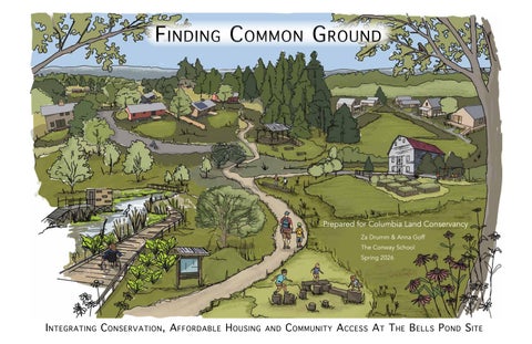
F inding C ommon G round
Prepared for Columbia Land Conservancy Za Drumm & Anna Goff The Conway School Spring 2026
I ntegrating C onservation , A ffordable H ousing and C ommunity A ccess A t T he B ells P ond S ite
3571 US-9, Hudson, NY 12534
Finding Common Ground
Designed By: Anna Goff and Za Drumm Spring 2026
Index of Sheets
Project Overview............................................................................1 Project Goals and Existing Conditions......................................2 Regional Context...........................................................................3 Site History.....................................................................................4 Ecological Value............................................................................5 Existing Vegetation.......................................................................6 Soils and Surficial Geology.........................................................7 Slopes and Drainage......................................................................8 Regional Hydrology.....................................................................9 Trails Views and Destinations.....................................................10 Design Alternatives.....................................................................11 Final Design Overview.................................................................12 Final Design Features..................................................................13 Vegetation Zones..........................................................................14 Meadow Palette............................................................................15 Shrubland Palette........................................................................16 Upland Forest Palette.................................................................17 Floodplain Forest........................................................................18 Trails and Design Features.........................................................19 Trail Network Accessibility......................................................20 Boardwalks, Bridges and Observations Deck..........................21 Bird and Wildlife Blinds...........................................................22 Vegetative Screens.......................................................................23 Vegetated Berm.............................................................................24 Trillium Barn................................................................................25 Trillium Neighborhood Concept...............................................26 Good Neighbor Palette...............................................................27 Good Neighbor Planting Guide.................................................28 Citations by Section.....................................................................29 Photo Citations............................................................................30
88 Village Hill Rd.Northampton, MA 01060 413-369-4044 www.csld.edu
Index of Sheets
Columbia-Greene Habitat for Humanity Part of the Bell’s Pond Site’s desirability is its proximity to Habitat’s existing Hudson Restore and organizational headquarters which abut the property. Columbia-Greene Habitat has built or refurbished twenty-seven homes since becoming established in 1993. Its housing target of building twenty-six homes on its portion of the Bell’s Pond Site would nearly double its past contributions to the regional housing market.
Drone image of the Bell's Pond Site, looking north (credit: Columbia Greene Northern Dutchess MLS)
Aligning Affordable Housing and Conservation Goals
In 2022, based on the understanding that affordable housing and conservation initiatives depend upon the same landbase and might best further their goals through collaborative efforts, CLC and Habitat joined eleven other organizations to form the Hudson Valley Alliance for Housing and Conservation. This partnership was a response to the impact of real estate trends, exacerbated by the COVID-19 pandemic and the Hudson Valley’s proximity to New York City, on conservation and affordable housing opportunities in the region. Sprawling real estate development is threatening open lands and the associated ecological services that all life depends upon. At the same time, low-income individuals and families are being displaced from the region due to increasing housing costs and shrinking rental opportunities. Trillium joined the alliance in 2025. The Bell’s Pond collaboration is one of a number of pioneering projects, rooted in this Alliance, which strive to “better serve Hudson Valley residents and communities by meeting the need for affordable housing, conserving important lands for human and ecological benefit, and adapting to and mitigating the effects of climate change” (Alliance). Scenic Hudson, another member of the Hudson Valley Alliance, is supporting the Bell’s Pond project as a significant fiscal contributor and partner.
Rendering by Holesum Studio for Habitat's housing (Dimitri Brand)
Habitat is working with Holesum Studios and Proper and O'Leary Engineering to design a site plan for a neighborhood of low-carbon, sustainable "Rural Starter Homes". The houses were designed by Holesum Studios to minimize construction costs and to fit Habitat’s model of builds that supported by volunteer labor. The site has an existing septic system, installed in 2011, which spans the Bell’s Pond Site and Habitat’s current property and should have adequate capacity for Habitat’s housing goals based on the system's design specifications. Though parcel sizes and shapes are not yet finalized, the area of the site subdivided for Habitat will be adjacent to its current property located southeast of the site.
Trillium Community Land Trust Trillium Community Land Trust began in 2022 as a working group of concerned citizens and housing professionals and incorporated as a nonprofit in 2024. Since then it has established a growing board of directors and acquired a home to renovate as affordable housing. Trillium hopes to build between sixteen and twenty-five units on its parcel. Trillium is early in its conceptual planning process, but is interested in pocket neighborhoods that incorporate sustainable building practices. Trillium will acquire the existing buildings located in the northeast corner of the site.
Rendering of Trillium's preliminary housing concept (Lead Architect: Linda Gatter AIA; Design Team and Rendering: Alexa Dannis)
88 Village Hill Rd.Northampton, MA 01060 413-369-4044 www.csld.edu
Since its founding in 1986, the Columbia Land Conservancy has conserved over 30,000 acres of land within Columbia County, including eleven properties that are open daily for the public to enjoy. To help the organization plot a course forward that is aligned with both their mission and community input, CLC developed “The Plan to Conserve Columbia County”, finalized October 2025. This Plan calls for CLC and conservation partners to conserve 35% of what it identifies as “critical” or “high priority” landscape by 2035. Though categorized as “medium” overall priority by the metrics used in this Plan, CLC recognized a valuable opportunity at the Bell’s Pond Site for modelling conservation efforts that support socioeconomic equity and sustainable housing development.
3571 US-9, Hudson, NY 12534
The different models of ownership translate to different spatial layouts in the residential developments. Habitat homes will be sold on onethird to half-acre properties and homeowners will be responsible for managing the land as they choose. Trillium homes will likely be sited closer together and there may be formal agreements that they adhere to around landscape and vegetation standards of the leased land.
Columbia Land Conservancy
Finding Common Ground
Columbia-Greene Habitat for Humanity and Trillium Community Land Trust (CLT) share the goal of creating affordable housing opportunities in the region, but differ in their approach, history, and scope. Both organizations strive for their residents to build equity through their homes, while limiting resale value to ensure that the housing remains affordable. Habitat will sell homes and lots with deed restrictions regarding resale. As a community land trust, Trillium will sell homes with an agreement that limits resale value through a 99-year ground lease with Trillium. Retaining ownership of the land helps community land trusts ensure that the housing will remain affordable for future generations.
Project Clients
Designed By: Anna Goff And Za Drumm Spring 2026
The Columbia Land Conservancy (CLC) is currently under contract to purchase a 143-acre parcel located on NY State Route 9, straddling the Greenport/Livingston town line. The property is being referred to as the Bell’s Pond Community Space (or Site in this document) due to its proximity to Bell’s Pond. The Bell’s Pond Site differs from CLC’s standard acquisitions both in its ecological character, which is shaped by recent anthropogenic disturbance, and intended use of furthering regional housing and conservation goals simultaneously. To do this, CLC plans to gift two subdivided parcels, approximately 15 acres each, to Columbia-Greene Habitat for Humanity (Habitat) and the Trillium Community Land Trust (Trillium) to develop affordable housing on their respective parcels. CLC will retain and manage the remaining acreage as public conservation lands. This project explores how housing, conservation, and public access can coexist on a shared landscape.
Two Nonprofits, Two Approaches to Housing
Plan Overview
Project Overview
1/10
C Fallow Fields
A
B
Barn
Shop
e9
Agricultural Fields
Circulation Recommendations for human and vehicular circulation, including siting trails and paths, public parking on the conservation lands, and parking on the Trillium parcel, prioritizing universal access wherever possible. Stormwater A design that improves stormwater management across the site.
F
ame Unn
G
F
One of many mown paths
Example of stormwater infrastructure
The Mud Creek, looking west
Old barn with Alliance Truck Centers beyond, looking north from the gravel drive
Old farmhouse, looking north from the gravel drive
Humanity Restore
eek d Cr
2025 Satellite (credit: Google Earth) with the property boundary
H
B
Habitat For
H E
A
E
Unnamed creek, looking east
D
Topsoil pile from 2011 site work, looking south
C
Renovated barn and gravel drive, looking east towards Route 9
Finding Common Ground
D
Residential Greenspace Recommendations for low-maintenance, native vegetation and other design elements for shared greenspace within the residential housing developments.
Ranch House
Much of the site consists of active agricultural fields and fallow fields that are returning to scrubland and young forest. More mature forest borders the creeks and the wetland swales that feed the creeks. The site contains both New York State Department of Environmental Conservation and Army Corps of Engineers designated wetlands. There are mown paths and access roads crisscrossing the site, leading to hunting infrastructure such as blinds and deer stands. Trails also lead to portions of the septic and stormwater infrastructure installed on the site in 2011 to facilitate a baseball training facility which never came to fruition. There are several large piles of topsoil, left over from the 2011 infrastructure installation and regrading, remaining in the northeast corner of the site.
Designed By: Anna Goff And Za Drumm Spring 2026
G
ut
•
Allegiance Truck Center
Ro
•
Ecological Restoration A restoration and management plan for the CLC property that increases biodiversity, addresses invasive species pressure, and facilitates educational and community stewardship opportunities.
reek
•
Drone image of the ranch and renovated barn, looking west (credit: Columbia Greene Northern Dutchess MLS)
Mud C
•
Private vs. Public Space A landscape design that defines the relationship between private residential space and public conservation lands, as well as abutting properties and roadways, using vegetative buffers and other design elements.
The 143-acre Bell’s Pond Site spans the Livingston/Greenport town line, with 61 acres to the north of the line in Greenport and 82 acres to the south in Livingston. The site is bordered by a two-lane portion of NY State Route 9 to the east, an unnamed creek to the south, and the Mud Creek to the west and north. The site abuts farmland across the creeks to the south and west, Habitat for Humanity's Restore and offices to the south on Route 9, and Allegiance Truck Centers to the north on Route 9. Three driveways enter the site from Route 9, providing access to the buildings on the northeastern corner of the site. These buildings include a small shop, currently rented to a local contractor, a modern ranch house, a large renovated barn, a smaller deteriorating barn, and an old house in an advanced state of disrepair.
Project Goals & Existing Condtions
Columbia Land Conservancy, Columbia-Greene Habitat for Humanity, and Trillium Community Land Trust collaborated on the following list of shared and organization specific landscape design goals based on a shared vision for the future of the site. •
88 Village Hill Rd.Northampton, MA 01060 413-369-4044 www.csld.edu
Existing Site Conditions
3571 US-9, Hudson, NY 12534
Project Goals
2/10
88 Village Hill Rd.Northampton, MA 01060 413-369-4044 www.csld.edu
Regional Context The Bell's Pond Site is located within the Hudson River Valley of Columbia County, New York, where broad agricultural floodplains transition into the foothills of the Taconic and Catskill Mountains. Situated approximately four miles east of the Hudson River, ten and a half miles west of the Taconic Mountains, and twelve miles east of the Catskill Mountains, the site occupies a position within a regional landscape shaped by geology, hydrology, and centuries of agricultural land use.
The half of the site that is in the town of Greenport falls within the Hudson school district, creating opportunities for Hudson families to relocate to one of the future affordable housing developments while remaining in the school district. Because Greenport has minimal zoning restrictions and well developed infrastructure, the town has become a default place for development in the region. The Bell’s Pond Site could set an important precedent for housing development with ecological integrity. Greenport and Hudson are currently designated as Disadvantaged Communities based on criteria developed by New York State’s Climate Justice Working Group (New York State Climate Leadership and Community Protection Act), stressing the importance of this project which addresses regional environmental and socioeconomic needs simultaneously. The site is located across Route 9 from Galvan’s Civic Motel which provides emergency housing to individuals and families in need and just up the road from the Bell’s Pond Community Mobile Home Park, meaning that the publicly accessible trails on the Bell’s Pond Site could benefit these communities in addition to those on the site.
Implications
Foothills of the Catskill Mountains
The regional history, ecological significance, and existing landscape character of Bell's Pond provide a strong foundation for achieving the project's goals of conservation, ecological restoration, public access, and community development. By protecting wetlands, floodplains, and wildlife corridors while expanding native habitats, the site can increase biodiversity on the site and within the region's broader ecological network. Carefully planned development areas for the Columbia-Greene Habitat for Humanity and Trillium Community Land Trust neighborhoods would allow housing needs to be addressed while minimizing ecological disturbance, creating a model for integrating affordable housing with long-term land conservation.
3571 US-9, Hudson, NY 12534
Looking west over Bell's Pond's existing agricultural fields toward the Catskill Mountains, a defining regional landmark that shapes the scenic identity and sense of place within the Hudson Valley.
Finding Common Ground
The site's position creates opportunities to support biodiversity while providing community access and housing, in an already beautiful and sought after location. From 2019 to 2025 the median sale price of a home in Columbia County increased from $257,500 to $527,450, the second most dramatic percentage increase of the nine counties in the Hudson Valley Region (Hudson Valley Pattern for Progress). As a result, many residents are being priced out of the area despite an increase in residential development (Hudson Valley Pattern for Progress).
Regional Context
The Hudson Valley has long been a center for agriculture, transportation, and industry. Forests were cleared for farming, while river commerce, railroads, mills, brick manufacturing, and mining transformed the region and established many of the agricultural and settlement patterns that continue to define Columbia County today. This combination of ecological richness, cultural history, scenic character, and accessibility contributes to the area's significance for conservation, recreation, and thoughtfully planned rural development (CLC, 2026).
Designed By: Anna Goff And Za Drumm Spring 2026
Bell's Pond lies within an ecological transition zone where floodplains, wetlands, agricultural lands, and upland forests converge. This intersection of landforms creates a diverse landscape characterized by fertile soils, interconnected waterways, varied topography, and important wildlife corridors. The surrounding mountain ranges contribute forested watersheds and the scenic character which helps define the region (Columbia Land Conservancy, 2026).
A publicly accessible trail system would reconnect people to the landscape through opportunities for recreation, education, and stewardship, potentially furthering ecological goals throughout the region by helping to build ecological awareness.
3/10
The region around the Bell's Pond Site was part of a broader Hudson Valley landscape composed of floodplains, meadows, shrublands, open woodlands, forests, and wetlands, rather than a uniformly forested landscape. These environments were influenced by Indigenous stewardship practices, including selective harvesting, cultivation, and low-intensity fire. These management techniques promoted a diversity of successional stages and encouraged species such as white oak, hickory, blueberry, huckleberry, blackberry, hazelnut, and hawthorn while supporting wildlife habitat and biodiversity. (Wexler, 2024)
Hudson Park Baseball Training Facility Plan
Shrubland
Agricultural Field
Upland Forest
Shrubland
Floodplain Forest
Colonial Agricultural Transition Following European settlement, the Bell's Pond Site became part of Livingston Manor, a 160,000-acre estate established in 1686. The manor laid the foundation for settlement patterns, agricultural development, and land ownership across much of present-day Columbia County (Pope, 1886). Under the Livingston Manor system, large portions of the region were cleared for agriculture, grazing, timber harvest, and settlement. This shift in land use coincided with the displacement of Mohican communities through disease, colonial expansion, violence, and land dispossession, resulting in the decline of Indigenous stewardship practices. By the nineteenth century, much of Columbia County had been transformed into a landscape dominated by fields, pastures, orchards, and managed woodlots. These land uses introduced new disturbance regimes and altered the trajectory of ecological succession throughout the region. (Edinger et al.; Wexler, 2024)
88 Village Hill Rd.Northampton, MA 01060 413-369-4044 www.csld.edu
In 2011, a previous owner of the property planned the Hudson Park Baseball Training Facility. An extensive septic system was installed across the site, new wells were drilled in the south of the site, and preliminary grading work resulted in the flattening of areas of the site and several large mounds of topsoil. Portions of a stormwater management system were installed, including drainage piping, sub-drainage systems, erosion and sediment controls, and a constructed wetland mitigation area designed to manage runoff and offset wetland impacts associated with the proposed development. Although the baseball complex was never completed, these improvements and preliminary grading work remain on the site, continuing to influence drainage patterns, hydrology, soil conditions and development potential.
Map showing the distribution of the successional stages present on the site in 2025
The vegetation patterns and species composition of the habitat types present today at the Bell's Pond Site reflect the cumulative history of these different periods of land-use. Almost the entire site was in cultivation as recently as 2006. Currently, there are active agricultural fields and previously cultivated areas in various stages of regrowth. Old fields have grown into shrublands, an early successional stage. The forests on the site, which represent a later successional stage, are a mix of upland forests and floodplain forest. Numerous apple trees can be found in the wooded edges of the site, an remnant from past orchards. The regrowth on the site is a mix of native species, naturalized European species, common to old farmsteads, and more newly introduced invasive species.
Implications •
Areas of former agricultural production and orchard management may exhibit soil compaction, altered nutrient levels, and residual contaminants, such as the arsenic identified in the 2011 SEQR Environmental Assessment. Further soil testing could be used to advise restoration efforts, and remediation if needed.
•
The location of existing infrastructure associated with 2011 site work for the baseball camp should be incorporated into site planning to avoid spatial conflicts and to allow for the potential utilization of these infrastructural resources.
3571 US-9, Hudson, NY 12534
For thousands of years, Indigenous peoples, including the Mohican people, used the Hudson River and its tributaries as transportation corridors connecting villages, agricultural areas, and regional trade networks (CLC, 2026). A 2011 Phase IB Cultural Resource Survey identified locations on the Bell's Pond Site containing Native American cultural materials that were interpreted as "waste products associated with processing glacially deposited chert [stone] as an early stage of stone tool production (SEQR)." These findings provide possible evidence of Indigenous use of the property.
Finding Common Ground
Baseball Camp Site Work
Designed By: Anna Goff And Za Drumm Spring 2026
Pre-Colonial: Archaeological Findings
Land Use & Succession
Site History
Site History
4/10
Shrubland Habitat
The existing fallow and cultivated agricultural fields represent significant ecological restoration opportunities at Bell's Pond. Conversion to native habitat would dramatically increase plant and wildlife diversity. Maintaing early successional meadow, grassland, shrubland, and young forest would be of particular value, as they have become increasingly uncommon throughout the Northeast as abandoned agricultural lands mature into closed-canopy forest (NYSDEC, 2015). In New York, abandoned fields can mature from fields to closed canopy forests in as little as twenty-five to thirty years (NYFOA).
Invasive species pressure can be high in early successional and edge habitats. In the emerging shrublands on the site honeysuckle, autumn olive, buckthorn, bittersweet and multiflora rose are all present and spreading. These opportunistic species can outcompete native plant vegetation, decreasing biodiversity. The displacement of native species which have coevolved to support the lifecycle of specialized native pollinators is of particular concern. Invasive plant species do provide wildlife services, such as cover, forage, and nesting sites. Ideally, when removing invasive or opportunistic species, care would be taken to replace any ecological services lost using native plants.
Cultivated Field 1st Year Fallow Field
Grassland and Meadow Habitat
Old Field, Shrubland
Grassland and meadow habitats are dominated by grasses and flowering forbs. Grassland bird habitat has a higher proportion of grasses and sedges, with forbs ideally occupying no more than 25% of the grassland area, and almost no woody vegetation (NYSDEC, 2022). Meadows typically have a higher proportion of flowering forbs, ranging from 20-50%, and may have more woody vegetation and canopy cover than grasslands.
Forest
Wetland & Floodplain Habitats
Native meadows support bees, butterflies, skippers, moths, and other beneficial insects while providing nesting cover and forage for species such as American goldfinch, field sparrow, and eastern bluebird (Xerces Society, 2024; NYSDEC, 2015). Grasslands that are greater than twenty acres, free of trees and shrubs in which predators could roost or take cover, with minimal forest edge are of the greatest value for grassland birds. Some less sensitive grassland bird species, such as bobolink and eastern meadowlark, may utilize smaller areas of grassland, but in the Hudson Valley region of New York, smaller fields, especially those surrounded by forest, may be of greater value to wildlife as shrubland (NYFOA).
Autumn Olive with emerging berries on site, June 2026
Young red maple stands emerging on the site, June 2026
Healthy wetland and floodplain habitats provide flood storage, groundwater recharge, water filtration, and habitat for amphibians, birds, mammals, and aquatic organisms (Edinger et al., 2014). Approximately 68 acres of the 143-acre Bell's Pond site are wetlands or within the 100 foot wetland buffers, making these systems a dominant feature of the landscape (Columbia County Environmental Management Council, n.d.). Much of the wetland on the site has been recently disturbed resulting in low diversity wand reduced ecological and hydrologic value. Wetlands and their associated buffers are protected under New York State and federal regulations, with exemptions for agricultural activities. (NYDEC, n.d.).
Young Forest Habitat
Implications
Like shrubland, the dense vegetation of young forest can provide habitat for nesting birds and helps support the New England Cottontail by providing forage and cover. There are young forests of different ages and species composition emerging on the site.
•
Promoting diverse native vegetation within wetland buffers, drainage swales, and floodplain forests would improve these habitat’s ecosystem functions to benefit the hydrology and ecology of the site and the region.
•
Maintaining a mix of successional habitat types while managing for invasive species could increase biodiversity across the site. Trails navigating these different habitats could provide varied recreational and educational experiences for residents and visitors.
•
The size, shape, species composition of different habitat types, as well as their poximity and connectivity to other habitats on the site, will influence which wildlife species they best support.
Mature Forest
Evidence of wild turkey and coyote on the site, June 2026
Wetland Boundary (2011 Delineation)
There are some stands of mature forest on the site. Mature forests provide important wildlife corridors, year-round forage, and nesting sites for forest birds. Mature forest near riparian areas, like those at the Bell's Pond Site, can help stabilize soils, maintain cooler soil, groundwater, and stream temperatures, and improve hydrologic and ecological function. Large tracts of contiguous forest are of the greatest ecologic value.
Finding Common Ground
Cultivated and Fallow Fields
Shrublands provide some of the benefits of meadows due to their matrix of forbs, grasses and woody shrubs. The shrubs provide additional cover, forage, and nesting sites for wildlife. Selective shrubland management, through periodic mowing or burning, can help retain habitat conditions that are increasingly scarce within the regional landscape. Shrubland habitat that is two to five acres or more and at least twenty feet in width provides superior habitat to more fragmented patches. Wider areas of shrubland offer better protection to nesting birds (NYFOA).
Designed By: Anna Goff And Za Drumm Spring 2026
The Bell's Pond Site contains a diverse network of ecological communities representing multiple stages of succession, including wetlands, floodplain forests, meadows, shrublands, regenerating forests, and mature upland forests. Together, these habitats support wildlife, improve water quality, and contribute to ecological resilience across the property (Edinger et al., 2014).
Bells Pond Site
Habitat Diversity
Evidence of a ground nesting bird on the site, June 2026
88 Village Hill Rd.Northampton, MA 01060 413-369-4044 www.csld.edu
Successional & Wetland Habitat Map
3571 US-9, Hudson, NY 12534
Ecological Value of Existing Habitats
5/10
Deciduous Forest
This vegetation map was created by correlating observations and GPS points recorded at the site with Google satellite imagery from fall of 2024. The map is not exhaustive, but gives an idea of species composition across the site, with a focus on which trees predominate areas of the canopy. Likewise, the below descriptions are not complete species inventories, but are rather meant to give an idea of the current character of the site. The existing conditions described will advise ecological restoration and design recommendations.
Black Locust
Oldfield/Scrubland Black Willow
Pine & Ash Cedar Forest Poplars
Lawn
Boundary Tree Recruitment (Upland Forest)
Cultivated Fields
Oldfield/Scrubland as s Pine & Cedar Forest
ba
ge
Fallow Fields
kC
ab
Pine & Cedar Forest
Ash
Gr as s
un
Reed Canary Grass
a n a ry
Oldfield/Scrubland
Young cedar, autumn olive, buckthorn and honeysuckle are the most prominent species in the dry shrublands. There are some areas of sumac, arrowwood viburnum, nannyberry, brambles, and sapling trees. Milkweed, goldenrod, penstemon, wolfbane, poison ivy, native columbine and other grasses and forbs are present as well. There is a mix of native species, naturalized European species, (such as mustards, Dianthus armeria, bedstraws, and wild daisies) and plants broadly recognized as invasive.
R eed C
Oldfields (Emerging Shrubland and Meadow)
Pine & Cedar Forest
Poplars Black Willow Oldfield/Scrubland
Lawn
Black Locust
Deciduous Forest Deciduous Forest
Deciduous Forest
Creekside (Floodplain Forest) There are wide expanses of skunk cabbage along the creek, flanked by stands of green ash and other hardwood trees. Multiflora rose and bittersweet are also present along the edges between the trees and skunk cabbage.
Wetland & Buffers There are thick stands of young red maple and grey dogwood emerging in the wet areas of the site. Many of the wetland zones that lack canopy are monocultures of reed canary grass. Pampas plume grass is also present. On slightly drier ground the vegetation becomes more diverse with different types of ferns and forbs. Mature black willows, pussy willows and other species of shrub willows are also present in and around the wetlands.
Primarily Deciduous Forest
Black Willow
Pine & Cedar Forest
Poplar
Oldfield/Scrubland
Hickory, Oak, Hophornbeam, Maple
First-year Fallow Fields
Green Ash
Cultivated Fields
Black Locust
Mown Lawn (along road)
Skunk Cabbage (along creek) Reed Canary Grass & Pampas Plume Grass)
3571 US-9, Hudson, NY 12534
dC
Gr
Finding Common Ground
R ee
ry a na
Designed By: Anna Goff And Za Drumm Spring 2026
Ash
Cultivated Fields
Existing Vegetation
Deciduous Forest
Sk
The more mature trees are mostly confined to the perimeter of the site near the creeks and house sites. Shagbark hickory, bitternut hickory, red oak, American hornbeam (in the south), green ash, sweet birch, quaking aspen, apple trees, and black locust (in the north) are all present along the boundaries of the site and other historically uncultivated areas of the site, such as the slopes around the wetlands. Hardwood saplings of the same species as nearby boundary trees can be seen spreading into the interior of the site in areas where cultivation and mowing have not occurred for a few years or more. The southern portion of the western boundary has a thick stand of cedar and pine between the hardwoods along the creek and the shrublands and fields to the east. In the deciduous forest there were extensive patches of trout lilies, some nice patches of ramps, and other native spring ephemerals..
Lawn
Black Locust
Oldfield/Scrubland
Ash
88 Village Hill Rd.Northampton, MA 01060 413-369-4044 www.csld.edu
Existing Vegetation
6/10
88 Village Hill Rd.Northampton, MA 01060 413-369-4044 www.csld.edu
Soils & Surficial Geology NYS Geological Survey Data for Surficial Geology
Soil Groups The soils types at the Bell's Pond Site can be categorized as wetland soils, transitional valley soils, and upland soils. Together, these soil groups create a gradient from saturated floodplain environments to well-drained upland landscapes, supporting a diversity of ecological communities across the site.
Alluvial Fan
Wetland soils occupy the lowest portions of the property, including floodplains, wetlands, and stream corridors. These soils are poorly drained and frequently saturated, supporting floodplain forests, wet meadows, shrub wetlands, and other hydric habitats. Their ability to store water and support wetland processes makes them critical for flood mitigation, water quality, and wildlife habitat.
Upland soils are found on the site's higher elevations. These well-drained soils provide greater stability, faster rates of infiltration, and suitable growing conditions for upland forests and meadow communities. Their drainage characteristics make them generally more suitable for development. The cluster of buildings in the northeast of the property were built on upland soils.
•
An ongoing history of agricultural activity has likely resulted in a loss of soil structure, soil biota, and certain nutrients.
•
The 2011 construction included site work and excavation. The heavy machinery used likely resulted in soil compaction in addition to that caused by agricultural cultivation involving regular tillage. Such compaction could compound the slow stormwater infiltration rates of the less well-drained soils on the site.
Natural Resources Conservation Service Soil Classification Data •
Upland
During this construction, large quantities of soil were scraped off the surface of the site for grading purposes and deposited to form the mounds in the northeast of the property. Areas where topsoil was removed may be less fertile.
Surficial Geology The Bell's Pond Site is shaped by two primary surficial geologic deposits: lacustrine sediments and alluvial fan deposits. The primary deposit across the site is lacustrine silt and clay, formed in glacial lakes that occupied the Hudson Valley following the retreat of the Laurentide Ice Sheet, about fifteen thousand years ago. These fine-textured sediments create poorly drained conditions and influence much of the site's hydrology. The site's alluvial fan deposits are part of a broader pattern of glacial and postglacial sedimentation that characterizes the Hudson River Valley. Along the edges of the valley, alluvial fan deposits occur where streams emerging from higher elevations slowed and spread across flatter terrain, depositing layers of sand, gravel, and silt in fan-shaped landforms. More recent alluvial deposits are found along active stream corridors and floodplain areas, where water continues to transport and deposit sediment during flood events. Alluvial deposits are generally better drained and more stable than the surrounding glacial lake sediments. Similar coarse-textured deposits throughout the region have historically served as important sources of sand and gravel, reflecting the powerful influence of glacial meltwater and stream processes on the modern landscape.
Implications •
Restoration efforts would be best served by protecting floodplain soils by limiting circulation and development in areas where they are present.
•
Infrastructure like boadwalks and bridges could help protect the softer and more saturated soils in the wetland areas, helping to preserve the soil structure, and related hydrology and habitat.
•
Revegetation efforts such as the establishment of meadows and forest can help remediate compaction as they form deep root systems. In doing so, they will also improve infiltration and filtration of water on the site. Conversely, existing soil compaction may make it more difficult for some species to thrive.
•
Chosing native species that have evolved on these soil types and surficial geology deposits will reduce the need for soil ammendments.
Transitional Valley
Wet/ Flood plain
3571 US-9, Hudson, NY 12534
Site Soil History
Finding Common Ground
Alluvium
Soils & Surficial Geology
Lacustrine Silt
Transitional valley soils occur across the broad central portions of the site where drainage conditions are more moderate. These soils serve as a bridge between the wetter floodplain environments and the drier uplands, supporting a mix of early successional and forest communities. Historically, these areas have often been favored for agriculture due to their relatively fertile and workable conditions. The borders of the existing cultivated fields largely match the extent of these soil types.
Designed By: Anna Goff And Za Drumm Spring 2026
Knickerbocker, Blasdell
7/10
Wetland
Wetland
The culvert under Route 82 that connects Bell’s Pond to the site is rated as a “moderate barrier” with the maximum passable storm event being a 100-year storm. There are at least two other unassessed culverts between Bell’s Pond and the site (NYSDEC). The culvert that allows the unnamed order one creek to the east of the site to pass under Route 9 is classified as a moderate barrier, with its current passable storm event modeled as a ten-year storm. This may result in the stream jumping the road in a more significant storm event, but the low order of the stream makes this potential less of a concern (NYSDEC). An inundation flood risk map from Redfin is shown inset in the red box on top of a map from the Hudson Valley Natural Resource Mapper showing culvert status.
Wetland
NY Route 9 Drainage, looking northwest
% Slope
Percent Slope
88 Village Hill Rd.Northampton, MA 01060 413-369-4044 www.csld.edu
The earthen dam, located approximately three quarters of a mile from the site, that retains water in Bell’s Pond was rated as a “low hazard” risk, meaning a breach is unlikely to cause significant environmental damage, significant economic loss, interruption of important utilities, or personal injury and loss of life (NYSDEC). It was last inspected in 1998 (U.S. Army Corps of Engineers). Nonetheless, maintaining an awareness of the dam’s status may be prudent given the site’s location below Bell’s Pond.
Drainage & 100' Wetland Buffer Wetland Buffer
Water from the surface of NY Route 9 sheds off the road and directly onto the Bell's Pond Site. There are no drainage features or curbs to slow or direct the water.
NY Ro ut e9
Implications •
The site's gentle topography creates opportunities for accessible circulation and flexible land use, while highlighting the importance of drainage patterns and soil conditions as primary organizing features of the landscape.
•
Trails near the creekside borders of the property would navigate more elevation changes compared with those sited on the flatter interior of the site.
•
Trails and infrastructure near the creeks and associated steeper grades are more likely to face erosion or inundation flooding and should be designed accordingly.
•
Wetland and floodplain restoration can help decrease flood risk on the site and downstream.
3571 US-9, Hudson, NY 12534
As some of the most ecologically significant and hydrologically sensitive areas on the property, wetlands and their associated buffers present important considerations for future planning and stewardship. Any trails, access roads, or infrastructure crossing wetlands or regulated buffer areas would require permitting and careful design to minimize impacts. Understanding these drainage patterns helps identify opportunities for conservation, restoration, access, and community use while maintaining the site's hydrologic and ecologic functions.
Flood Risk and Offsite Infrastructure
Finding Common Ground
Numerous low-gradient swales, many of which are wetlands, run from the interior of the property into the bordering creeks. Steeper slopes are generally confined to these streambanks and drainage features. This relatively gentle topography contributes to slower surface runoff, increased water retention, and the formation of extensive wetland and floodplain systems.
The inundation flood risk, as mapped by Redfin, is confined to the floodplains and swales on and around the property. Inundation of up to three feet is possible in these areas.
Designed By: Anna Goff And Za Drumm Spring 2026
The Bell's Pond Site is a predominantly flat to gently rolling landscape, with most of the site exhibiting slopes below five percent. Surface water generally flows from the slightly elevated eastern portions of the Bell’s Pond Site toward lower elevations along the western, southern, and northern edges of the property, where extensive wetlands and stream systems occur. Water runs off of Route 9 along this eastern edge and onto the property.
Inundation Flood Risk & Road-Stream Crossing Status
Inundation Flood Risk
Slopes & Drainage
Slopes & Drainage
8/10
Stockport CreekTinderhook Creek Watershed
Bell's Pond Site Drainage from Site to the Hudson River
g Ta
2 mi
Tracing Drainage to and from the Bell's Pond Site Ta g
hk an
Bell's Pond Site
Unnamed Creeks
2 te 8 Rou
Direction of flow to and from the Bell's Pond Site
Cr ee
k
9 te
Mu d
u Ro
Cre ek
ic
Bell's Pond
Bell’s Pond, for which the site and nearby hamlet are named for, sits approximately a mile down Route 9 (and Route 82) from the site. Water flows from Bell’s Pond, a 15-acre dammed lake with a maximum and normal storage of 120 acre-feet of water, into an unnamed creek that joins with the unnamed creek to the south of the site through a culvert about halfway across the site’s southern boundary. The creek along the southern boundary originates about 850 feet across Route 9 from the site and flows through the fire pond created on the current Habitat for Humanity Restore Parcel. The portion of this stream that defines the western section of the property’s southern boundary appears to have been straightened in the past. Near the southwest corner of the property, this creek joins the Mud Creek, which flows north, defining the northern half of the property’s western boundary The Mud Creek flows into the Taghkanic Creek. The Taghkanic Creek flows into the Claverack Creek, leaving the Loomis Creek-Taghkanic Creek Watershed and (HU-12) entering the Mud Creek-Claverack Creek watershed (HU-12). The Claverack Creek flows north into the Stockport Creek, where the drainage from the Bell’s Pond Site cuts west across the southern finger of the Stockport Creek-Kinderhook Creek Watershed (HU12) before flowing into the Hudson River.
Implications •
Revegetation of the site and ecologically informed stormwater management would help cool runoff from the site so that it does not contribute to the warming or pollution of the creeks downstream which are part of the ecological significant Lower Hudson watershed (HU-6).
•
There may be a possibility for recreational trout fishing on the site.
•
There is a citizen science opportunity for water quality monitoring on the site.
Finding Common Ground
Loomis CreekTaghkanic Creek Watershed
Designed By: Anna Goff And Za Drumm Spring 2026
ive
Hu ds on R
Riv er ds on
0 mi
Mud CreekClaverack Creek Watershed
Regional Hydrology
The creeks that border the site and connect to Bell’s Pond are classified as “known trout streams” by the NY Department of Environmental Conservation. All the streams in the Taghkanic Creek-Loomis Creek watershed are listed as "needs verification" in the priority water bodies list, so it is unknown whether their current water quality supports trout (NYSDEC).
Murder CreekHudson River Watershed
Hu
Stormwater from the Bell’s Pond Site travels north through a series of connected streams before flowing east into the Hudson River (as described to the left). The Bell’s Pond site is located towards the headwaters of the Loomis-Taghkanic Creek HU-12 watershed and the HU-10 Claverack Creek watershed, which share a boundary to the south. The small tributaries that make up the headwaters above the site to the south are all identified as “known important coldwater stream habitat.” This status ends at the southwestern corner of the site where two unnamed creeks flowing from the south and east merge. The Taghkanic Creek and all the streams downstream towards the Hudson are identified as “known important areas for migratory fish.”
r
k
ree
C ic
an hk
The Hudson River Estuary provides some of the most critical fish spawning habitat along the eastern seaboard (CLC, 2026). Key migratory species supported by the Hudson River include perch, herring, shad, striped bass, eels, and the endangered Atlantic sturgeon (NYSDEC).
88 Village Hill Rd.Northampton, MA 01060 413-369-4044 www.csld.edu
HU-12 Watershed Boundary
Regional Stream Ecology
Drainage Through HU-12 Watersheds
3571 US-9, Hudson, NY 12534
Regional Hydrology
9/10
Trails, Views & Destinations
88 Village Hill Rd.Northampton, MA 01060 413-369-4044 www.csld.edu
Circulation & Views Key Existing Trail Large Oak
Trails and Succession
Eyesore
Trucking Center
Trail Obstacle
Stormwater Infrastructure
Undesirable View Desirable View
Old Deer Blind
Destination
Poplar Grove
Mountain Views
ute 9
Meadow View
Ro
Mountain Views
Spring View of Hills
Mountain Views Wet Spots on Septic Line
Deer Path Maze
Existing mown paths through grassland, looking west on southern trail
View of View of Boundary Trees Barn
Mown path through young maple Path through dense cedars on grove, southeast corner of the property the western boundary
Rubble Pile
Habitat Restore
Dead Vines Poofy Pines
Undesirable Views Views of Route 9 and the Allegiance Trucking Center have been identified by the clients as undesirable. Most of the stormwater and septic infrastructure on site is small relative to the expanse of the landscape, and therefore not an eyesore. There are some areas in the southwest of the property where tangles of vines, or deceased conifers in denser forest, create unattractive brown tangles.
Desirable Views
Dead Cedars
Pine Arch Pleasant Spot
Creek Views
Grand Oak
Creek View
Cultivated Field 1st Year Fallow Field Old Field, Shrubland Forest
Creek Views
There is a nice view over the property towards the mountains on the western horizon from the back patio of the renovated barn. Trillium would like to protect or enhance this view, as the space will likely be used for gatherings and programming.
Implications Creation of new trails and repositioning of trails will become more labor intensive and disruptive as succession progresses and more woody plants grow up.
Parts of the Catskill Range are visible from much of the high eastern side of the site and other high points, such as the tops of the rolling hills in the south of the site. Traveling west the views are hidden as one descends into swales and then revealed at higher elevations. Likewise, thicker vegetation and curves in the trails limit views temporarily, providing a sense of intrigue as the views are revealed.
Siting of trails and the siting and composition of vegetative screens around residential developments should respond to how the views, hydrology, wind, and other climatic conditions change throughout the year. Boardwalks or small bridges may be needed to span wet spots and swales, especially for a creekside loop. Adding this infrastructure through wetlands would provide a more pleasant and accessible user experience. Boardwalks help limit ecological and hydrologic disturbance, after the initial disturbance of installation, by lifting the trail off of the soil surface.
The successional vegetation (including the invasive species that proliferate along habitat edges) screens some western views in the summer, hiding potential sightlines to the creeks and hills beyond. Seasonal changes in the vegetation also impact views. For example, long views to the west are open from high points on the generally lower west side of the site after leaf drop, but are obscured after the trees along the western property line leaf out Wolf trees provide a good destination, changing one’s sense of scale as they approach them. These larger trees are mostly found along the margins of the property and at the interior of wetlands and swales where there has been less disturbance. A few particularly attractive sizable oaks have been identified on the property.
Succession Key
Messy area, represented by one of the red Xs in the southwest corner of the above map marking an undesirable view.
Clearing thicker vegetation in strategic locations could create windows from trails or residences to the views beyond. The ecological and hydrologic impact of such clearing should be considered as well. For example, clearing trees in wetlands and riparian areas might enhance views but detrimentally affect ecosystem functions. Removing some of the invasive vegetation along the creeks and property edges would be ecologically beneficial and would create longer sightlines.
Finding Common Ground
Septic Outlet
Pooling Water
Barn
Rubble Pile
Designed By: Anna Goff And Za Drumm Spring 2026
Large Oak
NY
Many of the mown paths and roads that cross the site are maintained and utilized by hunters to access the blinds and deer stands around the perimeter of the property. There are substantial areas of regrowth where deer trails, some of which may have been mown trails, appear and disappear in the brush.
3571 US-9, Hudson, NY 12534
Pleasant Spot
Trails, Views & Destinations
Existing paths through meadow, grasslands, fallow fields and younger shrubland could be easily relocated by mowing or brush hogging a different route. Portions of trail that pass through forest or more mature shrublands, would require more disturbance, such as logging or clearing, to reroute. The existing paths along the perimeter of the property cross multiple sections of wetland. Standing water was observed in these areas this past spring.
Trail-like Path
10/10
88 Village Hill Rd.Northampton, MA 01060 413-369-4044 www.csld.edu
Design Alternatives Design 2: Community Commons
Design 3: Environmental Education
This design features denser housing development sited along Route 9, bringing the two housing nonprofits into closer proximity and relationship with one another. In this design there is more physical space for and focus on the conservation lands, which serve as the larger community commons.
In this design the two housing communities orient towards a formal shared commons which serves as the public’s entry point into the conservation lands, as CLC’s parking area is sited next to Trillium’s Barn. This central commons bridges the public and private spaces on the property and focuses on access and recreation for all people of all ages.
In this design the two housing developments are more self-contained, with vegetation providing privacy from the many trails, educational, and recreational features sited across the conservation lands to invite the public and residents into the shared space.
Design Intent and Features
Design Intent and Features
Design Intent and Features
•
Denser residential development reduces infrastructure costs and the extent of impermeable services needed for circulation. Some people may prefer to have more space between themselves and their neighbors, while others may enjoy the feel of a well designed neighborhood adjacent to open lands. Stormwater management in denser developments may need to be more strategic.
•
•
•
A more modest accessible trail system with fewer educational gathering spaces on the conservation land reduces the site disturbance and expense associated with accessible trail and infrastructure construction.
The common area that serves as a central use area shared between the residential developments and the public incorporates playgrounds, a pavilion, community gardens, sensory gardens and edible plantings, facilitating interactions between residents and the public. The gathering spaces and cultivated gardens within this shared common would require an initial investment and ongoing maintenance, which could require ongoing coordination between the CLC, Habitat, and Trillium.
The respective residential developments are more self-contained, separated from the conservation land and from one another by substantial vegetative screens. Each contains a simple, private common shared by the residents of the development. Multistory screening around the Trillium Barn defines an additional private outdoor gathering space. The houses are oriented towards the conservation land with private trails connecting the residences to the public trail system.
•
•
•
A looser vegetative buffer between the residential land and conservation land invites residents out into the landscape. This buffer incorporates informal, scattered tree nurseries to facilitate flood forest restoration and hedgerows that include native edible plants species.
Vegetative screening between the residential areas and the central public commons give the residents a sense of privacy outside of this shared space. Both residential developments feature green common areas within these private spaces to help foster a sense of community amongst the residents.
•
The conservation lands include an extensive accessible trail system, in keeping with this design alternatives focus on community access for all.
The siting of the public CLC parking is set back from Route 9, west of the housing developments. The trail that the public uses to access the conservation area goes through a native plant nursery to a nearby pavilion that can be used for educational or recreational purposes. Education is forward facing throughout the site, modeling ecological stewardship and best practices, such as prominent stormwater management features.
•
Beyond the more cultivated community commons and residential areas, the landscape gradually transitions to more naturalized openlands. Ease of landscape maintenance is prioritized in the conservation area, with a larger extent of mowable meadow and shrublands. Lower investment revegetation methods, such as livestaking around drainage areas help offset the investment in accessible trails and other recreational infrastructure.
•
The trail system navigates different ecotones and leads to a number of education-oriented features such as wildlife blinds, citizen science areas, and intensively managed, restoration demonstration areas. These educational restoration nodes sited in the different ecotones serve as nuclei for biodiversity. There is a mix of accessible and not universally accessible trails leading to these destinations. This design involves a greater investment of time and money and more disturbance on the conservation land.
•
In addition to a focus on flood forest restoration, there is an emphasis on incorporating native species that can be wild-harvested for human use into the conservation landscape. The intent is to promote a relationship of mutual benefit and stewardship between the housing communities and conservation lands, showing that conservation landscapes can be supported by an active human presence.
3571 US-9, Hudson, NY 12534
Finding Common Ground
Design Alternatives
Designed By: Anna Goff And Za Drumm Spring 2026
Design 1: Centering Conservation
11/30
88 Village Hill Rd.Northampton, MA 01060 413-369-4044 www.csld.edu
Final Design Overview Housing Developments The areas identified for the Trillium and Habitat for Humanity developments respond to site analysis. They are sited along Route 9, on flatter ground, near infrastructure, and outside of wetland buffers. They are bordered by vegetated buffers designed to insulate them from the road and neighboring properties. Trail connections from the developments provide access to the public conservation land. An accessible trail connecting the Trillium housing to the adjacent trail can be sited in response to Trillium's future residential site plan.
= Meadow & Grassland = Shrubland
Future Grand Oak bridge & Observation Deck
Plant Communities & Trail Network
Poplar Alley
Boardwalk & Bird Blind
Barn Parking
Pavilion
Play Area
Differentiating Space
Public Restrooms
CLC Parking
Habitat Residential Development
Poplar Alley
Gazebo
Pine Arch
N Grand Old Oak
Perched Bird Blind
cc ot A
essib
le
3571 US-9, Hudson, NY 12534
Habitat ReStore
Finding Common Ground
The siting of the CLC parking between the two residential developments provides easy access for residents as well as a degree of privacy and seperation. The parking area includes public bathrooms and aligns with a central use area extending west which includes a play area and classroom-sized covered pavilion. The vegetative screening that separates the residential developments from the conservation land forms wooded corridors across the eastern side of the site, creating shelter for wildlife and residents.
Bells Pond Site
This design proposes using different management strategies to promote and maintain varied emerging plant communities. Different mowing frequencies and selective removal and addition of species aims to increase biodiversity while preserving a range of successional stages. This benefits wildlife and creates variation for trail users. An accessible trail network with numerous loops navigates much of the site, with a short stretch of not accessible trail in the south offering a hillier route. This trail layout allows users to choose different experiences and to customize how far they'd like to travel on the trails.
Trillium Residential Development
Designed By: Anna Goff And Za Drumm Spring 2026
= Forest & Hedgerows
12/30
J
Bridge & Observation Deck To the north of the Pavilion a trail leads to an accessible bridge and observation deck spanning a swale filled with existing lovely old oaks. The observation deck includes fixed bench seating and spaces for mobility devices. It is scaled to facilitate small classsizes, while allowing room for accessible circulation.
Trillium Housing
A
I
A public restroom facility is sited on CLC land to the southwest of the parking area. The restroom footprint is sized for two rooms, each with multiple stalls, and an additional accessible family bathroom. This could be a plumbed restroom with a septic system or composting toilets and hand washing sinks with UV treated rainwater catchment from the roof.
CLC Parking Lot The public parking area is bordered by trees for screening and shade. The lot is oriented east-west to maximize the number of spaces that are shaded by the trees to the south. The accessible parking spaces are located on this shady southern side near the trail head and restrooms. Between the parking lot and the trail head there is an informal gathering area with shaded seating to facilitate comfortable transitions to and from the parking.
B
B
C
D
Pavilion
H
A covered 25 x 25 foot pavilion with movable bench seating and tables accomodates outdoor gatherings and educational programming. A mown area maintained around the pavilion provides additional gathering space. Rainwater from the roof is directed into vegetated swales.
L
G
Bird Blind & Boardwalk
E
An accessible bird blind sits in the floodplain forest just outside the wetland, providing views of the floodplain to the west. The blind is accessed via boardwalks that cross the wetland swale to the south.
Perched Bird Blind A boardwalk extends from the top of the southern slope above the creek to an accessible elevated bird blind overlooking the creek and expanse of skunk cabbage below to the south. Visitors enjoy a treehouse like experience in the canopy of the remnant floodplain forest.
E
J
K
C
I
Habitat Housing
H
F
D
Gazebo & Water Station A small covered seating area and drinking fountain take advantage of the existing well in the southeast corner of CLC’s property. A solar powered pump is installed at the well to serve the water fountain and irrigation needs for newly planted vegetation. This gazebo provides an opportunity for rest after a walk through the sunny meadow which is left open aside from a patch of new poplars midway along the trail. It is also a point of connection from the Habitat property to the CLC trail system.
F
Trails All the trails onsite are graded for accessibility, with slopes under five percent, except for the alternate southern hilly route between the gazebo and the perched bird blind. To achieve this with minimal disturbance, trails meander based on the existing topography, with the gentle turns adding experiential interest as new views are revealed beyond the turns. Though wetlands are mostly avoided in the siting of the trails to minimize disturbance, boardwalks allow the trails to cross wetlands and wetter areas in a few locations. Benches and shade trees are added in key locations to improve the comfort and experience of trail users.
G
88 Village Hill Rd.Northampton, MA 01060 413-369-4044 www.csld.edu
Public Restrooms
Trillium Greenspace & Parking A gravel parking area is added to the east of the renovated barn. Paths from the parking lead to the barn and the mown outdoor gathering space defined by a multistory planting and vegetative screen to the west of the barn. Rain gardens, shade tree plantings, and ornamental shrubs and flowers add ecological, visual, and functional value to the residential spaces.
Vegetated Berm Fill and soil are added to create a vegetated raised berm and flanking swales along Route 9. Deciduous and coniferous trees and shrubs are incorporated into this multi-story vegetative buffer for year round visual screening and noise reduction.
Vegetative Screens Multistory hedgerows around the housing developments and parking areas screen views, creating a sense of privacy and defining the three organizations' parcels. Coniferous species are integrated where year round screening is desired, including on the northwest sides to block winter winds. Conifers are excluded from portions of the buffer where winter views would enhance the experience for residents. Native blooming and fruiting species are selected for the hedgerows closer to the residences, parking areas, and the multistory vegetation that defines the gathering area behind Trillium's Barn.
3571 US-9, Hudson, NY 12534
K Conventional playground structures and natural play structures are sited near the parking lot and bathrooms adjacent to the trail leading to the pavilion. Shade trees are planted on the south side of the parking lot and kid-friendly plant species are integrated into the play area, creating a comfortable environment and vegetative pockets for play that encourage nature connection. Benches and picnic tables situated on the south side under the shade trees provide seating with views of the play space and the meadow beyond. There is a mown area maintained around the play area.
Finding Common Ground
A
Natural Play Area
Designed By: Anna Goff And Za Drumm Spring 2026
This design proposes using different management strategies for the different emerging plant communities on the site. Different mowing frequencies and selective removal and addition of species aims to increase biodiversity while preserving a range of successional stages. This benefits wildlife and creates variation for trail users. Areas of shrubland are maintained in and around the grassland and meadow. The forested areas around the creeks are expanded to occupy over half of the site, restoring the ecological and hydrologic benefits of floodplain forest past.
L
Final Design Features
Final Design Features
13/30
In the design a majority of the site is restored as forest, expanding the existing treelines, floodplain forest, earlier successional coniferous forest, and young deciduous forest and allowing the forested areas to reach maturity. In the plant palettes on the following pages, the forest is discussed as floodplain forest and upland forest, though there is not a clear delineation between these two habitat types.
Wet Shrubland
Vegetated Berm
Meadow
Residential
Wet Meadow
Vegetative Screens
Vegetated Berm The earthen berm and layered native vegetation interrupt the line of sight between road traffic and the residences and conservation land and reduce roadway noise. A vegetated swale at the base of the berm captures, and filters stormwater runoff before it travels across the site to the wetlands. The design emphasizes salt-tolerant species near the roadway, with dense evergreen and deciduous shrubs and canopy trees providing year-round screening, habitat, and interest. The vegetated berm plant palette could be used interchangably with any vegetative screening, especially where more noise, road salt, or undesirable views are a concern. (Page 24)
The floodplain forest system can be understood as three interconnected zones that respond differently to flooding and soil conditions. The active floodplain occupies the lowest elevations and experiences frequent inundation, making it essential for flood storage, sediment deposition, water filtration, and habitat for wetland-dependent species. Slightly higher in elevation, the floodplain terrace supports diverse floodplain forest communities on fertile alluvial soils and serves as a critical corridor between wetlands, meadows, and upland habitats. Along the edges of the system, the floodplain–upland transition creates a highly diverse ecotone shaped by occasional flooding and better drained soils.
Meadow
The Upland Forest occupies higher, more quickly draining areas. Some of the forest in the design is wetland forest located above the floodplain. Though it lacks the well draining soils that define upland forests, recommendations for these areas are included on the Upland Forest plant palette page. Areas of upland black locust and American hornbeam may persist as young forest depending on how much is harvested for constructing boardwalks and other structures on the site. Young forest can benefit species such as the New England Cottontail (NYFOA). In the design, most forest edges are bordered by shrubland. Certain areas transition directly to meadow to provide a varied aesthetic experience for trail users. There are a few non-contiguous areas of forest surrounded by meadow or shrubland. These are sited to provide shade and to screen views along trails and near the playground and pavilion. (Pages 17 and 18)
Shrubland
Dry, Mesic
Wet
The shrubland serves as transitional habitat between the open grassland & meadow systems and the surrounding forested communities. Shrublands provide wildlife cover, forage, and nesting sites. Shrublands support species that benefit from or depend on dense, early-successional vegetation, including birds, pollinators, and small mammals like the New England cottontail. In this design, most of the transitional shrubland buffers are at least twenty feet in width, as recommended by the New York Forest Owner’s Association. The placement of the shrubland is also intended to preserve, screen, or frame open views from the trails for a varied user experience. There are some wider areas of shrubland in the design that extend beyond transitional edge zones to provide bird nesting habitat, such as the patch of wet shrubland in the south of the meadow. Shrublands with wetter soil are of particular value as their dense vegetation provides thicker cover which benefits certain species, like the declining American Woodcock. (Page 16)
Dry, Mesic
Wet
The meadow and grassland restoration areas are the most open landscape specified in the site design. They will be referred to as meadow, though depending on the species composition that evolves, in response to existing conditions and management practices, some areas may be more accurately described as grassland. These habitats surround many of the trails and other educational and recreational features. The design features a sinuous meadow landscape, punctuated by areas of forest and shrubland. Due to the likelihood of domestic cats and dogs being present on the property, and the goals of stormwater management and increased biodiversity, a mosaic style meadow landscape, with ample biodiverse edge habitats, may make more sense than the larger uninterrupted expanses of grassland preferred by some ground nesting birds. “Wet meadow” occupies areas where water naturally collects and soils remain seasonally saturated. Having different soil conditions across the meadow can contribute to greater species diversity, and thus visual interest. (Page 15)
3571 US-9, Hudson, NY 12534
Shrubland
Upland & Floodplain
The species recommended and the concepts described on pages 26 and 27 provide inspiration and guidance for adding vegetation to the residential developments. Species from any of the palettes that match the site conditions could be integrated into the residential landscape. The species highlighted on the pages mentioned are charismatic species that are often integrated into more cultivated reidential garden spaces.
Finding Common Ground
Forest
Siting native species within the residential landscape is in keeping with the ethos of this project, showing how thoughtful housing developments can support ecological and conservation goals. Native residential plantings can facilitate opportunities to view birds and pollinators from the comfort and privacy of home.
Designed By: Anna Goff And Za Drumm Spring 2026
Multistory hedgerows around the housing developments and parking areas screen views, creating a sense of privacy and defining the three organizations' parcels. Coniferous species can be integrated where year round screening is desired, including on the northwest sides to block winter winds. Conifers can be excluded from portions of the screens where winter views would enhance the experience for residents. Native blooming and fruiting species are selected for the hedgerows closer to the residences, parking areas, and the multistory vegetation that defines the gathering area behind Trillium's Barn.
Vegetation Zones
Forest
Residential
Vegetative Screens
The map on this page shows the different vegetation zones in the final design. The plant palettes on the following pages reccommend plant species that could be included in the different vegetation zones. Many of the plant species included in the conservation land palettes were selected from the New York Natural Heritage Program ecological communities that best matched existing vegetation and site conditions. The species indicated for identified communities were screened by native status, habitat preferences, and regional suitability using the Native Plant Trust Garden Plant Finder. Wildlife benefits and host plant value were informed by the National Wildlife Federation Native Plant Finder, which is based on the research of Douglas Tallamy and colleagues documenting native plant relationships with Lepidoptera and other wildlife.
88 Village Hill Rd.Northampton, MA 01060 413-369-4044 www.csld.edu
Vegetation Zones design intent & plant palette key
14/30
88 Village Hill Rd.Northampton, MA 01060 413-369-4044 www.csld.edu
Meadow Plant Palettes & Design Details Botanical Name
Common Name
Growth Habit
Bloom Height Time
Pollinator Wildlife Bloom Color Soil Value Value
Lespedeza capitata
Bush clover
Forb
3-4'
Jul-Sep
Cream
D
H
H
Lespedeza hirta
Hairy bush clover
Forb
2-4'
Jul-Sep
White
D
H
H
Desmodium canadense
Showy tick trefoil
Forb
3-5'
Jul-Sep
Purple
D-M H
H
Monarda fistulosa
Wild bergamot
Forb
2-4'
Jul-Aug
Lavender
D-M VH
VH
Rudbeckia hirta
Black-eyed Susan
Forb
2-3'
Jun-Sep Yellow
D-M H
H
Solidago nemoralis
Gray goldenrod
Forb
1-3'
Aug-Oct Yellow
D-M H
H
Solidago juncea
Early goldenrod
Forb
2-4'
Jul-Sep
Yellow
D-M H
H
Pycnanthemum muticum
Mountain mint
Forb
2-3'
Jul-Sep
White
D-M VH
VH
Solidago rugosa
Rough goldenrod
Forb
3-5'
Aug-Oct Yellow
D-M VH
VH
Schizachyrium scoparium
Little bluestem
Grass
2-4'
Aug-Oct Tan
D-M L
L
Elymus virginicus
Virginia wild rye
Grass
2-4'
Jun-Jul
D-M L
L
Design Intent and Management
Panicum virgatum
Switchgrass
Grass
3-6'
Aug-Oct Tan
D-M L
L
Asclepias syriaca
Common milkweed Forb
3-5'
Jun-Aug Pink
M
VH
VH
Coreopsis tripteris
Tall coreopsis
Forb
4-7'
Jul-Sep
Yellow
M
H
H
Symphyotrichum novaeangliae
New England aster Forb
3-6'
Aug-Oct Purple
M
VH
VH
Symphyotrichum lateriflorum
Calico aster
Forb
2-4'
Sep-Oct White
M
H
H
Fragaria virginiana
Wild strawberry
G.Cover 4-8"
Apr-May White
M
M
M
The areas of meadow in the design are currently cultivated agricultural fields in the north and old field or emerging shrubland in the south. Different approaches will be required to convert these existing land covers to meadow. It is possible that the agricultural fields can be seeded with little additional preparation, depending on how past management practices have impacted the seedbank in these areas. Repeat tilling, flame weeding with a tractor mounted flame weeder, or cover cropping could help prepare the cultivated fields for meadow establishment.
Rubus flagellaris
Northern dewberry
G.Cover 6-12"
May-Jun White
M
M
M
Andropogon gerardii
Big bluestem
Grass
4-7'
Aug-Oct Tan
M
L
L
Sorghastrum nutans
Indian grass
Grass
4-6'
Aug-Oct Gold
M
L
L
Asclepias incarnata
Swamp milkweed
Forb
3-5'
Jul-Aug
Pink
W
VH
VH
Chelone glabra
White turtlehead
Forb
2-4'
Aug-Oct White
W
VH
VH
Eupatorium perfoliatum
Boneset
Forb
3-5'
Jul-Sep
White
W
VH
VH
Lobelia siphilitica
Great blue lobelia
Forb
2-4'
Aug-Sep Blue
W
H
H
Purple-stemmed Symphyotrichum puniceum aster
Forb
3-6'
Aug-Oct Purple
W
H
H
W
H
H
Forb
3-5'
Jul-Sep
Blue
Juncus effusus
Soft rush
Rush
2-4'
Jun-Aug Brown
W
L
L
Carex stricta
Tussock sedge
Sedge
2-3'
Apr-May Brown
W
L
L
Carex vulpinoidea
Fox sedge
Sedge
2-3'
May-Jun Brown
W
L
L
Showy Northeast Native Wildflower & Grass Seed Mix
Grasses and Seed Mix - Ernst wildflower mix for dry Conservation upland areas.
D-M
Low-Growing Wildflower & Grass Mix
Tolerant of annual Seed Mix - Ernst mowing, for along Conservation constant paths.
D-M
OBL-FACW Perennial Food & Cover Wetland Seed Mix
Seed Mix - Ernst Wetland restoration Conservation and mitigation mix.
W
Edible fruit, may need to be cooked for human consumption Appropriate for wet soil conditions
White Turtlehead
Long-term management, including rotational mowing and invasive species monitoring and intervention, will be necessary to maintain this early successional meadow habitat. Without regular mowing, the meadows will transition to shrubland or young forest. Especially in the wet meadow, mowing when the ground is frozen would help protect the sensitive soils and reduce risk of compaction.
New England Aster
Soil Moisture
Pollinator & Wildlife Value
W = Wet
L= Low
H = High
M = Mesic
M = Medium
VH = Very High
D = Dry
The planting palettes are not intended to represent exhaustive species lists for each ecological community or the full diversity that could potentially occur on the site. Rather, they present a curated selection of species chosen for their ecological suitability, compatibility with one another, establishment potential, and aesthetic qualities.
The plant species and seed mixes indicated for mesic or dry soils are appropriate for the drier portions of the meadow (shown on the map as yellow) while species and seed mixes indicated for wet soils are best suited to wetter portions of the meadow (shown on the map in yellow-green.) In areas where soil moisture may be variable, such as wetland buffers, a mix of species preferring wet, mesic, and dry soils can be used.
Many of the wetter areas of existing meadow, old field, and shrubland are currently colonized by reed canary grass and Phragmites, both of which are capable of outcompeting other species to form monocultures. In the design, most of the wetter areas on the site are converted to shrubland or forest, as these habitat types require less disturbance for maintenance and are more likely to outcompete the existing reed canary grass. Elimination of existing patches of reed canary grass and phragmites from the area specified as meadow in the design, and careful monitoring and early intervention to prevent new establishment of these competitive species, will be crucial components to stewarding diverse wet meadows.
Designed By: Anna Goff And Za Drumm Spring 2026
To convert areas of old field or shrubland to meadow, existing buckthorn, autumn olive, honeysuckle, and other shrubs should be removed through mechanical or targeted chemical management practices. Meadow can be established through plowing and tilling to establish a seed bed or through less intensive methods, such as seed drilling or mowing and flame weeding areas to be planted with plugs or overseeded. A mixture of methods can be employed, guided by site conditions and by how much disturbance seems feasible and ecologically appropriate.
3571 US-9, Hudson, NY 12534
Blue vervain
Wild Strawberry
Wet
Finding Common Ground
Verbena hastata
Dry, Mesic
Meadow
Green
Little Bluestem
15/30
Bloom Time
Bloom Soil Color
Pollinator Wildlife Value Value
Rhus glabra
Smooth sumac
Shrub
8-15'
Jun-Jul
Yellow D
M
VH
Corylus americana
American hazelnut
Shrub
8–15'
Mar–Apr Yellow D–M
M
VH
Rhus typhina
Staghorn sumac
Shrub
10-20' Jun-Jul
D-M
M
VH
Rubus flagellaris
Northern dewberry
G.Cover 6-12"
May-Jun White D-M
M
H
Vaccinium angustifolium
Lowbush blueberry
Shrub
1-2'
May-Jun White D-M
H
H
Allium cernuum
Nodding onion
Forb
1-2'
Jul-Aug
Pink
D-M
H
L
Linum medium var. texanum
Texas wild flax
Forb
1-2'
Jun-Jul
Blue
D-M
M
L
Solidago rigida var. rigida
Stiff goldenrod
Forb
3-5'
Aug-Oct
Yellow D-M
VH
M
Aronia melanocarpa
Black chokeberry
Shrub
3-6'
Apr-May White D-M-W H
VH
Pycnanthemum muticum
Mountain mint
Forb
2-3'
Jul-Sep
L
Rubus allegheniensis
Common blackberry Shrub
4-8'
May-Jun White M
H
VH
Rubus idaeus var. strigosus
Wild red raspberry
Shrub
3-6'
May-Jun White M
H
VH
Rubus occidentalis
Black raspberry
Shrub
3-6'
Apr-May White M
M
VH
Agrimonia rostellata
Woodland agrimony Forb
2-4'
Jul-Sep
Yellow M
M
L
Frasera caroliniensis
Green gentian
Forb
4-8'
Jul-Aug
Green M
M
L
Monarda clinopodia
Basil balm
Forb
2-4'
Jul-Aug
White M
VH
L
Sabatia angularis
Rose pink
Forb
1-3'
Jul-Sep
Pink
M
H
L
Sisyrinchium mucronatum
Blue-eyed grass
Forb
1-2'
May-Jun Blue
M
M
L
Cornus racemosa
Gray dogwood
Shrub
6-15'
May-Jun White M
H
VH
Shrub
6-10'
May-Jun White M
H
VH
Viburnum dentatum var. lucidum Smooth arrowwood
Red
White D-M-W VH
Viburnum lentago
Nannyberry
Shrub
10-18' May-Jun White M
H
VH
Cornus amomum
Silky dogwood
Shrub
6-12'
May-Jun White W
H
VH
Cornus sericea
Red-osier dogwood
Shrub
6-10'
May-Jun White W
H
VH
Salix candida
Sageleaf Willow
Shrub
8'
Apr-May White W
H
VH
Salix exigua
Narrow Leaf Willow
Shrub
55'
Mar-Jun
White W
H
VH
Salix petiolaris
Meadow Willow
Shrub
20'
Apr-Jun
Purple W
H
VH
Sambucus canadensis
American elderberry Shrub
6-12'
Jun-Jul
White W-M
VH
VH
Vaccinium corymbosum
Highbush blueberry
6-10'
May-Jun White W-M
H
VH
The planting palettes are not intended to represent exhaustive species lists for each ecological community or the full diversity that could potentially occur on the site. Rather, they present a curated selection of species chosen for their ecological suitability, compatibility with one another, establishment potential, and aesthetic qualities.
Staghorn Sumac
Shrub
Edible fruit, may need to be cooked for human consumption
Soil
Pollinator & Wildlife Value
W = Wet
L= Low
H = High
Appropriate for wet soil conditions
M = Mesic
M = Medium
VH = Very High
Blueberry
Dry, Mesic
Design Intent and Management
Blackberry
Mountain Mint
D = Dry
American Hazelnut
Red-Osier Dogwood
Wet
Nannyberry
The shrubland serves as transitional habitat between the open grassland & meadow systems and the surrounding forested communities. Shrublands provide wildlife cover, forage, and nesting sites. Shrublands support species that benefit from or depend on dense, early-successional vegetation, including birds, pollinators, and small mammals like the New England cottontail. In this design, most of the transitional shrubland buffers are at least twenty feet in width, as recommended by the New York Forest Owner’s Association. The placement of the shrubland is also intended to preserve, screen, or frame open views from the trails for a varied user experience. There are some wider areas of shrubland in the design that extend beyond transitional edge zones, such as the patch of wet shrubland in the south of the meadow. Shrublands with wetter soil are of particular value as their dense vegetation provides thicker cover which benefits certain species, like the declining American Woodcock. The planting palette emphasizes native mowable, thicket-forming shrubs, berry-producing species, and herbaceous plants to provide structural diversity, varied forage, and seasonal interest. The herbaceous plants recommended in the palette are listed as rare species in the New York Natural Heritage Program’s Successional Shrubland Guide. The seed mixes and plant species recommended on the Meadow/Grassland Planting Palette (page 15) can also be incorporated into the shrublands during earlier stages of succession from existing cultivated or old fields. Edible berry-producing shrubs may be concentrated near trail intersections, educational areas, and gathering spaces to encourage human engagement with the landscape while also supporting wildlife. Active management will be necessary to maintain this habitat over time. Without periodic disturbance, successional shrublands naturally transition into young forests and eventually mature forests. Mowing on a three to five year cycle with a brush hog or forestry mulcher is a good option for maintaining shrublands. To preserve the ecological value of this habitat system, management should occur outside of peak bird breeding and nesting periods and should promote patches of varying ages and densities across the landscape through rotational management. Winter mowing once the ground is frozen can help prevent soil compaction, especially on wetter soils which are more prone to compaction.
3571 US-9, Hudson, NY 12534
Height
Finding Common Ground
Growth Habit
Designed By: Anna Goff And Za Drumm Spring 2026
Common Name
Shrubland
Botanical Name
88 Village Hill Rd.Northampton, MA 01060 413-369-4044 www.csld.edu
Shrubland Plant Palettes & Design Details
16/30
88 Village Hill Rd.Northampton, MA 01060 413-369-4044 www.csld.edu
Upland Forest Plant Palettes & Design Details Canopy Pollinator Wildlife Value Value
Soil
Acer rubrum
Red Maple
Tree, large
40-70'
M-M H
Acer saccharum
H
Sugar Maple
Tree, large
60-80'
M
Betula alleghaniensis Yellow Birch
Tree, large
50-75'
M-W L
H
Paper Birch
Tree, large
50-70'
M
H
Betula papyrifera
M
High
L
Carya cordiformis
Bitternut Hickory
Tree, large
50-80'
M-M L
VH
Carya glabra
Pignut Hickory
Tree, large
50-80'
D-M L
VH
Carya ovata
Shagbark Hickory
Tree, large
60-80'
M
L
VH
Pinus strobus
Eastern White Pine Tree, large
80-150'
D-M L
VH
Prunus serotina
Black Cherry
Tree, large
50-80'
M
H
VH
Quercus alba
White Oak
Tree, large
60-100'
D-M M
VH
Yellow Birch Soil Moisture W = Wet
Quercus velutina
Black Oak
Tree, large
50-80'
D-M M
VH
M = Mesic
Acer pensylvanicum
Striped Maple
Tree, small
15-25'
M
M
M
Tree, small
15-20'
M
VH
H
D = Dry Pollinator & Wildlife Value
Tree, small
25-40'
D-M L
Hamamelis virginiana Witch Hazel Ostrya virginiana
Hophornbeam
Winterberry
H
Upland & Floodplain
L= Low
H = High
M = Medium
VH = Very High
Shrubs and Understory
Canopy
Botanical Name
Common Name
Bloom Growth Habit Height Time
Alnus incana ssp. rugosa
Speckled Alder
Shrub, large
10-20'
Bloom Color
Mar-Apr Brown
Soil
Pollinator Value
Wildlife Value
W
L
H
Lindera benzoin
Spicebush
Shrub
6-12'
Mar-Apr Yellow
M-W H
VH
Viburnum nudum var. cassinoides
Wild Raisin
Shrub
6-12'
May-Jun White
W
H
H
Vaccinium corymbosum
Highbush Blueberry
Shrub
6-12'
May
W
VH
VH
White
Ilex verticillata
Winterberry Holly
Shrub
6-12'
May-Jun White
W
H
VH
Thalictrum pubescens
Tall Meadow Rue
Forb
3-6'
Jun-Jul
W
H
M
White
Solidago caesia
Blue-stem Goldenrod
Forb
1-3'
Aug-Oct Yellow
D-M VH
M
Solidago bicolor
Silverrod
Forb
1-3'
Aug-Oct White
D-M VH
M
Apr–May Maroon
Trillium erectum
Red Trillium
Forb
8–18"
M-W M
H
Podophyllum peltatum
Mayapple
Forb
12-18" Apr-May White
M
M
M
Maianthemum racemosum
False Solomon's Seal
Forb
18-36" May-Jun White
M
H
M
Hepatica americana
Round-lobed Hepatica
Forb
4-8"
Mar-Apr Lavender M
H
M
Geum canadense
White Avens
Forb
2-4'
Jun-Aug White
H
M
M
Circaea canadensis
Enchanter's Nightshade Forb
12-24" Jul-Aug
White
M
M
M
Aralia nudicaulis
Wild Sarsaparilla
Forb
12-24" May-Jun White
M
M
M
Actaea racemosa
Black Cohosh
Forb
4-6'
M
H
M
Jul-Aug
White
Actaea pachypoda
White Baneberry
Forb
18-30" Apr-May White
M
H
H
Osmundastrum cinnamomeum
Cinnamon Fern
Fern
2-5'
W
L
H
N/A
N/A
Osmunda regalis var. spectabilis
Royal Fern
Fern
2-5'
N/A
N/A
W
L
H
Onoclea sensibilis
Sensitive Fern
Fern
1-3'
N/A
N/A
W
L
M
Carex stricta
Tussock Sedge
Sedge
2-3'
May-Jun Brown
W
L
H
M
Carex radiata
Eastern Star Sedge
Sedge
12-18" May
L
M
Carex pensylvanica
Pennsylvania Sedge
Sedge
6-12"
Apr-May Green
Green
D-M L
M
Carex albicans
White-tinged Sedge
Sedge
8-18"
Apr-May Green
D-M L
M
Mitchella repens
Partridge Berry
G.Cover
2-4"
May-Jul
White
M
M
H
Maianthemum canadense
Canada Mayflower
G.Cover
4-8"
May-Jun White
M
M
M
Gaultheria procumbens
Wintergreen
G.Cover
4-6"
Jul-Aug
D-M M
H
White
The planting palettes are not intended to represent exhaustive species lists for each ecological community or the full diversity that could potentially occur on the site. Rather, they present a curated selection of species chosen for their ecological suitability, compatibility with one another, establishment potential, and aesthetic qualities.
Edible fruit, may need to be cooked for human consumption Appropriate for wet soil conditions
Botanical Name
Common Name Intent Growth Height Soil Design andHabit Management
Acer rubrum
Red Maple
Quercus alba
White Oak
Pollinator Wildlife Value Value
Tree, large 40-70' M-M H H The plant palettes for the upland forest restoration areas are informed Acer saccharum Sugar Maple Tree, large 60-80' M M High selected based by three native New York State ecological communities Black Cheryy Betula alleghaniensis Yellow on Birch Tree, large on the 50-75' L H existing vegetation site andM-W regional vegetation patterns: Red Maple–Hardwood Swamp, Successional Pine–Northern Hardwood Forest, Betula papyrifera Paper Birch Tree, large 50-70' M L H and Appalachian Forest. Carya cordiformis Bitternut Hickory Tree, Oak–Hickory–Hophornbeam large 50-80' M-M L VH Species should be sited based on existing conditions and emerging plant Carya glabra Pignut Hickory Tree, large 50-80' D-M L VH communities which can serve as indicators of existing conditions. The palette is organized by Carya ovata Shagbark Hickory Tree, large 60-80' M L VH soil moisture and forest structure. Ideally, canopy trees, understory trees, Pinus strobus Eastern White Pine Tree, large 80-150' D-M L VH shrubs, and forbs, ferns, or other ground cover are all present in all areas of Prunus serotina Black Cherry Tree, large 50-80' M H VH upland forest. Tree, large
60-100'
D-M M
VH
In upland old fields and shrublands currently with growing populations of Quercus velutina Black Oak Tree, large this50-80' D-M M an opportunity VH invasive shrub species, palette provides to transition Acer pensylvanicum Stripedlow-diversity Maple Tree, small into 15-25' M Mand structurally M shrublands more resilient diverse native Hamamelis virginiana Witch Hazel Tree, small 15-20' willMgradually VH shade H out and suppress forests. Expanding canopy cover some invasive shrub populations. Monitoring and management for invasive Ostrya virginiana Hophornbeam Tree, small 25-40' D-M L H species will still be necessary, especially in and along forest edges and gaps. Sugar Maple There are forest species from the plant palette naturally germinating and growing (volunteering) in existing old fields and shrublands that will be converted into meadow in the design. These young trees represent hyperlocal ecotypes that are likely well-adapted to conditions on the site. There is ecological and economic value in allowing volunteer seed-grown trees to mature in place. Young stands of trees can be selectively thinned to speed the maturation of remaining saplings.
Royal Fern
Invasive species pressure in these emerging young forests is also high. Managing invasives without disturbing newly established, desired species would be labor intensive. This approach, which would require meticulous management, may be more feasible if isolated to priority areas identified based on location, the emerging plant species, and the level of invasive species pressure. Saplings and other desired plant species could also be relocated to a nursery and then returned to the site, allowing the plants to mature while invasive species pressure is reduced.
3571 US-9, Hudson, NY 12534
Height
Finding Common Ground
Growth Habit
Designed By: Anna Goff And Za Drumm Spring 2026
Common Name
Upland Forest
Botanical Name
17/30
Black walnut
Tree, large 50-75'
Spread Light
Soil
Bloom Time
Bloom Color
Seasonal Interest of Wildlife Value of Note Note
50-75'
Sun
M
May
Green
Edible nuts
M
Jun
Yellow
Tilia americana
American basswood
Tree, large 60-80'
40-60'
PSh
Carya cordiformis
Bitternut hickory
Tree, large 50-80'
35-50'
Sun/PSh M
Birds, mammals
Fragrant flowers
Pollinators
Apr-May Green
Golden buds
Wildlife
Purple fruits
Celtis occidentalis
Hackberry
Tree, med. 40-60'
40-60'
Sun/PSh M
Apr-May Green
Carpinus caroliniana
American hornbeam
Tree, small 20-35'
20-30'
PSh/Sh
M
Apr-May Discrete Muscular bark
M
Birds, butterflies Birds
Ostrya virginiana
Hophornbeam
Tree, small 25-40'
20-30'
PSh
Apr-May Discrete Hop-like fruit
Birds
Cornus racemosa
Gray dogwood
Shrub
8-15'
8-12'
Sun/PSh M
May-Jun White
White berries
Birds
Carex blanda
Woodland sedge
Sedge
1-2'
1-2'
PSh/Sh
Apr-May Brown
Fine texture
Birds
M
Ageratina altissima
White snakeroot
Forb
2-5'
2-3'
PSh/Sh
M
Aug-Oct White
Late nectar
Pollinators
Polygonatum biflorum
Solomon's seal
Forb
1-3'
1-2'
PSh/Sh
M
Apr-May White
Blue-black berries
Pollinators
Impatiens capensis
Jewelweed
Forb
2-5'
2-3'
PSh
M
Jul-Sep
Seed dispersal
Hummingbirds
Orange
Symphyotrichum novaeangliae New England aster
Forb
3-6'
2-3'
Sun
M
Aug-Oct Purple
Late season bloom
Pollinators
Matteuccia struthiopteris Ostrich fern
Fern
3-5'
3-4'
PSh/Sh
M
None
Architectural form
Birds
None
Ulmus americana
American elm
Tree, large 60-80'
50-70'
Sun/PSh M-W Mar-Apr Discrete Vase form
Acer negundo
Boxelder
Tree, med. 30-60'
30-50'
Sun/PSh M-W Mar-Apr Discrete Early nectar source Pollinators
Lindera benzoin
Spicebush
Shrub
6-12'
PSh
6-12'
M-W Apr
Yellow White
Red berries
Birds
Upland & Floodplain
Birds, swallowtails
Sambucus canadensis
American elderberry
Shrub
5-12'
5-10'
Sun/PSh M-W Jun-Jul
Purple berries
Birds, humans
Sambucus racemosa
Red Elderberry
Shrub
6–12'
6–10'
Sun/PSh M-W Apr–May White
Red berries
Pollinators, birds
Blue fruits
Birds
Discrete Winter seed heads
Birds
Viburnum dentatum
Arrowwood viburnum Shrub
6-10'
6-10'
PSh/Sun M-W May-Jun White
Elymus riparius
Riverbank wild rye
Grass
3-5'
2-3'
Sun/PSh M-W Jul-Aug
Arisaema triphyllum
Jack-in-the-pulpit
Forb
1-3'
1-2'
PSh/Sh
M-W Apr-May Green
Red berries
Birds
Mertensia virginica
Virginia bluebells
Forb
1-2'
1-2'
PSh
M-W Apr-May Blue
Spring ephemeral
Pollinators
3-5'
Solidago rugosa
Rough goldenrod
Forb
Acer saccharinum
Silver maple
Tree, large 60-90'
2-3'
Sun/PSh M-W Aug-Oct Yellow
50-70'
Sun/PSh W
Winter seed heads
Mar-Apr Discrete Yellow fall color
Design Intent and Management
Pollinators, birds Birds, pollinators
Platanus occidentalis
American sycamore
Tree, large 75-100' 60-80'
Sun
W
Apr-May Discrete Exfoliating bark
Birds, pollinators
Populus deltoides
Eastern cottonwood
Tree, large 70-100' 50-70'
Sun
W
Mar-Apr Discrete Fast-growing
Birds, mammals
Fraxinus pennsylvanica
Green ash
Tree, med. 50-70'
35-45'
Sun/PSh W
Apr-May Discrete Yellow fall color
Birds
M = Mesic
Cornus amomum
Silky dogwood
Shrub
6-12'
6-10'
PSh/Sun W
May-Jun White
Blue fruits
Birds, pollinators
D = Dry
Ilex verticillata
Winterberry
Shrub
6-10'
6-10'
Sun/PSh W
May-Jun White
Red winter berries
Birds
Carex stricta
Tussock sedge
Sedge
2-3'
2-3'
Sun/PSh W
Apr-May Brown
Winter structure
Birds, amphibians
Pollinator & Wildlife Value
Asclepias incarnata
Swamp milkweed
Forb
3-5'
2-3'
Sun
W
Jul-Aug
Pink
Seed pods
Pollinators
Eupatorium perfoliatum
Boneset
Forb
3-5'
2-3'
Sun/PSh W
Jul-Sep
White
Winter seed heads
Pollinators, birds
Onoclea sensibilis
Sensitive fern
Fern
2-4'
2-3'
PSh/Sh
None
None
Winter fertile fronds Birds
W
The planting palettes are not intended to represent exhaustive species lists for each ecological community or the full diversity that could potentially occur on the site. Rather, they present a curated selection of species chosen for their ecological suitability, compatibility with one another, establishment potential, and aesthetic qualities.
Soil Moisture W = Wet
L= Low M = Medium H = High VH = Very High
Edible fruit, may need to be cooked for human consumption Appropriate for wet soil conditions
At Bell's Pond, the floodplain forest can function as both a protected ecological reserve and a connective landscape that strengthens ecosystem resilience across the site. Restoration efforts prioritizing native vegetation communities, habitat connectivity, and natural stormwater processes while carefully balancing opportunities for public access and environmental education will benefit the sites diversity. Low-impact trails, boardwalks, and designated observation areas can provide meaningful experiences within the landscape while protecting sensitive ecological resources. These are explored in the Trail Features page 19.The floodplain system can be understood as three interconnected zones that respond differently to flooding and soil conditions. The active floodplain occupies the lowest elevations and experiences frequent inundation, making it essential for flood storage, sediment deposition, water filtration, and habitat for wetland-dependent species. Slightly higher in elevation, the floodplain terrace supports diverse floodplain forest communities on fertile alluvial soils and serves as a critical corridor between wetlands, meadows, and upland habitats. Along the edges of the system, the floodplain–upland transition creates a highly diverse ecotone where occasional flooding and well-drained soils support pollinators, wildlife movement, and resilient habitat connections throughout the property. Adopting a long term stewardship focusing plan maintaining natural hydrologic processes, controlling invasive species, enhancing native vegetation structure, directing public use to designated pathways, and increasing climate resilience across the landscape can have a significant impact on the sites diversity and flood resilience. These management strategies work together to strengthen ecological function while supporting Columbia Land Conservancy's goals of increasing biodiversity, conserving ecological resources, improving climate resilience, and creating meaningful opportunities for public engagement with the landscape.
American Basswood
American Sycamore
Boneset
Swamp Milkweed
3571 US-9, Hudson, NY 12534
Juglans nigra
Height
Finding Common Ground
Growth Habit
Designed By: Anna Goff And Za Drumm Spring 2026
Common Name
Floodplain Forest
Botanical Name
88 Village Hill Rd.Northampton, MA 01060 413-369-4044 www.csld.edu
Floodplain Forest Plant Palettes & Design Details
18/30
88 Village Hill Rd.Northampton, MA 01060 413-369-4044 www.csld.edu
Trails and Design Elements
Thresholds & Frames
A single landscape or design feature can create an experience that resonates with someone enough to call them back to a place again and again. For Marissa, Columbia Land Conservancy’s Special Projects Advisor and a primary client for this project, and other visitors to the site the big old oak along the creek in the southwest corner of the Bell’s Pond Site had this effect. The Bell’s Pond Site is a beautiful place, but it is less majestic than some nearby public conservation areas which boast waterfalls, expansive river views, and more prominent and consistent mountain views. Some simple design decisions can help create user experiences that spark a sense of wonder and curiosity, making it an even more appealing destination.
Designed By: Anna Goff And Za Drumm Spring 2026
Intentional thresholds have been used by cultures around the world from ancient to modern times. These thresholds can be an arboreal archway, like the pine arch existing on the southernmost trail at Bell’s Pond, stones set alongside a path, or an artistically crafted gateway or arbor. Such thresholds add visual interest and a reminder to appreciate the experiences facilitated by the space they help define. Similarly, frames that draw attention to a certain element in the landscape or view can be intentionally planted or constructed.
View of the proposed pavilion, field grown oak, and meadow as one enters the conservation land from the parking area
Reveal & Approach Views that are obscured and then revealed can pique people’s interest by creating a sense of intrigue and surprise. This can be achieved through views that are revealed around a bend, at the top of a slope, or through a break in vegetation. The trails in this design follow the gently curving contours of the site to maintain accessible grade and to facilitate these moments of reveal. In several stretches of trail in the Bell’s Pond Site design, views are revealed and then obscured repeatedly along the trail from different angles and distances. Sightlines to destinations on the trail or attractive features along the trail provide a sense of shifting scale and allow users to orient themselves while anticipating an arrival or approach to a pleasant sight. Curving edges of habitat types interact with the trails to create varied visibility, such as where views of the poofy & stately fieldgrown pine in the northern scrubland appear and disappear behind the vegetation creating a game of hide and seek. When entering the site from the parking area, both the field grown pine at the center of the heart and the pavilion are visible (as shown top, center), giving cues to trail users about what lies ahead on different trails before they return into thicker vegetation.
Existing Pine Threshold on Southern Trail, looking west
Surprise, Play & Art Though not specified in the design, artistic touches to functional features and land based sculpture can inspire trail goers, creating a sense of creative human connection within a naturalized landscape. A stone throne overlooking the creek might convince a child to make a long trek through nature that they might otherwise resist. Such design features can give the imagination a place to land and can amplify the sense of wonder and appreciation that people feel when exploring different ecological habitats.
View from the existing southern trail of the Poofy Pine and prospect to the north
Sculptural Stone Throne in Rockport Maine provides a places for contemplation, observation, or play
3571 US-9, Hudson, NY 12534
A view of the southern existing trail
Finding Common Ground
The existing Grand Oak along the western creek
In addition to views and sightlines, the degree of enclosure created by topography or vegetation impacts people’s instinctive sense of well-being in a space. Being too closed in or too exposed can make people feel ill-at ease. The design strives to find a balance by creating spaces that are backed by vegetation on one side and open on another. These aesthetic and experiential considerations should be tempered with an ecological understanding. For example, vegetation may need to be denser for the sake of ecologic and hydrologic functioning, resulting in a more enclosed trail experience in hydrologically sensitive areas like the swales on the site.
Trails and Design Elements
Prospect & Refuge
19/30
All trails in the design except for a short southern section between the gazebo and the pine arch are sited so that grade doesn't exceed five percent in keeping with FSTAG standards. To achieve this the trail follow the natural contours of the site and incorporates one section of switch backs in the south on the accessible loop to the Grand Old Oak.
Building and site code compliance
Environmental review and Subject to NYS wetland permitting may apply permitting requirements
Surface Requirements
Firm, stable, and slipresistant
Firm and stable
Stabilized crushed stone, boardwalks, ramps
36 in minimum
36 in minimum; 60 in preferred
5 ft preferred accessible trail width
5% preferred; 8.33% maximum for ramps
5% unlimited; up to 12% for short segments
Primary accessible routes maintained at ≤5%
2% maximum
5% maximum on natural surfaces; 2% on paved/elevated surfaces
≤2% preferred throughout
Ramps at structures
Required where grades exceed 5%
Located at key destinations and gathering areas
Trail Width Running Slope Cross Slope Rest Areas Passing Spaces
Required every 1,000 ft Required where routes when width is less than 60 Incorporated along are constrained in accessible routes
Environmental Flexibility
Allows documented exceptions to protect resources
Minimal flexibility
ADA Compliant Design Details The Americans with Disabilties Act (ADA) focuses on standards that support accessibility in the built environement. This includes areas associated with buildings, sidewalks, and restrooms. The final design includes ADA compliant parking lots, restrooms, pavilions, and programming spaces. Trillium has expressed interest in using the renovated barn for gathering and events. An accessibility ramp is in the design detail of the Trillium barn on page 25, located on the side of the barn adjacent to the parking lot. Installing an ADA accessible restroom in the barn would support a higher standard of accessibility for this space. In the design concepts for Trilliums's residential landscape shown on page 26, ADA pedestrian paths are the primary way of navigating the neighborhood.
Natural areas are preserved with FSTAG
All-Person's Accessible Trail Standards: FSTAG
Category
Description
Surface
Firm, stable, and slip resistant.
Clear Tread Width Usable width of the trail.
Standard Examples: stabilized crushed stone, compacted aggregate, boardwalk.
Running Slope (Longitudinal Grade) Cross Slope
Slope perpendicular to direction of travel.
5% max (natural surface) 2% max (paved or boardwalk)
Resting Intervals
Level spaces for rest.
Required when slope exceeds 5% 60" minimum length 36" minimum width 5% max slope (2% boardwalk/paved); may overlap with passing spaces
Passing Spaces
Allow users to pass one another.
Every 1,000 ft maximum when trail width is <60"; 60"×60" minimum or T-shaped turning area; may overlap with resting intervals
Tread Obstacles
Vertical changes in the trail surface.
2" max (natural surface) 0.5" max (paved or boardwalk)
Shall not allow passage of a 0.5" sphere (preferred) or 0.75" sphere where exceptions apply; orient elongated openings perpendicular to Openings in the trail surface. travel
Protruding / Objects along or Overhead Objects overhanging the trail.
Information for all users.
An access ramp matching the characteristic style of an older building.
60" preferred (5 ft) 36" minimum 32" absolute minimum with documented constraints
≤5%: No limit >5–8.33%: 200 ft >8.33–10%: 30 ft Maximum distance between >10–12%: 10 ft >12%: Not permitted resting intervals based on ≤30% of total trail length may exceed 8.33% slope.
Trail Signage
ADA + FSTAG work together across the site
Permitting Considerations
There can be a phased approach to improving the sited trails to meet full FSTAG standards through improvement of the trail surface, as resources allow.
Openings
Bell's Pond Design Application
May not protrude more than 4" into trail corridor between 27" and 80" above the tread Provide trail name, length, typical and maximum running slope, typical and maximum cross slope, surface type, minimum width, and date constructed or assessed
Compacted and stable trail surface example.
Design Details to Enhance Comfort and Long-term Accessibility •
Accessible programming spaces: The educational pavilion can be accessed by a ramp with adequate circulation space to allow movement of mobility devices so all can enjoy environmental education and community programming in the space. is sited on an accessible trail a short distance from the public parking area.
•
Rest areas and shade: Benches, shade trees, and gathering spaces are distributed throughout the site to provide opportunities for rest, to improve thermal comfort, and support visitors of varying ages and abilities.
•
Water access and respite: An accessible covered gazebo and drinking fountain, supplied by the existing well, provide a destination for rest and hydration in the southeastern portion of the accessible trail system.
•
Habitat viewing opportunities: Accessible observation decks, bird blinds, and viewing areas are integrated into the accessible trail system to encourage environmental stewardship and create immersive experiences within the landscape.
•
Ecologically responsive trail design: Boardwalks help minimize disturbance to wetlands, floodplain forests, and other sensitive ecological resources, while providing a stable surface for accessible trail use.
•
Connectivity & Wayfinding: The trail network connects points of interest across the landscape, including the private residential developments, through a number of interconnecting loops. This allows user to choose different experiences and distances. To facililtate this, wayfinding signage sited regularly on the trail communicates directions, distances, destinations, and accessibility information.
3571 US-9, Hudson, NY 12534
Parking lot, restrooms, Conservation land trail Best Use at Bell's Pond pavilion, and developed network and ecological amenities destinations
These standards guide trail widths, surface materials, slopes, boardwalk crossings, rest areas, and trail amenities to create an accessible visitor experience for people of varying ages and mobility needs, while minimizing ecological impacts
FSTAG Trail Standards
FSTAG
Finding Common Ground
The proposed trail system and features are informed by the Forest Service Trail Accessibility Guidelines. FSTAG was specifically developed for trails and outdoor recreation areas where accessibility must be balanced with existing topography, ecological resources, and natural processes (USDA Forest Service, 2013).
ADA
Designed By: Anna Goff And Za Drumm Spring 2026
Design Category
Trail Network & Accessibility
FSTAG Trails
88 Village Hill Rd.Northampton, MA 01060 413-369-4044 www.csld.edu
Trail Network and Accessibility
20/30
Boardwalk Construction The boardwalk can be designed as a single structure or as a modular system that can adapt to changing site conditions. Elevated approximately 12–24 inches above grade, it provides a durable 6–8-footwide walking surface with slipresistant decking. Edge protection and handrails are incorporated where required, and the structure is designed to meet Federal Trail Accessibility Standards (FSTAG).
The boardwalk, bridge, and observation deck provide access through wetlands and seasonally saturated areas while minimizing disturbance to sensitive ecological systems. Elevated structures allow visitors to experience wetland environments while supporting environmental education, wildlife observation, and accessible recreation without degrading soils, vegetation, or hydrologic function.
Category
Standard
Width
5–6' preferred (60" minimum)
Surface
Slip-resistant decking; stable and firm
Cross Slope
2% maximum
Edge Protection
Provide where there is a drop-off greater than 6"
Passing / Turning Nodes
Every 200–300 ft maximum on narrow sections or where direction changes
Openings
Shall not allow passage of a 0.5" sphere (preferred) or 0.75" where exceptions apply
Railings
36" minimum height where required
Bridge Materials & Construction A stand of black locust on the north edge of the property provides a potential source of durable, rot-resistant bridge material. Smaller trees can be used as pole wood, while larger stems can be milled for structural lumber. Combined with helical pile foundations, black locust creates a long-lasting, nonleaching, low-impact structure well suited to wetlands. Decking with ¼–½ in. gaps allows sunlight and precipitation to reach vegetation below, supporting wetland function and helping minimize impacts in accordance with NYSDEC best management practices.
Locust Stand Onsite
Helical Piles
Small Bridge Example, From Existing CLC Site
3571 US-9, Hudson, NY 12534
Concept of Bridge and Observation Deck
FSTAG Boardwalk Standards
Designed By: Anna Goff And Za Drumm Spring 2026
The material selection provides an opportunity to incorporate locally sourced materials. Black locust harvested from onsite or nearby conservation lands can be repurposed as bark-removed poles, structural beams, and decking. Its natural rot resistance makes it a durable, regionally appropriate material for wetland environments while reducing transportation impacts.
Bridge and Observation Deck
Bridges, Boardwalks & Obersvation Deck Finding Common Ground
Best practices for wetland infrastructure are elevating the structures above sensitive areas, minimizing grading and excavation, and using low-impact foundations such as helical piles or pin footings where feasible. These approaches maintain natural water movement, sediment transport, and wildlife passage beneath the structures while concentrating foot traffic on designated pathways to reduce soil compaction and vegetation damage. Alignment should avoid mature trees and significant root zones whenever possible.
Boardwalk Locations
88 Village Hill Rd.Northampton, MA 01060 413-369-4044 www.csld.edu
Boardwalks, Bridges & Observation Deck
21/30
88 Village Hill Rd.Northampton, MA 01060 413-369-4044 www.csld.edu
Bird & Wildlife Blinds
Siting Blinds Blinds should be sited near areas with high levels of bird and wildlife activity, such as areas near water features, food sources, or edges where two habitats meet. Consider the sightlines and sun angle and direction during peak birding hours, especially if the bird blind is intended for photography. Siting a blind downwind of prevailing summer winds can also increase chances of wildlife sightings.
Bird Blind at Boardwalk
Perched Bird Blind Polycarbonate Roof
Metal Roof
Concept for the Perched Blind
Blind with Ramp
Railings on Elevated Platform
Designing Blinds
Material Options & Design Elements
Wildlife viewing areas range from simple decks at ground level to elaborate structures. They can be integrated into different habitats at different vantage points. Siting and form of blinds respond to the desired use, the surrounding environment, and budgetary considerations. Topography can be taken advantage of: blinds at the edge of a bluff or bank, connected to higher ground by a boardwalk can provide views into the canopy and the ground below. This allows people to view what is below a steep bank, without causing erosion by descending the bank. For longer views in a more open landscape, blinds can be elevated in towers, though this requires significant room for ramps if accessibility is desired.
Metal roofs are a more expensive option, but are more sustainable, don’t add micro- (or macro-) plastics to the environment, create cooler indoor spaces, and have a longer lifespan than many other roofing options. Darker blinds can place more emphasis on the bright views outside the blind. Designing for Accessibility For accessibility, walkways leading to, into, and onto blinds and observation deck should be firm, stable, slip resistant, step-free, and wide enough to allow comfortable passage of mobility devices. All ramps and elevated platforms should have sturdy railings to provide a safe experience for children and adults. The higher the accessible ground surface, the greater the need for a protective barrier as part of the railing design. Having seating at different heights accommodates a broader range of individuals. An enclosed blind with viewing windows at different heights, including windows that can be used from a seated position and from a mobility device.
A more closed in covered blind with solid walls and viewing windows is a good option for viewing more skittish wildlife, but can lead to moisture build up within the structure and creatures taking shelter in a more closed in space. More permeable blinds increase airflow and reduce material costs. Walls made of vertical slats are one option for a more open structure that partially obscures the visitors within the structure from the wildlife beyond. Though having a roof increases cost, it also creates shelter in the rain, improves longevity of the decking, and reduces the need for sweeping, removing debris, and snow removal. View from the proposed location of the perched blind, looking south
3571 US-9, Hudson, NY 12534
Polycarbonate panels are an inexpensive option for an easy to install roof that lets more light into a blind while protecting it from the elements. They filter UV radiation, while allowing light to enter the space, which can create a greenhouse effect in more enclosed structures sited in sunny locations. The panels have a lifespan of 10-20 years and are fairly durable. Lifespan of the material is higher in shadier locations. Panels that have exceeded their lifespan begin to degrade and contribute to plastic pollution.
Finding Common Ground
Roofing Options
As small structures that can vary dramatically in form and style, blinds and wildlife observation decks create a good opportunity for integrating art and craft into the landscape. Working with local artists and craftspeople who specialize in structural sculpture or alternative building styles can make the bird blind more of a destination and point of interest within the landscape.
Bird & Wildlife Blinds
Designed By: Anna Goff And Za Drumm Spring 2026
Concept for an Informal Pole Wood Blind with Seating
22/30
Fruit & Flower Buffer
Coniferous Screen Buffer
0-4’
4-20’
Edge
4-20’
Edge Botanical Name Acer rubrum
Understory
Canopy
Shrub
20’+ Shrub
Common Name Red Maple
Growth Habit Tree
Understory
Canopy Height Width Sun (ft) (ft)
Soil
Common Name
Growth Habit
Height (ft) Width (ft) Sun
Soil
Salt Design Role Tolerance
Juniperus virginiana
Eastern Red Cedar
Tree
30–50
D
H
Bird habitat, forage
15–20
Sun
Tree, small 20–25 20–25 Sun/PSh
M
Flowers: May
Spring flowers
Diospyros virginiana
American Persimmon
Tree, small 35–60 20–35 Sun
Fall color, winter Flowers: May–Jun interest and wildlife D-M Fruit: Oct fruit
Asimina triloba
Pawpaw
Tree, small 15–30 15–20 PSh/Sun
M
Hamamelis virginiana
Witch Hazel
Shrub, Large
15–20 15–20 PSh
D-M Flowers: Oct–Nov Late blooms
Shrub
2–4
D
Flowers: Apr–May Colonizing and foliage Fruit: Aug–Sep interest
20–40
Sun/PSh D-M L
Fast-growing evergreen canopy
Ceanothus americanus New Jersey Tea Comptonia peregrina
Sweetfern
Shrub
2–5
4–8
Sun
D
Hypericum prolificum
Shrubby St. John's Wort Shrub
3–4
3–4
Sun
D-M Flowers: Jul–Aug
Itea virginica
Virginia Sweetspire
3–5
4–6
Sun/PSh
M-W Flowers: Jun
Long bloom, fall color Wildlife fruit, screening
Quercus alba
White Oak
Tree
60–80 50–80 FS
Canopy, wildlife habitat
Ilex glabra
Inkberry Holly
Shrub
5–8
5–8
Sun/PSh M-W M
Low evergreen massing
Quercus rubra
Red Oak
Tree
60–75 50–70 Sun/PSh D-M L
Sun/PSh M
Carpinus caroliniana
American Hornbeam
Evergreen understory, winter berries
Ostrya virginiana
American Hophornbeam
Long-term canopy, nuts
L
Woodland transition
Tree, small 30–45 20–30 Sun/PSh D-M L
Woodland structure, resilient understory canopy
Hamamelis virginiana Witch Hazel
Large Shrub
Late-season flowers
Arrowwood Viburnum
Large Shrub
12–15 8–12
Flowers: Apr–May Early blooms
50–80
Narrow evergreen screen
Shrub, large
M
Tree
Sun/PSh M-W M
Blackhaw Viburnum prunifolium Viburnum
Tree, small 20–30 20–30 Sun/PSh
Eastern White Pine
10–15
M
Eastern Redbud Flowering Dogwood 'Constellation'
Pinus strobus
30–50
Sun/PSh M
Cercis canadensis Cornus × 'Constellation'
Design Role Fall color, wildlife fruit
M
M
Tree
8–10
D-W Fruit: Sep–Oct
Sun
Northern White Cedar
8–12
Tree, large 30–50 20–30 Sun/PSh
20–30
Thuja occidentalis
Viburnum dentatum
Black Gum
40–60
Seasonal color, wildlife fruit
D-M L
Fruit / Flower Season
Tree
30–50 20–30 Sun/PSh D-W L
15–20 15–20 PSh
Nyssa sylvatica
Soil
White Spruce
Tree
M
Height Width (ft) (ft) Sun
Picea glauca
Black Gum
Tree, small 20–35 20–30 PSh
Growth Habit
General restoration canopy
Nyssa sylvatica
D-M L
Common Name
Primary evergreen screening, windbreak
Salt Design Role Tolerance
40–60 30–45 Sun/PSh M-W M
Botanical Name
Botanical Name
Screening, berries
Ilex opaca
American Holly
4–8
Sun
Cornus racemosa
Gray Dogwood
Shrub
8–12
8–12
Sun/PSh D-M M
Edge screening, habitat
Ilex verticillata
Winterberry Holly
Shrub
6–10
6–10
Sun/PSh M-W L
Winter berries, seasonal interest
Juniperus communis
Common Juniper
Shrub
2–4
4–8
Sh
D
M
Low evergreen cover
Shrub
5–10
5–8
Sun
D
H
Evergreen character
Viburnum dentatum
Arrowwood Viburnum
Blackhaw Viburnum prunifolium Viburnum
2–4
3–5
Sun
D
L
Comptonia peregrina
Sweetfern
Shrub
2–5
4–8
Sun
D
L
Nitrogen fixer, erosion control
Cornus amomum
Silky Dogwood
Shrub
6–10
6–10
Sun/PSh M-W L
Wet edge habitat
Cornus racemosa
Gray Dogwood
Shrub
8–12
8–12
Sun/PSh D-M M
Colony-forming edge
Shrub Shrub
8–12 12–15
8–10 8–12
Sun/PSh M
M
Ground layer, erosion control
2–5
Sun/PSh D-M M
D
L
Shrub
Northern Bayberry
New Jersey Tea Shrub
15–20
Sweetfern
Morella pensylvanica
Nitrogen fixer, pollinators
20–35
Comptonia peregrina
Wildlife fruit, structure
Ceanothus americanus
Shrub
M
Sun/PSh D-M M
Screening, berries Wildlife fruit, transition
Edible fruit, may need to be cooked for human consumption
Soil
Pollinator & Wildlife Value
W = Wet
L= Low
H = High
Appropriate for wet soil conditions
M = Mesic
M = Medium
VH = Very High
D = Dry
Shrub
3–5
Sun
Flowers: Jun–Jul
Nitrogen fixer
Catkins: Spring
Nitrogen fixer, dense shrub
Fruit: Sep–Winter
Summer bloom, pollinators
Morella pensylvanica
Northern Bayberry
Shrub
5–10
5–8
Sun
D
Physocarpus opulifolius
Ninebark
Shrub
6–10
6–8
Sun/PSh
D-M Flowers: May–Jun Flowers, bark interest
Vaccinium corymbosum
Highbush Blueberry
Shrub
6–12
4–8
Sun/PSh
M
Flowers: May Fruit: Jul
Pollinators, wildlife fruit
American Hazelnut
Corylus americana
Shrub
8–15
8–15
Sun/PSh
Catkins: Mar–Apr; Colonizing and D-M Nuts: Aug–Sep coppicable
Aronia melanocarpa
Black Chokeberry
Shrub
3–6
3–5
Sun/PSh
Flowers: May D-W Fruit: Aug–Sep
Prunus americana
American Plum
Shrub
15–25 15–20 Sun
Flowers: Apr–May Early blooms and D-M Fruit: Jul–Aug dense shrub
Shrub
6–12
Sun/PSh
Flowers: Jun M-W Fruit: Aug
Sambucus canadensis American Elderberry
6–10
Fall color
Pollinators, wildlife fruit
Viburnum prunifolium
Blackhaw Viburnum
Shrub
12–15 8–12
Sun/PSh
Flowers: May–Jun Pollinators, wildlife D-M Fruit: Sep fruit
Viburnum trilobum 'Wentworth'
Wentworth Highbush Cranberry
Shrub
8–12
Sun/PSh
M
8–10
3571 US-9, Hudson, NY 12534
0-4’
20’+
4-20’
Edge
Understory
Canopy
Shrub
Finding Common Ground
0-4’
20’+
Vegetative Screens
The Base Buffer forms the primary planting palette throughout the conservation lands. Inspired by the site's existing upland forests and natural successional communities, this mostly deciduous native palette establishes a transition between trails, habitats, and developed areas while maintaining ecological continuity. In addition to creating visual barriers, these buffers provide habitat, stabilize soils, support pollinators and wildlife. Containing less evergreen species, this palette provides less year round screening.
The Coniferous Buffer provides year-round visual screening and wind protection where greater density is desired. Used along driveways, property edges, service areas, and other locations requiring privacy, this palette combines evergreen trees with layered native shrubs to create a naturalistic screen that blends with the surrounding conservation landscape. While similar in structure to the Route 9 vegetated berm, this palette is less dense and species are not selected to withstand the same high levels of salt exposure, though some are salt tolerant.
The Fruit & Flower Buffer builds on the base conservation palette by incorporating native trees and shrubs selected for their ornamental qualities, extended bloom periods, and edible fruits. Located along frequently traveled trails, gathering spaces, and residential edges, this palette creates welcoming seasonal displays while supporting birds, pollinators, and other wildlife with nectar, pollen, and fruit throughout the growing season. In addition to providing seasonal forage for wildlife, the buffer offers opportunities for residents to harvest edible native fruits, encouraging environmental education, stewardship, and a deeper connection to the land through direct interaction with the landscape.
Designed By: Anna Goff And Za Drumm Spring 2026
Denser conifers can be used for screening near the Trucking Center and the CLC parking area, with showier trees and shrubs planted on the side of the screen nearest to the residences, trails, and other spaces where people might gather. Species with high to moderate salt tolerance can be used in sections of the screens nearest to roadways, sidewalks, or parking areas that will be regularly salted in the winter. In areas of the screen that are long and narrow (rather than backing up to adjacent forest), frequent invasive species monitoring and intervention will be of particular importance.
Base Conservation Buffer
88 Village Hill Rd.Northampton, MA 01060 413-369-4044 www.csld.edu
Vegetative Screens Plant Palettes & Design Details
Flowers: May–Jun Pollinators, wildlife Fruit: Sep–Oct fruit
The planting palettes are not intended to represent exhaustive species lists for each ecological community or the full diversity that could potentially occur on the site. Rather, they present a curated selection of species chosen for their ecological suitability, compatibility with one another, establishment potential, and aesthetic qualities.
23/30
50’
100’
Design Intent and Management
N
100’
Band one, closest to the road, features salt tolerant trees and shrubs and a high proportion of evergreen species.
Band 1 Band 2 Roadside Middle
Band 3 Interior, Showy
The second band relates to the top of the berm and features high to moderately salt tolerant shrubs and taller deciduous trees. The fast growing, suckering gray dogwood will provide early screening while the trees establish. Though slower growing, the viburnum’s shade tolerance will allow it to persist as a mid-story species after the trees mature. The third band is closest to the houses and features species chosen for their ecological and screening function, as well the aesthetic appeal provided by their attractive form, blossoms, or colorful fall foliage. The understory around the trees and shrubs can be seeded with native seed blends to provide groundcover. The recommended mixes include native grasses and forbs suited to the berm and swale conditions. On steeper or newly graded slopes, the Native Steep Slope Mix, which contains fast-growing annual ryegrass, provides rapid soil stabilization and erosion control while the native species become established. Invasive pressure along roadways can be high, as they are corridors of ecological disturbance. The berm, as a narrow strip of forest vegetation, represents a forest fragment which is almost entirely edge habitat. This makes it more susceptible to invasive species pressure. Regular monitoring and early intervention to prevent the establishment of invasive species would be in keeping with the state client goals for the Bell’s Pond Site. Berm Design Specifications The structural design of the vegetated berm along Route 9 is informed by Federal Highway Administration (FHWA) roadway guidance. *O.C. = Off Center
Salt Tolerance
Roadside Band
Design Role
20–30' M
H
Band 1 - Roadside
Primary year-round acoustic and visual screen, highest salt exposure zone
10–20' D
H
Band 1 - Roadside
Dense evergreen lower screen, drought and salt tolerant roadside massing
Evergreen Shrub 5–8'
5–8'
M
M-H
Band 1 - Roadside
Evergreen shrub layer, fills lower gaps in roadside screen
PO
Shrub
5–10'
6–10'
D-M H
Band 1 - Roadside
Salt-tolerant deciduous shrub for dense screening and seasonal texture
Staghorn Sumac
RT
Shrub
10–20'
10–20' D-M H
Band 1 - Roadside
Fast-establishing roadside shrub, durable visual mass and slope cover
Pinus resinosa
Red Pine
PR
Evergreen Tree
50–80'
25–35' D-M H
Band 2 - Middle
Tall evergreen structure behind roadside edge, vertical massing
Cornus racemosa
Gray Dogwood
Shrub
6–15'
6–10'
M
M
Band 2 - Middle
Dense deciduous middle-layer screen and transition shrub
Viburnum dentatum
Arrowwood Viburnum
Shrub
6–10'
6–10'
M
M
Band 2 - Middle
Middle-band screening shrub, adds seasonal structure and wildlife forage
Quercus rubra
Northern Red Oak QR
Deciduous Tree
60–90'
50–70' M
M
Band 2 - Middle
Tall deciduous canopy structure in middle band
Botanical Name
Common Name
Key
Growth Habit
Height
Width
Picea glauca
White Spruce
PG
Evergreen Tree
40–60'
Juniperus virginiana
Eastern Red Cedar
JV
Evergreen Tree
20–40'
Ilex glabra
Inkberry
Physocarpus opulifolius
Ninebark
Rhus typhina
Soil
Deciduous Tree
60–100' 60–80' D-M M
Band 2 - Middle
Long-term canopy tree, tall structural woodland transition
AM
Shrub
3–6'
3–6'
Band 3 - Interior/Showy
Lower, showier shrub for interior edge and seasonal interest
Black Gum
NS
Deciduous Tree
30–50'
20–30' M
M
Band 3 - Interior/Showy
Showier interior tree with strong fall color, protected from road salt
Crataegus phaenopyrum
Washington Hawthorn
CP
Small Tree
25–30'
20–25' M
M-H
Band 3 - Interior/Showy
Flowering small tree with fruit and dense branching; interior visual interest
Viburnum prunifolium
Blackhaw Viburnum
VP
Shrub/Small Tree 12–15'
8–12'
Band 3 - Interior/Showy
Large flowering shrub/small tree for showier interior screening
BA
Deciduous Tree
35–50' M
L-M
Band 3 - Interior/Showy
Interior woodland character; use only where protected from salt exposure
Quercus alba
White Oak
Aronia melanocarpa
Black Chokeberry
Nyssa sylvatica
Betula alleghaniensis Yellow Birch
50–75'
D-M M-H
D-M M
Mesic to Dry Native Pollinator Mix
Seed Mix, Ernst Conservation
D-M M-H
Berm and upper slopes
Native meadow establishment, erosion control, and pollinator habitat.
FACW Wetland Meadow Mix
Seed Mix, Ernst Conservation
W
M
Swale bottom
Stormwater infiltration, water quality improvement, and wet meadow habitat.
Retention Basin Floor Mix - Low Maintenance
Seed Mix, Ernst Conservation
M-W H
Swale bottom
Maintenance alternative, if high salt use and heavy mowing is anticipated. Not all native species.
Native Steep Slope Mix with Annual Ryegrass
Seed Mix, Ernst Conservation
M
Steep or newly graded slopes
Rapid soil stabilization and erosion control during native plant establishment.
M-H
Plant species are primarily native and were selected from New York ecological communities for their tolerance of roadside conditions, including deicing salts, periodic swale inundation, drought on upper berms, and periodic roadside mowing. Recommended native seed mixes were selected for salt tolerance, erosion control, and long-term resilience under low-maintenance conditions.
Finding Common Ground
50’
Designed By: Anna Goff And Za Drumm Spring 2026
0’ 10’ 25’
Vegetative Berm
The plant palette is divided into three bands of vegetation defined by their distance from the roadway. Siting and function of species within the bands is described in the last column of the table.
88 Village Hill Rd.Northampton, MA 01060 413-369-4044 www.csld.edu
Vegetated Berm Plant Palette & Design Details
3571 US-9, Hudson, NY 12534
0’ 10’ 25’
24/30
Category
Cornus × "Constellation"
Constellation Dogwood
Feature Tree
Ostrya virginiana
American Hophornbeam Feature Tree
Feature Tree
American Plum
Fruit Tree
Grove At Driveway Edge
Grass/Sedge
Foundation Bed Foundation Bed
Bee Balm
Perennial
Spring flowers, fall Protected accent near ramp Parking Lot Path 18-25 18-25 Sun/PSh color and parking lot entrance
M
25-40 20-30 Sun/PSh Durable structure
Buffer and as feature tree. Nice rounded form.
10-20 10-20 Sun
Flowers, edible fruit
Seperates gathering area from driveway. Can form thicket. Edible.
2-4
1.5-2 Sun
Winter texture
Pollinator gardens
3-4
2-3
Sun/PSh Summer flowers Long bloom season
Pollinator gardens
Echinacea purpurea
Purple Coneflower
Perennial
E
Foundation Bed
2-4
1.5-2 Sun
Pycnanthemum muticum
Mountain Mint
Perennial
P
Foundation Bed
2-3
2-3
Sun/PSh Pollinator support
Pollinator gardens
Symphyotrichum laeve
Smooth Aster
Perennial
A
Foundation Bed
2-4
2-3
Sun
Pollinator gardens Feature in buffers.
Viburnum opulus var. Wentworth American americanum "Wentworth" Cranberrybush
Late blooms
Pollinator gardens
Shrub
Buffer Edge
8-12
Flowers, fruit, fall 8-12 Sun/PSh color
4-6
4-6
Sun/PSh Fruit and fall color
Edge of patio. Edible berries.
3-5
3-5
PSh/FSh Summer blooms
Near herb raised beds and along patio
5–8
5–8
White flowers; Sun/PSh exfoliating bark
Shrub meadow, sunny edges.
Aronia melanocarpa
Black Chokeberry
Shrub
Edge of Patio, Herb Garden
Hydrangea arborescens
Smooth Hydrangea
Shrub
Edge of Patio. West Stairs.
Physocarpus opulifolius
Ninebark
Shrub
Shrub Meadow Phy. Coppice
2–4
3–5
Shrub Meadow Coppice
3–5
Shrub Meadow Hyp. Coppice
3–4
Ceanothus americanus
New Jersey Tea
Shrub
Shrub Meadow Cea. Coppice
Spiraea alba
Meadowsweet
Shrub
Sp.
Hypericum prolificum
Shrubby St. John's Wort Shrub
Sunny meadow edges, dry slopes
3–5
Sun
White summer flowers
Shrub meadow, can take wetter conditions.
3–4
Sun
Bright yellow midsummer flowers
Shrub meadow, sunny edges. Scent and blooms. Pollinator bed at barn foundation, shrub meadow. Foundation masses. Small snow break.
Shrub Meadow Coppice and Foundation Bed
3–5
3–6
Fragrant white flowers; excellent Sun/PSh fall color
5-8
Evergreen FSh/PSh structure
Itea virginica
Virginia Sweetspire
Shrub
Ilex glabra
Inkberry Holly
Evergreen
Not Placed
5-8
Picea glauca
White Spruce
Evergreen
Not Placed
30-60 15-25 FSh
Not Placed
Evergreen 25-40 10-15 FSh/PSh screening
Property edges Groundcover for shaded areas. Pollinator gardens.
Thuja occidentalis
Eastern Arborvitae
Evergreen
It.
Sun
Late spring white flowers; seed for wildlife
PS-S
Evergreen structure
Groundcover
Building anchors
Carex pensylvanica
Pennsylvania Sedge
Grass/Sedge
Not Placed
0.5-1
1-2
Viburnum dentatum
Arrowwood Viburnum
Shrub
Not Placed
6-10
Flowers and 6-10 FSh/PSh berries
Transition areas
Clethra alnifolia
Summersweet
Shrub
Not Placed
4-8
4-8
FSh/PSh Fragrant flowers
Gathering spaces
Diervilla lonicera
Bush Honeysuckle
Shrub
Not Placed
2–4
3–5
Yellow flowers; red Shrub meadow, sunny Sun-PSh fall color edges.
Fothergilla gardenii
Dwarf Fothergilla
Shrub
Not Placed
2-3
3-4
Flowers and fall Sun-PSh color
Trillium Barn
Accent locations
Perspective Looking South West From Barn Patio
View A
Design Intent The Trillium Barn landscape is designed as a welcoming and accessible community destination that supports education and gathering. Accessible paths, a 24' ramp, with DGA path and reinforced turf parking provide access while accommodating occasional overflow parking and service vehicles without compromising the site's natural character. Layered native plantings, flowering trees, meadows, and vegetated buffers frame outdoor gathering spaces, community gardens, and flexible lawn areas. An American plum grove screens the Trillium driveway, providing blooms and edible plums. The east side of the barn features a colorful native planting bed designed to be low maintenance and showcase the versatility and beauty of native plants in a more formal setting. An herb garden and small cut-flower and snacking garden flank the existing patio. New stairs on west provide better access.
Finding Common Ground
Monarda didyma
Recommended Location (Not all featured in plan)
Designed By: Anna Goff And Za Drumm Spring 2026
Schizachyrium scoparium Little Bluestem
Height Width Sun (ft) (ft) Exposure Seasonal Interest
Planting Plan for Barn Entry
3571 US-9, Hudson, NY 12534
Common Name
Prunus americana
View A
Map Key Design Zone
Botanical Name
88 Village Hill Rd.Northampton, MA 01060 413-369-4044 www.csld.edu
Trillium Barn Plant Palettes & Design Details
25/30
88 Village Hill Rd.Northampton, MA 01060 413-369-4044 www.csld.edu
Trillium Neighborhood Concept Rather than dispersing homes across the landscape, the Trillium neighborhood clusters residences around a shared common, preserving larger contiguous open spaces while creating opportunities for daily interaction among residents. Careful planning is needed to make sure house siting, stormwater management, circulation routes, and vegetation work in concert to create a functional, beautiful, and environmentally sound residential space.
Solar Orientation & Site Planning Homes are positioned to maximize passive solar performance by orienting primary living spaces and windows toward the south. This orientation increases winter solar gain, improves daylighting, and creates sunny locations for edible gardens and outdoor living while reducing heating demands. Deciduous shade trees and thoughtfully placed vegetation help moderate summer temperatures without limiting winter sunlight.
Visible stormwater infrastructure, such as dry rivers, rain gardens, vegetated swales, can add interest to the residential landscape. Runoff from roofs, pavement, and other impervious surfaces is directed into planted systems that slow, filter, and infiltrate rainfall before it reaches adjacent wetlands. Concentrating treatment near its source improves water quality, reduces runoff volume, supports groundwater recharge, and allows runoff to cool before it reaches nearby waterways. Additonally, there is opportunity for wildlife watering areas within the network of rain gardens. Catchment areas can pool water for amphibians and birds, while allowing ample overflow into the system during storm events.
Incorporating native shade trees to the south and west of paved surfaces and parking areas helps to create a more comfortable environment and reduce deleterious ecological effects of hot pavement and runoff.
Bioswales, tree islands, and landscaped infiltration areas are incorporated throughout parking areas to capture, redirect, and treat runoff.
Designed By: Anna Goff And Za Drumm Spring 2026
Stormwater Management
Accessible pedestrian pathways connect every home to shared amenities, including parking, gardens, and adjacent trail systems. Gentle grades, firm and stable walking surfaces, and accessible crossings over bioswales allow comfortable movement for residents of all ages and abilities. Prioritizing pedestrian circulation over vehicles creates a safer, healthier, and more socially connected neighborhood.
Permeable pavement may be appropriate in select locations where soils and long-term maintenance support its performance. However, conventional paving combined with well-designed green infrastructure and stormwater management is often more reliable, low maintenance, and cost-effective.
Vegetation Attractive, native trees, shrubs, grasses, and flowering perennials provide fourseason interest. Layered plantings soften the structures, break up the denser housing layout with green space, and help define private and shared recreational space, as well as transitions between the houses. The use of native plants in the landscape contributes to a connected habitat that extends from the conservation lands into the residential neighborhood, supporting pollinators, birds, and other wildlife just outside the home. The plant palette on page 27 and 28 provide suggestions for native plant species that are well-suited to compact residential neighborhoods.
3571 US-9, Hudson, NY 12534
Walkability & Accessibility
Covered Parking can keep cars and pavement cooler. If it is oriented so that the western winds are blocked by a wall, less snow and leaves will blow into the parking bays.
Finding Common Ground
Denser accessible housing usually equates to an overall reduction of impervious surfaces across the landscape, however there may be a greater concentration of impervious surfaces within the residential development. Concentrated parking areas help to reduce the overall footprint of paved surfaces while simplifying snow removal, maintenance, and infrastructure.
Trillium Neighborhood Concept
Parking & Drainage Considerations
26/30
Tree, small Tree, medium
Flowering Raspberry
8-12'
8-15'
PSh/Sun W/M/D Spring Sun PSh PSh/Sh
W/M/D May-June W/M M
May-June June-July
Pink White
Fragrant white fringe flowers; blue-black fruit on female plants; yellow fall color
Pollinators, caterpillars, birds
White
White spring flowers; red fruit; orange-red fall color
Pollinators, birds, humans (plant medicine)
White
Fragrant white flowers; red seed cones; semievergreen foliage in mild winters
Pollinators, caterpillars, birds
White
Large white flower panicles; yellow fall color; winter structure
Pollinators, hummingbirds
Fragrant midsummer flowers; golden fall color; persistent seed capsules
Pollinators, birds
White
White spring flowers; white berries; red winter stems
Caterpillars, birds
Pollinators, humans (edible flowers)
3-8'
4-6'
PSh/Sun W/M
July-August White
Red osier dogwood
6-10'
7-10'
PSh/Sun W/M
Spring
Fothergilla gardenii
Dwarf fothergilla
Shrub, suckering
2-3'
2-4'
PSh/Sun M/W
April-May
White
White bottlebrush flowers; blue-green foliage; brilliant Pollinators, caterpillars, birds, small orange-red fall color mammals
Hypericum prolificum
Shrubby St. John's wort
Shrub
3-5'
3-5'
Sun/PSh D/M
July-Aug
Yellow
Long yellow summer bloom; attractive seed capsules; yellow fall color
Pollinators, birds
Ilex glabra
Inkberry
Shrub
5-8'
5-8'
PSh/Sun W/M
May-June
Discrete
Evergreen foliage; black berries on female plants
Birds, small mammals
Ilex verticillata
Winterberry
Shrub
4-10'
4-10'
PSh/Sun W/M
Spring
Discreet
Red berries through winter; yellow fall foliage
Pollinators, caterpillars, birds
Mountain laurel
Shrub, suckering
5-15'
4-8'
Sh/PSh/S un W/M/D May-June
Pink/white
Evergreen foliage; showy late-spring flower clusters
Pollinators, caterpillars
Rhododendron viscosum
Swamp azalea
Shrub, suckering
3-5'
3-5'
PSh/Sun M/W
White
Fragrant white summer flowers; red-orange fall color
Pollinators, caterpillars
Rubus idaeus var. strigosa
American red raspberry
Shrub, suckering
White/pink
White spring flowers; red summer berries; cane structure
Humans (berries)
Rubus odoratus
Purple-flowering raspberry
Shrub, suckering
4-6'
4-8'
PSh/Sun M
June-Aug
Pink-purple
Large pink flowers; maple-like foliage; ornamental fruit; yellow fall color
Pollinators, birds, humans (edible fruit)
Syringa meyeri 'Palabin'
Dwarf Korean lilac
Shrub
4-5'
5-7'
Sun
M/D
April-May
Pink/lilac
Fragrant pink-lilac spring flowers; compact shrub form
Pollinators
Actaea racemosa
Black cohosh
Forb
4-6'
2-4'
Sh/PSh
W/M
July
White
Tall white flower wands; dark seed pods; bold woodland foliage
Pollinators Pollinators, humans (cut flowers, herbal tea)
3-6'
3-6'
PSh/Sun M
May-July April-May
Agastache foeniculum
Anise hyssop
Forb
2-4'
1-3'
PSh/Sun M/D
June-Sept
Lavender
Long summer bloom; aromatic foliage; persistent seed heads
Amsonia hubrichtii
Blue star
Forb
2-3'
2-3'
PSh/Sun M/D
April-May
Light blue
Soft blue spring flowers; fine-textured foliage; golden fall color
Pollinators, humans (cut flowers)
Summer flowers; winter seed cones; strong pollinator and bird value
Pollinators, birds, humans (cut flowers, plant medicine) Pollinators, humans (cut flowers)
Echinacea purpurea
Purple coneflower
Forb
2-4'
1.5-2'
PSh/Sun M/D
July-Aug
Purplish pink
Echinops ritro
Globe thistle
Forb
2.5-4'
1.5-2.5' PSh/Sun M/D
July-Sept
Blue
Globe-shaped blue flowers; architectural seed heads
Pollinators, caterpillars
Iris versicolor
Blue flag iris
Forb
2-2.5'
2-2.5'
Liatris spicata
Blazing Star
Forb
2-4'
.75-1.5' Sun
Lobelia siphilitica
Blue cardinal flower
Forb
2-3'
1-1.5'
Monarda spp.
Beebalm
Forb
2–4'
1.5–3'
Penstemon hirsutus
Hairy beardtongue
Forb
1.5-2'
1-2'
PSh/Sun W/M M
PSh/Sun W/M
May-June
Violet
Violet spring flowers; sword-like foliage; winter seed pods
Aug
Red-Purple
Vertical purple flower spikes; winter seed heads
Pollinators, birds, humans (cut flowers)
July-Sept
Blue
Late blue flowers; upright winter stems
Pollinators
Showy summer blooms, colorful bracts (some species), Many pollinators, humans (herbal tea, aromatic foliage, persistent seed heads culinary and medicinal uses, cut flowers)
PSh/Sun D/M/W June–August Many PSh/Sun W/M/D May-June Lavender
Lavender spring flowers; winter seed heads
Pollinators, humans (cut flowers)
Polygonatum biflorum
Solomon's seal
Forb
1-3'
1-1.5'
PSh/Sun W/M
April-May
Yellow
Arching stems; spring flowers; dark blue berries; yellow fall color Pollinators, humans (cut flowers)
Pycnanthemum muticum
Mountain mint
Forb
1-3'
1-3'
PSh/Sun W/M
July-Sept
White/pink
Silver-blue bracts; aromatic foliage; late-summer bloom
Pollinators, birds, humans (cut flowers, herbal tea)
Rudbeckia triloba
Brown-eyed Susan
Forb
2-3'
1-1.5'
PSh/Sun M
July-Oct
Yellow
Abundant yellow flowers; winter seed heads
Pollinators, birds, humans (cut flowers)
Late blue-violet flowers; seed heads; soft gray-green foliage Small blue spring flowers; grass-like texture
Pollinators, especially native bees Pollinators, humans (cut flowers) Amphibians, reptiles
Scutellaria incana Sisyrinchium angustifolium
Hoary skullcap Blue-eyed grass
Forb Forb
2-3' 1-1.5'
1.5-2' .5-1'
PSh/Sun M/D PSh/Sun M
July-Sept May-June
Blue-violet Blue
Onoclea sensibilis
Sensitive fern
Fern
3-4'
3-4'
PSh/Sun W/M
None
None
Bold green foliage; persistent bead-like fertile fronds
Osmunda claytoniana
Interrupted fern
Fern
2-3'
2-3'
PSh/Sun W/M
None
None
Bold vase-shaped foliage; distinctive interrupted fertile fronds; golden fall color Small mammals, amphibians, insects
Osmundastrum cinnamomeum
Cinnamon fern
Fern
2-3'
2-3'
Sh/PSh
None
None
Cinnamon-colored fertile fronds; bold wetland texture; Small animals, humans (edible golden fall color fiddleheads)
Anemone canadensis
Canadian anemone
Forb, groundcover
1-2'
2-5'
PSh/Sun W/M
April-June
White
White spring flowers; spreading groundcover; seed heads
Pollinators, humans
Wild strawberry
Forb, groundcover
.25-. 75'
spreadi ng PSh/Sun M/D
April-May
White
White spring flowers; red fruit; red fall foliage
Humans (berries)
Cranesbill geranium
Forb, groundcover
1.5-2'
1-1.5'
April-May
Pink
Pink spring flowers; mounded foliage; fall color
Pollinators, birds
Heal-all
Forb, groundcover
May-Oct
Purple
Low purple flowers; long bloom; spreading groundcover
Pollinators, humans (plant medicine)
Aug-Feb
Blue-green summer blades; copper-orange fall color; Purplish-red winter seed heads
Fragaria virginiana Geranium maculatum Prunella vulgaris ssp. lanceolata
Hoary Skullcap
10-35' 10-35'
May
Shrub
Kalmia latifolia
Beebalm
Bottlebrush buckeye Shrub
20-35' 20-35'
M/D
Shrub, suckering
Cornus sericea
Shrubby St. Johns Wort
Tree, small
12-20' 12-20'
PSh
Primary Creatures Supported
Pink spring flowers on bare branches; heart-shaped foliage; seed pods
Sweet pepperbush
Clethra alnifolia
Mountain Laurel
Sweetbay magnolia
20'
Bloom Time Bloom Color Seasonal Interest of Note
.5-1'
1-3'
W/M
PSh/Sun M PSh/Sun M/D
Purple Cone Flower Schizachyrium scoparium
Little bluestem
Grass
2-4'
1.5-2'
Sun
M/D
88 Village Hill Rd.Northampton, MA 01060 413-369-4044 www.csld.edu
Fringe tree Thornless cockspur hawthorn
20'
Soil
Birds
3571 US-9, Hudson, NY 12534
Chionanthus virginicus
Aesculus parviflora
Fringe Tree
Tree, small
Crataegus crus-galli var. inermis Magnolia virginiana
Sweetbay Magnolia
Redbud
Growth Habit Height Spread Light
Finding Common Ground
Cercis canadensis
Common Name
Designed By: Anna Goff And Za Drumm Spring 2026
Recommended Species for Around Residences
Botanical Name
Good Nighbor Palette
Good Neighbor Palette
27/30
Informed homeowners can find a comfortable balance between choosing plants for ecological benefit and for other desired qualities. Cultivating noninvasive, immigrant plant species based on a personal sense of aesthetic, biographical, or culinary connection, can enrich one’s relationship with the landscape.
Common Name
Ecological Concern
Native Alternative
Alternative Common Name
Acer platanoides
Norway maple
Suppresses native regeneration
Acer rubrum
Red maple
Anemone hupehensis
Japanese anemone
Spreads aggressively
Anemone virginiana
Tall thimbleweed
Berberis thunbergii
Japanese barberry
Invades forests; increases tick habitat
Aronia melanocarpa
Black chokeberry
Buddleja davidii
Butterfly bush
Self-seeds readily
Cephalanthus occidentalis
Buttonbush
Clematis terniflora
Sweet autumn clematis Overwhelms native vegetation
Clematis virginiana
Virgin's bower
Convallaria majalis
Lily-of-the-valley
Forms dense colonies
Convallaria majuscula
American Lily of the Valley
Euonymus alatus
Burning bush
Escapes cultivation into forests
Vaccinium corymbosum
Highbush blueberry
Hedera helix
English ivy
Smothers woodland understories
Parthenocissus quinquefolia Virginia creeper
Invades woodlands
Tiarella cordifolia
Foamflower
Lamiastrum galeobdolon Yellow archangel Lonicera spp.
Bush honeysuckles
Displace native shrubs
Viburnum dentatum
Arrowwood viburnum
Mentha spp.
Mint
Aggressively spreads by rhizomes
Pycnanthemum muticum
Blunt mountain mint
Miscanthus sinensis
Maiden grass
Escapes into meadows and roadsides
Schizachyrium scoparium
Little bluestem
Pachysandra terminalis
Japanese pachysandra Escapes into forests
Asarum canadense
Wild ginger
Phyllostachys spp.
Running bamboo
Aggressive rhizomatous spread
Salix discolor
Pussy willow
Pyrus calleryana
Callery pear
Escapes into fields and roadsides
Amelanchier canadensis
Serviceberry
Vinca minor
Periwinkle
Forms dense mats
Packera aurea
Golden ragwort
Wisteria floribunda
Japanese wisteria
Invades forests and woodland edges
Campsis radicans
Trumpet vine
*Wisteria This list in not comprehensive. It is always good wisteria practice to do researchAggressive or ask a knowledgeable plant enthusiast trees to see if a given plant is considered invasive before purchasing it or planting it on a site. sinensis Chinese vine that smothers Lonicera sempervirens Coral honeysuckle
Invasive
Wisteria Invasive
Vinca
Native
Trumpet Vine Native
Golden Ragwort
Invasive
Japanese Anemone Invasive
Burning Bush
Native
Thimbleweed Native
Blueberry
3571 US-9, Hudson, NY 12534
Native, seed grown, straight species or wild-type plants are of greater ecological value than native clones or cultivars because they often provide more ecological services and contribute to the genetic diversity, and thus adaptability, of a given species. Selecting local ecotypes, plants from populations that have adapted to the local environmental conditions, can result in healthier plants and can further enhance ecological resilience. In the face of climate change, assisted migration, the practice of selecting native ecotypes, or even species, from just south of one’s local region, or from a slightly lower elevation, can help build local populations adapted to warmer conditions.
Botanical Name (Avoid)
Finding Common Ground
The plant lists on this page are intended to help homeowners identify some of the plant species that would help diversify and otherwise benefit local ecological communities versus those that have the potential to reduce biodiversity and ecological services. Some non-native plant species are well-behaved, but may lack some of the ecological benefits, such as supporting a diversity of pollinators, that native plants provide. Likewise, horticultural varieties of otherwise ecologically beneficial species may have been selected for certain aesthetic characteristics at the expense of other ecologically beneficial characteristics.
Plant Species to Avoid and Native Alternatives
Designed By: Anna Goff And Za Drumm Spring 2026
Because every garden and property is a seed bank that may spread into the surrounding landscape, homeowners can help habitat restoration efforts by selecting native plants adapted to Hudson Valley ecosystems and avoiding opportunistic ornamental species known to escape cultivation. Native species selected based on local soils, hydrology, and climate conditions can require less watering and fertilizer. These practices can reduce the need for pesticides, herbicides, and other interventions that may negatively impact adjacent conservation lands, waterways, and sensitive habitats.
“Our gardens have become important parts of the conservation puzzle because they are now essential habitats for wildlife.” — Douglas W. Tallamy
Good Neighbor Planting Guide
Residents of the Habitat and Trillium neighborhoods occupy a unique position within the Bell's Pond conservation landscape. As homeowners and land stewards, they can contribute to the health and resilience of surrounding wetlands, meadows, forests, and wildlife corridors through the choices they make within their own yards. Individual properties function as part of a broader ecological network, and collectively small stewardship actions can have meaningful impacts on biodiversity, habitat connectivity, and ecosystem health (Tallamy 2007; Homegrown National Park n.d.).
88 Village Hill Rd.Northampton, MA 01060 413-369-4044 www.csld.edu
Good Neighbor Planting Guide
28/30
Regional Context City of Hudson. Affordable Housing Development Plan. November 2021, https://cms3.revize.com/revize/hudsonnynew/Hudson%20Draft%20 Report%20FINAL%20November%202021.pdf. Accessed 16 June 2026. Columbia Land Conservancy. Technical Report. Columbia Land Conservancy, 2026, https://columbialand.org/wp-content/uploads/2026/01/ CLC-Technical-Report_Final_reduced.pdf. Accessed 16 June 2026. Hudson Valley Pattern for Progress. Hudson Valley Regional Housing Market Report: Q4 and Annual 2025. Hudson Valley Pattern for Progress, Jan. 2026, https://www.pattern-for-progress.org/wp-content/ uploads/2026/01/2025-Q4-Annual-Housing-Report-.pdf. Accessed 9 July 2026. New York State Climate Leadership and Community Protection Act. Disadvantaged Communities Criteria. New York State, https://climate.ny.gov/ Resources/Disadvantaged-Communities-Criteria. Accessed 16 June 2026. Pattern for Progress. 2025 Q4 Annual Housing Report. Pattern for Progress, 2026, https://www.pattern-for-progress.org/wp-content/ uploads/2026/01/2025-Q4-Annual-Housing-Report-.pdf. Accessed 16 June 2026.
Site History Edinger, G.J., D.J. Evans, S. Gebauer, T.G. Howard, D.M. Hunt, and A.M. Olivero (eds.). Ecological Communities of New York State, Second Edition. New York Natural Heritage Program, New York State Department of Environmental Conservation, 2014. Pope, Franklin Leonard. The Western Boundary of Massachusetts: A Study of Indian and Colonial History. Pittsfield, MA: Privately Printed, 1886. Wexler, J. 2024. Columbia Land Conservancy's Conservation Lands: A Journey into the Precolonial Era. Wild Hudson Valley LLC. Prepared for Columbia Land Conservancy.
Ecological Value Columbia County Environmental Management Council. “Natural Resource Inventory (NRI).” Columbia County Environmental Management Council, https://sites.google.com/columbiacountyny.com/emc/natural-resourceinventory-nri. Accessed 14 June 2026. Edinger, G.J., D.J. Evans, S. Gebauer, T.G. Howard, D.M. Hunt, and A.M. Olivero (eds.). Ecological Communities of New York State, Second Edition. New York Natural Heritage Program, New York State Department of Environmental Conservation, 2014.
New York Forest Owners Association. Shrublands. New York Forest Owners Association, July 2024, https://nyfoa.org/wp-content/ uploads/2024/07/NYFOASWGShrublandsBrochure.pdf. Accessed 10 July 2026.
Regional Hydrology
New York Natural Heritage Program. Floodplain Forest. New York Natural Heritage Program, https://guides.nynhp.org/floodplain-forest/. Accessed 16 June 2026.
Soils and Surficial Geology
New York Natural Heritage Program. Successional Old Field. New York Natural Heritage Program, https://guides.nynhp.org/successional-old-field/. Accessed 16 June 2026. New York Natural Heritage Program. Red Maple–Hardwood Swamp. New York Natural Heritage Program, https://guides.nynhp.org/red-maplehardwood-swamp/. Accessed 16 June 2026. New York Natural Heritage Program. Successional Shrubland. New York Natural Heritage Program, https://guides.nynhp.org/successional-shrubland/. Accessed 16 June 2026. Native Plant Trust. Garden Plant Finder. Native Plant Trust, https:// plantfinder.nativeplanttrust.org/. Accessed 14 July 2026. Kiviat, Erik, and Gretchen Stevens. Biodiversity Assessment Manual for the Hudson River Estuary Corridor. Hudson River Estuary Program, New York State Department of Environmental Conservation, 2001. New York State Department of Environmental Conservation. New York State Wildlife Action Plan. New York State Department of Environmental Conservation, 2015. New York State Department of Environmental Conservation. “Freshwater Wetlands Program.” New York State Department of Environmental Conservation, https://dec.ny.gov/nature/waterbodies/wetlands/freshwaterwetlands-program. Accessed 14 June 2026. Wexler, Justin. Columbia Land Conservancy's Conservation Lands: A Journey into the Precolonial Era. Columbia Land Conservancy, 2024.
Slopes and Drainage Hudson River Foundation. “Restoring Signature Fisheries.” Hudson River Foundation, https://hudsonriver.org/article/restoring-signature-fisheries/. Accessed 9 July 2026. New York State Department of Environmental Conservation. Hudson Valley Natural Resource Mapper. Hudson River Estuary Program, https:// gisservices.dec.ny.gov/gis/hvnrm/. Accessed 9 July 2026. New York State Department of Environmental Conservation, Division of Water. DOW TOGS 3.1.5: Guidance for Dam Hazard Classification. Program Policy, issued by Mark Klotz, prepared by Alon Dominitz, Dam Safety Section, https://extapps.dec.ny.gov/docs/water_pdf/togs315.pdf. Accessed 9 July 2026.
88 Village Hill Rd.Northampton, MA 01060 413-369-4044 www.csld.edu
U.S. Army Corps of Engineers. National Inventory of Dams. U.S. Army Corps of Engineers, https://nid.sec.usace.army.mil/nid/. Accessed 16 June 2026. New York State Department of Environmental Conservation. Hudson Valley Natural Resource Mapper. Hudson River Estuary Program, https:// gisservices.dec.ny.gov/gis/hvnrm/. Accessed 9 July 2026. New York State Museum, New York State Geological Survey. Surficial Geology of New York State. New York State Museum, https://gisdata.ny.gov/ GISData/State/NYSSED/Metadata/nysed.nyssurf.html. Accessed 9 July 2026. United States Department of Agriculture, Natural Resources Conservation Service. Soil Survey Geographic Database (SSURGO). USDA NRCS, https://www.nrcs.usda.gov/resources/data-and-reports/soil-surveygeographic-database-ssurgo. Accessed 9 July 2026.
Plant Palettes New York Natural Heritage Program. Ecological Communities of New York State. New York State Department of Environmental Conservation, https:// gisservices.dec.ny.gov/gis/erm/naturalHeritageCommunities.html. Accessed 14 June 2026. Native Plant Trust. Garden Plant Finder. Native Plant Trust, https:// plantfinder.nativeplanttrust.org/. Accessed 14 June 2026. National Wildlife Federation. Native Plant Finder. National Wildlife Federation, https://nativeplantfinder.nwf.org/. Accessed 14 June 2026.
Trails and Accessibility United States Department of Agriculture Forest Service. (2013). Forest Service Trail Accessibility Guidelines (FSTAG): Scoping requirements, technical provisions, and appendices. U.S. Department of Agriculture. United States Department of Justice. (2010). 2010 ADA Standards for Accessible Design. U.S. Department of Justice.
Vegetated Berm Federal Highway Administration (FHWA). (n.d.). Highway Traffic Noise Barriers at a Glance (Keeping the Noise Down). U.S. Department of Transportation. Available at: FHWA Highway Traffic Noise Barriers at a Glance
3571 US-9, Hudson, NY 12534
Regional Plan Association. Hudson Valley Affordable Housing Conservation Strategy. Regional Plan Association, https://rpa.org/hudson-valleyaffordable-housing-conservation-strategy#shared-purpose-statement. Accessed 16 June 2026.
New York Forest Owners Association. Grasslands. New York Forest Owners Association, July 2024, https://nyfoa.org/wp-content/ uploads/2024/07/NYFOASWGGrasslands.pdf. Accessed 10 July 2026.
Turrin, Margie, and Marisa Annunziato. “Join Us on May 30 to Celebrate Hudson River World Fish Migration Day.” Lamont-Doherty Earth Observatory, Columbia Climate School, 27 May 2026, https://lamont. columbia.edu/news/join-us-may-30-celebrate-hudson-river-world-fishmigration-day. Accessed 9 July 2026.
Finding Common Ground
Columbia Land Conservancy. Technical Report. Columbia Land Conservancy, 2026, https://columbialand.org/wp-content/uploads/2026/01/ CLC-Technical-Report_Final_reduced.pdf. Accessed 16 June 2026.
New York Natural Heritage Program. Appalachian Oak–Hickory Forest. New York Natural Heritage Program, https://guides.nynhp.org/appalachian-oakhickory-forest/. Accessed 16 June 2026.
Designed By: Anna Goff And Za Drumm Spring 2026
Project Overview
Citations By Section
Citations By Section
29/30
Woolman, Brian. "Chelone glabra (White Turtlehead) Native North American Wetland Wildflower." Adobe Stock, https://stock.adobe.com/ images/chelone-glabra-white-turtlehead-native-north-american-wetlandwildflower/952657196. Accessed 6 July 2026.
Shrubland Palette and Design Details Cilicia. "Lush Hazelnut (Corylus avellana) Orchard in Giresun, Turkey. MultiStemmed Trees Thrive in the Black Sea Climate and Are Carefully Pruned for Productive Growth." Adobe Stock, https://stock.adobe.com/images/lushhazelnut-corylus-avellana-orchard-in-giresun-turkey-multi-stemmed-treesthrive-in-the-black-sea-climate-and-are-carefully-pruned-for-productivegrowth/2047555363. Accessed 6 July 2026. Marchek, Oleh. "Cornus sanguinea Is a Perennial Plant of the Dogwood Family. A Tall Shrub with Small Flowers and Black Inedible Berries." Adobe Stock, https://stock.adobe.com/images/cornus-sanguinea-is-a-perennialplant-of-the-sod-family-a-tall-shrub-with-small-flowers-and-black-inedibleberries-turf-well-is-grown-as-an-ornamental-plant/1956995621. Accessed 6 July 2026. Skymoon13. "Rusty Blackhaw Viburnum White Flowers on Green Shrub." Adobe Stock, https://stock.adobe.com/images/rusty-blackhaw-viburnumwhite-flowers-on-green-shrub/212854553. Accessed 6 July 2026.
Trails and Accessibility dbvirago. “ADA Ramp.” Adobe Stock, https://stock.adobe.com/ images/330060748. Accessed 10 July 2026. milantefotolia. “Meadow Path.” Adobe Stock, https://stock.adobe.com/ images/120204963. Accessed 10 July 2026.
Good Neighbor Planting Guide Conrad,Reiner/Wirestock. “Thimbleweed (Anemone virginiana).” Adobe Stock, https://stock.adobe.com/images/445126612. Accessed 10 July iryna_l. “Burning Bush in Fall.” Adobe Stock, https://stock.adobe.com/ images/417674278. Accessed 10 July 2026. kellyvandellen. “Packera aurea (Golden Ragwort).” Adobe Stock, https:// stock.adobe.com/images/1636300417. Accessed 10 July 2026.
Designed By: Anna Goff And Za Drumm Spring 2026
Meadow Plant Palette and Design Details
88 Village Hill Rd.Northampton, MA 01060 413-369-4044 www.csld.edu
Photo Citations
Upland Forest Palette and Design Details
Florin. "Massive Wood Beams Roof Structure with S Curved Shaped and Covered with Transparent Polycarbonate Sheet." Adobe Stock, https://stock. adobe.com/images/massive-wood-beams-roof-structure-with-s-curvedshaped-and-covered-with-transparent-polycarbonate-sheet/212871297. Accessed 8 July 2026. MichaelVi. "Wooden Picnic Shelter with Metal Roof in a Green Park." Adobe Stock, https://stock.adobe.com/images/wooden-picnic-shelter-with-metalroof-in-a-green-park/1930207838. Accessed 8 July 2026.
3571 US-9, Hudson, NY 12534
FineShine. "Congaree National Park, South Carolina: Boardwalk Loop, an Elevated Walkway Through the Old-Growth Bottomland Hardwood Forest and Swampy Environment That Protects Delicate Fungi and Plant Life." Adobe Stock, https://stock.adobe.com/images/congaree-national-parksouth-carolina-boardwalk-loop-an-elevated-walkway-through-the-old-growthbottomland-hardwood-forest-and-swampy-environment-that-protectsdelicate-fungi-and-plant-life/610106485. Accessed 8 July 2026.
Finding Common Ground
Bird and Wildlife Blinds
Citations By Section
Wolterke. "Autumnal Sugar Maple Tree at Willow River State Park." Adobe Stock, https://stock.adobe.com/images/autumnal-sugar-maple-tree-at-willowriver-state-park/536104776. Accessed 6 July 2026.
van Blerk, Jaco. "Wooden Bird Hide (Blind) Wall and Accessible Boardwalk with Covered Feeding Station." Adobe Stock, https://stock.adobe.com/ images/wooden-bird-hide-blind-wall-and-accessible-boardwalk-with-coveredfeeding-station/973398426. Accessed 8 July 2026.
30/30