RLC2 – Land at Deerleap (south) LAA Reference Site Size (Ha) Existing Use Proposed Future Use Proposed Number of Homes
RC-007 1.0 ha Natural greenspace Housing 8
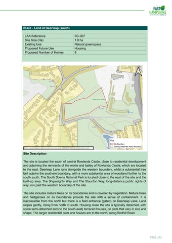
Site Description The site is located the south of central Rowlands Castle, close to residential development and adjoining the remnants of the motte and bailey of Rowlands Castle, which are located to the east. Deerleap Lane runs alongside the western boundary, whilst a substantial tree belt adjoins the southern boundary, with a more substantial area of woodland further to the south south. The South Downs National Park is located close to the east of the site and the built-up area. The Shipwrights Way and The Staunton Way, long-distance public rights of way, run past the western boundary of the site. The site includes mature trees on its boundaries and is covered by vegetation. Mature trees and hedgerows on its boundaries provide the site with a sense of containment. It is inaccessible from the north but there is a field entrance (gated) on Deerleap Lane. Land slopes gently, rising from north to south. Housing close the site is typically detached, with some semi-detached and (to the south-east) terraced houses, on plots that vary in size and shape. The larger residential plots and houses are to the north, along Redhill Road.
Page 443