
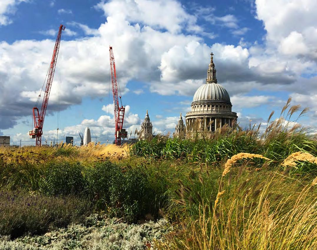
6. CLIMATE RESILIENCE
Introduction
This chapter contains guidance aimed to ensure that climate resilience principles are embedded within the design process of each development in the City.
It includes sections on:
• Flood risk and sustainable drainage systems: management of flood risk through water retention and flow control
• Water resource management: how to effectively manage and optimise the use of the available resources
• Building and urban overheating: preventing overheating in a dense and urbanised environment such as the City
• Pests and diseases: risks associated with animals, insects, weeds etc. in an urban context and guidance for a typical development in the City.
• Infrastructure resilience: key considerations for designing efficient and resilient infrastructure for a building and its external plot interface with the city.
Key approaches for the City
The City’s Climate Action Strategy and Adaptive Pathways study identified six key risks to the City as a result of climate change. These include flooding, water stress, overheating, new and emerging pests and diseases, disruption to food trade and infrastructure and impacts to biodiversity.
It is important to design developments with built-in resilience to these changes and disruptions, anticipating future climate changes throughout the design life of sites and buildings. Many of these solutions can simultaneously deliver a range of wider benefits which address climate change mitigation, enhance biodiversity and improve health.
Proposals within the City must consider this guidance from an early stage of the design and use it as a checklist when submitting a planning application and/or during any pre- and post-application discussions with the council.
Key policies and guidance
London Plan 2021
D6: Housing quality and standards
D11: Safety, security and resilience to emergency
GG6: Increasing efficiency and resilience
SI 4: Managing Heat Risk
SI 5: Water Infrastructure
SI 6: Digital Connectivity Infrastructure
SI 12: Flood Risk Management
SI 13: Sustainable drainage
Local Plan 2015
CS10: Design
DM10.2: Design of green roofs and walls
DM10.4: Environmental enhancement
CS15: Sustainable Development and Climate Change
DM 15.2: Energy and CO2 emissions assessments
DM 15.5: Climate change resilience and adaptation
CS18: Flood Risk
DM 18.1: Development in the City Flood Risk Area
DM 18.2: Sustainable drainage systems (SuDS)
DM 18.3 Flood protection and climate change resilience
Draft City Plan 2040
S7: Infrastructure and Utilities
IN1: Infrastructure provision and connection
S15: Climate Resilience and Flood Risk
CR1: Overheating and Urban Heat Island Effect
CR2: Flood Risk
CR3: Sustainable drainage systems (SuDS)
CR4: Flood protection and Flood Defences
Key actions to develop an exemplar City scheme
• Avoid urban heat island effects and the risk of overheating in the building by incorporating passive solar shading and by minimising the need for active cooling
• Reduce the risk of local flooding by attenuating water onsite and controlling the run-off rate
• Incorporate an integrated potable water management system
• Design green spaces, building spaces and services with a focus on nature, health and well-being to reduce the risk of emerging pests and diseases to develop and spread
Planning for Sustainability 36 Supplementary Planning Document | City of London Corporation
Table 6.1 Climate resilience key planning policies
Source: City of London Corporation
6. CLIMATE RESILIENCE
The City’s climate resilience risks
There are six key areas of climate-related risk identified for the City as part of the Adaptive Pathways Study carried out by Buro Happold for the development of the City of London Climate Action Strategy 2020-27. These risks need to be addressed within development and other planning processes to ensure that the City is resilient to climate change.
Flooding
It is anticipated that the City will experience a change in both the frequency, intensity and season variability of rainfall in the future, which will put pressure on our drainage system.
Water stress
Changes in rainfall patterns will impact on London’s capacity to meet its water demand and lead to drought. Droughts are expected to get longer and occur more frequently, with double the number of days of drought predicted in 2050 compared to 2020.
Overheating
Increasing temperatures as well as the frequency and length of heatwaves will be made worse in the City due to the urban heat island effect. This is when dense urban areas remain significantly warmer than the surrounding countryside, due to roads and buildings absorbing and retaining heat in the day and re-emitting it at night.
Pests and diseases
Changing seasonal conditions and global patterns will influence the spread of new and emerging diseases, while pests and invasive non-native species may also increase in number and range in a warmer, wetter atmosphere.
Trade, food and infrastructure
Weather-related impacts, geopolitical changes and altered climate conditions are likely to negatively impact upon major infrastructure, such as the power grid and transport network, as well as disrupting food production and trade on a domestic and international scale.
Biodiversity losses
Changes to the climate can fundamentally alter natural trends and cause decline and loss within ecosystems. This includes disruption to fundamental ecological processes such as pollination, carbon storage capacity and our dependence on the natural environment for our well-being and resources. See Chapter 7 Urban Greening and Biodiversity.

Planning for Sustainability 37 Supplementary Planning Document | City of London Corporation
Figure 6.1 CoL Climate Resilience Risks wheel
Source City of London Corporation
6. CLIMATE RESILIENCE
FLOOD RISK MANAGEMENT AND SUSTAINABLE DRAINAGE SYSTEMS
What is flood risk management
The term ‘flood risk’ refers to the probability of flooding within an area and the associated consequences. The likelihood is based on historical and forecast data. Flood Risk Management identifies how the risk of flooding can be reduced and managed sustainably.
What are Sustainable Drainage Systems (SuDS)
SuDS are designed to manage surface water volumes and pollution risks locally by mimicking natural processes as far as practicable. When done well this results in reduced runoff, improved water quality, amenity benefits and enhanced biodiversity and habitat.
Sources of flood risk
The risk of flooding from all sources, including fluvial, tidal, surface water, sewer, groundwater and other artificial sources must be assessed. In the City of London, the primary sources of flood risk are fluvial/tidal flood risk along the riverside and surface water/sewer flooding in the surface water hotspots identified around Farringdon Street and New Bridge Street areas.
Flood zone categorisation
Flood risk is defined for all areas of London and shown on the Environment Agency (EA) “Flood risk maps” and “Flood maps for planning.” The flood zone associated with the development will dictate the building types/usages permitted by the EA. Depending on a site’s location within a flood zone and its proposed use, a development might need to pass the Exception Test. More information on applying the Exception Test is available in the City of London Strategic Flood Risk Assessment.
• Flood Zone 1 has a low probability of flooding (Annual Exceedance Probability (AEP) <0.1%) and is appropriate for all land uses.
• Flood Zone 2 has a medium probability of fluvial (0.1% < AEP > 1%) and coastal (0.1% < AEP > 0.5%) flooding. This prohibits highly vulnerable developments. Designs should consider measurements to minimise the risk and impact of flooding.
• Flood Zone 3a has a high probability of fluvial (AEP > 1%) and coastal (AEP > 0.5%) flooding. It should be noted that large areas of London are within this flood zone. All land uses may be permissible within this zone, provided that flood risk has been assessed fully and appropriate mitigation provided. Mitigation may include, but will not be restricted to, measures such as raising flood defences in accordance with Thames Estuary 2100 Plan measures, ensuring no critical infrastructure is located at basement level, podium levels are set above breach levels, a Flood Emergency Plan is in place.
• It is vital that the information within and the limitations of the EA maps are fully understood.
• Flood Zone 3b categorises the functional floodplain (AEP > 5% or designed to flood in an extreme event). Only water compatible development is permitted within this zone to ensure that there is no impact on the functionality of the floodplain.
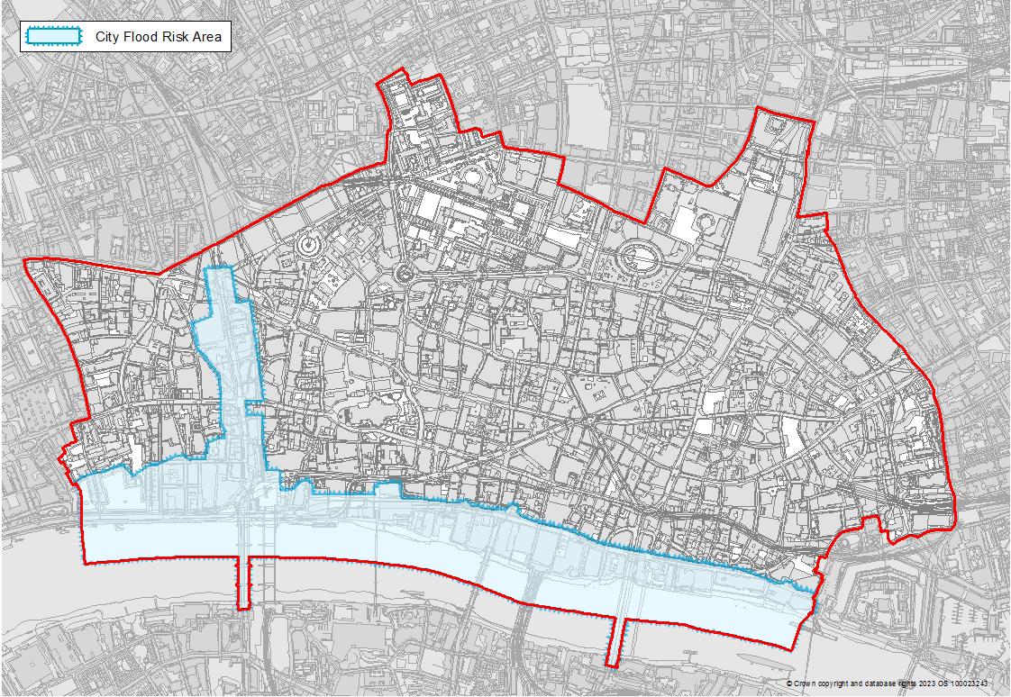
Planning for Sustainability 38 Supplementary Planning Document | City of London Corporation
Figure 6.2 City Flood Risk Source City of London Corporation
RESILIENCE
FLOOD RISK MANAGEMENT AND SUSTAINABLE DRAINAGE SYSTEMS
Approach to flood risk management
Flood risk must be assessed on a site-specific basis. Management measures must appropriately mitigate the risk, whilst considering the wider impacts to flooding elsewhere. Flood risk can be managed sustainably by utilising the following steps:
• Assess the risk to the site from each source of flooding
• Understand the flood mechanisms for each source of flooding. This could include the location, speed and consequence of flooding on a site
• Establish an acceptable risk threshold. This should be done in conjunction with interested parties including future occupants and with reference to relevant flood risk policy
• Mitigate the risks to an acceptable level. This could include moving vulnerable uses to less vulnerable areas, utilising sustainable drainage features or providing flood resistance and flood resilience measures
• Prepare in advance for the consequence of flooding and develop procedures to enable recovery. A Flood Emergency Plan can be implemented in order to notify site users of a flood event, provide a safe and efficient route away from danger and ensure the flooded site can return to functional use as soon as possible
Proposals should consider solutions that combine sustainability and flood risk management measures, for example; solar panels that double up as water collectors during rainfall or green roof features that provide biodiversity and flood risk benefits. Surface water attenuation may provide an opportunity for greywater reuse.
Drainage for all developments must have separate foul and surface systems. As far as practicable the systems must not be reliant on pumping. If pumping is required, such as from basements, then appropriate backup systems must be provided.
Critical infrastructure
6.3.6. Consultation with the EA and the CoL has indicated that they have no concern in discharging to the River Thames as long as certain criteria can be met, in terms of tide lock and adequate scour protection. TW also indicated that if its unviable to discharge to the River Thames, they will accept discharge into the combined sewer at 3x greenfield runoff rates in line with the London Plan for brownfield runoff rates.
6.4 ROOF STRATEGY
Case Study: Seal House
6.4.1. It is proposed that the new roof, which has a green roof incorporated will discharge directly into the River Thames via a sealed pipe network, in which given the head difference will discharge into the River Thames with no formal tide lock attenuation required. The pipe network will need to be sealed up to an anticipated maximum future river level of 5.78m AOD, as depicted below in Figure 3.
All infrastructure that is critical to the functioning of a building, such as heating and lighting, must be flood-proofed and situated above anticipated flood levels. This includes risks associated with breach events.
Safe egress and access must be provided in the event of a flood event, ideally to a safe area offsite.
Most buildings in Flood Zone 2 or Flood Zone 3 must have a bespoke Flood Emergency Plan in place. This is a requirement of the Lead Local Flood Authority (LLFA).
Careful substation and plant positioning in relation to flood risk from overland flow, rising river or groundwater can enhance resilience as well as tanking measures and raised threshold positions.
Key Measures
Whole building
Flood risk management vision and objectives
All developments must aim to ensure that the risk of flooding is managed sustainably, taking into consideration the evolving impacts of climate change on flood risk throughout the project’s lifetime, while minimising impact on the natural environment. To achieve this, proposals must:
• Ensure that the development is suitable for the flood zone it is situated in and its defined land use vulnerability
• Ensure that the development does not increase flood risk off site and, if possible, achieve a reduction in this risk
• Respect the inherent flooding pathways and make space for water within the proposed development as far as practicably possible
• Assess all sources of flood risk and provide mitigation as required
• Maximise the use of green infrastructure and SuDS to manage flood volumes throughout the development. Make use of available public realm to accommodate stormwater, improve water quality and provide amenity
• Ensure the safety of building occupants during flood events through the identification of suitable access and egress routes
WSP
October 2018
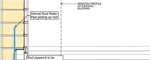
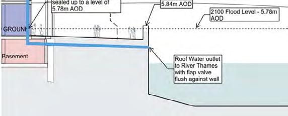
Roof Water Strategy. Source: Planning Application, Flood Risk Assessment and Outline Drainage Strategy
Use: Commercial Office, retail, restaurant
Key facts:
SEAL HOUSE
Project No.: 70028158 | Our Ref No.: DR-RP-001 Sellar
• Internal north-south access designed to ensure that safe egress and access is provided in the event of a breach in the Thames Tidal Defences
• Less vulnerable land uses are located on the ground and basement floors
• Levels slope away from the building, so that surface water flows away from the asset
• Green roofs are provided, which reduce runoff, create habitat and visual amenity
• Attenuation is provided that takes account of tidelock to surface water discharge from the site
• Surface is water is discharged direct to source (River Thames) in accordance with the SUDs hierarchy
39 Supplementary Planning Document | City of London Corporation
Figure 3 - Roof Water Strategy
Planning for Sustainability
6. CLIMATE
FLOOD RISK MANAGEMENT AND SUSTAINABLE DRAINAGE SYSTEMS
Beyond the building
SuDS and urban blue-green infrastructure (BGI) are effective measures to manage and reduce flood risk and should be integrated into the public realm or open spaces within the development where possible. The design of these spaces can include tree planting, swales, natural detention basins, or soakaways and can play a key role in supporting the urban ecosystem.
These solutions can:
• Reduce runoff and flood risk - impervious surfaces in urban developments increase run-off volumes and often overwhelm drainage networks/sewers.
• Restore the natural water balance – by reducing impervious surfacing, SuDS/BGI promote natural infiltration and encourage aquifer recharge.
• Support biodiversity by restoring natural habitats.
• Provide carbon reduction benefits – through sequestration and as an alternative to grey infrastructure with higher embodied carbon.
• Increase health and well-being in the urban realm – SuDS/ BGI can help to reduce the Urban Heat-Island effect and improve air quality
For developments along or near the riverbank, surface water should be discharged directly to the Thames, provided the required permissions are secured. This can present an opportunity to incorporate elements from the Estuary Edges guidance therefore also contributing to marine/terrestrial biodiversity.
CoLC will develop a Climate Resilient Planting Catalogue which will include advice on the best planting species and solutions for water attenuation and drainage.
Ground infiltration
It is important to understand that opportunities for discharge to ground in the City can be limited due to two reasons:
1. Many areas of London are built over contaminated land. Discharging to ground can result in the mobilisation of these contaminants, which can then enter watercourses;
2. For large parts of the City the underlying geology is not sufficiently permeable to enable the volume of discharge to ground required.
Local flood risk management strategy
As a Lead Local Flood Authority, CoLC has the responsibility to develop, maintain, apply and monitor the strategy for local flood risk management in the area, including in the form of the Local Flood Risk Management Strategy 2021-2027 (LFRMS). In this LFRMS, CoLC sets out commitments to achieve flood risk mitigation objectives, these include:
• Implementing procedures to maximise the use of SuDS in new public realm works and new developments
• Identifying all historic assets in the Square Mile at risk of flooding and working with building owners to adopt resilient design
• Working with utilities providers and infrastructure owners to create a public register of assets at risk of flooding and supporting owners to take action
• Producing guidance specific to retrofitting flood resistance and increasing resilience in commercial buildings
Where space or other constraints mean that urban blue-green infrastructure are not feasible, water may need to be attenuated in more traditional tanked systems. Where these are unavoidable, intelligent rainwater management systems should be utilised to enable rainwater to be stored and then used on site.
Planning for Sustainability
RESILIENCE
6. CLIMATE
Source: City of London Corporation
6. CLIMATE RESILIENCE
WATER RESOURCE MANAGEMENT
What are water resources and water resource management?
Water resources are the various types of water which are used or pass through a development. These include potable supply from utilities systems, rainwater and other greywater sources, as well as recycled water from within the development.
Water resource management can enable the effective and optimised use of available resources.
Key measures
Whole building
Water resources must be reliable, sustainable, secure and safe. To achieve this, a development should aim to:
• Reduce per capita consumption water demands through the smart optimisation of water usage and specifying water efficient devices
• Ensure that per capita consumption water demand in residential developments is 105 litres per day or less
• Forecast supply and demand to avoid inefficiencies
• Ensure that distribution is efficient and effective throughout the development by optimising systems and minimising leaks
• Where possible, make use of alternative water sources
• Recycle water sources, including treated sewage effluent (TSE) and greywater to reduce potable water demand. Regenerative water systems should be considered as standard to recycle water
• Minimise sewage outflow through efficient flushing, this prevents obstructions and helps avoid overwhelming the sewage systems
Measures for the management of potable water
• Measure and record usage in order to identify water and energy saving opportunities
• The use of leak detection technology to improve the performance of networks and reduce wastage
• Water saving technologies within the building such as low flow taps and aerated showers
• Ensure supply network has sufficient capacity
• Use of timed-release systems to reduce usage
• Incorporate rainwater and greywater recycling to reduce the demand of potable water
Measures for the management of rainwater
• Optimise collection opportunities for recycling. This includes irrigation and non-potable uses
• Make use of recycled water in heating and cooling system
Measures for the management of wastewater
• Minimise volumes of water required to be treated. Measures include ensuring effective flushing
• Ensure a network has sufficient capacity
• Consider the use of recycled water for toilet flushing. For example, in a large development, capturing water from one third of a building’s showers could meet the toilet flushing demand of the entire development
Measures to reduce water demand in plant and MEP systems
• Improve the supply and demand efficiency of plant and MEP systems by ensuring distribution networks are operating effectively and are regularly maintained
• Create a more efficient supply and use system, such as separating the supply of potable and non-potable water (use of greywater for non-potable and a blend of recycled and utility water for potable water)
• Consider resource scarcity management systems that might need to be instituted to manage periods of water stress, drought, or during extreme weather events
Case Study: 100 Liverpool StreetMajor refurbishment and extension
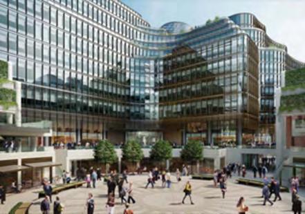
100 Liverpool Street, view from the Circle looking towards the proposal and the northern office entrance. Source: Planning Application: DAS
Use: Office, retail, leisure
Key facts:
• BREEAM rating ‘Outstanding’
• WELL Standard ‘Gold’
• 40% reduction in water consumption against BREEAM defined baseline in 2016
• Water demand partially met through rainwater harvesting and greywater reuse
• Drought resistant planting
Planning for Sustainability 41 Supplementary Planning Document | City of London Corporation
6. CLIMATE RESILIENCE
WATER RESOURCE MANAGEMENT
Beyond the Building
To lower the need for potable water for irrigation, the possibility of harvesting and reusing rainwater in the public realm or using rainwater collected from a building for nearby public realm planting should be explored. Any opportunities to combine SuDS with water recycling and to use climate resilient planting types with low water demand must also be considered.
These measures will help to maintain the quality of urban greening during periods of water shortage. The drought in summer 2022 had a significant impact on existing trees and planting in the Square Mile. Silver birches appear to have been particularly effected, but many trees displayed ‘false autumn’ characteristics due to stress.
Interconnected neighbourhood systems should also be considered with buildings of different roof size and demand profiles, right-sizing of on-site storage, and shared storage facilities.
Case Study: 100 Fetter Lane
Redevelopment for a 12-storey office

Use: Commercial office with public house
Key facts:
Source: Buro Happold

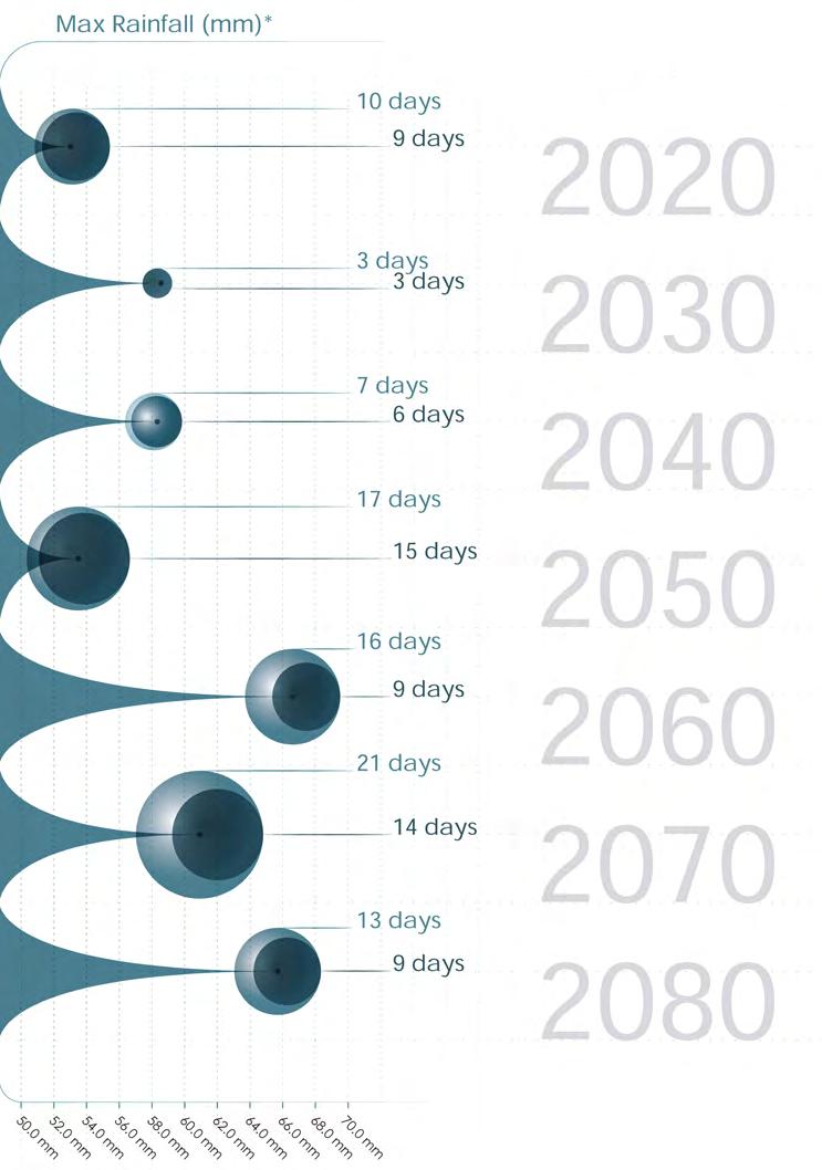
*Drought is defined at 15 days or more with less than 0.2mm of rainfall. Periods less than 15 days are listed here since the analysis involves calculating predicted days of drought, using this definition, for 12 separate models under UKCP18. The final number shown here is the average of the models’ results. Since some models predict 0 days of drought, this may give a result which is smaller than 15 days.
• Blue roof with ‘smart’ attenuation tank, to collect rainwater for use in WC flushing and irrigation, supplemented by grey water from showers
• Specification of low water consumption sanitary ware
• 50% improvement over baseline building water consumption
• Smart tank water to be supplemented by grey water from shower areas
Planning for Sustainability 42 Supplementary Planning Document | City of London Corporation
Figure 6.3 Anticipated days and periods of drought per year, 2020 – 2080, compared to anticipated monthly maximum rainfall (mm)
View of 100 Fetter Lane.
Source: Planning Application Design & Access Statement
6. CLIMATE RESILIENCE
BUILDING
AND URBAN OVERHEATING
What is overheating?
Overheating occurs when temperatures inside buildings and in the public realm reach levels that are uncomfortable for humans, animals and plants. This can cause health issues, disrupt infrastructure and damage ecosystems and biodiversity. In the City key drivers of overheating include the increase in heatwaves, increase in average daily temperatures and the urban heat island effect. It is important to consider the impact of overheating on building fabric and how this in turn impacts internal conditions during overheating events. Consideration should be given to stresses and shocks on materials to avoid infrastructure failure.
The Urban Heat Island
An Urban Heat Island (UHI) refers to an urban area that is significantly warmer than its surrounding areas. This is most commonly a result of intensive land use, trapping of heat in materials with low reflectivity and a high thermal mass (e.g. concrete), discharge of waste heat from building systems and heat generated by other human activities. The Urban Heat Island effect can cause night-time temperatures to be 4°C+ higher than outside the centre of London.
Heatwave
In London, a heatwave is defined as 3 or more days with maximum daily temperatures above 28°C.
Key measures
Whole building
The City’s dense and urbanised environment is at high risk of extreme heat. It is therefore important that all development actively contributes to reducing the heat island effect and improving thermal comfort within the City by utilising green and blue infrastructure, and design optimisation, as well as avoiding the expulsion of waste heat into the environment.
Ventilation and cooling strategies should be underpinned by thermal modelling with best practice utilising Computational Fluid Dynamics (CFD) modelling. Strategies could also consider potential future changes of building use.
All developments, must assess the impact of current and future weather data (for example by using CIBSE Design Summer Year weather datasets), alongside local acoustic and air pollution levels.
Beyond the Building
3.4. Facade Development
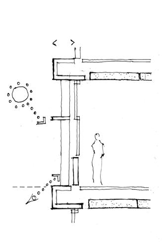
Development proposals must provide measures to alleviate heat stress on the ground, within the site and around the building. Blue and green infrastructure and shade can cool open spaces and offer respite during heat waves.
Applicants are advised to incorporate interventions recommended as part of The City of London’s Cool Streets and Greening Programme
Source:

Case Study: 100 Fetter LaneRedevelopment of commercial building
View of new publicly accessible link access.
Source: Planning Application, Design & Access Statement
Use: Office and public house
Key facts:
• Exposed soffits to allow cooling
• Deep reveals in the building fabric to create shade
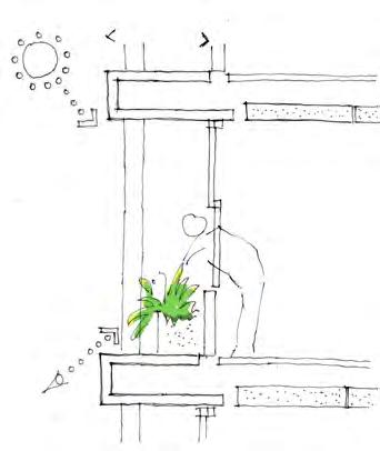
• Landscaping to include multiple green terraces with edgeplanting at eight different levels and a shaded sunken garden open to the public
• Mixed mode ventilation that combines natural ventilation and automated windows to enable night purging
A simple solid masonry approach with upstands for the pub block to the north and east and the pavilion block to the west. This is to create two distinct treatments for the pub and pavilion buildings and provide a transition from the north and west to the south east section of the site with a more open, light and simple building design. The pavilion design responds to the design language of the listed Greystoke Place facade. The pub is conceived as solid three dimensional building in a strong bright colour.
Passive Solar Shading Deep facade + upstands exposed concrete soffit part of the facade concept Passive protection Solid vertical elements Solid horizontal elements Openable windows Deeper facade Exposed concrete soffit Openable windows Passive protection Accessible planting Deep facade Exposed concrete soffit Openable windows External fins Projection where necessary SE corner light taller block approach The approach to the façade design is to provide deep, horizontal masonry strata elements for the taller corner block and mid section to maximise natural light, views and solar protection. West facing light mid-section approach with setback external planting The mid-section has deeper-set glazing to accommodate a series of external planters that can be safely maintained from the inside and outside and utilised by occupants. As previously described there are simple cladding design approaches to the building: Pavilion; Pub; SE block; and Green mid section. FPA 100-108 FETTER LANE 67 Planning for Sustainability 43 Supplementary Planning Document | City of London Corporation
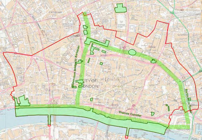
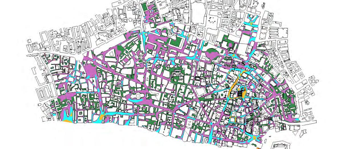
Figure 6.4 Cool Streets and Greening ‘green corridors’ and SINCs (current & proposed)
City of London Corporation
6. CLIMATE RESILIENCE
BUILDING AND URBAN OVERHEATING
metric will be utilized for London. The methodology for http://www.utci.org/ as is a and its underlying code.
designed for a 10m wind speed pedestrian height assuming computed pedestrian height (1.5m) equivalent using an before being input into the UTCI factor of 1.4 (U10 =U1.5*1.4).
Materials for landscape and site access routes should be selected accounting for increasing temperatures, such as using high albedo surfaces to reflect the radiation. Specifications for asphaltic surfaces should include appropriate additives to reduce chances of failure and deformation in high temperature events. Wider or more frequent jointing may be necessary to allow for increased movement of susceptible surfaces or bases such as hard paving caused by wider temperature ranges and cycles.
What is Thermal Comfort?
Thermal comfort takes into account a range of environmental and physiological factors to determine a comfortable temperature range.
Computational Fluid Dynamics (CFD) modelling can be undertaken to inform the location and massing of buildings as well as landscaping. Best practice entails assessment of the Universal Thermal Climate Index (UTCI) which considers metrological parameters and physiological effects on comfort.
the climate time-history using website above, and the frequency computed for each season. This outdoor pedestrian use.
City of London strategy
define deliberately chosen to ensure distinctiveness
The colours should not be adjusted.
CoLC is using a one-to-one virtual model of the City, a ‘digital twin’, to simulate the impacts of extreme heat events and the ideal placement of green roofs. This model is being integrated with CoLC’s ground-breaking Thermal Comfort Guidelines. These guidelines – believed to be the first of their kind globallyprovide a unique technical tool which enhances the understanding of the microclimatic qualities of the City’s public spaces (by merging wind, sunlight, temperature and humidity data). They include a methodology to assess the potential impact of new developments and can serve as an additional reference to help mitigate overheating risk.
Description Colour (HTML Colour Code)
Appropriate for use yearparks). Green (#378c4b)
Source: City of London Corporation 2020
Usage Category % of hours with acceptable UTCI Description
All Season ≥90% in each season Appropriate for use year-round (e.g. parks).
CoLC is leading by example through the implementation of its Cool Streets and Greening Programme, as part of which it has begun planting tree-shaded cool routes. In some cases this has reduced air temperatures between 3-8°C during heatwaves.
Appropriate for use during most (e.g. outdoor dining). Purple (#c86ebe)
Appropriate for short duration infrequent sedentary unsheltered bus stops entrances) year-round.
Appropriate for short duration infrequent sedentary during most of the year.
Appropriate for public spaces people are not expected for extended period pavements, cycle paths).
Cyan (#1effff)
Orange (#fab92d)
Red (#de2d26)
Seasonal ≥90% spring-autumn AND ≥70% winter
Short Term ≥50% in all seasons
Short Term
Seasonal ≥50% spring-autumn AND ≥25% winter
Transient < 25% in winter OR <50% in any other season
Appropriate for use during most of the year (e.g. outdoor dining).
Appropriate for short duration and/or infrequent sedentary uses (e.g. unsheltered bus stops or entrances) year-round.
Appropriate for short duration and/or infrequent sedentary uses during most of the year
Appropriate for public spaces where people are not expected to linger for extended period (e.g. pavements, cycle paths)
CRITERIA
Planning for Sustainability 44 Supplementary Planning Document | City of London Corporation
Figure 8: Categorization of Existing City Conditions
Figure 6.2 Thermal comfort map
BUILDING AND URBAN OVERHEATING
City of London overheating map
Figure 6.2 shows which areas of the City will be affected by the highest average heatwave temperatures as well as distribution of key public spaces that may support impact mitigation by providing cooling (green spaces) or shelter from heat. Temperature data is drawn Heat Wave Average Max Temperatures taken from the GLA 2016 study on the London Urban Heat Island Effect.
Under Regional UCKP18 projections ‘high emissions scenario’ the Square Mile is set to see an increase in the maximum daily air temperature, the annual number of days of heatwaves and the period of consecutive days of heatwave. By 2080 the number of days on heatwaves will have increased to 56 days per year compared to 14 days in 2020, with heatwaves lasting up to 22 days and a maximum daily air temperature of 39°C.
At 27°C indoor temperatures in well-insulated homes can result in overheating, at 30°C some commercial buildings will be vulnerable to power outages and at 35°C health adults can begin to experience heat stroke risk.
Impact of future weather files
A future weather file portrays a location’s anticipated annual weather stream in 10, 25, 50, 80, and 100 years into the future. Based on projections derived from numerous global climate models for various scenarios of greenhouse gas emissions, future weather files can be utilised in building energy modelling to get insights into future energy requirements.
The design approach for any development in the City must take into consideration the future weather file and their impact as recommended by BREEAM 2018 Hea 04: Thermal Comfort.
CIBSE Design Summer Year (DSY) for London is the most appropriate year of weather data to assess the summertime cooling needs of buildings in London. It enables designers to analyse the summer performance of their buildings and investigate the impact of urban macroclimatic factors and climate change when carrying out overheating risk assessments for buildings in London.
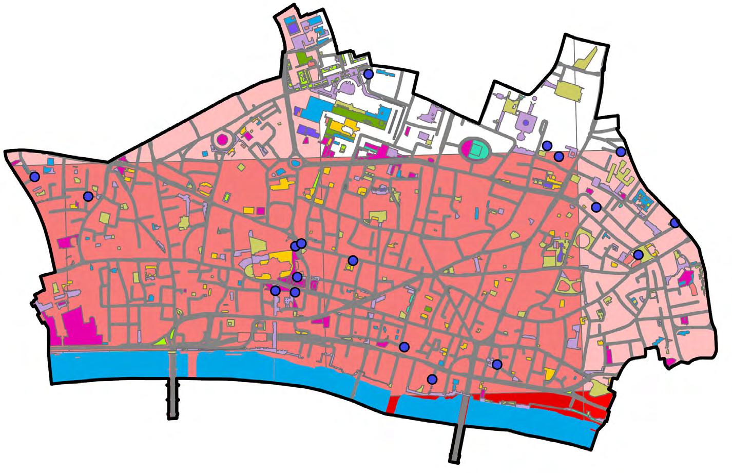
Public Space by type
Drinking Fountain
Amenity Greenspaces
Cemeteries & Churchyards
Natural & Semi-natural Green Spaces
Other or Private Under Construction
Outdoor Sports Facilities
Parks & Gardens
Primary Civic Squares
Provision for Children & Young People
Secondary Civic Spaces
Planning for Sustainability 45 Supplementary Planning Document | City of London Corporation
6. CLIMATE RESILIENCE
Figure 6.5 Overheating map with public space & drinking fountain distribution
29.4 - 29.5 29.5 - 29.6 29.6 - 29.7 29.7 - 29.8 29.8 - 29.9 Heat Wave Average Max Temperatures (°C)
Source: City of London Corporation 2020
6. CLIMATE RESILIENCE
PESTS AND DISEASES
What are pests and diseases?
In an urban context, pests can include non-native and established wildlife and invasive plants which can affect the health of people and other flora and fauna. Diseases can include human, animal, and plant infections that can be spread through zoonotic, airborne, waterborne and contact based transmission.
Warmer, wetter winters and hotter, drier summers will significantly raise the threat of pests and diseases in the UK, with these conditions facilitating the spread and emergence of vectors like ticks, mosquitoes and rats, and increase both transmission rates and overwinter survival rates.
The UK is currently free of many pests and diseases that afflict plants overseas. However, international movements are an identified pathway in which new pests and diseases are introduced. In urban environments this can be a particular risk to green infrastructure.
Urban trees, which are of significant value to climate change adaptation in urban areas, are at particular risk of new pathogens and pest outbreaks.
The increase in prolonged periods of heat stress and risk of flood events also poses a significant threat to spread of waterborne and communicable disease.
Key measures
Whole building
Developments must increase the levels of urban greening and take a landscape-based approach to developing habitat networks of resilient species that can help to tackle risk of biodiversity loss and spread of ecosystem pests. Proposals should consider solutions able to increase the resilience of the treescape on site and the wider area.
Design should discourage disease-carrying fauna and ensure biological security through procurement and management of trees and other green infrastructure, to avoid introduction of new plant pests and diseases.
Species should be selected for their ability to cope with extreme weather conditions and adapt to the urban landscape. Applicants must consider biosecurity within their proposals including how they will procure a diverse range of species, use resilient plants, their choice of supplier and how they will deal with imported plants when they arrive into their care.
Considerations for health and well-being
Management of the facilities and open spaces within in the development should consider the risk to public health through design and relevant protocols. These can include:
• Minimising touch points throughout the design of the building
• Ensuring facilities meet cleaning protocols such as clear desk policies where possible
• Ensuring adequate ventilation and air quality within the building and reducing other respiratory stresses (see BREEAM Hea 02 Indoor Air Quality)
• Effective management of operational waste to reduce risk of pests and disease vectors (see Wst 03 Operational Waste).
Beyond the building
Care must be taken to avoid planting non-native invasive species listed in Schedule 9 of the Wildlife and Countryside Act 1981 (as amended) and in the London Invasive Species Initiative (LISI). It is illegal to plant these species in the wild and we should aim to prevent development becoming a pathway for further spread of these specimens into London’s green spaces.
If present within or around the development site suitable specialists to remove non-native invasive species if these are found on site such as Japanese knotweed (Fallopia japonica) and Himalayan balsam (Impatients glandulifera) should be employed.
Consideration should be given to how the development will reduce biosecurity risk in its landscaping programme and manage future impacts of pests and diseases to occupiers and green infrastructure.
Plan for future climate scenarios in terms of temperature and humidity ranges, ensuring all plant, HVAC and water systems negate the risk of bacterial, viral or fungus growth. Particular consideration must be given to legionnaires disease and the supply of potable water. Applicant teams should refer to regulation of these systems and ensure there are multiple methods to maintain conditions and reduce contamination risk.
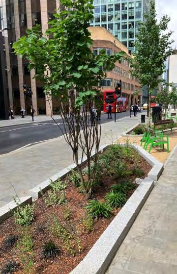
Case Study: City of London, Vine Street Public realm planting

Use: Public realm
Key facts:
• Included two species (Zelkova serrata and Koelreuteria paniculata) that are fast growing and resistant to a range of tree pests and diseases. Once grown, these will provide shade from canopy cover for pedestrians and cyclists along Vine Street to combat street level overheating.
Planning for Sustainability 46 Supplementary Planning Document | City of London Corporation
Vine Street tree planting. Source: Planning Application, DAS
6. CLIMATE RESILIENCE
PESTS AND DISEASES
A landscape-based approach to planting should be adopted within the development site and the adjacent public realm. Informed decision-making on the selection of species should ensure cohesion with and support for local habitat networks. For landscaping and public realm interventions, species should be diversified and, where possible, native/naturalised species with high biodiversity value are encouraged to support ecological functions. Species or genera that could be vulnerable to any new diseases that may be introduced in the future should be avoided, and species not yet affected by pests and diseases present in the UK are to be prioritised. The UK Plant Health Database should be consulted during the design process to determine species and genera of higher risk.
To avoid importing pests and diseases from abroad, the procurement of plants grown in reputable nurseries in the UK should be a priority. Where plants need to be imported, all the relevant biosecurity protocols and import checks must be adhered to. The potential for species to become invasive needs to be assessed by referring to the European Alien Species Information Network (EASIN) notification system for early detection in Europe.
Soft landscaping proposals for a new development must not include non-native invasive species - further information can be found in Schedule 9 of the Wildlife and Countryside Act 1981(as amended), the Non-Native Species Secretariat of Great Britain and Ireland, and the London Invasive Species List.
Maintenance of green infrastructure should be implemented as necessary for each habitat to ensure that no non-native invasive species settle and spread. Within the management and maintenance plans to be submitted to the City of London before implementation there should be a process in place to ‘alert’ responsible authorities of any pest or disease outbreaks within new and established green infrastructure.
Advice about climate resilience planting
CoLC is preparing a Climate Resilient Planting Catalogue, which will provide guidance on the design of public realm and planting selection including species tolerances, response to pests and diseases and to extreme heat (and other weather events). The function of species (ecosystem services, i.e. biodiversity enhancement, cooling, interception, sequestration) and the planting environment (site types and conditions) are also important criteria to be included.
Case Study: London Wall Place
Commercial redevelopment offering an acre of landscaped public gardens
Use: Commercial office, retail
Key facts:
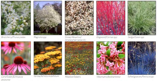
• Use of native species for planting, including: silver birch trees, bird cherry and cornelian cherry, hellebore, fern, and foam flowers

Planning for Sustainability 47 Supplementary Planning Document | City of London Corporation
Source:
London Wall Place planting palette. Source: Planning Application, DAS
City of London Corporation
RESILIENCE
INFRASTRUCTURE RESILIENCE
What is infrastructure resilience?
At a wider level, infrastructure resilience is defined as the ability of infrastructure such as utilities, transport, and digital networks to withstand the potential shocks or stresses faced during its design life including those that London will experience owing to the inevitable effects of climate change.
At a developmental level, buildings within the City of London will need to consider how to minimise disruption to building operation during extreme events of flooding, high heat and drought. The aim is to ensure that a building is designed to operate safely and effectively throughout its design life whilst minimising its loads and impact on the City network as a whole.
A risk assessment should determine the level of investment in resilience measures, taking into account climate risks as one set of factors that may affect the asset’s performance. Investment in more costly resilient measures may not be justified immediately, and so timing along with any complimentary additional benefits should be weighed in the assessment. To evaluate climate risk consistently across all aspects of the development, resiliencebased measurement frameworks and reporting standards should be used. This will enable confidence in adaptive business strategies that are based on robust future scenario modelling of likely climate impacts.
Key measures
Whole building
Buildings should be designed to maintain basic functioning and safety during adverse events wherever possible, but the more critical the function of the building the higher the level of protection that should be considered appropriate.
Demand reduction for utilities such as water and power will have the triple effect of reducing running costs and operational emissions, as well as reducing the peak strain on the wider city infrastructure networks. This would permit reduced supply from alternative sources or on-site back-up storage to go further, which will ultimately improve the resilience of the building through an increased level of self-sufficiency.
Multiple and diverse connection points to City networks should be provided, ensuring buildings maintain well-considered backup supply for critical loads, whilst maximising the level of on-site renewable generation options available. This will ensure the building has a higher level of function during shock events.
Data infrastructure resilience measures should be considered and include: dual connections; careful data centre and plant room positioning in relation to flood risk from overland flow, rising river or groundwater; tanking measures and raised threshold positions as well as the incorporation of cooling plant. Tanked basements that are water and gas-tight should be considered.
Beyond the building
Even within the City, risks will vary with location. Proposals should include an assessment of localised risks to recognise areas of vulnerability and put in place appropriate measures. These could include early warning systems, maintaining evacuation pathways, and establishing community protocols and emergency response plans for extreme climate events such as emergency hubs that would provide access to safe space and services during extreme weather events.
Any building is part of a greater set of networks so it is crucial that designers consult with all relevant stakeholders (Thames Water, Greater London Authority, Environment Agency, UK Power Networks etc) to understand how the design of the building and its surrounding environs coordinate with, complement and build on city-wide planning that is continuously evolving.
The City is a very dense and highly connected area, so opportunities should be sought to establish local resilience measures between buildings and assets to provide backup power, water or data connectivity beyond plot boundaries during widespread disruption events.
Case Study: 115-123 HoundsditchRedevelopment for a 24-storey tower
Proposed Blue Roofs.
Source: Planning Application, Flood Risk and Drainage Strategy
Use: Commercial office
Key facts:
• Site located in Flood Zone 1
• Rainwater harvesting and attenuation tanks, with water to be re-used for non-potable purposes, basement tank to discharge into public sewer with demarcation chambers suspended from ground floor as high as possible rather than the basement, to avoid flooding from sewers
• Exploration to incorporate blue roofs of up to 1,265m2
• Building Management System for water metres and water consuming plant to double up as leak detection
• SuDS to mitigate flooding
• Energy centre incorporates thermal storage and plate heat exchangers to facilitate connection to a district heating or cooling network
• Two intake rooms for data connections in the building’s basement
Planning for Sustainability 48 Supplementary Planning Document | City of London Corporation
6. CLIMATE
KEY MEASURES FOR CITY DEVELOPMENTS 6. CLIMATE RESILIENCE
Seek design solutions to reuse or divert excess heat (e.g. connection to waste heat & power systems) to minimise heat release and urban heat island effects
Use on-site energy generation such as photovoltaic panels to reduce demand and dependence on the grid
Design MEP systems for future temperature and humidity range scenarios to prevent proliferation of pests and disease
Position plant, MEP systems, and data centres above predicted flood levels
Prevent overheating of plant & data centres during extreme weather using passive approaches (or active cooling where necessary)
Minimise internal heat gains: e.g. short pipe lengths, energy efficient lighting, efficient domestic equipment
Assess the heat load profile of the building type and use to determine the need for exposed high thermal mass materials to moderate temperature
Detailed measures
Typical approaches for developments in the City by building element:
STRUCTURE
ENVELOPE
MATERIALS
PLANT & MEP
WHOLE BUILDING
BEYOND THE BUILDING
Install smart irrigation systems with moisture or precipitation sensors to irrigate only when necessary
Use leak detection systems and water saving technologies such as low flow taps and aerated showers.
Use dual data connections for building services
Optimise materials and colour finishes to minimise overheating and glare
Design ground surfaces to be resilient to heat and deformation e.g. light coloured or permeable paving or the use of preventative additives in asphalt
Maximise use of green infrastructure and SuDS to manage rainwater throughout the development
Manage heat through design: e.g. wall to glazing ratio, solar control glazing, balconies, external shading and trees, use of blinds, exposed thermal mass, high ceilings, massing and orientation and natural ventilation
Use regenerative water systems, greywater recycling and rainwater harvesting to reduce non-potable water demand
Maximise passive ventilation e.g. shallow floor plates, openable windows and panels
Use purge ventilation at night to manage day-time overheating.
Alleviate heat stress on materials and services through vegetation (trees, green roofs, climbing plant screens, planters, bio-swales etc)
Incorporate open spaces with visible sky to help cool surfaces at night by facilitating long wave radiation.
Use hard and soft landscaping to provide shade, absorb pollutants, and mitigate against wind conditions, and to benefit pedestrian comfort.
Adopt blue infrastructure to cool open spaces on site and in adjacent public realm e.g. use rainwater to cool façades through wetting and evaporation, expose rainwater retention and provide drinking fountains
Planning for Sustainability 49 Supplementary Planning Document | City of London Corporation